Embed Size (px)
Citation preview
1068
1079
1035
1100
1203
51081
1191
1611
1218
1091
1146
1220
1060
1014
1056
1095
1072
1025
1168 1160
1094
1152
1709
51001
1194
1193
1104
1051
1097
1112
1027
1189
1153
51066
1212
1180
1217
1169
1045
1084
1705
1610 1101
1158
1147
1062
1219
1098
1063
1004
1092
51043
1005
1607
1211
1102
1208
10381032
1033
1030
1148
1198
1020
51018
1207
1181
51009
1190
1204
1076
1215
1213
1156
10111009
1053
1608
1064
1109
1106
1143
1012
1018
1077
1006
1167
51123
1200
1185
1216
1197
50992
1199
1052
1706
1188
51002
1186
1202
6181
51192
1214
1001
51126
51194
51129
51127
51185
51184
51193
51183
51182
51186
6180
51128
454000m.E
454000m.E
56
56
58
58
460
460
62
62
64
64
66
66
68
68
470000m.E
470000m.E
5416
000m
. N
5416
000m
. N
18 18
5420 5420
22 22
24 24
26 26
5428
000m
. N
5428
000m
. N
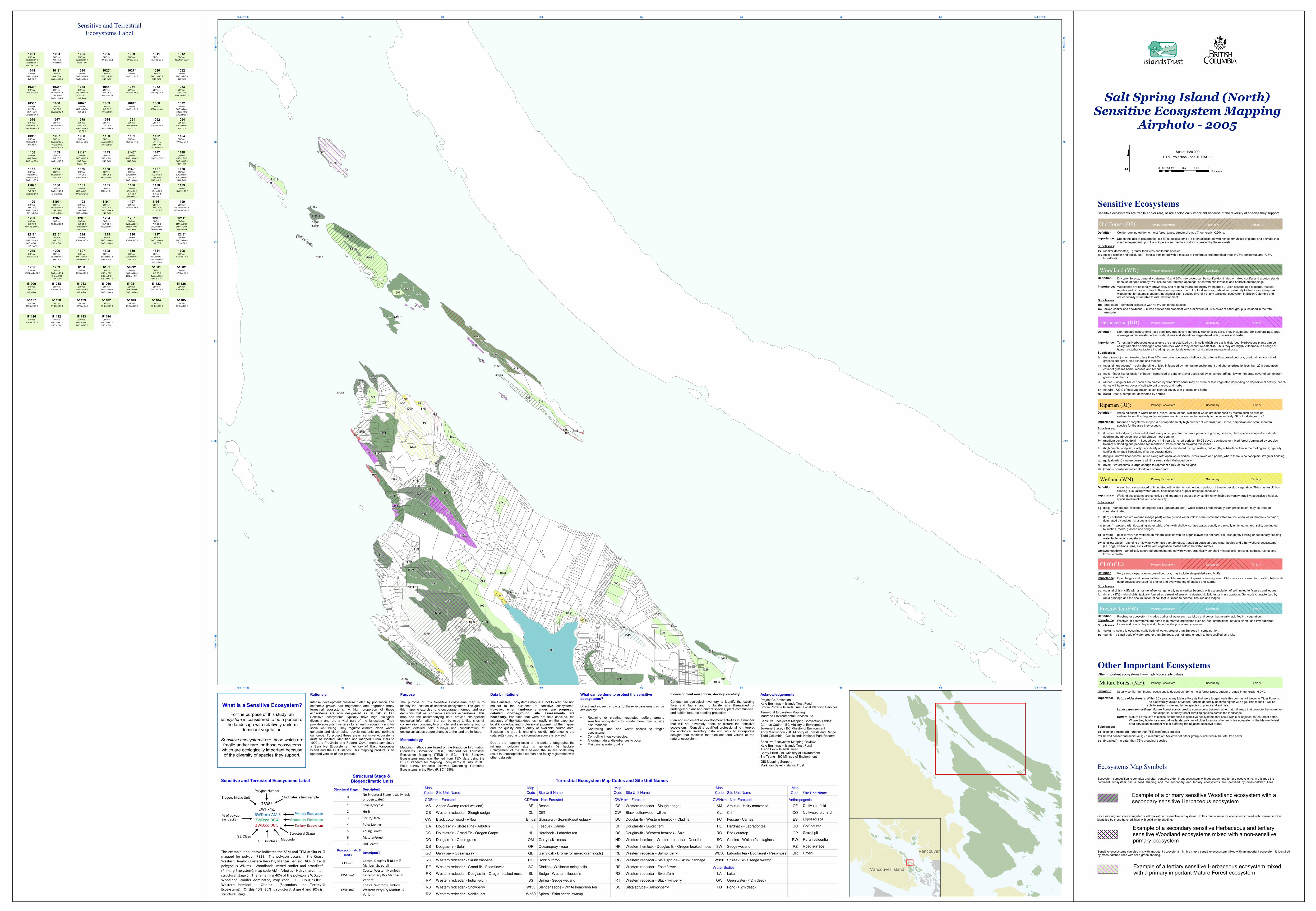
Sensitive and TerrestrialEcosystems Label
Salt SpringIsland
SaturnaIsland
MayneIsland
GalianoIsland
Vancouver Island
Vancouver
Salt Spring Island (North)Sensitive Ecosystem Mapping
Airphoto - 2005
$ UTM Projection Zone 10 NAD83Scale: 1:20,000
0 0.25 0.5 0.75 10.125Kilometers
Sensitive ecosystems are fragile and/or rare, or are ecologically important because of the diversity of species they support.Sensitive Ecosystems
Dry open forests, generally between 10 and 30% tree cover, can be conifer-dominated or mixed conifer and arbutus stands;because of open canopy, will include non-forested openings, often with shallow soils and bedrock outcroppings.
Importance:
Subclasses:
Non-forested ecosystems (less than 10% tree cover), generally with shallow soils. They include bedrock outcroppings, large openings within forested areas, spits, dunes and shorelines vegetetated with grasses and herbs.
Importance:
Subclasses:
Importance:
Areas adjacent to water bodies (rivers, lakes, ocean, wetlands) which are influenced by factors such as erosion,sedimentation, flooding and/or subterranean irrigation due to proximity to the water body. Structural stages 1 - 7.
Areas that are saturated or inundated with water for long enough periods of time to develop vegetation. This may result fromflooding, fluctuating water tables, tidal influences or poor drainage conditions.
Importance:Subclasses:
Importance:
Subclasses:
Very steep slope, often exposed bedrock, may include steep-sided sand bluffs.
Importance:Subclasses:
Freshwater ecosystem includes bodies of water such as lakes and ponds that usually lack floating vegetation.
Woodlands are nationally, provincially and regionally rare and highly fragmented . A rich assemblage of plants, insects,reptiles and birds are drawn to these ecosystems due to the food sources, habitat and proximity to the ocean. Garry oakwoodlands, for example support the highest plant species diversity of any terrestrial ecosystem in British Columbia andare especially vulnerable to rural development.
Terrestrial Herbaceous ecosystems are characterized by thin soils which are easily disturbed. Herbaceous plants can beeasily trampled or dislodged onto bare rock where they cannot re-establish. Thus they are highly vulnerable to a range ofhuman disturbance factors including residential development and various recreational uses.
Subclasses:Riparian ecosystems support a disproportionately high number of vascular plant, moss, amphibian and small mammalspecies for the area they occupy.
Wetland (WN):
Wetland ecosystems are sensitive and important because they exhibit rarity, high biodiversity, fragility, specialized habitat, specialized functions and connectivity.
Open ledges and horizontal fissures on cliffs are known to provide nesting sites. Cliff crevices are used for roosting bats while deep crevices are used for shelter and overwintering of snakes and lizards.
pd (pond) - a small body of water greater than 2m deep, but not large enough to be classified as a lake
Woodland (WD):
Herbaceous (HB):
hb (herbaceous) - non-forested, less than 10% tree cover, generally shallow soils, often with exposed bedrock, predominantly a mix ofgrasses and forbs, also lichens and mosses
cs (coastal herbaceous) - rocky shoreline or islet, influenced by the marine environment and characterized by less than 20% vegetationcover of grasses herbs, mosses and lichens.
sp (spit) - finger-like extension of beach, comprised of sand or gravel deposited by longshore drifting; low to moderate cover of salt-tolerantgrasses and herbs(dunes) - ridge or hill, or beach area created by windblown sand; may be more or less vegetated depending on depositional activity, beachdunes will have low cover of salt-tolerant grasses and herbs
du
(shrub) - >20% of total vegetation cover is shrub cover, with grasses and herbssh
bd (broadleaf) - dominant broadleaf with <15% coniferous speciesmx (mixed conifer and deciduous) - mixed conifer and broadleaf with a minimum of 25% cover of either group is included in the total
tree cover
Riparian (RI):
fm (medium bench floodplain) - flooded every 1-6 years for short periods (10-25 days); deciduous or mixed forest dominated by speciestolerant of flooding and periodic sedimentation, trees occur on elevated microsites
fh (high bench floodplain) - only periodically and briefly inundated by high waters, but lengthy subsurface flow in the rooting zone; typicallyconifer-dominated floodplains of larger coastal rivers
ff (fringe) - narrow linear communities along with open water bodies (rivers, lakes and ponds) where there is no floodplain, irregular floddinggu (gully riparian) - watercourse is within a steep sided V-shaped gullyri (river) - watercourse is large enough to represent >10% of the polygon
fl (low bench floodplain) - flooded at least every other year for moderate periods of growing season; plant species adapted to extendedflooding and abrasion, low or tall shrubs most common
(bog) - nutrient poor wetland, on organic soils (sphagnum peat), water source predominantly from precipitation; may be treed orshrub dominated
bg
fn (fen) - nutrient medium wetland (sedge peat) where ground water inflow is the dominant water source, open water channels common;dominated by sedges, grasses and mosses
ms (marsh) - wetland with fluctuating water table, often with shallow surface water, usually organically enriched mineral soils; dominatedby rushes, reeds, grasses and sedges
sp (swamp) - poor to very rich wetland on mineral soils or with an organic layer over mineral soil, with gently flowing or seasonally floodingwater table; woody vegetation
sw (shallow water) - standing or flowing water less than 2m deep, transition between deep water bodies and other wetland ecosystems (i.e. bogs, swamps, fens, etc.); often with vegetation rooted below the water surface
wm (wet meadow) - periodically saturated but not inundated with water, organically enriched mineral soils; grasses, sedges, rushes andforbs dominate
Cliff (CL):
cc (coastal cliffs) - cliffs with a marine influence, generally near vertical bedrock with accumulation of soil limited to fissures and ledges.
Freshwater (FW):
la (lake) - a naturally occurring static body of water, greater than 2m deep in some portion.
(rock) - rock outcrops not dominated by shrubsro
sh (shrub) - shrub-dominated floodplain or lakeshore
ic (inland cliffs) - inland cliffs: typically formed as a result of erosion, catastrophic failures or mass wastage. Generally characterized byrapid drainage and the accumulation of soil that is limited to bedrock fissures and ledges
Freshwater ecosystems are home to numerous organisms such as, fish, amphibians, aquatic plants, and invertebrates.Lakes and ponds play a vital role in the lifecycle of many species.
Definition:
Definition:
Definition:
Definition:
Definition:
Definition:
Importance:
Subclasses:
Other Important Ecosystems
Usually conifer-dominated, occasionally deciduous, dry to moist forest types, structural stage 6, generally >80yrs.
Mature Forest (MF):Other important ecosystems have high biodiversity values.
co (conifer dominated) - greater than 75% coniferous speciesmx (mixed conifer and deciduous) - a minimum of 25% cover of either group is included in the total tree cover
Definition:
Within 20 years, many Mature Forests that were logged early this century will become Older Forests.The biodiversity values of Mature Forests generally become higher with age. This means it will beable to sustain more and larger species of plants and animals.
Future older forests
Mature Forest stands provide connections between other natural areas that promote the movementand dispersal of many forest-dwelling species across the landscape.
Landscape connectivity
Mature Forest can minimize disturbance to sensitive ecosystems that occur within or adjacent to the forest patch.Where they border or surround wetlands, patches of older forest or other sensitive ecosystems, the Mature Forestarea serves an important role in buffering the adjacent sensitive areas.
Buffers
Example of a secondary sensitive Herbaceous and tertiarysensitive Woodland ecosystems mixed with a non-sensitive primary ecosystem
Occassionally sensitive ecosystems will mix with non-sensitive ecosystems. In this map a sensitive ecosystems mixed with non-sensitive isidentified by cross-hatched lines with solid white shading.
Example of a primary sensitive Woodland ecosystem with a secondary sensitive Herbaceous ecosystem
Ecosystem composition is complex and often contains a dominant ecosystem with secondary and tertiary ecosystems. In this map thedominant ecosystem has a solid shading and the secondary and tertiary ecosystems are identified by cross-hatched lines.
Ecosystems Map Symbols
Example of a tertiary sensitive Herbaceous ecosystem mixedwith a primary important Mature Forest ecosystem
Sensitive ecosystems can also mix with important ecosystems. In this map a sensitive ecosystem mixed with an important ecosystem is identified by cross-hatched lines with solid green shading.
Importance:
Subclasses:
Conifer-dominated dry to moist forest types, structural stage 7, generally >250yrs.
Old Forest (OF):
mx (mixed conifer and deciduous) - forests dominated with a mixture of coniferous and broadleaf trees (<75% coniferous and >25%broadleaf)
co (conifer-dominated) - greater than 75% coniferous species
Due to the lack of disturbance, old forest ecosystems are often associated with rich communities of plants and animals thatmay be dependent upon the unique environmental conditions created by these forests.
Definition:
Primary Ecosystem Secondary Tertiary
Primary Ecosystem Secondary Tertiary
Primary Ecosystem Secondary Tertiary
Primary Ecosystem Secondary Tertiary
Primary Ecosystem Secondary Tertiary
Primary Ecosystem Secondary Tertiary
Primary Ecosystem Secondary Tertiary
Primary Ecosystem Secondary Tertiary
bd (broadleaf) - greater than 75% broadleaf species
Sensitive and Terrestrial Ecosystems LabelStructural Stage &
Biogeoclimatic Units Terrestrial Ecosystem Map Codes and Site Unit NamesMap Code Site Unit Name
Map Code Site Unit Name
Map Code Site Unit Name
Map Code Site Unit Name
Map Code
AS Aspen Swamp (seral wetland) BE Beach CS Western redcedar - Slough sedge AM Arbutus - Hairy manzanita CFCS Western redcedar - Slough sedge CL Cliff CW Black cottonwood - willow CL Cliff COCW Black cottonwood - willow Em02 Glasswort - Sea-milkwort estuary DC Douglas-fir - Western hemlock - Cladina FC Fescue - Camas ESDA Douglas-fir - Shore Pine - Arbutus FC Fescue - Camas DF Douglas-fir - Sword fern HL Hardhack - Labrador tea GCDG Douglas-fir - Grand Fir - Oregon Grape HL Hardhack - Labrador tea DS Douglas-fir - Western hemlock - Salal RO Rock outcrop GPDO Douglas-fir - Onion grass OM Garry oak - moss HD Western hemlock - Western redcedar - Deer fern SC Cladina - Wallace's selaginella RWDS Douglas-fir - Salal OR Oceanspray - rose HK Western hemlock - Douglas fir - Oregon beaked moss SW Sedge wetland RZGO Garry oak - Oceanspray QB Garry oak - Brome (or mixed graminoids) RB Western redcedar - Salmonberry Wb50 Labrador tea - Bog laurel - Peat-moss URRC Western redcedar - Skunk cabbage RO Rock outcrop RC Western redcedar - Sitka spruce - Skunk cabbage Ws50 Spirea - Sitka sedge swampRF Western redcedar - Grand fir - Foamflower SC Cladina - Wallace's selaginella RF Western redcedar - FoamflowerRK Western redcedar - Douglas-fir - Oregon beaked moss SL Sedge - Western lilaeopsis RS Western redcedar - Swordfern LA LakeRP Western redcedar - Indian-plum SS Spirea - Sedge wetland RT Western redcedar - Black twinberry OW Open water (< 2m deep)RS Western redcedar - Snowberry Wf53 Slender sedge - White beak-rush fen SS Sitka spruce - Salmonberry PD Pond (> 2m deep)RV Western redcedar - Vanilla-leaf Ws50 Spirea - Sitka sedge swamp
Site Unit Name
Cultivated fieldCultivated orchard
Rural residential
Anthropogenic
Exposed soilGolf course
Road surface
Water Bodies
Gravel pit
Urban
CDFmm - Forested CDFmm - Non-Forested CWHxm - Forested CWHxm - Non-Forested
Structural Stage Descripton0 No Structural Stage (usually rock
or open water)1 Sparse/bryoid2 Herb3 Shrub/Herb4 Pole/Sapling5 Young Forest6 Mature Forest7 Old Forest
Biogeoclimatc Units Descripton
CDFmm Coastal Douglas-fir Mo i st Maritme Subz one
CWHxm1Coastal Western Hemlock Eastern Very Dry Maritme Variant
CWHxm2Coastal Western Hemlock Western Very Dry Maritme Variant
The example label above indicates the SEM and TEM atri but es mapped for polygon 7838. The polygon occurs in the Coast Western Hemlock Eastern Very Dry Maritme var i ant ; 60% of the polygon is WD:mx - Woodland: mixed conifer and broadleaf (Primary Ecosystem), map code AM - Arbutus - Hairy manzanita, structural stage 5. The remaining 40% of the polygon is WD:co - Woodland: conifer dominated, map code DC - Douglas-fir - Western hemlock – Cladina (Secondary and Tertar y Ecosystems). Of this 40%, 20% is structural stage 4 and 20% is structural stage 5.
SE Subclass
Biogeoclimatic Unit * Indicates a field sample
% of polygon (as decile)
SE Class
Polygon Number
Mapcode Structural Stage
Secondary Ecosystem Tertiary Ecosystem
Primary Ecosystem
7838* CWHxm1
6WD:mx AM 5 2WD:co DC 4 2WD:co DC 5
What is a Sensitive Ecosystem?
For the purpose of this study, an ecosystem is considered to be a portion of
the landscape with relatively uniform dominant vegetation.
Sensitive ecosystems are those which are fragile and/or rare, or those ecosystems
which are ecologically important because of the diversity of species they support.
Rationale Intense development pressure fueled by population and economic growth has fragmented and degraded many terrestrial ecosystems. A high proportion of these ecosystems are now designated as ‘at risk’ in BC. Sensitive ecosystems typically have high biological diversity and are a vital part of the landscape. They provide ecosystem services for a healthy economy and for social well being. They regulate climate, clean water, generate and clean soils, recycle nutrients and pollinate our crops. To protect these areas, sensitive ecosystems must be located, identified and mapped. From 1993 to 1999 the Provincial and Federal Governments completed a Sensitive Ecosystems Inventory of East Vancouver Island and the Gulf Islands. This mapping product is an updated version of that product.
Purpose The purpose of this Sensitive Ecosystems map is to identify the location of sensitive ecosystems. The goal of this mapping exercise is to encourage informed land use decisions that will conserve sensitive ecosystems. This map and the accompanying data provide site-specific ecological information that can be used to flag sites of conservation concern, to promote land stewardship and to prompt detailed field surveys and consideration of ecological values before changes to the land are initiated. Methodology Mapping methods are based on the Resource Information Standards Committee (RISC) Standard for Terrestrial Ecosystem Mapping (TEM) in BC. This Sensitive Ecosystems map was themed from TEM data using the RISC Standard for Mapping Ecosystems at Risk in BC. Field survey protocols followed Describing Terrestrial Ecosystems in the Field (RISC 1998).
Data Limitations The Sensitive Ecosystems map is a tool to alert decision makers to the existence of sensitive ecosystems. However, when land-use changes are proposed, detailed on-the-ground site assessments are necessary. For sites that were not field checked, the accuracy of the data depends heavily on the expertise, local knowledge, and professional judgment of the mapper and the quality and quantity of available source data. Because the area is changing rapidly, reference to the data set(s) used as the information source is advised. Due to the mapping scale of the aerial photographs, the minimum polygon size is generally ½ hectare. Enlargement of the data beyond the source scale may result in unacceptable distortion and faulty registration with other data sets.
What can be done to protect the sensitive ecosystems? Direct and indirect impacts to these ecosystems can be avoided by: Retaining or creating vegetated buffers around
sensitive ecosystems to isolate them from outside disturbances;
Controlling land and water access to fragile ecosystems;
Controlling invasive species; Allowing natural disturbances to occur; Maintaining water quality
If development must occur, develop carefully! Conduct an ecological inventory to identify the existing flora and fauna and to locate any threatened or endangered plant and animal species, plant communities, and habitat features needing protection. Plan and implement all development activities in a manner that will not adversely affect or disturb the sensitive ecosystem. Consult a qualified professional to interpret the ecological inventory data and work to incorporate designs that maintain the functions and values of the natural ecosystem.
Acknowledgements:
Project Co-ordination: Kate Emmings – Islands Trust Fund Brodie Porter – Islands Trust, Local Planning Services
Terrestrial Ecosystem Mapping: Madrone Environmental Services Ltd.
Sensitive Ecosystem Mapping Conversion Tables: Carmen Cadrin - BC Ministry of Environment Jo-Anne Stacey - BC Ministry of Environment Andy MacKinnon - BC Ministry of Forests and Range Todd Golumbia - Gulf Islands National Park Reserve
Sensitive Ecosystem Mapping Review: Kate Emmings – Islands Trust Fund Alison Fox – Islands Trust Corey Erwin - BC Ministry of Environment Sid Tsang - BC Ministry of Environment
GIS Mapping Support: Mark van Bakel - Islands Trust
CDFmm 5WD:co DA 4 3WD:co DA 5 2WD:mx DO 4
1001 CDFmm 7YF RK 5
3MF:co RK 6
1004 CDFmm
6WD:co DA 4 4HB:ro RO 1
1005 CDFmm
10WD:co DA 5
1006 CDFmm
10WD:co DA 3
1009 CDFmm
10MF:co DS 6
1011 CDFmm
10WN:sw OW 0
1012
CDFmm 6WD:co DA 4
4YF DS 5
1014 CDFmm 6NA DS 4
4WD:co DA 5
1018* CDFmm
5WD:co DA 4 5WD:co DA 4
1020 CDFmm
5MF:co RK 6 5NA RW 0
1025* CDFmm
10MF:co RK 6
1027* CDFmm
7WD:co DO 5 3NA RW 0
1030 CDFmm
9WD:co DO 4 1NA RW 0
1032
CDFmm 10WD:co DA 5
1033* CDFmm
6WD:co DO 4 2NA RW 0
2WD:co DA 5
1035* CDFmm
6WD:bd OM 4 3CL:cc CL 1 1NA RW 0
1038 CDFmm 8FS CF 2
2FW:pd PD 0
1045* CDFmm
10MF:co RK 6
1051 CDFmm
10WN:sp CS 4
1052 CDFmm 7NA DG 4
3WN:sp Ws50 3
1053
CDFmm 6NA DS 4 2NA RW 0
2WD:co DA 4
1056* CDFmm 7NA DS 3
3WD:co DO 4
1060 CDFmm
6MF:co DS 6 4YF DS 5
1062* CDFmm 6YF RK 5
4MF:co RK 6
1063 CDFmm
10MF:co RK 6
1064* CDFmm
10FW:la LA 0
1068 CDFmm
5WD:co DA 4 3HB:cs FC 2 2WD:bd QB 3
1072
CDFmm 7WN:sp RC 4
3WN:sp Ws50 3
1076 CDFmm
6WD:co DA 4 4HB:hb SC 1
1077 CDFmm 6NA DS 4
2WD:co DA 5 2NA DS 4
1079 CDFmm 7NA DS 4
3WD:co DA 5
1084 CDFmm
7MF:co DS 6 3YF DG 5
1091 CDFmm
10MF:co RF 6
1092 CDFmm
5WD:co DA 4 5YF DS 5
1094
CDFmm 6MF:co RF 6
4NA RF 4
1095* CDFmm
5WD:co DO 5 3HB:cs FC 2 2WD:bd QB 3
1097 CDFmm
10MF:co DG 6
1098 CDFmm
7WD:co DA 6 3MF:co DS 6
1100 CDFmm
10MF:co RK 6
1101 CDFmm 5YF RK 5 3NA RW 0
2WD:mx OM 3
1102 CDFmm
10WD:co DA 4
1104
CDFmm 6NA RW 0
4WD:mx DO 4
1106 CDFmm 6YF DS 5
4WD:co DO 5
1109 CDFmm
7WD:bd DO 4 2NA RW 0
1HB:ro RO 1
1112* CDFmm
5HB:ro RO 1 5NA RW 0
1143 CDFmm
7WD:co DA 5 3NA RW 0
1146* CDFmm
10MF:co DG 6
1147 CDFmm
6HB:cs FC 2 3WD:bd QB 4
1NA RW 0
1148
CDFmm 4HB:cs FC 2 4WD:co DA 4 2WD:bd QB 4
1152 CDFmm
6WD:co DA 4 4NA DS 4
1153 CDFmm 5NA DS 3
5WD:co DA 4
1156 CDFmm 6YF DS 5
4WD:co DA 4
1158 CDFmm
5WD:co DA 4 3NA DS 4
2WD:co DA 4
1160* CDFmm
6CL:cc CL 1 2NA RW 0
2HB:hb SC 1
1167 CDFmm
5WD:co DA 5 3WD:co DA 4
2NA RW 0
1168
CDFmm 7YF DS 5
3WD:co DA 4
1169* CDFmm
5WD:bd QB 4 5HB:cs FC 2
1180 CDFmm
8HB:hb SC 1 2WD:mx OM 3
1181 CDFmm
10CL:cc CL 1
1185 CDFmm
5CL:cc CL 1 3NA BE 1
2HB:hb SC 1
1186 CDFmm
5CL:cc CL 1 3NA BE 1
2HB:hb SC 1
1188 CDFmm
10MF:co DG 6
1189
CDFmm 7YF DS 5
2WD:co DA 5 1MF:co DG 6
1190 CDFmm
5WD:co DA 5 3NA RW 0
2MF:co RK 6
1191* CDFmm 6FS CF 2 2NA RW 0
2MF:co RK 6
1193 CDFmm 6NA DS 4
3WD:co DA 5 1NA RW 0
1194* CDFmm
10MF:co RK 6
1197 CDFmm 9YF DS 5
1CL:cc CL 1
1198* CDFmm
6WN:ms Em02 2 4WN:ms Em02 2
1199
CDFmm 6YF RF 5
4WN:ms Em05 2
1200 CDFmm
10HB:ro RO 1
1202* CDFmm 6YF DS 5
3MF:co RK 6 1WN:sp RV 4
1203* CDFmm 6NA DS 4
4WD:co DA 4
1204 CDFmm
7WD:co DA 5 2HB:ro RO 1 1NA RW 0
1207 CDFmm 7YF DS 5
2WD:co DA 5 1MF:co DG 6
1208* CDFmm
5MF:co DS 6 3MF:co DG 6 2MF:co DS 6
1211*
CDFmm 6WD:co DA 5 3HB:ro RO 1 1NA RW 0
1212* CDFmm 8YF DS 5
2HB:ro RO 1
1213* CDFmm
10HB:ro RO 1
1214 CDFmm
7WD:co DA 4 3WD:co DA 4
1215 CDFmm
10HB:ro RO 1
1216 CDFmm
8WD:co DA 5 2NA BE 1
1217 CDFmm
9WD:co DA 5 1CL:cc CL 1
1218*
CDFmm 10WD:co DA 5
1219 CDFmm
6WD:co DA 6 4YF DS 5
1220 CDFmm
8MF:co DG 6 2WN:sp Ws50 2
1607 CDFmm
5WD:bd QB 3 5HB:ro RO 1
1608 CDFmm
6WD:co DA 4 4YF DS 5
1610 CDFmm
7WD:co DA 4 2WD:co DA 5 1HB:cs FC 2
1611 CDFmm
10MF:co RF 6
1705
CDFmm 10WN:ms Em02 2
1706 CDFmm
5WD:bd QB 4 3HB:cs FC 2 2NA RW 0
1709 CDFmm
10HB:ro RO 1
6180 CDFmm
7HB:ro RO 1 2HB:hb SC 1 1WD:bd GO 3
6181 CDFmm
8WD:co DA 4 2HB:ro RO 1
50992 CDFmm 5YF DS 5
4WD:co DA 5 1HB:ro RO 1
51001 CDFmm
10WD:co DA 3
51002
CDFmm 9NA DS 4
1HB:ro RO 1
51009 CDFmm
10MF:co DS 6
51018 CDFmm
9WD:co DA 6 1HB:ro RO 1
51043 CDFmm
7WD:co DA 6 3WD:co DA 3
51066 CDFmm
7MF:co DS 6 3WD:co DA 6
51081 CDFmm
10WD:co DA 6
51123 CDFmm
10HB:ro RO 1
51126
CDFmm 10HB:ro RO 1
51127 CDFmm
10HB:ro RO 1
51128 CDFmm
10WD:co DA 5
51129 CDFmm
10HB:ro RO 1
51182 CDFmm
10HB:ro RO 1
51183 CDFmm
10HB:ro RO 1
51184 CDFmm
10HB:ro RO 1
51185
CDFmm 10HB:ro RO 1
51186 CDFmm
7WD:bd GO 3 3HB:ro RO 1
51192 CDFmm
8HB:ro RO 1 2WD:bd GO 3
51193 CDFmm
7WD:bd GO 3 3HB:ro RO 1
51194