Embed Size (px)
Citation preview
Ecological Engineering 25 (2005) 240–251
Salt marsh vegetation recovery at salt hay farm wetlandrestoration sites on Delaware Bay
Raymond L. Hinklea,∗, William J. Mitschb
a URS Corporation, 201 Willowbrook Boulevard, Wayne, NJ 07470, USAb Olentangy River Wetland Research Park, The Ohio State University, 352 West Dodridge Street, Columbus, OH 43202, USA
Received 29 February 2004; accepted 8 April 2005
Abstract
Public Service Enterprise Group’s (PSEG) Estuary Enhancement Program (EEP) restored normal daily tidal inundation anddrainage to three previously diked farm sites totaling 1780 ha during the period 1996–1998 along the shoreline of the DelawareEstuary in New Jersey, USA. Normal tidal exchange was either prevented or altered by the construction of dikes and watercontrol structures that were used to promote the growth of high marsh “salt hay” species, such as salt meadow cordgrass(Spartina patens) and salt grass (Distichlis spicata) at elevations below mean high tide. These elevations would normally supportlow marsh species, such as smooth cordgrass (Spartina alterniflora). Prior to restoration these sites were either un-vegetated dueto excessive ponding associated with poor drainage or vegetated with “salt hay” species as well as common reed (Phragmitesaustralis). ExtensiveS. alterniflora marshes occur in the vicinity of each site at similar elevations and these marshes were relied
ngeferencem (GIS)ritiesd site isponents
t
en
d
a
on as the source of seed for the re-establishment ofS. alterniflora on the restoration sites; thus, no other planting or seediwas implemented to initiate re-vegetation. Vegetation coverage at the restoration sites as well as a naturally restored rmarsh was determined during 1996–2003 utilizing geo-referenced remote sensing data and geographic information systeanalyses. Coverage byS. alterniflora or other desirable low marsh vegetation exceeded that required by New Jersey authoto meet the restoration goal at two sites 8 years ahead of the anticipated 12-year period and re-vegetation of the thirexpected to meet its goal within the established 12-year period. Annual vegetation coverage data have been integral comof an adaptive management program utilized by PSEG to manage the restoration process at each of the sites.© 2005 Elsevier B.V. All rights reserved.
Keywords: Spartina alterniflora; Spartina patens; Delaware Bay; Coastal restoration; Salt hay; Wetland restoration; Adaptive managemen
∗ Corresponding author. Tel.: +1 973 812 6886;fax: +1 973 785 0023.
E-mail address: Ray [email protected] (R.L. Hinkle).
1. Introduction
Salt marshes can be restored most easily whnatural hydrologic conditions are restored (Sinicropeet al., 1990; Teal and Weinstein, 2002; Mitsch anJørgensen, 2004). Opportunities for this hydrologicrestoration exist along the east coast of North Americ
0925-8574/$ – see front matter © 2005 Elsevier B.V. All rights reserved.doi:10.1016/j.ecoleng.2005.04.011
R.L. Hinkle, W.J. Mitsch / Ecological Engineering 25 (2005) 240–251 241
where former “salt hay farms”, reclaimed years agofrom salt marshes by isolating the marshes from tidalfluxes with coastal dikes, are once again subjectedto tidal inundation. These salt hay farm sites hadbeen managed to optimize salt hay, a natural haycrop comprised primarily of salt meadow cordgrass(Spartina patens), salt grass (Distichlis spicata), andblack grass (Juncus gerardii). The salt hay crop wastypically harvested up to three times each growingseason and sold for various commercial uses.Philipp(2005)described construction of dikes and water con-trol structures that allowed the outward flow of waterfrom the farmed area, provided controlled, scheduledflooding to support the high marsh vegetation typicalof salt hay farms, and prevented the normal tidalexchange with Delaware Bay. Thus, these areas, arti-ficially maintained as high marsh, were at elevationsthat would normally support low marsh species, suchas smooth cordgrass (Spartina alterniflora).
Public Service Enterprise Group’s (PSEG) EstuaryEnhancement Program (EEP) restored normal dailytidal inundation and drainage to three previouslydiked farm sites totaling 1780 ha during the period1996–1998. These sites are located along the shorelineof the Delaware Estuary in the State of New Jerseyin Eastern USA (Fig. 1 inTeal and Peterson, 2005).PSEG began the restorations in 1996 as requiredby a New Jersey Pollutant Discharge EliminationSystem (NJPDES) Permit No. NJ0005622. Removalof dikes and water control structures and dredgingo witht agec )d d byP
calet reat sitea ndsa ari-a ems(g theb tora-t of ar tionsa d toe ecies
utilization and overall function, and measure the spa-tial and temporal variability of the restored wetlandsystem. The effects of land use, position in a water-shed, and/or position relative to the estuary mouth oropen ocean must be considered when a reference marshis selected. Additional characteristics, such as salin-ity regime, tidal range, marsh vegetation, and creekgeomorphology, are also essential considerations. Therelative size of the reference marshes should also becomparable to the restoration sites to ensure that nat-ural dynamics are consistent. Consideration of eachof these factors during design of the wetland restora-tion program will ensure the selection of referencewetlands with environmental conditions comparableto the restoration sites. The use of reference marshecosystems as an essential component in the design andevaluation of the success of wetland restoration projectsis discussed byKentula et al. (1992), Brinson (1993),Smith et al. (1995), andMitsch and Jørgensen (2004).The use of reference marshes to monitor the successof restoration projects has also been integral to a num-ber of other wetland restoration programs including theNational Science Foundation (NSF) Long Term Eco-logical Research (LTER) Program, the San FranciscoBay Marsh Restoration Program, and the United StatesEnvironmental Protection Agency (USEPA) WetlandsResearch Program (WRP). In each of these programs,combinations of natural and restored marsh systemshave been used for comparison with marsh mitigation,restoration, and creation projects.
m,w uaryw erima armrm phs,r idalc rrentm llyr pro-c n fort rarei ong-t theu eria.T s nat-u gingm red
f new channel systems occurred through 1998,he restoration of daily tidal inundation and drainompleted by March 1998.Weishar et al. (2005escribes the overall restoration approach useSEG at all of the salt hay farm sites.Measuring the progress and “success” of large-s
idal restorations is difficult because of the large ao be monitored and the dynamic nature of thefter tidal flooding is re-introduced. Because wetlare inherently complex ecological systems with vble functions and interactions with adjacent systKentula et al., 1992; Mitsch and Gosselink, 2000), aeneralized model or framework for establishingounds of expectation for a coastal wetland res
ion project is not feasible. Instead, the selectioneference wetland that spans the range of condinticipated at the restoration site(s) is typically usestablish baseline ecological conditions, assess sp
As part of PSEG’s wetland restoration prograetland systems throughout the Delaware Estere evaluated as standards to establish intnd final success criteria for PSEG salt hay festoration sites (Weinstein et al., 1997). Candidatearshes were selected from aerial photogra
eviews of historical records, and evaluations of treek geomorphologies, marsh histories, and cuarsh characteristics. Both “pristine” and “natura
estored” marshes were included in the selectioness to establish appropriate bounds of expectatiohe restoration sites. Pristine marsh systems, whilen the estuary, provide the bases for establishing lerm goals for restoration success by establishingppermost “extent” of the restoration success crithese systems may not be as relevant, however, arally restored marshes to a young, rapidly chanarsh system. The incorporation of naturally resto
242 R.L. Hinkle, W.J. Mitsch / Ecological Engineering 25 (2005) 240–251
marsh systems into the process provides the midrangeextent of the bounds of expectation for the success ofthe restoration sites. The lowest bound of expectationfor the success criteria would be associated with themost recently restored sites (Kentula et al., 1992).
The final selection of reference marshes for thePSEG salt hay farm wetland restoration sites wasan iterative process requiring coordination with theregulatory and scientific communities, including theManagement Plan Advisory Committee (MPAC)and the Monitoring Advisory Committee (MAC).Site specific input was obtained from the scientificcommunity regarding the selection of a referencemarsh was also solicited during a workshop held inJuly 1995. Participants at this workshop includedPSEG staff, consultants to PSEG, and invited scientistsfrom regional universities and research centers. Topicsdiscussed at the workshop included:
• a general overview of salt marsh function, as devel-oped through the review of the history and charac-terization of wetlands in the Delaware Estuary;
• the use of reference marshes for gauging the progressof restoration efforts;
• the appropriate requirements and special conditionsfor evaluating progress in the wetland restorationprogram;
• the bounds of expectation for overall success of therestoration efforts.
Workshop participants identified and discussed thea wareE hese,t oursea , andW ho-t e ino atet h fullr thata salth al of7 shs isb uc-c ni lish“ tionp
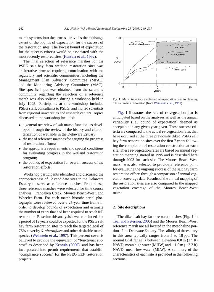
Fig. 1. Marsh trajectory and bound of expectation used in planningthis salt marsh restoration (fromWeinstein et al., 1997).
Fig. 1 illustrates the rate of re-vegetation that isanticipated based on the analyses as well as the annualvariability (i.e., bound of expectation) deemed asacceptable in any given year given. These success cri-teria are compared to the actual re-vegetation rates thathave occurred at the three previously diked PSEG salthay farm restoration sites over the first 7 years follow-ing the completion of restoration construction at eachsite. These re-vegetation rates are based on annual veg-etation mapping started in 1995 and is described herethrough 2003 for each site. The Moores Beach-Westmarsh was also selected to provide a reference pointfor evaluating the ongoing success of the salt hay farmrestoration efforts through a comparison of annual veg-etation coverage data. Results of the annual mapping ofthe restoration sites are also compared to the mappedvegetation coverage of the Moores Beach-Westmarsh.
2. Site descriptions
The diked salt hay farm restoration sites (Fig. 1 inTeal and Peterson, 2005) and the Moores Beach-Westreference marsh are all located in the mesohaline por-tion of the Delaware Estuary. The salinity of the estuaryin this area typically ranges from 5 to 18 ppt. Thenormal tidal range is between elevation 0.8 m (2.5 ft)NAVD, mean high water (MHW) and−1.0 m (−3.3 ft)NAVD, mean low water (MLW). A summary of thec ings
ppropriateness of 12 candidate sites in the Delastuary to serve as reference marshes. From t
hree reference marshes were selected for time cnalysis: Oranoaken Creek, Moores Beach-Westheeler Farm. For each marsh historic aerial p
ographs were reviewed over a 25-year time framrder to develop bounds of expectation and estim
he number of years that had been required to reacestoration. Based on this analysis it was concludedperiod of 12 years could be expected for the PSEGay farm restoration sites to reach the targeted go6% cover byS. alterniflora and other desirable marpecies (Weinstein et al., 1997). This percent coverelieved to provide the equivalent of “functional sess” as described byKentula (2000), and has bee
ncorporated into permit requirements that estabcompliance success” for the PSEG EEP restorarojects.
haracteristics of each site is provided in the followections.
R.L. Hinkle, W.J. Mitsch / Ecological Engineering 25 (2005) 240–251 243
2.1. Dennis Township salt hay farm
The 149 ha restoration area of the Dennis Townshipsite was diked in the 1950s and this area continued to befarmed for salt hay until acquired by PSEG in 1995. Atthe time of acquisition, a number of minor breaches haddeveloped in the perimeter dikes, resulting in floodingof some salt hay fields and the initiation of a returnof S. alterniflora cover in limited areas of the wetlandrestoration area.Phragmites australis also dominatedportions of the site (e.g., dikes and channel margins).PSEG’s restoration plan included the creation of sixnew inlets and associated channels that were designedto convey the volume of water during each tidal cyclerequired to fully inundate the wetland restoration area.Restoration construction activities were completed inAugust 1996, after which the entire area was subjectedto normal daily tidal inundation and drainage.
2.2. Maurice River Township salt hay farm
The tidal restoration area of this site encompasses459 ha. Historically, perimeter dikes were constructedand water control structures were installed to elimi-nate normal tidal inundation over the area. As recentlyas 1992, a large portion of the restoration area wasvegetated with salt hay species. The northeastern por-tion of the site was vegetated with dense stands ofPhragmites australis. During 1992, breaches in theperimeter dikes resulted in un-controlled flooding oft ingf ingd ingm neda nels,p ingm en-t
off els.R ine d ton
2
ialT for
salt hay farming for at least three generations, untilstorms in early 1996 created several breaches in theperimeter dikes. These breaches allowed flooding ofmost of the salt hay farming areas. Once flooded,these areas did not fully drain during low tide periodsbecause the volume of water impounded behind thedikes was greater than the breaches could conveyback to the estuary during low tide. As a result, mostof the restoration area was permanently flooded withup to 0.5 m of water during the growing season of1996. Salt hay farming was continued on only limitedareas in the western portion of the site after that date.PSEG’s restoration plan for this site included thecreation of 10 inlets and associated channel systems.The construction phase was completed in the fall of1997.
2.4. Moores Beach-West reference marsh
Moores Beach-West is a former salt hay farm thathas restored “naturally” following storm damage to itsperimeter dikes in 1972. Most of the area that wasin salt hay production in 1960 had been converted tolow marsh dominated byS. alterniflora by 1992. Noimprovements to the inlets or channels systems weremade to promote tidal inundation and drainage of therestored low marsh. The marsh area designated as thereference site encompasses approximately 550 ha.
3
ns meda onv ationc ive,f m2 )fi ,a opa olorf reda then eda gt n-d ain
he farming area as well as adjoining areas, includorested areas that were protected from tidal flooduring the period that the perimeter dikes were beaintained. Because the breaching was un-plannd there were no adequately sized drainage chanonding occurred over much of the area, eliminatuch of the vegetative cover, including the aforem
ioned forest areas.PSEG’s restoration plan included the creation
our new or enlarged inlets and associated channestoration construction activities were completedarly 1998, after which the entire area was subjecteormal daily tidal inundation and drainage.
.3. Commercial Township salt hay farm
The tidal restoration area of the Commercownship site covers 1171 ha and had been used
. Mapping methods
Vegetation mapping of the wetland restoratioites and the reference marshes has been perfornnually since 1995 to provide a pre-restoratiegetative cover baseline and assess annual vegetover change. This mapping used infrared-sensitalse color reversal Kodak Aerochrome Infrared Fil443, generally referred to as color infrared (CIRlm. CIR photography is a three-layer (cyan, yellownd magenta) film that has been widely used for crnd natural vegetation studies because image c
ormation is dependent upon reflected energy in thend green portion of the visible spectrum as well asear-infrared. CIR aerial photography was acquirt a nominal scale of 1:9600 (1 cm = 60 m) durin
he peak growing season each year following staard specifications for stereo coverage. To maint
244 R.L. Hinkle, W.J. Mitsch / Ecological Engineering 25 (2005) 240–251
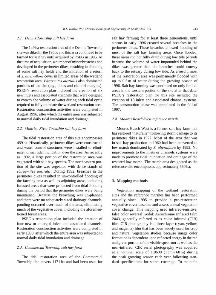
Table 1Cover type descriptions utilized for mapping of PSEG salt hay farm wetland restoration sites and reference marshes
Cover type designation Description
Spartina-dominated/other desirable marsh vegetation Dominated by species, such as smooth cordgrass (Spartina alterniflora), saltmeadow cordgrass (S. patens), salt marsh bulrush (Scirpus robustus),narrow-leaved cattail (Typha angustifolia), broad-leaved cattail (T. latifolia),walter millet (Echinochloa walteri), water hemp (Amaranthus cannabinus), andarrow-arum (Peltandra virginica)
Phragmites-dominated Supporting either monotypic stands of common reed (Phragmites australis) ormixed stands where common reed is the dominant species present
Non-vegetated marsh plain Mud flats, with <30% vegetative cover; inundated forest areas prior torevegetation; dredged material (high marsh creation areas); areas covered by wrack
Internal water Unvegetated internal portions of each site that are typically hydrologically isolatedand remain inundated at low tide
Channels Tidal creeks and channels greater than 1.5 m (5 ft) wideUpland/developed land Upland areas that occur adjacent to or within the wetland restoration area boundary
consistency in mapping, the time of photographing wasselected to provide images acquired during mid-day atlow tide.
Original CIR images were processed using stan-dard procedures for the production of digital orthopho-tographs, which were used to create digital maps ofvegetation coverage on each site. On-screen digitizingof cover type polygon boundaries utilizing the digitalorthophotographs was performed using AutoCAD LT2000TM software. Vegetation coverage of each site wasmapped utilizing the species-dominated cover typeslisted in Table 1. Each polygon mapped in this waywas assigned an identifying code consisting of the year,cover type designation, and a sequential polygon num-ber for that cover type. AutoCAD Map 2TM Release14.0 software was used to further analyze the data. Theminimum mapping unit (MMU) employed for the dig-itizing effort was 0.4 ha. In order to be identified as agiven cover type, it is generally necessary that the veg-etative cover of the polygon exceed 30%. Thus areasmapped as “mud flat” may support vegetation belowthe 30% mapping threshold. This is consistent with theapproach used by the U.S. Fish and Wildlife Service inthe preparation of National Wetland Inventory (NWI)maps, where areas supporting less than 30% cover areidentified as un-vegetated (Tiner, personal communi-cation, 1998).
4. Results and discussion
oe e
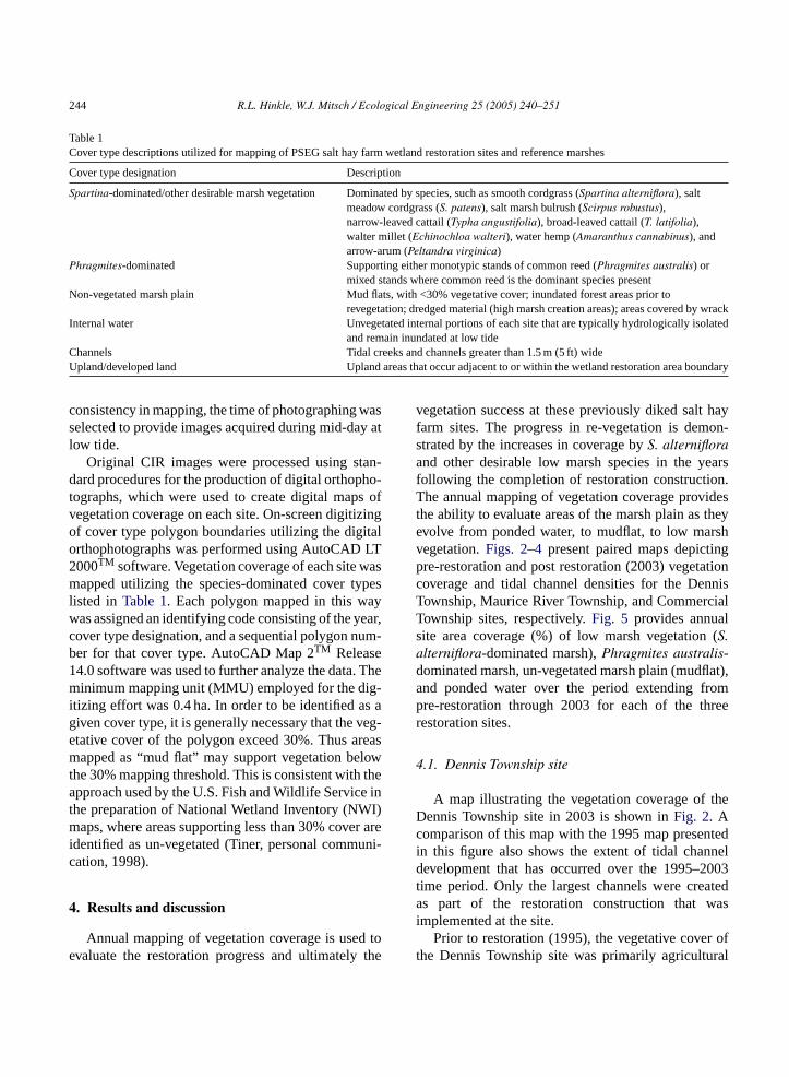
vegetation success at these previously diked salt hayfarm sites. The progress in re-vegetation is demon-strated by the increases in coverage byS. alternifloraand other desirable low marsh species in the yearsfollowing the completion of restoration construction.The annual mapping of vegetation coverage providesthe ability to evaluate areas of the marsh plain as theyevolve from ponded water, to mudflat, to low marshvegetation.Figs. 2–4present paired maps depictingpre-restoration and post restoration (2003) vegetationcoverage and tidal channel densities for the DennisTownship, Maurice River Township, and CommercialTownship sites, respectively.Fig. 5 provides annualsite area coverage (%) of low marsh vegetation (S.alterniflora-dominated marsh),Phragmites australis-dominated marsh, un-vegetated marsh plain (mudflat),and ponded water over the period extending frompre-restoration through 2003 for each of the threerestoration sites.
4.1. Dennis Township site
A map illustrating the vegetation coverage of theDennis Township site in 2003 is shown inFig. 2. Acomparison of this map with the 1995 map presentedin this figure also shows the extent of tidal channeldevelopment that has occurred over the 1995–2003time period. Only the largest channels were createdas part of the restoration construction that wasi
oft al
Annual mapping of vegetation coverage is used tvaluate the restoration progress and ultimately th
mplemented at the site.Prior to restoration (1995), the vegetative cover
he Dennis Township site was primarily agricultur
R.L. Hinkle, W.J. Mitsch / Ecological Engineering 25 (2005) 240–251 245
Fig. 2. Vegetation cover maps of Dennis Township salt marsh restoration site in 1995 and 2003.
246 R.L. Hinkle, W.J. Mitsch / Ecological Engineering 25 (2005) 240–251
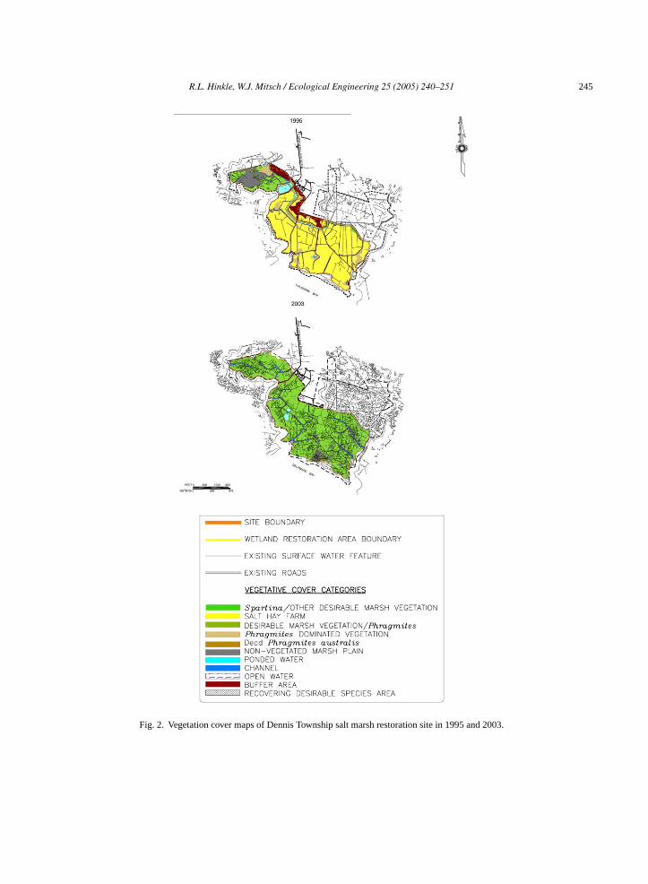
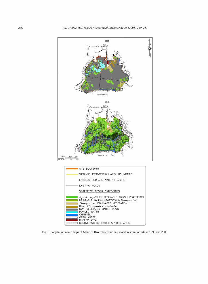
Fig. 3. Vegetation cover maps of Maurice River Township salt marsh restoration site in 1996 and 2003.
R.L. Hinkle, W.J. Mitsch / Ecological Engineering 25 (2005) 240–251 247
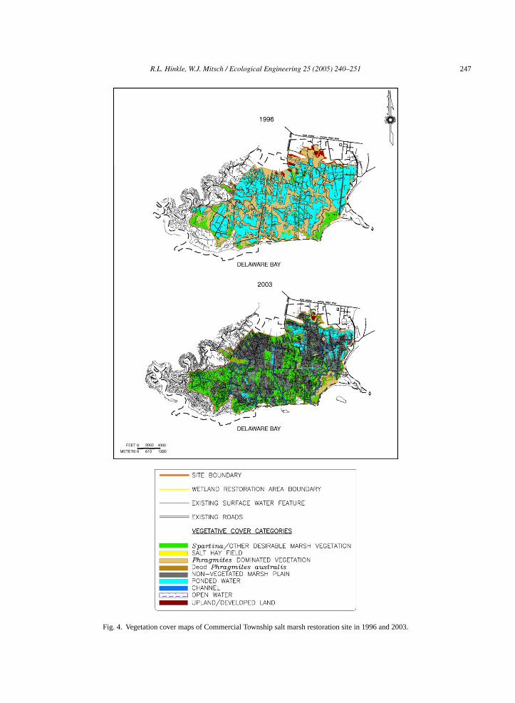
Fig. 4. Vegetation cover maps of Commercial Township salt marsh restoration site in 1996 and 2003.
248 R.L. Hinkle, W.J. Mitsch / Ecological Engineering 25 (2005) 240–251
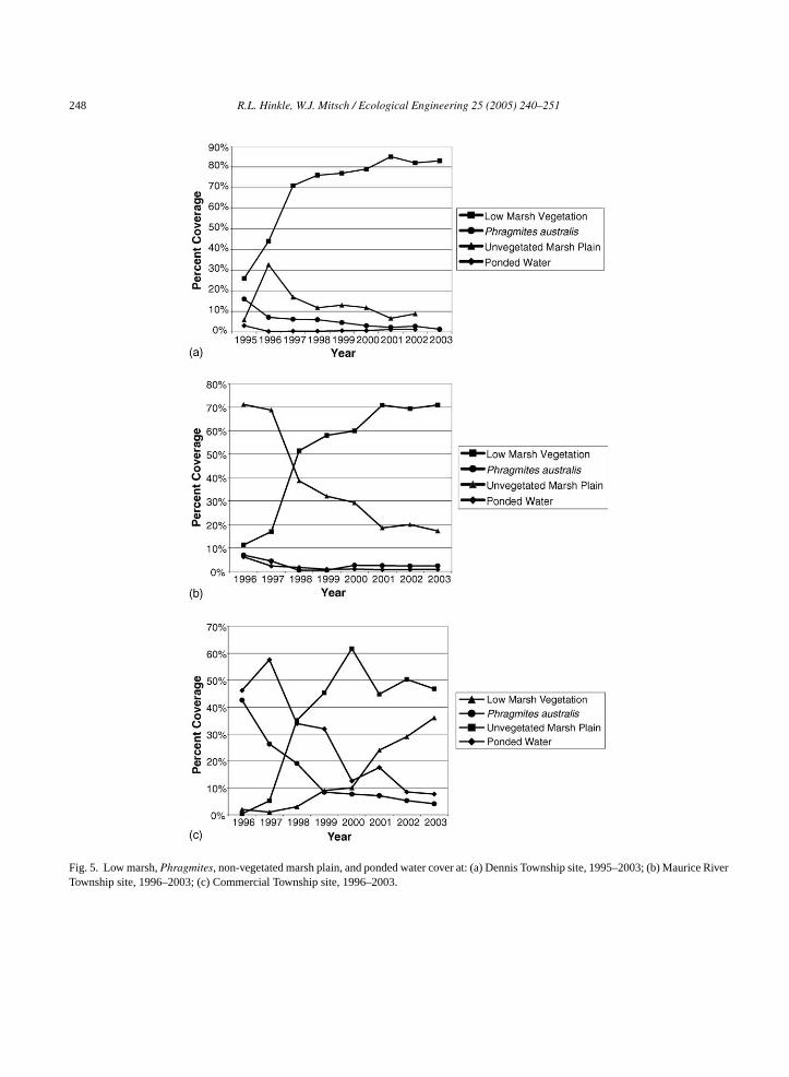
Fig. 5. Low marsh,Phragmites, non-vegetated marsh plain, and ponded water cover at: (a) Dennis Township site, 1995–2003; (b) Maurice RiverTownship site, 1996–2003; (c) Commercial Township site, 1996–2003.
R.L. Hinkle, W.J. Mitsch / Ecological Engineering 25 (2005) 240–251 249
salt hay fields andP. australis stands, which togetherextended over 56% of the restoration area. Most of thisvegetation coverage was dominated byS. patens andD. spicata. S. alterniflora dominanted over 25% of thesite, including in mixed stands withS. patens andP.australis. Mud flats and ponded water represented 9%of the site and primary channels (greater than 1.5 mwide) represented 2% of the site.
Because the Dennis Township site was at an ele-vation between mean tide (MT) and mean high waterand the restoration design provided for the appropriatehydroperiod following construction activities, most ofthe salt hay crop vegetation andP. australis cover waseliminated following the return of normal daily tidalflows in late summer of 1996 (Fig. 5a). During the1997 growing season,S. alterniflora seedlings natu-rally established from nearby sources over much of theformer salt hay areas and expanded to 76% cover ofthe site in 1998. Between 2000 and 2003,S. alterni-flora coverage ranged between 79 and 85% of the sitearea, andP. australis coverage has represented only1–3% of the site area.
While salt hay fields were virtually eliminated bytidal flooding, high marsh species have established onhigher elevations around the perimeter of the site thatare in the normal elevation range for these species (i.e.,above mean high water). These include areas wherematerial that was dredged to create the new inletsand channels was placed in a controlled manner toproduce a final elevation that was within the rangeo hs % oft
r re-v onsf in1 f thati wasr
4
iceR iss ofn ionc ited lain
sediment associated with incomplete tidal exchangebetween Delaware Bay and the site through un-planned breaches in the salt hay farm dikes. Thus, thepredominant cover types present in 1996 on the sitewere non-vegetated marsh plain and ponded waterareas, which represented 77% of the site area at thattime.
Following the restoration of normal inundation anddrainage to the area in 1998 by PSEG,S. alternifloraseedling survival dramatically increased andP. aus-tralis cover was essentially eliminated (Fig. 5b). Inthe subsequent years,S. alterniflora cover increasedsteadily, from 51% of the site area in 1998 to 71%in 2003. Because the un-vegetated portions of thesite historically provided significant habitat for variousshorebirds and wading birds, the desirable vegetationcoverage success criterion for this site was establishedat 66%. As a result, the Maurice River site met thesuccess criterion in 2001, only three growing seasonsfollowing the completion of restoration activities. Thesite has maintained coverage in excess of that in eachof the two growing seasons since the goal was reached(Fig. 5b).
4.3. Commercial Township site
Vegetation coverage at the Commercial restorationsite in 1996 and 2003 is illustrated inFig. 4. In 1996,the vegetative cover of the Commercial Townshipsite was primarily flooded salt hay fields (pondeda ht oftr terd .I eda itht egb d int thes ted)u gept thes r atl eted d to
f MHW–MHHW. During 2000–2003, high marspecies vegetative cover was present in over 1–2he Dennis Township site.
This site exceeded the final success criterion foegetation (76% coverage) within two growing seasollowing the completion of restoration construction996, and has maintained coverage in excess o
n each of the five growing seasons since the goaleached (Fig. 5a).
.2. Maurice River Township site
A comparison of vegetation cover at the Mauriver restoration site between 1996 and 2003hown inFig. 3. In 1996, prior to the restorationormal daily tidal flows, there was little vegetatover present at the Maurice River Township Sue to the constant saturation of the marsh p
reas) andP. australis (common reed) stands, whicogether extended over 89% of the area. Floodinghe salt hay fields, as well as manyP. australis stands,esulted from un-planned breaches in the perimeikes that did not allow for full drainage at low tide
n 1997, additional flooding of salt hay areas occurrssociated with channel dredging associated w
he restoration of tidal flows to the site. During throwing season of 1998,S. alterniflora seedlingsecame established, primarily near the bayfront an
he western portions of the site. However, most ofite continued to be inundated (and thus un-vegetantil 2000, when there was a change in the drainaatterns (Teal and Weishar, 2005; Fig. 6), by 2003
he ponded water areas had declined to 8% ofite. Because some areas continue to pond wateow tide or remain saturated because of incomplrainage, non-vegetated marsh plain area continue
250 R.L. Hinkle, W.J. Mitsch / Ecological Engineering 25 (2005) 240–251
dominate in 2002–2003, ranging from 47 to 50% ofthe site (Fig. 5c); however, the area ofS. alternifloracover increased during the period 2001–2003 from24 to 36%.
4.4. Moores Beach-West reference marsh
Vegetation at Moores Beach-West reference marshwas dominated byS. alterniflora over the 1995–2003period, ranging around 80% cover. The high percentcoverage by this intertidal species suggests that thetidal hydrology is relatively stable and that most areasthat are capable of supporting low marsh species arevegetated. Small areas (1–2%) of the Moores Beach-West marsh where localized ponding or low elevationsare present have remained as either open water or mud-flats, both of which are considered a normal componentof a S. alterniflora marsh.Phragmites australis wasa minor component of the reference marsh vegetationcover until 2001, when stands covering 6% of the marsharea were mapped. A similar coverage (5%) was foundin 2003.
4.5. Evaluation of restoration success
Following the completion of the hydrologic portionof wetland restoration at the former salt hay farm sites,the coverage ofS. alterniflora increased at each site atrates equal to or greater than predicted (Weinstein etal., 1997). Where salt hay had established and domi-n wase mt ptfl ons in-i
IRa toe tionsS ven nisT ella hips edt rshv the
adjacent reference marsh. The rapid success of thesetwo sites is largely a result of the following factors:
1. the sizing and location of channel systems that pro-vided the proper hydrology for low marsh speciesestablishment and growth immediately followingthe opening of the sites to tidal flows (Weishar etal., 2005);
2. the relatively small size of these restoration sites(150–460 ha) compared to the much larger Com-mercial site (1170 ha);
3. the initial conditions of desirable vegetation cover.For example, the Dennis Township site restoredquite rapidly as it already had 26% cover ofS.alterniflora in 1995 as restoration began.
As anticipated, re-vegetation of the CommercialTownship site has been slower than re-vegetation atthe other two salt hay farm wetland restoration sites,primarily due to the slower development of drainagechannels at this site and to its large size. The largearea of the site relative to the size and distributionof inlets and channels reduces the distribution of seedfrom adjacent smooth cordgrass marshes. Without fulldrainage of the site at low tide,S. alterniflora seed thatis deposited on the marsh plain has been slow to estab-lish. As this site has continued to develop, onsite seedsources have increased. Annual mapping has provideda basis for the quantification of the restoration processfrom ponded water to mudflat to low marsh vegeta-tion. Ponded water has decreased from 46% of this sitei eash tedt t ar ona asedo ande
5
ayr rlierp ss”.T ataa at ofa ess tot ces
ated due to the presence of the perimeter dikes, itliminated by the increased hydroperiod resulting fro
he restoration of normal daily tidal inundation. Exceor areas at and above 0.9 m MHHWP. australis hasargely been eliminated from the wetland restoratiites due to regular flooding by tidal waters with salties that can exceed 20 ppt.
Annual vegetative cover mapping based on Cerial photography provided the necessary datavaluate the progress and ultimately the restorauccess, as defined for the salt hay sites (seeFig. 1).. alterniflora and other low marsh species haaturally re-established over most of the Denownship and Maurice River Township sites as ws over significant areas of the Commercial Townsite. The Dennis and Maurice River sites reachheir design goals in less than 5 years with low maegetation coverage approaching that found in
n 1996 to approximately 8% in 2003 and these arave become predominantly mudflats. It is expec
hat re-vegetation of the mudflat areas will occur aapid rate. The Commercial Township site remainsn acceptable trajectory for restoration success bn the historic analysis of the other restoration sitesxpected re-vegetation patterns.
. Conclusions
Restoration of salt marshes in the Delaware Begion described here is early or on target with earognostications of the time necessary for “succewo of the three marshes examined with 6 year’s of dlready show desirable plant cover approaching thdjacent reference marshes. We attribute that succ
heir relatively small size, the proximity of seed sour
R.L. Hinkle, W.J. Mitsch / Ecological Engineering 25 (2005) 240–251 251
and native plant populations, and the restoration ofappropriate hydrology. The third site, a much largerrestoration area, is well on its way to success; it willtake several more years because of the large size rela-tive to tidal creek inflows and creek development. Thisproject illustrates the importance of proper hydrology,available seed source, and self-design to successfullyrestore coastal wetlands.
Acknowledgements
We appreciate the continued support of the PSEGEstuary Enhancement Program that has made thisproject and research possible. Kenneth Strait, PSEGEnvironmental Project Manager, and Brenda Evans,PSEG Senior Project Scientist, assisted in preparingthis manuscript. Olentangy River Wetland ResearchPark reprint 05-0xx.
References
Brinson, M.M., 1993. A Hydrogeomorphic Classification for Wet-lands, US Army Engineers Waterways Experiment Station, Tech-nical Report WRP-DE-4, Vicksburg, MS.
Kentula, M.E., Brooks, R.P., Gwin, S.P., Holland, C.C., Sherman, A.,Sifneos, J.C., 1992. An Approach to Improving Decision Making
in Wetland Restoration and Creation. Island Press, Washington,DC.
Kentula, M.E., 2000. Perspectives on setting success criteria for wet-land restoration. Ecol. Eng. 15, 199–209.
Mitsch, W.J., Gosselink, J.G., 2000. Wetlands, third ed. John Wiley& Sons Inc., New York.
Mitsch, W.J., Jørgensen, S.E., 2004. Ecological Engineering andEcosystem Restoration. John Wiley & Sons Inc., New York, 411pp.
Philipp, K.R., 2005. History of Delaware and New Jersey salt marshrestoration sites. Ecol. Eng. 25, 214–230.
Sinicrope, T.L., Hine, P.G., Warren, R.S., Niering, W.A., 1990.Restoring of an impounded salt marsh in New England. Estu-aries 13, 25–30.
Smith, R.D., Amman, A., Bartoldus, C., Brinson, M.M., 1995. AnApproach for Assessing Wetland Functions Using Hydroge-omorphic Classification, Reference Wetlands, and FunctionalIndicies. US Army Engineer Waterways Experiment Station,Technical Report WRP-DE-9, Vicksburg, MS.
Teal, J.M., Weinstein, M.P., 2002. Ecological engineering, design,and construction considerations for marsh restorations inDelaware Bay, USA. Ecol. Eng. 18, 607–618.
Teal, J.M., Peterson, S.B., 2005. Introduction to the Delaware Baysalt marsh restoration. Ecol. Eng. 25, 199–203.
Teal, J.M., Weishar, L., 2005. Ecological engineering, adaptive man-agement, and restoration management in Delaware Bay saltmarsh restoration. Ecol. Eng. 25, 304–314.
Weinstein, M.P., Balletto, J.H., Teal, J.M., Ludwig, D.F., 1997. Suc-cess criteria and adaptive management for a large-scale wetlandrestoration project. Wetlands Ecol. Manage. 4, 111–127.
Weishar, L., Teal, J.M., Hinkle, R.L., 2005. Designing large-scalewetland restoration for Delaware Bay. Ecol. Eng. 25, 231–239.