Embed Size (px)
Citation preview
Sai Kung Geopark Tour Commentary
Special Thanks: Agriculture, Fisheries and Conservation Department and San Cheung for
their invaluable support The information is for general reference only. Reproduction, copying or transmission in any form or means without prior written consent of Hong Kong Tourism Board is strictly prohibited. The Hong Kong Tourism Board disclaims any liability for the quality or fitness for the purpose of third party products or services, or for any errors or omissions. While every effort has been made to ensure the accuracy of the information in this commentary, the Hong Kong Tourism Board accept no responsibility, for any obsolescence errors or omissions contained herein.
Page 1
Brief introduction of Hong Kong Geology
The Hong Kong SAR comprises Hong Kong Island, Kowloon Peninsula, the New Territories,
and 260 outlying islands. Approximate total land area is 1,104 square kilometres. The topography
of Hong Kong is rugged, comprising steep mountainous areas and deeply dissected valleys. The
highest point is Tai Mo Shan (957 m) in the New Territories. Other high points include Victoria
Peak (552 m) on Hong Kong Island, and Lantau Peak (934 m) on Lantau Island.
The topography of Hong Kong is in fact very complicated. Different parts of Hong Kong were
actually formed in different periods of time in the geological calendar. The oldest strata
(sedimentary rock layers) was formed from sand and pebble of an extensive river delta region.
When more erosion happened during the Devonian Period (泥盆紀), layers of mud accumulated
to provide soil layer that almost ready for primitive plants. The discovery of Placoderm* Fossil
(盾皮鱼化石) proved that the Sedimentary Rock formation in this area could be dated back to 400
Million Years ago.
*(Placoderm was a kind of prehistoric fish that was widely lived across the globe throughout 443 million
years ago to 380 million years ago. They were considered lord of the sea as they were covered by hard
armour from head to thorax making them a terrible predator.)
During the Permian Period (二疊紀), the region was turned into a shallow sea, layers of grey silt
and sand were continued to be deposited and accumulated. Sometimes they buried corals and
shellfishes in their layers. After compacted over a long period of time, they turned into
sedimentary rock strata with fossils in between the layers. These rocks can be found at Ma Shi
Chau and Centre Island. Permian Period was also important for it’s great earth movements from
within which bent and cracked many parts. Fossils such as Ammonites (菊石) found at Ma Shi
Chau were creatures that lived some 290 Million Years ago. Besides, Rock features like foldings
(摺曲) and faults (斷層) are easily found from rocks here, making the site a vivid outdoor
geological classroom.
Hong Kong is also sitting along the Pacific Ring of Fire which is supposed to be unstable with
earth movements and volcanic activities. Hong Kong region’s days of instability was lasted some
40 million years in four main phases during the Jurassic Period (侏羅紀) from 180 mya to 140
mya which was the early Cretaceous Period (白堊紀). Volcanic eruptions were mainly split into
four phases in this region including super-volcano that blasted out tens of cubic km of molten
rock even Mt St Helen’s eruption was not comparable. This super-volcano eventually developed
into an enormous Caldera* (破火山口) in East Sai Kung, inside which the hot volcanic material
was forming the famous Hexagonal Rock Columns after losing temperature. (cooling and
contraction of hot volcanic mass leading to the formation of a network of polygonal cracks on the
surface, when cooling process continued and going downward cracks extend vertically
downward, cutting the volcanic mass into columns).
Finally when it came to the end of the all volcanic activities at early Cretaceous Period (白堊紀),
85% of the land mass was then created and Hong Kong was gradually taking shape of it’s present
look.
*(Caldera - When a very large volume of magma is erupted, the overlying rocks may collapse. The
collapse produces a hole or depression at the surface called a caldera. 由火山爆發或下陷所產生的大規
模窪地。)
Page 2
The very last piece of rock formation of Hong Kong was formed as a result of thin layers of silt
were being deposited into a lake year after year during the late Cretaceous and early Tertiary
Period (第三紀) some 55 million year ago, then the little Island of Tung Ping Chau was formed
which marked the end of land creation in Hong Kong.
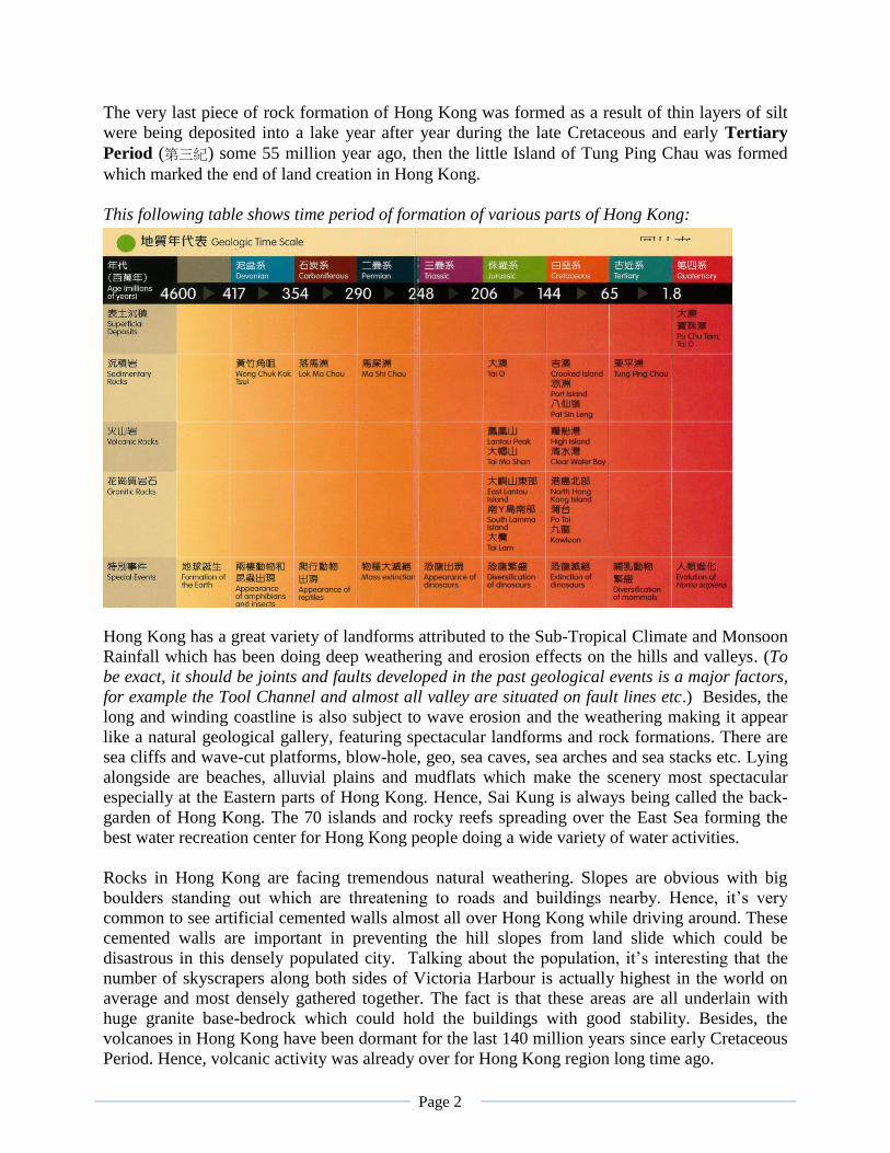
This following table shows time period of formation of various parts of Hong Kong:
Hong Kong has a great variety of landforms attributed to the Sub-Tropical Climate and Monsoon
Rainfall which has been doing deep weathering and erosion effects on the hills and valleys. (To
be exact, it should be joints and faults developed in the past geological events is a major factors,
for example the Tool Channel and almost all valley are situated on fault lines etc.) Besides, the
long and winding coastline is also subject to wave erosion and the weathering making it appear
like a natural geological gallery, featuring spectacular landforms and rock formations. There are
sea cliffs and wave-cut platforms, blow-hole, geo, sea caves, sea arches and sea stacks etc. Lying
alongside are beaches, alluvial plains and mudflats which make the scenery most spectacular
especially at the Eastern parts of Hong Kong. Hence, Sai Kung is always being called the back-
garden of Hong Kong. The 70 islands and rocky reefs spreading over the East Sea forming the
best water recreation center for Hong Kong people doing a wide variety of water activities.
Rocks in Hong Kong are facing tremendous natural weathering. Slopes are obvious with big
boulders standing out which are threatening to roads and buildings nearby. Hence, it’s very
common to see artificial cemented walls almost all over Hong Kong while driving around. These
cemented walls are important in preventing the hill slopes from land slide which could be
disastrous in this densely populated city. Talking about the population, it’s interesting that the
number of skyscrapers along both sides of Victoria Harbour is actually highest in the world on
average and most densely gathered together. The fact is that these areas are all underlain with
huge granite base-bedrock which could hold the buildings with good stability. Besides, the
volcanoes in Hong Kong have been dormant for the last 140 million years since early Cretaceous
Period. Hence, volcanic activity was already over for Hong Kong region long time ago.
圖片來
源:《岩
石學堂》
Page 3
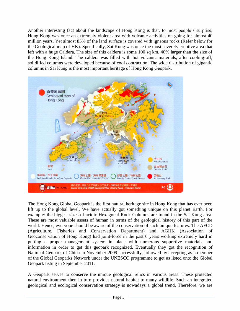
Another interesting fact about the landscape of Hong Kong is that, to most people’s surprise,
Hong Kong was once an extremely violent area with volcanic activities on-going for almost 40
million years. Yet almost 85% of the land surface is covered with igneous rocks (Refer below for
the Geological map of HK). Specifically, Sai Kung was once the most severely eruptive area that
left with a huge Caldera. The size of this caldera is some 100 sq km, 40% larger than the size of
the Hong Kong Island. The caldera was filled with hot volcanic materials, after cooling-off;
solidified columns were developed because of cool contraction. The wide distribution of gigantic
columns in Sai Kung is the most important heritage of Hong Kong Geopark.
Brief introduction of Hong Kong Global Geopark
The Hong Kong Global Geopark is the first natural heritage site in Hong Kong that has ever been
lift up to the global level. We have actually got something unique on this planet Earth. For
example: the biggest sizes of acidic Hexagonal Rock Columns are found in the Sai Kung area.
These are most valuable assets of human in terms of the geological history of this part of the
world. Hence, everyone should be aware of the conservation of such unique features. The AFCD
(Agriculture, Fisheries and Conservation Department) and AGHK (Association of
Geoconservation of Hong Kong) had joint-force in the past 6 years working extremely hard in
putting a proper management system in place with numerous supportive materials and
information in order to get this geopark recognized. Eventually they got the recognition of
National Geopark of China in November 2009 successfully, followed by accepting as a member
of the Global Geoparks Network under the UNESCO programme to get us listed onto the Global
Geopark listing in September 2011.
A Geopark serves to conserve the unique geological relics in various areas. These protected
natural environment then in turn provides natural habitat to many wildlife. Such an integrated
geological and ecological conservation strategy is nowadays a global trend. Therefore, we are
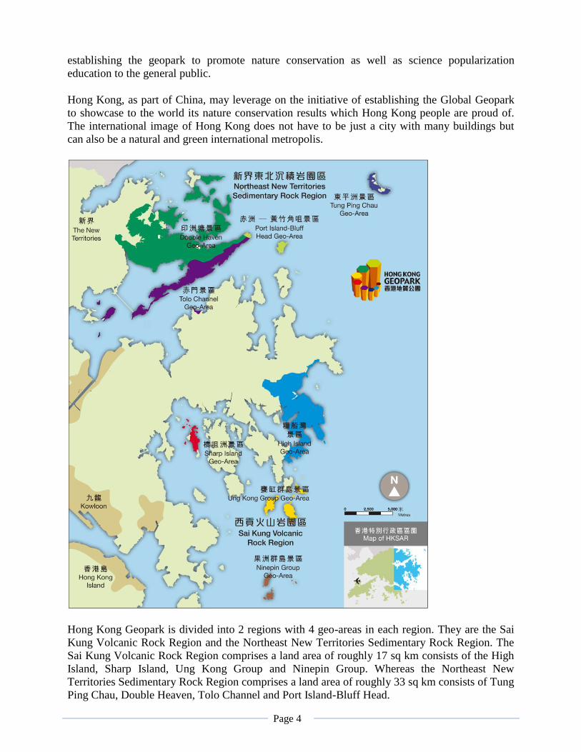
Page 4
establishing the geopark to promote nature conservation as well as science popularization
education to the general public.
Hong Kong, as part of China, may leverage on the initiative of establishing the Global Geopark
to showcase to the world its nature conservation results which Hong Kong people are proud of.
The international image of Hong Kong does not have to be just a city with many buildings but
can also be a natural and green international metropolis.
Hong Kong Geopark is divided into 2 regions with 4 geo-areas in each region. They are the Sai
Kung Volcanic Rock Region and the Northeast New Territories Sedimentary Rock Region. The
Sai Kung Volcanic Rock Region comprises a land area of roughly 17 sq km consists of the High
Island, Sharp Island, Ung Kong Group and Ninepin Group. Whereas the Northeast New
Territories Sedimentary Rock Region comprises a land area of roughly 33 sq km consists of Tung
Ping Chau, Double Heaven, Tolo Channel and Port Island-Bluff Head.
Page 5
Information of Geo-areas (Sai Kung Volcanic Rock Region):
History of Volcanic activities in Sai Kung
Hong Kong region had experienced four phases of volcanic activities stretching over a long
period of time from mid-Jurassic to early Cretaceous period. During the late Jurassic and early
Cretaceous and for a period of six million years, Sai Kung area was actually closing up the
violent period of Hong Kong region. The volcanic activity in Sai Kung roughly could be
classified into four stages. Firstly, the hidden power after accumulated or years finally came to a
violent eruption spewed out a tremendous amount of ash and rock fragments. These materials
literally spread out and covered a wide area of Sai Kung forming those early stage of land mass
of Sai Kung. Then it came to a period of dormant. The Sai Kung area was quietly taking its shape
with mostly tuff (凝灰岩) rocks, which is a rock formed from consolidation of volcanic ash.
However, partially some volcanic ash was being washed down into volcanic lakes piling up to
form tuffite (沉凝灰岩) which is considered as volcanic sedimentary rock. The third stage of the
volcanic activity was actually reviewed the power of a super-volcano. Tens of cubic km of
molten rock, ash and lava were blasted out into the air. The emptying magma chamber
underneath resulted a large scale collapse of the over-hanging crater and a gigantic Caldera was
formed here with the size of over 100 sq km. Then masses of volcanic materials that may contain
ash and lava mix were continuing flowing out and filled the basin of this caldera. Finally when
the surface molten matter started to lose temperature, hexagonal joints were developed and
extended vertically downward to form the amazing Hexagonal Rock Columns of Sai Kung.
These columnar rocks spread from the Tai Long Sai Wan in the North of Sai Kung to the
Ninepins Group in the South and the entire sea-bed in between. Hence the number of these
Hexagonal Rock Columns is believed to be over a million (including those flooded under the sea),
which the distribution area is the largest in this world. Besides, those columns found on the
Ninepins group has an average diameter of almost 2 meters across, again this is the largest so far
found on earth. The large size is very much attributed to the high acidity which was always
highly viscous and preventing heat loss less quickly than basic lava. The average length of the
columnar rocks here is also out-raced most geo-parks in other parts of the world. Taking a boat
tour around Sai Kung Islands is now becoming one of most enjoyable pastime to appreciate the
world class geo wonders and yet the scenery itself is exceptionally spectacular.
Page 6
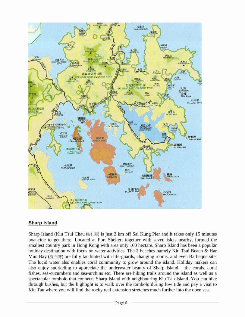
Sharp Island
Sharp Island (Kiu Tsui Chau 橋咀洲) is just 2 km off Sai Kung Pier and it takes only 15 minutes
boat-ride to get there. Located at Port Shelter, together with seven islets nearby, formed the
smallest country park in Hong Kong with area only 100 hectare. Sharp Island has been a popular
holiday destination with focus on water activities. The 2 beaches namely Kiu Tsui Beach & Har
Mun Bay (夏門灣) are fully facilitated with life-guards, changing rooms, and even Barbeque site.
The lucid water also enables coral community to grow around the island. Holiday makers can
also enjoy snorkeling to appreciate the underwater beauty of Sharp Island – the corals, coral
fishes, sea-cucumbers and sea-urchins etc. There are hiking trails around the island as well as a
spectacular tombolo that connects Sharp Island with neighbouring Kiu Tau Island. You can hike
through bushes, but the highlight is to walk over the tombolo during low tide and pay a visit to
Kiu Tau where you will find the rocky reef extension stretches much further into the open sea.
Page 7
The Sharp Island tombolo is about 250 metres long. It is flanked on both watersides by sand,
pebbles and seashell debris, while the centre is coarse sand mixed with gravel. This natural
tombolo is one of several tombolos found in Hong Kong. Similar features can be seen in between
Ma Shi Chau and Yim Tin Tsai. The Sharp Island tombolo emerges only when low tide.
Checking against the tidal information listed out by HK Observatory is advisable before visit.
Walking on the tombolo will be possible when tidal level is below 1.4 meter.
Geological Information on Sharp Island Near the pier of Sharp Island, there is evidence showing that the place was once sitting at the
edge of the ancient volcano. The rocks at the right hand side of the pier are mostly pyroclastic
rock (火山碎屑岩) including volcanic agglomerate (火山集塊岩), volcanic breccia (火山角礫岩)
and tuff (凝灰岩) etc. During the volcanic eruption, large, coarse, rock fragments associated with
ash and lapillus (火山礫) are ejected from the crater, they quickly descended in sequence of larger
size rock / fragments are closer as heavier while tiny size fragments are further away from the
crater. They cooled off and solidified to form rocks. Agglomerates are pyroclastic rocks that
consist almost wholly of angular or rounded fragments in relatively large size (>64 mm in
definition) and varying shape.
Further down the beach near the tombolo, a very rich varieties of volcanic rocks can be seen
easily. Rhyolite (流紋岩), a type of rock formed from viscous lava (or silica-rich) that carries
obvious flowing marks on the body. These marks proved that when the viscous lava extruded the
land surface, the semi-molten mineral crystals within the lava were elongated and twisted,
forming a pattern of parallel ‘lines’ and the texture was preserved when the lava turn into rock
after cooling down. Hence, traces of flowing can be clearly seen on the surface of the rock.
Rhyolitic lava is rich in silica content making it high in viscosity that normally unable to travel a
long distance. As a result, it will also stay close with the volcanic crater. Hence, it resembles
another evidence of Sharp
Island is near the edge of
the ancient volcano.
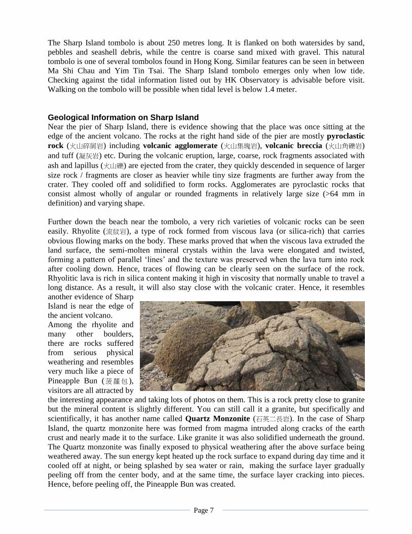
Among the rhyolite and
many other boulders,
there are rocks suffered
from serious physical
weathering and resembles
very much like a piece of
Pineapple Bun (菠蘿包 ),
visitors are all attracted by
the interesting appearance and taking lots of photos on them. This is a rock pretty close to granite
but the mineral content is slightly different. You can still call it a granite, but specifically and
scientifically, it has another name called Quartz Monzonite (石英二長岩). In the case of Sharp
Island, the quartz monzonite here was formed from magma intruded along cracks of the earth
crust and nearly made it to the surface. Like granite it was also solidified underneath the ground.
The Quartz monzonite was finally exposed to physical weathering after the above surface being
weathered away. The sun energy kept heated up the rock surface to expand during day time and it
cooled off at night, or being splashed by sea water or rain, making the surface layer gradually
peeling off from the center body, and at the same time, the surface layer cracking into pieces.
Hence, before peeling off, the Pineapple Bun was created.
Page 8
Kiu Tau is the name of an island just off the beach. During time of high-tide, the island is isolated
from Sharp Island by sea water in between. However, at times of low-tide, there is a solid
passage linked up the island to the beach. Originally, Kiu Tau was really an independent islet.
But the Monsoon wind help transporting the sediments depositing along the island and the beach.
Eventually a long sand-spit was built and connected the ends – a Tombolo (連島沙洲) was created.
This tombolo would be extremely fun for visitors who must follow the tidal information in order
to walk across to Kiu Tau and back during low tide.
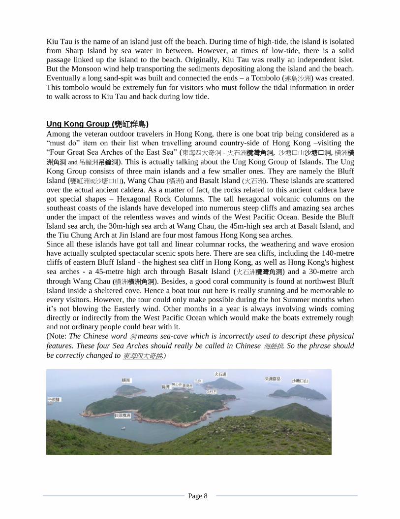
Ung Kong Group (甕缸群島)
Among the veteran outdoor travelers in Hong Kong, there is one boat trip being considered as a
“must do” item on their list when travelling around country-side of Hong Kong –visiting the
“Four Great Sea Arches of the East Sea” (東海四大奇洞 - 火石洲欖灣角洞, 沙塘口山沙塘口洞, 橫洲橫
洲角洞 and吊鐘洲吊鐘洞). This is actually talking about the Ung Kong Group of Islands. The Ung
Kong Group consists of three main islands and a few smaller ones. They are namely the Bluff
Island (甕缸洲或沙塘口山), Wang Chau (橫洲) and Basalt Island (火石洲). These islands are scattered
over the actual ancient caldera. As a matter of fact, the rocks related to this ancient caldera have
got special shapes – Hexagonal Rock Columns. The tall hexagonal volcanic columns on the
southeast coasts of the islands have developed into numerous steep cliffs and amazing sea arches
under the impact of the relentless waves and winds of the West Pacific Ocean. Beside the Bluff
Island sea arch, the 30m-high sea arch at Wang Chau, the 45m-high sea arch at Basalt Island, and
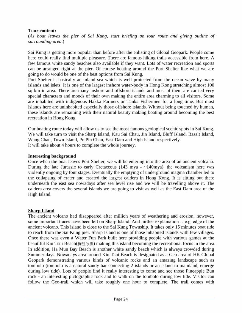
the Tiu Chung Arch at Jin Island are four most famous Hong Kong sea arches.
Since all these islands have got tall and linear columnar rocks, the weathering and wave erosion
have actually sculpted spectacular scenic spots here. There are sea cliffs, including the 140-metre
cliffs of eastern Bluff Island - the highest sea cliff in Hong Kong, as well as Hong Kong's highest
sea arches - a 45-metre high arch through Basalt Island (火石洲欖灣角洞) and a 30-metre arch
through Wang Chau (橫洲橫洲角洞). Besides, a good coral community is found at northwest Bluff
Island inside a sheltered cove. Hence a boat tour out here is really stunning and be memorable to
every visitors. However, the tour could only make possible during the hot Summer months when
it’s not blowing the Easterly wind. Other months in a year is always involving winds coming
directly or indirectly from the West Pacific Ocean which would make the boats extremely rough
and not ordinary people could bear with it.
(Note: The Chinese word 洞 means sea-cave which is incorrectly used to descript these physical
features. These four Sea Arches should really be called in Chinese 海蝕拱. So the phrase should
be correctly changed to 東海四大奇拱.)
Page 9
Ninepin Group (果洲群島)
Ever since the Sung Dynasty, the Nine Pin Island was already being regarded as a dangerous
sailing spot to those early day merchants due to its rough sea waves especially during Winter
season. The name of the Islands was being called Guo Parn Zhou (果盤州) as the group of islands
looked like a platter of fruits on the sea. The name “Ninepin” is inspired by an old British game
similar to modern day bowling. When British seamen first saw the array of these islands, the
familiar bowling game sprang to mind and they gave the group this colonial-colour name. Local
people still call the islands Guo Chau (果洲). The Ninepin Group is made up of North Ninepin
Island, South Ninepin Island, East Ninepin Island and 26 other islets.
The Ninepin Islands is situated East of Sai Kung
and Clearwater Bay peninsula are completely
exposed to this natural ocean spreading 900 km
across the West Pacific with no land barrier until
reaching North of the Philippines. Imagine if there
is strong wind generated somewhere in the West
Pacific and blowing directly towards Hong Kong,
after travelling hundreds of km picking up
moistures from the ocean surface adding its power
along the way. When reaching Sai Kung, the wind
power sometimes could be really damaging. The
weather in Hong Kong is heavily influence by the
Easterly wind with almost 8 months in a year. Only the few Summer months are less affected by
this ocean wind. Even though volcanic rocks are essentially hard and resistant, wind and waves
have taken their toll over the ages to shape the terrain of East Sai Kung rugged and imposing.
Given such challenging condition, visitors to the Ninepins can only make their trips during the
two or three summer months every year. Located at the middle part of the South Ninepin there
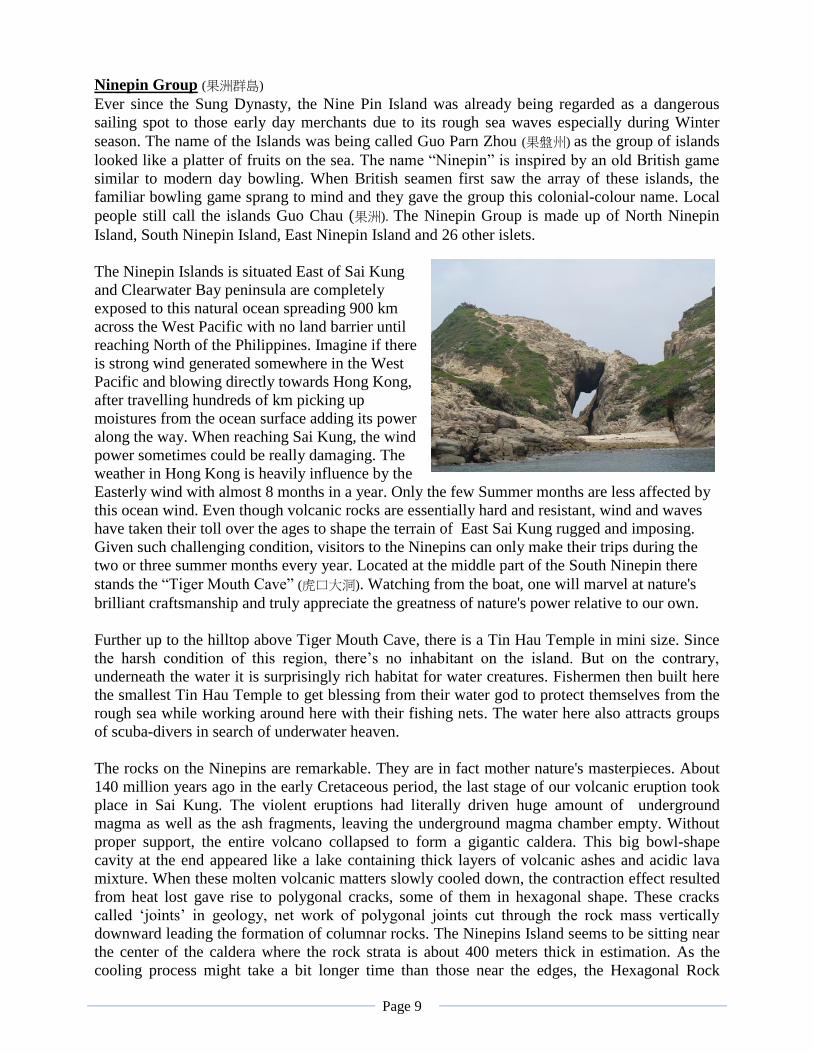
stands the “Tiger Mouth Cave” (虎口大洞). Watching from the boat, one will marvel at nature's
brilliant craftsmanship and truly appreciate the greatness of nature's power relative to our own.
Further up to the hilltop above Tiger Mouth Cave, there is a Tin Hau Temple in mini size. Since
the harsh condition of this region, there’s no inhabitant on the island. But on the contrary,
underneath the water it is surprisingly rich habitat for water creatures. Fishermen then built here
the smallest Tin Hau Temple to get blessing from their water god to protect themselves from the
rough sea while working around here with their fishing nets. The water here also attracts groups
of scuba-divers in search of underwater heaven.
The rocks on the Ninepins are remarkable. They are in fact mother nature's masterpieces. About
140 million years ago in the early Cretaceous period, the last stage of our volcanic eruption took
place in Sai Kung. The violent eruptions had literally driven huge amount of underground
magma as well as the ash fragments, leaving the underground magma chamber empty. Without
proper support, the entire volcano collapsed to form a gigantic caldera. This big bowl-shape
cavity at the end appeared like a lake containing thick layers of volcanic ashes and acidic lava
mixture. When these molten volcanic matters slowly cooled down, the contraction effect resulted
from heat lost gave rise to polygonal cracks, some of them in hexagonal shape. These cracks
called ‘joints’ in geology, net work of polygonal joints cut through the rock mass vertically
downward leading the formation of columnar rocks. The Ninepins Island seems to be sitting near
the center of the caldera where the rock strata is about 400 meters thick in estimation. As the
cooling process might take a bit longer time than those near the edges, the Hexagonal Rock
Page 10
Columns are seen bigger in sizes. Columns nearly 2 meters in diameter could be found quite
easily.
The Hexagonal Columns in Hong Kong is considered to be the best of its kind in the world. First
of all, the rock columns here are spreading over a scale of almost 100 sq km from the Ninepin
group all the way to the High Island. Secondly, our light colour acidic volcanic rock is rare
compare to those dark colour basaltic rock columns found in various parts of the world. Lastly,
the average size of rock columns is found much bigger in average size. From The Ninepin Group,
we can see columns well over 2 meters in diameter, whereas in Northern Ireland from the world
famous Giant Causeway, those columns are on average only 0.5 meter.
One way to appreciate this natural wonder is to sail from South Ninepin to North Ninepin, from
the boat visitors could appreciate the breath taking scene of unique volcanic rock arranged in a
striking formation of giant rock columns. Just the turn from South Ninepin to North Ninepin, an
islet off the east shore called Yuen Shek Pai (圓石排) offers the most amazing sight. Numerous
rock columns rise up neatly around the centre of the islet and form a natural staircase in spiral
shape. As the shape is really interesting, some people simply rename it the “Spiral Staircase” (迴旋的階梯).
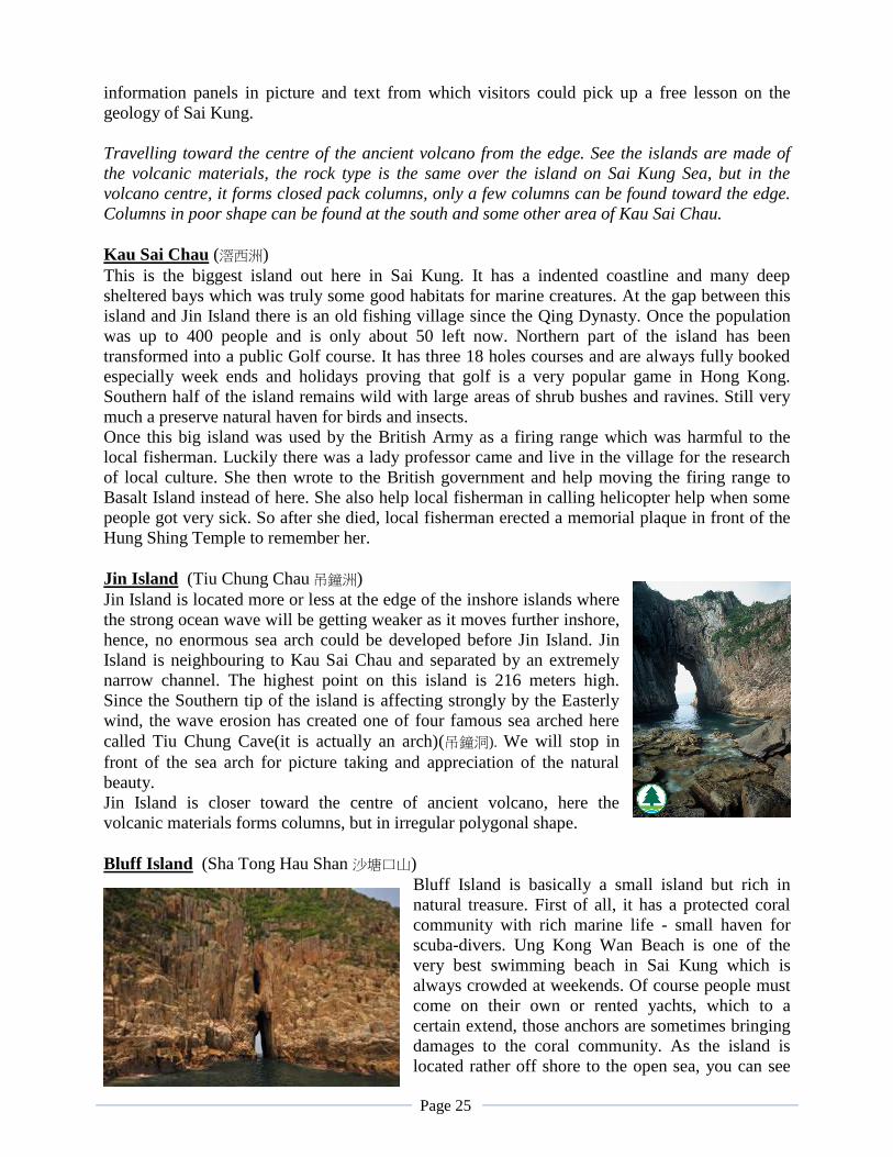
Bluff Island (Sha Tong Hau Shan)
Bluff Island (local Chinese call it Sha Tong Hau Shan 沙塘口山), or Ung Kong Chau, lies west of
Basalt Island and south of Town Island (Fo Tau Fan Chau 伙頭墳洲). In the southern corner of this
small island you can find one of the four biggest sea caves in our eastern waters - Sha Tong Hau
Cave (actually it should be correctly called a Sea-arch 海蝕拱). Where as sitting up on the center
North of the island, there is a white sandy beach called Ung Kong Bay(甕缸灣) which is a very
popular spot for swimmers from Sai Kung. Hikers like to call this island as Cliff Island (峭壁洲).
During their hiking, they will encounter cliffs almost in all directions of the island and the highest
cliff is measured some 140 meter above sea-level. Moreover geologist finds it a fantastic location
for the studying of rhyolite. Formations in clearly defined layers are prominent across the island,
and along the wavy shores, huge blocks tower by the water. These were evidence showing lava
was flowing around Bluff Island during the Early Cretaceous Period which was the very last
stage of the volcanic activity in Hong Kong. Fan Tap Pai in the south is one of the most
breathtaking coastal rock scenes in Hong Kong. When approaching, you will first see a huge sea
cliff which is wide and tall (140 m) appears like a giant cathedral organ, followed by a huge sea
arch cuts right through the island and it is just wide enough for a boat to sail past (but it’s risky as
it might have rock fall from above). It’s not a bad idea for a leisure sea expedition. Bluff Island is
also a diving hot spot as a large coral community is found all around the island. An increasing
number of divers are coming here to explore the mysterious ocean.
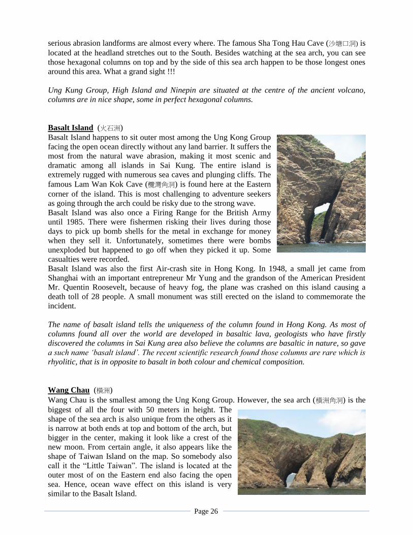
Basalt Island (火石洲)
Basalt Island is an island south of Town Island (Fo Tau Fan Chau 伙頭墳洲 ) and Wang Chau (橫
洲), east of Bluff Island and north of the Ninepins. The Island is to certain extent rather well
known to local people. First of all, during the British administration and before 1985, the
surrounding area of Basalt Island was a restricted area for the British Force to practice Cannon
Fire. Since fishermen in the old days were mostly poor people. Some fishermen risked
themselves to land on the island after every cannon practices to pick up the bomb-shell as well as
those gun powder that left-over for making small fishing use explosives. Sometimes it could be
Page 11
very unfortunate that some dynamite might go off just
when they pick it up and getting hurt was quite a
common thing for the fishermen. Then Basalt Island
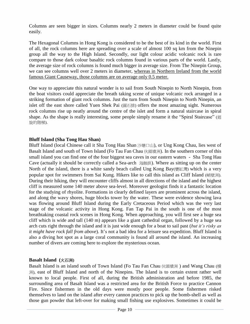
was also the site of the first air-crash that ever happened
in Hong Kong in 1948. It was a flight coming into Hong
Kong from Shanghai crashed on the island due to heavy
fog weather, killing all 30 people onboard including the
grandson of the American President Mr. Quentin
Roosevelt. More than 60 years have since passed and all
traces have been erased by swells and typhoons. Only
an air disaster monument remains on the island to recall
this tragic accident. Moreover, there are modern tragedies happened to some aggressive Shore
Fishing guys as well. Since Basalt Island is sitting at the most Eastern location among the Ung
Kong Group and receiving most severe wave erosion that broken rocks and debris kept going
down under to the sea by the edge of the island, hence creating lots of living habitats for the
corals and water creatures. It would then become a good spot for predator fishes to look for food.
Shore Fishing here is becoming popular as large fishes are always available. Unfortunately, both
the big waves and the unstable hanging rocks could be deadly threats to these fishing guys. In
June 2010, one experienced shore fishing guy was being headed-on by a several ton rock and
went dead immediately.
Like Bluff Island and Wan Chau, the outcropped stratum of Basalt Island was also formed at the
Early Cretaceous age. The island has very well developed sea stacks, island reefs and wave-cut
bays which clearly demonstrate the impacts of wave erosion on solid rocks. Waves, in forms of
erosion, abrasion and dissolution, always cause devastating damage to the shores. Given that the
Hexagonal Columns are full of long vertical joints and fissures, impacts of pounding waves on
rocks are particularly obvious. The 20 meter tall Lam Wan Kok Arch (欖灣角洞) was striking
through by these pounding waves along the joints. Meanwhile, continuous abrasion by sand and
gravel carried by waves has brought changes to the shores and submerged bedrock, sculpting an
amazing array of precipitous cliffs and spectacular landforms.
Wang Chau (橫洲)
Wang Chau is the smallest amongst the three major Ung Kong Islands. The highest point is
merely 80 metres above sea level while the narrowest part measures only 500 metres. It is a
barren island with little vegetation coverage. Especially the slopes facing East, the rugged surface
is simply rocky with no soil. This explains that the ocean wind has been strong and continuing. It
blew away all particles and left no chance for eroded minerals such as feldspar to accumulate to
form layers of soil for the growing of any vegetation. On the north side of Wang Chau, a striking
sea arch can be seen – Wang Chau Kok Arch (橫洲角洞). This sea arch is running North to South
over 10 meters across and over 30 meters tall forming the largest sea arch among the four sea
arches of the East Sea. The shape of this Sea Arch is enthralling as it appears like a new moon, or
from certain angle, it looks like the topography of Taiwan on the world map. It is wider in the
middle but getting narrow at the lower part of the arch.
Page 12
High Island
World rare acidic volcanic rock columns - High Island East Dam
High Island Reservoir East Dam is one of Hong Kong's most popular geological sites that this
place is full of visitors during all week ends and public holidays. The reason is simple, this place
is literally home to our most spectacular rock wonder in Hong Kong. Here, volcanic rock
composes neat arrays of giant hexagonal rock columns along the hillsides and shores all around.
Catching your eyes with striking angular facets, these giants are rare natural treasure and
invaluable geo-tourism resources.
At several spots, visitors could see bent rock columns and immediately a question may jump to
your mind – how come rocks can be bent? One possible explanation is that, during the process of
hot volcanic materials cooling down, and before it was solidified (still in semi-molten stage),
there could be some minor earthquake or earth movement, the soft “rock columns” leaned over
due to gravity and bent. After hardening, the rock appeared in curve shape. Further down the cliff
of the Hexagonal Rock Column Wall, visitor will find the most amazing Wall Mural – a huge S-
shape rock column-bunch with a major fissure crossing the letter S. You can interpret easily that
after the formation of the bent / twisted columns, gigantic force from earth’s movement sometime
later cracking the columns. Moreover, basaltic lava intruded into the fissure and forming the dark
color dyke cut across the curved columns. As the Basalt carries a lower content of Silica, the rock
colour is almost black where as the acidic volcanic rock is in much lighter colour. The cross, the
bend and the colour contrast, all together forming a wonderful piece of art done by the hand of
mother nature.
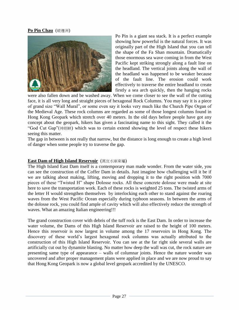
Po Pin Chau just off the East Dam is another extraordinary sight for visitors. This giant stack was
the result of a complete hill being slashed into two by natural forces. In earlier days before the
geopark name, travelers call it “God Cut Gap” (神削峽). It was such a grandeur piece of work that
travelers believed that only god could do it. They climbed the Fashan Mountain spending hours
just for getting close to the giant stack. Some even steered their sampan boats to traverse the
water gap in between to experience the stunning close up sight at the walls of Hexagonal Rock
Columns on both sides. Geology enthusiasts will certainly cherish the opportunity to see towering
rock stacks and fascinating hexagonal joints.
High Island Reservoir itself is also legendary. It was one of the early reservoirs that was built
from the ocean. Originally, High Island was the fourth largest island in Hong Kong and separated
from the Sai Kung Peninsula. The island was parallel to the Sai Kung Peninsula forming a long
water passage in between for the government ships to sail as short-cut to Sai Kung township.
Along both banks, there were many Hakka and Fishing villages. The idea of the reservoir was to
build giant dams to close the two ends of the water passage to make it a large pool in the middle.
Then the original sea-water was being pumped out back to the ocean and the cavity was replaced
by fresh water collecting from rain and mountain streams. The impressive man-made wonder
took 9 years to build. Ten villages were being removed to live in Government granted homes in
Sai Kung Town, leaving their village structures drown at the bottom of the reservoir intact. This
water storage facility is the biggest in Hong Kong with 100 meter high Dams to allow water level
going much higher than all other reservoirs in Hong Kong. The dramatic East Dam is a great
attraction of its own. The wind and wave coming in from east could be extremely damaging. The
Po Pin Chau would explain a bit of the natural power. So the East Dam itself will need some
proper protection as safety measure. Then the engineers invented the giant “twisted H” shape
concrete dolosse and prepared altogether 7000 units to build a Coffer Dam in front of the East
Page 13
Dam. These randomly places dolosses are weighted 25 tons each and the design of “twisted H”
shape will place the mechanism of interlocking each other to multiply their weight to stand
against the natural force. They function well and yet this cofferdam attracts many visitors who
admire much at human’s “great” invention.
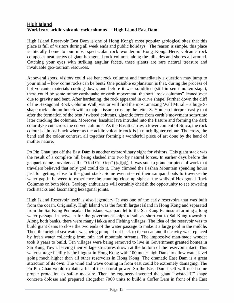
The volcanic rock columns found here stand as high as 30 metres. They were formed some 140
million years ago when volcanoes were active along where the Eastern part of China was.
Whenever there was an eruption, some lava flows gushed out along with huge amount of
extremely hot volcanic ash. They were filled into the great depression of a caldera. During the
cooling period, the rock contracted very uniformly and gave rise to the marvelous hexagonal
columnar joints seen today.
Page 14
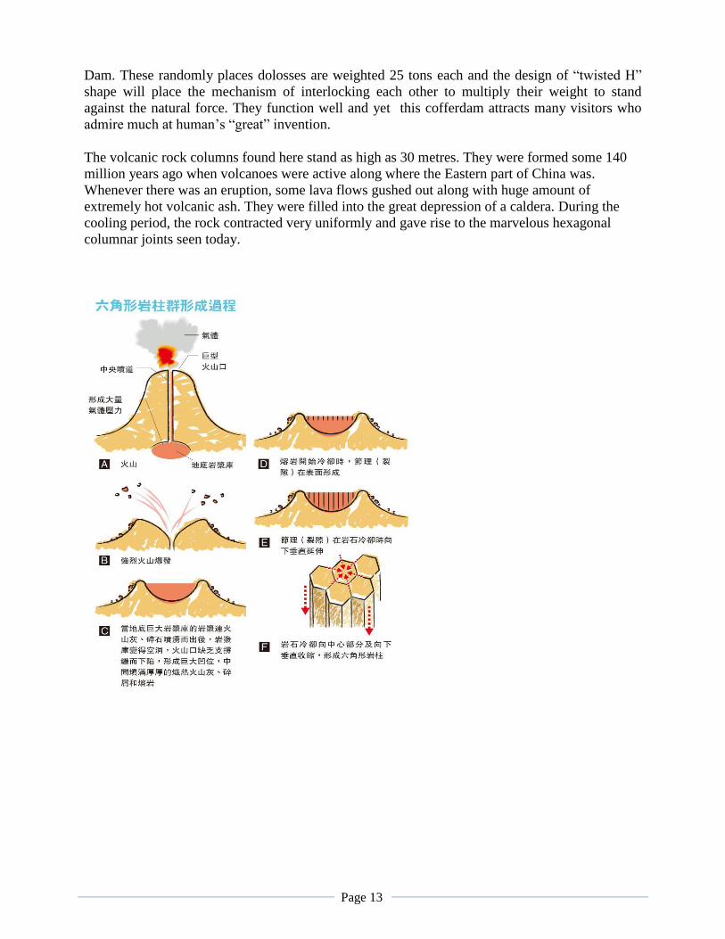
Geopark tour routes (Sai Kung): Sai Kung’s Land-based Geotour routes Geopark Visitor Centre in the Lions Nature Education Centre in Tsiu Hang 蕉坑
Geopark Visitor Centre
Rock
Acade
my
The tour content:
At the entrance, you can see a Magnetic Floating Earth Model. It is floating in the air and rotates
like planet earth. On the surface of the globe, you can see the names and sizes of the tectonic
plates. Then on the wall there are pictures displaying all abut tectonic movements and how it
relates to volcano activities and earth quakes. There is another model where you can press a
button and seeing the plates separating and leaving a gap in between. Hence, magma underneath
may then gush up to become a volcano or forming new land.
As we move along, you can see videos and pictures regarding all the different Geo-sites in Hong
Kong. Some displays are even in 3D effect. Next there is a model of a volcano crater. In the
crater you will find an animation showing you how the hexagonal rock columns are formed. Isn’t
that amazing? As we walk further, here’s another model showing why and how the complicated
coastal landforms in Hong Kong are shaped. It is a wave making model and you can try to make
wave yourself. Together with the screen showing various marine abrasion landforms, it is easy to
understand the Hong Kong coastline is changed continuously by waves erosion, especially Sai
Kung area is facing the open West Pacific Ocean which really shapes the area into numerous
amazing costal features.
Then we will move into rock gallery where lots of rock specimens, minerals and fossils are
displayed. They are separated in cases of Igneous , Sedimentary and Metamorphic rock types
stated clearly with specific names to facilitate visitors easy learning. Here’s you can also see with
your own eyes the oldest rock on earth, a piece of Gneiss from Canada which has a history of 3.9
Billion years. Others you can see specimens of Placoderm fossil, the kind of fish that were
Page 15
commonly found during the Devonian Age dated back 400 million years. Looking at these
exhibits, you may agree that human history is so short and so small comparing to what we saw.
The Rock Classroom nearby is mainly catering for students in Hong Kong. They will learn about
environmental science through games and experiments. With more knowledge, they will become
more aware of geo-conservation.
Last part of the visit is to take a walk along an interesting trail called the Rock Academy. The
trail is written with Geological Calendar names and starts with Devonian all the way to present
Quaternary and followed displaying 30 different kinds of local rocks getting from different parts
of Hong Kong. Walking along this trail, you can learn about different period of time along the
Geological Calendar, and all about diversity of rocks from Hong Kong by reading those display
information boards.
Sai kung’s Land base Geopark Tour Routes
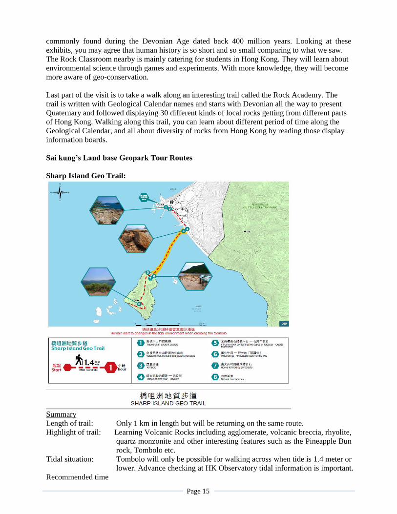
Sharp Island Geo Trail:
Summary
Length of trail: Only 1 km in length but will be returning on the same route.
Highlight of trail: Learning Volcanic Rocks including agglomerate, volcanic breccia, rhyolite,
quartz monzonite and other interesting features such as the Pineapple Bun
rock, Tombolo etc.
Tidal situation: Tombolo will only be possible for walking across when tide is 1.4 meter or
lower. Advance checking at HK Observatory tidal information is important.
Recommended time
Page 16
of staying: 1 hour and 15 minutes.
Recommended tour route:
1. The Pier (Rocks on the right side of pier and behind the interpretation boards)
2. The sandy beach (depositional landform)
3. Quartz Monzonite (石英二長岩) & Pineapple Bun rock (菠蘿包石)
4. Rhyolite 流紋岩(rocks formed from volcanic lava rich in silicon dioxide)
5. Crossing of Tombolo 連島沙洲(depositional landform)
6. Tuffite沉凝灰岩 (sedimentary volcanic rock)
7. Peak of Kiu Tau 橋頭(view of the surrounding) Return same way back to pier
The tour content:
Upon arriving Sharp Island by boat, there are 2 interpretation boards just off the pier. The tour
will be started at the very rugged rocky shore where traces of volcanic activities can be seen.
First of all, please look at the rocks around here. The large rocks are mostly pyroclastic rock (火
山碎屑岩) types including Volcanic Agglomerate (火山集塊岩) and Volcanic Breccia (火山角礫岩).
You can see that the rocks are looked like modern concrete that various sizes of rock fragment
sticking together to become larger rocks. Usually the thick ash stream would work like cement to
glue together all rock fragments that were created by the volcanic eruption. Breccia carries
smaller but angular fragments, whereas Agglomerate carries mush larger pieces of fragments.
Besides, the main rock type in this area is Tuff (凝灰岩) - rock formed by the accumulation of
volcanic ash. These pyroclastic rocks would serve as evidence that we are near to the edge of a
crater or the caldera.
(The tour will be continued to walk along the beach and look around from beach.)
From here you can see both a beach and a tombolo not far away. At the edge of the tombolo and
the coastal area, there are rock boulders gathering as well. The scene here tells you that these are
depositional processes. Out there where you see the island called Kiu Tau stands in the middle of
the sea. Both natural weathering and wave erosion works well on this island. Debris and tiny sand
fragments are being carried by sea wave and deposited along the quiet bay where we are standing
as well as in between the island and the beach. Eventually, this beach and the tombolo were
formed as a result. Big boulders were originally rolled downhill to the sea but were moved back
to shoreline during typhoon storms over the years. Looking at these, you may think that forces of
the nature are sometimes beyond our imagination.
(Further down the beach near the tombolo.)
Right here you can see a few interesting volcanic rocks. This is rhyolite (流紋岩) – a piece of rock
formed by flowing lava. If you watch carefully, you can see obvious flowing marks on the rock
body. These marks proved that when the viscous lava extruded the land surface flowing slowly, it
was quickly cooled off by the air and solidified. Hence, traces of flowing marks were clearly
stayed on the rock. You will see the next piece of rock is even more interesting, as it appears like
the yummy “Pineapple Bun” (菠蘿包). The rock is a kind of granite, to be more specific, it is
called quartz Monzonite (石英二長岩). According to its unique chemical composition, mainly
consists of quartz and 2 kinds of feldspar minerals. These minerals reacted with a higher
efficiency to the sun’s physical weathering. The surface layer was easily heated up and expanded
under the sun, gradually it cracked up all around the surface and resembled a piece of Pineapple
Page 17
Bun. But eventually it will exfoliate (頁狀剝落) piece by piece and broke up into smaller rock
fragments.
(Walking across the Tombolo. Remark: Make sure it is during low tide and is not emerging
tide as you may not be able to walk back at higher tide level.)
Please watch out and walk carefully as the sand-bar is very rugged with lots of pebble Stone. Do
you know why all the stones on this Tombolo are rounded up in shapes and definitely no angular
or sharp edges? The answer is simple. There are numerous waves forces plus the twice a day tidal
forces keep moving and rolling these stones to scratch with each other almost non-stop through
time. The abrasion has removed away all the sharp angles and edges as a result.
(At the end of the tombolo and on the left side coast, where a patch of Tuffite is located.)
Over here you can see a kind of very rare rock type called tuffite (沉凝灰岩), a kind of volcanic
sedimentary rock. Our common sense of sedimentary rock is normally formed from deposition
and consolidation of pebbles, sand and mud from weathered rock. But here this sedimentary rock
is made by volcanic eruption, isn’t that weir? Actually it happens. When volcanic ash came out
from the crater, they spread around in a wide range of area. When some of the ash were being
dropped and drown under water, they stacked up and go through the rock forming process –
forming a kind of sedimentary volcanic rock with the materials came from volcano eruption.
(The tour would go further up until reaching the top of the island.)
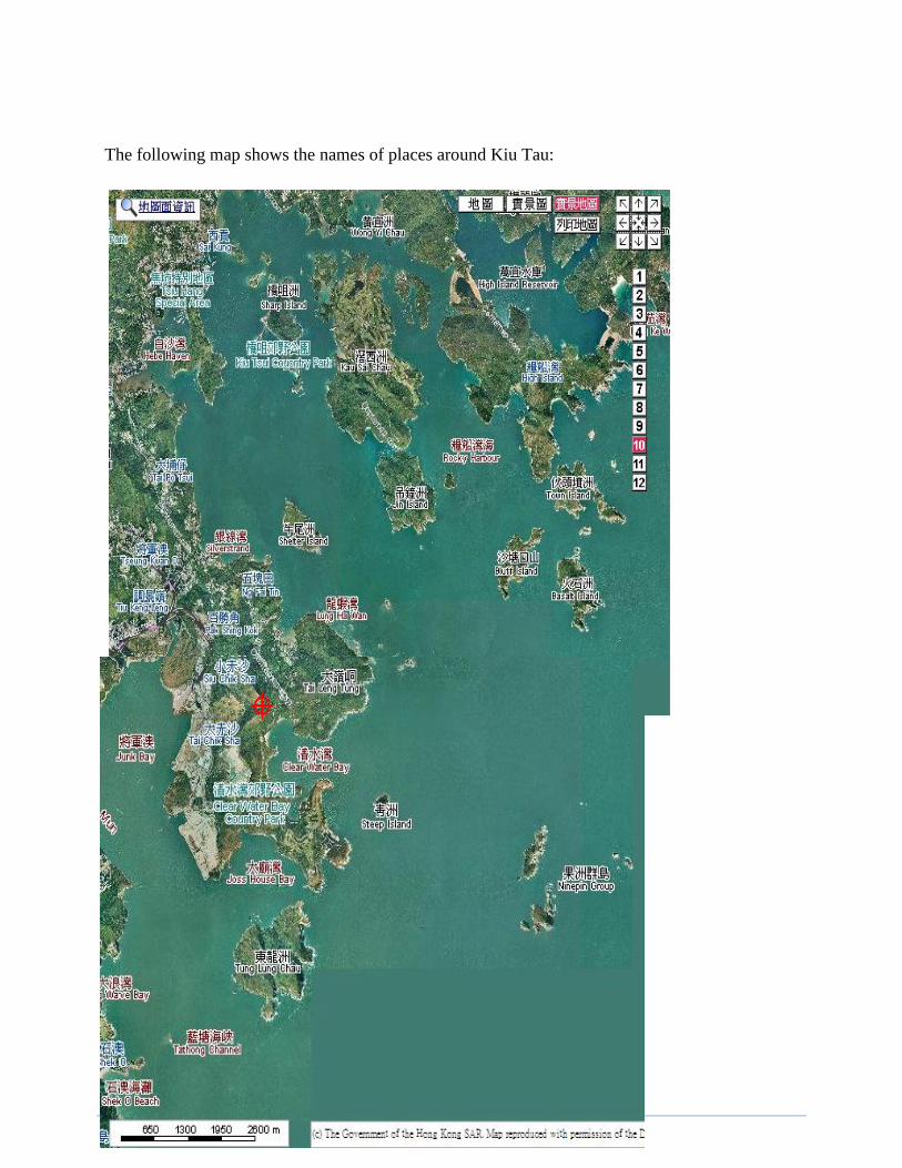
Standing on top of Kiu Tau, you can get almost a full view of Sai Kung islands. Referring to
maps up here, you can get to know some of the neighboring islands’ names such as Kau Sai
Chau (滘西洲) where there is a public Golf Course that everyone can play without membership.
Over there is Jin Island (吊鐘洲), further down is the Ung Kong Group (甕缸群島) and High Island
(糧船灣洲). Then down south is the Ninepin group (果洲群島) etc.
Page 18
The following map shows the names of places around Kiu Tau:
Page 19
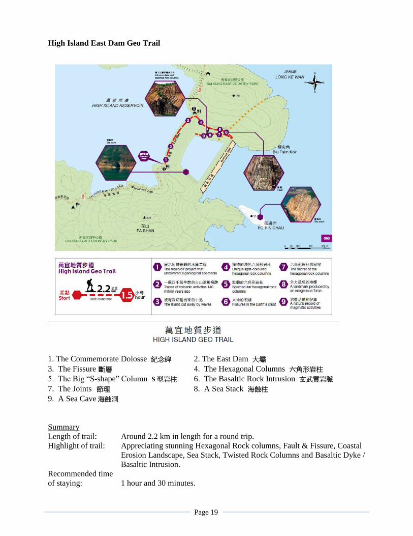
High Island East Dam Geo Trail
1. The Commemorate Dolosse 紀念碑 2. The East Dam 大壩
3. The Fissure 斷層 4. The Hexagonal Columns 六角形岩柱
5. The Big “S-shape” Column S型岩柱 6. The Basaltic Rock Intrusion 玄武質岩脈
7. The Joints 節理 8. A Sea Stack 海蝕柱
9. A Sea Cave海蝕洞
Summary
Length of trail: Around 2.2 km in length for a round trip.
Highlight of trail: Appreciating stunning Hexagonal Rock columns, Fault & Fissure, Coastal
Erosion Landscape, Sea Stack, Twisted Rock Columns and Basaltic Dyke /
Basaltic Intrusion.
Recommended time
of staying: 1 hour and 30 minutes.
Page 20
Recommended tour route:
1. The Commemorate Dolosse (the engineering of reservoir and it’s history)
2. The East Dam (looking at Po Pin Chau & the wall mural at far end and left of Dam)
3. The fault line and it’s relationship to the sea cave below the Commemorate Dolosse
4. Hexagonal Rock Column and its formation
5. The grand S-shape Columns (Earth movement forces)
6. Basaltic dyke (magma intrusion)
7. Joints (how it affects the landform)
8. Back up to the Pavilion (free to touch rock specimens and conclusion time)
The tour content:
(The tour starts from the Commemorate Dolosse.)
The giant rock here is manmade concrete. It’s in the shape of “Twisted H” and weighted 25 tons
each. There are altogether 7000 pieces of this Dolosse Rock made on the spot for the purpose of
constructing a Coffer Dam just to protect the Main Dam from being striking continuous by the
strong waves coming in from West Pacific Ocean. Especially during the typhoon and the winter
monsoon seasons, the roaring wave could be devastating. The landscape around here would be
good evidence. When the coffer dam is striking by the strong wave, the twisted H rocks interlock
each other to break the wave and absorbed wave Hence, it works so well so far.
Hong Kong was suffering from water rationing in the 60’s. The worst case was only 4 hours
water supply to the public in every four days time. Besides working hard with finding space for
building reservoirs, Hong Kong had to seek help from China. In 1966, China started to supply
water through big water pipes getting water from the Dongjiang in Guang Dong Province.
Unfortunately, China shutdown the supply in 1967 due to the Cultural Revolution. The
government then responded with the construction of this High Island Reservoir. It was the second
reservoir constructed from the ocean. The first one is Plover Cove Reservoir in Tai Po.
The reservoir was built by constructing two main dams connecting High Island to the Sai Kung
Peninsula. With roads laid down on the dams, now High Island is no longer an island any more.
The original ocean channel between the two places was then turned into a closed lake area.
Moreover, the two dams were raised to a level of 100 meter to make it the largest reservoir in
Hong Kong by volume. Aqueducts totaling 8 km in length were also constructed to transfer water
from streams around Sai Kung Peninsula to the reservoir. The construction took 8 years to
complete in 1979. After it’s completion, Hong Kong has been safe with water supply even
though today we are still getting regular water supply from China of up to 70 percent of our
consumption.
Here’s something interesting to tell you. Can you see the water level inside the dam is much
higher than outside at the ocean? Also can you imagine underneath the water, you could find sites
of up to ten villages being submerged by the rising water level, and most of their houses are still
intact except that they can’t be used any more. The indigenous farming and fishing families were
all being removed to live in the Sai Kung Town. Besides each family was compensated by giving
them proper living space, they were also given a shop on the ground floor just for them to make a
Page 21
living. Since Sai Kung is now a holiday resort with famous water recreations and seafood feast,
these “poor” people are now all turn around to become millionaires.
(Tour to be continued by walking to middle part of the Dam where the information board is
located.)
There are a few things worth seeing from here. First, you can see lots of big granite rock boulders
on the inside of the dam. Please note that these granites are being transported here only, and not
originated from here. The way to identify granite from volcanic rock is easy. Can you see granite
has relatively large size mineral crystals. Granite was formed by underground magama cooled off
over a relatively longer period of time and allowing mineral crystal to grow. Hence, you can
identify the 3 major minerals crystal of granite: the quartz (石英), feldspar (長石) and mica (雲母).
Now please come over to the other side and you can have a look on the volcanic rock formed on
the ground. Hot volcanic materials, ashes and may be lava came out of crater and into the air with
high temperature. It was quickly cooled off by air temperature and solidifies in a short period of
time, allowing not much time for minerals to grow into large crystals. Thus, volcanic rocks
usually contains no large mineral crystals but only little ones. Those smoky transparent dots are
quartz crystal and the pinky ones are feldspar crystals.
Hence you can identify these two types of rocks easily.
Next you should look outside to the ocean at the little island just off the coffer dam. That is the
Po Pin Chau. If you look carefully, you can tell it was originally part of the Fa Shan mountain of
High Island. It’s a result of the wave erosion alone the fault line over a long period. One of the
characteristics of hexagonal columns is that once the lower part being eroded, the hanging upper
parts will be easily fall down due to gravity (especially those with horizontal joints exist). The
vertical joints of these column help cutting it apart to form this stack island. It’s even more
amazing that the cutting wall carrying hundreds of vertical hexagonal rock columns resembling
very much like a giant church pipe organ.
Now let’s look at the far end left of the dam where you can see another huge wall mural. Again
you can see obvious rock columns and they are literally cover up the entire wall. The horizontal
platform layers are to cut short the rock columns in order to avoid long distance falling. Hence
the tumbling debris are staying on different levels. But if you look more carefully, there are
columns that are bent into curve. Who can bend a piece of rock?
The answer is again the mother-nature. When the magma started to cool off, contracting, and
gradually forming the polygonal columns. It still would take sometime before the column rock to
get solidified. During such time, there could be other minor earth movement caused by
underground collapse due to losing of magma. The jelly form column would then lean over
because of its weight until getting its balance. Later on when it got solidified, the rock column
then ended up in curve shape.
(Continue to walk down slope until reach the big fissure.)
Halfway down the slope, there is an obvious fault line comes into sight. There are lines of
weakness existing in most rocks. The fault line in front of us is a major line of weakness. The
rock strata / mountain was broken under the enormous generated in earth movement in the past.
The broken parts being compressed and pushed up and down, grinded to each others. In between,
rocks were crumbled into fragments or called fault breccia.Fault breccias formed a zone of 2
meter thick and stretch a long way into both ends of the mountain. Look further down across the
Page 22
buffer pool. There’s a huge sea cave related to this fault. You can follow the running direction of
this fault line and will go exactly where the cave is located, as well as up above the cave. Before
the coffer dam was built, crashed rocks along the fault line was eroded easily by the wave to form
such a big cave as it was relatively much weaker than the rocks on both sides.
(Continue walking down slope and go all the way to the wall with the big “S”.)
On this wall, this is regarded as the master piece of art made by mother-nature. You can tell there
are several stages of earth movement happened before. First of all, just before the semi-molten
rock columns were getting hardening, there were two forces coming from opposite side pushing
the rock slowly to bend in the shape of a big “S”. Gradually, the columns were solidified and
getting harder, but the forces were still there. Then the columns were cracked and going apart
leaving a big gap in the center. Some years later, there were other minor earth movements that the
Basaltic lava found its way gushed up to fill up the gap. After cooling, it became a line of Basalt
Dyke (玄武岩岩脈) which appeared in black colour and easy to identify. Lava that formed basalt is
much lower in acidic content and thinner in viscosity that it could make its intrusion easier.
(End of commentary. From here everyone will have free time to take pictures and should slowly
walk back uphill to the bus.)
The Sai Kung Visitor Centre
Before or after going through the gate of restriction on vehicles at Pak Tam Chung, there sits an
excellent option for visitors going to High Island East Dam – The Sai Kung Visitor Centre. You
can flip through information and background on the followings in a short while to make your trip
more fruitful.
Traditional rituals of villages in Sai Kung: The local inhabitants were mostly Hakka farmers
coming here for more than two centuries. They farmed for their own daily necessities. They
collected shells and corals for making lime powder together with excavation of granite stones as
building materials. They believed in several gods and have special festivals with serious rituals.
Ecological and geological interest in the area: The ecosystem in this area is rich in variety due to
diversity of habitats - a wide variety of landform, mountain, valleys, streams, ponds and coast etc.
Hence animals and human alike is found in large number. The geological features are also rich
enough to provide leisure fun and educational purposes for visitors. Pictures and models are
displayed to indulge visitors’ desire for seeing more.
Recreation and Scenic areas in Sai Kung Country Parks: The landscape of Sai Kung is un-
rivaling in Hong Kong. It has high mountains and valleys that suits hiking and picnicking.
Beautiful beaches and islands cater water sporting lovers wonderful pastimes. Nature lovers will
find Sai Kung like heaven to them.
Page 23
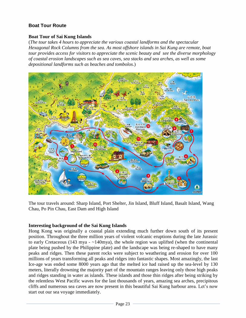
Boat Tour Route
Boat Tour of Sai Kung Islands
(The tour takes 4 hours to appreciate the various coastal landforms and the spectacular
Hexagonal Rock Columns from the sea. As most offshore islands in Sai Kung are remote, boat
tour provides access for visitors to appreciate the scenic beauty and see the diverse morphology
of coastal erosion landscapes such as sea caves, sea stacks and sea arches, as well as some
depositional landforms such as beaches and tombolos.)
The tour travels around: Sharp Island, Port Shelter, Jin Island, Bluff Island, Basalt Island, Wang
Chau, Po Pin Chau, East Dam and High Island
Interesting background of the Sai Kung Islands
Hong Kong was originally a coastal plain extending much further down south of its present
position. Throughout the three million years of violent volcanic eruptions during the late Jurassic
to early Cretaceous (143 mya - ~140mya), the whole region was uplifted (when the continental
plate being pushed by the Philippine plate) and the landscape was being re-shaped to have many
peaks and ridges. Then these parent rocks were subject to weathering and erosion for over 100
millions of years transforming all peaks and ridges into fantastic shapes. Most amazingly, the last
Ice-age was ended some 8000 years ago that the melted ice had raised up the sea-level by 130
meters, literally drowning the majority part of the mountain ranges leaving only those high peaks
and ridges standing in water as islands. These islands and those thin ridges after being striking by
the relentless West Pacific waves for the last thousands of years, amazing sea arches, precipitous
cliffs and numerous sea caves are now present in this beautiful Sai Kung harbour area. Let’s now
start out our sea voyage immediately.
Page 24
Tour content:
(As boat leaves the pier of Sai Kung, start briefing on tour route and giving outline of
surrounding area.)
Sai Kung is getting more popular than before after the enlisting of Global Geopark. People come
here could really find multiple pleasure. There are famous hiking trails accessible from here. A
few famous white sandy beaches also available if they want. Lots of water recreation and sports
can be arranged right at the pier. Of course boating around the Port Shelter like what we are
going to do would be one of the best options from Sai Kung.
Port Shelter is basically an inland sea which is well protected from the ocean wave by many
islands and islets. It is one of the largest inshore water-body in Hong Kong stretching almost 100
sq km in area. There are many inshore and offshore islands and most of them are carried very
special characters and moods of their own making the entire area charming to all visitors. Some
are inhabited with indigenous Hakka Farmers or Tanka Fishermen for a long time. But most
islands here are uninhabited especially those offshore islands. Without being touched by human,
these islands are remaining with their natural beauty making boating around becoming the best
recreation in Hong Kong.
Our boating route today will allow us to see the most famous geological scenic spots in Sai Kung.
We will take turn to visit the Sharp Island, Kau Sai Chau, Jin Island, Bluff Island, Basalt Island,
Wang Chau, Town Island, Po Pin Chau, East Dam and High Island respectively.
It will take about 4 hours to complete the whole journey.
Interesting background
Once when the boat leaves Port Shelter, we will be entering into the area of an ancient volcano.
During the late Jurassic to early Cretaceous (143 mya - ~140mya), the volcanism here was
violently ongoing by four stages. Eventually the emptying of underground magma chamber led to
the collapsing of crater and created the largest caldera in Hong Kong. It is sitting out there
underneath the east sea nowadays after sea level rise and we will be travelling above it. The
caldera area covers the several islands we are going to visit as well as the East Dam area of the
High Island.
Sharp Island
The ancient volcano had disappeared after million years of weathering and erosion, however,
some important traces have been left on Sharp Island. And further explaination …e.g. edge of the
ancient volcano. This island is close to the Sai Kung Township. It takes only 15 minutes boat ride
to reach from the Sai Kung pier. Sharp Island is one of those inhabited islands with few villages.
Once there was even a Water Fun Park built here providing people with various games at the
beautiful Kiu Tsui Beach(橋咀泳灘) making this island becoming the recreational focus in the area.
In addition, Ha Mun Bay Beach is another white sandy beach which is always crowded during
Summer days. Nowadays area around Kiu Tsui Beach is designated as a Geo area of HK Global
Geopark demonstrating various kinds of volcanic rocks and an amazing landscape such as
tombolo (tombolo is a natural sandy bar connecting 2 islands or an island to mainland, emerge
during low tide). Lots of people find it really interesting to come and see those Pineapple Bun
rock - an interesting pictographic rock and to walk on the tombolo during low tide. Visitor can
follow the Geo-trail which will take roughly one hour to complete. The trail comes with
Page 25
information panels in picture and text from which visitors could pick up a free lesson on the
geology of Sai Kung.
Travelling toward the centre of the ancient volcano from the edge. See the islands are made of
the volcanic materials, the rock type is the same over the island on Sai Kung Sea, but in the
volcano centre, it forms closed pack columns, only a few columns can be found toward the edge.
Columns in poor shape can be found at the south and some other area of Kau Sai Chau.
Kau Sai Chau (滘西洲)
This is the biggest island out here in Sai Kung. It has a indented coastline and many deep
sheltered bays which was truly some good habitats for marine creatures. At the gap between this
island and Jin Island there is an old fishing village since the Qing Dynasty. Once the population
was up to 400 people and is only about 50 left now. Northern part of the island has been
transformed into a public Golf course. It has three 18 holes courses and are always fully booked
especially week ends and holidays proving that golf is a very popular game in Hong Kong.
Southern half of the island remains wild with large areas of shrub bushes and ravines. Still very
much a preserve natural haven for birds and insects.
Once this big island was used by the British Army as a firing range which was harmful to the
local fisherman. Luckily there was a lady professor came and live in the village for the research
of local culture. She then wrote to the British government and help moving the firing range to
Basalt Island instead of here. She also help local fisherman in calling helicopter help when some
people got very sick. So after she died, local fisherman erected a memorial plaque in front of the
Hung Shing Temple to remember her.
Jin Island (Tiu Chung Chau 吊鐘洲)
Jin Island is located more or less at the edge of the inshore islands where
the strong ocean wave will be getting weaker as it moves further inshore,
hence, no enormous sea arch could be developed before Jin Island. Jin
Island is neighbouring to Kau Sai Chau and separated by an extremely
narrow channel. The highest point on this island is 216 meters high.
Since the Southern tip of the island is affecting strongly by the Easterly
wind, the wave erosion has created one of four famous sea arched here
called Tiu Chung Cave(it is actually an arch)(吊鐘洞). We will stop in
front of the sea arch for picture taking and appreciation of the natural
beauty.
Jin Island is closer toward the centre of ancient volcano, here the
volcanic materials forms columns, but in irregular polygonal shape.
Bluff Island (Sha Tong Hau Shan 沙塘口山)
Bluff Island is basically a small island but rich in
natural treasure. First of all, it has a protected coral
community with rich marine life - small haven for
scuba-divers. Ung Kong Wan Beach is one of the
very best swimming beach in Sai Kung which is
always crowded at weekends. Of course people must
come on their own or rented yachts, which to a
certain extend, those anchors are sometimes bringing
damages to the coral community. As the island is
located rather off shore to the open sea, you can see
Page 26
serious abrasion landforms are almost every where. The famous Sha Tong Hau Cave (沙塘口洞) is
located at the headland stretches out to the South. Besides watching at the sea arch, you can see
those hexagonal columns on top and by the side of this sea arch happen to be those longest ones
around this area. What a grand sight !!!
Ung Kung Group, High Island and Ninepin are situated at the centre of the ancient volcano,
columns are in nice shape, some in perfect hexagonal columns.
Basalt Island (火石洲)
Basalt Island happens to sit outer most among the Ung Kong Group
facing the open ocean directly without any land barrier. It suffers the
most from the natural wave abrasion, making it most scenic and
dramatic among all islands in Sai Kung. The entire island is
extremely rugged with numerous sea caves and plunging cliffs. The
famous Lam Wan Kok Cave (欖灣角洞) is found here at the Eastern
corner of the island. This is most challenging to adventure seekers
as going through the arch could be risky due to the strong wave.
Basalt Island was also once a Firing Range for the British Army
until 1985. There were fishermen risking their lives during those
days to pick up bomb shells for the metal in exchange for money
when they sell it. Unfortunately, sometimes there were bombs
unexploded but happened to go off when they picked it up. Some
casualties were recorded.
Basalt Island was also the first Air-crash site in Hong Kong. In 1948, a small jet came from
Shanghai with an important entrepreneur Mr Yung and the grandson of the American President
Mr. Quentin Roosevelt, because of heavy fog, the plane was crashed on this island causing a
death toll of 28 people. A small monument was still erected on the island to commemorate the
incident.
The name of basalt island tells the uniqueness of the column found in Hong Kong. As most of
columns found all over the world are developed in basaltic lava, geologists who have firstly
discovered the columns in Sai Kung area also believe the columns are basaltic in nature, so gave
a such name ‘basalt island’. The recent scientific research found those columns are rare which is
rhyolitic, that is in opposite to basalt in both colour and chemical composition.
Wang Chau (橫洲)
Wang Chau is the smallest among the Ung Kong Group. However, the sea arch (橫洲角洞) is the
biggest of all the four with 50 meters in height. The
shape of the sea arch is also unique from the others as it
is narrow at both ends at top and bottom of the arch, but
bigger in the center, making it look like a crest of the
new moon. From certain angle, it also appears like the
shape of Taiwan Island on the map. So somebody also
call it the “Little Taiwan”. The island is located at the
outer most of on the Eastern end also facing the open
sea. Hence, ocean wave effect on this island is very
similar to the Basalt Island.
Page 27
Po Pin Chau (破邊洲)
Po Pin is a giant sea stack. It is a perfect example
showing how powerful is the natural forces. It was
originally part of the High Island that you can tell
the shape of the Fa Shan mountain. Dramatically
those enormous sea wave coming in from the West
Pacific kept striking strongly along a fault line on
the headland. The vertical joints along the wall of
the headland was happened to be weaker because
of the fault line. The erosion could work
effectively to traverse the entire headland to create
firstly a sea arch quickly, then the hanging rocks
were also fallen down and be washed away. When we come closer to see the wall of the cutting
face, it is all very long and straight pieces of hexagonal Rock Columns. You may say it is a piece
of grand size “Wall Mural”, or some even say it looks very much like the Church Pipe Organ of
the Medieval Age. These rock columns are regarded as some of those longest columns found in
Hong Kong Geopark which stretch over 40 meters. In the old days before people have got any
concept about the geopark, hikers has given a fascinating name to this sight. They called it the
“God Cut Gap”(神削峽) which was to certain extend showing the level of respect these hikers
seeing this matter.
The gap in between is not really that narrow, but the distance is long enough to create a high level
of danger when some people try to traverse the gap.
East Dam of High Island Reservoir (萬宜水庫東壩)
The High Island East Dam itself is a contemporary man made wonder. From the water side, you
can see the construction of the Coffer Dam in details. Just imagine how challenging will it be if
we are talking about making, lifting, moving and dropping it to the right position with 7000
pieces of these “Twisted H” shape Dolosse rocks. All these concrete dolosse were made at site
here to save the transportation work. Each of these rocks is weighted 25 tons. The twisted arms of
the letter H would strengthen themselves by interlocking each other to stand against the roaring
waves from the West Pacific Ocean especially during typhoon seasons. In between the arms of
the dolosse rock, you could find ample of cavity which will also effectively reduce the strength of
waves. What an amazing Italian engineering!!!
The grand construction cover with debris of the tuff rock is the East Dam. In order to increase the
water volume, the Dams of this High Island Reservoir are raised to the height of 100 meters.
Hence this reservoir is now largest in volume among the 17 reservoirs in Hong Kong. The
discovery of these world’s largest hexagonal rock columns was actually attributed to the
construction of this High Island Reservoir. You can see at the far right side several walls are
artificially cut out by dynamite blasting. No matter how deep the wall was cut, the rock nature are
presenting same type of appearance – walls of columnar joints. Hence the nature wonder was
uncovered and after proper management plans were applied in place and we are now proud to say
that Hong Kong Geopark is now a global level geopark accredited by the UNESCO.
Page 28
Code for visiting Geosites in HK
Please observe the following code and safety guidelines when visiting the geosites in Hong Kong:
1. Never go on a rock or landform appreciation trip alone.
2. Never go on a rock or landform appreciation trip in adverse weather.
3. Plan a safe trip with reference to the tidal information posted on the Hong Kong
Observatory's website. Be aware that some coastal areas may not be accessible at all
times.
4. Plan a route with a proper trail that ALL members of your group may reasonably
handle.
5. Some islands and coastal areas may be difficult to access and are only suitable for
boat trips. Avoid visiting them when strong easterly winds prevail.
6. Remain alert to changes in the surrounding environment and any potential hazards,
such as rapids, cliffs and steep slopes. Exercise extra caution when rock surfaces are
wet.
7. Do not climb the rock columns or trample on severely weathered or eroded surfaces.
Watch out for shifting or slippery rocks.
8. Wear suitable hiking shoes, hats and clothes. Also take gloves, first-aid kits and
weather-proof clothes with you.
9. Mobile phone coverage may vary from place to place. Leave details of your route
and expected return time with someone, for raising the alarm if necessary.
10. Use only tour guides who have outdoor training and first-aid skills.
11. Use only boat operators who comply with all the safety requirements and have life
jackets for all passengers.
12. Do not take away any rock, fossil, mineral or silt. It is an offence to dig up, damage
or deface any rocks in Hong Kong.
The conservation of the geo-sites in Hong Kong is in our hands!