Embed Size (px)
Citation preview
Safety Warning Based on Highway SensorNetworks
Kai Xing Min Ding Xiuzhen Cheng Shmuel RotenstreichDepartment of Computer Science
The George Washington UniversityWashington, DC 20052, USA
{kaix,minding,cheng,shmuel}@gwu.edu
Abstract— In this paper we propose a novel vision for highwaysafety warning based on sensor networks, aiming at providinguser-friendly zero-delay safety warning to motorists. Our idealeverages the advanced sensing, networking and storage tech-nologies. Highway sensors detect events and store event recordsat multiple designated locations such that passing-by drivers canbe alerted to potential dangers or traffic delays through wirelesscommunication among sensors deployed at the highway and thevehicle. We design a location-centric storage protocol, whichmanages the propagation and storage of event records based onthe time needed to clear the event in the highway. This protocolensures that event records can be fairly distributed amonghighway sensors when event arrival rate is Poisson distributedwith the same mean, as verified by our simulation study andtheoretical performance analysis.
Keywords: safety warning, highway sensor networks,location-centric storage
I. INTRODUCTION
Although great effort has been made on highway safetywarning in the United States in recent years, the total numberof fatalities involved in motor vehicle traffic crash graduallyincreases over the past five years, as reported in Table I1. Thistrend will be continued in the future, projected by the Bureauof Transportation Statistics [5] and FARS (Fatality AnalysisReporting System) [6], due to the contradiction between theincreasing vehicle usage and the relatively slow highwayconstruction. Furthermore, the large number of injuries andfatalities (Table I) and the serious asset damage result in enor-mous economic loss, which further emphasizes the importanceof new technology to roadway safety.
1998 1999 2000 2001 2002Killed 41, 471 41, 611 41, 821 42, 116 42, 815
Injured ×103 3, 192 3, 236 3, 189 3, 033 2, 926
TABLE I
KILLED AND INJURED IN VEHICLE TRAFFIC CRASH.
On November 18, 2003, a novel safety philosophy called“Zero Fatality, Zero Delay” was proposed at the World
1Data obtained from the traffic safety fact annual reports by the NationalCenter for Statistics and Analysis of the National Highway Traffic SafetyAdministration [8], July 2004.
Congress on ITS (Intelligent Transportation Systems and Ser-vices) in Madrid, Spain. This exciting vision represents a newconcept of the way ITS should be designed and deployed.“Zero Fatality, Zero Delay” means that “in the future peopleand goods are transported without delay, injury, or fatality byintegrated systems that are built and operated to be safe, costeffective, efficient, and secure.” (Quoted from the news reportat the 2003 World Congress on ITS.) “Zero Delay” does notimply the zero-time transportation. It refers to the eliminationof the avoidable delays by the efficient use of technology andinformation. In this paper, we report our exploratory worktoward highway safety warning based on sensor networks, anattractive and economical idea aiming at “Zero Fatality, ZeroDelay”.
The application of sensor networks in ITS has not beenexplored because sensor network technology is still a newdevelopment. However, sensors have already been used inhighway and traffic data collection for real-time managementand control [9], [26], [32]. For example, the PATH program[9], [32] carried out by UC Berkeley utilizes the data collectedby highway sensors for automatic control at highway speedand precision docking. Beyond this, the data collected byhighway sensors has been used to facilitate the real-timeincident estimation or predication [24], [25]. In this paper, weconsider networked sensors, which collaboratively realize anactive safety warning system to prevent many of the injuriesand deaths involved in vehicle traffic crash.
The basic idea is as follows. A record is built by thehome sensor observing the occurrence of some event (e.g.fog, accident, etc.) in the highway. This record is stored inthe databases of the home sensor and sensors that are somedistance away against traffic direction. When a driver passes-by, a warning signal is generated to alert him to the possibledangers in his forward direction. We require that the density ofthe sensors storing a specific record decreases as the distanceto the event location increases. This mimics the placement ofexit signs along a highway: the closer the driver is to his exit,the more signs he can see.
This design is motivated by the following considerations.We would like the driver to be alerted as many times asnecessary but not too many, because warning signals are
IEEE Communications Society / WCNC 2005 2355 0-7803-8966-2/05/$20.00 © 2005 IEEE
annoying interrupts to the driver. It is obvious that a non user-friendly warning system may cause drivers to turn down theservice. Further, drivers should receive the right alert at theright time. It may be useless for a driver to be notified abouta serious traffic jam after he has turned in that direction; andone does not care about the current road condition in I-94 ifhe is heading for MN-35W. These observations motivate ourconsideration and are based on wireless sensor networks aimedat providing user-friendly zero-delay warnings for drivers onlywhen necessary. As a counter example, the popular radiobroadcasting system produces an overwhelming amount ofdelayed information to all customers in its coverage area.
The focus of this paper is the record storage problem inhighway sensor networks, which plays a key role in our visionof user-friendly zero-delay warning. The event record shouldbe stored in a way such that no sensor will be overloaded,as memory budget within a sensor is stingy. We proposea distributed data storage protocol, termed location-centricstorage, to effectively disseminate event records. This protocolhas the following nice features.
1) The propagation and storage of an event record aredetermined by the event location and the time neededto clear the road for the event. The closer to the eventlocation, the larger the number of sensors storing theevent; The longer the time needed to clear the road forthe event, the farther away the record is propagated, thelonger time the record is stored in the database.
2) If the number of events detected by each sensor at aunit time interval follows a Poisson distribution with thesame mean λ, then the memory space needed for recordstorage is evenly distributed. In other words, no sensorwill be overloaded and the storage protocol is fair.
3) The location-centric protocol is pure localized. Thepropagation of event records is controlled by their TTLvalues. Therefore the protocol scales well to large high-way sensor networks.
This paper is organized as follows. We first elaborate ourvision of highway safety warning based on sensor networks inSection II and discuss our network model in Section III. Thenwe propose and analyze the location-centric storage protocolin Section IV. Related work is sketched in Section V. Oursimulation results are reported in Section VI. We concludethis paper with a discussion in Section VII.
II. A NEW VISION OF HIGHWAY SAFETY WARNING
In this section, we first discuss our vision of user-friendlyzero-delay highway safety warning based on wireless sensornetworks. Then we identify several example applications.
A. Highway Safety Warning Based on Sensor Networks
In our consideration, the network contains highway sensorsfor data collection, and vehicle sensors for warning signalreception. Highway sensors are stationary after they are de-ployed along the road. Vehicle sensors are mobile as they
are placed within each vehicle. The raw data observed byhighway sensors go through a pre-processing procedure toproduce a event record, if an event occurs. The highway sensoris the home sensor of the event record. Each record, uniquelyidentified by its id, corresponds to one occurrence of someevent. The record has five other fields: event id, location,priority, index, and Time-To-Live (TTL). The event id specifiesthe type of the event (e.g. 0 for fog, 1 for traffic congestion,2 for car accident, etc). The location field consists of thegeographic position of the occurrence of the event. The priorityfield characterizes the seriousness of the event. The index valueis determined by the amount of time needed to clear the road.The TTL value tells the sensor storing this record when topurge the corresponding entry from its database. The recordis propagated along the highway through the broadcasting andrelaying of highway sensors. A sensor at designated locationcreates an entry for this event in its database and generateswarning signals for the vehicles passing-by.
The home sensor must store the event record. Whether ornot other highway sensors store a travelling event record isdetermined by their distance to the event location, and theindex of the event. The higher the index, the greater distancethe record will be propagated. The closer the highway sensor tothe event location, the higher the chance of storing the recordwithin the sensor. To achieve this goal, when receiving anevent record, a highway sensor computes its distance ∆ to thehome sensor of the event record and check whether ∆ is “closeenough”2 to one of the values within the set {c·(21−1), c·(22−1), · · · , c · (2σ − 1)}, where c is the average distance betweentwo neighboring highway sensors, σ is the index drawn fromthe event record. With this scheme, each highway sensor canlocally and independently determine whether it should drop orstore the received event record.
The priority value within each record is used to determinewhether a warning signal must be generated or not. Forexample, highway sensors always alert motorists to the highestpriority event. The index value can be a function of TTL(e.g. index= �log(TTL)�), since both are related to the timerequired to clear the road for the event.
B. Example Applications
Many different safety warning systems have been deployedin modern intelligent transportation services. In this subsec-tion, we examine several of them and discuss the applicabilityof our proposed idea of safety warning based on sensornetworks.
Perhaps the most popular highway safety warning system isthe radio networks, which broadcast information periodicallyon certain frequency. For example, the radio broadcast systemat the Washington metropolitan area repeats the highwayinformation once every 10 minutes within its coverage area.
2Here “close enough” means that this highway sensor is the closest amongits neighboring sensors to one of the ideal locations where the record shouldbe stored at.
IEEE Communications Society / WCNC 2005 2356 0-7803-8966-2/05/$20.00 © 2005 IEEE
Radio broadcasting in highway safety warning can never bethe most preferable service for a driver for the followingreasons. First, a period as long as ten minutes may be toolong for drivers that are approaching an accident to avoidcontinuous accident/traffic congestion. Radio broadcasting cannot provide zero-delay warning. Second, to be alerted, onemust continuously tune to the radio frequency when driving.This means the driver must sacrifice his favorite music forhighway information. Third, the information broadcasted tothe driver may be useless, as he is heading in another direction.These redundant information is intrusive, causing the driver tobe distracted, which further increases the chance of highwayaccident. The highway sensor network for safety warningproposed in this paper can provide zero delay warning, as theinformation has already been stored within the sensor that issome distance away from the event position. In such a system,drivers have little chance to receive unrelated information.Further, as the driver is approaching the event location, moreand more warnings will be generated for the driver. Thisautomatic reception of warning signals from highway sensorsintroduce the least amount of interruption to the driver, whocan listen to his favorite music while being alert.
Another warning system is the programmable “read-at-a-glance” LCD/HUD display along highways [35] [39]. It issupposed that drivers can read the abstract information onLCD/HUD at a glance when driving. In reality, drivers oftenmiss the abstract information or may not thoroughly readthe whole message due to high speed. What’s more, in badweather, at night, or during the time that is of high accidentprobability (e.g. road construction), drivers must pay muchmore attention on driving instead of quickly finish readingthe warning message. In this case, with higher probabilitythan usual, drivers may miss the critical information! Withour method, it is unnecessary for drivers to be completelydistracted from driving. When one passes-by, the necessaryinformation can just be downloaded automatically. Further-more, the closer the driver to the dangerous/accident location,the more frequently he will receive warning signals. Thischaracteristic is not available in any current highway warningsystems. It causes low miss rate for critical information, animportant feature that all highway safety warning systems areexpected to provide.
As reported by Federal HighWay Administration (FHWA)[10], thousands of trains and vehicles collide at railroadcrossings every year. In the year 2002, 311 people werekilled and 859 were injured in train-vehicle crash. Thus asafety warning system that could prevent many of these deathsand injuries is needed. But the installation of conventionaltechnology such as radio networks is cost-prohibitive due tothe low vehicle-volume at railroad crossings that are mainlyin rural areas. However, we can place sensors along crossingrailroads and roadways such that the approaching of a traincan be propagated through wireless communication to thecrossing roadways. Motorists can be warned multiple times
when driving toward the roadway-rail crossing point. Thefeasibility of this system is guaranteed by the fact that wirelesssignals can travel at much higher speed than that of the train.
The need for a highway fog warning system has longbeen recognized by the ITS society [2]. With such a system,motorists can avoid tragic pile-up accidents caused by dense orpatchy fog. A cost-efficient highway fog warning system basedon sensor networks can be sketched as follows. The occurrenceof fog, together with its intensity and duration information,are detected and computed by visibility sensors [7] (a type ofhighway sensor) deployed along highways. Highway sensorspropagate this event such that it can be stored at designatedlocations to alert drivers passing-by. Approaching motoristsreceiving fog warnings through the communication between itsvehicle sensor and highway sensors may be willing to detourto avoid possible traffic delay and crashes.
With the development of advanced sensing technologies,and the marriage of sensing, computing and communicating,highway safety warning based on sensor networks that pro-vides low-cost, zero-delay, minimum interruption, and leastinformation loss, becomes realistic. We envision our ideaof highway safety warning as a generic one, which can’tbe restricted by applications mentioned above in this paper.Furthermore, our idea is a prosperous try for achieving thegoal of “Zero Fatality, Zero Delay”.
III. THE NETWORK MODEL
We assume highway sensors (possibly with multiple modal-ities to measure visibility, vibration, speed, etc.) are deployedat fixed intervals (1 unit) along the highway. For simplicity,we model each direction of a highway as a straight line andevent records propagate against the traffic along the side thathas the event, since only approaching vehicles are interestedin it. Assume the transmission range of each sensor is a littlemore than 1 unit, thus each sensor can communicate with twoneighbors at opposite directions. Therefore, the topology ofour highway sensor network is a line graph such that twoneighboring sensors are separated by 1 unit in distance. Notethat in this paper we only consider one direction of a highwaysystem.
We also assume sensors can determine their positionthrough GPS or other techniques such as TPS [17] andiTPS [31]. We assume sensors are powered by solar panelsthus, energy supply is not a problem to keep their databasesrefreshed. Vehicle sensors can be powered by motor engines,as they are bundled with the vehicle. They work collaborativelywith the vehicle electronics to generate appropriate warningmessages based on the information obtained from highwaysensors. All highway sensors form a one-dimensional networkto seamlessly monitor the highway condition.
In this paper we will not delve into the preprocessing[13] techniques for event record generation. We also will notconsider the broadcasting in the highway sensor network [15]and inter vehicle communication [20]. We assume there exists
IEEE Communications Society / WCNC 2005 2357 0-7803-8966-2/05/$20.00 © 2005 IEEE
a robust broadcasting protocol such that event records canbe properly disseminated. We focus on data storage. That is,we consider how the event record can be stored efficientlyand effectively such that real-time warning signals can begenerated based on the entries in the database when a vehiclepasses by. We assume records are purged from the databasewhen their TTL values reach 0 to free space for new eventrecords.
The event record can be computed by one robust sensor,or by multiple collaborative sensors in close neighborhood.This is beyond the scope of our paper. Actually highwaysensors capable of detecting fogs, traffic jam, accident, etc.,are already available [12] and the research toward high qualityhighway sensors continues to flourish [21]. Similarly we willnot consider the generation of alarming signals in this paper.To realize the zero-delay safety warning based on sensornetworks, as described above, highway sensors must have theability to detect the approaching vehicle, possibly through thebeacon signals disseminated by the vehicle sensors.
IV. LOCATION-CENTRIC STORAGE
In this section, we first elaborate the protocol for location-centric storage for safety warning in highway sensor networks.Then we analyze the features of this storage technique.
A. Protocol Description
With the assumption that all highway sensors are deployeduniformly at fixed positions along a straight line modelling theone-dimension highway sensor network, the protocol can besimplified as follows.
• When detecting an event, a highway sensor at location xcreates, stores and broadcasts an event record.
• When receiving an event record, a highway sensor storesthe record if it is located at one of the following criticalpositions: x + 21 − 1, x + 22 − 1, · · · , x + 2σ − 1, whereσ is the index value drawn from the received record.Otherwise, the record is dropped. In both cases, thehighway sensor broadcasts the record if its distance tothe home sensor of the event record is less than 2σ .
• After a record is inserted into the database of some sensor,its TTL value starts to decrease and the entry containingthe record will be purged out of the database immediatelyafter TTL reaches 0.
• When receiving a query from a vehicle sensor, a highwaysensor sends a reply message based on the stored records.
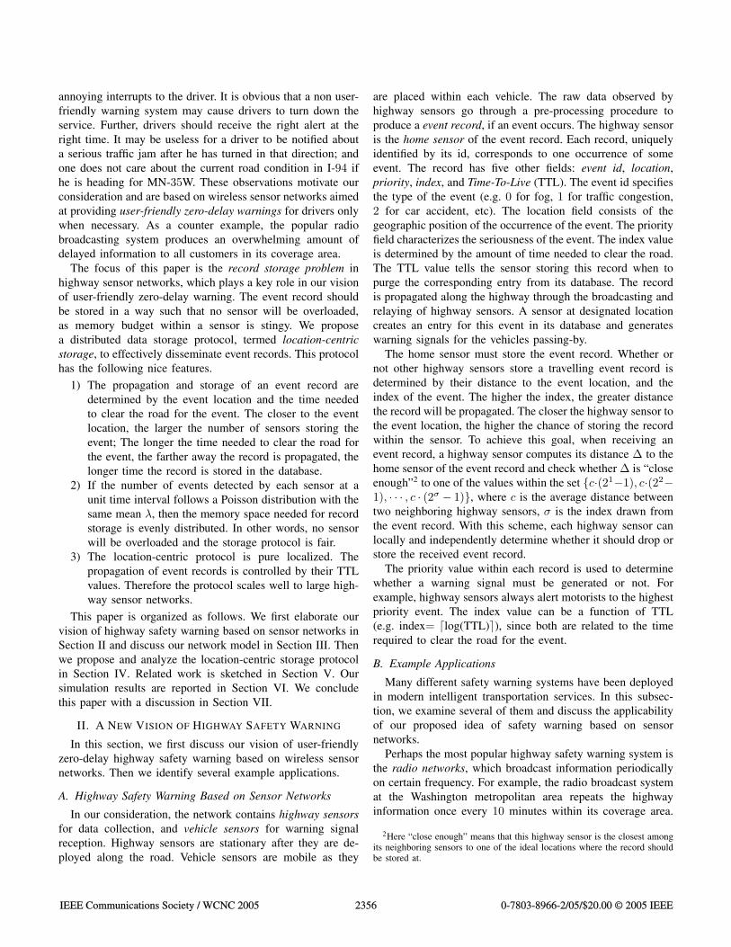
Intuitively if an event with index σ happens at location x, itsrecord will be stored at x, x + 1, x + 3, x + 7, · · · , x + 2σ − 1.This way, we ensure that: the closer the driver to the eventlocation, the greater the number of warning messages he mayget; the longer the time needed to clear the road for the event,the longer distance the record will be propagated. With thisidea of location-centric storage, building a user-friendly zero-delay warning system becomes a realistic. An example is givenin Fig. 1.
0 1 2 3 4 5 6 7 8 9 1110 12 13 14 15 16 1817 19 20
. . . . . . . . . . . . . . . . . . . . .
Fig. 1. An example location-centric storage scenario. Three event recordswith indices of 4, 3, and 4 are generated at locations 0, 2, and 4, respectively(indicated by the black circle, triangle and square). The empty circles, squaresand triangles represent the copies of the records stored at the correspondingpositions.
Note that even though highway sensors are not uniformlydistributed and it may not be appropriate to model the highwayas a straight line, it is still possible to apply this protocol. Asdescribed in Subsection II-A, by checking the distance to thehome sensor, a highway sensor can determine whether it isthe closest among its one-hop neighbors to one of the critical(ideal) storage locations. The simple model can simplify theperformance analysis conducted in next subsection.
B. Performance Analysis
Our location-centric storage has several nice features, whichare studied in this subsection. Again, the highway sensornetwork is modelled by a straight line with one sensor placedat each integral position and neighboring sensors separated byunit distance.
Theorem 4.1: If two records, produced by two differenthighway sensors at locations x and y respectively, are storedand disseminated in the one-dimensional sensor network fol-lowing the location-centric storage protocol, then at most onehighway sensor will store both of them.
Proof: Without loss of generality, we assume x < y. Wealso assume when the second record is generated, the first oneis still alive. Otherwise, the theorem holds trivially. Let theindices of the two records are σx and σy respectively. Then,the storage locations for records x and y are {x, x + 1, x +3, · · · , x + 2σx − 1}, and {y, y + 1, y + 3, · · · , y + 2σy − 1},respectively.
For contradiction we assume there are two highway sensorsthat store both records x and y. Let a1 and a2 be theexponentials that determine the two locations for record x. Thetwo exponentials b1 and b2 for record y are defined similarly.We have
x + 2a1 − 1 = y + 2b1 − 1, (1)
x + 2a2 − 1 = y + 2b2 − 1. (2)
Without loss of generality, we assume 0 ≤ a1 < a2. Thus0 ≤ b1 < b2. Since x < y, we have a1 > b1 and a2 > b2.
From Eqs. (1) and (2), we obtain
2a1 − 2b1 = 2a2 − 2b2 , (3)
which gives
(2a1−b1 − 1) = 2b2−b1(2a2−b2 − 1). (4)
IEEE Communications Society / WCNC 2005 2358 0-7803-8966-2/05/$20.00 © 2005 IEEE
Obviously the left hand side of Eq. (4) is odd but the righthand side is even, since b1 < b2, a1 > b1, and a2 > b2. Thisis impossible. Therefore the number of highway sensors thatstore the same pair of records is at most one. �
Theorem 4.1 indicates that no matter how big the indexvalue of a record is, there will be at most one sensor that storesthe same pair of records in the sensor network. However, theindex value determines how many copies of the record can bestored and what distance the record can be propagated in thehighway sensor network. Therefore it still affects the storagespace at each sensor, as indicated by Theorem 4.2.
Theorem 4.2: Assume broadcasting takes no time. Let σand T be the average index value and average TTL valuefor all events, respectively, where T is a positive integer thatrepresents T unit time. Also assume that at any sensor, thenumber of events detected during the unit time, denoted byN , follows a Poisson distribution with the same mean λ. Iftwo Ns obtained at two different sensors or at the same sensorbut from two different unit times are independent, then theaverage number of records stored at each highway sensor isλ(σ + 1)T .
Proof. Consider the sensor located at y. It is easily seenthat at any instant time t, this sensor will record only thoseevents arriving at sensors at x = y +1−2i for i = 0, 1, . . . , σduring the time interval [t − T, t]. Let Nij be the numberof events arriving at the sensor located at x = y + 1 − 2i
during the jth unit time interval [t − T + j − 1, t − T + j]for i = 0, 1, . . . , σ and j = 1, 2, . . . , T . Then the number ofevents at the sensor located at x = y + 1 − 2i during thetime interval [t − T, t] is Wi =
∑Tj=1 Nij . Therefore at any
time t, the number of records stored at the sensor at y equalsW =
∑σi=0 Wi =
∑σi=0
∑Tj=1 Nij . It follows from the
independence among Ns that W has a Poisson distributionwith mean equal to λ(σ + 1)T . This completes the proof. �
Theorem 4.2 indicates that each highway sensor stores aboutλ(σ+1)T number of records at any instant of time. This meansthat the average storage space at each sensor has nothing todo with the size of the highway sensor network. Thereforeour protocol scales well. Note that since the broadcasting ofeach record is controlled by the index and the home locationof the event, our protocol is efficient in energy and bandwidthutilization.
Theorem 4.3: Let σ be the average index for all kinds ofevents. Then the average number of broadcastings per recordis 2σ .
Proof. If the record with index σ is generated at locationx, it will be propagated along the highway until the highwaysensor at location x+2σ −1 captures it. This sensor will stopthe broadcasting of the message containing the record. Allintermediate sensors, including the sensor at x, will broadcastonce. Therefore the theorem holds. �
Based on Theorems 4.2 and 4.3, our location-centric storageis efficient in network resource (power, bandwidth, mem-ory) utilization. Further, location-centric storage is fair toall highway sensors in resource utilization, as long as theevents are randomly and independently generated. This is anintrinsic difference compared with data-centric storage [28],[29], which creates storage hot spot even when the numberof events in the network is low. Note that the computationoverhead for record generation is not discussed in this paper.We refer the readers to literatures related to advanced highwaysensor designs [22].
V. RELATED WORK
In this subsection, we briefly survey the related work alongtwo lines: the application of sensor technologies in highwaysafety warning and the data storage techniques in sensornetworks. Existing highway safety warning systems have beencovered in Subsection II-B.
Current highway warning systems have already exploitedadvanced sensor technologies [4] [21] [22] , such as mi-crowave presence-detecting radar, doppler microwave radar,laser radar, active/passive infrared, ultrasound, acoustic array,magnetic, video image processor, inductive loop detector, fogsensing, etc., for intersection control [3], freeway incidentdetection [26], traffic congestion monitoring [16], ramp andfreeway-to-freeway metering [38], lateral control [23], trafficdata collection [34], weather and highway condition detection[7], etc. These systems rely on the data collected by sensorsfor their management and control. None of them considersthe networking of sensors. As a contrast, our vision of user-friendly zero-delay highway safety warning is based on sensornetworks that can collect, disseminate and store updatedinformation for traffic alert.
There are several data storage techniques in wireless sensornetworks: local storage, external storage, and data-centricstorage [30]. In local storage, data is stored locally at thehome sensor and it is short-lived. In external storage, datais sent to the outside access point where it can be furtherprocessed as needed. In data-centric storage, data is stored byname/location. A geographic hash table (GHT) based data-centric storage [29] maps the data of the same type (name)to a fixed location in the sensor network. As analyzed by[29], when the number of events and the number of queriesare both high, external storage performs better in energyconsumption. When both are low, internal storage is better.In other cases, data-centric storage outperforms both externaland local storage. For our application scenario, none of thesestorage techniques is applicable. The proposed location-centricstorage selects sensors to store an event record based on itsdistance to the home sensor and the index of the event.
VI. SIMULATION
In our simulation, 2500 nodes representing highway sensorsare deployed in a straight-line mimicking a one-dimensional
IEEE Communications Society / WCNC 2005 2359 0-7803-8966-2/05/$20.00 © 2005 IEEE
highway system. These sensors are placed in equal intervalswith sensor i residing at location i. A sensor at location jbroadcasts a record generated by sensor i if j ≥ i and j <x + 2σ − 1, where σ is the index. This record will be storedin the databases of sensors i, i+1, i+3, i+7, · · · , i+2σ − 1.
We assume message delivery is instantaneous and error free.Whenever a sensor detects an event, a record with index σ willbe generated immediately. In our simulation, the number ofevents detected by each sensor per second (event arrival rate)follows a Poisson distribution with the same mean λ. Thismeans that the occurrences of events are independent withineach sensor, and the probability of event detection is the samefor all sensors. We set λ = 2i × 10−4, where i = 0, 1, · · · , 12.The index σ and the TTL value are randomly chosen from[0, 8] and [1, 1000]s, respectively. TTL decreases by 1 at eachsecond after the record is inserted into the database and arecord is removed from the database immediately after its TTLreaches 0.
The total simulation time is set to 2000. We count thenumber of records stored in each sensor at every second. Allsimulation results are averaged over 20 runs.
To measure the performance, we use the ratio MaxStorageAvgStorage .
Let Ni(t) be the number of records stored by sensor i, i =1, 2, · · · , 2500, at time t. Then
MaxStorage(t) = max2500i=1 {Ni(t)}, (5)
AvgStorage(t) =∑2500
i=1 Ni(t)2500
, (6)
for t = 1, 2, · · · , 2000. MaxStorage(t) reflects the worstcase for storage at time t among all sensors in the network;AvgStorage(t) is the best case when all records are perfectlydistributed among all sensors in the network. The ratio ofMaxStorage and AvgStorage illustrates the fairness of ourlocation-centric storage protocol in a highway sensor network.A higher ratio indicates the existence of storage hot spot,which may cause the highway safety warning fail if the storagespace is overflowed.
1 200 400 600 800 1000 1200 1400 1600 1800 20000
50
100
150
200
250
300
350
Time
Sto
rag
e
Avg when λ = 0.1024Max when λ = 0.1024Avg when λ = 0.0256Max when λ = 0.0256Avg when λ = 0.0016Max when λ = 0.0016
1 200 400 600 800 1000 1200 1400 1600 1800 20000
5
10
15
20
25
30
Time
MaxS
tora
ge / A
vgS
tora
ge
λ = 0.4096λ = 0.1024λ = 0.0256λ = 0.0064λ = 0.0016
(a) (b)
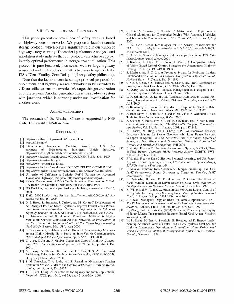
Fig. 2. (a) MaxStorage and AvgStorage vs. simulation time t whenλ = 0.0016, 0.0256, and 0.1024. (b) MaxStorage
AvgStoragevs. simulation time t
when λ = 0.0016, 0.0064, 0.0256, 0.1024, and 0.4096.
Fig. 2(a) illustrates MaxStorage and AvgStorage vs. sim-ulation time t for λ = 0.0016, 0.0256 and 0.1024 respectively.
This figure indicates that both MaxStorage and AvgStoragebecome stable after t = 800s. We also observe that larger λresults in higher MaxStorage and AvgStorage. Fig. 2(b)reports MaxStorage
AvgStorage vs. simulation time t for λ = 0.0016,0.0064, 0.0256, 0.1024, and 0.4096. It reveals that the ratiosdrop quickly after simulation starts and become stable aftert = 300s. It takes a little bit more time for the ratio tobecome stable when event arrival rate is low. For different λ,even though the ratios are not the same but they are close toeach other. We notice that the higher the event arrival rate, thelower the ratio. This indicates that our location-centric storageprotocol is more fairer for higher traffic load. From Fig. 2(b)we conclude that the storage space needed by each sensor isfairly distributed for a wide range of event arrival rates.
1 500 1000 1500 2000 2500 3000 3500 4000 45000
2
4
6
8
10
12
14
Event arrival rate
ρ
1 200 400 600 800 1000 1200 1400 1600 1800 20000
50
100
150
200
250
300
Time
Sto
rag
e
(a) (b)
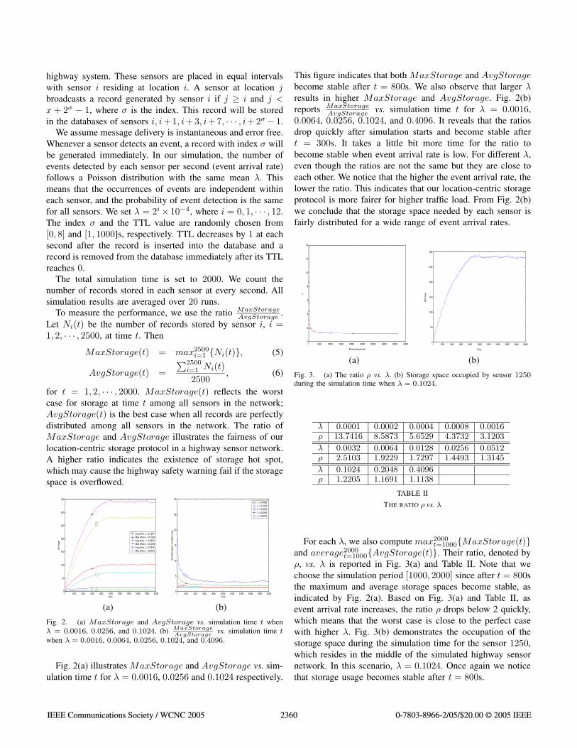
Fig. 3. (a) The ratio ρ vs. λ. (b) Storage space occupied by sensor 1250during the simulation time when λ = 0.1024.
λ 0.0001 0.0002 0.0004 0.0008 0.0016ρ 13.7416 8.5873 5.6529 4.3732 3.1203
λ 0.0032 0.0064 0.0128 0.0256 0.0512ρ 2.5103 1.9229 1.7297 1.4493 1.3145
λ 0.1024 0.2048 0.4096ρ 1.2205 1.1691 1.1138
TABLE II
THE RATIO ρ vs. λ
For each λ, we also compute max2000t=1000{MaxStorage(t)}
and average2000t=1000{AvgStorage(t)}. Their ratio, denoted by
ρ, vs. λ is reported in Fig. 3(a) and Table II. Note that wechoose the simulation period [1000, 2000] since after t = 800sthe maximum and average storage spaces become stable, asindicated by Fig. 2(a). Based on Fig. 3(a) and Table II, asevent arrival rate increases, the ratio ρ drops below 2 quickly,which means that the worst case is close to the perfect casewith higher λ. Fig. 3(b) demonstrates the occupation of thestorage space during the simulation time for the sensor 1250,which resides in the middle of the simulated highway sensornetwork. In this scenario, λ = 0.1024. Once again we noticethat storage usage becomes stable after t = 800s.
IEEE Communications Society / WCNC 2005 2360 0-7803-8966-2/05/$20.00 © 2005 IEEE
VII. CONCLUSION AND DISCUSSION
This paper presents a novel idea of safety warning basedon highway sensor networks. We propose a location-centricstorage protocol, which plays a significant role in our vision ofhighway safety warning. Theoretical performance analysis andsimulation study indicate that our protocol can achieve approx-imately optimal performance in storage space utilization. Thisprotocol is pure-localized, thus scales well to large highwaysensor networks. Our idea is an attractive way to approach theITS’s “Zero Fatality, Zero Delay” highway safety philosophy.
Note that the location-centric storage protocol proposed forone-dimensional highway sensor networks can be extended to2-D surveillance sensor networks. We target this generalizationas a future work. Another generalization is the roadway systemwith junctions, which is currently under our investigation foranother work.
ACKNOWLEDGMENT
The research of Dr. Xiuzhen Cheng is supported by NSFCAREER Award CNS-0347674.
REFERENCES
[1] http://www.fhwa.dot.gov/rnt4u/ti/hwy rail.htm.[2] http://ntl.bts.gov/.[3] Infrastructure Intersection Collision Avoidance, U.S. De-
partment of Transportation, Intelligent Vehicle Initiative,http://www.ite.org/library/IntersectionSafety/Ferlis.pdf
[4] http://www.itsdocs.fhwa.dot.gov/JPODOCS/REPTS TE/1J501!.PDF[5] http://www.transtats.bts.gov.[6] http://www-fars.nhtsa.dot.gov/.[7] http://www.itsdocs.fhwa.dot.gov/JPODOCS/PERIODIC/76M01!.PDF[8] http://www-nrd.nhtsa.dot.gov/departments/nrd-30/ncsa//AvailInf.html.[9] University of California at Berkeley PATH (Partners for Advanced
Transit and Highways) Program, http://www.path.berkeley.edu[10] FHWA, Development of IVHS Traffic Parameter Specifications C Task
- A Report for Detection Technology for IVHS, June 1994.[11] ITS Decision, http://www.path.berkeley.edu/ leap/, Accessed on: Feb.10,
2000.[12] Traffic 2000 Products and Services, http://www.traffic-2000.co.uk/, Ac-
cessed on: Jan. 15, 2000.[13] D. S. Breed, L. Summers, J. Carlson, and M. Koyzreff, Development of
An Occupant Position Sensor System to Improve Frontal Crash Protec-tion, Seventeenth International Technical Conference on the EnhancedSafety of Vehicles, no. 325, Amsterdam, The Netherlands, June 2001.
[14] L. Briesemeister and G. Hommel, Role-Based Multicast in HighlyMobile but Sparsely Connected Ad Hoc Networks, in Proceedings ofthe First Annual Workshop on Mobile Ad Hoc Networking Computing(MobiHOC), Boston, MA, USA, Aug 2000
[15] L. Briesemeister, L. Schafers and G. Hommel, Disseminating Messagesamong Highly Mobile Hosts based on Inter-Vehicle Communication,IEEE Intelligent Vehicle Symposium, pp. 522-527, Oct, 2000.
[16] C. Chen, Z. Jia and P. Varaiya, Causes and Cures of Highway Conges-tion, IEEE Control Systems Magazine, vol. 21 no. 4, pp. 26-33, Dec2001.
[17] X. Cheng, A. Thaeler, G. Xue, and D. Chen, TPS: A Time-BasedPositioning Scheme for Outdoor Sensor Networks, IEEE INFOCOM,HongKong China, March 2004.
[18] S. M. Donecker, T. A. Lasky and B. Ravani, A Mechatronic SensingSystem for Vehicle Guidance and Control, IEEE/ASME Trans on Mecha-tronics,, vol. 8, no. 4, Dec 2003
[19] T. T. Hsieh, Using sensor networks for highway and traffic applications,Potentials, IEEE, pp. 13-16, vol 23, issue 2, Apr-May, 2004.
[20] S. Kato, S. Tsugawa, K. Tokuda, T. Matsui and H. Fujii, VehicleControl Algorithms for Cooperative Driving With Automated Vehiclesand Intervehicle Communications, IEEE Trans. ITS, vol. 3, no. 3, Sep2002.
[21] L. A. Klein, Sensor Technologies for ITS Sensor Technologies forITS. http : //depts.washington.edu/ahb20/status/july2002/sensortech.pdf/.
[22] L. A. Klein, Sensor technologies and data requirements for ITS, Pub-lisher Boston: Artech House, 2001.
[23] J. Kosecka, R. Blasi, C. J. Taylor, J. Malik, A Comparative Studyof Vision-Based Lateral Control Strategies for Autonomous HighwayDriving, ICRA, pp. 1903-1908, 1998.
[24] S. Madanat and P. C. Liu, A Prototype System for Real-time IncidentLikelihood Prediction, IDEA Program, Transportation Research Board,National Research Council, Feb 28, 1995
[25] C. Oh, J. S. Oh, S. G. Ritchie and M. Chang, Real-Time Estimation ofFreeway Accident Likelihood, UCI-ITS-WP-00-21, Dec 2000
[26] K. Ozbay and P. Kachroo, Incident Management in Intelligent Trans-portation Systems, Publisher: Artech House, 1999
[27] L. Papadimitriou, G. Lu and M. Tomizuka, Autonomous Lateral Fol-lowing Considerations for Vehicle Platoons, Proceedings IEEE/ASMEAIM, 2003
[28] S. Ratnasamy, D. Estrin, R. Govindan, B. Karp and S. Shenker, Data-Centric Storage in Sensornets, SIGCOMM 2002, Feb 1st, 2002.
[29] S. Ratnasamy, B. Karp, L. Yin and F. Yu, GHT: A Geographic HashTable for DataCentric Storage, WSNA, 2002.
[30] S. Shenker, S. Ratnasamy, B. Karp, R. Govindan, and D. Estrin, Data-centric storage in sensornets, ACM SIGCOMM Computer Communica-tion Review, Vol. 33, No. 1, January 2003, pp. 137-142.
[31] A. Thaeler, M. Ding, and X. Cheng, iTPS: An Improved LocationDiscovery Scheme for Sensor Networks with Long Range Beacons,to appear in Special Issue on Theoretical and Algorithmic Aspects ofSensor, Ad Hoc Wireless, and Peer-to-Peer Networks of Journal ofParallel and Distributed Computing, Fall 2004.
[32] P. Varaiya, Freeway Performance Measurement System, PeMS v3, Phase1: Final Report. California PATH Research Report. UCBITS- PWP-2001-17. October, 2001.
[33] P. Varaiya, Freeway Data Collection, Storage,Processing, and Use, http ://gulliver.trb.org/conferences/INFOStructure/proceedings/INFOstructureV araiya.pdf
[34] P. Varaiya, Freeway Data Collection, Storage, Processing, and Use,PeMS Development Group, University of California, Berkeley, PeMSDevelopment Group
[35] H. Watanabe, H. Yoo, O. Tsimhoni, and P. Green, The Effect ofHUD Warning Location on Driver Response, Sixth World congress onIntelligent Transport Systems, Toronto, Canada, November 1999.
[36] R. White, and M. Tomizuka, Autonomous Following Lateral Control ofHeavy Vehicles Using Laser Scanning Radar, Proc. of the Amer. ControlConf.,, Arlington, VA, pp. 2333-2338, June 2001.
[37] J.D. Woll, Monopulse Doppler Radar for Vehicle Applications, M +RF97 Microwave and Communications Technologies Conference Pro-ceedings,, London, United Kindom, pp.234-238, Oct. 1997.
[38] L., Zhang, and D. Levinson, (2003) Balancing Efficiencey and Equityof Ramp Meters. Transportation Research Board 82nd Annual Meeting,Washington, DC.
[39] W. B. Zhang, H. Tan, A. Steinfield, B. Bougler, and D. Empey, Imple-menting Advanced Vehicle Control and Safety Systems (AVCSS) forHighway Maintenance Operations, in Proceedings of the Sixth AnnualWorld Congress on Intelligent Transportation Systems (ITS), Toronto,Canada, November, 1999.
IEEE Communications Society / WCNC 2005 2361 0-7803-8966-2/05/$20.00 © 2005 IEEE