Embed Size (px)
Citation preview
GENERAL DIRECTORATE OF HIGHWAYS
ROAD IMPROVEMENT AND TRAFFIC SAFETY PROJECT
TRAFFIC SAFETY PROJECT
SAFETY AUDIT HANDBOOK
Final Report
December 2001
SWEROAD TRAFFIC SAFETY PROJECT
Ankara Traffic Safety Consultancy Services
Safety Audit Handbook 1/31 December 2001
Foreword
Safety audit is a method for improving the safety of existing and new roads which was
introduced in the late 1980’s in Great Britain. In principle, the method implies that a small
team of safety specialists systematically examine either an existing road section or a plan
of a new road in order to identify accident risks. After this, a plan for the elimination of the
observed deficiences is prepared and implemented. The method has turned out to be very
effective and has been spread to many countries.
This report is a first handbook for KGM on how to conduct safety audits on existing and
new roads. Over time, and especially when more knowledge and experience have been
gained, and when new design and equipment guidelines have been published, the
handbook will need to be revised.
The main author of this report is Mr. Hans Ek, SweRoad’s specialist on safety audits.
Ankara, December 2001
Karl-Olov Hedman
Team Leader
SWEROAD TRAFFIC SAFETY PROJECT
Ankara Traffic Safety Consultancy Services
Safety Audit Handbook 2/31 December 2001
CONTENTS PAGE
Foreword 2
1 Introduction 2
2 Planned projects - safety audit action plan 5
2.1 Preliminary design phase - general 5
2.2 Preliminary design phase - general project data 6
2.3 Preliminary design phase - geometric design 8
2.4 Detailed design phase - general 11
2.5 Detailed design phase - geometric design 12
2.6 Detailed design phase - road equipment 19
3 Existing roads – safety audit action plan 20
3.1 Office work 21
3.2 Examination 26
3.3 Results 27
Appendices:
Appendix-1: Checklist 1. Preliminary Design
Appendix-2: Checklist 2. Final Design
Appendix-3: Example of a Field Investigation Form
Appendix-4: Example of an Excel-sheet
SWEROAD TRAFFIC SAFETY PROJECT
Ankara Traffic Safety Consultancy Services
Safety Audit Handbook 3/31 December 2001
1 Introduction
Safety audit is a relatively new method for improving traffic safety. It was introduced in
Great Britain and some other countries in the late 1980’s. In Sweden, this method has been
used for more than five years.
By using this method it is possible to identify and locate hazards, obstacles and
deficiencies along an existing road. It is also possible to identify details in the design of a
new project, which might have a negative effect on traffic safety.
A safety audit is a systematic examination or inspection of a planned road project or an
existing road from a safety point of view. The audit should be done in a group with
cooperation between different professionals. Normally, the group should consist of one
traffic engineer, one designer and – particularly in urban areas - one behavioral expert. The
examiners should not have been involved in the design of the project, that is, they should
be able to look at the project with “fresh”, impartial eyes.
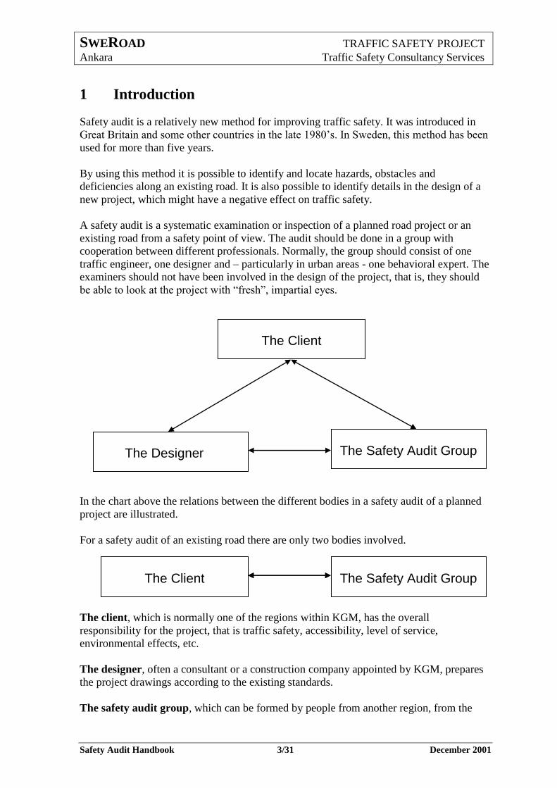
In the chart above the relations between the different bodies in a safety audit of a planned
project are illustrated.
For a safety audit of an existing road there are only two bodies involved.
The client, which is normally one of the regions within KGM, has the overall
responsibility for the project, that is traffic safety, accessibility, level of service,
environmental effects, etc.
The designer, often a consultant or a construction company appointed by KGM, prepares
the project drawings according to the existing standards.
The safety audit group, which can be formed by people from another region, from the
The Client
The Designer The Safety Audit Group
The Client The Safety Audit Group The Client The Safety Audit Group
SWEROAD TRAFFIC SAFETY PROJECT
Ankara Traffic Safety Consultancy Services
Safety Audit Handbook 4/31 December 2001
KGM Headquarters or from an independent consultant, checks the project drawings or an
existing road from the safety point of view.
During the checks, the proposed or existing design, is compared with the standard given by
the guidelines.
If the safety audit group finds some deficiencies from the safety point of view, they discuss
the design with the designer. If they cannot agree on an acceptable solution, the client has
to make the final decision about the design.
A safety audit can be carried out in different phases. For planned projects, it could be
carried out during the Preliminary Design Phase (Feasibility Study) and during the
Detailed Design Phase (Project Plan). It can also be carried out after the completion of the
construction work but before the road is opened for traffic. For existing roads, it could be
carried out during any phase, for example, as a part of an analysis of an accident prone
road section. For road works, during reconstruction or improvements, the temporary traffic
solutions can be examined before they are installed.
Planned Projects Existing Roads
1. Preliminary Design
2. Detailed Design
3. Black Spots or accident
prone road sections
4. Road works
Most kinds of existing or future roads or other traffic projects can be examined. For
example, all proposals of black spot improvements should be examined by a safety audit
group, before approval.
In this brief handbook, the methodology of safety audits is described. Together with the
attached checklists it can be used as help or as support. However, the most important factor
is the experience of the persons in the safety audit group.
The handbook is divided into two parts. The first part is for planned projects and the
second part for existing roads. In each part an action plan for the audit is presented. The
action plan for planned projects follows the steps given in the checklists. For each step,
some comments are given about important issues to be considered.
SWEROAD TRAFFIC SAFETY PROJECT
Ankara Traffic Safety Consultancy Services
Safety Audit Handbook 5/31 December 2001
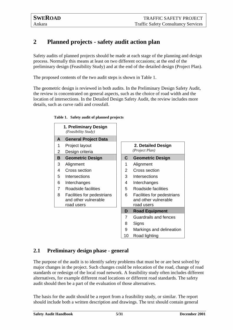
2 Planned projects - safety audit action plan
Safety audits of planned projects should be made at each stage of the planning and design
process. Normally this means at least on two different occasions; at the end of the
preliminary design (Feasibility Study) and at the end of the detailed design (Project Plan).
The proposed contents of the two audit steps is shown in Table 1.
The geometric design is reviewed in both audits. In the Preliminary Design Safety Audit,
the review is concentrated on general aspects, such as the choice of road width and the
location of intersections. In the Detailed Design Safety Audit, the review includes more
details, such as curve radii and crossfall.
Table 1. Safety audit of planned projects
1. Preliminary Design
(Feasibility Study)
A General Project Data
1 Project layout 2. Detailed Design
2 Design criteria (Project Plan)
B Geometric Design C Geometric Design
3 Alignment 1 Alignment
4 Cross section 2 Cross section
5 Intersections 3 Intersections
6 Interchanges 4 Interchanges
7 Roadside facilities 5 Roadside facilities
8 Facilities for pedestrians and other vulnerable road users
6 Facilities for pedestrians and other vulnerable road users
D Road Equipment
7 Guardrails and fences
8 Signs
9 Markings and delineation
10 Road lighting
2.1 Preliminary design phase - general
The purpose of the audit is to identify safety problems that must be or are best solved by
major changes in the project. Such changes could be relocation of the road, change of road
standards or redesign of the local road network. A feasibility study often includes different
alternatives, for example different road locations or different road standards. The safety
audit should then be a part of the evaluation of those alternatives.
The basis for the audit should be a report from a feasibility study, or similar. The report
should include both a written description and drawings. The text should contain general
SWEROAD TRAFFIC SAFETY PROJECT
Ankara Traffic Safety Consultancy Services
Safety Audit Handbook 6/31 December 2001
information on the project, such as planning conditions and design criteria. Detailed
drawings are usually not available. However, drawings showing the general design
principles, such as an overview of the horizontal and the vertical alignments, and location
and type of intersections, are needed.
An overview of the contents of the Preliminary Design Safety Audit is shown in the tables
below. The full extent is shown in checklist 1 in Appendix 1.
2.2 Preliminary design phase - general project data
The audit of the general project data should be performed at an early stage of the planning
process, normally at the end of the feasibility study. If a Preliminary Design Safety Audit
is not performed, the audit of general project data should be the first part of the Detailed
Design Safety Audit.
Table 2. Preliminary design phase - general project data
General Project Data
Project layout Road function and road standard
The extent of the project
Local roads
Pedestrians and other vulnerable road users
Roadside facilities
Design criteria Design speed and road standards
Traffic forecast and road standards
The audit of general project data should include the following:
2.2.1 Project layout
Road function and road standard
Determine the road function. What kind of traffic uses the road - long distance
traffic, regional traffic and/or local traffic?
Do pedestrians and bicyclists also use the road? Are they separated from motor traffic?
Is the standard of the new road adapted to the road function?
The extent of the project
Are the end points of the project suitably chosen?
Local roads Are solutions provided for local traffic?
Is the local road network adapted to the project?
This means that the number of accesses or intersections should be minimized by
connecting local distributors to a limited number of intersections.
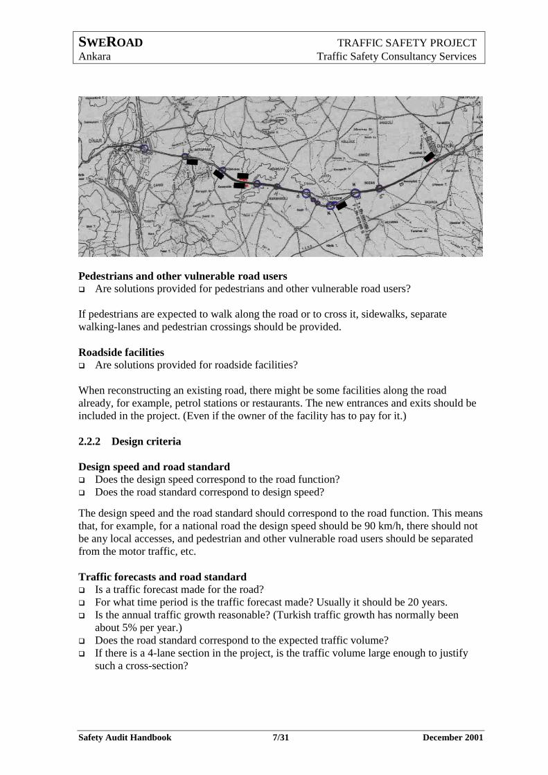
In the drawing below, the circles indicates intersections in the new road, the strokes
indicate local roads that will be closed.
SWEROAD TRAFFIC SAFETY PROJECT
Ankara Traffic Safety Consultancy Services
Safety Audit Handbook 7/31 December 2001
Pedestrians and other vulnerable road users Are solutions provided for pedestrians and other vulnerable road users?
If pedestrians are expected to walk along the road or to cross it, sidewalks, separate
walking-lanes and pedestrian crossings should be provided.
Roadside facilities Are solutions provided for roadside facilities?
When reconstructing an existing road, there might be some facilities along the road
already, for example, petrol stations or restaurants. The new entrances and exits should be
included in the project. (Even if the owner of the facility has to pay for it.)
2.2.2 Design criteria
Design speed and road standard
Does the design speed correspond to the road function?
Does the road standard correspond to design speed?
The design speed and the road standard should correspond to the road function. This means
that, for example, for a national road the design speed should be 90 km/h, there should not
be any local accesses, and pedestrian and other vulnerable road users should be separated
from the motor traffic, etc.
Traffic forecasts and road standard Is a traffic forecast made for the road?
For what time period is the traffic forecast made? Usually it should be 20 years.
Is the annual traffic growth reasonable? (Turkish traffic growth has normally been
about 5% per year.)
Does the road standard correspond to the expected traffic volume?
If there is a 4-lane section in the project, is the traffic volume large enough to justify
such a cross-section?
SWEROAD TRAFFIC SAFETY PROJECT
Ankara Traffic Safety Consultancy Services
Safety Audit Handbook 8/31 December 2001
2.3 Preliminary design phase - geometric design
Table 3. Preliminary design phase – geometric design
Geometric Design
Alignment horizontal alignment
vertical alignment
alignment consistency
Cross section roadway elements
roadside elements
Intersections
number and distances between accesses
capacity and sight
geometric design
signalized intersections
Interchanges need of interchanges
location of interchanges
Roadside facilities
requirements
location
Facilities for pedestrians and other vulnerable road users
requirements
location
The audit of geometric design should include the following:
2.3.1 Alignment
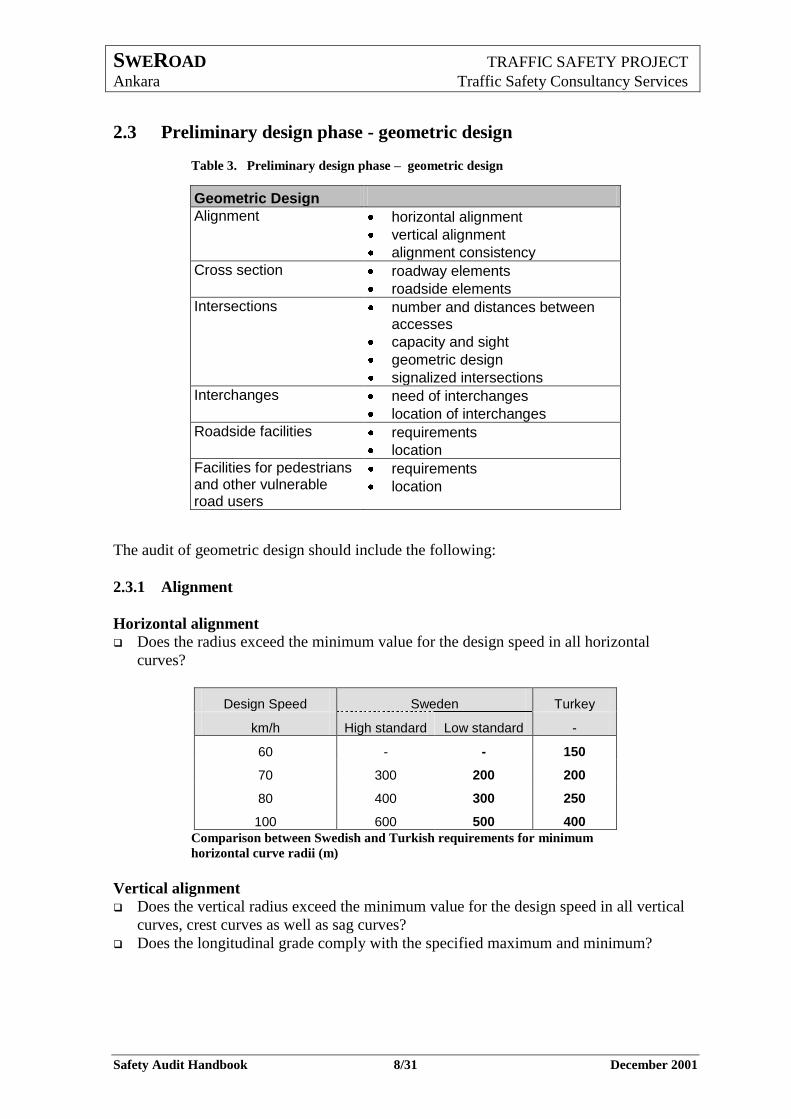
Horizontal alignment Does the radius exceed the minimum value for the design speed in all horizontal
curves?
Design Speed Sweden Turkey
km/h High standard Low standard -
60 - - 150
70 300 200 200
80 400 300 250
100 600 500 400
Comparison between Swedish and Turkish requirements for minimum
horizontal curve radii (m)
Vertical alignment
Does the vertical radius exceed the minimum value for the design speed in all vertical
curves, crest curves as well as sag curves?
Does the longitudinal grade comply with the specified maximum and minimum?
SWEROAD TRAFFIC SAFETY PROJECT
Ankara Traffic Safety Consultancy Services
Safety Audit Handbook 9/31 December 2001
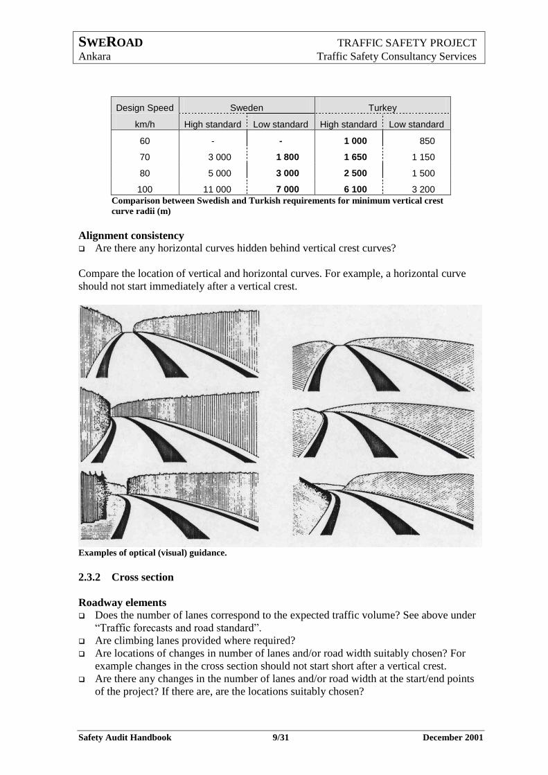
Design Speed Sweden Turkey
km/h High standard Low standard High standard Low standard
60 - - 1 000 850
70 3 000 1 800 1 650 1 150
80 5 000 3 000 2 500 1 500
100 11 000 7 000 6 100 3 200
Comparison between Swedish and Turkish requirements for minimum vertical crest
curve radii (m)
Alignment consistency Are there any horizontal curves hidden behind vertical crest curves?
Compare the location of vertical and horizontal curves. For example, a horizontal curve
should not start immediately after a vertical crest.
Examples of optical (visual) guidance.
2.3.2 Cross section
Roadway elements Does the number of lanes correspond to the expected traffic volume? See above under
“Traffic forecasts and road standard”.
Are climbing lanes provided where required?
Are locations of changes in number of lanes and/or road width suitably chosen? For
example changes in the cross section should not start short after a vertical crest.
Are there any changes in the number of lanes and/or road width at the start/end points
of the project? If there are, are the locations suitably chosen?
SWEROAD TRAFFIC SAFETY PROJECT
Ankara Traffic Safety Consultancy Services
Safety Audit Handbook 10/31 December 2001
Is the width of the median sufficient, that is, is it wide enough to avoid vehicles to run
over it? If not, are guardrails provided?
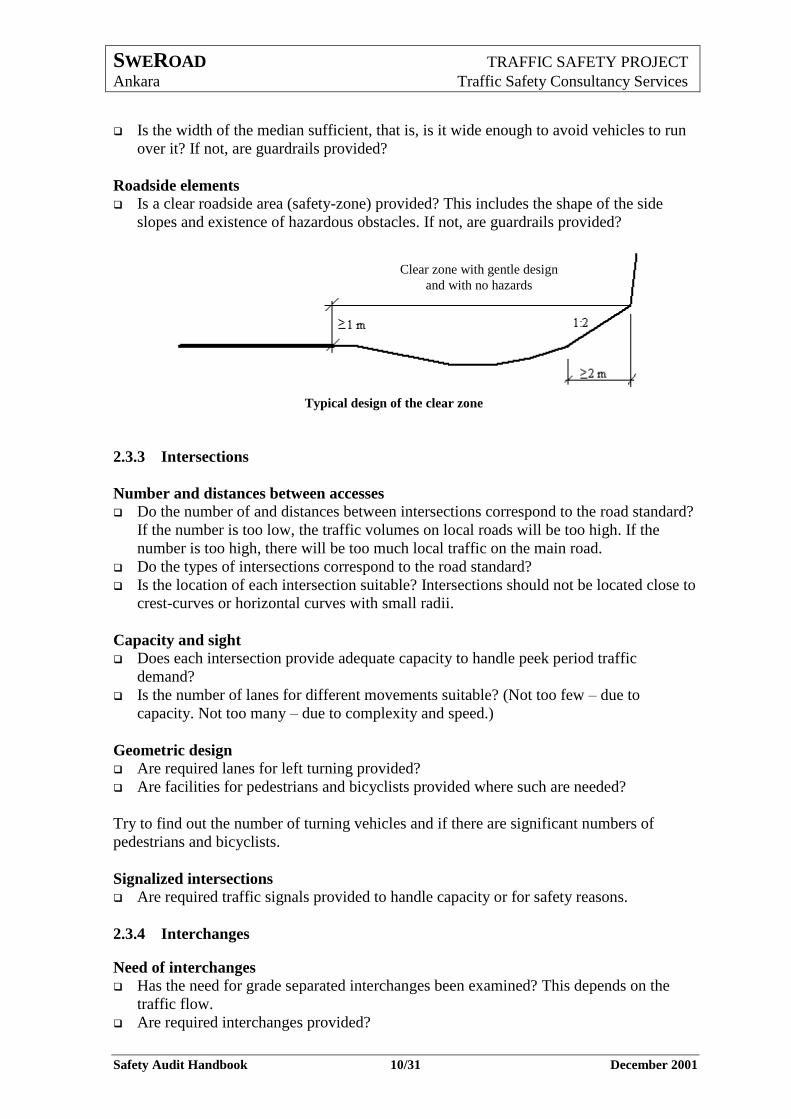
Roadside elements Is a clear roadside area (safety-zone) provided? This includes the shape of the side
slopes and existence of hazardous obstacles. If not, are guardrails provided?
Typical design of the clear zone
2.3.3 Intersections
Number and distances between accesses
Do the number of and distances between intersections correspond to the road standard?
If the number is too low, the traffic volumes on local roads will be too high. If the
number is too high, there will be too much local traffic on the main road.
Do the types of intersections correspond to the road standard?
Is the location of each intersection suitable? Intersections should not be located close to
crest-curves or horizontal curves with small radii.
Capacity and sight Does each intersection provide adequate capacity to handle peek period traffic
demand?
Is the number of lanes for different movements suitable? (Not too few – due to
capacity. Not too many – due to complexity and speed.)
Geometric design Are required lanes for left turning provided?
Are facilities for pedestrians and bicyclists provided where such are needed?
Try to find out the number of turning vehicles and if there are significant numbers of
pedestrians and bicyclists.
Signalized intersections Are required traffic signals provided to handle capacity or for safety reasons.
2.3.4 Interchanges
Need of interchanges
Has the need for grade separated interchanges been examined? This depends on the
traffic flow.
Are required interchanges provided?
Clear zone with gentle design
and with no hazards
SWEROAD TRAFFIC SAFETY PROJECT
Ankara Traffic Safety Consultancy Services
Safety Audit Handbook 11/31 December 2001
Location of interchanges
Are the locations of interchanges suitable?
2.3.5 Roadside facilities
Requirements
Are there any bus stops, rest areas and service stations required?
If required, are bus stops, rest areas and service stations provided?
Location
Are the locations of each facility suitable?
On a national high speed road, bus-stops should be provided in the form of lay-bys.
Parking areas, rest areas and service stations enable drivers to make short stops without
stopping on the road.
2.3.6 Facilities for pedestrians and other vulnerable road users
Requirements
Are facilities for pedestrians and other vulnerable road users required? See above about
the need of such facilities.
Are the required facilities provided?
Location
Are they suitably located? At grade crossings should be located where the speed is low.
2.4 Detailed design phase - general
The purpose of the audit in the detailed design phase is to check the safety aspects of the
final design as shown in a Project Plan or similar. For some items, this can be done by
checking the accordance with standards or guidelines. For other items the check has to be
made according to practices or the experience of the safety audit group.
A problem in Turkey is that there are no comprehensive standards or guidelines. Therefore,
some examples from Swedish guidelines are included in the handbook, where Turkish
guidelines are missing.
Often there are alternative solutions to many design problems. The audit should help to
chose the best solution from the safety point of view.
The Detailed Design Safety Audit is mainly a review of drawings. Drawings showing the
following should be available:
Geometric Design
Horizontal alignment
Vertical alignment
Cross sections
Design of intersections
Design of interchanges
Roadside facilities
SWEROAD TRAFFIC SAFETY PROJECT
Ankara Traffic Safety Consultancy Services
Safety Audit Handbook 12/31 December 2001
Road equipment
Guardrails and fences
Signs and signals
Marking and delineation
Road lighting
An overview of the contents of the Detailed Design Safety Audit is shown in the tables
below. The full extent is shown in checklist 2 in Appendix 2.
2.5 Detailed design phase - geometric design
The audit of geometric design should be made at the end of the detailed design phase but
before it is too late to make any changes in the design.
Table 4. Detailed design phase – geometric design
Geometric Design
Alignment sight distance
horizontal alignment
vertical alignment
alignment consistency
Cross section roadway elements
roadside elements
Intersections
number and distances
capacity and sight
geometric design
signalized intersections
Interchanges location
sight distance
exit and entry design
Roadside facilities
location
exit and entry design
Facilities for pedestrians and other vulnerable road users
location
access
design
The audit of geometric design should include the following:
2.5.1 Alignment
Sight distance
Eh = Eye height Sa = Sight angle Oh = Obstacle height
Sightline
Sight distance
Sa
EhOh
SWEROAD TRAFFIC SAFETY PROJECT
Ankara Traffic Safety Consultancy Services
Safety Audit Handbook 13/31 December 2001
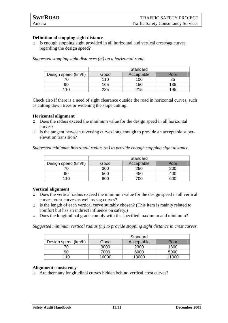
Definition of stopping sight distance
Is enough stopping sight provided in all horizontal and vertical crest/sag curves
regarding the design speed?
Suggested stopping sight distances (m) on a horizontal road.
Standard
Design speed (km/h) Good Acceptable Poor
70 110 100 85
90 165 150 135
110 235 215 195
Check also if there is a need of sight clearance outside the road in horizontal curves, such
as cutting down trees or widening the slope cutting.
Horizontal alignment Does the radius exceed the minimum value for the design speed in all horizontal
curves?
Is the tangent between reversing curves long enough to provide an acceptable super-
elevation transition?
Suggested minimum horizontal radius (m) to provide enough stopping sight distance.
Standard
Design speed (km/h) Good Acceptable Poor
70 300 250 200
90 500 450 400
110 800 700 600
Vertical alignment
Does the vertical radius exceed the minimum value for the design speed in all vertical
curves, crest curves as well as sag curves?
Is the length of each vertical curve suitably chosen? (This item is mainly related to
comfort but has an indirect influence on safety.)
Does the longitudinal grade comply with the specified maximum and minimum?
Suggested minimum vertical radius (m) to provide stopping sight distance in crest curves.
Standard
Design speed (km/h) Good Acceptable Poor
70 3000 2300 1800
90 7000 6000 5000
110 16000 13000 11000
Alignment consistency
Are there any longitudinal curves hidden behind vertical crest curves?
SWEROAD TRAFFIC SAFETY PROJECT
Ankara Traffic Safety Consultancy Services
Safety Audit Handbook 14/31 December 2001
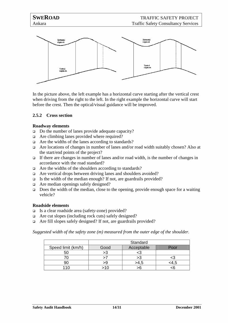
In the picture above, the left example has a horizontal curve starting after the vertical crest
when driving from the right to the left. In the right example the horizontal curve will start
before the crest. Then the optical/visual guidance will be improved.
2.5.2 Cross section
Roadway elements Do the number of lanes provide adequate capacity?
Are climbing lanes provided where required?
Are the widths of the lanes according to standards?
Are locations of changes in number of lanes and/or road width suitably chosen? Also at
the start/end points of the project?
If there are changes in number of lanes and/or road width, is the number of changes in
accordance with the road standard?
Are the widths of the shoulders according to standards?
Are vertical drops between driving lanes and shoulders avoided?
Is the width of the median enough? If not, are guardrails provided?
Are median openings safely designed?
Does the width of the median, close to the opening, provide enough space for a waiting
vehicle?
Roadside elements Is a clear roadside area (safety-zone) provided?
Are cut slopes (including rock cuts) safely designed?
Are fill slopes safely designed? If not, are guardrails provided?
Suggested width of the safety zone (m) measured from the outer edge of the shoulder.
Standard
Speed limit (km/h) Good Acceptable Poor
50 >3 <3
70 >7 >3 <3
90 >9 >4,5 <4,5
110 >10 >6 <6
SWEROAD TRAFFIC SAFETY PROJECT
Ankara Traffic Safety Consultancy Services
Safety Audit Handbook 15/31 December 2001
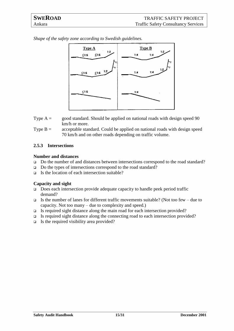
Shape of the safety zone according to Swedish guidelines.
Type A = good standard. Should be applied on national roads with design speed 90
km/h or more.
Type B = acceptable standard. Could be applied on national roads with design speed
70 km/h and on other roads depending on traffic volume.
2.5.3 Intersections
Number and distances
Do the number of and distances between intersections correspond to the road standard?
Do the types of intersections correspond to the road standard?
Is the location of each intersection suitable?
Capacity and sight Does each intersection provide adequate capacity to handle peek period traffic
demand?
Is the number of lanes for different traffic movements suitable? (Not too few – due to
capacity. Not too many – due to complexity and speed.)
Is required sight distance along the main road for each intersection provided?
Is required sight distance along the connecting road to each intersection provided?
Is the required visibility area provided?
Type A Type B
SWEROAD TRAFFIC SAFETY PROJECT
Ankara Traffic Safety Consultancy Services
Safety Audit Handbook 16/31 December 2001
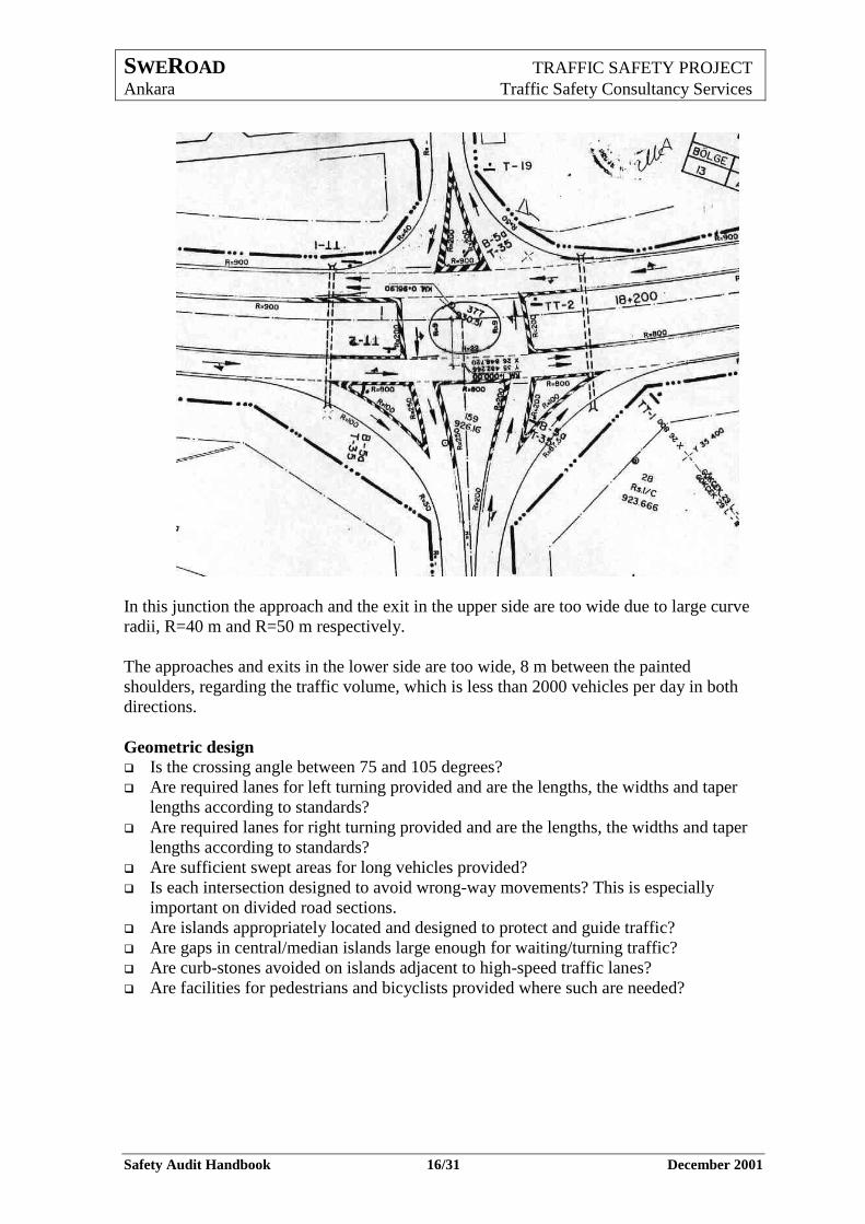
In this junction the approach and the exit in the upper side are too wide due to large curve
radii, R=40 m and R=50 m respectively.
The approaches and exits in the lower side are too wide, 8 m between the painted
shoulders, regarding the traffic volume, which is less than 2000 vehicles per day in both
directions.
Geometric design Is the crossing angle between 75 and 105 degrees?
Are required lanes for left turning provided and are the lengths, the widths and taper
lengths according to standards?
Are required lanes for right turning provided and are the lengths, the widths and taper
lengths according to standards?
Are sufficient swept areas for long vehicles provided?
Is each intersection designed to avoid wrong-way movements? This is especially
important on divided road sections.
Are islands appropriately located and designed to protect and guide traffic?
Are gaps in central/median islands large enough for waiting/turning traffic?
Are curb-stones avoided on islands adjacent to high-speed traffic lanes?
Are facilities for pedestrians and bicyclists provided where such are needed?
SWEROAD TRAFFIC SAFETY PROJECT
Ankara Traffic Safety Consultancy Services
Safety Audit Handbook 17/31 December 2001
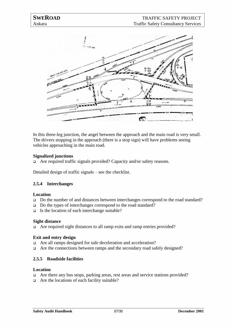
In this three-leg junction, the angel between the approach and the main road is very small.
The drivers stopping in the approach (there is a stop sign) will have problems seeing
vehicles approaching in the main road.
Signalized junctions Are required traffic signals provided? Capacity and/or safety reasons.
Detailed design of traffic signals – see the checklist.
2.5.4 Interchanges
Location
Do the number of and distances between interchanges correspond to the road standard?
Do the types of interchanges correspond to the road standard?
Is the location of each interchange suitable?
Sight distance
Are required sight distances to all ramp exits and ramp entries provided?
Exit and entry design
Are all ramps designed for safe deceleration and acceleration?
Are the connections between ramps and the secondary road safely designed?
2.5.5 Roadside facilities
Location
Are there any bus stops, parking areas, rest areas and service stations provided?
Are the locations of each facility suitable?
SWEROAD TRAFFIC SAFETY PROJECT
Ankara Traffic Safety Consultancy Services
Safety Audit Handbook 18/31 December 2001
Exit and entry design
Are all exits and entries to and from road side facilities safely designed?
2.5.6 Facilities for pedestrians and other vulnerable road users
Location
Are required facilities for pedestrians provided?
Are required facilities for bicyclists provided?
Are required facilities for slow moving vehicles, like tractors or carts drawn by
animals, provided?
Are the facilities suitably located?
Access
Are the accesses for pedestrians to pedestrian crossings, bus stops, etc. safely
designed?
Design
Are the pedestrian crossings safely designed?
Are the bicycle crossings safely designed?
If such facilities are provided, check the detailed design according to the checklist.
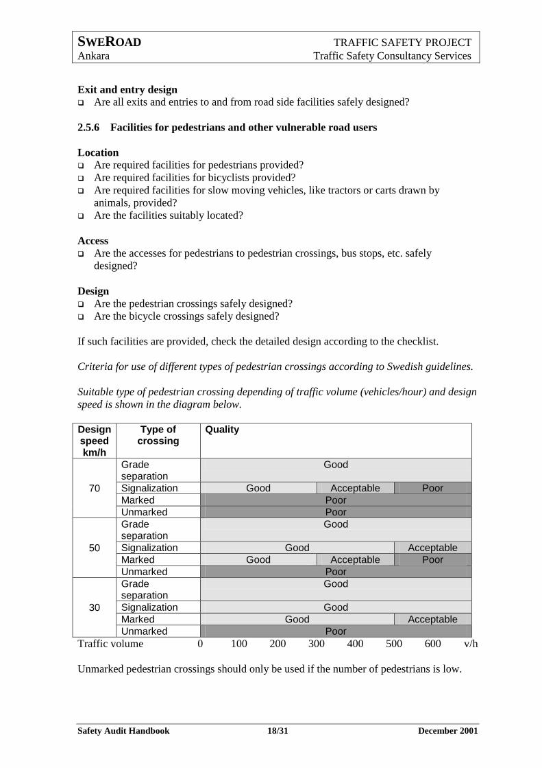
Criteria for use of different types of pedestrian crossings according to Swedish guidelines.
Suitable type of pedestrian crossing depending of traffic volume (vehicles/hour) and design
speed is shown in the diagram below.
Design speed km/h
Type of crossing
Quality
70
Grade separation
Good
Signalization Good Acceptable Poor
Marked Poor
Unmarked Poor
50
Grade separation
Good
Signalization Good Acceptable
Marked Good Acceptable Poor
Unmarked Poor
30
Grade separation
Good
Signalization Good
Marked Good Acceptable
Unmarked Poor
Traffic volume 0 100 200 300 400 500 600 v/h
Unmarked pedestrian crossings should only be used if the number of pedestrians is low.
SWEROAD TRAFFIC SAFETY PROJECT
Ankara Traffic Safety Consultancy Services
Safety Audit Handbook 19/31 December 2001
2.6 Detailed design phase - road equipment Table 5. Detailed design phase – road equipment
Road Equipment
Guardrails and fences requirements
location
Signs requirements
location
Markings and delineators requirements
Lighting requirements
The audit of road equipment should include the following:
2.6.1 Guardrails and fences
Requirements
Are required guardrails and fences provided?
Location
Are the start point and end point of the guardrails suitably located with respect to the
location of the hazard?
If they are, use the checklist for detailed design.
2.6.2 Signs
Requirements
Are required signs provided?
Location
Are the provided signs well located regarding their message?
Are the signs safely positioned?
If signs are provided, use the checklist for detailed design.
2.6.3 Markings and delineators
Requirements
Are required markings and delineators provided?
If they are, use the checklist for detailed design.
2.6.4 Lighting
Requirements
Is required road lighting provided?
If it is, use the checklist for detailed design.
SWEROAD TRAFFIC SAFETY PROJECT
Ankara Traffic Safety Consultancy Services
Safety Audit Handbook 20/31 December 2001
3 Existing roads – safety audit action plan
A safety audit of an existing road is usually carried out if the road is considered as unsafe
with more accidents than average for that kind of road.
A safety audit can also be the first step in preparation of a rehabilitation plan of an existing
road.
In both cases, the purpose is to identify obstacles and other deficiencies in order to be able
to remove the obstacles and to improve the deficiencies.
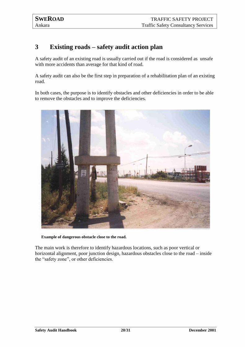
Example of dangerous obstacle close to the road.
The main work is therefore to identify hazardous locations, such as poor vertical or
horizontal alignment, poor junction design, hazardous obstacles close to the road – inside
the “safety zone”, or other deficiencies.
SWEROAD TRAFFIC SAFETY PROJECT
Ankara Traffic Safety Consultancy Services
Safety Audit Handbook 21/31 December 2001
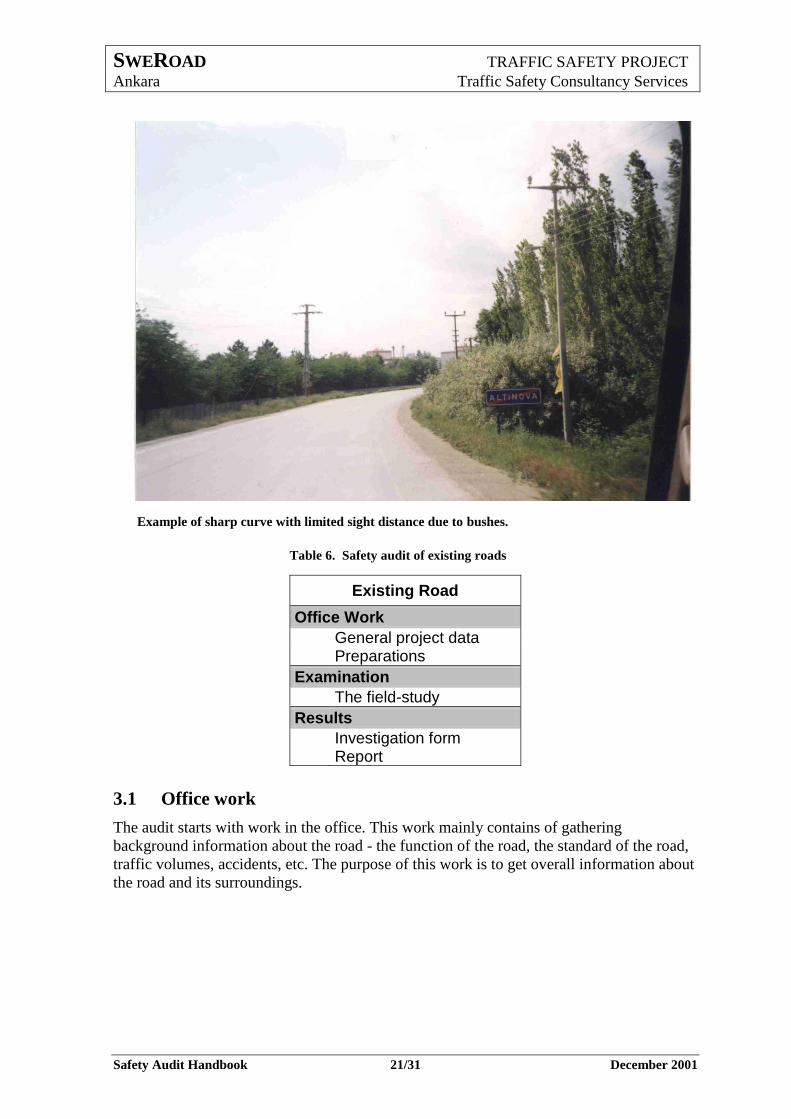
Example of sharp curve with limited sight distance due to bushes.
Table 6. Safety audit of existing roads
Existing Road
Office Work
General project data Preparations
Examination
The field-study
Results
Investigation form Report
3.1 Office work
The audit starts with work in the office. This work mainly contains of gathering
background information about the road - the function of the road, the standard of the road,
traffic volumes, accidents, etc. The purpose of this work is to get overall information about
the road and its surroundings.
SWEROAD TRAFFIC SAFETY PROJECT
Ankara Traffic Safety Consultancy Services
Safety Audit Handbook 22/31 December 2001
Table 7. Office work
Office Work
General project data Prerequisites
Road function
Traffic situation
Road standard
Surroundings
Preparations The field-study
Investigation form
The office work should include the following:
3.1.1 General project data
Prerequisites
It is necessary to have some maps or drawings. Suitable scales are 1:10 000 – 1:2 000.
Maps or drawings should be used as an instrument during the field-study but also as
support for presentation of the results of the audit.
At an early stage, the extent of the project should be determined. That is to define the
starting and ending points of the audit. Usually it is suitable to use well known
intersections as starting and ending points.
The kinds of problems that should be examined must be determined. The accident analysis
will sometimes indicate the most common types of problem.
In the table below, some typical deficiencies are listed.
Table 8. Some typical deficiencies
Road Design Road Side Area
Improper junction design Small horizontal or vertical
radius Improper or dangerous
pedestrian crossing
Dangerous fixed object in the roadway, roadside, traffic island or median
Dangerous rock cutting High, steep side slope without
guardrail
Regulations
Speed limit too high Wrong, misplaced or worn-out
sign or road marking
SWEROAD TRAFFIC SAFETY PROJECT
Ankara Traffic Safety Consultancy Services
Safety Audit Handbook 23/31 December 2001
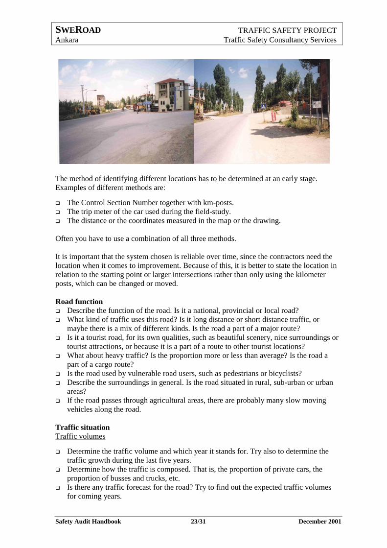
The method of identifying different locations has to be determined at an early stage.
Examples of different methods are:
The Control Section Number together with km-posts.
The trip meter of the car used during the field-study.
The distance or the coordinates measured in the map or the drawing.
Often you have to use a combination of all three methods.
It is important that the system chosen is reliable over time, since the contractors need the
location when it comes to improvement. Because of this, it is better to state the location in
relation to the starting point or larger intersections rather than only using the kilometer
posts, which can be changed or moved.
Road function
Describe the function of the road. Is it a national, provincial or local road?
What kind of traffic uses this road? Is it long distance or short distance traffic, or
maybe there is a mix of different kinds. Is the road a part of a major route?
Is it a tourist road, for its own qualities, such as beautiful scenery, nice surroundings or
tourist attractions, or because it is a part of a route to other tourist locations?
What about heavy traffic? Is the proportion more or less than average? Is the road a
part of a cargo route?
Is the road used by vulnerable road users, such as pedestrians or bicyclists?
Describe the surroundings in general. Is the road situated in rural, sub-urban or urban
areas?
If the road passes through agricultural areas, there are probably many slow moving
vehicles along the road.
Traffic situation
Traffic volumes
Determine the traffic volume and which year it stands for. Try also to determine the
traffic growth during the last five years.
Determine how the traffic is composed. That is, the proportion of private cars, the
proportion of busses and trucks, etc.
Is there any traffic forecast for the road? Try to find out the expected traffic volumes
for coming years.
SWEROAD TRAFFIC SAFETY PROJECT
Ankara Traffic Safety Consultancy Services
Safety Audit Handbook 24/31 December 2001
Traffic accidents
Gather information about accidents during the last three years.
Study the locations of the accidents. Check if there are any accident prone locations,
so-called black spots.
Study the type of the accidents. Check if there are any accident patterns indicating a
specific problem. For example, if there are many accidents with left-turning vehicles in
a junction or many single vehicle accidents where the vehicles are leaving the roadway.
Study also the severity of the accidents.
Summarize the result in a table and compare the result with average values for
comparable roads. Make comments about any differences from average values.
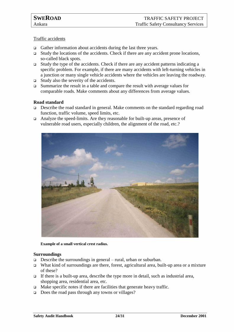
Road standard
Describe the road standard in general. Make comments on the standard regarding road
function, traffic volume, speed limits, etc.
Analyze the speed-limits. Are they reasonable for built-up areas, presence of
vulnerable road users, especially children, the alignment of the road, etc.?
Example of a small vertical crest radius.
Surroundings
Describe the surroundings in general – rural, urban or suburban.
What kind of surroundings are there, forest, agricultural area, built-up area or a mixture
of these?
If there is a built-up area, describe the type more in detail, such as industrial area,
shopping area, residential area, etc.
Make specific notes if there are facilities that generate heavy traffic.
Does the road pass through any towns or villages?
SWEROAD TRAFFIC SAFETY PROJECT
Ankara Traffic Safety Consultancy Services
Safety Audit Handbook 25/31 December 2001
3.1.2 Preparations
The field-study
Calculate with more than one field-study trip.
Before the first field-study trip, the activities have to be planned in detail.
Estimate the time for travelling to the starting point. Estimate the time needed to travel
through the actual section in both directions. If video recording is carried out, the speed
should not exceed 70 km/h. Several stops may have to be made during the trip, which
means that the average speed will be low, 30 – 50 km/h, depending on the number of stops.
Is it possible to carry out the field-study in one day or are several days needed?
Investigation form
Before the first field-study, an investigation form has to be prepared. There is an example
of an investigation form in Appendix 3. Below the most common deficiencies and
hazardous obstacles are listed.
Table 9. Common deficiencies and hazardous objects
Road Design Road Side Area
Road shoulder missing, too narrow or unpaved
Improper junction design Improper exit or entrance to
shop, petrol station or other commercial activity
Improper connection to small access road
Limited sight distance Improper or dangerous
pedestrian crossing Small horizontal or vertical
radius Temporary road narrowing (for
example bridge)
Dangerous fixed object in the roadway, roadside, traffic island or median
Dangerous bridge fixed object in the roadside or median (for example massive poles, pillars, fences, trees
Dangerous rock cutting, loose stones or rocks
House or other building High, steep side slope without
guardrail Guardrail endings Culvert endings
Regulations
Speed limit too high or too low Wrong, misplaced or worn-out
sign or road marking
SWEROAD TRAFFIC SAFETY PROJECT
Ankara Traffic Safety Consultancy Services
Safety Audit Handbook 26/31 December 2001
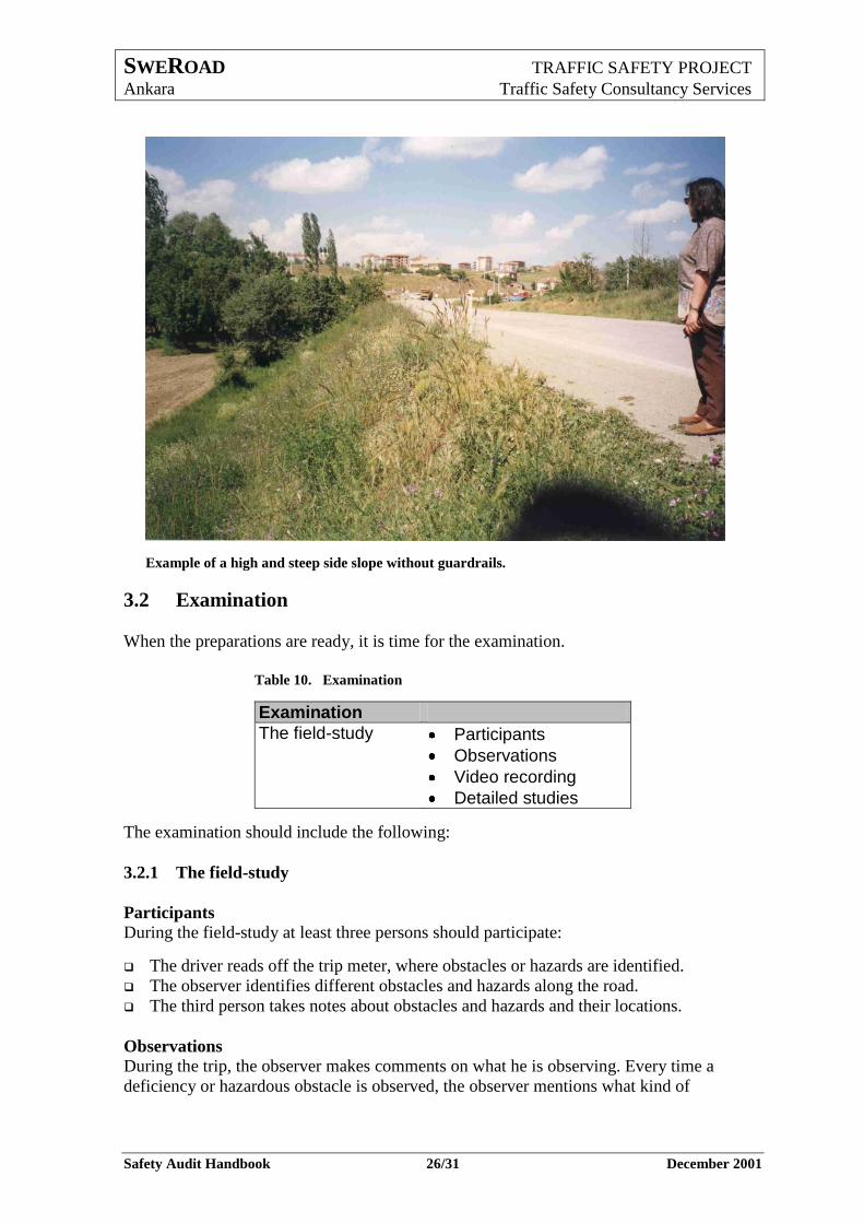
Example of a high and steep side slope without guardrails.
3.2 Examination
When the preparations are ready, it is time for the examination.
Table 10. Examination
Examination
The field-study Participants
Observations
Video recording
Detailed studies
The examination should include the following:
3.2.1 The field-study
Participants
During the field-study at least three persons should participate:
The driver reads off the trip meter, where obstacles or hazards are identified.
The observer identifies different obstacles and hazards along the road.
The third person takes notes about obstacles and hazards and their locations.
Observations
During the trip, the observer makes comments on what he is observing. Every time a
deficiency or hazardous obstacle is observed, the observer mentions what kind of
SWEROAD TRAFFIC SAFETY PROJECT
Ankara Traffic Safety Consultancy Services
Safety Audit Handbook 27/31 December 2001
deficiency or obstacle it is. The driver tells the reading of the trip meter. The third person
makes notes about the obstacle and the location.
Video recording
If a video recording is to be made (this is recommended), the observer should operate the
video camera. If possible, the camera should be mounted to a stand of some kind.
However, the stand has to be of a shock absorbing type. Otherwise the vibrations from the
vehicle will be transferred to the camera which makes it difficult to see what has been
recorded.
When a video recording is made, the sound should also be recorded. It will then be easy to
use the video to add more information to the investigation form in the office. It is also good
if the driver every kilometer mentions the distance from the start. If there are km-posts
along the road, they should also be mentioned when they are passed.
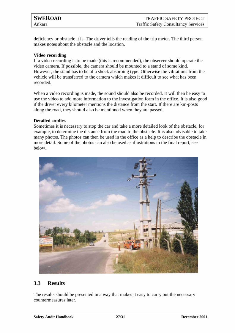
Detailed studies
Sometimes it is necessary to stop the car and take a more detailed look of the obstacle, for
example, to determine the distance from the road to the obstacle. It is also advisable to take
many photos. The photos can then be used in the office as a help to describe the obstacle in
more detail. Some of the photos can also be used as illustrations in the final report, see
below.
3.3 Results
The results should be presented in a way that makes it easy to carry out the necessary
countermeasures later.
SWEROAD TRAFFIC SAFETY PROJECT
Ankara Traffic Safety Consultancy Services
Safety Audit Handbook 28/31 December 2001
Table 11. Results
Results
Investigation form Computer works
Additional information
Report Contents
Illustrations
The results should include the following:
3.3.1 Investigation form
Computer works
Back in the office the investigation form has to be completed. The notes from the field-
study have to be entered into an EXCEL-sheet or a WORD-document in a computer. In
Appendix 4, there is an example of an EXCEL-sheet that can be used.
Additional information
To the notes from the field-study, information that can be gathered from the videotape
should be added. Sometimes additional information also can be gathered from maps and
drawings. Usually the location has to be determined in more detail than what is possible by
the trip meter during the trip. That can be done by measuring the distance in the project
drawings. It is also possible to use the time indicator in the video to calculate the exact
location. The calculation can be based on the assumption that the speed is constant
between two well-known locations, such as junctions or km-posts. The principle is to note
the time when the known locations and the obstacle are passed. Then divide the time in
seconds between the first known location and the obstacle with the time in seconds
between the known locations. Multiply the result with the distance between the two known
locations and the distance between the first known location and the obstacle will be the
result.
L1 = T1 / T2 * L2
where; L1 = the unknown distance
L2 = the known distance
T1 = the time between the first location and the obstacle
T2 = the time between the two known locations.
When the investigation form has to be completed, the following questions should be
answered:
Are the locations of all deficiencies, obstacles and hazards determined?
Are the locations of all changes in speed limit determined?
Are the locations of all km-posts determined?
Are the locations of major intersections determined?
Is there a need for an additional field trip?
SWEROAD TRAFFIC SAFETY PROJECT
Ankara Traffic Safety Consultancy Services
Safety Audit Handbook 29/31 December 2001
If some information still is missing, another field-study should be carried out. During this
trip more photos can be taken that later can be used as illustrations in the final report. (If
the road is located far away from the office or if the section is not too long, the photos can
be taken in a second round trip during the first field-study.)
If no more field-study is necessary, the investigation forms should be finalized and the
report should be prepared.
3.3.2 Report
Contents
An example of the report lay-out is presented below, as a table of contents.
Introduction
Prerequisites
General project data
Road function
Traffic situation
Road standards
The surroundings
Problem investigation (field-study)
Performance
Problems, deficiencies
The safety zone
Observations made during the audit
Proposals of countermeasures
General countermeasures in rural areas
General countermeasures in built up areas
Specific countermeasures
Oncoming work
Meetings
References
Appendix
Maps
Investigation form
SWEROAD TRAFFIC SAFETY PROJECT
Ankara Traffic Safety Consultancy Services
Safety Audit Handbook 30/31 December 2001
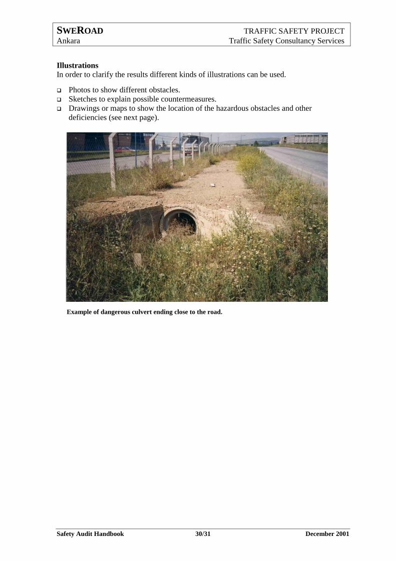
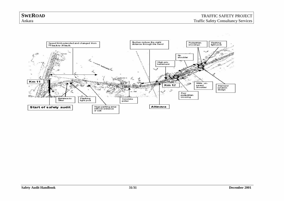
Illustrations
In order to clarify the results different kinds of illustrations can be used.
Photos to show different obstacles.
Sketches to explain possible countermeasures.
Drawings or maps to show the location of the hazardous obstacles and other
deficiencies (see next page).
Example of dangerous culvert ending close to the road.
SWEROAD TRAFFIC SAFETY PROJECT
Ankara Traffic Safety Consultancy Services
Safety Audit Handbook 31/31 December 2001