Embed Size (px)
Citation preview

I N T E R N A T I O N A L T E C H N O L O G Y S C A N N I N G P R O G R A M
SAFETY APPLICATIONS OF
Intelligent Transportation Systems in Europe and Japan
S P O N S O R E D B Y:
U.S. Department of TransportationFederal Highway Administration
I N C O O P E R AT I O N W I T H :
American Association of State Highwayand Transportation Officials
National Cooperative HighwayResearch Program J A N U A R Y 2 0 0 6

N O T I C EThe Federal Highway Administration provides
high-quality information to serve Government,
industry, and the public in a manner that pro-
motes public understanding. Standards and poli-
cies are used to ensure and maximize the quality,
objectivity, utility, and integrity of its information.
FHWA periodically reviews quality issues and
adjusts its programs and processes to ensure
continuous quality improvement.

1. Report No.
FHWA-PL-06-0012. Government Accession No. 3. Recipient’s Catalog No.
Technical Report Documentation Page
4. Title and Subtitle Safety Applications of Intelligent Transportation Systemsin Europe and Japan7. Author(s)
John Njord, Dr. Joseph Peters, Michael Freitas, Bruce Warner, K. Craig Allred, Dr. Robert Bertini, Robert Bryant, Robert Callan,Martin Knopp, Lyle Knowlton, Carlos Lopez, Tom Warne
9. Performing Organization Name and Address
American Trade InitiativesP.O. Box 8228Alexandria, VA 22306-8228
12. Sponsoring Agency Name and Address
Office of International ProgramsOffice of PolicyFederal Highway AdministrationU.S. Department of TransportationAmerican Association of State Highway and Transportation OfficialsNational Cooperative Highway Research Program
5. Report Date
January 20066. Performing Organization Code
8. Performing Organization Report No.
10. Work Unit No. (TRAIS)
11. Contract or Grant No.
DTFH61-99-C-005
13. Type of Report and Period Covered
14. Sponsoring Agency Code
15. Supplementary Notes
FHWA COTR: Hana Maier, Office of International Programs
16. Abstract
With nearly 43,0000 deaths a year on U.S. roads, a need exists for countermeasures to reduce the numberand severity of crashes. The Federal Highway Administration, American Association of State Highway andTransportation Officials, and National Cooperative Highway Research Program sponsored a scanningstudy of intelligent transportation systems (ITS) applications deployed in France, Germany, and Japan tomitigate traffic safety problems.
Among the safety applications of ITS technologies the scan team observed were changeable message signsto manage traffic flow, automated speed management and control efforts to reduce crashes, video incidentdetection and an eCall system to improve emergency personnel response times, and driver assistance initiatives such as adaptive cruise control, lane keeping, and assisted braking.
The team’s recommendations for U.S. implementation include projects to increase support for and docu-ment benefits of automated enforcement systems, evaluate advanced video detection and incident analysistechnology, deploy dynamic sign technologies, and conduct variable speed limit pilots. The team also recommends an initiative to encourage top-down leadership commitment to fatality reduction throughoutthe country.
17. Key Wordsautomated enforcement, collision warning, driverassistance, human factors, intelligent transportationsystem, safety, speed management, variable message sign
18. Distribution Statement
No restrictions. This document is available to thepublic from the: Office of International Programs,FHWA-HPIP, Room 3325, U.S. Department ofTransportation, Washington, DC [email protected]
19. Security Classify. (of this report)
Unclassified20. Security Classify. (of this page)
Unclassified21. No. of Pages
5222. Price
Free
Form DOT F 1700.7 (8-72) Reproduction of completed page authorized
SAFETY APPLICATIONS OF
Intelligent TransportationSystems in Europe
and Japan
J A N U A R Y 2 0 0 6
Prepared by the InternationalScanning Study Team:
JOHN R. NJORDUtah DOT
Co-Chair, Europe
DR. JOSEPH I. PETERSFHWA
Co-Chair, Europe
MICHAEL FREITASFHWA
Co-Chair, Japan
BRUCE WARNEROregon DOT
Co-Chair, Japan
K. CRAIG ALLREDFHWA
DR. ROBERT L. BERTINIPortland State University
ROBERT W. BRYANTOregon DOT
ROBERT M. CALLANFHWA
MARTIN KNOPPFHWA
LYLE KNOWLTONNew Hampshire DOT
CARLOS A. LOPEZTexas DOT
TOM WARNETom Warne and Associates
and
AMERICAN TRADEINITIATIVES, INC.
for the
FEDERAL HIGHWAYADMINISTRATION
U.S. DEPARTMENT OFTRANSPORTATION
AMERICAN ASSOCIATIONOF STATE HIGHWAY
AND TRANSPORTATIONOFFICIALS
NATIONAL COOPERATIVEHIGHWAY RESEARCH
PROGRAM

The International Technology Scanning Program,sponsored by the Federal Highway Administration(FHWA), the American Association of State Highwayand Transportation Officials (AASHTO), and theNational Cooperative Highway Research Program
(NCHRP), accesses and evaluates innovative foreign technologiesand practices that could significantly benefit U.S. highway transportation systems. This approach allows for advanced technology to be adapted and put into practice much more efficiently without spending scarce research funds to recreate advances already developed by other countries.
FHWA and AASHTO, with recommendations from NCHRP,jointly determine priority topics for teams of U.S. experts tostudy. Teams in the specific areas being investigated are formedand sent to countries where significant advances and innovationshave been made in technology, management practices, organizational structure, program delivery, and financing. Scanteams usually include representatives from FHWA, State departments of transportation, local governments, transportationtrade and research groups, the private sector, and academia.
After a scan is completed, team members evaluate findingsand develop comprehensive reports, including recommendationsfor further research and pilot projects to verify the value of
adapting innovations for U.S. use. Scan reports, as well as theresults of pilot programs and research, are circulated throughoutthe country to State and local transportation officials and the private sector. Since 1990, approximately 70 international scanshave been organized on topics such as pavements, bridge construction and maintenance, contracting, intermodal transport,organizational management, winter road maintenance, safety,intelligent transportation systems, planning, and policy.
The International Technology Scanning Program has resultedin significant improvements and savings in road program tech-nologies and practices throughout the United States. In somecases, scan studies have facilitated joint research and technology-sharing projects with international counterparts, further conserv-ing resources and advancing the state of the art. Scan studies havealso exposed transportation professionals to remarkable advance-ments and inspired implementation of hundreds of innovations.The result: large savings of research dollars and time, as well assignificant improvements in the Nation’s transportation system.
Scan reports can be obtained through FHWA free of chargeby e-mailing [email protected]. Scan reports are also available electronically and can be accessed on the FHWA’s Office of International Programs Web Site at www.international.fhwa.dot.gov. �
iv |
International Technology
SCANNING PROGRAM

SAFETY
Safety Applications of Intelligent Transportation Systems in Europeand Japan (2006)
Roadway Human Factors and Behavioral Safety in Europe (2005)
Traffic Safety Information Systems in Europe and Australia (2004)
Signalized Intersection Safety in Europe (2003)
Managing and Organizing Comprehensive Highway Safety in Europe (2003)
European Road Lighting Technologies (2001)
Commercial Vehicle Safety Technology and Practice in Europe (2000)
Methods and Procedures to Reduce Motorist Delays in European Work Zones (2000)
Innovative Traffic Control Technology and Practice in Europe (1999)
Road Safety Audits—Final Report and Case Studies (1997)
Speed Management and Enforcement Technology: Europe and Australia (1996)
Safety Management Practices in Japan, Australia, and New Zealand(1995)
Pedestrian and Bicycle Safety in England, Germany, and the Netherlands (1994)
PLANNING AND ENVIRONMENT
Transportation Asset Management in Australia, Canada, England,and New Zealand (2005)
Transportation Performance Measures in Australia, Canada, Japan,and New Zealand (2004)
European Right-of-Way and Utilities Best Practices (2002)
Geometric Design Practices for European Roads (2002)
Wildlife Habitat Connectivity Across European Highways (2002)
Sustainable Transportation Practices in Europe (2001)
Recycled Materials in European Highway Environments (1999)
European Intermodal Programs: Planning, Policy, and Technology (1999)
National Travel Surveys (1994)
POLICY AND INFORMATION
European Practices in Transportation Workforce Development (2003)
Intelligent Transportation Systems and Winter Operations in Japan (2003)
Emerging Models for Delivering Transportation Programs and Services (1999)
National Travel Surveys (1994)
Acquiring Highway Transportation Information from Abroad (1994)
International Guide to Highway Transportation Information (1994)
International Contract Administration Techniques for QualityEnhancement (1994)
European Intermodal Programs: Planning, Policy, and Technology(1994)
OPERATIONS
Superior Materials, Advanced Test Methods, and Specifications inEurope (2004)
Freight Transportation: The Latin American Market (2003)
Meeting 21st Century Challenges of System Performance ThroughBetter Operations (2003)
Traveler Information Systems in Europe (2003)
Freight Transportation: The European Market (2002)
European Road Lighting Technologies (2001)
Methods and Procedures to Reduce Motorist Delays in European Work Zones (2000)
Innovative Traffic Control Technology and Practice in Europe (1999)
European Winter Service Technology (1998)
Traffic Management and Traveler Information Systems (1997)
European Traffic Monitoring (1997)
Highway/Commercial Vehicle Interaction (1996)
Winter Maintenance Technology and Practices—Learning fromAbroad (1995)
Advanced Transportation Technology (1994)
Snowbreak Forest Book—Highway Snowstorm Countermeasure Manual (Translated from Japanese) (1990)
International TechnologyScanning Program:
BRINGING GLOBALINNOVATIONS TO U.S. HIGHWAYS
International Technology
SCAN REPORTS
SAFETY APPLICATIONS OF INTELLIGENT TRANSPORTATION SYSTEMS IN EUROPE AND JAPAN | v

INFRASTRUCTURE—GENERAL
Construction Management Practices in Canada and Europe (2005)
European Practices in Transportation Workforce Development (2003)
Contract Administration: Technology and Practice in Europe (2002)
European Road Lighting Technologies (2001)
Geometric Design Practices for European Roads (2001)
Geotechnical Engineering Practices in Canada and Europe (1999)
Geotechnology—Soil Nailing (1993)
INFRASTRUCTURE—PAVEMENTS
Quiet Pavement Systems in Europe (2005)
Pavement Preservation Technology in France, South Africa, and Australia (2003)
Recycled Materials In European Highway Environments (1999)
South African Pavement and Other Highway Technologies and Practices (1997)
Highway/Commercial Vehicle Interaction (1996)
European Concrete Highways (1992)
European Asphalt Technology (1990)
INFRASTRUCTURE—BRIDGES
Prefabricated Bridge Elements and Systems in Japan and Europe (2005)
Bridge Preservation and Maintenance in Europe and South Africa (2005)
Performance of Concrete Segmental and Cable-Stayed Bridges in Europe (2001)
Steel Bridge Fabrication Technologies in Europe and Japan (2001)
European Practices for Bridge Scour and Stream Instability Countermeasures (1999)
Advanced Composites in Bridges in Europe and Japan (1997)
Asian Bridge Structures (1997)
Bridge Maintenance Coatings (1997)
Northumberland Strait Crossing Project (1996)
European Bridge Structures (1995)
vi | I N T E R N AT I O N A L T E C H N O LO G Y E X C H A N G E R E P O R T S
ALL PUBLICATIONSARE AVAILABLE ONTHE INTERNET ATwww.international.fhwa.dot.gov

Abbreviations
AND ACRONYMSAASHTO American Association of State Highway and Transportation Officials
ADAS Advanced driver assistance systems
ADT Average daily traffic
ASF Autoroutes du Sud de la France
BASt Germany’s Federal Highway Research Institute
CCTV Closed-circuit television
DOT Department of transportation
ERTICO Europe’s Intelligent Transport Systems and Services
EU European Union
FHWA Federal Highway Administration
GPS Global Positioning System
HMI Human-machine interface
IT Implementation team
ITS Intelligent transportation systems
MPO Metropolitan planning organization
MUTCD Manual on Uniform Traffic Control Devices
NCHRP National Cooperative Highway Research Program
PSAP Public Service Answering Point
SHRP Strategic Highway Research Program
TMC Traffic management center
TOC Traffic operations center
TRB Transportation Research Board
USDOT U.S. Department of Transportation
VICS Vehicle Information and Communication System
VII Vehicle-Infrastructure Integration
VMS Variable message sign
VMT Vehicle miles traveled
SAFETY APPLICATIONS OF INTELLIGENT TRANSPORTATION SYSTEMS IN EUROPE AND JAPAN | vii

ix EXECUTIVE SUMMARYix Overviewix Sample Initiatives and Applicationsx Summary of Findings and Recommendationsxii Planned Implementation Actions
1 CHAPTER ONE: Introduction1 Study Objectives and Focus Areas2 Study Organization3 Panel Composition3 Amplifying Questions3 Implementation
5 CHAPTER TWO: Observed Applications and Initiatives
5 Communicating Via Overhead Message Signs6 eSafety Initiative7 eCall: Connecting the Driver to the Rest of the World8 Image Processing to Assist the Driver8 Electronic Toll Collection Transparency8 SafeMAP: Digital Information for Safer Driving9 Speed Management and Enforcement12 TPA Speed Horizon12 Video Detection for Traffic Management13 WILLWARN: A PReVENT Project14 Code of Practice15 SARI: Predicting Roadway Characteristics15 Driver Assistance16 Optimizing Facility Throughput
17 CHAPTER THREE: Findings and Recommendations17 Findings19 Recommendations
CHAPTER FOUR: Implementation21 A. Automated Enforcement Systems22 B. Evaluating Advanced Video Detection and Incident
Analysis Technology23 C. Advanced ITS Signing for Safety and Mobility24 D. Safety Benefits of Vehicle-Infrastructure Integration Systems24 E. Dynamic Speed Limits: Improving Safety and Mobility25 F. Top-Down Safety Leadership Commitment: Making It
Personal26 G. Enhanced Roadway Features Database
27 APPENDIX A: ITS World Congress, Japan
31 APPENDIX B: International Contacts
35 APPENDIX C: Team Members
39 APPENDIX D: Amplifying Questions
FIGURES1 Figure 1. Annual number of fatalities.2 Figure 2. Annual fatality rate.2 Figure 3. World Health Organization fatality and injury report.5 Figure 4. International symbol.5 Figure 5. Changeable message signs.5 Figure 6. Variable message sign.6 Figure 7. Variable message sign with congestion indication.6 Figure 8. Variable message sign with congestion indication—
ground mount.6 Figure 9. Static overhead sign.7 Figure 10. eSafety Forum logo.7 Figure 11. eSafety Forum organization chart.8 Figure 12. Liber-t.9 Figure 13. Enforcement cameras and speed limit signage on
the A7.10 Figure 14. Fixed speed enforcement camera.10 Figure 15. Speed enforcement signage.10 Figure 16. Measured results of automated enforcement.11 Figure 17. Automatic speed enforcement process diagram.12 Figure 18. LAVIA logo.13 Figure 19. TPA speed horizon system.13 Figure 20. Speed profile diagram.13 Figure 21. WILLWARN logo.14 Figure 22. PReVENT project approach.16 Figure 23. Crashes in Germany 1998-2002: loss-of-control
crashes.28 Figure 24. Driving support system—poor visibility.28 Figure 25. P-MAC warning system—work zone.29 Figure 26. VICS.
TABLES3 Table 1. Scan itinerary.3 Table 2. Team members and organizations.
Table of
CONTENTS
viii | TABLE OF CONTENTS

OVERVIEW
Safety continues to be of paramount concern to transportation professionals and elected officialsthroughout the country. In 2004 almost 43,000 fatalitieswere recorded on the Nation’s highways, with another2.8 million injuries in crashes. While the fatality rate has
declined slightly over the past decade, there is a clear need toreduce the high human cost of crashes logged each year.
The objective of this scanning study was to find existing intel-ligent transportation systems (ITS) applications deployed in othercountries that could be effective in mitigating safety problems inthe United States. Of particular interest to the scanning team wereapplications that decrease traffic crashes and their severity. Specificexamples sought included collision avoidance, infrastructure-cooperative systems, automated warning and enforcement strate-gies, speed management, severe weather condition and hazardwarning systems, and other technology deployments.
This scanning study was sponsored by the Federal HighwayAdministration (FHWA), the American Association of State Highway and Transportation Officials (AASHTO), and the National Cooperative Highway Research Program (NCHRP). The scanning team visited Japan in October 2004 and Germanyand France in May 2005.
In each country, the team held meetings and conducted sitevisits with representatives of government agencies correspondingto both the State and Federal levels in the United States, and withtrade associations and private-sector organizations including vehicle manufacturers. The three countries were selected becauseof existing and emerging applications of ITS strategies that hadresulted in measurable improvements in safety. Although theentire team visited Germany and France, only a subgroup partici-pated in the 2004 ITS World Congress in Nagoya, Japan. Whilein Japan, the group also met with industry and governmentorganizations and participated in an extensive field review ofdeployed ITS technologies.
The work of this scanning team focused on 11 areas wheretechnology deployments would improve safety on the Nation’shighway system:� Automated enforcement of speed limits and traffic signals� Infrastructure-based collision warning systems� Vehicle-based measures for crash avoidance� Identification and prioritization of safety problem areas
� Selection of ITS over traditional countermeasures for safetyproblems
�Weather mitigation systems� Speed management and traffic calming� Pedestrian and bicycle safety� Navigation, traveler information, and signage issues related to
safety� Collection of safety-related data elements� Obstacles to implementation, such as public acceptance and
legal/liability issuesTo help the hosting organizations focus their briefings, the
scan team provided specific amplifying questions relating to eacharea before its visit. This report is a summary of the findings andrecommendations of the team.
SAMPLE INITIATIVES AND APPLICATIONSThe scan team was privileged to see firsthand and through hostcountry presentations many different safety applications of ITStechnologies. Some were in the research and development stagewhile others have seen some measure of application or deploy-ment. The aggregate knowledge gained from this study has result-ed in the findings and recommendations in this document. Toindicate the genesis of these findings and recommendations, someof the observed applications and technologies are listed below:� Overhead signs with static and changeable messages are used
to manage traffic flow, reduce congestion, and communicateincidents and other information.
� Various European Union (EU) initiatives, including eSafety,INVENT, and PReVENT, represent public-private partnershipsfocused on specific safety applications of ITS technologies.
� The eCall system will allow for more accurate and timelyresponse by emergency personnel to crashes and other incidents on the highways. It is projected that it will save some2,000 lives a year once fully implemented in 2009.
� Image processing was presented in a number of formats andapplications. Each application showed promise in gatheringcritical information for the driver, analyzing that input in anonboard processor, and then communicating it to the driver ina timely way.
� Electronic toll collection is used in France to create a more efficient travel experience on the tollways.
� Various initiatives involving digital mapping took static anddynamic information about the roadway and its geometric and
Executive
SUMMARY
SAFETY APPLICATIONS OF INTELLIGENT TRANSPORTATION SYSTEMS IN EUROPE AND JAPAN | ix

performance characteristics, as well as real-time informationgathered from other sources near the vehicle, and communi-cated it to the driver. One of these was SafeMAP, which offerssignificant driver assistance by combining both digital mapping and onboard navigation features.
� Speed management and control were the focus of a number ofEU efforts to reduce crashes and their consequential injuriesand fatalities. These efforts ranged from informational toextensive enforcement initiatives and offered some demonstra-ble benefits for safety. The 85-percent reduction in crashesmeasured in one study of a French motorway is noteworthyand reflects the possible safety benefits of this strategy.
� Video incident detection was demonstrated to the team in away that reflected significant potential value in improving safety. Critical to successful use of video detection are the algorithms used to discern between typical traffic flow andactivity and the circumstances associated with an incident or crash.
� The European Union has established a Code of Practice toprotect implementers and manufacturers from excessive liability claims associated with the deployment of ITS technologies. This code defines the standard of care that, if met, protects these providers and promotes further deployment of new systems.
� Various driver assistance initiatives were observed, includingthose that provide research in the area of driver behavior,human-machine interface, and anticipatory and detection systems.
� Optimizing system throughput was also viewed in Germany,where shoulder running and aggressive use of alternative routing add additional capacity to motorways.The applications and initiatives the host countries shared
confirmed the validity of their selection for this tour. They weremany and varied and offered a glimpse into the possibility forimproving safety on the U.S. road and highway system.
SUMMARY OF FINDINGS AND RECOMMENDATIONSAt the conclusion of the European visits in May 2005, the teamidentified a series of findings and developed recommendations.These findings and recommendations reflect specific areas whereITS technologies already underway in other countries couldmake a significant improvement in safety in the United States.Both the findings and recommendations are divided into fourelements: the driver, the vehicle, the environment, and policy.The team believes that effectively deploying ITS applications withan eye toward these four elements will result in substantiveimprovements in highway safety.
Driver
Information is an important element of ITS highway safety-improvement technologies. However, not all information isessential for all drivers at the same time; rather, the right infor-mation should be given to drivers at the right time and place
for them to react properly to those inputs. There is growingrecognition, particularly in the manufacturing community, thatthe driving task is very complex; thus, one goal is to reduce thedriver burden. Too much information at the wrong time is notuseful, just as dated or old information is of no value inimproving safety. Systems that provide information must alsorecognize and adjust to the diverse demographic needs of thedriver population.
Another important aspect of driver safety is the balancebetween technology that assists the driver with inputs in thedecisionmaking process and the basic responsibility that all drivers have to operate their vehicles in a proper and safe man-ner. Technology can assist, but it cannot replace, sound deci-sions. Ultimately, there is no replacement for the human mindand its ability to process complex inputs, render judgment, andtake appropriate action. Technology can, however, improve thedriver’s ability to make good and safe decisions.
The team came away from its visits with a strong sense ofthe importance of the human factors element in making surethat the driver integrates well with the vehicle, environment,and policy components of ITS. Industry is concentrating ondriver behavior in crash and noncrash situations to betterdetermine the nature of this integration and to promoteincreased safety. European research efforts are focused on the“average driver,” since this typically represents who is on theroad. The average driver may be fatigued, prone to mistakes orpoor judgment on speeds and distances, or distracted. Humanfactors research focuses on achieving safe and reliable resultsunder these less-than-optimal conditions. Ultimately, it isimperative that the driver, vehicle, environment, and policycomponents work together in a harmonious way, sometimesreferred to as “cooperative driving.”
Finally, there appears to be no substitute for compliance withtraffic laws and regulations in advancing safety. This is particular-ly true for speed enforcement. In Europe, the team observedmeasurable improvements in reducing the numbers of fatalities,crashes, and injuries as speed was regulated more carefully andenforcement activities were increased.
Two major recommendations emanate from the driver-relatedfindings of this scan: 1. Identify stakeholders and interest groups and promote their
collaborative efforts to raise the awareness of the driver’s needs.2. Advance the use of technology, driver education, insurance
incentives, and other means to promote greater speed compliance and management.
Vehicle
The vehicle has been the focus of many safety improvementsover the years, including seatbelts and airbags. These passive systems have netted substantial benefits to the public and haveclearly resulted in reduced injuries and fatalities. The teambelieves that the safety benefits of these passive systems likely arenearing a maximum, and that in the future more emphasis
x | EXECUTIVE SUMMARY
should be placed on active systems that will further reduce theadverse effects of crashes on the Nation’s highways. Active sys-tems, such as electronic stability-control systems found on manyof today’s cars, should be complemented with such technologiesas adaptive cruise control, assisted braking, lane keeping, andothers to achieve even greater safety improvements.
Integrating the vehicle with its surrounding environment willbe essential to advancing a number of the team’s recommenda-tions. While onboard navigation systems provide some opera-tional and safety benefits, there is a need to proliferate processingdevices that can send, receive, analyze, and output informationin real-time fashion. Further, adding traffic-control informationand warning features to the navigation system will provide driv-ers with critical information affecting the driving task. These systems need to be low cost to achieve the market penetrationthat will result in the safety improvements envisioned.
The team has two broad recommendations on the vehiclecomponent: 3. Promote the aggressive implementation of low-cost, onboard
processing devices in U.S. automobiles that will communicatewith infrastructure features and receive information from othersources.
4. Promote and collaborate in the development of technologyfocused on driver assistance (e.g., adaptive cruise control, lane keeping, assisted braking, etc.).
Environment
The findings relating to the environment component of ITS safetysystems are many and varied. They include a substantial findingthat controlling speed through effective management andenforcement strategies appears to result in very real reductions incrashes, fatalities, and injuries. In fact, the team is convinced thatthe greatest gains in safety can be achieved by managing speed. A voluntary system resulting in no citations could achieve somelevel of benefit, but a more aggressive photo-enforcement processwould bring substantive realization of the objectives of this scan effort.
There is a clear need to further integrate the environment andits infrastructure elements with the vehicle. An infrastructure thatincludes “smart” components, such as chips on signs and signalsthat offer two-way communication attributes (between vehicleand infrastructure), is just a part of this enhanced environmentfor the driver and the vehicle. Obviously, this is a long-term ini-tiative, but one that must be advanced. Meanwhile, equippingthe vehicle with the ability to recognize infrastructure features,such as traffic signals and signs, will bridge this technology gapuntil penetration of smart features is sufficiently thorough toresult in the desired safety benefits.
Complementary to this finding is another that identifies theneed to integrate, certify, and maintain detailed location codes,speed limits, and other critical information on digital maps thatinteract dynamically with the vehicle’s onboard processor.
To achieve substantial benefits in safety improvement on the
Nation’s highways, the team recommends the following initiativesrelated to the environment component:5. Promote additional testing and implementation of photo
enforcement of speed. Implement a program of photo-speedradar with a noncitation strategy to help curb aggressive driv-ing on roads and highways.
6. Promote the accelerated development and deployment of systems to facilitate communication between the infrastruc-ture and the vehicle.
7. Promote the further use of changeable/dynamic graphicalsigns (international standards).
8. Integrate/certify/maintain detailed location codes, speed lim-its, and other critical infrastructure features in digital maps.Further integrate this information with onboard vehicle technology.
9. Develop and deploy technology that uses information gathered to provide real-time notice of incidents. Use data collected in traffic operations centers to react to emergencies.
10. Promote the use of operations data in planning for futureimprovements to the infrastructure.
Policy
While the team observed many findings related to the policycomponent, it has singled out two for this report. The first is theobvious relationship between political and organizational leadership and the advancement of ITS technologies that willproduce substantive safety improvements. Much of what is beingadvanced in the countries the team studied is the result of suchleadership that crosses all boundaries in the transportation industry.
Many factors contribute to safety on the Nation’s highways,including governmental agencies, vehicle manufacturers, and sys-tems developers. It is critical to find the proper balance of obliga-tions among the car manufacturer, road authority, and systemsproviders on who supplies what information to the driver.
Liability is a key concern of the private sector that reduces itsability to deploy technologies proven in research studies thatcould be made widely available. The European community isdeveloping a Code of Practice that will set standards of performance and a “duty of care” that it hopes will address theliability issues connected with the deployment of advanced tech-nologies. Development of a similar U.S. code of practice wouldopen the door to many ITS applications in use elsewhere in theworld but not yet deployed in the United States.
There is a strong sense of collaboration between public agencies and private-sector organizations in the European Union.This cooperation exists in areas such as funding, research, jointpublic-private working groups focused on specific issues, information protocols, and others. Again, leadership is the key to advancing complex policy issues such as speed enforcementand management.
The team has two recommendations relating to policy:
SAFETY APPLICATIONS OF INTELLIGENT TRANSPORTATION SYSTEMS IN EUROPE AND JAPAN | xi

11. Create a national highway safety leadership initiative focusing on safety applications of ITS technologies.
12. Create a warehouse for standardizing, gathering, managing,and analyzing before-and-after performance data relating tosafety applications of ITS technologies.
PLANNED IMPLEMENTATION ACTIONSThe implementation team (IT) is a subset of the full scanningteam. It is charged with establishing the implementation strategies of this scan, disseminating key findings, and promot-ing the recommendations the team developed. Using these pre-liminary findings and recommendations, the IT is searching outopportunities to include in State projects certain safety aspectsof the ITS technologies witnessed during the scanning study. Asthe recommendations can be generally separated into twobroad categories (infrastructure-based and vehicle-based), theteam will focus initially on infrastructure-based initiatives thatcan be readily incorporated into State projects in the preliminary or final design phases of development.
The technologies to be implemented will be oriented towardemergency transportation operations and integrated corridormanagement, with specific emphasis on alternate routing, alter-nate signal phasing, speeding warning, and variable speed limitcontrol. In addition, technologies will be promoted that providereal-time traveler information by means of changeable messageboards, 511 services, and radio or other in-vehicle methods. Inthe future, as advances in in-vehicle communication and videodetection are made (and market penetration warrants it), theteam’s efforts will be expanded to include communication andintegration of data between the vehicle and the infrastructure.One of the more promising technologies is video detection ofincidents and emergency-response validation using image-processing algorithms within corridors. Such technologies promote both safer operation and capacity optimization through effective traffic management.
Another promising implementation topic is the develop-ment and use of in-vehicle communication with either car-to-car or car-to-infrastructure methods to promote driversafety and awareness. The scanning team is aware of the Vehicle-Infrastructure Integration (VII) initiative under development and believes its findings and recommendationswill complement those efforts. It is researching the alignment ofthese ITS and safety elements (i.e., Global Positioning System (GPS) mapping and navigation, adaptive cruise control,lane keeping, assisted braking, etc.) to identify champions,opportunities, and roadblocks. This effort will facilitate promotion of effective standards and policies to bridge the gapbetween the automotive industry and government policymakers. �
xii | EXECUTIVE SUMMARY

SAFETY APPLICATIONS OF INTELLIGENT TRANSPORTATION SYSTEMS IN EUROPE AND JAPAN | 1
STUDY OBJECTIVE AND FOCUS AREAS
The Safety Applications of Intelligent TransportationSystems scan was jointly organized and sponsoredby the Federal Highway Administration (FHWA),the American Association of State Highway andTransportation Officials (AASHTO), and the Nation-
al Cooperative Highway Research Program (NCHRP). The studybegan in fall 2004 and continued through summer 2005.
The objective of this study was to find existing intelligenttransportation systems (ITS) applications deployed in othercountries that could be effective in mitigating safety problemsin the United States. Of particular interest to the scanning teamwere applications that decrease traffic crashes and their severity.Specific examples sought included collision avoidance (including infrastructure-cooperative systems), automatedwarning and enforcement, severe weather conditions warning, and automation.
The purpose of the international scanprocess is to build on the successes of theStrategic Highway Research Program (SHRP)Implementation Task Force in the followingefforts:� Promoting close partnerships� Strengthening communications� Identifying champions of technology �Marketing technology� Supporting implementation� Providing a continuous assessment of
outcomesBy focusing on these areas, the outcomes
of this international scan will assist the U.S.Department of Transportation (USDOT),State departments of transportation (DOTs),and local transportation officials and organi-zations in gaining a better understanding ofissues related to communications, liability,maintenance, life-cycle costs, and effective-ness of such systems, based on the experience of the countriesvisited. In addition, the potential exists to accelerate the appli-cation of countermeasures that can have valuable and long-last-ing impact on U.S. highway safety in reducing the number andseverity of crashes.
The need is clear for U.S. transportation agencies and officialsto acquire information on the application of ITS technologies toenhance safety. Figure 1 reflects the trends in fatality rates in theUnited States from 1988 through 2004. In the most recent yearon record, the total number of fatalities associated with trafficcrashes on the Nation’s roadways exceeded 42,800. This reflects aslight increase from 2003.
Fatality rates shown in figure 2 (see next page), indicated asdeaths per 100 million vehicle miles traveled (VMT), decreasedslightly to 1.46 in 2004 from 1.48 in 2003.1 The decrease in thefatality rate, coupled with a higher number of fatalities, is theresult of an increase in total VMT versus total number of fatali-ties. Transportation officials certainly take no comfort in thisalmost imperceptible decrease in the fatality rate when more than42,000 deaths a year still occur on the Nation’s highways.
The impact of these deaths is highly significant in terms ofthe price paid by families and friends, as well as by employers
and others. The impact of injuries from a personal and medicalsense is also sobering. The National Highway Traffic SafetyAdministration estimates that the costs associated with trafficcrashes exceed $231 billion per year, which represents 2 percentof the Nation’s gross domestic product.2 In responding to this
CHAPTER ONE
Introduction
FIGURE 1. Annual number of fatalities. (www.nhtsa.dot.gov)

significant financial impact of crashes andtheir resulting fatalities, automobile insur-ance rates for injuries and property damageincreased an average of 10 percent between2002 and 2003 alone.3 The timeliness ofthis international scan and the possibility ofleveraging ITS applications already deployedin other countries to mitigate these impactsare clear.
Traffic fatalities and injuries resultingfrom crashes are of concern in the interna-tional arena as well. The World HealthOrganization considers the high death rateon roads and highways to be epidemic inproportion to the world population. Figure3 reflects the organization’s findings in thelate 1990s, which caused it to be moreaggressive in moving to reduce this heavytoll on societies worldwide.
To maximize the value derived from this scan, thepanel divided its efforts into two phases. In phase one, asubset of the full panel participated in the ITS World Con-gress held in Nagoya, Japan, in October 2004. This groupattended valuable sessions at the ITS World Congress andparticipated in a tour of innovations being advanced inJapan on safety applications of ITS technologies. A summary of the Japan phase findings is in Appendix A.
In phase two, the full scan team visited Germany andFrance. While much can be learned from many othercountries in Europe, including England, Finland, Sweden,and Switzerland, the team’s limited time required a deliber-ate and focused series of meetings in only two of the countries where these applications exist.
Accordingly, the panel conducted meetings in bothcountries with government agencies, the private sector, andmembers of academia. In addition, while in Japan at theITS World Congress, panel members met with representa-tives from many countries not visited, with the intent ofgathering further information from their experiences in thisstudy area.
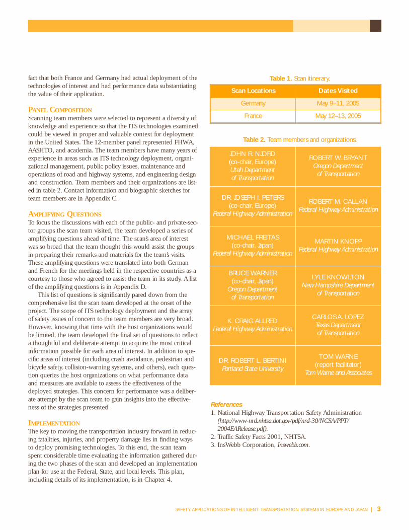
STUDY ORGANIZATIONFHWA, AASHTO, and NCHRP sponsored the scanningstudy. The countries the team visited, with their respectivedates, are listed in table 1, and the international contactsinterviewed are in Appendix B.
The team selected France and Germany because oftheir significant deployment and application of ITS tech-nologies with a focus on improving safety in their highwaysystems. In addition, in Germany the team was able tomeet with researchers from the private sector to gaingreater understanding of their efforts toward this objective.A major discriminator in making these selections was the
2 | CHAPTER ONE
WORLDWIDE ROAD TRAFFIC FATALITIES—1998UNITS = 25,000 LIVES LOST PER SQUARE
POOR NATIONSAfrica
AmericasChina
Eastern MediterraneanEurope
IndiaSouth-East AsiaWestern Pacific
WEALTHY NATIONSEastern Mediterranean
EuropeNorth AmericaWestern Pacific
Combined Totals
170,118125,959178,89470,677106,757216,859118,60841,165
92366,09949,30425,3301,170,694
WORLDWIDE ROAD TRAFFIC INJURIES—1998UNITS = 750,000 INJURIES PER SQUAREPOOR NATIONS
AfricaAmericas
ChinaEastern Mediterranean
EuropeIndia
South-East AsiaWestern Pacific
WEALTHY NATIONSEastern Mediterranean
EuropeNorth AmericaWestern Pacific
Combined Totals
6,116,5594,410,7365,384,9092,533,7713,213,1047,203,8643,997,6311,432,539
29,9792,082,3211,670,374772,83838,848,625
FIGURE 3. World Health Organization fatality and injury report.(www.nhtsa.dot.gov)
FIGURE 2. Annual fatality rate. (www.nhtsa.dot.gov)
SO
UR
CE
: W
OR
LDH
EA
LTH
OR
GA
NIZ
AT
ION
fact that both France and Germany had actual deployment of thetechnologies of interest and had performance data substantiatingthe value of their application.
PANEL COMPOSITIONScanning team members were selected to represent a diversity ofknowledge and experience so that the ITS technologies examinedcould be viewed in proper and valuable context for deploymentin the United States. The 12-member panel represented FHWA,AASHTO, and academia. The team members have many years ofexperience in areas such as ITS technology deployment, organi-zational management, public policy issues, maintenance andoperations of road and highway systems, and engineering designand construction. Team members and their organizations are list-ed in table 2. Contact information and biographic sketches forteam members are in Appendix C.
AMPLIFYING QUESTIONSTo focus the discussions with each of the public- and private-sec-tor groups the scan team visited, the team developed a series ofamplifying questions ahead of time. The scan’s area of interestwas so broad that the team thought this would assist the groupsin preparing their remarks and materials for the team’s visits.These amplifying questions were translated into both Germanand French for the meetings held in the respective countries as acourtesy to those who agreed to assist the team in its study. A listof the amplifying questions is in Appendix D.
This list of questions is significantly pared down from thecomprehensive list the scan team developed at the onset of theproject. The scope of ITS technology deployment and the arrayof safety issues of concern to the team members are very broad.However, knowing that time with the host organizations wouldbe limited, the team developed the final set of questions to reflecta thoughtful and deliberate attempt to acquire the most criticalinformation possible for each area of interest. In addition to spe-cific areas of interest (including crash avoidance, pedestrian andbicycle safety, collision-warning systems, and others), each ques-tion queries the host organizations on what performance dataand measures are available to assess the effectiveness of thedeployed strategies. This concern for performance was a deliber-ate attempt by the scan team to gain insights into the effective-ness of the strategies presented.
IMPLEMENTATIONThe key to moving the transportation industry forward in reduc-ing fatalities, injuries, and property damage lies in finding waysto deploy promising technologies. To this end, the scan teamspent considerable time evaluating the information gathered dur-ing the two phases of the scan and developed an implementationplan for use at the Federal, State, and local levels. This plan,including details of its implementation, is in Chapter 4.
References
1. National Highway Transportation Safety Administration(http://www-nrd.nhtsa.dot.gov/pdf/nrd-30/NCSA/PPT/ 2004EARelease.pdf).
2. Traffic Safety Facts 2001, NHTSA.3. InsWebb Corporation, Inswebb.com.
SAFETY APPLICATIONS OF INTELLIGENT TRANSPORTATION SYSTEMS IN EUROPE AND JAPAN | 3
Table 2. Team members and organizations.
Table 1. Scan itinerary.
Scan Locations Dates Visited
Germany May 9–11, 2005
France May 12–13, 2005
JOHN R. NJORD(co-chair, Europe)Utah Department of Transportation
ROBERT W. BRYANTOregon Department
of Transportation
DR. JOSEPH I. PETERS(co-chair, Europe)
Federal Highway Administration
ROBERT M. CALLANFederal Highway Administration
MICHAEL FREITAS(co-chair, Japan)
Federal Highway Administration
MARTIN KNOPPFederal Highway Administration
BRUCE WARNER(co-chair, Japan)
Oregon Department of Transportation
LYLE KNOWLTONNew Hampshire Department
of Transportation
K. CRAIG ALLREDFederal Highway Administration
CARLOS A. LOPEZTexas Department of Transportation
DR. ROBERT L. BERTINIPortland State University
TOM WARNE(report facilitator)
Tom Warne and Associates

4 | CHAPTER ONE

SAFETY APPLICATIONS OF INTELLIGENT TRANSPORTATION SYSTEMS IN EUROPE AND JAPAN | 5
The scan team met with both public- and private-sector organizations in France and Germany. In every case, the host organizations were generous insharing their latest advancements in applying ITStechnologies to improve safety on their road and
highway systems. This chapter provides a glimpse into the widearray of applications and initiatives the scan team observed during the course of its study in Europe.
COMMUNICATING VIA OVERHEADMESSAGE SIGNSThe team observed many effective meansfor communicating information to thetraveling public via both static and variable message signs (VMS). The Euro-peans rely on these signs to provide vehi-cle operators with up-to-date informationabout traffic conditions, road restrictions,
and other situations affecting the safe and efficient use of thefacility. In both France and Germany, the use of internationalsymbols (figure 4) is obviously well established (as well as inother EU countries). These symbols, which transcend languagebarriers among countries, allow for the accurate and clear communication of information motorists need to safely use roadsand highways.
This effort, focused on simplifying the communication ofinformation, follows very closely the human-machine interface(HMI) initiatives in both countries, a deliberate effort to providedrivers with only the information that is essential at a criticaltime in the journey. In a transportation world where drivers areinundated with information (including that provided by typicalsigning, advertising, and cellular services), the opportunity torelieve the information load through use of symbols in lieu oftext appears promising.
Variable or changeable message signs take many forms in the European transportation system. Some signs have standard, changeable legends that can be tailored to communi-cate, in textual format, key information and data, as shown in figures 5 and 6. Graphical representations of roadway networks and their level of congestion are also not uncommon in Germany, as shown in figures 7 and 8 (see next page).
Other signs included a combination of standard messaging
and international symbols, providing standard inputs to the driver on road conditions, speed, or warnings.
In addition, observed signing also provided transportationsystem operators the ability to provide additional routing infor-mation for congestion or incident management purposes. Thesigns also are used to divert traffic from one route to another andoften offer the driver a choice by estimating the differences intravel time for provided options.
Static signs, as shown in figure 9, are also thoughtfullydesigned to communicate the maximum amount of informationto the vehicle operator in the clearest fashion possible. The scanteam observed significantly more use of routing symbols on signsin Europe than in the United States. These symbols and graphicsdepict movements and give drivers a sense of how routing deci-sions will occur as they proceed through interchanges on the
CHAPTER TWO
Observed Applications and Initiatives
Figure 4.International symbol.
Figure 5. Changeable message signs.
Figure 6. Variable message sign. (BMW)

road ahead. This combined use of symbols and text messages in astatic, overhead-signing situation appears to be an effective meansof communication.
ESAFETY INITIATIVEThe European Commission established the eSafety effort toadvance a significant number of initiatives that will result in sub-stantial safety improvements for those who travel the roads andhighways of its member countries. This eSafety Forum (figure 10)is composed of nine working groups whose projects includecrash-causation analysis, human-machine interface, and others.Figure 11 shows the organization and reflects the breadth of theindividual initiatives in the eSafety initiative.
The eSafety initiative has produced a collective umbrellastructure for advancing the many subinitiatives that composethe overall effort. The working groups identified by each box infigure 11 are key to the success of safety, since this is where thetechnical research occurs and where public-private interactionsresult in the various products and services developed. Neverthe-less, the structure is sufficiently robust at the forum level thatkey efforts are able to move toward implementation. The teamobserved that the EU members and private-sector companieswho support the eSafety initiative have developed a productiveand effective relationship with tangible results from their collec-tive efforts.
The eSafety program is composed of multiple elements thatwill collectively contribute to the safer operation of vehicles onthe roadway. To date, the European Union has committed aboutEUR170 million (US$212 million) to support the various pro-grams falling within the eSafety research and deployment struc-ture. The vision of the eSafety initiative is divided into two majorcategories:� First-generation, or autonomous, systems� Second-generation, or cooperative, systems
First-generation systems focus more on the vehicle as an iso-lated unit capable of gathering some external inputs but operatingmostly within its own sphere of information. The following threedescriptors offer insight into how this is accomplished:� Advanced vehicle sensors and communications systems
integrate with onboard navigation systems.� Advanced GPS coordinates with digital mapping and location-
based services.� Vehicle and infrastructure information emphasizes safety and
efficiency.To move the eSafety effort forward, European Union has
established what it calls second-generation initiatives, which willmanage the vehicle’s performance in the context of the overall sys-tem. The vehicle is no longer seen as a singular element in theroadway environment; instead, all elements (including other vehi-cles and the infrastructure itself) work together as a system. Thetwo descriptors offered for this second-generation eSafety systemare the following:� Intelligent vehicles are able to link to one another and
6 | CHAPTER TWO
Figure 7. Variable message sign with congestion indication. (BMW)
Figure 8. Variable message sign with congestionindication—ground mount. (BMW)
Figure 9. Static overhead sign.

exchange information with the roadway infrastructure withincreasingly greater intelligence as more data and information are acquired.
� Sensors, system architecture, software, and positioning technologies integrate the vehicle within a global road safety system.Many systems the scan team observed are elements of the EU
eSafety initiative. PReVENT is one of these systems. With EUR55million (US$69 million) dedicated over 4 years, the purpose ofthe PReVENT effort is fivefold:� Safe speed� Safe following� Lateral support� Intersections� Vulnerable users
Each specific area constitutes a focus of intense research toprovide safer operation of vehicles on EU roadways. Transporta-tion professionals will recognize the logic behind these five areasand see why research on each would lead to safer vehicle operations.
ECALL: CONNECTING THE DRIVER TO THE RESTOF THE WORLDOne challenge facing emergency response resources is timelynotification. Similarly perplexing is the issue of responding withthe proper personnel and resources to address a specific incidentand its victims. In many cases, the individuals first on the scenewere not traditional law enforcement or medical personnel, butauto club employees or others. In response to this importantneed, the EU eSafety initiative continues to examine many of thehuman-machine interface initiative’s components, including
notification following an incident. One such component is theeCall system in preliminary development in Europe.
eCall is an initiative that will allow a motorist to either automatically or manually communicate with a Public ServiceAnswering Point (PSAP) when an incident occurs. PSAP thennotifies appropriate emergency service organizations so they canrespond quickly to the situation. During this communicationprocess, PSAP personnel will assist the reporting vehicle operatorin addressing immediate needs at the scene of the incident.Simultaneous communication of critical health and safety infor-mation can be sent to the proper emergency organizations so thatthe response is tailored to the specific circumstances. Additional-ly, the GPS component of the eCall initiative will allow emer-gency response resources to go to the precise location of the inci-dent without wasting precious minutes searching for the caller.
The European Commission has adopted a plan to equip allnew cars in Europe with eCall as soon as 2009. eCall will joinalready-deployed cellular communications systems with GPS,facilitating precise location of incidents as soon as they occur. Itis anticipated that 2,000 lives a year will be saved in Europe asresponse times are reduced by up to 50 percent in rural areasand 40 percent in urban areas.
SteeringCommitte
SAFETYFORUM
eCallDrivingGroup
AccidentCausationAnalysis
HumanMachine
Interaction
ResearchTechnologicalDevelopment
Real-TimeTrafffic and
TravelInformation
Road Maps
DigitalMaps
Heavy-DutyVehicles
InternationalCooperation
UserOutreach
eScope
Figure 11. eSafety Forum organization chart. (BASt)
Figure 10. eSafety Forum logo. (www.escope.info)
SAFETY APPLICATIONS OF INTELLIGENT TRANSPORTATION SYSTEMS IN EUROPE AND JAPAN | 7

IMAGE PROCESSING TO ASSIST THE DRIVERCreating an environment for safer vehicle operation is a majorobjective of a number of projects. Image processing falls underthe broad umbrella of the advanced driver assistance systems(ADAS) effort, part of the eSafety initiative. Image processing cen-ters on capturing various images, processing the informationreceived, and communicating it to drivers to enhance their abilityto safely control their vehicles.
A vehicle can gather image information from a variety ofsources. These include video, laser, radar, and other inputs fromthe infrastructure itself. Video cameras may be located strategical-ly around a vehicle, providing 360-degree inputs of the environ-ment immediately next to and ahead of the vehicle. Once gath-ered, these video images are processed with data gathered fromother sensors and intelligent outputs are then provided to thedriver for use in making critical decisions.
Technology under development uses image processing tohelp the driver recognize infrastructure features, traffic-controldevices, and other key environmental elements surrounding thevehicle. For example, a video camera could capture the image ofa typical octagonal stop sign. Once that image enters the proces-sor, it is interpreted as a traffic-control device and more particu-larly as a stop sign. At this point the onboard processor can com-municate to the driver the proximity of a stop sign as the vehicleapproaches that location. In carrying this example further, theonboard processor could sense that as the vehicle approaches thelocation of the stop sign it is not decelerating appropriately forthe current speed and road conditions. If the vehicle were alsoequipped with an automated braking system, the driver wouldbe prompted to begin braking or automatic braking could beginto avoid the car driving through the stop sign.
Other uses of image processing include detection of speedlimits, traffic signals, and other traffic-control devices, as well asanomalies that may occur in front of or next to a vehicle. Theimages are processed based on the shape or form of the device, as
well as its color, texture, and optical characteristics. The onboardprocessor is capable of taking the many images captured by thevehicle’s sensors and sorting them so that only those that reflectspecific safety needs are processed and interpreted for the driver.
One example presented to the scan team during its visit toBMW in Germany showed how images of signs are first capturedby their shape and other physical characteristics. Then, as thevehicle gets closer, further details of the sign’s characteristics aredetermined through a series of algorithms until the message isclearly known and communicated to the driver.
Examples of opportunities to use image processing for saferdriving include pedestrian and hazard detection. Hazards wouldalso include safety concerns such as disabled vehicles, construc-tion work zones, and obstructions in the roadway.
ELECTRONIC TOLL COLLECTION TRANSPARENCYOver the years, France has developed an extensive system of tollroads that cover much of the country and provide significantmobility to residents and visitors alike. Authorized in nationallegislation in 1955, tollways totaling 7,973 kilometers (km) areoperated by 11 concessionaries with more than 76.3 billion kmtraveled each year. Total annual toll revenues across these systemshave reached EUR6.1 billion. Many efforts have been undertakento streamline the collection of these tolls. In a given year thesetolls are collected by the following means:� 36 percent by credit card� 33 percent by Liber-t� 31 percent by cash or check
The Liber-t system (see figure 12) was established to providetransparency among the tollways and make traveling around thecountry more convenient. With more than 1,156,000 sub-scribers, the Liber-t transponder system allows a traveler to movefreely from one tollway to another knowing that tolls will beaccumulated at a central processing center where one invoice willbe generated, no matter where the travel occurred. Recognizingthe mobility between adjacent countries and the existence ofother tollways around Europe, other EU countries are moving toassure this same transparency.
Liber-t provides many incentives to its users in addition tothe single-invoice feature. Discounts ranging from 10 to 20 per-cent are offered to frequent travelers who use the same route 10or more times a month. If the same journey is made more thanfive times a month, then the sixth and tenth trips are free. Fur-ther enhancing the use of the Liber-t system is the current devel-opment and future deployment of its use in parking garages andfor other motorist services. Ultimately, systems like Liber-t willmake travel more efficient and provide desired transparency tousers as they move from one system to another.
SAFEMAP: DIGITAL INFORMATION FOR SAFER DRIVINGTwo systems that have developed simultaneously in the trans-portation industry are digital-mapping initiatives and onboardnavigation systems. In the European Union SafeMAP effort,
8 | CHAPTER TWO
Figure 12. Liber-t. “To receive an offer adaptedto your travels, consult Liber-t’s information
page. Click here.” (www.autoroutes.fr)

public-sector agencies and private-sector firms work together tocombine these technologies to bring a higher level of service tothe driver. SafeMAP focuses on six assistance features: � Speed limit assistance� Curve warning� Intersection warning� Overtaking assistance� Hazardous area warning� Crash spot warning
For SafeMAP to be effective, the static and dynamic featuresof the roadway must be integrated into digital maps that becomepart of the onboard navigation system provided in the vehicle.Static information includes speed limits, roadway features, geo-metrics, and so forth. Dynamic information includes crash data,weather conditions, construction work zones, and other data thatchange with time. Combining these inputs with an onboard navi-gation system and its GPS capabilities provides the vehicle opera-tor with an information-rich environment that will lead to a saferdriving experience.
In some cases the data will warn drivers of a geometric fea-ture or an area prone to icing. Perhaps the warning will alert thedriver to a location with a higher-than-normal number of crash-es. Other situations might include warnings that an intersectionis ahead or the posted speed limit is being exceeded. While theuse of a static digital map can be valuable to the vehicle operator,the combined effect of both static and dynamic information onthe environment the vehicle is traveling in will be a powerfulapplication of the ITS technologies the scan team observed. Ultimately, SafeMAP will allow the driver to focus on making keydecisions with pertinent and timely information.
SPEED MANAGEMENT AND ENFORCEMENTThe scan team observed several significant speed-managementand -enforcement initiatives in its review of safety applications inEurope. In particular, France is making a clear effort to addressexcessive speed and its contribution to crashes, with their result-ant injuries and fatalities.
One system the team observed is an experimental speed-control effort on the A7 Motorway operated by Autoroutes duSud de la France (ASF). ASF officials are concerned aboutincreasing levels of congestion all along the A7 corridor, butespecially on the section between Valence Sud and MontélimarNord. Managing speed or, more specifically, creating an environ-ment with more consistency in the speed level is the objective ofthis experiment on the A7 Motorway. Speed control is just one of the measures ASF is implementing to improve the drivingexperience within the system.
ASF’s strategy is to provide advisory speed notices tomotorists as they travel along the A7. Overhead gantries are usedto both measure speed and communicate to drivers that they areexceeding the posted speed limit. Cameras take images of vehi-cles at two points 10 km apart. The resulting speed calculationsare used to identify vehicles exceeding the posted speed limit.
Figure 13 shows a typical application of the cameras andvariable-message sign communicating speed information. Mul-tiple installations such as the one depicted in this figure pro-vide ASF with sufficient information to notify motorists of theirspeed compliance.
Initially, the message posted on the variable-message sign wasgeneric. In the second phase of the speed-control effort, however,researchers will assess public reaction to the posting of licenseplate information for more specific communication of speed vio-lations to motorists. No citations are issued in either case. Rather,the objective is to inform and encourage speed compliance.
Preliminary results are encouraging. ASF measured a nominal3 percent increase in capacity on the A7 where this system is inplace. In addition, it found an 80 percent compliance rate in areaswhere the posted speed limit was 110 kilometers per hour (km/h)and a 50 percent rate where the limit was 90 km/h. This seems toindicate greater compliance at speeds where the drivers are morecomfortable with the rate. Conversely, it appears that an unnaturalattempt to control speed at a lower level than drivers believe isappropriate does not result in as high a compliance level. Otherresults include overall reductions in the maximum speeds meas-ured. Also, ASF noted that the reaction time for motorists to vol-untarily respond to a newly posted speed limit was about 5 min-utes from the time the new speed limit was posted.
ASF’s motto for its system, “Gain time by driving slower,”appears to have merit as further efforts are made to improve thedriving experience and safety aspects of the A7 Motorway.
The final and most aggressive speed-management initiativeobserved was implemented by the French Ministry of Transportand reflects a comprehensive approach to using enforcement toreduce crashes and their resultant injuries and fatalities. In defin-ing its enforcement policy, the ministry adopted three objectives:� Compliance with the law, using sanctions as education
SAFETY APPLICATIONS OF INTELLIGENT TRANSPORTATION SYSTEMS IN EUROPE AND JAPAN | 9
Figure 13. Enforcement cameras and speed limit signageon the A7. (French Ministry of Transport)

Figure 15. Speed enforcement signage.(French Ministry of Transport, DSCR)
Figure 16. Measured results of automated enforcement. (French Ministry of Transport)
10 | CHAPTER TWO
Figure 14. Fixed speed enforcement camera.(French Ministry of Transport, DSCR)
� Improvement in enforcement efficiency� Experimentation with legal and technological aspects
One of the first steps adopted in moving this initiative for-ward was to ensure that the legal framework was in place. Thesuccess of the system required non-law-enforcement personnelfrom a central location to have the authority to issue citations.This central location is known as the Public Prosecutor, whichhas the authority to remotely cite vehicles because of special vali-dation conditions imposed on the camera system on the highway.
Once the legal framework was in place, the technologicalcomponents were implemented to include fixed sites as well asmobile units. Initially, 70 fixed cameras were put in place (seefigure 14), allowing for each French driver to be “enforced”twice a month. The ministry’s 2005 goal was to have 1,000
fixed and mobile cameras in place. To designate areas whereenforcement is occurring, special signing was installed to warnmotorists of the presence of speed cameras (see figure 15). Sitemaps on the Web also show enforcement locations. Figure 17depicts the overall process from violation through adjudication.
A major point the ministry made about its speed enforcementinitiative is the clear and unequivocal support it has receivedfrom political leaders. The very visible endorsement of thesestrategies by national leaders communicates to the public theimportance of taking safety seriously on the motorways.
The results of this effort by the ministry are noteworthy.Speeding violations decreased from almost 7 percent to less than3 percent in areas where camera enforcement was in operation,as figure 16 shows.

SAFETY APPLICATIONS OF INTELLIGENT TRANSPORTATION SYSTEMS IN EUROPE AND JAPAN | 11
Figu
re 1
7. A
utom
atic
spe
ed e
nfor
cem
ent p
roce
ss d
iagr
am. (
Fren
ch M
inist
ry o
f Tra
nspo
rt, D
SCR)
In addition, these sites showed a dramatic 85 percentreduction in crashes in the 10-month study period. The min-istry also noted a general decrease in speeding violations else-where on the motorway network, even in locations with nocameras. Public reaction to the cameras includes an admissionby 86 percent of drivers that their speed reduction was a conse-quence of the presence of the speed cameras and recognitionby 77 percent that this automated speed enforcement systemimproved road safety.
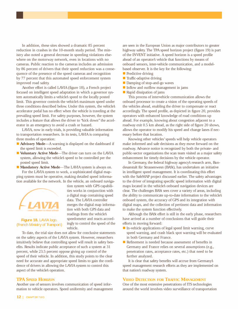
Another effort is called LAVIA (figure 18), a French projectfocused on intelligent speed adaptation in which a governor sys-tem automatically limits a vehicle’s speed to the locally postedlimit. This governor controls the vehicle’s maximum speed underthree conditions described below. Under this system, the vehicle’saccelerator pedal has no effect when the vehicle is traveling at theprevailing speed limit. For safety purposes, however, the systemincludes a feature that allows the driver to “kick down” the accel-erator in an emergency to avoid a crash or hazard.
LAVIA, now in early trials, is providing valuable informationto transportation researchers. In its tests, LAVIA is comparingthree modes of operation:� Advisory Mode—A warning is displayed on the dashboard if
the speed limit is exceeded.� Voluntary Active Mode—The driver can turn on the LAVIA
system, allowing the vehicle’s speed to be controlled per theposted speed limit.
�Mandatory Active Mode—The LAVIA system is always on.For the LAVIA system to work, a sophisticated digital map-
ping system must be operative, making detailed speed informa-tion available for the network. In the vehicle, an onboard naviga-
tion system with GPS capabili-ties works in conjunction witha digital map containing speeddata. The LAVIA controllermerges the digital map informa-tion with both GPS data andreadings from the vehicle’sspeedometer and reacts accord-ingly to control the speed of thevehicle.
To date, the trial size does not allow for conclusive statementson the safety aspects of the LAVIA system. However, researchersintuitively believe that controlling speed will result in safety ben-efits. Results indicate public acceptance of such a system at 31percent, while 23.5 percent oppose giving up control of thespeed of their vehicle. In addition, this study points to the clearneed for accurate and appropriate speed limits to gain the confi-dence of drivers in allowing the LAVIA system to control thisaspect of the vehicle’s operation.
TPA SPEED HORIZONAnother use of sensors involves communication of speed infor-mation to vehicle operators. Speed uniformity and management
are seen in the European Union as major contributors to greaterhighway safety. The TPA speed horizon project (figure 19) is partof the INVENT initiative. A speed horizon is a speed profileahead of an operator’s vehicle that functions by means ofonboard sensors, inter-vehicle communication, and a model-based observer. It is the key for the following: � Predictive driving� Traffic-adaptive driving � Damping of stop-and-go waves � Inflow and outflow management in jams � Rapid dissipation of jams
This process of intervehicle communication allows theonboard processor to create a vision of the operating speeds ofthe vehicles ahead, enabling the driver to compensate or reactaccordingly. The speed profile, as depicted in figure 20, providesoperators with enhanced knowledge of road conditions upahead. For example, knowing about congestion adjacent to aroadway exit 0.5 km ahead, as the right side of figure 20 shows,allows the operator to modify his speed and change lanes if nec-essary before that location.
Knowing other vehicles’ speeds will help vehicle operatorsmake informed and safe decisions as they move forward on theroadway. Advance notice is recognized by both the private- andpublic-sector organizations the scan team visited as a major safetyenhancement for timely decisions by the vehicle operator.
In Germany, the federal highway agency’s research arm, Bun-desanstalt für Strassenwesn (BASt), has undertaken an initiativein intelligent speed management. It is coordinating this effortwith the SafeMAP project discussed earlier. The safety advantagesto the driver of integrating specific speed information with digitalmaps located in the vehicle’s onboard navigation devices areclear. The challenges BASt sees cover a variety of areas, includingthe ability to communicate up-to-date information to the vehicle’sonboard system, the accuracy of GPS and its integration withdigital maps, and the collection of pertinent data and informationto make the system function effectively.
Although the BASt effort is still in the early phase, researchershave arrived at a number of conclusions that will guide theirefforts in moving forward:� In-vehicle applications of legal speed limit warning, curve
speed warning, and crash black spot warning will be evaluatedin both Germany and France.
� Refinement is needed because assessment of benefits in Germany and France relies on several assumptions (e.g.,penetration rates, acceptance rates, etc.) that need to be further analyzed.It is clear that safety benefits will accrue from Germany’s
speed management research efforts as they are implemented onthat nation’s roadway system.
VIDEO DETECTION FOR TRAFFIC MANAGEMENTOne of the most extensive penetrations of ITS technologiesaround the world involves video surveillance of transportation
Figure 18. LAVIA logo.(French Ministry of Transport)
12 | CHAPTER TWO

networks. This ability to view activities and operations onbridges, in tunnels, and on highways has proved to be a valuabletool for transportation managers in maximizing the efficiency oftheir systems. Over the years, the challenge has been to find ameans whereby numerous camera images can be processed in anautomated manner that will enable system operators to respondto incidents with accuracy and in a timely manner.
A technology developed in France and observed by the scanteam focuses on this ability to precisely interpret video images,discern anomalies, and alert transportation professionals toevents occurring on the network. In addition, these images canbe used to address emergencies in a timely manner and offertransportation agencies enhanced security inputs for critical facilities. To accomplish this complex task, specific steps are followed once the cameras are in place and operational:� Analyze the area under observation.� Capture the background image.� Digitize the background image.� Detect moving vehicles and track through “marking.”� Perform a trajectory analysis of all “marked” vehicles.�Measure.� Detect incidents.
Sophisticated algorithms are used to analyze about 20 percent of the images captured by each camera every second.From these images the system is able to discern when anomalies have occurred and, when properly filtered, offer system operators timely alerts to potential problems. In addi-tion, the analysis not only provides the most current image ofthe area where an incident occurred, but also images of activi-ties that occurred just before the event. In this way, much morerelevant information can be secured to enable the operator tomake the correct response decision. While many attempts havebeen made over the years to develop an automated system forvideo incident detection, the technology and computationalabilities of the systems were not robust enough until now toprovide accurate and timely notification of incidents using thevideo feeds already being captured. The systems the scan teamobserved are a clear indication of the potential that video image processing can have on improving safety on the U.S.highway network.
WILLWARN: A PREVENT PROJECTThe WILLWARN (Wireless Local Danger Warning) system (figure21) is another element of the PReVENT initiative. It focuses onproviding the driver with critical information on which safe driv-ing decisions may be based. It centers on car-to-car communica-tions in which critical information is exchanged between adjacentvehicles. As these inputs are analyzed by an onboard processor, an“electronic” horizon is created, giving the driver an enhanced viewof the road ahead. Figure 22 (see next page) depicts how informa-tion from the WILLWARN system and from other components ofthe PReVENT project is gathered from many sources adjacent tothe vehicle to create this “electronic” safety environment.
WILLWARN has anonboard capability that offersthe following to the vehicleoperator:� Onboard hazard detection� In-car warning management� Decentralized warning distri-bution by using short-range,dedicated communications
The applications of the WILLWARN system are numerous. It will allow for safer driving conditions in rural areas or wheresevere weather or other difficult conditions make travel haz-ardous. Potential obstacles or hazards in both urban and ruralareas will be highlighted to the driver through WILLWARN, offer-ing opportunity for evasive action. In areas of low visibility, theinputs provided by this system will give drivers key informationabout road situations ahead that will allow them to travel safely.
SAFETY APPLICATIONS OF INTELLIGENT TRANSPORTATION SYSTEMS IN EUROPE AND JAPAN | 13
Figure 20. Speed profile diagram. (INVENT, DaimlerChrysler)
Figure 19. TPA speed horizon system. (INVENT, DaimlerChrysler)
Figure 21. WILLWARN logo.(www.PReVENT-ip.org)

Finally, inputs on construction work zones will promote safety forboth drivers and workers in the construction area.
WILLWARN is yet another means for gathering informationfrom a variety of sources, processing that information, and presenting it to the driver in a format that is not distracting to the safe operation of the vehicle.
CODE OF PRACTICETort liability is one of the major challenges facing the EuropeanUnion. It is a worldwide issue, with every country and technolo-gy implementer concerned about how crashes or other incidentsmight turn into major legal issues. To deal with this problem, theEuropean Union has established a Code of Practice that definesroles, responsibilities, and “duty of care” that providers and operators have in deploying ITS safety systems.
The Code of Practice is not a new concept. Other industries,such as aircraft manufacturers and the pharmaceutical industry,have adopted such a document to stem, to whatever possibledegree, the tide of litigation that may result from product failure.In many respects, highway industry standards such as the FHWAManual on Uniform Traffic Control Devices (MUTCD) and othersare examples of codes that organizations can follow and rely on.In Japan, officials have adopted the Japanese Industrial Standards(JIS) as their equivalent code.
The EU Code of Practice offers a risk assessment that trans-
lates product development and deployment into “reasonablesafety” performance standards. By following these guidelines,product developers or system operators can be reasonably surethat their activities meet accepted expectations for safety andutility. One important aspect of the Code of Practice is that itprovides the definition of “safe” for entities involved in develop-ing the elements of the advanced driver assistance systems(ADAS) discussed elsewhere in this report.
As products or systems are developed in the EuropeanUnion, they go through a series of queries that assist the develop-er in determining whether the concept will meet the Code ofPractice in a real-world application. Typical questions that mustbe answered include the following:� Is it possible that the driver may fail to perceive a system
message?� Is it necessary to support system feedback using additional
information channels (e.g., acoustic in addition to opticaldisplay)?
� Does the system provide timely feedback about system reaction in a given traffic situation (e.g., take over request fromadaptive cruise control)?
� Can system output and information be perceived by the driverquickly enough to facilitate appropriate reaction (e.g., takeover request from adaptive cruise control)?By answering these and other questions, product developers
14 | CHAPTER TWO
Figure 22. PReVENT project approach. (www.prevent-ip.org)

can determine if they have met their “duty of care” for a givenproduct and complied with the Code of Practice, thereby qualifying to benefit from its protections.
To date, the ITS community and its related contributors havenot developed a U.S. version of a code of practice. Those whohosted the scan team in Europe clearly stated that the deploy-ment of some of the most impressive and valuable technologiescould not occur until such a code is in place.
SARI: PREDICTING ROADWAY CHARACTERISTICSThe French Ministry of Transportation has embarked on aresearch effort called SARI as part of its PREDIT program. SARI has its impetus in the notion that roadway safety can beimproved if drivers are provided appropriate information toavoid surprises in their decisionmaking processes. The objectivesof the SARI research effort are as follows:� Select road conditions that affect driver behavior.� Identify road conditions that are problematic and identify the
causes.� Develop prototype information systems to evaluate the
effectiveness of the SARI system.French transportation professionals believe that warning
drivers of road conditions as they approach specific locations willimprove their ability to operate vehicles in a safe and prudentway. This creation of a safer driving environment depends onproviding accurate and timely information to drivers. Conditionsthat may be communicated include challenging geometry, high-crash locations, weather or visibility conditions, and other pertinent inputs that would impact vehicle operation.
Research will be conducted in five principal areas:� Physical road characteristics that cause critical acceleration or
deceleration and stresses� Discontinuities in roadway visibility or legibility that could
lead to inappropriate trajectories� Road deterioration� Presence of other vehicles when the weather is poor� Knowledge about incidents involving other vehicles that are
related to the road conditionThe results of this research will be valuable as transportation
professionals strive to more accurately determine how best tocommunicate information to drivers to improve their perform-ance on the roadway.
DRIVER ASSISTANCEThe scan team observed a number of other initiatives presentedby the public and private sectors in the European Union thatfocused on helping the driver with various tasks and operations.A joint public-private effort that concentrates on these systemsfunctions under an umbrella called INVENT, a collection of projects that focus on driver assistance and active safety.
The individual projects in INVENT are divided into five categories:� Driver behavior and human-machine interface
� Detection and interpretation of the driving environment� Anticipatory active safety� Congestion assistant� Traffic impact, legal issues, and acceptance
Within the detection and interpretation of the driving envi-ronment are efforts to enhance information collection throughindividual types of sensors (e.g., cameras, laser, etc.). What isperhaps more significant is that the efforts also incorporate theconcept of sensor fusion, meaning data is gathered by more thanone method or collection device and combined. This combina-tion of inputs develops synergy, and the ultimate effect of thisfusion concept is a richer information environment for the driver.One goal of creating this environment is to offer early detectionof moving objects, allowing a vehicle operator more time tomake critical operational decisions.
In the anticipatory active safety category, efforts are dividedamong a variety of research projects that promise many safetybenefits. Included are systems that focus on crash prevention andthe reduction of their severity as well as protection of all partici-pants in the traffic flow, including vehicle operators, passengers,pedestrians, and cyclists. Under development are technologies tohelp drivers make safer lane changes and maintain their laneposition, as well as proximity sensors that communicate relativeposition of the vehicle and other roadway features and occu-pants. Key to this category is the word “anticipatory,” since thetechnologies being assessed and deployed offer an “intelligent”look at the current and possible future conditions surrounding avehicle on the highway.
Congestion assistant systems are designed to help a driverwith tasks that can cause fatigue during periods of high conges-tion on the highway. System benefits include the following:� Maintaining a fixed distance from a leading vehicle� Maintaining the vehicle in a lane� Automatic braking, including to a fully stopped condition� Automatic driver-confirmed acceleration from a stopped
conditionUltimately, use of these systems will greatly reduce many
repetitive driving tasks and allow the driver to focus attention onmore critical driving decisions.
Driver assistance can be provided in many forms. In somecases, the driver is fully aware of the systems and interacts withinformation received from a variety of inputs as describedabove. In other cases, this assistance is provided in the back-ground and the driver often is unaware of the help provided. Anexample is the electronic stabilization control (ESC) systemsbeing installed on many late-model vehicles in Europe and theUnited States. These ESC systems assist the driver when certainperformance circumstances present themselves on the roadway.When operational, an ESC system will assist a driver in steeringand movement maneuvers that will help him keep the vehiclesafely on the roadway and avoid over turning or some otheroutcome. The significant benefits of ESC systems are shown infigure 23 (see next page).
SAFETY APPLICATIONS OF INTELLIGENT TRANSPORTATION SYSTEMS IN EUROPE AND JAPAN | 15

In this case, the data is solely for one manufacturer’s vehicles,but the point is clear that benefits are substantial for all vehiclesequipped with an ESC system.
OPTIMIZING FACILITY THROUGHPUTIn the Munich area the scan team visited the Traffic OperationsCenter (TOC) of the Autobahndirektion Sudbayern, the region-al transportation agency. The team noted many interesting fea-tures of this facility and its contribution to traffic managementin the area. One in particular the team found valuable was adeliberate effort to maximize the throughput on the highwaynetwork by using two strategies: active routing and shoulderrunning.
Active routing of traffic flow was accomplished with anaggressive use of changeable message signs that allowed TOC tooffer alternative routing information to motorists to reduce thecongestion on specific routes. Changeable message signs wouldcommunicate this information in the form of routing options,distance, and time consequences. Drivers could then makeinformed decisions on how they would traverse a certain routebased on enhanced information provided by TOC.
In addition, TOC thoughtfully used shoulder running duringperiods of peak congestion to maximize the use of availablepavement surface to carry traffic on the system. Several measureswere implemented to ensure the safety of those using shoulders.For example, before opening a lane to traffic, TOC surveyed thecomplete length through video cameras to ensure no disabledvehicles on the shoulder would create a hazard. In addition,
signing, striping, and other traffic-control devices were modified toaccommodate the temporary use ofshoulders for traffic flow. Ultimately,shoulder running has proven very successful for the AutobahndirektionSudbayern. While shoulder runningper se is not an ITS technology, it is aconcept whose safety and effectivenessdepend on appropriate use of thesetechnologies.
One characteristic of the approachtaken in Europe to transportation safetyis the holistic view the European Unionhas of the process. The EuropeanUnion looks at the driver, environment,infrastructure, and related policy issuesand attempts to synchronize all of theseinto an approach that makes significantimprovements in safety performance. Itrecognizes that achievements in onlyone of these four areas will fall short of the overall goal of reducing trafficfatalities and injuries by half in the next decade.
The scan team found the visits to Germany and France valuable in achieving the objectives of the scan tour. The technologies observed offer clear promise for improving safety on U.S. roads and highways.
16 | CHAPTER TWO
Figure 23. Crashes in Germany 1998-2002: loss-of-control crashes. (DaimlerChrysler)

This report offers a glimpse into the various ITStechnologies either available or in the developmentstage that have the potential to improve safety onthe Nation’s roads and highways. Consequent tothe observations offered in Chapter 2, the scan
team believes some significant findings define the state of ITSdeployment and its potential contribution to safety in the European Union. In addition, the team has developed 12 recommendations it believes will advance U.S. efforts to achievegreater safety, indicated by fewer crashes and reduced fatalitiesand injuries. The findings are presented first, followed by the recommendations.
FINDINGSMany findings emerged from the scan team’s review of theobserved technologies during its visits to France, Germany, andJapan. A few of the most salient are presented here. To organizethe findings into a logical presentation, the team has dividedthem into the four standard components of the highway system:� Driver� Vehicle� Environment� Policy
Each of the findings and recommendations is divided intoone of these four components, reflecting its role in the overallsafety of the highway system.
Driver
The driver is a major focus of the safety initiatives in the European Union. Officials recognize that many crashes arecaused by driver error, inattention, or poor judgment andbelieve that significant opportunity exists to better equip driverswith tools and information that will help them operate theirvehicles more effectively. EU efforts focus on several areas relating to the driver, including driver assistance and thehuman-machine interface.
One important element of driver assistance is information.Transportation professionals in the European Union believe thatdrivers’ ability to comprehend complex informational elementsin a short time period and render sound decisions is withoutequal in the technology world. However, they believe a strongneed exists to provide more useful information to drivers sothey can make these decisions with the best understanding pos-
CHAPTER THREE
Findings and Recommendations
sible. Getting them the right information at the right time is keyto the success of the informational element of the EU driverassistance effort.
Not all information is essential to the driver. Some may beused only by an onboard processor as background informationcontributing to the relevance of more important information.Transportation professionals are developing a growing apprecia-tion that the driving task is very complex; thus, a goal of someresearch is to reduce “driver burden.” Driver burden is a condi-tion that describes the point at which information starts to dis-tract from the driver’s task. Too much information at the wrongtime isn’t useful—just as dated or old information is of no valuein improving safety. Proximity is also an issue. Once the vehicle ispast a certain location, information about that location maybecome irrelevant to the operator. In the European Union, creat-ing information systems that recognize both timing and accuracyis the objective of public and private sectors alike.
Another significant variable in creating the driver assistanceenvironment is the diversity of age and ability of the populationof vehicle operators. Information systems and data processorsmust recognize these demographic differences and adjust accord-ingly, even if a different driver gets behind the wheel of a vehiclejust operated by another driver. In the end, human factors initia-tives go beyond developing systems designed for the “ideal driv-er.” The research the team observed focused on the “average driv-er,” who may be distracted, fatigued, prone to mistakes, or unableto evaluate speed and distance inputs properly.
Another important aspect of driver safety concerns the bal-ance between technology that assists the driver with inputs in thedecisionmaking process and the basic responsibility all drivershave to operate their vehicles properly and safely. Ultimately,there is no technological replacement for the human mind and itsability to process complex inputs, render judgment, and takeappropriate action. Technology can, however, improve the driver’sability to make good and safe decisions.
The team came away from its visit with a strong sense of theimportance of the human factors element in ensuring that thedriver integrates well with the other three elements of the high-way system highlighted in this chapter. Industry is spending con-siderable time trying to understand driver behavior in crash andnoncrash situations to better determine the nature of this integra-tion and improve on it to promote safety. Ultimately, it is impera-tive that the driver, vehicle, environment, and policy elements
SAFETY APPLICATIONS OF INTELLIGENT TRANSPORTATION SYSTEMS IN EUROPE AND JAPAN | 17

work in a harmonious way. This is sometimes referred to as“cooperative driving.”
Finally, there appears to be no substitute for compliance withtraffic laws and regulations in advancing safety. This is particular-ly true for speed enforcement. Measurable safety improvementsare clear when speed is managed and/or regulated in a proactivemanner. The efforts in Germany and France will reduce thenumbers of fatalities, crashes, and injuries as speed is regulatedmore carefully and enforcement activities are increased.
Vehicle
The vehicle has been the focus of many safety improvementsover the years, including seatbelts and airbags. These passive sys-tems have netted substantial benefits to the public and haveclearly resulted in reduced injuries and fatalities. The scan teambelieves that the safety benefits of these passive systems likely arenearing a maximum, and that in the future more emphasisshould be placed on active systems that will further reduce theadverse effects of crashes on the Nation’s highways. One note-worthy active system is electronic stability control. The evidenceis clear that the presence and functionality of such systemsreduces crashes, injuries, and fatalities. Other active systems,such as adaptive cruise control, assisted braking, and lane keep-ing, will also help achieve the desired safety improvements envi-sioned by this scan effort.
Integrating the vehicle with its surrounding environment willbe essential to advancing a number of the team’s recommenda-tions. Onboard navigation systems can provide some safety bene-fit, especially when integrated with digital mapping and otherfeatures. However, the current processing ability of these onboardnavigation devices is not adequate to handle the significant pro-cessing duties envisioned when analyzing video images and othervery taxing tasks must be accomplished. Thus, a different type ofdevice will have to find substantial penetration in the market toachieve the results envisioned with some of the systems the teamobserved. There is a need to proliferate processing devices thatcan send, receive, analyze, and output information in real-timefashion. Further, adding traffic control information and warningfeatures to this system will provide drivers with critical informa-tion affecting the driving task. These systems need to be low costto achieve the market penetration that will result in the safetyimprovements envisioned.
Environment
The findings relating to the environment component of ITS safetysystems are many and varied. They include a substantial findingthat controlling speed through effective management andenforcement strategies appears to result in very real reductions incrashes, fatalities, and injuries. Operating facilities with more uni-form speed patterns and slightly reduced speeds are obviouslyassisting France in its quest for safer highways. While the teammembers understood the importance of speed managementbefore the scanning study, they are now even more convinced
that some of the greatest safety gains can be achieved by manag-ing this critical safety variable. A voluntary system resulting in nocitations could achieve some level of benefit, but a more aggres-sive photo-enforcement process would bring substantive realiza-tion of the objectives of this scan.
The need to further integrate the environment and its infra-structure elements with the vehicle is obvious. An infrastructurethat includes “smart” components, such as chips on signs andsignals that offer two-way communication capabilities (betweenvehicle and infrastructure), is just part of this enhanced environ-ment for the driver and the vehicle. Many safety benefits willaccrue with vehicle-to-environment communications in placethat enhance the driver’s ability to anticipate road geometrics andreact to traffic control situations, and otherwise improve theatmosphere in which the driver makes key decisions.
This integration is obviously a long-term initiative, but onethat must be advanced. In fact, realization of this goal is manyyears away. However, an intermediate step would be to equip thevehicle with the ability to recognize infrastructure features suchas traffic signals and signs. This step will bridge this technologygap until penetration of smart features is sufficiently thorough toresult in the desired safety benefits. Developing standards thatmany manufacturers can follow and that drivers can becomeaccustomed to will go a long way toward improving the penetra-tion of technologies in the transportation market.
Complementary to this finding is another that sees the needto integrate, certify, and maintain detailed location codes, speedlimits, and other critical information on digital maps that interactdynamically with the vehicle’s onboard processor. This ability togather information from the environment and incorporate it withother information relating to crash history, weather conditions,and other factors will further enhance drivers’ abilities to safelyoperate their vehicles.
Policy
While many findings can be articulated within the policy component, the team has singled out several for this report.The first is the obvious relationship between political and orga-nizational leadership and the advancement of ITS technologiesthat will produce substantive safety improvements. Much ofwhat is being advanced in the countries visited is the result ofsuch leadership that crosses all boundaries in the transportationindustry. The results of France’s automated speed enforcementprogram are clear: reduced crashes and resultant fatalities andinjuries. This came about only when national and local leadersmade safety a major initiative of their political leadership andheld governmental agencies accountable for achieving the stated safety objectives.
Public agencies and private-sector organizations in the Euro-pean Union have a strong sense of collaboration. This coopera-tion exists in areas such as funding, research, joint public-privateworking groups focused on specific issues, information protocols,and others. A compelling case can be made that leadership is the
18 | CHAPTER THREE

key to advancing complex policy issues such as speed enforcement and management.
Many factors contribute to safety on U.S. highways. Theyinclude governmental agencies, vehicle manufacturers, systemsdevelopers, and others. It is critical to find the proper balance ofobligations among the car manufacturer, road authority, and systems providers of technology on who supplies what informa-tion to the driver and in what format. Much needs to be organ-ized and structured so that ITS technologies can be deployed inthe most efficient manner possible.
Liability is a key concern of the private sector that reduces itsability to deploy technologies proven in research studies thatcould be made widely available. The European community isdeveloping a Code of Practice to set standards of performanceand a “duty of care” that it hopes will address the liability issuesfaced with the deployment of these advanced technologies.Development of a similar U.S. code of practice would open thedoor to many ITS applications in use elsewhere in the world butnot yet deployed in the United States.
RECOMMENDATIONSThe scan team developed 12 recommendations to achieve theobjectives of this scanning study. Like the findings, they aredivided into four elements—driver, vehicle, environment, andpolicy. The implementation plan in Chapter 4 addresses how theteam will advance these recommendations.
Driver
The two recommendations for the driver element are as follows:1.Identify stakeholders and interest groups and advance
their collaborative efforts to raise awareness of the driver’s needs. This recommendation will help public andprivate organizations identify key driver inputs, establishhuman-machine interface communication protocols, andpromote an optimal decisionmaking environment for safevehicle operation.
2.Advance the use of technology, driver education, insurance incentives, and other means to promotegreater speed compliance and management. The scanteam believes a concerted effort that covers all members of thetransportation community focused on speed management andenforcement will bring landmark benefits to system users inthe form of reduced crashes and their collateral effects.
Vehicle
The team’s two recommendations on the vehicle element are as follows: 3.Promote the aggressive implementation of low-cost,
onboard processing devices in U.S. automobiles that willcommunicate with infrastructure features and receiveinformation from other sources. The future use of onboardprocessing devices appears to be central to deploying many ofthe ITS technologies observed during the scanning study. The
ability to achieve significant penetration will be governed bythe strength of the partnership achieved between the privatesector and public agencies that provide transportation services.
4.Promote and collaborate on the development of technol-ogy focused on driver assistance (e.g., adaptive cruisecontrol, lane keeping, assisted braking, etc.). Active sys-tems that provide assistance to the driver must be incorporatedinto new vehicles as rapidly as the technologies will permit.This pace may be determined by how quickly Recommenda-tions 3 and 4 are completed. The same benefits now offered byelectronic stabilization systems will begin to accrue from theseother technologies as fast as they can be deployed.
Environment
To achieve substantial benefits in safety improvement on theNation’s highways, the team recommends the following in theenvironment element:5.Promote additional testing and implementation of photo
enforcement of speed. Implement a program of photospeed radar with a noncitation strategy to help curbaggressive driving and address speed variability on theNation’s roadways. In conjunction with Recommendation 2,the team further recommends a strategy that focuses on volun-tary efforts to curb excess speed as an intermediate measureleading to full enforcement of speed on U.S. highways. Thiswould not replace a more aggressive effort to manage andenforce speed limits.
6.Promote the accelerated development and deployment ofsystems that facilitate communication between the infrastructure and the vehicle. The public and private sectors must unite to establish architecture, communicationprotocols, and other standards to facilitate this communication.Included must be the deployment of chips and other technolo-gy devices on infrastructure features and the development ofonboard systems to process these inputs.
7.Promote the further use of changeable/dynamic graphicalsigns (international standards). The need to communicateinformation to drivers through static and changeable messagesigns continues to grow. Text messages are limited in their abil-ity to communicate pertinent information in any volume, giventhe travel speed of most vehicles. The increased use of graphi-cal signs using international standards will achieve a higherand more effective level of communication.
8.Integrate/certify/maintain detailed location codes, speedlimits, and other critical infrastructure features on digital maps. Further integrate this information withonboard vehicle technology. The scan team recognizes theimportance of bringing information from many sources to theonboard processor. Much of this information is static and, once digitized, can easily be input to multiple devices and platforms.
9.Develop and deploy technology that uses existing infor-mation gathered to provide real-time notice of incidents.
SAFETY APPLICATIONS OF INTELLIGENT TRANSPORTATION SYSTEMS IN EUROPE AND JAPAN | 19

Process data collected in traffic operations centers toreact to emergencies. A large volume of information isavailable to transportation agencies and operating systemsthat relate to the driver, vehicle, and environment. The abilityto synthesize this information, manage its use, and communi-cate it to emergency responders is critical to the safe opera-tion of roads and highways.
10. Promote the use of operations data in planning futureimprovements to the infrastructure. In conjunction withthe information gathered and processed in executing Recom-mendation 9, there is a need to take this robust data set andcreate an environment of enhanced asset management thatwill benefit both the public and private sectors.
Policy
The scan team made two recommendations relating to policy:11. Create a national highway safety program leadership
initiative focusing on safety applications of ITS tech-nologies. Leadership is an essential component ofobserved advances in the deployment of ITS technolo-gies. The scan team recommends that key individual andorganizational leaders be identified, and that an era of newand stronger leadership emerge to launch these ITS initiativesfor greater highway safety.
12. Create a warehouse for standardizing, gathering, man-aging, and analyzing before-and-after performance datarelating to safety applications of ITS technologies. Moreinformation is gathered today than is being used productivelyby public and private entities. Even more will be collectedwhen new technologies are deployed. A significant needexists to create the systems and structures necessary to effec-tively manage the volumes of data and information that willbe characteristic of these ITS initiatives and address theinherent legal issues that will emerge from this effort.There is no question that these recommendations are ambi-
tious. The scan team believes that their fulfillment will be essen-tial to achieving the paramount objective of this scan and that ofall transportation professionals: improve the safety of the Nation’stransportation system.
An implementation team (IT) was established from amongthe members of the scan team. This subgroup was charged withdeveloping strategies to achieve the recommendations containedin this chapter. These strategies are in Chapter 4.
20 | CHAPTER THREE

The recommendations in Chapter 3 encompass abroad array of initiatives that will individually andcollectively have a profound impact on safety in theUnited States. Some are long term or strategic intheir objectives and others are more tactical. As part
of its responsibility, the scan team formed a subgroup called theImplementation Team and charged it with establishing an implementation plan for the recommendations in this report.This chapter contains the initial elements of the plan that willadvance some of the team’s recommendations. Others will followas these initiatives mature in the future.
A. AUTOMATED ENFORCEMENT SYSTEMS
Background
There is sufficient evidence to show that speed is a major factorcontributing to major-injury and fatality crashes. Driving inexcess of the posted speed or regulatory speed limit is an ever-increasing problem in both rural and urban environments. Closely related to speed is the increasing occurrence of red-lightrunning. Both problem areas significantly affect a jurisdiction’sability to achieve its goal of improving motor vehicle safety. Other modes in the transportation corridor, such as bicycling and walking, are similarly impacted.
Most U.S. roads and streets are not designed to be self-explaining in providing guidance or regulatory information to thedriver. Everything from lane markings to guide and regulatorysigns to traffic-control devices is provided to help drivers safelynavigate streets and highways. While certain traffic controldevices are “regulatory,” they can be considered “advisory” whendrivers choose to disregard them. When these devices are disre-garded, the potential for serious crash events—many involvinginnocent second parties—rises significantly.
The human factor is the major consideration when evaluatingthese speed-related problems. A number of subconscious factorsmay contribute to speeding. For example, it is known that thepower, suspension, and luxury ride of today’s vehicles make iteasy to drive at speeds in excess of those posted. The smoothride, when combined with the safer roadway geometry and cross-section provided by today’s modern highways, contributes to acomfort factor for driving faster than the targeted safe speed.
Another factor that contributes to both speed and red-lightrunning is a changing U.S. culture in which many individuals are
CHAPTER FOUR
Implementation
in a hurry to get from one point to another. Coupled with thistrend are greater demands on the law enforcement community toaddress drug, crime, and homeland security issues within budgetlimits. With this reduced enforcement presence on roadways, theperceived risk of consequence to drivers who decide to exceedthe speed limit is also reduced.
The scan team noted a high priority for speed management inGermany and France, evidenced by the support from top electedofficials and decisionmakers as well as the number of routinedeployments. While the degree of political and social acceptanceaffects the deployment level and schedule, the technology appearsmature to help U.S. jurisdictions confront the problems andtragedies associated with vehicles driving over the speed limit.
Proposal
Many examples of ITS technology have proven beneficial inreducing congestion and improving safety for the traveling public.One technology deployed throughout Europe to proactively man-age speeding and red-light running is automated enforcementsystems using photo detection and photo-radar. This will includedata on both enforcement and red-light running.
Objectives
1. Expand on efforts underway in the United States to educateand inform both the public and political bodies about theseverity of these problems. Emphasize the tools available tohelp jurisdictions and State and local agencies improve safetyand reduce major crashes and accompanying fatalities.
2. Explore the level of public and political support for developingand deploying these technologies as a tool for managing speed-ing and red-light running across a full range of options fromawareness to issuing citations for violations.
3. Develop standards and guidance documents for jurisdictionson the use of these technologies.
Tasks
1. Gather case studies of locations where these two technologieshave been deployed in the United States.
2. Research and survey States and major metropolitan planningorganizations across the country to create a database of legaland regulatory requirements and limitations on the use of thesetechnologies.
3. Develop a survey tool that agencies and jurisdictions can use to
SAFETY APPLICATIONS OF INTELLIGENT TRANSPORTATION SYSTEMS IN EUROPE AND JAPAN | 21
measure the public’s awareness of the problem and the level ofacceptance for using these technologies.
4. Produce a deployment document that includes information onavailable devices, cost data, pertinent standards, and best prac-tices for deploying the technologies. Include methods to over-come resistance and guidance on developing and administer-ing the next generation of automated-enforcement programs.
5. Develop an educational campaign strategy that can be used toalert the public and elected officials to the significance andconsequences of the problems of excessive speed and red-lightrunning. Emphasize the benefits that could be realized bydeploying this type of technology as documented by a recentFHWA Turner-Fairbank Highway Research Center report onred-light running and other studies.
6. Explore the possibility of establishing a demonstration site in ahigh-problem area that could be used both to measure theeffectiveness of tools developed and to document the safetybenefits realized. After seeing a scan team presentation, the Ore-gon Department of Transportation showed interest in pilotingan automated speed notification system similar to the systemused in France. The Terwilliger Curves on I-5 in Portland pres-ent a recurring safety condition where an automated system forposting vehicle license plates of speeding vehicles approachingthe curves could help reduce overall speeds and crashes.
Scan Team Lead
Robert Bryant, Craig Allred, Robert Bertini, and Martin Knopp
Deliverables
1. A documented research, adoption, and deployment inventoryof where the two technologies have been deployed in the United States
2. A documented education and campaign strategy describingproducts and tools that need to be developed
3. An instrument that can be used to survey and assess the levelof public acceptance of such policies and efforts
4. A documented inventory of State laws and local regulationspertaining to this technology
5. A Web site that serves as a clearinghouse for U.S. case studiesand information on pertinent technology
6. A manual (or the framework for a manual) that could be madeavailable for use by States or local jurisdictions interested inpursuing automated enforcement
7. A demonstration project for automated license plate messagingon signs for speeding vehicles. Based on the interest of theOregon Department of Transportation, work initially with thatagency.
B. EVALUATING ADVANCED VIDEO DETECTION ANDINCIDENT ANALYSIS TECHNOLOGY
Background
ITS technologies often have evolved and been implemented with
the major emphasis on traffic flow (i.e., mobility). Safety may bementioned as a side benefit, but may not be quantified oremphasized. An example of such a service application is the useof data from inductance loop detectors for automated incidentdetection. These are used to alert operators in traffic managementand operations centers (TMC/TOC) that existing conditionsappear to match those typically associated with an incident.
In the United States, these applications have largely been dis-continued because of both the high error and false-call rates fromthe loop data and the increasing use of cellular phone technolo-gies by the general population. Operators simply were distracted(and frustrated) by the false alarms, and benefits of such a systemwere never realized or appreciated by transportation decision-makers. Most TMCs/TOCs moved to more reliable technologiesand real-time information via closed-circuit television (CCTV)and cell phone calls from travelers or dispatchers about roadwayincidents.
Today’s systems are less robust for prioritizing the informationan operator needs to deploy response teams or advise motoristsvia dynamic message signs or other means. The challengeremains to manage the effective flow of incident data generatedby traffic and the information that public safety operators needduring the early minutes of the response where dispatch deci-sions on people and equipment are critical. Furthermore, for themost part, the causes and effects of such incidents are not sharedwith State DOT safety engineers who assess highway safety anddesign mitigation treatments.
The scan team was briefed on and observed a demonstrationof an emerging technology developed in France to improve theintegration of CCTV networks and operators for both automatedincident detection and enhanced video access leading to theoccurrence of the incident. Computer systems analyze videoimages to isolate a potential incident from a number of scenarios.Information from numerous cameras is analyzed and the opera-tor then receives visual indicators that a particular video mayinclude an active incident. The operator can select the video andreplay the last few minutes leading up to the incident, then trans-port the video sequences to other dispatch operators or offlineanalysts. The system appears to overcome the user-interface limi-tations of the early systems used in the United States and appearseasily configurable by the user. This technology has the potentialto link to existing CCTV networks and enhance incidentresponse and post-incident safety assessments.
Objectives
1. Evaluate the potential benefit of a system in the United Statesto accurately detect incidents through existing CCTV networks.
2. Evaluate the user interface for ability to overcome human-factors issues and gain a general level of acceptance by operators and dispatchers.
3. Provide incident response personnel with improved tools forresponse decisions.
22 | CHAPTER FOUR

4. Provide safety engineers with effective access to incidentvideos that can improve their assessment of factors contributing to a crash.
Tasks
1. Develop briefing materials on the system to promote initial,basic communication of this technology among the extendedteam.
2. Contact locations in the United States that have shown aninterest in this system and ascertain their goals, users, andplanned evaluations of the system. Issue requests for informa-tion from potential providers to ascertain the availability andcapability of functionally equivalent systems and providers.Synthesize this initial information.
3. Contingent on Task 2, fund a deployment of this system in anexisting TMC/TOC to evaluate accuracy rates, determine bene-fits for responders, identify human-factors issues, and assessbenefits relating to the post-crash review processes. Potentialtest candidates include Atlanta, Denver, Kansas City, Mary-land’s Montgomery County, New Hampshire, Portland, andSalt Lake City.
4. Develop a focused technology transfer document thatdescribes the technology, its effectiveness and availability, andthe downstream policy and legal issues of applying it.
5. Conduct an NCHRP synthesis of current uses of video fortransportation and archiving practices and issues.
Scan Team Lead
Lyle Knowlton, Robert Callan, and Martin Knopp
Deliverables
1. Briefing materials2. A list of groups contacted for briefings and a briefing schedule3. Project deployment and evaluation4. Deployment document5. Video use and archiving synthesis
C. ADVANCED ITS SIGNING FOR SAFETY AND MOBILITY
Background
The use of signs to inform motorists of traffic conditions havebeen deployed around the United States for many years. The typical application is a multiline text sign to advise travelers of anincident or conditions downstream from the sign. The signs alsoare used to inform motorists of public safety issues and, morerecently, child abduction notifications known as AMBER Alerts.Some smaller signs are used at limited locations for lane-controlindications that more graphically alert the driver to potential lanechanges downstream. U.S. practitioners are making efforts to usethese text-based signs more effectively by striving to remediatelimitations of sign technology to convey meaningful and relevantinformation.
The scan team observed technologies in France, Germany,
and Japan that appeared to increase the receptiveness of congestion messages in a more effective manner. In some loca-tions, signs were observed that displayed dynamic congestionmaps similar to those used on Web sites in the United States. In addition, dynamic signs were used proactively to route trav-elers to destinations or provide lane assignments, in contrast tothe United States where signs typically display the message“USE ALTERNATE ROUTES.” The team noted the use of symbols and common formatting of speeds and destinations,and believes that this practice provides a more effective transferof messages to travelers. Further, some countries have devel-oped protocols for displaying static and dynamic informationon overhead signs.
Objectives
1. Increase awareness and adoption of the use of symbols fortraffic management by U.S. transportation agencies and theMUTCD standards body.
2. Deploy sign technologies that display congestion, travel time,and incident information via dynamic maps and symbols.Develop appropriate protocols and standards for sign layout.Evaluate user acceptance, message comprehension, and potential increases in erratic maneuvers by motorists readingthe signs.
3. Deploy sign technologies that dynamically change routedirections based on traffic conditions. Evaluate deployedtechnologies for user acceptance and impacts on congestion.
4. Deploy sign technologies that dynamically assign lanes basedon traffic conditions, events, and destinations to better segre-gate traffic involved in commuting trips, special events, long-haul transport, etc.
Tasks
1. Develop briefing materials on the system for information sharing during the early phases of expanding the team.
2. Consult with MUTCD officials on the status and potential benefit of adopting uniform symbols for congestion and safe-ty messaging. Discuss development of protocols to guidecomprehensive standardization of the static and dynamicsigning along road segments. This will promote more unifiedexpectations of travelers around the country and facilitatemore complex messaging as users more easily direct theirattention to common interfaces. Develop a cooperative action plan.
3. Meet with the human factors specialists at FHWA’s Turner-Fairbank Highway Research Center to assess past experiencewith the driving simulator used to test graphic map displaysfor motorists. Develop a cooperative action plan.
4. Contingent on Task 3, deploy and evaluate dynamic congestion map signs at a test location as a pilot deployment.
5. Deploy and evaluate dynamic parking signs in test locations.6. Deploy dynamic lane assignment and evaluate the complexity
and achievable benefits.
SAFETY APPLICATIONS OF INTELLIGENT TRANSPORTATION SYSTEMS IN EUROPE AND JAPAN | 23

Scan Team Lead
Martin Knopp
Deliverables
1. Briefing materials2. MUTCD action plan for mobility symbols and static/dynamic
signing protocols3. A list of groups contacted and a schedule for briefings4. Project deployment and evaluation
D. SAFETY BENEFITS OF VEHICLE-INFRASTRUCTUREINTEGRATION SYSTEMS
Background
Significant advances have been made in the development ofonboard navigational systems technology to provide real-timeinformation to the driver for making operational decisions. Muchof the focus by automakers in Europe (as well as in the UnitedStates) is on developing onboard video-detection and radar-detection devices. These devices detect objects such as hazards,pedestrians, or other vehicles within a prescribed range, processand interpret the nature and proximity of the object, and provideinformation to the driver. This information is advisory andintended to help the driver make critical decisions.
In Japan, the scan team observed presentations on efforts tolink the infrastructure and vehicle. Examples include pedestrianmotion detectors at crosswalks that trigger attention-getting mes-sages to vehicles from roadside signs and work zone proximitywarnings that notify drivers of changing or migrating hazardlocations during the life of a project.
While video- and radar-detection systems are complex andexpensive, this approach to capturing data requires less relianceon the infrastructure component for transmitting roadside infor-mation to the vehicle. The auto industry assumes that it cannotrely on public agencies to provide this critical component. Whilethis approach could work, it shifts the responsibility to the auto-mobile manufacturers, who depend on public acceptance andmarket penetration.
Proposal
Collaborate and partner with the Vehicle-Infrastructure Integra-tion (VII) Steering Committee and U.S. auto industry in design-ing and implementing a VII project to develop the technology forroadside features. Included would be regulatory signs, advisorysigns, and traffic-control devices that could communicate infor-mation to a vehicle’s onboard device. Enhanced safety for allmotorists would be the primary goal.
Objectives
1. Expand on the efforts in the United States to advance technol-ogy focusing specifically on research and development of theroadside-device component of VII.
2. Advocate for the design of a prototype project that can be
used to evaluate the technology of roadside infrastructure,and provide an assessment of the expected benefits forimproving safety.
3. Use the prototype project to evaluate the human-factors com-ponent, including driver reaction, utility of information pro-vided, and driver acceptance.
Tasks
1. Review existing VII use cases and assess the level of considera-tion for safety applications. Prepare a matrix comparing andcontrasting the use cases with the applications observed on thescan.
2. Meet with VII Steering Committee representatives to assessboth the progress of VII and the level of interest in pursuingprototype projects that focus specifically on safety enhance-ment.
3. Review the prioritization of existing USDOT IntelligentTransportation Systems Joint Program Office (ITS JPO)research initiatives related to VII and synthesize the identifiedissues, priorities, and schedules for safety-related applica-tions. Communicate findings and recommendations to ITS JPO.
Scan Team Lead
Robert Bryant and Martin Knopp
Deliverables
1. Matrix of use cases related to safety2. Feasibility report resulting from meeting with VII Steering
Committee representatives and auto manufacturers3. Memorandum to ITS JPO on VII research on safety
E. DYNAMIC SPEED LIMITS: IMPROVING SAFETY ANDMOBILITY
Background
ITS technologies increasingly have been deployed to assist in traf-fic operations and control. Enhanced mobility and safety havebeen joint products of these advances in ITS. An ever-increasingawareness in the transportation community supports the ideathat mobility suffers without an emphasis on safety, resulting inboth a costly breakdown of the transportation system and a negative environmental impact.
Incidents and congestion may result in secondary crashes,many of which are more serious than the original incident.Fixed or static speed limits in use since the early deployment oftraffic control devices are often disregarded. Drivers travelingover the speed limit usually assume a 5- to 10-mile-per-hour(mi/h) tolerance before a law enforcement official pulls over adriver. Many courts have adopted or accepted these tolerances.The resulting speed differential between vehicles can easilyreach 50 mi/h before enforcement on a roadway with a 75-mi/hspeed limit unless there is active management. Drivers attempt-
24 | CHAPTER FOUR
ing to push the upper limits often drive aggressively to maintain their speed.
The scan team participated in a Paris, France, briefing byPaul Maarek on the A-7 Motorway variable speed control experi-ment. This private corporate project developed and funded bythe concessionaire ASFA has listed as its dual goal the reductionof congestion and the improvement of service.
Traffic on route A-7 has been increasing by 3 percent eachyear. This important tollway constitutes the major route to Spainand the Riviera. Rural sections of A-7 routinely carry 75,000average daily traffic (ADT), peaking to 117,000 ADT during thesummer holiday months, making it even more difficult for ASFAto safely manage traffic.
ASFA developed algorithms that anticipate traffic conditions30 to 45 minutes into the future. The algorithms were used toconduct an evaluation of speed on a 19-km section (one direc-tion) of A-7 from July 31 to September 15, 2004. Using the traf-fic data for time of day and season, optimal speeds were deter-mined and posted on mainline signs and at tollway entrances.Drivers not following these speed recommendations, while notofficially cited, found their license tag numbers displayed on variable message signs. This pilot study is still experimental to evaluate the effectiveness of variable speed enforcement andthe public’s reaction.
Overhead signs and bridges have license-tag readers in placeover each lane. Recommended speeds of 110 km/h had a com-pliance rate of 80 percent, while recommended speeds of 90km/h had a compliance rate of 50 percent. The optimal speedwas determined to be between 90 and 105 km/h. The results ofthis pilot are very promising, both in terms of reducing conges-tion but more importantly in a dynamic increase in safety. Thepilot study found that congestion was reduced by 16 percent,and delay from congestion was reduced by 2 hours. The studyprojected an annual savings of 30,000 hours and US$1.8 millionfrom reduced congestion, and a 48 percent reduction in crasheson the tollway. Public awareness of the speed-control messageswas 87 percent, and 98 percent of drivers remember seeing atleast five variable message signs. Sixty-one percent of surveyeddrivers approved of the project.
Objectives
1. Evaluate the potential benefit of a similar pilot in the UnitedStates to jointly increase safety and improve mobility.
2. Evaluate the acceptance level of a similar project in the UnitedStates.
Tasks
1. Develop briefing materials on the variable speed limit (VSL)system.
2. Develop methodology and algorithms to determine optimumspeeds based on differing traffic conditions.
3. Conduct an evaluation of recommended speeds using modeling software.
4. Test and evaluate VSL and its impact on safety on a congestedhighway segment.
Scan Team Lead
Robert Bertini and Craig Allred
Deliverables
1. Briefing materials2. Selected algorithms3. Analysis report4. Project deployment and evaluation
F. TOP-DOWN SAFETY LEADERSHIP COMMITMENT:MAKING IT PERSONAL
Background
Safety was observed to be a core value in the daily life of citi-zens of the countries the scan team visited. Leaders at the high-est levels of government have made a strong commitment toimproving road safety and have established national goals forfatality reduction. In France, road safety was a campaign issuein past national elections. In fact, the current president hasestablished roadway safety as a national priority. ITS has playedan important role in working toward realization of the goal ofimproving roadway safety.
Through a top-down leadership commitment, the leaders andgovernments of these nations followed through with strong,automated enforcement programs showing very positive results.Both the high priority placed on road safety and the belief insafety as a core value of society were clearly evident from thebehavior demonstrated by the people the scan team met. Trafficsafety laws are very stringent in France, Germany, and Japan. Asa result, fatality rates are lower in these countries than in theUnited States. This personal commitment to safety has had a dramatic impact on the design and operation of transportationfacilities as well as on speed enforcement programs.
Objectives
1. Share the models of top-down leadership commitment (“makeit personal”) in fatality reduction and improved roadway safetywith key governmental leaders at both the Federal and Statelevels in the United Sates.
2. Provide key governmental leaders at both the Federal andState levels in the United States with critical facts and information that will motivate a similar personal leadershipcommitment throughout the Nation.
Tasks
1. Develop briefing materials describing the concept of top-downleadership commitment and its role in fatality reduction andimproved roadway safety, using France, Germany, and Japan asexamples.
2. Convene a meeting of co-chairs from previous international
SAFETY APPLICATIONS OF INTELLIGENT TRANSPORTATION SYSTEMS IN EUROPE AND JAPAN | 25

scans involving safety on developing stronger safety leadershipin the United States. Develop an action plan.
3. Contact key groups to request time on their national meetingagendas for briefings on the state of road safety in the UnitedStates and the benefits that can be achieved through top-level,committed personal leadership. Groups will include the Gov-ernors Highway Safety Association, the National GovernorsAssociation, the National Conference of State Legislatures, andkey members of the U.S. Congress and Administration.
4. Procure the services of a marketing/public outreach firm tocraft a safety message that can be easily understood by legisla-tors, executives, and the public at large and that emphasizesthe importance of taking action now rather than later.
Scan Team Lead
Carlos Lopez, Robert Callan, Joseph Peters, and John Njord
Deliverables
1. Briefing materials2. Action plan of integrated scans on safety related to leadership3. A list of groups contacted and the schedule for these briefings4. Printed materials, brochures, and a video news release-type
presentation on the use of ITS to enhance safety
G. ENHANCED ROADWAY FEATURES DATABASE
Background
This scan uncovered many current and proposed applicationsof ITS technologies aimed at improving safety that rely on anenhanced map database resident in either the vehicle, at somecentralized location, or both. In many cases these map databas-es would be designed to “learn” from data reported by vehiclesand to provide information to other vehicles, emergencyresponders, incident management systems, or transportationauthorities. With current navigation systems that contain staticmaps, the scan revealed a need to develop means of updatingmap data in real time, perhaps depending on the vehicle’s position in real time.
The scan team also observed that some ITS safety applica-tions require detailed speed limit boundaries. The delivery ofthis information sounds simple initially, but experience in bothGermany and France has proven that this is quite difficult froman inventory and location basis for even a small study area. It ispossible that systems could be developed using image process-ing to automatically update and improve speed limit boundarydatabases in the future, or future speed limit signs could beinstalled with small chips capable of communicating their location and status to a central system.
In the United States there have been, and continue to be,efforts to include map databases and to make the providers’systems interoperable in terms of location codes, accuracy, etc.All of these examples of future ITS safety applications havehighlighted the importance of assessing both the level of need
and the feasibility of enhancing electronic map databases usedin navigation systems. A first step in this evolution would be tocapture and display accurate speed limit information on thevarious roadway segments. This is anticipated to includeacquiring the perspectives of current map data providers, aswell as road-mapping specialists involved with the GIS-Tsoftware program.
Objectives
1. Improve the accuracy and completeness of data of the road-side inventory relevant to enabling more advanced ITS appli-cations and interactions between vehicle and roadside, andvehicle and driver. Initially, data are anticipated to includespeed limits, types of crossing points (pedestrians, midblockcrossings, schools), and types of control.
2. Increase public and private partnerships mutually benefitingfrom increased data quality.
Tasks
1. In the future, systems will be needed to integrate, certify, andmaintain detailed location codes, speed limits, and other criti-cal infrastructure features within digital maps. Further integra-tion of this information with onboard vehicle technology willalso be required.
2. Prepare a synthesis and documentation of current activities inthe United States related to mapping and feature integration,plus a literature review to gather recent and relevant researchin this area, including consideration of future NCHRP problemstatements in this area.
3. Conduct discussions with the National Science Foundationand the GIS-T community to assess research needs and oppor-tunities.
4. Conduct discussions with commercial map data serviceproviders to understand their perspectives on needs, benefits,and opportunities.
5. Conduct a case study or field trial in conjunction with ongoing VII and other field implementations.
Scan Team Lead
Robert Bertini and Lyle Knowlton
Deliverables
1. A PowerPoint® presentation and briefing book2. A list of groups contacted and a schedule for briefings3. Printed materials, brochures, and a video news release-type
presentation on the use of ITS to enhance safety 4. Based on decisions and resources discovered above, a plan for
a potential pilot study or test project to assess benefits, withcost and schedule estimates
26 | CHAPTER FOUR

The ITS World Congress is an international gatheringof professionals and vendors with the commonobjective of advancing intelligent transportation systems throughout the world. The following is thegeneral makeup of those attending the conference:
1. Government officials2. Members of academia3. Private-sector firms offering ITS-related services4. Suppliers of ITS-related products and services 5. Law enforcement personnel and organizations5. Other emergency services providers
The timing of the 11th World Congress on ITS in Nagoya,Japan, and the launching of this safety-related technology scanprovided a unique opportunity for panel members to takeadvantage of the year’s most comprehensive showcase of technology-related products and services available in the ITSenvironment. Seven members of the panel were able to attendthe congress from October 18 to 22, 2004:� Michael Freitas, co-chair, FHWA� Bruce Warner, co-chair, Oregon DOT� Dr. Robert L. Bertini, Portland State University� Carlos Lopez, Texas DOT� John R. Njord, Utah DOT� Lyle Knowlton, New Hampshire DOT� Thomas R. Warne, report facilitator, Tom Warne and
AssociatesWhile at the ITS World Congress, scan team members
attended technical sessions, delivered presentations, moderatedtechnical sessions, reviewed the myriad of trade fair exhibits,and participated in an ITS safety technical tour. Panel membersalso met several times to discuss their findings, observations,and other pertinent information that could become a part of thefinal report for this scan.
In addition, on Monday, October 18, 2004, the panel metwith representatives of FHWA, AASHTO, the U.S. private sector, ERTICO, and European countries that are well advancedin their implementation of ITS practices. ERTICO is a not-for-
SAFETY APPLICATIONS OF INTELLIGENT TRANSPORTATION SYSTEMS IN EUROPE AND JAPAN | 27
profit, public-private partnership established in 1991 toadvance intelligent transportation systems in the EuropeanUnion. It was envisioned that this meeting would establish aclear understanding of the opportunities to be explored by thescan team during the second phase of this scan.
The meeting with the European officials included discussionof a variety of ITS applications in various EU countries. Amongthe topics discussed were the following:1. Officials described the general purpose of ERTICO and how
the European Union is advancing ITS technologies toimprove safety performance on roads and highways. EU hasset a goal of reducing fatalities by 50 percent by 2010 andeliminating fatalities altogether by 2020. Also, its eSafety program focuses on deployment of new technologies.
2. It was reported that Sweden is operating a system in whichthe vehicle and the roadway infrastructure communicate andfunction collaboratively. In addition, Sweden has speedcontrol technology in place as a safety measure. It is
attempting to prevent crashes, protect occupants in crashes,and implement faster systems for getting aid to crash victims.
3. France has achieved a 21-percent reduction in fatalities withthe speed-management strategies it is using. A strong com-mitment to road safety comes from the highest levels of government. While skeptical at first, the French public nowaccepts speed-management strategies as a necessary and life-saving addition to the highway system.
4. ADAC, Germany’s equivalent of the U.S. American Automobile Association (AAA), reported on its efforts toimprove driver education.
5. The Netherlands has implemented automatic enforcementstrategies to improve speed management.
6. There is concern in the European Union that all improvementsare focused on the vehicle and roadway infrastructure, whilemore than 90 percent of crashes are caused by driver error.
7. Renault is one equipment manufacturer that has made speed limiters available on its trucks as original installedequipment.
APPENDIX A
Scan Subteam ReportITS World Congress—Nagoya, Japan

8. Efforts in the United Kingdom have focused both oncrash causation and on reduction of the impact of crashesthat do occur.
The meeting was valuable for the panel as a precursor tomaking decisions on which European countries to visit duringthe 2005 study.
TT-3, ITS SAFETY FRONTLINE TOURThe “TT-3, ITS Safety Frontline Tour” offered scan team mem-bers the opportunity to see how both public and private enti-ties in Japan have combined efforts to offer a wide array of ITS-related safety improvements to the transportation system. Thisdaylong technical tour included a wide variety of technologieswith direct application to U.S. systems. The technologiesshowcased during the tour included the following systems.
Driving Support System
Using the differential GPS onboard navigation system, the driving support system (DSS) offers drivers of snowplowsand law-enforcement vehicles enhanced views of obscuredobjects in front of the vehicle, thereby facilitating saferoperation on the highway. This system translates detectedobstacles into visual images depicting dangerous conditionsahead, as noted in figure 24.
P-MAC
P-MAC (figure 25) is a system intended to increase workersafety. In this case, a variable-message sign is combined withradar detection of approaching vehicles, offering a real-timemessaging system that warns oncoming traffic of activity in awork zone. Message content changes if the vehicle approach-ing the work zone fails to take apparent evasive action.
Mobile Radio LAN System
The Japan Highway Public Corporation has installed ahigh-speed network for mobile objects aimed at communi-cating real-time information to vehicles and their occu-pants. It allows continuous communication of vital safetyinformation using a radio local area network (LAN) in the2.4 GHz bandwidth. The system is capable of communicat-ing a wide variety of information, including data andimages, to the vehicle systems.
Advanced Cruise-Assisted Highway Systems
Advanced cruise-assisted highway systems (AHS) provide information on highway features (curve data or other road-way information) as well as warnings of obstacles that maybe ahead on the roadway but not yet visible. Advancedwarning and information enables the driver to respond safely even under adverse driving conditions.
Vehicle Information and Communication System
The Vehicle Information and Communication SystemFigure 25. P-MAC warning system—work zone.
(Ministry of Land, Infrastructure, and Transport, Japan)
28 | APPENDIX A
Figure 24. Driving support system—poor visibility.(Ministry of Land, Infrastructure, and Transport, Japan)
THE VIEW FROM THE PASSENGER SEAT ANDTHE SYSTEM OUTPUT ON THE DISPLAY.

(VICS) is a real-time system that provides information to theonboard navigation system in vehicles. Information includessuch elements as weather, road conditions, navigation assis-tance, traffic conditions, and virtually any other data that mighthelp drivers operate their vehicles in a safe manner. The systemhad 9.2 million subscribers by March 2004. Users pay a one-time setup fee, in addition to purchasing the onboard naviga-tion system, and then receive the VICS service free. See figure 26.
Radar Cruise Control (with Low-Speed Following Mode)
The radar cruise control (with low-speed following mode) systemwas demonstrated by Toyota, Nissan, and Mitsubishi at a test site.When activated, this system enables drivers to adjust headwaybetween their vehicles and the one immediately ahead, therebyproviding for a uniform flow of traffic and automatic adjustmentof speed based on the actions of the leading vehicle.
Vision-Assist Technology
Vision-assist technology allows vehicle operators to “see” objectsand roadway features that otherwise would be invisible becauseof blind spots or obscured-vision conditions. Cameras mountedon the vehicle at strategic locations can provide the vehicle operator with direct video images or enhanced visual renderingsof conditions and obstacles.
Adaptive Cruise Control
Adaptive cruise control differs from radar cruise control in thatit provides the added benefit of mild to increasingly intensebraking if the driver of a vehicle does not respond safely to aslowing or stopping vehicle ahead. Designed to reduce or elimi-nate rear-end collisions, this system increases the safety of vehi-cles and their occupants through automated braking actions.
Japan Road Traffic Information Center
The Japan Road Traffic Information Center is operated by theJapanese Ministry of Land, Infrastructure, and Transport andoffers motorists a wide variety of services, including weatherconditions, road conditions, congestion conditions, and con-struction restrictions. Operated in conjunction with many ofthe other systems featured during this tour, the center is a sig-nificant modern component of the ministry’s ITS initiative.
Road Construction Management System
The Road Construction Management System involves morethan 1,500 taxi probes that travel extensively throughout theNagoya region and provide a wealth of information for use bythe Japan Road Traffic Information Center in managing thetransportation system. GPS technology is combined with dataon traveling speed and wiper operation to give a more com-plete picture of the operation of the system elements and anyweather-related concerns to be communicated to othermotorists.
Driving Safety Support Systems
The driving safety support systems operation consists of a col-lection of field tests focused on offering motorists additionalinformation to improve their safety and that of vehicles andpedestrians around them. It includes the frequent communica-tion of location-specific crash information to encourage driversto be more cautious as they approach certain locations. It alsocommunicates real-time information on congestion and thepresence of pedestrians in crosswalks.
In addition to the above-described technologies, the panelobserved many other safety-related technologies and strategiesat the ITS World Congress that may have application inimproving the safety of the Nation’s transportation system. Thethemes the team observed are summarized below: 1. Japan has a vast number of vendors of ITS-related products
and services, making the country a competitive environmentfor procurement, deployment, and operation of ITS.
2. Interoperability is advanced because of the maturation ofsystem integration.
3. The onboard navigation system serves as the catalyst for ITSdeployment in motor vehicles, with other technologies ema-nating from that point.
4. The Japanese use cameras, vehicle-performance information,sensors, infrastructure inputs, and other information in com-
SAFETY APPLICATIONS OF INTELLIGENT TRANSPORTATION SYSTEMS IN EUROPE AND JAPAN | 29
Figure 26. VICS.(Ministry of Land, Infrastructure, and Transport, Japan)

bination to achieve safety-related improvements in theirtransportation system.
5. VICS technology has substantial penetration in Japan.6. The Japanese put a strong emphasis on how the use of ITS
will improve both safety and the environment.7. Strong national leadership on safety exists in both Japan (by
the national government) and Europe (by the EuropeanUnion).
8. The goals and objectives of the Europeans and Japanese toreduce crashes and fatalities are not constrained by currentknowledge, practices, or technology. These goals are seen tobe sufficiently important to drive researchers toward eventualencompassing solutions.
Overall, the experience in Japan at the ITS World Congresscomplemented the onsite visits to Germany and France andconfirmed many of the findings and recommendations contained in this report.
30 | APPENDIX A

SAFETY APPLICATIONS OF INTELLIGENT TRANSPORTATION SYSTEMS IN EUROPE AND JAPAN | 31
GERMANY
Stuttgart, Germany
(DaimlerChrysler)
Peter FrankDiplom-IngenieurManager, Research and TechnologyPassive Safety and HMI for Driver Assistance Systems
DaimlerChrysler AG
Dr. Ralf G. HerrtwichDirector, Vehicle IT and Services (REI/V)Berlin-Stuttgart-Ulm-Palo AltoDaimlerChrysler AG
Dr.-Ing. Ulrich KresselMachine Perception (RIC/AP)DaimlerChrysler AG
Gerhard NöckerResearch & TechnologyManager, Situation-Dependent Applications
REI/VF HPC 050-G021DaimlerChrysler AG
Matthias SchulzeSenior Manager, Telematics Functions(REI/VF)DaimlerChrysler Research & Technology
Dr.-Ing. Juergen SchwarzResearch & TechnologyManager, System Safety Assisting Systems(REI/AA)DaimlerChrysler AG
Munich, Germany
(BMW)
Dr. Klaus BogenbergerBMW AG80788 MunchenGERMANYE-mail: [email protected]
Susanne BreitenbergerBMW AG80788 MunchenGERMANYE-mail: [email protected]
Martin HauschildBMW AG80788 MunchenGERMANYE-mail: [email protected]
Dr. Jinjun XuBMW AG80788 MunchenGERMANYE-mail: [email protected]
Dr. Peter ZahnBMW Forschung und Technik GmbH80788 MunchenGERMANYE-mail: [email protected]
Munich, Germany
(Traffic Control Center)
Dr. Thomas LinderAutobahndirektion SudbayernSeidlstr 7-1180335 MunchenGERMANYE-mail: [email protected]
Munich, Germany
(Traffic Control Center-Siemens)
Dr. Andreas KauscheSiemens AG, I&S ITS CE81359 MunchenGERMANYE-mail: [email protected]
Wilke ReintsSiemens AG, I&S ITS CE PS81359 MunchenGERMANYE-mail: [email protected]
Torsten SchwierSiemens AG, I&S ITS IUS81359 MunchenGERMANYE-mail: [email protected]
Bergisch Gladbach, Germany
(Bundesanstalt für
Strassenwesn—BASt)
Dipl.-Volksw. Kai AssingBundesanstalt für StrassenwesenSection, Accident Statistics,
Accident AnalysisBrüderstrasse 5351427 Bergisch GladbachGERMANYTelephone: +49 (22 04) 43 427Fax: +49 (22 04) 43 403E-mail: [email protected]
APPENDIX B
International Contacts

Dipl.-Ing. Frank FrischeisenAutobahndirektionSüdbayernPostfach 20 01 3180001 MünchenGERMANYTelephone: +49 (0)89 / 54552 – 338Fax: +49 (0)89 / 54552 – 662E-mail: [email protected]
Dr. Christhard GelauBundesanstalt für StrassenwesenFederal Highway Research InstituteVehicle Safety AssessmentDriver Assistance SystemsBrüderstrasse 53D-51427 Bergisch GladbachGERMANYTelephone: +49 (22 04) 43 641Fax: +49 (22 04) 43 676E-mail: [email protected]
Dr.-Ing. Birgit HartzBundesanstalt für StrassenwesenTelematik,VerkehrsbeeninflussungBrüderstrasse 53D-51427 Bergisch GladbachGERMANYTelephone: +49 (22 04) 43 585Fax: +49 (22 04) 43 680E-mail: [email protected]
Dr. Robert HoyerIntelligent Transportation SystemsInstitut f. Automationu. Kommunikation e.V.MagdeburgSteinfeldstr. 3D-39179 BarlebenGERMANYTelephone: +49 392 03 810 48Fax: +49 392 03 811 00E-mail: [email protected]
Dipl.-Ing. Sylvia PiszczekBundesanstalt für StrassenwesenFederal Highway Research InstituteSection, Telematics, Traffic ManagementBrüderstrasse 5351427 Bergisch GladbachGERMANYTelephone: +49 (22 04) 43 521Fax: +49 (22 04) 43 680E-mail: [email protected]
Guenter ZimmermannBAStBruederstr. 5351427 Bergisch-GladbachGERMANYE-mail: [email protected]
FRANCE
Paris, France
(Ministry of Transport)
Antoine AversengFrench Ministry of TransportArche Sud92005 La Defense CedexFRANCEE-mail: antoine.averseng@
equipement.gouv.fr
Christophe BouillyFrench Ministry of Transport, DSCRArche Sud92055 La Defense CedexFRANCEE-mail: christophe.bouilly@
equipement.gouv.fr
Annie CanelFrench Ministry of InteriorArche Sud92005 La Defense CedexFRANCEE-mail: [email protected]
Claude CaubetSETRA46 avenue Aristide BriandBP 10092225 Bagneux CedexFRANCEE-mail: [email protected]
Benoit DavidSETRA46 avenue Aristide BriandBP 10092225 Bagneux CedexFRANCEE-mail: [email protected]
Mathieu GoetzkeFrench Ministry of TransportTour Pascal B92005 La Defense CedexFRANCEE-mail: mathieu.goetzke@
equipement.gouv.fr
Jean-Francois JaninFrench Ministry of Transport, DSCRArche Sud92055 La Defense CedexFRANCEE-mail: jean-francois.janin@
equipement.gouv.fr
Patrick MallejacqFrench Ministry of TransportArche Sud92005 La Defense CedexFRANCEE-mail: patrick.mallejacq@
equipement.gouv.fr
Antony MeuazooneSETRA46 avenue Aristide BriandBP 10092225 Bagneuz CedexFRANCEE-mail: antony.meauzoone@
equipement.gouv.fr
32 | APPENDIX B

Laurent NicoleSETRA46 avenue Aristide BriandBP 10092225 Bagneux CedexFRANCEE-mail: [email protected]
Jacques NouvierCERTU9, rue Juliette Recamier69456 Lyon Cedex 06FRANCEE-mail: [email protected]
Phil RowleyFrench Ministry of TransportArche Sud92005 La Defense CedexFRANCEE-mail: [email protected]
Paris, France
(ASFA)
Paul MaarekAutoroutes Trafic3, rue Edmond Valentin75007 ParisFRANCEE-mail: [email protected]
Lydia MammarAutoroutes Trafic3, rue Edmond Valentin75007 ParisFRANCEE-mail: [email protected]
Paris, France
(CITILOG)
Gregory PernotCITILOG5, avenue d’Italie75013 ParisFRANCEE-mail: [email protected]
Samuel SellamCITILOG5, avenue d’Italie75013 ParisFRANCEE-mail: [email protected]
Eric ToffinVice PresidentCitilog, Inc.2 Penn Center PlazaSuite 200Philadelphia, PA 19102Telephone: (215) 854 6324Cell phone: (267) 304 5236Web site: www.citilog.com
SAFETY APPLICATIONS OF INTELLIGENT TRANSPORTATION SYSTEMS IN EUROPE AND JAPAN | 33

34 |

SAFETY APPLICATIONS OF INTELLIGENT TRANSPORTATION SYSTEMS IN EUROPE AND JAPAN | 35
CONTACT INFORMATION
John R. Njord (AASHTO co-chair, Europe)Executive DirectorUtah Department of Transportation4501 South 2700 WestSalt Lake City, UT 84119Telephone: (801) 965–4027Fax: (801) 965–4338E-mail: [email protected]
Dr. Joseph I. Peters (FHWA co-chair, Europe)ManagerITS Joint Program Office (HOIT), FHWA400 Seventh Street, SW.Washington, DC 20590Telephone: (202) 366–2202Fax: (202) 493–2027E-mail: [email protected]
Michael Freitas (FHWA co-chair, Japan)Travel Management CoordinatorITS Joint Program Office (HOIT), FHWA400 Seventh Street, SWWashington, DC 20590Telephone: (202) 366–9292Fax: (202) 493–2027E-mail: [email protected]
Bruce A. Warner (AASHTO co-chair, Japan)DirectorOregon Department of Transportation355 Capitol Street, NE. (Room 135)Salem, OR 97301Telephone: (503) 986–3452Fax: (503) 986–3432E-mail: [email protected]
K. Craig AllredTransportation Specialist Safety & Design Team FHWA Resource Center 12300 West Dakota Avenue, Suite 340 Lakewood, CO 80228 Telephone: (720) 963–3236 E-mail: [email protected]
Dr. Robert L. BertiniAssociate ProfessorPortland State UniversityDept. of Civil & Environmental
Engineering1719 Southwest Tenth Ave.,
Room 128 (for delivery)PO Box 751 (for mail)Portland, OR 97207–0751Telephone: (503) 725–4249Fax: (503) 725–5950E-mail: [email protected]
Robert W. BryantRegion ManagerOregon Department of TransportationHighway Division, Region 4PO Box 5309Bend, OR 97708–5309Telephone: (541) 388–6191E-mail: [email protected]
Robert (Bob) M. CallanDivision AdministratorGeorgia Division, Federal HighwayAdministration61 Forsyth Street, Suite 17T100Atlanta, GA 30303Telephone: (404) 562–3630Fax: (404) 562–3703E-mail: [email protected]
Martin KnoppOperations Technical Service TeamLeader FHWA-RC19900 Governors Drive, Suite 301Olympia Fields, IL 60461Telephone: (708) 283–3514Fax: (708) 283–3501 E-mail: [email protected]
Lyle (Butch) KnowltonDirector of Operations DivisionNew Hampshire Department
of TransportationPO Box 4831 Hazen DriveConcord, NH 03302–0483Telephone: (603) 271–1697Fax: (603) 271–3914E-mail: [email protected]
Carlos A. LopezDirector of Traffic OperationsTexas Department of Transportation-TRF125 E. 11th StreetAustin, TX 78701Telephone: (512) 416–3200Fax: (512) 416–3214E-mail: [email protected]
Thomas R. Warne (report facilitator)PresidentTom Warne and Associates, LLC9874 S. Spruce Grove WaySouth Jordan, UT 84095Telephone: (801) 302–8300Fax: (801) 302–8301E-mail: [email protected]
APPENDIX C
Team Members

BIOGRAPHIC SKETCHES
John R. Njord (AASHTO co-chair, Europe), executive director ofthe Utah Department of Transportation since June 2001, leads ateam responsible for the planning, design, construction, andmaintenance of Utah’s transportation system. Njord joined thedepartment in 1988 and has served in various engineering capac-ities, including deputy director. He also served on the Salt LakeOrganizing Committee as director of transportation planning forthe 2002 Olympic Winter Games. In 2002, he was named UtahCommunicator of the Year by the Public Relations Society ofAmerica. He was president of AASHTO in 2004, and is nowchair of the Transportation Research Board Executive Committee.He also chairs the 511 Travel Information Deployment Coalitionand the Vehicle-Infrastructure Integration (VII) Executive Leader-ship Team. Njord is a graduate of the University of Utah and aregistered professional engineer.
Dr. Joseph I. Peters (FHWA co-chair, Europe) is manager ofITS program assessment for USDOT’s Intelligent Transportation Systems Joint Program Office (ITS JPO). He has 33 years of experience in research, development, testing, and evaluation. Hiscareer started in 1972 with university grant research in supportof FHWA and the U.S. Navy. He joined FHWA in 1975, followedby positions managing U.S. Army and U.S. Air Force researchprograms. Beginning in 1984, he spent 11 years in the privatesector and became an assistant vice president with Science Appli-cations International Corporation (SAIC). He returned to Federalservice in September 1995 with ITS JPO, where he develops andmanages its evaluation program. Major activities under hissupervision include the evaluation of ITS field operational tests,model deployments, and select local deployments of ITS. Heleads the development of Web-based decisionmakers’ resources,including the ITS Technology Overview, which integrates ITSbenefits, costs, deployment statistics, and lessons-learned information according to ITS technology application areas. He received his Ph.D. in applied-experimental psychology from the Catholic University of America in 1977.
Michael Freitas (FHWA co-chair, Japan) is a civil engineer with35 years’ experience with FHWA. For much of his career, Freitaswas involved in safety research, including crash analysis, roadsidesafety, and large truck safety. He has been involved in the ITSprogram since its inception and is now the travel managementcoordinator in the USDOT ITS Joint Program Office. As such, hehas budget and general program overview responsibilities overthose portions of the ITS JPO program dealing with advancedtraffic management, traveler information, and rural ITS pro-grams. He also serves as the day-to-day manager of ITS JPO insupport of the acting director.
Bruce Warner (AASHTO co-chair, Japan) is director of the Ore-gon Department of Transportation (ODOT), which manages or
regulates highways, rail, public transit, motor carrier, and driverand motor vehicle services. Warner’s department has about 4,800employees and a biennial budget of $1.7 billion. Before assuminghis present position, Warner was chief operating officer of Metro,the regional government of the Portland, OR, metropolitan area,which administers Oregon’s unique land use and transportationplanning laws. Warner also worked as ODOT’s regional managerfor the Portland area, where he championed deployment of ITStechnology. Warner has been involved in transportation issues formore than 25 years. He is chair of AASHTO’s National StandingCommittee on Highway Traffic Safety, which is developing strate-gies to reduce the number of motorists, pedestrians, and bicy-clists killed on U.S. roadways. Warner has a bachelor’s degree incivil engineering form the University of Washington in Seattleand is a registered professional civil engineer.
Kenneth Craig Allred is a transportation specialist on theSafety and Design Team at the FHWA Resource Center. He ispart of a national team of specialists who deliver state-of-the-arttraining, provide technical assistance, promote market-readytechnologies, and support technology deployment in the areasof road safety and geometric design. The team works closelywith the FHWA Divisions to assist State departments of transportation, local road safety officials, and others in advanc-ing practices related to intersection safety, roadside design,pedestrian safety, and context-sensitive solutions. Previously,Allred was the public safety coordinator for the USDOT ITSJoint Program Office, working with law enforcement, fire,emergency medical services, and engineering staffs. He was theUSDOT lead for two major initiatives, Wireless E911 and theAMBER Alert program for missing children. Allred retired fromthe Utah Department of Public Safety after 25 years, starting asa trooper and leaving as a department director. Director of theUtah Highway Safety Office for 8 years, he worked to enhancehighway safety and led efforts to increase safety belt use in theState from 43 to 82 percent. Allred is a past chair and vice chairof the National Governors Highway Safety Association. He haspresented and instructed at the national, State, and local levelsin 42 States and U.S. territories. Allred has been an activemember of the International Association of Chiefs of PoliceHighway Safety Committee since 1990. He has a bachelor’sdegree in psychology and criminal justice from Weber StateUniversity.
Dr. Robert L. Bertini is associate professor of civil and environmental engineering and urban studies and planning anddirector of the Center for Transportation Studies at PortlandState University. Building on a career that includes planning,designing, and constructing highway, rail, and airport facilities,Bertini has developed a research program, laboratory, and grad-uate curriculum in intelligent transportation systems (ITS). Asdirector of the university’s Center for Transportation Studies, hefocuses his research on the integration of new technologies and
36 | APPENDIX C

collaborates with other disciplines such as urban planning,electrical engineering, and computer science. Bertini receivedthe prestigious National Science Foundation CAREER Award,and as part of that grant is developing a regional ITS dataarchive program in the Portland metropolitan region. Before hisacademic appointment, Bertini was a senior research scientistwith DaimlerChrysler Research, and worked as a transportationengineer with Parsons Brinckerhoff Quade and Douglas, Par-sons Transportation, and the San Mateo County Department ofPublic Works. Bertini has a bachelor’s degree in civil engineer-ing from California Polytechnic State University, a master’sdegree in civil engineering from San Jose State University, and aPh.D. in civil engineering from the University of California atBerkeley, where he was an Eisenhower Transportation Fellowand a University of California Transportation Center Fellow.Bertini is a registered professional engineer in California andOregon, and serves on committees of the TransportationResearch Board, Institute of Electrical and Electronics Engineers, and Institute of Transportation Engineers.
Robert W. Bryant has served as manager of Region 4 for theOregon Department of Transportation (ODOT) since December1998. ODOT is responsible for planning, design, construction,maintenance, and operation of the State highway system, andfor providing State citizens with a safe and efficient highwaysystem. Region 4 makes up the central one-third of the geo-graphic area of Oregon and contains 3,701 kilometers (2,300miles) of State highways. Bryant joined ODOT in February1984 in the Region 2 Location office as a highway engineer,and transferred to Region 4 in 1987 as a consultant contractliaison. Throughout his ODOT career, he has held various positions in engineering, project development, and highwayconstruction. He entered into management as the Region 4project development engineer, and held positions as construction project manager and region technical servicesmanager before becoming region manager.
Robert M. Callan is the division administrator for the FHWAGeorgia Division in Atlanta, GA. Callan leads a multidiscipli-nary staff responsible for administering the Federal-Aid High-way Program in Georgia. He provides leadership and guidanceto State and local officials in identifying surface transportationneeds and related priorities in carrying out national transporta-tion program goals. Callan’s emphasis is directed at reducingfatalities and injuries on Georgia’s highways, as well as leadingefforts aimed at improving mobility and reducing congestion inthe State. Callan has a bachelor’s degree in civil engineeringfrom the University of Massachusetts Dartmouth and has com-pleted graduate work in public administration at Virginia Poly-technic Institute and State University and the University ofSouthern California. He is a licensed professional engineer inNorth Carolina and serves on the board of ITS Georgia. He is amember of the Division Administrator Safety Advisory Council,
which advises FHWA’s Office of Safety on policy and programissues dealing with FHWA’s overall approach to safety.
Martin Knopp is a supervisory highway engineer at the FHWAResource Center in Olympia Fields, IL. The Resource Centerprovides technical assistance, promotes market-ready technolo-gies, and offers training to FHWA divisions, State departmentsof transportation, metropolitan planning organizations, andother transportation partners. Knopp is the team leader for theOperations Technical Service Team, which focuses on trafficoperations, traffic engineering, ITS, emergency transportationoperations, and freight operations. In the past, Knopp served asdirector of ITS for the Utah Department of Transportation andin FHWA assignments in Colorado, Florida, Georgia, Kentucky,Seattle, and Utah. Knopp has extensive experience with ITSdeployment, traffic management, and special events. He is anassociate member of the Institute of Transportation Engineersand participates on the steering committee of ITS America’sTransportation Systems, Operations, and Planning Forum.Knopp is a registered professional engineer in Utah andreceived a bachelor’s degree in civil engineering from Pennsyl-vania State University.
Lyle “Butch” Knowlton is director of operations for the NewHampshire Department of Transportation (NHDOT). Knowltonis responsible for the operations and maintenance activities ofthe Bureaus of Highway Maintenance, Bridge Maintenance,Traffic Operations, Turnpikes, and Fleet Services. He is leadingNHDOT’s first efforts to implement several ITS initiatives,including incident management (511) in the I-95, I-93, and theCentral Turnpike corridors. He has also been instrumental inplanning a new Transportation Management Center, which willbe occupied jointly by the State Police, 911, NHDOT, andEmergency Management Services. Knowlton is a graduate ofClarkson College of Technology with a degree in civil and environmental engineering and has a master’s degree in business administration from Plymouth State University. He is a licensed professional engineer in New Hampshire, serves onthe AASHTO Subcommittee on Systems Operation and Management, and chairs the Interstate Bridge Authority.
Carlos A. Lopez is director of the Traffic Operations Divisionof the Texas Department of Transportation. The division isresponsible for statewide traffic operations, including all ITSprograms. Selected as special project engineer in 1988, Lopezwas responsible for traffic light synchronization and trafficmanagement. Lopez became the division’s Traffic EngineeringSection director in 1993 and was appointed division directorfor Traffic Operations in 1999. Lopez earned his bachelor’sdegree in civil engineering in 1982 and his master’s degree in1989, both from the University of Texas at Austin. He became alicensed professional engineer in 1987. Lopez is a member ofthe Texas Section of the Institute of Transportation Engineers
SAFETY APPLICATIONS OF INTELLIGENT TRANSPORTATION SYSTEMS IN EUROPE AND JAPAN | 37

and serves on Transportation Research Board and AASHTOcommittees that deal with traffic operations.
Thomas R. Warne (report facilitator) is the president andfounder of Tom Warne and Associates, LLC, a management andmarketing consulting firm serving the transportation industry.His clients include engineering companies, contractors, andFederal and State agencies, as well as a variety of private-sectorclients. Major projects include engagements on the WoodrowWilson Bridge, San Francisco Oakland Bay Bridge, Trans-TexasCorridor, Tri-Rail Double Track project in Florida, and HudsonInstitute’s 2010 and Beyond Project. Warne is the former execu-tive director of the Utah Department of Transportation(UDOT), where he was responsible for the $1.59 billion reconstruction of I-15 through Salt Lake City as well as leadingUDOT through its preparations for the 2002 Winter OlympicGames. Before his work in Utah, Warne spent 12 years at theArizona Department of Transportation, where he served as thatagency’s chief operating officer for the last 3 years of his tenure.He is a past president of AASHTO, a former member and vicechairman of the Transportation Research Board’s ExecutiveCommittee, and a former member of the Eno TransportationFoundation’s Board of Advisors. Warne has a bachelor’s degreein civil engineering from Brigham Young University and a master’s degree in civil engineering from Arizona State University. He is a registered professional engineer.
38 | APPENDIX C

SAFETY APPLICATIONS OF INTELLIGENT TRANSPORTATION SYSTEMS IN EUROPE AND JAPAN | 39
The scan team developed the following amplifyingquestions to assist the hosting organizations infocusing their presentations on specific areas ofinterest within the main topic of this internationalscan. The questions represent the most essential
elements or issues within the topic of safety applications of ITStechnologies and should not be considered all inclusive. Simplystated, they were drafted both to provide an outline of the scanteam’s major areas of interest and an opening point in the discussion on this very important and multidimensional subject.
1. AUTOMATED ENFORCEMENT OF SPEED LIMITS ANDTRAFFIC SIGNALSa. What technologies are deployed in vehicles and/or the
infrastructure to achieve automated enforcement?b. What institutional barriers existed prior to deployment and
how were they addressed?c. What was the role of the private sector in implementing
automated enforcement of speed limits and traffic signals?d. How have performance measures been used to determine
the effectiveness of automated enforcement?e. Given the historical experience of your agency/organization
with automated enforcement, how will this technology andpractice change in the future?
2. INTERSECTION-COLLISION AVOIDANCE SYSTEMSa. What kinds of ITS-related systems have been deployed in
your country?b. What is the role of the public and private sectors in
developing an effective intersection-collision avoidance system?
c. What sociopolitical barriers existed prior to deployment andhow were they addressed?
d. How have performance measures been used to determinethe effectiveness of the deployed intersection-collisionavoidance systems?
3. VEHICLE-BASED MEASURES FOR CRASH AVOIDANCEa. What vehicle-based measures for crash avoidance have been
deployed in your country?b. What is the role of the public and private sectors in
developing effective vehicle-based measures for crashavoidance?
APPENDIX D
Amplifying Questions
c. What sociopolitical barriers existed prior to deployment andhow were they addressed?
d. How have performance measures been used to determinethe effectiveness of vehicle-based measures for crash avoidance?
4. IDENTIFICATION AND PRIORITIZATION OF SAFETYPROBLEM AREASa. What ITS technologies are used to assist public agencies in
identifying safety problem areas, and how are they utilizedto establish priorities for improvements?
b. How has the use of ITS technologies assisted your agency inmore effectively addressing safety-related problems in yourtransportation system?
c. What public involvement processes are in place to allowpublic input into establishing priorities?
d. How have you measured your success in this process?
5. SELECTION OF ITS OVER TRADITIONALCOUNTERMEASURES FOR SAFETY PROBLEMSa. How are safety countermeasures chosen in your agency/
country?b. How have performance measures been used to determine
the effectiveness of the chosen countermeasures?c. How are ITS countermeasures integrated into the
transportation system?
6. WEATHER-MITIGATION SYSTEMSa. What technologies have been deployed to improve the safety
of the transportation system?b. How have performance measures been used to determine
the success of the weather-mitigation systems that havebeen deployed?
c. How is the information derived from the weather-mitigationsystems used by different agencies and levels of government?
7. SPEED MANAGEMENT AND TRAFFIC CALMINGa. What ITS technologies are used for speed management and
traffic calming?b. What has been the public involvement process for
identifying locations and technologies to deploy?c. How have performance measures been used to determine

the success of speed-management and traffic-calmingdeployments?
8. PEDESTRIAN AND BICYCLE SAFETYa. What unique and successful ITS technologies have been
deployed to improve pedestrian and bicycle safety inyour country?
b. What other agencies are involved in advancing successfulpedestrian and bicycle safety programs (e.g., schools, lawenforcement, insurance companies, etc.)?
c. How have performance measures been used to determinethe success of the pedestrian and bicycle safety measuresthat have been deployed?
9. NAVIGATION, TRAVELER INFORMATION, AND SIGNAGEISSUES RELATED TO SAFETYa. What ITS technologies are being utilized to improve
the navigation, traveler information, and signage components of your transportation system?
b. How are these technologies identified, prioritized, anddeployed?
c. How have performance measures been used to determinethe success of the navigation, traveler information, and signage elements?
10. COLLECTION OF SAFETY-RELATED DATA ELEMENTSa. What safety-related data elements are deemed critical to
the decisionmaking process when it comes to deployingITS technologies to enhance safety on your transporta-tion system?
b. What privacy issues have resulted from efforts to collectsafety-related data and how have they been addressed?
c. What jurisdictional issues have had to be addressed indeploying collection systems for safety-related data elements?
d. What measures are in place to ensure the quality of thedata collected?
40 | APPENDIX D

Office of International ProgramsFHWA/US DOT (HPIP)400 Seventh Street, SWWashington, DC 20590
Tel: 202/366-9636Fax: 202/366-9626
Publication No. FHWA-PL-06-001HPIP/1-06(3.5)EW