Embed Size (px)
Citation preview
DISCUSSIONPAPERAFRICA2017
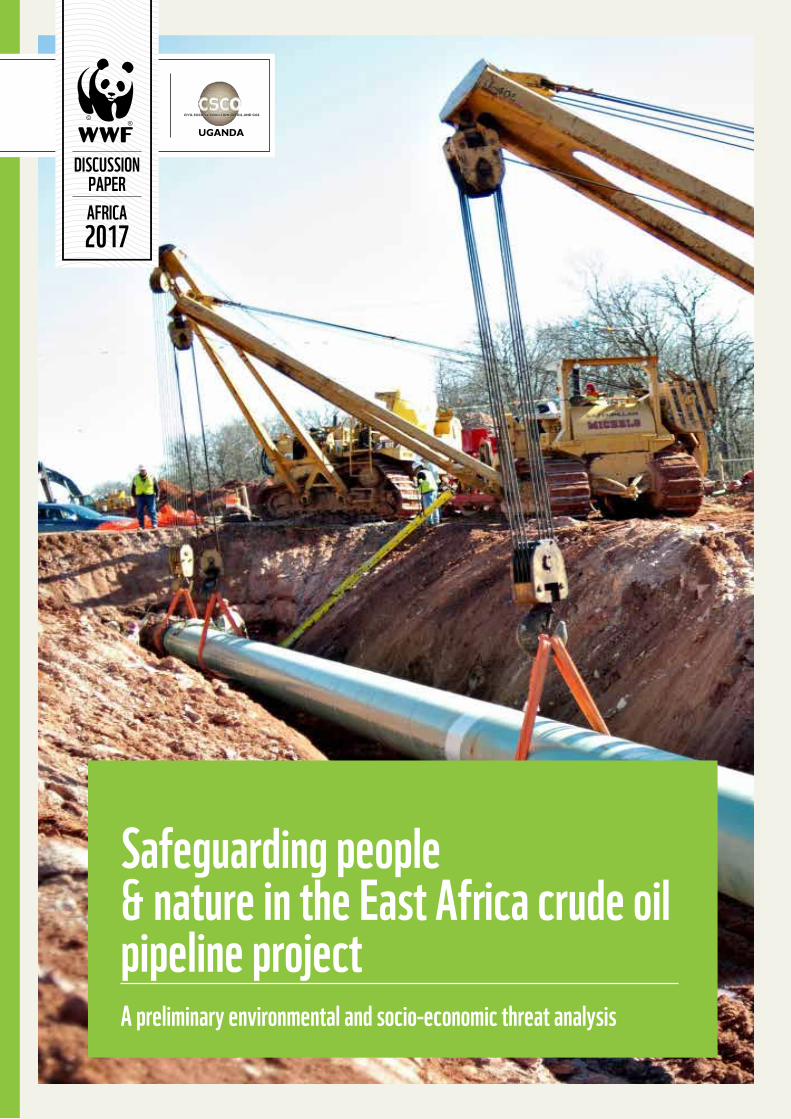
Safeguarding people& nature in the East Africa crude oil pipeline project A preliminary environmental and socio-economic threat analysis
iii
ACRONYMS VACKNOWLEDGEMENTS VIEXECUTIVE 1
SUMMARY 11.0 NTRODUCTION 42.0 JUSTIFICATION 63.0 OBJECTIVES 7
4.0 SCOPE 85.0 THE EAST AFRICA CRUDE OIL PIPELINE (EACOP) PROJECT 86.0 METHODOLOGY 11
6.1 Preliminary environmental and natural resources impact analysis 116.1.1 Assessing environmental threat severity 116.1.2 Definingthedataset 12
6.2 Preliminary socio-economic impact analysis 136.3 Limitations of the methodology 13
7.0 RESULTS & DISCUSSION 147.1 Overview 147.2 Impacts on the environment and natural resources 14
7.2.1 Potentialimpactsonimportantbiodiversity andnaturalhabitats 147.2.2 Wildlifehabitatsandcorridors 167.2.3 Waterresources 187.2.4 Marinecoastalecosystem 20
7.3 Socio Economic implications 247.3.1 Employmentandbusinessopportunities 247.3.2 Taxrevenue 257.3.3 Inequalities 267.3.4 Inflation 267.3.5 Stress,crimeanddisruptionof communitycohesion 267.3.6 Increasedchangesinland-usepatterns anderosionofculturalheritage 277.3.7 Highriskofcontaminationofwater,land andotherbasiclivelihoodnecessities 277.3.8 Humanrightsviolations,communityhealth andsafetyaswellasoccupationhazards 287.3.9 Reducedstatecapacitychallengesand riskofarmedconflict 29
8.0 KEY RECOMMENDATIONS 319.0 CONCLUSION 37BIBLIOGRAPHY 38
CONTENTS
Published in July, 2017
By WWF and Civil Society Coalition on Oil and Gas in Uganda (CSCO)
WWF’s missionistostopthedegradationoftheplanet’snaturalenvironmentandtobuildafutureinwhichhumansliveinharmonywithnature,byconservingtheworld’sbiologicaldiversity,ensuringthattheuseofrenewablenaturalresourcesissustainable,andpromotingthereductionofpollutionandwastefulconsumption.
CSCO’s missionistopromotemaximalbenefitstothepeopleofUgandafromoilandgasdiscoveriesbypromotingsocio-economicandenvironmentalsustainabilityintheexplorationandexploitationactivities.
Citation: WWFandCSCO,2017.SafeguardingPeople&NatureintheEastAfricanCrudeOil(EACOP)PipelineProject,Apreliminaryenvironmentalandsocio-economicthreatanalysis,WWFandCSCOResearchPaperNo.3,2017,Kampala,Uganda.
AUTHORS
Any reproduction in full or in part must mention the title and Credit the above-mentioned publisher as the copyright owner.
© 2017 WWF and CSCO. All rights reserved
Robert Ddamulira - Africa Energy Coordinator, WWF Uganda
Roy Namgera - Energy and Extractives Programme Officer, WWF Tanzania
Ivan Amaniga Ruhanga - Extractives Manager, WWF Uganda
Paolo Tibaldeschi - Senior Advisor, Environment and Development, WWF-Norway
Rogers Muyambi - Africa Energy Officer, WWF Africa Energy Hub (Uganda)
Onesmus Mugyenyi, ACODE
Gerald Byarugaba, Oxfam
Paul Twebaze, PROBICOU
Henry Bazira, Water Governance Institute
Julius Ssenyonjo, PEMO
Sam Mucunguzi, Citizen Concern Africa
Florence Kyalimpa, ACODE
Shutterstock
viv
LIST OF TABLES
Table 1: Threat summary table 23
LIST OF BOXESBox 1: The African elephant (Loxodonta Africana) 18Box 2: The lake Victoria 20Box 3: Mangroves in Tanzania 22Box 4: Case Study 1: socio-economic impacts of the chad-cameroon oil pipeline 30
LIST OF FIGURESFigure 1: Right of Way (ROW) Proposed route of the East Africa Crude Oil Pipeline (EACOP) 8Figure 2: Right of Way for the proposed EACOP 9Figure 3: Detailed cross-section of the proposed East Africa Crude Oil Pipeline (EACOP) 9Figure 4: Typical approach to trenching activities 10Figure 5: East Africa Crude Oil Pipeline (EACOP) and protected areas, UNESCO world heritage sites and key biodiversity areas (KBAs) 15Figure 6: Illustration of the direct impacts of the EACOP on wildlife and habitats 16Figure 7: East Africa Crude Oil Pipeline (EACOP) over Elephant habitats, IUCN Red List of Threatened Species and wildlife corridors 17Figure 8: East Africa Crude Oil Pipeline (EACOP) over Lakes and rivers, Lake Victoria basin boundary and Wetlands 19Figure 9: EACOP and potential impacts on marine coastal ecosystem 21Figure 10: Animal overpass in Singapore built to protect animals from traffic 34
ACRONYMSCIFOR Centre for International Forestry Research CSCO Civil Society Coalition on Oil and Gas In UgandaEACOP East Africa Crude Oil Pipeline EBSAs Ecologically or Biologically Significant Marine Areas EIA Environmental Impact AssessmentGLWD Global Lakes and Wetlands Database GoU Government of Uganda ILO International Labour Organisation ISME International Society for Mangrove Ecosystems. ITTO International Tropical Timber OrganizationIUCN International Union for the Conservation of NatureKBAs Key Biodiversity Areas MEMD Ministry of Energy and Mineral Development NASA National Aeronautics and Space AdministrationPTA Preliminary Threat AnalysisRAN Rainforest Action Network RCMRD Regional Centre For Mapping Of Resources For Development SDGs Sustainable Development Goals SERVIR Sistema Regional de Visualización y Monitoreo de Mesoamérica SPILL Strategic Plan for the Implementation of the Land Acts TNC The Nature Conservancy TNC The Nature ConservancyUDHR Universal Declaration of Human Rights UGPBHR UN Guiding Principles on Business and Human Rights. UNEP United Nations Environment Programme UNESCO United Nations Educational, Scientific and Cultural Organization USAID United States Agency for International DevelopmentVGGT Voluntary Guidelines on the Responsible Governance of Tenure WCMC World Conservation Monitoring Centre WHS World Heritage SiteWRI World Resources Institute WWF World Wide Fund for Nature
1vi
The pipeline construction is set to start in 2017 and end in 2020 and will cost approximately $3.6 billion capital expenditure and USD$ 91 million operational expenditure per annum (Directorate of Petroleum, 2017). This paper presents findings from a Preliminary Threat Analysis (PTA) of the proposed pipeline that was conducted by WWF in collaboration with partner CSOs in Uganda and Tanzania. The analysis entails a GIS overlap analysis of the proposed pipeline route over a series of environmental and socio-economic metrics and a qualitative appraisal of the threats based on literature review, observations and collective experiences of the authors. The analysis reveals a number of potential negative environmental impacts associated with the planned development that have to be carefully assessed before a final decision is taken on actual implementation of the project. Major impacts include, among others the following:
i) Nearly 2000km2 of protected wildlife habitat (Biharamulo Game Reserve and Wembere Steppe Key Biodiversity Area) will be affected by significant habitat disturbance,
fragmentation and increased risk of wildlife poaching due to the EACOP project.
ii) Approximately 500km2 of important wildlife corridors for the Eastern Chimpanzee and the African Elephant species are likely to be severely degraded. This will add to already existing severe pressure on these species from illegal wildlife trade and poaching for bush meat and ivory respectively.
iii) High risk of fresh water pollution and degradation especially in the over 400km stretch of the Lake Victoria basin through which the pipeline is planned to traverse. This lake basin currently supports the direct livelihoods of more than 30 million people in the region.
iv) Two important Ecologically or Biologically Significant Marine Areas (EBSAs) - Pemba-Shimoni-Kisite in the north and the Tanga Coelacanth in the South are at high risk in case of an oil spill. This is especially so given the huge amount of crude oil (more than 170,000 tons per loading) to be transferred offshore at the Tanga Port.
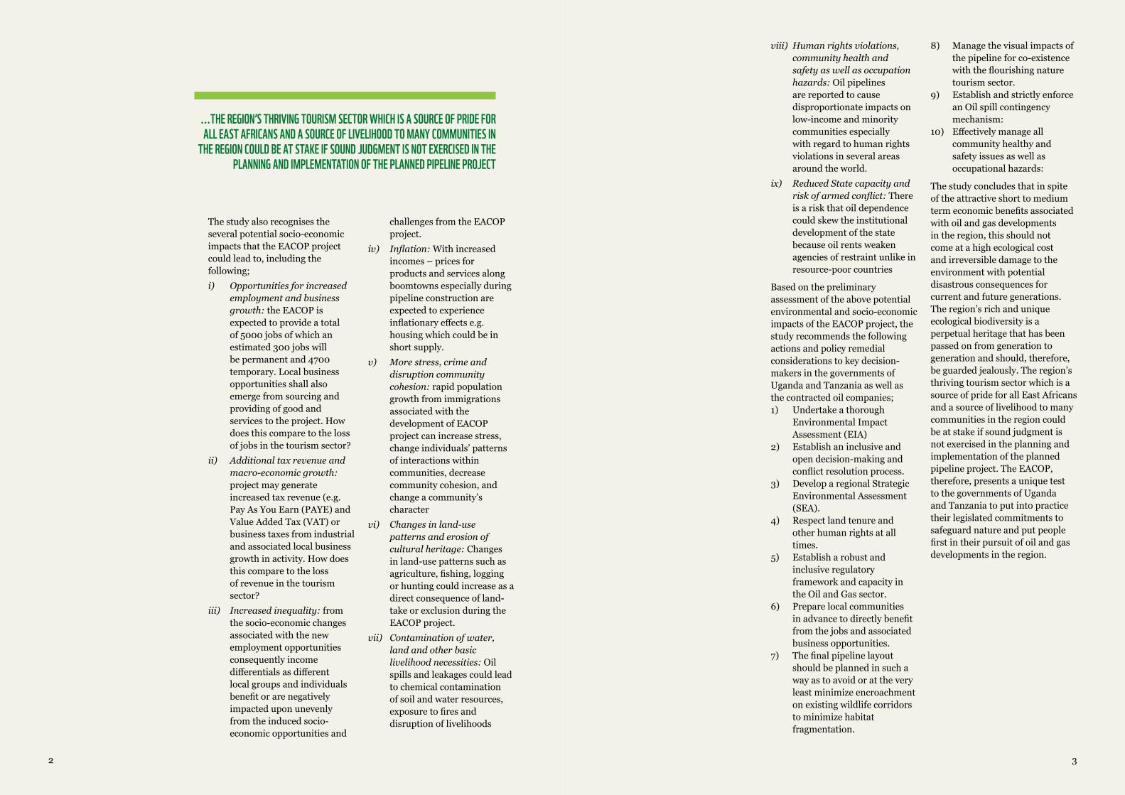
We are very grateful to all those who contributed in various ways to the initiation and development of this pre-
liminary threat analysis (PTA) of the East Africa Crude Oil Pipeline (EA-COP). The team is grateful to the members of the Civil Society Coalition of Oil and Gas in Uganda (CSCO), Bunyoro Albertine Petroleum Network on Environmental Conservation (BAPENECO) and the Northern Albertine Network on Environment and Petroleum (NANEP) for the time and com-mitment given to review the draft analysis report and its finalization.
The Eastern Africa region is rife with oil and gas resources and new discoveries continue to be documented and reported across the region. Several oil and gas development
infrastructure projects are being planned across the region with significant potential to transform the region’s landscape and biological diversity. Of major concern to conservation organizations operating in the region are the potential negative ecological impacts these oil and gas development are likely to have on the region’s landscapes, most of which are high value conservation areas with rich and unique biodiversity. One such proposed infrastructure development is the 1,445km long Hoima-Tanga pipeline that is being proposed to transport crude oil from the oil fields in Hoima, Western Uganda to the Coastal Town of Tanga in Tanzania.
ACKNOWLEDGEMENTS EXECUTIVESUMMARY
©GlobalW
armingim
ages/WWFC
anon
We also wish to acknowledge and appreciate the support we received in this process from Mrs. Anna Behm Masozera of the International Gorilla Conservation Programme (IGCP).
Acknowlegde source of funding for this work and CD UCO for overall support and guidance
32
The study also recognises the several potential socio-economic impacts that the EACOP project could lead to, including the following;
i) Opportunitiesforincreasedemploymentandbusinessgrowth: the EACOP is expected to provide a total of 5000 jobs of which an estimated 300 jobs will be permanent and 4700 temporary. Local business opportunities shall also emerge from sourcing and providing of good and services to the project. How does this compare to the loss of jobs in the tourism sector?
ii) Additionaltaxrevenueandmacro-economicgrowth:project may generate increased tax revenue (e.g. Pay As You Earn (PAYE) and Value Added Tax (VAT) or business taxes from industrial and associated local business growth in activity. How does this compare to the loss of revenue in the tourism sector?
iii) Increasedinequality: from the socio-economic changes associated with the new employment opportunities consequently income differentials as different local groups and individuals benefit or are negatively impacted upon unevenly from the induced socio-economic opportunities and
challenges from the EACOP project.
iv) Inflation: With increased incomes – prices for products and services along boomtowns especially during pipeline construction are expected to experience inflationary effects e.g. housing which could be in short supply.
v) Morestress,crimeanddisruptioncommunitycohesion:rapid population growth from immigrations associated with the development of EACOP project can increase stress, change individuals’ patterns of interactions within communities, decrease community cohesion, and change a community’s character
vi) Changesinland-usepatternsanderosionofculturalheritage:Changes in land-use patterns such as agriculture, fishing, logging or hunting could increase as a direct consequence of land-take or exclusion during the EACOP project.
vii) Contaminationofwater,landandotherbasiclivelihoodnecessities:Oil spills and leakages could lead to chemical contamination of soil and water resources, exposure to fires and disruption of livelihoods
...THE REGION’S THRIVING TOURISM SECTOR WHICH IS A SOURCE OF PRIDE FOR ALL EAST AFRICANS AND A SOURCE OF LIVELIHOOD TO MANY COMMUNITIES IN
THE REGION COULD BE AT STAKE IF SOUND JUDGMENT IS NOT EXERCISED IN THE PLANNING AND IMPLEMENTATION OF THE PLANNED PIPELINE PROJECT
viii) Humanrightsviolations,communityhealthandsafetyaswellasoccupationhazards:Oil pipelines are reported to cause disproportionate impacts on low-income and minority communities especially with regard to human rights violations in several areas around the world.
ix) ReducedStatecapacityandriskofarmedconflict:There is a risk that oil dependence could skew the institutional development of the state because oil rents weaken agencies of restraint unlike in resource-poor countries
Based on the preliminary assessment of the above potential environmental and socio-economic impacts of the EACOP project, the study recommends the following actions and policy remedial considerations to key decision-makers in the governments of Uganda and Tanzania as well as the contracted oil companies;1) Undertake a thorough
Environmental Impact Assessment (EIA)
2) Establish an inclusive and open decision-making and conflict resolution process.
3) Develop a regional Strategic Environmental Assessment (SEA).
4) Respect land tenure and other human rights at all times.
5) Establish a robust and inclusive regulatory framework and capacity in the Oil and Gas sector.
6) Prepare local communities in advance to directly benefit from the jobs and associated business opportunities.
7) The final pipeline layout should be planned in such a way as to avoid or at the very least minimize encroachment on existing wildlife corridors to minimize habitat fragmentation.
8) Manage the visual impacts of the pipeline for co-existence with the flourishing nature tourism sector.
9) Establish and strictly enforce an Oil spill contingency mechanism:
10) Effectively manage all community healthy and safety issues as well as occupational hazards:
The study concludes that in spite of the attractive short to medium term economic benefits associated with oil and gas developments in the region, this should not come at a high ecological cost and irreversible damage to the environment with potential disastrous consequences for current and future generations. The region’s rich and unique ecological biodiversity is a perpetual heritage that has been passed on from generation to generation and should, therefore, be guarded jealously. The region’s thriving tourism sector which is a source of pride for all East Africans and a source of livelihood to many communities in the region could be at stake if sound judgment is not exercised in the planning and implementation of the planned pipeline project. The EACOP, therefore, presents a unique test to the governments of Uganda and Tanzania to put into practice their legislated commitments to safeguard nature and put people first in their pursuit of oil and gas developments in the region.
54
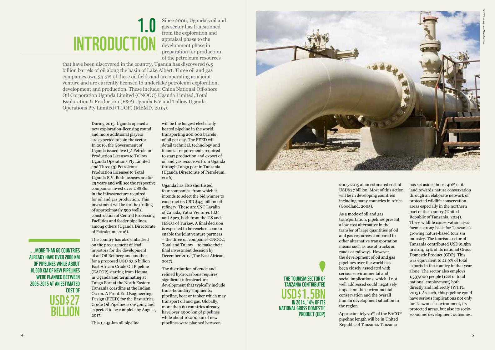
During 2015, Uganda opened a new exploration-licensing round and more additional players are expected to join the sector. In 2016, the Government of Uganda issued five (5) Petroleum Production Licenses to Tullow Uganda Operations Pty Limited and Three (3) Petroleum Production Licenses to Total Uganda B.V. Both licenses are for 25 years and will see the respective companies invest over US$8bn in the infrastructure required for oil and gas production. This investment will be for the drilling of approximately 500 wells, construction of Central Processing Facilities and feeder pipelines, among others (Uganda Directorate of Petroleum, 2016).
The country has also embarked on the procurement of lead investors for the development of an Oil Refinery and another for a proposed USD $3.6 billion East African Crude Oil Pipeline (EACOP) starting from Hoima in Uganda and terminating at Tanga Port at the North Eastern Tanzania coastline at the Indian Ocean. A Front End Engineering Design (FEED) for the East Africa Crude Oil Pipeline is on-going and expected to be complete by August, 2017.
This 1,445-km oil pipeline
will be the longest electrically heated pipeline in the world, transporting 200,000 barrels of oil per day. The FEED will detail technical, technology and financial requirements required to start production and export of oil and gas resources from Uganda through Tanga port in Tanzania (Uganda Directorate of Petroleum, 2016).
Uganda has also shortlisted four companies, from which it intends to select the bid winner to construct its USD $4.3 billion oil refinery. These are SNC Lavalin of Canada, Yatra Ventures LLC and Apro, both from the US and IESCO of Turkey. A final decision is expected to be reached soon to enable the joint venture partners – the three oil companies CNOOC, Total and Tullow – to make their final investment decision by December 2017 (The East African, 2017).
The distribution of crude and refined hydrocarbons requires significant infrastructure development that typically include trans-boundary shipments; pipeline, boat or tanker which may transport oil and gas. Globally, more than 60 countries already have over 2000 km of pipelines while about 10,000 km of new pipelines were planned between
...MORE THAN 60 COUNTRIES ALREADY HAVE OVER 2000 KM
OF PIPELINES WHILE ABOUT 10,000 KM OF NEW PIPELINES
WERE PLANNED BETWEEN 2005-2015 AT AN ESTIMATED
COST OF
USD$27 BILLION
Since 2006, Uganda’s oil and gas sector has transitioned from the exploration and appraisal phase to the development phase in preparation for production of the petroleum resources
that have been discovered in the country. Uganda has discovered 6.5 billion barrels of oil along the basin of Lake Albert. Three oil and gas companies own 33.3% of these oil fields and are operating as a joint venture and are currently licensed to undertake petroleum exploration, development and production. These include; China National Off-shore Oil Corporation Uganda Limited (CNOOC) Uganda Limited, Total Exploration & Production (E&P) Uganda B.V and Tullow Uganda Operations Pty Limited (TUOP) (MEMD, 2015).
1.0INTRODUCTION
2005-2015 at an estimated cost of USD$27 billion. Most of this action will be in developing countries including many countries in Africa (Goodland, 2005).
As a mode of oil and gas transportation, pipelines present a low cost alternative in the transfer of large quantities of oil and gas resources compared to other alternative transportation means such as use of trucks on roads or railways. However, the development of oil and gas pipelines over the world has been closely associated with serious environmental and social implications, which if not well addressed could negatively impact on the environmental conservation and the overall human development situation in the region.
Approximately 70% of the EACOP pipeline length will be in United Republic of Tanzania. Tanzania
has set aside almost 40% of its land towards nature conservation through an elaborate network of protected wildlife conservation areas especially in the northern part of the country (United Republic of Tanzania, 2014). These wildlife conservation areas form a strong basis for Tanzania’s growing nature-based tourism industry. The tourism sector of Tanzania contributed USD$1.5bn in 2014, 14% of its national Gross Domestic Product (GDP). This was equivalent to 21.9% of total exports in the country in that year alone. The sector also employs 1,337,000 people (12% of total national employment) both directly and indirectly (WTTC, 2015). As such, this pipeline could have serious implications not only for Tanzania’s environment, its protected areas, but also its socio-economic development outcomes.
THE TOURISM SECTOR OF TANZANIA CONTRIBUTED
USD$1.5BN IN 2014, 14% OF ITS
NATIONAL GROSS DOMESTIC PRODUCT (GDP)
©UCUndergroundConstruction
6 7
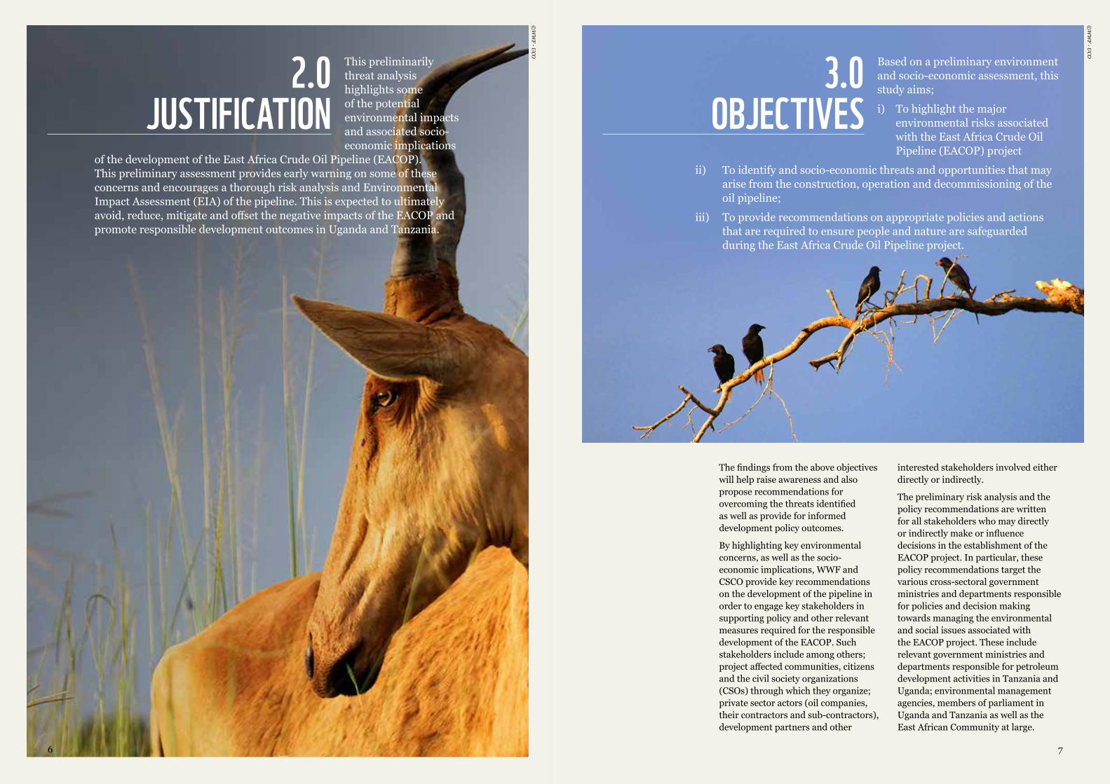
This preliminarily threat analysis highlights some of the potential environmental impacts and associated socio-economic implications
of the development of the East Africa Crude Oil Pipeline (EACOP). This preliminary assessment provides early warning on some of these concerns and encourages a thorough risk analysis and Environmental Impact Assessment (EIA) of the pipeline. This is expected to ultimately avoid, reduce, mitigate and offset the negative impacts of the EACOP and promote responsible development outcomes in Uganda and Tanzania.
2.0JUSTIFICATION
©WWF-U
CO
The findings from the above objectives will help raise awareness and also propose recommendations for overcoming the threats identified as well as provide for informed development policy outcomes.
By highlighting key environmental concerns, as well as the socio-economic implications, WWF and CSCO provide key recommendations on the development of the pipeline in order to engage key stakeholders in supporting policy and other relevant measures required for the responsible development of the EACOP. Such stakeholders include among others; project affected communities, citizens and the civil society organizations (CSOs) through which they organize; private sector actors (oil companies, their contractors and sub-contractors), development partners and other
interested stakeholders involved either directly or indirectly.
The preliminary risk analysis and the policy recommendations are written for all stakeholders who may directly or indirectly make or influence decisions in the establishment of the EACOP project. In particular, these policy recommendations target the various cross-sectoral government ministries and departments responsible for policies and decision making towards managing the environmental and social issues associated with the EACOP project. These include relevant government ministries and departments responsible for petroleum development activities in Tanzania and Uganda; environmental management agencies, members of parliament in Uganda and Tanzania as well as the East African Community at large.
Based on a preliminary environment and socio-economic assessment, this study aims;
i) To highlight the major environmental risks associated with the East Africa Crude Oil Pipeline (EACOP) project
ii) To identify and socio-economic threats and opportunities that may arise from the construction, operation and decommissioning of the oil pipeline;
iii) To provide recommendations on appropriate policies and actions that are required to ensure people and nature are safeguarded during the East Africa Crude Oil Pipeline project.
3.0OBJECTIVES
©WWF-U
CO
98
The thematic scope of this preliminary assessment is to investigate the various environmental and socio-economic issues associated with the EACOP project. The geographical scope on
the other hand covers the proposed project route from the Hoima District in Western Uganda through to Tanga port at the Indian Ocean in North Eastern Tanzania. The temporal (time) scope of the assessment covers the EACOP project period up to June 2017 – any developments or alterations of the EACOP project after June 2017 are excluded from this assessment and will be covered in subsequent assessment and studies.
4.0SCOPE
5.0THE EAST AFRICA
CRUDE OIL PIPELINE (EACOP) PROJECT
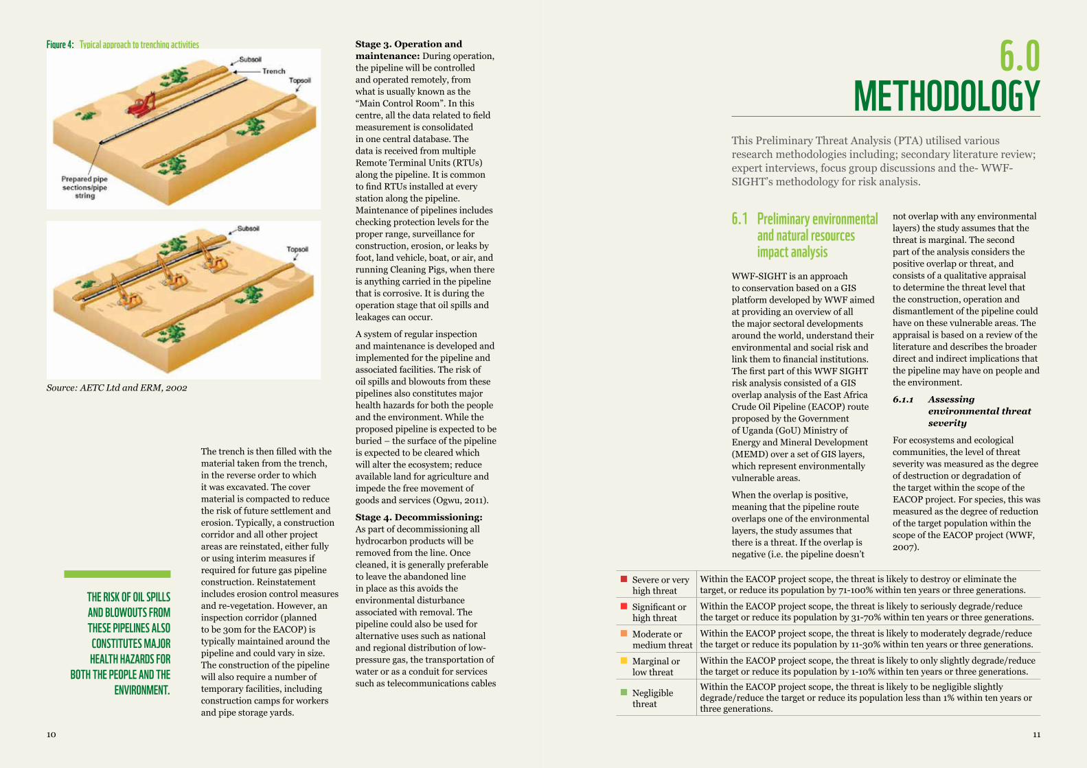
The selected mode of transfer of Uganda’s refined petroleum products is an oil and gas pipeline. This proposed Hoima-Tanga oil pipeline has been agreed between the Ugandan and Tanzanian governments to transport crude oil from Uganda for export via Tanga Port at the Indian Ocean in North Eastern Tanzania. Construction of the pipeline is projected to start in 2017 and end in 2020 (Earthfinds, 2016). The oil pipeline will start in Buseruka sub-county, Hoima District in Mid-western Uganda, passing through Masaka and Mutukula (in Uganda), Biraharamulo, Shinyanga and Tanga in Northern Tanzania. The pipeline is set for an approximate capital expenditure budget of USD$ 3.6 billion (Musisi, 2016) (See Figure 1 below).
Figure 1: Right of Way (ROW) Proposed route of the East Africa Crude Oil Pipeline (EACOP)
The proposed EACOP pipeline is expected to be 24-inch diameter and shall be located below ground. It will run for 1,445 km in length along a 30-100m path known as the pipeline Right of Way (ROW), see Figure 2 below;
Figure 2: Right of Way for the proposed EACOP
Undertake Studies(FEED, ESIA, RAP,Geotechnical and
Geotechnical Surveys...)
Engineering Procumentand Construction
Pre - Project
2016 2017 2018 - 2020
PipelineCorridor 2km
100mCorridor
30mCorridor
Final InvestmentDecision
Final OilDecember 2020
Source:DirectorateofPetroleum,2017
Several relatively shorter pipelines are expected to transport unrefined oil and gas from numerous production wellheads to the refinery as well as transfer and processing facilities in Uganda’s Albertine Graben.
It is important to note that an oil and gas pipeline is not confined to the pipe itself, it also includes ancillary facilities such as receiving dispatch, pump and control stations; access or maintenance roads, booster stations (required at regular intervals for long distances to cope with internal friction changes in elevation along the line) and compression stations which maintain pipeline pressure at regular intervals (Barclays, 2015). In fact, due to the waxy property of the crude oil, the pipeline will be heated over 50 degrees Celsius.
Figure 3: Detailed cross-section of the proposed East Africa Crude Oil Pipeline (EACOP)
+ Buoyancy control where required
HDPE Casing
High VoltagePower cable (22/33kv)
Aluminium race way fortrave heating (LLHT)
PU Foam
Fiber Optic Cable
FBE
24” pipeX65 API 5L
1.8m to 2mdeep trench
Source:DirectorateofPetroleum,2017
According to the Directorate of Petroleum (2017b), the EACOP is expected to comprise of the following ground installations;
i) Six (6) pumping stations with crude bulk heaters and power generation.ii) Two (2) pressure reduction stationsiii) Fifty three (53) block value stationsiv) Twenty three (23) heating stations.
Tanga Port is also expected to be improved with some specialized installations that shall comprise an onshore marine terminal. This terminal will include; a marine storage terminal at Chongoleani (Tanga bay); a jetty to berth a Suez Max Tanker in 23m water depth and a trestle between a marine terminal and the jetty.
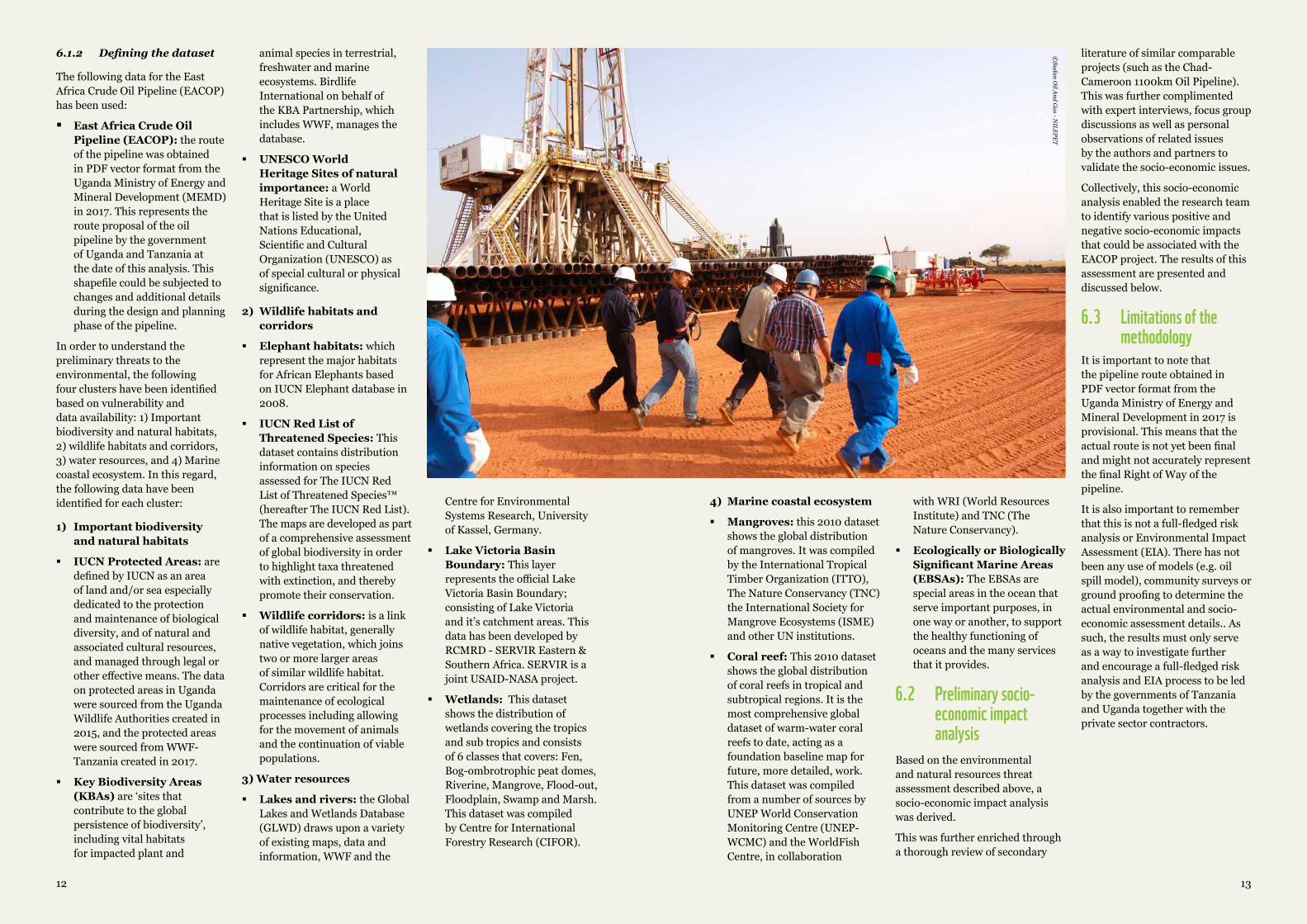
5.1 Pipeline development stages Generally, every oil and gas pipeline establishment normally goes through 4 development stages (AETC Ltd & ERM, 2002) described here below:
Stage 1. Procurement of a contractor (usually international) – An offer to bid is typically launched to recruit the contractor that can meet the technical and financial requirements for the construction of the pipeline. The process is usually competitive, transparent and involves stakeholder participation to ensure a proper choice is made.
Stage 2. Construction: The pipelines typically utilize vast tracts of land whose original ecosystem is often permanently altered through land-clearance and on-going regular pipeline maintenance operations. The contractor typically uses a normal spread of oil and gas pipeline installation and one or more special section crews for river crossings or other specialized pipe segment installations. Topsoil is stripped and stored to one side of the corridor. The pipeline trench is typically excavated, allowing the pipeline to be buried with a minimum depth of cover of 1m. Deeper burial may be required at river, road, rail and other crossings. Pipe sections are transported to the construction corridor by truck and laid end-to-end alongside the open trench. The pre-coated pipe sections are then welded together and a further protective coating applied to the welded joints.
1110
THE RISK OF OIL SPILLS AND BLOWOUTS FROM THESE PIPELINES ALSO
CONSTITUTES MAJOR HEALTH HAZARDS FOR
BOTH THE PEOPLE AND THE ENVIRONMENT.
Figure 4: Typical approach to trenching activities
Source:AETCLtdandERM,2002
The trench is then filled with the material taken from the trench, in the reverse order to which it was excavated. The cover material is compacted to reduce the risk of future settlement and erosion. Typically, a construction corridor and all other project areas are reinstated, either fully or using interim measures if required for future gas pipeline construction. Reinstatement includes erosion control measures and re-vegetation. However, an inspection corridor (planned to be 30m for the EACOP) is typically maintained around the pipeline and could vary in size. The construction of the pipeline will also require a number of temporary facilities, including construction camps for workers and pipe storage yards.
Stage 3. Operation and maintenance: During operation, the pipeline will be controlled and operated remotely, from what is usually known as the “Main Control Room”. In this centre, all the data related to field measurement is consolidated in one central database. The data is received from multiple Remote Terminal Units (RTUs) along the pipeline. It is common to find RTUs installed at every station along the pipeline. Maintenance of pipelines includes checking protection levels for the proper range, surveillance for construction, erosion, or leaks by foot, land vehicle, boat, or air, and running Cleaning Pigs, when there is anything carried in the pipeline that is corrosive. It is during the operation stage that oil spills and leakages can occur.
A system of regular inspection and maintenance is developed and implemented for the pipeline and associated facilities. The risk of oil spills and blowouts from these pipelines also constitutes major health hazards for both the people and the environment. While the proposed pipeline is expected to be buried – the surface of the pipeline is expected to be cleared which will alter the ecosystem; reduce available land for agriculture and impede the free movement of goods and services (Ogwu, 2011).
Stage 4. Decommissioning: As part of decommissioning all hydrocarbon products will be removed from the line. Once cleaned, it is generally preferable to leave the abandoned line in place as this avoids the environmental disturbance associated with removal. The pipeline could also be used for alternative uses such as national and regional distribution of low-pressure gas, the transportation of water or as a conduit for services such as telecommunications cables
6.1 Preliminary environmental and natural resources impact analysis
WWF-SIGHT is an approach to conservation based on a GIS platform developed by WWF aimed at providing an overview of all the major sectoral developments around the world, understand their environmental and social risk and link them to financial institutions. The first part of this WWF SIGHT risk analysis consisted of a GIS overlap analysis of the East Africa Crude Oil Pipeline (EACOP) route proposed by the Government of Uganda (GoU) Ministry of Energy and Mineral Development (MEMD) over a set of GIS layers, which represent environmentally vulnerable areas.
When the overlap is positive, meaning that the pipeline route overlaps one of the environmental layers, the study assumes that there is a threat. If the overlap is negative (i.e. the pipeline doesn’t
not overlap with any environmental layers) the study assumes that the threat is marginal. The second part of the analysis considers the positive overlap or threat, and consists of a qualitative appraisal to determine the threat level that the construction, operation and dismantlement of the pipeline could have on these vulnerable areas. The appraisal is based on a review of the literature and describes the broader direct and indirect implications that the pipeline may have on people and the environment.
6.1.1 Assessing environmental threat severity
For ecosystems and ecological communities, the level of threat severity was measured as the degree of destruction or degradation of the target within the scope of the EACOP project. For species, this was measured as the degree of reduction of the target population within the scope of the EACOP project (WWF, 2007).
Severe or very high threat
Within the EACOP project scope, the threat is likely to destroy or eliminate the target, or reduce its population by 71-100% within ten years or three generations.
Significant or high threat
Within the EACOP project scope, the threat is likely to seriously degrade/reduce the target or reduce its population by 31-70% within ten years or three generations.
Moderate or medium threat
Within the EACOP project scope, the threat is likely to moderately degrade/reduce the target or reduce its population by 11-30% within ten years or three generations.
Marginal or low threat
Within the EACOP project scope, the threat is likely to only slightly degrade/reduce the target or reduce its population by 1-10% within ten years or three generations.
Negligible threat
Within the EACOP project scope, the threat is likely to be negligible slightly degrade/reduce the target or reduce its population less than 1% within ten years or three generations.
This Preliminary Threat Analysis (PTA) utilised various research methodologies including; secondary literature review; expert interviews, focus group discussions and the- WWF-SIGHT’s methodology for risk analysis.
6.0METHODOLOGY
1312
6.1.2 Definingthedataset
The following data for the East Africa Crude Oil Pipeline (EACOP) has been used:
East Africa Crude Oil Pipeline (EACOP): the route of the pipeline was obtained in PDF vector format from the Uganda Ministry of Energy and Mineral Development (MEMD) in 2017. This represents the route proposal of the oil pipeline by the government of Uganda and Tanzania at the date of this analysis. This shapefile could be subjected to changes and additional details during the design and planning phase of the pipeline.
In order to understand the preliminary threats to the environmental, the following four clusters have been identified based on vulnerability and data availability: 1) Important biodiversity and natural habitats, 2) wildlife habitats and corridors, 3) water resources, and 4) Marine coastal ecosystem. In this regard, the following data have been identified for each cluster:
1) Important biodiversity and natural habitats
IUCN Protected Areas: are defined by IUCN as an area of land and/or sea especially dedicated to the protection and maintenance of biological diversity, and of natural and associated cultural resources, and managed through legal or other effective means. The data on protected areas in Uganda were sourced from the Uganda Wildlife Authorities created in 2015, and the protected areas were sourced from WWF-Tanzania created in 2017.
Key Biodiversity Areas (KBAs) are ‘sites that contribute to the global persistence of biodiversity’, including vital habitats for impacted plant and
animal species in terrestrial, freshwater and marine ecosystems. Birdlife International on behalf of the KBA Partnership, which includes WWF, manages the database.
UNESCO World Heritage Sites of natural importance: a World Heritage Site is a place that is listed by the United Nations Educational, Scientific and Cultural Organization (UNESCO) as of special cultural or physical significance.
2) Wildlife habitats and corridors
Elephant habitats: which represent the major habitats for African Elephants based on IUCN Elephant database in 2008.
IUCN Red List of Threatened Species: This dataset contains distribution information on species assessed for The IUCN Red List of Threatened Species™ (hereafter The IUCN Red List). The maps are developed as part of a comprehensive assessment of global biodiversity in order to highlight taxa threatened with extinction, and thereby promote their conservation.
Wildlife corridors: is a link of wildlife habitat, generally native vegetation, which joins two or more larger areas of similar wildlife habitat. Corridors are critical for the maintenance of ecological processes including allowing for the movement of animals and the continuation of viable populations.
3) Water resources
Lakes and rivers: the Global Lakes and Wetlands Database (GLWD) draws upon a variety of existing maps, data and information, WWF and the
©SudanO
ilAndG
as-NILE
PET
Centre for Environmental Systems Research, University of Kassel, Germany.
Lake Victoria Basin Boundary: This layer represents the official Lake Victoria Basin Boundary; consisting of Lake Victoria and it’s catchment areas. This data has been developed by RCMRD - SERVIR Eastern & Southern Africa. SERVIR is a joint USAID-NASA project.
Wetlands: This dataset shows the distribution of wetlands covering the tropics and sub tropics and consists of 6 classes that covers: Fen, Bog-ombrotrophic peat domes, Riverine, Mangrove, Flood-out, Floodplain, Swamp and Marsh. This dataset was compiled by Centre for International Forestry Research (CIFOR).
4) Marine coastal ecosystem
Mangroves: this 2010 dataset shows the global distribution of mangroves. It was compiled by the International Tropical Timber Organization (ITTO), The Nature Conservancy (TNC) the International Society for Mangrove Ecosystems (ISME) and other UN institutions.
Coral reef: This 2010 dataset shows the global distribution of coral reefs in tropical and subtropical regions. It is the most comprehensive global dataset of warm-water coral reefs to date, acting as a foundation baseline map for future, more detailed, work. This dataset was compiled from a number of sources by UNEP World Conservation Monitoring Centre (UNEP-WCMC) and the WorldFish Centre, in collaboration
with WRI (World Resources Institute) and TNC (The Nature Conservancy).
Ecologically or Biologically Significant Marine Areas (EBSAs): The EBSAs are special areas in the ocean that serve important purposes, in one way or another, to support the healthy functioning of oceans and the many services that it provides.
6.2 Preliminary socio-economic impact analysis
Based on the environmental and natural resources threat assessment described above, a socio-economic impact analysis was derived.
This was further enriched through a thorough review of secondary
literature of similar comparable projects (such as the Chad-Cameroon 1100km Oil Pipeline). This was further complimented with expert interviews, focus group discussions as well as personal observations of related issues by the authors and partners to validate the socio-economic issues.
Collectively, this socio-economic analysis enabled the research team to identify various positive and negative socio-economic impacts that could be associated with the EACOP project. The results of this assessment are presented and discussed below.
6.3 Limitations of the methodology
It is important to note that the pipeline route obtained in PDF vector format from the Uganda Ministry of Energy and Mineral Development in 2017 is provisional. This means that the actual route is not yet been final and might not accurately represent the final Right of Way of the pipeline.
It is also important to remember that this is not a full-fledged risk analysis or Environmental Impact Assessment (EIA). There has not been any use of models (e.g. oil spill model), community surveys or ground proofing to determine the actual environmental and socio-economic assessment details.. As such, the results must only serve as a way to investigate further and encourage a full-fledged risk analysis and EIA process to be led by the governments of Tanzania and Uganda together with the private sector contractors.
1514
7.2 Impacts on the environment and natural resources
7.2.1 Potential impacts on important biodiversityandnatural habitats
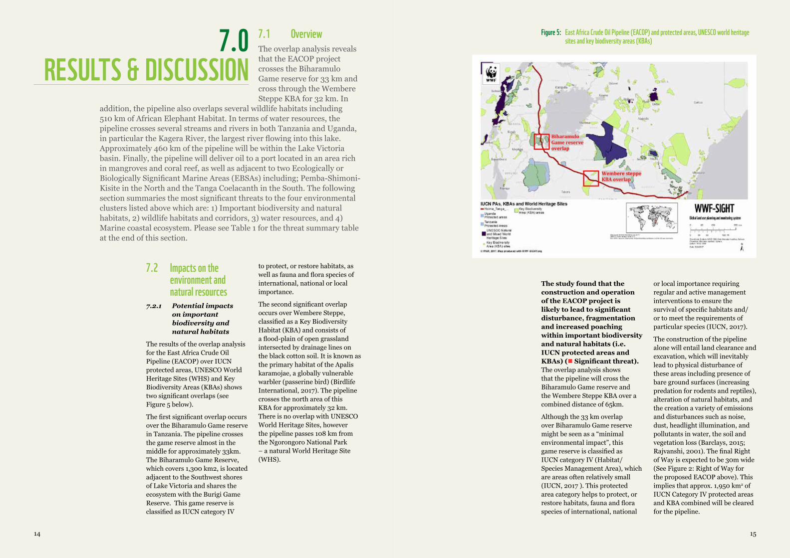
The results of the overlap analysis for the East Africa Crude Oil Pipeline (EACOP) over IUCN protected areas, UNESCO World Heritage Sites (WHS) and Key Biodiversity Areas (KBAs) shows two significant overlaps (see Figure 5 below).
The first significant overlap occurs over the Biharamulo Game reserve in Tanzania. The pipeline crosses the game reserve almost in the middle for approximately 33km. The Biharamulo Game Reserve, which covers 1,300 km2, is located adjacent to the Southwest shores of Lake Victoria and shares the ecosystem with the Burigi Game Reserve. This game reserve is classified as IUCN category IV
to protect, or restore habitats, as well as fauna and flora species of international, national or local importance.
The second significant overlap occurs over Wembere Steppe, classified as a Key Biodiversity Habitat (KBA) and consists of a flood-plain of open grassland intersected by drainage lines on the black cotton soil. It is known as the primary habitat of the Apalis karamojae, a globally vulnerable warbler (passerine bird) (Birdlife International, 2017). The pipeline crosses the north area of this KBA for approximately 32 km. There is no overlap with UNESCO World Heritage Sites, however the pipeline passes 108 km from the Ngorongoro National Park – a natural World Heritage Site (WHS).
Figure 5: East Africa Crude Oil Pipeline (EACOP) and protected areas, UNESCO world heritage sites and key biodiversity areas (KBAs)
The study found that the construction and operation of the EACOP project is likely to lead to significant disturbance, fragmentation and increased poaching within important biodiversity and natural habitats (i.e. IUCN protected areas and KBAs) ( Significant threat). The overlap analysis shows that the pipeline will cross the Biharamulo Game reserve and the Wembere Steppe KBA over a combined distance of 65km.
Although the 33 km overlap over Biharamulo Game reserve might be seen as a “minimal environmental impact”, this game reserve is classified as IUCN category IV (Habitat/Species Management Area), which are areas often relatively small (IUCN, 2017 ). This protected area category helps to protect, or restore habitats, fauna and flora species of international, national
or local importance requiring regular and active management interventions to ensure the survival of specific habitats and/or to meet the requirements of particular species (IUCN, 2017).
The construction of the pipeline alone will entail land clearance and excavation, which will inevitably lead to physical disturbance of these areas including presence of bare ground surfaces (increasing predation for rodents and reptiles), alteration of natural habitats, and the creation a variety of emissions and disturbances such as noise, dust, headlight illumination, and pollutants in water, the soil and vegetation loss (Barclays, 2015; Rajvanshi, 2001). The final Right of Way is expected to be 30m wide (See Figure 2: Right of Way for the proposed EACOP above). This implies that approx. 1,950 km2 of IUCN Category IV protected areas and KBA combined will be cleared for the pipeline.
7.0RESULTS & DISCUSSION
7.1 Overview The overlap analysis reveals that the EACOP project crosses the Biharamulo Game reserve for 33 km and cross through the Wembere Steppe KBA for 32 km. In
addition, the pipeline also overlaps several wildlife habitats including 510 km of African Elephant Habitat. In terms of water resources, the pipeline crosses several streams and rivers in both Tanzania and Uganda, in particular the Kagera River, the largest river flowing into this lake. Approximately 460 km of the pipeline will be within the Lake Victoria basin. Finally, the pipeline will deliver oil to a port located in an area rich in mangroves and coral reef, as well as adjacent to two Ecologically or Biologically Significant Marine Areas (EBSAs) including; Pemba-Shimoni-Kisite in the North and the Tanga Coelacanth in the South. The following section summaries the most significant threats to the four environmental clusters listed above which are: 1) Important biodiversity and natural habitats, 2) wildlife habitats and corridors, 3) water resources, and 4) Marine coastal ecosystem. Please see Table 1 for the threat summary table at the end of this section.
1716
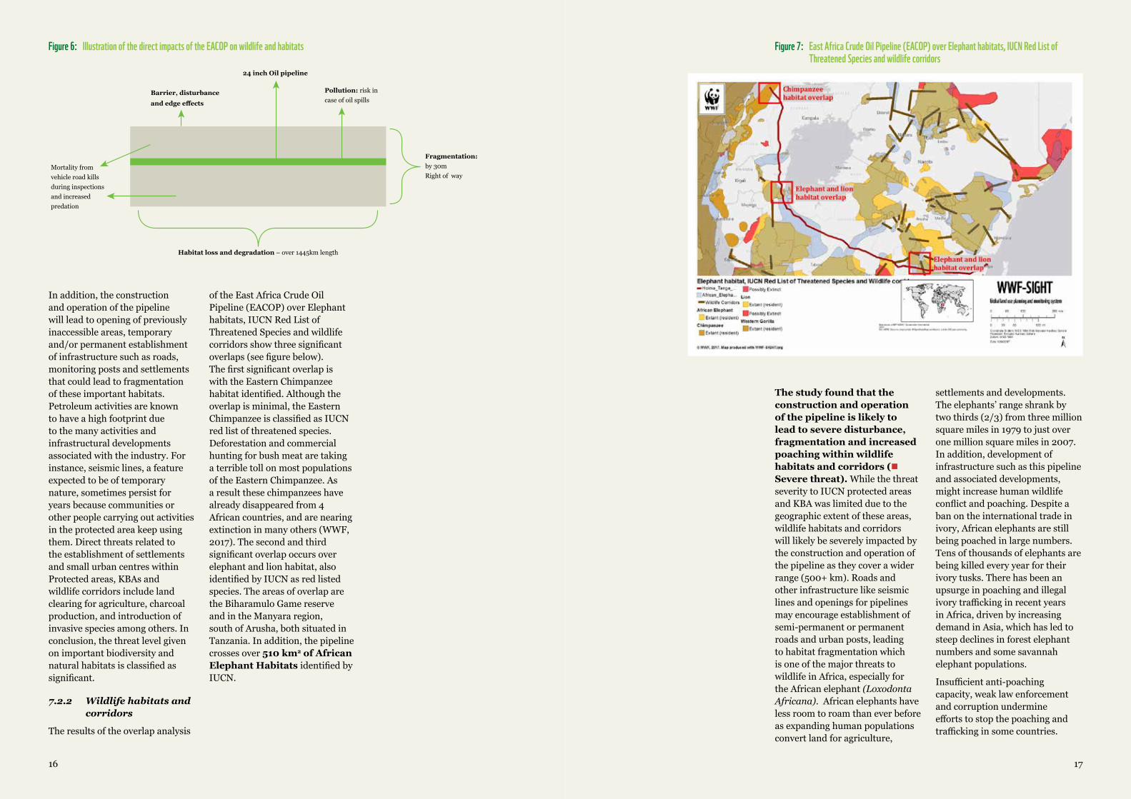
Figure 6: Illustration of the direct impacts of the EACOP on wildlife and habitats
In addition, the construction and operation of the pipeline will lead to opening of previously inaccessible areas, temporary and/or permanent establishment of infrastructure such as roads, monitoring posts and settlements that could lead to fragmentation of these important habitats. Petroleum activities are known to have a high footprint due to the many activities and infrastructural developments associated with the industry. For instance, seismic lines, a feature expected to be of temporary nature, sometimes persist for years because communities or other people carrying out activities in the protected area keep using them. Direct threats related to the establishment of settlements and small urban centres within Protected areas, KBAs and wildlife corridors include land clearing for agriculture, charcoal production, and introduction of invasive species among others. In conclusion, the threat level given on important biodiversity and natural habitats is classified as significant.
7.2.2 Wildlifehabitatsandcorridors
The results of the overlap analysis
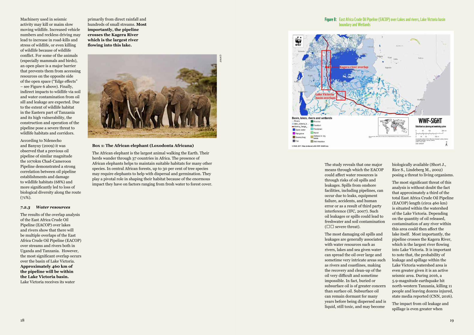
of the East Africa Crude Oil Pipeline (EACOP) over Elephant habitats, IUCN Red List of Threatened Species and wildlife corridors show three significant overlaps (see figure below). The first significant overlap is with the Eastern Chimpanzee habitat identified. Although the overlap is minimal, the Eastern Chimpanzee is classified as IUCN red list of threatened species. Deforestation and commercial hunting for bush meat are taking a terrible toll on most populations of the Eastern Chimpanzee. As a result these chimpanzees have already disappeared from 4 African countries, and are nearing extinction in many others (WWF, 2017). The second and third significant overlap occurs over elephant and lion habitat, also identified by IUCN as red listed species. The areas of overlap are the Biharamulo Game reserve and in the Manyara region, south of Arusha, both situated in Tanzania. In addition, the pipeline crosses over 510 km2 of African Elephant Habitats identified by IUCN.
Habitat loss and degradation – over 1445km length
Fragmentation:by 30mRight of way
Pollution: risk incase of oil spills
Barrier, disturbance
and edge effects
Mortality fromvehicle road killsduring inspectionsand increasedpredation
24 inch Oil pipeline
Figure 7: East Africa Crude Oil Pipeline (EACOP) over Elephant habitats, IUCN Red List of Threatened Species and wildlife corridors
The study found that the construction and operation of the pipeline is likely to lead to severe disturbance, fragmentation and increased poaching within wildlife habitats and corridors ( Severe threat). While the threat severity to IUCN protected areas and KBA was limited due to the geographic extent of these areas, wildlife habitats and corridors will likely be severely impacted by the construction and operation of the pipeline as they cover a wider range (500+ km). Roads and other infrastructure like seismic lines and openings for pipelines may encourage establishment of semi-permanent or permanent roads and urban posts, leading to habitat fragmentation which is one of the major threats to wildlife in Africa, especially for the African elephant (LoxodontaAfricana). African elephants have less room to roam than ever before as expanding human populations convert land for agriculture,
settlements and developments. The elephants’ range shrank by two thirds (2/3) from three million square miles in 1979 to just over one million square miles in 2007. In addition, development of infrastructure such as this pipeline and associated developments, might increase human wildlife conflict and poaching. Despite a ban on the international trade in ivory, African elephants are still being poached in large numbers. Tens of thousands of elephants are being killed every year for their ivory tusks. There has been an upsurge in poaching and illegal ivory trafficking in recent years in Africa, driven by increasing demand in Asia, which has led to steep declines in forest elephant numbers and some savannah elephant populations.
Insufficient anti-poaching capacity, weak law enforcement and corruption undermine efforts to stop the poaching and trafficking in some countries.
1918
Machinery used in seismic activity may kill or maim slow moving wildlife. Increased vehicle numbers and reckless driving may lead to increase in road-kills and stress of wildlife, or even killing of wildlife because of wildlife conflict. For some of the animals (especially mammals and birds), an open place is a major barrier that prevents them from accessing resources on the opposite side of the open space (“Edge effects” – see Figure 6 above). Finally, indirect impacts to wildlife via soil and water contamination from oil sill and leakage are expected. Due to the extent of wildlife habitat in the Eastern part of Tanzania and its high vulnerability, the construction and operation of the pipeline pose a severe threat to wildlife habitats and corridors.
According to Ndenecho and Banyuy (2009) it was observed that a previous oil pipeline of similar magnitude the 1070km Chad-Cameroon Pipeline demonstrated a strong correlation between oil pipeline establishments and damage to wildlife habitats (68%) and more significantly led to loss of biological diversity along the route (71%).
7.2.3 Water resources
The results of the overlap analysis of the East Africa Crude Oil Pipeline (EACOP) over lakes and rivers show that there will be multiple overlaps of the East Africa Crude Oil Pipeline (EACOP) over streams and rivers both in Uganda and Tanzania. However, the most significant overlap occurs over the basin of Lake Victoria. Approximately 460 km of the pipeline will be within the Lake Victoria basin. Lake Victoria receives its water
primarily from direct rainfall and hundreds of small streams. Most importantly, the pipeline crosses the Kagera River which is the largest river flowing into this lake.
©W
WF
Box 1: The African elephant (Loxodonta Africana)
The African elephant is the largest animal walking the Earth. Their herds wander through 37 countries in Africa. The presence of African elephants helps to maintain suitable habitats for many other species. In central African forests, up to 30 per cent of tree species may require elephants to help with dispersal and germination. They play a pivotal role in shaping their habitat because of the enormous impact they have on factors ranging from fresh water to forest cover.
Figure 8: East Africa Crude Oil Pipeline (EACOP) over Lakes and rivers, Lake Victoria basin boundary and Wetlands
The study reveals that one major means through which the EACOP could affect water resources is through risks of oil spills and leakages. Spills from onshore facilities, including pipelines, can occur due to leaks, equipment failure, accidents, and human error or as a result of third party interference (IFC, 2007). Such oil leakages or spills could lead to freshwater and soil contamination ( severe threat).
The most damaging oil spills and leakages are generally associated with water resources such as rivers, lakes and sea given water can spread the oil over large and sometime very intricate areas such as rivers and coastlines, making the recovery and clean-up of the oil very difficult and sometime impossible. In fact, buried or subsurface oil is of greater concern than surface oil. Subsurface oil can remain dormant for many years before being dispersed and is liquid, still toxic, and may become
biologically available (Short J., Rice S., Lindeberg M., 2002) posing a threat to living organisms.
The most significant threat of this analysis is without doubt the fact that approximately a third of the total East Africa Crude Oil Pipeline (EACOP) length (circa 460 km) is situated within the watershed of the Lake Victoria. Depending on the quantity of oil released, contamination of any river within this area could then affect the lake itself. Most importantly, the pipeline crosses the Kagera River, which is the largest river flowing into Lake Victoria. It is important to note that, the probability of leakage and spillage within the Lake Victoria watershed area is even greater given it is an active seismic area. During 2016, a 5.9-magnitude earthquake hit north-western Tanzania, killing 11 people and leaving dozens injured, state media reported (CNN, 2016).
The impact from oil leakage and spillage is even greater when
2120
freshwater and soil contamination occurs within IUCN protected areas, KBAs and other important wildlife habitats. The pipeline crosses areas recognised for their wilderness, biodiversity, and ecosystem services. An oil leakage or spillage could severely affect these important biodiversity areas. As such, because the probabilities of incident are high due to earthquakes and tremors and that Lake Victoria is a major ecosystem in East Africa on which on which more than 20 million people depend for water and food, this pipeline could pose a sever threat to nature and people.
7.2.4 Marine coastal ecosystem
It is expected that the EACOP will terminate at an onshore marine terminal and a jetty to berth a Suezmax Oil Tanker capable of carrying approximately 170,000 tons of dead weight. The Suezmax Oil Tanker approximately 300m long, 50m wide and stands in a minimum of 23m water depth (Brodosplit, 2017).
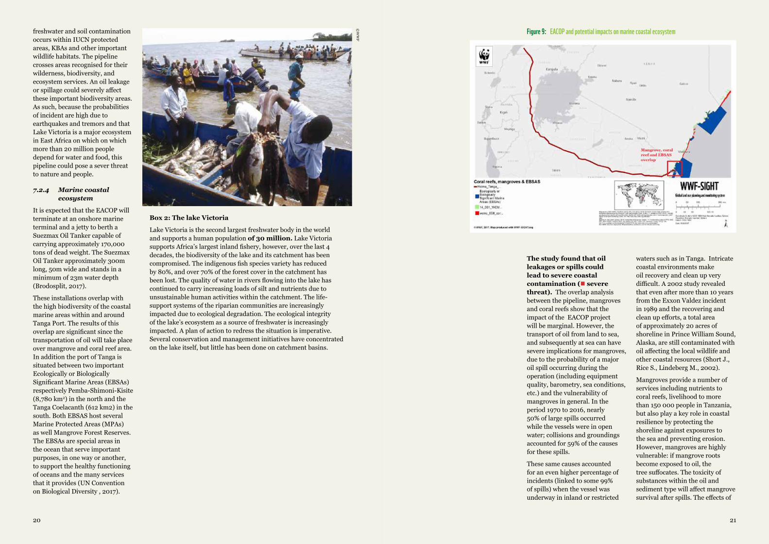
These installations overlap with the high biodiversity of the coastal marine areas within and around Tanga Port. The results of this overlap are significant since the transportation of oil will take place over mangrove and coral reef area. In addition the port of Tanga is situated between two important Ecologically or Biologically Significant Marine Areas (EBSAs) respectively Pemba-Shimoni-Kisite (8,780 km2) in the north and the Tanga Coelacanth (612 km2) in the south. Both EBSAS host several Marine Protected Areas (MPAs) as well Mangrove Forest Reserves. The EBSAs are special areas in the ocean that serve important purposes, in one way or another, to support the healthy functioning of oceans and the many services that it provides (UN Convention on Biological Diversity , 2017).
©W
WF
Box 2: The lake Victoria
Lake Victoria is the second largest freshwater body in the world and supports a human population of 30 million. Lake Victoria supports Africa’s largest inland fishery, however, over the last 4 decades, the biodiversity of the lake and its catchment has been compromised. The indigenous fish species variety has reduced by 80%, and over 70% of the forest cover in the catchment has been lost. The quality of water in rivers flowing into the lake has continued to carry increasing loads of silt and nutrients due to unsustainable human activities within the catchment. The life-support systems of the riparian communities are increasingly impacted due to ecological degradation. The ecological integrity of the lake’s ecosystem as a source of freshwater is increasingly impacted. A plan of action to redress the situation is imperative. Several conservation and management initiatives have concentrated on the lake itself, but little has been done on catchment basins.
Figure 9: EACOP and potential impacts on marine coastal ecosystem
The study found that oil leakages or spills could lead to severe coastal contamination ( severe threat). The overlap analysis between the pipeline, mangroves and coral reefs show that the impact of the EACOP project will be marginal. However, the transport of oil from land to sea, and subsequently at sea can have severe implications for mangroves, due to the probability of a major oil spill occurring during the operation (including equipment quality, barometry, sea conditions, etc.) and the vulnerability of mangroves in general. In the period 1970 to 2016, nearly 50% of large spills occurred while the vessels were in open water; collisions and groundings accounted for 59% of the causes for these spills.
These same causes accounted for an even higher percentage of incidents (linked to some 99% of spills) when the vessel was underway in inland or restricted
waters such as in Tanga. Intricate coastal environments make oil recovery and clean up very difficult. A 2002 study revealed that even after more than 10 years from the Exxon Valdez incident in 1989 and the recovering and clean up efforts, a total area of approximately 20 acres of shoreline in Prince William Sound, Alaska, are still contaminated with oil affecting the local wildlife and other coastal resources (Short J., Rice S., Lindeberg M., 2002).
Mangroves provide a number of services including nutrients to coral reefs, livelihood to more than 150 000 people in Tanzania, but also play a key role in coastal resilience by protecting the shoreline against exposures to the sea and preventing erosion. However, mangroves are highly vulnerable: if mangrove roots become exposed to oil, the tree suffocates. The toxicity of substances within the oil and sediment type will affect mangrove survival after spills. The effects of
2322
oiling on mangroves can last for many years. For example, reduced mangrove area and epifaunal cover is still recorded in Makupa Creek, Kenya, ten years after spills occurred (Taylor M., 2003). Disappearance of mangroves will lead to loss of habitat and erosion of the coastline, exposing infrastructure and local community to inundation and flooding risks from the ocean. As such, due to the high probability of oil spill in the transportation process and the impacts on mangroves and reefs, the EACOP project could easily pose a severe threat to marine coastal ecosystem.
The main impacts of oil spills shall be on freshwater and marine ecosystems a well as neighbouring local communities. A number of factors influence the scale of these impacts. These include; the size of the spill, the kind of oil, the season of the spill, and the vulnerability of local plants and animals. The spill size often determines the area affected, whether it reaches the shore, and how much of the shore it covers. The extent of contamination also depends on the nature of the recipient ecosystems and the types of plants and animal wildlife affected. Some ecosystems, such as mangroves, salt marshes, coral reefs, and polar bear habitats, are particularly sensitive to oil spills and can take years to recover (RAN, 2002).
Contamination and loss of mangrove and coral reef could decrease fish stock and increase exposure to climate change impacts for coastal communities and tourism: Mangroves and coral reef as well as seagrass beds, patch reefs, mudflats, salt marshes, estuaries and associated habitats, act as nursery grounds for juveniles of numerous fish species. Their nursery role is underpinned by the provisioning of resources, such as food or shelter, for many
Table 1: Threat summary table
EACOP Project Stages
Construction Operation Decommissioning
Biodiversity and natural habitats
Significant threat – 1) Con-struction of the pipeline could lead to disturbance of PAs and KBAs. 2) Temporary and/per-manent infrastructure i.e. roads and settlements would lead to fragmentation of the areas. 3) Access to natural resources could lead to increase poach-ing in the absence of effective enforcement.
Significant threat – 1) the probability of oil spill given it is a seismic area could lead to a long-term pollution of the Protected areas (Oil residues) and contaminate feeding/breeding grounds of wildlife as well as the water bodies of the protected, which are necessary for its overall functioning.
Moderate threat - the decommission-ing, if improperly done, could lead to contamination and pollution.
Wildlife habitats and corridors
Severe threat - transport of material can lead to permanent establishment of infrastructure i.e. roads and settlements which would to lead fragmentation of habitat and disruption of the corridor. In addition, easier access to natural resources can lead to increase poaching in the absence of enforcement.
Severe threat - the prob-ability of oil spill, even with a contingency plan could lead to pollution and contamination of feeding/breeding grounds of wildlife as well as the water bodies of the protected, which are necessary for any wildlife.
Moderate threat - the decommission-ing, if improperly done, could lead to contamination and pollution.
Water re-sources
Moderate threat - Construc-tion of the pipeline would require water, and if badly planned and used, this could leave wetlands dry of their water. Also, temporary or per-manent settlements could lead to depilation and pollution of water resources.
Severe threat - the probabili-ty of oil spill combined with the magnitude of the river network and tributaries to the Lake Vic-toria could lead to disastrous consequences by pollution and contamination of water bod-ies including lake Victoria and have dramatic environmental and socio-economic conse-quences for the region.
Moderate threat - the decommissioning could lead to pollu-tion of water bodies.
Coastal eco-system
Moderate threat – depending on the location and route of the pipeline, the construction of the pipeline or associated infra-structure could lead to removal of mangroves
Severe threat - the prob-ability of oil spill or leakage at any stage of the transportation process from land to sea, could lead to serious consequences by pollution and oil contamina-tion of mangroves, reefs and water bodies including Lake Victoria and have dramatic environmental and socio-economic consequences for the region.
Low threat - the decommissioning could lead to pollu-tion of water bodies.
©W
WF
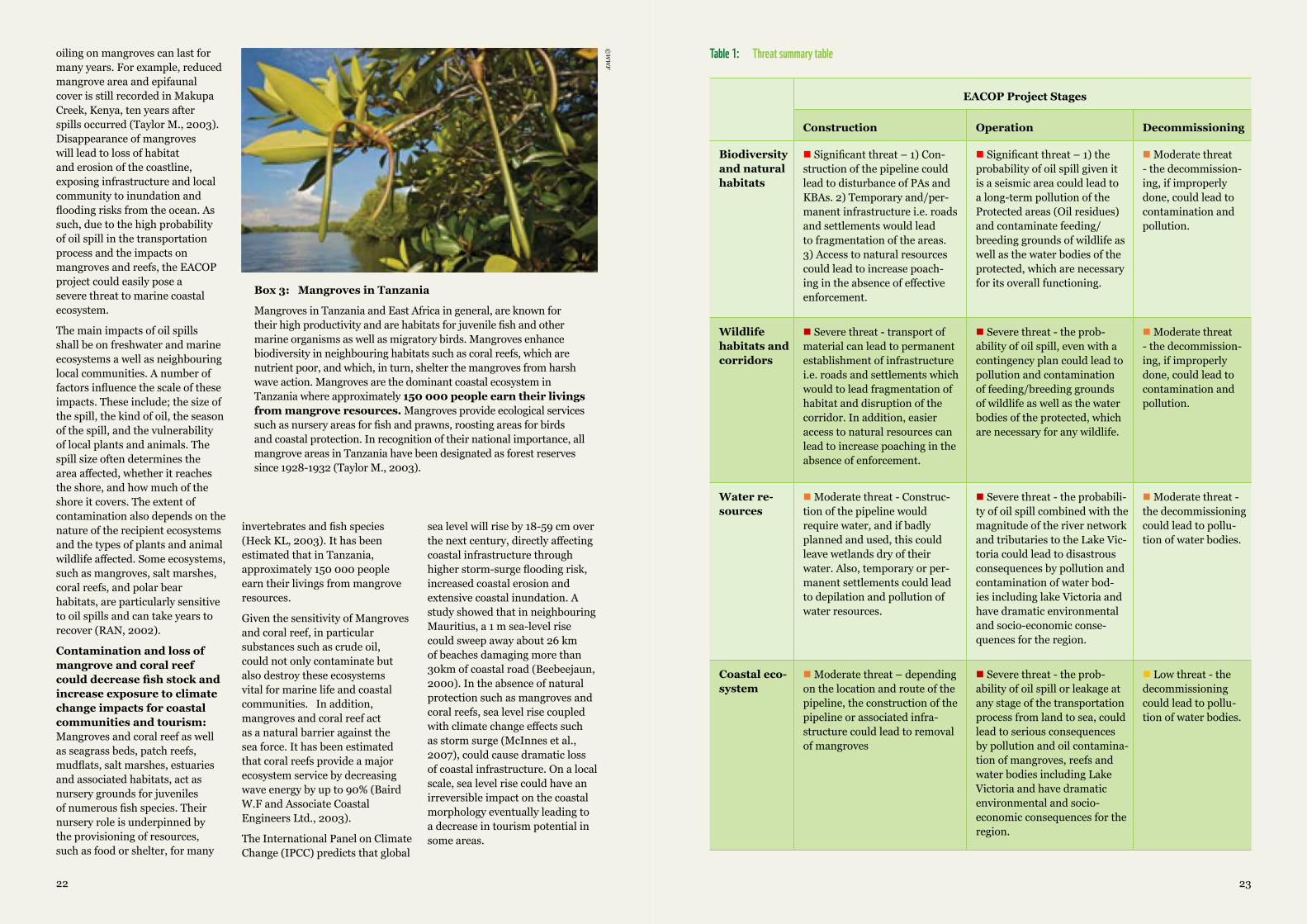
Box 3: Mangroves in Tanzania
Mangroves in Tanzania and East Africa in general, are known for their high productivity and are habitats for juvenile fish and other marine organisms as well as migratory birds. Mangroves enhance biodiversity in neighbouring habitats such as coral reefs, which are nutrient poor, and which, in turn, shelter the mangroves from harsh wave action. Mangroves are the dominant coastal ecosystem in Tanzania where approximately 150 000 people earn their livings from mangrove resources. Mangroves provide ecological services such as nursery areas for fish and prawns, roosting areas for birds and coastal protection. In recognition of their national importance, all mangrove areas in Tanzania have been designated as forest reserves since 1928-1932 (Taylor M., 2003).
invertebrates and fish species (Heck KL, 2003). It has been estimated that in Tanzania, approximately 150 000 people earn their livings from mangrove resources.
Given the sensitivity of Mangroves and coral reef, in particular substances such as crude oil, could not only contaminate but also destroy these ecosystems vital for marine life and coastal communities. In addition, mangroves and coral reef act as a natural barrier against the sea force. It has been estimated that coral reefs provide a major ecosystem service by decreasing wave energy by up to 90% (Baird W.F and Associate Coastal Engineers Ltd., 2003).
The International Panel on Climate Change (IPCC) predicts that global
sea level will rise by 18-59 cm over the next century, directly affecting coastal infrastructure through higher storm-surge flooding risk, increased coastal erosion and extensive coastal inundation. A study showed that in neighbouring Mauritius, a 1 m sea-level rise could sweep away about 26 km of beaches damaging more than 30km of coastal road (Beebeejaun, 2000). In the absence of natural protection such as mangroves and coral reefs, sea level rise coupled with climate change effects such as storm surge (McInnes et al., 2007), could cause dramatic loss of coastal infrastructure. On a local scale, sea level rise could have an irreversible impact on the coastal morphology eventually leading to a decrease in tourism potential in some areas.
2524
7.3 Socio Economic implications
The petroleum industry at large is associated with a wide range of socio-economic issues, which could also be manifested during the East Africa Crude Oil Pipeline project. Based on a review of existing literature, expert interviews and focus-group discussions, the study found the following issues worthy of further consideration in the EACOP project;
7.3.1 Employment andbusinessopportunities
The EACOP project could generate several economic benefits at local, national and regional level. It is estimated that the EACOP will create some 5000 jobs in total, of which 4700 will be temporary and only 300 will be permanent (Directorate of Petroleum, 2017b).
Employment is often a major reason why major energy developments such as EACOP are embraced by community members, particularly in communities with histories of economic decline. There is a real potential that jobs and business activity directly related to the EACOP project will increase, as will jobs and business activity in sectors that provide goods and services to the EACOP and the workers associated with its development. It is however important to manage expectations as only a total of about 5000 jobs will be provided with only 300 of these jobs being permanent (i.e. till the duration of the pipeline). The total number of jobs is for example only 0.5% of the total number of jobs (1.3 million) from the Tanzania tourism industry alone.
Yet the degradation (incl. poaching and encroachment) of protected areas, KBAs and wildlife habitats
could lead to loss in tourism. Tanzania, where most of the pipeline will be built and operated, is a country heavily dependent on tourism. This tourism is reliant on the country’s unique natural biodiversity assets, which include healthy protected areas, KBAs and iconic species like lions and the African Elephants. Approximately 40 per cent of Tanzania’s land area is set aside in protected areas for conservation with 16 national parks, 29 game reserves, 40 controlled conservation areas (including the Ngorongoro Conservation Area) and marine parks. These assets provide the basis for most of the tourism industry, which in 2014 contributed USD$1.5bn in 2014, 14% to its Gross Domestic Product (GDP) and which was 21.9% of total exports in Tanzania. The sector also employs 1,337,000 people (12% of total national employment) both directly and indirectly (WTTC, 2015).
It is important to note that this sector is growing rapidly, rising from US $1.74 billion in 2004 to US $4.48 billion in 2013. In 2012, 1,043,000 tourists arrived at Tanzania’s borders compared to 590,000 in 2005. Tourism is a key source of sustainable income for operators and local communities (Dylan, 2012). As such, risks associated to the pipeline construction and operation such as fragmentation of habitats and contamination and pollution due to oil spills could not only impact the natural resources upon which tourism depends, but also the livelihood of the local communities and opportunities for the villages that have for generations depended on such tourism economic activity.
On the other hand, the many jobs generated from oil pipeline development projects focus on providing goods and services to workers (The Perryman Group 2008). These jobs often have less
stability and offer fewer benefits. In addition, although businesses catering to industry can see a surge in profits, local businesses may compete with each other and the new extractive industry high demand for skilled workers (e.g., mechanics, heavy equipment operators, truck drivers) may make such personnel unavailable for other long-term sectors (such as agriculture) of the economy. This competition leads to a shortage of skilled workers and strains the ability of local businesses to provide commensurate wages and benefits (Braiser et al, 2011).
INCOME DISPARITIES ARE SHOCKING:
THE RICHEST 10%
CONTROLS 40%OF THE COUNTRY’S WEALTH
AND ITS POOREST
20%HAS A SHARE OF JUST 4.4%.
(TERRY, 2004)
©KateH
olt/WWFU
K
7.3.2 Tax revenue
The oil pipeline project may generate increased tax revenue (e.g. Pay As You Earn (PAYE) and Value Added Tax (VAT) or business taxes from industrial and associated local business growth in activity. Property tax revenues may also increase along the pipeline if assessed values rise to reflect new construction and increased market values of property. Higher personal income tax revenues may benefit municipalities, districts, and the state if local incomes
increase (due to jobs or royalty/lease income) and if the local tax structure enables collection of such local taxes (Theodori, 2009). It is however important to note that unless there are prior plans to prepare local communities to benefit from the new business and job opportunities, the increased business activity from the oil pipeline may have limited direct benefits for local residents or communities (see Case Study 1: Socio-Economic impacts Of the Chad-Cameroon Oil Pipeline Project).
2726
7.3.3 Inequalities
There could also be socio-economic changes associated with the new employment opportunities whereby income differentials and inflation could lead to gross levels of overall inequality as different local groups and individuals benefit or are negatively impacted upon unevenly from the induced socio-economic opportunities and challenges from the EACOP project. This could be a challenge to social cohesion and harmony E&P and UNEP, 1997).
In Nigeria for example, the disparity between oil wealth and poverty is especially notable. Despite the fact that over $300 billion in oil profits has been generated over the past 25 years, the proportion of households living below the United Nation’s absolute poverty line of $1/day grew from 27% in 1980 to 66% by 1996. Income disparities are shocking: the richest 10% controls 40% of the country’s wealth and its poorest 20% has a share of just 4.4%. . (Terry, 2004)Terry, (2004) further observes that dependence on petroleum skews the social structure of countries. Because of the enormous capital and technological resources nec-essary to exploit this resource, foreigners (principally oil compa-nies) become a dominant, if not the dominant internal social force, es-pecially at the beginning stages of development. This has important implication for the creation of a lo-cal domestic entrepreneurial class. Though foreign companies may form partnerships with domestic elites, their overwhelming econom-ic presence, capital and technologi-cal advantages mean that domestic entrepreneurs have less opportu-nity to develop on their own. To be successful, the domestic businesses must forge close ties either to the state or to foreign capital, or they may be marginalized.
7.3.4Inflation
With increased incomes – prices for products and services along boomtowns especially during pipeline construction are expected to experience inflationary effects. Take for example housing; this is usually scarce in small, rural boomtowns with limited housing stocks. However, the rapid influx of industry workers quickly fills available rental units and temporary housing (such as hotels and mobile homes). New housing takes time to build, and communities are often reluctant to approve large-scale development projects that may not be needed after the ‘boom’ pipeline construction period. Such housing shortages could result in rapid escalation of purchase prices and rental rates, which may not recover to the previous price levels. This could push long-term residents out of the housing market (Gilmore and Duff 1975), exacerbating stress on individuals and families.
7.3.5 Stress,crimeanddisruptionofcommunity cohesion
Rapid growth in boomtowns is also linked with mixed social impacts. Earlier research on boomtowns emphasized negative impacts, leading to the development of the ‘social disruption’ model. This work demonstrated that rapid population growth from immigration associated with the development of EACOP project could increase personal stress, change individuals’ patterns of interactions within communities, decrease community cohesion, and change a community’s character. Individuals’ quality of life, ties to community members, and mental and physical health can also be affected, leading to increases in social problems (e.g., crime, substance abuse) and overall disorganization. This increases stress on local organizations
and community services, and creates a lower standard of living for persons detached from the extractive-related economy. Social impacts are experienced differentially based on social class, gender, age, length of residence, and degree of direct benefit from the development (Braiser et al, 2011).
7.3.6 Increasedchangesinland-usepatternsanderosionofculturalheritage
Changes in land-use patterns such as agriculture, fishing, logging or hunting could increase as a direct consequence of land-take or exclusion during the EACOP project. While there could be improved access due to new and/or improved roads – inversely there could also be restricted access to key natural resources due to land-take or change in related access regulations. These changes if not managed well could lead to land conflicts, loss of cultural heritage and spread of disease (E&P and UNEP, 1997).
Large developments such as the EACOP project are often associated to land conflict simply because the ROW is very long and large (estimated total of 43,350km2) and will most likely affect several rural and urban communities. As such, land conflict can be expected from this development.
East Africa is known for its indigenous land and sacred forests. The pipeline and associated developments could lead to a loss of cultural heritage erosion, especially for impacts on indigenous peoples, and their unique cultural systems and values.
In addition, new infrastructure such as roads and settlements, as well as activities such as agriculture could disrupt existing community livelihoods through
conflict or restricting access to natural resources along the entire pipeline Right of Way. Besides, land acquisition, which generally follows large projects such as this, could force resettlement of existing communities. Finally, the large work force needed to build the pipeline could lead to immigrations that are typically associated with socio-cultural changes in social structure, organization, cultural heritage, practices, beliefs and changes in local value/belief systems as well as accelerated spread of communicable and sexually transmitted diseases such as HIV/AIDS amongst local communities (E&P and UNEP, 1997).
7.3.7 Highriskofcontaminationofwater,landandotherbasiclivelihoodnecessities
Oil spills and leakages could lead to chemical contamination of soil and water resources, exposure to fires and disruption of local livelihoods. The pipeline will transport oil, which is a hazardous substance and can pose a health risk to people leaving in the surroundings of the pipeline, especially to the ones who use water from the watershed in which the pipeline is located. As seen in the environmental risk analysis, the area is prone to seismic activities, which could increase the risk of contamination.
In January 2017, a ruptured oil pipeline leaked up to 40,000 gallons of crude oil into the Yellowstone River in Montana (USA), contaminating the drinking water for the nearby town of Glendive of approximately 5000 residents. The oil spill in the river was visible from the air for over 25 miles downstream from where it happened. The spill is the second in the river in recent years. In 2011, Exxon Mobil Corp’s 40,000 bpd Silvertip pipeline in Montana
2928
ruptured underneath the river, releasing more than 1,000 barrels of crude and costing the company about $135 million to clean up (Scientific American, 2017). Without a proper contingency plan let alone efficient mechanisms for enforcing such a plan, oil spills along the EACOP similar to the ones described above could have disastrous consequences within the Lake Victoria watershed and the coastline affecting the millions of people and wildlife that depend on such associated natural resources.
A major oil spill could also contaminate agricultural soil and increase the risk of fire potentially destroying large living areas. Chemical contamination of agricultural soil and water resources would mean that subsistence agriculture, which is a predominate socio-economic livelihood activity in both Tanzania and Uganda, would be severely impacted, and would force local communities to found new suitable areas, leading to further land conflict and habitat destruction. A related livelihood disruption was caused in Mozambique when in 1992, the tanker KATINA P carrying 66,700 tonnes of heavy fuel oil broke in two and sank 85 nautical miles off Mozambique leading to release of oil. Oil entered mangrove stands in the bay and a fishing ban was imposed in Maputo Bay immediately after oil came ashore and saltpans along the Matola River were closed to extraction for several weeks (ITOPF, 2017).
7.3.8 Human rights violations, community health andsafetyaswellasoccupationhazards
Construction phase could lead to occupational hazards and labour rights violations. In 2009, the International Labour Organisation (ILO) conducted a survey on
OIL SPILLS AND LEAKAGES COULD LEAD TO CHEMICAL CONTAMINATION
OF SOIL AND WATER RESOURCES, EXPOSURE TO FIRES AND DISRUPTION
OF LOCAL LIVELIHOODS.
working conditions in Tanzania and concluded that a majority of employment contracts are casual, verbal or non-existent. Most workers in the informal economy have little or no social protection and receive little or no social security (ILO, 2009). Pipeline workers’ rights, working and safety conditions could be overlooked and run the risk of being compensated in case of an accident. As such, labour rights and including the four core labour standards, and occupational health and safety need to be respected.
Oil pipelines have been connected to human rights violations around the world and have caused disproportionate impacts on low-income, disempowered and minority communities. According to RAN (2002), in the United States for example, the Pacific Pipeline, a project constructed by a consortium of Chevron, Unocal, and Texaco in the late 1990s, faced a lawsuit from the City of Los Angeles that alleged their routing of the pipeline constituted an environmental injustice. Pacific Pipeline is a 132-mile long heavy crude pipeline that transports 130,000 barrels per day of oil from Bakersfield, California, through the heart of Los Angeles, into the refinery district on the Pacific Coast. In transit through the City of Los Angeles, it bisects 75 neighbourhoods. Analysis
conducted by Impact Assessment Inc. for the City of Los Angeles demonstrated that 74 of the 75 communities had minority populations higher than the national average; 72 of the 75 had minority populations higher than the California average; 42 of the 75 had minority populations over 90% of the total tract population; all of the tracts had a higher percentage of non-English speakers than the national average; and 62 of 75 had per capita income lower than the national, state, county, and city levels.
Human rights abuses have also been linked to the construction of the Chad-Cameroon Pipeline. The project, sponsored by an international consortium lead by ExxonMobil and ChevronTexaco involves the development of the Doba oil fields in southern Chad and the construction of a 1070-kilometer pipeline to an offshore oil-loading facility on Cameroon’s Atlantic coast. Advocacy groups such as Rainforest Action Network (RAN) have raised concerns about increasing violence and human rights abuses, corruption, and devastation of the Bakola (or Pygmies) peoples who live along the pipeline. RAN (2002) notes that “both the US State Department and Amnesty International have documented
serious human rights abuses by Chad and Cameroon governments, including extrajudicial killings, torture, abuse, rape, limiting freedom of the press and arresting opposition politicians and other civilians. Many believe that there has already been an increase in violence and human rights abuses in Chad as a result of the pipeline project (RAN, 2002)
7.3.9 Reducedstatecapacity challenges andriskofarmedconflict
There could also be wider socio-economic impacts associated not just with the EACOP but with the overall oil industry in the region. Terry (2004) asserts that because the revenue base of in an oil-dependent state is the state, oil rents grossly affect state capacity. There is a risk that oil dependence could skew the institutional development of the state because oil rents weaken agencies of restraint. In resource-poor countries, intense population pressure on scarce resources reduces the tolerance for inefficiency and predation, and the economy cannot support extensive protection or an over- expanded bureaucracy. But in oil states, the brake of scarcity does not exist. Instead, oil dependence encourages the expansion of states into new arenas while weakening opportunities to strengthen administrative capacities, especially non-oil-based tax systems, merit-based civil services,
and the rule of law— fundamental elements for creating efficient states.
The transfer of oil from Uganda through Tanzania could also create motivation for increased armed conflict in the region. Throughout the 1990s, many armed groups have relied on revenues from natural resources such as oil, timber, or gems to substitute for dwindling Cold War sponsorship. Resources not only financed, but in some cases motivated conflicts, and shaped strategies of power based on the commercialisation of armed conflict and the territorialisation of sovereignty around valuable resource areas and trading networks. As such, armed conflict in the post-Cold War period is increasingly characterised by a specific political ecology closely linked to the geography and political economy of natural resources. Research shows increased vulnerability to armed conflict resulting from resource dependence, rather than conventional notions of scarcity or abundance. It also demonstrates the risks of violence linked to the conflictuality of natural resource political economies, and the opportunities for armed insurgents resulting from the lootability of resources. Armed violence leads to the subjugation of the rights of people to determine the use of their environment and results in brutal patterns of resource extraction and predation. This phenomenon is popularly called the “Natural Resource Curse” or “Paradox of plenty” – which refers to the failure of many resource-rich countries to benefit fully from their natural resource wealth, and for governments in these countries to respond effectively to public welfare needs (Philip, 2001; Terry, 1997).
HUMAN RIGHTS ABUSES HAVE ALSO BEEN LINKED TO THE CONSTRUCTION OF THE CHAD-CAMEROON PIPELINE.
3130
Box 4: Case Study 1: socio-economic impacts of the chad-cameroon oil pipeline
The community response to the Chad-Cameroon oil pipeline followed an earlier model of social reaction to extractive industries which is typically characterized by high expectation, reality, and then disillusionment as local communities react to boom and burst cycles of major infrastructure projects such as oil and gas development.
During the early phase of the pipeline construction, the region experienced boom in most social and economic activities. There was increase in money supply and circulation from both the pipeline workers and from compensation. However, this was a short-term positive impact. The long-term impacts have proved to be the contrary. Livelihoods depend on people access to everyday basic necessities such as health, food, education, employment etc. The people hoped to improve their living conditions from the employment opportunities. The jobs available to local communities were of low pay and for short periods, most skilled and semi-skilled workers were sourced from elsewhere.
The local residents were hired for between one day to a maximum of three months and the daily wages range from USD$ 2 (1200 Central Africa Francs - CFAs) for unskilled labour to USD$12 (7000 CFA) for skilled labour. This explained why most of the villagers said they preferred to go for fishing or hunting than to work for the pipeline project because the wages were low.
Health improvement was also a major area of concern. There are indications that the health situation attributed directly to the pipeline has worsened. There is pollution of rivers and streams which these communities depended upon and they are therefore more exposed to waterborne diseases such as typhoid, malaria, diarrhoea and skin diseases.
An assessment study found that out of 100 villages traversed by the pipeline, only 10% had drinkable water systems. Most of the villagers said the opening of the forest has increased the presence of mosquitoes around their homes. For instance, the village stream at Mbikiliki, which was a source of water in the region, was destroyed by the project and this has caused a health crisis in the village. This pipeline trajectory has not only disrupted the course of the stream but it has also created stagnant water, which is breeding ground for mosquitoes.
There have been widespread of sexually transmissible diseases along the pipeline route and it is claimed that, the rate of HIV/AIDS along the project is more than the national prevalence rate of 5.4% and a study conducted by the Swiss Tropical Institute in 2001 quotes a prevalence rate of 8% and 15% in Sarah and Kelou, two villages close to the pipeline. The villagers said new beer bars sprung up around construction camps, which encouraged prostitution. With the influx of migrant workers and many beer bars, prostitution was widespread especially amongst minors in the villages. This has also probably increased the rate of unwanted pregnancy and the rise of a generation of children commonly known as “pipeline children”.
The whereabouts of the fathers of these children are not known thereby adding more burdens to the families concerned. There have been questions on whether the project was worthwhile. The estimated cost of the project was $3.5 billion but finally, the total cost of the project stood at $4.2billion. Therefore, why should the governments of the two host countries contract such heavy debts for projects that hold little benefits for the local population and the environment and which is largely a private sector project?
Source: Nkushi Francis Shombong, 2010.
To ensure effective safeguards for people and nature during the
development of the EACOP project WWF and CSCO
propose the following recommendations;
contingency plan, c) offsetting adverse impacts such as increasing acreage Protected Areas and establishing an Environmental Investment Plan (EIP) to fund other offset projects.
The final selected interventions should also be developed and implemented in conjunction with relevant stakeholder bodies. Identification of such stakeholder groups including local communities and civil society organizations early in the process will therefore be very critical. Predictions and options generated, as part of the EIA should be proposed to all stakeholders and decision-makers. By using EIA both environmental and socio-economic benefits can be achieved, such as reduced cost and time of project implementation and design, avoided treatment/clean-up costs and impacts of laws and regulations.
2) Establish an inclusive open decision-making and conflict resolution processExperience has shown that by opening up the decision-making process and including all stakeholders – this often reduces risk and conflicts by creating shared ownership and cooperation. As such, WWF and CSCO recommend that any decision regarding the East Africa Crude Oil Pipeline (EACOP) especially during, planning, construction, operation and decommissioning should be open, transparent and inclusive. This decision-making process
is an approach to arriving at actionable agreements through participatory practices. This approach involves clearly sharing problems, requirements, and constraints with affected parties; collaborating purposefully with multiple stakeholders to secure diverse opinions and comprehensive feedback; and managing relationships and expectations across competing needs and priorities.
An effective conflict resolution process should also be instituted to address community concerns and any human rights violations. Such a system should ideally include implementation and maintaining a procedure for grievance management that includes clear mechanisms to (i) receive and register grievances and concerns from the public; (ii) screening and assessing the issues raised and determine how to address them; (iii) provide, track, and document responses, if any; and (iv) regular consultative review and adjustments in the grievance management program, as appropriate. In addition, human rights and grievance management actions should be communicated through publicly available periodic reports including environmental and socio-economic sustainability updates (IFC, 2012).
3) Develop a regional Strategic Environmental Assessment (SEA)As shown in this study, the pipeline overlaps important biodiversity assets, which support and will continue to support millions of people long after oil and gas resources are exhausted. High environmental sensitivity right from the source of oil and gas resources in Uganda, where exploration areas overlap with nearly 70%
1) Undertake a thorough Environmental Impact Assessment (EIA)We recommend that the next immediate step in the East Africa Crude Oil Pipeline (EACOP) development is to undertake an Environmental Impact Assessment (EIA). EIA is a process of evaluating the likely environmental impacts of a proposed project or development, taking into account inter-related socio-economic, cultural and human-health impacts, both beneficial and adverse.
This process is paramount and should be used to identify the environmental, social and economic impacts of the pipeline prior to any type of decision-making. By predicting environmental impacts at an early stage in project planning and design, this process will identify if the pipeline’s construction and operation are environmentally and socially viable. If so, the EIA will identify ways and means to a) reduce adverse impacts to suit the local environment such as reassessing the proposed route of the pipeline, b) mitigate these adverse impacts such as establishing an early warning system for oil spill and a
8.0KEY RECOMMENDATIONS
32
of Uganda’s wildlife protected areas through to the actual proposed pipeline that overlaps with the Lake Victoria Lake for nearly 500 km.
WWF and CSCO therefore recommend that a Strategic Environmental Assessment (SEA) be developed for the EACOP. An SEA consists of a range of analytical and participatory approaches that aim to integrate environmental considerations into policies, plans and programmes and evaluate the inter-linkages with economic and social considerations (OECD, 2017). As infrastructure and extractive projects are rising in East Africa, SEAs are becoming more urgent and necessary. Examples of SEA recommendations to the oil and gas sector to be considered should include setting apart specific important biodiversity conservation areas such as the proposed Ngaji Block (in Queen Elizabeth National Park, South Western Uganda) which is contiguous with Virunga National Park in the Democratic Republic of Congo - a World Heritage Site. Virunga National Park is home to the world’s less than 900 Mountain Gorillas remaining in the wild (Ellis, 2008). Such areas need to be defined as no-go zones for further oil and gas developments to enable the long-term conservation of biological diversity for posterity. Before selecting a route for the oil and gas pipeline, a regional SEA should be should be developed to integrate environmental considerations into policies and plans of the East Africa Crude Oil Pipeline (EACOP).
A key component of the SEA process will be the need to develop a specific environmental and socio-economic sensitivity atlas
for the entire route of the EACOP project. The region already has good examples of environmental atlas process, for example the Uganda government has previously developed the Environmental Sensitivity Atlas for the Albertine Graben. Developing a sensitivity atlas for the EACOP would go a long-way in ensuring effective monitoring of the associated activities on people and nature.
Where feasible biodiversity offsets based on effective total natural resource valuations (both direct and indirect values) should be undertaken as part of the comprehensive SEA process. Application of biodiversity offsets should adhere to the mitigation hierarchy standards, which require that such biodiversity offsets should only be considered only after appropriate avoidance, minimization, and restoration measures have been applied. Besides, biodiversity offsets should be designed and implemented to achieve measurable conservation outcomes that can reasonably be expected to result in no net loss and preferably a net gain of biodiversity; however, a net gain is key requirement in critical habitats. The design of a biodiversity offset must adhere to the “like-for-like or better” principle and must be carried out in alignment with best available information and current practices (IFC, 2012)
4) Respect Land tenure and other human rights at all times Land tenure systems are of central importance to the millions of rural poor that depend upon forests, agriculture, freshwater fishing or herding for their livelihoods (GRI, 2016). In East Africa, most rural residents are
own property alone as well as in association with others and that no one shall be arbitrarily deprived of his property (UN, 1948).
Land tenure rights are also captured in international initiatives and instruments such as the UN Sustainable Development Goals, The Universal Declaration of Human Rights (UDHR) or the UN Guiding Principles on Business and Human Rights (UGPBHR). Secure property rights are a key to economic growth. Equitable access to land is the basis for pro-poor and socially inclusive economic and long-term growth.
5) Establish a robust and inclusive regulatory framework and capacity in the Oil and Gas sectorIt is expected that access and operations permits, consents and licences will be issued to the various aspects of EACOP pipeline project depending on the specifics of the jurisdictional framework in Uganda and Tanzania. However, the extent to which these regulations and permit requirements are implemented shall depend largely on the nature of the oil and gas companies involved as well as their contractors. This is because of the prevailing environmental and social governance frameworks, which are either absent, out-dated or poorly implemented in many cases. Given this case – the oil and gas companies must adhere to not only local regulations and standards but also to international environmental and social standards and industry Best Practices. To avoid irreversible impacts on people and the environment, it is important that oil and gas regulatory frameworks and institutions be well established and developed first before harnessing the resource.
smallholders cultivating cereal crops on rainfed land and raising livestock. In Tanzania, the government issued in 2006 its Strategic Plan for the Implementation of the Land Acts (SPILL) to guide the transition to a legal framework that supports private property rights and control of resources in farming areas (Global Security, 2017). As such, it is important that the development of the pipeline, in particular the section in Tanzania, is aligned with the SPILL. WWF and CSCO do recommend that both governments and companies in charge of the pipeline development adopt the Voluntary Guidelines on the Responsible Governance of Tenure (VGGT), where business have a responsibility to respect human rights and legitimate tenure rights” (GRI, 2016).
We are also mindful of the proposed land law amendments in Uganda pushing for compulsory land ownership for public interest. This would be in direct contravention of Article 17 of the UDHR, which asserts that everyone has the right to
WWF AND CSCO BELIEVE THAT IT TAKES TIME TO DEVELOP
THE RIGHT COMPETENCE, INSTITUTIONS, LET ALONE THE
ENFORCEMENT MECHANISMS TO ENSURE THERE IS A STRONG
LOCAL CONTENT AND EFFECTIVE PARTICIPATION OF CITIZENS IN
THE OIL AND GAS SECTOR
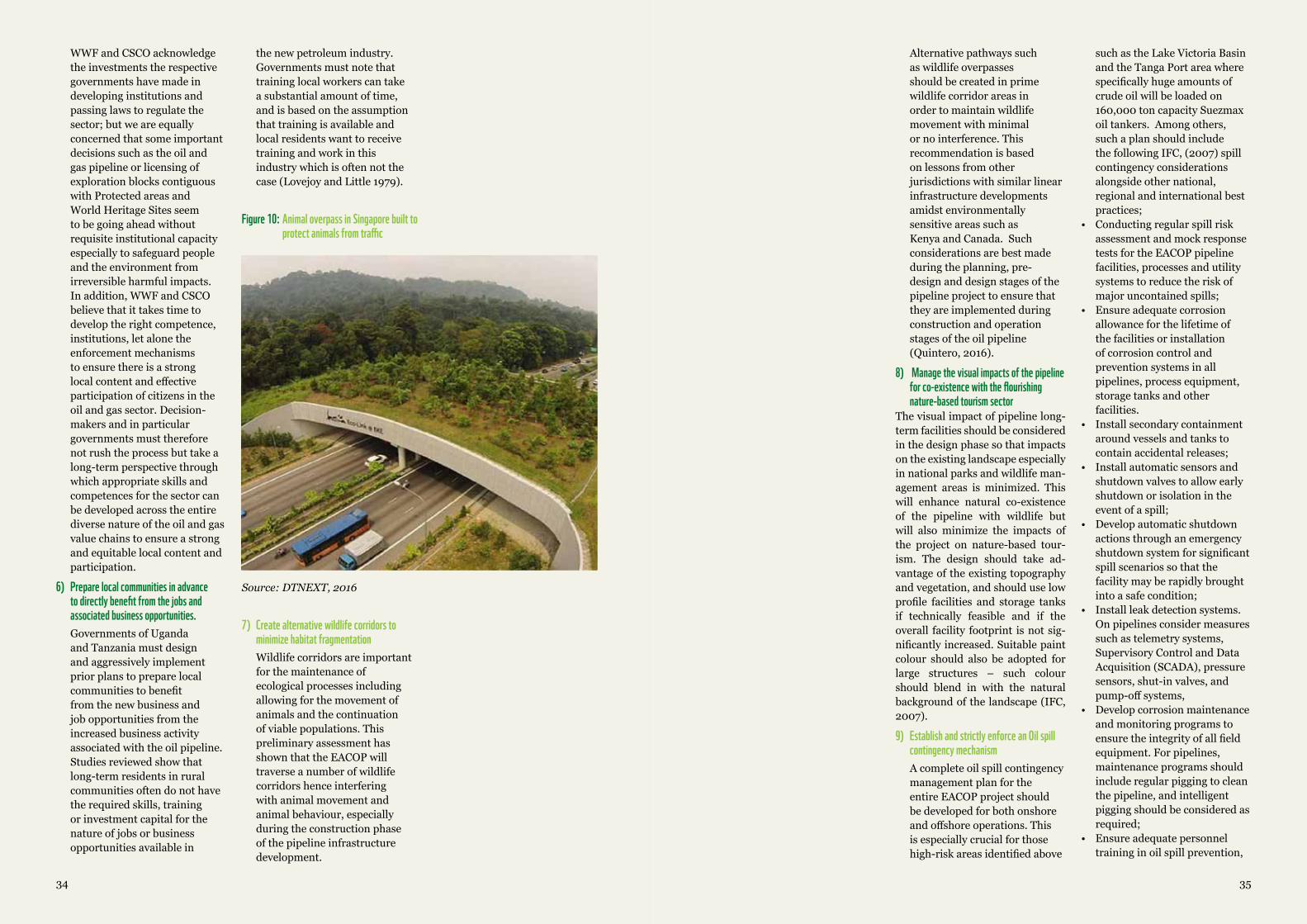
3534
WWF and CSCO acknowledge the investments the respective governments have made in developing institutions and passing laws to regulate the sector; but we are equally concerned that some important decisions such as the oil and gas pipeline or licensing of exploration blocks contiguous with Protected areas and World Heritage Sites seem to be going ahead without requisite institutional capacity especially to safeguard people and the environment from irreversible harmful impacts. In addition, WWF and CSCO believe that it takes time to develop the right competence, institutions, let alone the enforcement mechanisms to ensure there is a strong local content and effective participation of citizens in the oil and gas sector. Decision-makers and in particular governments must therefore not rush the process but take a long-term perspective through which appropriate skills and competences for the sector can be developed across the entire diverse nature of the oil and gas value chains to ensure a strong and equitable local content and participation.
6) Prepare local communities in advance to directly benefit from the jobs and associated business opportunities.Governments of Uganda and Tanzania must design and aggressively implement prior plans to prepare local communities to benefit from the new business and job opportunities from the increased business activity associated with the oil pipeline. Studies reviewed show that long-term residents in rural communities often do not have the required skills, training or investment capital for the nature of jobs or business opportunities available in
Source:DTNEXT,2016
Figure 10: Animal overpass in Singapore built to protect animals from traffic
Alternative pathways such as wildlife overpasses should be created in prime wildlife corridor areas in order to maintain wildlife movement with minimal or no interference. This recommendation is based on lessons from other jurisdictions with similar linear infrastructure developments amidst environmentally sensitive areas such as Kenya and Canada. Such considerations are best made during the planning, pre-design and design stages of the pipeline project to ensure that they are implemented during construction and operation stages of the oil pipeline (Quintero, 2016).
8) Manage the visual impacts of the pipeline for co-existence with the flourishing nature-based tourism sector
The visual impact of pipeline long-term facilities should be considered in the design phase so that impacts on the existing landscape especially in national parks and wildlife man-agement areas is minimized. This will enhance natural co-existence of the pipeline with wildlife but will also minimize the impacts of the project on nature-based tour-ism. The design should take ad-vantage of the existing topography and vegetation, and should use low profile facilities and storage tanks if technically feasible and if the overall facility footprint is not sig-nificantly increased. Suitable paint colour should also be adopted for large structures – such colour should blend in with the natural background of the landscape (IFC, 2007).
9) Establish and strictly enforce an Oil spill contingency mechanismA complete oil spill contingency management plan for the entire EACOP project should be developed for both onshore and offshore operations. This is especially crucial for those high-risk areas identified above
such as the Lake Victoria Basin and the Tanga Port area where specifically huge amounts of crude oil will be loaded on 160,000 ton capacity Suezmax oil tankers. Among others, such a plan should include the following IFC, (2007) spill contingency considerations alongside other national, regional and international best practices;
• Conducting regular spill risk assessment and mock response tests for the EACOP pipeline facilities, processes and utility systems to reduce the risk of major uncontained spills;
• Ensure adequate corrosion allowance for the lifetime of the facilities or installation of corrosion control and prevention systems in all pipelines, process equipment, storage tanks and other facilities.
• Install secondary containment around vessels and tanks to contain accidental releases;
• Install automatic sensors and shutdown valves to allow early shutdown or isolation in the event of a spill;
• Develop automatic shutdown actions through an emergency shutdown system for significant spill scenarios so that the facility may be rapidly brought into a safe condition;
• Install leak detection systems. On pipelines consider measures such as telemetry systems, Supervisory Control and Data Acquisition (SCADA), pressure sensors, shut-in valves, and pump-off systems,
• Develop corrosion maintenance and monitoring programs to ensure the integrity of all field equipment. For pipelines, maintenance programs should include regular pigging to clean the pipeline, and intelligent pigging should be considered as required;
• Ensure adequate personnel training in oil spill prevention,
the new petroleum industry. Governments must note that training local workers can take a substantial amount of time, and is based on the assumption that training is available and local residents want to receive training and work in this industry which is often not the case (Lovejoy and Little 1979).
7) Create alternative wildlife corridors to minimize habitat fragmentationWildlife corridors are important for the maintenance of ecological processes including allowing for the movement of animals and the continuation of viable populations. This preliminary assessment has shown that the EACOP will traverse a number of wildlife corridors hence interfering with animal movement and animal behaviour, especially during the construction phase of the pipeline infrastructure development.
3736
containment, and response;• Ensure spill response and
containment equipment is deployed at specific high risk locations is well maintained and is readily available for a rapid response in case.
10) Effectively manage all community healthy and safety issues as well as occupational hazardsCommunity healthy and safety as well as occupational health and safety issues should be carefully considered as part of a comprehensive hazard and risk assessment and management system implemented by all contractors on the EACOP project with oversight from a multi-stakeholder team. This should include, community healthy and safety as well as occupational hazard identification study [HAZID], hazard and operability study [HAZOP], or other risk assessment studies with clear management response measures outlined as well as on-going monitoring and feedback mechanism instituted. Facilities should be designed to eliminate or reduce the potential for community or employee injury
or risk of accident and should take into account prevailing environmental conditions at the site location including the potential for extreme natural hazards such as earthquakes or hurricanes. This will be especially crucial for the Lake Victoria basin, which is a seismically active zone and the coastal area, which is prone to hurricanes.
The overall EACOP health and safety management planning should demonstrate: that a systematic and structured approach to managing health and safety will be adopted and that controls are in place to reduce risks to as low as reasonably practical; that staff are adequately trained; and that EHS response equipment is maintained in a safe condition (IFC, 2007) and is readily accessible in case of unforeseen emergencies.
It is important to be aware as demonstrated above that experience elsewhere shows that the environmental and socio-economic consequences of oil pipeline development especially in areas of major governance deficits tend to be negative. These among others include various environmental impacts on important wildlife habitats, water resources, wildlife corridors and vulnerable marine environments. Yet on the socio-economic front such projects could lead to more jobs and business opportunities but also in many instances slower than expected economic growth, limited economic diversification, poor social welfare indicators, and high levels of poverty, and inequality. There is a real risk that without proper safeguards for people and nature, devastating impacts on society, economy and the environment could become the hallmarks of the EACOP project.
Yet, the EACOP project still presents a unique opportunity to the governments of Uganda and Tanzania to put into action their legislated commitments to safeguard nature and people during the development of the oil and gas sector in the region.
Realizing this important opportunity will require proper assessment of the various environmental and socio-economic risks associated with this huge infrastructure undertaking, improved cooperation between central and local governments, private sector and civil society as well as close consultations and engagements with affected local communities at each step of the pipeline project. It is our expectation that as the two countries embark on this large infrastructure project, more information will be made publically available to enable effective public participation, oversight and engagement.
This preliminary threat analysis was
never intended to be exhaustive of all the
various environmental and socio-economic issues
that could be associated with the EACOP project. It is meant to highlight what we believe are key
considerations that both Uganda and Tanzania governments together with their private sector contractors need to take into serious consideration if
the EACOP is to lead to the desired development outcomes envisaged.
9.0CONCLUSION
3938
BIBLIOGRAPHYAETCLtd&ERM.(2002).CeyhanOilPipelineAzerbaijanPreparedforBP.Baku:EnvironmentalAndSocialImpactAssessment(EIA).
BairdW.FandAssociateCoastalEngineersLtd.(2003).StudyoncoastalerosioninMauritius.PortLouis:ReefWatchConsultancyLtd.,RiskM.(2003).
Barclays.(2015).EnvironmentalandSocialrisks-oilandgas.London,UnitedKingdom:BarclaysPLC,UK.
Beebeejaun.(2000).AfricanVulnerabilityandAdaptationtoAcceleratedSea-LevelRise(ASLR).ProceedingsoftheSURVASExpertworkshop,p.65.
BirdlifeInternational.(2017,June30).ImportantBirdAreasfactsheet:Wemberesteppe.RetrievedfromDatazone:http://datazone.birdlife.org/site/factsheet/wembere-steppe-iba-tanzania
Braiser,K.;Filteau,M.;McLaughlin,D.;Jacquet,J.;Stedman,R.;Kelsey,T.;Goetz,S.2011.Residents’PerceptionsofCommunityandEnvironmentalImpactsfromDevelopmentofNaturalGasintheMarcellusShale:AComparisonofPennsylvaniaandNewYorkCases.JournalofRuralSocialSciences.26(1):32-61.
Brodosplit,2017.SuezmaxOilTanker.Brodosplit,Hrvatska,Croatia.
CNN.(2016,Sept.11).Tanzaniaearthquakekills11,injuresnearly200.RetrievedfromCNN:http://edition.cnn.com/2016/09/11/africa/tanzania-deadly-earthquake/
DirectorateofPetroleum,2017.RecentdevelopmentsinUganda’soilandgassector,PresentationbyDr.StephenRobertIsabalija,PermanentSecretaryMinistryofEnergyandMineralDevelopment,at8thEastAfricanPetroleumConferenceandExhibition,7-9thJune,2017,Bujumbura,Burundi.
DirectorateofPetroleum,2017b).EastAfricaCrudeOilPipeline(EACOP)developmentanditsbenefitstotheregion,presentationbyMr.NabothMugyerwa,PrincipleEngineerMinistryofEnergyandMineralDevelopment,at8thEastAfricanPetroleumConferenceandExhibition,7-9thJune,2017,Bujumbura,Burundi
DTNEXT,2016,http://www.dtnext.in/News/City/2016/02/14201550/Tamil-Nadus-wildlife-overpass-plan-gathers-dust.vpf
DylanMcDowell,2012.TheImpactofIncomeGeneratingProgramsatTarangireNationalPark,Tanzania,2012,http://digitalcollections.sit.edu/cgi/viewcontent.cgi?article=2424&context=isp_collection
Earthfinds.(2016,June11).ConstructionofUganda-TanzaniapipelinetostartinJanuary.RetrievedfromEarthfinds:http://www.earthfinds.co.ug/index.php/oil-and-gas/item/498-construction-of-uganda-tanzania-pipeline-to-start-in-january
Ellis,Christina(2008).InvestmentStrategyfortheConservationofAfricanandAsianGreatApes:WWFNetherlands,2008-2012.WWFNetherlands.
ExplorationandProduction(E&P)ForumandUNEP,1997.EnvironmentalManagementinoilandgasexplorationandproduction,anoverviewofissuesandmanagementapproaches.
Gilmore,JohnS.andMaryK.Duff.1975.BoomTownGrowthManagement:ACaseStudyofRockSprings-GreenRiver,Wyoming.Boulder,CO:WestviewPress.
GlobalSecurity.(2017,June19).Tanzania-LandTenure.Retrievedfromglobalsecurity.org:http://www.globalsecurity.org/military/world/tanzania/land.htm
Goodland,R.(2005).OilandGas
Pipelines-SocialandEnvironmentalImpactAssessment,StateoftheArt.Virginia,USA:InternationalAssociationofImpactAssessment,USA.
GRI,G.R.(2016).LandTenureRights:Theneedforgreatertransparencyamongcompaniesworldwide.Amsterdam:GlobalReportingInitiaive.
HeckKL,H.G.(2003).Criticalevaluationofthenurseryrolehypothesisforseagrassmeadows.MarineEcologyProgressSeries,253:123–136.
IFC,2007.Environmental,Health,andSafetyGuidelinesonshoreoilandgasdevelopment,IFCPublications,WashingtonD.C,USA.
IFC,2012.EnvironmentalPerformanceStandards,IFCPublications,WashingtonD.C,USA.
ILO.(2009).NationalprofileofworkingconditionsintheUnitedRepublicofTanzania.Geneva:InternationalLabourOrganisation.
ITOPF.(2017).KATINAP,offMozambique,1992.RetrievedfromTheInternationalTankerOwnersPollutionFederation(ITOPF):http://www.itopf.com/in-action/case-studies/case-study/katina-p-off-mozambique-1992/
IUCN,I.U.(2017,June22).CategoryIV:Habitat/SpeciesManagementArea.RetrievedfromProtectedareas:https://www.iucn.org/theme/protected-areas/about/protected-areas-categories/category-iv-habitatspecies-management-area
Lovejoy,StephenB.andRonaldL.Little.1979.“EnergyDevelopmentandLocalEmployment.”TheSocialScienceJournal16(2):27–49.
McDowell,D.(2012).TheImpactofIncomeGeneratingProgramsatTarangireNationalPark,Tanzania.IndependentStudyProject(ISP)collection,paper1402,2-3.
MEMD.(2015).PROGRESSOF
IMPLEMENTATIONOFTHENATIONALOILANDGASPOLICYFORUGANDA.Kampala,Uganda:MinistryofEnergyandMineralDevelopment(MEMD).
Musisi,F.(2016).Oilpipeline:WhichwayforUganda?Kampala:DailyMonitor.
NdenechoE.NebaandBanyuyP.Ngeh,2009.EnvironmentalassessmentoftheChad-CameroonoilandpipelineprojectintheKribiregionofCameroon,InternationalNGOJournalVol.4(5),pp.225-235,Availableonlineatwww.academicjournals.org/INGOJ
NkushiFrancisShombong,2010.Chad-CameroonPetroleumDevelopmentAndPipelineProject,ImpactAssessmentoftheProjecttotheLocalCommunity:CaseStudyoftheOceanDivisionofCameroon.ThesissubmittedinpartialfulfillmentoftherequirementsfortheMasterofPhilosophy(M.Phil.)DegreeinResourcesandHumanAdaptations,DepartmentofGeographyUniversityofBergen,Norway.
OECD.(2017,June22).Strategicenvironmentalassessment(SEA).RetrievedfromOECDEnvironment&development:http://www.oecd.org/dac/environment-development/strategicenvironmentalassessment.htm
Ogwu,F.A.(2011).ChallengesofOilandGasPipelineNetworkandtheroleofPhysicalPlannersinNigeria.Newcastle,UK:NewcastleUniversity,UK.
PhilipLeBillion,2001.Thepoliticalecologyofwar:naturalresourcesandarmedconflicts–JournalofPoliticalgeography,Volume20.Issue5,561-584.Pergamon
QuinteroD.Juan,2016.Aguidetogoodpracticesforenvironmentallyfriendlyroads,TheNatureConservancy,TheLatinAmericaConservationCouncil,WashingtonD.C,USA
RainforestActionNetwork(RAN),
40
2002.TheChad/CameroonRainforestOilPipelineCaseStudy.http://www.ran.org/rancampaigns/citigroup/cschadcam.html;SusanneBreitkopf(2000);TheChadCameroonPetroleumDevelopmentandPipelineProject:RiskyBusiness,Urgewald,Sassenberg,Germany.
Rajvanshi,A.,V.B.Mathur,G.C.Teleki,andS.K.Mukherjee.2001.Roads,SensitiveHabitatsandWildlife:EnvironmentalGuidelineforIndiaandSouthAsia.Dehradun,India:WildlifeInstituteofIndiaandCanadianEnvironmentalCollaborativeLtd.
ScientificAmerican,2017-https://www.scientificamerican.com/article/oil-spills-in-yellowstone-river-after-pipeline-leak1/-Lastaccessed,July,2017
ShortJ.,RiceS.,LindebergM.(2002).TheExxonValdezOilSpill:HowMuchOilRemains?Alaska:NOAAFisheries.
TarangireNationalPark.(2016).RetrievedfromTanzaniaOdyssey:http://www.tanzaniaodyssey.com/tanzania/tarangire
TaylorM.,R.C.(2003).MangrovesofEastAfrica.Nairobi:UnitedNationsEnvironment Programme.
TheEastAfrican.(2017,May1).Ugandashortlistsfourfirmsforoilrefineryproject.RetrievedfromTheEastAfrican:http://www.theeastafrican.co.ke/business/Uganda-shortlists-four-firms-for-oil-refinery-project/2560-3909798-dg4l2x/index.html
TerryLynnKarl,2004Oil-LedDevelopment:Social,Political,andEconomicConsequences,EncyclopediaofEnergy,Volume4.2004ElsevierInc.StanfordUniversity,Stanford,California,UnitedStates
TerryLynnKarl,1997.ParadoxofPlenty:OilBoomsandPetro-States.Berkeley:UniversityofCaliforniaPress.
Theodori,GeneL.2009.“ParadoxicalPerceptionsofProblemsAssociatedwithUnconventionalNaturalGasDevelopment.”SouthernRuralSociology24(5):97–117.
ThePerrymanGroup.2008.DrillingforDollars:AnAssessmentoftheOngoingandExpandingEconomicImpactofActivityintheBarnetShaleonForthWorthandSurroundingArea.RetrievedMay14,2010(http://www.bseec.org/images/summaryreport.pdf).
UgandaDirectorateofPetroleum.(2016,August30).DirectorateofPetroleum,News.RetrievedfromDirectorateofPetroleum,MinistryofEnergyandMineralDevelopment,Uganda:http://petroleum.go.ug/news/62/Government-of-Uganda-Issues-Five-5-Petroleum-Production-Licences-to-Tullow-Uganda-Operations-Pty-Limited-and-Three-3-Petroleum-Production-Licences-to-Total-Uganda-BV
UNConventiononBiologicalDiversity.(2017,June26).BackgroundontheEBSAProcess.RetrievedfromEcologicallyorBiologicallySignificantMarineAreas:https://www.cbd.int/ebsa/about
UN,1948.UniversalDeclarationofHumanRights(UDHR),UNPublications,NewYork,USA.
UnitedRepublicofTanzania.(2014).FifthNationalReportontheImplementationoftheConventiononBiologicalDiversity.DaresSalaam,Tanzania:TheVicePresident’sOffice,DivisionofEnvironment,UnitedRepublicofTanzania(URT).
WorldTravelandTourismCouncil(WTTC)2015.TravelandTourismeconomicimpact2015,Tanzania.London,UK.www.wttc.org/-/media/files/reports/economic%20impact%20research/countries%202015/tanzania2015.pdf
WWF(2017,June10).Endangeredspecies,GreatApes,chimpanzees.RetrievedfromEndangeredspecies,GreatApes,chimpanzees:http://wwf.panda.org/what_we_do/endangered_species/great_apes/chimpanzees/
WWF,(2007).ResourcesforImplementingtheWWFProject&ProgrammeStandards.Gland:WWF,WorldWideFundforNature.RetrievedfromDefine:ThreatRanking.
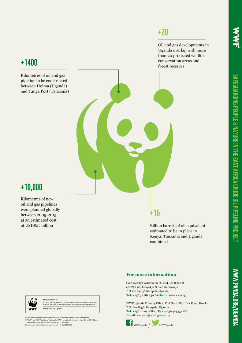
WWF Uganda Country Office, Plot No. 2, Sturrock Road, KololoP.O. Box 8758, Kampala, UgandaTel: +256 20 051 0800, Fax: +256 414 531 166Email: [email protected]
For more information:
WWF-Uganda @WWFUganda
SAFEGUARDING PEOPLE & NATURE IN THE EAST AFRICA CRUDE OIL PIPELINE PROJECT WWW.PANDA.ORG/UGANDA
Kilometres of oil and gas pipeline to be constructed between Hoima (Uganda) and Tanga Port (Tanzania)
Billion barrels of oil equivalent estimated to be in place in Kenya, Tanzania and Uganda combined
Kilometres of new oil and gas pipelines were planned globally between 2005-2015 at an estimated cost of USD$27 billion
+1400
+16
+10,000
Oil and gas developments in Uganda overlap with more than 20 protected wildlife conservation areas and forest reserves
+20
Civil society Coalition on Oil and Gas (CSCO)c/o Plot 96, Kanyokya Street, KamwokyaP.O Box 29836 Kampala-UgandaTel: +256 31 281 250, Website: www.csco.ug


![Mining insights from text - Python · February crude OSPs in Asia [nL3E7NS3R5] > Ghana latest in Africa to cut fuel subsidies ... oil crude product output export produc oilfield boost](https://img.pdfslide.us/doc/110x75/5f020fe87e708231d40262fa/mining-insights-from-text-python-february-crude-osps-in-asia-nl3e7ns3r5-.jpg)