Embed Size (px)
Citation preview
i
d
August 2014
Leon County Public Schools
Safe Routes to School Audit Report Montford Middle School
Safe Routes to School Audit Report
Leon County Schools MONTFORD MIDDLE SCHOOL i
Table of Contents Acknowledgements ...................................................................................................................................... iii
Chapter 1: Introduction ................................................................................................................................ 1
Project Purpose ......................................................................................................................................... 1
School Overview ....................................................................................................................................... 1
School Zone ............................................................................................................................................... 1
Chapter 2: On-Site Meeting and Inventory ................................................................................................... 3
Date and Weather Conditions .................................................................................................................. 3
Highlights and Key Observations of On-Site Meeting ............................................................................... 3
Circulation ............................................................................................................................................. 3
Inventory Map ....................................................................................................................................... 4
Issues and Opportunities ...................................................................................................................... 6
Chapter 3: Student Travel Survey – Summary of Results ............................................................................. 7
Chapter 4: Parent Survey – Summary of Results .......................................................................................... 8
Chapter 5: Neighborhood Field Review ........................................................................................................ 9
Character of Neighborhood Area .............................................................................................................. 9
Crash Data ................................................................................................................................................. 9
Neighborhood Assessment ..................................................................................................................... 11
Walk/Bike Shed ....................................................................................................................................... 11
Methodology ...................................................................................................................................... 11
Evaluating Roadways ........................................................................................................................ 12
Evaluating Other Factors and Barriers ............................................................................................ 13
Chapter 6: Findings and Recommendations ............................................................................................... 15
Infrastructure Improvements ................................................................................................................. 15
On-Site Recommendations ................................................................................................................. 17
Off-Site Recommendations ................................................................................................................. 17
Programs ................................................................................................................................................. 19
Policies .................................................................................................................................................... 19
Planning-Level Cost Estimates ................................................................................................................ 21
Chapter 7: Conclusion ................................................................................................................................. 22
Appendix A: Student Travel Survey ............................................................................................................. 24
Safe Routes to School Audit Report
Leon County Schools MONTFORD MIDDLE SCHOOL ii
Appendix B: Student Travel Survey – Detailed Analysis ............................................................................. 25
Appendix C: Parent Survey .......................................................................................................................... 27
Appendix D: Parent Survey – Detailed Analysis .......................................................................................... 29
Safe Routes to School Audit Report
Leon County Schools MONTFORD MIDDLE SCHOOL iii
Acknowledgements Renaissance Planning Group and Wendy Grey Land Use Planning, LLC would like to thank the following
organizations for their input, guidance, and resources in developing this Safe Routes to School Audit
report for Montford Middle School.
Capital Region Transportation Planning Agency (CRTPA)
Safe Routes to School (SRTS) National Partnership
Leon County Public Schools (LCS)
Florida Department of Transportation (FDOT)
Leon County Sheriff’s Office (LCSO)
Prepared By:
Safe Routes to School Audit Report
Leon County Schools MONTFORD MIDDLE SCHOOL 1
Chapter 1: Introduction
Project Purpose The purpose of this Safe Routes to School (SRTS) audit report is to provide recommendations to improve
student walking and bicycling rates to and from school. In addition, this report addresses other
enhancements to improve the overall travel safety and convenience for students, parents and the
school. Improvement recommendations are provided in the following categories: infrastructure,
programs, and polices. This SRTS audit includes an array of considerations formulated from a range of
research and analytical tools employed to better understand and comprehend the issues and concerns
affecting current walking and bicycling rates of student to and from school. This report highlights a
summary of students’ school travel patterns through in-class student travel surveys, parent self-
reported surveys, on-site meetings with school officials, and field reviews.
School Overview Montford Middle School is located at 5789 Pimlico Drive, Tallahassee, 32309 in Leon County, Florida. It
is part of the Leon County Public Schools system. Regular school hours are from 9:30am to 3:50pm. A
before school program is offered from 7:45am to 9:00am. In addition, an after school program is
available from 4:00pm to 6:00pm.
The number of students enrolled at the school, for the 2013 school year, was 1,140. The school has a
current capacity for 584 students. The school includes grade levels 6th to 8th grade.
Students attending this school feed from Desoto Trail, Gilchrist, W.T. Moore, and Roberts Elementary
Schools and either to Chiles or Lincoln High Schools.
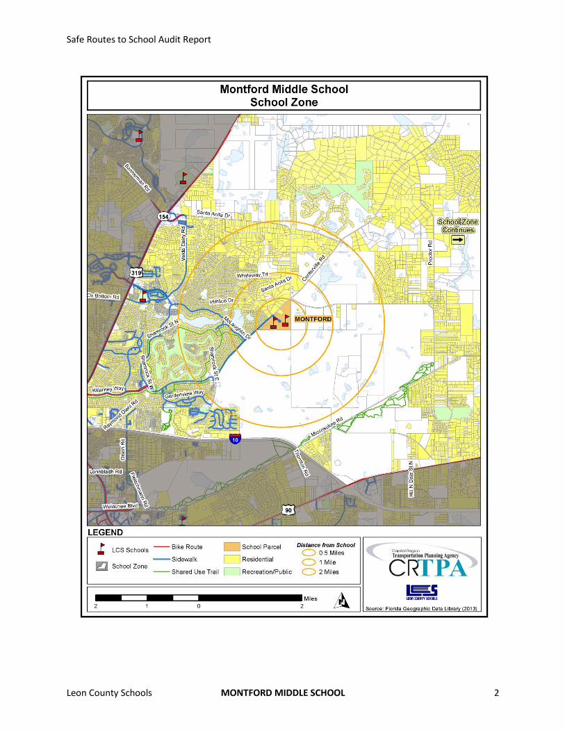
School Zone The Montford Middle school zone, located in northeastern Leon County, encompasses the
neighborhoods of Sawgrass Plantation, Killearn Estates, Whitfield Plantation, Royal Oaks, Foxcroft,
Killearn Acres, and Tredington Park. Land uses in the school zone are predominantly residential with
some recreation uses. However, a significant portion of the school zone is vacant. The Montford school
zone includes three major roadways. Interstate-10 runs east to west and borders the zone to the south.
Thomasville Road runs slightly southwest to northeast and borders the zone to the west. Centerville
Road also runs slightly southwest to northeast and bisects the zone into east and west. There are two
other Leon County schools within the zone including Roberts Elementary School on Pimlico Drive and
Desoto Trail Elementary School on Velda Dairy Road. Recreational facilities within the school zone
include the Miccosukee Greenway Trail and the Killearn golf course.
Safe Routes to School Audit Report
Leon County Schools MONTFORD MIDDLE SCHOOL 2
Safe Routes to School Audit Report
Leon County Schools MONTFORD MIDDLE SCHOOL 3
Chapter 2: On-Site Meeting and Inventory
Date and Weather Conditions The on-site inventory meeting was conducted on March 6th, 2013. The weather was cool with
temperatures in the 50 degrees Fahrenheit.
Highlights and Key Observations of On-Site Meeting During this visit, Montford Middle School representatives provided insight about students’ travel to and
from school and discussed what was working, or not working well. The meeting began by discussing
current policies, programs, and administration related to students’ travel to and from school. Examples
of safety education programs discussed include crossing guards, safety patrols, and traffic education.
Additionally, before- and after-school programs provided for students were discussed.
The school does not currently have a student safety patrol program or any bicycle or pedestrian safety
education programs. Only students in the before school program are permitted to arrive to school as
early as 7:45am; others cannot arrive until 8:45am. After-school programs are available until 6:00pm.
There are safety concerns with riding bicycles on sidewalks on campus. School administrators would
prefer students walk bicycles out to Pimlico Drive.
It was noted that flashing lights (i.e., school zone warning lights) are located along Centerville Road.
There are three designated crossing guards at the intersection of Centerville Road & Pimlico Drive, the
intersection of Centerville Road & McLaughlin Drive, as well as at the roundabout on Pimlico Drive
between Roberts Elementary School and Montford Middle School. The crossing guard at the roundabout
is paid for by Montford Middle School. School representatives noted that some parents pickup students
from the elementary school (Roberts) parking lot, which is not condoned by either school. Although, the
schools operate at different hours, this causes problems for school staff. Also, there is a problem with
some parents picking up their children at Centerville Road and Donnybrook Place, where is no actual
official parking area.
Circulation
During a tour of the school, school representatives provided explanations of school circulation patterns
as to where and how children were entering and exiting school grounds via walking or bicycle and
arriving and departing by automobile or school bus.
Walking and bicycling to the school has traditionally been fairly substantial. However, during the site
visit a trail that students and parents normally use to get to Pimlico Drive from Killearn Estates was
closed temporarily due to a City utility project. Walkers and bicyclists can only enter campus from
Pimlico Drive. The school has bicycle parking racks conveniently located near the front of the school.
The school bus drop-off and pick-up zone functions adequately and with direct access to a walking
facility. Additionally, the loading and unloading zone is mostly covered. It was also noted that a
temporary shuttle bus is being provided for those students who normally walk or bike to school but
cannot do so due to the City utility project occurring along the trail.
Safe Routes to School Audit Report
Leon County Schools MONTFORD MIDDLE SCHOOL 4
The parent drop-off and pick-up zone functions adequately to accommodate the volume of automobiles
entering and exiting the site. The loading/unloading zone is covered and there is direct access to a
walking facility. There is a holding area available for students waiting to be picked-up. It was noted that
the school handles about 600 automobiles daily.1
Inventory Map
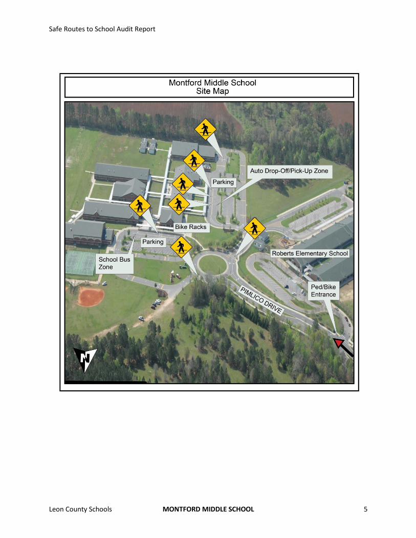
An aerial photograph showing Montford Middle School is located on the following page. As shown in
the photo, the school fronts Pimlico Drive. Students can access campus from Pimlico Drive via
Centerville Road (not pictured). Bicycle parking racks are located near the front entrance of the school.
Standard width sidewalks are located along both sides of Pimlico Drive, from Centerville Road to the
school, which connect directly to the school’s main entrance. Additionally, there are several crosswalks
in the immediate school property area that give students identified crossing zones through the Pimlico
Drive roundabout, automobile zone, and school bus zone. Pimlico Drive, north of Centerville Road, has
standard width sidewalks on only one side of the street. Additionally, there are standard width
sidewalks along the non-school (northwest) side of Centerville Road, southwest of Pimlico Drive.
The automobile pick-up and drop-off zone is located directly in front of the school’s main entrance.
Automobiles both enter and exit the zone from a shared driveway (with Roberts Elementary School)
along the roundabout at Pimlico Drive. Parking spaces are located in this area as well. The bus drop-off
and pick-up zone is separately located along the side of the school. Buses enter and exit the zone from a
shared driveway along the roundabout at Pimlico Drive. Additional parking spaces are located in this
area as well.
1 It was not specified if this was the typical number of automobiles for before or after the City utility project began.
Safe Routes to School Audit Report
Leon County Schools MONTFORD MIDDLE SCHOOL 5
Safe Routes to School Audit Report
Leon County Schools MONTFORD MIDDLE SCHOOL 6
Issues and Opportunities
School-specific issues, opportunities, and impediments concerning the SRTS program were discussed.
Geography appears to be the primary issue with students’ ability to walk and bicycle to school. A large
portion of the area surrounding the school to the south and east is vacant or farmland, thereby, limiting
the amount of residential housing within walking distance for middle school children. This kind of
external factor is not something that will change in the short-term; however, there are opportunities to
increase walking and bicycling infrastructure to and from existing surrounding housing west of
Centerville Road.
With what opportunities that do exist to increase walking and bicycling, including student safety,
consideration should be especially given to Centerville Road and Pimlico Drive. Traffic calming measures
should be explored to reduce automobile speeds and increase awareness of children in the area,
especially during school commuting times. Also, school-related and –supportive committees such as the
Parent/Teacher Organization (PTO) can be used to help educate parents on the opportunities and
benefits to having their children walk or bicycle to school, where such options are feasible.
These same groups can also help get the word out to parents of both Montford Middle School and
Roberts Elementary School, concerning on-campus (and off-campus) issues, such as appropriate
behavior and protocol for dropping-off and picking-up students. There is the possibility of reconfiguring
the parking area for the two schools, as a way to make the current ad hoc situation work more
efficiently. In the mean time, continued education and enforcement during the morning and afternoon
commute hours are critical.
Safe Routes to School Audit Report
Leon County Schools MONTFORD MIDDLE SCHOOL 7
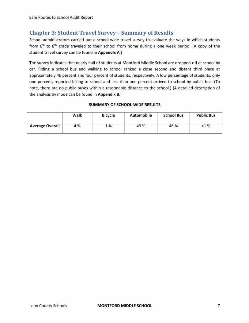
Chapter 3: Student Travel Survey – Summary of Results School administrators carried out a school-wide travel survey to evaluate the ways in which students
from 6th to 8th grade traveled to their school from home during a one week period. (A copy of the
student travel survey can be found in Appendix A.)
The survey indicates that nearly half of students at Montford Middle School are dropped-off at school by
car. Riding a school bus and walking to school ranked a close second and distant third place at
approximately 46 percent and four percent of students, respectively. A low percentage of students, only
one percent, reported biking to school and less than one percent arrived to school by public bus. (To
note, there are no public buses within a reasonable distance to the school.) (A detailed description of
the analysis by mode can be found in Appendix B.)
SUMMARY OF SCHOOL-WIDE RESULTS
Walk Bicycle Automobile School Bus Public Bus
Average Overall 4 % 1 % 49 % 46 % <1 %
Safe Routes to School Audit Report
Leon County Schools MONTFORD MIDDLE SCHOOL 8
Chapter 4: Parent Survey – Summary of Results School administrators carried out a school-wide survey to better understand the neighborhood safety
issues and concerns of parents and the factors influencing their decision to allow their children to walk
or bicycle to school. (A copy of the parent survey can be found in Appendix C.)
Parent survey results were counted and analyzed by grade level groupings of 6th-8th Grade. (A detailed
description of results for the parent surveys can be found in Appendix D.)
The surveys of students living within two miles from the school indicate that a greater percentage of
Montford Middle School students arrive to school by car in the morning, while fewer return home by
the same mode in the afternoon. The car-to-school average for a typical week is 42% in the morning and
decreases to 31% in the afternoon. In the afternoon, there are a greater percentage of students
returning walking. Overall, approximately one out of three students commutes to and from school by
walking or biking. The school bus-to-school average for a typical week is 25% in both the morning and
afternoon. The walk-to-school and bike-to-school averages for a typical week are 19% and 15% in the
morning and 29% and 15% in the afternoon, respectively. None of the students rode a public bus or
used an alternative commute mode in the morning or afternoon.
Neighborhood safety concerns for parents of middle-school-aged (6th-8th) children include three main
concerns including issues with speeding vehicles, sidewalks/walking, and transportation outside of the
school zone. There were 15 comments of concern regarding issues with speeding vehicles. Specific
locations where high-speed vehicles tend to be a problem are Pimlico Drive, Centerville Drive, and
Bradfordville Road. Parents also mention vehicles speeding in the school zone and residential
neighborhoods such as Donnybrook in Killearn Estates. Additionally, there were 12 comments of
concern regarding issues with sidewalks and walking. General concerns include the lack of sidewalks,
sidewalks too close to major roads, and walk routes that are isolated due to woods. Lastly, there were
four comments of concern regarding issues with transportation outside of the school zone.
With regard to factors that might influence their decision to allow their child to walk or bike to school,
survey responses indicate that factors such as having separated and continuous bicycle/pedestrian
pathways, accompanying children (other children), having a greater adult presence along walk routes to
school, and enforcing speeding limits were agreed upon by parents from 6th-8th grade.
Safe Routes to School Audit Report
Leon County Schools MONTFORD MIDDLE SCHOOL 9
Chapter 5: Neighborhood Field Review A neighborhood field review was conducted on February 26th, 2013. The review consisted of an
assessment of accessibility, connectivity and safety along neighborhood roadways within proximity to
Montford Middle School. On the day of the field review, the weather was rainy with temperatures in
the mid 60’s degrees Fahrenheit. Following the field review, a walk/bike shed area was delineated on a
map within the school zone, surrounding the school. This chapter includes a Walk/Bike Shed section
describing the approach to defining the area and an associated map for Montford Middle School.
Character of Neighborhood Area Montford Middle School is located in a mostly suburban residential neighborhood primarily comprised
of low-density, single-family homes. The neighborhood street pattern throughout the area is mostly
residential cul-de-sacs and curved streets that connect to residential collector roadways in a semi-
gridded manner. For the most part, there is a pretty good sidewalk network on streets that are busiest.
Streets without sidewalks in the neighborhoods are still very walkable due to low traffic volumes and
their residential nature. However, most roads northeast, past Pimlico Drive, are not suitable for walking
or bicycling due to the lack of bike/ped infrastructure and higher speeds. The shared-use Killearn Trails
run throughout the Killearn Country Club neighborhood and extend along Centerville Road to the
school, providing a well-connected bike-ped network throughout the neighborhood.
A major roadway in the school zone includes:
Centerville Road, a two-lane undivided roadway with a posted speed limit of 35mph.
Bradfordville Road, a two-lane undivided roadway with a posted speed limit of 35 mph.
Crash Data Crash data were collected from the Florida Department of Transportation’s (FDOT) State Safety Office
for years 2009-2011. Crashes reported include any crashes within Leon County and on any local and
major roadways. The data were collected for a typical school year, August 15th to May 30th. Additionally,
only bicycle and pedestrian crashes that occurred during typical school commute hours, 7:00A to 9:30A
and 1:50P to 4:20P, and school days, Monday to Friday, were examined.
There was one bicycle crash that occurred within the theoretical two-mile walk/bike radius of Montford
Middle School. The crash occurred during the afternoon and injuries were reported. The crash involved
a child and occurred at the intersection of Centerville Road and Pimlico Drive, immediately in front of
Montford Middle School.
SUMMARY OF CRASH REPORTS (2009-2011)
Date Time Day On Road Nearest Intersection
Injury or Fatality?
Type of Crash
Person(s) Involved
05/05/11 4:15P Thursday Centerville Rd.
Pimlico Dr. Injury Bicyclist Child
Safe Routes to School Audit Report
Leon County Schools MONTFORD MIDDLE SCHOOL 10
Safe Routes to School Audit Report
Leon County Schools MONTFORD MIDDLE SCHOOL 11
Neighborhood Assessment Montford Middle School can be considered a neighborhood school, in part, as it services surrounding
nearby neighborhoods within relative close proximity. However, the school’s campus on the southeast
side of Centerville Road, opposite of the neighborhoods within proximity, does pose certain safety
concerns, as students are required to cross an active major roadway for access. The current pedestrian
and bicycle infrastructure along Pimlico Drive and Centerville Road, southwest of Pimlico Drive, help to
improve the safety and accessibility tremendously. Unfortunately, however, neighborhoods within a
reasonable walking and bicycling distance to the northwest along Bradfordville Road and northeast
along Centerville Road are not so fortunate.
Project-specific recommendations can be found in the Findings and Recommendations chapter of this
report.
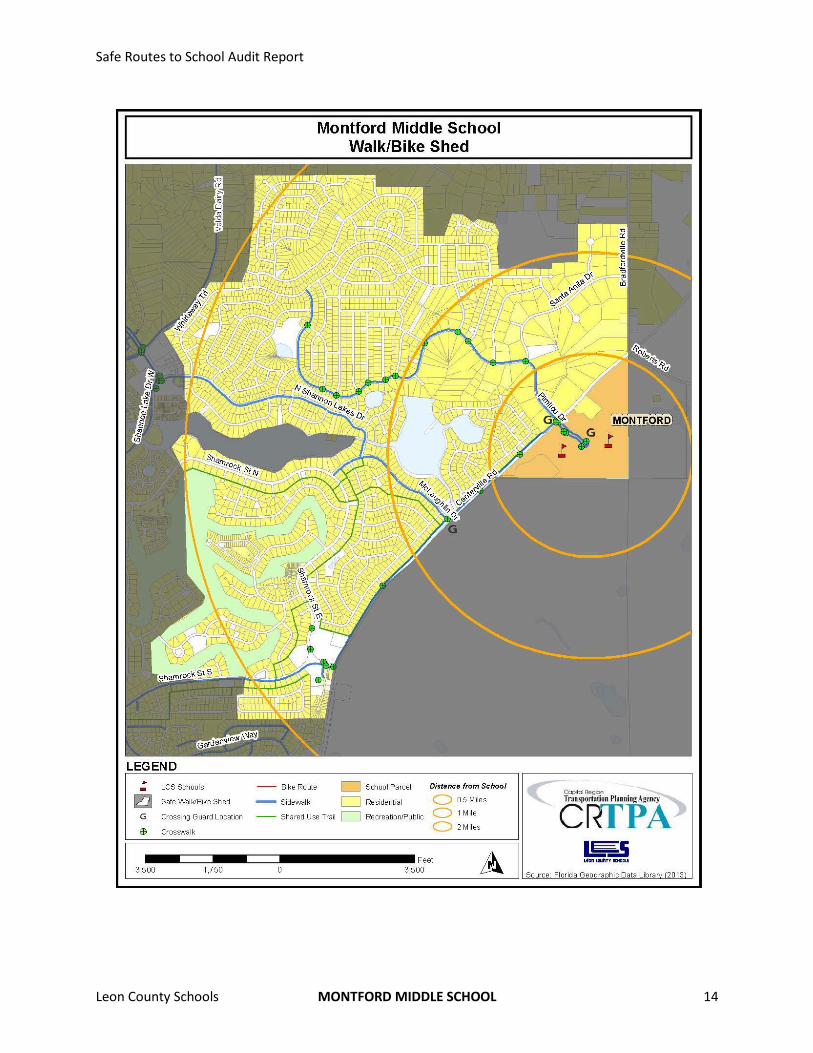
Walk/Bike Shed As mentioned previously, a walk/bike shed area was delineated on a map within the school zone,
surrounding the school. The Montford Middle School walk/bike shed map is included on page 14.
The walk/bike shed area and associated map are not meant to suggest that middle school students of all
ages, maturity level, and experience should commute to and/or from school within the area delineated.
Certainly, all students are not expected to walk or bike to school from practically any distance without
the accompaniment of either a parent or older sibling. Also, students without the appropriate
experience or maturity level will likewise be more limited in their accessibility to school. Therefore, the
walk/bike shed map functions more as a guide for parents, school administrators and students to
evaluate and identify areas potentially commutable and conducive to walking and bicycling to school.
The final decision to walk or bicycle to school is still at the discretion of the parents.
The walk/bike shed for Montford Middle School mostly extends west and southwest from the school.
Centerville Road generally forms the eastern limits of the walk/bike shed because there is a lack of
residential land uses to the east. Considering the distance middle-school-aged students can be expected
to travel on foot or bicycle, the walk/bike shed extends approximately two miles west of Centerville
Road into the Killearn Acres and Killearn Estates neighborhoods where there are local, neighborhood
streets. Neighborhoods further north of Killearn Acres were excluded from the walk/bike shed due
primarily to their lack of thru streets.
It should be noted that certain improvement recommendations could potentially expand the potential
walk/bike shed area, due to improved conditions for walking and bicycling.
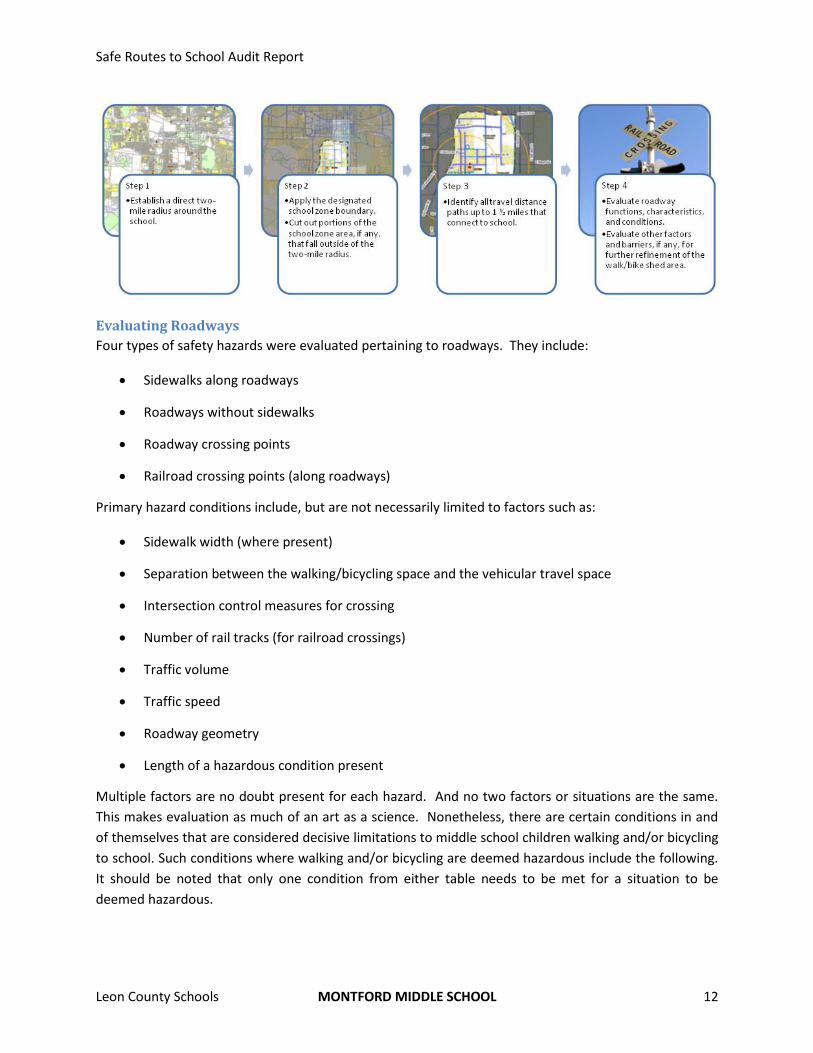
Methodology
Many factors were evaluated to ultimately determine the limits of the walk/bike shed area. The general
methodology for identifying the shed included the following steps:
Safe Routes to School Audit Report
Leon County Schools MONTFORD MIDDLE SCHOOL 12
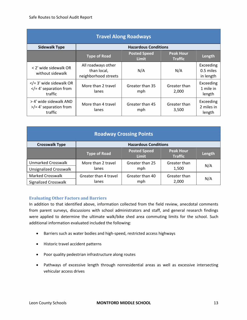
Evaluating Roadways
Four types of safety hazards were evaluated pertaining to roadways. They include:
Sidewalks along roadways
Roadways without sidewalks
Roadway crossing points
Railroad crossing points (along roadways)
Primary hazard conditions include, but are not necessarily limited to factors such as:
Sidewalk width (where present)
Separation between the walking/bicycling space and the vehicular travel space
Intersection control measures for crossing
Number of rail tracks (for railroad crossings)
Traffic volume
Traffic speed
Roadway geometry
Length of a hazardous condition present
Multiple factors are no doubt present for each hazard. And no two factors or situations are the same.
This makes evaluation as much of an art as a science. Nonetheless, there are certain conditions in and
of themselves that are considered decisive limitations to middle school children walking and/or bicycling
to school. Such conditions where walking and/or bicycling are deemed hazardous include the following.
It should be noted that only one condition from either table needs to be met for a situation to be
deemed hazardous.
Safe Routes to School Audit Report
Leon County Schools MONTFORD MIDDLE SCHOOL 13
Travel Along Roadways
Sidewalk Type Hazardous Conditions
Type of Road Posted Speed
Limit Peak Hour
Traffic Length
< 2' wide sidewalk OR without sidewalk
All roadways other than local,
neighborhood streets N/A N/A
Exceeding 0.5 miles in length
</= 3' wide sidewalk OR </= 4' separation from
traffic
More than 2 travel lanes
Greater than 35 mph
Greater than 2,000
Exceeding 1 mile in length
> 4' wide sidewalk AND >/= 4' separation from
traffic
More than 4 travel lanes
Greater than 45 mph
Greater than 3,500
Exceeding 2 miles in
length
Roadway Crossing Points
Crosswalk Type Hazardous Conditions
Type of Road Posted Speed
Limit Peak Hour
Traffic Length
Unmarked Crosswalk More than 2 travel lanes
Greater than 25 mph
Greater than 1,500
N/A Unsignalized Crosswalk
Marked Crosswalk Greater than 4 travel lanes
Greater than 40 mph
Greater than 2,000
N/A Signalized Crosswalk
Evaluating Other Factors and Barriers
In addition to that identified above, information collected from the field review, anecdotal comments
from parent surveys, discussions with school administrators and staff, and general research findings
were applied to determine the ultimate walk/bike shed area commuting limits for the school. Such
additional information evaluated included the following:
Barriers such as water bodies and high-speed, restricted access highways
Historic travel accident patterns
Poor quality pedestrian infrastructure along routes
Pathways of excessive length through nonresidential areas as well as excessive intersecting
vehicular access drives
Safe Routes to School Audit Report
Leon County Schools MONTFORD MIDDLE SCHOOL 14
Safe Routes to School Audit Report
Leon County Schools MONTFORD MIDDLE SCHOOL 15
Chapter 6: Findings and Recommendations The existing points of access for walkers and bicyclists to Montford Middle School provide efficient
access onto campus. Pimlico Drive was designed specifically to accommodate such functions. This is
also true for those requiring or desiring automobile or school bus access. The sole roadway corridor
linking to Pimlico Drive is Centerville Road, for which school representatives expressed concerns with
speeding automobiles. Other than Centerville Road, there appear to be few issues with safety or
convenience relative to walking and bicycling to Montford Middle School.
The primary issues experienced by school representatives include bicycles riding along sidewalks on
campus; parents parking near the Centerville Road and Donnybrook Place intersection to pick-up
students; and parents using the Roberts Elementary School parking lot to pick up students so to avoid
the official drop-off / pick-up zone. Regarding the latter, even though the schools operate at different
hours, this causes problems for school staff. It would benefit both schools to work together to study the
issues and come up with joint solutions to resolve the problem.
School-related and –supportive committees such as the Parent/Teacher Organization (PTO) can be used
to help educate parents on the opportunities and benefits to having their children walk or bicycle to
school, where such options are feasible. These same groups can also help get the word out to parents
of both Roberts Elementary School and Montford Middle School concerning on-campus issues such as
appropriate behavior and protocol for dropping-off and picking-up students. This chapter includes some
policy and programmatic recommendations for the school’s consideration that might help to ease some
of these concerns while increasing walking and bicycling to and from school.
Finally, there is a sizeable area surrounding Montford Middle School that is currently used for
agriculture purposes or is vacant and undeveloped. It is uncertain as to how much, if any, of this land
will eventually be developed. Montford Middle School along with Roberts Elementary School and the
Leon County School Board should be prepared to engage future developers and local agencies regarding
desired pedestrian and bicycle-related infrastructure connections as well as automobile circulation plans
that could impact Pimlico Drive.
Infrastructure Improvements The following recommendations supplement the current walk/bike shed area as delineated on the map,
addressing infrastructure needs and improvements that would enhance walking and bicycling safety and
convenience to and from Montford Middle School. They include both on- and off-site improvements as
follows:
16
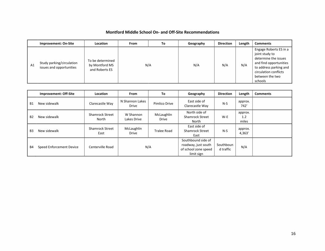
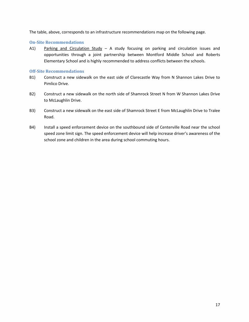
Montford Middle School On- and Off-Site Recommendations
Improvement: On-Site Location From To Geography Direction Length Comments
A1 Study parking/circulation issues and opportunities
To be determined by Montford MS and Roberts ES
N/A N/A N/A N/A
Engage Roberts ES in a joint study to determine the issues and find opportunities to address parking and circulation conflicts between the two schools
Improvement: Off-Site Location From To Geography Direction Length Comments
B1 New sidewalk Clarecastle Way N Shannon Lakes
Drive Pimlico Drive
East side of Clarecastle Way
N-S approx.
742’
B2 New sidewalk Shamrock Street
North W Shannon Lakes Drive
McLaughlin Drive
North side of Shamrock Street
North W-E
approx. 1.2
miles
B3 New sidewalk Shamrock Street
East McLaughlin
Drive Tralee Road
East side of Shamrock Street
East N-S
approx. 4,363’
B4 Speed Enforcement Device Centerville Road N/A
Southbound side of roadway, just south
of school zone speed limit sign
Southbound traffic
N/A
17
The table, above, corresponds to an infrastructure recommendations map on the following page.
On-Site Recommendations
A1) Parking and Circulation Study – A study focusing on parking and circulation issues and
opportunities through a joint partnership between Montford Middle School and Roberts
Elementary School and is highly recommended to address conflicts between the schools.
Off-Site Recommendations
B1) Construct a new sidewalk on the east side of Clarecastle Way from N Shannon Lakes Drive to
Pimlico Drive.
B2) Construct a new sidewalk on the north side of Shamrock Street N from W Shannon Lakes Drive
to McLaughlin Drive.
B3) Construct a new sidewalk on the east side of Shamrock Street E from McLaughlin Drive to Tralee
Road.
B4) Install a speed enforcement device on the southbound side of Centerville Road near the school
speed zone limit sign. The speed enforcement device will help increase driver’s awareness of the
school zone and children in the area during school commuting hours.
Safe Routes to School Audit Report
Leon County Schools MONTFORD MIDDLE SCHOOL 18
Safe Routes to School Audit Report
Leon County Schools MONTFORD MIDDLE SCHOOL 19
Programs C1) Walk and bicycle encouragement literature – While there exists a strong percentage of students
within a two-mile radius that commute by walking, rates can still be improved by sending home
literature to parents, as well as making it available on the school website, about the benefits of
children walking and bicycling to school. Information and statistics from the National Safe
Routes to School organization can be used to highlight health and safety benefits. The literature
provided to parents should highlight some specific examples of how parents and the community
can make walking and bicycling to school safe and fun. Examples of programs to promote
walking and bicycling include participating in Walk/Bike to School Days; creating a mileage club
where students or entire classrooms keep track of how much they walk or bike to school to
compete for prizes or certificates; and encouraging families who normally drive to school to look
for ways to safely and legally park in a parking lot away from school, but within walking distance,
and then walk to school from the lot.
C2) Bicycle safety and accessibility workshop – Bicycling at the middle school level is a great option.
Such rates could be further improved by organizing and holding a workshop or a bike rodeo that
demonstrates bicycle safety topics, catered to younger children, such as bicycle hand signals,
how to properly wear a bicycle helmet, and properly obeying traffic signs/signals. Parents and
students should be reminded that under Florida Law, anyone under the age of 16 must wear a
bicycle helmet. An on-campus bicycle obstacle course that covers skills such as avoiding
obstacles, balancing at slow speeds, turning, and making emergency stops can be very helpful
for young riders. Additionally, a group bicycle ride, through the neighborhood surrounding the
school, can be a safe and fun way to get children more comfortable with their built environment
and any obstacles they may encounter en route to school. Local community groups, as well as,
Leon County Sheriff’s Office, and Leon County Public Schools may be willing to donate time and/
or supplies such as bikes, helmets, and locks for workshops and rodeos if contacted.
C3) Parent drop-off/pick-up zone protocol encouragement– Send home literature to parents, as well
as make it available on the school website, about the proper drop-off and pick-up process for
the school, particularly at the start of a new school year or after an extended school break.
Maps of the drop-off/pick-up zone, as well as, the traffic flow pattern can be very helpful to
parents. The literature available to parents should remind them to be patient and courteous to
other drivers and clearly discourage parents from letting children out in the parking lot outside
the drop zone, releasing them on the side of the road, or parking on the side of the road (to wait
for their child). Providing small rewards to students whose parents follow the proper drop-
off/pick-up process is typically more beneficial than punishing improper behavior. If necessary,
educational flyers could be placed on the windshields of vehicles illegally parked to remind
parents of the proper rules and procedures.
Policies D1) School-Specific Safe Routes Coordinator/Advisor – Both Montford Middle School and Roberts
Elementary School could benefit from having a safe routes coordinator to help accomplish
Safe Routes to School Audit Report
Leon County Schools MONTFORD MIDDLE SCHOOL 20
projects, jumpstart programs and implement polices to improve and diversify student
commuting options and increase student safety. Given the shared proximity between the two
schools, this role could be a combined role between them both and would not require a fulltime
staff commitment to safe routes-related issues and needs and, thus, could possibly be
performed by an existing school administrator or staff member. The safe routes coordinator
would also advocate for improvements and changes before the School Board and other various
agencies with transportation and funding responsibilities throughout the County. In addition,
the safe routes coordinator could be assigned with seeking out potential funding sources and
completing grant applications.
D2) Increased enforcement along Centerville Road – There are concerns with vehicles speeding
along Centerville Road during drop-off and pick-up times. While this may be impacting student
walking and bicycling rates, it also exposes a safety issue that should be addressed. Greater
enforcement along with speed awareness could increase safety and improve walking and
bicycling rates to and from school. Also, random, however persistent, enforcement of speed
limits along Centerville Road could help to increase speed compliance overall. Also, speed
record/reveal trailers that show motorists how fast they are traveling could be placed along
Centerville Road, both north and south of Pimlico Drive. These temporary sign devices are
known to improve speed limit compliance.
D3) Bike check and security – School policies to encourage bicycle riding could include having a
school official or parent volunteer at the bike parking area in the morning and afternoon to
check-in and check-out students parking their bikes. The adult assigned to handle check-in and
check-out will assist with locking the bike in the morning and will unlock the bike for the
students in the afternoon. For further encouragement, the school should consider investing in
basic, school-owned bike locks that can be applied when students check-in. By having locks
available at school, students do not need to remember to bring one each day. Basic locks can be
purchased fairly cheap.
Safe Routes to School Audit Report
Leon County Schools MONTFORD MIDDLE SCHOOL 21
Planning-Level Cost Estimates Planning-level cost estimates are included in the table, below. They are intended to be used as a guide.
Specific, detailed cost estimates for individual projects will require closer assessment of project
conditions and constructability at the time of improvement.
General Unit Cost Estimates2
Item Assumptions Unit Average
Unit Cost ($)
sidewalk concrete sidewalk (5’ wide) linear foot 32
sidewalk concrete sidewalk + curb (5’ wide) linear foot 150
shared-use path multi-use trail – paved (at least 8’ wide) mile 481,140
shared-use path multi-use trail – unpaved (at least 8’ wide) mile 121,390
pavement symbol pedestrian crossing Each 360
pavement symbol shared lane/bicycle marking each 180
pavement symbol school crossing each 470
paved shoulder asphalt material square foot 5.56
crosswalk high visibility crosswalk (ladder or zebra striping) each 2,540
crosswalk standard parallel lines crosswalk each 770
signage bike route sign each 160
signage stop/yield sign each 300
signage no turn on red (standard metal sign) each 220
signage no turn on red (electronic sign) each 3,200
signage trail regulation sign each 160
speed trailer temporary sign board that display the speed of passing vehicles each 9,510
flashing beacon standard beacon (system + labor/materials) each 10,010
flashing beacon rectangular rapid flashing beacon (system + labor/materials) each 22,250
ped hybrid beacon high intensity activated crosswalk (HAWK) signal each 57,680
ped/bike detection push button each 350
signal audible pedestrian signal each 800
signal countdown timer module each 740
2 Bushell, M. A., Poole, B. W., Zegeer, C. V., & Rodriuez, D. A. (2013). Costs for Pedestrian and Bicyclist Infrastructure Improvements: A Resource for Researchers, Engineers, Planners, and the General Public. Federal Highway Administration.
Safe Routes to School Audit Report
Leon County Schools MONTFORD MIDDLE SCHOOL 22
Chapter 7: Conclusion While Montford Middle School is situated off of Centerville Road, along the opposite side of most
walkable and bikeable neighborhoods, the pedestrian infrastructure connecting it is mostly adequate to
support students walking and bicycling to and from school. This convenience is reflected somewhat in
the walking and bicycling rates to and from school. Overall, over one-third of students commute to and
from school by either walking or bicycling. Compared to other schools in Leon County, this rate is
admirable; however, there still exists a sizeable cohort that could be encouraged.
One thing made clear by parents is there concerns with speeding vehicles, sidewalks/walking, and
transportation outside of the school zone. Factors influencing their decisions to allow their children to
walk or bike to school include things such as having separated and continuous bicycle/pedestrian
pathways, accompanying children (other children), having a greater adult presence along walk routes to
school, and enforcing speeding limits. The recommendations included in this report attempt to address
many of the sentiments expressed by parents.
It’s worth noting that the multi-use trail along Centerville Road is well-separated and buffered from
automobile traffic. Also, the design of this facility is, in fact, ideal for mixing motorized and non-
motorized traffic along busy roadways. Either way, Centerville Road is a fairly busy roadway that
encourages elevated speeds for motorists commuting to and from downtown. Regardless of walk-bike
facility quality, automobile traffic can still understandably standout as an influential factor in deciding
how a child commutes to school.
There are proven health benefits to children riding and bicycling to school. Besides the obvious physical
fitness benefits, it has been shown that children who walk and bike to school are more alert and
comprehensive in their daily learning. This is another point of education that is beneficial for parents
and educators to know, as indicated in the Findings and Recommendations chapter.
Montford Middle School has most of the physical elements to improve walking and bicycling to school.
Not to mention, the school is well organized when it comes to procedure and assistance in getting kids
on and off campus safely and efficiently. There are, however, a few measures that should be explored
to help improve overall walking and bicycling rates to and from school, as laid out in the previous
chapter. These measures along with what is already occurring in and around Montford Middle School
will no doubt help to improve walking and bicycling safety and increase non-motorized commuting
rates.
Safe Routes to School Audit Report
Leon County Schools MONTFORD MIDDLE SCHOOL 23
Appendices
Safe Routes to School Audit Report
Leon County Schools MONTFORD MIDDLE SCHOOL 24
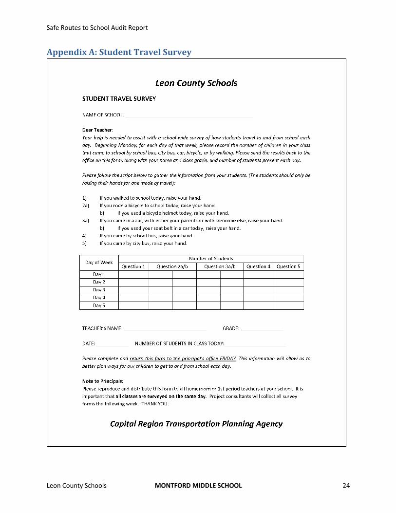
Appendix A: Student Travel Survey
Safe Routes to School Audit Report
Leon County Schools MONTFORD MIDDLE SCHOOL 25
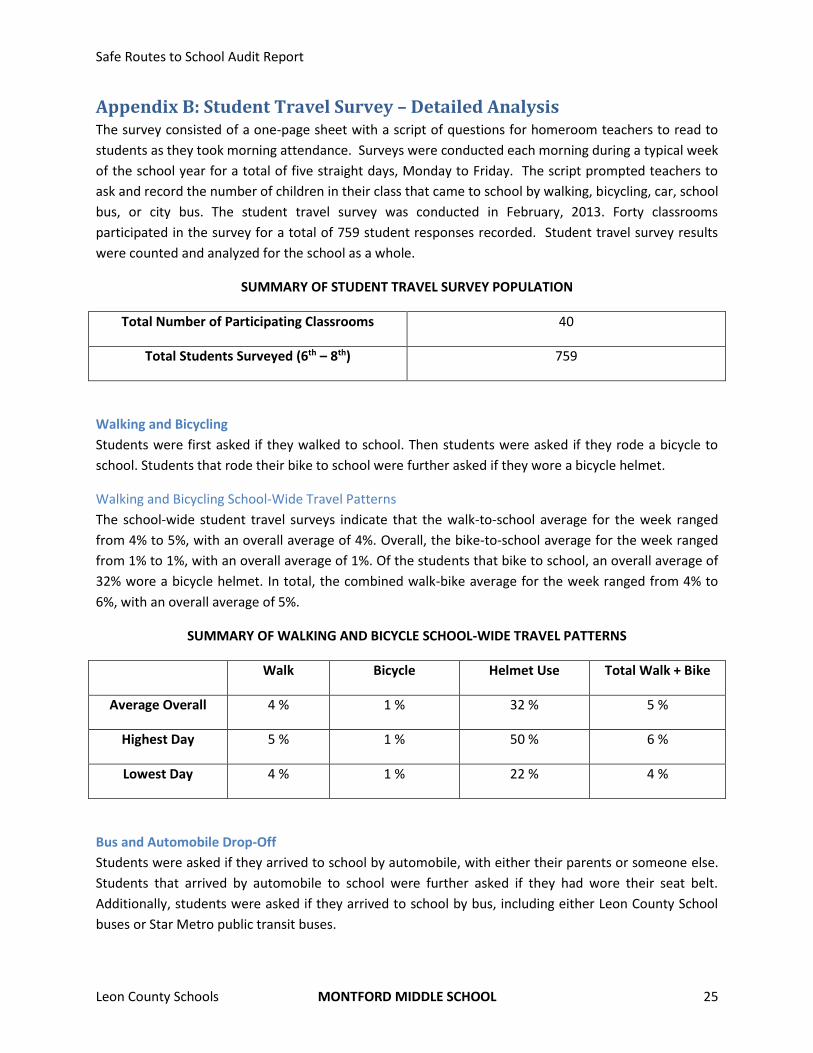
Appendix B: Student Travel Survey – Detailed Analysis The survey consisted of a one-page sheet with a script of questions for homeroom teachers to read to
students as they took morning attendance. Surveys were conducted each morning during a typical week
of the school year for a total of five straight days, Monday to Friday. The script prompted teachers to
ask and record the number of children in their class that came to school by walking, bicycling, car, school
bus, or city bus. The student travel survey was conducted in February, 2013. Forty classrooms
participated in the survey for a total of 759 student responses recorded. Student travel survey results
were counted and analyzed for the school as a whole.
SUMMARY OF STUDENT TRAVEL SURVEY POPULATION
Total Number of Participating Classrooms 40
Total Students Surveyed (6th – 8th) 759
Walking and Bicycling
Students were first asked if they walked to school. Then students were asked if they rode a bicycle to
school. Students that rode their bike to school were further asked if they wore a bicycle helmet.
Walking and Bicycling School-Wide Travel Patterns
The school-wide student travel surveys indicate that the walk-to-school average for the week ranged
from 4% to 5%, with an overall average of 4%. Overall, the bike-to-school average for the week ranged
from 1% to 1%, with an overall average of 1%. Of the students that bike to school, an overall average of
32% wore a bicycle helmet. In total, the combined walk-bike average for the week ranged from 4% to
6%, with an overall average of 5%.
SUMMARY OF WALKING AND BICYCLE SCHOOL-WIDE TRAVEL PATTERNS
Walk Bicycle Helmet Use Total Walk + Bike
Average Overall 4 % 1 % 32 % 5 %
Highest Day 5 % 1 % 50 % 6 %
Lowest Day 4 % 1 % 22 % 4 %
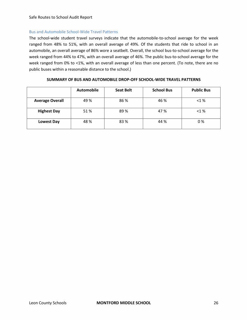
Bus and Automobile Drop-Off
Students were asked if they arrived to school by automobile, with either their parents or someone else.
Students that arrived by automobile to school were further asked if they had wore their seat belt.
Additionally, students were asked if they arrived to school by bus, including either Leon County School
buses or Star Metro public transit buses.
Safe Routes to School Audit Report
Leon County Schools MONTFORD MIDDLE SCHOOL 26
Bus and Automobile School-Wide Travel Patterns
The school-wide student travel surveys indicate that the automobile-to-school average for the week
ranged from 48% to 51%, with an overall average of 49%. Of the students that ride to school in an
automobile, an overall average of 86% wore a seatbelt. Overall, the school bus-to-school average for the
week ranged from 44% to 47%, with an overall average of 46%. The public bus-to-school average for the
week ranged from 0% to <1%, with an overall average of less than one percent. (To note, there are no
public buses within a reasonable distance to the school.)
SUMMARY OF BUS AND AUTOMOBILE DROP-OFF SCHOOL-WIDE TRAVEL PATTERNS
Automobile Seat Belt School Bus Public Bus
Average Overall 49 % 86 % 46 % <1 %
Highest Day 51 % 89 % 47 % <1 %
Lowest Day 48 % 83 % 44 % 0 %
Safe Routes to School Audit Report
Leon County Schools MONTFORD MIDDLE SCHOOL 27
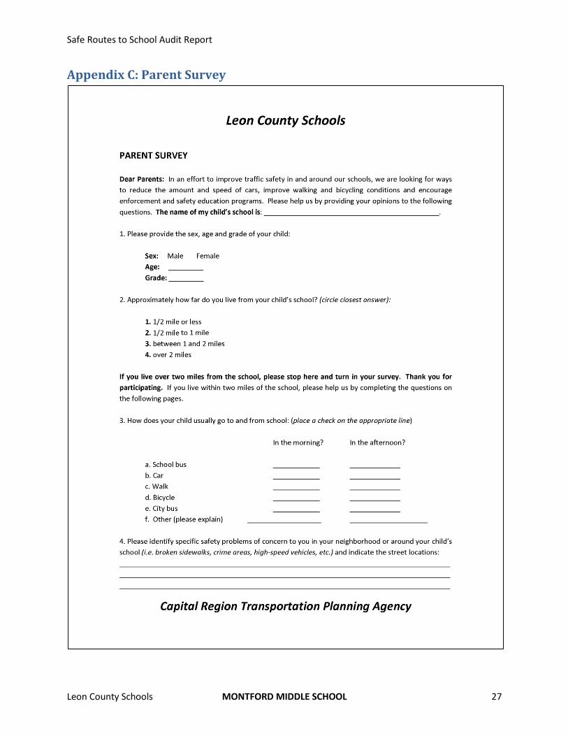
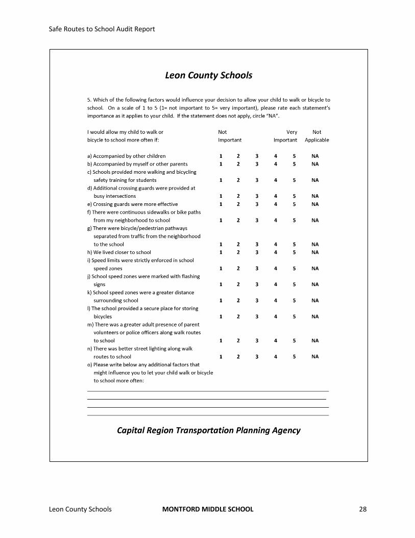
Appendix C: Parent Survey
Safe Routes to School Audit Report
Leon County Schools MONTFORD MIDDLE SCHOOL 28
Safe Routes to School Audit Report
Leon County Schools MONTFORD MIDDLE SCHOOL 29
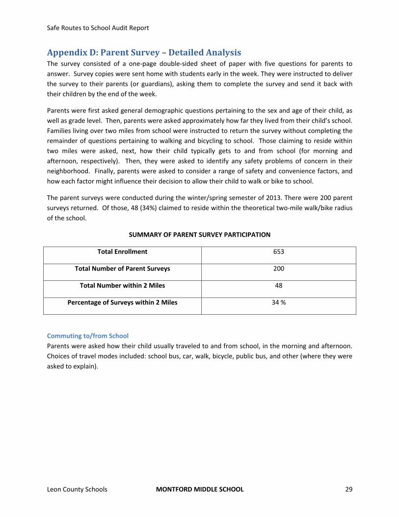
Appendix D: Parent Survey – Detailed Analysis The survey consisted of a one-page double-sided sheet of paper with five questions for parents to
answer. Survey copies were sent home with students early in the week. They were instructed to deliver
the survey to their parents (or guardians), asking them to complete the survey and send it back with
their children by the end of the week.
Parents were first asked general demographic questions pertaining to the sex and age of their child, as
well as grade level. Then, parents were asked approximately how far they lived from their child’s school.
Families living over two miles from school were instructed to return the survey without completing the
remainder of questions pertaining to walking and bicycling to school. Those claiming to reside within
two miles were asked, next, how their child typically gets to and from school (for morning and
afternoon, respectively). Then, they were asked to identify any safety problems of concern in their
neighborhood. Finally, parents were asked to consider a range of safety and convenience factors, and
how each factor might influence their decision to allow their child to walk or bike to school.
The parent surveys were conducted during the winter/spring semester of 2013. There were 200 parent
surveys returned. Of those, 48 (34%) claimed to reside within the theoretical two-mile walk/bike radius
of the school.
SUMMARY OF PARENT SURVEY PARTICIPATION
Total Enrollment 653
Total Number of Parent Surveys 200
Total Number within 2 Miles 48
Percentage of Surveys within 2 Miles 34 %
Commuting to/from School
Parents were asked how their child usually traveled to and from school, in the morning and afternoon.
Choices of travel modes included: school bus, car, walk, bicycle, public bus, and other (where they were
asked to explain).
Safe Routes to School Audit Report
Leon County Schools MONTFORD MIDDLE SCHOOL 30
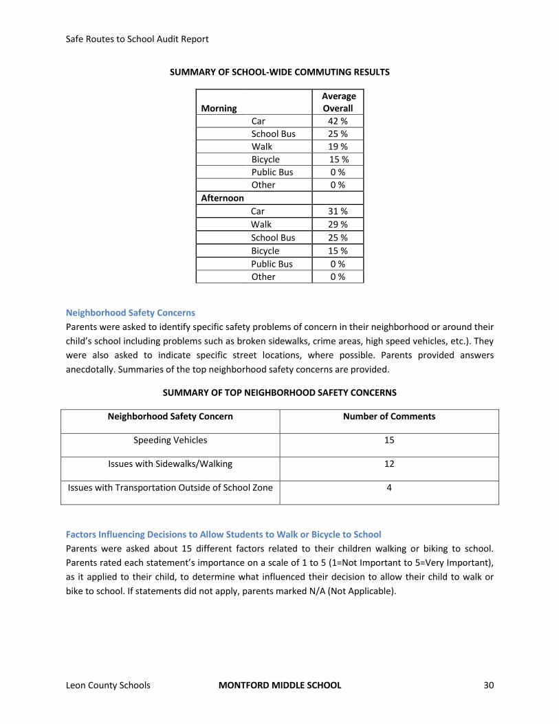
SUMMARY OF SCHOOL-WIDE COMMUTING RESULTS
Morning Average Overall
Car 42 %
School Bus 25 %
Walk 19 %
Bicycle 15 %
Public Bus 0 %
Other 0 %
Afternoon Car 31 %
Walk 29 %
School Bus 25 %
Bicycle 15 %
Public Bus 0 %
Other 0 %
Neighborhood Safety Concerns
Parents were asked to identify specific safety problems of concern in their neighborhood or around their
child’s school including problems such as broken sidewalks, crime areas, high speed vehicles, etc.). They
were also asked to indicate specific street locations, where possible. Parents provided answers
anecdotally. Summaries of the top neighborhood safety concerns are provided.
SUMMARY OF TOP NEIGHBORHOOD SAFETY CONCERNS
Neighborhood Safety Concern Number of Comments
Speeding Vehicles 15
Issues with Sidewalks/Walking 12
Issues with Transportation Outside of School Zone 4
Factors Influencing Decisions to Allow Students to Walk or Bicycle to School
Parents were asked about 15 different factors related to their children walking or biking to school.
Parents rated each statement’s importance on a scale of 1 to 5 (1=Not Important to 5=Very Important),
as it applied to their child, to determine what influenced their decision to allow their child to walk or
bike to school. If statements did not apply, parents marked N/A (Not Applicable).
Safe Routes to School Audit Report
Leon County Schools MONTFORD MIDDLE SCHOOL 31
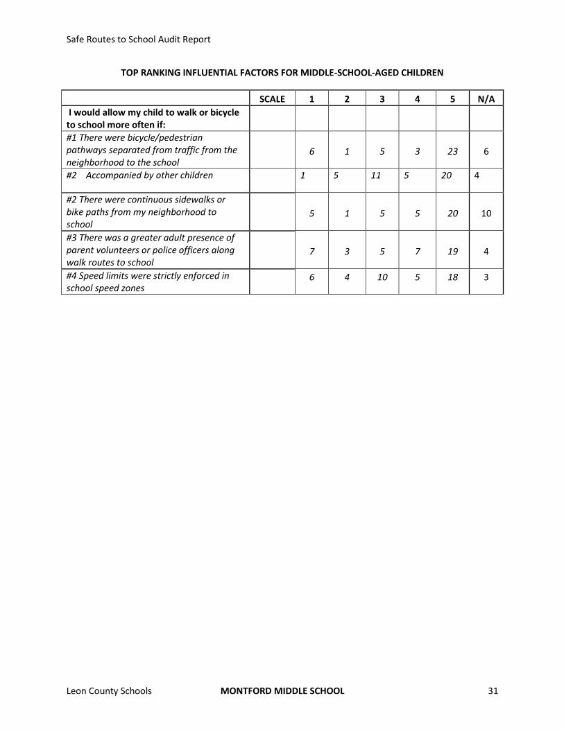
TOP RANKING INFLUENTIAL FACTORS FOR MIDDLE-SCHOOL-AGED CHILDREN
SCALE 1 2 3 4 5 N/A
I would allow my child to walk or bicycle to school more often if:
#1 There were bicycle/pedestrian pathways separated from traffic from the neighborhood to the school
6 1 5 3 23 6
#2 Accompanied by other children 1 5 11 5 20 4
#2 There were continuous sidewalks or bike paths from my neighborhood to school
5 1 5 5 20 10
#3 There was a greater adult presence of parent volunteers or police officers along walk routes to school
7 3 5 7 19 4
#4 Speed limits were strictly enforced in school speed zones
6 4 10 5 18 3