Embed Size (px)
Citation preview
Safe and Accessible Pedestrian Facilities
Inventory Model (SAPFIM): Planning and Design
Submitted by:
Fabian Cevallos, Ph.D.
Transit Program Director
Lehman Center for Transportation Research (LCTR)
Florida International University (FIU)
10555 West Flagler Street, EC 3609
Miami, FL 33174
Phone: (305) 348-3144
Email: [email protected]
Submitted to:
Joel Volinski
NCTR Program Director
National Center for Transit Research (NCTR)
University of South Florida (USF)
4202 E. Fowler Ave., CUT100
Tampa, FL 33620-5375
Phone: (813) 974-9847
Email: [email protected]
May 2017
II
DISCLAIMER
While every precaution has been taken in the preparation of this document, the publisher and
authors assume no responsibility for errors or omissions, or for damages resulting from the use of
the information contained herein. The opinions, findings, and conclusions expressed in this
publication are those of the authors and not necessarily those of the National Center for Transit
Research.
III
ACKNOWLEDGMENT
This research was managed and funded by the National Center for Transportation Research
(NCTR) under the direction of Mr. Joel Volinski. We would like to thank Mr. Haifeng Wang,
Senior Programmer at the Lehman Center for Transportation Research (LCTR) at Florida
International University (FIU), for his expertise in software development and database design; Ms.
Thalia Pickering, LCTR Web Designer, for her capability in web design and for her assistance
with the documentation; and Ms. Shirin Noei, Ph.D. student, for helping with the literature review.
The project team would also like to recognize the following individuals: Mr. Carey Shepherd with
FHWA for his leadership and support of the SAPFIM project; Mr. Dean Perkins with FDOT for
his expertize, guidance, and assistance on the development of the SAPFIM data criteria; Ms.
Gabrielle Matthews with FDOT for the management and guidance on the matching project and for
her assistance with the different meetings and events; and Mr. Peter Gies with the Broward MPO
for his active participation in this project. Finally, the project team would like to thank Dr. Fabian
Cevallos, LCTR Principal Investigator, for his direction and management of this project.
IV
LIST OF FIGURES
Figure 1: Design of SAPFIM Web Application ........................................................................... 44
Figure 2: SAFIM Data Flow Diagram .......................................................................................... 45
V
LIST OF TABLES
Table 1: GPS Data Inventory ........................................................................................................ 16
Table 2: Example of State DOT Pedestrian Inventories ............................................................... 22
Table 3: Example of Local Jurisdiction Pedestrian Inventories ................................................... 22
Table 4: Pedestrian Characteristics by Age Group ....................................................................... 27
Table 5: Characteristics of Pedestrian-Friendly Communities ..................................................... 28
Table 6: Common Residential Traffic Management Program Actions ........................................ 32
Table 7: Common Types of Traffic Calming Methods ................................................................ 33
Table 8: Work Zone Maintenance ................................................................................................ 34
Table 9: Sidewalk Criteria ............................................................................................................ 38
Table 10: Curb Ramps & Blended Transition Criteria ................................................................. 41
Table 11: Street Crossing Criteria ................................................................................................. 42
VI
TABLE OF CONTENTS
DISCLAIMER ................................................................................................................................ II
ACKNOWLEDGMENT............................................................................................................... III
LIST OF FIGURES ...................................................................................................................... IV
LIST OF TABLES ......................................................................................................................... V
TABLE OF CONTENTS .............................................................................................................. VI
BACKGROUND ............................................................................................................................ 7
PROJECT OBJECTIVES ............................................................................................................... 8
LITERATURE REVIEW ............................................................................................................... 8
PEDESTRIAN FACILITIES ........................................................................................................ 14
DESIGN OF SAPFIM .................................................................................................................. 38
NEXT STEPS ............................................................................................................................... 46
REFERENCES ............................................................................................................................. 48
7
BACKGROUND Pedestrian facilities like sidewalks, curb ramps, and crosswalks are critical elements that play a
vital role in the life of a community. According to the American Association of Retired Persons
(AARP), 8 out of 10 Americans prefer being in a community that offers sidewalks, which provides
pedestrians with an accessible and safe path to walk within the public right-of-way separated from
motor vehicles and on-road bicycles. Six out of ten prefer a neighborhood that features a mix of
residential, commercial, and activities or services within easy access instead of a neighborhood
that requires a car for every errand. AARP states that “People who live in neighborhoods with
sidewalks are 47% more likely than residents of areas without sidewalks to be active at least 39
minutes a day”.
As pedestrian facilities are critical for pedestrian movement and access, they enhance livability,
connectivity, and promote a healthier lifestyle. Further, they benefit communities by promoting
social economic activities. Therefore, safe, accessible, and well-maintained pedestrian facilities
are a fundamental community investment that enhances public health and maximizes social capital.
Continuous and accessible pedestrian networks improve mobility and livability for all pedestrians
and are particularly important for seniors and pedestrians with disabilities. Pedestrians who use
sidewalks may have disabilities and may use mobility aids such as wheelchairs, scooters, walkers,
canes, etc. Others may have visual impairments (blind or low vision) or have hearing impairments
(deaf or hard-of-hearing). According to the Americans with Disabilities Act (ADA) regulations,
28 CFR Part 35, services provided by state and local governments, including features and devices
along roadside pedestrian facilities must be “accessible to and useable by” all users, including
people with disabilities.
It is often a big challenge for large urban areas to maintain and redesign or repair pedestrian
facilities to comply with the Americans with Disabilities Act. It requires a tremendous effort to
ensure accessibility for seniors and people with disabilities when these facilities are substandard
or poorly maintained. Based on these challenges, agencies are required to develop transition plans
to plan and schedule corrections to identified deficiencies. However, planning for the best
provisions for accessibility during the process of redevelopment and construction in a number of
communities can be challenging. Without readily available and accurate information, pedestrian
improvements cannot be easily prioritized.
Pedestrian facilities are instrumental in encouraging walkability, which can help improve the
quality of life of our citizens and the livability of our communities. Therefore, it is critical that
local agencies have access to detailed information of pedestrian facilities to be able to make
intelligent decisions. For example, a computerized pedestrian facilities inventory can easily help
identify areas with no sidewalks and document the conditions of existing sidewalks, the level of
8
accessibility, and the existence of obstacles or deficiencies that prevent pedestrians to take full
advantage of these facilities.
A tool to keep track of pedestrian facilities can assist local agencies in prioritizing investments for
pedestrian improvements: repairs, improvements, and new construction projects. To accomplish
this, there is a need to develop a software tool that can facilitate this effort. Having a tool available
to local agencies can help improve the livability of communities. It can also help identify any
safety and accessibility deficiencies that are barriers to senior and pedestrians with disabilities.
PROJECT OBJECTIVES The main objective of this project is to plan and design a web-based software application that local
agencies can use for the collection, storage, querying, analysis, and reporting of pedestrian
facilities like sidewalks along public roads. Criteria for determining the accessibility of pedestrian
facilities will be based on the literature review including the Guidelines for Accessible Public
Rights of Way (PROWAG) and the ADA Standards for Transportation Facilities (ADASTF).
The Lehman Center for Transportation Research (LCTR) at Florida International University (FIU)
has expertize developing web-based systems in the field of transportation. This project is intended
to assist with the development a software tool that can be used by local agencies for the assessment
of pedestrian facilities. It will include accessible and safety features associated with sidewalks,
curb ramps, and street crossings. Data will be collected using field devices (i.e., tablets with GPS,
camera, and wireless capability) which can be uploaded directly into the web server.
To achieve the project objectives, the research tasks include a review of the literature, a section on
pedestrian facilities, the SAPFIM design including the main data elements, and the next steps
towards the development and deployment of the SAPFIM web-based application.
LITERATURE REVIEW
In this section, the research team identified a series of documents that provide useful information
for the understanding, preparation, and development of guidelines and standards as they relate to
safe and accessible pedestrian facilities.
The Americans National Standards Institute document (ANSI A117.1, Council of American
Building Officials, 1961), originally published in 1961 and reaffirmed without changes in 1971, is
one of the building blocks towards addressing issues that deal with accessibility (ANSI, 1961,
FHWA, 2004, ICC/ANSI, 2015). A newer and more comprehensive versions of ANSI A117.1 had
been released and as of August 2016, the ANSI A117 Committee and the International Code
9
Council (ICC) were in the process of a public review of the standard. Passed by Congress in 1968,
the Architectural Barriers Act (ABA) (Public Law 90-480) (Goldman, 1968) sets the Federal law
requiring new facilities constructed for Federal agencies or with Federal funding to meet
accessibility standards (UFAS). Uniform Federal Accessibility Standards (UFAS, Federal
Standard 795) define the minimum standards for design, construction, and alteration to meet the
requirements of ABA. UFAS is derived from ANSI A117.1-1980 and Access Board's 1982
Minimum Guidelines and Requirements for Accessible Design (MGRAD). The technical
specifications of MGRAD were mainly based on the ANSI A117-1980 and the specifications were
derived from State accessibility codes, U.S. Access Board research, public review and comments,
and existing Federal standards.
In 1973, the passage of the Rehabilitation Act significantly changed the way Federal public policy
addresses programs and services for people with disabilities. The Rehabilitation Act of 1973, Title
V, Section 504 (Public Law 93-112, amended by PL 516 and PL 95-602) requires federally funded
facilities and programs to be accessible to people with disabilities. The Education of All
Handicapped Children Act of 1975, now The Individuals with Disabilities Education Act (IDEA),
greatly expanded educational opportunities and requiring school accommodations for children
with disabilities. Lastly, the passage of the Americans with Disabilities Act in 1990 gave civil
rights protection to individuals with disabilities. ADA defines an individual with a disability
(ADA, 1990) as a person who has a physical or mental impairment that substantially limits one or
more major life activities, has a record of such an impairment, or is regarded by others as having
such an impairment.
Americans with Disabilities Act of 1990 (ADA) extended the coverage of ABA, and Rehabilitation
Act, Section 504 to include all public facilities regardless of funding. The Title II implementing
regulations for ADA requires all newly constructed and altered facilities to be readily accessible
to persons with disabilities. Transportation agencies are responsible for developing a transition
plan for removing the structural barriers, including communication barriers, and providing access
to existing pedestrian facilities. In some States, codes have been adopted that exceed the
requirements set forth in the ADA guidelines. In these States, both ADA and the State code must
be satisfied. The U.S. Department of Justice (DOJ) and the U.S. Department of Transportation
(DOT) use the U.S. Access Board guidelines as a basis to establish accessibility standards. Both
the DOJ and DOT may create standards that exceed the recommendations published by the U.S.
Access Board. However, they must be consistent with the minimum Access Board guidelines. The
standards from then DOJ and DOT are enforceable under the ADA, but the Access Board
guidelines are only advisory. The Americans with Disabilities Act Accessibility Guidelines
(ADAAG) completed by the U.S. Access Board in 1991, amended in 1998, 2000, and 2002 and is
based on specifications established in UFAS and ANSI A117.1
The Intermodal Surface Transportation Efficiency Act of 1991 (ISTEA) specifically called for
integrating pedestrian travel into the transportation system. ISTEA increased the Federal-aid
10
funding options for pedestrian facilities and programs. In 1998, Transportation Equity Act for the
21st Century (TEA-21) extended the opportunities established in ISTEA and increased funding
available for pedestrian facilities. The Accessible Sidewalks and Street Crossings: An
Informational Guide from the Federal Highway Administration (2001) go into the details of
sidewalk design, but they also provide a good summary of the legal framework as previously
discussed.
The Livable Communities for Adults with Disabilities published by the National Council on
Disability in 2004 offers a compelling vision for our nation. It articulates the elements of a livable
community; highlights existing examples of livable communities in the United States today, which
can serve as models for others; and describes how communities can develop and sustain their
livability features. Chapter three of this report focuses on accessible, affordable, reliable, and safe
transportation system.
In 2005, the Ada County Highway District (ACHD) conducted extensive pre-planning as part of
the Pedestrian-Bicycle Transition Plan to ensure that the inventory of existing sidewalk and curb
ramp facilities was both cost effective and produced accurate and reliable data for further analysis.
The ACHD evaluated a number of GPS products that could collect data electronically for their
system inventory. The selected hand-held GPS unit was used for the field data collection. The
collected data was formatted and added to the ACHD’s geographic information system (GIS)
database which allowed for further evaluation and analysis. By successfully deploying the GPS-
based data collection effort, ACHD was able to fully inventory the critical pedestrian facilities and
prioritize the pedestrian improvements (Transpo Group, 2005).
The Guide for Maintaining Pedestrian Facilities for Enhanced Safety (FHWA, 2013) provides
guidance for maintaining pedestrian facilities with the primary goal of increasing safety and
mobility. This guide focuses on sidewalks, walkways and curb ramps, shared-use paths,
crosswalks, signals, signs, and other treatments of facilities for crossing streets.
Zhang et al. (2014) in the “Develop a Plan to Collect Pedestrian Infrastructure and Volume Data
for Future Incorporation into Caltrans Accident Surveillance and Analysis System Database”
presented the primary goals to design a flexible database: to store pedestrian and bicycle
infrastructure and volume data to be queried in safety analyses, for network deficiencies, and any
other uses; to determine an efficient method of collecting data that can be scaled for use across the
entire state highway system; to pilot test the data collection process and ensure that all data can be
feasibly collected and stored within the database framework; and to estimate the total time-cost of
collecting this data across the entire state highway system. This guidance detailed the institutional
aspects of the Traffic Accident Surveillance and Analysis System-Transportation System Network
(TASAS-TSN) database, including the origins of the database, maintenance procedures, and
potential concerns about implementing new variables. It also included a review of literature on
direct demand modeling for pedestrians based on transportation network and land-use
11
characteristics. This literature aimed to estimate pedestrian volumes throughout the network,
which was one potential use of the volume database component of this project.
Further, this Caltrans’ guide describes the database developed during this project to store
pedestrian and bicycle infrastructure and volume data. The structure used is based on two core
elements, nodes and approaches, which provide the spatial structure for the highway network.
Nodes correspond to intersections, midblock crosswalks, and points every 1-mile along remote
highways (i.e., whenever nodes do not occur for any other reason). Approaches refer to the
connections between nodes. Approaches are defined by the direction of motor vehicle traffic,
meaning that between two intersections (two nodes) on a bidirectional road, there are two
approaches. Secondary elements such as sidewalks, crosswalks, buffer zones, and bicycle facilities
are then each related by a unique ID to the approaches and nodes. Separate tables are used for each
element type (e.g., approaches, nodes, sidewalks, crosswalks, buffers). It also includes a document
describing all of the data elements to be collected for this database in detail. Directions are given
for taking different measurements and for classifying categorical information, such as crosswalk
types. It describes the pilot data collection process and provides instructions for collecting data in
the field. A pilot project was conducted with the goals of refining the data collection process and
database format, estimating the total time required to collect data across the entire state highway
network, and checking the feasibility of collecting infrastructural data using remote imagery.
Based on the results of the data collection pilot, this report gives an estimate of the time required
for collection of pedestrian and bicycle infrastructural data across the entire California state
highway network using various data collection processes (computer-based, field-based, and a
hybrid approach). Cost estimates are not provided for populating the volume database. Volume
data is proposed for collection as part of regular traffic safety investigations and other field visits,
as the cost of installing a Miovision camera is very low. The volume data should be collected as
frequently as is feasible.
Finally, this report presents conclusions and recommendations for implementation of the data
collection process. Areas for future discussion include software for use in implementing the
database; whether a GIS-based approach should be considered; connections to the existing
TASAS-TSN system; and plans and a timeline for conducting the complete pedestrian and bicycle
infrastructure inventory.
FHWA supports flexible design of bicycle and pedestrian facilities. The American Association of
State Highway and Transportation Officials (AASHTO) bicycle and pedestrian design guides are
the primary national resources for planning, designing, and operating bicycle and pedestrian
facilities. In addition, the National Association of City Transportation Officials (NACTO) Urban
Bikeway Design and the Institute of Transportation Engineers (ITE) Designing Urban Walkable
also provide information on the design of bicycle and pedestrian facilities. Thoroughfares are built
upon AASHTO guides, which can help communities plan and design safe and convenient facilities
12
for pedestrian and bicyclists. FHWA supports the use of these resources for further development
of non-motorized transportation networks, particularly in urban areas
AASHTO published two guides that address pedestrian and bicycle facilities:
Guide for the Planning, Design, and Operation of Pedestrian Facilities (AASHTO, 2004)
provides guidelines for the planning, design, operation, and maintenance of pedestrian
facilities, including signals and signing. The guide recommends methods for
accommodating pedestrians, which vary among roadway and facility types, and addresses
the effects of land use planning and site design on pedestrian mobility.
Guide for the Development of Bicycle Facilities (AASHTO, 2012) provides detailed
planning and design guidelines on how to accommodate bicycle travel and operation in
most riding environments. It covers the planning, design, operation, maintenance, and
safety of on-road facilities, shared use paths, and parking facilities. Flexibility is provided
through ranges in design values to encourage facilities that are sensitive to local context
and incorporate the needs of bicyclists, pedestrians, and motorists.
NACTO first released the Urban Bikeway Design Guide in 2010 to address more recently
developed bicycle design treatments and techniques. It provides options that can help create
complete streets that better accommodate bicyclists. Many of the treatments in the NACTO Guide
are compatible with the AASHTO Bike Guide and demonstrate new and innovative solutions for
the varied urban settings across the country. The second edition of the NACTO Urban Bikeway
Design Guide was published in 2014.
ITE Designing Walkable Urban Thoroughfares - A Context Sensitive Approach: An ITE
Recommended Practice (2010) is a useful guide to gain an understanding of the flexibility inherent
in the AASHTO Green Book, A Policy on Geometric Design of Highways and Streets. The
chapters emphasized thoroughfares in walkable communities (compact, pedestrian-scaled villages,
neighborhoods, town centers, urban centers, urban cores and other areas where walking, bicycling
and transit are encouraged). It described the relationship, compatibility and trade-offs that may be
appropriate when balancing the needs of all users, adjoining land uses, environment and
community interests when making decisions in the project development process.
A Livability Fact Sheet of Sidewalks (2014), prepared by the American Association of Retired
Persons and the Walkable and Livable Communities Institute (AARP WALC, 2014), gathers some
of the studies related to pedestrian facilities. Following is a brief summary of those findings.
According to the US Centers for Disease Control and Prevention (CDC) study of 2013,
People just need safe, convenient, and pleasant places near their homes, schools and
workplaces to make walking routine.
A survey by the Surface Transportation Policy Partnership found that 55 percent of
Americans would prefer to walk more and drive less.
13
Sidewalks can be curved to avoid trees. In fact, protecting a tree is one of the few reasons
for a sidewalk to deviate from a direct route.
There is often enough of a public right-of-way easement in place to create a sidewalk
without infringing in on a property owner’s land.
Increased pedestrian activity reduces criminal activity; increases property values and tax
revenues.
The Livability Fact Sheet of Sidewalks recommends engaging neighbors and the community;
making the sidewalk wide enough; using a site-appropriate design; prioritizing high-use areas and
connectivity; considering driveways; and maintaining with municipal funds, when advocating and
planning for sidewalks.
In the Observations and Recommendations: The Built Environment Albuquerque, New Mexico.
Walkable and Livable Communities Institute (WALC, 2014) observations and short-
term/medium-term/long-term recommendations during a visit to Albuquerque are summarized as
follows:
Downtown areas and neighborhoods that aim to improve the ability of people to walk,
bicycle, and socialize, should adopt: lower vehicle speeds; narrower vehicle lanes;
buildings face front of the street; on-street parking and complete streets.
Short-term projects considered low-hanging fruit includes moving transit benches out of
sidewalks; conducting a public outreach campaign; training department staff; adopting a
street design manual; telling the stories; enhancing bicycle parking; and reducing lane
widths on wide streets if full road diets are not yet feasible.
Mid-range projects (the second wave) included the following: putting San Pedro road on a
diet; improving the intersection of San Pedro and Constitution; engaging the public and
conducting a charrette for San Pedro road; putting Constitution Avenue on a road diet;
putting Summer Blvd. on a road diet; starting a weekly growers market; bicycle
boulevards; Mark Twain Elementary School; ensuring lighting is placed at all intersections
and mid-block crossings; and identifying opportunities for roundabouts.
Long-range or policy initiatives (the big wins) were: passing a strong complete streets
ordinance; creating an Albuquerque destination brand; completing the 50-mile loop;
planting street and median trees; completing, improving, and maintaining sidewalks;
complying with ADA; partnering with local schools to promote safe routes to school;
analyzing the viability of BRT on Central Ave.; working with NMDOT and county
officials to improve walkability.
According to the Portland Area Comprehensive Transportation System (PACTS, 2014), walking
and bicycling environments should be safe; pedestrian and bicycle network should be accessible
and economical; walking and bicycling environment should be clear, easy to use, and attractive to
14
enhance community livability; and design guidelines should be applied using professional
judgment.
The steps involved in creating a bicycle and pedestrian network plan in the PennDOT Design
Manual Part 2 Highway Design (2016) include the following elements: inventorying the existing
transportation system; identifying bicycle/pedestrian travel corridors; evaluating and selecting
specific route alternatives; identifying design treatments applicable to specific site conditions; and
selecting the appropriate facility options to move forward with design and construction.
PEDESTRIAN FACILITIES People’s abilities vary in agility, balance, cognition, coordination, endurance, flexibility, hearing,
problem solving, strength, vision, and walking speed. The design of sidewalk environments is
important to all pedestrians, but is particularly important to those with disabilities who have limited
travel options and depend on the pedestrian environment.
Barriers restrict the movement of persons to easily navigate within the pedestrian environment. In
addition, lack of information makes it difficult for pedestrians to maneuver in this environment.
The barriers within a pedestrian environment include curbs, steep slopes, obstacles, and limitations
in the design of sidewalks such as widths being too narrow to walk; the information barriers include
complex intersections, detours, and general lack of street crossing information.
Assistive technologies enhance the ability of people with disabilities to move freely within the
pedestrian environment. Technology can be used to reduce limitations that may exist in the
sidewalk environment and include Accessible Pedestrian Signals and engineering treatments like
curb ramps, detectable warnings, or push buttons at traffic signals to assist with intersection
crossing.
Good sidewalk design should consider the following attributes: accessibility for all users, including
those with disabilities; safety, so users do not feel threatened by the adjacent traffic or the
pedestrian environment; adequate sidewalk design with landscaping that creates a buffer space
between pedestrians and traffic and also provide shade; and provide a social public space to allow
people interaction.
In downtown areas, sidewalks need to be designed to accommodate a larger number of pedestrian
traffic than in other surrounding areas. Inclusion of streetscapes in downtowns can serve multiple
purposes that need to consider the following zones: the building frontage zone, the pedestrian zone,
the planter and furniture zone, and the curb zone. The building frontage zone is the area between
the building and the pedestrian zone. The pedestrian zone is the area that is specifically reserved
for the pedestrian walking activity. The planter and furniture zone is between the curb and the
pedestrian travel zone and provides a buffer from the street traffic and allows for the consolidation
15
of elements like utilities poles, hydrants, telephone kiosks, etc. as well as street furniture such as
benches, shelters, signs. Lastly, the curb zone is the six inches of the sidewalk corridor that is
adjacent to the roadway and that also discourages motor vehicles from entering/exiting the
sidewalk area.
In reference to sidewalk grades and cross slopes, steep grades and cross slopes should be avoided
whenever possible as they can present a problem for wheelchairs and pedestrians with disabilities.
There are many factors that play a role on the usability of sidewalks; they include: the materials
used for the surface that also have an impact on firmness, stability, and slip resistance; changes in
direction and elevation, and dimensions of gaps, grates, and openings. Further, obstacles that
protrude into the sidewalk corridor and that are difficult to detect can be problematic to blind
pedestrians. Therefore, designers need to keep in mind that as they change the grade of driveway
crossings to allow cars to effectively negotiate the grade change between the street and the
sidewalk, they must also follow good pedestrian design practices and not compromise the
accessibility and safety of sidewalk environments.
Curb ramps can help eliminate the vertical edge of the curb and with detectable warnings, they can
mark the boundary between the sidewalk and street. This can be useful for pedestrians with vision
impairments and pedestrians who use walking aids such as canes, walkers, or crutches. Wider
crosswalks can also enhance the use of curb ramps for all users.
To assist with safe street crossing, audible tones and speech messages at traffic signals can provide
WALK, DON'T WALK information to pedestrians. Infrared or Light Emitting Diodes (LED)
transmitters can send speech messages in multiple formats to personal receivers including
information on the location, direction of travel, and the name of the street to be crossed. In addition,
the physical design, placement, and location of the pedestrian signal devices need to be taken into
consideration so that the signal device is accessible to pedestrians with vision and mobility
impairments (FHWA, 2001).
Designing an effective pedestrian crossing involves the correct layout of pedestrian elements
including: information (signs, accessible pedestrian/traffic signals, markings), turning radius,
visible crosswalks (including raised crosswalks), adequate crossing times, medians, refuge islands,
corner island, curb ramps with detectable warnings, and curb extensions. It also involves careful
consideration of adequate sight lines, traffic patterns, and traffic signal phasing. Other techniques
such as restrictions on right turns, pedestrian lead times, and traffic calming measures will benefit
all pedestrians. Regulations that prohibit parking at the corner can also improve blocked sight lines
(ITE, 2010).
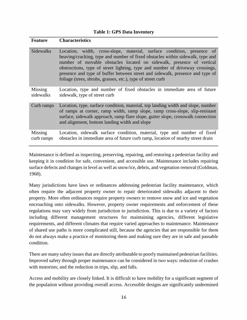
According to the Ada County Highway District (ACHD, 2005), the features and characteristics
of their GPS data inventory is summarized in Table 1.
16
Table 1: GPS Data Inventory
Feature Characteristics
Sidewalks Location, width, cross-slope, material, surface condition, presence of
heaving/cracking, type and number of fixed obstacles within sidewalk, type and
number of movable obstacles located on sidewalk, presence of vertical
obstructions, type of street lighting, type and number of driveway crossings,
presence and type of buffer between street and sidewalk, presence and type of
foliage (trees, shrubs, grasses, etc.), type of street curb
Missing
sidewalks
Location, type and number of fixed obstacles in immediate area of future
sidewalk, type of street curb
Curb ramps Location, type, surface condition, material, top landing width and slope, number
of ramps at corner, ramp width, ramp slope, ramp cross-slope, slip-resistant
surface, sidewalk approach, ramp flare slope, gutter slope, crosswalk connection
and alignment, bottom landing width and slope
Missing
curb ramps
Location, sidewalk surface condition, material, type and number of fixed
obstacles in immediate area of future curb ramp, location of nearby street drain
Maintenance is defined as inspecting, preserving, repairing, and restoring a pedestrian facility and
keeping it in condition for safe, convenient, and accessible use. Maintenance includes repairing
surface defects and changes in level as well as snow/ice, debris, and vegetation removal (Goldman,
1968).
Many jurisdictions have laws or ordinances addressing pedestrian facility maintenance, which
often require the adjacent property owner to repair deteriorated sidewalks adjacent to their
property. More often ordinances require property owners to remove snow and ice and vegetation
encroaching onto sidewalks. However, property owner requirements and enforcement of these
regulations may vary widely from jurisdiction to jurisdiction. This is due to a variety of factors
including different management structures for maintaining agencies, different legislative
requirements, and different climates that require varied approaches to maintenance. Maintenance
of shared use paths is more complicated still, because the agencies that are responsible for them
do not always make a practice of monitoring them and making sure they are in safe and passable
condition.
There are many safety issues that are directly attributable to poorly maintained pedestrian facilities.
Improved safety through proper maintenance can be considered in two ways: reduction of crashes
with motorists; and the reduction in trips, slip, and falls.
Access and mobility are closely linked. It is difficult to have mobility for a significant segment of
the population without providing overall access. Accessible designs are significantly undermined
17
if maintenance is neglected and pedestrian facilities are allowed to degrade to a state where they
cannot be used or are avoided. There are generally two accessibility issues related to maintenance
and both require maintaining an accessible path. First, proper and routine maintenance of
walkways allow access between intersections. Secondly, the maintenance of transition points (curb
ramps, medians, crosswalks, etc.) ensures access at intersections.
Sidewalks and shared use paths are the main types of pedestrian facilities that accommodate
pedestrians. The surface material used for these facilities can have a significant effect on how and
how often maintenance is performed. Of the hard surfaces, concrete is the most common surfacing
type for sidewalks while asphalt is commonly used for shared use paths. Furthermore, asphalt
pavement is often used as a temporary pavement for patching concrete sidewalks.
Bricks and pavers are used to preserve a traditional material and appearance in a downtown or
historic district. In some settings pavers are used to border concrete sidewalks. Although these
materials tend to be very durable, they do have some unique maintenance issues. Surfaces can also
be soft and composed of loose stone, compacted stone dust, or wood chips. Stone surfacing,
especially crushed stone is sometimes used for paths and sidewalks. It is more likely that stone or
gravel will be used for sidewalks as a temporary fix before a more permanent surface material
ultimately replaces it.
Maintenance issues that commonly occur for pedestrian facilities can be sorted into two broad
groups: those that are directly related to the pedestrian facility infrastructure itself, such as
sidewalk surfacing deficiencies; and those that relate to seasonal or day-to-day maintenance, which
require keeping the facility clean and free of nuisance materials. This involves removal of
vegetation, snow, ice, sand, and other materials. An effective pedestrian facility maintenance
program needs to address both sets of issues.
Infrastructure problems can be broadly categorized into two groups for sidewalks and paths:
surfacing problems and structural problems. Both sets of problems cause maintenance issues. Most
structural deficits will ultimately affect surface conditions.
Minor surface defects may only affect appearance, but moderate to severe conditions will
ultimately become a safety hazard and may significantly affect the usable life of the sidewalk. The
most common maintenance problems with hard surface materials result from structural conditions
such as those caused by cracking, heaving, tilting, gaps (often at concrete joints), and sidewalk and
path sections that either are depressed or raised.
Most of thesame maintenance issues impacting sidewalksalso impact curb ramps. The most
frequent maintenance problem with crosswalk markings is durability. Another durability-related
maintenance problem is the conspicuity of pavement markings.
The conditions of sidewalks for safe, comfortable, and accessible travel are influenced not only by
18
infrastructure problems, but also by seasonal events such as snowfall, the accumulation of leaf
debris, and the overgrowth of vegetation. Maintenance activities to remove obstacles to safe
walking are needed to keep sidewalks accessible and hazard-free year-round.
Following a snowfall, snow and ice must be cleared from sidewalks, paths, curb ramps, and
crosswalks to provide safe and accessible passage for pedestrians. Most of the problems caused by
extreme heat manifest themselves as serious structural problems. Another problem in hot climates
is associated with markings. Markings on newly paved streets can be degraded with vehicles
tracking over them.
Street trees and other plants adjacent to the sidewalk are a beneficial amenity for a variety of
reasons including provision of shade, carbon dioxide reduction, increased property value, storm
water control, and visual interest. However, vegetative growth encroaching upon sidewalks or
paths is a serious condition that requires maintenance. Sightlines to driveways and intersections
must also be maintained for pedestrian safety.
Sidewalk and path inspection criteria serve many useful purposes, especially to reduce slips and
falls based on avoidable sidewalk and path hazards. Damaged surfaces and defects can make
facilities impassable for everyone and also limit accessibility of people with disabilities or mobility
impairments. Other reasons include providing guidelines to agency employees, conveying
information to residents, and preventing and/or minimizing lawsuits and liability exposure.
The 2010 ADA Standards (United States Access Board, 2010) are the measure of accessibility for
buildings and sites and can be enforced at the Federal level. Some agencies will use these standards
for the public right of way to the extent they seem to fit because Public Rights of Way Accessibility
Guidelines (PROWAG) is not yet a Federal standard. While this may work in limited
circumstances, the 2010 ADA standards do not address the situations commonly found in the
public right-of-way such as steep terrain and the constraints of being located next to roadway.
They also do not address additional features such as pedestrian signals, crosswalks, refuge islands,
on street parking, and the need for detectable warnings at street crossings. The Access Board also
establishes the guidelines for buildings and sites, so there is consistency where it is reasonable to
use the same criteria.
In the Proposed Accessibility Guidelines for Pedestrian Facilities in the Public Right-of-Way
(United States Access Board, 2011), the Architectural and Transportation Barriers Compliance
Board is proposing accessibility guidelines for the design, construction, and alteration of
pedestrian facilities in the public right-of-way. The purpose of these guidelines is to ensure that
sidewalks, pedestrian street crossings, pedestrian signals, and other facilities for pedestrian
circulation and use constructed or altered in the public right-of-way by state and local governments
are readily accessible to and usable by pedestrians with disabilities.
The guidelines cover pedestrian features in public right-of-ways, including sidewalks and other
19
pedestrian ways, street crossings, medians and traffic islands, overpasses, underpasses and bridges.
It applies to permanent as well as temporary facilities provides provisions to address Pedestrian
Access Routes including Sidewalks, Curb Ramps/Blended Transitions, and Street Crossings.
The Access Board’s proposed guidelines address access to newly constructed and altered public
streets and sidewalks covered by the American with Disabilities Act and the Architectural Barriers
Act (ABA) or the Rehabilitation Act. The guidelines also refer to requirements in the Federal
Highway Administration’s Manual on Uniform Traffic Control Devices (MUTCD) for Streets and
Highways to ensure consistency and to avoid redundancy. Specifically, the guidelines invoke
MUTCD definitions and technical criteria for temporary alternate pedestrian routes and pedestrian
signals and push buttons. Many of these provisions are designed to ensure that the public rights-
of-ways contain a continuous accessible route that accommodates all pedestrians, including those
who need mobility aids. These requirements are also expected benefit many other users.
Communities should develop and adopt inspection and maintenance criteria in order to keep the
sidewalk facilities in good conditions. The inspections should consider cracks, changes in grade,
cross-slopes, vertical clearances, maximum running grades, minimum clear width, and the distance
protruding objects extend into the pedestrian path.
Generally, there are two broad accessibility categories related to maintenance and both require
maintaining an accessible path. First, proper and routine maintenance of walkways allow access
between intersections while the maintenance of intersections (curb ramps, medians, crosswalks,
etc.) ensures access at street crossings. Communities will need to balance their needs with the
available funding for maintaining pedestrian facilities. A data collection and assessment plan can
assist with the prioritization of activities and the decision to either repair or replace the sidewalk
facilities. The plan should establish procedures for the public to understand and follow. This should
cover how a community repairs facilities, pays for them, informs affected residents, does
inspections, establishes projects annually, and schedules repairs.
Routine maintenance consists of day-to-day activities that are scheduled by maintenance personnel
to maintain and preserve the condition of facilities at a satisfactory level of service. Corrective
maintenance is described as activities that are performed in response to the development of a
deficiency or deficiencies that negatively impact the safe, and efficient operations of the facility.
Corrective maintenance activities are generally reactive, not proactive, and performed to restore a
facility to an acceptable level of service due to unforeseen conditions. Preventive maintenance
consists of treatments to extend the functional condition of a facility. It is typically applied to
facilities in good condition having significant remaining service life.
Preventive measures fall into the short and long-term maintenance categories above with the best
examples including: mud jacking, joint sealing, grinding, and horizontal cutting for sidewalks; and
chip sealing and slurry for asphalt sidewalks and paths.
20
When a tripping hazard or obstacle is reported, an agency makes note of the hazard and responds
quickly. Multiple falls or complaints about the same area require a city to place a particular
sidewalk or street higher on the schedule for repair or replacement. The first step is to inspect the
problem location to determine if there is a hazard, as determined by the community’s inspection
criteria. A follow-up repair is either made on the spot, if a repair crew has been sent to the location
to verify it as a hazard, or a repair should be scheduled if an inspector is sent and a legitimate
hazard exists. A program associated with a quick response is intended to respond rapidly to
problems such as tripping hazards. These problems will be addressed through patching, wedging,
crack filling, or even sidewalk replacement. With this program in place, tripping hazards can be
responded to in the quickest possible fashion.
To address sidewalk issues in a manageable and predicable fashion, communities should sponsor
sidewalk replacement programs that rotate or cycle through a community on a zone-by-zone basis.
By concentrating sidewalk replacement into zones, less expensive construction bids for
replacement work can typically be negotiated. Alternatively, smaller communities may be able to
manage community-wide inspection and replacement programs on an annual basis without a need
to split the community into zones.
Communities that fully fund repairs, with no special assessing of impacted properties, have the
advantage of being able to move quickly with those repairs. This is also a more equitable way to
fund repairs that does not rely simply on the residents that live adjacent to older sidewalks in need
of repair.
All requests for sidewalk work or reported hazards should go to the same department and
preferably the same person. Every community employee who observes a potential sidewalk or path
problem condition should be directed to report it. It is always good policy to document reported
problems and how they were resolved. If, after a complaint is received, inspection reveals that a
condition does not meet the community’s criteria for repair or correction, appropriate
documentation should note that.
Some communities are not aware of what pedestrian facilities it owns. Without knowing that, it is
difficult to accept ownership for repairs. Every community should have an updated inventory of
pedestrian facilities noting the general condition of each facility.
Cities should adopt and follow their own plans and policies, and ordinances for sidewalk inspection
and repair. In any form, communities should define what conditions are defective and establish an
approach for repair including how the repairs are going to be made and on what type of schedule.
There may be times and reasons that a community cannot follow its own policy. At that point, a
community should explain and support why it is not following its own established plan or policy
along with how they are going to mitigate the impacts.
Initial design and construction methods greatly influence the long-term maintenance and lifespan
21
of sidewalks. Historically concrete has been the material of choice by many jurisdictions because
of its ease of installation, durability, reliability and availability of materials. The thickness of the
sidewalk material, use of reinforcing bars, mesh use of aggregate base, depth of sub-base below
the sidewalk, distance from trees, and other design details impact how well a sidewalk will age
over time. If best practices are followed, the expected sidewalk materials service life can be as
long as eighty years for concrete, bricks, and interlocking concrete pavers; and forty years for
asphalt (FHWA, 2013).
Providing an adequate subgrade below sidewalks may deter many of failures by providing stability
and good drainage, helping the sidewalk to be more resistant to seasonal changes.
It is important toensure that sidewalks are constructed withenough thickness to support expected
vehicleloading. Insome cases reinforcement (usually with a weldedwire mesh or rebar) can be
used to increase theloading capacity of sidewalks.
Proper sidewalk drainage is important for maintenance purposes and to provide a safe and
comfortable experience for users. It is important to provide a slight cross slope on sidewalks to
ensure proper drainage and prevent pooling of water, especially in climates where ice can form.
Control and expansion joints should be provided in all concrete sidewalks and paths to minimize
cracking and guide where cracking should occur. Asphalt sidewalks typically do not need joints
or scoring patterns.
Curb ramps and detectable warning surfaces present unique maintenance needs. The primary
issues with detectable warning fields are debris collection, detachment from the sidewalk, or
damage to the domes in the warning fields.
Proper site conditions, including soils, tree selection and location are all essential to ensure that
the trees thrive in their location and do not interfere with nearby utilities, sidewalks or streets.
A variety of sources are available to fund pedestrian facility inspection and maintenance programs.
In general, funding strategies can be split into two categories: programs that are funded by abutting
property owners; and programs funded by community taxes, funds, and fees.
Many communities treat pedestrian facilities as a community-wide asset, and fund their repair and
maintenance directly. Sidewalk repair and replacement is commonly paid for through the general
fund, which is typically funded by property and sales tax revenues. Many communities have
downtown or other business district areas that (i.e., business improvement districts, community
improvement districts, business improvement area, transportation improvement districts, etc.)
have assumed responsibility of sidewalk maintenance, including winter maintenance. These
special districts may fund sidewalk maintenance through their general funds or may assess local
property owners for general sidewalk maintenance as well as necessary repairs and replacements.
22
Means of financing for homeowners association activities is similar to improvement districts or
business improvement districts typically through some form of assessment based on valuation.
Assessment programs assess abutting property owners for the costs of maintaining or replacing
pedestrian facilities. Property owners may be held responsible for the full cost of the maintenance
or the jurisdiction may pay part of cost. If a community does not have a history of assessing
property owners for pedestrian facility maintenance, it can be very difficult politically tobegin an
assessment program. An assessment program requires that the municipality have a system in place
to assess property owners for the costs of maintaining abutting pedestrian facilities. In some
communities, property owners are directly responsible for maintaining sidewalks, and city
ordinances mandate that they schedule and pay for repairs on their own.
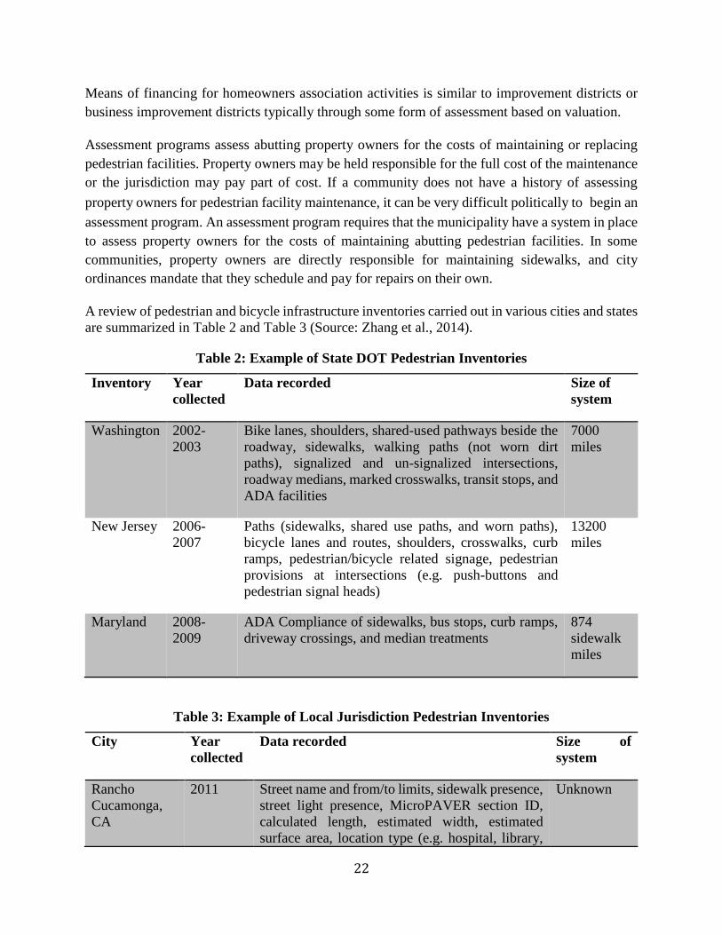
A review of pedestrian and bicycle infrastructure inventories carried out in various cities and states
are summarized in Table 2 and Table 3 (Source: Zhang et al., 2014).
Table 2: Example of State DOT Pedestrian Inventories
Inventory Year
collected
Data recorded Size of
system
Washington 2002-
2003
Bike lanes, shoulders, shared-used pathways beside the
roadway, sidewalks, walking paths (not worn dirt
paths), signalized and un-signalized intersections,
roadway medians, marked crosswalks, transit stops, and
ADA facilities
7000
miles
New Jersey 2006-
2007
Paths (sidewalks, shared use paths, and worn paths),
bicycle lanes and routes, shoulders, crosswalks, curb
ramps, pedestrian/bicycle related signage, pedestrian
provisions at intersections (e.g. push-buttons and
pedestrian signal heads)
13200
miles
Maryland 2008-
2009
ADA Compliance of sidewalks, bus stops, curb ramps,
driveway crossings, and median treatments
874
sidewalk
miles
Table 3: Example of Local Jurisdiction Pedestrian Inventories
City Year
collected
Data recorded Size of
system
Rancho
Cucamonga,
CA
2011 Street name and from/to limits, sidewalk presence,
street light presence, MicroPAVER section ID,
calculated length, estimated width, estimated
surface area, location type (e.g. hospital, library,
Unknown
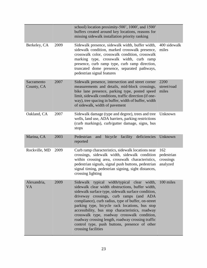
23
school) location proximity-500’, 1000′, and 1500′
buffers created around key locations, reasons for
missing sidewalk installation priority ranking
Berkeley, CA 2009 Sidewalk presence, sidewalk width, buffer width,
sidewalk condition, marked crosswalk presence,
crosswalk color, crosswalk condition, crosswalk
marking type, crosswalk width, curb ramp
presence, curb ramp type, curb ramp direction,
truncated dome presence, separated pathways,
pedestrian signal features
400 sidewalk
miles
Sacramento
County, CA
2007 Sidewalk presence, intersection and street corner
measurements and details, mid-block crossings,
bike lane presence, parking type, posted speed
limit, sidewalk conditions, traffic direction (if one-
way), tree spacing in buffer, width of buffer, width
of sidewalk, width of pavement
2200
street/road
miles
Oakland, CA 2007 Sidewalk damage (type and degree), trees and tree
wells, land use, ADA barriers, parking restrictions
(curb markings), curb/gutter damage, signs, bus
stops
Unknown
Marina, CA 2003 Pedestrian and bicycle facility deficiencies
reported
Unknown
Rockville, MD 2009 Curb ramp characteristics, sidewalk locations near
crossings, sidewalk width, sidewalk condition
within crossing area, crosswalk characteristics,
pedestrian signals, signal push buttons, pedestrian
signal timing, pedestrian signing, sight distances,
crossing lighting
162
pedestrian
crossings
analyzed
Alexandria,
VA
2009 Sidewalk typical width/typical clear width,
sidewalk clear width obstructions, buffer width,
sidewalk surface type, sidewalk surface condition,
driveway crossings, curb ramps (and ADA
compliance), curb radius, type of buffer, on-street
parking type, bicycle rack locations, bus stop
accessibility, bus stop characteristics, roadway
crosswalk type, roadway crosswalk condition,
roadway crossing length, roadway crossing traffic
control type, push buttons, presence of other
crossing facilities
100 miles
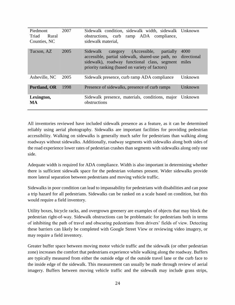
24
Piedmont
Triad Rural
Counties, NC
2007 Sidewalk condition, sidewalk width, sidewalk
obstructions, curb ramp ADA compliance,
sidewalk material,
Unknown
Tucson, AZ 2005 Sidewalk category (Accessible, partially
accessible, partial sidewalk, shared-use path, no
sidewalk), roadway functional class, segment
priority ranking (based on variety of factors)
4000
directional
miles
Asheville, NC 2005 Sidewalk presence, curb ramp ADA compliance Unknown
Portland, OR 1998 Presence of sidewalks, presence of curb ramps Unknown
Lexington,
MA
Sidewalk presence, materials, conditions, major
obstructions
Unknown
All inventories reviewed have included sidewalk presence as a feature, as it can be determined
reliably using aerial photography. Sidewalks are important facilities for providing pedestrian
accessibility. Walking on sidewalks is generally much safer for pedestrians than walking along
roadways without sidewalks. Additionally, roadway segments with sidewalks along both sides of
the road experience lower rates of pedestrian crashes than segments with sidewalks along only one
side.
Adequate width is required for ADA compliance. Width is also important in determining whether
there is sufficient sidewalk space for the pedestrian volumes present. Wider sidewalks provide
more lateral separation between pedestrians and moving vehicle traffic.
Sidewalks in poor condition can lead to impassability for pedestrians with disabilities and can pose
a trip hazard for all pedestrians. Sidewalks can be ranked on a scale based on condition, but this
would require a field inventory.
Utility boxes, bicycle racks, and overgrown greenery are examples of objects that may block the
pedestrian right-of-way. Sidewalk obstructions can be problematic for pedestrians both in terms
of inhibiting the path of travel and obscuring pedestrians from drivers’ fields of view. Detecting
these barriers can likely be completed with Google Street View or reviewing video imagery, or
may require a field inventory.
Greater buffer space between moving motor vehicle traffic and the sidewalk (or other pedestrian
zone) increases the comfort that pedestrians experience while walking along the roadway. Buffers
are typically measured from either the outside edge of the outside travel lane or the curb face to
the inside edge of the sidewalk. This measurement can usually be made through review of aerial
imagery. Buffers between moving vehicle traffic and the sidewalk may include grass strips,
25
bushes, street trees, street furniture, and parked cars. The type of buffer is important because larger
objects (such as parked cars) make pedestrians feel safer with respect to adjacent traffic.
Volumes are extremely important for planning purposes, such as for warrants, for safety
countermeasures, and for estimating pedestrian risk. While volumes may be estimated for
statewide planning purposes, the most accurate figure possible should be collected for analyses of
specific locations.
Most transit users travel to transit stops as pedestrians. Information on transit stops may be
available via online aerial imagery (Google Maps), or using in street-level imagery.
Providing accessible, affordable, reliable, and safe transportation is such an enormous challenge
that some states and counties have been thinking systemically, trying to coordinate all the disparate
transportation services and funding streams to create more efficient, cost-effective, and universally
accessible transit systems. Realizing that lack of coordination is largely due to the fact that sixty
two different federal programs fund transportation, not to mention the proportion of state and local
taxes earmarked for transportation, several Federal agencies, including the FTA and the
Departments of Health and Human Services, Labor, and Education, have launched a national five-
year initiative to break down the barriers within human service transportation programs and
encourage local partnerships to improve transportation services. One of the components of this
initiative is the Framework for Action: Building a Fully Coordinated Transportation System, a
comprehensive evaluation and planning tool to help state and community leaders, and agencies
involved in human service transportation and transit service, along with their stakeholders,
improve or start coordinated transportation systems.
The State of Florida has been working since 1979 to expand transportation services through the
Florida Coordinated Community Transportation Program. Broward County, Florida,
Transportation Options (TOPS) is an example of coordination at the local level under the
leadership of the Florida CTD.
The JAUNT, Inc. Regional Public Transit Agency of Central Virginia was formed in 1975 to meet
the transportation needs of area human service agencies. Today, JAUNT serves as a rural service
provider, a leader in commuter transportation, a coordinated human service agency transporter,
and an urban paratransit provider. JAUNT provides services to the citizens of Albermarle,
Fluvanna, Louisa, and Nelson Counties and the City of Charlottesville with a fleet of more than
70 vehicles.
The Sweetwater County, Wyoming public transportation’s transit authority (STAR) was created
in 1989 and replaced a number of health and human services agency-based transportation services
to form a coordinated public transportation system. STAR provides transportation to the general
public and to agencies on a contractual basis, and serves the sparsely populated 10,400 square mile
area of Sweetwater County in southwest Wyoming.
26
In a successful effort led by disability advocates, the faith community, and other CBOs, residents
of six cities in Kent County, Michigan, passed a millage increase to fund expanded transportation
services that benefit many segments of the population.
Inspired by a California inventor, Charlotte, North Carolina, is pilot-testing an innovative program
with portable devices that use GPS satellite technology to empower people with visual
impairments to better navigate the city’s public transportation system.
According to the news (Boatman, 2015), the city of Los Angeles has reached a tentative
agreement with disability advocates to spend $1.4 billion to fix crumbling sidewalks that do not
provide people who use wheelchairs with the adequate public access required by the ADA.
Communities Actively Living Independent and Free (CALIF) filed the lawsuit in August 2010
advocates. The plaintiffs alleged that Los Angeles discriminated against disabled residents by not
fixing damaged sidewalks; not repairing sidewalks with curb cuts that were too steep for
wheelchairs; not removing obstructions that blocked sidewalks, such as signs and trees; and not
ensuring enough access to public transportation via sidewalks. It is estimated that 40 percent of
the sidewalks in Los Angeles are in need of repair.
Damaged sidewalks have been a problem for disabled Los Angeles residents for decades. Many
residents of Los Angeles have been involved in accidents related to broken sidewalks. The city has
paid over $6 million in damages related to trip-and-fall lawsuits since 2011.
According to the settlement, the City of Los Angeles has 30 years to repair or replace damaged
sidewalks. It is required to spend $31 million per year to improve sidewalks starting in 2016 and
gradually increase it to $63 million per year in the future. The settlement also requires the city to
pay $15 million in attorneys’ fees and costs. This settlement is an important victory for disabled
residents of Los Angeles. Cities and towns have a responsibility to make sure that their public
spaces are accessible to individuals who use wheelchairs in accordance with the Americans with
Disabilities Act.
The primary focus of Pedestrian Facilities Guidebook, Washington State DOT (1997), is to
encourage good planning, design, and engineering practices related to pedestrian facilities. The
guidebook also addresses important construction, ongoing maintenance, and operational aspects
related to pedestrian facilities. Following is the summary of this guidebook coming in eleven
design toolkits.
Common characteristics of pedestrian collisions are: driver inattention; struck by vehicle while
crossing at an intersection (50 percent of all collisions); struck by vehicle while crossing mid-block
(33 percent of all collisions); struck from behind while walking along the roadway in the same
direction as traffic (particularly in rural areas); motorist exceeding safe speed (contributes to most
pedestrian fatalities); darting out into the street at mid- block (most common type of pedestrian
27
collision for children); vehicles backing up (difficult to see children and others walking behind);
and collisions in urban areas (80 percent of all collisions).
Some important needs of pedestrians are: safe streets and walking areas; convenience; nearby
places to walk; visibility; comfort and shelter; attractive and clean environment; access to transit;
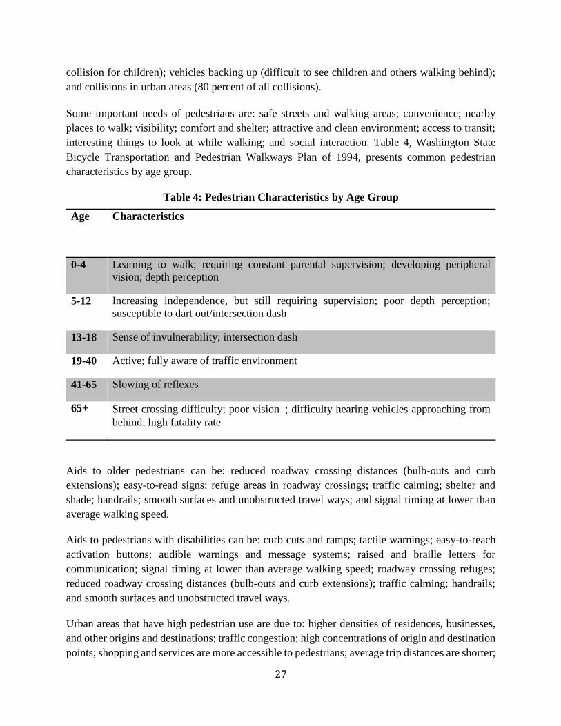
interesting things to look at while walking; and social interaction. Table 4, Washington State
Bicycle Transportation and Pedestrian Walkways Plan of 1994, presents common pedestrian
characteristics by age group.
Table 4: Pedestrian Characteristics by Age Group
Age Characteristics
0-4 Learning to walk; requiring constant parental supervision; developing peripheral
vision; depth perception
5-12 Increasing independence, but still requiring supervision; poor depth perception;
susceptible to dart out/intersection dash
13-18 Sense of invulnerability; intersection dash
19-40 Active; fully aware of traffic environment
41-65 Slowing of reflexes
65+ Street crossing difficulty; poor vision; difficulty hearing vehicles approaching from
behind; high fatality rate
Aids to older pedestrians can be: reduced roadway crossing distances (bulb-outs and curb
extensions); easy-to-read signs; refuge areas in roadway crossings; traffic calming; shelter and
shade; handrails; smooth surfaces and unobstructed travel ways; and signal timing at lower than
average walking speed.
Aids to pedestrians with disabilities can be: curb cuts and ramps; tactile warnings; easy-to-reach
activation buttons; audible warnings and message systems; raised and braille letters for
communication; signal timing at lower than average walking speed; roadway crossing refuges;
reduced roadway crossing distances (bulb-outs and curb extensions); traffic calming; handrails;
and smooth surfaces and unobstructed travel ways.
Urban areas that have high pedestrian use are due to: higher densities of residences, businesses,
and other origins and destinations; traffic congestion; high concentrations of origin and destination
points; shopping and services are more accessible to pedestrians; average trip distances are shorter;
28
parking is too costly or unavailable; transit service is more readily available; and more available
pedestrian facilities.
According to Washington State Bicycle Transportation and Pedestrian Walkways Plan of 1994,
common reasons for low levels of pedestrian travel are: poor facilities; lack of sidewalks or
walkways; failure to provide a contiguous system of pedestrian facilities; concerns for personal
safety; failure to provide facilities to and from popular origins and destinations; inclement weather,
poor lighting; and lack of separated facilities.
Pedestrian facilities and features include sidewalks; trails; curb ramps; traffic calming and control
devices; grade-separated crossings; wide shoulders and other technologies; design features; and
strategies intended to encourage pedestrian travel. State policies can encourage pedestrian travel
through: addressing pedestrian issues using comprehensive planning; considering pedestrian needs
in all transportation facilities; reinforcing a sense of neighborhood and community with
transportation designs that accommodate pedestrian use; ensuring a connected system of
pedestrian routes in urban areas; enhancing pedestrian mobility and safety in rural areas; defining
jurisdictional roles in providing pedestrian facilities; encouraging land use and transportation
development that accommodates pedestrians; providing pedestrian facilities that complement local
business activity and provide access for employees; enhancing intermodal access for persons with
impaired mobility; and maintaining the existing transportation system adequately so pedestrian
use is maximized. Some common characteristics of pedestrian-friendly communities are listed in
Table 5 (Pedestrian Guidebook Facilities, 1997).
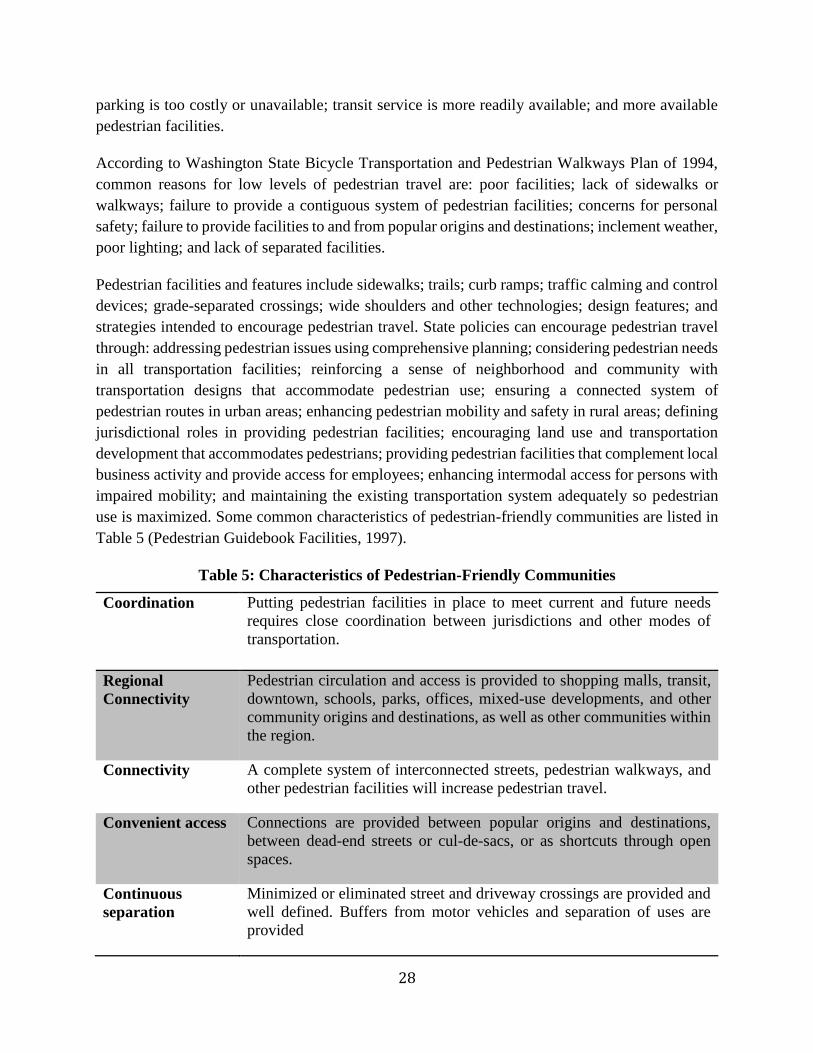
Table 5: Characteristics of Pedestrian-Friendly Communities
Coordination Putting pedestrian facilities in place to meet current and future needs
requires close coordination between jurisdictions and other modes of
transportation.
Regional
Connectivity
Pedestrian circulation and access is provided to shopping malls, transit,
downtown, schools, parks, offices, mixed-use developments, and other
community origins and destinations, as well as other communities within
the region.
Connectivity A complete system of interconnected streets, pedestrian walkways, and
other pedestrian facilities will increase pedestrian travel.
Convenient access Connections are provided between popular origins and destinations,
between dead-end streets or cul-de-sacs, or as shortcuts through open
spaces.
Continuous
separation
Minimized or eliminated street and driveway crossings are provided and
well defined. Buffers from motor vehicles and separation of uses are
provided
29
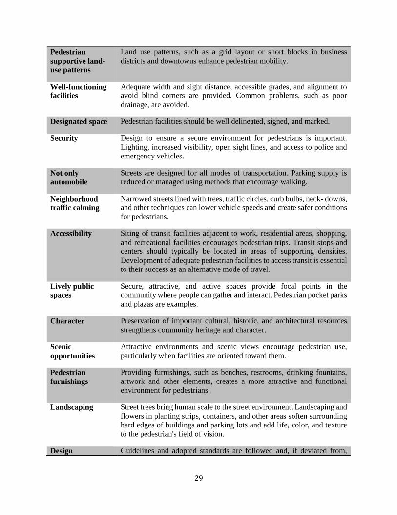
Pedestrian
supportive land-
use patterns
Land use patterns, such as a grid layout or short blocks in business
districts and downtowns enhance pedestrian mobility.
Well-functioning
facilities
Adequate width and sight distance, accessible grades, and alignment to
avoid blind corners are provided. Common problems, such as poor
drainage, are avoided.
Designated space Pedestrian facilities should be well delineated, signed, and marked.
Security Design to ensure a secure environment for pedestrians is important.
Lighting, increased visibility, open sight lines, and access to police and
emergency vehicles.
Not only
automobile
Streets are designed for all modes of transportation. Parking supply is
reduced or managed using methods that encourage walking.
Neighborhood
traffic calming
Narrowed streets lined with trees, traffic circles, curb bulbs, neck- downs,
and other techniques can lower vehicle speeds and create safer conditions
for pedestrians.
Accessibility Siting of transit facilities adjacent to work, residential areas, shopping,
and recreational facilities encourages pedestrian trips. Transit stops and
centers should typically be located in areas of supporting densities.
Development of adequate pedestrian facilities to access transit is essential
to their success as an alternative mode of travel.
Lively public
spaces
Secure, attractive, and active spaces provide focal points in the
community where people can gather and interact. Pedestrian pocket parks
and plazas are examples.
Character Preservation of important cultural, historic, and architectural resources
strengthens community heritage and character.
Scenic
opportunities
Attractive environments and scenic views encourage pedestrian use,
particularly when facilities are oriented toward them.
Pedestrian
furnishings
Providing furnishings, such as benches, restrooms, drinking fountains,
artwork and other elements, creates a more attractive and functional
environment for pedestrians.
Landscaping Street trees bring human scale to the street environment. Landscaping and
flowers in planting strips, containers, and other areas soften surrounding
hard edges of buildings and parking lots and add life, color, and texture
to the pedestrian's field of vision.
Design Guidelines and adopted standards are followed and, if deviated from,
30
requirements justified and documented.
Proper
maintenance
Frequent cleanup and repair on a regular basis ensures consistent use.
Typical elements of pedestrian-friendly streets are: streets that are interconnected and small block
patterns provide good opportunities for pedestrian access and mobility; narrower streets, scaled
down for pedestrians and less conducive to high vehicle speeds; traffic calming devices to slow
traffic, or reduced speed limits; median refuge islands to provide a refuge area for crossing
pedestrians; public spaces and pedestrian pockets adjacent to the main pedestrian travel way, that
provide a place to rest and interact (sidewalk cafes, benches, etc.); awnings/covered building
entrances that shelter pedestrians from weather; planting buffers, with landscaping and street trees
that provide shelter and shade without obstructing sight distances and help to soften the
surrounding buildings and hard surfaces; street lighting designed to pedestrian scale (shorter light
poles with attractive fixtures that are effective in illuminating the pedestrian travel way but not
obtrusive or harsh); wide and continuous sidewalks or separated walkways that are fully
accessible. Clear delineation and direction for the pedestrian (special paving on sidewalk or at edge
of pedestrian travel area, easy-to-reach signal actuators, etc.); lively building faces with
architectural relief, windows, or attractive surfacing; street furnishings, such as benches, garbage
receptacles, drinking fountains, and newspaper stands, if not placed in the route of travel; public
art, murals, banners, sculpture pieces and water features; colorful planters, holiday lighting and
other attractive features; signs, information kiosks, maps, and other elements to help pedestrians.
Accessibility Design for All-An Illustrated Handbook, Washington State Regulations (1995),
defines accessible route of travel as a continuous unobstructed path connecting all accessible
elements and spaces in an accessible building or facility than can be negotiated by a person using
a wheelchair and that is usable by persons with other disabilities (includes access routes across
sites between building entrances and other public facilities such as parking, sidewalks, restrooms,
etc.).
Most common types of pedestrian/motor vehicle collisions for children aged K-6 are: darting out;
dashing across an intersection; crossing in front of a turning vehicle; crossing a multi-lane street;
entering or crossing an intersection; playing in a roadway; going to or from a school bus; and
crossing behind a vehicle that is backing up. In this case, recommended processes for improving
student pedestrian safety are: preparing school walk route plans; providing school walk route maps
and information to parents and students; identifying pedestrian safety deficiencies; and
implementing remedial actions and improvements to address pedestrian safety concerns.
Pedestrian improvements along school walk routes can be: well-compacted crushed rock or gravel
shoulders, separated crushed rock or gravel path, paved shoulder, paved walkway or sidewalk
separated from roadway by ditches, swales, or planting buffers. As some of these improvements

31
are a short-term solution, a long-term solution need to be considered for the route of travel to be
accessible. For this, the surface needs to be smooth and stable with edge treatments when
necessary.
Separation treatments for multi-use pathways can be: colored paving; signing; textured paving or
paving patterns; pavement markings; and striping with education program about trail use and other
measures.
According to the Design and Safety of Pedestrian Facilities, A Proposed Recommended Practice
of the Institute of Transportation Engineers, ITE Technical Council Committee TENC 5A-5
(1998), criteria to be analyzed to determine pedestrian safety deficiencies are: roadway and traffic
control device inventory; sight distance studies; adequacy of gaps in the stream of traffic for
pedestrian crossings; collision summaries and diagrams; conflict analysis; pedestrian volumes and
characteristics; and traffic volumes and speeds.
Based on the Oregon Bicycle and Pedestrian Plan (1995), access management techniques can be:
reducing the number of existing driveways or consolidating driveways to parking areas and
businesses; and providing raised or landscaped medians or concrete barriers to control turning
movements from the street. Furthermore, some of the access management benefits are: the number
of conflict points is reduced (e.g., the use of center medians to reduce the number of conflicts
between left-turning vehicles and pedestrians); pedestrian crossing opportunities are enhanced
with an accessible raised median and fewer conflicts with turning cars; accommodating people
with disabilities becomes easier with the reduced need for special treatments at driveway cuts;
traffic volumes may decrease if local traffic can use other available routes; and improved traffic
flow may reduce the need for road-widening, and reducing the number of lanes to cross at
intersections, allowing more space for use by pedestrians and bicyclists.
Basic principles of intersection design to accommodate pedestrians are: intersections that function
well for pedestrians are typically compact; free-flowing motor vehicle movements are either
eliminated or vehicles are forced to a significantly slower speed through the intersection; all legs
of an intersection should be available for pedestrian use; closing a crosswalk doesn’t necessarily
prevent pedestrians from crossing in that direction. Pedestrians need to be able to travel in a direct
line across the intersection and the direction of travel needs to be clearly identified for all
pedestrians, including those with sight impairments, avoiding increasing potential conflicts or the
level of pedestrian exposure to motor vehicles. Note that on some T-intersections, it may not be
desirable for pedestrians to cross in front of left turning vehicles.
Basic conditions that are considered for the installation of pedestrian crossing improvements are:
school walking routes; routes identified in the non-motorized plan; connection to significant
business areas; access to transit; higher level of protection or better sight distance or otherwise
easier to cross; serving people who have more difficult than average crossing the street; a safety
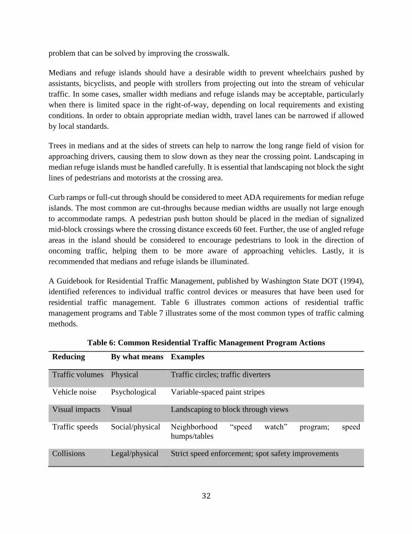
32
problem that can be solved by improving the crosswalk.
Medians and refuge islands should have a desirable width to prevent wheelchairs pushed by
assistants, bicyclists, and people with strollers from projecting out into the stream of vehicular
traffic. In some cases, smaller width medians and refuge islands may be acceptable, particularly
when there is limited space in the right-of-way, depending on local requirements and existing
conditions. In order to obtain appropriate median width, travel lanes can be narrowed if allowed
by local standards.
Trees in medians and at the sides of streets can help to narrow the long range field of vision for
approaching drivers, causing them to slow down as they near the crossing point. Landscaping in
median refuge islands must be handled carefully. It is essential that landscaping not block the sight
lines of pedestrians and motorists at the crossing area.
Curb ramps or full-cut through should be considered to meet ADA requirements for median refuge
islands. The most common are cut-throughs because median widths are usually not large enough
to accommodate ramps. A pedestrian push button should be placed in the median of signalized
mid-block crossings where the crossing distance exceeds 60 feet. Further, the use of angled refuge
areas in the island should be considered to encourage pedestrians to look in the direction of
oncoming traffic, helping them to be more aware of approaching vehicles. Lastly, it is
recommended that medians and refuge islands be illuminated.
A Guidebook for Residential Traffic Management, published by Washington State DOT (1994),
identified references to individual traffic control devices or measures that have been used for
residential traffic management. Table 6 illustrates common actions of residential traffic
management programs and Table 7 illustrates some of the most common types of traffic calming
methods.
Table 6: Common Residential Traffic Management Program Actions
Reducing By what means Examples
Traffic volumes Physical Traffic circles; traffic diverters
Vehicle noise Psychological Variable-spaced paint stripes
Visual impacts Visual Landscaping to block through views
Traffic speeds Social/physical Neighborhood “speed watch” program; speed
humps/tables
Collisions Legal/physical Strict speed enforcement; spot safety improvements
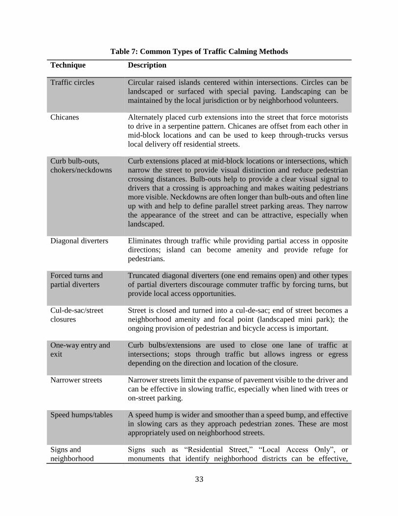
33
Table 7: Common Types of Traffic Calming Methods
Technique Description
Traffic circles Circular raised islands centered within intersections. Circles can be
landscaped or surfaced with special paving. Landscaping can be
maintained by the local jurisdiction or by neighborhood volunteers.
Chicanes Alternately placed curb extensions into the street that force motorists
to drive in a serpentine pattern. Chicanes are offset from each other in
mid-block locations and can be used to keep through-trucks versus
local delivery off residential streets.
Curb bulb-outs,
chokers/neckdowns
Curb extensions placed at mid-block locations or intersections, which
narrow the street to provide visual distinction and reduce pedestrian
crossing distances. Bulb-outs help to provide a clear visual signal to
drivers that a crossing is approaching and makes waiting pedestrians
more visible. Neckdowns are often longer than bulb-outs and often line
up with and help to define parallel street parking areas. They narrow
the appearance of the street and can be attractive, especially when
landscaped.
Diagonal diverters Eliminates through traffic while providing partial access in opposite
directions; island can become amenity and provide refuge for
pedestrians.
Forced turns and
partial diverters
Truncated diagonal diverters (one end remains open) and other types
of partial diverters discourage commuter traffic by forcing turns, but
provide local access opportunities.
Cul-de-sac/street
closures
Street is closed and turned into a cul-de-sac; end of street becomes a
neighborhood amenity and focal point (landscaped mini park); the
ongoing provision of pedestrian and bicycle access is important.
One-way entry and
exit
Curb bulbs/extensions are used to close one lane of traffic at
intersections; stops through traffic but allows ingress or egress
depending on the direction and location of the closure.
Narrower streets Narrower streets limit the expanse of pavement visible to the driver and
can be effective in slowing traffic, especially when lined with trees or
on-street parking.
Speed humps/tables A speed hump is wider and smoother than a speed bump, and effective
in slowing cars as they approach pedestrian zones. These are most
appropriately used on neighborhood streets.
Signs and
neighborhood
Signs such as “Residential Street,” “Local Access Only”, or
monuments that identify neighborhood districts can be effective,
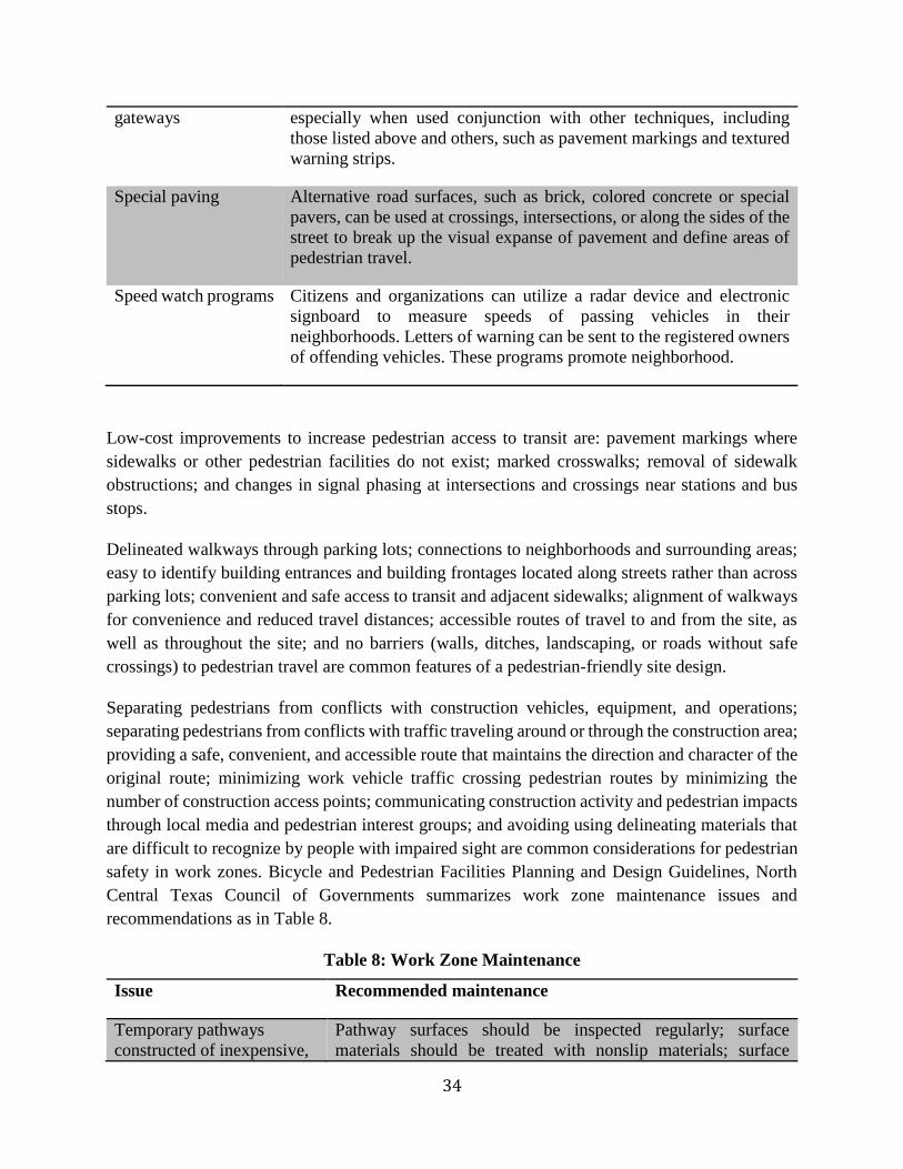
34
gateways especially when used conjunction with other techniques, including
those listed above and others, such as pavement markings and textured
warning strips.
Special paving Alternative road surfaces, such as brick, colored concrete or special
pavers, can be used at crossings, intersections, or along the sides of the
street to break up the visual expanse of pavement and define areas of
pedestrian travel.
Speed watch programs Citizens and organizations can utilize a radar device and electronic
signboard to measure speeds of passing vehicles in their
neighborhoods. Letters of warning can be sent to the registered owners
of offending vehicles. These programs promote neighborhood.
Low-cost improvements to increase pedestrian access to transit are: pavement markings where
sidewalks or other pedestrian facilities do not exist; marked crosswalks; removal of sidewalk
obstructions; and changes in signal phasing at intersections and crossings near stations and bus
stops.
Delineated walkways through parking lots; connections to neighborhoods and surrounding areas;
easy to identify building entrances and building frontages located along streets rather than across
parking lots; convenient and safe access to transit and adjacent sidewalks; alignment of walkways
for convenience and reduced travel distances; accessible routes of travel to and from the site, as
well as throughout the site; and no barriers (walls, ditches, landscaping, or roads without safe
crossings) to pedestrian travel are common features of a pedestrian-friendly site design.
Separating pedestrians from conflicts with construction vehicles, equipment, and operations;
separating pedestrians from conflicts with traffic traveling around or through the construction area;
providing a safe, convenient, and accessible route that maintains the direction and character of the
original route; minimizing work vehicle traffic crossing pedestrian routes by minimizing the
number of construction access points; communicating construction activity and pedestrian impacts
through local media and pedestrian interest groups; and avoiding using delineating materials that
are difficult to recognize by people with impaired sight are common considerations for pedestrian
safety in work zones. Bicycle and Pedestrian Facilities Planning and Design Guidelines, North
Central Texas Council of Governments summarizes work zone maintenance issues and
recommendations as in Table 8.
Table 8: Work Zone Maintenance
Issue Recommended maintenance
Temporary pathways
constructed of inexpensive,
Pathway surfaces should be inspected regularly; surface
materials should be treated with nonslip materials; surface
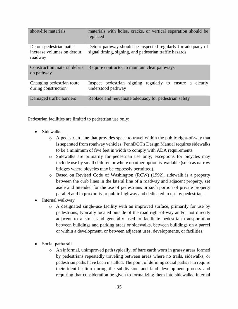
35
short-life materials materials with holes, cracks, or vertical separation should be
replaced
Detour pedestrian paths
increase volumes on detour
roadway
Detour pathway should be inspected regularly for adequacy of
signal timing, signing, and pedestrian traffic hazards
Construction material debris
on pathway
Require contractor to maintain clear pathways
Changing pedestrian route
during construction
Inspect pedestrian signing regularly to ensure a clearly
understood pathway
Damaged traffic barriers Replace and reevaluate adequacy for pedestrian safety
Pedestrian facilities are limited to pedestrian use only:
Sidewalks
o A pedestrian lane that provides space to travel within the public right-of-way that
is separated from roadway vehicles. PennDOT's Design Manual requires sidewalks
to be a minimum of five feet in width to comply with ADA requirements.
o Sidewalks are primarily for pedestrian use only; exceptions for bicycles may
include use by small children or where no other option is available (such as narrow
bridges where bicycles may be expressly permitted).
o Based on Revised Code of Washington (RCW) (1992), sidewalk is a property
between the curb lines in the lateral line of a roadway and adjacent property, set
aside and intended for the use of pedestrians or such portion of private property
parallel and in proximity to public highway and dedicated to use by pedestrians.
Internal walkway
o A designated single-use facility with an improved surface, primarily for use by
pedestrians, typically located outside of the road right-of-way and/or not directly
adjacent to a street and generally used to facilitate pedestrian transportation
between buildings and parking areas or sidewalks, between buildings on a parcel
or within a development, or between adjacent uses, developments, or facilities.
Social path/trail
o An informal, unimproved path typically, of bare earth worn in grassy areas formed
by pedestrians repeatedly traveling between areas where no trails, sidewalks, or
pedestrian paths have been installed. The point of defining social paths is to require
their identification during the subdivision and land development process and
requiring that consideration be given to formalizing them into sidewalks, internal
36
walkways, or trails as a part of new development to facilitate pedestrian movement
within a site and connections to adjacent areas.
Use-restricted path
o Paths are typically unpaved trails that are primarily used for one form of travel.
Most commonly, single-use paths are designated for pedestrian/hiking purposes
only due to trail width, surface, topography, condition, accessibility limitations, and
potential user conflict.
Bicycle Facilities are limited to bicycle use only:
Shared roadway (with limited, inconsistent, or no shoulder)
o A roadway accommodating bicyclists and motorists in the same travel lane.
Typically the travel lanes are wider than what would be designed for automobile
traffic only for the associated functional classification of the road and its context
(e.g. rural or urban).
o Shared roadways may be a Signed Bike Route or include other indicators such as
Share the Road Signs, Sharrows, or other pavement markers.
Shared roadway with paved shoulder
o The street with a paved shoulder or wide curb lane that accommodates bicyclists
adjacent to the vehicle travel lanes. A four to six foot shoulder is preferable, in
conjunction with applicable municipal and PennDOT guidelines.
o Paved shoulders are separated from travel lanes by the striping representing the
outside edge of the outermost travel lane.
Bike lane
o A designated travel lane along the shoulder for exclusive use by bicyclists. Bicycle
lanes are typically located on roadways in urban and suburban settings with
moderate to high vehicular traffic volumes and moderate to high-posted speeds.
o PennDOT's Design Manual requires a formal bicycle lane to have a five-foot
dedicated shoulder, application of pavement striping, markings, and regulatory
signage. Bicycle lane facilities should be one-way facilities that carry traffic in the
same direction as motor vehicles.
In addition to the shared roadway and bike lane facilities, supplemental signage, roadway
treatments (striping, coloration, or texture) can be added to these facilities when warranted.
Share the Road
o A supplemental signage added to a shared roadway to warn motorists of the
increased likelihood of bicyclists.
Sharrow
o A pavement marker that increases driver awareness of shared roadway
arrangements.
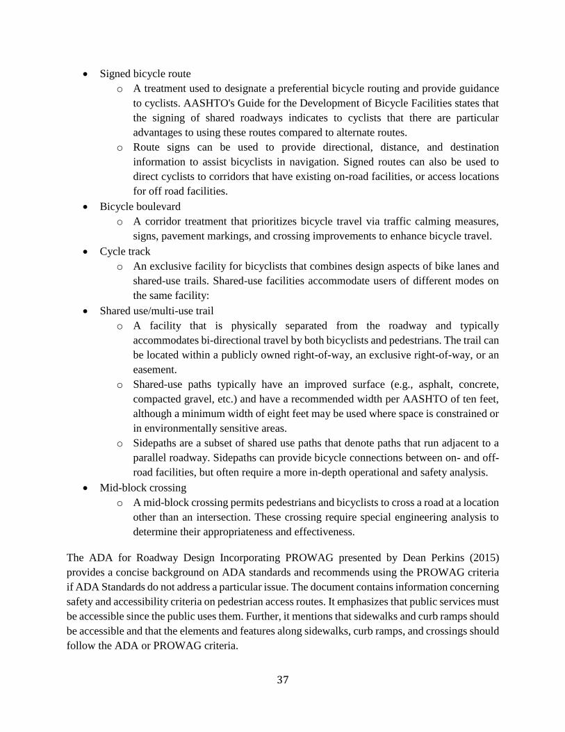
37
Signed bicycle route
o A treatment used to designate a preferential bicycle routing and provide guidance
to cyclists. AASHTO's Guide for the Development of Bicycle Facilities states that
the signing of shared roadways indicates to cyclists that there are particular
advantages to using these routes compared to alternate routes.
o Route signs can be used to provide directional, distance, and destination
information to assist bicyclists in navigation. Signed routes can also be used to
direct cyclists to corridors that have existing on-road facilities, or access locations
for off road facilities.
Bicycle boulevard
o A corridor treatment that prioritizes bicycle travel via traffic calming measures,
signs, pavement markings, and crossing improvements to enhance bicycle travel.
Cycle track
o An exclusive facility for bicyclists that combines design aspects of bike lanes and
shared-use trails. Shared-use facilities accommodate users of different modes on
the same facility:
Shared use/multi-use trail
o A facility that is physically separated from the roadway and typically
accommodates bi-directional travel by both bicyclists and pedestrians. The trail can
be located within a publicly owned right-of-way, an exclusive right-of-way, or an
easement.
o Shared-use paths typically have an improved surface (e.g., asphalt, concrete,
compacted gravel, etc.) and have a recommended width per AASHTO of ten feet,
although a minimum width of eight feet may be used where space is constrained or
in environmentally sensitive areas.
o Sidepaths are a subset of shared use paths that denote paths that run adjacent to a
parallel roadway. Sidepaths can provide bicycle connections between on- and off-
road facilities, but often require a more in-depth operational and safety analysis.
Mid-block crossing
o A mid-block crossing permits pedestrians and bicyclists to cross a road at a location
other than an intersection. These crossing require special engineering analysis to
determine their appropriateness and effectiveness.
The ADA for Roadway Design Incorporating PROWAG presented by Dean Perkins (2015)
provides a concise background on ADA standards and recommends using the PROWAG criteria
if ADA Standards do not address a particular issue. The document contains information concerning
safety and accessibility criteria on pedestrian access routes. It emphasizes that public services must
be accessible since the public uses them. Further, it mentions that sidewalks and curb ramps should
be accessible and that the elements and features along sidewalks, curb ramps, and crossings should
follow the ADA or PROWAG criteria.
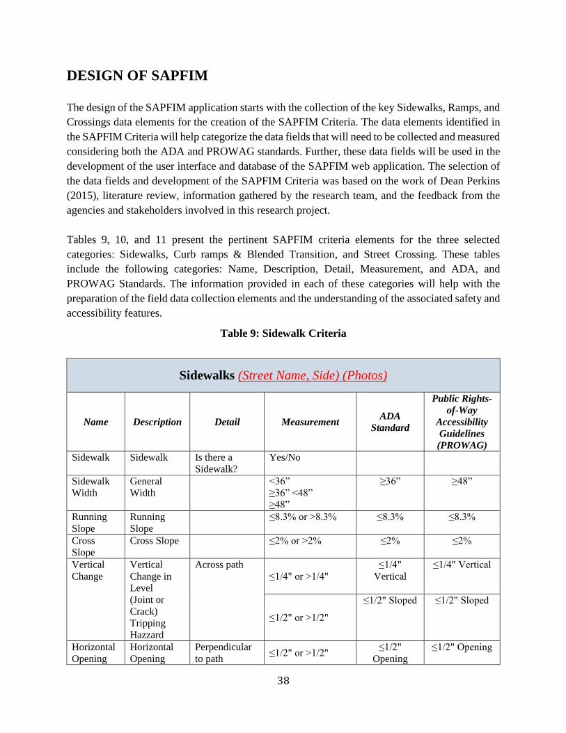
38
DESIGN OF SAPFIM
The design of the SAPFIM application starts with the collection of the key Sidewalks, Ramps, and
Crossings data elements for the creation of the SAPFIM Criteria. The data elements identified in
the SAPFIM Criteria will help categorize the data fields that will need to be collected and measured
considering both the ADA and PROWAG standards. Further, these data fields will be used in the
development of the user interface and database of the SAPFIM web application. The selection of
the data fields and development of the SAPFIM Criteria was based on the work of Dean Perkins
(2015), literature review, information gathered by the research team, and the feedback from the
agencies and stakeholders involved in this research project.
Tables 9, 10, and 11 present the pertinent SAPFIM criteria elements for the three selected
categories: Sidewalks, Curb ramps & Blended Transition, and Street Crossing. These tables
include the following categories: Name, Description, Detail, Measurement, and ADA, and
PROWAG Standards. The information provided in each of these categories will help with the
preparation of the field data collection elements and the understanding of the associated safety and
accessibility features.
Table 9: Sidewalk Criteria
Sidewalks (Street Name, Side) (Photos)
Name Description Detail Measurement ADA
Standard
Public Rights-
of-Way
Accessibility
Guidelines
(PROWAG)
Sidewalk Sidewalk Is there a
Sidewalk?
Yes/No
Sidewalk
Width
General
Width
˂36”
≥36” ˂48”
≥48”
≥36” ≥48”
Running
Slope
Running
Slope
≤8.3% or ˃8.3% ≤8.3% ≤8.3%
Cross
Slope
Cross Slope ≤2% or ˃2% ≤2% ≤2%
Vertical
Change
Vertical
Change in
Level
(Joint or
Crack)
Tripping
Hazzard
Across path
≤1/4" or ˃1/4"
≤1/4"
Vertical
≤1/4" Vertical
≤1/2" or ˃1/2"
≤1/2" Sloped ≤1/2" Sloped
Horizontal
Opening
Horizontal
Opening
Perpendicular
to path ≤1/2" or ˃1/2"
≤1/2"
Opening
≤1/2" Opening
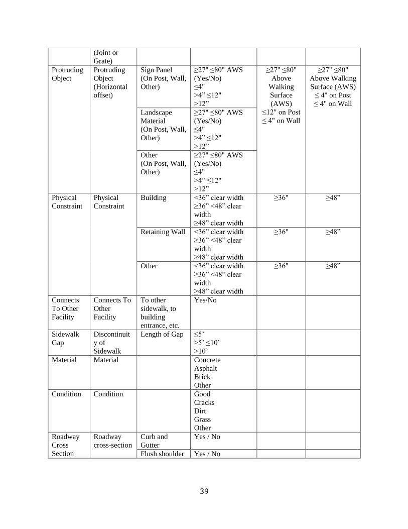
39
(Joint or
Grate)
Protruding
Object
Protruding
Object
(Horizontal
offset)
Sign Panel
(On Post, Wall,
Other)
≥27" ≤80" AWS
(Yes/No)
≤4"
>4” ≤12"
>12”
≥27" ≤80"
Above
Walking
Surface
(AWS)
≤12" on Post
≤ 4" on Wall
≥27" ≤80"
Above Walking
Surface (AWS)
≤ 4" on Post
≤ 4" on Wall
Landscape
Material
(On Post, Wall,
Other)
≥27" ≤80" AWS
(Yes/No)
≤4"
>4” ≤12"
>12”
Other
(On Post, Wall,
Other)
≥27" ≤80" AWS
(Yes/No)
≤4"
>4” ≤12"
>12”
Physical
Constraint
Physical
Constraint
Building ˂36” clear width
≥36” ˂48” clear
width
≥48” clear width
≥36" ≥48”
Retaining Wall ˂36” clear width
≥36” ˂48” clear
width
≥48” clear width
≥36" ≥48”
Other ˂36” clear width
≥36” ˂48” clear
width
≥48” clear width
≥36" ≥48”
Connects
To Other
Facility
Connects To
Other
Facility
To other
sidewalk, to
building
entrance, etc.
Yes/No
Sidewalk
Gap
Discontinuit
y of
Sidewalk
Length of Gap ≤5’
>5’ ≤10’
˃10’
Material Material Concrete
Asphalt
Brick
Other
Condition Condition Good
Cracks
Dirt
Grass
Other
Roadway
Cross
Section
Roadway
cross-section
Curb and
Gutter
Yes / No
Flush shoulder Yes / No
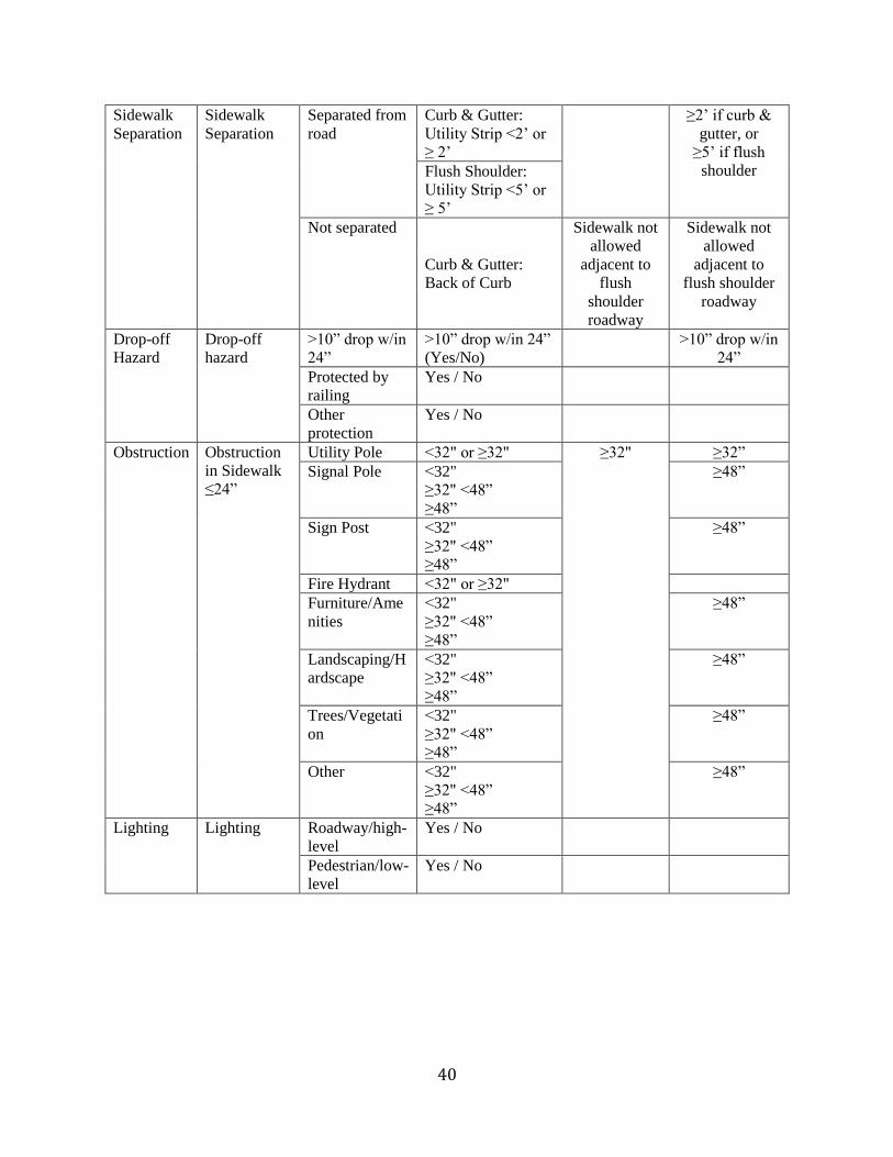
40
Sidewalk
Separation
Sidewalk
Separation
Separated from
road
Curb & Gutter:
Utility Strip ˂2’ or
≥ 2’
≥2’ if curb &
gutter, or
≥5’ if flush
shoulder Flush Shoulder:
Utility Strip <5’ or
≥ 5’
Not separated
Curb & Gutter:
Back of Curb
Sidewalk not
allowed
adjacent to
flush
shoulder
roadway
Sidewalk not
allowed
adjacent to
flush shoulder
roadway
Drop-off
Hazard
Drop-off
hazard
>10” drop w/in
24”
>10” drop w/in 24”
(Yes/No)
>10” drop w/in
24”
Protected by
railing
Yes / No
Other
protection
Yes / No
Obstruction Obstruction
in Sidewalk
≤24”
Utility Pole ˂32" or ≥32" ≥32" ≥32”
Signal Pole ˂32"
≥32" <48”
≥48”
≥48”
Sign Post ˂32"
≥32" <48”
≥48”
≥48”
Fire Hydrant ˂32" or ≥32"
Furniture/Ame
nities
˂32"
≥32" <48”
≥48”
≥48”
Landscaping/H
ardscape
˂32"
≥32" <48”
≥48”
≥48”
Trees/Vegetati
on
˂32"
≥32" <48”
≥48”
≥48”
Other ˂32"
≥32" <48”
≥48”
≥48”
Lighting Lighting Roadway/high-
level
Yes / No
Pedestrian/low-
level
Yes / No
41
Table 10: Curb Ramps & Blended Transition Criteria
Curb ramps & Blended Transition (Intersection, Corner) (Photo)
Name Description Detail Measurement ADA
Standard
Public Rights-
of-Way
Accessibility
Guidelines
(PROWAG)
Curb
Ramp
Curb Ramp Is there a Curb
Ramp?
Yes/No
Running
Slope
Running
Slope
Slope of curb
ramp
≤8.3% or ˃8.3% ≤8.3% ≤8.3%
Counter
Slope
Gutter Slope Gutter slope ≤5% or ˃5% ≤5% ≤5%
Cross
Slope
Cross Slope Top and bottom ≤2% or ˃2% ≤2% ≤2%
Flare
Slope
Flare Slope Both sides of
ramp ≤10% or ˃10%
≤10% ≤10%
Ramp
Length
Ramp Length From bottom of
ramp to top of
ramp
˂72”
≥72” <88”
≥88”
Ramp
Width
Ramp Width At narrowest
point
˂36”
≥36” ˂48”
≥48”
≥36" ≥48"
Top
Landing
Top Landing Landing Width ˂36”
≥36” ˂48”
≥48”
≥36" ≥48"
Bottom
Landing
Bottom
Landing
Landing Width ˂48" or ≥48" ≥48" ≥48"
Detectable
Warnings
Detectable
Warnings
Truncated
Domes
Yes/No
Color:
Brick Red,
Yellow,
Black, No
Color, Other
Yes/No
Detectable
Warning
Detectable
Warnings
Placement
Detectable
Warnings
Placement
≤2” from back of
curb
>2” ≤5’ from back
of curb
˃5’ from back of
curb
≤2” from
Back of curb
or
≤5’ from
Curb
≤2” from Back
of curb
or
≤5’ from Curb
Type of
Ramps
Type of
Ramps
Perpendicular
Parallel
Combination
Diagonal
Other
42
Table 11: Street Crossing Criteria
Street Crossing (Intersection, Location) (Photo)
Name Description Detail Measurement ADA Standard
Public Rights-
of-Way
Accessibility
Guidelines
(PROWAG)
Street
Crossing
Street
Crossing
Is there a
Marked
Crossing?
Yes/No
Horizontal
Opening
Horizontal
Opening
(Joint or
Grate)
Perpendicular
to path ≤1/2" or ˃1/2"
≤1/2" ≤1/2"
Median Island/Median Yes/No
Pedestrian
Refuge
60" deep x 60"
wide (Yes/No)
48" deep x 60"
wide (Yes/No)
48" deep x 60"
wide
60” deep x 60”
wide
Pedestrian
Signal
Pedestrian
Signal
Is there a push-
button?
Yes/No
Push-button 2" dia. raised
(Yes/No)
2" dia. raised
Accessible
Features
Audible
Tactile
Other
None
Height of
Button
≤42" AWS
>42” ≤48” AWS
˃48" AWS
≤48" AWS ≤42" AWS
Level Clear
Space
≥30"x 48"
(Yes/No)
≥30"x 48" ≥30"x 48"
Number of
Lanes to Cross
1, 2, 3, 4, 5, 6, 7,
8, 9, 10
Total Time to
Cross
Seconds
Measured on
“Date” at
“Time”
Date-Time Stamp
Material Material Concrete
Asphalt
Brick/Paver
Other
43
Condition Condition Good
Cracks
Faded
Other
The main elements considered in the design of the SAPFIM application are illustrated in Figure 1.
The diagram starts with the Planning of the software that sets the vision of the expected outcome.
This phase will be based on the experience of the research team with feedback from all the
participants in this research project. Then, the SAPFIM Criteria outlines the data that will need to
be collected in the field and measured using the ADA and PROWAG standards. The criteria will
also be used for the development of the SAPFIM database. Once the previous steps are completed,
the Web Design will start. The web application will consist of four (4) sections that will be created
for the collection of data, management, and assessment of pedestrian facilities. Those sections
include:
1. Data Collection
2. Reports
3. Data Management
4. Maps
In the Data Collection section, users through the user interface will collect sidewalks, ramps, and
street crossing data. Data will be uploaded directly into the SAPFIM web server and can be
collected using field devices that have GPS, camera, and wireless capabilities. If necessary, office
computers can also be used to input or correct some of the information collected in the field.
Under Reports, users will be able to generate and print reports such as full report for each of the
three pedestrian categories: sidewalks, ramps, and street crossings. In addition, a report that
measures the compliance of pedestrian facilities with ADA and PROWAAG will be included in
the software application. This feature can assist the agencies using SAPFIM with identifying the
data records that do not comply with ADA or PROWAAG standards, which can be very helpful
for prioritizing improvements and complying with ADA requirements.
In the data management section, users will be able to generate queries based on the data available
in the database. Data can be exported in CSV format for use in other software applications; pictures
will be exported in JPG format.
The Maps section will allow users to view and print the collected pedestrian facilities using Google
Map. Users will also be able to navigate on the map to get information by clicking on the
appropriate icons that represent the sidewalks, ramps, and street crossings data collected.
44
Planning
Web Design
Data Collection
Sidewalks Ramps
Crossstreets Full ReportsADA & PROWAG
Reports
Queries Export
MapsData
ManagementReports
SAFIM Data
CriteriaSAPFIM
Database
Figure 1: Design of SAPFIM Web Application
DATA FLOW OF SAPFIM
This section describes the SAPFIM process and data flow. Users will be able to access SAPFIM
through a web browser using a computer, tablet, smartphone, or laptop. In the field, users will be
able to collect new data or modify an existing pedestrian data point from the database. Once a data
record is retrieved, it can be edited. After the sidewalk information has been updated, a user will
be able to save it to the database.
Figure 2 shows the process and data flow functions of SAPFIM. It depicts how users using various
devices or computers will be able to upload data or retrieve information through the internet by
accessing the database by means of the SAPFIM application hosted in the web server.
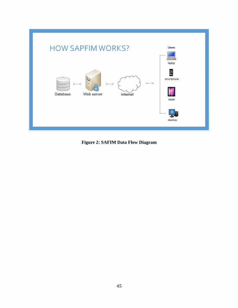
45
Figure 2: SAFIM Data Flow Diagram
46
NEXT STEPS This section presents the next steps towards the development of SAPFIM, as presented in the scope
of work of the “Safe and Accessible Pedestrian Facilities Inventory Model (SAPFIM):
Development” project funded by the National Center for Transportation Research (NCTR).
The main objective is to develop a web-based software application that local agencies can use for
the collection, storage, querying, analysis, and reporting of pedestrian facilities. It will include
accessible and safety features associated with sidewalks, curb ramps, and street crossings. Data
will be collected using devices, (i.e., tablets with GPS, camera, and wireless capability) which can
be uploaded directly into the web server.
To achieve this, the FIU research team proposes a series of work tasks that include software
development and testing and producing a final report.
Prepare the Project Work Plan for the Development of SAPFIM
This task will serve as a general guideline for all the milestones according to the proposed
schedule.
Develop the SAPFIM Software
As part of this task, a web-based pedestrian facility application will be developed using
Microsoft Visual Studio to collect data from pedestrian facilities in order to efficiently
assess the conditions of pedestrian facilities such as sidewalks along public rights of way.
o Database
This includes the creation and setup of the SQL server database using Microsoft SQL
Server, which will be the back end of the software application.
o User Interface
In this step, the user interface of the web application will be created.
Test and Troubleshoot the Web Application
This task includes an overall testing of software such as device testing, wireless
communication testing, database testing, which will ensure that the software is bug free
and provides opportunities to improve the application.
47
Prepare the Final Report
A draft final report documenting all aspects of this research will be prepared and submitted
to NCTR for review and comments. This will include the work plan, the development of
the software, and the results from the software testing. The final report will provide the
information gathered for the development of the Safe and Accessible Pedestrian Facilities
Inventory Model (SAPFIM). Based on the feedback from NCTR, the report will be revised
and finalized, and resubmitted.
48
REFERENCES
AARP, WALC (2014). Sidewalks: A Livability Fact Sheet. American Association of Retired
Persons and Walkable and Livable Communities Institute.
http://www.aarp.org/content/dam/aarp/livable-communities/documents-
2014/Livability%20Fact%20Sheets/Sidewalks-Fact-Sheet.pdf
AASHTO Executive Committee. (1999). "Guide for the Development of Bicycle Facilities."
American Association of State Highway and Transportation Officials, Washington, DC.
AASHTO (2004). Guide for the Planning, Design, and Operation of Pedestrian Facilities.
American Association of State Highway and Transportation Officials.
AASHTO (2012). Guide for the Development of Bicycle Facilities. American Association of
State Highway and Transportation Officials.
ACHD (2005). Pedestrian-Bicycle Transition Plan. Ada County Highway District (ACHD),
Idaho. Report prepared by the Transpo Group. http://www.achdidaho.org/Departments/PP/Ped-
Bike_Plan.aspx
Allan, B., & Moffett, F. C. (1998). Accessibility Design for All: An Illustrated Handbook:
Washington State regulations (WAC 51-40). Olympia, WA (Capitol Court, Suite 237, 1110
Capitol Way, S., Olympia 98501-2272): A.I.A., Washington Council.
American National Standards Institute (ANSI) (1998). Accessible and Usable Buildings and
Facilities. The Council.
Americans with Disabilities Act of 1990: Law and Explanation. (1990). Chicago, Ill. (4025 W.
Peterson Ave., Chicago 60646): Commerce Clearing House.
Bicycle, Oregon, and Pedestrian Plan. "Oregon Department of Transportation." Salem,
OR (1995).
Boatman|, B. M. (2015). Los Angeles Will Fix Crumbling, Inaccessible Sidewalks - New
Mobility. Retrieved October 18, 2016, from http://www.newmobility.com/2015/04/los-angeles-
will-fix-crumbling-inaccessible-sidewalks/
Designing Walkable Urban Thoroughfares: A Context Sensitive Approach. (2010). Washington,
DC: Institute of Transportation Engineers.
Federal Highway Administration (FHWA) (2001). Accessible Sidewalks and Street Crossings:
An Informational Guide. 1200 New Jersey Avenue, SE Washington, DC 20590 USA.
http://www.bikewalk.org/pdfs/sopada_fhwa.pdf
49
Federal Highway Administration (FHWA) (2013). A Guide for Maintaining Pedestrian
Facilities for Enhanced Safety. No. FHWA-SA-13-037.
Federal Highway Administration (FHWA). Designing Sidewalks and Trails for Access
https://www.fhwa.dot.gov/environment/bicycle_pedestrian/publications/sidewalks/contents.cfm
Goldman, Charles D. Architectural Barriers: A Perspective on Progress. W. New England Law
Review 5 (1968): 465.
Florida Department of Transportation. (2016). FDOT Americans with Disabilities Act (ADA):
ADA / Accessibility Program. http://www.fdot.gov/designsupport/ADA/
International Code Council, Inc. (2016). ICC A117.1 Standard Fourth Public Review Draft
Background Report. ICC/ANSI A117.1 Standard Development - 2015 Edition
http://productionpullzone.umz7izwbxixtqs4tn8wkvgdcktq5y5tafr.netdna-cdn.com/wp-
content/uploads/asc_a117/A117-1-Fourth-Public-Review-Draft.pdf
ITE (1998). Design and Safety of Pedestrian Facilities. Institute of Transportation Engineers.
Traffic Engineering Council Committee TENC 5A-5.
ITE (2010). Designing Walkable Urban Thoroughfares - A Context Sensitive Approach: An ITE
Recommended Practice. Institute of Transportation Engineers.
Keim, Donald W. (1976). "Education of all Handicapped Children Act of 1975, University of
Michigan, JL Reform 10: 110.
Kockelman, K., Zhao, Y., Heard, L., Taylor, D., & Taylor, B. (2000). The Nature of ADA’s
Sidewalk Cross-Slopes Requirements: A Review of the Literature. Transportation Research
Record, 1705, 53-60.
LaPlante, J. N., and Short, T. R. (2000). AASHTO GUIDE FOR THE PLANNING, DESIGN
AND OPERATION OF PEDESTRIAN FACILITIES. Institute of Transportation Engineers.
NACTO (2010). Urban Bikeway Design Guide. National Association of City Transportation
Officials
NACTO (2014). Urban Bikeway Design Guide, Second Edition. National Association of City
Transportation Officials.
National Council on Disability (2004). Livable Communities for Adults with Disabilities.
Oberlink, M. "Livable communities for adults with disabilities." Policy brief (Center for Home
Care Policy and Research (US)) 29 (2005): 1-6.
PACTS (2014). Regional Bicycle and Pedestrian Facility Design Guidance for the PACTS
Metropolitan Planning Area. Portland Area Comprehensive Transportation System. Report
50
prepared by Alta Planning + Design. http://www.pactsplan.org/plans-studies/2013-plans-studies-
completed/
Pedestrian Guidebook Facilities (1997). Incorporating Pedestrians into Washington’s
Transportation System. Prepared by Otak for Washington State DOT, Olympia, WA.
PennDOT (2016). Design Manual Part 2 Highway Design. Publication 13M, 2015 Edition
Change No. 1. Pennsylvania Department of Transportation. https://www.dot.state.pa.us/public/
pubsforms/Publications/PUB%2013M.pdf
Perkins, Dean. (2015). ADA for Roadway Design: Incorporating PROWAG. Design Training
Expo. http://www.fdot.gov/design/Training/DesignExpo/2015/presentations/ADAandPROWAG-
DeanPerkins.pdf
Rehabilitation Act of 1973 (1998). https://www.disability.gov/rehabilitation-act-1973/
Revised Code of Washington. Vol RCW 70.010 (1992). Washington Electronic Authentication
Act.
Savage, Joseph P., MacDonald, David R., and Ewell John. (1994). A Guidebook for Residential
Traffic Management. Olympia, WA: Washington State Department of Transportation.
United States Access Board (1991). The Americans with Disabilities Act Accessibility
Guidelines (ADAAG). Amended in 2002. https://www.access-board.gov/guidelines-and-
standards/buildings-and-sites/about-the-ada-standards/background/adaag
United States Access Board (2004). Americans with Disabilities Act and Architectural Barriers
Act Accessibility Guidelines. Amended in 2014. https://www.access-board.gov/attachments/
article/412/ada-aba.pdf
United States Access Board. (2006). ADA Standards for Transportation Facilities.
https://www.access-board.gov/guidelines-and-standards/transportation/facilities/ada-standards-
for-transportation-facilities
United States Access Board. (2006). Americans with Disabilities Act (ADA) Standards for
Transportation Facilities. https://www.access-
board.gov/attachments/article/1417/ADAdotstandards.pdf
United States Access Board (2010). Guide to the ADA Standards. https://www.access-
board.gov/guidelines-and-standards/buildings-and-sites/about-the-ada-standards/guide-to-the-
ada-standards
United States Access Board (2011). Proposed Accessibility Guidelines for Pedestrian Facilities
in the Public Right-of-Way. https://www.access-board.gov/attachments/article/743/nprm.pdf
United States Congress. "Intermodal surface transportation efficiency act of 1991."Public
Law (1991): 102-240.
51
United States Congress. "Transportation Equity Act for the 21st Century." Public Law (1998):
105-178.
United States Department of Justice Civil Rights Division. (2016). Information and Technical
Assistance on the Americans with Disabilities Act. https://www.ada.gov/
United States Department of Transportation. Accessibility: Equal Access to Transportation.
https://www.transportation.gov/accessibility
WALC (2014). Observations and Recommendations: The Built Environment. Albuquerque,
New Mexico. Walkable and Livable Communities Institute.
Zhang, Y., Proulx, F. R., Ragland, D. R., Schneider, R. J., & Grembek, O. (2014). Develop a
Plan to Collect Pedestrian Infrastructure and Volume Data for Future Incorporation into Caltrans
Accident Surveillance and Analysis System Database. Prepared by the UC Berkeley Safe
Transportation Research and Education Center for the California Department of Transportation
(Caltrans).