Embed Size (px)
Citation preview
132 • Journal of Cave and Karst Studies, August 2002 Copyright © 2002 by The National Speleological Society
Abdulali M. Sadiq and Sobhi J. Nasir - Middle Pleistocene karst evolution in the State of Qatar, Arabian Gulf. Journal of Cave and Karst Studies 64(2): 132-139.
Karst is a distinctive environment characterized by land-forms that are the product of dissolution of surface and sub-surface rock by natural water to a greater extent than in otherlandscapes. It occurs both as surface and underground features(White 1988; Ford & Williams 1989). The highly varied inter-actions among chemical, physical, and biological processeshave a broad range of geologic effects, including dissolution,precipitation, sedimentation, and ground subsidence (White1984; Trudgill 1985; Ford & Williams 1989; Smart &Whitaker 1991). Diagnostic features such as sinkholes(dolines), sinking streams, caves, and large springs are theresult of the dissolving action of circulating groundwater (Ford& Williams 1989; Smart & Whitaker 1991).
Karst includes features such as large caves, called as duhulin Arabic. It is an important feature of Eocene exposure sur-faces in Qatar as well as some large parts of the ArabianPeninsula (Abul-Haggag 1965; Edgell 1990; Mukhopadhyayet al. 1996). Several substantial caves are known in Qatar, butmany have probably been filled with blown sand, or have col-lapsed to produce some of the thousands of depressions ordolines. The most pronounced topographic features of Qatarare created by the large number (9736) of shallow depressions(Embabi & Ali 1990). Many of these depressions are the sur-face expression of subsurface collapse structures. Most ofthem are circular with diameters ranging from a few hundredmeters up to ~3 km. Some reach depths of 25 m while othersare only a few centimeters deep. Embabi and Ali (1990) relat-ed most sinkholes to these depressions. Analysis of the mor-phometric and spatial distribution parameters of karst depres-sions reveals that the Qatari karst is represented by broad, shal-low depressions with an average density of 1 depression perkm² (Embabi & Ali 1990).
The purpose of this paper is to report the geologic evolu-tion of exposed sinkholes in Qatar through an air photo study,
field investigations, and petrology.
GEOLOGIC SETTING
Qatar forms an exposed part of the Arabian shelf betweenthe Arabian Shield and the mobile belt of Iran. It is centered atabout 25°N., 51°E. Topographically, Qatar has a low-relief
MIDDLE PLEISTOCENE KARST EVOLUTION IN THESTATE OF QATAR, ARABIAN GULF
ABDULALI M. SADIQ AND SOBHI J. NASIRDepartment of Geology, The University of Qatar, P.O.Box 2713, Doha, QATAR [email protected]
Karst is widespread on the peninsula of Qatar in the Arabian Gulf, including depressions, sinkholes,caves, and solution hollows. More than 9700 large and small depressions, and several exposed sinkholesand caves are known. Field and air-photo studies indicate that the depressions, sinkholes, and caves ofQatar are genetically related, sinkholes representing an early phase in the development of depressions.Karst is concentrated mainly within the limestone, dolomite, gypsum, and anhydrite horizons of theEocene Rus and Dammam Formations. Most karst features in Qatar show NE-SW and NW-SE orienta-tions, similar to the joint and fracture systems. This observation indicates that rock type and the presenceof joints and fractures played a major role in the development of karst in Qatar. Cylindrical, bottle-shaped, compound, and bowl-shaped morphotype karst pits were identified. These forms represent agenetic sequence in which the bowl-shaped pits evolved through a series of cylindrical and bottle-shapedcompound intermediate stages. Most karst of central Qatar was formed due to extensive subsurface dis-solution of carbonate and sulfate deposits under Middle Pleistocene wet climatic conditions and conse-quent subsidence. Joint-flow drainage may account for differential dissolution resulting in the formationof a pitted karst terrain in the northern part of Qatar.
Figure 1. Geologic map of Qatar (modified after Cavelier1970) showing location of investigated sinkholes; (1):Alghosheimah, (2): Umkareibah, (3): Alsuberiat, (4):Hamam, (5): Duhail, (6) Mudhlem, (7): Musfer.
Journal of Cave and Karst Studies, August 2002 • 133
SADIQ AND NASIR
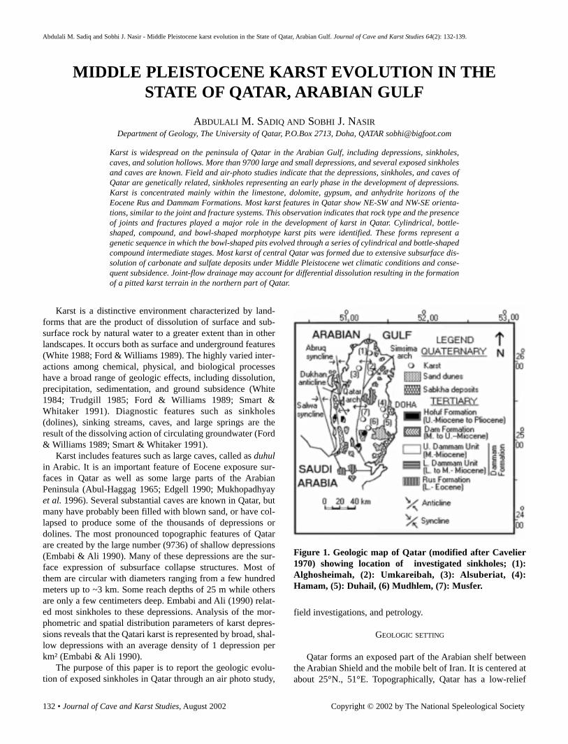
landscape with a maximum elevation of ~110 m msl.Structurally, Qatar is an elliptical anticlinal arch with a N-Smain axis (Fig. 1). The exposed geologic succession is madeup of Tertiary limestone and dolomite with interbedded clay,shale, gypsum, and marl, covered in places by Quaternarydeposits (Cavelier 1970). Major faulting is not observed.Tertiary sedimentation started in Qatar with a marine trans-gression in the Paleocene. Shallow-marine to sabkha condi-tions prevailed until the end of the Eocene; a carbonate-evap-orite sequence (Rus and Dammam Formations) was depositedduring this time. The sea regressed at the end of the Eocene,marked by a widespread unconformity, causing the absence ofOligocene deposits over most of the area. Depressions andsinkholes are mainly distributed south of latitude 25° 20’,which coincides with the northerly limit of the deep gypsumand anhydrite horizons of Eocene age. Although a dry arid cli-mate characterizes Qatar at present, moist and dry climaticconditions alternated during the Miocene and Pleistocene(Butzer 1961; Al-Saad et al. 2002). Karstification of the UpperDammam Unit limestone, providing easier pathways forgroundwater, took place during this period. Today, Tertiarysedimentary rocks constitute the main aquifers containingusable groundwater in Qatar, originating from recharge byoccasional rainstorms on outcrops of the same rocks in SaudiArabia. The water flows north and east in the direction of theregional dip and discharges along the present-day coast of theGulf. The aquifers are presently being exploited at a compara-tively high rate.
STRATIGRAPHY
The exposed rocks in Qatar consist of the following forma-tions (Fig. 2):
LOWER EOCENE RUS FORMATIONThe Rus Formation is composed of soft limestone,
dolomitic limestone, chalky limestone, gypsum, anhydrite, andshale. The thickness ranges between 42-112 m. Most depres-sions are related to dissolution of the gypsum and anhydritewithin this formation, resulting in the development of numer-ous surface-collapse depressions (Embabi & Ali 1990).
LOWER-MIDDLE EOCENE DAMMAM FORMATIONThe Dammam Formation conformably overlies the Rus
Formation and covers most of Qatar (Cavelier 1970). It rangesin thickness between 30-50 m, and is divided into the LowerDammam Unit and Upper Dammam Unit. The former consistsof the Fhiheil limestone member, the Midra shale member, andthe Dukhan limestone member. The Upper Dammam consistsof the Simsima limestone and dolomite member and theAbarug dolomite and marl member. All sinkholes of Qataroccur within the Upper Dammam Unit.
LOWER-MIDDLE MIOCENE DAM FORMATIONThe Miocene was characterized by regression of the sea
and continental erosion. The Dam Formation consists of shal-low marine and lacustrine deposits, and reaches a thickness of80 m.
UPPER MIOCENE TO PLIOCENE HOFUF FORMATION.The Hofuf Formation consists of fluvial sediments and is
~18 m thick. The deposits consist of coarse sand and sandstonewith pebbles of various rocks, mostly derived from the Arabianshield and the Arabian shelf, and transported by large river sys-tems (Al-Saad et al. 2002).
QUATERNARYQuaternary shallow-marine and continental sediments con-
sists of sabkha deposits, sand dunes, and calcareous sand.
SINKHOLES IN QATAR
Air photos show that karst in Qatar occurs as three types:sinkholes, simple depressions, and compound depressions.Simple depressions are those with a single center. Compounddepressions have more than one center, and are large and rec-tangular or irregular in shape. These depressions seem to haveformed through the amalgamation of several simple depres-sions. Field investigations indicate that the areas between thedepressions are extensively stylolitized and likely were origi-nally characterized by small-scale, fretted and sculpted karrenforms typical of subaerial karstification. Sinkholes are concen-trated in the central and northern parts of Qatar (Fig. 1).Analysis of sinkholes and the major axis orientations ofdepressions shows a structural control on the karst develop-
Figure 2. Simplified lithostratigraphy of surface rocks inQatar in relation to regional tectonics. UDU: UpperDammam Unit; LDU: Lower Dammam Unit. (Modifiedafter Cavelier 1970).
134 • Journal of Cave and Karst Studies, August 2002
MIDDLE PLEISTOCENE KARST EVOLUTION IN THE STATE OF QATAR, ARABIAN GULF
ment. The long-axis orientations of sinkholes have pronouncedNW-SE and NE-SW orientations, which correspond with thejoint and fracture orientations in the study area. A 0.1-1 m thickcalcrete surface is characteristic of karst areas in central Qatar.The wall rocks of sinkholes are highly jointed and fractured,with many stylolites, voids, and selective dissolution cavities.Thin-section studies of wall rocks from different sinkholes innorthern Qatar show that the upper 1-2 m of the walls aredolomitic in composition, whereas the lower portion of thewalls is biomicritic to biosparitic limestone with a significantproportion of dissolutional pores that are mostly filled withgypsum. The rocks belong to the Upper Dammam Unit. In cen-tral Qatar, marl underlies the upper calcrete whereas thick gyp-sum beds underlie the limestone. The rocks composing the
sinkholes of central Qatar belong to the Upper and LowerDammam units. Speleothems, such as stalactites, stalagmites,columns, flowstone, and rimstone pools were not observed inany sinkholes or caves in the investigated areas. The lower partof most caves is either very dark or very steep and were notexplored.
SINKHOLES IN NORTHERN QATAR
Most sinkhole entrances in northern Qatar are vertical(Figs. 3, 4) and formed by dissolution along planes of struc-tural weakness that extend to the surface. Sinkholes are foundin the following areas:
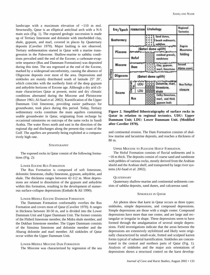
ALGHOSHEIMAH SINKHOLES (Fig. 3)These are four vertical sinkholes formed in the Upper
Dammam Unit. The holes are 15-20 m apart, occurring as anellipse with a long axis of 40 m. Hole A is the largest (2 x 1 m);it is 1 m vertical then increases in size to 11 m in diameter withdepth. Hole B has a smaller entrance (1.5 m in diameter), butis wider inside (12.5 m) than Hole A. Hole C has a small open-ing of 0.5 m and reaches a depth of 3.5 m. Hole D has an evensmaller opening (0.4 m) and a depth of 2.5 m. Calcretedeposits (10 cm thick) cover the surface of all these holes.Holes C and D dip towards holes A and B. All holes may beinterconnected.
Figure 3. Idealized lithologic profiles of the Algosheimahsinkholes. Alt.; Absolute altitude above sea level.
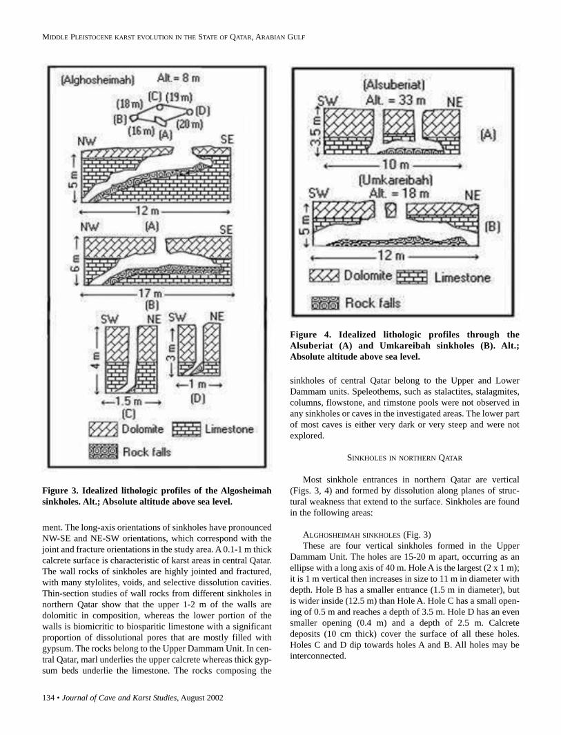
Figure 4. Idealized lithologic profiles through theAlsuberiat (A) and Umkareibah sinkholes (B). Alt.;Absolute altitude above sea level.
Journal of Cave and Karst Studies, August 2002 • 135
SADIQ AND NASIR
ALSUBERIAT SINKHOLES (Fig. 4A)The Alsuberiat area shows two separated sinkholes. Each
has its own opening (0.8 m diameter), but they are connectedat ~2-3 m depth. Both sinkholes are vertical and reach a depth
of 3.1-3.3 m.
UMKAREIBAH SINKHOLES (Fig. 4B)The Umkareibah sinkholes are similar to those of the
Alsuberiat area and consist of two holes. The first has twoopenings, each 1.65 m in diameter and separated by ~1 m ofdolomitic rock. The first sinkhole reaches a depth of 3 m and asize of 1.5-2 m in diameter. The second sinkhole (not shown)is of the vertical type, has an opening of 2 m in diameter, andreaches a depth of 2.3 m and a size of 13 m in diameter. Allsinkholes dip in a NW-SE direction to unknown depth.
SINKHOLES IN CENTRAL QATAR
Sinkholes in central Qatar are generally larger in size anddepth than those of northern Qatar. They occur as verticalshafts connected to steeply inclined passages (Fig. 5). Mostsinkholes reach the gypsum layers of the Lower DammamUnit and the Rus Formation. The investigated sinkholesinclude the following:
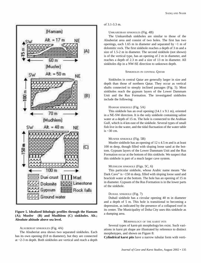
HAMAM SINKHOLE (Fig. 5A)This sinkhole has an oval opening (14.1 x 9.1 m), oriented
in a NE-SW direction. It is the only sinkhole containing salinewater at a depth of 15 m. The hole is connected to the ArabianGulf, which is 4 km east of the sinkhole. Several types of smallfish live in the water, and the tidal fluctuation of the water tableis ~30 cm.
MUSFER SINKHOLE (Fig. 5B)Musfer sinkhole has an opening of 12 x 4.5 m and is at least
100 m deep, though filled with sloping loose sand at the bot-tom. Gypsum layers of the Lower Dammam Unit and the RusFormation occur at the bottom of this sinkhole. We suspect thatthis sinkhole is part of a much larger cave system.
MUDHLEM SINKHOLE (Figs. 5C, 6)This particular sinkhole, whose Arabic name means “the
Dark Cave” is ~150 m deep, filled with sloping loose sand andbrackish water at the bottom. The hole has an opening of 15 min diameter. Gypsum of the Rus Formation is in the lower partsof the sinkhole.
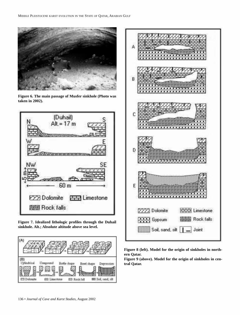
DUHAIL SINKHOLE (Fig. 7)Duhail sinkhole has a circular opening 40 m in diameter
and a depth of 5 m. This hole is transitional to becoming adepression, as indicated by the presence of a collapsed roof inits center. The Municipality of Doha City uses this sinkhole asa dumping area.
MORPHOLOGY OF THE KARST PITSSeveral types of karst-pit morphology/ies exist. Such vari-
ations in karst pit shape are illustrated by reference to distinctmorphotypes, and shown on Figure 8:Cylindrical karst pits have a narrow tubular form with verti-
Figure 5. Idealized lithologic profiles through the Hamam(A); Musfer (B) and Mudhlem (C) sinkholes. Alt.;Absolute altitude above sea level.
136 • Journal of Cave and Karst Studies, August 2002
MIDDLE PLEISTOCENE KARST EVOLUTION IN THE STATE OF QATAR, ARABIAN GULF
Figure 6. The main passage of Musfer sinkhole (Photo wastaken in 2002).
Figure 7. Idealized lithologic profiles through the Duhailsinkhole. Alt.; Absolute altitude above sea level.
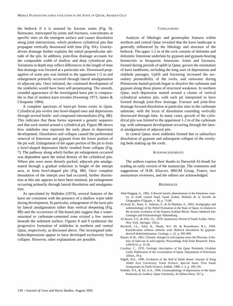
Figure 8 (left). Model for the origin of sinkholes in north-ern Qatar.Figure 9 (above). Model for the origin of sinkholes in cen-tral Qatar.
Journal of Cave and Karst Studies, August 2002 • 137
SADIQ AND NASIR
cal or steeply inward inclined pit walls.Bottle-shaped karst pits comprise cylindrical pits in whichthe lower portion of the pit wall has been removed to producea beveled wall that slopes outwards.Compound karst pits comprise two or more adjacent cylin-drical or bottle pits with a common interpit area.Bowl-shaped karst pits have steep sides with a gently con-cave, irregular, or flat base.Depressions can be former sinkholes that are partly or com-pletely filled with autochthonous material.
DISCUSSION
Karstification in Qatar, as well as in other parts of theArabian Gulf area (Abul-Haggag 1965; Al-Sayaro & Zötl1978; Jado & Zötl 1984; Mukhopadhyay et al. 1996), is asso-ciated with the calcareous, dolomitic, and gypsiferousDammam Formation of Eocene age. Local stratigraphy andpetrography suggest that the primary karst-forming processaffecting the Dammam Formation is a selective dissolution ofrock driven by rainwater as well as groundwater. Such karsti-fication takes place along the subsurface contact between theupper dolomite layers and the lower gypsum-bearing lime-stone of the Dammam Formation. This indicates that mostsinkholes were formed because of preferential dissolutionassociated with the difference in composition betweendolomitic, calcitic, and gypsum rocks. Karstification in theArabian Gulf area mainly formed in the Middle Pleistocene,between 325,000 BP and 560,000 BP (Rauert et al. 1988;Edgell 1990). During this time, a wet climate predominated inthe Arabian Gulf region (Edgell 1990: Table 1). In addition, thelarge volumes of Neogene sediment deposited indicate a plu-vial and humid climate during the Miocene and Pliocene(Whybrow & McClure 1981). Similar indications are alsoapparent from the large alluvial fans of Early Quaternary age(Al-Saad et al. 2002).
The rate at which limestone and gypsum dissolution pro-ceeds within the surficial meteoric environment is dependentupon several factors, including rainfall regime, temperature,distribution of soil-cover and biological activity, and structur-al weakness and lithology of the carbonate substrate (Trudgill1985; White 1984; Ford & Williams 1989; Smart & Whitaker1991; Reeder et al. 1996; Hose 1996; Miller 1996; Frank et al.1998; Hill 2000). Of these, dissolution is directly impacted bythe amount of rainfall (White 1984); an increase in precipita-tion always results in an increase in the rate of limestone dis-solution. Temperature primarily influences limestone dissolu-tion through its effect on the level of biological activity.Lithology of the carbonate substrate also has a profound effecton karstification, calcite dissolving more readily than dolomitedue to its higher solubility (Martinez & White 1999).Karstification can take place where dolomite and gypsum arein contact with the same aquifer (Bischoff et al. 1994).Gypsum dissolution drives the precipitation of calcite, thusconsuming carbonate ions released by dolomite. Gypsum-dri-ven dedolomitization may be responsible for the karstic system(Bischoff et al. 1994), but dedolomitization was not observedin thin sections.
Karst pits making up the sinkholes and depressions inQatar are structurally controlled and seem to be initiatedthrough fractures and joint-flow drainage (Fig. 8A). The pro-files of all types of sinkholes in northern Qatar indicate strongvertical control, which is attributed to the numerous fracturesand joints in the bedrock. Based upon sinkhole long-axis data,it appears that such lines of structural weakness in the bedrockinfluence sinkhole orientation. Sinkholes commonly formalong high-permeability pathways through the vadose zone,which are sites of fracture concentrations and intersections(White 1988).
Sinkholes may also become elongated along lines of majorweakness by a combination of dissolution and collapse(Reeder et al. 1996). Collapse can originate at some depth in
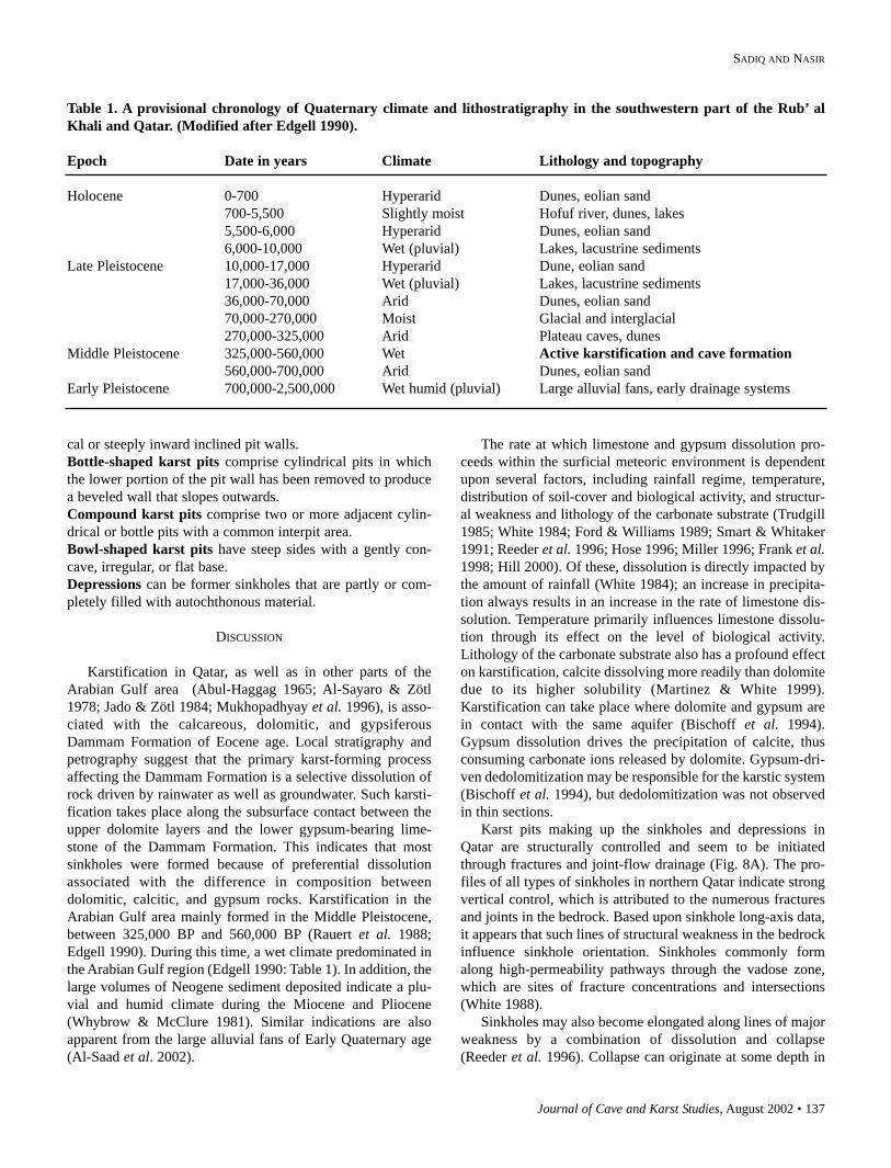
Table 1. A provisional chronology of Quaternary climate and lithostratigraphy in the southwestern part of the Rub’ alKhali and Qatar. (Modified after Edgell 1990).
Epoch Date in years Climate Lithology and topography
Holocene 0-700 Hyperarid Dunes, eolian sand700-5,500 Slightly moist Hofuf river, dunes, lakes5,500-6,000 Hyperarid Dunes, eolian sand6,000-10,000 Wet (pluvial) Lakes, lacustrine sediments
Late Pleistocene 10,000-17,000 Hyperarid Dune, eolian sand17,000-36,000 Wet (pluvial) Lakes, lacustrine sediments36,000-70,000 Arid Dunes, eolian sand70,000-270,000 Moist Glacial and interglacial270,000-325,000 Arid Plateau caves, dunes
Middle Pleistocene 325,000-560,000 Wet Active karstification and cave formation560,000-700,000 Arid Dunes, eolian sand
Early Pleistocene 700,000-2,500,000 Wet humid (pluvial) Large alluvial fans, early drainage systems
138 • Journal of Cave and Karst Studies, August 2002
MIDDLE PLEISTOCENE KARST EVOLUTION IN THE STATE OF QATAR, ARABIAN GULF
the bedrock if it is assisted by fracture zones (Fig. 9).Rainwater, intercepted by joints and fractures, concentrates atspecific sites on the emergent surface and causes dissolutionalong joint intersections, which produces cylindrical pits thatpropagate vertically downward with time (Fig. 8A). Gravity-driven drainage further explains the initial perpendicular atti-tude of the pits. In addition, joint-flow drainage accounts forthe comparable width of shallow and deep cylindrical pits.Variations in depth may reflect differences in the length of timethat drainage was focused at a particular site. Downward prop-agation of some pits was limited to the uppermost 1-2 m andenlargement primarily occurred through lateral amalgamationof adjacent pits. Once initiated, the continued development ofthe sinkholes would have been self-perpetuating. The smooth,rounded appearance of the investigated karst pits is compara-ble to that of modern karst terrains (Sweeting 1973; James &Choquette 1984).
A complete spectrum of karst-pit forms exists in Qatar.Cylindrical pits evolve into bowl-shaped ones and depressionsthrough several bottle- and compound intermediates (Fig. 8B).This indicates that these forms represent a genetic sequenceand that each started around a cylindrical pit. Figure 8B showshow sinkholes may represent the early phase in depressiondevelopment. Dissolution and collapse caused the preferentialremoval of limestone and gypsum from the lower portion ofthe pit wall. Enlargement of the upper portion of the pit to forma bowl-shaped depression likely resulted from collapse (Fig.7). The pathway along which further pit enlargement occurredwas dependent upon the initial density of the cylindrical pits.Where pits were more densely packed, adjacent pits amalga-mated through a gradual reduction in height of the interpitarea, to form bowl-shaped pits (Fig. 8B). Once completedenudation of the interpit area had occurred, further dissolu-tion at this site appears to have been minimal, pit enlargementoccurring primarily through lateral dissolution and amalgama-tion.
As speculated by Walkden (1974), several features of thekarst are consistent with the presence of a shallow water tableduring development. In particular, enlargement of the karst pitsby lateral amalgamation rather than vertical deepening (Fig.8B) and the occurrence of flat-based pits suggest that a water-saturated or carbonate-cemented zone existed a few metersbeneath the sediment surface. Figures 8 and 9 synthesize theprogressive formation of sinkholes in northern and centralQatar, respectively, as discussed above. The investigated sink-holes/depressions appear to have developed exclusively fromcollapse. However, other explanations are possible.
CONCLUSIONS
Analysis of lithologic and geomorphic features withinnorthern and central Qatar revealed that the karst landscape isgenerally influenced by the lithology and structure of thebedrock. The upper 1-2 m of the rock consists of dolomite anddolomitic limestone underlain by gypsum and gypsum-bearingbiomicritic to biosparitic limestone. Joints and fractures,formed during periods of uplift in Qatar, govern the orientationof karst landforms, including the long axes of depressions andsinkhole passages. Uplift and fracturing increased the sec-ondary permeability of the rocks, and rainwater duringPleistocene humid periods began to dissolve the carbonate andgypsum along these planes of structural weakness. In northernQatar, each depression started around a cluster of verticalcylindrical solution pits, with each pit interpreted to haveformed through joint-flow drainage. Fracture and joint-flowdrainage focused dissolution at particular sites in the carbonatesubstrate, with the locus of dissolution extending verticallydownward through time. In many cases, growth of the cylin-drical pits was limited to the uppermost 1-2 m of the carbonatetop, with subsequent development occurring through the later-al amalgamation of adjacent pits.
In central Qatar, most sinkholes formed due to subsurfacedissolution of gypsum and subsequent collapse of the overly-ing beds making up the roofs.
ACKNOWLEDGMENTS
The authors express their thanks to Darweish Al-Imadi forreading an early version of the manuscript. The comments andsuggestions of H.M. Kluyver, BRGM Group, France, twoanonymous reviewers, and the editors are acknowledged.
REFERENCES
Abul-Haggag, A., 1965, A Recent karstic phenomenon in the limestone coun-try of north central Najd, Saudi Arabia: Bulletin de la Société deGéographie d’Egypte, v. 38, p. 73-80.
Al-Saad, H., Nasir, S., Sadooni, F., & Al-Sharhan, A., 2002, Stratigraphy andsedimentology of the Hofuf Formation in the State of Qatar, in relation tothe tectonic evolution of the Eastern Arabian Block: Neues Jahrbuch fuerGeologie und Palaeontologie Abhandlung.
Al-Sayari, S.S., & Zötl, J.G., 1978, Quaternary Period of Saudi Arabia: Wien-New York, Springer, 334 p.
Bischoff, J.L., Julia, R., Shank, W.C III, & Rosenbauer, R.J., 1994,Karstification without carbonic acid: Bedrock dissolution by gypsum-derived dedolomitization: Geology, v. 22, p. 995-999.
Butzer, K.W., 1961, Climatic changes in arid regions since the Pliocene, A his-tory of land use in arid regions: Proceedings Arid Zone Research: Paris,UNESCO, p. 31-56.
Cavelier, C., 1970, Geologic description of the Qatar Peninsula (ArabianGulf), Publication of the Government of Qatar, Department of PetroleumAffairs, 39 p.
Edgell, H.S., 1990, Evolution of the Rub’al Khali desert: Journal of KingAbdel Aziz University: Earth Science, Special Issue: First SaudiSymposium on Earth Science, Jeddah, 1989, v. 3, p. 109-126.
Embabi, N.S., & Ali, A.A., 1990, Geomorphology of depressions in the QatarPeninsula (in Arabic): Qatar University, Al-Ahleia Press, 357 p.
Journal of Cave and Karst Studies, August 2002 • 139
SADIQ AND NASIR
Ford, D.C., & Williams, P.W., 1989, Karst geomorphology and hydrology:London, Unwin Hyman, 320 p.
Frank, E., Mylroie, J., Troester, J., Calvin Alexander, E., & Carew, J., 1998,Karst development and speleogenesis, Isla de Mona, Puerto Rico: Journalof Cave and Karst Studies, v. 60, p. 73-83.
Hill, C., 2000, Overview of the geologic history of cave development in theGuadalupe Mountains, New Mexico: Journal of Cave and Karst Studies,v. 62, p. 60-71.
Hose, L., 1966, Geology of a large, high-relief, sub-tropical cave system:Sistema Purification, Tamaulipas, Mexico: Journal of Cave and KarstStudies, v. 58, p. 6-21.
Jado, A.R., & Zötl, J.G., 1984, Quaternary Period of Saudi Arabia: Wien-NewYork, Springer, 360 p.
James, N.P., & Choquette, P.W., 1984, Diagenesis 9. Limestones - The mete-oric diagenetic environment: Geoscience Canada, v. 11, p. 161-194.
Martinez, M.I., & White, W., 1999, A laboratory investigation of the relativedissolution rates of the Lirio limestone and the Isla de Mona dolomite, andimplications for cave and karst development on Isla de Mona: Journal ofCave and Karst Studies, v. 61, p. 7-12.
Miller, T., 1996, Geologic and hydrologic controls on karst and cave develop-ment in Belize: Journal of Cave and Karst Studies, v. 58, p. 100-120.
Mukhopadhyay, A., Al-Sulaimi, J., Al-Awadi, E., & Al-Ruwaih, F., 1996, Anoverview of the Tertiary geology and hydrogeology of the northern part ofthe Arabian Gulf region with special reference to Kuwait: Earth ScienceReviews, v. 40, p. 259-296.
Rauert, W., Geyh, M.A., & Henning, G.J., 1988, Results of 14C and U/Th dat-ing of sinter samples from caves of the As Summan Plateau: Hannover,Institute of Hydrology, GSF Munich and Niedersachsisches Landesamtfuer Bodenforschung, 62 p.
Reeder, P., Brinkmann, R., & Alt, E., 1996, Karstification on the northern VacaPlateau, Belize: Journal of Cave and Karst Studies, v. 58, p. 121-130.
Smart, P.L., & Whitaker, F.F., 1991, Karst processes, hydrology and porosityevolution, in Wright, V.P., ed., Palaeokarsts and palaeokarstic reservoirs,PRIS Occasional Publication Series No. 2. University of Reading, p. 1-55.
Sweeting, M.M., 1973, Karst landforms: Newport, Columbia University Press,362 p.
Trudgill, S.T., 1985, Limestone geomorphology: London, Longman, 196 p.Walkden, G.M., 1974, Palaeokarstic surfaces in Upper Viséan (Carboniferous)
limestones of the Derbyshire Block, England: Journal of SedimentaryPetrology, v. 44, p. 1232-1247.
White, W.B., 1984, Rate processes: Chemical kinetics and karst landformdevelopment, in LaFleur, R.G., ed., Groundwater as a Geomorphic Agent:London, Allen and Unwin, p. 227-248.
White, W.B., 1988, Geomorphology and hydrology of karst terrains: NewYork, Oxford University Press, 464 p.
Whybrow P.J., & McClure, H.A., 1981, Fossil mangrove roots and paleoenvi-ronments of the Miocene of eastern Arabia: Palaeogeography,Palaeoclimatology, Palaeoecology, v. 32, p. 213-225.