Embed Size (px)
Citation preview
SADDLEBROOKE HIKING CLUB NEWSLETTER
http://saddlebrookehikingclub.com
JANUARY/FEBRUARY 2016
2014-6
66
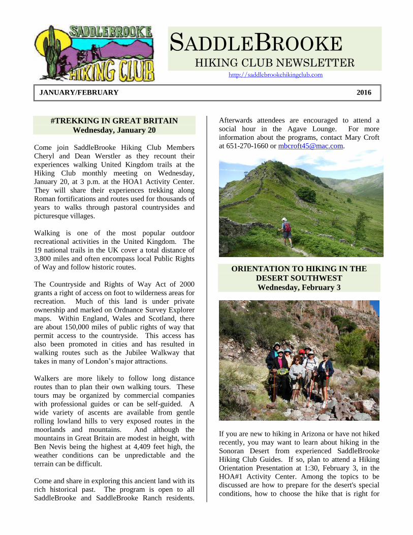
#TREKKING IN GREAT BRITAIN
Wednesday, January 20
Come join SaddleBrooke Hiking Club Members
Cheryl and Dean Werstler as they recount their
experiences walking United Kingdom trails at the
Hiking Club monthly meeting on Wednesday,
January 20, at 3 p.m. at the HOA1 Activity Center.
They will share their experiences trekking along
Roman fortifications and routes used for thousands of
years to walks through pastoral countrysides and
picturesque villages.
Walking is one of the most popular outdoor
recreational activities in the United Kingdom. The
19 national trails in the UK cover a total distance of
3,800 miles and often encompass local Public Rights
of Way and follow historic routes.
The Countryside and Rights of Way Act of 2000
grants a right of access on foot to wilderness areas for
recreation. Much of this land is under private
ownership and marked on Ordnance Survey Explorer
maps. Within England, Wales and Scotland, there
are about 150,000 miles of public rights of way that
permit access to the countryside. This access has
also been promoted in cities and has resulted in
walking routes such as the Jubilee Walkway that
takes in many of London’s major attractions.
Walkers are more likely to follow long distance
routes than to plan their own walking tours. These
tours may be organized by commercial companies
with professional guides or can be self-guided. A
wide variety of ascents are available from gentle
rolling lowland hills to very exposed routes in the
moorlands and mountains. And although the
mountains in Great Britain are modest in height, with
Ben Nevis being the highest at 4,409 feet high, the
weather conditions can be unpredictable and the
terrain can be difficult.
Come and share in exploring this ancient land with its
rich historical past. The program is open to all
SaddleBrooke and SaddleBrooke Ranch residents.
Afterwards attendees are encouraged to attend a
social hour in the Agave Lounge. For more
information about the programs, contact Mary Croft
at 651-270-1660 or [email protected].
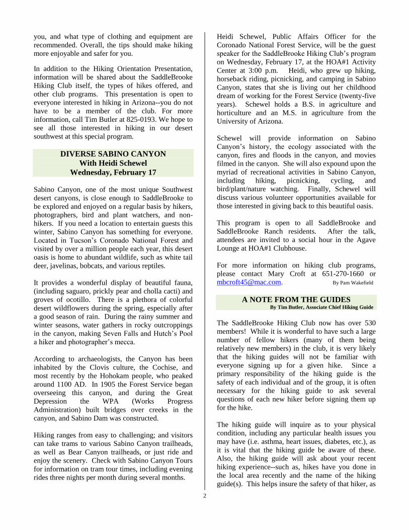
ORIENTATION TO HIKING IN THE
DESERT SOUTHWEST
Wednesday, February 3
If you are new to hiking in Arizona or have not hiked
recently, you may want to learn about hiking in the
Sonoran Desert from experienced SaddleBrooke
Hiking Club Guides. If so, plan to attend a Hiking
Orientation Presentation at 1:30, February 3, in the
HOA#1 Activity Center. Among the topics to be
discussed are how to prepare for the desert's special
conditions, how to choose the hike that is right for
2
you, and what type of clothing and equipment are
recommended. Overall, the tips should make hiking
more enjoyable and safer for you.
In addition to the Hiking Orientation Presentation,
information will be shared about the SaddleBrooke
Hiking Club itself, the types of hikes offered, and
other club programs. This presentation is open to
everyone interested in hiking in Arizona--you do not
have to be a member of the club. For more
information, call Tim Butler at 825-0193. We hope to
see all those interested in hiking in our desert
southwest at this special program.
DIVERSE SABINO CANYON
With Heidi Schewel
Wednesday, February 17
Sabino Canyon, one of the most unique Southwest
desert canyons, is close enough to SaddleBrooke to
be explored and enjoyed on a regular basis by hikers,
photographers, bird and plant watchers, and non-
hikers. If you need a location to entertain guests this
winter, Sabino Canyon has something for everyone.
Located in Tucson’s Coronado National Forest and
visited by over a million people each year, this desert
oasis is home to abundant wildlife, such as white tail
deer, javelinas, bobcats, and various reptiles.
It provides a wonderful display of beautiful fauna,
(including saguaro, prickly pear and cholla cacti) and
groves of ocotillo. There is a plethora of colorful
desert wildflowers during the spring, especially after
a good season of rain. During the rainy summer and
winter seasons, water gathers in rocky outcroppings
in the canyon, making Seven Falls and Hutch’s Pool
a hiker and photographer’s mecca.
According to archaeologists, the Canyon has been
inhabited by the Clovis culture, the Cochise, and
most recently by the Hohokam people, who peaked
around 1100 AD. In 1905 the Forest Service began
overseeing this canyon, and during the Great
Depression the WPA (Works Progress
Administration) built bridges over creeks in the
canyon, and Sabino Dam was constructed.
Hiking ranges from easy to challenging; and visitors
can take trams to various Sabino Canyon trailheads,
as well as Bear Canyon trailheads, or just ride and
enjoy the scenery. Check with Sabino Canyon Tours
for information on tram tour times, including evening
rides three nights per month during several months.
Heidi Schewel, Public Affairs Officer for the
Coronado National Forest Service, will be the guest
speaker for the SaddleBrooke Hiking Club’s program
on Wednesday, February 17, at the HOA#1 Activity
Center at 3:00 p.m. Heidi, who grew up hiking,
horseback riding, picnicking, and camping in Sabino
Canyon, states that she is living out her childhood
dream of working for the Forest Service (twenty-five
years). Schewel holds a B.S. in agriculture and
horticulture and an M.S. in agriculture from the
University of Arizona.
Schewel will provide information on Sabino
Canyon’s history, the ecology associated with the
canyon, fires and floods in the canyon, and movies
filmed in the canyon. She will also expound upon the
myriad of recreational activities in Sabino Canyon,
including hiking, picnicking, cycling, and
bird/plant/nature watching. Finally, Schewel will
discuss various volunteer opportunities available for
those interested in giving back to this beautiful oasis.
This program is open to all SaddleBrooke and
SaddleBrooke Ranch residents. After the talk,
attendees are invited to a social hour in the Agave
Lounge at HOA#1 Clubhouse.
For more information on hiking club programs,
please contact Mary Croft at 651-270-1660 or
[email protected]. By Pam Wakefield
A NOTE FROM THE GUIDES By Tim Butler, Associate Chief Hiking Guide
The SaddleBrooke Hiking Club now has over 530
members! While it is wonderful to have such a large
number of fellow hikers (many of them being
relatively new members) in the club, it is very likely
that the hiking guides will not be familiar with
everyone signing up for a given hike. Since a
primary responsibility of the hiking guide is the
safety of each individual and of the group, it is often
necessary for the hiking guide to ask several
questions of each new hiker before signing them up
for the hike.
The hiking guide will inquire as to your physical
condition, including any particular health issues you
may have (i.e. asthma, heart issues, diabetes, etc.), as
it is vital that the hiking guide be aware of these.
Also, the hiking guide will ask about your recent
hiking experience--such as, hikes have you done in
the local area recently and the name of the hiking
guide(s). This helps insure the safety of that hiker, as
3
well as insuring that all those going on a particular
hike will be comfortable with the pace and distance
of the hike.
So please do not be offended if a guide asks you
these questions. You are not being singled out! Our
goal as guides is to make each hike safe and
enjoyable for all.
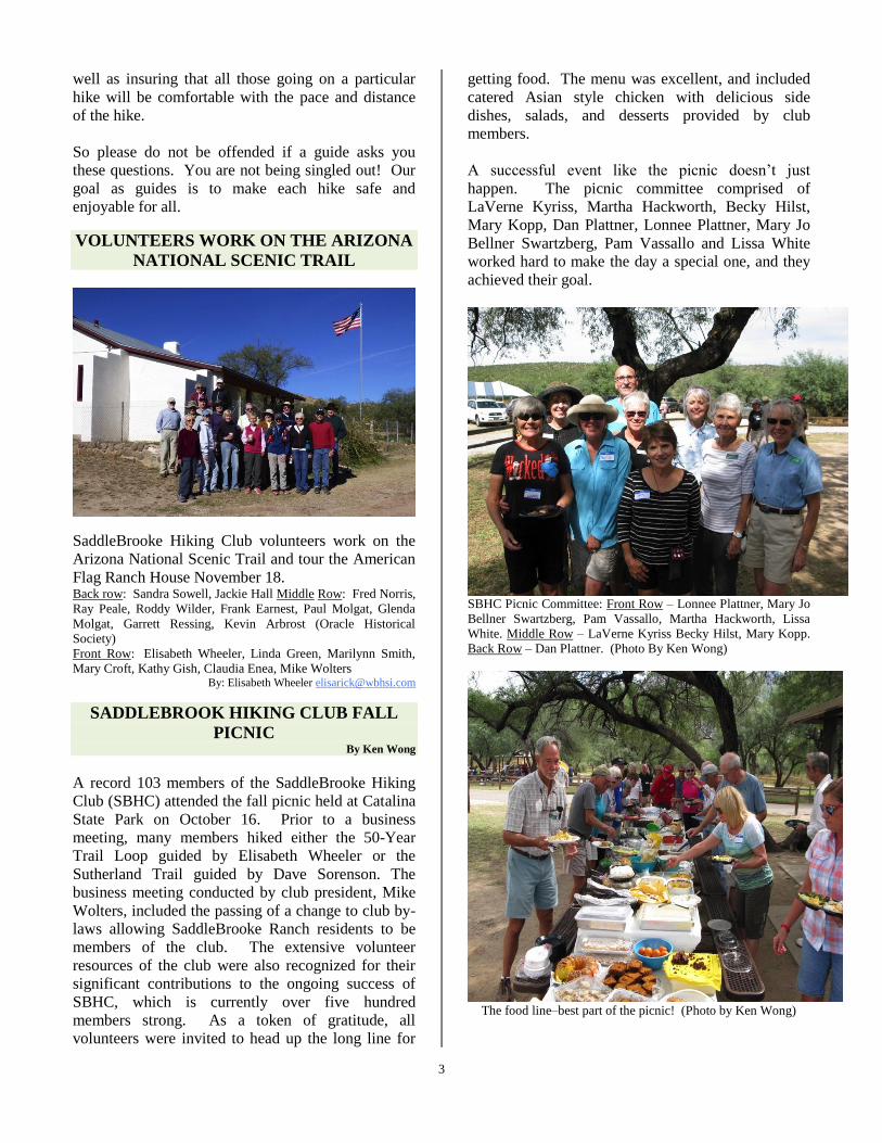
VOLUNTEERS WORK ON THE ARIZONA
NATIONAL SCENIC TRAIL
SaddleBrooke Hiking Club volunteers work on the
Arizona National Scenic Trail and tour the American
Flag Ranch House November 18. Back row: Sandra Sowell, Jackie Hall Middle Row: Fred Norris,
Ray Peale, Roddy Wilder, Frank Earnest, Paul Molgat, Glenda
Molgat, Garrett Ressing, Kevin Arbrost (Oracle Historical
Society)
Front Row: Elisabeth Wheeler, Linda Green, Marilynn Smith,
Mary Croft, Kathy Gish, Claudia Enea, Mike Wolters By: Elisabeth Wheeler [email protected]
SADDLEBROOK HIKING CLUB FALL
PICNIC By Ken Wong
A record 103 members of the SaddleBrooke Hiking
Club (SBHC) attended the fall picnic held at Catalina
State Park on October 16. Prior to a business
meeting, many members hiked either the 50-Year
Trail Loop guided by Elisabeth Wheeler or the
Sutherland Trail guided by Dave Sorenson. The
business meeting conducted by club president, Mike
Wolters, included the passing of a change to club by-
laws allowing SaddleBrooke Ranch residents to be
members of the club. The extensive volunteer
resources of the club were also recognized for their
significant contributions to the ongoing success of
SBHC, which is currently over five hundred
members strong. As a token of gratitude, all
volunteers were invited to head up the long line for
getting food. The menu was excellent, and included
catered Asian style chicken with delicious side
dishes, salads, and desserts provided by club
members.
A successful event like the picnic doesn’t just
happen. The picnic committee comprised of
LaVerne Kyriss, Martha Hackworth, Becky Hilst,
Mary Kopp, Dan Plattner, Lonnee Plattner, Mary Jo
Bellner Swartzberg, Pam Vassallo and Lissa White
worked hard to make the day a special one, and they
achieved their goal.
SBHC Picnic Committee: Front Row – Lonnee Plattner, Mary Jo
Bellner Swartzberg, Pam Vassallo, Martha Hackworth, Lissa
White. Middle Row – LaVerne Kyriss Becky Hilst, Mary Kopp.
Back Row – Dan Plattner. (Photo By Ken Wong)
The food line–best part of the picnic! (Photo by Ken Wong)
4
If you are interested in joining the SaddleBrooke
Hiking Club or obtaining more information regarding
club activities, go to our website. Link is:
http://saddlebrookehikingclub.com, where you can
download a membership application form. Have any
questions? Call our club President, Mike Wolters, at
719-530-1039 or email [email protected]
SEDONA HIKING TRIP
October, 2015 By Sandra Sowell
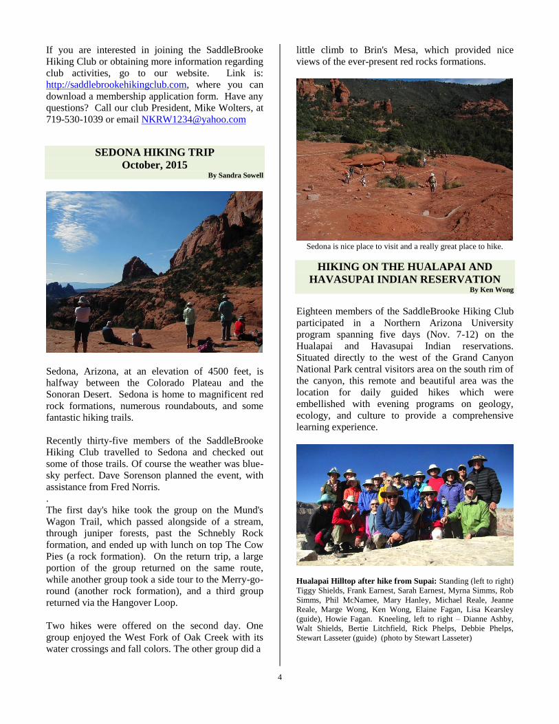
Sedona, Arizona, at an elevation of 4500 feet, is
halfway between the Colorado Plateau and the
Sonoran Desert. Sedona is home to magnificent red
rock formations, numerous roundabouts, and some fantastic hiking trails.
Recently thirty-five members of the SaddleBrooke
Hiking Club travelled to Sedona and checked out
some of those trails. Of course the weather was blue-
sky perfect. Dave Sorenson planned the event, with
assistance from Fred Norris.
.
The first day's hike took the group on the Mund's
Wagon Trail, which passed alongside of a stream,
through juniper forests, past the Schnebly Rock
formation, and ended up with lunch on top The Cow
Pies (a rock formation). On the return trip, a large
portion of the group returned on the same route,
while another group took a side tour to the Merry-go-
round (another rock formation), and a third group
returned via the Hangover Loop.
Two hikes were offered on the second day. One
group enjoyed the West Fork of Oak Creek with its
water crossings and fall colors. The other group did a
little climb to Brin's Mesa, which provided nice
views of the ever-present red rocks formations.
Sedona is nice place to visit and a really great place to hike.
HIKING ON THE HUALAPAI AND
HAVASUPAI INDIAN RESERVATION By Ken Wong
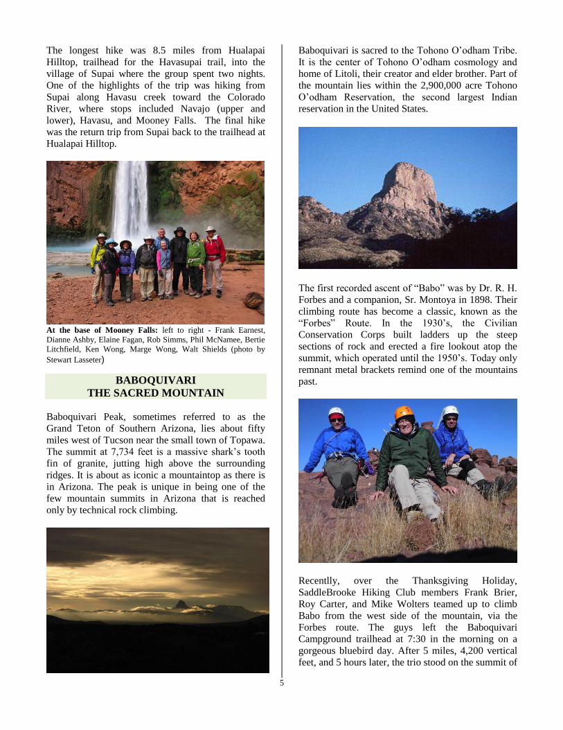
Eighteen members of the SaddleBrooke Hiking Club
participated in a Northern Arizona University
program spanning five days (Nov. 7-12) on the
Hualapai and Havasupai Indian reservations.
Situated directly to the west of the Grand Canyon
National Park central visitors area on the south rim of
the canyon, this remote and beautiful area was the
location for daily guided hikes which were
embellished with evening programs on geology,
ecology, and culture to provide a comprehensive
learning experience.
Hualapai Hilltop after hike from Supai: Standing (left to right)
Tiggy Shields, Frank Earnest, Sarah Earnest, Myrna Simms, Rob
Simms, Phil McNamee, Mary Hanley, Michael Reale, Jeanne
Reale, Marge Wong, Ken Wong, Elaine Fagan, Lisa Kearsley
(guide), Howie Fagan. Kneeling, left to right – Dianne Ashby,
Walt Shields, Bertie Litchfield, Rick Phelps, Debbie Phelps,
Stewart Lasseter (guide) (photo by Stewart Lasseter)
5
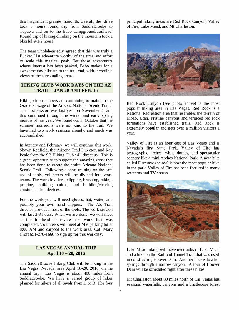
The longest hike was 8.5 miles from Hualapai
Hilltop, trailhead for the Havasupai trail, into the
village of Supai where the group spent two nights.
One of the highlights of the trip was hiking from
Supai along Havasu creek toward the Colorado
River, where stops included Navajo (upper and
lower), Havasu, and Mooney Falls. The final hike
was the return trip from Supai back to the trailhead at
Hualapai Hilltop.
At the base of Mooney Falls: left to right - Frank Earnest,
Dianne Ashby, Elaine Fagan, Rob Simms, Phil McNamee, Bertie
Litchfield, Ken Wong, Marge Wong, Walt Shields (photo by
Stewart Lasseter)
BABOQUIVARI
THE SACRED MOUNTAIN
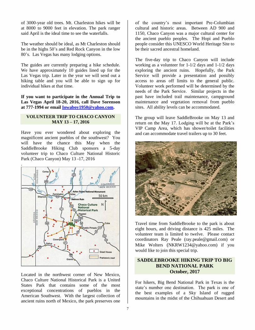
Baboquivari Peak, sometimes referred to as the
Grand Teton of Southern Arizona, lies about fifty
miles west of Tucson near the small town of Topawa.
The summit at 7,734 feet is a massive shark’s tooth
fin of granite, jutting high above the surrounding
ridges. It is about as iconic a mountaintop as there is
in Arizona. The peak is unique in being one of the
few mountain summits in Arizona that is reached
only by technical rock climbing.
Baboquivari is sacred to the Tohono O’odham Tribe.
It is the center of Tohono O’odham cosmology and
home of Litoli, their creator and elder brother. Part of
the mountain lies within the 2,900,000 acre Tohono
O’odham Reservation, the second largest Indian
reservation in the United States.
The first recorded ascent of “Babo” was by Dr. R. H.
Forbes and a companion, Sr. Montoya in 1898. Their
climbing route has become a classic, known as the
“Forbes” Route. In the 1930’s, the Civilian
Conservation Corps built ladders up the steep
sections of rock and erected a fire lookout atop the
summit, which operated until the 1950’s. Today only
remnant metal brackets remind one of the mountains
past.
Recentlly, over the Thanksgiving Holiday,
SaddleBrooke Hiking Club members Frank Brier,
Roy Carter, and Mike Wolters teamed up to climb
Babo from the west side of the mountain, via the
Forbes route. The guys left the Baboquivari
Campground trailhead at 7:30 in the morning on a
gorgeous bluebird day. After 5 miles, 4,200 vertical
feet, and 5 hours later, the trio stood on the summit of
6
this magnificent granite monolith. Overall, the drive
took 5 hours round trip from SaddleBrooke to
Topawa and on to the Babo campground/trailhead.
Round trip of hiking/climbing on the mountain took a
blissful 9-1/2 hours.
The team wholeheartedly agreed that this was truly a
Bucket List adventure worthy of the time and effort
to scale this magical peak. For those adventurers
whose interest has been peaked, Babo makes for a
awesome day hike up to the trail end, with incredible
views of the surrounding areas.
HIKING CLUB WORK DAYS ON THE AZ
TRAIL – JAN 20 AND FEB. 16
Hiking club members are continuing to maintain the
Oracle Passage of the Arizona National Scenic Trail.
The first session was last year on November 5, and
this continued through the winter and early spring
months of last year. We found out in October that the
summer monsoons were not kind to the trail. We
have had two work sessions already, and much was
accomplished.
In January and February, we will continue this work.
Shawn Redfield, the Arizona Trail Director, and Ray
Peale from the SB Hiking Club will direct us. This is
a great opportunity to support the amazing work that
has been done to create the entire Arizona National
Scenic Trail. Following a short training on the safe
use of tools, volunteers will be divided into work
teams. The work involves, clipping, brushing, raking,
pruning, building cairns, and building/clearing
erosion control devices.
For the work you will need gloves, hat, water, and
possibly your own hand clippers. The AZ Trail
director provides most of the tools. The work session
will last 2-3 hours. When we are done, we will meet
at the trailhead to review the work that was
completed. Volunteers will meet at MV parking lot at
8:00 AM and carpool to the work area. Call Mary
Croft 651-270-1660 to sign up for this workday.
LAS VEGAS ANNUAL TRIP
April 18 – 20, 2016
The SaddleBrooke Hiking Club will be hiking in the
Las Vegas, Nevada, area April 18-20, 2016, on the
annual trip. Las Vegas is about 400 miles from
SaddleBrooke. We have a varied group of hikes
planned for hikers of all levels from D to B. The four
principal hiking areas are Red Rock Canyon, Valley
of Fire, Lake Mead, and Mt Charleston.
Red Rock Canyon (see photo above) is the most
popular hiking area in Las Vegas. Red Rock is a
National Recreation area that resembles the terrain of
Moab, Utah. Pristine canyons and terraced red rock
formations have established trails. Red Rock is
extremely popular and gets over a million visitors a
year.
Valley of Fire is an hour east of Las Vegas and is
Nevada’s first State Park. Valley of Fire has
petroglyphs, arches, white domes, and spectacular
scenery like a mini Arches National Park. A new hike
called Firewave (below) is now the most popular hike
in the park. Valley of Fire has been featured in many
westerns and TV shows.
Lake Mead hiking will have overlooks of Lake Mead
and a hike on the Railroad Tunnel Trail that was used
in constructing Hoover Dam. Another hike is to a hot
springs through a narrow canyon. A tour of Hoover
Dam will be scheduled right after these hikes.
Mt Charleston about 30 miles north of Las Vegas has
seasonal waterfalls, canyons and a bristlecone forest
7
of 3000-year old trees. Mt. Charleston hikes will be
at 8000 to 9000 feet in elevation. The park ranger
said April is the ideal time to see the waterfalls.
The weather should be ideal, as Mt Charleston should
be in the highs 50’s and Red Rock Canyon in the low
80’s. Las Vegas has many lodging options.
The guides are currently preparing a hike schedule.
We have approximately 10 guides lined up for the
Las Vegas trip. Later in the year we will send out a
hiking table and you will be able to sign up for
individual hikes at that time.
If you want to participate in the Annual Trip to
Las Vegas April 18-20, 2016, call Dave Sorenson
at 777-1994 or email [email protected].
VOLUNTEER TRIP TO CHACO CANYON
MAY 13 – 17, 2016
Have you ever wondered about exploring the
magnificent ancient pueblos of the southwest? You
will have the chance this May when the
SaddleBrooke Hiking Club sponsors a 5-day
volunteer trip to Chaco Culture National Historic
Park (Chaco Canyon) May 13 -17, 2016
.
Located in the northwest corner of New Mexico,
Chaco Culture National Historical Park is a United
States Park that contains some of the most
exceptional concentrations of pueblos in the
American Southwest. With the largest collection of
ancient ruins north of Mexico, the park preserves one
of the country’s most important Pre-Columbian
cultural and historic areas. Between AD 900 and
1150, Chaco Canyon was a major cultural center for
the ancient pueblo peoples. The Hopi and Pueblo
people consider this UNESCO World Heritage Site to
be their sacred ancestral homeland.
The five-day trip to Chaco Canyon will include
working as a volunteer for 1-1/2 days and 1-1/2 days
exploring the ancient ruins. Hopefully, the Park
Service will provide a presentation and possibly
access to areas off limits to the general public.
Volunteer work performed will be determined by the
needs of the Park Service. Similar projects in the
past have included trail maintenance, campground
maintenance and vegetation removal from pueblo
sites. All ability levels can be accommodated.
The group will leave SaddleBrooke on May 13 and
return on the May 17. Lodging will be at the Park’s
VIP Camp Area, which has shower/toilet facilities
and can accommodate travel trailers up to 30 feet.
Travel time from SaddleBrooke to the park is about
eight hours, and driving distance is 425 miles. The
volunteer team is limited to twelve. Please contact
coordinators Ray Peale ([email protected]) or
Mike Wolters ([email protected]) if you
would like to join this special trip.
SADDLEBROOKE HIKING TRIP TO BIG
BEND NATIONAL PARK
October, 2017
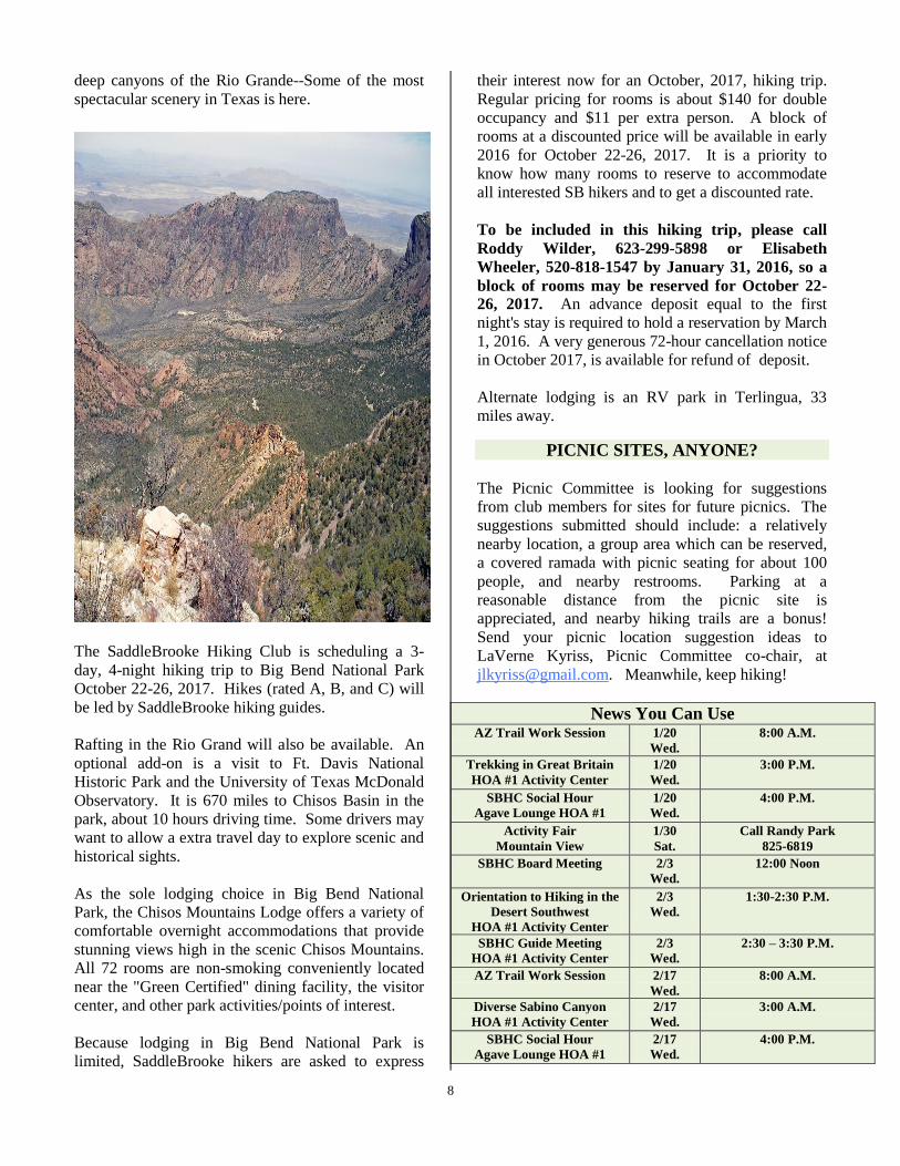
For hikers, Big Bend National Park in Texas is the
state’s number one destination. The park is one of
the best examples of a Sky Island of rugged
mountains in the midst of the Chihuahuan Desert and
8
deep canyons of the Rio Grande--Some of the most
spectacular scenery in Texas is here.
The SaddleBrooke Hiking Club is scheduling a 3-
day, 4-night hiking trip to Big Bend National Park
October 22-26, 2017. Hikes (rated A, B, and C) will
be led by SaddleBrooke hiking guides.
Rafting in the Rio Grand will also be available. An
optional add-on is a visit to Ft. Davis National
Historic Park and the University of Texas McDonald
Observatory. It is 670 miles to Chisos Basin in the
park, about 10 hours driving time. Some drivers may
want to allow a extra travel day to explore scenic and
historical sights.
As the sole lodging choice in Big Bend National
Park, the Chisos Mountains Lodge offers a variety of
comfortable overnight accommodations that provide
stunning views high in the scenic Chisos Mountains.
All 72 rooms are non-smoking conveniently located
near the "Green Certified" dining facility, the visitor
center, and other park activities/points of interest.
Because lodging in Big Bend National Park is
limited, SaddleBrooke hikers are asked to express
their interest now for an October, 2017, hiking trip.
Regular pricing for rooms is about $140 for double
occupancy and $11 per extra person. A block of
rooms at a discounted price will be available in early
2016 for October 22-26, 2017. It is a priority to
know how many rooms to reserve to accommodate
all interested SB hikers and to get a discounted rate.
To be included in this hiking trip, please call
Roddy Wilder, 623-299-5898 or Elisabeth
Wheeler, 520-818-1547 by January 31, 2016, so a
block of rooms may be reserved for October 22-
26, 2017. An advance deposit equal to the first
night's stay is required to hold a reservation by March
1, 2016. A very generous 72-hour cancellation notice
in October 2017, is available for refund of deposit.
Alternate lodging is an RV park in Terlingua, 33
miles away.
PICNIC SITES, ANYONE?
The Picnic Committee is looking for suggestions
from club members for sites for future picnics. The
suggestions submitted should include: a relatively
nearby location, a group area which can be reserved,
a covered ramada with picnic seating for about 100
people, and nearby restrooms. Parking at a
reasonable distance from the picnic site is
appreciated, and nearby hiking trails are a bonus!
Send your picnic location suggestion ideas to
LaVerne Kyriss, Picnic Committee co-chair, at
[email protected]. Meanwhile, keep hiking!
News You Can Use AZ Trail Work Session 1/20
Wed.
8:00 A.M.
Trekking in Great Britain
HOA #1 Activity Center
1/20
Wed.
3:00 P.M.
SBHC Social Hour
Agave Lounge HOA #1
1/20
Wed.
4:00 P.M.
Activity Fair
Mountain View
1/30
Sat.
Call Randy Park
825-6819
SBHC Board Meeting 2/3
Wed.
12:00 Noon
Orientation to Hiking in the
Desert Southwest
HOA #1 Activity Center
2/3
Wed.
1:30-2:30 P.M.
SBHC Guide Meeting
HOA #1 Activity Center
2/3
Wed.
2:30 – 3:30 P.M.
AZ Trail Work Session 2/17
Wed.
8:00 A.M.
Diverse Sabino Canyon
HOA #1 Activity Center
2/17
Wed.
3:00 A.M.
SBHC Social Hour
Agave Lounge HOA #1
2/17
Wed.
4:00 P.M.

9
Hiking Calendar: January & February

Hikes Offered
Sunday, January 03, 2016 Tortolita Mountains: Wild Burro Canyon with Key Exchange. Rating: C. Pace:
Moderate [467, 08:00 AM, $2]. The trailhead is reached via the Rail-X Marble Mine Road off Oracle Hwy at the
county line, then another 2.5 miles on another jeep road. We hike into Wild Burro Canyon from the north side of the
Tortolitas on an old road past an old stone wall (that once was a goat corral), past a windmill, and down the new
North-End section of the Wild Burro Trail. From there we continue along the southern section of the Wild Burro
Trail to some old stone house ruins, water cistern, and "swimming pool". We continue 2 more miles along a flat
sandy arroyo, some on compacted soil, to the trailhead near the Ritz Carlton at the end of Dove Mountain Blvd. The
group hiking north from the Ritz Carlton trailhead, for the key exchange, will do the reverse. 4WD vehicles will be
needed to reach the northern starting point. Hike 8 miles; trailhead elevation 3600 feet at the north end,3000 feet at
the Wild Burro Trailhead; net elevation change 700 feet; accumulated gain north __ feet, __ feet south; RTD 20
miles (dirt). [Guides: Susan Hollis & Randy Park, 825-6819]
Monday, January 04, 2016 Baby Jesus/ Sutherland Trail Key Exchange. Rating: B. Pace: Moderate [494,
8:00 AM, $2 + $2]. The hike links two very beautiful and popular trails with a one way key exchange. One group
will start at the Fifty Year Trail parking area and follow the Baby Jesus Trail to the Madonna and Child rock
formation. The other group will begin at Catalina State Park and follow the Sutherland Trail past Cargodero Canyon
to meet the other group at the rock formation where the exchange will take place. Hike 8 miles; trailhead elevation
2700 feet (Catalina State Park), 3400 feet (50 Year Car Park); net elevation change 700 feet; accumulated gain __
feet; RTD 24 miles. [Guide: Tim Butler, 825-0193, [email protected]]
Tuesday, January 05, 2016 Alamo Canyon. Rating: D. Pace: Moderate [6, 8:30 AM, $2 + $2]. The hike begins
at the Romero Ruins Trailhead in Catalina State Park. Other than one short area by the wash, the elevation change is
gradual. This is a lovely hike up to Alamo Canyon Falls and return. Water may be present in the canyon after rainy
periods, but there are no water crossings. Hikers will stop by the Romero Ruins and take the informative loop trail
from there. Hike 3.3 miles; trailhead elevation 2700 feet; net elevation change 360 feet; accumulated gain 435 feet;
RTD 24 miles. [Guides: Ruth & Paul DeBruine, Ph: 217-454-0478, e-mail: [email protected]]
Tuesday, January 05, 2016 Superstitions: Roger's Canyon Cliff Dwellings. Rating: B. Pace: Moderate [424,
07:00 AM, $15]. The hike reaches deep into a wilderness area of the Superstition Mountains. The trailhead is
reached via Florence to Hwy # 60 east and then northeast on 19 miles of scenic, rough unimproved Forest Service
roads that require 4WD vehicles with adequate clearance. The trail may be slippery in places during rainy seasons.
The trail proceeds downhill into the canyon area to the ancient cliff dwellings built by the Salado Indians around
A.D. 1150 to A.D. 1250. The ruins are in very good shape and present a nice opportunity for the photographer to get
good photos. Entering the ruins is possible but involves some rock scrambling. Care should be taken not to damage
700 years of history. An additional one mile round-trip hike to Angel Basin is an option along with the exploration
of Fish Creek Canyon. The hike out is all uphill via the same route. Hike 8.5 miles; trailhead elevation 4800 feet;
net elevation change 1056 feet; accumulated gain 1425 feet; RTD 166 miles (dirt). [Guide:Randy Park 825-6819].
Wednesday, January 06, 2016 Romero Pools. Rating: C!. Pace: Moderate [370, 8:00 AM, $2 + $2]. The hike
begins in Catalina State Park at the easternmost trailhead and follows Romero Canyon Trail into the foothills. The
trail crosses open desert then climbs steeply until it reaches a saddle and then down into the canyon area where
several pools are located. There are excellent views of Romero and Montrose Canyons along the way. The well-
maintained trail is rocky and rough in places, but is not overly difficult for most hikers. An option is a 0.75 miles
round-trip, relatively level hike to the upper pools. We will have lunch at the lower or upper pools. The return is via
the same route. Hike 5.6 miles; trailhead elevation 2700 feet; net elevation change 980 feet; accumulated gain 1400
feet; RTD 24 miles. [Guide: Dave Corrigan, 820-6110, [email protected] ]
Thursday, January 07, 2016 Bill Cody Loop. Rating: B. Pace: Moderate [107, 8:00 AM, $4]. The beautiful,
historic Bill Cody loop begins at the American Flag trailhead on the old Mt. Lemmon Road and covers a section of
the Arizona Trail. Hikers pass the 1877 adobe house at the trailhead, and then proceed up the Arizona Trail to the
Oracle Ridge Trail. We then go south toward Apache Peak, and down FR # 639, through Camp Bonita Canyon past

11
the old Patterson Diaz homestead site. Campo Bonito is a great place for lunch. From Campo Bonito, hikers swing
northward past the “Yellow Cabin” and through the grounds of La Casa del High Jinks, the site where Bill Cody
staked his gold mine in 1912. We may tour the unique stone house if the owner is home. Hikers return to the
trailhead via the Arizona Trail. Hike 7.7 miles; trailhead elevation 4400 feet; net elevation change 701 feet;
accumulated gain 1506 feet; RTD 41 miles. [Guide: Michael Reale; 825-8286; [email protected].]
Friday, January 08, 2016 Hidden Canyon Loop. Rating: C. Pace: Moderate [219, 8:00 AM, $2]. This is a
beautiful hike, practically in our "back yard,” to a secluded canyon in the upper reaches of the Sutherland Wash.
There are many beautiful rock formations and saguaro cacti along the way and a rock ledge with a great view down
the valley. The ledge is a great place for lunch. The hike begins in the Fifty-Year Trail area past Golder Ranch Road
gate. After lunch, we will continue out of the canyon, circle around Hidden Canyon Peak back to the "North Gate,”
and return to the trailhead via the Fifty-Year Trail. Hike 8.6 miles; trailhead elevation 3200 feet; net elevation
change 750 feet; accumulated gain 1237 feet; RTD 12 miles (dirt). [Guide: Tim Butler, 825-0193,
Saturday, January 09, 2016 OSP East Loop. Rating: C. Pace: Moderate [307, 9:00 AM, $3 + $2]. The hike
begins at the Kannally Ranch House parking lot in Oracle State Park. Hikers follow the Nature Trail to the Wildlife
Corridor Trail where we go northeast to the AZ Trail. At the intersection, we turn southeast and follow trail to the
intersection with the Manzanita Trail. We follow this trail west and onto the Nature Trail that takes us back to the
trailhead. This route is fairly level with little elevation change with wide open views and interesting rock formations
among the low desert plants. Hike 6.2 miles, trailhead elevation 4350 feet; net elevation change __ feet;
accumulated gain 760 feet; RTD 40 miles. [Guide: Marv Rossof; 877-9262
Monday, January 11, 2016 [B] American Flag to Windmill. Rating: B. Pace: Moderate [10, 7:30 AM, $3]. From the American Flag Trailhead off of the Mt. Lemmon Road, the trail proceeds in a northerly direction across
National Forest and State Trust Land, crossing Webb Road and continuing to Oracle State Park. After traveling 1.7
miles through the park, the trail crosses Cottonwood Wash and continues to a windmill after another 0.3 mile.
Hikers will stop and have a snack or lunch here and return via the same route. This section of the Arizona National
Scenic Trail ambles through washes and across low ridges speckled with high desert plants. There are expansive
views of the Galiuro Mountains and Oracle Ridge along the way. Hike 8.7 miles; trailhead elevation 4400 feet; net
elevation change 350 feet; accumulated gain 1254 feet; RTD 41 miles. Elisabeth Wheeler 818-1547.
Tuesday, January 12, 2016 Bridal Wreath Falls Loop. Rating: C. Pace: Moderate [119, 8:00 AM, $6]. The
Douglas Spring Trailhead is located at the east end of Speedway Blvd. The hike involves some relatively steep
climbing up the Douglas Spring Trail for the first 2.5 miles, before turning off on the 0.3 mile spur leading to the
falls. We return via the Douglas Spring trail for 0.3 miles, and then take the Three Tanks Trail for 1.5 miles to
where it joins the Carillo Trail. We hike for 0.5 miles and rejoin the Douglas Spring Trail, with considerable
elevation, and return to the trailhead. Another option is to continue on the Three Tanks Trail to the Garwood Trail
that joins the Douglas Spring Trail only 0.3 mile from the trailhead. The trail is well used and easy to follow. Bring
sun protection. Water may be flowing over the falls if there has been sufficient rainfall. Hike 7.2 miles; trailhead
elevation 2720 feet; net elevation change 1050 feet; accumulated gain 1086 feet; RTD 80 miles. [Guide: Walt
Shields, 818-3439, [email protected].]
Wednesday, January 13, 2016 Romero Springs. Rating: B. Pace: Moderate [371, 07:30 AM, $2 + $2]. The hike
begins in Catalina State Park at the easternmost trailhead and follows Romero Canyon Trail into the foothills. The
trail crosses open desert then climbs steeply until it reaches a saddle and then down into the canyon area where
several pools are located. The spring is located about 2 miles past the Romero pools in a very scenic section of the
canyon. It has been known to have quite a bit of wildlife. There are excellent views of Romero and Montrose

12
Canyons along the way. Lunch will be at the spring. The return is via the same route. Hike 10.3 miles; trailhead
elevation 2700 feet; net elevation change 2020 feet; accumulated gain 2736 feet; RTD 24 miles. [Guide:Randy
Park, 825-6819.]
Thursday, January 14, 2016 Alamo Canyon to the Water Tank. Rating: C. Pace: Moderate [7, 09:00 AM, $2
+ $2]. The hike begins at the Romero Ruins Trailhead in Catalina State Park. Elevation change is gradual. The trail
proceeds from the ruins through Alamo Canyon. Water may be present in the canyon after rainy periods. Hikers
then go around, down, and up and down again to an unused, large water tank. Trail is rocky in some areas. The
return is one of three ways of equal distance. Hike 6.5 miles; trailhead elevation 2700 feet; net elevation change 400
feet; accumulated gain 1050 feet; RTD 24 miles. Marv Rossof 877 9262
Thursday, January 14, 2016 Peppersauce and Nugget Canyon Loop. Rating: C!. Pace: Moderate [319, 8:00
AM, $5]. The hike begins at the Peppersauce Campground on the northeast side of the Catalinas. The trail follows
old Mt. Lemmon (Oracle Control) Road up to the Nugget Canyon turnoff. We will stop to see Peppersauce Cave.
Bring a flashlight. We then travel up the canyon, follow jeep roads, view an old mine, then come down Peppersauce
Canyon. Much of the hike is through oak woodland with good views from the higher hills, but there are numerous
stream crossings involving boulder hopping during periods following significant precipitation. This is a strenuous
hike for this level due to a steep incline in one area and loose rocks in another. Hike 8.3 miles; trailhead elevation
4600 feet; net elevation change 1230 feet; accumulated gain 1318 feet; RTD 53 miles (dirt). [Guide: Michael Reale;
825-8286; [email protected]]
Friday, January 15, 2016 Deer Camp / Baby Jesus Loop. Rating: C. Pace: Moderate [167, 8:00 AM, $2]. The
hike begins in the Fifty-Year Trail area. We hike easterly toward Deer Camp, and then take the Middle Tank
Connecting Trail to the Baby Jesus Trail which leads back to the trailhead. The area has little traffic and is a delight
to the senses. Hike 6.2 miles; trailhead elevation 3200 feet; net elevation change 667 feet; accumulated gain 1166
feet; RTD 12 miles (dirt). [Guide: Tim Butler, 825-0193, [email protected]]
Saturday, January 16, 2016 Tanque Verde Ridge Trail. Rating: B. Pace: Moderate [443, 7:30am, $6]. The
hike begins at the Javalina Picnic Area in Saguaro National Park – East off the Cactus Forest Drive loop road, and is
a picturesque hike in the Rincon Mountains with tremendous views of Tucson and the surrounding area.The hike is
somewhat steep in parts as it proceeds up Tanque Verde Ridge. At three miles into the hike, we will view a crested
saguaro, but continue on another mile to lunch on a mesa with great views. There are some great photo stops along
the way. Hike 7.8 miles; trailhead elevation 3120 feet; net elevation change 1962 feet; accumulated gain 2225 feet;
RTD 82 miles. [Guide: Susan Hollis 825-6819 or [email protected]]
Monday, January 18, 2016 Hutch’s Pool. Rating: B!. Pace: Moderate [227, 8:00 AM, $4 + $tram]. Hikers will
take the Sabino Canyon tram (fee required) to the trailhead at its last stop up the canyon. After a moderately steep
but brief climb out of the canyon, the trail is mostly level but involves several stream crossings along the East and
West Forks before reaching the pool. Some boulder hopping may be necessary depending on seasonal rains and
winter snow melt on Mt. Lemmon. During periods of heavy rain or significant snow melt, the crossings can be
difficult. Ask the guide about current stream flow conditions. This lovely hike will take the group to a permanent
pool surrounded by giant Arizona Cypress trees, which is great place for a snack or lunch. The return is via the same
route to the trailhead to catch the tram. Hike 8.8 miles; trailhead elevation 3300 feet; net elevation change 900 feet;
accumulated gain 1454 feet; RTD 56 miles. [Guide: Walt Shields, 818-3439,[email protected].]
Monday, January 18, 2016 Tortolita Mountains: Wild Mustang / Cochie Springs Loop. Rating: B. Pace:
Moderate [468, 7:00 AM, $4]. The hike begins in the hikers parking area of the Ritz Carlton and proceeds up a
connecting spur behind the hotel to join the Upper Javelina trail. After a short distance it connects with the Wild

13
Mustang trail which meanders north over rolling mountainous terrain with beautiful views of the Catalinas. At a
cairn-marked spur (N32 30 16.3, W 111 04 02.9) the trail, which is less developed, climbs near a crested saguaro
over two saddles to its highest point and descents steeply into Cochie Canyon where an old ranch and windmill are
located. It then joins the Cochie Springs trail for a long loop back to join the Wild Mustang trail The hike can be
done in either direction but involves steeper climbs going clockwise. Hike 10.8 miles; trailhead elevation 2780 feet;
net elevation change 1390 feet; accumulated gain 3057 feet.; RTD 44 miles. Elisabeth Wheeler 818-1547.
Tuesday, January 19, 2016 Tortolita Mountains: Alamo Springs / Wild Mustang Loop. Rating: B. Pace:
Moderate [454,8:00AM, $4]. This hike travels the outer rim of the area. From the Ritz Calton hiker parking lot,
proceed through the Wild Burro Wash, to Lower Javalina Trail to the Alamo Springs Trail. After ascending the first
part, we take a short side trail to a high point overlooking the area to the west. We then continue on the Alamo
Springs Trail to our lunch spot in Wild Burro Canyon. We then proceed on a short connector trail to the Wild
Mustang Trail until we connect with the Upper Javelina Trail and return to the trailhead via the Wild Burro Wash.
The hike offers remote hiking with great views of the Tortolita Mountains and passes several crested saguaros. Hike
10 miles; trailhead elevation 3000 feet; net elevation change 1300 feet; accumulated gain 2136 feet; RTD 44 miles.
[Guide:Phil McNamee 369-4504 [email protected]]
Tuesday, January 19, 2016 103 [C!] Big Rock Dome #1 Big Rock Dome #1. Rating: C!. Pace: Moderate [103,
08:30 AM, $0]. Many SaddleBrooke residents have a view from their homes of ""Dome Rock"" -- the large dome
to the east that is bald in the middle with patchy vegetation on both sides -- located about a third of the way up
Charouleau Peak. Many have mused that it would be great to have a picnic on top of this prominent landmark. Do
this hike and you can make the claim. The hike starts at the South end of Arroyo Way in Unit 21 ( near the horse
farm) . We cross Canada del Oro, which may have a shallow flow if it has rained, and follow a dirt road before
turning left on the Charouleau Gap Road. After about 2 miles, passing forests of ocotillo, we climb across some
interesting bald rock formations. There are great views of SaddleBrooke, Catalina and Biosphere along the way. On
the way back, the group takes a short 1/2 mile side trip to a scenic overlook. Charouleau Gap Road has loose,
slippery rocks in some areas,so hiking poles are recommended. Hike 6.5 miles; trailhead elevation 3200 feet; net
elevation change 675 feet; accumulated gain 1031 feet; RTD 0 miles. [Guide: Litch Litchfield, Phone: 520-369-
4506, email: [email protected]]
Wednesday, January 20, 2016 Arizona Trail: Work Session. Rating: C. Pace: Moderate [87, 8 AM, $3 Paid
by club]. Come and join the fun —it’s nice to work side by side with other hiking club members, as we help
maintain the “Oracle Passage” section of the Arizona National Scenic Trail. This 6.5 mile section starts at the
American Flag TH, ambles through washes and across low ridges speckled with high desert plants just east of
Oracle State Park south to Highway 77. Generally, the work is light, and involves clipping, brushing, raking,
pruning, building cairns and developing/clearing erosion control devices. Bring along gloves, hat, water, and hand
clippers. Other tools, if needed, will be provided. The work session usually lasts about 3 hours. Hike 3-6 miles.
RTD 41 miles. The club will pay the $3 driver donation. Mary Croft, 651-270-1660
Wednesday, January 20, 2016 Activity Center HOA#1 3:00 PM Trekking in Great Britain - Presented by
Cheryl and Dean Werstler. Join SaddleBrooke Hiking Club members, Cheryl and Dean Werstler, as they recount
their experiences walking United Kingdom trails. They will share their experiences trekking along Roman
fortifications and routes used for thousands of years, as well as their walks through pastoral country sides and
picturesque villages.
Wednesday, January 20, 2016 Social Hour – 4:00 P.M. in the Agave Lounge HOA #1. The social hour follows
the Trekking in Great Britain program.

14
Thursday, January 21, 2016 David Yetman Trail. Rating: C. Pace: Moderate [165, 08:00 AM, $6]. The hike is
an easy walk through typical vegetation of the Sonoran Desert. The trail has two trailheads; one at Camino de Oeste
and one near the bottom of the west side of Gates Pass. Cars will be left at one end and hikers will drive to the other
trailhead. From the Gates Pass side, the trail is easy for the first mile, easy down a wash, but steep upward for a
short distance along the climb back up to the ridge. Hikers pass the Central Arizona Project, an old stone house built
in the early 1930’s by Sherry Bowen, and a well that serves a wildlife watering tank. Bring lunch, water, hat, sun
lotion, and hiking stick. Hike 6.3 miles; trailhead elevation 2800 feet; net elevation change 606 feet; accumulated
gain 760 feet; RTD 75 miles. [Guide: Michael Reale; 825-8286; [email protected].]
Thursday, January 21, 2016 Linda Vista Loop. Rating: D. Pace: Moderate [249, 8:30 AM, $2]. The Linda
Vista Trailhead and parking lot is one block east of Oracle Road on Linda Vista Blvd. The hike proceeds into the
foothills of Pusch Ridge and is an excellent introduction to desert hiking. The trail gradually ascends to provide
excellent views of Oro Valley. Hiking sticks may be helpful for rocky steps-up and steps-down. The trail passes
through a riparian area and ascends to a rocky outcropping which is a good place for a snack break. There are
magnificent saguaros throughout the drainage from Pusch Ridge. Hike 3 miles (mileage may be extended by doing
an extra loop – ask the guide); trailhead elevation 2720 feet; net elevation change 400 feet; accumulated gain __
feet; RTD 28 miles. [Guides: Ruth & Paul DeBruine, Ph: 217-454-0478, e-mail: [email protected]]
Thursday, January 21, 2016 Picacho Peak via Hunter Trail. Rating: B!. Pace: Moderate [330, 08:00 AM, $7 +
$2]. From Barret Loop, we hike the Hunter Trail to a saddle, then down to the Sunset Vista Trail and up to the top
of Picacho Peak, which provides 360-degree views of the area. The trail descends about 350 feet after reaching the
saddle before resuming the upward climb from the west side of the Peak. Permanently installed guide cables are
used along several steep sections to reach the summit. Bring leather or rubber tipped gloves for holding on to cables.
This is a short, strenuous hike and a favorite among hikers. The return to the trailhead is along the same route. There
are several areas of climbing where the trail is slippery due to loose rock and/or where the trail is exposed to sharp
drop-offs. Park entrance fee required. Hike 4.0 miles; trailhead elevation 2000 feet; net elevation change 1393 feet;
accumulated gain 2106 feet; RTD 90 miles. [Guide: Roy Carter, 818-3137]
Friday, January 22, 2016 Fifty-Year Trail Area North Loop. Rating: C. Pace: Moderate [185, 8:00 AM, $2]. The hike begins in the Fifty-Year Trail area off Golder Ranch Road, goes east to the Upper Loop Trail, then north to
a rock with a bench for viewing. The return is via the same Fifty-Year Trail. There are beautiful saguaros and rock
formations, in addition to excellent views of SaddleBrooke, Sun City, and the Tortolitas. The hike may be done in
reverse. Hike 5.9 miles; trailhead elevation 3200 feet; net elevation change 430 feet; accumulated gain 906 feet;
RTD 12 miles (dirt). [Guide: Tim Butler, 825-0193, [email protected].]
Saturday, January 23, 2016 OSP West Loop. Rating: C. Pace: Moderate [310, 9:00 AM, $3 + $2]. The hike
begins at the Kannally Ranch House parking lot in Oracle State Park. We hike the Nature Trail to the Wildlife
Corridor Trail where we go northeast to the AZ Trail. At the intersection we turn west and hike toward Hwy # 77.
We then turn south to the Mariposa Trail and onto the Bellota Trail that takes us back to the trailhead. The first third
of the hike is fairly level, the second third is a series of up and down hills on rocky trail and the last third has gentle
hills. Hike 6.8 miles; trailhead elevation 4350 feet; net elevation change 450 feet; accumulated gain 1150 feet; RTD
40 miles. Marv Rossof 877-9262
Monday, January 25, 2016 Oracle Ridge Trail to Saddle. Rating: C. Pace: Moderate [304, 8:00 AM, $4]. The
hike begins in Oracle at a trailhead off the Cody Loop Road. It follows the Oracle Ridge Trail to the junction with
the American Flag/Cody Trail where there are great views of Biosphere II and the Tortolitas to the west. We follow
the ridge south where we will lunch in a saddle at the top of Bonita Canyon on the northwest side of Apache Peak.

15
Return by the same route. Hike 7 miles; trailhead elevation 4720 feet; net elevation change 700 feet; accumulated
gain 1000 feet; RTD 40 miles (dirt). [Guide: Dave Corrigan, 820-6110, [email protected]]
Monday, January 25, 2016 Honey Bee Canyon North. Rating: D. Pace: Moderate [222, 08:00 AM, $2]. The
hike takes place in Honey Bee Canyon at Rancho Vistoso. We'll see Hohokam petroglyphs, grinding holes and end
for snacks/lunch at a one of two broken dams. For those exploring Honey Bee for the first time, this is a real eye
opener. Hike 3.2 miles; trailhead elevation 2700 feet; net elevation change 200 feet; accumulated gain 178 feet;
RTD 26 miles. Dave Sorenson 777-1994.
Tuesday, January 26, 2016 Sweetwater Preserve. Rating: C. Pace: Moderate [432, 7:30 AM, $5]. The trailhead
is at the end of Tortolita Road, one mile off El Camino del Cerro. The 703 acre preserve is in the Tucson Mountains
(this is not the Sweetwater Trail which leads to Wasson Peak.) There is a system of trails within the park made in
2008 by a crew of Piima County trail builders. It consists of 12 distinct loops and paths that interconnect so they can
be linked together. Each trail is 0.5 to 1.5 miles in length, for 10.4 miles total. A map of the area may be found on
the website (www.sdmb.org/trail Sweetwater.html). Hike 7.3 miles; trailhead elevation 2800 feet; net elevation
change <1000 feet; accumulated gain 680 feet; RTD 60 miles. Guide: Elisabeth Wheeler 818-1547.
Wednesday, January 27, 2016 Seven Falls. Rating: B. Pace: Moderate [387, 8:00AM, $4]. The hike begins at
the Sabino Canyon Visitor Center, and continues to lower Bear Canyon, then along the Bear Canyon Trail to Seven
Falls. The return is via the same route. The falls, which constitute one of the most spectacular natural features in the
Tucson area, usually have some water flowing over them but may be dry if there has been inadequate rain. The trail
crosses the Bear Canyon wash several times in each direction and can involve significant boulder hopping/wading
after rainy periods. Ask the guide about current conditions. Hike 8.6 miles; trailhead elevation 2720 feet; net
elevation change 662 feet; accumulated gain 1307 feet; RTD 56 miles. [Guide: Phil McNamee 369-4504
Thursday, January 28, 2016 Canyon Loop, Birding, and Nature Trails. Rating: C. Pace: Moderate [136,
9:00AM, $2 + $2]. Starting at the main trailhead in Catalina State Park, this hike traverses an area that is a great
example of the Sonoran Desert and its riparian areas. We first hike the Nature Trail which has panoramic views, and
then continue onto the Canyon Loop Trail. We will fork onto the Birding Loop Trail prior to returning. If the group
is really ambitious, we will swing through the Canyon Loop Trail the opposite way we came for a total of 6.7 miles.
Depending upon the season, some water crossings are possible. Hike 4.6 miles; trailheadelevation 2700 feet; net
elevation change __ feet; accumulated gain 370 feet; RTD 24 miles. Guide: Marv Rossof; 877-9262
Friday, January 29, 2016 Dripping Springs from the Sutherland Trail. Rating: C. Pace: Moderate [172, 08:30
AM, $2 + $2]. From the main trailhead at the east end of Catalina State Park, the hike follows the Sutherland Trail
past the wilderness sign, and then turns toward Dripping Springs at a Sutherland Trail sign. There are large rocks
placed in a row on the right (east) side of the Sutherland Trail. Much of the trail is sandy and there may be several
water crossings. After entering the wilderness area, the trail is somewhat rocky. An old abandoned mine is visible to
the left of the canyon. Keep to the left at a trail junction for lower Romero Canyon, which can be visited later. Hike
4.8 miles; trailhead elevation 2700 feet; net elevation change __ feet; accumulated gain 460 feet; RTD 24 miles.
[Guide: Litch Litchfield phone: 520-369-4506, e-mail: [email protected]]
Saturday, January 30, 2016 - Activity Fair at Mountain View. The Hiking Club needs volunteers for booth at
the fair. If you are willing to volunteer, please call Randy Park, 825-6819.
Monday, February 01, 2016 King Canyon Loop. Rating: C. Pace: Moderate [241, 08:00 AM, $6]. The hike
begins from a parking area across from the Desert Museum and proceeds up the King Canyon Trail to the

16
Sweetwater Saddle. The return is either down the trail to the Mam-a Gah picnic area or down an old mining road to
the wash, then along the dry wash where petroglyphs can be viewed. The wash is interesting and wildlife can
sometimes be seen. Bring a camera, lunch, water, and hiking stick if you have one. Hike 5.4 miles; trailhead
elevation 2800 feet; net elevation change 1000 feet; accumulated gain 1195 feet; RTD 73 miles [Guide: Roy Carter,
818-3137]
Monday, February 01, 2016 Sabino Canyon - Bear Canyon Loop (no Tram). Rating: A. Pace: Moderate [374,
7 AM, $4]. Starting at the Sabino Canyon Visitor Center, hikers follow the Phone Line and Sabino Canyon Trails to
the East Fork intersection, the East Fork to the Bear/Sycamore intersection and then the Bear Canyon Trail past
Seven Falls, back to the Visitor Center. We may have to revise the route if the stream is high in Bear Canyon. This
is a very scenic hike on good trails. Hike 17.8 miles; trailhead elevation 2720 feet; net elevation change 2110 feet;
accumulated gain 4155 feet; RTD 56 miles. Elisabeth Wheeler 818-1547.
Tuesday, February 02, 2016 Canada del Oro from the Preserve. Rating: C. Pace: Moderate [133, 8:00 AM,
$1]. The trail begins at the white water tank in the SaddleBrooke Preserve area. Hikers walk down a short dirt road
and go through a barbed wire fence. The hike proceeds northerly along the CDO, passing 2 old dams and an old
stone house. The return is via the same route. Hike 4 to 6 miles; trailhead elevation 3270 feet; net elevation change
700 feet; accumulated gain __ feet; RTD 3 miles (some dirt). [Guide: Phil McNamee 369-4504
Wednesday, February 3, 2016 HOA#1 Activity Center 1:30 p.m- 2:30 p.m. ORIENTATION TO HIKING
IN THE DESERT SOUTHWEST. If you are new to hiking in Arizona or have not hiked recently, you may want
to learn about hiking in the Sonoran Desert from experienced SaddleBrooke Hiking Club Guides. If so, plan to
attend a Hiking Orientation Presentation at 1:30 PM, February 3, in the HOA1 Activity Center. Among the topics to
be discussed are how to prepare for the desert's special conditions, how to choose the hike that is right for you, and
what type of clothing and equipment are recommended. Overall, the tips should make hiking more enjoyable and
safer for you. In addition to the Hiking Orientation Presentation, information will be shared about the
SaddleBrooke Hiking Club itself, the types of hikes offered, and other club programs. This presentation is open to
everyone interested in hiking in Arizona--you do not have to be a member of the club. For more information, call
Tim Butler at 825-0193. We hope to see all those interested in hiking in our desert southwest at this special
program.
Wednesday, February 03, 2016 230 PM HOA1 Activity Center - Hiking Guide meeting
Thursday, February 04, 2016 Tortolita Mountains: Cochie Spring Trail. Rating: B. Pace: Moderate [456,
8:00 AM, $4]. The hike begins in the hikers parking area of the Ritz Carlton and proceeds up a connecting spur
behind the hotel to join the Upper Javelina trail. The Upper Javelina Trail provides views of the Tucson Mtns and
Boboquiveri Peak to the south. After a short hike on the Wild Mustang Trail, hikers join the Cochie Spring Trail
and continue several miles to the remains of a dam past a windmill. Hikers will experience a quiet mountain
wilderness. The return is by the same route. Hike 9.0 miles; trailhead elevation 2780 feet; net elevation change 645
feet; accumulated gain1786 feet; RTD 44 miles. [Guide: Michael Reale; 825-8286.]
Thursday, February 04, 2016 Oracle Ridge. Rating: C. Pace: Moderate [302, 09:00 AM, $3]. The hike begins
in Oracle at a trailhead off the Cody Loop Road. It follows the Oracle Ridge Trail to the junction with the American
Flag/Cody Trail there are great views of Biosphere II and the Tortolitas to the west. We will lunch on the ridge and
return by same route. Hike 5.2 miles; trailhead elevation 4700 feet; net elevation change __ feet; accumulated gain
700 feet; RTD 40 miles (dirt). Marv Rossof 877 9262.

17
Friday, February 05, 2016 Alamo Canyon. Rating: D. Pace: Moderate [6, 8:00 AM, $2 + $2]. The hike begins
at the Romero RuinsTrailhead in Catalina State Park. Other than one short area by the wash, the elevation change is
gradual. This is a lovely hike up to Alamo Canyon Falls and return. Water may be present in the canyon after rainy
periods, but there are no water crossings. Hikers will stop by the Romero Ruins and take the informative loop trail
from there. Hike 3.3 miles; trailhead elevation 2700 feet; net elevation change 360 feet; accumulated gain 435 feet;
RTD 24 miles. [Guide: Tim Butler, 825-0193, [email protected]]
Saturday, February 06, 2016 Box Camp Trail [New, 7:30AM, $4+tram$] Rating B. Hikers will take the Sabino
Canyon Tram to the TH at its last stop up the canyon. After a moderately steep climb out of the canyon, we will
access the Box Camp Trail from the East Fork trail. We will hike up Box Camp Trail, a fairly steep climb to an
overlook point. At the overlook point, there are great views down into the East and West Fork of Sabino Canyon
and views of Spencer Canyon and Palisade Canyon to the east and Box Camp Canyon to the west. Return is via the
same route. Hike 12 miles; trailhead elevation 3300 feet; net elevation change ~ 4000 feet; accumulated gain ~4000
feet; RTD 56 miles. Guide: Susan Hollis 825-6819
Monday, February 08, 2016 Ventana Canyon - Lower Level. Rating: D. Pace: Moderate [475, 08:00 AM, $4]. The hike begins from a parking lot at the Ventana Canyon Resort and proceeds gradually up Ventana Canyon for a
mile or so. Several stream crossings are involved and there may be water depending on recent rains which require
some boulder hopping. At the turnaround point, the trail starts a steep climb through the beautiful canyon which
leads eventually to Maiden Pools and, much further along, Window Rock. The trail passes through massive cliffs of
metamorphic stone slanting skyward to sharp points above the canyon floor. Hike 3 miles; trailhead elevation 3040
feet; net elevation change 400 feet; accumulated gain 400 feet; RTD 54 miles. Guide: Dave Sorenson 777-1994.
Tuesday, February 09, 2016 Picacho Peak via Sunset Vista Trail. Rating: B!. Pace: Moderate [331, 8:00 AM,
$7 + $2]. From the Sunset Vista Trailhead we follow the lower route to Picacho Peak. The climb to the top involves
the use of cables to get to the top, which provides 360-degree views of the area. This is a short, strenuous climb, but
less so than from the Hunter Trailhead at Barret Loop. Bring leather or rubber tipped gloves and ample water. There
are several areas of climbing where the trail is slippery due to loose rock and where the trail is exposed to sharp
drop-offs. Park entrance fee required. Hike 6 miles; trailhead elevation 1850 feet; net elevation change 1494 feet;
accumulated gain > 1500 feet; RTD 90 miles. [Guide:Phil McNamee 369-4504 [email protected].]
Tuesday, February 09, 2016 Hidden Canyon. Rating: C. Pace: Moderate [217, 8:00 AM, $2]. This is a
beautiful hike to a secluded hidden canyon in the upper reaches of the Sutherland Wash. There are many beautiful
rock formations and saguaro cacti. The hike begins past the Golder Ranch Road gate in the Fifty-Year Trail area.
Hike 7.5 miles; trailhead elevation 3200 feet; net elevation change 620 feet; accumulated gain 880 feet; RTD 12
miles (dirt). [Guides: Ruth & Paul DeBruine, Ph: 217-454-0478, e-mail: [email protected]]
Wednesday, February 10, 2016 Maiden Pools. Rating: C!. Pace: Moderate [254, 8:00 AM, $4]. Starting at the
public parking lot on the left (past the employees' parking lot) at Ventana Canyon Resort, hikers follow the new
Forest Service trail into the canyon. The trail is rocky in places with some steep climbing and substantial steps-up
which make it more difficult than the average C hike. There are numerous wash crossings which involve boulder
hopping if water is flowing. On the return, there are fine views of the east side of Tucson. The pools provide an
excellent place for lunch. The return is by the same route. Hike 5.2 miles; trailhead elevation 3000 feet; net
elevation change 1100 feet; accumulated gain 1335 feet; RTD 54 miles. [Guide: Dave Corrigan, 820-6110]
Thursday, February 11, 2016 Josephine Saddle and Rogers Rock. Rating: B. Pace: Moderate [237, 7:30 AM,
$10]. The hike starts in Madera Canyon (Santa Rita Mountains) and goes up Old Baldy Trail to Josephine Saddle.
We then go down the Super Trail for about a mile and take a turnoff for Rogers Rock and travel about 0.25 miles to

18
the rock. The top provides a wonderful view and is an excellent place to eat lunch. The return is down the Super
Trail to the parking lot. The hike may be done in reverse. Hike, 6.7 miles; trailhead elevation 5450 feet; net
elevation change 1630 feet; accumulated gain 1839 feet; RTD 130 miles. [Guide: MichaelReale; 825-8286;
Thursday, February 11, 2016 Linda Vista Loop. Rating: D. Pace: Moderate [249, 08:00 AM, $2]. The Linda
Vista Trailhead and parking lot is one block east of Oracle Road on Linda Vista Blvd. The hike proceeds into the
foothills of Pusch Ridge and is an excellent introduction to desert hiking. The trail gradually ascends to provide
excellent views of Oro Valley. Hiking sticks may be helpful for rocky steps-up and steps-down. The trail passes
through a riparian area and ascends to a rocky outcropping which is a good place for a snack break. There are
magnificent saguaros throughout the drainage from Pusch Ridge. Hike 3 miles (mileage may be extended by doing
an extra loop – ask the guide); trailhead elevation 2720 feet; net elevation change 400 feet; accumulated gain __
feet; RTD 28 miles. [Guide: Roy Carter.]
Friday, February 12, 2016 Bridal Veil Falls. Rating: A. Pace: Moderate [72, 08:00 AM, $4]. The trail begins at
Sabino Canyon Visitor Center and reaches the falls via the Esperero Trail. It crosses the Cactus Picnic area, a
heavily used trail, and Rattlesnake canyon. It then gains elevation fairly quickly as it proceeds to Bird Canyon,
narrowly avoiding a section of private land. The trail is well maintained but there are some steep climbs interspersed
with short switchbacks. It eventually leads to the ridge nicknamed ‘Cardiac Gap’. From the ‘Gap’, the trail then
drops to the north side of the ridge and heads toward Cathedral Peak, circling the basin which leads to Geronimo
Meadow. The last half mile to the falls is steep and may be overgrown, but is well worthwhile if there has been
adequate rainfall to supply the falls. Hike 12.4 miles; trailhead elevation 2700 feet; net elevation change 2640 feet;
accumulated gain 3265 feet; RTD 56 miles. [Guide: Roy Carter, 818-3137.]
Friday, February 12, 2016 103 [C!] Big Rock Dome #1. Rating: C!. Pace: Moderate [103, 08:00 AM, $0]. Many SaddleBrooke residents have a view from their homes of ""Dome Rock"" -- the large dome to the east that is
bald in the middle with patchy vegetation on both sides -- located about a third of the way up Charouleau Peak.
Many have mused that it would be great to have a picnic on top of this prominent landmark. Do this hike and you
can make the claim. The hike starts at the South end of Arroyo Way in Unit 21 ( near the horse farm) . We cross
Canada del Oro, which may have a shallow flow if it has rained, and follow a dirt road before turning left on the
Charouleau Gap Road. After about 2 miles, passing forests of ocotillo, we climb across some interesting bald rock
formations. There are great views of SaddleBrooke, Catalina and Biosphere along the way. On the way back, the
group takes a short 1/2 mile side trip to a scenic overlook. Charouleau Gap Road has loose, slippery rocks in some
areas,so hiking poles are recommended. Hike 6.5 miles; trailhead elevation 3200 feet; net elevation change 675 feet;
accumulated gain 1031 feet; RTD 0 miles. [Guide: Litch Litchfield, 520-369-4506, email: [email protected]]"
Monday, February 15, 2016 Robles Pass Trails in Tucson Mountain Park. Rating: C. Pace: Moderate [367,
7:00 AM, $6]. Robles Pass Trails are south of Ajo Highway and west of Mission Road. Thirteen trails loop together
through washes and ridgelines with great views. We will explore several trails. Hike 6.5 miles; trailhead elevation
__ feet; net elevation change 900 feet; accumulated gain 900 feet; RTD 75 miles. Elisabeth Wheeler 818-1547.
Tuesday, February 16, 2016 Alamo Canyon. Rating: D. Pace: Moderate [6, 08:00 AM, $2 + $2]. The hike
begins at the Romero Ruins Trailhead in Catalina State Park. Other than one short area by the wash, the elevation
change is gradual. This is a lovely hike up to Alamo Canyon Falls and return. Water may be present in the canyon
after rainy periods, but there are no water crossings. Hikers will stop by the Romero Ruins and take the informative
loop trail from there. Hike 3.3 miles; trailhead elevation 2700 feet; net elevation change 360 feet; accumulated gain
435 feet; RTD 24 miles. [Rob Simms [email protected] or 517-410-9031]

19
Tuesday, February 16, 2016 Romero Pools. Rating: C!. Pace: Moderate [370, 8:00AM, $2 + $2]. The hike
begins in Catalina State Park at the easternmost trailhead and follows Romero Canyon Trail into the foothills. The
trail crosses open desert then climbs steeply until it reaches a saddle and then down into the canyon area where
several pools are located. There are excellent views of Romero and Montrose Canyons along the way. The well-
maintained trail is rocky and rough in places, but is not overly difficult for most hikers. An option is a 0.75 miles
round-trip, relatively level hike to the upper pools. We will have lunch at the lower or upper pools. The return is via
the same route. Hike 5.6 miles; trailhead elevation 2700 feet; net elevation change 980 feet; accumulated gain 1400
feet; RTD 24 miles. [Guide: Phil McNamee 369-4504 [email protected].]
Wednesday, February 17, 2016 Arizona Trail: Work Session. Rating: C. Pace: Moderate [87, 8 AM, $3 Paid
by club]. Come and join the fun —it’s nice to work side by side with other hiking club members as we help
maintain the “Oracle Passage” section of the Arizona National Scenic Trail. This 6.5 mile section starts at the
American Flag TH, ambles through washes and across low ridges speckled with high desert plants just east of
Oracle State Park south to Highway 77. Generally, the work is light, and involves clipping, brushing, raking,
pruning, building cairns and developing/clearing erosion control devices. Bring along gloves, hat, water, and hand
clippers. Other tools, if needed, will be provided. The work session usually lasts about 3 hours. Hike 3 miles. RTD
41 miles. The club will pay the $3 driver donation. Mary Croft 651-270-1660.
Wednesday, February 17, 2016 HOA #1 Activity Center HOA 3:00 PM . Hiking in Sabino Canyon -
presented by a Naturalist from Sabino Canyon, Heidi Schewel. The presentation will provide information on
the canyon’s history, the ecology associated with the canyon, fires and floods in the canyon, and movies filmed in
the canyon.
Wednesday, February 17, 2016 Social Hour – 4:00 P.M. in the Agave Lounge HOA #1. The social hour
follows the Diverse Sabino Canyon program.
Thursday, February 18, 2016 Rams Creek Basin. Rating: C. Pace: Moderate [354, 9:00 AM, $2]. From the
Rams Creek Pass subdivision, we hike up a wash on a new trail through nice vegetation and then climb 560 feet to a
watering tank. There are great views of Rancho Vistoso, the Tortolitas, SaddleBrooke, and the Biosphere along the
way. We then continue on to a waterfall where we will have lunch. The return is via the same route. Hike 5 miles;
trailhead elevation 2600 feet; net elevation change 789 feet; accumulated gain 830 feet; RTD 21 miles. Marv
Rossof; 877-9262.
Thursday, February 18, 2016 Superstitions: Dutchman Trail / Bluff Springs Loop. Rating: B. Pace:
Moderate [402, 7:00 AM, $14]. The hike starts at the Peralta Trailhead off Hwy # 60 in the Superstitions and
follows the Dutchman Trail through Barkley Basin. From the basin, the trail climbs past Miners Needle (smaller
sister of Weavers Needle) to Miners Summit, then descends along the Bluff Springs Trail to Bluff Spring (has
seasonal water). There are netleaf hackberry and oak shade trees along the way. Hikers then continue back to the
trailhead with superb views of Weavers Needle. Hike 9.7 miles; trailhead elevation 2415 feet; net elevation change
895 feet; accumulated gain 1580 feet; RTD 154 miles (dirt). [Guide: Dave Corrigan, 820-6110,
Friday, February 19, 2016 Hidden Canyon Loop. Rating: C. Pace: Moderate [219, 8:00 AM, $2]. This is a
beautiful hike, practically in our ""back yard,” to a secluded canyon in the upper reaches of the Sutherland Wash.
There are many beautiful rock formations and saguaro cacti along the way and a rock ledge with a great view down
the valley. The ledge is a great place for lunch. The hike begins in the Fifty-Year Trail area past Golder Ranch Road
gate. After lunch, we will continue out of the canyon, circle around Hidden Canyon Peak back to the""North Gate,”
and return to the trailhead via the Fifty-Year Trail. Hike 8.6 miles; trailhead elevation 3200 feet; net elevation

20
change 750 feet; accumulated gain 1237 feet; RTD 12 miles (dirt). [Guide: Tim Butler, 825-0193,
Monday, February 22, 2016 Picketpost Mountain. Rating: B!. Pace: Moderate [333, 7 AM, $12]. The daunting
angular shape of Picketpost Mountain intrigues all who drive along US Hwy # 60 between Phoenix and Superior.
This is a short, steep hike to the summit of Picketpost Mountain. From the Arizona Trail parking lot south of Hwy #
60 and west of the Boyce Thompson Arboretum, the group will hike south on the Arizona Trail to a prominent
drainage. Look for a cairned path which branches up the foothills of the mountain. The Picketpost Trail splits into
two routes which eventually meet before the last cleft. Both routes have steep rocky sections which require sure-
footedness. Once the rim is reached the route continues SE to the summit which has a mailbox for registering. 360-
degree views are spectacular. Hike 4.3 miles; trailhead elevation 2400 feet; net elevation change 2000 feet;
accumulated gain 2066 feet; RTD 165 miles. Elisabeth Wheeler 818-1547
Tuesday, February 23, 2016 Deer Camp. Rating: C. Pace: Moderate [166, 8:00 AM, $2]. The hike begins in the
Fifty-Year Trail area. We hike east up and out of Sutherland Wash, through beautiful rock formations with many
saguaros to a camp at the base of Samaniego Peak. The return is via the same route. Hike 5.7 miles; trailhead
elevation 3200 feet; net elevation change 825 feet; accumulated gain 990 feet; RTD 12 miles (dirt). [Guides: Ruth
& Paul DeBruine, Ph: 217-454-0478, e-mail: [email protected]]
Wednesday, February 24, 2016 Seven Falls. Rating: B. Pace: Moderate [387, 08:30 AM, $4]. The hike begins
at the Sabino Canyon Visitor Center, and continues to lower Bear Canyon, then along the Bear Canyon Trail to
Seven Falls. The return is via the same route. The falls, which constitute one of the most spectacular natural features
in the Tucson area, usually have some water flowing over them but may be dry if there has been inadequate rain.
The trail crosses the Bear Canyon wash several times in each direction and can involve significant boulder
hopping/wading after rainy periods. Ask the guide about current conditions. Hike 8.6 miles; trailhead elevation
2720 feet; net elevation change 662 feet; accumulated gain 1307 feet; RTD 56 miles. [Howie and Elaine Fagan,
818-9555, [email protected].]
Thursday, February 25, 2016 Pima Canyon to 2nd Dam. Rating: C. Pace: Moderate [336, 8:00 AM, $3]. The
Pima Canyon Trailhead is at the east end of Magee Road. The first mile or so is across open desert along the south
side of Pusch Peak. We pass the small first dam as we enter the beautiful, rugged canyon. The rocky trail passes
through a grove of large trees providing welcome shade before emerging again in the open. The trail then leads to a
rocky open area in the canyon beyond a small dam near several Indian grinding holes. The return is via the same
route. Hike 6.1 miles; trailhead elevation 2960 feet; net elevation change 1000 feet; accumulated gain 1275 feet;
RTD 42 miles. [Guide: Phil McNamee 369-4504 [email protected].]
Thursday, February 25, 2016 Esperero Trail. Rating: B. Pace: Moderate [178, 08:00 AM, $4]. The hike
reaches a saddle known locally as Cardiac Gap, which overlooks Esperero Canyon. We'll warm up by hiking from
the Sabino Canyon Visitor Center parking lot, through the Cactus Picnic Area and over a few small foothills to "the
Gulch". The hiking is initially steep.... then it gets much steeper. We'll have lunch at the saddle (el. 4400 feet) while
viewing the falls below, and return to the Visitor Center. Depending on season, there may be water in the falls.
Extra drinking water is recommended. Hike 7.0 miles; trailhead elevation 2700 feet; net elevation change 1700 feet;
accumulated gain 2036 feet; RTD 56 miles. [Guide: Michael Reale' 825-8286; [email protected].]
Friday, February 26, 2016 Dripping Springs from the Sutherland Trail. Rating: C. Pace: Moderate [172,
08:00 AM, $2 + $2]. From the main trailhead at the east end of Catalina State Park, the hike follows the Sutherland
Trail past the wilderness sign, and then turns toward Dripping Springs at a Sutherland Trail sign. There are large
rocks placed in a row on the right (east) side of the Sutherland Trail. Much of the trail is sandy and there may be

21
several water crossings. After entering the wilderness area, the trail is somewhat rocky. An old abandoned mine is
visible to the left of the canyon. Keep to the left at a trail junction for lower Romero Canyon, which can be visited
later. Hike 4.8 miles; trailhead elevation 2700 feet; net elevation change __ feet; accumulated gain 460 feet; RTD
24 miles. [Guide: Litch Litchfield, phone: 520-369-4506, e-mail: [email protected]]
Saturday, February 27, 2016 50 Mile Trail North/Golder Ranch Circular. Rating: B. Pace: Moderate [New,
7:00AM, $1]. This hike is a traverse through the Sonoran desert landscape. We will be in our backyard right behind
Saddlebrooke beginning off of the end of Golder Ranch Road,. There are beautiful saguaros and rock formations to
be seen, in addition to excellent views of SaddleBrooke, Sun City, and the Tortolitas. Hike 9.3 miles; trailhead
elevation 3200 feet; net elevation change 800 feet; accumulated gain 500 feet; RTD: 5 miles. Guide: Aaron
Schoenberg. Cell Phone: (845) 987-4893. Home phone 825-2060. E-mail: [email protected].
Saturday, February 27, 2016 OSP East Loop. Rating: C. Pace: Moderate [307, 9:00 AM, $3 + $2]. The hike
begins at the Kannally Ranch House parking lot in Oracle State Park. Hikers follow the Nature Trail to the Wildlife
Corridor Trail where we go northeast to the AZ Trail. At the intersection, we turn southeast and follow trail to the
intersection with the Manzanita Trail. We follow this trail west and onto the Nature Trail that takes us back to the
trailhead. This route is fairly level with little elevation change with wide open views and interesting rock formations
among the low desert plants. Hike 6.2 miles, trailhead elevation 4350 feet; net elevationchange __ feet; accumulated
gain 760 feet; RTD 40 miles. [Guide: Marv Rossof; 877-9262