Embed Size (px)
Citation preview

SEVERN &
AVON VALLEY COMBINED
F LOOD GROUP
BUILDING ON THE FLOODPLAIN IS MISGUIDED ( A PROOF OF EVIDENCE)
A Study Of Tewkesbury | D A Witts ‐Vernon Smith (Civil Engineer)

FORWARD
The National Flood Forum strongly encourages local communities who are at risk of flooding to proactively get involved with how floods are managed in their own area.
Local communities are often the ‘real experts’ when it comes to flood history and they also understand the mechanics of how a community floods. Local communities are actively committed to lessening their risk of flooding and preventing further flooding. This can often be exacerbated by new developments; especially if they are build on the flood plain. Local communities must be listened to when it comes to understanding where is at risk of flooding as they are the ones on the ground watching a flood event as it happens. They are also passionate about preventing new developments that they know to be at risk of flooding.
I commend this study to you, many hours of hard work and research has been put into this report and I sincerely hope that the community of Tewkesbury are listened to and the evidence presented with in this report is treated with the seriousness it deserves.
Mary Dhonau
Chief executive
The National Flood Forum
01299 403055
www.floodforum.org.uk
2
3
1: Introduction
It is well known that Tewkesbury and the surrounding areas are prone to flooding because of the joining of the rivers the Severn and the Avon. To stop flooding completely is impossible, however much can be done to minimize the frequency and the impact of flooding our homes and property. The debate has two elements, the floodplain and the development within. Since the flooding in July 2007 there is a large public debate between the residents and local authorities as to whether building in and near the floodplain has influenced the flooding of homes and property. The second part of the debate is the infrastructure and the maintenance of the existing sewer and water drainage systems and the eventual modernisation of the systems and above all the cost of doing this. This document will discuss the problems and examine the evidence on both sides of the debate to establish a common strategy for building large developments in the Tewkesbury Borough.

4
Contents: Forward Page 2 Introduction Page 3 Floodplain: Page 5 Government Guidelines to Local Authorities on Planning Page 6 Indicative Floodplain Map Page 7 Local Plan Page 9 Hydrologist Floodplain Map Page 10 1924 Floodplain Page 12 Floodplain Runoff & Bottlenecks Page 13 Water Displacement Page 16 Diversion of Water Page 19 Future Building Page 20 Conclusions Page 22 Infrastructure: Page 23 Surface Water Drainage System Page 23 Foul Sewer System Page 24 Modernisation Page 25 Recommendations Page 26 Summary Conclusion Page 27 Bibliography and Sources Page 28

FLOODPLAIN
The floodplain covering the three counties of Gloucestershire, Worcestershire and Herefordshire is one of the largest in the UK. Tewkesbury is unique in the fact that it is situated at the junction of the Rivers Severn and Avon. Because water volumes are so high during flooding, water management as advocated by PPS 25 has little or no effect.
5

6
Government Guidelines to Local Authorities on Planning Applications:
PPS25: PPS25 is guidance to Developers and Local Planning Authorities and does not cover all the eventualities for manipulation of the rules. One of the biggest inbuilt failures of PPS25 is the fact that the developers are required to submit with their planning application a Flood Risk Assessment (FRA). This is open to greying of the risks in favour of the planning application. PPS25 allows developers and Local Planning Authorities to build up or infill land in the floodplain and then manage water runoff from the new development with no regard to the effect of flooding in other areas due to the displacement of water by the landfill and the added runoff from the building. Raising the ground to above the floodplain levels through landfill has allowed the Local Planning Authority in Tewkesbury to manipulate the Indicative Floodplain Map to encompass new developments (see examples under heading Indicative Floodplain Map. This has proved costly in Tewkesbury due to a number of developments approved in this way. Further detail is discussed under the heading Water Displacement. Water management is laudable in areas where flood events have minimal volumes of water, but where high volumes are experienced such as the converging of the rivers Severn and Avon at Tewkesbury water management on individual sites becomes ineffective. In the Government Inspector’s report Public Local Inquiry into Objections of the Tewkesbury Borough Local Plan to 2011 the inspector states as follows: “It would be inappropriate to preclude development from the floodplain altogether. PPG25 states that flooding is a material consideration in determining planning applications and preparing development plans. The risk based approach advocated in PPG25 and incorporated in the new policy would allow the Council to attach appropriate weight to the issue of flooding, depending on the location and the level of risk attached to the site of the proposal. In this way each application could be determined on its own merits”. She goes on to say. “The recommended new policy is accompanied by substantive new text that would provide the background to and reasoned justification for the policy. Reference to historic trends and likely severity of flooding has been removed in favour of a risk based approach”. In Tewkesbury the Risk Based Approach is gambling with people’s lives and property especially as the Borough Council has admitted that it has not carried out a Strategic Flood Risk Assessment for the Borough in conjunction with their Local Plan.

Indicative Floodplain Map (IDF):
Figure 1: Indicative Floodplain Map © Environment Agency dated 2007. The Indicative floodplain map shows the floodplain much smaller than it really is, it is a man made map in conjunction with the local plan using a risk based approach on PPS25 guidelines. The July 2007 flood proved that the Indicative Floodplain map is totally inaccurate, it indicates that: a: Newtown does not flood in 1000 yrs. b: Mythe Treatment Plant can’t flood. c: Town Centre can’t flood. d: Wynyards Close can’t flood e: The Abbey floods 1-1000 yrs. Historical records prove the Abbey flooded in 1341, 1585, 1770, 1874 and 2007. The IDF states the minimum building level to be 13.4 metres above sea level, this is totally wrong; hydrologists say the flood level is 15 metres+. If you examine the land contours the map shows the water is on an incline, when everyone knows water finds its own level. Fig1 Shows the IDF for Tewkesbury 2007 the Wheatpieces Estate No.1 is a development built on a man made island of land within the floodplain, it is noticeable how the blue floodplain fits like a glove around this estate. The proof that this was originally floodplain is shown on the 1924 Ordnance Survey map indicating that the whole parcel of land was floodplain. Senior citizens in Tewkesbury also confirm this
7
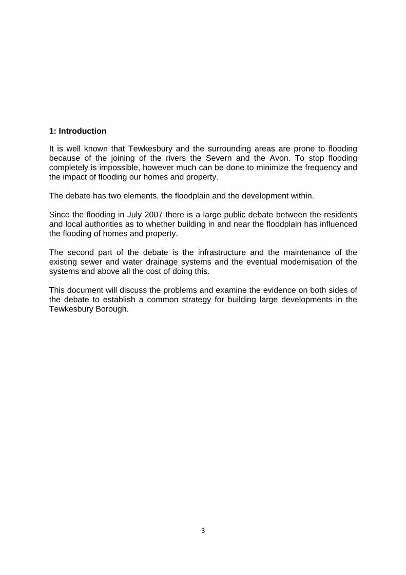
(see Testimonies Tewkesbury Town Council report 2002) also 1974 Ordnance Survey maps give the land height to be 10 metres above sea level, readings taken 2007 show 17 metres today. The Tewkesbury bypass No.2, known as the Dam by the local residents, is a road constructed on a built up strip of land straight down the middle of the floodplain and here again fits perfectly on the IDF. News reporters who flew over Tewkesbury during the July floods reported that the water was 2 metres higher on the eastern side (Newtown side) of the bypass than the western side. This is confirmed even by Tewkesbury Borough Council local plan 1988 to be floodplain, again O.S. 1974 gives levels of 10-11 metres today average height of the Eastern Relief road to be 15.5 metres. A recent development No.3, known as the Bredon Rd development shows on the IDF that it just borders the floodplain, originally this area was allotments and local residents say that this land flooded regularly, and some of these witnesses worked their own allotments there for a number of years. Allotment heights on 1974 O.S. maps prove the land to be no higher anywhere than 12 metres above sea level. RISK BASED APPROACH??? REMOVE HISTORIC TRENDS???
Figure:2These sites are opposite the Bredon Road Development.
Figure 3: The town centre does not flood according to the Environment Agency’s I.D.F. map dated 2007. The Indicative Floodplain Map shows that the Newtown area No.4 is not in the floodplain and yet in July Newtown flooded. Over the years the flood waters have
8

9
been creeping further and further into this area with increase in development continues. Lower Newtown is only 13 metres above sea level (datum point Spa House). Newtown is also affected along with the rest of Tewkesbury by the large amounts of water dumped into the Swilgate River and the Tirlebrook from the large industrial units that have and are being built east of Tewkesbury (Northway Industrial Estate) as well as the very large housing developments in Bishops Cleeve, some 450 houses alone since 2002. Water from the M5 motorway is also dumped into the Tirlebrook. There are a number of other anomalies thrown up by the IDF and we have given four as examples. Finely last but not least one of the most serious is the Mythe Water Treatment plant. The Environment Agency’s Indicative Floodplain Map claims it cannot flood, which is a serious error for the whole of Gloucestershire as we are all to well aware. Local Plan: The Tewkesbury Borough Council’s local plan was devised by officers of the Borough in 1988 along with Central Government and Developers, it earmarked areas for development. The Environment Agency’s Hydrology maps of the existing flood plain and historical records were only consulted but not used, because of RISK BASED STRATEGY. Question: Should the local plan be updated annually? PPG25 came in, in 2002 and was revised to PPS25 in 2006. It is a Risk Based Approach strategy. Was it at this point that the TBC’s errors in their plan came to light? At the full council meeting on December 18th 2007 Tewkesbury Borough Council officers admitted that they had not done a Strategic Flood Risk Assessment for the local plan when they should have, the Government Inspector MARY TRAVERS BA (HONS) DipTP MRTPI did not pick up this point up in her inquiry. This omission throws up a serious weakness, because a developer does his own Flood Risk Assessment (F.R.A.) for his site. With no S.F.R.A. for the local plan to take into account, a development could seriously exacerbate the risk of flooding in the area. If a Strategic Flood Risk Assessment has not been done it also begs the question as to whether a Regional Flood Risk Appraisal has been done. If you examine the local plan for Tewkesbury via the Planning Portal on the internet, go to the section on Environment and EVT5.
EVT5 - Development in High, and Low to Medium Flood Risk Areas
In the section on development in High and Low Flood Risk Area it says that a development proposal should be accompanied by a Flood Risk Assessment (F.R.A.) and would be allowed if: Then it gives a number of criteria and one of them is:
THE RISK TO HUMAN LIFE AND PROPERTY IS ACCEPTABLE, Bearing in mind that the developer does his own F.R.A. (PPS25): Why is a builder allowed to determine life or death and the damage to other property?

A local plan should be drawn up with the Environment Agency leading, local councillors, Insurance officers of the Association of British Insurers and interested developers. The Local Planning Department should be advisory only. A Strategic Flood Risk Assessment should then be applied and adjustments made. Hydrologist Floodplain Map: Figure 4: Hydrologist Floodplain Map © Environment Agency Figure 4 shows the hydrologist map of the floodplain that was commissioned by the Environment Agency in 1999 and updated in 2003. The reason the map was updated in 2003 was to include the tidal affect of the River Severn that was overlooked in 1999. The fact that the river Avon is 8 hours behind the Severn and both Rivers link at Tewkesbury; the Avon could also be affected by the tides. The hydrologist floodplain map needs to be updated to reflect this omission. This was admitted to the town council by Anthony Perry and Rex Thomas of the Environment Agency. You only have to glance at the maps shown in figures 1 and 4 to see that the hydrologist floodplain bears no resemblance to the indicative floodplain. The hydrologist based the mapping on the worst six months rainfall on record and on the worst rainfall in 24 hours on record, plus the highest spring tide height of the River Severn, building structures are ignored. A hydrologist uses ordnance survey map contours to determine height. The Hydrology map is working to 15 metre above sea level as opposed to the 13.4 that Tewkesbury Borough Council uses in their Indicative Floodplain Map for new planning applications. The floodplain on this map compares closely within 10% of the 1924 floodplain map (see Figure: 5 under 1924 Floodplain section). If the July 20th flooding had occurred in line with the spring tides the whole of the town of Tewkesbury would have been devastated and there would have not been
10

enough helicopters to evacuate the people. This is the gamble of using any Risk Based Approach that the people of Tewkesbury are unwilling to take. The hydrologist floodplain backs all the arguments that the residents associations have been putting to the Tewkesbury Borough Council over many years and the TBC have completely ignored the electorate’s feelings. We cannot understand why the Environment Agency has not been warning Severn Trent, Gloucestershire County Council and the Tewkesbury Borough Council that the Indicative Floodplain Map is only a map of the floodplain with constraints of PPS 25 and the local plan by Tewkesbury Borough Council and not a map based solely on water. The map shows: Wheatpieces Estate should flood but now displaces 528 million gallons
July 2007. The Eastern Bypass should flood but acts as a dam. Newtown could flood part did. Mythe Treatment Plant could flood and did Severn Trent should have
been warned. The Abbey could flood. Wynyards Close and Morrisons Superstore could flood and did. Church Street could flood and did. Half of the Mitton Estate could flood. Bredon Road Development could flood and part did. The Town Centre could flood. Figure 4a shows the flood profile of July 2007 which follows very closely to the profile on the Hydrologists map as to recorded levels, witness testimony and photographic evidence.
Figure 4a Flood profile July 2007. © Crown Copyright Licence No. 100047974
11
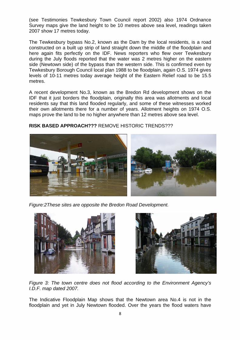
1924 Floodplain: Figure 5 shows a representation of the 1924 floodplain, this map was done by the author and is based on the royal ordnance survey map of that year and O.S. map 1974 where it shows areas “Liable to Flood”. The data was also compiled by interviewing many senior citizens of Tewkesbury who have lived in the area all their lives and have a lot of knowledge concerning flooding in the area. It is felt that this type of knowledge cannot be ignored by Central Government, the Environment Agency and Local Authorities. The Environment Agency even claim they use this source, clearly it has been overlooked. Figure: 5 1924 Floodplain. . © Crown Copyright Licence No. 100047974 The author also did an overlay of the major building developments that have taken place since 1924 (see Figure 5a) and it confirms that the environment agency’s Hydrologists floodplain map is correct on its prediction of property that would flood. This map is available for further examination. It is estimated that there is only a 10% difference in this flood plain map to the 2003 Hydrologist map the reason for this is because in 1924 the Ordnance Survey maps used a datum on the mean sea level at Liverpool, it was not until 1933 that they changed to the Newlyn Datum line. The difference is that the Liverpool line is 3ft higher than the Newlyn one. Based on the knowledge of local people and historical records the map shows that 15 metres was a good average for flood height. They recognised not to build in the floodplain, which is evident in the location of the existing buildings. Other historical maps 1895, 1921, 1968 and 1974 support the E.A. 2003 hydrology floodplain map to be accurate at predicting the extent of the floodplain.
12

Figure 5a: Major developments since1924. ©Crown Copyright Licence No. 100047974 All the information in the flood maps used in this report can be authenticated using NASA data at http://flood.firetree.net/?ll=51.9932,-2.1598&z=4&m=14 . Floodplain Runoff & Bottlenecks: In their written statement to the Gloucestershire County Council scrutiny inquiry the Environment Agency stated “We need a public debate about what level of flood protection we want and choose to afford in this country”. Anthony Perry and Rex Thomas of the Environment Agency stated to the Tewkesbury Town Council that Tewkesbury was not top of their priority list, their priority list bears no resemblance to flood danger, it is based on population, subsequently towns and districts with heavier populations, but no danger of flooding, are higher up on the Environment Agency’s spending. Water runoff from the floodplain is via the Tirlebrook, Swilgate, Little Fid and Carrant Brook and maintenance of these has been virtually nil in the last 20 to 25 years. Carrant Brook: Figure 6 shows the state of the culverts for the brook under the road near the Morrisons Supermarket.
13

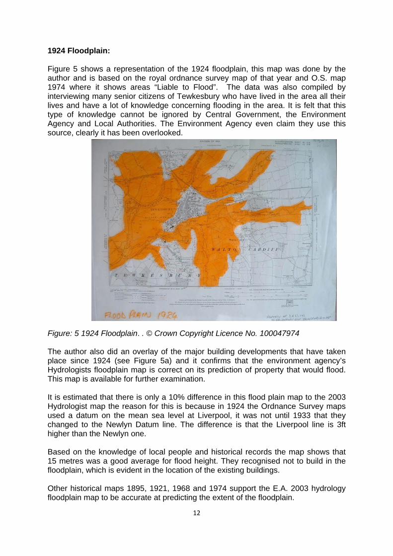
Figure 6: Carrant Brook culvert and exit channels near Morrisons Supermarket. Much of the brook is in this state which hampers runoff of the water into the Severn river, it does not seem to register with the authorities that the quicker local water can get away the less damage is cause by incoming water surges from other areas. Much of the surface water from roads and the recent industrial estates to the east of Tewkesbury runs off into this waterway and Carrant Brook then flows into the Avon, its exit is only 5 metres wide at this point and need urgent canalization. The Little Fid Wheatpieces is a controversial housing estate in Tewkesbury built on a man made island in the middle of the floodplain, here again the maintenance of this waterway is nil (see Figure 8). A major part of the surface water from the large Wheatpieces housing estate drains into the Swilgate but part of it and the proposed Wheatpieces 2 estate will drain into the Little Fid and still more houses are being approved to be built in this location. The junction with the Swilgate is only 1 metre wide. This water course needs urgent upgrading by the Environment Agency. Recently the Tewkesbury Borough Council has approved another 107 houses (Rudgeway) to be built next to the Wheatpieces estate right in the floodplain .Figure 7 is a picture of this site taken on July 23rd three days after the deluge. Burn marks on the hedge rows surrounding this site shows the water was eight feet high at one point. The Little Fid is in the back of this picture and the un-flooded land in the centre is spoil dumped by the builder from other parts of the site. Residents in the building that the photograph was taken from said that the water was lapping their doorsteps and had to use sandbags on the 21st. Recent authenticated surveying shows the present height in this area is only 12 metres above sea level.
14
Figure 7: site of 107 houses just approved by Tewkesbury Borough.
Figure 8: the state of the Little Fid Tirlebrook The Tirlebrook is another major tributary that drains the Cotswold escarpment into the Severn River via the Swilgate and a lot of the land either side of it is in private ownership therefore under current rules the riparian owner is responsible for the condition of the brook. This might save the authorities money but the land owners do not have the same priority and there is no enforcement of maintenance. Figure 9 shows the state of the Tirlebrook at this moment in time. The government should tackle this problem with some kind of tax incentive to encourage farmers and land owners to maintain these tributaries and enforce it with legislation.
Figure 9: The Tirlebrook
15
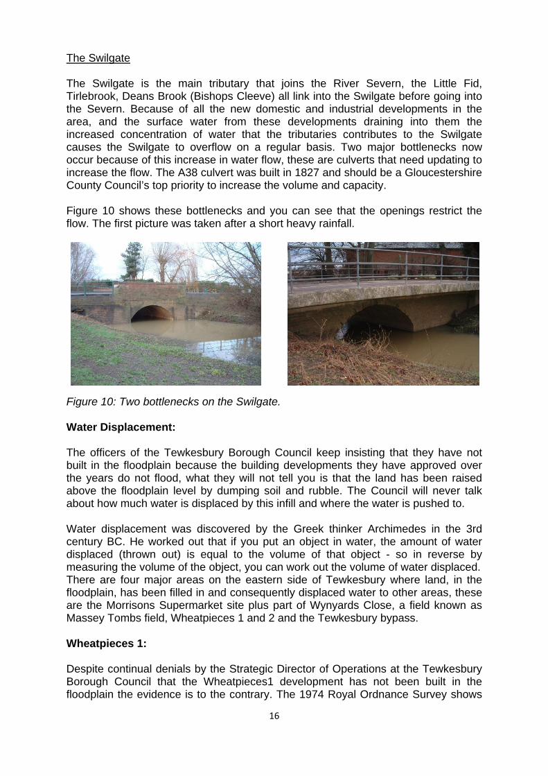
The Swilgate The Swilgate is the main tributary that joins the River Severn, the Little Fid, Tirlebrook, Deans Brook (Bishops Cleeve) all link into the Swilgate before going into the Severn. Because of all the new domestic and industrial developments in the area, and the surface water from these developments draining into them the increased concentration of water that the tributaries contributes to the Swilgate causes the Swilgate to overflow on a regular basis. Two major bottlenecks now occur because of this increase in water flow, these are culverts that need updating to increase the flow. The A38 culvert was built in 1827 and should be a Gloucestershire County Council’s top priority to increase the volume and capacity. Figure 10 shows these bottlenecks and you can see that the openings restrict the flow. The first picture was taken after a short heavy rainfall.
Figure 10: Two bottlenecks on the Swilgate. Water Displacement: The officers of the Tewkesbury Borough Council keep insisting that they have not built in the floodplain because the building developments they have approved over the years do not flood, what they will not tell you is that the land has been raised above the floodplain level by dumping soil and rubble. The Council will never talk about how much water is displaced by this infill and where the water is pushed to. Water displacement was discovered by the Greek thinker Archimedes in the 3rd century BC. He worked out that if you put an object in water, the amount of water displaced (thrown out) is equal to the volume of that object - so in reverse by measuring the volume of the object, you can work out the volume of water displaced. There are four major areas on the eastern side of Tewkesbury where land, in the floodplain, has been filled in and consequently displaced water to other areas, these are the Morrisons Supermarket site plus part of Wynyards Close, a field known as Massey Tombs field, Wheatpieces 1 and 2 and the Tewkesbury bypass. Wheatpieces 1: Despite continual denials by the Strategic Director of Operations at the Tewkesbury Borough Council that the Wheatpieces1 development has not been built in the floodplain the evidence is to the contrary. The 1974 Royal Ordnance Survey shows
16

the datum levels for the area that the estate has been on; we then took the datum levels at various points on the development and the graph (Figure 11) below shows the ground level for 1974 and the difference between the 1974 level and the 2008 level added to the 1974 levels. This shows quite dramatically how much land infill has taken place. On page 12 we mentioned the recent approval by the Tewkesbury Borough Council for another 107 houses in the floodplain, the land level for this site at the moment is 12 metres which is under the 1947 flood level of 12.4 metres, it will be interesting to see whether some land fill takes place.
Figure 11 Wheatpieces Ground levels 1974/2008 in Metres Morrisons Supermarket, Wynyards Close and Massey Tombs Field: Other sites on the eastern side of Tewkesbury that has been subjected to landfill are listed in the heading; these sites are close to the Newtown area of Tewkesbury that suffered severe flooding for the first time in living memory. The following graph Figure 12 shows the land levels for the sites in 1974. The differences between the land levels for 2008 and the 1974 levels have been added to the 1974 levels, this shows the amount of landfill that has taken place. We must say that only part of the Wynyards close site was subject to landfill.
17

2007 flood level 1947 Flood level Figure 12 Land Levels in metres Now that we have established landfill has taken place we can now work out the water displacement for each site and the following chart (Figure 13) gives the water displacement in gallons at various flood levels. The question should now be asked “Where is the water pushed to?”
Figure 13 Gallons displacement by site. Red = 2007 flood. It is estimated that in the July 2007 floods 495 million gallons of this water displacement flooded the Newtown area. Other areas in Tewksbury flooded that do not regularly flood and other areas experienced elevated water levels. It is agreed that the July 2000 some floods were extraordinary, but the basic effects of water displacement have been evident over a number of years. When the eastern bypass
18
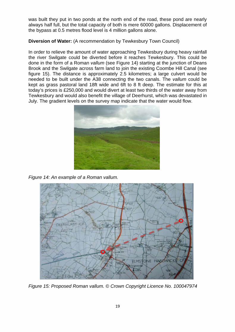
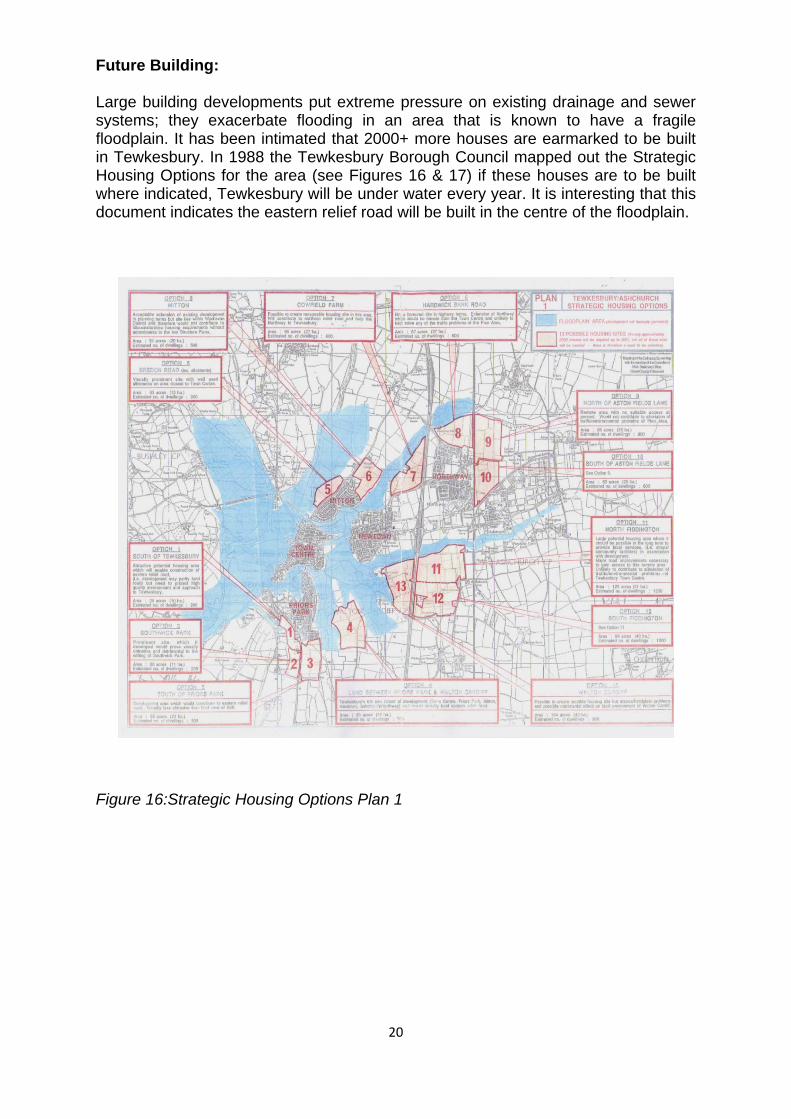
was built they put in two ponds at the north end of the road, these pond are nearly always half full, but the total capacity of both is mere 60000 gallons. Displacement of the bypass at 0.5 metres flood level is 4 million gallons alone. Diversion of Water: (A recommendation by Tewkesbury Town Council) In order to relieve the amount of water approaching Tewkesbury during heavy rainfall the river Swilgate could be diverted before it reaches Tewkesbury. This could be done in the form of a Roman vallum (see Figure 14) starting at the junction of Deans Brook and the Swilgate across farm land to join the existing Coombe Hill Canal (see figure 15). The distance is approximately 2.5 kilometres; a large culvert would be needed to be built under the A38 connecting the two canals. The vallum could be kept as grass pastoral land 18ft wide and 6ft to 8 ft deep. The estimate for this at today’s prices is £250,000 and would divert at least two thirds of the water away from Tewkesbury and would also benefit the village of Deerhurst, which was devastated in July. The gradient levels on the survey map indicate that the water would flow. Figure 14: An example of a Roman vallum. Figure 15: Proposed Roman vallum. © Crown Copyright Licence No. 100047974
19
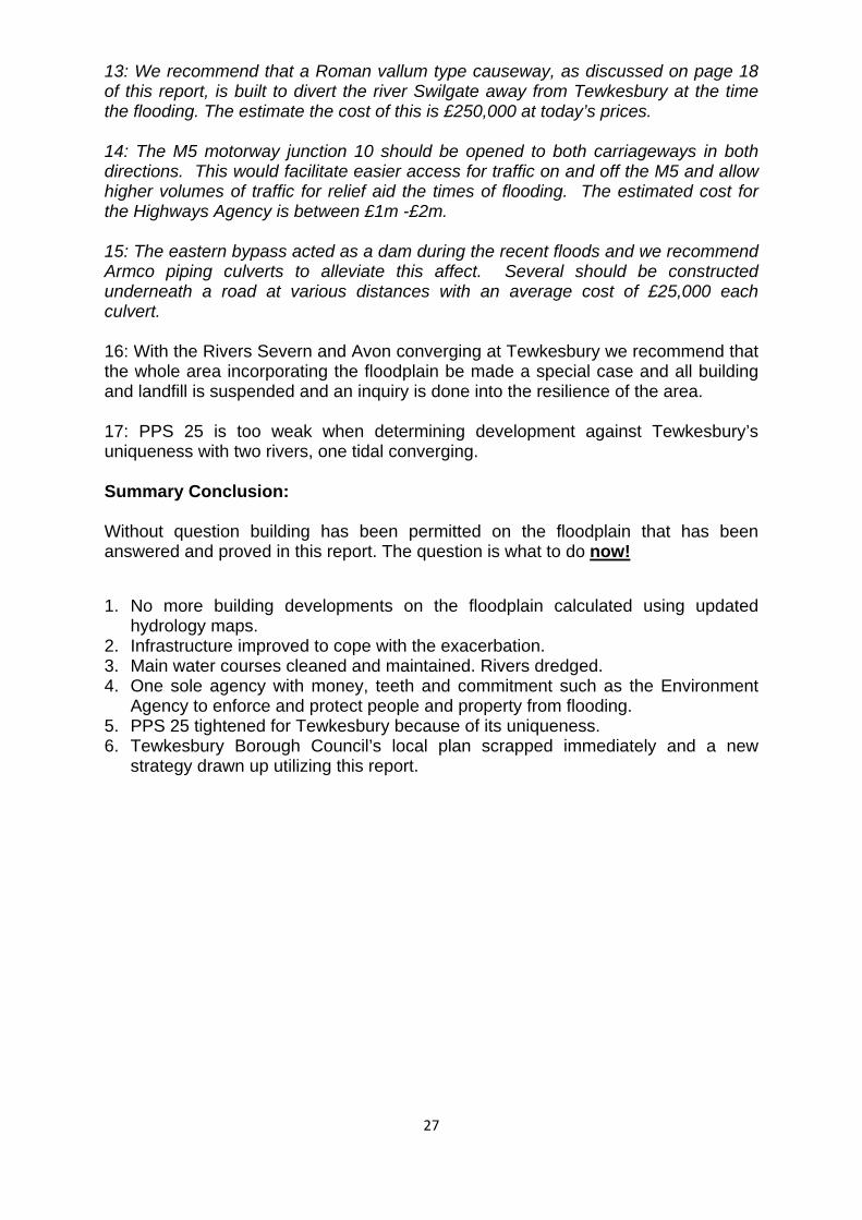
Future Building: Large building developments put extreme pressure on existing drainage and sewer systems; they exacerbate flooding in an area that is known to have a fragile floodplain. It has been intimated that 2000+ more houses are earmarked to be built in Tewkesbury. In 1988 the Tewkesbury Borough Council mapped out the Strategic Housing Options for the area (see Figures 16 & 17) if these houses are to be built where indicated, Tewkesbury will be under water every year. It is interesting that this document indicates the eastern relief road will be built in the centre of the floodplain.
20
Figure 16:Strategic Housing Options Plan 1

Figure 17: Strategic Housing Options Plan 2
21

22
Conclusions: 1: PPS 25 is weighted towards the Developer and the Local Planning Authority to remove the arguments against building in the floodplain.
2: PPS 25 advocates a Risk Based Approach to flooding where the residents of existing houses take the risk.
3: A Risk Based Approach cannot be used where the floodplain overrides all other influences on the infrastructure in an area such as Tewkesbury.
4: The Environment Agency’s indicative floodplain map is totally inaccurate.
5: No statutory body is in place with the means to enforce any development infringement and oversee large scale developments in and near the floodplain.
6: PPS 25 excludes local knowledge and historical records of flooding.
7: Landfill and increased water run off new developments has exacerbated flooding in the area. PPS 25 does not require any detailed study on displacement and its effects.
8: The tributaries of the Severn and Avon have not been maintained or enlarged to cope with increased water levels and the culverts cause bottlenecks. 9: There is no general statutory duty on the Government to protect land or property against flooding as stated in PPS 25. 10: Landowners have the primary responsibility for safeguarding their land and other property against natural events such as flooding, even when Central and Local Government policies and actions put their properties in danger. 11: Raising ground levels to above the floodplain levels through landfill allows the Local Planning Authority to manipulate the Indicative Floodplain Map. 12: Water management is laudable in areas where flood events have minimal volumes of water, but where high volumes are experienced such as the converging of the rivers Severn and Avon at Tewkesbury water management on individual sites becomes ineffective. 13: A Strategic Flood Risk Assessment has not been done by the Tewkesbury Borough Council for the area rendering all planning between 1980-2007 invalid against PPS 25. 14: The water displaced by landfill is approaching One Billion Gallons in the Tewksbury area causing damage to people’s properties.

THE INFRASTRUCTURE
The Infrastructure: Over the last 30 to 40 years the infrastructure of the country has deteriorated due to the lack of maintenance and no investment to modernise the systems. Cutbacks by successive Governments have led to many parts of the system failing. Surface Water Drainage: The surface water drainage systems have not been maintained over the last 10 to 20 years causing large parts of the system to fail during heavy rain. On July 20th and 21st 2007 many houses started to flood due to the accumulation of rainwater because drains were blocked from silt and debris. This was followed by floodwater when the rivers broke their banks. During the heavy rains in early January 2008 many roads and houses were flooded due to blocked drains. A representative of Gloucestershire County Council stated on a BBC radio Gloucestershire interview that even if they had maintained the drains to allow water runoff, the pipes in the system were too small to cope.
23

This is a damning statement and proves that Central and Local Governments need to make heavy investment in the drainage systems in order to protect property and ultimately lives. Regular cleaning and maintenance is a must for Gloucester County Council and should be their first priority within the county. In Tewkesbury and Bishops Cleeve the majority of surface water from roads and buildings drains into the tributaries of the rivers Severn and Avon, the situation is further exacerbated because the tributaries are not maintained in pristine condition. Foul Sewer System: (Tewkesbury Town) The main sewerage systems in Tewkesbury town were made up of a mixture of different designs some of them dating back to Victorian Times. The mixture combines pressurised and gravity fed systems and there seems to be a problem with the Bredon Road development (mentioned earlier in the report), this is because the new developments sewer system is a pressurise system which attached to the gravity fed systems running through the Mitton estate and the Mitton estate system attaches to the another pressurise system. The Gloucestershire Echo reported November 27th 2007 that the developer Pettifer Estates Limited have a problem with the switching on their system because of the danger of damaging the old system (see Figure 18).
24
Figure 18 Gloucestershire Echo Report

25
Modernisation: With the amount of development that has taken place in Tewkesbury over the last 20 to 30 years and the potential problems that will occur in the future due to the lack of capacity of the existing system. A case should be put forward for the complete modernization of the foul sewer system in Tewkesbury which Severn Trent would require government funding to complete over the next ten years an a must for Tewkesbury’s residents under the human charter of a Duty of Care.

26
Recommendations: Many of these recommendations have been put forward by the Tewkesbury Town Councils Infrastructure Committee (typed in italics) which the authors endorse. 1: Dredge rivers. 2: The Environment Agency should have a statutory duty to reduce flood risk to people and property over time and to put this priority on the same footing as it other environmental objectives. 3: The developers of new build developments should contribute towards the wider cost of upgrading drainage and foul water sewerage systems. 4: Building regulations should be upgraded to a higher standard and the Code for Sustainable Homes should be made mandatory. 5: The water companies should be statutory consultants on sewerage systems for new developments. 6: A clear investment commitment is needed by Central Government to update the infrastructure. 7: Central Government should have a statutory duty to protect people and property from the dangers of flooding. 8: PPS 25 should make mandatory the use of local knowledge and historical records on flooding. 9: Landfill should be made illegal within the floodplain, to stop water displacement into other areas, and landowners’ should be compelled to clear illegal landfill. 10: The responsibility of clearing ditches brooks and streams should be taken away from the riparian owners and placed with the Environment Agency. 11: The old railway line acted as a dam during the floods of July 2007 and without this bund effect, areas of North Oldbury up to Hollams Road, Old Hospital Road and Rope Walk up to Chance Street would have flooded. We urge this damning affect of the old railway line to be increased by putting flood defences in the gaps at Cotteswold Road, Newtown Lane and Northway Lane. This would have the effect of protecting these localised areas. Temporary flood defences erected by Gloucestershire county council, which can be re-used in times of expected flood would cost in the region of £12 to £15000. 12: As a matter of urgency the exits of the Swilgate River and Carrant brook need to be upgraded to increase the flow of water. It is believed each would cost £200,000 at today’s prices.
27
13: We recommend that a Roman vallum type causeway, as discussed on page 18 of this report, is built to divert the river Swilgate away from Tewkesbury at the time the flooding. The estimate the cost of this is £250,000 at today’s prices. 14: The M5 motorway junction 10 should be opened to both carriageways in both directions. This would facilitate easier access for traffic on and off the M5 and allow higher volumes of traffic for relief aid the times of flooding. The estimated cost for the Highways Agency is between £1m -£2m. 15: The eastern bypass acted as a dam during the recent floods and we recommend Armco piping culverts to alleviate this affect. Several should be constructed underneath a road at various distances with an average cost of £25,000 each culvert. 16: With the Rivers Severn and Avon converging at Tewkesbury we recommend that the whole area incorporating the floodplain be made a special case and all building and landfill is suspended and an inquiry is done into the resilience of the area. 17: PPS 25 is too weak when determining development against Tewkesbury’s uniqueness with two rivers, one tidal converging. Summary Conclusion: Without question building has been permitted on the floodplain that has been answered and proved in this report. The question is what to do now!
1. No more building developments on the floodplain calculated using updated hydrology maps.
2. Infrastructure improved to cope with the exacerbation. 3. Main water courses cleaned and maintained. Rivers dredged. 4. One sole agency with money, teeth and commitment such as the Environment
Agency to enforce and protect people and property from flooding. 5. PPS 25 tightened for Tewkesbury because of its uniqueness. 6. Tewkesbury Borough Council’s local plan scrapped immediately and a new
strategy drawn up utilizing this report.

Bibliography and Sources: Authors: Dave Witts had a 40 year career with a large Engineering Company in the Tewksbury area. He spent 10 years as an Industrial Market Analyst and is skilled in analysing data and statistics. David also spent a number of years in sales and ended his career as a manager in Warehouse and Transport logistics. Vernon Smith trained as a civil engineer at Kidderminster Technical College. Vernon worked in the highways department for Worcester County Council from 1978 – 1999 He was a self employed civil engineer from 1999 – 2003. He started his own civil engineering company which he operates to this day. This report will probably upset the local authority and individuals within the government, but we have written this report with an open mind and presented the facts that have taken many days of foot slogging, research and authentication. We strongly hope the powers that be within the planning authority read and digest this report and not spend all their efforts in finding ways to try to discredit it.
D A Witts Vernon Smith Date published: January 2008 Licences: Ordnance Survey Paper Map copying licence 100047974. Sources: PPS 25 Planning Portal www.planningportal.gov.uk Environment Agency Tewkesbury Town Council Infrastructure Committee Tewkesbury Borough Council Gloucestershire County Council http://flood.firetree.net/?ll=51.9932,-2.1598&z=4&m=14 National Flood Forum Local Knowledge Ordnance Survey With thanks to Cllr. Chuck Pavey for the original vallum idea.
28