Embed Size (px)
Citation preview

CRUISE REPORT
S-193
SCIENTIFIC ACTIVITIES UNDERTAKEN ABOARD THE
SSV Robert C. Seamans
Honolulu, HI – Prince Rupert, British Columbia - Victoria, British Columbia - Seattle, WA
8 May – 15 June 2004
Sea Education Association Woods Hole, Massachusetts

2
To obtain unpublished data, contact the SEA data archivist: Erik Zettler, Science Coordinator Sea Education Association PO Box 6 Woods Hole, MA 02543 (508) 540-3954 phone (800) 552-3633 phone (508) 457-4673 fax [email protected] email www.sea.edu website

3
Table of Contents Ship's Complement 4
Data Description 5
Figure 1: Cruise Track 6
Figure 2: Hydrographic sections 7
Table 1: Student Research Projects 8
Table 2: Oceanographic sampling stations 9
Table 3: Surface station data 12
Table 4: Neuston tow data 13
Table 5: Hydrocast data 14
Table 6: Sediment composition data 17
4
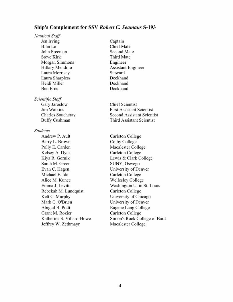
Ship's Complement for SSV Robert C. Seamans S-193 Nautical Staff
Jen Irving Captain Bihn Le Chief Mate John Freeman Second Mate Steve Kirk Third Mate Morgan Simmons Engineer Hillary Mendillo Assistant Engineer Laura Morrisey Steward Laura Sharpless Deckhand Heidi Miller Deckhand Ben Erne Deckhand
Scientific Staff
Gary Jaroslow Chief Scientist Jim Watkins First Assistant Scientist Charles Soucheray Second Assistant Scientist Buffy Cushman Third Assistant Scientist
Students Andrew P. Ault Carleton College Barry L. Brown Colby College Polly E. Carden Macalester College Kelsey A. Dyck Carleton College Kiya R. Gornik Lewis & Clark College Sarah M. Green SUNY, Oswego Evan C. Hagen University of Denver Michael F. Ide Carleton College Alice M. Kunce Wellesley College Emma J. Levitt Washington U. in St. Louis Rebekah M. Lundquist Carleton College Kett C. Murphy University of Chicago Mark C. O'Brien University of Denver Abigail B. Pratt Eugene Lang College Grant M. Rozier Carleton College Katherine S. Villard-Howe Simon's Rock College of Bard Jeffrey W. Zethmayr Macalester College
5
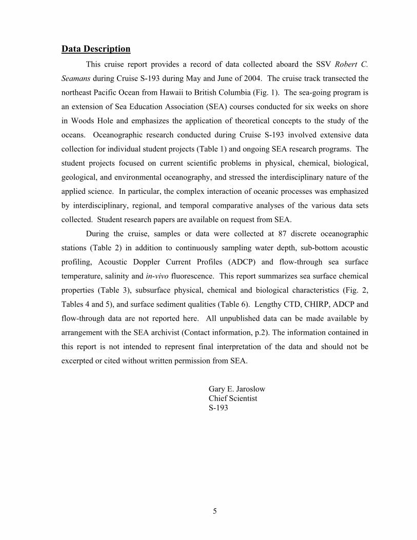
Data Description This cruise report provides a record of data collected aboard the SSV Robert C.
Seamans during Cruise S-193 during May and June of 2004. The cruise track transected the
northeast Pacific Ocean from Hawaii to British Columbia (Fig. 1). The sea-going program is
an extension of Sea Education Association (SEA) courses conducted for six weeks on shore
in Woods Hole and emphasizes the application of theoretical concepts to the study of the
oceans. Oceanographic research conducted during Cruise S-193 involved extensive data
collection for individual student projects (Table 1) and ongoing SEA research programs. The
student projects focused on current scientific problems in physical, chemical, biological,
geological, and environmental oceanography, and stressed the interdisciplinary nature of the
applied science. In particular, the complex interaction of oceanic processes was emphasized
by interdisciplinary, regional, and temporal comparative analyses of the various data sets
collected. Student research papers are available on request from SEA.
During the cruise, samples or data were collected at 87 discrete oceanographic
stations (Table 2) in addition to continuously sampling water depth, sub-bottom acoustic
profiling, Acoustic Doppler Current Profiles (ADCP) and flow-through sea surface
temperature, salinity and in-vivo fluorescence. This report summarizes sea surface chemical
properties (Table 3), subsurface physical, chemical and biological characteristics (Fig. 2,
Tables 4 and 5), and surface sediment qualities (Table 6). Lengthy CTD, CHIRP, ADCP and
flow-through data are not reported here. All unpublished data can be made available by
arrangement with the SEA archivist (Contact information, p.2). The information contained in
this report is not intended to represent final interpretation of the data and should not be
excerpted or cited without written permission from SEA.
Gary E. Jaroslow Chief Scientist S-193
6
Figure 1. Cruise-track map for Cruise S-193 of the SSV Robert C. Seamans from May 8 to June 15, 2004. The cruise began in Honolulu, HI, USA, made port stops in Prince Rupert and Victoria, BC, Canada, Port Townsend, WA, USA and ended in Seattle, WA.
7
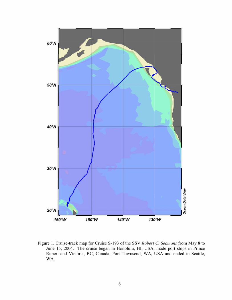
Figure 2. Data collected at CTD stations located in map (lower left, stations shown by blue
dots). Along-track water temperature, salinity, density and in-vivo fluorescence (top and middle sections). Plots of water-column temperature and temperature versus salinity (lower right).

8
Table 1. Student Research Projects
Title Student Researcher(s)
Current variability of the Northeast Pacific Barry Brown Conor Hagen
Geostrophic flow in the eastern North Pacific Kett Murphy
North Pacific Intermediate Water: Its presence and composition Polly Carden Jeff Zethmayr
A comparison between subtropical and subpolar water masses as related to the vertical distribution of oxygen and chlorophyll-a concentrations
Andrew Ault Rebekah Lundquist
Phytoplankton patchiness in the North Pacific Subtropical and Alaskan Gyres
Kelsey Dick
Species distribution of Halobates in the North Pacific Ocean Alice Kunce
Biogeographical environments and euthecosome pteropods species distribution in the North Pacific
Kiya Gornik
Zoogeographic distribution of pelagic foraminifera as a function of physical, chemical and biological water-mass qualities in the northeast Pacific Ocean
Abigail Pratt
Species variation, feeding habits and health of northeastern Pacific myctophidae
Mark O'Brien Kate Villard-Howe
Marine sediment transport and its relationship to hydrodynamic energy: a study of Penguin Bank
Grant Rozier Sarah Green
Anthropogenic effects of the ocean: pelagic plastic distribution and abundance in the northeastern Pacific Ocean
Michael Ide Emma Levitt

9
Table 2: Oceanographic sampling stations Local Log Sampling
Station Date Time (nm) Latitude Longitude Depth
(m) General Locale CTD Casts S193-016-CTD 11-May-04 2220 102.0 21°34.7' N 157°16.8' W 1420 40 km N of Molokai S193-018-CTD 12-May-04 1003 245.0 22°16.2' N 157°00.8' W 1179 67 km N of Molokai S193-023-CTD 13-May-04 2115 390.8 24°35.7' N 155°39.8' W 1155 333 km NE of Oahu S193-025-CTD 14-May-04 0923 460.6 25°34.8' N 154°55.1' W 250 537 km NNE of Oahu S193-030-CTD 15-May-04 2300 659.9 28°01.5' N 152°22.2' W 1007 900 km NNE of Oahu S193-032-CTD 16-May-04 1301 698.6 28°27.1' N 151°48.9' W 298 926 km NE of Oahu S193-034-CTD 16-May-04 2152 721.8 28°41.3' N 151°27.9' W 1210 N Pacific Gyre S193-038-CTD 18-May-04 0012 856.0 30°48.4' N 150°31.9' W 1134 N Pacific Gyre S193-043-CTD 19-May-04 1055 988.4 33°00.8' N 149°44.2' W 253 Transition Zone S193-044-CTD 19-May-04 2240 1081.4 34°39.3' N 149°23.5' W 1206 Transition Zone S193-046-CTD 20-May-04 1026 1150.7 35°39.9' N 149°06.4' W 250 Transition Zone S193-047-CTD 20-May-04 2015 1222.0 36°49.2' N 149°13.0' W 1196 Subpolar Front S193-049-CTD 21-May-04 1004 1313.5 38°23.1' N 149°33.8' W 1184 Subpolar Front S193-052-CTD 22-May-04 1000 1423.6 40°19.2' N 149°26.5' W 200 Subpolar Front S193-053-CTD 22-May-04 2115 1478.6 41°17.3' N 149°33.8' W 1125 Subpolar Front S193-055-CTD 23-May-04 2109 1587.3 43°08.8' N 148°47.9' W 1163 Subpolar Front S193-061-CTD 25-May-04 1004 1749.0 45°40.6' N 147°22.9' W 1148 Subpolar Front S193-063-CTD 26-May-04 2102 1985.0 48°44.6' N 143°32.9' W 1116 Subpolar Front S193-065-CTD 27-May-04 1030 2060.5 49°39.7' N 142°50.1' W 250 Alaskan Gyre S193-067-CTD 28-May-04 1011 2188.0 51°25.8' N 139°46.8' W 1100 Alaskan Gyre S193-069-CTD 29-May-04 0900 2286.5 52°53.3' N 137°58.9' W 2125 Alaskan Gyre S193-071-CTD 30-May-04 0915 2381.5 53°51.7' N 135°37.5' W 200 Alaskan Gyre S193-072-CTD 31-May-04 0340 2479.9 54°20.8' N 132°47.4' W 194 Dixon Entrance S193-074-CTD 5-Jun-04 0045 2749.0 52°33.1' N 130°90.4' W 250 Hecate Straight S193-075-CTD 6-Jun-04 1104 2875.5 51°28.6' N 130°34.8' W 1005 75 km S of Q. Charlotte Is. S193-076-CTD 6-Jun-04 2111 2891.0 51°16.2' N 130°12.7' W 800 51 km SE of Q. Charlotte Is. S193-078-CTD 10-Jun-04 1120 3127.5 49°11.9' N 126°45.0' W 800 35 km SW of Nootka Sound S193-079-CTD 12-Jun-04 1835 3264.5 48°20.9' N 123°58.3' W 800 Juan de Fuca Strait Hydrocasts S193-025-HC 14-May-04 0923 460.6 25°34.8' N 154°55.1' W 250 537 km NNE of Oahu S193-030-HC 15-May-04 2300 659.9 28°01.5' N 152°22.2' W 1007 900 km NNE of Oahu S193-032-HC 16-May-04 1301 698.6 28°27.1' N 151°48.9' W 298 926 km NE of Oahu S193-043-HC 19-May-04 1055 988.4 33°00.8' N 149°44.2' W 253 Transition Zone S193-046-HC 20-May-04 1026 1150.7 35°39.9' N 149°06.4' W 250 Transition Zone S193-052-HC 22-May-04 1000 1423.6 40°19.2' N 149°26.5' W 200 Subpolar Front S193-053-HC 22-May-04 2115 1478.6 41°17.3' N 149°33.8' W 1125 Subpolar Front S193-065-HC 27-May-04 1030 2060.5 49°39.7' N 142°50.1' W 250 Alaskan Gyre S193-071-HC 30-May-04 0915 2381.5 53°51.7' N 135°37.5' W 200 Alaskan Gyre S193-072-HC 31-May-04 0340 2479.9 54°20.8' N 132°47.4' W 194 Dixon Entrance Meter Nets S193-020-MN* 12-May-04 2145 287.8 23°01.4' N 156°53.1' W 100 N of Oahu S193-025-MN** 14-May-04 1004 460.6 25°35.4' N 154°55.7' W 200 537 km NNE of Oahu

10
S193-031-MN* 16-May-04 0039 659.9 28°01.4' N 152°21.5' W 100 900 km NNE of Oahu S193-034-MN** 16-May-04 2230 721.8 28°41.0' N 151°27.7' W 200 N Pacific Gyre S193-041-MN* 18-May-04 2143 924.8 31°58.6' N 149°56.4' W 100 N Pacific Gyre S193-041-MN** 18-May-04 2143 924.8 31°58.6' N 149°56.4' W 100 N Pacific Gyre S193-051-MN* 21-May-04 2240 1363.2 39°18.4' N 149°29.3' W 90 Transition Zone S193-051-MN** 21-May-04 2240 1363.2 39°18.4' N 149°29.3' W 100 Transition Zone S193-062-MN* 25-May-04 2125 1809.4 46°32.5' N 146°30.0' W 100 Subpolar Front S193-062-MN** 25-May-04 2130 1809.4 46°32.5' N 146°30.0' W 100 Subpolar Front S193-068-MN 28-May-04 2020 2236.5 52°05.4' N 138°51.3' W 1000 Alaskan Gyre S193-068-MN* 28-May-04 2117 2238.0 52°05.4' N 138°51.3' W 100 Alaskan Gyre S193-068-MN** 28-May-04 2122 2238.0 52°05.4' N 138°51.3' W 100 Alaskan Gyre *335-µm-mesh 1-m diameter net **200-µm-mesh 1-m diameter net 1000-µm-mesh 2-m diameter net Neuston Nets S193-001-NT 9-May-04 1455 3.1 21°15.2' N 157°51.6' W 0 4 km. S of Waikiki, Oahu S193-002-NT 9-May-04 2125 8.5 21°04.2' N 157°45.0' W 0 30 km. SE of Waikiki, Oahu S193-014-NT 11-May-04 0024 102.0 21°07.0' N 157°32.9' W 0 25 km. SE of Oahu S193-015-NT 11-May-04 1245 156.0 21°44.1' N 157°35.9' W 0 36 km. NE of Oahu S193-017-NT 11-May-04 2301 201.9 21°33.7' N 157°17.6' W 0 41 km. NW of Molaikai S193-019-NT 12-May-04 1102 245.0 22°16.3' N 157°01.7' W 0 67 km. NW of Molaikai S193-021-NT 12-May-04 2234 288.2 23°00.1' N 156°53.0' W 0 365 km. NW of Molokai S193-022-NT 13-May-04 1156 354.9 23°56.8' N 156°01.3' W 0 250 km. NW of Molokai S193-024-NT 13-May-04 2206 390.8 24°36.4' N 155°40.5' W 0 333.3 km NE of Oahu S193-026-NT 14-May-04 2205 533.3 26°35.5' N 154°00.7' W 0 333.3 km NE of Oahu S193-027-NT 14-May-04 2306 535.5 26°34.6' N 154°03.0' W 0 670 km NNE of Oahu S193-028-NT 14-May-04 2349 536.2 26°34.5' N 154°04.4' W 0 670 km NNE of Oahu S193-029-NT 15-May-04 0029 537.1 26°34.5' N 154°05.6' W 0 670 km NNE of Oahu S193-033-NT 16-May-04 1338 698.6 28°27.5' N 151°48.1' W 0 1000.1 km N of Oahu S193-036-NT 17-May-04 1146 795.5 29°49.5' N 151°00.0' W 0 N Pacific Gyre S193-039-NT 18-May-04 0120 856.0 30°49.5' N 150°32.0' W 0 N Pacific Gyre S193-040-NT 18-May-04 1217 902.5 31°32.4' N 149°59.4' W 0 N Pacific Gyre S193-042-NT 18-May-04 2309 926.0 31°57.6' N 149°58.8' W 0 N Pacific Gyre S193-045-NT 19-May-04 2350 1087.0 34°40.0' N 149°23.1' W 0 N Pacific Gyre S193-048-NT 20-May-04 2121 1222.0 36°49.3' N 149°13.4' W 0 Subpolar Front S193-050-NT 21-May-04 1059 1313.6 38°23.7' N 149°34.3' W 0 Subpolar Front S193-054-NT 22-May-04 2337 1479.0 41°18.5' N 149°20.0' W 0 Subpolar Front S193-056-NT 23-May-04 2231 1587.5 43°10.1' N 148°09.3' W 0 Subpolar Front S193-057-NT 24-May-04 2200 1705.3 44°58.9' N 147°44.3' W 0 Subpolar Front S193-058-NT 24-May-04 2237 1706.3 45°00.1' N 147°44.2' W 0 Subpolar Front S193-059-NT 24-May-04 2323 1707.3 45°01.7' N 147°44.6' W 0 Subpolar Front S193-060-NT 25-May-04 0010 1708.5 45°03.0' N 147°45.2' W 0 Subpolar Front S193-064-NT 26-May-04 2211 1985.1 48°45.2' N 143°31.9' W 0 Subpolar Front S193-066-NT 27-May-04 2351 2122.8 50°33.5' N 140°53.3' W 0 Alaskan Gyre S193-070-NT 30-May-04 0109 2351.1 53°35.6' N 136°28.3' W 0 Alaskan Gyre S193-073-NT 31-May-04 0426 2479.9 54°21.4' N 132°50.2' W 0 Dixon Entrance Phytoplankton Nets S193-025-PN 14-May-04 0919 459.5 25°34.8' N 154°55.1' W 0 537 km NNE of Oahu S193-032-PN 16-May-04 1230 698.6 28°27.1' N 151°48.9' W 0 926 km NE of Oahu S193-046-PN 20-May-04 1035 1150.7 35°39.9' N 149°06.4' W 0 Transition Zone
11
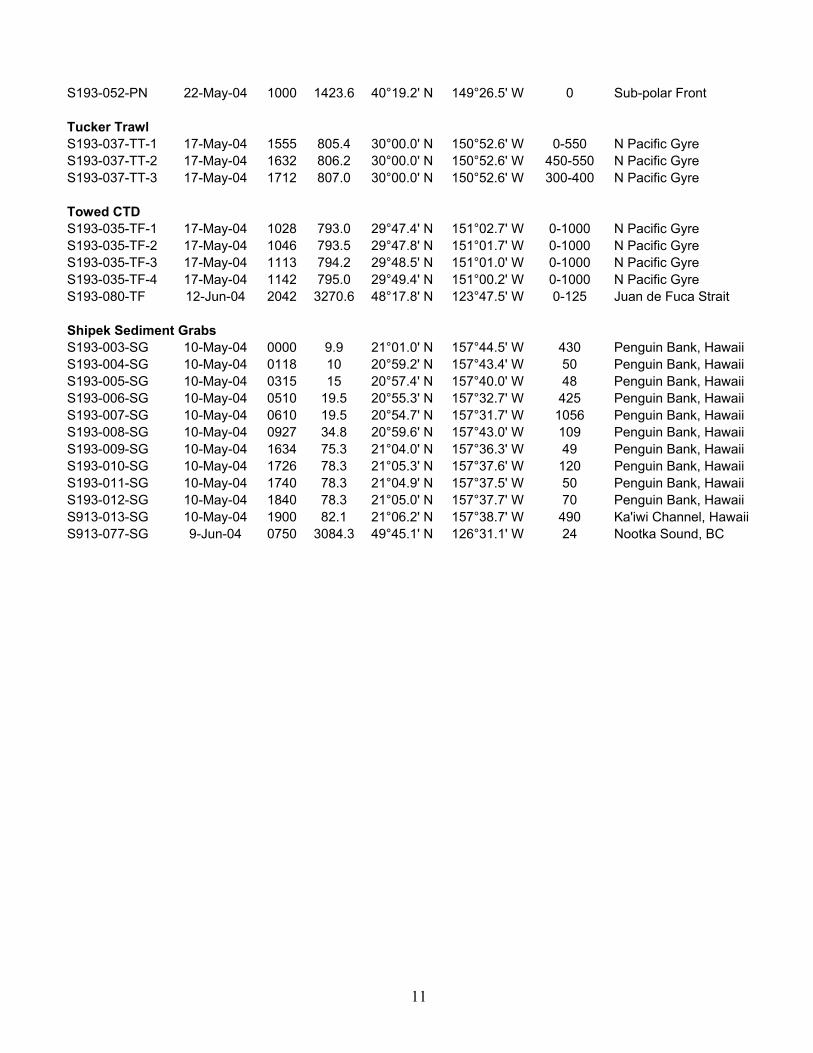
S193-052-PN 22-May-04 1000 1423.6 40°19.2' N 149°26.5' W 0 Sub-polar Front Tucker Trawl S193-037-TT-1 17-May-04 1555 805.4 30°00.0' N 150°52.6' W 0-550 N Pacific Gyre S193-037-TT-2 17-May-04 1632 806.2 30°00.0' N 150°52.6' W 450-550 N Pacific Gyre S193-037-TT-3 17-May-04 1712 807.0 30°00.0' N 150°52.6' W 300-400 N Pacific Gyre Towed CTD S193-035-TF-1 17-May-04 1028 793.0 29°47.4' N 151°02.7' W 0-1000 N Pacific Gyre S193-035-TF-2 17-May-04 1046 793.5 29°47.8' N 151°01.7' W 0-1000 N Pacific Gyre S193-035-TF-3 17-May-04 1113 794.2 29°48.5' N 151°01.0' W 0-1000 N Pacific Gyre S193-035-TF-4 17-May-04 1142 795.0 29°49.4' N 151°00.2' W 0-1000 N Pacific Gyre S193-080-TF 12-Jun-04 2042 3270.6 48°17.8' N 123°47.5' W 0-125 Juan de Fuca Strait Shipek Sediment Grabs S193-003-SG 10-May-04 0000 9.9 21°01.0' N 157°44.5' W 430 Penguin Bank, Hawaii S193-004-SG 10-May-04 0118 10 20°59.2' N 157°43.4' W 50 Penguin Bank, Hawaii S193-005-SG 10-May-04 0315 15 20°57.4' N 157°40.0' W 48 Penguin Bank, Hawaii S193-006-SG 10-May-04 0510 19.5 20°55.3' N 157°32.7' W 425 Penguin Bank, Hawaii S193-007-SG 10-May-04 0610 19.5 20°54.7' N 157°31.7' W 1056 Penguin Bank, Hawaii S193-008-SG 10-May-04 0927 34.8 20°59.6' N 157°43.0' W 109 Penguin Bank, Hawaii S193-009-SG 10-May-04 1634 75.3 21°04.0' N 157°36.3' W 49 Penguin Bank, Hawaii S193-010-SG 10-May-04 1726 78.3 21°05.3' N 157°37.6' W 120 Penguin Bank, Hawaii S193-011-SG 10-May-04 1740 78.3 21°04.9' N 157°37.5' W 50 Penguin Bank, Hawaii S193-012-SG 10-May-04 1840 78.3 21°05.0' N 157°37.7' W 70 Penguin Bank, Hawaii S913-013-SG 10-May-04 1900 82.1 21°06.2' N 157°38.7' W 490 Ka'iwi Channel, Hawaii S913-077-SG 9-Jun-04 0750 3084.3 49°45.1' N 126°31.1' W 24 Nootka Sound, BC

12
Table 3. Surface station data. Temp Salinity PO4 Chl-a Station Date Time Log Latitude Longitude (°C) (PSU) (mm) (mg/l) SS-001 9-May-04 1515 3.1 21°14.8' N 157°51.1' W 25.9 34.4 0.243 0.019 SS-002 9-May-04 2140 8.5 21°03.9' N 157°45.0' W 26.7 34.4 0.266 0.011 SS-003 11-May-04 0040 102.2 21°06.6' N 157°32.7' W 25.9 34.6 0.658 0.019 SS-004 11-May-04 1300 156.4 21°43.6' N 157°35.8' W 25.9 34.6 0.294 0.024 SS-005 11-May-04 2320 201.9 21°32.9' N 157°18.1' W 25.7 34.8 0.234 0.016 SS-006 12-May-04 1107 246.0 22°16.4' N 157°01.7' W 25.7 34.8 0.234 0.010 SS-007 12-May-04 2240 288.2 22°59.9' N 156°52.9' W 25.5 34.6 0.257 0.010 SS-008 13-May-04 1200 354.9 23°56.8' N 156°01.5' W 25.3 34.9 0.182 0.026 SS-009 13-May-04 2200 390.8 24°36.4' N 155°40.6' W 25.4 34.7 0.168 0.018 SS-010 14-May-04 2214 533.3 26°35.4' N 154°00.8' W 23.6 35.2 0.206 0.025 SS-011 14-May-04 2300 535.5 26°34.6' N 154°03.0' W 23.3 35.2 0.154 0.070 SS-012 15-May-04 0016 536.6 26°34.4' N 154°05.3' W 23.2 35.2 0.136 0.016 SS-013 15-May-04 0145 538.5 26°34.9' N 154°07.6' W 23.2 35.2 0.257 0.036 SS-014 17-May-04 1208 795.9 29°50.3' N 150°59.4' W 20.3 34.9 0.040 0.025 SS-015 18-May-04 0135 856.2 30°49.2' N 150°32.3' W 19.8 34.6 0.000 0.006 SS-016 18-May-04 1235 903.2 31°32.7' N 149°59.1' W 19.2 34.2 0.000 0.017 SS-017 18-May-04 2313 926.0 31°57.6' N 149°58.7' W 19.7 34.6 0.000 0.013 SS-018 20-May-04 0000 1087.7 34°40.4' N 149°23.0' W 17.4 34.0 0.110 0.026 SS-019 20-May-04 2130 1222.8 36°50.4' N 149°13.9' W 15.5 33.6 0.160 0.015 SS-020 21-May-04 1104 1313.6 38°23.8' N 149°34.4' W 15.1 33.5 0.110 0.010 SS-021 23-May-04 2245 1587.5 43°10.2' N 148°49.7' W 10.9 32.9 0.780 0.130 SS-022 24-May-04 2210 1705.3 44°59.1' N 147°44.3' W 10.3 32.7 0.790 0.063 SS-023 24-May-04 2305 1706.8 45°00.7' N 147°44.2' W 10.3 32.8 0.830 0.112 SS-024 24-May-04 2345 1707.8 45°02.2' N 147°44.9' W 10.3 32.8 0.730 0.080 SS-025 25-May-04 0035 1709.4 45°03.7' N 147°45.7' W 10.2 32.8 0.760 0.061 SS-026 25-May-04 2135 1808.9 46°32.8' N 146°29.8' W 9.6 32.6 0.960 0.048 SS-027 26-May-04 2220 1985.2 48°45.3' N 143°31.6' W 9.3 32.5 0.950 0.057 SS-028 27-May-04 2355 2122.8 50°33.5' N 140°53.5' W 10.1 32.4 0.900 0.044 SS-029 28-May-04 2042 2237.2 52°05.9' N 138°51.2' W 10.0 32.4 0.890 0.032 SS-030 29-May-04 0118 2351.1 53°36.0' N 136°28.9' W 10.0 32.4 0.710 0.090
13
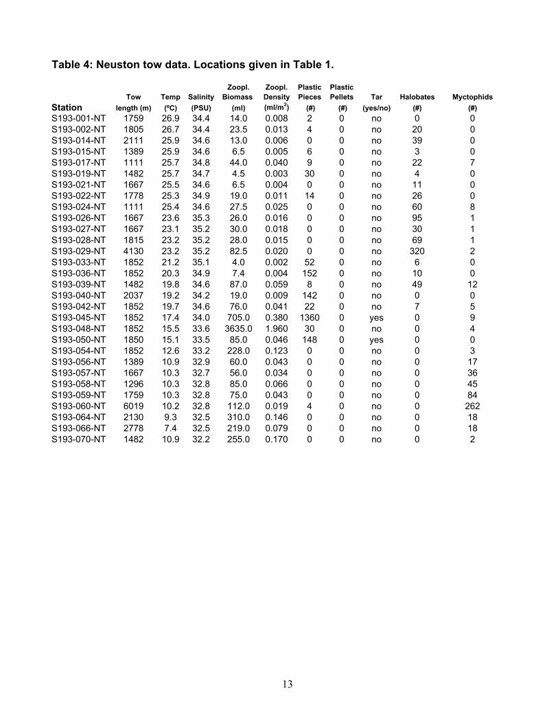
Table 4: Neuston tow data. Locations given in Table 1.
Zoopl. Zoopl. Plastic PlasticTow Temp Salinity Biomass Density Pieces Pellets Tar Halobates Myctophids
Station length (m) (ºC) (PSU) (ml) (ml/m2) (#) (#) (yes/no) (#) (#)S193-001-NT 1759 26.9 34.4 14.0 0.008 2 0 no 0 0S193-002-NT 1805 26.7 34.4 23.5 0.013 4 0 no 20 0S193-014-NT 2111 25.9 34.6 13.0 0.006 0 0 no 39 0S193-015-NT 1389 25.9 34.6 6.5 0.005 6 0 no 3 0S193-017-NT 1111 25.7 34.8 44.0 0.040 9 0 no 22 7S193-019-NT 1482 25.7 34.7 4.5 0.003 30 0 no 4 0S193-021-NT 1667 25.5 34.6 6.5 0.004 0 0 no 11 0S193-022-NT 1778 25.3 34.9 19.0 0.011 14 0 no 26 0S193-024-NT 1111 25.4 34.6 27.5 0.025 0 0 no 60 8S193-026-NT 1667 23.6 35.3 26.0 0.016 0 0 no 95 1S193-027-NT 1667 23.1 35.2 30.0 0.018 0 0 no 30 1S193-028-NT 1815 23.2 35.2 28.0 0.015 0 0 no 69 1S193-029-NT 4130 23.2 35.2 82.5 0.020 0 0 no 320 2S193-033-NT 1852 21.2 35.1 4.0 0.002 52 0 no 6 0S193-036-NT 1852 20.3 34.9 7.4 0.004 152 0 no 10 0S193-039-NT 1482 19.8 34.6 87.0 0.059 8 0 no 49 12S193-040-NT 2037 19.2 34.2 19.0 0.009 142 0 no 0 0S193-042-NT 1852 19.7 34.6 76.0 0.041 22 0 no 7 5S193-045-NT 1852 17.4 34.0 705.0 0.380 1360 0 yes 0 9S193-048-NT 1852 15.5 33.6 3635.0 1.960 30 0 no 0 4S193-050-NT 1850 15.1 33.5 85.0 0.046 148 0 yes 0 0S193-054-NT 1852 12.6 33.2 228.0 0.123 0 0 no 0 3S193-056-NT 1389 10.9 32.9 60.0 0.043 0 0 no 0 17S193-057-NT 1667 10.3 32.7 56.0 0.034 0 0 no 0 36S193-058-NT 1296 10.3 32.8 85.0 0.066 0 0 no 0 45S193-059-NT 1759 10.3 32.8 75.0 0.043 0 0 no 0 84S193-060-NT 6019 10.2 32.8 112.0 0.019 4 0 no 0 262S193-064-NT 2130 9.3 32.5 310.0 0.146 0 0 no 0 18S193-066-NT 2778 7.4 32.5 219.0 0.079 0 0 no 0 18S193-070-NT 1482 10.9 32.2 255.0 0.170 0 0 no 0 2
14
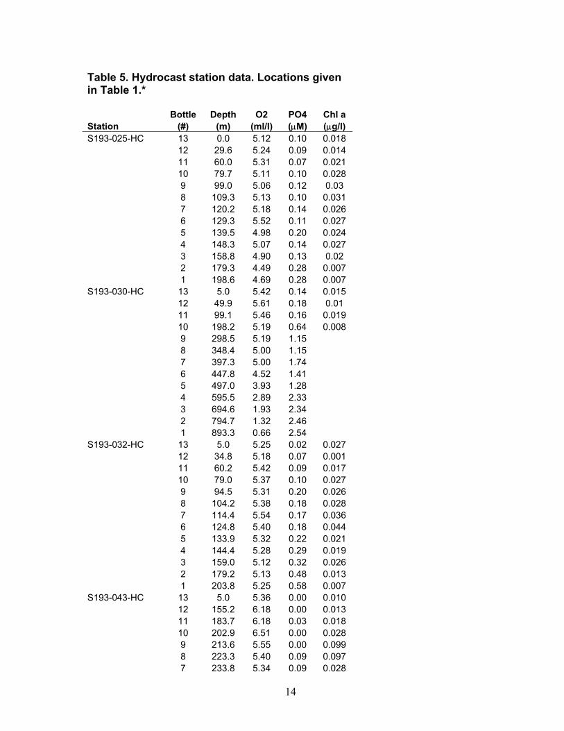
Table 5. Hydrocast station data. Locations given in Table 1.* Bottle Depth O2 PO4 Chl a Station (#) (m) (ml/l) (µM) (µg/l) S193-025-HC 13 0.0 5.12 0.10 0.018 12 29.6 5.24 0.09 0.014 11 60.0 5.31 0.07 0.021 10 79.7 5.11 0.10 0.028 9 99.0 5.06 0.12 0.03 8 109.3 5.13 0.10 0.031 7 120.2 5.18 0.14 0.026 6 129.3 5.52 0.11 0.027 5 139.5 4.98 0.20 0.024 4 148.3 5.07 0.14 0.027 3 158.8 4.90 0.13 0.02 2 179.3 4.49 0.28 0.007 1 198.6 4.69 0.28 0.007 S193-030-HC 13 5.0 5.42 0.14 0.015 12 49.9 5.61 0.18 0.01 11 99.1 5.46 0.16 0.019 10 198.2 5.19 0.64 0.008 9 298.5 5.19 1.15 8 348.4 5.00 1.15 7 397.3 5.00 1.74 6 447.8 4.52 1.41 5 497.0 3.93 1.28 4 595.5 2.89 2.33 3 694.6 1.93 2.34 2 794.7 1.32 2.46 1 893.3 0.66 2.54 S193-032-HC 13 5.0 5.25 0.02 0.027 12 34.8 5.18 0.07 0.001 11 60.2 5.42 0.09 0.017 10 79.0 5.37 0.10 0.027 9 94.5 5.31 0.20 0.026 8 104.2 5.38 0.18 0.028 7 114.4 5.54 0.17 0.036 6 124.8 5.40 0.18 0.044 5 133.9 5.32 0.22 0.021 4 144.4 5.28 0.29 0.019 3 159.0 5.12 0.32 0.026 2 179.2 5.13 0.48 0.013 1 203.8 5.25 0.58 0.007 S193-043-HC 13 5.0 5.36 0.00 0.010 12 155.2 6.18 0.00 0.013 11 183.7 6.18 0.03 0.018 10 202.9 6.51 0.00 0.028 9 213.6 5.55 0.00 0.099 8 223.3 5.40 0.09 0.097 7 233.8 5.34 0.09 0.028

15
6 243.6 5.28 0.11 0.022 5 251.6 5.19 0.29 0.017 4 245.9 5.31 0.28 0.015 3 235.1 5.36 0.23 0.024 2 215.0 5.28 0.34 0.007 1 195.1 5.31 0.48 0.003 S193-046-HC 13 5.0 5.58 0.26 0.006 12 30.4 6.06 0.25 0.017 10 79.8 5.93 0.35 0.173 9 89.9 6.04 0.32 0.031 8 99.4 5.95 0.34 0.040 7 110.0 5.63 0.50 0.010 6 119.7 5.66 0.59 0.014 5 129.8 5.57 0.60 0.004 4 139.9 5.57 0.71 0.009 3 149.4 5.66 0.61 0.003 2 169.0 5.61 0.84 0.004 1 188.8 5.45 0.70 0.001 S193-052-HC 13 5 6.28 0.41 0.024 12 9.9 6.32 0.360 0.014 11 20.4 6.41 0.510 0.016 10 30.1 6.39 0.440 0.018 9 39.6 6.41 0.390 0.030 8 49.8 6.37 0.450 0.019 7 59.4 6.30 0.560 0.200 6 69.9 6.37 0.560 0.085 5 80 6.49 0.450 0.020 4 89.9 6.37 0.620 0.021 3 100 6.00 0.620 0.009 2 109.2 5.90 0.630 0.008 1 120 5.61 0.660 0.008 S193-053-HC 13 5.0 6.01 0.537 0.100 12 20.7 6.90 0.523 0.077 11 45.5 6.45 0.630 0.043 10 69.9 6.12 0.532 0.025 9 100.3 5.75 0.690 0.008 8 198.5 5.05 1.250 0.047 7 298.4 4.76 1.623 6 398.0 3.49 1.422 5 496.8 2.60 2.410 4 596.5 2.00 2.452 3 695.2 1.28 2.736 2 794.2 0.82 2.401 1 992.5 S193-65-HC 13 0 6.57 1.310 0.046 12 11.2 6.54 1.306 0.029 11 19.7 6.56 1.352 0.021 10 29.3 6.69 1.329 0.051 9 39.7 6.78 1.334 0.045 8 49.9 6.86 1.683 0.044 7 59.4 6.84 1.473 0.088 6 70.5 6.77 1.571 0.098

16
5 78.6 6.98 1.646 0.072 4 89.5 7.22 1.525 0.075 3 100.2 6.23 1.75 0.042 2 120.2 5.03 2.08 0.009 1 148.6 4.20 2.27 0.009 S193-071-HC 13 0.0 6.75 0.67 0.537 12 9.9 6.94 0.62 1.167 11 20.4 6.61 0.67 0.682 10 25.9 6.49 0.99 9 1.14 8 7 39.7 6.51 0.950 0.055 6 50.6 6.46 1.160 0.079 5 60.3 6.40 0.800 0.066 4 68.3 6.34 0.910 0.045 3 80.1 6.46 1.060 0.022 2 89.5 5.26 1.150 0.023 1 99.8 4.65 1.310 0.021 S193-072-HC 13 0.0 6.83 0.530 0.241 12 5.1 7.05 0.50 0.425 11 10.1 7.08 0.53 0.246 10 15.6 6.82 0.58 0.282 9 20.3 6.46 1.07 0.152 8 24.7 6.14 1.04 0.139 7 30 5.55 1.36 0.121 6 35.2 5.47 1.43 0.104 5 40.3 5.22 1.30 0.120 4 50.7 5.12 1.67 0.044 3 59.8 5.17 1.76 0.073 2 70.4 4.71 1.80 0.041 1 90 4.27 2.15 0.033
*Blank spaces = no data collected.

17
Table 6. Sediment composition data. Locations given in Table 1. Station Qualitative description S193-003-SG very fine sand to silt S193-004-SG medium to fine sand, coral and shell fragments S193-005-SG fine to coarse rounded sand, shell fragments S193-006-SG fine sand to med fine sand, shell and coral fragments 40% of sample S193-007-SG No sample S193-008-SG medium grain size. Coralline to fine grain, shell and coral pieces S193-009-SG sand, round and angular S193-010-SG sand, round and angular fragments S193-011-SG silty sand, little sample S193-012-SG cobbly sand, coralgal chunks up to 3-4 cm, Halimeda platelets, red algae nodules S913-013-SG sand, no organics S913-077-SG silty clay, green, strong organic smell

![PART 193 LIQUEFIED NATURAL GAS FACILITIES FEDERAL … · PART 193 – LIQUEFIED NATURAL GAS FACILITIES: FEDERAL SAFETY STANDARDS Part 193 Master (193-[20]) 1/36 Revised 4/08 NEW FORMAT](https://img.pdfslide.us/doc/110x75/5b7bf9a47f8b9a9d078b5526/part-193-liquefied-natural-gas-facilities-federal-part-193-liquefied-natural.jpg)

![T. GORNIK BUILD / DESIGN LTD. · 2019-03-07 · t. gornik build / design ltd. 4 3 n o r t h d r i v e . 4,023 ft^2 [374 m^2] first floor area only garage side entrance hallway elevator](https://img.pdfslide.us/doc/110x75/5f339d3f89c0227ba6094440/t-gornik-build-design-ltd-2019-03-07-t-gornik-build-design-ltd-4-3-n-o.jpg)