Embed Size (px)
Citation preview

College of Earth, Ocean, and Atmospheric Sciences 1
RV Wecoma 1975–2011
This brief pictorial history is dedicated to the memory of the Oregon State University
Research Vessel Wecoma, all her captains and crew, and all they did
to enable a vast body of oceanographic research, to protect the safety of all who sailed on her,
and to provide us all with good food and good company.

College of Earth, Ocean, and Atmospheric Sciences2
Wecoma in her original configuration, approaching Newport for the first time, on 2 January 1976.
Wecoma at sea in her latest configuration, 29 September 2011.

College of Earth, Ocean, and Atmospheric Sciences 3
Wecoma crossing the Yaquina Bay Bar for the last time, 30 November 2011. These two photos were taken 12 seconds apart, at about 1:15 pm.

College of Earth, Ocean, and Atmospheric Sciences4
1975 RV Wecoma is launched, and RV
Oceanus christened, on 31 May 1975, at Sturgeon Bay, Wisconsin. Both ships and their sister, RV Endeavor, were built for and owned by the National Science Foundation, each to be operated by a separate institution: Oregon State University, Woods Hole Oceanographic Institution, and University of Rhode Island. Representing Oregon State University at the launch ceremony were OSU President Robert MacVicar, Dean John Byrne of the School of Oceanography, and Marine Superintendent E. B. Rittenhouse.
After the launch, Wecoma and Oceanus lay side by side for a further six months in Sturgeon Bay for completion of their superstructures and basic outfitting.
Wecoma left Sturgeon Bay on 25 November, sailing through the St. Lawrence Seaway and the Panama Canal on her way to Newport, Oregon, with port calls at Woods Hole, Massachusetts; Balboa, Panama; and San Diego, California. A small scientific party on board, including Mike and Jan Gemperle (Oregon State University), collected gravity, magnetic and bathymetric data en route. Wecoma first arrived in Newport on 2 January 1976 with Captain Howard Linse on the bridge.
1976After an enthusiastic welcome,
Wecoma underwent immediate
Wecoma launched Memorial Day weekend, Peterson Shipyard,
Sturgeon Bay, Wisconsin.
After the launch: Wecoma hull afloat in Sturgeon Bay.
Oceanus and Wecoma together in Woods Hole, Massachusetts, 1975.

College of Earth, Ocean, and Atmospheric Sciences 5
modifications in Newport. The founder of oceanography at OSU, Wayne V. Burt, had already participated in the design and outfitting of Oregon State University’s earlier research vessels (RV Acona, RV Yaquina, and RV Cayuse), and was determined to make Wecoma even more suited to the diverse kinds of sampling required by OSU physical, biological, chemical, and geological oceanographers. Staterooms for the chief scientist and captain were added on the main and bridge decks; a sheltered aft-control station (‘doghouse’) was added on the boat deck; winches and a large crane were installed; a long wet lab suitable for dissecting large fish was added on the starboard side; a starboard passageway was retained to enable piston coring of the sea bed.
Wecoma’s first working voyage out of Newport was a short cruise beginning on 8 May with Jane Huyer (Oregon State University) as chief scientist. Several other short cruises followed in rapid succession, including three to study benthic life (led by Drew Carey, Oregon State University), fish (led by Bill Pearcy, Oregon State University), and small-scale mixing (led by Doug Caldwell, Oregon State University).
Wecoma was formally dedicated on 23 July, with National Science Foundation Director Guyford Stever giving the keynote address and presenting the vessel to Oregon State University President Robert MacVicar and Acting Dean George Keller of the School of Oceanography.
A series of ten more research cruises filled the remainder of the year;
Wecoma’s first arrival in Newport, June 2, 1976.
Wecoma after addition of staterooms, wet lab, doghouse and crane.
Wecoma in her original configuration, approaching Newport, Oregon,
January, 1976.

College of Earth, Ocean, and Atmospheric Sciences6
most were very short. The first long expedition for Wecoma, lasting nearly two months, consisted of two legs. The first leg (led by Bill Pearcy and David Stein, Oregon State University) used mid-water trawls and deep-sea beam trawls to study fish in an open-ocean region north of Hawaii and west of Portland, Oregon, (45°N, 150°W). The second leg (led by Robert Bernstein of Scripps Institute of Oceanography and Denny Kirwan of Texas A&M University) studied the North Pacific Current between 150°W and 170°W; Bernstein and Kirwan were among the first to deploy satellite-tracked drifters.
1977 Wecoma spent the first six months
on a long voyage to Peru (WELOC77) with port calls in San Diego, California; Balboa, Panama; and Callao, Peru. The first leg, led by Lou Gordon (Oregon State University) studied dissolved gases in the Eastern Tropical North Pacific. The second leg studied the geology and geophysics of the Galapagos Rise and the East Pacific Rise.
The next three legs were part of a multi-ship expedition to Peru coastal waters by the Coastal Upwelling Ecosystems Analysis (CUEA) project, led by Dick Barber (Duke University), Dick Dugdale (University of Washington), and Bob Smith (Oregon State University); the other three ships were Melville (Scripps Institute of Oceanography), Iselin (University of Miami), and Cayuse (Oregon State University). The last
OSU’s RV Cayuse and Wecoma in port in Callao, Peru,
during CUEA, 1977.
Erwin Suess and Captain Howard Linse on Wecoma’s bridge.
Erwin Suess and George Keller with a sediment core in the
wet lab, off Peru, 1977.

College of Earth, Ocean, and Atmospheric Sciences 7
two legs were devoted to studying sediments off Peru under the leadership of Vern Kulm, George Keller, Erwin Suess and Hans Schrader, all of Oregon State University.
After returning to Newport, Oregon, Wecoma spent the rest of the year on 12 local cruises led by Oregon State University faculty members in biological, physical, optical, and geological oceanography. The Slope Undercurrent Study (SUS), conducted jointly by Barbara Hickey (University of Washington) and Bob Smith, Jane Huyer and Marv Lilley (Oregon State University), included an array of current meters moored across the continental margin as well as monthly hydrographic surveys between July 1977 and July 1978. Students from the Marine Technician program at Clatsop Community College participated in many of these cruises.
Captain Howard Linse retired, and Tony Loskota took over as Master.
1978Wecoma made a long voyage in
March and April; researchers on the cruise studied geochemical processes in the Santa Barbara Basin (Jack Dymond and others, Oregon State University) and internal waves in the offshore waters of southern California (Chip Cox, Scripps Institute of Oceanography), returning to Newport, Oregon, in May.
Short local cruises dominated the schedule through summer and early fall. Hydrographic sampling and mooring cruises for the Slope Undercurrent
Cook Tom Kluttz serving breakfast in the galley.
(Newport News-Times photo)
Wecoma alongside pier in her home port. (Newport News-Times photo)
Captain Linse and seaman Jack Miller on the bridge.
(Newport News-Times photo)

College of Earth, Ocean, and Atmospheric Sciences8
Study resumed until September. In June, Doug Caldwell (Oregon
State University) and his research team began a series of cruises to study small-scale physical processes over the Oregon continental shelf. They pioneered a new Rapid Sampling Vertical Profiler (RSVP), which drifted gently down through the water all the way to the bottom and then was pulled back with a fine line on a fishing rod. They also devised a Tripod equipped with many fragile sensors to measure fine structure and turbulence in the bottom boundary layer. These sensitive instruments were paired with conventional sampling of bottom sediments (mud, sand, etc.) in order to estimate bottom roughness. Instrument development continued on board Wecoma as well as in the lab ashore between cruises.
In autumn, Wecoma spent a month on a cruise to survey zooplankton around Kodiak Island in the northwestern Gulf of Alaska, for the Outer Continental Shelf Assessment Program (OCSEAP, led by Ken Waldron, National Oceanic and Atmospheric Administration).
1979–80Short local cruises dominated
Wecoma’s schedule until June, with a wide range of projects for various disciplines, including optics, geology, chemistry, and biology. Doug Caldwell’s (Oregon State University) Sublayer project culminated in a week-long cruise off Cascade Head, Oregon. One
Ralph Moore and Stuart Blood exhibiting the Rapid Sampling Vertical
Profiler and its hand-operated retrieval system.
Doug Caldwell supervising final adjustments on the bottom Tripod.
Priscilla Newberger acquiring RSVP data.

College of Earth, Ocean, and Atmospheric Sciences 9
evening, Captain Tony Loskota brought Wecoma inshore to shelter behind Cascade Head so delicate instruments could be repaired.
In early July, Wecoma departed for Honolulu, Hawaii. For nearly a year, Wecoma sailed back and forth between Hawaii and Tahiti for the NORPAX Shuttle project under the leadership of Klaus Wyrtki (University of Hawaii).
On 29 September 1979, just after Wecoma left Honolulu on a NORPAX cruise, Oregon State University graduate student Richard Cobler was reported missing and never found. A graduate scholarship in his honor was eventually established.
Thanksgiving, Christmas, and New Year’s Day were all spent at sea. Each NORPAX leg measured temperature, salinity and chemical properties along cross-equatorial transects in the central Pacific Ocean between 145°W and 160°W. Each leg lasted about 25–30 days. Wecoma made a total of ten NORPAX Shuttle legs before returning to Newport, Oregon, in July 1980.
Local cruises off Oregon and California filled the schedule of Wecoma during the last half of 1980. These included three three-week cruises: one to study faulting and hydrothermal activity on the Gorda Ridge (for Dale Bibee, Oregon State University); one to study the vertical exchange (VERTEX) of particles and chemicals in the upper ocean off Monterey Bay for a multi-institutional team including Larry Small (Oregon State University), John Martin (Moss Landing Marine Laboratory), Ken Bruland (University of California Santa
Releasing and retrieving the Rapid Sampling Vertical Profiler
(RSVP) looks a lot like fishing.
Doug Caldwell’s bottom-landing Tripod about to enter the water .
Preparing to launch the box corer to collect a bottom sample.

College of Earth, Ocean, and Atmospheric Sciences10
Cruz), and Dave Karl (University of Hawaii).
Captain Tony Loskota retired, and Bruno Forsterer took over as Master. Ken Palfrey became Marine Superintendent, replacing Captain R. G. Redmond.
In preparation for the multi-institutional Coastal Dynamics Experiment (CODE) to take place off northern California, Oregon State University acquired a removable A-frame for Wecoma (for heavy surface moorings) and a modern CTD system (to measure temperature, salinity and pressure with better accuracy).
1981Captain Bruno Forsterer left
Oregon State University, and Warren Dietrichson took over as Master.
The multi-institutional Coastal Dynamics Experiment (CODE) and the complementary SuperCODE experiment dominated the schedule of Wecoma for the next two years.
CODE was concentrated in a small region between Pt. Arena, California, and Pt. Reyes, just north of San Francisco. It included an array of moored current meters (Bob Beardsley and Bill Grant of Woods Hole Oceanographic Institution, and Clint Winant of Scripps Institute of Oceanography), bottom pressure gages (Wendell Brown and Jim Irish, University of New Hampshire), surface drifters (Russ Davis, Scripps Institute of Oceanography), repeated surveys to measure temperature and
Jane Huyer’s portion of CODE makes several hundred CTD
casts in 1981–82.
Rich Schramm calling the bridge.
The SuperCODE gang, led by Bob Smith, resting between moorings.

College of Earth, Ocean, and Atmospheric Sciences 11
salinity (Jane Huyer, Oregon State University), and underway current measurements by shipborne acoustic Doppler current profiler (Lloyd Regier and Mike Kosro, Scripps Institute of Oceanography).
The study included meteorological observations from aircraft and buoys as well as from aboard Wecoma, and also incorporated satellite measurements of sea surface temperature. CODE cruises were concentrated in the season of strongest upwelling, April through July.
The CODE region became known for its persistent strong winds and high seas; both scientists and crew grew weary of the ship’s heavy rolls that result from riding ‘in the trough’ because of the need to sample along transects perpendicular to the coast. Notebooks, pencils and dishes flew through the air, and engineers had difficulty reading their oil and water gages.
Many of Wecoma’s port calls were to the Coast Guard pier on Yerba Buena Island in San Francisco Bay. Strong tidal currents at the pier presented an exceptional challenge to Captain Dietrichson and his crew.
In contrast to CODE, SuperCODE (led by Bob Smith and John Allen, Oregon State University) spanned a large extent of the U.S. West Coast, from Pt. Conception, California, at 35°N to Coos Bay, Oregon, at 43°N. SuperCODE also included shelf moorings and repeated hydrographic sections; observations were made in winter and fall as well as in spring and summer.
In late autumn, the VERTEX team
Captain Warren Dietrichson on the bridge, chatting with KATU reporter
Lisa Stark. (from OSU Goes To Sea)
Wecoma heading to Eureka, California, to exchange personnel, 1981.
Captain Dietrichson and his guest relaxing at the Captain’s table in
the mess. (from KATU’s OSU Goes to Sea)

College of Earth, Ocean, and Atmospheric Sciences12
(Larry Small of Oregon State University, John Martin of Moss Landing Marine Laboratory, and others) took Wecoma for a five-week cruise to waters off southern Mexico (18°N, 108°W) to study the vertical exchange of materials by sampling around a drifting particle interceptor trap.
1982CODE and SuperCODE again
dominated the schedule, with only a few cruises for other projects. Important scientific results, especially the observation of ‘squirts and jets,’ eventually led to other major projects on Wecoma in 1987–88, 1993 and 1994–95. December marked the end of CODE with recovery of the last moorings.
In September there were two cruises to an offshore site (39.5°N, 128°W, depth >4000 m) off northern California to study the sediments, near-bottom currents, water properties and sedimentation rates for the Low Level Waste Ocean Disposal Program (LLWODP) under the leadership of Oceanography Dean, Ross Heath, of Oregon State University.
1983Wecoma made a second
expedition to Peru (WECOC83). By serendipity, this expedition took place during a very strong El Niño, one of the strongest in recent memory. Also by serendipity, moorings were in place off both the southern Oregon shelf and the
Retrieving Rosette/CTD with the help of an overhead rail during
Peru Currents project.
Wecoma in port, San Diego, California. (from KATU’s OSU Goes to Sea)

College of Earth, Ocean, and Atmospheric Sciences 13
northern Peru shelf, so anomalous El Niño currents were measured in both locations.
The first leg of WECOC83 departed Newport, Oregon, in January, and the SuperCODE team (led by Bob Smith, Oregon State University) surveyed waters off Southern Oregon and northern California.
During the second leg, from Balboa, Panama, to Callao, Peru, Wecoma made a transequatorial section along 95°W, serviced moorings, and surveyed Peruvian coastal waters for the Peru Currents project, led by Bob Smith and Jane Huyer (Oregon State University). Water temperatures were so much higher than normal that crew members caught subtropical dorado (mahi-mahi) in the normally cold coastal upwelling zone; all aboard enjoyed grilled fish for lunch.
The third leg (led by Dick Barber of Duke University) surveyed coastal and equatorial waters beginning in Callao, Peru, and ending at Balboa, Panama, with an intermediate stop at Santa Cruz in the Galapagos Islands.
A series of short legs completed the expedition. Because of the strong El Niño, Wecoma made an extra transect off San Diego for the ongoing CalCOFI program (led by Joe Reid, Scripps Institute of Oceanography). Television station KATU of Portland, Oregon, sent along a news team to make a series of brief videos (‘OSU Goes to Sea’) that aired on the evening news. After completion of another SuperCODE survey and an extra transect off Newport, Wecoma returned home in
Bosun John Keiper weaving a safety net for the gap in
Wecoma’s starboard rail.
Seaman Dick Deer with remains of the dorado he caught in
Peru coastal waters.

College of Earth, Ocean, and Atmospheric Sciences14
mid April.Wecoma spent the rest of the
year deployed on a variety of projects, some lasting only a few days, others as long four weeks. Vern Kulm (Oregon State University) studied lithification of sediments along the lower continental slope off Oregon and Washington. The VERTEX team (Ken Bruland of University of California Santa Cruz, Larry Small of Oregon State University, and others) studied the vertical exchange of materials in a small region north of Hawaii (28°N, 155°W); as in their previous cruises off Monterey Bay, they sampled the water column while following a drifting particle collector. Jim Murray (Oregon State University) studied the chemistry of pore water in the sediments along Baja California, Mexico. In September, Wecoma returned to the Low Level Waste Ocean Disposal Program site off northern California to recover and replace current meter and sediment trap moorings.
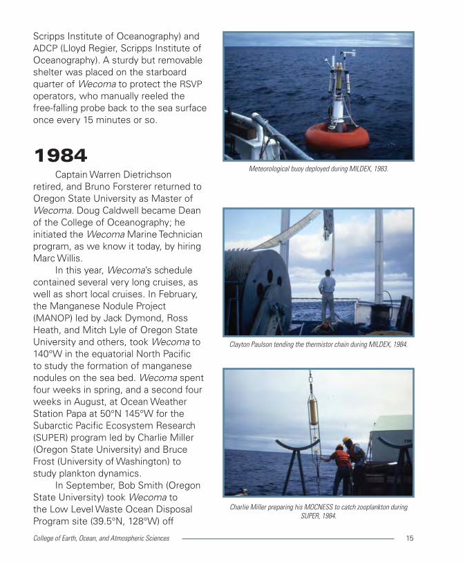
In October, Wecoma participated in MILDEX, a study of mixing in the ocean surface layer at 34°N, 127°W off southern California, along with RV Acania from the Naval Postgraduate School and RV FLIP from Scripps Institute of Oceanography. MILDEX included a wide variety of instruments and sampling methods: Rapid Sampling Vertical Profiler, or RSVP, (Doug Caldwell and Jim Moum, Oregon State University), a thermistor chain (Clayton Paulson, Oregon State University), acoustics (Rob Pinkel, Scripps Institute of Oceanography on FLIP), surface drifters and moorings (Russ Davis,
Mike Neeley-Brown on the fantail, operating Rapid Sampling Vertical
Profiler (RSVP), MILDEX, 1983.
Melora Park and Mike Neeley-Brown repairing RSVP on deck, 1983.
RV FLIP seen from Wecoma during MILDEX, 1983.
College of Earth, Ocean, and Atmospheric Sciences 15
Scripps Institute of Oceanography) and ADCP (Lloyd Regier, Scripps Institute of Oceanography). A sturdy but removable shelter was placed on the starboard quarter of Wecoma to protect the RSVP operators, who manually reeled the free-falling probe back to the sea surface once every 15 minutes or so.
1984Captain Warren Dietrichson
retired, and Bruno Forsterer returned to Oregon State University as Master of Wecoma. Doug Caldwell became Dean of the College of Oceanography; he initiated the Wecoma Marine Technician program, as we know it today, by hiring Marc Willis.
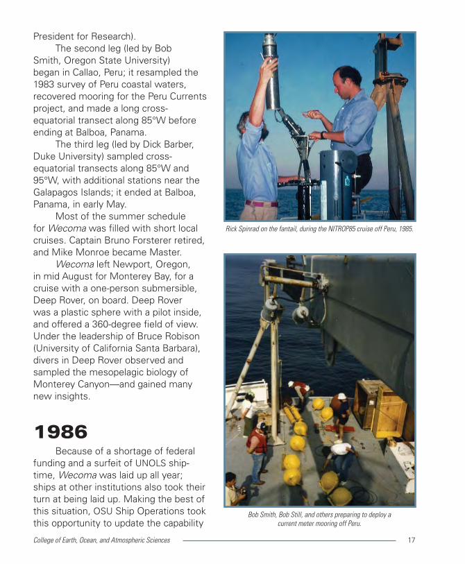
In this year, Wecoma’s schedule contained several very long cruises, as well as short local cruises. In February, the Manganese Nodule Project (MANOP) led by Jack Dymond, Ross Heath, and Mitch Lyle of Oregon State University and others, took Wecoma to 140°W in the equatorial North Pacific to study the formation of manganese nodules on the sea bed. Wecoma spent four weeks in spring, and a second four weeks in August, at Ocean Weather Station Papa at 50°N 145°W for the Subarctic Pacific Ecosystem Research (SUPER) program led by Charlie Miller (Oregon State University) and Bruce Frost (University of Washington) to study plankton dynamics.
In September, Bob Smith (Oregon State University) took Wecoma to the Low Level Waste Ocean Disposal Program site (39.5°N, 128°W) off
Meteorological buoy deployed during MILDEX, 1983.
Clayton Paulson tending the thermistor chain during MILDEX, 1984.
Charlie Miller preparing his MOCNESS to catch zooplankton during
SUPER, 1984.

College of Earth, Ocean, and Atmospheric Sciences16
northern California to recover moorings and sediment traps for the last time. The cruise continued farther south to deploy a set of three current meter moorings for the Ocean Prediction Through Observations, Modeling and Analysis (OPTOMA) program. Portland artist Henk Pander joined the cruise to make sketches in preparation for a new mural for the Oregon State University Memorial Union.
The TropicHeat 84 cruise in November and December was led by Clayton Paulson and Jim Moum (Oregon State University) and Lloyd Regier (Scripps Institute of Oceanography). They measured upper ocean temperature with a towed thermistor chain, velocity shear with a free-falling RSVP, and continuous profiles of upper ocean currents with an acoustic Doppler current profiler (ADCP). Sampling was along a trans-equatorial transect at 140°W from 3°N to 3°S. RSVP and ADCP measurements were also made continuously at one equatorial station for twelve days.
1985In January, Wecoma began a third
expedition to Peru. The first project, NITROP85, led by Lou Codispoti and Ted Packard (Bigelow Lab for Ocean Sciences in Maine), aimed to study nitrogen transformation in the low-oxygen layer between 5°S and 17°S off Peru. The multidisciplinary team aboard this cruise included optical oceanographer Rick Spinrad (Oregon State University; now in 2012, OSU Vice
Detail of Pander’s mural in OSU’s Memorial Union.
Sediment traps on fantail, ready to sail.
Deep Rover launch from Wecoma, Monterey Canyon, 1985.
College of Earth, Ocean, and Atmospheric Sciences 17
President for Research). The second leg (led by Bob
Smith, Oregon State University) began in Callao, Peru; it resampled the 1983 survey of Peru coastal waters, recovered mooring for the Peru Currents project, and made a long cross-equatorial transect along 85°W before ending at Balboa, Panama.
The third leg (led by Dick Barber, Duke University) sampled cross-equatorial transects along 85°W and 95°W, with additional stations near the Galapagos Islands; it ended at Balboa, Panama, in early May.
Most of the summer schedule for Wecoma was filled with short local cruises. Captain Bruno Forsterer retired, and Mike Monroe became Master.
Wecoma left Newport, Oregon, in mid August for Monterey Bay, for a cruise with a one-person submersible, Deep Rover, on board. Deep Rover was a plastic sphere with a pilot inside, and offered a 360-degree field of view. Under the leadership of Bruce Robison (University of California Santa Barbara), divers in Deep Rover observed and sampled the mesopelagic biology of Monterey Canyon—and gained many new insights.
1986Because of a shortage of federal
funding and a surfeit of UNOLS ship-time, Wecoma was laid up all year; ships at other institutions also took their turn at being laid up. Making the best of this situation, OSU Ship Operations took this opportunity to update the capability
Rick Spinrad on the fantail, during the NITROP85 cruise off Peru, 1985.
Bob Smith, Bob Still, and others preparing to deploy a
current meter mooring off Peru.

College of Earth, Ocean, and Atmospheric Sciences18
of Wecoma as much as possible. Double doors and a telescoping
overhead rail were added at the aft end of the wet lab to allow the CTD/rosette to be brought indoors immediately after recovery. A permanent transducer was installed for the Acoustic Doppler Profiling System, to measure upper-ocean currents while Wecoma was underway. The network for logging and sharing navigation, meteorological and other data was modernized. The removable A-frame on the stern of Wecoma was replaced with a sturdier, permanent one. Staterooms for the ship’s mates were added on the bridge deck, so more bunks were available to scientists.
1987Wecoma’s schedule was
dominated by three projects: VERTEX, Coastal Transition Zone, and TropicHeat.
The VERTEX team (John Martin of Moss Landing Marine Laboratory, Larry Small of Oregon State University, and others) had a two-week cruise to a site far west of San Diego (33°N, 139°W) in January, and a series of three cruises in the Northeast Pacific in July and August. As in previous years, they studied the vertical transport and exchange of materials in the upper ocean; they measured the microbial biomass, microbial productivity, and the primary productivity in the vicinity of drifting sediment traps. The last VERTEX cruise of the year took place off Monterey, California, in late October.
The Coastal Transition Zone (CTZ)
Marc Willis preparing the rosette sampler for another CTD station.
Bob Still and Henry Pittock check ADP.
Steve Pierce and Bob Smith drag glass floats for deep-water
ADP mooring.

College of Earth, Ocean, and Atmospheric Sciences 19
had four cruises in this year. CTZ was a multi-investigator project (led by Ken Brink of Woods Hole Oceanographic Institution and Doug Caldwell of Oregon State University) designed to study the nature of the ‘squirts and jets’ and ‘cold filaments’ that apparently connect the cold coastal upwelling zone to the offshore warm region off northern California in spring and summer. Three survey cruises (in February, late May, and mid June) measured water properties and the currents between Coos Bay, Oregon, and San Francisco. A fourth cruise in early June measured the turbulence and mixing rates in a current jet identified by the preceding survey cruise. In preparation for more intensive CTZ work in 1988, a new Acoustic Doppler Profiler (ADP) mooring was deployed off Coos Bay.
TropicHeat 87 had a long cruise in March, April, and May led by Clayton Paulson and Jim Moum (Oregon State University); they made ADCP and thermistor chain measurements along a very long transect through the tropical and equatorial zone (38°N to 5°S along 140°W) during the first leg between Newport, Oregon, and Papeete, Tahiti. During the second leg, the RSVP profiler was added to the suite of instruments providing continuous measurements along the equator from 150°W to 108°W. The cruise ended in Acapulco, Mexico.
1988 In January, Wecoma once again
headed to the Equatorial Pacific. One
Clayton Paulson preparing to load his thermistor chain
system onto Wecoma.
Thermistor chain on deck during rough weather.
Dennis Barstow assisting with CTZ mooring deployment, 1988.

College of Earth, Ocean, and Atmospheric Sciences20
leg (led by Dick Barber and Francisco Chavez, Monterey Aquarium Research Institute) worked in a region between 15°N and 15°S near 150°W to study the balance between new and total primary productivity, and the relation between turbulence and phytoplankton adaptability. Another leg was for Michael Bender (University of Rhode Island) to study benthic processes between Tahiti and Honolulu. The VERTEX team, led by John Martin (Moss Landing Marine Laboratory), took the final leg between Honolulu and Monterey, California, before Wecoma headed back to Newport, Oregon.
Wecoma spent the summer off northern California on cruises for the Coastal Transition Zone group, which included Doug Caldwell, Mark Abbott, John Allen, Tim Cowles, Jane Huyer, Mike Kosro, Jim Moum, Clayton Paulson and Bob Smith (all of Oregon State University). RV Thomas Washington and RV Pt. Sur also participated in this project.
Wecoma made the first and last of a series of six CTD/ADCP surveys of the transition region between 38°N and 39°N. The quality of current observations from the Wecoma underway ADCP system was better than in previous years, largely because data from the expanding array of Global Positioning Satellites had become available for marine navigation, first supplementing and eventually replacing the old Loran-A and Loran-C systems. Wecoma also deployed three deep-water ADP moorings, and spent three weeks sampling the microstructure
Wecoma off central California. (thanks to Vicky Cullen, WHOI)
The OSU Mixing Group’s Chameleon probe measures turbulence and
mixing while it falls freely through the water. Like the Rapid Sampling
Vertical Profiler, it is reeled in by hand.

College of Earth, Ocean, and Atmospheric Sciences 21
along one transect with the thermistor chain and the RSVP profiler.
During autumn, Wecoma had several short cruises. One of these was for Steve Lentz (Woods Hole Oceanographic Institution) to begin the Shelf Mixed Layer Experiment (SMILE) at the site of the 1981–82 CODE project, off California between Pt. Reyes and Pt. Arena.
Captain Mike Monroe retired, and Chief Mate Jim Doyle became Master.
1989–90In January 1989, Wecoma
departed for the Gulf of Tehuantepec, for a six-week study led by Des Barton (University of North Wales) on the effect of a strong narrow wind jet on the circulation of the upper ocean; collaborators included Mike Kosro and Bob Smith (Oregon State University). In late winter and spring, Wecoma had two more cruises off northern California to continue SMILE (Steve Lentz, Woods Hole Oceanographic Institution). The remainder of 1989 was dominated by short local cruises. Wecoma had no cruises in November and December.
Wecoma left Newport, Oregon, in mid January of 1990 for the western tropical Pacific, to conduct a pilot study (led by Mike Gregg, University of Washington) for the upcoming international Tropical-Ocean/Global-Atmosphere Coupled Ocean-Atmosphere Response Experiment (TogaCOARE). The transit from Newport to Guam took three weeks; Gregg’s cruise lasted four weeks.
The Seasoar towed undulating vehicle has an impeller to provide
hydraulic power for changing wing angle.
MarTecs Brian Wendler and Marc Willis testing Seasoar.
Bob Smith and Jane Fleischbein monitoring Seasoar’s faired cable.
College of Earth, Ocean, and Atmospheric Sciences22
Wecoma returned to Hawaii by the end of March; she operated out of Honolulu for several more cruises before coming home at the end of July.
Wecoma’s schedule for summer and most of autumn was occupied with short local cruises. In October, Barbara Hickey (University of Washington) began the Columbia Plume Experiment which continued through the following winter.
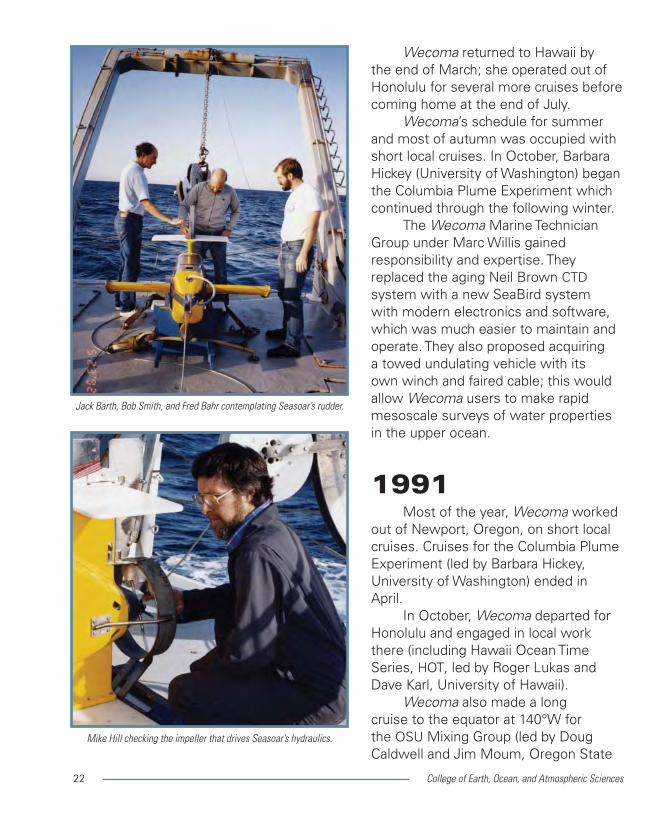
The Wecoma Marine Technician Group under Marc Willis gained responsibility and expertise. They replaced the aging Neil Brown CTD system with a new SeaBird system with modern electronics and software, which was much easier to maintain and operate. They also proposed acquiring a towed undulating vehicle with its own winch and faired cable; this would allow Wecoma users to make rapid mesoscale surveys of water properties in the upper ocean.
1991Most of the year, Wecoma worked
out of Newport, Oregon, on short local cruises. Cruises for the Columbia Plume Experiment (led by Barbara Hickey, University of Washington) ended in April.
In October, Wecoma departed for Honolulu and engaged in local work there (including Hawaii Ocean Time Series, HOT, led by Roger Lukas and Dave Karl, University of Hawaii).
Wecoma also made a long cruise to the equator at 140°W for the OSU Mixing Group (led by Doug Caldwell and Jim Moum, Oregon State
Jack Barth, Bob Smith, and Fred Bahr contemplating Seasoar’s rudder.
Mike Hill checking the impeller that drives Seasoar’s hydraulics.

College of Earth, Ocean, and Atmospheric Sciences 23
University) to participate in the Tropical Instability Wave Experiment (TIWE); the researchers remained on station for three weeks while using a new free-falling instrument, Chameleon, a descendent of Doug Caldwell’s RSVP profiler, to sample the upper 200 m nearly continuously.
Wecoma returned to Hawaii early in December for a few more local cruises there, and then remained in port in Honolulu over Christmas and New Year’s Day.
1992Wecoma performed intermittent
sampling at the HOT (Hawaii Ocean Time Series) station for Roger Lukas and Dave Karl, University of Hawaii. Sampling continued until April, separated by two cruises to the Equatorial Pacific. The first, beginning in mid January and led by Jim Murray (University of Washington) and Bob Collier (Oregon State University) deployed sediment traps for the Joint Global Ocean Flux Study (JGOFS). The other, beginning in mid March (for Neil Tindale, University of Rhode Island), measured concentrations of atmospheric iron. Wecoma returned to Newport, Oregon, at the end of April, and began a series of short cruises off the Oregon coast that continued until mid August.
Three very short cruises (in May, July and August) tested both the hardware and software of Wecoma’s new Seasoar system. Seasoar itself was a bare vehicle that needed to be
Marc Willis, Brian Wendler, and Jack Barth tending the faired cable
during Seasoar deployment.
Marc Willis exhibiting the tow bridle and tapered termination of the
conducting cable used to tow the Seasoar vehicle.

College of Earth, Ocean, and Atmospheric Sciences24
completed with sensors and a data acquisition system. For the upcoming TogaCOARE cruises, Wecoma Marine Technicians (Marc Willis, Mike Hill and Brian Wendler) installed a SeaBird CTD with dual temperature and conductivity sensors, and a PAR sensor to measure the intensity of ambient light. The MarTech software specialist (Tim Holt) devised a real-time display of incoming data to assist operators to make appropriate sampling decisions. These test cruises also provided training in operating the system and in maintaining its various components.
In late August, Wecoma headed west again: first to Honolulu, for a short cruise there, then on to Pohnpei (about 7°N, 158°E) and eventually Guam (about 13°N, 145°E) in order to participate in TogaCOARE, the large international Coupled Ocean-Atmosphere Response Experiment of the Tropical Ocean/Global Atmosphere program.
Besides Wecoma and RV Moana Wave from the U.S., ships from several other nations also participated. COARE was designed to measure both atmospheric and oceanic conditions, and to study the exchange of heat, moisture and momentum between them. Sampling techniques included rapidly repeated surveys, fixed moorings, and Doppler radars.
Wecoma participated by deploying surface buoys (Bob Weller, Woods Hole Oceanographic Institution) and subsurface moorings (Charlie Eriksen, University of Washington), and by making meteorological observations (Clayton Paulson, Oregon State
Marc Willis at Seasoar controls, COARE.
Bosun John Keiper heading in for lunch.
Mike Hill during a rare swim call.

College of Earth, Ocean, and Atmospheric Sciences 25
University) and rapid Seasoar/ADCP surveys (Jane Huyer and Mike Kosro of Oregon State University; Roger Lukas, Peter Hacker, and Eric Firing of University of Hawaii). All observations were concentrated in a small area centered at 2°S, 156°E. The mooring deployment cruise began in Pohnpei in mid October and ended in Guam in early November, immediately after the passage of typhoon Omar.
Because the new Seasoar system was essential to rapid surveys, at least two of the Wecoma Marine Technicians (Marc Willis, Mike Hill, Brian Wendler, and Tim Holt) participated in each of the three survey cruises; they worked hard to keep Seasoar running in spite of occasional failures.
The first survey cruise began in Guam in early November and returned there in early December; the second began in mid December and returned to Guam in mid January. Thanksgiving Day, Christmas and New Year’s Day were all spent at sea.
1993The third TogaCOARE survey
cruise left Guam in late December and continued sampling through mid February. Mark Huntley (University of Hawaii) joined the ship during a brief port call in Pohnpei on the way back to Guam; he planned to use an Optical Plankton Counter with Seasoar on an upcoming project and needed to confirm compatibility. Two COARE mooring recovery cruises took Wecoma from Guam and Pohnpei
Wecoma’s crew back in Newport: Captain Jim Doyle, Engineers Bob
Ashley and Mel Goff, Mate Danny Arnsdorff,
Messman Roby Schroeder and others.
Seasoar equipped with Optical Plankton Counter for EBC, 1993.
Towing Seasoar, during EBC, 1993.
College of Earth, Ocean, and Atmospheric Sciences26
back to Honolulu. Wecoma returned to Newport, Oregon, in late April.
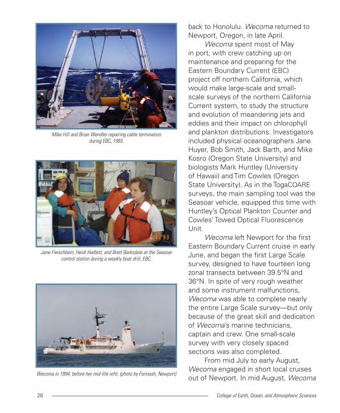
Wecoma spent most of May in port, with crew catching up on maintenance and preparing for the Eastern Boundary Current (EBC) project off northern California, which would make large-scale and small-scale surveys of the northern California Current system, to study the structure and evolution of meandering jets and eddies and their impact on chlorophyll and plankton distributions. Investigators included physical oceanographers Jane Huyer, Bob Smith, Jack Barth, and Mike Kosro (Oregon State University) and biologists Mark Huntley (University of Hawaii) and Tim Cowles (Oregon State University). As in the TogaCOARE surveys, the main sampling tool was the Seasoar vehicle, equipped this time with Huntley’s Optical Plankton Counter and Cowles’ Towed Optical Fluorescence Unit.
Wecoma left Newport for the first Eastern Boundary Current cruise in early June, and began the first Large Scale survey, designed to have fourteen long zonal transects between 39.5°N and 36°N. In spite of very rough weather and some instrument malfunctions, Wecoma was able to complete nearly the entire Large Scale survey—but only because of the great skill and dedication of Wecoma’s marine technicians, captain and crew. One small-scale survey with very closely spaced sections was also completed.
From mid July to early August, Wecoma engaged in short local cruises out of Newport. In mid August, Wecoma
Wecoma in 1994, before her mid-life refit. (photo by Forinash, Newport)
Jane Fleischbein, Heidi Hadlett, and Brett Barksdale at the Seasoar
control station during a weekly boat drill, EBC.
Mike Hill and Brian Wendler repairing cable termination
during EBC, 1993.

College of Earth, Ocean, and Atmospheric Sciences 27
returned to the Eastern Boundary Current region for a second Large Scale survey and again encountered strong winds and high seas. The Large Scale survey ended after 11 of the original 14 transects were completed. Two small-scale surveys were also completed. Wecoma returned to Newport in late September.
On September 30, a simple ceremony took place on the fantail of Wecoma. At the initiative of Kathryn Brooksforce (Oregon State University), a plaque and scroll had been prepared to honor Wecoma Bosun John Keiper. Many OSU sea-going oceanographers (faculty, research assistants, and graduate students alike) signed the scroll.
Wecoma made one more short local cruise before going out of service in mid October.
1994 1994 marked nearly 20 years
since Wecoma was launched. Both the National Science Foundation and Oregon State University hoped she could keep working for another 10–15 years. To make that a real possibility, Wecoma underwent a major overhaul for her Mid-Life Refit; sister ships RV Oceanus and RV Endeavor independently underwent their own mid-life refits.
The stern of Wecoma was extended back seven feet to make more working space on the fantail, and the stern A-frame was replaced by a sturdier model. The galley was completely
Looking down on Wecoma’s fantail while her stern extension
is under construction.
John Keiper holding up his plaque for all to see.
Engineer Duane Leafdahl taking a good look.

College of Earth, Ocean, and Atmospheric Sciences28
rebuilt, with stainless steel cabinets replacing the old wooden ones. New acoustic transducers were installed in the transducer well. The stateroom on the main deck was removed to make room for an electronics lab, and the starboard passageway was removed to enlarge a wet lab.
Unlike her sister ships, RV Oceanus and RV Endeavor, Wecoma retained her double stacks and characteristic profile. As part of this major mid-life overhaul, all three ships underwent a formal inspection that unfortunately concluded that they contained more interior space than their license allowed. Oregon State University Ship Operatations found a quick but expensive solution: build interior bulkheads in Wecoma’s shaft alley, so these spaces were not included in the ship’s ‘interior space.’ Woods Hole Oceanographic Institution and the University of Rhode Island pursued a different (political) solution that eventually succeeded, applying to all three ships.
Wecoma went back into service as a research vessel in late May, and the cycle of cruises resumed until the beginning of October. Most cruises this year were short and local, with only one exception: Al Devol (University of Washington) had a one-month cruise in summer to study sediments of the Washington continental margin.
Marine Superintendent Ken Palfrey retired; he was replaced by Fred Jones.
Marine Superintendent Ken Palfrey on the fantail, in Newport.
The new outboard bulkhead for Wecoma’s expanded wet land
electronics labs.
Side view of Wecoma’s stern extension under construction.

College of Earth, Ocean, and Atmospheric Sciences 29
1995–96January 1995 opened with sea
trials, followed by a four-week cruise for Eric D’Asaro (University of Washington) to study surface mixed layer dynamics off Oregon.
In April, Jim Edson (Woods Hole Oceanographic Institution) has a three-week cruise to study the atmospheric marine boundary layer off California.
In September, the Strata Formation on Margins (STRATAFORM) project led by Chuck Nittrouer (State University of New York) had a three-week cruise to study sedimentary processes on the continental shelf near Eureka, California.
Of the several short cruises spread throughout spring and summer of 1995, two were for the Coastal Jet Separation (CJS) study led by Jack Barth and Bob Smith of Oregon State University. CJS was designed to study the meandering coastal jet that tends to bend offshore (separate from the coast) in the vicinity of Cape Blanco, Oregon, where upwelling winds are very strong. Both CJS cruises (in May and August) made rapid Seasoar surveys to map the jet, and also deployed satellite-tracked drifters in the core of the jet.
In 1996, Wecoma had many short cruises off Oregon and California, and one very long cruise to Mexico for Horst Felbeck (Scripps Institute of Oceanography) and colleagues to study tube worms at deep-sea vents. Seven of the short cruises were for Chuck Nittrouer (State University of New York) and Mike Richardson (Naval Research Laboratory) to continue their studies of shelf sediments near Eureka, California.
Captain Jim Doyle on starboard wing of Wecoma’s bridge, at
the pier in Newport.
Jane Huyer, Bob Smith, and others beginning to deploy Seasoar
for Coast Jet Separation (CJS) study when a rogue wave comes aboard.
Jack Barth deploying a ‘holey sock’ drifter during CJS. Drifters are
tracked by satellite, some for more than a year.

College of Earth, Ocean, and Atmospheric Sciences30
1997The cycle of short local cruises out
of Newport, Oregon, resumed in late January, but was soon interrupted by the first expedition of Wecoma to the southeastern Bering Sea, beginning in mid May. All of the Bering Sea cruises were for oceanographers at NOAA Pacific Marine Environmental Laboratory in Seattle; among these oceanographers was OSU Oceanography alumna Phyllis Stabeno. Wecoma returned to Newport in late July.
Al Devol (University of Washington) had a three-week cruise in August to study benthic metabolism in sediments of the Washington continental margin. Tom Sanford and Eric Kunze (University of Washington) had a four-week cruise in September–October to study internal tides in the vicinity of the Mendocino escarpment off northern California.
The remainder of the schedule for Wecoma was filled with short local cruises. Two of these, in September and November, were arranged at short notice for Bob Smith (Oregon State University) to monitor the impact of a strong El Niño that was first detected in May.
Captain Jim Doyle retired and former Chief Mate, Danny Arnsdorff, took over as Master.
1998Bosun John Keiper retired in
February and was eventually replaced by Doug Beck. Wecoma crew and scientists benefitted from a new Ship Chief Mate Mark Jenkins supervising arrival at the pier, 7 March 1998.
Wecoma’s new pier with crane and staging building, as seen
from Wecoma’s bow.
New OSU Ship Operations building.

College of Earth, Ocean, and Atmospheric Sciences 31
Operations building and a new pier in Newport, Oregon.
Bob Smith, Jane Huyer, and Mike Kosro (Oregon State University) had one short cruise in January, and four more later in the year, to begin a Long Term Observation Program (LTOP) as part of the U.S. Global Ocean Ecosystems Dynamics (GLOBEC) program. Each cruise included CTD and ADCP sampling. Beginning in September, these cruises also included nutrient, chlorophyll, and zooplankton sampling (for Pat Wheeler, Oregon State University, and Bill Peterson, National Oceanic and Atmospheric Administration), and the deployment of satellite-tracked drifters (for Jack Barth, Oregon State University).
STRATAFORM (led by Chuck Nittrouer, State University of New York) had a short cruise in January and six more in August and October, to continue studying shelf sedimentation off northern California.
In late April, Wecoma returned to the Bering Sea for a second series of cruises for NOAA Pacific Marine Environmental Laboratory; projects included Fisheries-Oceanography Coordinated Investigations and SouthEast Bering Sea Carrying Capacity. Wecoma returned to Newport in early July.
Independent cruises in various seasons investigated diverse subjects including the geophysics of the Juan de Fuca Ridge (J. Cohen, University of Hawaii), the estuarine ecosystem of the Columbia River (C. Simenstad, University of Washington), turbulence
The OSU Mixing Group’s Marlin, designed to observe deep turbulence
and mixing, has many sensors.
Marlin going over the side.
Marlin’s depressor weight also has sensors.

College of Earth, Ocean, and Atmospheric Sciences32
and mixing over the Oregon continental margin (Jim Moum, Oregon State University), small-scale biological structure (Tim Cowles, Oregon State University), and benthic structure of the Columbia River Bar (Gary Klinkhammer, Oregon State University).
1999–2000Wecoma had STRATAFORM cruises
for Chuck Nittrouer (now at University of Washington) and seasonal LTOP cruises for Bob Smith (Oregon State University) and his GLOBEC colleagues in both years.
In April and July 1999, Murray Levine and Jack Barth (Oregon State University) and others began a program with National Oceanic and Atmospheric Administration colleagues to study the wind-driven coastal circulation off Oregon that included shelf moorings and repeated sampling along a transect off Newport, Oregon. Other short cruises included studies of iron over the shelf (Lex Van Geen, Lamont Dougherty Earth Observatory), marine chemistry (Bob Collier, Oregon State University), and the Columbia River Bar (Gary Klinkhammer, Oregon State University).
In May 1999, Wecoma headed to the Bering Sea for NOAA Pacific Marine Environmental Laboratory a third time, returning to Seattle in mid June.
The OSU Mixing Group led by Jim Moum (Oregon State University) had a three-week cruise in August 1999 to study the dynamics of mixing along Oregon’s continental slope. Their principal sampling tool was a large
Jane Huyer looking for spurious spikes in LTOP CTD data.
Chief Scientist Bob Smith, GLOBEC LTOP.
Marlin in the water.

College of Earth, Ocean, and Atmospheric Sciences 33
instrument named Marlin, which carried a wide variety of sensors to measure currents, temperature, salinity, optical backscatter, and turbulence parameters. Marlin was towed horizontally, about 35 m below a streamlined depressor weight. During this cruise, Marlin was towed mainly at depths between 1100 and 1800 m.
The GLOBEC North East Pacific program had two intensive sampling periods in the California Current in 2000, in June and in August, each using two ships. These process studies were designed to investigate relations between physics and biology, and among trophic levels. Wecoma’s role was to make meso- and fine-scale Seasoar/ADCP surveys for Tim Cowles and Jack Barth (Oregon State University).
Wecoma had long cruises off Hawaii in October and November 2000, as part of HOME, the Hawaii Ocean Mixing Experiment. HOME was designed to study the generation of internal tides by the flow of barotropic tidal currents across the topography of the Hawaiian Ridge. Participants included scientists from University of Washington and Scripps Institute of Oceanography as well as Oregon State University, working on both Wecoma and RV Roger Revelle (Scripps Institute of Oceanography). Wecoma’s HOME cruises were led by Tom Sanford (University of Washington) using his Absolute Velocity Profiler, by Murray Levine (Oregon State University) using current meter moorings, and by Jim Moum and Jonathan Nash (OSU Mixing Bongo net deployment, GLOBEC LTOP.
Vertical net haul for zooplankton, LTOP.
Beginning yet another CTD cast, LTOP.

College of Earth, Ocean, and Atmospheric Sciences34
Group, Oregon State University) using both Chameleon and Marlin to measure mixing and turbulence.
A small new Oregon State University research vessel, RV Elakha, 54 feet long, was commissioned for use in studies of Oregon’s coastal ocean. Elakha could sample shallow, near-shore waters that were out of the reach of Wecoma; Elakha has been used mainly for one- to two-day cruises.
2001Besides the seasonal GLOBEC
LTOP cruises for Bob Smith (Oregon State University) and colleagues, Wecoma had several independent short cruises.
Much of the schedule of Wecoma was filled with cruises for the interdisciplinary Coastal Ocean Advances in Shelf Transport (COAST) project to study cross-shelf transport. COAST included spatial surveys on Wecoma, and repeated transects on RV Thomas G. Thomson (University of Washington). Participants included Jack Barth, Pat Wheeler, John Allen, Jim Moum and many others from Oregon State University. At this time, Seasoar had additional sensors, and the tow cable had optical fibers instead of electrical conductors. Wecoma deployed the COAST moorings on a short cruise in mid May (led by Murray Levine, Oregon State University), just before the first three-week Seasoar survey cruise (led by Jack Barth, Oregon State University). The moorings were recovered at the end of August, immediately after the
Jack Barth checking Seasoar sensors.
Three MarTechs pondering Seasoar (Toby Martin, Linda Fayler,
and Marc Willis).
Linda Hunn drawing salinity samples.

College of Earth, Ocean, and Atmospheric Sciences 35
second Seasoar survey cruise. Wecoma had three other long
cruises this year. The first was a 24-day cruise out of Hawaii in April (led by Anthony Michaels, University of Southern California) for a study of carbon cycling in the ocean. The second (led by Ed Baker, NOAA Pacific Marine Environmental Laboratory) studied deep vents on the Juan de Fuca Ridge in July. The third (led by Jim Moum, Oregon State University) studied topographically induced mixing on the continental shelf off Oregon in late September.
2002Short seasonal cruises for GLOBEC
LTOP continued; in this year Wecoma had only four, in February, April, July, and December. The September LTOP cruise was reluctantly transferred to RV Atlantis.
In April, Wecoma had a 25-day cruise led by Barry and Evelyn Sherr (Oregon State University) to study marine bacteria off Oregon in exquisite detail.
In June, Wecoma had a three-week cruise led by Bill Peterson (NOAA Hatfield Marine Science Center) to participate in another intensive GLOBEC Northeast Pacific study of the northern California Current. Sampling included CTD/rosette casts and zooplankton net tows to complement simultaneous mesoscale surveys from RV Thomas G. Thompson.
Wecoma spent three months, from August to November, working off Hawaii. The Hawaiian Ocean Mixing
Filtering and analyzing bacteria samples.
Krista Longnecker acquiring CTD data as chief mate
Rick Verlini looks on.
Relaxing in the mess-deck.
College of Earth, Ocean, and Atmospheric Sciences36
Experiment (HOME) had a second intensive field program (a sequel to the one in 2000), with mooring cruises led by Murray Levine (Oregon State University) and two long cruises to measure microstructure and mixing parameters led by Craig Lee (University of Hawaii) and Jim Moum (Oregon State University). Wecoma also had a few short cruises to continue repeated observations for the Hawaii Ocean Time Series (HOT) program.
2003Wecoma began the year
participating in a winter COAST program with mooring and Seasoar survey cruises (led by Murray Levine and Jack Barth, Oregon State University), while other COAST investigators were working on RV Roger Revelle in the same region of the Oregon shelf. The large Seasoar survey had eight transects across the continental margin between the Umpqua River and Cape Lookout; the small surveys were concentrated over the shelf between Cape Lookout and Depoe Bay.
During a 12-day cruise in late February, Doug Hammond (University of Southern California) collected piston cores from the sea floor to study the fractionation of nitrogen isotopes in marine sediments. Wecoma had three short GLOBEC LTOP cruises led by Jane Huyer and Bob Smith (Oregon State University) before this series of seasonal monitoring programs finally ended in September after a six-year run.
Wecoma had long cruises to the Steve Pierce processing Seasoar data.
Wecoma off Oregon.
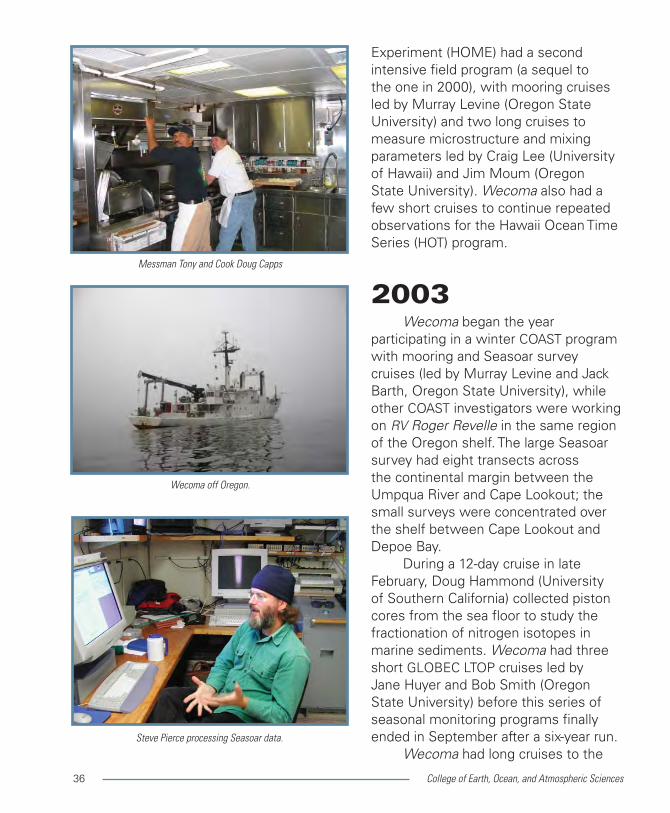
Messman Tony and Cook Doug Capps

College of Earth, Ocean, and Atmospheric Sciences 37
Gulf of Alaska in spring and summer (led by Dave Musgrave, University of Alaska Fairbanks) for the GLOBEC North East Pacific Program. Researchers used Seasoar to study Topographic Control of Mesoscale Variability. Wecoma also had a two-week cruise to sample the GLOBEC ‘GAK’ transect off Seward for Tom Weingartner (University of Alaska Fairbanks). Barbara Hickey (University of Washington) had two cruises to study the Ecology and Oceanography of Harmful Algal Blooms (ECOHAB) in the Pacific Northwest, one in June and one in September.
2004In mid February, Wecoma departed
Newport, Oregon, for a long expedition. Wecoma first had a five-week cruise out of Hawaii for Mike Gregg (University of Washington) to study restratification of the surface mixed layer, both at a mid-gyre station (at 25°N, 150°W) and in the subtropical front (about 31°N, 150°W). A two-week transit took Wecoma from Honolulu to Saipan. From Saipan, Wecoma made two cruises (led by Douglas Wiens, Washington University in St. Louis) to study the Mariana Subduction Zone. Tasks for the cruise were to retrieve more than fifty ocean bottom seismographs and to visit seven islands of the Northern Mariana Islands to remove land seismographs and to sample rocks and volcanic gasses; the second cruise ended in Guam in mid May.
On Wecoma’s long voyage home from Guam, atmospheric chemist
Wecoma seen from the northern Mariana Island of Agrihan, 2004.
A winter Seasoar tow off Oregon.
Preparing to deploy the piston core.

College of Earth, Ocean, and Atmospheric Sciences38
Eric Saltzman (University of California Irvine) measured rare gases in the air and ocean surface layer. The ship track of Wecoma lay along the equator from 165°E to 160°W, and then straight north to Honolulu; from there she headed north to 45°N, 150°W before turning east to Newport, arriving in early July.
In July, Wecoma (with RV Pt. Sur) participated in a three-week interdisciplinary study of River Influences on Shelf Ecosystems (RISE, led by Barbara Hickey, University of Washington). RISE was a collaborative program with many investigators including Ed Dever, Jim Moum, and Jonathan Nash (Oregon State University). RISE aimed to determine the effect of the Columbia River Plume on regional productivity; the strategy was to make observations during the high-flow period in three years and during a low-flow period in one year.
Wecoma had a 17-day cruise out of Seattle in August, for Rick Keil (University of Washington) to study interactions between organic matter and minerals and marine sediments. Other short local cruises were all for Oregon State University oceanographers (Bill Peterson, Jane Huyer, Mike Kosro, Barry Sherr, and Clare Reimers). Wecoma’s field year ended in mid October.
Marine Superintendent Fred Jones retired and was replaced by Pete Zerr.
2005Wecoma arrived in Honolulu
in early January, for a series of long and short cruises. Two three-week
Tawnya Peterson (OHSU) drawing samples for RISE, 2005.
(photo by Neil Banas, UW)
The island of Anatahan behind Wecoma seen from her small boat.
R/V Elakha escorting Wecoma as she departs Yaquina Bay,
February 2004.

College of Earth, Ocean, and Atmospheric Sciences 39
cruises (led by Claudia Benitez-Nelson, University of South Carolina) in January and March were designed to study the influence of eddies on plankton dynamics and carbon cycling in the lee of Hawaii. A third three-week cruise (led by Jingfeng Wu, University of Alaska Fairbanks) studied biochemistry in the waters south of Hawaii. Short cruises included sampling at the Hawaii Ocean Time Series station (for Dave Karl, University of Hawaii) and instrument testing (Tommy Dickey, University of California Santa Barbara). Wecoma returned to Newport, Oregon, in early May.
The RISE program had short mooring cruises (led by Ed Dever, Oregon State University) in May and October, and two three-week cruises in June and August (led by Barbara Hickey, University of Washington, and Ken Bruland, University of California Santa Cruz) with sampling concentrated near the mouth of the Columbia River but extending south to Newport and north to Grays Harbor; meanwhile, RV Pt. Sur was also working in the RISE region.
A two-week cruise off central Oregon in July (led by Roger Gauss, Naval Research Laboratory) was designed to evaluate and improve models of underwater acoustics. Another two-week cruise in September (led by Jonathan Nash, Oregon State University) studied the relationship between internal waves and mixing. Wecoma also had short cruises for Bob Embley (NOAA), Clare Reimers (Oregon State University) and Fred Prahl (Oregon State University). Wecoma had no Chief Engineer Bob Ashley taking a break.
Captain Danny Arnsdorff and mate Gary Stephenson on the bridge.
Neil Banas (UW) participating in RISE. (thanks to Neil Banas)

College of Earth, Ocean, and Atmospheric Sciences40
cruises in November or December.
2006Wecoma was laid up through
January, and headed to the shipyard in Seattle in early February, returning to Newport, Oregon, in mid April. In both directions, the transit included work days to service moorings of NOAA’s tsunami detection network (for Shannon McArthur, NOAA Pacific Marine Environmental Laboratory).
The RISE program had a three-week survey cruise beginning in late May (led by Barbara Hickey, University of Washington) as well as short mooring cruises in May and October (led by Ed Dever, Oregon State University).
In August, Wecoma had a long cruise off central California to make Seasoar and Doppler Sonar surveys of internal tide generation and mixing (led by Shaun Johnston and Dan Rudnick, Scripps Institute of Oceanography) as part of a large multi-ship program called AESOP (Assessing the Effects of Submesoscale Ocean Parameterizations).
Wecoma had several short cruises, including one to study optics off San Diego (for J. Jaffe, Scripps Institute of Oceanography), deep-sea crustaceans (for Tammy Frank, Harbor Branch Oceanographic Institution), and mesoscale acoustic variability in the California Current (for Curt Collins, Naval Postgraduate School). There was also a short cruise for Jack Barth and Murray Levine (Oregon State University) to test an autonomous profiling and boundary
Deploying the CAPABLE vertical profiler.
Seaman Doug Andrews and Bosun Doug Beck in Seattle.
Deploying the CAPABLE bottom portion.

College of Earth, Ocean, and Atmospheric Sciences 41
layer system (named CAPABLE) being developed in collaboration with Western Environmental Technology Laboratories Inc. (WET Labs) for the Oregon Coastal Ocean Observing System (ORCOOS).
Wecoma was laid up in November and December.
2007Captain Danny Arnsdorff retired,
and Rick Verlini took over as Master.Wecoma had two long cruises
this year. A five-week cruise in May and June (led by Dick Feely, NOAA Pacific Marine Environmental Laboratory) measured the distribution of dissolved carbon dioxide along the west coast of North America from 52°N to 26°N. Wecoma traveled to Hawaii for a five-week cruise in July (led by Mike Gregg, University of Washington) to study intrusions at the subtropical front north of Hawaii. Wecoma returned to Newport, Oregon, about mid August.
A new program, the Coastal Margin Observation and Prediction (CMOP), had a short cruise in April and two 18-day cruises in August and November. CMOP was an interdisciplinary program (led by A. Baptista, Oregon Health Sciences University with partners at Oregon State University and University of Washington) to study the Columbia River estuary, plume, and Oregon and Washington shelf regions. Participants included Murray Levine, Jack Barth, Fred Prahl and others from Oregon State University.
Wecoma had several short cruises, Tubing for Tim Cowles’ pumping ROV.
Wecoma in Yaquina Bay, March 2007.
Preparing to deploy Tim Cowles’ ROV.

College of Earth, Ocean, and Atmospheric Sciences42
including two to develop CAPABLE for Jack Barth (Oregon State University), two to study shelf sediments for Jim McManus (Oregon State University), and two for Tom Sanford (University of Washington). Wecoma had no cruises in December.
2008 Wecoma remained out of service
until mid March. Her schedule this year was dominated by short local cruises. CMOP had three cruises: one in April which included servicing of Murray Levine’s (Oregon State University) mooring at NH-10, one in early June (led by Tawnya Peterson, Oregon Health and Science University) and another in late September (led by Byron Crump, Oregon Health and Science University). Anne Tréhu (Oregon State University) had two short cruises to study microseismic events. In August, Tim Cowles (Oregon State University) used a remotely operated vehicle (ROV) system to study thin layers of plankton in the Oregon coastal upwelling system.
Jim Moum (Oregon State University) had a long cruise out of Hawaii for 18 days of turbulence profiling alongside the NOAA TAO mooring on the equator at 140°W to support moored microstructure devices deployed there. Wecoma returned home at the end of November.
im Moum loading instruments for his 2008 cruise to the equator.
(photo by Kate Rowland)
Kelly Benoit-Bird, Chris Wingard, Chad Waluk rechecking
Tim Cowles’ ROV.
Chris Wingard driving the ROV.

College of Earth, Ocean, and Atmospheric Sciences 43
2009Wecoma remained out of service
until mid February. She had many short cruises but only two long cruises this year. Mike Gregg (University of Washington) had a four-week cruise in April to study internal tides and tidal mixing in Monterey Canyon. A five-week cruise begun in early September (for Daniel Simon of NOAA Pacific Marine Environmental Laboratory) took Wecoma to the Eastern Equatorial Pacific to service NOAA’s long-term TAO moorings that monitor tropical atmospheric and oceanic conditions (and detect El Niño). After a short port call in the Galapagos, Wecoma returned to Newport, Oregon, in mid October.
Among the short cruises, several were for Oregon State University projects that were continuing from previous years. These included Tim Cowles’ use of an ROV to study thin layers of plankton, Anne Tréhu’s study of microseismic events along the continental margin, and Murray Levine’s use of non-toxic dye to study lateral mixing.
In May, Jim Moum (Oregon State University) had a ten-day cruise to test turbulence sensors on a reconfigured autonomous glider. Burke Hales (Oregon State University) had a two-week cruise to study carbon transfer in the bottom boundary layer over the shelf, and Clare Reimers (Oregon State University) had three short cruises to develop instrumentation for determining benthic oxygen exchange on the Oregon shelf. Ed Dever (Oregon State University) had a one-day cruise to deploy the first
Katie Rathmell (OHSU) preparing Glider Phoebe for launch.
Relief mate Danny Arnsdorff and Captain Rick Verlini with
Murray Levine, 2009.
NOAA’s Jim Rauch riding a TAO buoy in the Eastern Equatorial Pacific
to replace meteorological sensors.
College of Earth, Ocean, and Atmospheric Sciences44
mooring of the Endurance Array of the Ocean Observing Initiative (OOI), a large, multi-institutional program to enable long term monitoring of the ocean. Wecoma had no cruises in November or December.
2010The large crane on Wecoma was
replaced in January. In mid February she departed for a cruise (led by Shannon McArthur, NOAA National Data Buoy Center) to the Eastern Equatorial Pacific to service 14 TAO moorings between 8°N and 8°S at 95°W and 110°W; Wecoma returned to Newport, Oregon, in early April.
In April, Murray Levine (Oregon State University) had a CMOP cruise to service moorings, survey shelf waters, and deploy an autonomous glider to travel back and forth across the shelf while continuously measuring temperature, salinity and dissolved oxygen. CMOP had additional cruises in May (led by Lydie Herfort, Oregon Health and Science University), August (Fred Prahl, Oregon State University) and October (Murray Levine, Oregon State University).
Jim Moum (Oregon State University) had a ten-day cruise in June to continue instrument development for routine turbulence measurements from autonomous gliders. Ed Dever (Oregon State University) had two very short cruises in April and July to test moorings for the OOI Endurance Array.
In mid August, Wecoma departed for Dutch Harbor, Alaska, for a three-
Deploying the benthic multi-function node at the base of the inshore
mooring of the Endurance Array.
Bosun Doug Beck running the trawl winch.
Murray Levine, unidentified person, and Walt Waldorf loading their
ORCOOS surface buoy.

College of Earth, Ocean, and Atmospheric Sciences 45
week cruise (led by Phyllis Stabeno, NOAA Pacific Marine Environmental Laboratory) in the eastern Bering Sea. Wecoma returned to Seattle in mid September, and then began a three-week cruise (led by Richard Keil, University of Washington) to study the biochemistry of sinking particles and marine sediments along the Washington continental margin. Wecoma returned to Newport in early October.
Murray Levine and Jack Barth (Oregon State University) each had short cruises in October, to service CMOP moorings and test the CAPABLE autonomous profiler, respectively. Jim Moum (Oregon State University) had a two-week cruise in Puget Sound to study topographic form drag. Wecoma returned to Newport in mid November and had no cruises in December.
2011Wecoma resumed operations
in mid March. Most cruises this year were short, lasting ten days or less. There were a few one-day cruises to continue developing the OOI Endurance Arracy and Jack Barth’s (Oregon State University) CAPABLE profiler. Murray Levine (Oregon State University) had two short cruises to service CMOP moorings.
Demian Bailey was appointed OSU Marine Superintendent. In August, Jeff Crews was appointed Master.
Jeff McGuire (Woods Hole Oceanographic Institution) had a two-week cruise to retrieve ocean bottom seismographs from the continental
Preparing the OOI Benthic Package for deployment at sea.
Recovering the inshore OOI buoy after six months in the
upwelling zone.
Practicing deployment of the OOI Benthic Experimental Package
while at the pier.

College of Earth, Ocean, and Atmospheric Sciences46
margin off Vancouver Island. Clare Reimers (Oregon State University) had a ten-day cruise in July to mentor young oceanographers interested in going to sea, and another in October to estimate benthic oxygen fluxes by eddy correlation techniques. Dick Feely (NOAA Pacific Marine Environmental Laboratory) had a four-week cruise beginning in mid August to study ocean hypoxia and acidification over the continental shelf.
Wecoma’s last two cruises, led by Robert Dziak (NOAA) and John Collins (Woods Hole Oceanographic Institution), made seismic surveys and deployed ocean bottom seismographs in the Cascadia Subduction Zone. Wecoma spent Thanksgiving at sea, and returned to Newport, Oregon, across a rough Yaquina Bay Bar on November 30, 2011.
Wecoma crossing the bar on 30 November 2011, at the end of
her last cruise.

College of Earth, Ocean, and Atmospheric Sciences 47
AfterwordUnder the auspices of the National
Science Foundation, the Oregon State University Ship Operations Group headed by Marine Superintendent Demian Bailey made a thorough comparison of sister ships RV Wecoma and RV Oceanus in 2011, and determined their general equivalence. In November 2011, the Oregon State University Ship Operations group discovered a leak in Wecoma’s hull in a location difficult to access. Cost to repair the hull was estimated to be prohibitive and subject to great uncertainty.
In December 2011, the Oregon State University Ship Operations Committee and Dean Mark Abbott made the decision to retire Wecoma and take over operation of the Oceanus, recently retired from service at Woods Hole Oceanographic Institution. NSF and WHOI concurred, and gave their blessing. RV Oceanus departed Woods Hole, Massachusetts, on 25 January 2012, and arrived in Newport, Oregon, on 21 February 2012.
Wecoma had been expecting a full schedule for 2012; that schedule is now transferred to Oceanus. Captain Jeff Crews, his officers and crew, the Marine Technicians, and the Ship Operations staff are working hard to prepare Oceanus for her diverse new role as full heir to our beloved Wecoma.

College of Earth, Ocean, and Atmospheric Sciences48
AcknowledgmentsThis pictorial history of Wecoma
was assembled by Jane Huyer from many sources. Jim Moum provided a copy of Pete Zerr’s spreadsheet of 1975–2006 Wecoma cruises. The UNOLS website shows annual schedules for Wecoma’s later years. The Oregon State University Ship Operations office in Newport has a full set of Wecoma cruise reports; Demian Bailey, Monita Cheever and Fred Jones cheerfully made all materials available. Oregon State University Archives; Oregon State University Ship Operations; the College of Earth, Ocean, and Atmospheric Sciences Dean’s Office; and the Oregon State University Mixing Group all provided photographs, as did Marc Willis, Daryl Swensen, Dennis Barstow, Doug Caldwell, Jane Fleischbein, Linda Hunn, Charlie Miller, David Reinert, Craig Risien, Rich Schramm, and some anonymous Oregon State University oceanographers. A few images from outside sources are acknowledged in individual captions.
Funds to operate Wecoma were provided by the National Science Foundation, the Office of Naval Research, the National Oceanic and Atmospheric Administration and a few other agencies.
If you wish to support continued oceanographic research and education at Oregon State University, you can make donations for the College of Earth, Ocean, and Atmospheric Sciences through the Oregon State University Foundation, 850 SW 35th Street, Corvallis, Oregon, 97333. You can also contact Doug Brusa, Director of Development, at 541-207-8686
Oceanus and Wecoma together again in Newport, 21 February 2012.