Embed Size (px)
Citation preview
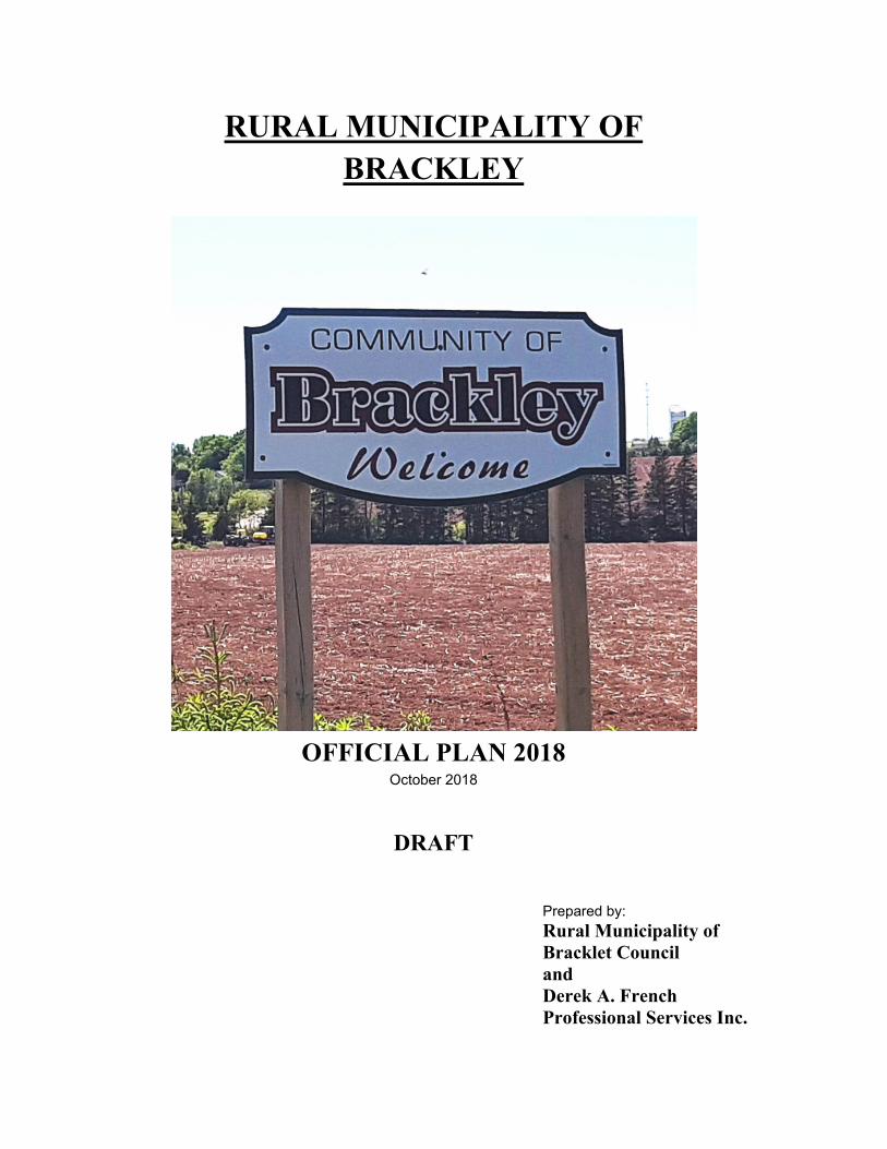
RURAL MUNICIPALITY OF BRACKLEY
OFFICIAL PLAN 2018 October 2018
DRAFT
Prepared by: Rural Municipality of Bracklet Council and Derek A. French Professional Services Inc.
i
Rural Municipality of Brackley Official Plan
TITLE TABLE OF CONTENTS Page
1.0 INTRODUCTION 1
1.1 Purpose 1.2 Planning Area 1.3 Legal Enablement 1.4 Time Frame 2 1.5 Plan Content 1.6 Official Plan Review 1.7 Special Planning Area 4
2.0 THE RURAL MUNICIPALITY OF BRACKLEY 6
2.1 Historical Background 2.2 Municipal Organization 7 2.3 Site and Situation 8 2.4 Population 9 Table 1- Population
Map 1- Location 10 2.5 Present Land Use 11
2.5.1 General 2.5.2 Residential Map 2- Present Land Use 12 2.5.3 Rural Resource 13 2.5.4 Commercial and Industrial 14 2.5.5 Institutional 15 2.5.6 Parks and Open Space
2.6 The Local Economy 16 2.7 Transportation 2.8 Municipal Services 17
2.8.1 Sanitary Sewer 2.8.2 Central Water 2.8.3 Fire Protection 18 2.8.4 Police Protection 2.8.5 Solid Waste Management and Recycling 2.8.6 Social and Recreation
ii
Rural Municipality of Brackley Official Plan
3.0 ENVIRONMENT 20
3.1 Surface Water and Groundwater 3.2 Wastewater and Water Servicing Study
4.0 FUTURE DEVELOPMENT GOALS 22
4.1 Introduction 4.2 Future Development Concept 4.3 Goals 23
4.3.1 General 4.3.2 Social 4.3.3 Economic 24 4.3.4 Physical 4.3.5 Environmental
5.0 OBJECTIVES, POLICIES AND PLAN ACTIONS 25
5.1 Introduction 5.2 Residential
Objectives Policy PR-1: Zoning 26 Policy PR-2: Minimum Lot Sizes Policy PR-3: Undersized Lots 27 Policy PR-4: Ribbon/Strip Development Policy PR-5: Residential Compatibility Policy PR-6: Residential Development Standards 28 Policy PR-7: Accessory Apartments Policy PR-8: In-Home Occupations 29 Policy PR-9: Bed and Breakfast
5.3 Commercial 30 Objectives
Policy PC-1: Zoning 31 Policy PC-2: Buffers
5.4 Industrial 32 Objectives
Policy PM-1: Zoning Policy PM-2: Buffers
5.5 Agriculture 33 Objectives
Policy PA-1: Zoning 34
iii
Rural Municipality of Brackley Official Plan
Policy PA-2: Livestock Operations 5.6 Transportation 35
Objectives Policy PT-1: Access 36 Policy PT-2: Strip Development Policy PT-3: Maintenance
5.7 Environment 37 Objectives
Policy PE-1: Septic Systems and Wells Policy PE-2: Point Sources of Pollution Policy PE-3: Central Services 38 Policy PE-4: Alternate Energy Systems Policy PE-5: Environmental Reserve 39
5.8 Recreation and Open Space Development Policy PROS-1: Recreation Subsidy 40 5.9 Special Planning Area Regulations
6.0 GENERAL FUTURE LAND USE MAP 42
Map 3 – General Future Land Use Map 43
7.0 IMPLEMENTATION 44
7.1 Administration 7.2 Development Bylaw
7.2.1 Approval of Development or Change of Use 7.2.2 Development Agreements 45 7.2.3 Variances
7.3 Budgeting 7.3.1 Budget Policies
7.4 Review 46 7.5 Amendments 7.6 Appeal Procedure
1
Rural Municipality of Brackley Official Plan
1.0 INTRODUCTION
1.1 Purpose
The Official Plan for the Rural Municipality of Brackley is a formalized statement of Goals, Objectives, Policies and Plan Actions approved by Council concerning the nature, extent and pattern of land use and development within the Rural Municipality until the year 2033.
The Rural Municipality’s Goals as set out in the Plan indicate overall policy direction while the Objectives and Policies deal with specific topics and issues. Plan Actions are statements indicating specific initiatives or directions which will be undertaken to implement the Plan’s Policies and Objectives.
The Official Plan guides the physical, social and economic development of the Rural Municipality. It provides the policy framework for the Rural Municipality of Brackley Zoning and Subdivision Control (Development) Bylaw and policy direction for Council’s actions in relation to: economic development initiatives; public works; social programs; municipal services; environmental standards; and fiscal management.
1.2 Planning Area
The Official Plan covers all the geographical area contained within the legal municipal boundaries of the Rural Municipality of Brackley and Rural Municipality of Winsloe South. Although the Official Plan can only control those matters which arise within the Rural Municipality’s legal boundaries, consideration must also be given to what is happening in adjacent municipalities and, indeed, the Greater Charlottetown Area and the Province as a whole.
1.3 Legal Enablement
The Rural Municipality of Brackley derives the majority of its powers from the Municipal Government Act and the Planning Act. The Planning Act empowers Council to appoint a Planning Board, adopt (and amend) an Official Plan and subsequently to adopt implementing land use and development bylaws. The Municipal Government Act empowers Council to make other bylaws and/or to implement programs, actions or strategies to help implement other aspects of the Official Plan
2
Rural Municipality of Brackley Official Plan
1.4 Time Frame
The Official Plan will guide the physical, social and economic development of t he Municipality until the year 2033. Periodic reviews will take place as required, but the reviews must occur at least once every 5 years pursuant to the requirements of the Planning Act.
1.5 Plan Content
The Planning Act, R.S.P.E.I., 1988, Cap P-8, requires that an Official Plan shall include:
� a statement of economic, physical, social and environmental
objectives;
� a statement of policies for future land use, management and development, expressed with reference to a specified period not exceeding fifteen years;
� proposals for its implementation, administration and the periodic
review of the extent to which the objectives are achieved.
This document contains six sections:
1) Introduction 2) The Rural Municipality of Brackley 3) Future Development Goals 4) Objectives, Policies and Plan Actions 5) General Land Use Plan; and 6) Implementation
The first section deals with the purpose, scope and legal enablement for the Official Plan. The second section summarizes the background studies and provides a description of the physical, social and economic characteristics of the Rural Municipality. The third section provides a broad summary of how the Rural Municipality desires to see its development unfold in the future. The fourth section is the core of the document, stating objectives, policies and intended actions for specific topics. The fifth section includes the General Land Use Plan or Official Plan Map. The last section sets out the process for administering and implementing the Official Plan and Development Bylaw.
1.6 Official Plan Review
An Official Plan is intended to be a dynamic planning tool and is therefore subject to periodic review and/or amendment. The initial
3
Rural Municipality of Brackley Official Plan
planning process in Brackley started in June of 1987 and the first Official Plan was completed in 1988. Official Plan reviews for Brackley were completed in 1999, 2006 and 2014. The current Official Plan review is therefore the fifth Official Plan for the Rural Municipality of Brackley.
This review includes Winsloe South area as well. Winsloe South was amalgamated with Brackey on December 13, 2017. There has been a considerable amount of development that has taken place in the Rural Municipality since 1987, particularly in the southern parts bordering the City of Charlottetown. When combined with the impact of the Charlottetown Region Special Planning Area Regulations, there is a need for a comprehensive review of the Official Plan policies to ensure that they continue to adequately serve the needs of the Rural Municipality.
Current Review
The review of the 2014 Official Plan commenced in 2018 as a result of the amalgamation of Winsloe South with Rural Municipality of Brackley and the requirements of Section 15.1 (1) of the PEI Planning Act. A consultant was retained to undertake the review and a Planning Board was appointed as per Section 9(2) of the Act. Funding assistance was received from the Federally and Provincially funded Capacity Building Fund administered by the Provincial Infrastructure Secretariat Office. The Planning Board held a series of meetings to identify a direction for various plan review topics for the consultant.
A current land use survey was performed to obtain current land use information.
Background studies were undertaken to obtain demographic and social information as well as information from agencies and operations that supply services to the Rural Municipality.
A series of one on one interviews were conducted with the commercial and industrial land owners in the Rural Municipality.
A public meeting was held to obtain public input into the planning process. A portion of this meeting included an exercise in community goal and action formulation concerning the topics of residential, municipal services, zoning and environmental issues.
4
Rural Municipality of Brackley Official Plan
1.7 Special Planning Area
In 1993 as part of the Provincially initiated Municipal Reform process in the Greater Charlottetown and Summerside Areas, the Provincial Government imposed Special Planning Area (SPA) Regulations which enforced a partial development freeze in the rural areas directly adjacent to the 2 major urban regions. The Rural Municipality of Brackley fell within the Charlottetown Region Special Planning Area.
While some limited development was allowed, communities with Official Plans were forced to adopt severe development restrictions which to a large extent removed most of the Rural Municipality’s autonomy and control. Some communities, such as Winsloe South, responded by abandoning their Official Plan. Others, like Brackley, continued to operate for the next 24 years under a confusing arrangement with duplicated regulations and severely curtailed authority. The result was very slow rates of development and a great deal of confusion and frustration. At the same time uncontrolled and unserviced residential development continued at an increased rate just beyond the SPA.
Prior to initiating the 2014 Official Plan Review all 13 communities affected by the SPA regulations in the Charlottetown, Stratford and Cornwall Areas joined together, hired a consultant and submitted a report to the Provincial Government on the future of the SPA.
The report resulted in an agreement with the Provincial Government whereby Official Plans in the SPA could effectively be removed from most of the regulatory restrictions provided that the Plans and Bylaws effectively restrict large scale urban style developments from spilling over into these rural communities.
This Official Plan review has been prepared in conformance with the standards imposed by the Provincial Government and upon its approval the Rural Municipality of Brackley is no longer bound by the specific provisions of subsections (2) to (9) of the SPA regulations. Section 63.(10) of the SPA Regulations specifically requires, however, that Official Plans made pursuant to this Section must be “consistent with the objectives set out in subsection (3)” as follows:
(3) The specific objectives for development within
the Charlottetown Region Special Planning Area are
(a) to minimize the extent to which unserviced Residential, commercial and industrial Development may occur;
(b) to sustain the rural community by limiting
5
Rural Municipality of Brackley Official Plan
future urban or suburban residential development and non-resource commercial and industrial development in order to minimize the loss of primary industry lands to non-resource land uses; and
(c) to minimize the potential for conflicts between resource uses and urban residential, commercial and industrial uses.
It must be noted, however, that the Rural Municipality of Brackley is somewhat unique among the rural communities included in the Special Planning Areas. Parts of the Rural Municipality are already served by central water supply from the City of Charlottetown and are therefore deemed under the Regulations to be “serviced”. The established land use patterns within the Rural Municipality, particularly in the southern portion, are already quite “urban” in nature, with significant commercial and industrial development. This area can no longer be truly characterized as “rural” in terms of its land use and farming and other resource activities are becoming less dominant and less viable. This will require Council to interpret the above noted SPA objectives in a sensitive and appropriate fashion given the established development patterns and character.
6
Rural Municipality of Brackley Official Plan
2.0 THE RURAL MUNICIPALITY OF BRACKLEY
2.1 Historical Background
The Rural Municipality of Brackley is located in the southeast corner of Lot 33, just to the north of Charlottetown Royalty. Lot 33 was ceded to Thomas DesBrisay, the Lt. Governor of P.E.I., in late 1767. He brought nine families from England in 1770 to settle the area, one of whom was Mr. Brackley. Growth was quite slow until the late 1790’s when the 1797 survey indicated the population amounted to one hundred souls and had a total of twelve families. Population growth in Brackley remained quite slow until the late 1800’s when there were over forty settlers living in the area, the majority of whom depended on farming for their livelihood. The history of the Rural Municipality is very much tied to transportation. Once constructed, the Brackley Point Road became one of the primary transportation connections between the capital city of Charlottetown and the North Shore and remains so today. Early settlement was primarily based on farming but with the construction of the railroad and the main railroad connection at Royalty Junction, the Rural Municipality became a transportation hub. By 1880 the Meacham’s Atlas shows a church, a school, a post office and a blacksmith all located at the junction of the railroad and the Brackley Point Road.
The original Brackley United Church was erected in 1863 and was Methodist. The first remodeling took place in 1900 and a spire was added in 1922. In 1925 the Methodist Church formerly became the Brackley United Church. The church received major interior renovations in 1954. In 1977 the church was moved 200 feet from its original location so that a finished basement and rear wing could be added.
The first school in Brackley was opened in the early 1800’s, with the first teacher being John Arbuckle who came in 1834. Following that term, the school closed for several years and re-opened in 1839. The school continued to serve the community well until its closure.
The cluster of commercial development and warehousing that has developed in the Rural Municipality is very much as a result of the combination of the Brackley Point Road and the railroad station. The development of the Charlottetown Airport immediately to the south of the Rural Municipality has added another locational advantage for businesses in the area and added further volumes to the traffic on the Brackley Point Road. When the new east-west runway was constructed at the airport in the late 1970’s, Union Road was bisected
7
Rural Municipality of Brackley Official Plan
and all the northern traffic on that busy roadway also got directed on to the Brackley Point Road.
Non-farm residential development started to develop in the 1960’s and the pace of development increased in the 1970’s and 1980’s largely due to the easy access to the Capital City. The Provincial Government responded to the growing “urban sprawl” in the rural communities surrounding Charlottetown with the Special Planning Area (or buffer Zone) Regulations. The result has been a significant slowing of the pace of residential development since 1994.
Agriculture has been a main factor i n the Rural Municipality’s development and continues to be a prominent activity today. Unlike many of the other communities in the Special Planning Areas around Charlottetown, however, Brackley has a relatively well developed and diverse commercial land base and in many respects is not truly “rural” but rather represents a mix of urban and rural development.
2.2 Municipal Organization
Municipal incorporation on Prince Edward Island has its foundation in our former local school boards. For many years, the local School Board was essentially the only identifiable group within the Rural Municipality that government and other groups could liaise with on matters of concern to the Rural Municipality. In the late 1960’s the province began its school consolidation program and by the mid 1970’s all local community schools had been closed and local school boards disbanded. This left the old school districts without any recognizable body to which governments and/or individuals could raise concerns.
In February of 1983, the Community of Brackley was incorporated under the Community Improvement Act as a Community Improvement Committee (C.I.C.). The Rural Municipality incorporated for two main reasons – the collection of fire dues and to have an identifiable group to represent the residents on local and regional matters. At the time of its incorporation Brackley was given five areas of authority that were standard for all C.I.C.’s: administration, fire protection, garbage collection, street lighting and recreation.
In 1988, Brackley CIC residents decided to undertake the preparation and adoption of an Official Plan. The lack of local control over development in the Community, the high rate of development in the Charlottetown area for the previous few years and problems surfacing from poor land use planning or no planning are some of the reasons the Rural Municipality Council felt it would be an appropriate time to commence an Official Plan. From the mid 1970’s to the late 1980’s many communities in the Charlottetown Area were involved in
8
Rural Municipality of Brackley Official Plan
preparing Official Plans to guide their Rural Municipality’s development.
In 1983, the Community Improvement Act was replaced by the Municipal Government Act. As a result, the Brackley Community Improvement Committee became the Community of Brackley. Brackley kept all of the powers it obtained while it was a C.I.C. The Planning Act also provides all incorporated municipalities with the power to undertake community planning. The former Community of Winsloe South seceded from the Comber Community of Winsloe in 1985 and was subsequently granted full community status on Mach 1, 1986. It’s Official Plan and Bylaw were rescinded on 1994 when the special the Special Planning Area came into effect.
In 1994, a major amalgamation initiative took place on Prince Edward Island. Smaller, neighbouring communities were joined with larger centres such as Charlottetown, Summerside and Cornwall. In order to discourage development from “leap-frogging” to areas outside the newly amalgamated municipalities, the Province introduced the Special Planning Area Regulations described earlier. The purpose of these regulations is to limit the amount of unserviced residential subdivision occurring adjacent to the larger centres and also to limit the development of “non-resource activities” such as non-resource commercial and industrial development which are considered to pose a threat to the rural economy. Brackley is geographically located in an area governed by the Charlottetown Special Planning Area Regulations. The Rural Municipality was therefore required to amend its development bylaws in a manner consistent with these Provincial regulations. The result has been a very slow rate of local development since 1994.
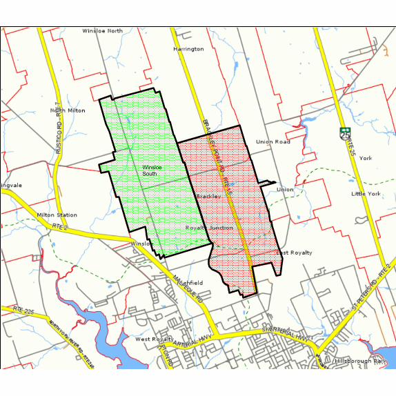
2.3 Site And Situation
The Rural Municipality of Brackley is located immediately to the North of the City of Charlottetown. The Brackley Point Road bisects the Rural Municipality from north to south and the Confederation Trail bisects the Rural Municipality from east to west and also runs along its south-western boundary with Charlottetown. The Charlottetown Airport is located just to the south-east of the Rural Municipality and, in fact, the north-western corner of the airport is located within the boundaries of the Rural Municipality.
The Rural Municipality is approximately 4,541 acres in size, which includes 2,171 of former Brackley and 2,370 of Winsloe South. Topography is gently rolling. There are several streams in the area which are all part of the Winter River Watershed. This watershed is the
9
Rural Municipality of Brackley Official Plan
major source of groundwater for the City of Charlottetown and in fact one of the City’s major well fields is located along the Brackley Point Road in the geographic centre of the Rural Municipality.
To the north the Rural Municipality is bounded by North Winsloe and Harrington, to the east by the Rural Municipality of Union Road and to the west by a portion of the City of Charlottetown.
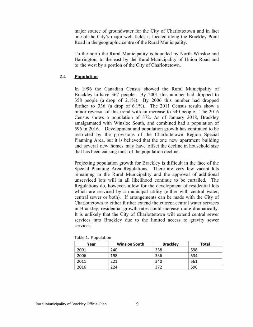
2.4 Population
In 1996 the Canadian Census showed the Rural Municipality of Brackley to have 367 people. By 2001 this number had dropped to 358 people (a drop of 2.1%). By 2006 this number had dropped further to 336 (a drop of 6.1%). The 2011 Census results show a minor reversal of this trend with an increase to 340 people. The 2016 Census shows a population of 372. As of January 2018, Brackley amalgamated with Winsloe South, and combined had a population of 596 in 2016. Development and population growth has continued to be restricted by the provisions of the Charlottetown Region Special Planning Area, but it is believed that the one new apartment building and several new homes may have offset the decline in household size that has been causing most of the population decline.
Projecting population growth for Brackley is difficult in the face of the Special Planning Area Regulations. There are very few vacant lots remaining in the Rural Municipality and the approval of additional unserviced lots will in all likelihood continue to be curtailed. The Regulations do, however, allow for the development of residential lots which are serviced by a municipal utility (either with central water, central sewer or both). If arrangements can be made with the City of Charlottetown to either further extend the current central water services in Brackley, residential growth rates could increase quite dramatically. It is unlikely that the City of Charlottetown will extend central sewer services into Brackley due to the limited access to gravity sewer services. Table 1. Population
Year Winsloe South Brackley Total
2001 240 358 598
2006 198 336 534
2011 221 340 561
2016 224 372 596

10
Rural Municipality of Brackley Official Plan
MAP 1
LOCATION
Winsloe
South
11
Rural Municipality of Brackley Official Plan
2.5 Present Land Use
2.5.1 General
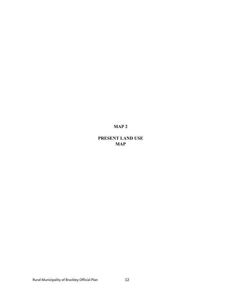
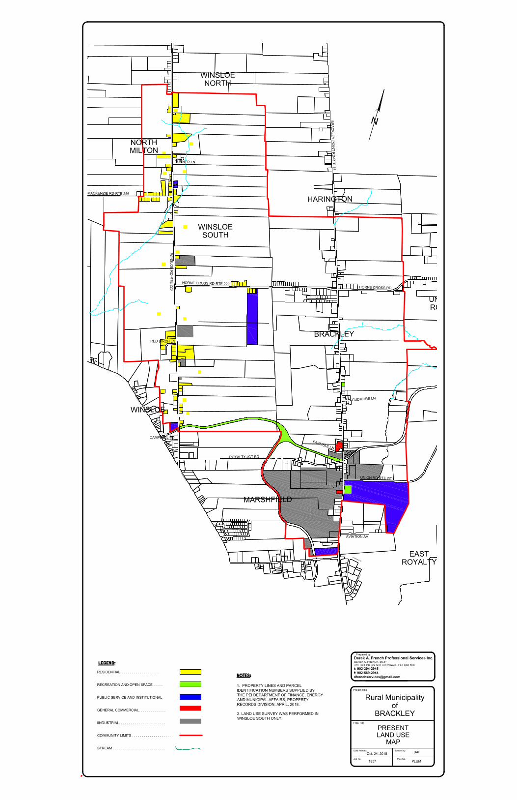
A Present Land Use Survey was conducted as part of the Planning process and the results are shown on Map 2.
2.5.2 Residential
The land use survey reveals that there are approximately 4,541 acres of land in the Rural Municipality. Approximately 17% of this acreage has been developed, with the majority of this developed land utilized for residential purposes (non-farm) and a significant portion (approximately 10%) being utilized for commercial, industrial & public service and institutional developments.
Virtually all of the residential development has been single family in nature. According to Statistics Canada, in 2011 there were 135 private dwellings in Brackley. While single family dwellings remain the popular housing choice, alternative housing options must also be considered as a means of meeting the needs of an aging and more demographically diverse population.
While a small number of total housing units can be classified as farm residences, the majority are non-farm residences, and most would fit the standard definition of “strip development”. The Brackley Point Road is significantly developed with much of the road frontage in the Rural Municipality now in residential development. Significant infilling opportunities are still evident, however, and no doubt might well have been infilled by now if the Special Planning Area Regulations had not been in place for the last 20 years.
12
Rural Municipality of Brackley Official Plan
MAP 2
PRESENT LAND USE MAP
RUSTICO RD-RTE 7MACKENZIE RD-RTE 256WINSLOE RD-RTE 223RTE 2MALPEQUE RDCAMPBELL RDMALPEQUE RDHORNE CROSS RD-RTE 220BRACKLEY POINT RD-RTE 15ROYALTY JCT RDCOUNTRYROSE STPENNY LNBROOKDALE DRKAREN DRMACNEILL AVMOUNT EDWARD RDHORNE CROSS RD FAIR ISLE LNDAY AVBRACKLEY POINT RDUNION RD-RTE 221UNION RD-RTE 221UNION RD-RTE 221NORWOOD RDSHERWOOD RDTURNER LNCUDMORE LNAVIATION AVRED BIRCH LNMAPLE HILLS AVNEWSON DRNVIEW DRBRACKLEYWINSLOENORTHMILTONWINSLOENORTHHARINGTONUNIONROADEASTROYALTYMARSHFIELDWINSLOESOUTH
MACKENZIE RD-RTE 256
WIN
SLO
E R
D-R
TE
223
R
T
E
2
M
A
L
P
E
Q
U
E
R
D
CAMPBELL RD
M
A
L
P
E
Q
U
E
R
D
HORNE CROSS RD-RTE 220
BR
AC
KLE
Y P
OIN
T R
D-R
TE
15
ROYALTY JCT RD
C
O
U
N
T
R
Y
RO
SE
S
T
PENNY LN
BROOKDALE DR
KAREN DR
M
A
C
N
E
IL
L
A
V
M
O
U
N
T E
D
W
A
R
D
R
D
HORNE CROSS RD
F
A
I
R
I
S
L
E
L
N
D
A
Y
A
V
B
R
A
C
K
L
E
Y
P
O
IN
T
R
D
UNION RD-RTE 221
NORWOOD RD
S
H
E
R
W
O
O
D
R
D
TURNER LN
CU
DM
OR
E L
N
AVIATION AV
RED BIRCH LN
M
A
P
L
E
H
I
L
L
S
A
V
N
VIEW DR
BRACKLEY
WINSLOE
NORTH
MILTON
WINSLOE
NORTH
HARINGTON
UNION
ROAD
EAST
ROYALTY
MARSHFIELD
WINSLOE
SOUTH
PRESENT
LAND USE
MAP
RESIDENTIAL . . . . . . . . . . . . . . . . . . .
RECREATION AND OPEN SPACE . . . . .
PUBLIC SERVICE AND INSTITUTIONAL
GENERAL COMMERCIAL. . . . . . . . . . . . . .
IINDUSTRIAL. . . . . . . . . . . . . . . . . . . . . . . .
COMMUNITY LIMITS . . . . . . . . . . . . . . . . . . . .
STREAM . . . . . . . . . . . . . . . . . . . . . . . . . . .
1. PROPERTY LINES AND PARCEL
IDENTIFICATION NUMBERS SUPPLIED BY
THE PEI DEPARTMENT OF FINANCE, ENERGY
AND MUNICIPAL AFFAIRS, PROPERTY
RECORDS DIVISION, APRIL, 2018.
2. LAND USE SURVEY WAS PERFORMED IN
WINSLOE SOUTH ONLY.
Project Title
Plan Title
Job No.
PLUM
Plan No.
1857
Oct. 24, 2018
Date Printed: Drawn by:
DAF
Derek A. French Professional Services Inc.
Prepared by:
t: 902-394-2945
f: 902-569-2944
379 TCH, PO Box 580, CORNWALL, PEI, C0A 1H0
DEREK A. FRENCH, MCIP
Rural Municipality
of
BRACKLEY
13
Rural Municipality of Brackley Official Plan
There are also significant strips of residential development along the Horne Cross Road, west of the Brackley Point Road, and along the Royalty Junction Road.
2.5.3 Rural Resource
Rural Resource land remains the dominant land use in Brackley. Of the estimated 4,541 acres in the Rural Municipality, over 3,780 acres (83%) remain in either agricultural production or woodland. Many of the wooded areas are located along the Rural Municipality’s prominent stream systems, particularly in the vicinity of the City of Charlottetown’s well field on the Brackley Point Road. Much of the land in the general vicinity of the well field is being retained by the City as a conservation area in order to protect the well field and to facilitate aquifer recharge.
The farms in the Rural Municipality are typical of PEI mixed farming operations with the exception of two relatively large dairy operations and one large commercial poultry operation. In reality, the majority of the land is farmed by fewer than a dozen farmers. The amount of farmland in the Rural Municipality has declined over time due to the demands of non-farm types of activity. The largest acreage has been lost to residential development, much of that has been farm road frontage. The industrial and commercial development mentioned above also accounts for additional land taken out of agricultural production and additional resource lands would have been lost to the Charlottetown Airport.
Future residential development poses the greatest threat to agricultural land and the farming community in the long term. This type of sprawl development vastly increases the possibility of conflict between the land uses. The CSPA Regulations have slowed down this type of development but have not completely eliminated it. If central services were to be made available in Brackley, the resultant loss of farmland and the increased land use conflicts could have serious implications for the long-term health of the farming community. It is apparent, however, that the remaining farmland south of Royalty Junction is already completely surrounded by either industrial or residential development and it is no longer viable as long-term farmland. The eventual servicing of this land and its conversion to urban uses is to be expected and is desirable from a land use perspective. Agriculture is still a viable way of life in Winsloe South. Agricultural lands within the Rural Municipality boundaries make up approximately 2,340 acres (98.7%) of the Rural Municipality's total area of 2,370 acres.
14
Rural Municipality of Brackley Official Plan
2.5.4 Commercial and Industrial
As noted earlier, a significant portion of the land in Brackley is currently in commercial or industrial use. This development is focused on the area adjacent to the intersection of the former railway line (now the Confederation Trail) and the Brackley Point Road. There is also some activity just north of the Sherwood Road on the boundary with Charlottetown and some obvious pressure for commercial or industrial infilling between these two nodes.
On the Sherwood Road a large portion of the Island Construction site with its aggregate storage and asphalt plant lies within the boundaries of the Rural Municipality and represents a significant heavy industrial use. Just to the north on the Brackley Point Road is Bernmar Construction, a ICF contractor. The new Provincial Queens County Highway Depot location has utilized two former farms for its industrial use. Further to the north of this is Livingston’s Auto Salvage. This is a large auto parts storage and recycling operation which would normally be considered to be an industrial use. Directly adjacent to the south is Dalziel’s Auto Body. A little further north lies the large Meyer Canada industrial warehouse. There are also corporate offices and some manufacturing and assembly operations that take place at this facility.
Across the street from Meyer Canada is BJ’s Truck Parts and Truck Repair and the large Purolator Depot. This combined site also has a very significant parking area for truck and equipment storage. In the same vicinity there are also several contractor’s storage yards.
Just to the south on the Union Road is the MacLean’s Construction Head Office and the associated contractor’s storage yard. To the north of the Meyer Canada warehouse is the Fair Isle Motel. Winsloe Road is the location of Atlantic Roofers, Signature Installs, Winsloe Business Park, and McQuaid’s Storage. These facilities are to be property designated as industrial land uses.
In total this represents a very significant cluster of mixed commercial and industrial land uses in the southern portion of the Rural Municipality. Other smaller commercial operations and “in home occupations” are likely scattered throughout the Rural Municipality but were not reviewed during this land use survey. Commercial development within Winsloe South has been limited in the past, and is 1ikely to remain so in the future, although several farm-related commercial developments have located within the Rural Municipality over the past few years. At present, there is no industrial development within the Rural Municipality.
15
Rural Municipality of Brackley Official Plan
2.5.5 Institutional
The most prominent Institutional facility in Brackley is the Charlottetown Airport. The northwestern portion of the Airport lands lie within the boundaries of the Rural Municipality and a portion of the east- west runway also extends into Brackley. The historic Charlottetown Cemetery is located on the southern boundary of the Rural Municipality on the Brackley Point Road. The other significant institutional facility is the Brackley Community Centre (known as Brackley Commons) at the corner of the Brackley Point Road and the Union Road. This facility is not only an important social focus for various Community activities, it is also a designated Provincial EMO centre in the event of any local or regional disasters or other emergencies.
There are no churches, schools or nursing homes in the Rural Municipality of Brackley. The former Brackley School building has been removed from its original site on the Brackley Point Road in the middle of the Rural Municipality and the lot is now owned by the Women’s Institute. Winsloe Road is accessed by Winsloe Cemetery, South Winsloe United Church and the Winsloe United Church.
2.5.6 Parks and Open Space
Brackley has one community park adjacent to the Community Centre with some walking trails and two tennis courts. The land is leased from the Charlottetown Airport Authority. The City of Charlottetown land near the Charlottetown Wellfield is being maintained as a conservation buffer for the well field.
The other recreational facilities in the Rural Municipality include a significant section of the Confederation Trail, including the Royalty Junction, and a significant length of Rural Municipality owned walking/biking trail along the shoulder of the Brackley Point Road. This trail now extends from the southern boundary with Charlottetown north to the City of Charlottetown well field. The trail is paved and is proving very popular with local residents and others. The long-term objective would see the trail completed north to Harrington and hopefully eventually to the North Shore.
16
Rural Municipality of Brackley Official Plan
2.6 The Local Economy
The Rural Municipality of Brackley is still primarily a rural community with the majority of its land base in agricultural production. Given the trend to farm consolidation in recent years, however, a very small number of Brackley residents actually make their living as full time farmers. The vast majority of Brackley residents could be classified as “rural non- farm” and make their living in Charlottetown. This makes Brackley largely a “bedroom” community.
What sets Brackley apart from the other rural communities surrounding the capital, however, is the large cluster of urban type commercial and industrial facilities located near the former railroad junction with the Brackley Point Road and running south to the border with Charlottetown. This gives Brackley a strong commercial tax and employment base and a much more complex mix of land uses. It is difficult to determine how many local residents are employed in these businesses but if residential development controls were not currently in place (via the SPA Regulations), it is safe to predict that the strong local employment base would likely create a relatively strong local housing market.
While existing land use conflicts with the neighbouring properties were quite limited, the issue of servicing is a major challenge to the future growth of these sectors. While many of these businesses are currently connected to the Charlottetown central water system, on-site waste water treatment is now and will continue to be a challenge, particularly given the somewhat difficult local soils conditions. Any future commercial or industrial growth will likely have to be limited to “dry” facilities, such as warehousing, unless some form of central waste water collection and treatment can be identified. If this servicing issue can be resolved, there would appear to be considerable demand for commercial growth.
2.7 Transportation
The primary transportation route through the Rural Municipality of Brackley is the Brackley Point Road and the Winsloe Road which bisect the Rural Municipality from north to south. The Brackley Point Road is the primary route connecting the City of Charlottetown to the North Shore. As noted earlier, the Union Road also connects to the North Shore, but it has been intercepted by the new east-west runway at the Charlottetown Airport. This caused the northern portion of the Union Road to be connected to the Brackley Point Road just north of the Airport. The Union Road remains a busy route and offers a short cut to and from the City for many residents living in communities
17
Rural Municipality of Brackley Official Plan
north of the City such as: The North Shore Municipality, the Rural Municipality of York and Pleasant Grove. At rush hour this causes considerable turning movement volumes at the Brackley Point Road / Union Road intersection.
Other east - west local streets include the Horne Cross Road, and the Royalty Junction Road.
Pedestrian facilities in the Rural Municipality of Brackley exceed those of any other rural municipality in the capital region. As noted earlier, the Confederation Trail travels east-west in the southern portion of the Rural Municipality and also extends from Royalty Junction southward to connect to the City of Charlottetown. The Rural Municipality’s own paved walkway/trail runs along much of the length of the Brackley Point Road and offers pedestrians and bikers an excellent connection to the Confederation Trail. The trail is very well used by local residents and others.
2.8 Municipal Services
2.8.1 Sanitary Sewer
At the present time, there is no municipal sanitary sewer system in the Rural Municipality of Brackley. The rural nature in the northern portion of the Rural Municipality would suggest that it is unlikely that a sewer system will be needed in this area. In the southern portion, however, the combination of a significant level of development and very poor site conditions for on-site treatment systems has created a high risk situation for on-site system failures. While the availability of central water services from the City of Charlottetown has mitigated most health risks due to water contamination, many septic systems are being pumped out regularly and are almost acting as holding tanks. At some point this problem must be solved either through the extension of the Charlottetown sewer system or via the development of some form of local solution.
2.8.2 Central Water
As noted previously, a number of properties in Brackley are connected to the City of Charlottetown central water system via access to the water main that runs along the Brackley Point Road connecting to the wellfield in the middle of the Rural Municipality. While properties along the Brackley Point Road have generally been accommodated, the City of Charlottetown has been unwilling to allow any servicing of
18
Rural Municipality of Brackley Official Plan
properties not fronting on the Brackley Point Road. All other properties are therefore serviced by on-site wells. Since all on-site wells are also draining water from the same Winter River basin as the City’s wells, there would appear to be no good reason for this decision. In fact, limiting the number of new wells in the immediately vicinity of the wellfield would appear to be a very positive direction for the City. Discussions with the City continue in order to find an optimum solution to water supply in the area and to find the best way to manage the scarce ground water resources in the region.
2.8.3 Fire Protection
The Rural Municipality of Brackley receives fire protection from the North River Fire Department. There are usually 9-10 calls per year from Brackley. In general, the Rural Municipality is content with the quality and the price of the service it receives.
2.8.4 Police Protection
The Rural Municipality of Brackley receives police protection from the RCMP detachment based in the former West Royalty detachment. This service is provided from the Province and at present, there are no other feasible alternatives.
2.8.5 Solid Waste Management and Recycling
The Rural Municipality of Brackley participates in the province-wide waste reduction strategy managed by the Island Waste Management Corporation. Residents sort their household waste, compost and recyclables for road side pick-up. This situation is a vast improvement as it was previously the responsibility of residents to individually dispose of their household waste in an environmentally responsible manner. The former bulk landfill site was the destination for the majority of residents’ garbage in the past. The site is now closed, and the sorted product is now trucked to a new recycling/composting plant in nearby Brookfield.
2.8.6 Social and Recreation
The Rural Municipality of Brackley’s major recreational facility is the Brackley Commons. Since its construction this facility has become a major focus for Rural Municipality meetings and events and it is also well used by residents and others for private events. The facility also
19
Rural Municipality of Brackley Official Plan
has a well-developed open area with walking trails and two tennis courts.
The other major community recreational facility is the Brackley Point Road trail/walkway. This trail represents a major investment for the Rural Municipality and it has become very actively used and a source of pride for many in the Rural Municipality. It serves to encourage healthier, more active lifestyles for local residents and also facilitates social interaction.
Given the very close proximity of the City of Charlottetown, many local residents also participate in sports, social clubs and other social and recreational programs in the City. The Rural Municipality provides a grant to families to assist with the cost of having their children participate in recreational programing in the City of Charlottetown. The Women’s Institute’s local chapter has a long history and remains a very active and important social force in the Rural Municipality.
20
Rural Municipality of Brackley Official Plan
3.0 ENVIRONMENT
3.1 Surface Water and Groundwater
The major environmental concern in Brackley is the protection of surface and groundwater resources. A basic knowledge of the hydrologic cycle makes it clear that these resources are closely linked and mutually dependent.
Given the fact that Prince Edward Island is completely surrounded by salt water and we have no large bodies of fresh water, we are completely dependent on groundwater and wells for our domestic water supply. The acquifers in Brackley not only supply the needs of local residents, they are also part of the Winter River watershed, which is the primary source of water supply for the residents of the City of Charlottetown. For many years, in fact, the Brackley well field was the primary source of domestic water supply for the City of Charlottetown.
It will be important for all ground water and surface water users in the Winter River Watershed to work together to optimize the management of this critically important resource. Critical in this effort will be the continued efforts of the extremely active Winter River Watershed Management group.
3.2 Wastewater and Water Servicing Study
While a number of properties fronting on the Brackley Point Road south of the City of Charlottetown’s well field are connected to the City’s central water supply, many properties depend on individual wells for their water supply. All properties in Brackley, however, depend on individual on-site wastewater treatment facilities (septic tanks and tile fields). For some time, it has been known that soil conditions in the area are not well suited to the installation and operation of these on-site systems.
In 2008 Brackley Council decided to conduct a comprehensive analysis of the current septic systems in the Rural Municipality and to produce a plan for future wastewater services in the Rural Municipality. The firm of Engineering Technologies Canada (ETC) was retained to perform the study and a report was produced in November of 2008.
ETC’s assessment of local soil and site conditions confirmed that most of the Rural Municipality has significant limitations for the installation of traditional on-site wastewater treatment systems. In fact, of all existing homes in the Rural Municipality only 2% were determined to be “viable for long term on-site servicing with a conventional, in-ground septic system”. Of the remaining homes, 26% will require an

21
Rural Municipality of Brackley Official Plan
eventual off- site wastewater servicing solution (some form of central system); 40% will require an Innovative or Alternative system; and 32% will require an above ground dispersal field. These above ground systems can be quite expensive, often exceeding $25,000.
At the time of the study the rate of septic system malfunction was deemed to be “very high”. Approximately 29 septic systems were believed to be malfunctioning.
With this type of performance, the normal concern would be potential well contamination. Given the number of properties connected to the City of Charlottetown’s central water supply system, however, this risk is minimized. In terms of future development, however, the City has imposed policies which would restrict further water supply connections to new commercial developments and to any lots which do not currently front on the Brackley Point Road. This means that any new commercial developments and any new residential lots not fronting on the Brackley Point Road should undergo a rigorous sustainability assessment to ensure that on-site services can be viable over the long term. This may mean larger lot sizes and/or engineer certified systems which are designed to address individual site conditions.
Given the number of relatively large commercial and industrial developments in the area south of the Royalty Junction, it is apparent that the best long term solution for this area would be the extension of central sanitary sewer services from the City of Charlottetown. The cost of such an extension will likely mean that this will not be economically viable until some additional development is proposed in the area to offset the cost. Any extension will also obviously require the agreement of the City of Charlottetown.
For the area to the north of the Royalty Junction along the Brackley Point Road, ETC has recommended the eventual installation of a STEP sewer system, preferably connecting downstream to the Charlottetown central system. An alternative might be the development of a local Land Based Effluent Dispersal facility. Either option would be expensive and does not appear realistic in the short term. Until such a system can be installed the homeowners in this area appear to be left with only very expensive individual on-site system upgrading. For the balance of the Rural Municipality to the north it appears that on-site systems should be viable if detailed sustainability assessments are performed for each lot.
22
Rural Municipality of Brackley Official Plan
4.0 FUTURE DEVELOPMENT GOALS
4.1 Introduction
The Goals presented in this Chapter are broad statements indicating the overall shared vision of Brackley’s Council, residents and property owners in terms of the future evolution or development of the Rural Municipality. These Goals provide the framework and general direction for the subsequent more detailed statements which follow.
4.2 Future Development Concept
The Rural Municipality of Brackley is unique among the 13 communities encircling the City of Charlottetown and the Towns of Cornwall and Stratford. The southern portion of the Rural Municipality directly adjacent to the City has a distinctly suburban character with a mix of commercial and industrial developments, a portion of the Charlottetown Airport, a large cemetery and moderate housing density. The northern portions of the Rural Municipality, however, are very comparable with their neighbouring rural communities. The area remains primarily “rural” in character with a mix of active farms and rural non-farm housing stripped along the rural thoroughfares.
The common thread in the Rural Municipality is the strong sense of community identity and independence. Most if not all residents of Brackley moved to the Rural Municipality (or stayed there) because they did not want to live in an urban area. The suggestion is often made that residents in rural areas adjacent to cities move there simply to avoid urban taxes and utility rates. While this issue cannot be completely negated, there are many other appeals to living in a smaller community which is able to maintain its rural values and lifestyle.
The Future Development Concept reflected in this Plan would see the Rural Municipality of Brackley remain as a distinct and viable community. While it is inevitable that some form of central services will be needed in the core area of the Rural Municipality and somewhat higher residential densities may result, these residents will continue to want to be part of the larger rural community and will want to retain a distinct identity from their neighbours in the City of Charlottetown.
Even with the advent of central services, residents of Brackley still desire to see their Rural Municipality develop slowly and wish to protect the viability of farming and other resource-based activities in the future.
23
Rural Municipality of Brackley Official Plan
The significant assessment base in the southern portion of the Rural Municipality is important, however, to maintain the viability of the Rural Municipality and to support expanded community services in the future.
Brackley residents also value the physical appeal and overall health of their local and regional environment. This Plan will emphasize the importance of moving toward a “watershed” land use planning approach and will seek to protect ground and surface water resources and significant natural areas. The Plan will also seek to establish higher standards for various elements of the built environment within the Rural Municipality.
The overall Goal of this Plan remains:
To continue to be primarily a rural community while allowing properly planned and environmentally sound residential and commercial development to occur in designated areas and to encourage recreational opportunities and institutional facilities for our residents.
4.3 Goals
4.3.1 General
� To maintain the unique mixed-use character of the Rural Municipality with a healthy core of commercial/industrial development and high quality rural areas in the balance of the Rural Municipality.
� To create a community climate which fosters a sense of safety,
security and stability.
� To strictly limit large scale unserviced residential development.
4.3.2 Social
� To foster the creation and maintenance of a safe, efficient, stable and visually appealing residential environment.
� To foster social interaction and healthy lifestyles for all residents
of the Rural Municipality.
� To provide for a range of housing opportunities which meet varied socio-economic needs.
24
Rural Municipality of Brackley Official Plan
4.3.3 Economic
� To protect the viability of established businesses in the Rural Municipality.
� To accommodate limited commercial/industrial expansion in a
manner that is environmentally responsible and that is compatible with adjacent established land uses.
� To protect the long-term viability of farming and other
resource-based activities.
4.3.4 Physical
� To establish a plan for future development that balances future residential and commercial/industrial development and maintains the rural character of the Rural Municipality.
� To encourage the maintenance of a safe and efficient vehicular
circulation system in the Rural Municipality.
� To enhance the safety of pedestrians.
� To encourage action to protect the quality and quantity of drinking water in the Rural Municipality.
4.3.5 Environmental
� To protect and enhance the quality and quantity of groundwater and surface water resources in and adjacent to the Rural Municipality.
� To protect and enhance significant natural areas. � To encourage energy efficiency.
� To protect air quality.
25
Rural Municipality of Brackley Official Plan
5.0 OBJECTIVES, POLICIES AND PLAN ACTIONS
5.1 Introduction
This chapter represents the policy core of the Official Plan. Within the broad policy framework laid down by the previous chapter, the following Objectives provide more precise statements which address specific issues and concerns within the Rural Municipality.
Policies and Plan Actions outline the proposed course of action to achieve the performance targets described in the Objectives. Policies indicate with some precision the approach the Council will take in pursuing its Objectives. Plan Actions are concrete measures which implement that approach.
5.2 Residential
The Rural Municipality of Brackley offers a very appealing location for residential development due to its close proximity to the City of Charlottetown, local employment base and its appealing pastoral rural character. As a direct result of the Special Planning Area Regulations, however, residential development has been very slow over the past 24 years. For the most part this slow pace of residential development is felt by residents to have directly contributed to the maintenance of the rural quality of life which they value.
In order to accommodate even moderate residential growth in the future, the Rural Municipality would have to find a way to provide some form of central servicing, through the extension of services from the City of Charlottetown.
OBJECTIVES:
� To restrict large scale unserviced residential development.
� To encourage a range of cost-effective residential development options.
� To enhance the character and appearance of established
residences and neighbourhoods.
� To encourage residential development standards which stress safety, efficiency, aesthetic appeal, land use compatibility, environmental sustainability and fostering of healthy lifestyles.
26
Rural Municipality of Brackley Official Plan
POLICIES:
Policy PR-1: Zoning
It shall be the policy of Council to establish a Serviced Residential Zone which would enable future fully serviced residential development in areas which may be serviced by some form of central municipal services at some point in the future. All unserviced (on-site) residential development shall occur in the Agricultural Zone and shall conform to the policies set out in the Charlottetown Region Special Planning Area Regulations.
Plan Action:
� The Zoning and Subdivision Control (Development) Bylaw will establish a Serviced Residential Zone and shall allow limited on-site serviced residential development in the Agricultural zone. No land will be zoned as Serviced Residential until central municipal services are provided, and a re-zoning application has been approved.
� The Serviced Residential Zone may also provide for
limited multi-family housing options. No multi-family housing will be permitted with on-site services unless an environmental impact assessment has been prepared by a licensed engineer.
� All unserviced residential development shall take place in the Agricultural Zone in conformance with the policies as established under the Charlottetown Region Special Planning Area Regulations. Accordingly, no more than five (5) lots may be created from any parcel which was legally “existing” as of July 9,1994.
Policy PR-2: Minimum Lot Sizes
It shall be the policy of Council to establish minimum residential lot sizes for both the Serviced Residential Zone and the Agricultural Zone.
Plan Action:
� The Zoning and Subdivision Control (Development)
Bylaw shall establish a minimum lot size for the Serviced Residential Zone for centrally serviced lots which shall maintain the rural character of the area.
27
Rural Municipality of Brackley Official Plan
� In the Agricultural Zone minimum residential lot sizes shall be a minimum of 1 acre and shall be of an adequate size to accommodate the installation of a second tile field in order to better ensure the long-term sustainability of the system.
Policy PR-3: Undersized Lots
It shall be the policy of Council to permit the development of existing undersized lots under certain conditions.
Plan Action:
� The Zoning and Subdivision Control (Development)
Bylaw will permit the development of existing undersized lots provided that a licensed engineer has certified both the design and installation of the on-site wastewater treatment system.
Policy PR-4: Ribbon/Strip Development
It shall be the policy of Council to regulate the number of uncontrolled accesses in the Agricultural Zone in order to control strip development.
Plan Action:
� The Zoning and Subdivision Control (Development) Bylaw will permit the establishment of a subdivision road serving up to five (5) lots, provided that safe sight distance can be obtained.
� The Bylaw will also enable the creation of “panhandle”
lots which share a single access.
Policy PR-5: Residential Compatibility
It shall be the policy of Council to encourage a housing mix compatible with adjacent areas.
Plan Action:
� Limited duplex developments will be permitted if they will not distract from existing low density neighbourhoods and if the lot on which they are located has suitable septic disposal capabilities.
28
Rural Municipality of Brackley Official Plan
� Permanent occupancy of travel trailers or recreational
vehicles will be prohibited.
� Mobile homes will not be permitted to be located in the Rural Municipality.
� Mini-homes will be considered single family dwellings
under the Zoning and Subdivision Control (Development) Bylaw and will be permitted in all Residential and Agricultural Zones.
Policy PR-6: Residential Development Standards
It shall be the policy of Council to establish residential development standards relating to density, setbacks, parking, buffering and other matters in order to enhance the health, safety and convenience of residents.
Plan Action:
� The Zoning and Subdivision Control (Subdivision) Bylaw will establish residential designations for mini-homes, single family, and duplex uses.
� The Zoning and Subdivision Control (Subdivision)
Bylaw will establish residential development standards relating to lot sizes, setbacks, servicing, open space, parking, buffering and other related matters.
� Council will encourage residential properties to be
developed and maintained at a high standard.
� Council will encourage energy efficiency and reduced water consumption in residential construction.
Policy PR-7: Accessory Apartments
It shall be the policy of Council to permit the addition of an accessory apartment to any single- f a mi l y dwelling provided that the exterior of the residence retains an appropriate single- f a m i l y appearance and the lot has suitable septic disposal capabilities, or is centrally serviced.
29
Rural Municipality of Brackley Official Plan
Plan Action:
� The Zoning and Subdivision Control (Division) Bylaw will permit the addition of an accessory apartment to any single-family dwelling provided that adequate parking spaces are provided, the apartment has safe fire exits and meets all requirements of the fire marshal, the exterior of the residence retains an appropriate single-family appearance and the lot and septic system have been certified to be able to sustain the additional wastewater treatment demand.
Policy PR-8: Residential-Commercial Operation
Dramatic changes in the workplace combined with new telecommunications technology such as computers, the internet, and fax machines have made it possible, and sometimes imperative, that more people work out of their homes. With this trend in mind, Council shall permit a range of in-home occupations in residential areas, provided there is no significant negative impact on adjacent properties or the immediate neighbourhood.
Plan Action:
� The Development Bylaw will set out standards for residential-commercial occupations, which limit potential residential conflicts such as noise, hours of operation, square footage, number of employees, parking, signage, physical changes to the structure and any other factors which may represent an impediment to the safety, convenience or enjoyment of neighbouring residents.
Policy PR-9: Bed & Breakfast
It shall be the policy of Council to permit and in fact encourage the operation of small scale “bed and breakfast” operations in all residential zones, provided they have no negative effects on the surrounding neighbourhood.
Plan Action:
� The Development Bylaw shall permit the operation of
“bed and breakfast” operations in all residential zones provided that they are limited in terms of size, signage, parking, dining facilities and that the overall visual appearance of the building and character of the neighbourhood is not negatively affected.
30
Rural Municipality of Brackley Official Plan
5.3 Commercial
The Charlottetown Region Special Planning Area Regulations place severe limitations on large scale non-resource based commercial development in the areas surrounding the City. In terms of realizing its goal of maintaining the rural character of Communities like Brackley this restriction is very appropriate. Given Brackley’s somewhat unique mix of land uses, however, a somewhat more flexible policy is appropriate. The presently established commercial enterprises in the Rural Municipality are well accepted and should be given adequate protection. New non-resource based commercial developments, however, must have access to central municipal sewer and water services in order to be approved pursuant to the SPA Regulations and they must be buffered from any adjacent residential development.
Resource-based commercial activities which are closely related to primary sector activities are very appropriate and necessary in the rural parts of the Rural Municipality and should be permitted provided that safe access can be established and there are no negative impacts on neighbouring residences or farms.
OBJECTIVES:
� To strictly limit any new large scale unserviced non-resource commercial development.
� To minimize potential land use conflicts between commercial
development and local residents and landowners.
� To protect the interests of established commercial developments where they do not pose public safety or health risks and where they are compatible with neighbouring land uses.
� To accommodate appropriate commercial development where it
is fully serviced, poses no risks to neighbouring properties and can contribute to strengthening the Rural Municipality’s rural lifestyle.
� To accommodate appropriate resource-based commercial
development in rural areas.
POLICIES:
Policy PC-1: Zoning
It shall be the policy of Council to zone all established commercial uses in the Zoning and Subdivision Control Bylaw as “Commercial” unless
31
Rural Municipality of Brackley Official Plan
they pose safety concerns or create significant land use conflicts with neighbouring properties.
Plan Action:
� Current commercial developments other than “residential-commercial occupations” will be designated as Commercial (C1) Zones in the Zoning and Subdivision Control Bylaw.
� No new large scale non-resource based commercial
developments shall be permitted unless they are fully serviced. Development shall proceed via a re-zoning application and an amendment to the General Future Land Use Map.
� Any new small scale non-resource commercial
developments shall be processed as a Development Bylaw amendment but shall not require an Official Plan
amendment. Activities which consume large amounts of water or produce significant amounts of waste-water shall be discouraged.
� Resource-based commercial developments, such as feed
mills or saw mills, shall be considered as “special permit uses” within the Agricultural (A1) Zone and may be approved provided that safe access can be provided, and no land use conflicts will be created for neighbouring properties.
Policy PC-2: Buffers
It shall be the policy of Council to establish adequate buffer areas adjacent to any new or expanded commercial developments in order to minimize any negative effects on adjacent properties.
Plan Action:
� The Zoning and Subdivision Control (Development)
Bylaw shall establish minimum buffer area requirements, ie. setbacks, screening, etc. for any new or expanded commercial developments in order to mitigate negative impacts on adjoining properties.
32
Rural Municipality of Brackley Official Plan
5.4 Industrial
The Charlottetown Region Special Planning Area Regulations place severe limitations on any large scale non-resource based industrial development. In terms of realizing its goal of maintaining the rural character of the Communities surrounding the Capital, this restriction is very appropriate. There are a number of industrial developments that are well established in the Rural Municipality, however, and the viability of these operations should be protected. These operations shall be zoned Industrial in the Zoning and Subdivision Control Bylaw. Any expansion or further industrial development should only proceed if central services are available and if the proposed development is compatible with any adjacent residential or agricultural land uses.
Industrial developments will be limited unless full central services are supplied. Industries which use major amounts of domestic water shall be discouraged.
OBJECTIVES:
� To strictly limit any further development of unserviced non- resource based industrial developments in the Rural Municipality.
� Where such facilities are already established to protect their
long-term viability unless there are significant land use conflicts with adjacent properties.
� To permit the development of appropriate resource-based
industrial uses in rural areas.
POLICIES:
Policy PM-1: Zoning
It shall be the policy of Council to zone all established industrial uses in the Zoning and Subdivision Control (Development) Bylaw as “Industrial” unless they pose safety concerns or create significant land use conflicts for neighbouring properties. New non-resource based industrial uses shall be prohibited unless they are fully serviced and are compatible with adjacent land uses. Any expansion shall proceed via a re-zoning application and an amendment to the General Future Land Use Map. Resource-based industrial uses may be accommodated in rural areas where they are appropriate.
33
Rural Municipality of Brackley Official Plan
Plan Action:
� All current industrial developments will be designated as Industrial (M1) Zones in the Zoning and Subdivision Control (Development) Bylaw.
� No new non-resource based industrial developments will be permitted without the provision of central services and shall proceed via a re-zoning application and an amendment to the General Future Land Use Map.
� Resource-based industrial developments may be considered as “special permit uses” within the Agricultural (A1) Zone and may be approved provided that safe access can be provided, and no land use conflicts will be created for neighbouring properties.
Policy PM 2: Buffers
It shall be the policy of Council to establish adequate buffer areas adjacent to any new or expanded industrial developments in order to minimize any negative effects on adjacent properties.
Plan Action:
� The Zoning and Subdivision Control
(Development) Bylaw shall establish minimum buffer area requirements, ie, setbacks, screening, landscaped buffers, etc. for any new or expanded industrial developments in order to mitigate negative impacts on adjoining properties.
5.5 Agriculture
Even though the Rural Municipality of Brackley has a relatively diverse mix of land uses, agriculture and related resource activities remain the dominant land use in Brackley and provide the foundation for the Rural Municipality’s high quality rural lifestyle. While the number of full time farmers has declined, and a significant amount of farmland is leased to corporate or non-resident farmers, farming will continue to be the dominant land use in the Rural Municipality for the period of this Plan and for the foreseeable future.
Current market conditions make farming challenging and the Rural Municipality must be sensitive to these challenges. To the extent
34
Rural Municipality of Brackley Official Plan
practical, however, resource lands should be encouraged to be kept in active agricultural use.
While there are inevitable minor conflicts between farmers and non- farm residents, the Rural Municipality accepts these minor nuisances as part of our rural lifestyle.
OBJECTIVES:
� To protect the long-term viability of farming in the Rural
Municipality.
� To minimize conflicts between farmers and non-farm residents.
POLICIES:
Policy PA-1: Zoning
It shall be the policy of Council to designate an Agricultural Zone which will protect farming and forestry lands from the intrusion of conflicting land uses and serve to discourage the conversion of primary resource lands into non-resource use.
Plan Action:
� The Development Bylaw shall designate all those
lands currently in agriculture use as an Agricultural (A1) Zone.
� Council shall work with the local farming
community and residents to minimize land use conflicts.
Policy PA-2: Livestock Operations
It shall be the policy of Council to protect existing livestock operations from residential encroachment, but also to protect existing residents from the encroachment of new large-scale livestock operations.
Plan Action: � The Development Bylaw shall follow the
recommendations of the P.E.I. Department of Agriculture and Fisheries' "Guidelines for Manure Management for Prince Edward Island" for the purpose of evaluating the environmental impact of an intensive livestock operation.
35
Rural Municipality of Brackley Official Plan
� The Development Bylaw shall restrict any new
residential development from locating within 152.4 metres (500 ft.) of an existing livestock operation as per the specifications of the Guidelines for Manure Management for Prince Edward Island.
� The Development Bylaw shall prohibit any new
intensive livestock operation from locating within 152.4 metres (500 ft.) of any existing residences as per the specifications of the Guidelines for Manure Management for Prince Edward Island.
� Council will endeavour to ensure that all
livestock operations in the Community comply fully with all Provincial regulations in relation to manure handling and storage and other matters, including the Guidelines for Manure Management for Prince Edward Island.
5.6 Transportation
Significant volumes of traffic pass through the Rural Municipality of Brackley and both the safety of the travelling public and the efficiency of the Province’s Highway system are major priorities for Council. Council strongly supports the current Provincial sight distance restrictions and is also concerned about the hazards caused by uncontrolled strip development along all roads in the Rural Municipality. Where significant strip development has already occurred, however, highway speeds should be reduced and “infilling” type development is appropriate.
OBJECTIVES:
� To protect the safety of the travelling public.
� To maintain safety and efficiency of the Province’s Highway
system.
� To limit uncontrolled access and turning movements on all roads in the Rural Municipality.
� To ensure a high level of maintenance on all roads in the Rural
Municipality.
36
Rural Municipality of Brackley Official Plan
� To limit strip development.
POLICIES:
Policy PT-1: Access Access Regulations and to limit uncontrolled highway access.
Plan Action:
� The Development Bylaw shall require the
issuance of an Access permit from the Provincial Government prior to the issuance of any development permit.
Policy PT-2: Strip Development
It shall be the policy of Council to adopt regulations which limit strip development in the Rural Municipality.
Plan Action:
� Where this is not sufficient to accommodate the
needs of the developer, one of these accesses may be used to create a public or private road which will provide internal access.
� Where a section of highway has been almost fully developed, “infill” type development shall be permitted, and the ten-chain rule will not apply.
Policy PT-3: Maintenance
It shall be the policy of Council to work with the Provincial Government to ensure that all roads in the Rural Municipality are maintained in good condition.
Plan Action:
� Council will meet with officials from the Provincial Government on an annual basis to Rural Municipality.
37
Rural Municipality of Brackley Official Plan
5.7 Environment
Other than the properties that are connected to the City of Charlottetown’s central water system, all properties in the Rural Municipality of Brackley are dependent on individual wells and on-site sewage treatment systems. Proper installation and maintenance of these systems is therefore of critical importance to the entire Rural Municipality. Given the location of one of the City’s primary wellfields in the centre of Brackley, risks related to groundwater contamination are also a major regional concern. The Rural Municipality is also concerned about the protection of surface water resources and air quality.
OBJECTIVES:
� To protect the quality and quantity of ground and surface water
resources.
� To protect air quality.
� To encourage the use of alternate energy systems.
POLICIES:
Policy PE-1: Septic Systems and Wells
It shall be the policy of Council to work with the Provincial Government to ensure that all on-site sewage treatment systems and wells in the Rural Municipality are installed at a high standard and are appropriately maintained. Where systems are abandoned Council shall endeavour to ensure that the systems are removed, and proper abandonment techniques are utilized.
Plan Action:
� The Zoning and Subdivision Control
(Development) Bylaw shall require that all new on-site treatment systems and wells are approved by the Provincial Government.
� Council will encourage all property owners to
perform regular maintenance on their on-site systems.
Policy PE-2: Point Sources of Pollution
It shall be the policy of Council to work with the Provincial
38
Rural Municipality of Brackley Official Plan
Government to identify and control potential point sources of groundwater and surface water pollution.
Plan Action:
Council will work with the Provincial Government
to help identify potential point sources of pollution such as underground and above ground petroleum storage, pesticide and fertilizer storage, other chemical storage, manure storage, etc.
Policy PE-3 Central Services
It shall be the policy of Council to work with the City of Charlottetown and local developers to try to identify viable opportunities for the installation of additional central water services and the possible installation of some form of central waste water collection and treatment in portions of the Rural Municipality that are currently experiencing problems with on- site systems or to accommodate future development.
Plan Action:
� Council shall continue to negotiate with the City
of Charlottetown and developers to facilitate the expansion of central water services and the installation of central sewer services in order to: address existing environmental challenges in the Rural Municipality; provide better protection for regional groundwater supplies; and accommodate future residential, commercial and industrial development.
Policy PE-4: Alternate Energy Systems
It shall be the policy of Council to encourage the use of alternate energy systems in the Rural Municipality.
Plan Action:
� Council will endeavour to encourage the use of
alternate energy systems in the Rural Municipality and will work to reduce or eliminate any regulatory hurdles which may be in place.
39
Rural Municipality of Brackley Official Plan
Policy PE-5: Environmental Reserve
It shall be the policy of Council to support the protection of streams and wetlands in the Community though the Watercourse and Wetland Protection Regulations under the Environmental Protection Act.
Plan Action:
� The Environmental Reserve (O2) Zone shall only permit limited passive recreational uses and conservation related activities with the approval of the Prince Edward Island Department of Communities, Land and Environment or its successor.
� Council will work with the Provincial Government
to ensure that designated Riparian Zones adjacent to streams and wetlands are appropriately protected and managed.
� Development shall not be permitted in a
designated riparian (buffer) zone until a Buffer Zone Activity Permit is issued by the Province.
5.8 Recreation and Open Space Development
Council recognizes the importance of recreation and public open space facilities to the physical and spiritual well-being of its residents. However, it also recognizes that it does not currently have either the population base or the financial resources to provide such facilities. Residents must rely on the recreational facilities that are provided by nearby municipalities such as Charlottetown. For this reason, Council has adopted a Recreational Subsidy policy. OBJECTIVES:
• To encourage residents to utilize public recreation facilities and programs in adjacent municipalities.
• To encourage residents to maintain a safe, livable and healthy Community.
• To support the long term enhancement of the Confederation Trail.
POLICIES:
40
Rural Municipality of Brackley Official Plan
Policy PROS-1: Recreation Subsidy
It shall be the policy of Council to establish a recreation subsidy to encourage local children to participate in recreational programs available in the region.
Plan Action:
• Council shall establish a Recreation Subsidy Program with the following policies:
1. Only children residing in the Rural Municipality of
Brackley for three months or longer are eligible for the subsidy program.
2. Only those children who are 17 years of age or younger will qualify for the subsidy.
3. There may only be one subsidy per child per year to a maximum of $100.00.
4. An official receipt(s) with the child’s name is required as part of the application.
5. Programs eligible for the subsidy are those sports recognized as members of Sport PEI, plus skate boarding, snow boarding, dance lessons and music lessons, Scouts Canada, 4-H, etc.
6. Applications for subsidy may be submitted during the calendar year, but no later than December 31st of the same year.
7. All applications for subsidy will be processed at regular Council meetings.
8. Union Road Council reserves the right to reject any subsidy application.
9. Applications may be obtained on the Community Website, www.communityof unionroadpei.com.
5.9 Special Planning Area Regulation
At the time of approval of this Official Plan the Rural Municipality of Brackley remained under the Charlottetown Region Special Planning Area Regulations. This Plan was prepared in conformance with Section 63 (10) of these regulations and shall be interpreted to be consistent with the objectives stated in Section 63 (3) of the Regulations:
63(10) a Municipality with an official plan may, as an alternative to amending its official plan and bylaws
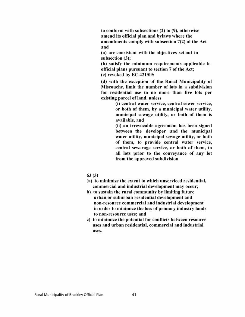
41
Rural Municipality of Brackley Official Plan
to conform with subsections (2) to (9), otherwise amend its official plan and bylaws where the amendments comply with subsection 7(2) of the Act and (a) are consistent with the objectives set out in subsection (3); (b) satisfy the minimum requirements applicable to official plans pursuant to section 7 of the Act; (c) revoked by EC 421/09;
(d) with the exception of the Rural Municipality of Miscouche, limit the number of lots in a subdivision for residential use to no more than five lots per existing parcel of land, unless
(i) central water service, central sewer service, or both of them, by a municipal water utility, municipal sewage utility, or both of them is available, and (ii) an irrevocable agreement has been signed between the developer and the municipal water utility, municipal sewage utility, or both of them, to provide central water service, central sewerage service, or both of them, to all lots prior to the conveyance of any lot from the approved subdivision
63 (3) (a) to minimize the extent to which unserviced residential,
commercial and industrial development may occur; b) to sustain the rural community by limiting future
urban or suburban residential development and non-resource commercial and industrial development in order to minimize the loss of primary industry lands to non-resource uses; and
c) to minimize the potential for conflicts between resource uses and urban residential, commercial and industrial uses.
42
Rural Municipality of Brackley Official Plan
6.0 GENERAL FUTURE LAND USE MAP
The General Future Land Use Map is a conceptual representation of the direction Council envisions land use patterns emerging over the next fifteen years. It lays the foundation and establishes the direction for the Zoning Map in the Development Bylaw, which is normally more precise in terms of boundaries and land use designation. The Zoning Map must, however, conform to the General Future Land Use Map.
In formulating the General Future Land Use Map, Council has applied the following criteria:
� Land use conflicts shall be minimized.
� Commercial/industrial development shall be limited and directed toward established commercial/industrial clusters. Established commercial and industrial developments shall be protected.
� Existing Institutional developments shall be protected.
� No new large scale residential development is envisaged.
� Agriculture shall remain the dominant land use in the Rural
Municipality.
� New Industrial development shall be discouraged unless directly related to the primary sector.
� All other relevant policies and principles included in this Plan
shall be implemented.
43
Rural Municipality of Brackley Official Plan
MAP 3
GENERAL FUTURE LAND USE MAP
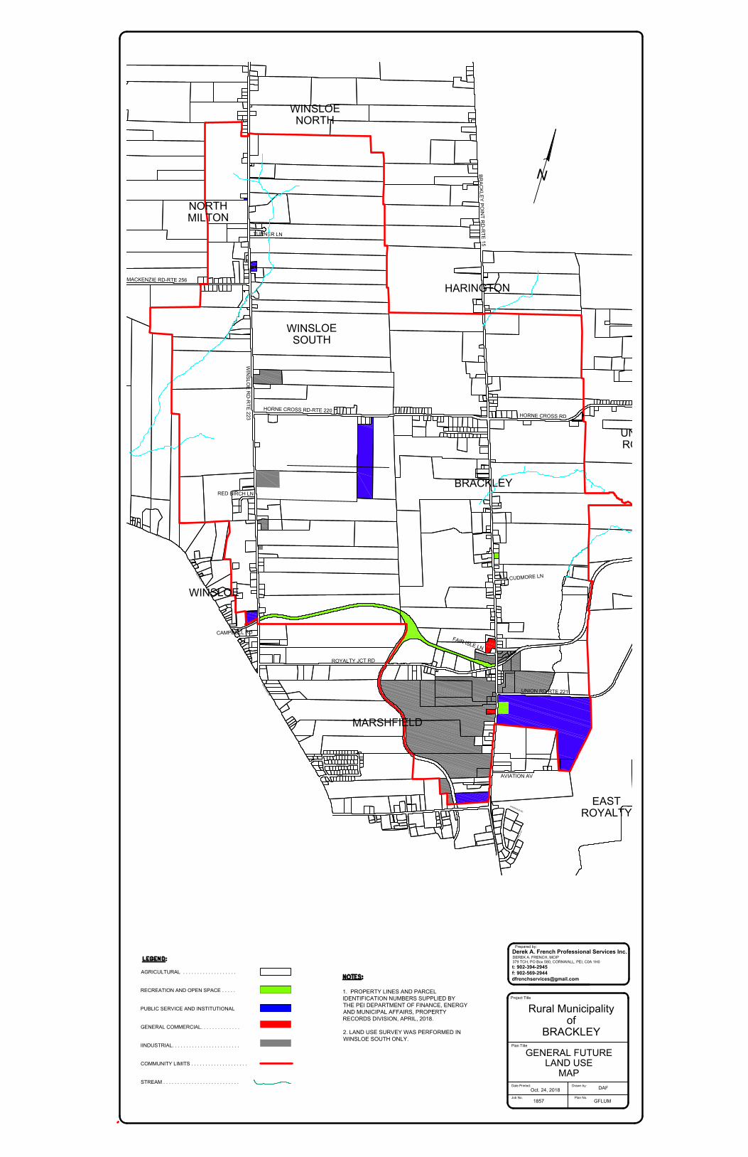
RUSTICO RD-RTE 7MACKENZIE RD-RTE 256WINSLOE RD-RTE 223RTE 2MALPEQUE RDCAMPBELL RDMALPEQUE RDHORNE CROSS RD-RTE 220BRACKLEY POINT RD-RTE 15ROYALTY JCT RDCOUNTRYROSE STPENNY LNBROOKDALE DRKAREN DRMACNEILL AVMOUNT EDWARD RDHORNE CROSS RD FAIR ISLE LNDAY AVBRACKLEY POINT RDUNION RD-RTE 221UNION RD-RTE 221UNION RD-RTE 221NORWOOD RDSHERWOOD RDTURNER LNCUDMORE LNAVIATION AVRED BIRCH LNMAPLE HILLS AVNEWSON DRNVIEW DRBRACKLEYWINSLOENORTHMILTONWINSLOENORTHHARINGTONUNIONROADEASTROYALTYMARSHFIELDWINSLOESOUTH
MACKENZIE RD-RTE 256
WIN
SLO
E R
D-R
TE
223
R
T
E
2
M
A
L
P
E
Q
U
E
R
D
CAMPBELL RD
M
A
L
P
E
Q
U
E
R
D
HORNE CROSS RD-RTE 220
BR
AC
KLE
Y P
OIN
T R
D-R
TE
15
ROYALTY JCT RD
C
O
U
N
T
R
Y
RO
SE
S
T
PENNY LN
BROOKDALE DR
KAREN DR
M
A
C
N
E
IL
L
A
V
M
O
U
N
T E
D
W
A
R
D
R
D
HORNE CROSS RD
F
A
I
R
I
S
L
E
L
N
D
A
Y
A
V
B
R
A
C
K
L
E
Y
P
O
IN
T
R
D
UNION RD-RTE 221
NORWOOD RD
S
H
E
R
W
O
O
D
R
D
TURNER LN
CU
DM
OR
E L
N
AVIATION AV
RED BIRCH LN
M
A
P
L
E
H
I
L
L
S
A
V
N
VIEW DR
BRACKLEY
WINSLOE
NORTH
MILTON
WINSLOE
NORTH
HARINGTON
UNION
ROAD
EAST
ROYALTY
MARSHFIELD
WINSLOE
SOUTH
GENERAL FUTURE
LAND USE
MAP
AGRICULTURAL . . . . . . . . . . . . . . . . . . .
RECREATION AND OPEN SPACE . . . . .
PUBLIC SERVICE AND INSTITUTIONAL
GENERAL COMMERCIAL. . . . . . . . . . . . . .
IINDUSTRIAL. . . . . . . . . . . . . . . . . . . . . . . .
COMMUNITY LIMITS . . . . . . . . . . . . . . . . . . . .
STREAM . . . . . . . . . . . . . . . . . . . . . . . . . . .
1. PROPERTY LINES AND PARCEL
IDENTIFICATION NUMBERS SUPPLIED BY
THE PEI DEPARTMENT OF FINANCE, ENERGY
AND MUNICIPAL AFFAIRS, PROPERTY
RECORDS DIVISION, APRIL, 2018.
2. LAND USE SURVEY WAS PERFORMED IN
WINSLOE SOUTH ONLY.
Project Title
Plan Title
Job No.
GFLUM
Plan No.
1857
Oct. 24, 2018
Date Printed: Drawn by:
DAF
Derek A. French Professional Services Inc.
Prepared by:
t: 902-394-2945
f: 902-569-2944
379 TCH, PO Box 580, CORNWALL, PEI, C0A 1H0
DEREK A. FRENCH, MCIP
Rural Municipality
of
BRACKLEY
44
Rural Municipality of Brackley Official Plan
7.0 IMPLEMENTATION
7.1 Administration
Administration of this Plan shall be the responsibility of Council. Council shall, however, seek the input of Planning Board on matters pertaining to the Plan. The primary implementation tool for this Plan is the Development Bylaw. Aspects of the Plan may also be implemented through other municipal bylaws and regulations, Council’s operating policies and procedures, the municipal budget and other appropriate Council actions. Council may also delegate aspects of the implementation of this Plan or the Development Bylaw to a Development Officer appointed by Council.
7.2 Development Bylaw
Immediately upon approval by the Minister of Community, Land and Environment, Council shall amend its current Zoning and Subdivision Control (Development) Bylaw to be in conformance with the policies and provisions of this Plan, in accordance with the provisions of the Planning Act. The revised bylaw shall be referred to as the Rural Municipality of Brackley Zoning and Subdivision Control (Development) Bylaw.
The Development Bylaw shall set out specific land use zones, permitted uses for each zone, standards and procedures for development and land use, and standards and procedures for the subdivision and consolidation of land in the Rural Municipality. The Bylaw may also provide for “conditional” and “special permit” uses. Conditional uses shall be subject to such restrictive conditions as Council deems appropriate. Special Permit uses represent exceptions to the “permitted uses” in each zone and shall be approved at the sole discretion of Council.
7.2.1 Approval of Development or Change of Use
The Development Bylaw shall require any person undertaking any development, change of use of land or premises or subdivision/consolidation of land to apply for a permit using a standard application procedure. Exceptions shall be noted in the Bylaw. Council may attach such conditions as it deems appropriate to any permit in order to ensure conformance with this Plan.
The Bylaw may also require submission of a Construction Plan for the development outlining such details as construction phasing, stockpiling
45
Rural Municipality of Brackley Official Plan
of soil, screening or fencing, erosion or run-off control measures, heavy truck traffic access, hours of operation and any other items which could present a nuisance or hazard during construction.
Once the development is approved, a numbered permit will be issued which must be displayed at the site. The receipt of a development permit does not excuse the applicant from complying with any Provincial or Federal laws in force, such as fire protection, health and safety, sewage disposal, plumbing and electrical installation, disabled access. Council shall maintain liaison with appropriate Provincial officials during the permit issuing process.
7.2.2 Development Agreements
Council may, at its discretion, require the developer of a subdivision or a development to enter into a Development Agreement or Subdivision Agreement. These agreements will contain all conditions which were attached to the building permit or subdivision approval and shall be legally binding on both parties.
7.2.3 Variances
Council may grant a variance to the provisions of the Development Bylaw where strict compliance would represent an inappropriate burden to the developer and where the general intent of this Plan is upheld.
7.3 Budgeting
While the Development Bylaw and other bylaws passed under the Municipal Government Act are the primary tools for controlling and directing development activities in the Rural Municipality, the Community budget is the key policy tool for directing the annual activities of Council. As such, the budget is a key implementation tool for many of the policies and plan actions laid out in this Plan. To the extent practicable, the budget should conform with the policies of this Plan.
7.3.1 Budget Policies
Council has established the following fiscal policies as a framework to guide decisions on municipal revenues and expenditures:
� Council shall strive to maintain stable and affordable property
tax rates.
� Council shall pursue all available options for cost-sharing and
46
Rural Municipality of Brackley Official Plan
maximize financial assistance from other levels of government.
� Council shall pursue a “user pay” approach for programs and services where appropriate.
� Council shall not budget for an operating deficit in any year.
� Any incurred deficit shall be addressed as part of the subsequent
annual budget if possible.
� Council shall continue to maintain low staff levels and contract out for specialized services until needs and projected savings warrant additional staffing.
7.4 Review
Council shall on a regular basis review its activities in terms of successful implementation of this Plan.
7.5 Amendments
The Official Plan and Development Bylaw may be amended as circumstances require or in response to requests from the public, provided that all provisions of the Planning Act are met.
7.6 Appeal Procedure
Any person who is dissatisfied with a decision of Council in the administration of the Official Plan or the Development Bylaw may, within 21 days of the decision, appeal the decision to the Island Regulatory and Appeals Commission.