Embed Size (px)
Citation preview

Rural Area Development Plan Formulation and
Implementation (RADPFI) Guidelines, 2016
Ministry of Panchayati Raj
Government of India
FINAL DRAFT 43349/2017/1003
173

RADPFI Guidelines, 2016 ii
PREFACE
Spatial planning is an important aspect of any planned development. It is vital for
provision of serviced land and laying down of infrastructure further to which ‘development’
takes place. Spatial planning is undertaken in urban areas with different levels of success. It is
however limited only to large urban settlements in most of the States as we have observed in
practice. These spatial plan are prepared in the form of Master plans, Development plans and
Comprehensive Development Plans. It is appreciated by all the planning practitioners that
urban areas and the rural settlements should be considered in totality for planning at the
district and regional level. Several States also have their Town and Country Planning bodies
for undertaking Spatial planning, such exercises for rural settlements has altogether been
absent.
Out of about 7933 urban settlements in India only 3892 qualify to be classified as
Census Towns by the Census of India. From 2001 to 2011 the urban population of India has
increased major contribution of which was by inclusion of large rural settlements as urban
settlements in 2011. Such Census Town attracting migration from surrounding villages,
serving as nodal centers or market places and as centers of socio-economic activities. The
gram panchayat areas surrounding the settlements are used for agriculture, grazing, mining,
resource collection and a variety of other uses. Environmental concerns are also rapidly
gaining importance on account of increasing pressure on land and other resources. Planned
development is intricately linked with socio-economic development including poverty
alleviation. The need for Spatial Planning in Gram Panchayat areas can therefore hardly be
over emphasised.
While the Ministry of Urban Development has released the Urban and Regional
Development Plan Formulation and Implementation Guidelines, similar guidelines for Spatial
planning in Gram Panchayat areas is lacking. The present document is prepared to serve as
the guidelines for planned Spatial development in Gram Panchayat Areas.
This document has been prepared by a Policy Planners, Experts, Institutions namely
Town and Country Planning Organizations, NIRD&PR, SPA, NRSC and CGG.
The Final Draft RADPFI Version 2.0 .is prepared under the leadership of Shri.K K
Joadder, Chief Planner, Town & Country Planning Organisation, with valuable contributions
from TCPO, NIRD&PR, SPA, NRSC and CGG.
43349/2017/1003174

RADPFI Guidelines, 2016 iii
ACKNOWLEDGEMENT
The RADPFI Guidelines are prepared with energy by TCPO, SPA, NRSC, CGG,
NIRD&PR, Policy Planners, Experts, State Government Representatives and MoPR, each
one of whom have contributed significantly, for the preparation of the RADPFI Guidelines.
The development of the RADPFI Guidelines was headed by Shri.K K Joadder Chief
Planner and Shri R,Srinivas, Town and Country Planner, TCPO, with back up support from
all Resource Organisations like NRSC, SPA, NIRD&PR and CGG.
The Guidelines Committee place on records the rich contributions of Dr S S
Meenakshisundaram, former Secretary(RD) and Advisor, NIAS, IISc, Bangalore, Dr P K
Mohanty, Advisor, CGG, Shri S M Vijayanand, CS, Govt of Kerala; Dr M N Roy, Former
Addl CS(RD&PR), Govt of West Bengal & Chainman, Ridhi Foundation and Dr W R
Reddy, DG, NIRD&PR, who have hand hold the preparation Team to address the vital issues
to make the spatial planning in GPs a reality.
The RADPFI Guidelines preparation Team thank the MoPR to provide an opportunity
to participate in the grassroot development and bringing a change in the development
scenarios in the rural India.
43349/2017/1003175
RADPFI Guidelines, 2016 iv
TEAM MEMBERS
Members, Experts, Institutional Members and State Representatives
1. Dr. S S Meenakshisundaram, Former Secretary (RD)& Advisor NIAS, IISc,
Bangalore;
2. Dr. P K Mohanty,Former Chief Secretary, Govt of AP& Advisor, CGG, Hyderabad;
3. Dr. W R Reddy, Director General, NIRD&PR, Hyderabad;
4. Dr. M N Roy, Former Addl CS(RD & PR), Govt of West Bengal, Kolkota;
5. Dr. Shabbeer Shaik, Director(G & UMRG), CGG, Hyderabad;
6. Dr K K Jaodder, Chief Town Planner, TCPO, MUD, Govt of India, New Delhi;
7. Dr. R Nagaraja, Former Chief General Manager & DD, NRSC, Hyderabad;
8. Shri. R Srinivas, Town and Country Planner, Head, Metropolitan &U.T
Division, TCPO, MoUD, GoI, New Delhi;
9. Shri. Harpal Dave, Assistant Town and Country Planner , TCPO, MoUD, GoI, New
Delhi;
10. Prof. N Sridharan, Professor, Dept of Regional Planning,SPA, New Delhi;
11. Dr. Sibabrata Kar,UNDP Consultant, MoPR, Govt of India, New Delhi;
12. Shri. Antony, Director, SIRD, Kotarakara, Kollam, Kerala;
13. Dr. V Madhava Rao, Advisor & Head(CGARD), NIRD&PR, Hyderabad;
14. Dr. T. Phanidra Kumar, Assistant Professor, CGARD, NIRD&PR, Hyderabad;
15. Dr. Leela Kumari, Faculty, IMG, Trivandrum;
16. Dr. Ram Mohan, Faculty, IMG, Trivandrum.
Research Associates
1. Ms Tanya Chaudhary
2. Shri Nishant Kumar Roy
43349/2017/1003176

RADPFI Guidelines, 2016 i
Contents
1. INTRODUCTION ......................................................................................................... 1
1.1 Need for RADPFI Guidelines.................................................................................. 2
1.2 Aim and Objectives ................................................................................................. 8
1.3 Scope and Application ............................................................................................ 8
2. PLAN FORMULATION ............................................................................................. 11
2.1 Developing and implementing RADPFI Guidelines .............................................. 11
2.2 Modification in framework to implement the guidelines ........................................ 12
2.3 Plan formulation for Gram Panchayats .................................................................. 12
2.4 Statutory obligations ............................................................................................. 13
2.4.1 Planning Machinery/Staffing for Villages/Panchayat to plan or execute plans 13
2.4.2 Legislative processes...................................................................................... 13
2.5 People’s participation ............................................................................................ 15
2.6 Integrating and Implementation of Rural Planning ................................................ 16
2.7 Contents of existing Gram Panchayat Development Plan(GPDP) .......................... 17
3. SPATIAL APPROACH TO RURAL PLANNING ...................................................... 19
3.1 Categorisation of villages ...................................................................................... 19
3.1.1 Villages with in Planning Area of the delineated Metropolitan area/city/town 19
3.1.2 Villages adjacent to corridor development ...................................................... 20
3.1.3 Villages in the interior .................................................................................... 21
3.2 Villages categorized by their population size ......................................................... 22
3.3 Classification of Gram Panchayat .......................................................................... 25
3.4 Need for categorising the villages ......................................................................... 25
4. CONTENTS OF GRAM PANCHAYAT SPATIAL DEVELOPMENT PLAN ............ 27
4.1 Introduction .......................................................................................................... 27
4.2 Contents of the Plan .............................................................................................. 27
4.2.1 Analysis of Existing Scenario ........................................................................ 27
4.2.2 Projections ..................................................................................................... 31
4.2.3 Strategies and Proposal .................................................................................. 32
5. RURAL INFRASTRUCTURE PLANNING: LANDUSE, NORMS AND STANDARDS
…………………………………………………………………………………………...33
5.1 Introduction .......................................................................................................... 33
5.2 Landuse for Rural Areas ....................................................................................... 33
43349/2017/1003177
RADPFI Guidelines, 2016 ii
5.3 Norms and Standards ............................................................................................ 35
5.3.1 Habitat Planning in Rural Areas ..................................................................... 36
5.3.2 Road Infrastructure ........................................................................................ 39
5.3.3 Social Facilities .............................................................................................. 41
5.3.4 Water supply and Sanitation ........................................................................... 43
5.3.5 Solid and Liquid Waste Management ............................................................. 45
6. ENVIRONMENTAL SUSTAINABILITY AND DISASTER MANAGEMENT ......... 53
6.1 Natural Resources in Rural Areas .......................................................................... 53
6.2 Sustainability ........................................................................................................ 53
6.3 Sustainable Rural Planning.................................................................................... 53
6.3.1 Sustainable parameters ................................................................................... 53
6.4 Climate Change Mitigation and Adaptation ........................................................... 54
6.5 Climate Proofing ................................................................................................... 55
6.5.1 Vulnerability .................................................................................................. 55
6.5.2 Rural Disaster Resilience Strategy and Plan ................................................... 56
6.6 Disaster Management ............................................................................................ 57
6.6.1 Institutional Set up ......................................................................................... 57
6.6.2 Community Based Disaster Management (CBDM) ........................................ 58
6.6.3 Gram Panchayat/Village Disaster Management Plan ...................................... 59
7. SIMPLIFIED PLANNING TECHNIQUES.................................................................. 64
7.1 Data Identification and listing ............................................................................... 64
7.2 Data Collection Techniques .................................................................................. 69
7.2.1 Primary data collection techniques ................................................................. 69
7.2.2 Secondary Data Collection techniques ........................................................... 72
7.3 Mapping ............................................................................................................... 72
7.3.1 Scale of Map .................................................................................................. 72
7.3.2 Map Information checklists ............................................................................ 73
7.3.3 Procedure of Collecting Data ......................................................................... 75
7.4 GIS Based Gram Panchayat Spatial Development Plan (Refer Annexure 5) .......... 77
7.5 Bhuvan platform for spatial planning .................................................................... 78
7.5.1 Database available ......................................................................................... 79
7.5.2 Geo-visualization facility ............................................................................... 79
7.5.3 Interactive modules for planning needs .......................................................... 80
8. CONSOLIDATION OF GRAM PANCHAYAT SPATIAL DEVELOPMENT PLANS
87
43349/2017/1003178

RADPFI Guidelines, 2016 iii
8.1 Spatial planning .................................................................................................... 87
8.2 Spatial Consolidation of Plans ............................................................................... 88
8.3 Integration of Spatial plans with Sectoral Plans ..................................................... 88
9. RESOURCE MOBILISATION FOR PLAN IMPLEMENTATION ............................. 90
9.1 Fourteenth Finance Commission ........................................................................... 91
9.1.1 Basis of Horizontal Distribution ..................................................................... 91
9.1.2 Recommendations of XIV Finance Commission ............................................ 92
9.2 Financial Plans for Rural Areas ............................................................................. 92
9.2.1 Budget of the Gram Panchayt ......................................................................... 93
9.2.2 Annual Report................................................................................................ 93
9.3 Spatial Budgeting INPUTS REQUIRED ............................................................... 94
9.4 Convergence with central rural schemes ................................................................ 94
10. INSTITUTIONAL SUPPORT MECHANISMS AND CAPACITY BUILDING ..... 95
10.1 Institutional Set up ................................................................................................ 95
10.2 System Support for Planning and Implementation ................................................. 95
10.2.1 District Town and Country Planning Departments(TCPDs) ............................ 95
10.2.2 Rural Development Assistants (RDA) ............................................................ 96
10.2.3 Gram Panchayat Planning Committee ............................................................ 96
10.3 Capacity Building ................................................................................................. 96
10.3.1 Capacity Building Framework........................................................................ 96
11. OPERATIONALIZATION OF RADPFI GUIDELINES ......................................... 99
11.1 Adoption of RADPFI Guidelines .......................................................................... 99
11.2 Implementation Of Projects/ Schemes ................................................................... 99
11.2.1 Monitoring of Implementation ..................................................................... 101
11.2.2 Machinery For Planning ............................................................................... 101
11.2.3 People's Involvement In Planning And Implementation................................ 102
11.2.4 Manpower Requirement ............................................................................... 103
11.3 New Roles and Functions of State Town and Country Planning Departments ..... 103
11.4 Information System, Database For Implementation ............................................. 104
11.5 Recommendations to State Governments/ Town and Country Planning Departments/
Local Bodies/Development Authorities ......................................................................... 106
11.6 Modified State Town and Country Planning Acts ................................................ 106
11.6.1 Bihar Urban Planning and Development Act, 2012 ...................................... 106
11.6.2 Kerala Town and Country Planning Act ....................................................... 107
12. RERFERENCES ........................................................................................................ i
43349/2017/1003179

RADPFI Guidelines, 2016 iv
ANNEXURE 1: Decentralised Planning in India .................................................................. iii
ANNEXURE 2: Perspective Plans for National and International case studies ................... xiii
ANNEXURE 3: Interview Schedules ................................................................................. xxi
ANNEXURE 4: Classification of Assets in Bhuvan Panchayat ......................................... xxv
ANNEXURE 5: GIS based GP Planning Case Studies By NIRD ..................................... xxix
43349/2017/1003180
RADPFI Guidelines, 2016 v
LIST OF TABLES
Table 1.1:Distribution of Area (Sq.km.) by Residence ........................................................... 4
Table 1.2:Average Rural Population per village .................................................................... 6
Table 2.1: Selected States and Relevant Acts for Planning Purpose ..................................... 11
Table 3.1: Categorisation of villages according to population size ....................................... 25
Table 5.1: Landuse for rural areas ....................................................................................... 34
Table 5.2: Parameters of residential building ....................................................................... 37
Table 5.3: Parameters of commercial buildings .................................................................. 37
Table 5.4: Parameters of industrial buildings ....................................................................... 38
Table 5.5: Parameters of institutional and community buildings .......................................... 38
Table 5.6: Parking Norms.................................................................................................... 39
Table 5.7: Norms for Village Roads .................................................................................... 40
Table 5.8: Setbacks for building types ................................................................................. 40
Table 5.9: Norms for Educational/health/public utility Facilities ......................................... 41
Table 5.10: Plot Size, Ground Coverage, FAR, Height and Setbacks ................................... 42
Table 5.11: Norms for socio cultural facilities ..................................................................... 42
Table 5.12: Norms for provision of water ............................................................................ 43
Table 5.13: Potable water quality standards ......................................................................... 44
Table 5.14: Norms for number of seats, urinals, bathrooms and area for washing ................ 45
Table 5.15: Sewage disposal standards ................................................................................ 49
Table 5.16: Various technique of sewage treatment processes ............................................. 50
Table 6.1: Parameters and Strategy for Climate Proofing and Community Resilience .......... 55
Table 7.1: Data Collection List for GPSDP ......................................................................... 64
Table 7.2: Scale of Map of GPSDP ..................................................................................... 72
Table 7.3: Map information checklist .................................................................................. 73
Table 7.4: Satellite Imagery................................................................................................. 76
Table 9.1: Flow of funds from Central divisible pool to Panchayats .................................... 91
Table 9.2: Format of Balance sheet/Budget for rural areas ................................................... 93
43349/2017/1003181

RADPFI Guidelines, 2016 vi
LIST OF FIGURES
Figure 1.1: Density of Rural settlements, 2011 ...................................................................... 5
Figure 1.2:Rural Population Density, 2011 ............................................................................ 6
Figure 1.3:Scope of RADPFI Guidelines ............................................................................... 9
Figure 2.1: Statutory obligation for preparation of GPSDP .................................................. 14
Figure 2.2: Framework for use of RADPFI in rural development plans ............................... 14
Figure 3.1:Settlement Pattern and Corridors ........................................................................ 22
Figure 5.1: Various levels of SWM .................................................................................... 47
Figure 6.1: Rural Disaster Resilience Strategy and Plan ...................................................... 56
Figure 6.2: Disaster Management Cycle .............................................................................. 59
Figure 6.3: Suggested Framework for developing SDMP,DDMP,VDMP,CDMP ................ 60
Figure 7.1: Stages of conducting Primary Survey ................................................................ 69
Figure 7.2: Process of using GIS in GPSDP ........................................................................ 78
Figure 7.3: Snapshot of a marked asset (point) with attribute form ...................................... 83
Figure 7.4: Snapshot of a marked assets (line) with attribute form ....................................... 83
Figure 7.5: Snapshot of the marked assets (polygon) with attribute form ............................. 84
Figure 7.6: Activity planned as line feature ......................................................................... 85
Figure 7.7: Activity planned spatially as Polygon feature .................................................... 86
Figure 8.1: Consolidation of Gram Panchayat Village Plan ................................................ 88
Figure 8.2: Categorization of spatial activity plans .............................................................. 89
43349/2017/1003182

RADPFI Guidelines, 2016 vii
Abbreviations
CAA Constitutional Amendment Act
CFC Central Finance Commission
CGG Centre for Good Governance
DPC District Planning Committee
FAR Floor Area Ratio
FF-XIV Fourteenth Finance Commision
GPDP Gram Panchayat Development Plan
GPSDP Gram Panchayat Spatial Development Plan
MoPR Ministry of Panchayati Raj
MoRD Ministry of Rural Development
MoUD Ministry of Urban Development
NGO Non- Governmental organization
NIRD National Institute of Rural Development
SFC State Finance Commission
TCPD Town and Country Planning Department
TCPO Town and Country Planning Organisation
URDPFI Urban and Regional Development Plan Formulation and Implementation
Guidelines
RADPFI Rural Area Development Plan Formulation and Implementation Guidelines
NRSC National Remote Sensing Centre
SPA School of Planning and Architecture
43349/2017/1003183

Introduction
RADPFI Guidelines, 2016 1
1. INTRODUCTION
The Constitution (73rd
Amendment) Act, 1992 relating to Panchayats containing articles 243
to 243-O and the Constitution (74th Amendment) Act, 1992 relating to
Municipalities (articles 243P to 243ZG) imparted some basic features of democratic
decentralization of the governance especially the Panchayati Raj Institutions all over the
country. The 73rd
CAA mentions about the responsibility of Gram Panchayats, to prepare the
social, economic and resource plans for rural areas, but not the spatial plans. The 11th
schedule of 73rd
CAA lists the functions of Gram Panchayat, which does not include
preparation of spatial plans for Gram Panchayats as one of the functions of Panchayats.
Therefore, the rural areas are devoid of planned spatial development. The absence of planned
spatial development in rural areas has major impact on regional development, especially in
case of villages in the planning area boundary of the metropolitan areas and cities. The Rural
Area Development Plan Formulation and Implementation Guidelines (RADPFI) guidelines
emphasizes the need for the preparation of rural spatial plans, integrated with the overall
development. The RADPFI guidelines aims to provide direction for the preparation of spatial
plans for Gram Panchayat and also mentions the required alterations and additions in the
existing statutory provisions of planning.
The main features of the 73rd Amendment are - (i) a three-tier system of Panchayati Raj (ii)
Panchayat elections to be held regularly every five years; (iii) reservation of seats for the
Scheduled Castes and Scheduled Tribes and for women (not less than one-third of seats), (iv)
constitution of State Finance Commissions; (v) Constitution of District Planning Committee
to prepare development plans for the district as a whole; (vi) establishment of State Election
Commissions; and (vii) establishment of Gram Sabhas. The RADPFI guidelines highlights
the importance of preparation of spatial plans for rural area and suggests the addition of
clause for spatial planning for rural areas in statutory provisions.
Further, the State Legislatures have power, to confer on the Panchayats such powers and
authority as may be necessary to enable them to function as institutions of self-government
(Article 243G). They may be entrusted with the responsibility of (a) preparing plans for
economic development and social justice, (b) implementation of schemes for economic
development and social justice, and (c) in regard to matters listed in the Eleventh Schedule
(inserted by the 73rd Amendment). The list contains 29 items, including, land improvement,
minor irrigation, animal husbandry, fisheries, education, women and child development etc.
The 11th Schedule thus distributes powers between the State Legislature and the Panchayat
just as the 7th Schedule distribute powers between the Union and the State Legislature.
Therefore, spatial planning in rural areas needs to be entrusted to the Gram Panchayats.
Preparation of spatial plans for rural areas holds immense significance and hence the
document makes an attempt to provide the direction for the same along with the legislative
framework, institutional framework and transfer of funds to rural local bodies as per 14th
Finance Commission recommendations.
73rd
CAA, envisaged a three tier government, devolution of funds, along with functions
delegated to both urban and rural local bodies. These were implemented by the state
43349/2017/1003184

Introduction
RADPFI Guidelines, 2016 2
governments with required modifications through the Municipal and Panchayat Acts. The
provisions for setting up a District Planning Committee (Article 243ZD) and consolidation of
village and City plans in District Plan, has been mentioned in the Manual for Integrated
District Planning, prepared by Ministry of Panchayati Raj in 2008, elucidates “District
Planning as participative and multidimensional process and hence gives guidelines for
preparation of any District Plan which is inclusive of both urban and rural requirements, and
perceives the District as a Region.”
Therefore, realizing the significance of the planned development in villages, Ministry of
Panchayati Raj vide OM No.N-11019/16/2016-Planning dated 29th February ,2016
constituted an Inter-Ministerial Working Group for formulation of Rural Area Development
and Plan Formulation and Implementation (RADPFI) Guidelines under the chairmanship of
Secretary, Ministry of Panchayati Raj with representatives of Ministries of Urban
Development, Rural Development, Environment, Forests & Climate Change, Industrial
Policy and Promotion and Departments of Agriculture, Cooperation & Farmer Welfare, Land
Resources and other organizations like Town and Country Planning Organization, School of
Planning and Architecture, New Delhi, CEPT University, , Centre for Good Governance,
Administrative Staff College of India, National Remote Sensing Centre and National
Informatics Centre. Further, vide Ministry of Panchayati Raj OM No.11019/16/2016-
Planning dated 21st April,2016 a separate Guidelines Development Committee was
constituted to draft the RADPFI Guidelines under the chairmanship of Director General,
National Institute of Rural Development and Panchayati Raj.
1.1 Need for RADPFI Guidelines
Spatial plans are prepared for cities and towns popularly known as Master Plans and
Development Plans and notified under the respective State Town and Country Planning Acts
and Urban Development Acts. These Acts in their title include Country Planning, but in
actual terms, there is neither provision of preparing Master/Development Plans for village nor
much attention has been given by the State Governments to prepare the same.
The need for the RADPFI guidelines arises from the fact, that the there are 6.4 lakh villages
in the country and 68.84 percent of the total population lives in the rural areas. These villages
have varied characteristics and shows different degrees of transformation from rural to urban.
The villages which show high degree of transformation due to their spatial location may
attain urban characteristics in the future and therefore it becomes indispensible to plan these
settlements.
The areal extent of rural areas as stated in the Table1.1, State-wise as well as for the entire
nation indicates the vast stretch of the land are in rural areas. Almost 94% of the total area of
India, comprises rural areas. In India, rural areas cover 94% of land and 69% of population
while urban area holds 6% of land and 31% of population.
43349/2017/1003185

Introduction
RADPFI Guidelines, 2016 3
There has been no serious attempt to prepare Spatial Plans for rural areas and taking into
account the vast rural population of the country who have been deprived of the access to
basic facilities, the guidelines assumes much significance with overall objective of inclusive
development of rural areas. The guideline encourages the planned development in the
neglected part of the country which as shows in Table 1.1, accounts for 3,101,505 Sq.Km.
approximately. The idea of Planning in rural areas often receives cynical perspectives
because of the socio economic constraints that exist in villages, lack of technical knowledge,
lower levels of educational attainment. However, with the new Digital Literacy vision of the
government and the anticipated socioeconomic development, the rural planning may be
contemplated as the next possibility. Moreover, the provision of basic infrastructural facilities
requires norms and standards to make available the required services. Such norms and
standards are prescribed by the RADPFI guidelines to facilitate the development in rural
areas.
TAKING FORWARD URDPFI GUIDELINES, 2014
The URDPFI Guidelines, 2014 mentions:
“While the planning and developmental norms for the city are available, there are no such
norms for peri-urban areas. As the regional and metropolitan area planning intends to
bring such area in planning framework it is only logical that development norms for peri-
urban area is also developed because of its heavy bias towards urban character. In the
absence of this, such settlements will keep developing unscientifically. These areas
develop faster than rural settlements and have considerable urban form, yet it cannot have
zoning regulation of larger cities.”(URDPFI Guidelines, 2014, pg.138)
Therefore, it is imperative to formulate the RADPFI Guidelines for the guidance of State
Government.
43349/2017/1003186

Introduction
RADPFI Guidelines, 2016 4
Table 1.1:Distribution of Area (Sq.km.) by Residence
SL.NO States/UTs No.of
villages
Total Rural Urban Area/Village
1 Jammu & Kashmir 6,652 222236 220990.1 1245.9 33.22
2 Himachal Pradesh 19,831 55673 55402.18 270.82 2.79
3 Punjab 12,729 50362 47847.4 2514.6 3.76
4 Chandigarh 24 114 4.47 109.53 0.19
5 Uttarakhand 16,805 53483 52581.08 901.92 3.13
6 Haryana 6,955 44212 42235.92 1976.08 6.07
7 NCT of Delhi 165 1483 326.44 1156.56 1.98
8 Rajasthan 41,353 342239 335606.04 6632.96 8.12
9 Uttar Pradesh 107,440 240928 233365.71 7562.29 2.17
10 Bihar 45,113 94163 91838.28 2324.72 2.04
11 Sikkim 452 7096 7057.75 38.25 15.61
12 Arunachal Pradesh 4,065 83743 NA NA NA
13 Nagaland 1,315 16579 16335.52 243.48 12.42
14 Manipur 2,391 22327 22147.5 179.5 9.26
15 Mizoram 817 21081 20494 587 25.08
16 Tripura 870 10486 10094.12 391.88 11.60
17 Meghalaya 6,023 22429 22146.11 282.89 3.68
18 Assam 26,247 78438 77178.12 1259.88 2.94
19 West Bengal 40,783 88752 83632.59 5119.41 2.05
20 Jharkhand 32,615 79716 77467.12 2248.88 2.38
21 Odisha 51,352 155707 152355.34 3351.66 2.97
22 Chhattisgarh 20,308 135192 131810.3 3381.7 6.49
23 Madhya Pradesh 55,392 308252 300505.59 7746.41 5.43
24 Gujarat 18,544 196244 188840.46 7403.54 10.18
25 Daman & Diu 23 111 56.38 54.62 2.45
26 Dadra & Nagar 70 491 445.3 45.7 6.36
27 Maharashtra 43,722 307713 298628.75 9084.25 6.83
28 Andhra Pradesh 28,123 160205 156085.73 4119.27 9.50
29 Karnataka 29,483 191791 185783.46 6007.54 6.30
30 Goa 359 3702 2903.14 798.86 8.09
31 Lakshadweep 24 30 8.05 21.95 0.34
32 Kerala 1,364 38852 31253.2 7598.8 22.91
33 Tamil Nadu 16,317 130060 116427.97 13632.03 7.14
34 Puducherry 92 490 335.44 154.56 3.65
35 Andaman & N.Is 547 8249 8211.08 37.92 15.01
36 Telangana 640867 114840 111104.77 3735.23 4.84
India 6,652 3287469 3101505.41 102220.59 33.22 Source: Census of India, 2011 Note: The sum of rural and urban area does not tally with the total area, as the bifurcation of rural and urban
area is not given for the state of Arunachal Pradesh.
43349/2017/1003187

Introduction
RADPFI Guidelines, 2016 5
Figure 1.1 shows the concentration of villages per 100 sq.km or rural settlements density,
which shows that Indo Gangetic plain has higher number of villages per 100 sqkm. This data
can be related to the average rural population per sq.km of rural area, and importance of rural
areas can thus be realised.
Figure 1.1: Density of Rural settlements, 2011
Source: Census of India, 2011
43349/2017/1003188

Introduction
RADPFI Guidelines, 2016 6
Figure 1.2:Rural Population Density, 2011
Source: Census of India, 2011
Figure 1.1 and Figure 1.2 gives a fair idea of density of rural settlements and rural population.
The Indo Gangetic plains holds higher density of rural settlements as well as rural population.
Kerala holds an exception in case of density of rural settlements because of its large size of
the villages. The country’s average works out to 1300 rural population per village, where
Kerala has 12,808 rural population per village. (Table 1.2)
Table 1.2:Average Rural Population per village
43349/2017/1003189

Introduction
RADPFI Guidelines, 2016 7
State Rural Pop. No. of Villages Average Rural
Population per Village
JAMMU & KASHMIR 9108060 6,652 1,369
HIMACHAL PRADESH 6176050 19,831 311
PUNJAB 17344192 12,729 1,363
CHANDIGARH 28991 24 1,208
UTTARAKHAND 7036954 16,805 419
HARYANA 16509359 6,955 2,374
NCT OF DELHI 419042 165 2,540
RAJASTHAN 51500352 41,353 1,245
UTTAR PRADESH 155317278 107,440 1,446
BIHAR 92341436 45,113 2,047
SIKKIM 456999 452 1,011
ARUNACHAL PRADESH 1066358 4,065 262
NAGALAND 1407536 1,315 1,070
MANIPUR 2021640 2,391 846
MIZORAM 525435 817 643
TRIPURA 2712464 870 3,118
MEGHALAYA 2371439 6,023 394
ASSAM 26807034 26,247 1,021
WEST BENGAL 62183113 40,783 1,525
JHARKHAND 25055073 32,615 768
ODISHA 34970562 51,352 681
CHHATTISGARH 19607961 20,308 966
MADHYA PRADESH 52557404 55,392 949
GUJARAT 34694609 18,544 1,871
DAMAN & DIU 60396 23 2,626
DADRA & NAGAR HAVELI 183114 70 2,616
MAHARASHTRA 61556074 43,722 1,408
ANDHRA PRADESH 56361702 28,123 2,004
KARNATAKA 37469335 29,483 1,271
GOA 551731 359 1,537
LAKSHADWEEP 14141 24 589
KERALA 17471135 1,364 12,809
TAMIL NADU 37229590 16,317 2,282
PUDUCHERRY 395200 92 4,296
ANDAMAN & NICOBAR ISLANDS 237093 547 433
INDIA 833748852 640867 1,301
Source: Census of India, 2011
43349/2017/1003190
Introduction
RADPFI Guidelines, 2016 8
Recently, Ministry of Urban Development has brought out Urban and Regional Development
Plan Formulation and Implementation Guidelines in 2014. The Guidelines basically have
been prepared for the guidance of the Urban Local Bodies and Urban Development
Authorities to prepare Master Plans/Development Plans for cities and towns. The URDPFI
Guidelines 2014, have incorporated the regional connotation in terms of prescribing norms
and standards for spatial planning in urban areas; however, it becomes imperative to consider
village level planning duly considering the spatial approach. Though, the rural areas have
very different characteristics based on their nature and degree of transforming into urban
areas, there is a need for separate guidelines for the planning in rural areas.
One of the responsibilities of Gram Panchayats in the 73rd
CAA is prepare plans for
economic development and social justice for Gram Panchayat. However, no such plans
are being prepared at the village level with spatial connotation and incorporation, and
without which it is very well known fact that majority of villages in the country are bereft of
access to basic facilities. This also justifies the need to prepare Guidelines for Rural Area
Development Plan Formulation and Implementation (RADPFI).
Rural areas are highly flexible, and cater for a wide range of activities relating to agriculture,
as well as rural industries, tourism, basic raw material extraction and mining. At the same
time, rural land may also contain land with significant environmental values, provides habitat
to various species. They are also centre for primary activities like dairying, farming, poultry,
pisciculture and mining.
1.2 Aim and Objectives
The aim of this guidelines is: “to have planned spatial development for overall integrated
development of villages”
Objectives
To suggest methodological framework for preparing Gram Panchayat level
Development Plan.
To arrive at a spatial standards for Gram Panchayat development, especially for
abadi areas
To prescribe norms and standards for providing infrastructure facilities and
amenities at the village level and its integration with spatial district plan.
To examine the provision of existing statutory framework and suggest suitable
amendments so as to ensure preparation of Rural/Village level Development Plan.
To recommend institutional framework for operationalising the guidelines and
provide a road map for planned development of Gram Panchayat.
1.3 Scope and Application
This document provides the guidelines for the spatial planning and development of rural
areas. It will give direction to the process of development in various sectors such as physical
and social infrastructure, economic activities, road and transport connectivity, land values and
anticipated economic activities and aids towards a workable solution for conversion of
43349/2017/1003191

Introduction
RADPFI Guidelines, 2016 9
agricultural to non agricultural purpose for unplanned/unauthorised development. The
preparation of spatial plans for rural areas also needs to follow the process as per statutory
provisions. The illustration below lists the important areas where RADPFI guidelines are to
be referred to, for making spatial development plans for Gram Panchayat.
Figure 1.3:Scope of RADPFI Guidelines
Application
Dealing with different development standards, for different rural areas, with
varied characteristics.
To facilitate the planned spatial development of rural areas.
Planning for environmental benefit and disaster preparedness.
To link spatial plans with 14th
FC and SFC.
To improve the digital literacy and village e-governance.
Integration/Cconsolidation of village development with Block/ District plan.
It is hoped that the Guidelines would be referred by the State Town and Country Planning
Departments, State Rural Development and Panchyati Raj Departments and host of other
offices located at the district/block level which are responsible for allocation of funds for the
infrastructure development both physical and social in the villages. All departments in
district will allocate budget according to Gram Panchayat Spatial Development Plan’s
proposals
The application of RADPFI guidelines extend to the arena of not just plan preparation, but
also in the field of academics. The documents can be referred by the Planning schools, as a
part of course curriculum, where preparations of village plans are laid emphasis on. The
Landuse and spatial planning
•Integrated decentralised and participatory spatial planning for rural areas.
Connectivity and environmental
apscts.
•Spatial connectivity through roads, and public mode of transport and IT.
•Spatial plan including environmental aspects, socio economic plans, national standards, community requirements and ensure people's participation and panchayat involvement.
Standardisation of social service
delivery
•Provision of Basic Amenities to rural areas
43349/2017/1003192

Introduction
RADPFI Guidelines, 2016 10
guidelines will facilitate planned development in rural areas, if followed with effective
governance structure. The past developments in the area of statutory framework for rural
development and linkages between urban and rural planning are further discussed in
forthcoming chapters.
43349/2017/1003193

Plan Formulation
RADPFI Guidelines, 2016 11
2. PLAN FORMULATION
2.1 Developing and implementing RADPFI Guidelines
As mentioned in the preceding chapter, there is no exclusive exercise for spatial planning of
panchayats/villages, and spatial planning is undertaken only if they are part of a planning
area/region notified by the state government. In most of the cases, panchayats/villages-level
planning is undertaken through District Planning Committees (DPCs). For the purpose of
integrated planning some states like Karnataka, Tripura, Sikkim, Rajasthan, Haryana, etc.
have made provisions in their modified Panchayat Act to establish DPCs. Other States like
Gujarat, Orissa, Madhya Pradesh, Maharashtra, etc., have enacted separate enabling
legislation for the constitution of DPCs, instead of incorporating such provisions in the
Panchayat Acts. In addition, some states have made provisions for panchayats/village
planning in their Town & Country Planning Act. Though the 74th CAA envisages spatial and
environmental planning for integration of the municipal and panchayat plans with district
plans wide Article 243-ZD(3-a), how effectively it has been implemented is an area of further
research. A list some select states indicating relevant Acts to deal with panchayats/village
planning is presented below
Table 2.1: Selected States and Relevant Acts for Planning Purpose
S.No. State Acts
1. Karnataka Karnataka Town and Country Planning Act 1961 amended in 2015
2. Andhra Pradesh AP Metropolitan Region & Urban Development Authorities Act,
2016
Panchayat Raj Act, 1994
3. Kerala Kerala Town and Country Planning 2016
Kerala Panchayat Raj Act 1994
4. Jharkhand Jharkhand Regional Development Authority Act-2001
Town Planning and Improvement Trust Act, 1954
5. Bihar Bihar Town and Country Planning Act-2012, amended in 2014
6. Chhattisgarh Chhattisgarh Nagar tatha Gram Nivesh Adhiniyam-1973
7. West Bengal West Bengal Town and Country (Planning and Development) Act,
1979 , Amended in 1994
8. Odisha Orissa Town Planning & Improvement Trust Act, 1956
9. Haryana Haryana Panchayatiraj Act 2007
10. Punjab Punjab Regional and Town Planning and Development Act, 1995
11. Uttar Pradesh Regulation of Building Operation Act, 1958 – Regulated Area
UP Urban Planning and Development Act, 1973 – Development
Area
UP Industrial Development Act, 1976 – Special Region
Special Area Development Authority, 1985 – Special Development
Area
12. Uttarkhand Uttar Pradesh Special Area Development Authority Act, 1986
Housing and Urban Development Authority Act, 2013
43349/2017/1003194

Plan Formulation
RADPFI Guidelines, 2016 12
13. Himachal Pradesh Himachal Pradesh Town and Country Planning Act, 1975
14. Goa Goa, Daman and Diu Town and Country Planning Act, 1974
15. Gujarat Gujarat Town Planning & Urban Development Act, 1976
16. Madhya Pradesh Madhya Pradesh Town and Country Planning Act, 1973
17. Maharashtra
Source: Acts of Various State Governments and National Rurban Mission (NRuM)
2.2 Modification in framework to implement the guidelines
The States which does not have provision of spatial planning in any of their Acts may adopt
the following provisions depending on their respective situation.
The provision for the declaration of development zone and preparation of
development plan/Local Plans (spatial plans) for every Gram Panchayat and erection
of buildings, as envisaged under Section 230 and 241 of the Haryana Panchayat Raj
(Amendment) Act,2007.
The provision for preparation of Local Area Plan, as envisaged in the Chapter 5,
Section 30 (a) of the Kerala Town and Country Planning Act, 2016.
2.3 Plan formulation for Gram Panchayats
The community Development Plans in 1951 adopted a mechanism or framework for the first
time, to bring rural development in India. Balwant Rai Mehta Committee came with a
suggestion to include three tier planning in Indian Planning Framework and further with 1992
CAA, the provisions were made for three tier institutional mechanism for planning and
Constitution of District planning Committee for consolidation or rural and urban plans and
preparation of District Plans. However, mandate for spatial plans for rural areas was not made
in 73rd
CAA.
There are 2,38,617 Gram Panchayats in India and RADPFI suggests the Gram Panchayat
Boundary as a planning boundary for Gram Panchayat Spatial planning.
Gram Panchayat level planning process comprises the following steps (Handbook for
preparation of Gram Panchayat Level Plan, State institute of Rural Development, Assam,
2011):
a) Identification of issues by Gram Sabhas / Ward Sabhas, based on vision document of
the panchayat which has already been prepared.
b) Determination of solution by Standing Committees of Gram Panchayat.
c) Prioritisation of solution and fund allocation by Village Panchayats.
d) Resulting in the preparation of first draft village panchayat plan.
e) Reconsideration of draft plan in second Gram Sabha meeting.
f) Finalisation of village panchayat plan by the full meeting of the village panchayat.
43349/2017/1003195

Plan Formulation
RADPFI Guidelines, 2016 13
2.4 Statutory obligations
2.4.1 Planning Machinery/Staffing for Villages/Panchayat to plan or execute plans
The preparation of Gram Panchayat Spatial Development Plan, is the sole responsibility of
Gram Panchayat, and hence constitution of a Village Planning Committee would bring ease
in realization of functions of Panchayat. The Village Planning Committee can comprise
Sarpanch, Sachiv, persons having special knowledge of economics, planning, finance,
engineering or administration, as determined by the state of DPCs. Apart from this, the
School Principal and Teachers, Doctors, ANMs, ASHA workers, NGO workers and youth
and women of the villages with adequate qualifications can be engaged in the committee for
preparation of Village Plans.
The DPC constituted in states as per 74th CAA, can further scrutinize each village
development spatial plans as the consolidation lies in their function.
2.4.2 Legislative processes
Similar to Master Planning done in ULBs, Rural Area planning should also be based on
similar legal process for its sustainability and continuity. The planning processes, such as
community participation, followed in urban planning shall be made mandatory. The Flow of
process regarding decentralisation of Plan approval process of Gram Panchayat Spatial
Development Plan is illustrated at Figure 2.1
The 73rd
CAA enables decentralisation while 243ZD in 74th CAA facilitates integrated
district planning through consolidation of rural and urban plans.
State Policy lays down that the State shall take steps to organise village panchayats and
endow them with such powers and authority as may be necessary to enable them to function
as units of self-government. 1
243ZD- Committee for district planning- There shall be constituted, in every State at
the district level a District Planning Committee to consolidate the plans prepared by the
Panchayats and the Municipalitiies in the district and to prepare a Draft Development Plan
for the district as a whole.
However, there is no mandate or constitutional provision for preparation of Gram Panchayat
Spatial Development Plans. Neither the existing planning framework has spatial planning
approach nor there is, statutory provision exclusively for spatial plans for Gram Panchayat. It
would be imperative to ensure enabling mechanisms for preparation of these plans which
may necessitates amendments to existing Town and Country Planning Acts and Gram
Panchayat Acts. The sectoral planning in villages is carried out in form of infrastructure
planning through grants provided by State and Central government. The RADPFI guidelines
shall facilitate the norms and standards for rural infrastructure planning as well as suggest
statutory requirements and amendments in the existing T&CP acts for inclusion of rural
planning.
1 73rd CAA, 1992
43349/2017/1003196

Plan Formulation
RADPFI Guidelines, 2016 14
Figure 2.1 shows the Decentralised Plan Approval process, where panchayat plays a major
role in preparation of the Gram Panchayat Spatial Development Plan. RADPFI guidelines
suggest the plan approval process in synchronisation with the District or Block Vision of
Development and hence the role of DPCs becomes mandatory. If in case, DPCs have not
been constituted the Block Development Office shall take the lead and guide the preparation
of GPSDP
Figure 2.1: Statutory obligation for preparation of GPSDP
The Article 40 of the Constitution which enshrines one of the Directive Principles of
Role of RADPFI in Spatial Rural Development Plans
The RADPFI guidelines aim to provide norms and spatial standards for making rural
development plans, in synergy with the ICAP and RURBAN Mission. The preparation of
rural development plans by local government with the participation and consultation of
stakeholders involve, should refer the RADPFI guidelines for various stages of process. The
RADPFI is a comprehensive document prepared in such a way that it can be understood by
a layman.
Figure 2.2: Framework for use of RADPFI in rural development plans
Declaration of Gram panchayat Planning areas under T&CP act or Panchayat Act
Gram Panchayat Planning Committee to prepare Gram Panchayat Spatial Development Plan (GPSDP)
Publication of Draft GPSDP for inviting objections and suggestions
Review of draft GPSDP based on objections and suggestions
Passing of GPSDP by Gram Panchayat Resolution
Submission of GPSDP to DPC
Recommendation of DPC to state government for final notification under relevant act
43349/2017/1003197
Plan Formulation
RADPFI Guidelines, 2016 15
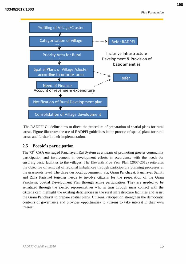
The RADPFI Guideline aims to direct the procedure of preparation of spatial plans for rural
areas. Figure illustrates the use of RADPFI guidelines in the process of spatial plans for rural
areas and further in their implementation.
2.5 People’s participation
The 73rd
CAA envisaged Panchayati Raj System as a means of promoting greater community
participation and involvement in development efforts in accordance with the needs for
ensuring basic facilities to the villages. The Eleventh Five Year Plan (2007-2012) reiterates
the objective of removal of regional imbalances through participatory planning processes at
the grassroots level. The three tier local government, viz, Gram Panchayat, Panchayat Samiti
and Zilla Parishad together needs to involve citizens for the preparation of the Gram
Panchayat Spatial Development Plan through active participation. They are needed to be
sensitized through the elected representatives who in turn through mass contact with the
citizens cam highlight the existing deficiencies in the rural infrastructure facilities and assist
the Gram Panchayat to prepare spatial plans. Citizens Paticipation strengthen the democratic
contents of governance and provides opportunities to citizens to take interest in their own
interest.
Profiling of Village/Cluster
Categorisation of village /Cluster
Priority Area for Rural Development
Inclusive Infrastructure Development & Provision of
basic amenities Spatial Plans of Village /cluster
according to priority area
Need of Finance Account of revenue & expenditure
and source of Funding acc. To 14th
FC Notification of Rural Development plan
by Gram Panchayat
Consolidation of Village development plans into Blocks plans and Block Plans
into District Plans by DPC
Refer RADPFI
Refer RADPFI
43349/2017/1003198

Plan Formulation
RADPFI Guidelines, 2016 16
The participatory process can take many forms. Most commonly it takes forms of
participatory focus groups, facilitated by outside facilitators: NGO staff, Consultants,
researchers.2
2.6 Integrating and Implementation of Rural Planning
State Planning Commission provides support and direction for the preparation of District
Plans. And therefore, it is proposed that the District Planning Commission shall support and
direct the preparation of Gram Panchayat Spatial Development Plans, in accordance with the
overall vision development of Block and District. However, the state and central
involvement shall be limited and Gram Panchayats shall be given required autonomy to plan
according to the indigenous needs and requirements. Key elements of the operational systems
shall be as follows and is further discussed in Chapter 8:
Gram Panchayat shall be in consultation with subject matter specialists, Government
officials, NGOs and other stakeholder(s) determines plan ceiling between various
rural segments or villages within the Gram Panchayats and formulates strategy to
prepare and integrate their plan proposals.
Rural Plans: Each Gram Sabha follows a participatory process with the help of
Technical Support Group (TSG) and government functionaries to come up with a
“vision of development” based on local needs. The Gram Sabha prepares its plan
proposal after consultation with all the stakeholders especially with poor, SC, ST and
women. The recommendations and needs of each group are integrated to prepare the
plan proposal of Gram Panchayat. Similarly, Janpad Panchayat integrates the plan
proposals of all Gram Panchayats including the interventions of Janpad. These are
finally consolidated and integrated at the Block and District level.
The rural and urban plans are submitted to the DPC for consolidation and approval.
The DPC consolidates the plans at the district level with the help of district level TSG.
The consolidated and integrated plan is finalized by DPC after due deliberations. The
DPC is expected to ensure that the integrated District Plan provides clarity on the
roles of various government departments and arrangements for monitoring and
evaluation of the projects. The District Plan is then submitted to the State Planning
Commission
All the line departments are grouped into major key sectors. Further, working groups
are constituted for each sector for preparing proposals keeping in view the needs and
possible inter- and intra-sector convergence.The major sectors are as follows:
– Education: School Education, Technical Education, Skill Education
– Health and Nutrition: Public Health and Family Welfare, Public Health
Education, Women and Child Development, Food and Civil Supplies;
2 Chambers and Mayoux, 2003, Reversing the Paradigm: Quantification and Participatory methods, EDIAIS
Conference, University of Manchester, U.K
43349/2017/1003199

Plan Formulation
RADPFI Guidelines, 2016 17
– Livelihoods: Agriculture, Forest, Panchayat and Rural Development,
Animal Husbandry, Industry, Social Welfare, Water, Fisheries, Handicraft,
Cooperatives, Planning, Backward Classes, Scheduled Castes/Scheduled
Tribes;
– Infrastructure: Public Works, Rural Development, Water, Power,
Planning;
– Energy: Energy, Rural Development, Forest;
– Social Security: Social Justice, Women and Child Development, Revenue,
etc.
All government resources are included and district wise and department wise resource
envelopes are calculated to facilitate the process. Budget is also earmarked separately
for SCs, STs and women.
Plan components are prepared focusing on specific social groups like SCs, STs,
women and children at the level of habitation and then integrated. Gram Panchayat is
the basic unit of planning in rural areas.
2.7 Contents of existing Gram Panchayat Development Plan(GPDP)
The guidelines issued by Ministry of Finance, for the release and utilisation of the
local bodies grant stipulate that proper plans are to be prepared by the gram
panchayats for the basic services within the functions devolved to them as per State
laws before incurring expenditure under the FFC award.
In the context of the Constitutional mandate, these plans have to be participatory plans
involving the community, particularly the gram sabha, in the formulation of priorities
and projects and will also have to ensure the mandates of social justice and economic
development mentioned in Article 243G. The Gram Panchayat Development Plan
(GPDP) will have to have a clear component addressing vulnerabilities of poor and
marginalised people and their livelihood opportunities through an integrated poverty
reduction plan that converges with the labour budgeting and projectisation exercises
under MGNREGS as well.
Various states have prepared Gram Panchayat Development Plan Guidelines for
which would facilitate the coordination of various activities to be undertaken and
arrangements that need to be made for the execution of a time bound action plan for
preparation of Gram Panchayat Development plans.
The contents of GPDP has not been mentioned in the guidelines issued by MoPR and
is left upto the states to give the prescribed format or the contents of GPDP, different
states have given different formats for preparation of Plans, however, broadly they
are as follows:
i. Introduction
ii. Resource Envelop
43349/2017/1003200

Plan Formulation
RADPFI Guidelines, 2016 18
iii. Situation Analysis
iv. Environment Generation
v. Visioning
vi. Prioritization
vii. Technical and Administrative approval
viii. Post Plan arrangements
ix. System support for participatory planning in Gram Panchayat and Capacity
Building
The above contents mentioned only refer to the sectoral development of the villages/Gram
Panchayats but no Spatial reference is made, therefore RADPFI proposes the preparation of
Gram Panchayat Spatial Development Plans. The spatial approach is discussed in next
chapter and the contents are suggested in Chapter 4.
43349/2017/1003201
Spatial Approach to Rural Planning
RADPFI Guidelines, 2016 19
3. SPATIAL APPROACH TO RURAL PLANNING
3.1 Categorisation of villages
In India, the rural areas have no clear definition. Census has given definition of the urban
areas, and all those areas which do not satisfy the parameters of urban are classified as rural
areas. The rural areas or the villages, also have different characteristics according to their
population size, proximity to and dependence on urban centre respectively, topography,
economic activities, social customs and traditional values. There has been attempt by the
Census of India to classify the urban and rural areas according to population size which in
turn also effects in terms of characteristics of the city/town. But no such classification has
been given for the rural areas where the characteristics of rural areas can be categorised and
used for future planning. Hence, this document makes the first attempt to categorise the rural
areas/villages on the basis of following criteria.
3.1.1 Villages with in Planning Area of the delineated Metropolitan area/city/town
The village in the vicinity to the urban centre will be having interdependence with the city,
for the village’s economic activities and growth. The village will not be a typical rural area
with only agricultural activities but may have diversified economic activities (non-farm)
existing. The transitioning in the character of the village is often witnessed and therefore, the
area is termed to be a part of Rural Urban Fringe.
This categorization signifies the villages which exist in the rural urban fringe areas and are
present adjacent to the metropolitan city within the planning area boundary. These villages
may or may not be connected to the city/town, by either a National Highway/State
Highway/Major District Road or Other District road. The categorization can be done on the
basis of such connectivity through the above mentioned transport networks.
Along the national/state highway and within the urbanisable limit of Municipal
Corporation
Not along a national or State highway, but within the urbanisable limit of the
Municipal Corporation.
Character of villages in fringe area
The Urban-Rural Fringe (URF) is the zone of transition in land use, social and demographic
characteristics, lying between (a) the continuously built- up urban and suburban areas of the
central city, and (b) the rural hinterland, characterized by the almost complete absence of
non-farm dwellings, occupations and land use, and of urban and rural social orientation; an
incomplete range and penetration of urban utility services; uncoordinated zoning or planning
regulations; areal extension beyond although contiguous with the political boundary of the
central city; and an actual and potential increase in population density, with the current
density above that of surrounding rural districts but lower than the central city. These
43349/2017/1003202

Spatial Approach to Rural Planning
RADPFI Guidelines, 2016 20
characteristics may differ both in zonal and sectoral way, and can be modified through time
(Pryor, 1968). 3
74th CAA defines “a transitional area”, “a smaller urban area” or “a larger urban area”:
meaning such area as the governor may, having regard to the population of the area, the
density of the population therein, the revenue generated for local administration, the
percentage of employment in non-agricultural activities, the economic importance or such
other factors as he may deem fit, specify by public notification for the purposes of this part.
The 74th CAA, mentions about the Transition areas where Nagar Panchayat would be the
ULB to provide for the development for areas in transition from a rural area to urban area.
URDPFI Guidelines, 2014, gives definition of peri urban area as zone which is within the
planning limits but outside the urbanisation limit of the municipal corporation/authority or
metropolitan planning committee or authority. URDPFI suggests planning for integration of
plans of such settlements through two approaches:
The plans can be prepared by the developmental body in consultation with the village
authority and implemented jointly by the village authority or developmental body,
Village bodies may prepare the plan and such plans will be compiled and made part of
overall developmental plan of the region by developmental body.
3.1.2 Villages adjacent to corridor development
“Economic Corridors” connect economic region along a defined geography. They do not
stand alone, as their role in regional economic development can be comprehended only in
terms of the network effects that they induce (Asian Development Bank, 2013). The impact
on the cities and the villages lying adjacent to the economic corridors, have tremendous
influence on the cities/towns as well as villages, in terms of land prices foremost. Surge in
Land prices is the indirect impact arising from the anticipated landuse arising in the future.
The economic activity in the villages adjoining an economic corridor is diversified as well.
The anticipated industrial and economic growth along the corridor gives opportunities to the
adjacent urban and rural areas to participate in the economic development. The
transformation of villages is initiated with the future anticipated economic growth. The case
study of Delhi Mumbai Industrial Corridor (DMIC) and the villages falling adjacent to this
corridor can be taken as interesting exemplar to establish the changes which have been taken
in the villages. DMIC will cover the development of 1540 km long Western Dedicated
Freight Corridor with 24 nodes or investment regions/industrial areas, across seven states.
The villages near to industrial areas have their interdependency with the industry in terms of
provision of employment and provision of raw materials. The industrial development, in turns
leads to income generation for the labour. Therefore, the villages near industrial cities have
peculiar characteristics regarding work culture and economic activities in the villages. The
industrial city will act as a pull factor for labour to migrate from rural areas of backward
districts which will further lead to urbanization and economic development of the city. If
planned well, the villages near these urban centers may experience huge amount of trickle-
3 Pryor, R.J, 1968, Defining the Rural-Urban Fringe, Social Forces, Vol.47, No.2, pp-202-215
43349/2017/1003203

Spatial Approach to Rural Planning
RADPFI Guidelines, 2016 21
down effect rather than only experiencing backwash effect and acting as a provider for the
cities.
Villages near industrial city should have following criteria:
Direct connectivity to the industrial region
People commuting from the village to the city for daily work in industry.
Atleast more than 50% of village population depended on industry in the city, either
through employment or by provision of raw material.
Villages near investment regions tend to fall in the category of fast transforming villages,
which is because of new land use activities coming in near future. Specialised investment in
the region leads to differential characterisation and degree of development in the villages,
which requires spatial plans for planned development in the region.
Apart from the corridor development, a city with active tourism opportunities provides
employment opportunities to local population and people residing in nearby villages. The
employment generation in the villages due to tourism activities in the city has to be highly
recognized. Moreover, the villages can also serve as a centre for village tourism and can
generate its own income. The provision for services/ infrastructure has to be given
accordingly. A village development plan has to address the spatial development in
accordance with the economic activities present.
Any village depended on tourist city centre shall have following basis:
Atleast more than 50% of population engaged in tertiary activities based on tourism in
the city.
People commuting from village to city for daily work.
Villages being on the way of the existing tourism circuit, if any.
3.1.3 Villages in the interior
The rural areas which are purely depended on agriculture and allied activities or fishing and
mining & quarrying activities should have spatial plans which are having potential to develop
such activities and mentions the basic requirements for betterment of quality of life of
individual, to mitigate the outward migration to urban areas. The villages with such socio
economic characteristics are defined as pure rural areas isolated from the urban centers with
specialized activities as per the geographic suitability of the area/region. The basis of
qualifying to such categorization for village shall be:
More than 75% of population depended on primary activity
Isolation from urban areas in terms of distance and accessibility.
Since the physiographical conditions of the region holds significance in such classifications,
the villages with small population size, with geographical contiguity can also be considered
as a Cluster of villages, which would address integrated economic and spatial development in
the villages.
43349/2017/1003204
Spatial Approach to Rural Planning
RADPFI Guidelines, 2016 22
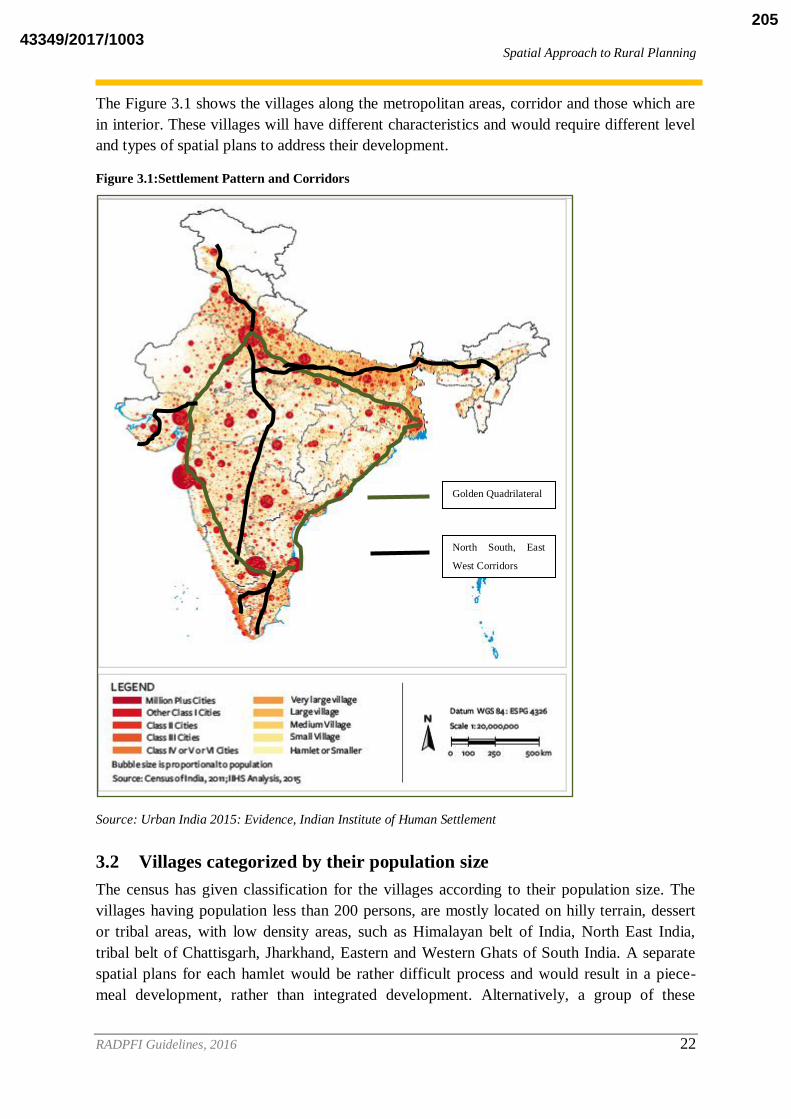
The Figure 3.1 shows the villages along the metropolitan areas, corridor and those which are
in interior. These villages will have different characteristics and would require different level
and types of spatial plans to address their development.
Figure 3.1:Settlement Pattern and Corridors
Source: Urban India 2015: Evidence, Indian Institute of Human Settlement
3.2 Villages categorized by their population size
The census has given classification for the villages according to their population size. The
villages having population less than 200 persons, are mostly located on hilly terrain, dessert
or tribal areas, with low density areas, such as Himalayan belt of India, North East India,
tribal belt of Chattisgarh, Jharkhand, Eastern and Western Ghats of South India. A separate
spatial plans for each hamlet would be rather difficult process and would result in a piece-
meal development, rather than integrated development. Alternatively, a group of these
Golden Quadrilateral
North South, East
West Corridors
43349/2017/1003205

Spatial Approach to Rural Planning
RADPFI Guidelines, 2016 23
hamlets with proper connectivity, can be treated as an integrated cluster. Also, the socio
economic characteristics of the villages will have to be determined, while making spatial
plans for cluster of such villages. The most critical aspect would be the connectivity and the
sharing of resources amongst the villages for formation of such cluster. In case of villages
with small population size and with spatial contiguity clusters could be formed by identifying
contiguous villages/gram panchayats within a radius of 5–10 km (or radius appropriate to the
population density and geography of the region) around the identified growth center. The
criteria for selection of cluster can be same as given by RURBAN guidelines for selection
procedure.
Selection criteria gives due weightage to rural demography, growth in non farm work force,
presence of clusters, tourism and pilgrimage significance, proximity to transport corridors.
The Integrated Cluster Action Plan methodology takes due cognizance of Tribal districts
and follows distinct approaches for Tribal and Non Tribal districts. The ICAP addresses the
rural development in the clusters comprising small villages. The ICAP mentions the desired
level of benchmark for :
Basic amenities
Social amenities
Economic amenities, and
Digital amenities
The categorisation of villages as per Census 2011, explains the fact that 58.33% of the
villages have population between 1000-5000 and are ideal for preparation of Gram Panchayat
Spatial Development Plan. (Table 3.1) However, the villages having more than 5,000
population, the Spatial Development Plan can be prepared on the basis of URDPFI
guidelines,2014. The villages which are less than 1000 population would also be considered
for planned development which shall depend on their location, physiographic conditions and
connectivity.
43349/2017/1003206

Spatial Approach to Rural Planning
RADPFI Guidelines, 2016 24
43349/2017/1003207

Spatial Approach to Rural Planning
RADPFI Guidelines, 2016 25
Table 3.1: Categorisation of villages according to population size
Class Size Population
Size
Total
Villages
Total
Population
% of rural
population
Average
population
Remarks
Class I 10000+ 4,682 7,23,66,805 8.68 15456 1. Large villages which
are likely to be urban in
future, if near
metropolitan areas.
2. Large villages which
may be purely depended
on flourishihng
agricultural or other
primary activities.
Class II 5000-9999 18,641 12,38,08,537 14.85 6642 1. Villages which are
having population next
to Class I village, and would also be urban, if
near metropolitan areas.
Class III 2000-4999 96,388 28,86,37,987 34.63 2995 1. Medium sized
villages which can be
grouped together to form
a cluster, if have
geographical contiguity.
Class IV 1000-1999 1,39,136 19,74,96,806 23.70 1419
Class V 500-999 1,41,761 1,032,91,220 12.39 729
1. Small sized villages
where cluster plans
would be feasible.
Class VI 200-499 1,14,726 39,68,3027 4.76 346
Class VII Less than
200
82,149 81,79,066 0.98 100 Isolated hamlet, where
villages are located on
hilly terrain, dessert or
tribal areas, and spatial
plans shall be based on
connectivity and sharing
of resources.
Uninhabited 43,384 - -
Total 6,40,867 83,34,63,448 100.00
Source: Census of India,2011
3.3 Classification of Gram Panchayat
DATA FROM NIRD&&PR
3.4 Need for categorising the villages
The unplanned development spurting up near the urban centers in the extended
abadi area of the village, giving rise to unauthorized development, which has to
be later regularized and retrofitted into planned development.
The interdependency existing between the villages and the metro cities, makes it
important to plan the villages for the provision of services and infrastructure.
43349/2017/1003208

Spatial Approach to Rural Planning
RADPFI Guidelines, 2016 26
The plan for the rural land in vicinity to urban centre holds importance because of
the anticipated spatial expansion of the urban area.
The connectivity of the villages to the nearby metro city, leads to rising real estate
prices leading to new non-farm activities coming in the villages, for which
infrastructural services are required.
The planning of the activities to be permitted in the fast transforming villages
needs to be decided, for making a sustainable environment in the village.
43349/2017/1003209

Content of Gram Panchayat Spatial Development Plan
RADPFI Guidelines, 2016 27
4. CONTENTS OF GRAM PANCHAYAT SPATIAL
DEVELOPMENT PLAN
4.1 Introduction
Planning exercise at Gram Panchayat level is complex because of the socio economic
hindrances which exists at the rural level. The GPSDP should follow an overall common
vision for the district. Because, plans prepared at these levels must be compiled at higher
administrative units. Use of cadastral maps at village area planning level is important and the
revenue department which is custodian of cadastral maps has to play the critical role in
providing, reliable and authentic land data base.
With the enforcement of respective amended town and country planning acts, the state
governments would thereby be empowered to prepare GPSDP.
Lower literacy levels in rural areas can be a hindrance to the planning process or can result in
faulty planning or social-economic bias. The State governments can provide technical
assistance/knowhow to village Panchayats. States can have a better Planning functioning
reciprocated by healthy indicators on basic parameters at grass root level, such as :
Literacy,
Women’s participation in decision making, women empowerment,
Handling of development funds as in past records,
Transparency in funds handling,
Inclusion of vulnerable groups and youth in decision making
Therefore, the contents of the plan shall be accordingly included in the GPSDP to address the
overall development of the villages. A sample plan of Chandrapur District and an
international case study is given in the annexure for reference. (Annexure 2)
4.2 Contents of the Plan
The Gram Panchayat Spatial Development Plan (GPSDP) shall be prepared in accordance
with the RADPFI guidelines. Therefore, the contents of the GPSDP are discussed in the
chapter to guide the Panchayats in the direction of rural spatial planning.
4.2.1 Analysis of Existing Scenario
I. Regional setting
The following locational attributes shall be considered in planning exercise:
a) Location of the panchayat in absolute terms of latitude and longitude; also
distance and direction from other established points;
b) Nodal significance of the village/panchayat in the national or regional
infrastructure of transport and communication, power, and in an agricultural
area, irrigation network, agricultural extension services, agricultural produce
collection and distribution centre, agro-industries linked to local markets;
c) Status that the panchayat/village occupied in the rural hierarchy involved;
d) Role and status of the village/panchayat in the rural delivery systems of social
services;
43349/2017/1003210

Content of Gram Panchayat Spatial Development Plan
RADPFI Guidelines, 2016 28
e) Relative significance of locations of village/panachayat in proximity to a
metropolis/megapolis:
i. Nodal significance
ii. Presence of high productive economic activities
iii. Presence of large scale market
The following site attributes shall be studied for taking up a planning exercise:
a) Conditions of site: low-lying, swamp, or dry land, ridge; on a river bank or
canal side. Within the Block/district- flat, sloping (in which direction),
undulating-gentle slope, moderate slope, steep slope.
b) Value and importance of the site; and its historical past, that is, when the
nucleus was established.
c) Analyse the factors responsible for determining the site:
i. In alluvial plains
ii. In hilly and mountainous regions
iii. In arid regions
iv. In the areas of territorial ruler ship
v. In the areas around some localised physical resources, mining
settlements, manufacturing
vi. towns, resort towns
vii. Around large metropolises
d) Climate and its influence on daily life, on building the homes, the range of
crops a panchayat can produce; and how the panchayat/rural activities have
modified the natural climate, particularly in the built-up area.
e) Nearness/proximity to the core or urban centre.
II. Human Resource
a) Shall include the analysis of population characteristics.
b) The chapter should include the size, territorial distribution, and composition of
population, changes therein, and the components of such changes.
c) The important data such as migration, population growth, population distribution,
age sex population distribution, sex ratio, households characteristics shall be
included in the chapter.
d) Skill assessment data under skill development programme.
e) Ward level data (Now few villages also have wards)
f) SECC (Socio economic Caste census) data, provides village wise caste and socio
economic data.
III. Land Use and Land Management (Village level)
Land use planning of rural areas shall be in accordance with the categorisation
mentioned in the chapter 5th. The chapter shall give information regarding the
activities carried out in the abadi and agricultural area of the villages. It will also give
information regarding existing services, living conditions and available land resource
for further development of various activities. The rural area often has mixed land use
43349/2017/1003211

Content of Gram Panchayat Spatial Development Plan
RADPFI Guidelines, 2016 29
in abadi area, and the clear cut demarcation is not possible, therefore principle of
zonation may not be applied in various villages, especially small villages in the
interior. The Gram Panchayat is liable to modify the land use zones given in table 5.1
accordingly and formulate the land use plan. It is the onus of Gram Panchayat to
restrict and prohibit activities which pollute the land, water and air resources in the
local area, in the proposal.
The land management in the rural areas shall discuss the availability of land as a
resource for raising revenue or for infrastructural development. It shall restrict the
unplanned development near the metropolitan areas which often arises in the extended
abadi areas of the villages.
IV. Economic Base: Primary, Secondary, Tertiary (if any)
The economic base of the village is largely primary. However, a village may depend
on other activities as well depending on its connectivity, infrastructure, socio-
economic status and regional setting. This chapter shall include the details of each
economic activities in the villages, especially the one on which the village depends.
In case of primary activities the details such as workforce, employment, productivity,
cost incurred, market activities, government assistance, landholding size, landholding
ownership, techniques used in production, Net sown area, Gross sown area, irrigation
details, storage information shall be given. The details can be referred in Chapter 5th.
V. Infrastructure: Social, Physical and Economic.
The plan shall analyse the available infrastructure in the villages and the population
and area served by the existing services. The analysis carried in the chapter aims to
bring out the requirements of infrastructural services and basic amenities in rural
areas.
a) Physical- Deals with housing (Census data), Roads, Drainage,
b) Social – Deals with Health, Education and Community Centres
c) Economic- Deals with Milk collection centre, Godowns, Market Yards, Wholesale
(Location and site)
VI. Disaster and Climate Resilience
The rural areas are the ecological backbone of a region and hence shall be given
special attention to conserve the environmental resources. This chapter shall discuss
the vulnerability of rural areas to various disasters. Hazards in the rural areas turns
into a disaster easily, since these areas are given no attention and hence GPSDP shall
dedicate a chapter to the issue stating the possible solution to the proneness of the
villages to any hazard such as floods, fire, drought, earthquake etc. and suggest both
pre and post disaster mitigation measures. The traditional methods and techniques to
conserve the resources which are environment friendly shall also be included in the
chapter. The building typology and the agricultural activities affecting environment
43349/2017/1003212

Content of Gram Panchayat Spatial Development Plan
RADPFI Guidelines, 2016 30
can be discussed along with the waste disposal and solid waste management issues
and solution to build a climate resilient village.
The above mentioned aspects are area specific, however, synchronisation with the
District Disaster Plan should be carried out in the Proposals and copy shall be
forwarded to District office. The integration of Disaster Plan with the District Disaster
Plan should be followed in the GPSDP and government agencies shall ensure the
same.
VII. Resources and Potential
The villages or panchayats have Common Property Resources which belongs to the
Panchayat, the GPSDP should mention the location and extent of all such resources
along with their usage and potential that they carry for the development of rural areas.
The forest area, River body, Land as a resource should be mentioned as per their
extent on map and in table (area, usage, population depended)
VIII. Local level Governance: Common Issues and Potentials
This chapter on governance may include the present institutional framework of the
panchayat, its functions performed as per 73rd
CAA, its existing members, their term,
various departments involved in planning of the panchayat, allocation of funds and
budget preparation of panchayat.
The exercise of people’s participation and decentralisation of powers and funds can be
discussed in this section along with community participation in plan preparation
stating the issues and potential in the existing form of governance of Panchayat.
Existing convergence and future convergence shall be discussed.
IX. Resource Mobilisation Options
This chapter will include the options offered by the panchayat for raising its revenue
from the resources owned by Panchayat.
X. Convergence of Central/State funded Schemes and Projects
The existing central and state rural schemes for housing, infrastructure, employment,
social assistance, and rural development allocates certain budget for various sectors in
rural areas, such schemes shall be acknowledged and realised while planning the rural
areas, especially during the requirement of financial assistance. This chapter should
mention the budget received from the existing schemes of government; and study
implementation, reviewing, monitoring and effectiveness of such schemes. The
transfer of funds is guided by the recommendations of the 14th
Finance Commission.
XI. Special Needs of Gram Panchayat
This chapter shall solely include the needs of the Gram Panchayat in present and in
future (for 10 years), depending on the calculated population projections, using
current trends of population growth and economic activities to be induced (if any).
43349/2017/1003213

Content of Gram Panchayat Spatial Development Plan
RADPFI Guidelines, 2016 31
XII. Conservation Areas
Tousrism, activities, handicrafts and culturally important areas shall be given
special emphasis on and shall be planned accordingly.
XIII. Vision of the Gram Panchayat
For instance the following are some of the vision, mentioned in the GPDPs,
however, they can be varied depending on the collective aspirations of the villages.
– Open defecation-free Panchayat
– Safe drinking water available to all households of GP
– Destitute free GP
– GP where all habitations are connected through all-weather road
– Child labour-free GP
– Forced migration-free GP
– Trafficking free-GP
– 100% Anganwadi enrolment GP
– 100% school enrolment GP
– 100% child and mothers are covered through immunization GP
– Malnutrition-free GP
– Infant death-free GP
– Maternal death-free GP
– Complete NSAP coverage GP
– Home for all-GP
– Clean and green GP
4.2.2 Projections
I. Population
Projected population should be guided by trends in rural population growth of
panchayat, migration, economic activities induced or dispersal of economic activities.
II. Economic Base and Employment
Hierarchy of commercial centres, dispersal of commercial activities, any specialised
economic activities of the villages, workforce, dependency on primary activities,
production, potential of any other activity.
III. Shelter
Housing needs and requirements according to population projected.
IV. Transportation
Travel demand, forecast, road length, hierarchy of roads, transport terminals.
V. Infrastructure
Need of infrastructural services according to the projected population.
VI. Land use requirement for various activities proposed or needed
43349/2017/1003214

Content of Gram Panchayat Spatial Development Plan
RADPFI Guidelines, 2016 32
4.2.3 Strategies and Proposal
This chapter will include the strategies and vision of Panchayat in accordance with the district
vision. The proposal shall be described spatially along with the budget required and source of
funding.
43349/2017/1003215

Rural Infrastructure Planning: Land use, Norms and Standards
RADPFI Guidelines, 2016 33
5. RURAL INFRASTRUCTURE PLANNING: LANDUSE,
NORMS AND STANDARDS
5.1 Introduction
The vision of RADPFI guidelines is to bring parity in terms of planned development amongst
all settlements, whether rural or urban. Therefore, the need for planned development holds
importance for rural settlements as well. The preparation of spatial plans shall depend on the
prescription on norms and standards for the provisioning of infrastructure facilities. The
chapter has attempted to prescribe norms and standards based on which proposals can be
drawn. However, no guidelines have been prepared yet for dealing with spatial provision of
services or management of land for rural areas.
Rurban Mission, launched by the Ministry of Rural Development addresses the need and
urgency for provision of urban services to rural areas. However, if mission accomplishes,
there are high chances and possibilities for land speculation leading to growing unauthorised
activities in the periphery of the settlements. Thus, there is need for regulating such activities
in rural areas, and hence norms and standards are required for activities permitted in under
various uses in rural areas.
.However, the existing conditions do not seem to be much favourable, considering the
diversity of Indian villages. The RURBAN mission and the Integrated Cluster Action
Programme (ICAP) aims to bring service parity in rural areas and thereby foresee planned
development of cluster of villages. Therefore, it becomes imperative to have development
guidelines with a pragmatic vision for rural areas where people actively participate in the
process of community development. The RADPFI guidelines answers the questions:
– What are the principles while planning and designing future settlements in rural areas
and upgrading existing ones?
– What are key elements of sustainability?
– What futuristic changes do we have to prepare for?
– What lessons can be learnt from past?
5.2 Landuse for Rural Areas
Land and land use are essentially State subjects. The increasing urbanisation has put
tremendous pressure on the land to be put for urban uses. As per Census 2011, the total area
under the cities has increased from 77,370 sq. kms. to 1,02,220.59 sq.km. in 2011 thereby
signifying increase of areas under cities and towns by 32.1 percent during 2001-11. In order
to prevent unwarranted conversion of rich agricultural land to urban uses, it becomes
essential to prescribe landuse norms and activities permissible for the rural areas.
Proper planning of land and its resources allows for rational and sustainable use of land
catering to various needs, including social, economic, developmental and environmental
needs. Proper land use planning based on sound scientific, and technical procedures, and land
utilisation strategies, supported by participatory approaches empowers people to make
43349/2017/1003216

Rural Infrastructure Planning: Land use, Norms and Standards
RADPFI Guidelines, 2016 34
decisions on how to appropriately allocate and utilize land and its resources comprehensively
and consistently catering to the present and future demands. There is a need for scientific,
aesthetic and orderly disposition of land resources, facilities and services with a view to
securing the physical, economic and social efficiency, health and well-being of communities.
The land use prescription shall form the internal component of the Spatial Development Plan.
Further, how the landuses are to be regulated within the Gram Panchayat and at the fringe of
villages become crucial aspect. This is backed by the fact that rural areas also needs to ensure
adequate food security and hence rich fertile land need not be converted into non agricultural
uses.
The table 5.1 provides break up of landuse categories for both built up and non built up areas.
Table 5.1: Landuse for rural areas
Built up
Area
Use category Activities Permitted
Residential Residences*
Commercial/Economic Retail shopping
Informal Shop
Daily market, weekly, informal , regulated and specialised markets
Godowns, Storage grounds
Industry Service and Light industry(MSMEs,
Household industries, agrobased industries, khadi industries, cottage industry, industries
depended on indigenous raw materials and art
and craft.) Location of SEZ and Big Industries.
Educational School
Anganwadis
Training Centres
Vocational Institute
College
Skill development institute/Organisation
Health Services Subcentre/PHC/CHC
Dispensary
Pvt. Clinic
Vetrinary Hospital/Clinic
Hospitals
Utilities and Services Bank
ATM
Credit Society
Police thana
Cremation ground/Burial ground/Crematorium
Community Hall
Dharamshala
Public Toilet
Social Welfare Centre
Special Area Temple
Heritage area
Scenic Value Area
Government Restricted Areas
Recreational Playgrounds
43349/2017/1003217

Rural Infrastructure Planning: Land use, Norms and Standards
RADPFI Guidelines, 2016 35
Garden
Chaupal
Public open space
Transportation &Communication
NH/SH/MDR/ODR/VR
Village access roads
Railways
Bypass
Bus stand/ Railway station/Integrated Customs
Non-
Built Up
Area
Area under non-agricultural use
Barren and Un-
Culturable use
Permanent Pasture and
other Grazing land
Land under
miscellaneous tree crops
Agricultural land/ cultivable land/ culturable
land
Culturable Waste Land Agricultural land/ cultivable land/ culturable
land Fallow land other than
Current Fallows
Current Fallows
Net Sown Area
*The villages often, do not have, clear cut demarcated zones, For instance, there may be a household
serving as a residence and a shop and a micro scale household cottage industry, therefore, Gram
Panchayat may modify the land use zones according to the local situation. However, each Gram
Panchayat shall mention about the restricted/prohibited activities which pollute the air, water and land
resources in the local area and should mention in the landuse plan. Also, the socio cultural
environment of the community in the village should be considered while preparing the landuse plan.
For instance, the villages where tribal communities are dependent on indigenous resources the plan
shall consider landuse plan accordingly.
5.3 Norms and Standards
Norms and Standards for Infrastructure provision and construction activities are essential to
promote development of amenities as well as sustainable built up environment for human
habitation.
The standards for building construction and infrastructural allocations have been prescribed
by National Building Code of Bureau of Indian Standards, Indian Road Congress etc, in
various sectors of infrastructure construction and development.
There have been standards and norms in existence and enforced to a certain extent by the
relevant statutory authorities in urban areas but compliance to the same in rural areas is
virtually non-existent. Hence the construction activities in rural areas are by and large
unregulated resulting in organic growth which is characterised by haphazard development
and access to basic facilities remains a big challenge in rural areas.
The formulation of norms and standards has to be in congruence to a sustainable land
utilization plan.
43349/2017/1003218

Rural Infrastructure Planning: Land use, Norms and Standards
RADPFI Guidelines, 2016 36
In the upcoming scenarios of seeding and expansion of urban development or processes of
urbanization in the urban regional hinterlands, a set of norms and guidelines to regulate and
moderate development activity in rural areas become nevertheless important.
5.3.1 Habitat Planning in Rural Areas
While planning for housing in rural settlements the following factors shall be taken into
consideration:
Ecosystem and Biodiversity.
Topography with its direct effect on climate, likelihood of natural disasters, natural
drainage, etc.
Identity of the place rooted in its culture and heritage.
Nearness and connectivity with nearby urban centres.
Occupation related requirements.
Water and Waste management.
Land records and Land tenure.
Site selected shall be conveniently approachable and suitably developed and shall not
be subjected to water logging/flooding.
Facilities like branch of co-operative bank, a fertilizer depot, a veterinary hospital,
market place and a branch of the co-operative consumer store besides facilities for
educational and health care should be available within a maximum distance of 5 km
from any settlement.
Proposed Road Hierarchy
5.3.1.1 Norms for Low Income Housing development.
Plot size : 80 m2, Minimum
Density (Gross) : 60 plots per hectare, Maximum
Minimum frontage : 6 m
Ground coverage : 33percent (subject top a maximum of 50 percent)
Floor area ratio (FAR) : 2, Maximum
Open spaces : 1.21 hectare open space for a village with 200 houses.
(Source: National Building Code, Doc: CED 46 (8064)WC, Nov 2015)
43349/2017/1003219
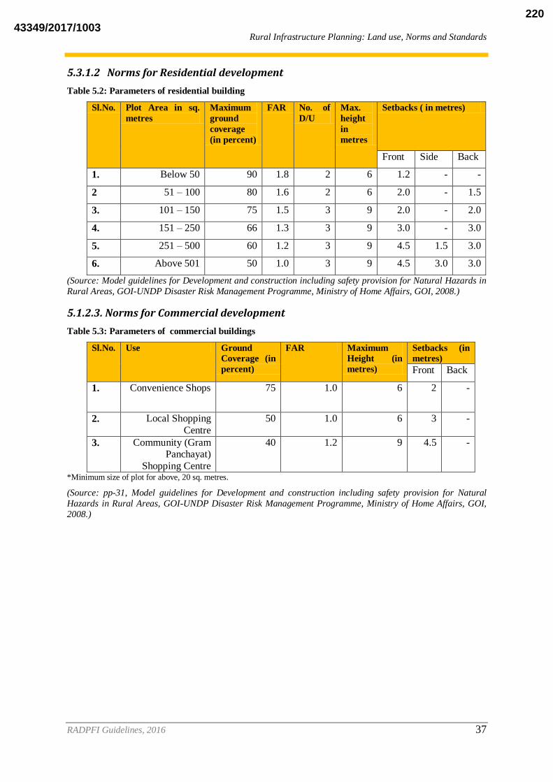
Rural Infrastructure Planning: Land use, Norms and Standards
RADPFI Guidelines, 2016 37
5.3.1.2 Norms for Residential development
Table 5.2: Parameters of residential building
Sl.No. Plot Area in sq.
metres
Maximum
ground
coverage
(in percent)
FAR No. of
D/U
Max.
height
in
metres
Setbacks ( in metres)
Front Side Back
1. Below 50 90 1.8 2 6 1.2 - -
2 51 – 100 80 1.6 2 6 2.0 - 1.5
3. 101 – 150 75 1.5 3 9 2.0 - 2.0
4. 151 – 250 66 1.3 3 9 3.0 - 3.0
5. 251 – 500 60 1.2 3 9 4.5 1.5 3.0
6. Above 501 50 1.0 3 9 4.5 3.0 3.0
(Source: Model guidelines for Development and construction including safety provision for Natural Hazards in
Rural Areas, GOI-UNDP Disaster Risk Management Programme, Ministry of Home Affairs, GOI, 2008.)
5.1.2.3. Norms for Commercial development
Table 5.3: Parameters of commercial buildings
Sl.No. Use Ground
Coverage (in
percent)
FAR Maximum
Height (in
metres)
Setbacks (in
metres)
Front Back
1. Convenience Shops 75 1.0 6 2 -
2. Local Shopping
Centre
50 1.0 6 3 -
3. Community (Gram Panchayat)
Shopping Centre
40 1.2 9 4.5 -
*Minimum size of plot for above, 20 sq. metres.
(Source: pp-31, Model guidelines for Development and construction including safety provision for Natural
Hazards in Rural Areas, GOI-UNDP Disaster Risk Management Programme, Ministry of Home Affairs, GOI,
2008.)
43349/2017/1003220

Rural Infrastructure Planning: Land use, Norms and Standards
RADPFI Guidelines, 2016 38
5.3.1.3 Norms for Industrial Use (Resource based cottage Industries, non polluting industries and Non hazardous industries except those permitted by the
State/UTs)
Table 5.4: Parameters of industrial buildings
Sl.
No.
Plot Size (in sq.
metres)
Ground
Coverage
(in percent)
FAR Height Setbacks (in metres)
Front Side Back
1. 100-400 60 1.2 8 3 - 3
2. 400-1000 55 1.1 8 4.5 - 3
3. 100-4000 50 1.0 8 6 3 3
4. Above 4000 45 0.9 8 9 3 4.5
(Source: pp-31,Model guidelines for Development and construction including safety provision for Natural
Hazards in Rural Areas, GOI-UNDP Disaster Risk Management Programme, Ministry of Home Affairs, GOI,
2008.)
5.3.1.4 Institutional and Community Facilities
Table 5.5: Parameters of institutional and community buildings
Sl.
No.
Plot Size (in sq.
metres)
Ground
Coverage
(in percent)
FAR Height Setbacks (in metres)
Front Side Back
1. 500-1500 40 1.2 9 4.5 3 3
2. 1001-2000 33 1.0 9 4.5 3 4.5
3. 2001-4000 30 0.9 9 6 3 4.5
4. Above 4001 25 0.9 12 9 3 6
(Source: Adapted from Model guidelines for Development and construction including safety provision for
Natural Hazards in Rural Areas, GOI-UNDP Disaster Risk Management Programme, Ministry of Home Affairs,
GOI, 2008.)
43349/2017/1003221

Rural Infrastructure Planning: Land use, Norms and Standards
RADPFI Guidelines, 2016 39
5.3.1.5 Parking Norms
The following Equivalent Car parking space (ECS) or Equivalent Vehicle parking space
(EVS) should be provided:
Table 5.6: Parking Norms
Sl.
No.
Use No. of ECS/EVS
1. Residential 1 EVS for 100-200 sq. metre
plot
1 ECS and 1 EVS for plots more than 201 sq metres.
2. Multi Family Residential 1 ECS for 75-100 sq metre
built up area and 1.25 for more
than 101 sq. metre built up area.
3. Motel 1 ECS for every room
4. Wholesale Mandi, Godown and Cold Storage 2 EVS for 550 cu. Metre
storage, 2 ECS for 100 sq metres built up area.
5. Offices, Conference Hall, Banquet Hall 2 ECS for 100 sq. metre built
up area
6. Educational 1 ECS for 100 sq m built up area.
7. Industrial 1 EVS,0.5 ECS for 100 sq.
metre built up area. *ECS stands for Equivalent car space which is 23sq.metres, if provided in open.
** EVS stands for Equivalent Vehicle Space, which is a more neutral term for the type of vehicle it proposes for parking. It
is an inclusive term for Light Commercial Vehicle and tractors with trailors and non-motorised vehicles like Bullock Carts.
The recommended space requirement for EVS in open is, 35 sq.metres.
(Source: Adapted from Model guidelines for Development and construction including safety provision for Natural
Hazards in Rural Areas, GOI-UNDP Disaster Risk Management Programme, Ministry of Home Affairs, GOI,
2008.)
5.3.2 Road Infrastructure
Rural Connectivity is a key component of Rural Development in India. Rural roads contribute
significantly to generating increased agricultural incomes and productive employment
opportunities, alongside promoting access to economic and social services. Rural Roads are
the virtual lifelines for the vast multitude residing in rural areas. However, even today, only
about 60% of villages/ Habitations in the country are connected by roads.4
A Road Network in a Block or District comprises of all categories of roads, such as National
Highways, State Highways, Major District Roads, Other District Roads and Village roads,
which facilitate the essential movement of persons and goods in an area.
The Road system in India has been classified by the Indian Roads Congress into three
categories. These are as follows:
i. Primary Road System- Expressways and National Highways (NH)
4 http://pmgsy.nic.in/pmg61.asp
43349/2017/1003222

Rural Infrastructure Planning: Land use, Norms and Standards
RADPFI Guidelines, 2016 40
ii. Secondary Road System- State Highways (SH) and Major District Roads
(MDR)
iii. Tertiary System or Rural Roads- Other District Roads (ODR) and Village
Roads (VR)5 .
The rural roads in India are commonly referred to:
(i) Other District Roads (ODR)
(ii) Village Roads (VR)
Other district roads are the roads serving rural area of production and providing them with
outlet to market centres, taluka/tehsil headquarters, block development headquarters or major
district roads, and would serve to connect villages with population 1000 and above or cluster
of villages. Village roads are roads connecting villages or cluster/group of villages with each
other and to the nearest road of a higher category. These two categories of roads are proposed
to be called together as 'rural roads' with uniform standards.
The following table gives the minimum road widths for Village Roads. For further
information on the norms and design specifications Indian Road Congress’ Rural Roads
Manual,2002 can be referred.
Table 5.7: Norms for Village Roads
Village
Road
type
Road Description Minimum
Road Width
(in metres)
Functions /remarks
R1 Link Roads 6 m Inter village , ODR, highways connectors.
R2 Major Through Roads 7.5 m Main village roads with drain on
both sides to facilitate drainage
system of the village
R3 Minor Through roads 4.5 m Other village roads
R4 Minor Through Lanes 3.75 m Village lanes (Source: Draft National Building Code, Doc: CED 46 (8064) WC, Nov 2015; Rural Roads Manual, 2002,
Indian Road Congress)
5.3.2.1 Control of building activities along Highways and roads
In order to regulate and control building activities along National Highways, State Highways,
Major District roads and major urban roads as notified by – PWD, the persons responsible for
carrying out excavation, earth work, construction, demolition or repairs to all sites within 100
m. from these roads shall apply to the Panchayat concerned for permission to carry out such
work in accordance with the set back mentioned here below, subject to NOC from
PWD/NHAI, where ever applicable.
Table 5.8: Setbacks for building types
5 ibid
43349/2017/1003223

Rural Infrastructure Planning: Land use, Norms and Standards
RADPFI Guidelines, 2016 41
Type of
Building
Activity
National Highway
or State Highway
Major District
Roads
Village Roads (All
sub categories)
Theatres,
Industrial
Units etc.,
Major
Commercial
Establishments
8 metre front setback 5 metre 3 metre
Residential 5 metre front setback 3 metre 3 metre
Institutional 8 metre front setback 5 metre 5 metre
(Source:pp-35,Model guidelines for Development and construction including safety provision for Natural
Hazards in Rural Areas, GOI-UNDP Disaster Risk Management Programme, Ministry of Home Affairs, GOI,
2008.)
5.3.3 Social Facilities
The social infrastructure component includes health and education services for the
population. The norms for setting up schools and health centre is given below. For the
villages of categories III to VII the provision of infrastructure can follow a cluster approach
wherein the settlements have a common centrally located facility. The norms for hilly tribal
and difficult areas can be set for at a lower threshold as per the respective state government
policy.
Table 5.9: Norms for Educational/health/public utility Facilities
Use Standard/Population Area (in hectares) Distance from
Habitation
a) Primary School 1 for 5000 0.4 to .6 ha Within 500
metres
b)High School with
Primary School
1 for 15000 1 ha Within 1km
c)Dispensary/Health
Centre
1 for 5000 .05 ha Within 500
metres
d) Community Hall 1 for 5000 .05 ha Within 1 km
e) Aanganwadi 1 for 5000 .05 ha Within 500
metres
( UNDP Disaster Risk Management Programme Ministry of Home Affairs, Govt. of India , 2008) The distance
norms as well as population norms can be relaxed in case of hill areas/desert areas with low population
densities/concentration.
43349/2017/1003224

Rural Infrastructure Planning: Land use, Norms and Standards
RADPFI Guidelines, 2016 42
5.3.3.1 Site Specific Norms for Education and Health Facilities
Table 5.10: Plot Size, Ground Coverage, FAR, Height and Setbacks
Sl.
No.
Use Minimum
Plot Size
(in sq.
metres)
Ground
Coverage
(in
percent)
FAR Height Setbacks (in metres)
Front Side Back
1. Nursery
School/Anganwadi
5000-1500 33.3 1.0 10 4.5 3 3
2. Primary School 1500-3000 30 0.9 10 6 3 6
3. Senior Secondary 4000-
10000
25 1.0 12.5 9 4.5 6
4. Nursing Home, 250 35 0.7 6 3 - 3
5. Dispensary 251-500 33.3 1.0 9 4.5 3 3
6. Diagnostic centre Above
501
30 1.0 12 6 3 4.5
( UNDP Disaster Risk Management Programme Ministry of Home Affairs, Govt. of India , 2008)
5.3.3.2 Socio Cultural Facilities
The provision of socio cultural facilities shall correspond to the changing settlement
demography worklife and in line to the idea of providing urban level facilities to the rural
populace.
Table 5.11: Norms for socio cultural facilities
Category Population Served per unit Land Area Requirement
(minimum)
Crematorium One per Block 0.5 ha
Cremation Ground One per Gram Panchayat or
5000 Population
400 sq. metres
Burial Ground 5000 residents observing burial rituals in a Habitation
or a Gram panchayat
500 sq. metres
Open Spaces/Parks One housing area park per 5000 population and
Neighbourhood Park for
15000.
0.50 ha and 1 ha respectively.
Playground /Ground for
Fairs and Festivals
One per 5000 population 1.00 ha.
Religious Places 5000 400 sq metres
Fire station 2 lakh population or 10 km
radius
0.6 ha
(Sources: Derived from URDPFI Guidelines 2014; Green Burial Ground Project, PARD)
43349/2017/1003225

Rural Infrastructure Planning: Land use, Norms and Standards
RADPFI Guidelines, 2016 43
5.3.4 Water supply and Sanitation
5.3.4.1 Potable Drinking Water in rural Areas
The National Rural Drinking Water Programme envisages to provide every rural person with
adequate safe water for drinking, cooking and other domestic basic needs on a sustainable
basis. This basic requirement should meet minimum water quality standards and be readily
and conveniently accessible at all times and in all situations.
While Implementing the Rural Water Supply Schemes, the following norms can be adopted
for providing potable drinking water for the population The minimum supply for areas with
extreme conditions of access of water resource, 40 litres per capita per day can be set as the
minimum. The division of purpose for the usage of water ois as follows for the same:
40 litres per capita per day(lpcd) for humans to meet the following requirements.
Table 5.12: Norms for provision of water
Purpose Quantity (lpcd)
Drinking 3
Cooking 5
Bathing 15
Washing utensils & house 7
Ablution 10
(Source: Acclerated Rural Water Supply Programme)
In addition, provision should be allowed at 30 lpcd for animals in hot and cold
desert/ecosystems .With normal output of 12 litres per minute, one handpump or standpost is
estimated for every 250 persons. In case of an independent
habitation/hamlet/Wadi/Tola/Majra/Mohra etc, if their population is less than 250 persons
and there is no potable water source within its location, one source may be provided . A rural
habitation not having any safe water source with a permanently settled population of 20
households or 100 persons, whichever is more, may be taken as the unit for coverage with
funds under the Accelerated Rural Water Supply Programme. However, the State
Government could cover any habitation regardless of its size/population/number of
households.
The above is the minimum to be provided. The recommended provison is in the range of 70-
100 lpcd within walking distance of 50 metres. Individual states can adopt higher norms ,
supplying above 100 lpcd.
5.3.4.2 Safe water standards
A source is said to be safe if it is free from physical, chemical , bacterial and any biological
contamination. It also should conform to the drinking water quality standards prescribed. The
recommended standards acceptable and cause for rejection for drinking water in India by
WHO and BIS is as follows:
43349/2017/1003226
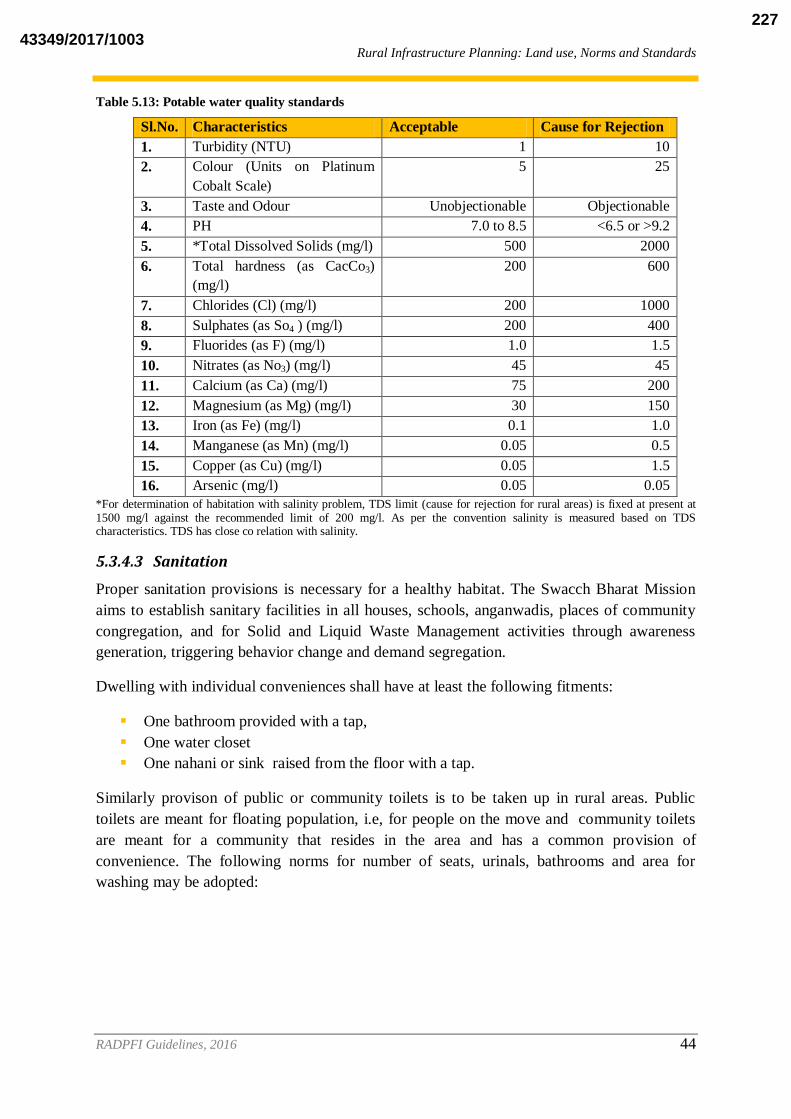
Rural Infrastructure Planning: Land use, Norms and Standards
RADPFI Guidelines, 2016 44
Table 5.13: Potable water quality standards
Sl.No. Characteristics Acceptable Cause for Rejection
1. Turbidity (NTU) 1 10
2. Colour (Units on Platinum
Cobalt Scale)
5 25
3. Taste and Odour Unobjectionable Objectionable
4. PH 7.0 to 8.5 <6.5 or >9.2
5. *Total Dissolved Solids (mg/l) 500 2000
6. Total hardness (as CacCo3)
(mg/l)
200 600
7. Chlorides (Cl) (mg/l) 200 1000
8. Sulphates (as So4 ) (mg/l) 200 400
9. Fluorides (as F) (mg/l) 1.0 1.5
10. Nitrates (as No3) (mg/l) 45 45
11. Calcium (as Ca) (mg/l) 75 200
12. Magnesium (as Mg) (mg/l) 30 150
13. Iron (as Fe) (mg/l) 0.1 1.0
14. Manganese (as Mn) (mg/l) 0.05 0.5
15. Copper (as Cu) (mg/l) 0.05 1.5
16. Arsenic (mg/l) 0.05 0.05
*For determination of habitation with salinity problem, TDS limit (cause for rejection for rural areas) is fixed at present at 1500 mg/l against the recommended limit of 200 mg/l. As per the convention salinity is measured based on TDS characteristics. TDS has close co relation with salinity.
5.3.4.3 Sanitation
Proper sanitation provisions is necessary for a healthy habitat. The Swacch Bharat Mission
aims to establish sanitary facilities in all houses, schools, anganwadis, places of community
congregation, and for Solid and Liquid Waste Management activities through awareness
generation, triggering behavior change and demand segregation.
Dwelling with individual conveniences shall have at least the following fitments:
One bathroom provided with a tap,
One water closet
One nahani or sink raised from the floor with a tap.
Similarly provison of public or community toilets is to be taken up in rural areas. Public
toilets are meant for floating population, i.e, for people on the move and community toilets
are meant for a community that resides in the area and has a common provision of
convenience. The following norms for number of seats, urinals, bathrooms and area for
washing may be adopted:
43349/2017/1003227

Rural Infrastructure Planning: Land use, Norms and Standards
RADPFI Guidelines, 2016 45
Table 5.14: Norms for number of seats, urinals, bathrooms and area for washing
Types of toilets Toilet seats Bath Units Urinal units Clothes washing
area
Community toilets One seat per
50 users
One unit per 50
users
One unit per
200-300
users
4 - 5 sq. metres
per 10 toilet seats;
min 1.5m x 1.2 m
Public toilets near railway
stations ( may be used at all
hours)
One seat per
100 users
One unit per 70
users
One unit per
300-500
users
4 to 5 sq. metres
per 30 toilet seats;
minimum 1.5m x
1.2m.
Public toilets near market
place/ offices ( will mostly
be used during working
hours)
One seat per
100 users
One unit per 50
users
One unit per
200-300
users
4 to 5 sq. metres
per 10 toilet seats;
minimum 1.5m x
1.2m.
(Source: BIS, Code of Basic Requirements for water Supply, Drainage and Sanitation, 1993)
5.3.5 Solid and Liquid Waste Management
5.3.5.1 Introduction
Waste can be defined as: Any material/liquid that is left over after productive use or which is
beyond any use in its current form and is generally discarded as unwanted; and Material
linked to human activity in comparison to nature which has its own system of recycling waste
such that it eventually becomes a resource: for example, organic matter such as leaves,
branches, and so on, decompose to form manure.
Waste can be classified in different ways:
Based on its physical properties, waste can be categorized into solid waste (for
example, garbage) and liquid waste (for example, waste water) ;
Based on pattern of use, it can be classified into human waste (faeces, urine), animal
waste, farm waste and industrial as well as commercial waste; and • Based on source,
waste can be categorized as municipal waste (for example, household waste,
commercial waste, and demolition waste), hazardous or toxic waste (for example,
radioactive waste, explosives waste and e-waste), and biomedical waste (for example,
hospital waste)
Solid Waste: Any waste other than human excreta, urine and wastewater is called solid waste.
Solid waste can be classified into two types: biodegradable and non-biodegradable.
Biodegradable waste is that which can be decomposed by biological processes, for example,
vegetable peel, food, farm waste, and so on. Organic waste is biodegradable and can be
recycled; and Non-biodegradable waste cannot be broken down by biological processes, for
example, paper, glass, metal, and so on.
43349/2017/1003228

Rural Infrastructure Planning: Land use, Norms and Standards
RADPFI Guidelines, 2016 46
Non-biodegradable waste can be further classified into two types: recyclable and no
recyclable
Recyclable waste is that waste which has economic value that can be recovered, for
example, metal, paper, glass, plastic bottle, and so on
Non-recyclable waste is that waste which does not have economic value of recovery,
for example, tetra packs, thermocol, and so on..
Solid and Liquid Waste Management : SLWM is one of the key components of any
sanitation initiative. In India especially in rural areas, waste is a severe threat to the public
health concern and cleanliness. Though, the form of waste (both solid and liquid) generated
in rural areas is predominantly organic and biodegradable yet is becoming a major problem to
the overall sustainability of the ecological balance.
For e.g. it is estimated that rural people in India are generating liquid waste (greywater) of the
order of 15,000 to 18,000 million liters and solid waste (organic/recyclable) 0.3 to 0.4 million
metric tons per day respectively (DDWS-UNICEF, 2008). Generation of solid waste in rural
areas ranges between 50 gm/cap /day and 250 gm / cap / day as mentioned below:
Rural (Peri-urban or Urban outgrowth) 150 to 250 gm / cap / day.
Rural (Remote /Tribal) 50 to 150 gm / cap / day.
Liquid Waste: Liquid waste is water which has been used once and is no longer fit for human
consumption or other uses where clean water is required. Broadly, there are two types of
liquid waste or wastewater (Figure 1):
Black water is wastewater from toilets containing fecal matter; and
Gray water or sullage is wastewater from bathrooms or kitchens. Gray water generally
contains fewer pathogens than black water.
43349/2017/1003229
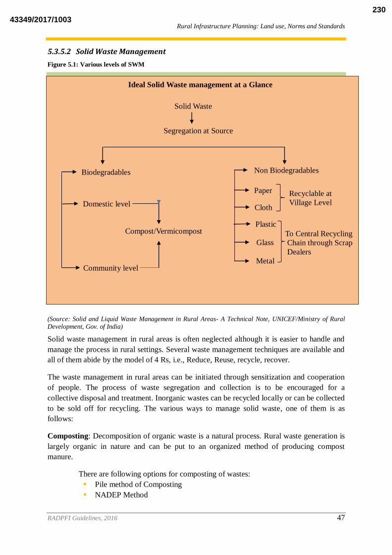
Rural Infrastructure Planning: Land use, Norms and Standards
RADPFI Guidelines, 2016 47
5.3.5.2 Solid Waste Management
Figure 5.1: Various levels of SWM
(Source: Solid and Liquid Waste Management in Rural Areas- A Technical Note, UNICEF/Ministry of Rural
Development, Gov. of India)
Solid waste management in rural areas is often neglected although it is easier to handle and
manage the process in rural settings. Several waste management techniques are available and
all of them abide by the model of 4 Rs, i.e., Reduce, Reuse, recycle, recover.
The waste management in rural areas can be initiated through sensitization and cooperation
of people. The process of waste segregation and collection is to be encouraged for a
collective disposal and treatment. Inorganic wastes can be recycled locally or can be collected
to be sold off for recycling. The various ways to manage solid waste, one of them is as
follows:
Composting: Decomposition of organic waste is a natural process. Rural waste generation is
largely organic in nature and can be put to an organized method of producing compost
manure.
There are following options for composting of wastes:
Pile method of Composting
NADEP Method
Ideal Solid Waste management at a Glance
Solid Waste
Segregation at Source
Biodegradables
Domestic level
Compost/Vermicompost
Community level
Non Biodegradables
Paper
Cloth
Plastic
Glass
Metal
Recyclable at
Village Level
To Central Recycling
Chain through Scrap
Dealers
43349/2017/1003230
Rural Infrastructure Planning: Land use, Norms and Standards
RADPFI Guidelines, 2016 48
Bangalore Method
Indore method
Coimbatore Method
Vermi Composting
Thermophilic Composting
Biogas Technology
One hectare of composting site can handle 83.33 tonnes per day. A composting site for
biodegradable waste collected in the village can be accordingly built on a site away from the
habitation as well as water body, close to the agricultural fields, where the manure generated
can be put to use.
1. Biomethanation: is a process of anaerobic decomposition which results in the
production of Methane. The site requirement is less as compared to the
handling capacity, i.e., 1 hectare for 125 tonnes per day.
2. Gasification/ Pyrolysis: It is a thermochemical decomposition of organic
material at high temperatures in the absence of oxygen. The land required for a
50 tonne per day plant is 1 hectare.
3. Incineration: It is a waste treatment process involving combustion of organic
substances. The thermal treatment of waste converts it itno ash , gas and heat
which in some cases can be used to generate electricity. The land required is I
hectare for 125 tonne per day.
4. The non biodegradable waste generated of some value like , paper, plastic ,
metal can be sold off through the central recycling chain through scrap dealers.
In spite of composting, re-use and recycling, some waste remains
untreated/unmanaged which requires final disposal, either by incineration or
by land filling.
Gram Panchayat can organize themselves to construct and maintain landfill. Gram Panchayat
may make use of Youth Club members/Women Self Help Groups.
Selection of Landfill Site: Gram panchayat in consultation with Zilla Parishad/ Block
Panchayat (as the case may be) should select the landfill site which should be:
Located at the outskirts of the village
Accesible
On vacant/uncultivated land
Located in the natural depressions with slight slopes
Site should be such as to avoid surface water and ground water pollution.
5.3.5.3 Liquid Waste Management
Liquid Waste Management is important to complete the total sanitation system and for a
better environment. The waste water can be recycled in other uses like irrigation or
horticulture. The norms for the treated effluent to be released in the environment or water
sources are:
43349/2017/1003231

Rural Infrastructure Planning: Land use, Norms and Standards
RADPFI Guidelines, 2016 49
Table 5.15: Sewage disposal standards
Parameters Inland Surface water Land for Irrigation
Suspended solids
(mg/l). Max.
100 200
pH value 5.5 to 9.0 5.5 to 9.0
Oil and Grease
(mg/l)., Max
10 10
Total residual
Chlorine(mg/l)
1.0 -
Ammoniacal
Nitrogen
50 50
Total Kjeldahl
Nitrogen (mg/l)
100 -
Free Ammonia,
(mg/l)
5 -
Nitrate Nitrogen
(mg/l)
10 -
Biological Oxygen
Demand, mg/l
10 -
Biological Oxygen
Demand,
Mg/l
30 100
Chemical Oxygen
Demand, (mg/l)
250 -
Arsenic (As) (mg/l) 0.2 0.2
Lead (Pb), mg/l 0.1 -
Dissolved
Phosphate (P)
(mg/l)
5.0 -
Sulphide (S) (mg/l) 2.0 -
Phenolic
Compound, (mg/l)
1.0 -
(Source: CPCB, 1986, Government of India)
Waste water collection system is necessary for any further discussion on the treatment
techniques and facilities. On site decentralized treatment would need pipes conecting the
source to the treatmnent or collecting facility. The centralized treatment system for
settlements needs a layout of drains to carry grey and black water. The shallow surface
drain is most suitable for carrying grey water along with storm water. For black water
mixed with grey matter ( sewage), small bore/shallow sewer is the cost effective sustainable
option. They are designed alongside with interceptor tanks at the sources to receive liquid
portion of household waste water for off site treatment and disposal.
Various technologies available for treatment of liquid waste generated in settlements is given
in the table.
43349/2017/1003232

Rural Infrastructure Planning: Land use, Norms and Standards
RADPFI Guidelines, 2016 50
Table 5.16: Various technique of sewage treatment processes
Sl
No. Recycling/
Treatment
Technique
Applicability Land
Requirement
(per MLD in
Hectares)
Capital
Cost
(per
MLD in
INR)
O&M cost
Million/
year/MLD
1 Activated Sludge
Process
The most widely used option for treatment of domestic wastewater
for medium to large towns where
land is scarce.
0.15-0.25 2-4 0.3-0.5
2 Stabilisation
Pond
Systems(SPS)
• In warm conditions
• Easy land availability
• Where power supply is
expensive, low or unreliable. • Where social preference is for
aquaculture
0.8-2.3 1.5-4.5 0.06-0.1
3. Duckweed
Pond
System
• Low strength domestic wastewater
after sedimentation of influent
• Biological Oxygen Demand (BOD)<80mg/L
2-6 1.5-4.5 0.18
4. Root Zone
Treatment System
• Suitable for treatment of small
quantities of waste water(250 gm BOD per day)
• Maximum 50 kf BOD per day.
low
5. Anaerobic Decentralised
wastewater
treatment system
(DEWATS)
• Modified septic tank system • Takes total waste water , both
grey and black.
• Effluent has much less BOD ,suitable for reuse in agriculture
and horticulture.,
• Can be designed tohandle waste water flow of 1- 1000 m
3 per day.
6. Soakage pit • Simplest method of construction
and use for grey water. • Household level, low volume
handling
• Suitable for sandy or sandy clay soil, for clay and black soil size of
the pit would need to be larger.
7. Upflow anaerobic
Sludge
Blanket Process(UA
SB)
The suitability of this technology may be doubtful as a standalone
secondary treatment option may be
needed.
0.2-0.3 2.5-3.6 0.08-0.17
8. Facultative
Aerate Lagoon
(FAL)
• Standalone system
• As a a pre treatment unit for WSP. • As an upgradation option for
0.27-0.4 2.2-2.9 0.15-0.2
43349/2017/1003233
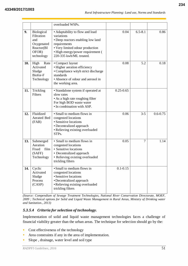
Rural Infrastructure Planning: Land use, Norms and Standards
RADPFI Guidelines, 2016 51
overloaded WSPs.
9. Biological Filtration
and
Oxygenated Reactor(BI
OFOR)
technology
• Adaptability to flow and load variations
• Deep reactors enabling low land
requirements • Very limited odour production
• High energy/power requirement (
220-335 kwh/ML treated.
0.04 6.5-8.1 0.86
10. High Rate
Activated
Sludge Biofor-F
Technology
• Compact layout
• Higher aeration efficiency
• Compliance wityh strict discharge standards
• Absence of odour and aerosol in
the working area.
0.08 5.2 0.18
11. Trickling
Filters
• Standalone system if operated at
slow rates
• As a high rate roughing filter For high BOD waste water
• In combination with ASP.
0.25-0.65
12.
Fluidized
Aerated Bed
(FAB)
• Small to medium flows in
congested locations
• Sensitive locations
• Decentralized approach • Relieving existing overloaded
STPs.
0.06 3-5 0.6-0.75
13. Submerged
Aeration
Fixed film
(SAFF) Technology
• Small to medium flows in
congested locations
• Sensitive locations
• Decentralized approach • Relieving existing overloaded
trickling filters
0.05 7 1.14
14. Cyclic
Activated
Sludge
Process (CASP)
• Small to medium flows in
congested locations
• Sensitive locations
• Decentralized approach • Relieving existing overloaded
trickling filters
0.1-0.15
(Source: Compendium of Sewage Treatment Technologies, National River Conservation Directorate, MOEF,
2009 ; Technical options for Solid and Liquid Waste Management in Rural Areas, Ministry of Drinking water
and Sanitation., 2013)
5.3.5.4 Criteria for selection of technology.
Implementation of solid and liquid waste management technologies faces a challenge of
financial viability greater than the urban areas. The technique for selection should go by the:
Cost effectiveness of the technology
Area constraints if any in the area of implementation.
Slope , drainage, water level and soil type
43349/2017/1003234

Rural Infrastructure Planning: Land use, Norms and Standards
RADPFI Guidelines, 2016 52
The population it can serve,
It would be desirable, if several villages can pool together a facility with least distance to be
covered. The Rurban settlements can follow URDPFI guidelines in implementing a
centralized Solid and Liquid waste management system. Similarly the Villages adjacent to a
municipality can become a part of the integrated urban waste management system.
43349/2017/1003235

Environmental Sustainability and Disaster Management
RADPFI Guidelines, 2016 53
6. ENVIRONMENTAL SUSTAINABILITY AND DISASTER
MANAGEMENT
6.1 Natural Resources in Rural Areas
Rural areas are blessed with natural resources of land, water, vegetation and minerals. The
rural habitations inhabit the bountiful natural landscape thus providing the rural population
livelihood and sustenance extended to urban and regional economies.
6.2 Sustainability
One of the early definition of sustainable development was provided by Brundtland
Commission (1987) as: ‘development that meets the needs of the present without
compromising the ability of future generations to meet their own needs6 . The Brundtland
Commission’s report also states that “in essence, sustainable development is a process of
change in which the exploitation of resources, the direction of investments, the orientation of
technological development; and institutional changes are all in harmony and enhance both
current and future potential to meet human needs and aspirations. Applied to the context of
planning and development, the most fundamental element of sustainability is the utilization
of natural resources in a region most efficiently, most equitably across sections of society and
in such a manner that the resources are conserved and renewed for future generations to meet
their needs and aspirations. Integrating sustainability principles in planning process and
development in today’s scenario has been explained in this chapter.
6.3 Sustainable Rural Planning
6.3.1 Sustainable parameters
Sustainable habitat development means achieving a balance between the economic and
social development of human habitat together with the protection of environment, equity in
employment, shelter, basic services, social infrastructure and transportation. Some of these
parameters, which can be considered in Planning and Development, are:
1. Integrated Rural-Regional Planning: Regional planning and development to control,
mushrooming unplanned and unorganized growth of rural settlements along with
integration of land use and transport resulting in sustainable development. The article
243ZD of the constitution proposes the integration of rural and urban plans into a District
Development Plan thus consolidating both the plans with the District and State vision for
development.
2. Sustainable Agriculture: Sustaining agricultural productivity depends on quality and
availability of natural resources like soil and water. Agricultural growth can be sustained
by promoting conservation and sustainable use of these scarce natural resources through
appropriate location specific measures. Indian agriculture remains predominantly rainfed
6 1 World Commission on Environment and Devlopment’s (The Brundtland Commission) Report, Our Common
Future (Oxford:Oxford University Press, 1987)
43349/2017/1003236
Environmental Sustainability and Disaster Management
RADPFI Guidelines, 2016 54
covering about 60% of the country’s net sown area and accounts for 40% of the total food
production. Thus, conservation of natural resources in conjunction with development of
rainfed agriculture holds the key to meet burgeoning demands for foodgrain in the
country. Towards this end, National Mission for Sustainable Agriculture (NMSA) has
been formulated for enhancing agricultural productivity especially in rain-fed areas
focusing on integrated farming, water use efficiency, soil health management and
synergizing resource conservation.7
3. Promotion of Renewable Energy: India has embarked upon the targets envisaged for
renewable energy generation through solar and wind, emboldened by the Jawaharlal
Nehru National Solar Mission. The target to be achieved through the solar generation of
electricity is 100 GW by 2022. The Rural areas can utilise the renewable sources of
energy for in situ fulfilment of their requirements of energy. Similarly the use of
agricultural, livestock/human waste can be used for biogas generation.
4. Sustainable Rural Infrastructure: Considerable amount of reuse and recycling has been
an integral part of our traditional culture, especially due to austere lifestyles in rural areas.
But with the changing times and the upgrading of services, the creation of new
infrastructure should take the cognisance of principle of reuse and recycle, and recover to
promote sustainable environment.
6.4 Climate Change Mitigation and Adaptation
Climate change and its recent trends have a direct impact on Human and Natural environment
affecting lives and livelihoods. The changes in weather phenomena with increase in the
occurrence of extreme events and long term climatic variability has impacted human
habitations and regional economies to a great extent. These changes also impact agriculture
and pathogens which pose a challenge to the rural economic base. Numerous agencies
including National and International agencies are carrying out studies and are supporting
settlements to develop, adopt and implement sustainable and climate safe practices as per the
National Action Plan on Climate Change, Government of India. The International Panel on
Climate Change (IPCC) Working Group‐II’s most recent report (2013) paints a grim picture
for India. Focus of the report is on food and water supply and the urgent need for our regions
to be resilient. Considering this, the Regional Plans and Development Plans must mainstream
the impact of climate change and developing climate resilient rural areas.. The focus should
be on water security, use of heat repealing materials in construction and minimising concrete
surfaces. It may be desirable to develop appropriate policies and bring about effective legal
and administrative control systems to deal with the problem.8
7 National Mission on Sustainable Agriculture, Operational Guideline, Ministry of Agriculture, Government of India,2014 8 Adapted from URDPFI Guidelines,2014.
43349/2017/1003237

Environmental Sustainability and Disaster Management
RADPFI Guidelines, 2016 55
6.5 Climate Proofing
The expression “climate proofing” is meant as a process that aims to identify risks that an
investment project or development plan or simply people and their assets may face as a result
of climate change, and to reduce those risks to levels considered to be acceptable. It does not
imply a complete mitigation of the potential risks of climate change. ADB (2005) defines it
as: “Climate proofing is a shorthand term for identifying risks to a development project, or
any other specified natural or human asset, as a consequence of climate variability and
change, and ensuring that those risks are reduced to acceptable levels through long-lasting
and environmentally sound, economically viable, and socially acceptable changes
implemented at one or more of the following stages in the project cycle: planning, design,
construction, operation, and decommissioning.”9.
Table 6.1: Parameters and Strategy for Climate Proofing and Community Resilience
6.5.1 Vulnerability
Housing, Rural Infrastructure and Services, Poverty and Livelihood, Ecosystems and Land-
Use as well as emergency response capacity are the key sectors which are considered to
understand the present and future vulnerability of the rural settlements in the context of
climate change impacts.10
Kapur(2010) identifies the vulnerable population by three
components-
Disadvantaged people,
Fragile living and
Lack of services.
9 pp-18, Guidelines for Climate Proofing Investment in Agriculture, Rural Development, and Food security, Asian Development Bank, 2012 10 Pp-203, URDPFI Guidelines, 2014
Parameters Strategy
Housing Guidelines for construction of buildings on
slopes
Structural Stability of buildings in hills for the
entire Gram Panchayat.
Soil Erosion and sedimentation control in
Non Hill areas.
Ecologically sensitive Rural Planning Demarcate eco sensitive areas
Bringing in principles of climate resilient
rural development based on environmental
parameters like conservation of natural
ecosystems and watershed management.
Rural Infrastructure and Services Augment water supply and water treatment
in rural areas
Water conservation and rain water harvesting.
Disaster Resilience Preventive health measures
Public health management and surveillance
system
Emergency medical response
43349/2017/1003238
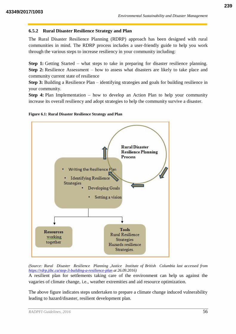
Environmental Sustainability and Disaster Management
RADPFI Guidelines, 2016 56
6.5.2 Rural Disaster Resilience Strategy and Plan
The Rural Disaster Resilience Planning (RDRP) approach has been designed with rural
communities in mind. The RDRP process includes a user-friendly guide to help you work
through the various steps to increase resiliency in your community including:
Step 1: Getting Started – what steps to take in preparing for disaster resilience planning.
Step 2: Resilience Assessment – how to assess what disasters are likely to take place and
community current state of resilience
Step 3: Building a Resilience Plan – identifying strategies and goals for building resilience in
your community.
Step 4: Plan Implementation – how to develop an Action Plan to help your community
increase its overall resiliency and adopt strategies to help the community survive a disaster.
Figure 6.1: Rural Disaster Resilience Strategy and Plan
(Source: Rural Disaster Resilience Planning ,Justice Institute of British Columbia last accessed from
https://rdrp.jibc.ca/step-3-building-a-resilience-plan at 26.09.2016)
A resilient plan for settlements taking care of the environment can help us against the
vagaries of climate change, i.e., weather extremities and aid resource optimization.
The above figure indicates steps undertaken to prepare a climate change induced vulnerability
leading to hazard/disaster, resilient development plan.
43349/2017/1003239

Environmental Sustainability and Disaster Management
RADPFI Guidelines, 2016 57
6.6 Disaster Management
“Disaster means a catastrophe, mishap, calamity or grave occurrence affecting any area from
natural and manmade causes, or by accident or negligence, which results in substantial loss
of life or human suffering or damage to, and destruction of property, or damage to , or
degradation of environment and is of such a nature and magnitude as to be beyond coping
capacity of the community of the affected areas”. It is clear from the definition, that disaster
may impact human habitat in a severe manner. Hence it is evident to manage these disasters
at appropriate level so that impact can be minimized.
As per section 2 (e) of Disaster Management Act, 2005, disaster management means a
continuous and integrated process of planning, organizing, coordinating and implementing
measures which are necessary or expedient for-
Prevention of danger or threat of any disaster
Mitigation or reduction of risk aof any disaster or its severity or consequences
Capacity-building
Preparedness to deal with any disaster
Prompt response to any threatening disaster situation or disaster
Assessing the severity or magnitude of effects of any disaster
Evacuation, rescue and relief
Rehabilitation and reconstruction .11
6.6.1 Institutional Set up
The Disaster management Act, 2005 (DM Act 53 of 2005) lays down institutional and
coordination mechanisms for effective Disaster Management at the National, State, District
and Local levels. As mandated by this Act, the Government of India created a multi-tiered
institutional system consisting of:
National Disaster Management Authority (NDMA), headed by the Prime Minister.,
State Disaster Management Authorities (SDMAs) by the Chief Ministers and
District Management Authorities by the District Collectors and co chaired by elected
representatives of the local authorities of the respective districts.
The Act further provides for constitution of National Executive Committee (NEC), National
Institute of Disaster Management (NIDM) and National Disaster Response Force (NDRF).12
It also envisages the involvement of Community based and local level disaster management
Initiatives in coordination and consonance with the District and state level disaster
management authorities.
For the purpose of this Policy, local authorities would include Panchayati Raj Institutions
(PRI), Municipalities, District and Cantonment Boards, and Town Planning Authorities
which control and manage civic services. These bodies will ensure capacity building of their
officers and employees for managing disasters, carry out relief, rehabilitation and
11
pp-218, URDPFI Guidelines 12 Pp 219-220, URDPFI Guidelines, 2014
43349/2017/1003240

Environmental Sustainability and Disaster Management
RADPFI Guidelines, 2016 58
reconstruction activities in the affected areas and will prepare DM Plans in consonance with
the guidelines of the NDMA, SDMAs and DDMAs. Specific institutional framework for
dealing with disaster management issues in mega cities will be put in place.
6.6.2 Community Based Disaster Management (CBDM)
CBDM initiates a process involving sequential stages that can be operationalized to reduce
disaster risk. Processes of CBDM are guided by principle of :
subsidiarity,
economies of scale,
equity,
heterogeneity and
public accountability.
The different stages in CBDM are:
disaster/vulnerability
risk assessment,
risk reduction planning,
early warning systems,
post disaster relief and participatory monitoring and
evaluation.
CBDM by its very nature demands a decentralized bottoms-up approach with intensive,
micro interventions at the local Panchayats, ward or village level with the intention of
generating confidence, awareness, knowledge, partnership and ownership for planning and
rolling out local disaster management plans encompassing all levels of disaster management
continuum. Equity and inclusion of marginalized segments of the society and bringing the
vulnerable groups to the centre stage of planning and implementation of the CBDM has to be
prioritized to make the programme participatory and inclusive.
Disasters affect the entire community, however, persons with disability, women and children,
underprivileged, older persons and pregnant women need special attention at the programme
implementation level. Such rights and human dignity based inclusive ethos created by such
programmes will empower communities and display resilience in times of crisis. Capacity
building and training of community volunteers is the mainstay of community based disaster
management since they are the first responders. Considering the large number of stakeholders
and community representatives that need to be sensitized and trained, it is important that
capacity building and training interventions be meticulously planned for the purpose of
CBDM. CBDM should converge with existing mainstream, institutional mechanisms and
social welfare delivery programmes to make it holistic, cost effective, multi-dimensional and
community centric.13
13 Pp 6-7 NDMA Guidelines, Community Based Disaster Management,2014.
43349/2017/1003241
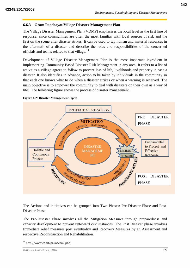
Environmental Sustainability and Disaster Management
RADPFI Guidelines, 2016 59
6.6.3 Gram Panchayat/Village Disaster Management Plan
The Village Disaster Management Plan (VDMP) emphasizes the local level as the first line of
response, since communities are often the most familiar with local sources of risk and the
first on the scene after disaster strikes. It can be used to tap human and material resources in
the aftermath of a disaster and describe the roles and responsibilities of the concerned
officials and teams related to that village.14
Development of Village Disaster Management Plan is the most important ingredient in
implementing Community Based Disaster Risk Management in any area. It refers to a list of
activities a village agrees to follow to prevent loss of life, livelihoods and property in case a
disaster .It also identifies in advance, action to be taken by individuals in the community so
that each one knows what to do when a disaster strikes or when a warning is received. The
main objective is to empower the community to deal with disasters on their own as a way of
life. The following figure shows the process of disaster management.
Figure 6.2: Disaster Management Cycle
The Actions and initiatives can be grouped into Two Phases: Pre-Disaster Phase and Post-
Disaster Phase.
The Pre-Disaster Phase involves all the Mitigation Measures through preparedness and
capacity development to prevent untoward circumstances. The Post Disaster phase involves
Immediate relief measures post eventuality and Recovery Measures by an Assessment and
respective Reconstruction and Rehabilitiation.
14 http://www.cdmhipa.in/vdmi.php
PRE DISASTER
PHASE
POST DISASTER
PHASE
43349/2017/1003242

Environmental Sustainability and Disaster Management
RADPFI Guidelines, 2016 60
Figure 6.3: Suggested Framework for developing SDMP,DDMP,VDMP,CDMP
(Source: NDMA Guidelines, Preparation of State Disaster Management Plans)
6.6.3.1 Vulnerability Mapping
Hazard zonation mapping and vulnerability analysis in a multi-hazard framework will be
carried out utilising Geographic Information System (GIS) based databases such as the
National Database for Emergency Management (NDEM) and National Spatial Data
Infrastructure (NSDI). As a first step towards addressing disaster vulnerabilities, Central
Ministries and Departments, National agencies, knowledge-based institutions and DM
authorities at the State and District levels need to carry out risk and vulnerability assessment
of all disaster prone areas. Hazard zonation mapping and vulnerability analysis based on GIS
and remote sensing data, needs to mandatorily include a ground check component. Hazard
and Consequence Mapping on GIS platforms will be prepared for all chemical accident prone
districts. 5.1.3 The increasing use of GIS, remote sensing and applications of Global
Positioning Systems (GPS) in DM, has made it imperative to set up a mechanism for sharing
thematic and spatial data through a designated electronic clearing house. The NSDI has been
set up by the Survey of India, to collect, compile, analyse and prepare value-added maps for
use by various agencies in the field of DM for management of natural resources, industrial
applications etc. The NSDI need to work towards interoperability of data and information
sharing protocols to facilitate effective policy analysis. A two-way interoperable link will be
established between NSDI and the proposed National Disaster Emergency Communication
Network for easy and quick sharing. The programme designed to have spatial and non-spatial
43349/2017/1003243
Environmental Sustainability and Disaster Management
RADPFI Guidelines, 2016 61
databases in a secure environment under the NDEM will derive the data sets through NSDI
for addressing the information needs for disaster management.15
6.6.3.2 Prevention Preparedness and Mitigation Measures
Prevention consists of actions that reduce risk from natural or manmade disaster incidents. It
is required to list and elaborate all types of measures (like - building codes, floodplain
management, storm water management, coastal area zoning and management plan, etc.) –
planned and implemented by the districts as a part of prevention measures. It is good to have
long term mitigation goals in place and connect these goals with measures that district has
planned and implemented.
These goals may include (but not limited to):
1. Provide better early warning methods for flood, storms, cyclone
2. Reduce the destruction and loss of life within buildings
3. Provide for safer environments for transportation systems
4. Eliminate flooding in populated areas
5. Ensure redundant water supply systems
6. Reduce environmental degradation and restoration of livelihood
7. Reduce effects of the natural environment on the infrastructure
8. Ensure redundant power systems on critical facilities
9. Ensure adequate materials available for road maintenance
Protection reduces or eliminates a threat to people, property and the environment. Primarily
focused on adversarial incidents, the protection of Critical Infrastructure and Key Resources
(CIKR) is vital to local habitations, national security, public health & safety and economic
vitality. Protection includes actions or measures taken to cover or shield assets from
exposure, injury or destruction. Protective actions may occur before, during or after an
incident and prevent, minimize or contain the impact of an incident.
Mitigation, with its focus on the impact of a hazard, encompasses the structural and non-
structural approaches taken to eliminate or limit a hazard‘s exposure; impact on people,
property and the environment. Besides flood proofing, river desiltation, change in land use
pattern and shelter belt plantation.
Examples of mitigation activities also include:
1. Town Planning Act: Planning, adopting and enforcing stringent building codes,
flood-proofing requirements, seismic design standards and cyclone wind-bracing
requirements for new construction or repairing existing buildings.
2. Zoning Regulations: Planning and adopting zoning ordinances that steer development
away from areas subject to flooding, storm surge or coastal erosion.
15 Pp-17, National Policy on Disaster Management,2009;NDMA, Ministry of Home Affairs
43349/2017/1003244

Environmental Sustainability and Disaster Management
RADPFI Guidelines, 2016 62
3. Development Control Regulations: Incorporate the disaster management concerns
into development. This should include all Government Sponsored Developmental
Programs and Schemes.
4. Undertaking retrofitting work on public buildings to withstand ground shaking or
cyclone-strength winds.
5. Specificity of disaster:
6. Land use regulation: Planning and building community shelters and cyclone safe
rooms to help protect people in their homes, public buildings and schools in hurricane
and tornado-prone areas.
7. Safety norms for economic and social infrastructures including places of worships
and crowd management: Steps taken for developing and implementing public safety
norms for critical infrastructures and places of worships.
8. Capacity Building for Mitigation: Steps taken for human resource development and
capacity building for effective disaster mitigation at District Level.
9. Awareness generation on disaster mitigation.
For further information National Disaster Management Guidelines and Handbook for
Effective Disaster Management at Micro Level- NDMA&IGNOU, can be consulted.
6.6.3.3 Roles and Responsibilities at local level
Local Authorities have the following duties:
i. To provide assistance to the District Collector in disaster management activities.
ii. To ensure training of its officers and employees and maintenance of resources so as
to be readily available for use, in the event of a disaster.
iii. To undertake capacity building measures and awareness and sensitization of the
community
iv. To ensure that all construction projects under it conform to the standards and
specifications laid down.
v. Each department of the Government in a district shall prepare a disaster management
plan for the district. The local authorities need to ensure that relief, rehabilitation and
reconstruction activities in the affected area, within the district, Block, Cluster and
Gram panchayats are carried out.
vi. Trust / Organisations managing Places of Worships & Congregation
a) Each establishment / organisation identified as ―critical infrastructure and
key resource in a Gram Panchayat or cluster.
b) Including places of congregation in a Gram Panchayat shall prepare ―on-site
and ―off-site disaster management plan.
c) Carry out mitigation, response, relief, rehabilitation and reconstruction
activities.
43349/2017/1003245

Environmental Sustainability and Disaster Management
RADPFI Guidelines, 2016 63
Community Groups and Volunteer Agencies:
i. Local community groups and voluntary agencies including NGOs normally help in
prevention and mitigation activities under the overall direction and supervision of the
DDMA or the Collector.
ii. ii. They should be encouraged to participate in all training activities as may be
organized and should familiarise themselves with their role in disaster management.
43349/2017/1003246
Simplified Planning Techniques
RADPFI Guidelines, 2016 64
7. SIMPLIFIED PLANNING TECHNIQUES
One of the most commonly faced problems by Spatial Planners is lack of data availability and
data records maintained by government offices. This poses a great deal of hindrance in plan
preparation. The entire planning exercise requires collection and maintenance of datasets for
analysis of present situation or existing scenario to predict the future requirements, issues and
potential of a settlement. The data can be quantitative as well as qualitative to analyse the
existing infrastructural services and make estimates based on population projections.
The Census of India, is the only organisation providing the information of villages regarding
the demography and households assets and provision of services in Village directory. The
CSO report on “Basic Statistics for Local Level Development”(BSSLD) is another initiative
which addressed the needs of data requirement at local level for future planning.
The chapter briefly describes some of the useful and simplified techniques for data collection,
survey, analysis, projections and mapping.
7.1 Data Identification and listing
The BSSLD report gives a clear idea about the datasets that needs to be maintained at local
level and hence, a checklist can be prepared, referring BSSLD document, which would help
in preparation of datasets for further analysis. Table below gives a suggestion of datasets
required for Gram Panchayat Spatial Development Plan.
Table 7.1: Data Collection List for GPSDP
Aspect Sub aspect Indicators
Location Regional Setting Latitude and Longitude/ Regional Setting
Administrative Boundaries of Gram
Panchayat
Abadi area of Village/ spatial area of
village.
Increase in horizontal space
Increase in vertical space
Physical
Topography Variation in degree of Slopes
Elevation above mean sea level.
Surface Drainage Number of major rivers and streams.
Their nature.( perennial or seasonal)
Their direction of flow.
Use and potential of the water body
Climate Temperature (Annual Mean Temperature
and Mean Monthly Temperature in Degree
Celsius)
Rainfall (Average monthly rainfall in mm)
Land Utilisation Percentage of land under:
Net area sown.
Current fallow
Fallow land other than current fallow.
Permanent pastures and other grazing land.
Land under miscellaneous tree crops
43349/2017/1003247

Simplified Planning Techniques
RADPFI Guidelines, 2016 65
Culturable wasteland
Non-cultivable land.
Barren and unculturable land.
Area under non-agriculture use.
Forest.
Land use As given in Chapter 4
Demography
(Schedule 1,
2, 3, 4, 5)
Population Size Number of persons- TOTAL
Population In different
age groups and sex
Age group:
0-6 years
7 to 14 years
15 to 19 years
20 to 39 years
40 to 59 years
60 and above
Population Distribution
by religion and caste
Varying percentage of population in different
sectors of religion and caste. Map of residential segregation, if any.
Population density
Expressed As Persons per square km.
Migration Total No. of inmigrants from rural areas:
Distance from last residence
Reason for migration
Single migrant or with family.
Total no. of out migrants from village:
Distance from destination
Reason for migration
Migrated with family or single
Population growth in
last few Decades
Increase in percentage of population from the
base year.
Occupation Structure Agricultural & allied workers.
Mining &quarrying
Manufacturing
Electricity, gas and water supply.
Construction.
Wholesale, retail trade& repair work, hotel
& restaurant
Transport, storage and communications
Financial intermediation, real estate,
business activities
Other services.
Sex ratio Females per 1000 males
Household information
(schedule 4 and 5)
Head of the household
income of household/ households living
below poverty line
Household size
Information about member of HH- age,
sex, education
Infrastructure
Water supply
Water sources:
Groundwater
43349/2017/1003248

Simplified Planning Techniques
RADPFI Guidelines, 2016 66
(Schedule 6
and 7)
Physical
infrastructure
Well
Tube well
Handpumps
Surface water
Lakes
Reserviors
Streams
Storage and treatment of water Type of water supply
Piped or other
Per capita supply
Duration of water supply
Quality of water supply
Consumption of water. ( in lpcd)
Industrial Use
Agricultural Use
Domestic Use.
Charges of water supply or tariff.
Power supply Duration of power supply Source of power supply
Power tariff or charges paid
Consumption of electricity.
Consumption in KW Consumption by different sectors:
Agricultural
Industrial
Domestic
Waste disposal and sanitation
Type of waste
Industrial waste
Biomedical waste
Agricultural waste
Domestic waste
Quantity of waste generated (in tonnes)
Storage of waste.
Communal bins
Door to Door collection
Methods of disposal
Landfill/disposal site
Authority/community responsible for SWM (if
any)
Road
Road network and hierarchy
National highway
State highway
MDR
ODR
Village road.
Length for each level of hierarchy in km. ROW for each level of hierarchy in metres.
Quality of materials used
Length of Road constructed under which scheme and by whom.
43349/2017/1003249

Simplified Planning Techniques
RADPFI Guidelines, 2016 67
Money spent in construction or roads
Social
Infrastructure
Education
Existence of institutions, number and their
location:
Primary, Middle, Secondary and Senior
Secondary
College for general education, engineering
university and deemed university.
Vocational training centres, their activities.
Distance travelled by students to reach. Provision of facilities
Pupil Teacher ration
Classroom Pupil Ratio Non teaching staff available
Mid day meal provision
Available infrastructure
Educational indicators
Literacy rate
Enrolment rate
Drop out rate
Levels of educational attainment.
Health Existence of health institutes , their numbers
and their location
Sub centre
Primary health centre
District hospital
Community health centre
Nursing homes
Speciality and super speciality hospitals
Veterinary hospital for pets and animals
Facilities provided
Number of beds available
Staff available, ASHA workers, ANM
Types of treatment.
Health indicators
Infant Mortality rate
Maternal mortality rate
Prevalent diseases
Vaccination to children
Existing
resources
Agriculture
Area Gross sown area and net sown area
(hectares)
Size of landholdings
Productivity / yield.
Type of crops produced per unit area
Input used
Type and amount of fertiliser used
Amount of seeds used
Source of irrigation
Manure used
Storage Location of godown or domestic storage
(spatial location)
Marketing Self use or sold in market, if sold:
Location of market
Amount earned from selling.
43349/2017/1003250

Simplified Planning Techniques
RADPFI Guidelines, 2016 68
Weekly markets (Including their spatial
location)
Cropping pattern Single cropping or multiple cropping system What type of crops are grown
Credit facilities
Amount of loan distributed yearly or decadal to the farmers.
Irrigation Canal irrigation or Lift irrigation
Number of acres irrigated
Numbers of acres irrigated
Horticulture Area under horticulture Hectares of area under horticulture Type of cultivation- flower cultivation or cash
crop cultivation, orchards.
Consumption or market Self use or sold, if sold: amount of money
earned
Transportation Mode, distance in km.
Forest Area under forest
Area under reserved, protected, community
forest or village forest or private forest.
Present utilisation
Industry Number and type of
industry
Small scale, medium scale and large scale
industries.
Location Inputs
Availability of raw materials
Power
Water supply
Outputs
Productivity
Market
Transportation
Housing
Housing
Type of house:
Kutcha ,semi-pucca or pucca houses
Type of material used for construction
Number of rooms.
toilet facilities available to the household
assets owned by houses
type of fuel used for cooking and place
where it is availed from
Transport
Rail
Hierarchy of rail network
Broad gauge, metered gauge, narrow gauge.
Location of railway station Location of Bus stop
Location of Railway station
Digital
Connectivity
No.of schools having smart classes Citizens service centre
Village level record maintenance
Cable operators or Cable connections
No. Of people having internet connection.
Public Asset
Mapping
Mapping the resources of the community (As
done by NRSC)
43349/2017/1003251

Simplified Planning Techniques
RADPFI Guidelines, 2016 69
7.2 Data Collection Techniques
Information or data can be divided into two types, i.e. Primary data and Secondary data.
Primary data is collected first hand by investigator, thus through Primary survey. Secondary
data is second hand data, initially collected by some other investigator for other purpose but
later on used by an investigator for his/her own purpose.
7.2.1 Primary data collection techniques
Primary data are data that were previously unknown and which have been collected directly
by the researcher for a particular research project. Primary information is primary data to
which meaning has been added; in other words, the data have been analysed, inferences have
been drawn from them and, thereby, meaning has been added.
This section discusses four types of primary surveys which are listed in the order of passive
to active respondents. Following are the broad categories of primary surveys:
Visual survey / Reconnaissance survey: This survey does not require direct contact
with population of the study area. It is quick overview of the area.
Inspection: It involves direct inspection of area by surveyor for extracting
information.
Personal Interview / Dialogue: This survey is more personal and could be either face
to face or telephonic. In such type of surveys some initial topics are investigated to
gain insight in the area of interest.
Self-survey: In this type of survey indirect contact is made with the respondent by
sending questionnaire through mail or handed out but the response is not collected on
the spot.
Figure 7.1: Stages of conducting Primary Survey
Primary Research (Data Collection)
Choosing the Technique Self Surveys
Interviews
Direct Inspection
Defining the questions Nominal Scales : Answers in
“yes” or “no”
Ordinal Scales: Prioritises the
choices given
Interval Scales: Provides
yardstick for measuring-age
Defining Primary Data Collection needs and obtaining resources
43349/2017/1003252

Simplified Planning Techniques
RADPFI Guidelines, 2016 70
Determining the sample Simple Random- Random
samples are selected.
Systematic sampling: random
number is selected and every nth
sample is surveyed
Stratified sampling: homogenous
groups are defined and surveyed.
Cluster sampling: heterogenous
groups are selected for survey
Conducting Survey
Analysing the Data
Compiling and editing the raw data
Analysis of the distribution of response to a single question
Analysis of interrelations among variables
Interpreting the analysis
Source: Reading Material on Planning Techniques by JH Ansari and Shri Mahavir & MM analysis
7.2.1.1 Visual surveys / Reconnaissance survey
Visual surveys are direct inspection surveys which are performed by survey teams moving in
automobile or walking. This type of survey can be used in the initial stages of the
investigation, often after preparing initial checklist. It performs variety of functions, such as:
Familiarise with study area.
Give initial impressions of the physical and human state of an area.
Identify selected areas for further investigation.
Generate ideas for development of checklist.
7.2.1.2 Inspection
Direct Inspection: The direct inspection of conditions or activities is employed in many
kinds of surveys where human communication is not required to elicit the information 16
It
can be used for observing traffic counts, recreation area use surveys, housing quality studies
and proxy observations where required.
`Indirect Inspection: The findings of the initial survey can be substantiated with the help of
Key Indicator Survey which are specific to the objectives of the analysis. Often, instead of
16 Reading Material on Planning Techniques by JH Ansari and Shri Mahavir
43349/2017/1003253

Simplified Planning Techniques
RADPFI Guidelines, 2016 71
getting direct information on the variable, surveyors rely on observing approximations known
as proxies. A proxy is used to inform about a variable without direct investigation, instead
investigating its key indicators. Such as: instead of enquiring about the income range, the
surveyor can observe the housing condition, number of vehicles and other consumer goods.
7.2.1.3 Personal Interview/Dialogue
A number of types of surveys are undertaken face to face or by telephonic conversation. The
questionnaire format in these surveys is either objective or subjective and based on
qualitative or quantitative information gain.
In case of quantitative survey, the structured dialogue is one-way where precise questioning
takes place. Semi-structured dialogue is a flexible two-way process where only some initial
topics are investigated. These topics can be revised as the practitioner gains insight in the area
as information flows-in from the respondents. The semi-structured dialogue is thus an
informal process but it needs to be managed expertly, particularly in the aspects listed below:
Behavioural factors of the surveyors and respondents
Questions not to be ambiguous or long
Careful probing to seek answers
Judging responses without biases
Cross-checking with other respondents
Managing the conversation
Recording the interview (audio/video)
Avoiding errors and biases
7.2.1.4 Focussed Group Discussion (FGD)
Focussed group discussion is a qualitative data collection and research technique. Questions
about opinions, perceptions, beliefs, attitude of people towards planning aims, services are
probed in these discussions. FGD can be used for learning about stakeholders, their
interrelationship and to know about a range of issues on the topic. This method costs fairly
low compared to surveys, as one can get results relatively quickly and increase the sample
size by talking with several people at the same time. FGDs can either be used to explore
meaning of survey findings that cannot be explained statically as well as before designing
questionnaires. Homogenous group of people are selected for FGD so that they are
comfortable and have free flow of discussion. Main objective and key questions of the
meeting should be pre-decided. Group of 10 to 12 people and questions should be selected for
a single FGD110. More than one, mostly three to four FGDs to be done before legitimate
results can be reached on an issue. FGD in rural settings can make use of interactive
diagrammatic data collection techniques such as mapping, Venn diagram etc.
7.2.1.5 Self-Survey
These are often in the questionnaires sent to respondents through mail or survey forms
handed out or inserted in the newspapers and the filled questionnaires are mailed back to the
surveyor. It has various limitations, like; responses can be low and unsatisfactory.
Primary data collection techniques can be costly and very time consuming thus methods of
rapid information collection, which rely mostly on direct observation, is an alternative. This
method seeks several views of any one “fact” (cross checking), makes use of checklists and
43349/2017/1003254
Simplified Planning Techniques
RADPFI Guidelines, 2016 72
semi structured dialogue. However, rapid methods must not be considered as substitutes to
specialist investigations and should be used for quick access to information for rapid decision
making only.
7.2.2 Secondary Data Collection techniques
Secondary data is the data that have been already collected and recorded by someone else and
readily available from other sources. Secondary data collection is faster, less expensive and
includes lesser activities. However, the secondary data may not always meet the needs of the
planners/researchers or investigator.
Published sources:
Mostly secondary data is collected from published sources, which makes it reliable. Some
important Sources of published sources and statistical data are as follow:
Published reports of Central and State Governments and local bodies.
Statistical abstracts, census reports and other reports published by different Ministries of
the Government.
Official publications of the foreign Governments.
Reports and Publications of trade associations, chambers of commerce, financial
institutions etc.
Journals, Magazines and periodicals.
Periodic Publications of Government organizations like Central Statistical Organization
(CSO), National Sample Survey Organization (NSSO), Census Decadal data.
Reports submitted by Economists, Research Scholars, Bureaus,
Published works of research institutions and Universities
Unpublished sources:
Statistical and non-statistical data can also be collected from various unpublished sources.
Some of the important unpublished sources from which secondary data can be collected are:
The research works carried out by scholars, research associates and professionals.
The records maintained by private firms and business enterprises, which may not have
been published due to business discretion.
Records and statistics maintained by various departments and offices of the Central and
State
Governments, Corporations, Undertakings among others.
7.3 Mapping
7.3.1 Scale of Map
The scale of map will differ according to type of map and the information required from the
map. Following are the list of the maps to be prepared for the Gram Panchayat Spatial
Development Plan:
Table 7.2: Scale of Map of GPSDP
43349/2017/1003255
Simplified Planning Techniques
RADPFI Guidelines, 2016 73
Map Information Scale
Regional Map Location of Village in District/Block 1:50,000-1:1,00,000
Gram Panchayat
Map
No. of Villages in a panchayat and adjoining areas showing rivers, roads,
railways, administrative boundary of
panchayat, abadi area of villages and location of various facilities
1:20,000-1:50,000
Abadi area map Inhabited area of the villages 1:5000-1:10000
Layout map of
village
Layout of residential area of the
village and location of various facilities.
1:5000 minimum
Landuse map of
village
Landuse 1:5000 or more
7.3.2 Map Information checklists
Table 7.3 shows the maps required for GPSDP , the information it intends to provide, and its
sources from where to avail it.
Table 7.3: Map information checklist
Features Sub Categories Sources
Physical Physiography Terrain(Hills, Plains
and valleys)
SoI Toposheets Satellite
Image Photo Mosiac from
NRSC & Bhuvan (Resolution 30m, Height
Accuracy 8m), Aerial
Photographs
Water
bodies/drainage
Rivers, Canals,
Lakes, Ponds,
Reservoirs, Tanks,
Abandoned quarries with water, wells,
Hot Springs
SoI Toposheets,
Satellite Image Photo
mosaic from NRSC &
Bhuvan (1:50,000; for 2005, 2012),
Aerial Photographs
Ground water Aquifers, Water Table, Fluctuation in
Water Table
SoI Toposheets, Bhuvan Ground water
prospects maps (1:50,000),
Centre Ground Water
Commission
Geological Structure Lineament, Fracture/
Fault line valley,
SoI Toposheets,
Satellite Image Photo
43349/2017/1003256
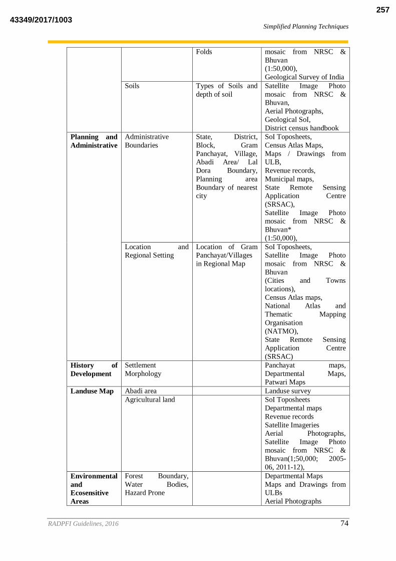
Simplified Planning Techniques
RADPFI Guidelines, 2016 74
Folds mosaic from NRSC &
Bhuvan (1:50,000),
Geological Survey of India
Soils Types of Soils and
depth of soil
Satellite Image Photo
mosaic from NRSC & Bhuvan,
Aerial Photographs,
Geological SoI,
District census handbook
Planning and
Administrative
Administrative
Boundaries
State, District,
Block, Gram
Panchayat, Village, Abadi Area/ Lal
Dora Boundary,
Planning area
Boundary of nearest city
SoI Toposheets,
Census Atlas Maps,
Maps / Drawings from ULB,
Revenue records,
Municipal maps,
State Remote Sensing Application Centre
(SRSAC),
Satellite Image Photo mosaic from NRSC &
Bhuvan*
(1:50,000),
Location and Regional Setting
Location of Gram Panchayat/Villages
in Regional Map
SoI Toposheets, Satellite Image Photo
mosaic from NRSC &
Bhuvan (Cities and Towns
locations),
Census Atlas maps, National Atlas and
Thematic Mapping
Organisation
(NATMO), State Remote Sensing
Application Centre
(SRSAC)
History of
Development
Settlement
Morphology
Panchayat maps,
Departmental Maps,
Patwari Maps
Landuse Map Abadi area Landuse survey
Agricultural land SoI Toposheets
Departmental maps
Revenue records
Satellite Imageries Aerial Photographs,
Satellite Image Photo
mosaic from NRSC & Bhuvan(1;50,000; 2005-
06, 2011-12),
Environmental
and
Ecosensitive
Areas
Forest Boundary,
Water Bodies, Hazard Prone
Departmental Maps
Maps and Drawings from ULBs
Aerial Photographs
43349/2017/1003257

Simplified Planning Techniques
RADPFI Guidelines, 2016 75
CPCB (Zoning Atlas of
Industries)
Socio
economic
aspects
Residential Segregation, BPL
households
Primary Survey
Housing Type of Houses, Houses with IAY aid,
Buidling age,
Building Height,
Buidling material
Primary Survey
Infrastructure Water supply
network
Primary Surveys, various
concerned departments
Sewerage and SWM
Waste treatment and waste dumping site
Telecommunication
network
Educational / health institutes
Post office
Police station
Fire station
Socio cultural and
religious centres
Proposed plan
of various
sectors
Source: Adopted from URDPFI Guidelines, 2014
7.3.3 Procedure of Collecting Data
Procedure to retrieve data by permissions, which is not available in the public forum are
given below:
7.3.3.1 Toposheets
Unrestricted topographical/ city guide maps published by Survey of India are available for
sale. The standard topographical maps on scale 1:25000 and more published for selected
villages are useful for rural development plan purpose. All the topographical maps along the
external boundary/coastline of India, as indicated in the Topo Index map of Survey of India
are categorised as restricted maps. The restricted category maps can be procured by State and
Central Governments / Private Individuals / organisations/commercial firms by following a
prescribed procedure. Private individuals and organizations / commercial firms can also
obtain restricted maps with prior approval from Ministry of Defence through the State
Government to whom they should apply.
7.3.3.2 Aerial photography
The available information regarding area of interest, its scale and cost rates can be obtained
from Surveyor General’s Office, Dehradun or the Directorate of Survey (Air), New Delhi.
Survey of India (SoI) has a dedicated web portal for presenting the meta data information
available with SoI from various aerial photography tasks commenced. Web Aerial
43349/2017/1003258

Simplified Planning Techniques
RADPFI Guidelines, 2016 76
Photography Transaction Registry (APTR) provides transparent indenting process based on
instructions issued by Ministry of Defence. Indentor can obtain the existing photography by
marking the area of interest on 1:250,000 scale topographical map, indicating purpose,
identifying the type (B&W, colour, colour infrared), scale and the photographic product
required (contact prints, enlargements, mosaic, etc.). If the existing photography does not
cater to the requirements of indentor, process for fresh aerial photography can be initiated.
The National Government agencies, which provide fresh aerial photography, are:
Indian Air Force (through Survey of India)
National Remote Sensing Centre, Hyderabad
Air Survey Company, Calcutta.
For indenting fresh aerial photography the indentor may approach any of the flying agencies
with specific information. The indentor may mark the limit of the area to be photographed on
1:250,000 scale toposheet if photography is required on scale smaller than 1:20,000 and
1:50,000 scale toposheet if photography is required on scale 1:20,000 and larger and apply
with the specific requirements mentioned for the procurement of the existing aerial
photography.
7.3.3.3 Satellite Imagery
National Remote Sensing Centre, Hyderabad is the nodal agency for supply of current and
archived satellite data products from all contemporary satellites namely Ocenasat-1,
Ocenasat-2, Resourcesat1, Cartosat-1, Cartosat-2, Resourcesat-1 and from older satellites
like, IRS-IA, IRS-IB, IRS-IC, IRS-ID, IRSP3. These can be processed to various levels and
supplied on photographic media or on digital computer compatible media. Satellite data
(processed and raw), aerial products, visualisation services can be assessed from the NRSC
Data Centre, Hyderabad. Standard Satellite Data provided by NRSC (as on 2014) is presented
in the Table
Table 7.4: Satellite Imagery
Sensor Product Scale (Accuracy)
HIGH RESOLUTION
PAN(1m) System corrected Geo-referenced
Mono (9.6Km X 9.6Km)
10. (100m)
Ortho Kit with RPC AOI 11. (100m)
PAN-A/F(2.5 m) Geo-reference Mono (27.5Km X 27.5 Km)
12. (250 m)
Stereo Ortho Kit (27.5Km X 27.5
Km)
13. (250 m)
Ortho Corrected (7.5’X7.5’) 25,000 (25m)
LISS-4MX (5m) Standard (23.5 KmX 23.5 Km) 14. (500 m)
Standard Full Scene (70 Km X 70
Km)
15. (100 m)
Full Scene Ortho Reflected (70 Km X 70 Km)
16. (10m)
MICRO WAVE
(RISAT)(1m-
50m)
Standard RISAT SAR 17.
43349/2017/1003259

Simplified Planning Techniques
RADPFI Guidelines, 2016 77
MEDIUM RESOLUTION
LISS-III (24m) Standard Full Scene 141 Km X 141
Km
250,000 (500 m)
Full Scene Ortho Rectified 141Km X
141 Km
18. (24m)
AWiFS (56m) Standard Full scene 740 KmX740
Km
19. (500 m)
Full Scene Ortho Rectified 740Km X
740 Km
20. (56m)
Standard Quadrant 370KmX 370 Km 500,000 (500 m)
Quadrant Ortho Rectified 370Km X 370 Km
21. (56m)
LOW RESOLUTION
OCM (360m) Full scene (1420Km X 1420Km) 22. (1.5 Km) Source: National Remote sensing centre quoted in URDPFI Guidelines,2014
7.3.3.4 Geological Survey of India
To assess the meta-database of Geo-environmental studies for various villages in India, with
interpretation of geomorphology, hydrology, geological structures and tectonic data from
Geological Survey of India, Rural Local Bodies and its representatives can approach Ministry
of Mines and GSI with their specific requirements.
7.4 GIS Based Gram Panchayat Spatial Development Plan (Refer
Annexure 5)
Rural areas development plan formulation and implementation requires a methodological
framework for spatial planning. For the resource-based development of rural areas, a
Panchayat-level integrated spatial participatory planning is the need of the hour. Spatial
planning involves making decisions based on the spatial patterns and processes such as
distance, location, neighborhood and proximity of various natural resources, infrastructural
facilities, human activities and welfare activities in a set of terrain conditions. It is essential
for a planner to understand the patterns of land use and land cover with social structure and to
identify local resources and amenities.
In the entire process of village development plan formulation--starting from preparation,
approval and finally its implementation on ground--an enabling environment is required,
where one can geo-visualize, analyze and monitor the implementation status in a transparent
way. Such an enabling environment will act as a tool in crafting the strategic guidelines at the
Panchayat-level for a holistic development of the region.
GIS shall be used for the preparation of spatial plans for panchayats. GIS along with the
interface of Remote sensing will add to availability of various information at village level
which will facilitate spatial planning in rural areas. Annexure 5 mentions the case study
conducted by NIRD, which can be referred for the preparation of GIS based Gram
Panchahyat Plans
43349/2017/1003260

Simplified Planning Techniques
RADPFI Guidelines, 2016 78
Remote sensing and GIS technologies play a key role here, right from generating and
integrating geospatial information, to presenting on a user-friendly and interactive map. A
map depicts the terrain, natural resources and human activities along with infrastructure
facilities as an integrated view, which is the base for spatial thinking and further decides on
intervention required and forming planning strategy. It helps to make informed decisions and
subsequently the informed investments at the Panchayat-level for effective and transparent
planning, implementation & monitoring of centre- or state-sponsored schemes.
Figure 7.2: Process of using GIS in GPSDP
Source: Formulation of GIS based Master Plan for AMRUT Cities, Town and Country Planning Organisation,
Ministry of Urban Development, GoI, November 2015
7.5 Bhuvan platform for Spatial Planning
43349/2017/1003261

Simplified Planning Techniques
RADPFI Guidelines, 2016 79
An enabling environment named Bhuvan Panchayat Portal is developed and hosted by NRSC
(ISRO) under the project named 'Space-based Information Support for Decentralized
Planning (SIS-DP)'. The web-portal integrates geospatial layers derived from space-based
inputs in a web-GIS framework with interactive modules like Area Profile Report
Generation, Asset Mapping, Activity Planning and Implementation-Monitoring for
facilitating effective developmental planning in the light of Village Developmental Plan.
7.5.1 Database Available
The following are the database available on Bhuvan Panchayat Portal:
Satellite imagery: An ortho-corrected high-resolution satellite imagery database
(fused product of Cartosat-1 and LISS-IV imagery) is generated for the entire country
to act as a base layer for further mapping.
Thematic data: Overlaid on the base layer, various thematic layers (such as land
cover, drainage, transportation and slope layers) are prepared at 1:10,000 scale for the
entire country.
Legacy data: Soil information layer, groundwater potential, forest boundary,
watershed boundary, wasteland information and slope class layer
Cadastral data: Prepared at 1:4000 scale for five priority States
Administrative boundaries: Village, Panchayat, Intermediate Panchayat, District,
State, Parliamentary and Assembly Constituency
Asset Data: A continuously growing national inventory of geo-tagged community
assets along with their photographs and related attributes is available on the Portal for
its utilization in developmental planning. The inventory is crowd-sourced for
citizens/PRIs/facilitators to map assets through Bhuvan Panchayat Asset Mapping
Mobile App.
Non-spatial data: In addition to the geospatial layers, the project database comprises
village amenities, demographic and climatic data integrated with spatial database.
Following are the points worth mentioning in terms of database:
Periodicity of the satellite data: There is a provision to update the satellite data
every 2 years in order to facilitate regular monitoring of progress as per village.
Accessibility of the datasets: All the datasets are available in public domain and
viewing them on Portal does not require any registration.
7.5.2 Geo-visualization facility
Geo-visualization in its entirety encompasses search, access, visualize, analyze, understand
and use the spatial and associated non-spatial data. The default window of the Portal contains
a map-viewer that enables the geo-visualization of satellite imagery (along with other geo-
spatial layers) that may be zoomed up to Panchayat / Village level. The left pane in the
default view of the Portal gives options to visualize or hide various geospatial information
layers. Several navigation tools, measurement tools and personalization tools are also
provided to facilitate geo-visualization.
43349/2017/1003262
Simplified Planning Techniques
RADPFI Guidelines, 2016 80
7.5.3 Interactive modules for planning needs
Towards the aim of facilitating the preparation of resources-based village developmental
plans using space-based inputs, several specialized sets of functions are created, which may
be used as tools for information extraction, analysis and updation along with its utilization as
per the planning requirements. Following is a detailed description of each of such modules, as
to what their capabilities are and how they can be used.
7.5.3.1 Automated area profile report generation module
This module integrates the spatial and non-spatial data for the selected area and delivers a
ready-to-use profile report in a professional format with various maps, statistics and graphs.
The selected area, part of an administrative unit, is spatially identified by a unique code. The
demography and climate datasets are linked with the spatial datasets through this unique
code. The data is retrieved and presented using spatial queries exploiting join and aggregation
operations. In a nutshell, for the desired area, this module presents a resource inventory on
natural resources and available manmade community assets along with information on
disaster-prone locations and other major issues/constraints with its priorities.
The following points are worth mentioning regarding this module:
The module is interactive: Information can be updated from the user side as well. It
facilitates assimilation of crowd-sourced information which may be considered more near
to ground reality.
Freely downloadable pdf: The snapshot of satellite imagery and thematic maps along with
various statistics of an area up to the Panchayat / Village level can be viewed and
downloaded as a report in 'pdf' format. Considering the interest of the specific users,
chapter-wise selection and downloading is also enabled. Figure 7.3 shows cover page of
one such automatically generated pdf format report.
No registration required: This module does not require any registration in general, although
updation of information can only be done by registered users of the Portal.
The following are the components of this module:
Identification details: This component provides administrative details of the selected area.
Contact details of the key persons at various administrative levels are also provided so as
to facilitate communication with the governing bodies. A table has also been given to
highlight the on-going schemes along with its potential beneficiaries and money
allocation details for a quick overview of development activities under progress in the
selected area. This data is useful to locate any area and to decide the ongoing as well as
future development activities.
Climate data: It provides information about statistical average of rainfall, temperature, and
humidity over the desired area and timeframe. This data is averaged in two ways: grid-
wise and district-wise.
43349/2017/1003263

Simplified Planning Techniques
RADPFI Guidelines, 2016 81
Major issues and constraints of the area: It describes the problems and limitations in the
area that require immediate attention. The development of an area depends on many
factors such as its geographical location, governing authority, public participation,
funding though various development schemes and their monitoring etc. Requirements for
development would be different for each administrative unit (district/block/village). To
begin and assess any development activity in any area, it is necessary to have an
inventory of both existing and required facilities/amenities. This will help to decide the
type of development activities which can be undertaken, and the same can be proposed
and subsequently communicated to the higher authorities to get required sanction. Many
of the issues listed here may find its origination at the Panchayat level discussions by the
villagers during Gram Sabha meetings.
Priorities of the area: This component provides a list of significant activities that needs to
be taken up on priority in the area. This list may point out all the gaps in developmental
activities; however, the governing body needs to identify crucial and important activities
which should be taken up immediately. Usually many applications for different schemes
and activities proposed by local bodies are submitted to PRI heads, but a priority list of
activities will enhance the focus of governing bodies to felicitate the important process.
Ongoing activities: This component highlights the ongoing activities under various schemes
in an area. An inventory of existing activities under different schemes, its functioning
authority/department, allocated budget, its period, and status are very important data for
planning and decision making. PRI has to assess the development status of selected area
using this data, and thus can further refine the ongoing development activities.
Village and Town Directory - 2011: This component provides primary census abstract with
village & town directory of the area as per Census-2011. It gives insight into socio-
economic information in the form of tables and charts. Many development schemes are
based on socio-economic profile of an area. These schemes are introduced to bring gender
and economic equality and also to improve literacy, health as well as overall behavioral
and social development. To introduce such schemes and assess such activities, primary
demographic data of an area is the foremost requirement. This component also facilitates
governing body to modify the dynamic demographic details of selected area. These
changes can be seen on portal in yellow column as well as in print format area profile
report in tabular representation with starred mark.
Village Amenities Directory - 2011: This component provides the information of Village
Amenities at the village level; the data has been compiled from Census of India 2011. It
provides the detailed information for Educational, Medical, Drinking Water and Other
facilities. For grassroot level planning, this data will be reliable and basic source for
developmental activities.
House Listing & Housing Census Schedule - 2011: This component provides House
Listing & Housing Census Schedules according to Census of India 2011. It gives the
details of households by condition, predominant material, ownership status, and other
facilities in the form of tables and charts. Broad idea can be obtained about the status of
the basic facilities available such as source of drinking water, lighting, house condition,
transportation, possession of assets etc. This information is needed to plan and manage
43349/2017/1003264
Simplified Planning Techniques
RADPFI Guidelines, 2016 82
these amenities effectively in an area. Presently, these data are available at the district
level only.
Mapping of vulnerable areas: Vulnerable areas are defined as areas which are susceptible
to the disaster and damage. Vulnerability mapping will help people to depict the threats in
that place and manage their infrastructure and asset according to the same. Any area may
be subjected to many natural calamities due to its varying terrain and climatic conditions.
This increases the disaster risk and exposing the assets of the administrative unit to
become vulnerable to these risks. Lack of information in this regard may lead to failure of
the development plans and activities. This component provides the details of vulnerable
areas, type of disasters occurring in that area, the status of risk prone infrastructure,
coping mechanisms and available disaster risk reduction measures in the area.
7.5.3.2 Asset mapping module
Asset mapping is an activity to spatially identify the village amenities which are valuable to
the community. Towards an effective planning and development at grassroots level,
awareness of the assets available in the region is a pressing need; hence creation of a spatial
digital inventory of assets is initiated and facilitated through Bhuvan Panchayat. Assets
inventory is the compilation of different types of assets which are created / being created
under various schemes of Government of India, States and Communities by themselves to
facilitate the local population. Bhuvan Panchayat identifies 271 different types of assets
which are grouped into 3 major categories as follows (complete list is given in Annexure 1):
Civic Amenities/Infrastructure: 226 Asset types
Governance Assets: 35 Asset types
Productive Assets: 10 Asset types
The asset mapping module facilitates:
Geo-visualization of assets: Assets that are already mapped can be viewed interactively
overlaid on satellite imagery.
Mapping assets: It allows users to spatially mark assets directly in the map-viewer
window along with entering its associated attribute information in attached form field
(Figure 7.3, 7.4,7.5 ). Although, a dedicated asset mapping mobile app is developed for
GPS-based mapping of assets from the field.
Query assets: Planning in an area of interest essentially requires knowledge of
information at hand. Questions may be posed as to "what all assets are in the area",
"where are secondary schools located", etc. This module facilitates such queries to be
answered. This allows information from the assets data to be converted into valuable
knowledge of desired area.
The following are the points worth mentioning regarding asset mapping module:
Participatory approach for mapping assets: Considering the requirement of enormous
efforts toward creation of a national inventory of assets at Panchayat/village level, a
participatory approach through crowd sourcing is followed. Through the asset
mapping mobile app linked with the Portal, any registered citizen can easily map
assets from the field using his/her smartphone. To start through, under another project
43349/2017/1003265

Simplified Planning Techniques
RADPFI Guidelines, 2016 83
of ISRO, named 'Empowering Panchayati Raj Institutions Spatially (EPRIS), efforts
are being made to map assets of around 10% of the Gram Panchayats in the country,
on a pilot basis, using Bhuvan Panchayat platform.
Bhuvan Panchayat asset mapping mobile app: It is an android-based mobile
application for facilitating asset mapping directly from the field with geo-location,
asset photograph and associated attributes. The app is freely downloadable from the
Portal. It requires a simple first time registration after which user can start mapping
assets. The mapped assets are uploaded to the Bhuvan servers and are also linked to
the Portal.
Moderation of uploaded asset data: In order to avoid junk information (which is often
possible when the system is crowd-sourced), validation/moderation steps are adopted
by facilitating intervention by the concerned PRIs. For this, provisions are made for
creation of separate PRI logins. Assets are considered validated after a simple
approval of mapped assets from PRI logins. Further, to distinguish the assets mapped
by the citizens and PRIs two different presentation schemes (icons) are designed.
Assets identified from satellite imagery: A few clearly distinguishable assets can be
directly fetched from the associated thematic maps which are prepared overlaid on
satellite imagery. Such assets directly get appended to the spatial inventory.
Figure 7.3: Snapshot of a marked asset (point) with attribute form
Figure 7.4: Snapshot of a marked assets (line) with attribute form
43349/2017/1003266

Simplified Planning Techniques
RADPFI Guidelines, 2016 84
Figure 7.5: Snapshot of the marked assets (polygon) with attribute form
7.5.3.3 Activity planning module
This module is designed to provide an enabling framework for planning developmental
activities under various Centre and State Governmental Schemes at the Gram Panchayat
level. All 29 functions entrusted to the PRIs under the XI schedule are categorized and
compiled into five major sectors comprising land and water development activities,
productive activities, civic amenities and infrastructural development activities, social
welfare activities and governance activities. This module facilitates the involvement of the
common man in the local developmental planning. Any registered citizen can propose
activities under the schemes in the Gram Panchayat of his/her area and this can be viewed,
modified and consolidated successively at all three tiers of PRIs.
The following points are worth mentioning regarding activity planning module:
Spatially enabled process of activity planning: The user is given an option to geo-
locate the plan as point, line or polygon. Once the Polygon is drawn, a form appears
for the user to fill necessary information like activity title, cost, duration, and details
of the activity. A user may attach any supporting documents to justify his/her plan.
Once all the compulsory fields are filled, user can save the activity (Figure 7.8, 7.9).
Support of geo-spatial layers while planning: Spatial and non-spatial information
assistance can be availed while planning by overlaying the required thematic layers
and existing assets layer available on the left pane as base on his/her area of interest.
Participatory approach while planning: The Portal provides an effective approach in
local planning as citizens can participate in planning activities. 'Draft plans' from the
citizens would be available for consolidation to Sarpanch. This will facilitate PRI
heads in submitting the 'Panchayat plan' without biasing and conflicts. However, the
role of Panchayats at all three levels (Gram, Intermediate and District Panchayats)
will remain significant towards the consolidation of activities planned by the citizens.
Although, citizens can track the activity planned by him/her to know its current status
as approved or pending for approval.
43349/2017/1003267

Simplified Planning Techniques
RADPFI Guidelines, 2016 85
Separate logins for citizens and PRIs: The Portal have provisions for separate user
accounts which helps in distinguishing citizen inputs from plans formulated by PRIs.
Facilitating consolidation at three levels by PRIs: The citizen plans in draft mode are
automatically forwarded to concerned PRI accounts for consolidation and approval.
The versatility of this module can be understood as the plan is passed through various
levels of Panchayat system. Under PRI accounts, provisions are made for
consolidation of plans with accepting, rejecting or editing facilities. The geometry and
associated information of plans can be modified as desired by PRIs.
Incorporation of various Central and State Government Schemes: The Portal serves
for planning of developmental activities through various flagship schemes of Govt. of
India and other State-specific schemes which can be continuously updated. Activities
from each scheme are enlisted to facilitate sectoral plans.
Figure 7.6: Activity planned as line feature
43349/2017/1003268

Simplified Planning Techniques
RADPFI Guidelines, 2016 86
Figure 7.7: Activity planned spatially as Polygon feature
7.5.3.4 Implementation and monitoring module
Once the plan is finally approved by District Planning Committee and ready for implementation, an
interface is required which may help in monitoring of approved and ongoing activities. To address
this requirement, Bhuvan-panchayat portal is facilitated with 'Implementation and Monitoring'
module. This module helps PRIs in tracking the progress of work undertaken against activities and
sub-activities planned by citizens under various schemes. PRI heads at all the three levels can update
the status of percentage completion of any ongoing activities. Once this status achieves 100 %, the
activity is listed as completed activity.
Online monitoring facility: The synoptic view provided by satellite imagery offers technologically
the most appropriate method for quick and reliable mapping and monitoring of various natural
resources both in space and time domain. In order to facilitate monitoring the progress of ground
works physically, there is a provision to periodically update the satellite imagery dataset every two
years. With the launch of Cartosat-2 C & D and Cartosat-3, the spatial resolution of the satellite
images will be getting to a finer level of upto 0.25 m. The ongoing works can also be
photographically mapped using GIS in conjunction with mobile based technologies.
43349/2017/1003269

Consolidation of Gram Panchayat Spatial Development Plans
RADPFI Guidelines, 2016 87
8. CONSOLIDATION OF GRAM PANCHAYAT SPATIAL
DEVELOPMENT PLANS
The rural planning exercise shall be carried out at Gram Panchayat Level, where each Gram
Panchayat may have group of villages. The spatial development plans should consider the
needs and requirements of each village. This approach can be adopted through assigning
locational significance to each facility, which can be achieved through mapping exercises.
The locational attribute to a facility would help to comprehend the usage and area served by
the same facility rather than concern for just a mere presence of the service. District Planning
Manual, 2008 has elaborately mentioned about the consolidation of Rural and Urban Plans
into District Plans based on sharing of common resources. The District Planning Manual
acknowledges the missing spatial planning approach in rural areas and has also suggested the
way in which consolidation of plans could be carried out.
8.1 Spatial planning
Spatial planning involves management of space. It is not just ‘land use management’, but a
planning with a vision for holistic development that takes into account the combined effect of
spatial patterns and processes. It is a kind of territorial management with focus on the spatial
relations within and around territories. Bhuvan Panchayat platform brings spatial planning
deeply embedded in governance systems at all the three tiers of Panchayati Raj. It helps in
guiding for land use decisions considering the pattern of resource mobilization and resource
allocation. It is a single window interface providing an information system and decision
support system along with facilitating spatial developmental planning. Error! Reference
ource not found. shows categorization of spatial activity plans in a Gram Panchayat based
on their distribution with respect to major settlement concentration – Core zone, buffer zone
and outer zone.
RADPFI guidelines suggests consolidation of various village level plans to Gram Panchayat
Spatial development plans which should be further consolidated into Block level plans for
integrated development of the region.
43349/2017/1003270
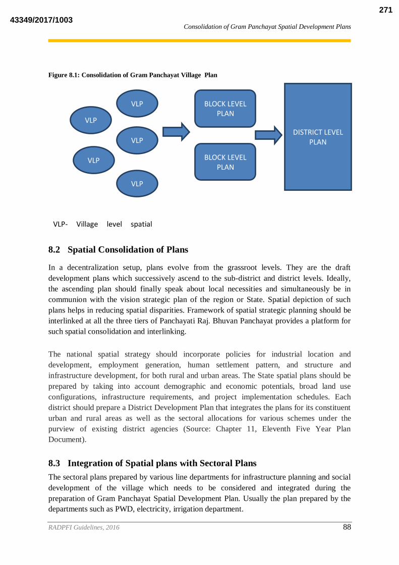
Consolidation of Gram Panchayat Spatial Development Plans
RADPFI Guidelines, 2016 88
Figure 8.1: Consolidation of Gram Panchayat Village Plan
8.2 Spatial Consolidation of Plans
In a decentralization setup, plans evolve from the grassroot levels. They are the draft
development plans which successively ascend to the sub-district and district levels. Ideally,
the ascending plan should finally speak about local necessities and simultaneously be in
communion with the vision strategic plan of the region or State. Spatial depiction of such
plans helps in reducing spatial disparities. Framework of spatial strategic planning should be
interlinked at all the three tiers of Panchayati Raj. Bhuvan Panchayat provides a platform for
such spatial consolidation and interlinking.
The national spatial strategy should incorporate policies for industrial location and
development, employment generation, human settlement pattern, and structure and
infrastructure development, for both rural and urban areas. The State spatial plans should be
prepared by taking into account demographic and economic potentials, broad land use
configurations, infrastructure requirements, and project implementation schedules. Each
district should prepare a District Development Plan that integrates the plans for its constituent
urban and rural areas as well as the sectoral allocations for various schemes under the
purview of existing district agencies (Source: Chapter 11, Eleventh Five Year Plan
Document).
8.3 Integration of Spatial plans with Sectoral Plans
The sectoral plans prepared by various line departments for infrastructure planning and social
development of the village which needs to be considered and integrated during the
preparation of Gram Panchayat Spatial Development Plan. Usually the plan prepared by the
departments such as PWD, electricity, irrigation department.
VLP
VLP
VLP
VLP
VLP
BLOCK LEVEL PLAN
BLOCK LEVEL PLAN
DISTRICT LEVEL PLAN
VLP- Village level spatial plans
43349/2017/1003271
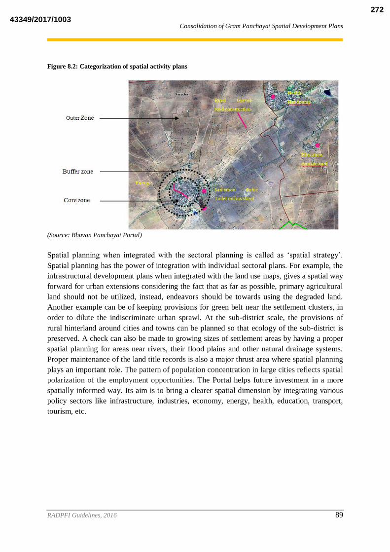
Consolidation of Gram Panchayat Spatial Development Plans
RADPFI Guidelines, 2016 89
Figure 8.2: Categorization of spatial activity plans
(Source: Bhuvan Panchayat Portal)
Spatial planning when integrated with the sectoral planning is called as ‘spatial strategy’.
Spatial planning has the power of integration with individual sectoral plans. For example, the
infrastructural development plans when integrated with the land use maps, gives a spatial way
forward for urban extensions considering the fact that as far as possible, primary agricultural
land should not be utilized, instead, endeavors should be towards using the degraded land.
Another example can be of keeping provisions for green belt near the settlement clusters, in
order to dilute the indiscriminate urban sprawl. At the sub-district scale, the provisions of
rural hinterland around cities and towns can be planned so that ecology of the sub-district is
preserved. A check can also be made to growing sizes of settlement areas by having a proper
spatial planning for areas near rivers, their flood plains and other natural drainage systems.
Proper maintenance of the land title records is also a major thrust area where spatial planning
plays an important role. The pattern of population concentration in large cities reflects spatial
polarization of the employment opportunities. The Portal helps future investment in a more
spatially informed way. Its aim is to bring a clearer spatial dimension by integrating various
policy sectors like infrastructure, industries, economy, energy, health, education, transport,
tourism, etc.
43349/2017/1003272

Resource Mobilization for Plan Implementation
RADPFI Guidelines, 2016 90
9. RESOURCE MOBILISATION FOR PLAN
IMPLEMENTATION
The 73rd
CAA carried out in 1992 by the Union Government envisaged vastly enhanced
expenditure responsibilities for the village panchayats in the country. However, it had not
made any specific assignments of taxes to these bodies to meet their enhanced expenditure. It
had been left to the state legislature to authorise village panchayats to collect taxes, duties,
tolls, and fees or to assign such taxes to them and also to provide grant-in-aid to them.
Though the state legislature was competent to do this even before the constitutional
amendment virtually none of the States took initiative in this matter.
The enlarged responsibilities of village panchayats fell into two main categories namely (1)
the traditional responsibilities which these bodies had been performing before the
constitutional amendment and (2) responsibility conferred on them by the 73rd
amendment
covering both Plan and non-Plan activities. The traditional functions were funded by
revenues raised by the panchayats supplemented by grants from the State government while
the new additional responsibilities were to be financed by resources available to the State
government.
Gram Panchayat for the development of villages depends entirely upon the grants and funds
from the state government and through the centrally sponsored schemes. However, there may
be certain sources through which a Gram Panchayat can raise its revenue to facilitate the
development of the villages. It is seen that panchayats located close to urban areas enjoy
better amenities in terms of health, education, and communication compared to other
panchayats selected for the study. This has an impact on the working of these panchayats and
also on their capability for mobilising resources internally.
The main sources of income of the panchayat may broadly be classified under four heads:
Tax revenue, Non-Tax revenue, Grants and Loans.17
Under tax revenue, main sources are: Own taxes, Assigned taxes, and Shared taxes.
Own taxes are those assigned to the panchayats and collected by them. The entire proceeds of
own taxes are appropriated by the panchayat. Assigned taxes are those assigned to the
panchayats, but collected by the State and given to the local bodies after deducting the cost of
collection. Shared taxes are levied and collected by the State, but a portion is shared with the
local bodies.
Non-tax revenue consists of licence fees, market fees, contributions, and deposits.
Grant component is a transfer from the State government, which may be either tied or untied.
Loans are conspicuously absent in most cases and constitute a negligible portion of the total
receipts.
17 Nair, R.P, 2004, Mobilisation of Resources by Panchayats: Potentials and Feasibilities (A Case Study of Six Selected Panchayats in Kerala), Kerala Research Programme on Local Level Development, Centre for Development Studies, Thiruvananthpuram.
43349/2017/1003273

Resource Mobilization for Plan Implementation
RADPFI Guidelines, 2016 91
9.1 Fourteenth Finance Commission
The main objective of fiscal transfer is to bring about progressivity; or, in other words,
equality in the fiscal strength of the panchayats earning different levels of income. To achieve
this objective, the mechanism of transfer should be used in such a way that panchayats with
lower income should get higher transfers from the State. In other words, to achieve fiscal
equalisation across the panchayats there should be an inverse relationship between per capita
own revenue and per capita grants.
The XIV finance Commission mandated to recommend measures needed to augment the
resources of Panchayats and Municipalities with the help of State’s supplements, based on the
recommendation of State Finance Commission (SFC)
The XIV Finance Commission has recommended assured transfers to local bodies for
planning and delivering of basic services smoothly within the functions assigned to them
under relevant legislatures.
Vertical Devolution to Panchayat
Table 9.1: Flow of funds from Central divisible pool to Panchayats
Finance Commission Assigned to Panchayats
Rupees in Crores
FC X 4,380
FC XI 8,000
FC XII 20,000
FC XIII 63,015
Source: Report XIV Finance Commission
9.1.1 Basis of Horizontal Distribution
The FC-X distributed its award exclusively on the basis of population (based on the 1971
Census). The FC-XI assigned a weight of 40 per cent to population (1991 Census), 10 per
cent to area and 20 per cent to distance from highest per capita income. The FC-XII retained
the weights used by FC-XI for each of these three criteria, but used the 2001 population data
for distribution. The FC-XIII increased the weight attached to population to 50 per cent and
retained the weight assigned to area at 10 per cent. While they retained the weight assigned to
distance from the highest per capita income at 20 per cent for urban local bodies, for rural
local bodies this was reduced to 10 per cent and a new criteria- proportion of scheduled caste
and scheduled tribe population - with a weight 10 percent was introduced. Apart from these
three common criteria, others like index of decentralisation, revenue effort, index of
deprivation, index of devolution and Finance Commission grant utilisation index have been
used by different Finance Commissions. In the distribution of grants, factors such as
population, area and deprivation related indices take into account the resource needs of the
States. Other criteria such as index of decentralisation, index of devolution, revenue
mobilisation linked the quantum of grants to the efforts of States to decentralise or to
empower the local bodies.
43349/2017/1003274

Resource Mobilization for Plan Implementation
RADPFI Guidelines, 2016 92
9.1.2 Recommendations of XIV Finance Commission
The XIV Finance Commission has recommended :
Grant-in-aid to duly constituted Panchayats (Rural Local Bodies) in two parts,
namely: Basic Grant and Performance Grant, In case of Gram Panchayat, 90% of
Grant will be Basic Grant and 10% will be Performance Grant.
Basic Grant to Panchayats for delivering Basic services especially water supply,
sanitation including septic management, sewage and solid waste management,
maintenance of community asset, roads, footpaths, street lightening, burial and
cementation grounds and other basic services as per 11th schedule.
The FFC has not distinguished between O&M and capital expenditure within the
components of basic services. However, it is advised that the cost of technical and
administrative support towards O&M and capital expenditure should not exceed 10%
of the allocation of to a Gram Panchayat.
Basic grant of Rs.1,80,262.96 crore for the GPs for the period 2015-20. Whereas
amount of Rs.20,029.22 crore of performance grants for GPs has been recommended
for a period of 2015-20. The details of State wise allocation of basic grants and
performance grants to Gram Panchayats for period 2015-20 can be referred from
Guidelines for Release and Utilisation of Grant recommended by the Fourteenth
Finance Commission (FFC) for Rural and Urban Local Bodies (Local Bodies Grant),
No.13(32)FFC/FCD/2015-16, 8th
October, 2015
Eligibility for Performance Grants for Gram Panchayat:
1. Gram Panchayat will have to submit audited accounts that relate to year not earlier
than two years preceding the year in which Gram Panchayat seeks to claim the
performance grant
2. The Gram Panchayats will have to show an increase in their own revenues over the
preceding year as reflected in the audited accounts.
FFC has further recommended that book of accounts prepared by the local body should
distinctly account own taxes, assigned taxes, devolutions and grants and grants for any
functions assigned by state or centre. This may be added to the Budget of the Gram
Panchayat as suggested to be prepared in Chapter 2.
It is desirable that 2% of the total funds transferred to Gram Panchayats to be used for
preparation of Gram Panchayat Spatial Development Plan.
9.2 Financial Plans for Rural Areas
Every Gram panchayat shall have and maintain its own fund to which shall be credited :
a. All moneys received by the panchayat from the Government by way of grants, loans,
advances, or otherwise;
b. All development charge or other charges or fees received by the Panchayat
c. All moneys received by the gram panchayat from any other source.
43349/2017/1003275

Resource Mobilization for Plan Implementation
RADPFI Guidelines, 2016 93
9.2.1 Budget of the Gram Panchayt
Every Gram Panchayat shall prepare a budget document in such form and at such time every
year as may be prescribed by the rules, a budget in respect of the financial year next ensuring,
showing the estimated receipts and expenditure of the panchayat and shall forward to the
DPC such number of copies thereof as may be prescribed by rules.
(1) Every panchayat shall maintain proper accounts and other relevant records and
prepare an annual statement of accounts including the balance sheet in such
form as the Government may by rules prescribe.
(2) The accounts of every Gram Panchayat shall be subject to audit annually by
the District Planning Committee of the State and any expenditure incurred by
DPCs in connection with such audit shall be payable by the state.
(3) The accounts of every Gram Panchayat as certified by the DPCs or any other
person appointed by DPCs in this behalf together with the audit report thereon
shall be forwarded annually to the Government and the Board.
9.2.2 Annual Report
(1) The DPC shall prepare for every year a report of its activities during that year
and submit the report to the Government in such form and on or before such
date as may be prescribed by rules, and the Government shall cause a copy of
the Report to be laid before the State Legislature.
(2) Every Gram Panchayat shall prepare for every year a report of its activities
during that year and submit the report to the Government and the Board in
such form on or before such date as may be prescribed by rules Table 4. 1:
Table 9.2: Format of Balance sheet/Budget for rural areas
Particulars Actual for the
year
2014-2015
Budget estimates
for the year
2015-2016
Actual for the
year or revised
estimates 2015-
2016
Budget estimates
for the year
2016-2017
OPENING
BALANCE
- - - -
Revenue
Receipts
Capital receipts
Total
GRANT TOTAL
Revenue
Expenditure
Capital
expenditure
Total
CLOSING
BALANCE
43349/2017/1003276

Resource Mobilization for Plan Implementation
RADPFI Guidelines, 2016 94
REVENUE
RECEIPTS
Grants and Funds
Tax Revenue
Property/Chulha
tax/other taxes
User Charges(if
any)
Sale and hire
Charges
Rental Income
Other Income
REVENUE
EXPENDITURE
Establishment
O&M
Administrative
CAPITAL
RECEIPTS
Grants
Contribution and
specific Purpose
Deposits Received
Deposits Work
Other Liabilities
CAPITAL
EXPENDITURES
Fixed Assets
Loans Advances
and Deposits
*The additions and substractions may be carried out as per the Panchayats’ revenue and expenditure heads.
9.3 Spatial Budgeting INPUTS REQUIRED
9.4 Convergence with central rural schemes
The main source of revenue of Panchayat is grants from centre or state and hence the Gram
Panchayat Spatial development Plan shall be in line with the existing schemes and allocation
of funds to rural areas. Following are few centrally sponsored schemes for rural area through
which funds can be drawn for various development in rural areas, according to projected
requirements.
Mahatma Gandhi National Employment Guarantee Act -Rural employment
Sarva Shiksha Abhiyan -Education
Pradhan Mantri Gram Sadak Yojana- Rural roads
National Health Mission- Healthcare
Integrated Child Development Scheme- Child development
Indira Awas Yojana -Rural housing
Mid-Day meal Scheme- Nutrition
National Rural Drinking Water Programme- Water
43349/2017/1003277

Institutional Support Mechanism and Capacity Building
RADPFI Guidelines, 2016 95
10. INSTITUTIONAL SUPPORT MECHANISMS AND
CAPACITY BUILDING
10.1 Institutional Set up
Planning function is a continuous process and the planning department’s work continues from
plan preparation to plan processing, enforcement implementation, plan detailing, review and
then plan formulation and so on. The plan formulation, implementation, monitoring and
review exercises must be statutorily prescribed in the State acts and completed within the
specified time frame as schedule. In the context of these requirements institutional set up has
a vital role.18
10.2 System Support for Planning and Implementation
To operationalise the entire planning and implementation process at the Gram Panchayat
level, a strong administrative arrangement with regard to System Support is needed to be put
in place. Besides human resource, technological and knowledge support, this arrangement
shall include specific executive orders on technical, administrative and financial sanctions,
procurement system by the Gram Panchayat. Since the Gram Panchayats are adequately
empowered vide Article 243G of the Constitution with regard to preparation of an inclusive
development Plan for Social Justice and Economic Growth. Fourteenth Finance Commission
recommendations also maintains that the Gram Panchayats assume its legitimate role of
approving Gram Panchayats Plans & mobilize the resources at its disposal for effective
implementation of the respective Gram Panchayats Plans. Acknowledging the need to
translate the ideas and aspirations of the stakeholders as reflected in the Plan document into
tangible outcomes, it is imperative that both the planning & implementation stage of the
project receives undivided support of all manners of resources like Human Resource,
Technological Resource, infrastructural resource, Data resource, etc. Towards this end,
therefore the Gram Panchayats will optimally utilize the services of the manpower deployed
both from State level rural Development department and all the Line Departments.19
The work profiles of some of the functionaries or Technical Support Group (TSG) are
detailed below.
10.2.1 District Town and Country Planning Departments(TCPDs)
Gram panchayat planning would be moderated and assisted by the town and
country planners at the district level.
Subsequently rural Development assistants are needed to assist spatial planners
with the ground level work.
District level vision exercise as well as consolidation of the urban and rural
plans in relevance to the state and district vision.
18
Adapted from URDPFI Guidelines 2014 19Adapted from Gram Panchayat Development Plan Guidelines, 2015, Government of Sikkim.
43349/2017/1003278

Institutional Support Mechanism and Capacity Building
RADPFI Guidelines, 2016 96
10.2.2 Rural Development Assistants (RDA)
Development Administration: RDAs are responsible for assisting in the planning,
implementation and monitoring of all developmental schemes of the State
Government, Government of India and the Panchayat level.
Assist the Town and Country Planner at the District and Block level.
Assistance for village library: Government can establish village libraries in the
Panchayat Ghars of all Gram Panchayat Units which they are to maintain.
Election related work: Election related work like delimitation of GPUs,
preparation of electoral rolls, verification of polling stations, duties of polling
officers and other related duties like counting, etc. which requires a very high
sense of responsibility and accountability.
Monitor e-Panchayat activities.20
10.2.3 Gram Panchayat Planning Committee
It would constitute of competent Urban/Rural/Regional Planner, Rural
development Assistants, Gram Sachiv, Patwari, Gram panchayat members,
resource persons from the rural schools and health centres and official associated
at rural level from the line departments.
The Gram Panchayat planning committee would together aid, assist and contribute
through participatory planning tools a comprehensive Panchayat development
plan formulation in consultation with the Gram Sabha.
The spatial plan would follow the spatial budgeting at the district and block level
for various sectoral schemes of development.
10.3 Capacity Building
In order to implement the Participatory Planning for development of Gram Panchayats,
capacity building is one of the important tools at all levels. The training strategy includes
building capacities of all the stakeholders including Empowered Committee at State Level,
Resource Groups at Panchayat level, other institutions etc. Training Strategy would be to
provide training in cascading mode i.e. building capacities at SIRD level, then at District and
block level, so as parallel trainings could be done in shortest possible time. 3 percent of the
Basic Grant to Gram Panchayats to be earmarked for Capacity Building
10.3.1 Capacity Building Framework
10.3.1.1 Key Stakeholders
At State Level
State PR & RD Officers at State Level
Administrative Secretary + Senior Level Officer of Line departments
State Resource Group including Universities representatives, Academician,
NGOs, Subject Experts, UNDP Consultants, etc.
20ibid
43349/2017/1003279

Institutional Support Mechanism and Capacity Building
RADPFI Guidelines, 2016 97
Faculty of State institutes of Public Administration, Scientists from KrishiVigyan
Kendra, Public Relation Officers etc.
Accredited or Private Training agencies to be identified.
Mobile resource teams to be identified At Training Institute
Faculty of SIRD.
Resource Persons of SIRD at District Level
Deputy Commissioners + Additional DCs + Senior Level Officer of Line
departments
District PR & RD Officers at District Level
District Resource Group including Universities representatives, Academician,
NGOs, Subject Experts, UNDP Consultants, etc.
At Block Level
State PR& RD Officers at Block Level
Block Level Officers of Line departments
Block Resource Group including Local institutions, Eminent Retd. Personnel,
NGOs, Subject Experts etc.
At Gram Panchayat (Sensitization)
Elected Representatives and Panchayat Functionaries
Special Gram Sabhas, Camps, Seminars etc. for mass awareness of citizens.
10.3.1.2 Resource Persons or Master Trainers
Faculty of State Institute for Rural Development (SIRD) and Extension Training
Centres.
Resource Person or Master Trainers of SIRD
Resource Persons of SBM-G
Resource Persons of SRLM
Resource Persons of MGNREGA
Resource Persons of Housing For All Scheme.
Resource Managers of Rurban Mission.
District Project Managers (Digital India)
10.3.1.3 Selection and Capacity Building of Resource Persons
Proposed resource persons in place with orientation towards imparting training.
Capacities of the proposed resource persons can be honed through 2-3 day State
Level Workshop to be held at SIRD. MoPR to provide training support.
Information Education and Communication activities fund of RGPSA can be
used.
10.3.1.4 Developing Training Modules and Materials
Model Training Modules to be provided by MoPR.
Customization of Training Modules in local language by SIRD
Training Management Portal would be used for design of modules etc.
43349/2017/1003280

Institutional Support Mechanism and Capacity Building
RADPFI Guidelines, 2016 98
Handbooks, CDs, CBTs, PPTs would be prepared by SIRD
10.3.1.5 Infrastructure and logistics
SIRD training facilities would be used for orientation programmes of Master
Trainers.
Training programs of District, Block and Gram Panchayats would be held at
district and block.
10.3.1.6 Monitoring and Ensuring Quality
Empowered Committee at State Level would do overall monitoring. Monitoring
Module (IT based) would be developed.
SIRD would monitor the training programs and report to Empowered Committee.
Training Management Portal of Panchayat Enterprise Suite (PES) for monitoring.
State Resource Group would do the Training Need Assessment at regular intervals
to review and revise training modules, processes etc.
43349/2017/1003281

Operationalization of RADPFI Guidelines
RADPFI Guidelines, 2016 99
11. OPERATIONALIZATION OF RADPFI GUIDELINES
11.1 Adoption of RADPFI Guidelines
Rural Area Development Plan has no significance if it does not get implemented on ground.
In the Planning Process in our country, excellent ideal plans were construed but these could
not see the implementation stage due to numerous factors both local, socio economic,
demographic, area and topography related, fund related issues, lapse in programmes and
policies and a host of other related issues over period of time.
Spatial planning for development is an envisioning process which requires a sound
assessment of the ground realities and provides options for sustainable development within
demographic, physical, socio economic, jurisdictional and financial aspects. The focus is on
spatial dimension as all development efforts have direct impact on the use of the land and
different development projects need to be coordinated and integrated within a desirable
spatial frame. The process of spatial planning is dynamic and needs to address the emerging
problems of the human settlements. The formulation of the RADPFI Guidelines 2016
addresses the present challenges of rural spatial growth and development, plan preparation
process and implementation and attempts to standardise and also simplify the guidelines
required for planning in the country.
The norms and standards prescribed by RADPFI Guidelines 2016 are in the form of a
suggested model, which may be adopted by the State Governments in accordance to their
local conditions. State Town and Country Planning Departments have been preparing
Development plans for urban areas based on from UDPFI Guidelines, 1996 and subsequently
URDPFI Guidelines, 2016. The ‘Country planning’ which has always remained absent in
practice from the various Town and Country Planning Acts as well as by state level agencies
is now being given impetus through the ‘RURBAN mission’ and adoption of new and
updated State Town and Country Planning Acts and also by the upholding of spatial norms
by the RADPFI Guidelines.
The norms and standards are in slight variance to the urban norms and standards; but as stated
in the URDPFI guidelines, 2016; the norms of both can be adopted by the respective state
governments as well as can evolve its own but on a precondition of not violating the
minimum standards given in the guidelines.21
11.2 Implementation of Projects/ Schemes
It is essential that the Gram Panchayat Spatial Development Plan (GPSDP) should be time
bound, has clear cut outcomes, address the needs and priorities of the communities and area,
enhance resource conservation, bring in sustainable development of the area.
The pre-implementation stages of GPSDP consist of the following major components:
21Adapted from URDPFI Guidelines, 2014
43349/2017/1003282

Operationalization of RADPFI Guidelines
RADPFI Guidelines, 2016 100
(a) The date on which the GPSDP will be firmed up taking into account various parameters
specified in the Plan.
(b) The dates on which the sanctioning authority, whether it is the State Government or the
Central Government (as the case may be) will be ready with the formal sanction separately in
respect of each of the schemes/ projects , whether it is in the agriculture, irrigation,
electrification, education, road connectivity, health infrastructure and delivery, social and
economic sector schemes, need based and region specific schemes, communication, agro
processing, rural industries etc.
(c) The dates on which GPSDP is launched for the schemes/projects by the Gram Panchayat.
After these critical landmarks are determined, under the pre-implementation stages of each of
the projects/schemes, the Panchayat will start implementing GPSDP with an obligation and
adhere to the time line as broadly suggested in the GPSDP.
(iii) In order to ensure that the time line is strictly adhered to, the delegation of authority and
responsibility of the Gram Panchayat be considerably enhanced, and entrusted to Gram
Panchayat Members for implementing the schemes/ projects etc. included in the GPSDP.
(iv) After determining the exact date of physical start-up of the projects, a simple graphical
PERT network with clearly mentioning in local language preferably on a wall of the
Panchayat Building or a separate cement board for transparency and ensuring participation of
the local people.
(v) Before a project is included in the GPSDP and later on taken up for implementation, a
very detailed examination of the scheme/project be undertaken. Detailed site investigations,
geological investigations, resource endowment, technology assessment, SWOT analysis etc.
should be undertaken in all cases. Expenditures on these investigations are very necessary
and should be sanctioned liberally.
(vi) With regard to critical projects in the field of rural industry, electrification, irrigation,
communication, road connectivity, drinking water and sanitation, rural housing, education
and health, etc. a good deal of study like exact location, accessibility, serviceability,
adequacy, judicious use, conservation of NRM, choice of technology, social cost benefit etc
should be analysed and implemented in a simplified and expeditious manner.
(vii) As unutilised funds have to lapse towards the end of the financial year, the possibility of
funding on a long term basis, for at least in critical sectors, will have to be examined as
against the present system of annual funding. This will avoid delay in the implementation of
projects.
(viii) Gram Panchayat responsibility for the implementation of the Plan should result in a
sense of involvement in fulfilling of the Plan targets. The existing procedure would need a
very careful examination so that proper formulations are drawn up quickly, and implemented.
43349/2017/1003283

Operationalization of RADPFI Guidelines
RADPFI Guidelines, 2016 101
(ix) When the project is undertaken, and even before the first phase of the project has been
completed, expansion schemes have been introduced with the result that neither the
objectives of the first phase were achieved, nor the various expansion projects which are
loaded on to the original projects are productive, resulting in time and cost overruns. It
would, therefore, be imperative that no expansion projects should be taken up unless the
original project is completed, and is fully stabilised, and has given the desired results both in
regard to the physical and fiscal performance.
(x) The Planning process at District and Block Level is fairly stabilized and there is a need to
improve the plan process and project implementation at GP level. Though recently GPDP and
SAGY are aiming towards improving the planning scenarios considerable strengthening is
required at the GP level and RADPFI is expected to address these issues.
11.2.1 Monitoring of Implementation
1. The GPSDP implementation by the Gram Panchayat would also need to effectively
monitor with a view to ensuring that for each scheme various targets relating to time and cost,
generation of services, social and economic benefits relating to the individual projects
through the rural industries, agricultural, primary education, irrigation, drinking water and
sanitation, rural roads connectivity, primary health or any other sector of the rural economy
are achieved.
2. Implementation of the GPSDP has to be very effective, and for this task, various line
Departments concerned at the Block and District level of the concerned states have to be
strongly geared up and quarterly or six monthly reviews with regard to the implementation of
the GPSD Plans.
11.2.2 Machinery For Planning
1. There is technical manpower shortage at GP level or even Block level, particularly in core
sectors like agriculture, drinking water and sanitation, irrigation, agro processing, rural roads,
education and health and social services sectors. A GPSD project need techno-economic
feasibility and social costs benefits.
2. The Block Planning machinery would need to be strengthened in the areas where
deficiencies exist with regard to their role in supervising project implementation of the GPSD
Plan projects. It would be desirable that the Block Planning agencies co-ordinate effectively
with the Gram Panchayat in respect of formulation and implementation of the Plans.
3. Planning at the local level has an important role to play in investment decisions in
agriculture, minor irrigation, animal husbandry, fisheries, marketing and processing, cottage
and small scale industries, local infrastructure and social sector services including water
supply, housing, health, education, sanitation, roads and local transport, which should be
made area specific at the grass root level based on local environments, physiography,
43349/2017/1003284

Operationalization of RADPFI Guidelines
RADPFI Guidelines, 2016 102
demographic profile, socio economic aspects and potential for growth and fuller
employment. It is envisaged that if the Block Level Planning is strengthened, the technical
manpower could help in not only scientific plan formulation but also in the effective plan
implementation of the programmes for the faster development of the rural area optimizing
the use of local endowments, integrating the GPSD plan objectives and local needs.
4. The GP level plans would need to be in harmony with the Block and District level Plans.
The investment decisions at the local level would need to take into account the effects of
Central/State Plans in that area and of neighbouring localities. The cluster of GPs as rural
areas and propensity to develop faster, is intended to be the primary area for GPSD local
planning. Area specific development programmes will help deal with the problems of
regional imbalances and intra-regional variations. The GPSD planning projects would require
specific technical skills and manpower resources within a framework of guidelines
formulated at the local level. Thus strengthening the planning machinery is imperative for
promoting location-specific area plans for rapid development.
11.2.3 People's Involvement In Planning And Implementation
1. Apart from decentralisation of the administrative machinery and provision of adequate
coordinating mechanisms at the local level, it will be necessary to ensure that at every stage
of planning and implementation there is full participation and involvement of the people.
Allocations or public funds for schemes in these sectors, whether by the Central or the State
Governments are on the basis of certain patterns of funding designed to achieve the targets of
the Plan. The selection of the specific tasks, however, is governed by local conditions and in
assigning priorities it might be necessary to involve both the Gram Panchayat and Block
Panchayat at the local level as well as the representatives of people particularly of the
beneficiary groups, women’s groups, youth, socially disadvantaged groups, NGOs and
community based organisations for implementation of the RADP in consonant of its
objectives and spirits at local level.
2. The institutional mechanism for this purpose will need to be adapted to changing
requirements. The Panchayati Raj institutions should be strengthened in order to become
institutions of democratic management of rural development both at the block and GP levels.
Some State Governments have already established systems where at the Block level the
development work is entrusted to Block Level Technical and administrative Officials for
effective implementation. The block and GP level representative institutions will, however,
have to give adequate voice in their affairs to the weaker sections of the society who are the
major beneficiaries of the programmes ol development. The welfare of women and their
economic emancipation should receive special attention.
3. Special emphasis would need to be placed on involving the youth at GP level. More
imaginative ways through skill development, employment, upgradation of their technical
skills, exposure for new innovations and rural technologies, opportunities in service sector, IT
based tools and new way of eLearning and distance learning methods to be evolved, for
43349/2017/1003285

Operationalization of RADPFI Guidelines
RADPFI Guidelines, 2016 103
tapping the potential and idealism of the youth for constructive action in rural areas. Through
participation of the youth, women, farmers, artisans, handloom and khadi workers,
disadvantages groups etc, several development activities could be initiated towards
addressing the needs for energy, housing, basic needs, drinking water and sanitation, farming
technologies, employment, social security, education and health, income generating activities
etc, under the purview of the RAD Plan implementation.
11.2.4 Manpower Requirement
1. Manpower requirement require careful review at GP level so as to bring about a hybrid
approach with tapping technical manpower from PMKSY, Agriculture , MGNREGA,
PMGSY, PMIAY etc and tapping the guidance of Block level technical functionaries, to keep
a judicious mix for a sustainable approach. Staff posted in tribal, hill and backward regions
require attention so that competent technical staff can be given skill upgradation and
behaviourial modification for improved performance in the GPSD Plan implementation in
such regions. Project based and part-time employment of locally skilled people, retired block
level functionaries, NGO technical staff, CBOs, or through training, capacity building and
hand holding of the Panchayat functionaries, involving local educational and social
organisations, women’s groups, farmers organisations etc can render maximise benefits
from existing institutions for accelerating the development of rural areas, under RADPFI.
Volunteerism, entrepreneurship, CSR, PP activities to be developed to be of backbone
support agencies in rural areas.
2. Inadequacy of adequate administrative framework at Block and GP level is a major
challenge in the promotion of basic amenities like housing, education, health and
communication, accessibility, drinking water and sanitation, employment, economic activities
etc for rural area development in terms of growth and economic development. Though the GP
is the nodal agency to implement the GPSD Plans, Block level technical personnel should
give their technical advise and support in the implementation of the Plans, for which the job
profile of the Block functionaries may be redefined and made broad based.
11.3 New Roles and Functions of State Town and Country Planning
Departments
The new role of Town and Country Planning Departments that emerges out of the provisions
of the 73rd&74th CAA shall, among others, include :
a) Advice and technical assistance to the State Government on matters pertaining
to spatial planning and development as well as implementation of state
programmes;
b) Initiation of action pertaining to provision of legal support in relevant Acts for
socio‐economic, spatial planning and development processes; and on the
suggested Regional, Rural and Urban Development Planning system;
43349/2017/1003286

Operationalization of RADPFI Guidelines
RADPFI Guidelines, 2016 104
c) Assistance to the State Urban and Regional Planning Board in formulation of
the State Perspective Plan and strategy of spatio‐economic development of the
State, having regard to proposals contained in district and metropolitan area
development plans;
d) Division of the State into various planning regions taking into account the
physical, socio cultural, economic and climatic considerations and formulation
of plans of their spatio‐economic development to serve as a guide for resolving
inter‐district developmental issues and provide basis for inter‐district
cooperation and co‐ordination with a view to prepare district development
plans more harmonious;
e) Scrutiny of the district and metropolitan area development plans for approval
of State Government, taking into account the State perspective plan, spatio-
economic development strategy and proposals of relevant planning region
covering the district or the metropolitan area;
f) Ensuring that respective settlement Development Plans
(Regional/Urban/Cluster/Gram Panchayat) prepared by local authorities are
within the framework of the approved perspective plan of the State/settlement;
g) Technical assistance to local authorities if so requested at the cost of the
concerned body;
h) Preparation of the development plan in case of default by the local authority,
district planning committee or the metropolitan planning committee, if so
directed by the State Government, at the cost of the concerned planning body;
i) Provision of necessary research input directly or through the help of consultants
in formulation of policies, strategies, norms, standards, laws, regulations and
rules pertaining to urban and regional planning and development matters;
j) Provision of manpower training facilities;
k) Establishment of an Urban and Regional Information System and
dissemination of information22
.
11.4 Information System, Database for Implementation
1. A detail computer based information systems for data storage, retrieval and processing of
all Government Departments and sectors, both State and Central are being available and are
in use in the country up to GP level. For most of the Central Schemes, the data is being
updated on daily basis. A dedicated data capturing framework in the NIC to be developed for
computerized desktop based, tablet based and mobile based updation on the progress of
implementation of works under GPSD Plans.
22 URDPFI Guidelines, 2014
43349/2017/1003287

Operationalization of RADPFI Guidelines
RADPFI Guidelines, 2016 105
2. Dash Boards in the NIC RADP MIS to be evolved to show the progress of work and also
help monitoring and timely completion of the works, as per the GPSD Plans.
3. GIS based asset monitoring and updation through photographs, positional coordinates with
details of the asset created, beneficiaries etc to be uploaded on daily basis by the various
technical personal available in GP level under Central and State level and through that of
Block level.
4. Crowd sourcing of information on GPSD Plan implementation would give a fillip to the
faster progress of works under GPSDP in rural areas.
5. Social media networks to be extensively used for knowing the views of the stake holders in
the progress monitoring and implementation issues for timely resolving the same for effective
implementations.
TRAINING
1. Training, capacity building and hand holding is an essential component of the GPSD
Plan implementation for all GP functionaries, Block functionaries, youth, women’s
groups and other stake holders in rural area. Training need to be organized at local
level in simple manner in local language with instruction manuals to be available
pictorially for easy understanding.
2. Training to be implemented on Mission Mode to make the GPSD Plans effectively
implementable for bringing faster development and addressing the priorities and
needs of the targeted rural areas and hence the training need to be area specific with
special skills like hills, disaster prone, tribal areas, coastal, drought prone etc.
3. The existing Block and GP technical Staff under various State and Central
development schemes to train, sensitise and familiarise the stake holders for operating
in a mission mode approach.
SOCIAL AUDIT
1. The Social Audit dimension should be an integral part of the GPSD Plan
implementation in rural areas. All the processes and methodologies followed under
MGNREGA may be followed for GPSD Plans also for standard practice and for
taking advantage of the local people’s familiarizes and that of the Gram Panchayats.
2. The observations and feedback from the Social Audit should be rolled back to GPSD
Plans for scientific, need and priority based, implementable, plan implementation to
derive optimum benefits to the rural areas and people.
43349/2017/1003288

Operationalization of RADPFI Guidelines
RADPFI Guidelines, 2016 106
11.5 Recommendations to State Governments/ Town and Country
Planning Departments/ Local Bodies/Development Authorities
State Governments should review and where necessary amend the respective State Town
and Country Planning Acts and related laws of the State Government to minimize
inconsistencies and contradictions and inadequacy in to propel integrated spatial and sectoral
planning in rural areas. The state T&CP Acts could direct the public participation at
pre‐planning and post draft plan formulation stage and the time period for approval of
development plans. The amendments are suggested to be referred from the Model Town and
Country Planning Law and Model Municipal Law by the Central Government revision.
The relevant state level acts to be considered for revision can be looked up in table number
10.2 of the URDPFI Guidelines 2014.
States need to proactively amend their T&CP Acts to incorporate the provisions of 74th
CAA on the lines of Bihar and Kerala.
States also need to amend Building Regulation as per the directions of Ministry of Urban
Development
Efforts to be made to operationalize the MPC and DPC with appropriate role of T&CP
Departments.
Integration of Sectoral Plans with Master Plans and GPDPs with provision of notification
of the same.
Any future amendments to be need based with wider stakeholder consultations
Regulatory framework to be reengineered which ought to be people’s friendly and with
an enabling environment in a time bound and transparent manner.
Revision of Model Town and Country Planning Law to be undertaken keeping in view
the emerging issues and dynamism of spatial planning.
TCPO and SPA together may attempt for this exercise as a follow up of the URDPFI and
RADPFI Guidelines.
11.6 Modified State Town and Country Planning Acts
The Bihar and Kerala State Town and Country Planning Acts of 2012 and 2016 have tried to
incorporate the components suggested by the 73rd
and 74th
CAAs as well as tried to widen the
ambit of spatial planning to the Town as well as Country, i.e. Rural areas or Gram
Panchayats. The implementation of the same would however prove the efficacy of the same.
The following sub sections just highlight the sections of the respective Acts which relates to
spatial planning in rural areas.
11.6.1 Bihar Urban Planning and Development Act, 2012
Section 22: Contents of Development Plan-
The Planning Authority shall consider and incorporate, while preparing the Development
Plan, such information and details including land use, Zoning Regulation, development
43349/2017/1003289
Operationalization of RADPFI Guidelines
RADPFI Guidelines, 2016 107
control regulations, whether the Planning Area is a Natural Hazard Prone Area, within a time
frame of twenty years or such extended period as may be specified by the Government:
a) prepare a topographical map for the Planning Area and also earmark lands fit
for agriculture (wet and dry), and allied sectors like animal husbandry, dairy,
poultry, horticulture, floriculture, forestry (including social forestry), urban
agriculture and wasteland fit for various kinds of development;
b) Identify and map the facilities at the level of village, block, city and district.
c) Identification and demarcation of zones and sub zones, within the holistic
framework of the Development Plan.
d) Collect, compile and update the information on natural and human resources
and the demographic profile, for preparing the database at block, city and
district level for decentralized planning.
e) modify, amend and consolidate the objectives and strategies made for five
years or annual draft Development Plans of rural and urban areas,
considering the overall objectives of development .
11.6.2 Kerala Town and Country Planning Act
The Kerala Town and Country Planning Ordinance 2013, got passed as an Act in 2016. The
act states to -
To provide for the promotion of planned development and regulation of growth of urban and
rural areas in the State with focus on scientific spatial planning and to secure to their present
and future inhabitants, sanitary conditions, amenity and convenience and for other matters
connected therewith or incidental thereto.
Preamble.—WHEREAS, it is expedient to provide for the promotion of planned development
and regulation of growth of urban and rural areas in the State with focus on scientific spatial
planning and to secure to their present and future inhabitants, sanitary conditions, amenity
and convenience and for other matters connected therewith or incidental thereto.
Local Planning Area.—From the date of commencement of this Act, the area under the
jurisdiction of a Municipal Corporation, Municipal Council, Town Panchayat or Village
Panchayat shall be deemed to be a Local Planning Area, for the purposes of this Act.
Powers and functions of the Municipal Corporations, Municipal Councils etc. in relation to
spatial planning.—Notwithstanding anything contained in the Kerala Municipality Act, 1994
or the Kerala Panchayat Raj Act, 1994, Municipal Corporation, Municipal Council, Town
Panchayat or Village Panchayat shall have the following additional functions for the purpose
of this Act, namely:—
(a) prepare or get prepared for the Local Planning Area or part thereof,—
(i) a master plan, taking into account the Plans, if any, prepared under this
Act which have relevance to the Local Planning Area;
43349/2017/1003290

Operationalization of RADPFI Guidelines
RADPFI Guidelines, 2016 108
(ii) execution plans, taking into account the master plan and other Plans, if
any, prepared under this Act which have relevance to the Local Planning
Area;
(b) implement all or any of the provisions contained in the Plans under this Act
by formulating and executing projects, Land Pooling Schemes, Detailed Town
Planning Schemes or otherwise;
(c) formulate, promote, regulate and control land use and developmental activities
in the Local Planning Area as per the Plans under this Act;
(d) set up special function agencies, if necessary, for specific functions such as
plan preparation, implementation of projects and guide, direct and assist such
agencies on matters pertaining to their respective functions; and
(e) perform such other functions as are supplemental, incidental or consequential
to any of its functions and or as may be directed by the Government from time
to time.
The Kerala Town and Country Planning Act is the most recent and updated with
the spatial Planning component for both Urban and Rural Areas. The act is
exemplary in relation to the strengthening and emphasis it provides to spatial
planning.
(Kerala Town and Country (Planning and Development) Act 2016; accessed, 19/07/2016;
http://www.townplanning.kerala.gov.in/ACTS_RULES/ACTS_RULES_01.htm)
43349/2017/1003291

Annexure
RADPFI Guidelines,2016 i
12. RERFERENCES 1. Accelerated Rural Water Supply Programme Guidelines,Ministry of Rural
Development
2. Asif and Rahman, 2010, Land use and Socio-economic Responses to Urban
Enchroachment on Agricultural Land-A study of an Indian Urban-Rural Fringe,
Geographical Journal, Vol.65, No.4, pp. 289-314
3. Bureau of Indian Standards, Code of Basic Requirements for water Supply, Drainage
and Sanitation, 1993)
4. Chambers and Mayoux, 2003, Reversing the Paradigm: Quantification and
Participatory methods, EDIAIS Conference, University of Manchester, U.K
5. Census of India, 2011
6. Compendium of Sewage Treatment Technologies, National River Conservation
Directorate, MOEF, 2009 ; Technical options for Solid and Liquid Waste
Management in Rural Areas, Ministry of Drinking water and Sanitation., 2013
7. Draft National Building Code, Doc: CED 46 (8064) WC, Nov 2015; Rural Roads
Manual, 2002, Indian Road Congress
8. Formulation of GIS based Master Plan for AMRUT Cities, Town and Country
Planning Organisation, Ministry of Urban Development, GoI, November 2015
9. Gram Panchayat Development Plan Guidelines, 2015, Government of Sikkim
10. Gram Panchayat Development Plan, Haryana, 2015
11. Green Burial Ground Project, PARD
12. Guidelines for Climate Proofing Investment in Agriculture, Rural Development, and
Food security, Asian Development Bank, 2012
13. Model guidelines for Development and construction including safety provision for
Natural Hazards in Rural Areas, GOI-UNDP Disaster Risk Management Programme,
Ministry of Home Affairs, GOI, 2008
14. Nair, R.P, 2004, Mobilisation of Resources by Panchayats: Potentials and Feasibilities
(A Case Study of Six Selected Panchayats in Kerala), Kerala Research Programme on
Local Level Development, Centre for Development Studies, Thiruvananthpuram
15. National Building Code, Doc: CED 46 (8064)WC, Nov 2015
16. National Mission on Sustainable Agriculture, Operational Guideline, Ministry of
Agriculture, Government of India,2014
17. National Policy on Disaster Management,2009;NDMA, Ministry of Home Affairs
18. NDMA Guidelines, Preparation of State Disaster Manangement Plans
19. Office of National Statistics, U.K, 2011
20. Pryor, R.J, 1968, Defining the Rural-Urban Fringe, Social Forces, Vol.47, No.2, pp-
202-215
21. Reading Material on Planning Techniques by JH Ansari and Shri Mahavir & MM
analysis
22. Report XIV Finance Commission
23. Urban India 2015: Evidence, Indian Institute of Human Settlement
24. UNDP Disaster Risk Management Programme Ministry of Home Affairs, Govt. of
India , 2008
43349/2017/1003292

Annexure
RADPFI Guidelines,2016 ii
25. UNICEF/Ministry of Rural Development, Gov. of India
26. World Commission on Environment and Development’s,The Brundtland Commission
Report, Our Common Future, Oxford University Press, 1987
INPUTS RECEIVED FROM
1. Town and Country Planning Organization
2. National Remote Sensing Centre
3. Centre For Good Governance
43349/2017/1003293

Annexure
RADPFI Guidelines,2016 iii
ANNEXURE 1:
Decentralised Planning in India
Decentralised planning is a system through which planning process is brought close to the
ultimate target of development, i.e, the people. It is a multilevel planning system in which
planning is attempted at different political, administrative and executive levels. So that there
is greater integration between the development needs and priorities of smaller areas and
different socio-economic classes within the hierarchies of the local, district, regional, state
and national levels.
Decentralisation involves planning for all sectors or types of activity within a geographical
area. It lays emphasis not only on decentralisation of the decision making process but also on
increasing participation by the people at all stages of planning. These would enable full
utilisation of resources according to the needs of the local people by making them actively
involved in the formulation as well as execution of plans at the grass root level.
Decentralisation implies a movement away from the centre. It implies an even distribution of
power among all agents in the social, political and economic spheres. It facilitates the
articulation of people’s needs and demand.
Decentralised governance, from capital cities to towns and villages, is the best way to involve
people in development activities and for increasing efficiency. Local officials and politics
will be better scrutinised and their activities better monitored. They will be more accountable
to the communities which they are supposed to serve. Decentralisation by empowering
people from the grass root level helps to generate a sense of belongingness among them and
they get more deeply involved in development works
The Indian constitution has the concept of decentralisation in the Directive Principles of State
Policy. Article 40 of the Directive Principles of State Policy states that the state shall take
steps to organise villages and panchayats and endow them with such powers and authority as
may be necessary to enable them to function as units of self government. The division of
power and functions enshrined in Article 246, read with the seventh schedule of the
constitution, made multilevel planning almost a necessity.
Subject to the provisions of the Constitution, the Legislature of a State may, by law, endow
the Panchayats with such powers and authority as may be necessary to enable them to
function as institutions of self government and such law may contain provisions for the
devolution of powers and responsibilities upon Panchayats at the appropriate level, subject to
such conditions as may be specified therein, with respect to-
(a)The preparation of plans for economic development and social justice,
(b)The implementation of schemes for economic development and social justice
as may be entrusted
43349/2017/1003294
Annexure
RADPFI Guidelines,2016 iv
(c)To them including those in relation to the matters listed in the Eleventh
Schedule.
Evolution of Decentralized Planning
India adopted economic planning with the launch of the First Five Year Plan in 1951. Five
Year Plans have been mainly centralized plans. But even then, from the very first plan
onwards attempts have been made by the government to introduce some degree of
decentralization into the planning process by strengthening local level planning. Sometimes
such attempts have been strong and visible. At other times, they have been weak and
dormant. Thus decentralized planning has evolved in India in fits and starts over the years. Its
evolution can be divided into five phases for a brief examination.
Phase – I: The Community Development Phase
The period includes the First Five Year Plan (1951-56) and the Second Five Year Plan (1956-
61). During the First Plan the Community Development (CD) programme was started with
great enthusiasm to give concrete shape to Gandhi’s ideal of a self-reliant village.
Significantly, the programme was started on October 2, 1952 in 55 selected blocks of the
country to coincide with the birthday of the Mahatma. It was designed as a people’s
movement. According to the then ministry of Community Development, Government of
India, “The initiative for Community Development programme comes from the people
themselves. Village Communities not only choose the priorities according to which the
problems are to be tackled, but they also undertake the major responsibility for implementing
them. The role of the Government is to assist all these activities at every stage. Officials
guide and help the villagers, provide technical advice and organise supplies, services and
finance”. The programme was implemented through the National Extension Service. In
practice, however, the method adopted for the purpose was “top-down” in which all the
directions came from the centre. But such directions neither reflected local needs, nor came
with the necessary financial and technical resources. Therefore, the members of the
community did not take much interest in the programme as was hoped for.
Phase - II : The Panchayati Raj Phase
This (1960-70) phase marks the creation of the Panchayati Raj institutions following the
recommendations of the Balwantrai Mehta Committee set up to study the working of the
Community Development projects. The Committee made an historic observation relating to
decentralization: “So long as we do not discover or create a representative and democratic
institution which will supply the local interest, supervision and care necessary to ensure that
expenditure of money upon local projects conforms with needs and wishes of the locality,
invest it with adequate power and assign to it appropriate finances we will never be able to
evoke local initiative in the field of development.”
According to the Balwantrai Mehta Committee’s recommendations the Panchayati Raj
system was to have three tiers at the village, block and district levels. At the village and block
levels there were to be elected democratic bodies. At the district level there was to be an
43349/2017/1003295

Annexure
RADPFI Guidelines,2016 v
advisory body under the Chairmanship of the District Collector. MPs, MLAs and other
important persons were to be its members. The elected bodies were to be entrusted with
planning and development activities. Panchayati Raj institutions were set up in many states
following this report. But at the district level this institution was not regarded as a separate
level of government. No Panchayat Samiti or Zilla Parishd at the block and district levels
developed a proper development profile of the area. Political leaders dominated the meetings
at the Panchayat Samiti and Zilla Parishad. All the development decisions were taken by the
State and Central authorities. Lower level units were given guidelines for target and
programme implementation from above. These institutions suffered a great decline by the end
of 1970s.The Ashok Mehta Committee appointed in 1977 to review the existing situation of
Panchayati Raj in the country recommended a two-tier system.
Phase – III : The Special Programmes Phase
During the 4th Five Year Plan some important changes were introduced to economic
planning and development in the country. Up to this time States were getting plan funds from
the Centre in the form of assistance for specific projects proposed by the State and approved
by the Centre. But this system of disbursement of Central assistance for the States was
changed during the 4th Plan. Now the so called Gadgil Formula came into play whereby
block allocation were given by the Centre to the States on the basis of 30% grant and 70%
loan irrespective of schemes and priorities adopted by the States. This can be described as a
step towards decentralization of the planning process from the Centre to the States. The
States now had to build up and strengthen their planning machinery to utilize the funds.
Around this time it was also realized that the economic growth achieved in the country so far
through the 5-Year Plans had not benefited all groups of society and all regions uniformly.
A need for the launch of special schemes to specifically benefit these areas and groups were
felt. This led to the introduction of some special programmes in the plan like the following: •
The Pilot Intensive Rural Employment Project (PIREP) • The Small Farmers Development
Agency Programme (SFDAP) • The Marginal Farmers and Agricultural Labourers Agencies
Programme (MFALAP) • The Drought Prone Area Programme (DPAP) • The Tribal Areas
Development Programme (TADP) • The Hill Areas Development Programme (HADP) • The
Minimum Needs Programme (MNP) A look at the titles of these programmes makes it clear
that now the emphasis in rural development was given on “target groups” and “target areas”.
The Development Block was viewed as the most suitable unit for this kind of area planning.
Activities suitable for the area were to be planned and implemented with close involvement
of the local people. A Working Group on Block- Level Planning appointed by the
Government under the chairmanship of Prof. Dantwala prepared guidelines for blocklevel
planning. But later on, with the change of government and adoption of a new 6th Plan (1980-
89) the emphasis of local planning changed from the Block-level to the District-level.
Phase – IV : The District Planning Phase
The Sixth and Seventh Five Year Plans during this period (1980-90) continued with the
special programmes in old and new forms. Decentralized Planning at the district and local
43349/2017/1003296

Annexure
RADPFI Guidelines,2016 vi
levels were intensely discussed during this period. The government set up a Working Group
on District Planning under the Chairmanship of C.H.Hanumanth Rao in 1982. The Working
Group recommended a unified planning process at the district level covering all sectoral
programmes. It gave a detailed prescription for organizing planning at the district level
relating to methodology, institutions and other prerequisites.
The G.V.K.Rao Committee appointed in 1985 to recommend administrative arrangements
for rural development also pointed out that the district plan should not be viewed simply as a
segment of the State Plan. It should be conceived and executed at the district level and
integrated into the State Plan. Both the committees provided detailed guidelines to the states
to reorganize planning below the State level. Many state governments went for decentralized
planning in their own ways while following these guidelines generally.
Phase – V :
The Panchayati Raj Revival Phase Decentralized Planning depends to a great deal on the
devolution of functions and powers from government at the top to the local levels. The
Panchayati Raj institutions ( PRIs ) form the lower level authorities in our country. It has
been seen, however, that even when powers and functions are given up to these institutions,
something is held back for exercise by competing agencies. Very often the weak
constitutional position of the Panchayati Raj institutions was the reason for this neglect. The
Government has tried to strengthen the PR institutions by turning them into constitutional
units of self-government through the 73rd Amendment to the Constitution in 1993. As many
as 29 subjects have been identified for the PRinstitutions. Many States have already devolved
considerable number of functions and powers to these institutions with the power to mobilize
resources. At present the trend all over the country is to move fast towards decentralized
planning through PRinstitutions.
(Adapted From- Decentralized Planning: A Training Module, Gopabandhu Academy of
Administration, Orissa, Bhubaneswar)
Implications of &73rd
and 74th
Constitutional Amendment Act
The 73rd Constitutional Amendment Act came in effect from 24th
April, 1993 and 74th
Constitution Amendment Act (74th CAA), in effect from 1
st June 1993, ushered a new era in
the history of rural and urban local government in the country.
The key mandatory provisions are:
The establishment in every state (except those with populations below 2 million) of rural
local bodies (panchayats) at the village, intermediate and district levels (Article 243B)
I. Direct elections to all seats in the panchayats at all levels (Article 243C)
II. Compulsory elections to panchayats every five years with the elections being
held before the end of the term of the incumbent panchayat in the event that a
panchayat is dissolved prematurely, elections must be held within six months,
43349/2017/1003297

Annexure
RADPFI Guidelines,2016 vii
with the newly elected members serving out the remainder of the five year
term (Article 243E)
III. Mandatory reservation of seats in all panchayats at all levels for Dalits and
Advivasis in proportion to their share of the panchayat population (Article
243D)
IV. Mandatory reservation of one-third of all seats in all panchayats at all levels
for women, with the reservation for women applying to the seats reserved for
Davits and Advises as well (Article 243D)
V. Indirect elections to the position of panchayat chairperson at the intermediate
and district levels (Article 243C)
VI. Mandatory reservation of the position of panchayat chairperson at all levels
for Davits and Advises in proportion to their share in the state population
(Article 243D)
VII. Mandatory reservation of one-third of the positions of panchayat chairperson
at all three levels for women (Article 243D)
VIII. In addition, the act mandates the constitution of two state-level
commissions: an independent election commission to supervise and manage
elections to local bodies, much as the Election Commission of India manages
state assembly and parliamentary elections (Article 243K); and a state finance
commission, established every five years, to review the financial position of
local bodies and recommend the principles that should govern the allocation of
funds and taxation authority to local bodies (Article 243 I).
XI. As per Article 243 H of 73rd
CAA the Finances has been left to the
legislature of the state to specify the imposition of taxes, duties, fees etc.
X. Article 243 ZD provides for constitution of District Planning Committee at
district level in every state, to consolidate the plans prepared by the panchayats
and the municipalities in the district and to prepare a draft development plan
for the district as a whole. The DPC would provide interaction with the
municipal bodies and panchayati Raj institutions, in addition to planning and
conflict resolutions.
In terms of Article 243M of 73rd
CAA the above provisions may not apply to Scheduled
Areas and Tribal Areas as referred to in Article 244 of the constitution (i.e., Scheduled Areas
and Scheduled Tribes in the states of Assam, Meghalaya, Tripura and Mizoram.). However,
Parliament may by law, extend the provisons of Part IX A to these areas subject to such
exceptions and modifications as may be specified in that law.
(http://www.preservearticles.com/2011092814252/what-are-the-importance-points-of-73rd-
and-74th-constitutional-amendments-india.html; accessed 19th July, 2016)
43349/2017/1003298

Annexure
RADPFI Guidelines,2016 viii
Following is a successive list of items mentioned in 11th schedule of the Constitution meant
under the responsibilities of Panchayats. We can very well see the missing spatial planning
and regulation component from the Rural governance.
Table01 : List of items- Eleventh Schedule
LIST OF FUNCTIONS
1. Agriculture, including Agricultural
Extension
16.Poverty Alleviation programme
2. Land improvement, implementation of land
reforms, land consolidation and soil
conservation
17.Education, including primary and secondary
schools
3. Minor Irrigation, water Management and
watershed development
18.Technical training and vocational education
4.Animal husbandry, dairying and poultry 19.Adult and non-formal education
5. Fisheries
20.Libraries
6. Social Forestry and Farm forestry 21.Cultural Activities
7.Minor Forest Produce 22.Markets and Fairs
8.Small scale Industries, including food
processing industries
23.Health and santitation , including hospitals,
primary health centres and dispensaries
9.Khadi, village and cottage industries 23.Family welfare
10.Rural Housing 24.Women and child development
11.Drinking water 25.Social Welfare, including welfare of the
Physically and mentally challenged.
12.Fuel and fodder 26.Welfare of the weaker sections, and in
particular , of the Scheduled Castes and the
Scheduled Tribes
13.Roads, Culverts, Bridges, Ferries, waterways
and other means of communication
27.Public Distribution System
14.Rural electrification, including distribution of
electricity
28.Maintenance of community assets
15.Non conventional energy sources
Town and Country Planning Legal Framework
Town and country Planning Organisation (TCPO) formulated the Model Town and Country
Planning Law in the year 1960-. This model Act was revised by TCPO in year 1985 “Model
Regional and Town Planning and Development Law” to enact a comprehensive urban and
regional planning legislation in all the States and UT’s. It is in the form of guidelines which
ensures better overseeing and coordination of planning with implementation, so that a single
agency can perform both these functions. The law provides for the constitution of State
Regional and Town Planning Board by the State Governmnets for the purpose of advising on
the delineation of the region for the planned development.
43349/2017/1003299
Annexure
RADPFI Guidelines,2016 ix
Since the preparation of the Model Law , almost 3 decades back, many legislative and
ideological changes have taken place in the developmental approach of Government of India.
Also to incorporate the provisions of 73rd
CAA, the Model law requires a revision in the spirit
to uphold Spatial Planning and Rural Development together with the empowerment of the
Panchayati Raj system.
Rural Areas have always been out of any spatial planning guidelines or bye laws and
development has largely been unregulated and haphazard. The need to regulate human
habitations at the initial stage for a sustainable and better evolution of human habitat has been
recently felt very strongly and it gets even more necessary to inculcate the provisions for
Rural Development planning in the Town and Country Planning Laws of the state and the
model law of the centre.
State Level Legal Framework and Rural planning- Overview.
Urban, Regional and Rural planning legislations controls the planning and development
activity in a state. Some states have comprehensive Town and Country Planning legislation
which provides for spatial and land utilization planning in Rural Areas.
The West Bengal Town and Country (Planning and Development) Act, 1979
The West Bengal Town and Country (Planning and Development ) Act in Section 31 - Land
Use and Development Control Plan The [Land Use and Development Control Plan] may also
Allocate areas or zones of land for use—
The existing and proposed lines of communications, including railways, transports,
airports, canals and linkage between towns and villages
Indicate, define or provide for—
The existing and proposed lines of communications, including railways, transports,
airports, canals and linkage between towns and villages
Locate cluster of villages and huts and designate land for hats, markets, ottage industry,
livestock, pasture festivals, fairs, meals and like community facilities and conservation of
trees and forests;
The Karnataka Town and Country Planning Act, 1961
Statement of Objects and Reasons
Act 11 of 1963: Physical Planning has to precede economic planning as otherwise cities,
towns and villages of our country will grow to unmanageable sizes without proper planning
resulting in unhealthy surroundings.
Section 4A. Declaration of Local Planning Areas, their amalgamation, Sub-Division,
inclusion of any area in a Local Planning Area.
(1) The State Government may by notification declare any area in the State to be
a Local Planning Area for the purposes of this Act, [or include within such
43349/2017/1003300
Annexure
RADPFI Guidelines,2016 x
local planning area, any area adjacent thereto, and on such declaration or
inclusion]
this Act shall apply to such area:
To create conditions favorable for planning and re-planning of the urban and
rural areas in the [State of Karnataka], with a view to providing full civic and
social amenities for the people in the State.
The Goa, Daman and Diu Town and Country Planning Act, 1974
(Act No. 21 of 1975) [4th November, 1975] AN ACT
To provide for planning the development and use of rural and urban land in the Union
territory of Goa, Daman and Diu and for purposes connected therewith.
Section 8. Functions and powers of Board.
(1) Subject to the provisions of this Act and the rules made thereunder, the
functions of the Board shall be to guide, direct and assist the Planning and
Development Authorities, to advise the Government in matters relating to the
planning, development and use of rural and urban land in the State, and to
perform such other functions as the Government may, from time to time,
assign to the Board.
Bihar Urban Planning and Development Act, 2012
Section 22: Contents of Development Plan.-
The Planning Authority shall consider and incorporate, while preparing the Development
Plan, such information and details including land use, Zoning Regulation, development
control regulations, whether the Planning Area is a Natural Hazard Prone Area, within a time
frame of twenty years or such extended period as may be specified by the Government:
prepare a topographical map for the Planning Area and also earmark lands fit for
agriculture (wet and dry), and allied sectors like animal husbandry, dairy, poultry,
horticulture, floriculture, forestry (including social forestry), urban agriculture and
wasteland fit for various kinds of development;
Identify and map the facilities at the level of village, block, city and district.
Identification and demarcation of zones and sub zones, within the holistic framework
of the Development Plan.
Collect, compile and update the information on natural and human resources and the
demographic profile, for preparing the database at block, city and district level for
decentralized planning.
modify, amend and consolidate the objectives and strategies made for five years or
annual draft Development Plans of rural and urban areas, considering the overall
objectives of development .
43349/2017/1003301

Annexure
RADPFI Guidelines,2016 xi
Kerala Town and Country Planning Act, 2016
The Kerala Town and Country Planning Ordinance 2013, got passed as an Act in
2016. The act states to -
to provide for the promotion of planned development and regulation of growth of urban and
rural areas in the State with focus on scientific spatial planning and to secure to their present
and future inhabitants, sanitary conditions, amenity and convenience and for other matters
connected therewith or incidental thereto.
Preamble.—WHEREAS, it is expedient to provide for the promotion of planned
development and regulation of growth of urban and rural areas in the State with focus on
scientific spatial planning and to secure to their present and future inhabitants, sanitary
conditions, amenity and convenience and for other matters connected therewith or incidental
thereto.
Local Planning Area.—From the date of commencement of this Act, the area under the
jurisdiction of a Municipal Corporation, Municipal Council, Town Panchayat or Village
Panchayat shall be deemed to be a Local Planning Area, for the purposes of this Act.
Powers and functions of the Municipal Corporations, Municipal Councils etc. in relation to
spatial planning.—Notwithstanding anything contained in the Kerala Municipality Act, 1994
or the Kerala Panchayat Raj Act, 1994, Municipal Corporation, Municipal Council, Town
Panchayat or Village Panchayat shall have the following additional functions for the purpose
of this Act, namely:—
(a) prepare or get prepared for the Local Planning Area or part thereof,— (i) a
master plan, taking into account the Plans, if any, prepared under this Act
which have relevance to the Local Planning Area; (ii) execution plans, taking
into account the master plan and other Plans, if any, prepared under this Act
which have relevance to the Local Planning Area;
(b) implement all or any of the provisions contained in the Plans under this Act
by formulating and executing projects, Land Pooling Schemes, Detailed Town
Planning Schemes or otherwise;
(c) formulate, promote, regulate and control land use and developmental activities
in the Local Planning Area as per the Plans under this Act;
(d) set up special function agencies, if necessary, for specific functions such as
plan preparation, implementation of projects and guide, direct and assist such
agencies on matters pertaining to their respective functions; and
(e) perform such other functions as are supplemental, incidental or consequential
to any of its functions and or as may be directed by the Government from time
to time.
43349/2017/1003302

Annexure
RADPFI Guidelines,2016 xii
The Kerala Town and Country Planning Act is the most recent and updated with
the spatial Planning component for both Urban and Rural Areas. The act is
exemplary in relation to the strengthening and emphasis it provides to spatial
planning.
(Kerala Town and Country (Planning and Development) Act 2016; accessed, 19/07/2016;
http://www.townplanning.kerala.gov.in/ACTS_RULES/ACTS_RULES_01.htm)
43349/2017/1003303
Annexure
RADPFI Guidelines,2016 xiii
ANNEXURE 2:
Perspective Plans for National and International case studies
National Case:Chandrapur
The Chandrapur district perspective plan draw a long-term development plan by integrating the
various sectors of development with the sectoral plans as well as regional and state development
plans. This plan integrates all the settlements in the district both rural and urban in an appropriate
hierarchical pattern and plan for their all round development on long term basis by proposing for
up-gradation of various infrastructural facilities. It take into account regional socio-economic and
cultural practices while proposing for new schemes of development. Key features of the
perspective plan of Chandrapur District are:
Long term spatial development plan,
Development Plans and Annual Plans will flow from the perspective plan
To provide sectorwise broad directions of development
spatial integration of the urban and rural settlements
indicate future functional hierarchy of the settlements in the district.
plan for their all round development proposing for up-gradation of various
infrastructural facilities
Methodology followed in preparation of the plan are as follows:
Assess availability and distribution of economic and physical resources in relation to
demographic profile of the district.
Make and inventory of resources such as land, forest cover, minerals, agriculture,
water resources, industries etc. will be prepared.
Examine availability of socio-economic infrastructure e.g. educational & health
facilities, traffic and transportation, marketing, and communication facilities.
Analyse and assess development potentials and constraints. Projections of population
both urban and rural have been attempted.
Development strategy for spatial planning is formulated for the district.
Proposed settlement system for the district is being formulated both for the urban and
rural settlements.
Development programmes are integrated at the settlement level by filling up the gaps
in the settlement system and also by integrating the schemes of the urban and rural
settlements.
43349/2017/1003304
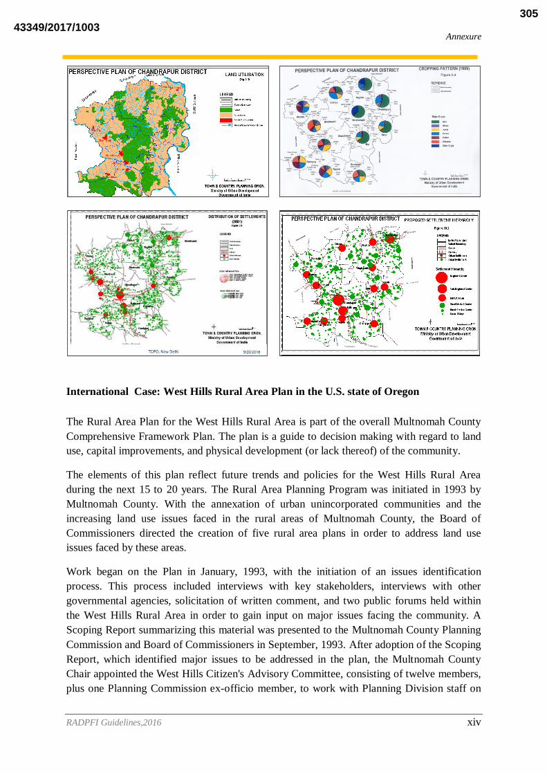
Annexure
RADPFI Guidelines,2016 xiv
International Case: West Hills Rural Area Plan in the U.S. state of Oregon
The Rural Area Plan for the West Hills Rural Area is part of the overall Multnomah County
Comprehensive Framework Plan. The plan is a guide to decision making with regard to land
use, capital improvements, and physical development (or lack thereof) of the community.
The elements of this plan reflect future trends and policies for the West Hills Rural Area
during the next 15 to 20 years. The Rural Area Planning Program was initiated in 1993 by
Multnomah County. With the annexation of urban unincorporated communities and the
increasing land use issues faced in the rural areas of Multnomah County, the Board of
Commissioners directed the creation of five rural area plans in order to address land use
issues faced by these areas.
Work began on the Plan in January, 1993, with the initiation of an issues identification
process. This process included interviews with key stakeholders, interviews with other
governmental agencies, solicitation of written comment, and two public forums held within
the West Hills Rural Area in order to gain input on major issues facing the community. A
Scoping Report summarizing this material was presented to the Multnomah County Planning
Commission and Board of Commissioners in September, 1993. After adoption of the Scoping
Report, which identified major issues to be addressed in the plan, the Multnomah County
Chair appointed the West Hills Citizen's Advisory Committee, consisting of twelve members,
plus one Planning Commission ex-officio member, to work with Planning Division staff on
43349/2017/1003305

Annexure
RADPFI Guidelines,2016 xv
preparation of this document. The Committee held monthly meetings between November
1993 and June 1994 to review all elements included within this document. The Committee's
role was not to make official recommendations to the Planning Commission and Board of
Commissioners, but rather to review and comment upon materials prepared by Planning
Division staff, and provide a forum for additional public involvement in the preparation of
the West Hills Rural Area Plan. In July, 1994 Multnomah County hosted two public forums
in order to present material which came from the Citizen's Advisory Committee meetings.
Next, Planning Division staff prepared this document for review and comment by the
Planning Commission and Board of Commissioners at noticed public hearings.
GOAL: The goal of the west hills rural area plan is to preserve the rural character of
the area.
POLICY 1: Where possible, use incentives, rather than restrictions or disincentives, to
accomplish land use and other policies contained in the West Hills Rural Area Plan.
POLICY 2. Preserve resource-based land uses related to forest practices as the primary land
use in the West Hills.
STRATEGY: Divide Commercial Forest Use lands within the West Hills into three
categories. The first, designated CFU-1 Forest Lands, consists of areas with large land-
holdings generally in excess of 40 acres and areas with few or no existing residences. The
second, designated CFU-2 Forest Lands, consists of areas with smaller land holdings
generally less than 40 acres, and areas with scattered existing residences. The third,
designated CFU-5 Forest Lands, consists of properties within that area identified as a Study
Area on the map titled West Hills (Northern Portion). [Amended 1999, Ord. 924 § II]
STRATEGY: Preserve CFU-1 Forest Lands for continued commercial timber production by
limiting residential uses to tracts of 160 acres or greater, or non-contiguous tracts of 200 acres
or greater.
STRATEGY: Allow non-forestry related uses,such as residences,on CFU-2 Forest Lands as
follows:
a. dwellings on 160 acre tracts or 200 acre non-contiguous tracts.
b. dwellings on existing lots of record owned continously by the current owner or antecedents
of the current owner since 1985 which are capable of producing less than 5,000 cubic feet per
year of commercial timber.
c. dwellings on existing lots of record which contain at least eleven existing lots and five
existing dwellings within a 160 acre square template centered on the lot of record containing
the proposed dwelling.
STRATEGY: Allow non-forestry related uses, such as residences, on CFU-5 Forest lands on
all tracts as defined by OAR 660-- 06-027(5)(a). [Added 1999, Ord. 924 § II]
43349/2017/1003306
Annexure
RADPFI Guidelines,2016 xvi
STRATEGY: If current statewide planning regulations of Commercial Forest Use lands are
changed, Multnomah County should not allow new subdivision lots of less than 40 acres in
the CFU-2 district or less than 80 acres in the
CFU-1 district in order to preserve forest practices and natural resources such as wildlife
habitat, streams, and scenic views.
POLICY 3. Preserve farm lands in the West Hills for agriculture as the primary use.
STRATEGY: Allow non-agricultural uses, such as residences, on Exclusive Farm Use Lands
as permitted by Oregon Administrative Rules, with additional development standards and lot
aggregation requirements to ensure public safety, public health and welfare, and protection of
natural and environmental resources.
POLICY 4 Do not designate additional "Exception" lands in the rural West Hills. [Amended
1999, Ord. 924 § II]
STRATEGY: Consider redesignation of approximately 80 acres at the intersection of U.S.
Highway 30 and Watson Road, adjacent to the Columbia County line, from Commercial
Forest Use CFU-2 to CFU-5. [Amended 1999, Ord.924 § II]
POLICY 5 Promote a community core in the rural West Hills through establishment of a
rural center which serves the local needs of West Hills residents.
STRATEGY: Consider a limited area near the intersection of Cornelius Pass Road and
Skyline Blvd. for designation as a Rural Center if justified by a county-initiated assessment
of the need for additional commercial or other uses to support public needs in the rural West
Hills.
STRATEGY: Do not consider expansion of the existing Burlington Rural Center unless 1)
existing facilities of the Burlington Water District are upgraded, 2) evidence of increased
demand for housing and commercial or institutional services in Burlington exists in the form
of construction on vacant lots within the existing rural center boundaries, and 3) a market
analysis indicates that the expansion of the Burlington Rural Center is necessary to serve
West Hills Rural Area needs.
POLICY 6: Do not adjust the Urban Growth Boundary in the West Hills.
STRATEGY: Study 90 acres of relatively undeveloped land in the Balch Creek basin
(SUBAREA ONE) for proper zoning which will recognize this area's severe development
limitations.
STRATEGY: Rezone approximately 50 acres located along Walmer, Ramsey, and Ramsey
Crest Drives (SUBAREA THREE) from Rural Residential to appropriate urban residential
zoning districts.
POLICY 7: Urge METRO to designate most of the West Hills Rural Area as a Rural Reserve
within the Regional
43349/2017/1003307

Annexure
RADPFI Guidelines,2016 xvii
Framework Plan -- consider Urban Reserve designations only for fringe areas adjacent to
Portland and Washington County urban areas.
STRATEGY: Forward to Metro a resolution directing that only the southern and central
portions of the Bonny Slope subarea of the West Hills Rural Area be considered as an urban
reserve area as part of the Region 2040 project.
POLICY 8: Oppose placement of regional roadways in the West Hills Rural Area, should
such roadways be under consideration by any regional transportation authority in the future.
POLICY 9: Improve West Hills Rural Area roadways to attain appropriate safety levels for
local motorized and nonmotorized traffic.
STRATEGY: Accelerate re-paving and shoulder-paving on Skyline Blvd. to make the route
safer for use of automobiles, bicycles, pedestrians, and equestrians.
STRATEGY: Include in the capital improvement program a project to upgrade Cornelius
Pass Road, with first priority the road between its intersection with Skyline Blvd. and the
switchback to the north, and second priority being the road between the switchback and
Highway 30.
STRATEGY: Include in feasibility studies of a "rails-to-trails" conversion of the Burlington
Northern Cornelius Pass line consideration of making the trail a bicycle route as well in order
to remove the bicycle route from Cornelius Pass Rd. and eliminate modal conflicts.
POLICY 10: Discourage through traffic on local roads not shown on the Circulation Plan.
STRATEGY: On local roads with heavy through traffic consider additional control measures
such as traffic signals and speed bumps to reduce such traffic.
POLICY 11. Coordinate planning and development review activities with the affected school
districts to ensure that adequate school facilities exist to serve local needs.
STRATEGY: Monitor student population at Skyline Elementary School, and work with the
Portland School District on solutions if the school becomes overcrowded.
POLICY 12: Require proposed development in the West Hills to meet fire safety standards.
STRATEGY: Ensure that agencies responsible for fire protection in the West Hills Rural
Area are provided an opportunity to comment on development applications prior to approval
of the application.
POLICY 13 Require proposed development to be supplied by a public water system with
adequate capacity or a private water system with adequate capacity.
STRATEGY: Require a finding of adequate quantity of water available to a development
project prior to final approval of the project, and clearly spell out a procedure which allows
adequate public review of the proposed water source without requiring the project applicant
to undergo excessive and possibly unnecessary expense.
43349/2017/1003308

Annexure
RADPFI Guidelines,2016 xviii
STRATEGY: Work cooperatively with the Burlington Water District in ensuring adequate
water supply to its customers.
POLICY 14: Discourage public sewer service to areas outside of the Urban Growth
Boundary and areas where public sewer service would accommodate inappropriate levels of
development.
STRATEGY: Consider lowering the allowed density of urban residential land for areas
within the Balch Creek basin which have no public sewer service.
POLICY 15: Maintain and enhance the recreational values of Forest Park and adjacent areas
in concert with the City of Portland, METRO, and other agencies.
STRATEGY: Review lands which become available through tax foreclosure in the the
vicinity of Forest Park and within the Balch Creek Basin for potential recreational use.
STRATEGY: Target key parcels needed for enhancement of Forest Park recreational values
for acquisition through revenue from the Natural Area Fund.
STRATEGY: Coordinate management of acquired properties in the vicinity of Forest Park to
preserve natural resource values consistent with the Natural Resource Management Plan to be
approved by the City of Portland.
STRATEGY: Promote and provide incentives for voluntary use of conservation easements by
property owners in lieu of purchase.
POLICY 16: Support and promote the placement of links within a regional trail system for
use by pedestrians, equestrians, and bicyclists.
STRATEGY: Support and participate in the feasibility studies for the conversion of the
Burlington Northern Cornelius Pass line into a recreational trail, which will provide a
regional trail for the Portland Metropolitan area; consider its impacts on adjacent properties
and include affected property owners in discussions on all phases of the project.
STRATEGY: If the Greenway to the Pacific project locates a trail alignment in the West
Hills, do not obstruct METRO's acquisition of the right-of-way for such a facility and review
development proposals along the trail alignment for compatibility with the proposed trail.
POLICY 17: Consider and mitigate the impact on adjacent private properties of all proposed
recreational facilities.
POLICY 18: Use voluntary measures to decrease the negative impacts of some agricultural
practices upon water quality in area streams.
STRATEGY: Do not institute zoning regulation of agricultural practices to protect streams at
this time – instead pursue a voluntary educational program jointly with the U.S. Natural
Resources Conservation Service and the West Multnomah Soil and Water Conservation
District.
43349/2017/1003309
Annexure
RADPFI Guidelines,2016 xix
POLICY 19: Protect water quality in areas adjacent to Multnomah Channel through control
of runoff from West Hills Rural Area streams.
STRATEGY: Revise the ESEE analysis and protection program for Burlington Bottoms to
include discussion of water quality impacts from West Hills drainages into this wetland, and
adopt appropriate zoning ordinance amendments to protect water quality in Burlington
Bottoms.
STRATEGY: During the Sauvie Island/Multnomah Channel Rural Area Plan preparation,
review ESEE analysis and protection program for Multnomah Channel to include discussion
of water quality impacts from West Hills drainages into the channel, and adopt appropriate
zoning ordinance amendments to protect water quality in
POLICY 20: Develop and maintain consistent regulations for significant streams under the
jurisdiction of both the City of Portland and Multnomah County.
POLICY 21: Use hillside development and erosion control standards to control the effects of
nonpoint runoff into streams from sources such as roadways, parking areas, and farms.
POLICY 22: Protect against seismic hazards to structures and ground areas susceptible to
upset.
STRATEGY: Work with the City of Portland to implement appropriate building code
revisions for areas of greatest seismic hazard, when information on the location of such areas
becomes available.
POLICY 23: Protect lands having slopes greater than 25% from inappropriate development.
STRATEGY: Revise the Multnomah County Comprehensive Framework Plan to designate
lands with average slope greater than 25% as having development limitations. This action
will resolve an inconsistency between the Comprehensive Framework Plan and the Hillside
Development Overlay provisions of the Multnomah County Zoning
POLICY 24: Balance protection of scenic views with flexibility of use by property owners.
STRATEGY: Do not preclude or prevent building on any lot because of scenic
considerations.
STRATEGY: Allow placement of residences so that a view from the property is possible as
long as the proposed development is visually subordinate.
STRATEGY: Regulate the use of reflective glass in scenic areas.
STRATEGY: Require industrial uses to meet the same siting standards as residential
development in order to protect scenic views.
STRATEGY: Work with the Oregon Department of Forestry to better protect scenic views
from the negative impacts associated with timber harvesting.
43349/2017/1003310

Annexure
RADPFI Guidelines,2016 xx
STRATEGY: Provide incentives for development compatible with significant scenic views.
POLICY 25: Balance protection of significant streams with flexibility of use by property
owners.
STRATEGY: Minimize runoff from roads, particularly from County road clearing processes.
STRATEGY: Encourage "friends of" individual streams to educate people about best
management practices necessary to protect streams.
STRATEGY: Work with the Oregon Department of Forestry to better protect significant
streams from the negative impacts associated with timber harvesting.
STRATEGY: Work with the local Soil and Conservation Districts to educate farmers about
sound farming practices which also protect significant streams.
STRATEGY: Provide incentives for development compatible with significant streams.
STRATEGY: Consider additional streams for significance and protection if requested by a
property owner or other interested party.
POLICY 26: Balance protection of wildlife habitat with flexibility of use by property owners.
STRATEGY: Enforce existing animal control restrictions on free-ranging domestic pets
which can have a negative impact on wildlife.
STRATEGY: Encourage fencing which allows wildlife to pass through.
STRATEGY: Encourage clustering of development to minimize conflicts with wildlife.
STRATEGY: Develop programs to educate people about how wildlife habitat can co-exist
with other uses on private property.
STRATEGY: . Continue to collect data and information on the status of wildlife and wildlife
habitat in the West Hills.
STRATEGY: Work with the Oregon Department of Forestry to better protect wildlife habitat
from the negative impacts associated with timber harvesting.
STRATEGY: Work with the local Soil and Conservation Districts to educate farmers about
sound farming practices which also protect wildlife habitat.
STRATEGY Provide incentives for development compatible with wildlife habitat .
POLICY 27: Allow expansion of the Angell Brothers quarry to provide needed aggregate
materials for the Portland metropolitan area.
POLICY 28: Balance the need for aggregate material with the protection of scenic views,
streams, and wildlife habitat in the vicinity of the Angell Brothers quarry by implementing
the measures contained within the West Hills
43349/2017/1003311

Annexure
RADPFI Guidelines,2016 xxi
ANNEXURE 3:
Interview Schedules
Introduction of the village:
Name of the State
Name of the District
Name of the Block
Name of the Gram Panchayat
Name of the village
Demography: schedule 1
0-7 8-14 15-19 20-39 40-59 60 and
above
TOTAL
Male S
C
S
T
OB
C
GEN.
Female
TOTAL
Population Growth: schedule 2
Years Population
SC ST OBC GEN
Male Female Male Female male Female male Female
N
N+1
N+2
N+3
N+4
N+5
Migration schedule: 3
Name Sex Age group Occupation Place of
origin
Distance
from
village
Reason for
migration
Migrated
single or
with
Family
43349/2017/1003312

Annexure
RADPFI Guidelines,2016 xxii
Household Information: schedule 4
Name Relation
ship to
the head
of HH
Age Married
/unmarried/
Divorced/
separated
Sex Educati
on level
Occupation Income/
month
Source of
Lightening
Type of fuel
used for
cooking
Assets: schedule 5
Tv Radio Fridge Computer
/
Laptop
Computer
With
Internet
Connection
Washing
Machine
Bicycle Two
Wheeler
Car/
Jeep
Truck Tractor
Facilities: schedule 6
Distance from educational
facility
Primary
Middle
Secondary
Degree college
Technical education
Vocational training centre
Distance from health facility Subcentre
PHC
CHC
District hospital
Vetrinary hospital
Anganwadi
Distance from major roads Weather Road
Metalled Road
NH/SH
Distance from cooperative
society
Distance from state capital
Distance from block
headquarter
Distance from metropolitan
city
Distance from district
headquarter
Distance from Railway station
43349/2017/1003313

Annexure
RADPFI Guidelines,2016 xxiii
Distance from bus stop
Distance from post office
Distance from bank
Distance from weekly market
Distance from ATM facility
Distance form Internet
Facility shop
Infrastructure :schedule 7
Water supply
Source of water Ground water
Surface water
Duration of water supply
Average consumption of
water supply
Domestic use
Industrial use
Agricultural use
For cattle
Quality of water supply
Treatment of water? If any?
Charges for water supply?
Individual connection
Power supply
Source of power supply
Individual connection
Duration of power supply
Metered connection
Duration of power supply for irrigation and
agricultural purposes
Waste disposal and sanitation
Amount of waste generated Domestic
Industrial
43349/2017/1003314

Annexure
RADPFI Guidelines,2016 xxiv
Agricultural
Cattle
Storage of waste
Treatment of waste
Landfill site
Recycling of waste, if any
Health
Level of health
facility available
Dispensary Subcentre PHC CHC
No. of trained
doctors
No. of trained
asha workers
Equipments
available
No. of beds
available
No. of non
medical staff
Medicines
available
Mortality indicators:
Girls Boys
No. of live births
No. of still births
Death below 1 year
1-6 yr 7-14 yr 15-20 yr 20-39 yr 40-59 yr Above 60yr
Other
deaths
M F M F M F M F M F M F
No. of deaths of women at time of child birth
No. of Institutional delivery
What are the common diseases in villages?
According to age group? Chronic and acute
43349/2017/1003315

Annexure
RADPFI Guidelines,2016 xxv
Disabled persons:
No. of disable
persons by type
of disability
Male Female Total
Education
Level of school Primary Middle Secondary
No. of students
enrolled
sc st obc gen sc st obc gen sc st obc gen
Male
Female
No. of teachers
No. of classrooms
No. of students
attending
No. of students
discontinuing
Reasons for
discontinuation
ANNEXURE 4: Classification of Assets in Bhuvan Panchayat Major
Category Subclass Asset Group Asset Type Count
Civ
ic A
men
itie
s /
Infr
astr
uct
ure
Ass
ets
Education Facilities
Schools Primary School / Middle School / Secondary School / Senior Secondary School / Training School / School for disabled / Other School
7
Colleges / Universities University / Science College / Commerce College / Arts College / Medical Sciences / Engineering College / Management College / ITI / Polytechnic / Other College or University
10
Training Institutions / Centres
Adult Literacy / Distant Learning / Computer Centre / Vocational Training / Physical Training Institute / Other Training Institute or Centre
6
Public Libraries Public Library 1
Other Educational Assets Other Educational Asset 1
Medical and Health
Facilities
Aanganwadi Aanganwadi 1
Women & Child Health Centres
Women & Child Health Centre 1
Health Centres / Hospitals Sub Centre / Primary Health Centre / Community Health Centre / Dispensary / Hospital / Super Speciality Hospital / Other Health Centre or Hospital
7
Other Medical Facilities Drug Rehabilitation Centre / Blood Bank / Immunization Centre / T. B. Clinic / AIDS Centre / Polyclinic / Leprosy Centre / Mental Hospital / Tobacco Control Centre / Physiotherapy Centre / Occupational Therapy Centre / Emergency Trauma Centre / Eye Hospital / Diagnostic Lab / Medical Shop / Other Medical Facility
16
Veterinary Veterinary Dispensaries / Veterinary Dispensary or Hospital 1
43349/2017/1003316

Annexure
RADPFI Guidelines,2016 xxvi
& Fisheries Facilities
Hospitals
Other Veterinary Facilities Other Veterinary Facilities 1
Transport Systems &
Connectivity
Road Types and Structures
National Highway / State Highway / Major District Road / Footpath / Cart Track / Bridge / Culvert / Flyover / Causeway / Underpass / Tracks / Other Structure
12
Road Transport Facilities Subway / Bus Stand / Parking Area / Bus Shelter / Bus Stop / Bus Depot / Taxi or Auto Stand / Check Post / Other Road Transport Facility
9
Railway Types and Structures
Indian Railways / Metro / Tram / Monorail / Other Rails / Railway Bridge / Manned Crossing / Unmanned Crossing / Other Railway Structure
9
Railway Transport Facilities
Railway Station / Railway Reservation Centre / Metro Station / Loco Shed / Railway Yard / Other Railway Transport Facility
6
Air Transport Facilities Airport / Helipad / Airstrip / Other Air Transport Facility 4
Water Transport Facilities Harbour / Sea Port / Light House / Waterway / Jetty / Boat or Ferry Station / Other Water Transport Facility
7
Power and Energy
Electricity and Usage Electricity and Usage 1
Electric Assets Power Pole / Street Light / Transformer / Power Sub-station / Other Electric Asset
5
Power Generation Plants Nuclear Power Plant / Solar Plant / Thermal Plant / Hydel Plant / Tydal Plant / Wind Mills / Bio-energy Plant / Biogas Plant / Other Power Generation Plant
9
Sanitation & Sewerage Facilities
Public Toilets Public Toilet 1
Garbage Disposal Sites Garbage Disposal Site 1
Garbage Treatment Units Garbage Treatment Unit 1
Drains / Naalas Drain or Naala 1
Sewage Treatment Plants Sewage Treatment Plant 1
Postal & Telecom Services
Postal Facilities Post Box / Post Office / Courier Service / Other Postal Facility 4
Telecom Facilities Telephone Booth / Telephone Exchange / Telecom Poles / Distribution Point Station / Mobile Tower / Cyber Café / Other Telecom Facility
7
Banks, Insurance &
Credit Societies
Banks Bank 1
ATMs ATM 1
Insurance Insurance Company 1
Credit Societies Credit Society 1
Other Financial Institutions
Other Financial Institutions 1
Major
Category
Subclass Asset Group Asset Type Count
Civ
ic A
men
itie
s /
Infr
ast
ru
ctu
re A
ssets
Water
Sources
&
Structures
Water Sources Tap / Hand Pump / Well / Dug Well cum Bore Well / Tubewell / Tank or
Pond / Canal / River / Lake / Spring / Tanker Supply / Other Water Source
12
Water Structures Dam / Check Dam / Earthen Dam / Barrage / Weir / Anicut / Rainwater
Harvest Tank / Storage Tank / Overhead Tank / Pump House / Water
Treatment Plant / Water Desalination Plant / Other Water Structure
13
General
Assets /
Facilities
Commercial Milk Depot / Milk Collection Centre / Tea Stall / Restaurant / Godown or
Warehouse / Cold Storage / Repairing and Workshop / Slaughter House /
Mandi / Commodity-wise Market / Haat / Shopping Mall / Other Market /
Other Commercial Unit
14
Fuel Depots Fuel Depot 1
Public Distribution
Shops
Ration or Fair Price Shop / Cooking Gas Distribution / Kerosene Depot /
Other Public Distribution Shop
4
Public / Social Services Child Adoption Centre / Day Care Centre / Night Shelter House /
Orphanages / Old Age Home / Disaster Shelter / Fire Station / Dhobhighat
/ Cremation Ground / Graveyard / Other Public or Social Service Unit
11
Lodging Facilities Hotel / Guest House / Lodge / Inn / Dharamshala / Other Lodging Facility 6
Tourist Places Zoo / Museum / Park or Garden / Historic Place / Other Tourism Site 5
Religious Places Temple / Church / Mosque / Shrines / Dargah / Gurudwara / Monastery / 9
43349/2017/1003317

Annexure
RADPFI Guidelines,2016 xxvii
Agiary / Other Religious Place
Recreational Places Cinema or Video Hall / Kisan Club / Youth Club / Sports Club /
Playground / Stadium / Akhada / Choupal / Auditorium / Marriage or
Community Hall / Other Recreational Facilities
11
Feed Fodder Facilities Feed or Fodder Manufacturing Unit / Fodder Storage House 2
Livestock Water
Troughs
Livestock Water Troughs 1
Other General Assets Other General Asset 1
Others
(Specify)
Other Civic Amenities /
Infrastructure Assets
Other Civic Amenities or Infrastructure Asset 1
Go
vern
an
ce A
ssets
Administ
rative
Offices Collector Office / Zila Parishad / Panchayat Samiti / Tehsil or Taluka
Office / Gram Panchayat Bhavan / Gram Sewak Office / Patwari Office /
Police Station or Chowki / Line Department Office / Other Office
10
Government Lodging
Facilities
Circuit House / Youth Hostel / Dak Bunglow / Forest Guest House 4
Other Administrative
Assets
Other Administrative Asset 1
Extension,
Training &
Data
Collection
Centres
Information Centres Krishi Vigyan or Gyan Kendra / Kisan Call Centre / Agricultural Kiosk /
Agro Service Centre / Pest Control Centre or Unit / Certified Seed Centre /
Fertilizer or Manure Depot / Charitable Trust / Non Governmental
Organization / Voluntary Organization / Other Information Centre
11
Training and Research
Centres
Farmers Training Centre / Agricultural Research Station / Village
Cooperative / Soil Testing Laboratory / Other Training and Research
Centre
5
Data Collection Centre Hydro-meteorological Observation Station / Rain Gauge or Meteorological
Instrument / Other Collection Centre or Observatory
3
Other
(Specify)
Other Governance
Assets
Other Governance Asset 1
Pro
du
cti
ve A
ssets
Agricultu
re
System
and
Allied
Activities
Agriculture Practice Agriculture Practice 1
Dairy Unit Dairy Unit 1
Fishery / Aquaculture Fishery or Aquaculture 1
Poultry Farm Poultry Farm 1
Other Farming Assets Other Farming Asset 1
Forest
Produce
Forest Forest 1
Mining &
Quarrying
Mines Mine 1
Quarries Quarry 1
Industries
& Types
Industries Industry 1
Others
(Specify)
Other Productive
Assets
Other Productive Asset 1
43349/2017/1003318

RADPFI Guidelines,2016 xxix
ANNEXURE 5:
GIS based GP Planning Case Studies By NIRD&PR (Villivalam, Kanchipuam, Tamilnadu)
Introduction
Spatial technologies play a key role in generating timely and reliable information for
planning and decision-making at all levels. The use of GIS for a micro administrative unit for
planning and implementation was tested in an Action Research Project in one of the
panchayats in India, where the knowledge base is developed up to cadastral level (land parcel
level) and the house hold socio economic data is embedded on this layer on a GIS platform,
with all graphic features of house type and house hold linked, to enable stakeholders take
decisions in a dynamic mode.
Even though it is widely recognized that the Geographic Information System (GIS) has the
capacity to analyze both spatial and temporal data on a cost effective manner for effective
planning and management, its application at the micro level for participatory planning and
management is limited. In this context an Action Research Project was taken up at the
Panchayat level by the National Institute of Rural Development where efforts were made to
develop an interactive package for participatory management at the panchayat level.
An attempt has been made to actually apply the GIS Package, simple, user friendly,
customized, local need based, interactive and can be handled by the local youth and Gram
Panchayat functionaries. It could be called Panchayat GIS, which has all inbuilt features of
various decisions at he Gram Panchayat level integrating various layers of information both
spatial and attribute pertaining to the Villivalam Gram Panchayat.
Identification of Problems and Objectives
1. To devise a GIS Based Action Plan for the Gram Panchayat Level Planning on an
Interactive Mode.
2. To test the Interactive GIS Based Gram Panchayat Plan on Pilot Basis with the help
of Local Self Government, Government Functionaries, NGO, and the Local People.
Study Area
The study area consists of entire Villivalam Gram Panchayat. It is created using the
geographical extents of the Gram Panchayat and true origin (74o N 21
o E) of the Walijabad
Block of Kanchipuram District of the State of Tamilnadu.
The Gram Panchayat as three (3) villages namely Villivalam, Koyambakam and Pandyan.
The study area chosen was the Villivalam Gram Panchayat of Wallijabad Block of
Kanchipuram District, Tamil Nadu State, a Southern State in India.
43349/2017/1003319

RADPFI Guidelines,2016 xxx
The purpose was to give appropriate development initiatives in planning, monitoring and
projectisation by the local people of Villivalam Gram Panchayat and the local bodies, for
developing a reliable database and take decisions based on the same.
Development of an Interactive GIS Package for these people is a modest attempt to take
Spatial Technologies and ICT to the door steps of the local people to reap benefits of
advanced technologies at the lowest level, making GIS application as a mass movement.
Study Methodology and Analytical Framework
The base data forms the attribute database and the maps, satellite imagery, Ariel photographs
etc spatial database. These databases are integrated in a GIS platform and an information
system is developed.
The developed information system is embedded with query facilities so as to make it
interactive. The presentation is developed in GIS Map Objects 2.30 Version Software and
customisation is being made through capabilities of Map Object GIS Software and Visual
Basic 6.0.
Flexibility is built in the Interactive GIS Village Plan to adapt to new situations and
environments. The pilot software is being provided to the Villivalam Gram Panchayat and the
GP functionary and the village youth are trained to use the same.
A group of youth is specially trained at SIRD, Tamil Nadu in computer skills and they are
very enthusiastic in operating and maintaining the same. Four(4) Desktop Computer Systems
were provided by NIRD&PR to this erstwhile Action Research Village of NIRD, where lot of
development activities has been brought by participatory mode by SIRD, Tamilnadu and the
NIRD&PR.Tamil Language interface is being attempted and the Gram Panchayat GIS
Package showcases the Government, NGO and Local Bodies for their daily activities,
monitoring, reporting, decision making, data needs and other allied activities.
Method and Type of Data Collected
1. Integrated resource surveys (Natural resources and Human resources) and mapping at
the panchayat level involving local volunteers, panchayat officials etc.
2. Surveys relating to basic infrastructure of the Panchayat roads, drinking water
resources, schools etc.
3. Household information, housing structure, type of material used in house construction,
basic amenities like electricity, water, telephone etc.
4. Photograph of the house and its members.
5. Household wise collection of data relating to house tax, water tax etc.
6. The resource surveys using cadastral map in the scale of 1: 5000. Plot wise
information was collected.
7. Develop a Cadastral based Information System (CIS) at panchayat level with Geo-
reference to higher level administrative system.
Process Methodology
43349/2017/1003320

RADPFI Guidelines,2016 xxxi
A Participatory Rural Appraisal (PRA) exercise was carried on to understand the priorities
and needs of the people of Villivalam Gram Panchayat. The PRA Resource Map showed
good understanding of people about their Gram Panchayat spatial spread, resources,
infrastructure, Governmental programmes and projects and their neighbourhood.
The entry level activity taken up was information on education, tutorials, admission,
coaching, Question Banks, Career prospects, skill development and related aspects. The
database on the same was built up from existing database of the Gram Panchayat, Walijabad
Block and Kanchipuram District information base. This was further consolidated with
Tamilnadu Sate and other web based materials making it accessible for youth, students,
Panchayat Factionaries and others.
Topo Sheet of the district and cadastre map of Villivalam including that of Koyanbakam and
Pandyan was geo-coded. Satellite imagery of Resource Sat P6 both LISS III and PAN were
obtained and merged and overlaid on the base vector layer with draping. Various relational
database of the Gram Panchayat were integrated with the base vector layer and analysis based
on the Gram Panchayat day to day decision requirements were attempted for use by the
Panchayat for local level application.
The GIS, Image Processing and other allied Software used are Arc Info 9.0, Arc View 3.2,
Map Object 2.0 and Visual Basic 6.0, for developing the Interactive GIS for Gram Panchayat
Planning.
The output on the Window Screen is placed for visualizing the Software capabilities and
outcomes. The required data format for inputting and building up of database are placed in
the window format by Visual Basic and Map Object capabilities. The Software has the
capabilities to update database and the files are saved in new databases, which facilitates
comparison of data over time period, for studying the impact of schemes or programmes or
development initiatives and in detection of changes.
The land holding and survey numbers are integrated with the house door numbers for exact
identification of each person and household for detail database pertaining to all aspect of
demography viz. age, sex, education, occupation etc, asset structure, income particulars, land
use and land cover particulars from satellite imageries and cadastre, and other useful
information like social status, ration card, marital status and related data.
The photographs of each household family member are embedded with the house at the back
drop. The profile of each household is available. The Villivalam Gram Panchayat profile with
graphics is also available at Gram Panchayat layer. All formats are placed in window format
for ease in use and understanding at the local level with Visual Basic 6.0 Software.
With a Training of one day, a person with high school qualification can operate the software
and maintain the same. Any new parameters can be added and the software can be upgraded
from time to time based on the need of the time, without losing any data.
Salient features
43349/2017/1003321

RADPFI Guidelines,2016 xxxii
The Village GIS has been developed using ArcGIS 9.0, Map Objects 3.0 and VISUAL BASIC
6.0 working under WINDOWS. A standard Pentium IV system would suffice the hardware
requirement for its implementation. The following are some of the salient features of Village
GIS:
Thematic maps
Thematic maps are often required to provide decision support information for spatial planning in
several key areas. Village GIS facilitates efficient generation and display of thematic maps
directly by the end user to enable him perform situation analysis and gain an insight for proper
decision-making. It also supports map tool bar (zoom, pan) on any thematic map.
Display of village profile
The Gam Panchayat profile is a template containing a set of predefined attributes of the village
(village name, Panchayat name, population details, availability of facilities etc.) User can view
the profile of any specific sector by clicking on the sector in the map or by choosing the desired
item from the Gram Panchayat menu list displayed on the screen.
User-friendly interface
Village GIS provides an interactive and user-friendly interface and it does not require any GIS
expertise for its operation. It requires about 4~5 hours of learning time and could be thus easily
deployed in the rural areas where the operating personnel are usually novices.
Applications of Village GIS
Village GIS has been customized for facility planning and management for the Villivalam Gram
Panchayat in Walijabad Block of Kancipuram District of Tamilnadu State. Although Village GIS
can support a wide range of applications due to its open-ended design, it is presently being
contemplated for use for the following applications.
1. Facility planning (Identification of suitable locations for creation of new facilities such as
primary schools, middle schools etc.)
2. Monitoring the functional status of various village amenities such as transformers, hand
pumps, schools, hospitals etc.
3. Monitoring and evaluation of the implementation of various rural development and
poverty alleviation programmes/schemes (Mid-day meals scheme for school children,
housing and employment guarantee schemes etc.)
4. Management of road network.
5. Village connectivity to Panchayat Hqrs.
6. Land Holding Analysis
7. House Type Analysis
8. Income Analysis
9. Occupation Analysis
10. Social Strata and eligibility analysis
11. Age Group Analysis for education infrastructure
43349/2017/1003322
RADPFI Guidelines,2016 xxxiii
Observations & Findings
The striking revelations in this study is the fact that local people are greatly enthusiastic in
adapting to new technology and new way of working together and takes lot of interest in
knowing new ways of doing things.
Secondly the people at the local level rise above political, economic and social affiliations,
and express their solidarity in effecting the new tools and technology in their day-to-day
work.
The women participation was quite encouraging and they come forward for propagating the
use and adoptability to new way of doing things.
The younger mass feels social upheaval and increase in their social status in exposure and use
of new IT Tools at the local level.
The people’s representatives give all encouragement and support and stand by the people in
introduction of new technology and in new ways of doing things, irrespective of their
political affiliations.
The district and local administration takes great interest in introducing new IT Tools and
request development of these tools with inbuilt functionality of day to day administrative use
at all level, in improving their performance and effectiveness and express their support and
cooperation in any attempt in this regards.
Replicability
The Interactive GIS developed at the Gram Panchayat can be replicated. There are also
possibilities and potential available for adding additional features and in making it wide
spectrum software.
The database required may vary depending on the type of problem faced in a particular area.
The level of social mobilization needed to ensure participation in data collection and analysis
can also vary from place to place, which can be handled by the software with necessary
modifications.
Lessons Learned
Geographic information systems are being integrated in communities to serve many purposes,
and with various degrees of effectiveness. The contribution in this pilot project was to
provide a broad view of the current state of Village GIS practice in the country.
The critical lessons learnt from this pilot project can be summarized as under:
43349/2017/1003323

RADPFI Guidelines,2016 xxxiv
a. Any change process is dynamic and people at local level have resilience to cope with
new technological changes and assimilate the new process and system and new way of
doing things into their societal and institutional framework;
b. GIS as a fusion and sandwich approach have brought in integration among the
fragmentation and dispersal data/ information and frame the same as an integrated
package conveniently visualized by the community at their level;
c. The Graphic and map presentation along with relational data clicked the conscience of
the local people to identify themselves with a system which spells out their unique
recognition and give a psychological satisfaction of projecting who they are, their
affiliations, neighborhood and societal binding;
d. Given a platform and facilitation, the local people, who are totally ignorant about the
new technologies like GIS, came forward to use the same with ease and conviction;
e. The younger generation exert influence on their parents, neighbours and elders to ride
on new technology and bring in collective optimism and desire for a hope for better
future;
f. Data gaps and errors in the Village GIS were voluntarily identified by people and the
same is corrected, which brought in greater conviction that the new technological
change can prove beneficial;
g. When shown Gram Panchayat, Block and District scenarios by various GIS analysis,
their participation and acceptance seems to be greatly strengthened;
h. A view of satellite imagery integrating their cadastre appalled their sense of
understanding and knowledge base, giving relentless support for Village GIS;
i. Synoptic view, spatial spread, locational features and understanding terrain and
topography of their area vis-à-vis conventional resource maps exhibiting congruence
made them enthusiastic and satisfied;
j. Integrating all aspects of village in an GIS information system is more powerful and
vibrant as it exhibits graphic display, locational features, entity and gross information,
it’s true value, display and nature, what it was and present status (temporal analysis), a
system which can act an any level with time and space dimension identifying man,
neighborhood, household, assets, occupation, economy and the like in particular and
society and life in general.
Where do we go from here!
Time has changed. When we remember of the initial days when the country had gone for the
bank, railway, airlines and a host of other computerization, there was stiff resistance and
experts apprehended that such a measure would jeopardize the employment situation in the
country and displace large number of people from securing employment.
Today, all know, how embedded the system of computerization everywhere in Government,
Banking, Airlines, Railways and in all walks of life, economy and society are.
Similarly GIS would bring a sea change in the outlook and thinking of the people, policy
makers, experts and elected representatives, when stabilized with the system. The transition
would result beneficial outcome sooner or later.
43349/2017/1003324

RADPFI Guidelines,2016 xxxv
Many countries namely Qatar, Singapore, Australia, USA, UK, Germany, Canada and a host
of other countries have faced enormous amount of teething problems at the beginning but
now, everything is so simple, reliable, robust and happening everywhere.
The Village GIS have inherent significance from the point of decentralized governance and
Constitutional Mandate of empowering people at local level. There can’t be a better tool than
GIS for providing a powerful decision support system to the people to take their own
decisions, analyze situations, assess potentials, plan for future, model and simulate and
generate scenarios.
Technology is enshaping mankind and with rapid strides of development in GIS Software and
in the Information and Communication Technologies, and with price slashing in cascades, not
only GIS will be an affordable tool in the hands of local people but would usher an integrated
end to end solution based system for local bodies, NGOs, Government Departments, and
people at large.
GIS with GPS, Internet connectivity, high resolution satellite imageries and attribute data can
revolutionize the entire thinking process of mankind in coming years. Rather than e-
governance, it would be possible to implement
G-Governance (GIS Governance) at all levels, anytime, any place, making information flow
and decision making a real time dynamic process ensuring total participation and
involvement of local people.
Conclusion
The user friendly interactive GIS for a micro administrative unit have helped in ensuring
better participation of the stakeholders in decision making. The variation in the level of
education of the community was bridged by pictorial representation of data. The project
helped in empowerment of the community and generated land literacy.
User friendly interactive GIS data base generated at a micro administrative unit (panchayat)
can improve the efficiency of administration, improve resource mobilization and help in
informed decision making. The software being simple and customized and open for
modifications holds lot of promise for local level applications. The strong aspect of this
software is the capabilities of liking wide graphic aspects, like photographs, audios, videos,
imageries and analyzed maps etc , which project field realities and help taking appropriate
decision making, by people themselves.
Village GIS is a GIS based Gram Panchayat Planning system, which has all the data formats
to build up data inventory, link graphics, identify locational features, generate various graphic
analysis for decision making and shows information both horizontal and vertical. Village GIS
is expected to usher in the desired transparency and easiness in the Gram Panchayat planning
and enable a faster response to the changing ground realities in the development planning,
owing to its in-built scientific approach. It demonstrates that the GIS approach can provide
cost effective solutions for local level planning in rural areas, and help bring the benefits of
Spatial Technologies to the rural masses.
43349/2017/1003325

RADPFI Guidelines,2016 xxxvi
With local knowledge and local control, accountability set in where a GIS system could
direct at real needs, and the design relevant to local conditions. Sensitising, Training and
education village Youth, elders, Gram Panchayat functionaries and involvement of women,
particularly from SHGs work towards sustainable GIS systems at local levels.
GIS is a tool of power. Like all geographical information, GIS has the potential to reduce
social inequities or to exacerbate them, within regions. GIS can be subversive or it can
empower techno-elite (Clark and Worobec 1996). But Yapa (1991, 52) argues that GIS may
also be an instrument for ‘discovering’ local resources contextually and that the full
implementation of appropriate technology is not possible without access to a GIS because it
is the knowledge of the region (and the ability of the GIS to enhance this knowledge) that
makes appropriate technology a viable alternative to the current modes of development.
GIS could become a tool for empowerment, decision alternatives, scenarios, modeling, what
if analysis, locational and spatial spread analysis and an integrating tool for interfacing all
information for synthesis, which can be a very potential tool for Gram Panchayat Planning
and with the changing Map Policy of Government, GIS has come a long way and be an
integral part of our life, administration, policies and programmes.
In a global thinking and technology subservient to mankind in a global thinking and
technology subservient to mankind, GIS could become a tool in the service of the poor rather
than a technological instrument for their control. To that end, GIS and ICT and other spatial
technology tools need to converge and emerge as powerful application tools for wider use at
all levels, particularly at local or cadastral level, to take the benefit of technology to the door
step of the poorest of the poor, to empower the people for making their lives better, livable
and for leading a life with quality inputs for sustenance.
Figure 0.1:Villivilam gram panchayat
43349/2017/1003326

RADPFI Guidelines,2016 xxxvii
IRS P6 , LISS IV MX DATA
Survey numbers of land parcel integrated with household and house numbers for a integrated
information system at local level.
Figure 0.2:Satellite imagery of the study area showing land use and land cover and river basin
Figure 0.3:Land records map drapped over image
VILLIVILAM GRAM PANCHAYAT
43349/2017/1003327

RADPFI Guidelines,2016 xxxviii
Figure 0.4:A Screen Shot in the Village GIS Software with detail Window Display format.
LAND RECORDS MAP DRAPPED OVER IMAGE
43349/2017/1003328

RADPFI Guidelines,2016 xxxix
Figure 0.5:Villivalam Gram Panchayat Layout and Village GIS interface for interactivity.
RalegaonSiddhi, Ahmednagar District,
Maharashtra State
Study Area Profile:
Ralegaon Siddhi Gram Panchayat is situated in ParnerTaluka in Ahmednagar District, with
geographical extents of the true origin (74 degree 22min 0sec E & 18 degree 54 min 0 sec N)
in Maharashtra State. Distanced about 87 km from Pune city towards north-east and 5 km
away from Pune -Ahmednagar State Highway and having total Geographical area measuring
9.67 Sq.km. Drought-prone and resource poor area with annual rainfall ranging between 50-
700 mm and temperature varying between 12ºC to 44ºC, the GP is surrounded by small
hillocks on the northeast and southern sides. The land is undulating and slopes vary from 3-
15%, soils shallow with black soils mixed with pebbles seen in lower areas and soils are
inferior and unsuitable for cultivation in higher areas, with about 70% of the area the soils ,
composition of which light to medium in structure. Due to inadequacy and uncertainty of
rainfall leading to failure of the crop, and with soil depth up to 45cm and having low N.P.K.
contents, the prospects of agriculture appears to be under great stress.
43349/2017/1003329

RADPFI Guidelines,2016 xl
Objectives:
1. To prepare land base map for Ralegaon siddhi village to analyze demographical and
cadastral information;
2. To prepare various types of thematic maps (land use and land cover,Drainage,
ground water (well and bore wells), soil maps etc;
3. To identify rural resources for generating self employment and stronger village based
economy;
4. To identify the constraints in agriculture /economic expansion;
5. To study basic services like education, health, drinking water, road connectivity,
communication, sanitation, energy use, transport details etc , for identifying the
standards of rural areas;
6. To suggest various action plans and decision rules for rural development.
Methodology and Analytical Framework :
The methodology used for a GIS based GP planning for Ralegaon Siddhi essentially consists
of design and creation of appropriate spatial as well as attribute databases and integration of
the same to facilitate the creation of various planning scenarios for facility planning and
management.
Capturing all layers of data:
1. Integrated resource surveys (Natural resources and Human resources) and
mapping at the GP level ;
2. Physical surveys relating to basic infrastructure of the GP;
3. Household information, housing structure, type of material used in house
construction, basic amenities like electricity, water, telephone etc.
4. Socio economic survey including PRA, FGD etc;
5. Estimation of resource base, needs, gaps, alternative strategies to augment the
requirements for over all growth and development of the GP.
Natural Resource Management:
The land base map was prepared for the study area using the high resolution satellite imagery
globe world view one imagery of 50cm resolution at 1:1000 scale. The total image of the
study area was divided in to grids of 500 m by 500m and the plots were taken at 1:1000 scale
in such a manner that 1 mm on the map will be equal to 1 meter on the ground. The land base
map is prepared by taking these plots to the field where all the houses, field bunds and pump
sets locations will be marked on the field plot. These field plots were digitized and the land
base map is prepared for the entire study area. The data models were prepared for collecting
the land base details like the house address, the no of floors, family info details etc. These
data collected will be linked to the land base map for generating the final land base map. For
generation of natural resources, thematic maps land use land cover , Hydrogeomorphology,
Soil, Slope etc the merged data of cartosat 1and IRS P6 LISS IV images was used . Taking
the SOI Toposheets as source, the thematic layers like drainage and contours are prepared at
43349/2017/1003330

RADPFI Guidelines,2016 xli
1:25,000 scales. The slope map is derived using Survey of India topographical sheets at
1:25000 scale with 5 meter contour interval. The rainfall and temperature data and other
collateral data of the study area are collected and is integrated in the GIS Domain.
Figure 0.6:Flow Chart Depicting Broad Methodology
Spatial database creation:
Open Source Software, Map Objects and Dot Net Software were used for creation of
the required spatial database in digital form. The digital map layer information
weregenerated appropriately in the form of Thematiclayers, each layer representing a
unique entity in the spatial data dictionary.
Non-spatial databases:
The Non Spatial database represent the characteristics of the spatial relational data reflecting
the land use, land cover, infrastructure, basic facilities, demographic profile, land holding, asset
structure, income and livelihoods etc.
The database on village level basic amenities includes schools, hospitals/dispensaries, Gram
Panchayat Building, Anganwadi, rural housing under IAY, Post Office, Banks, MGNREGS
and IWMP structures, etc., and accessibility to drinking water, sanitary latrines, telephones, and
road, SHG Micro Finance, amongst others. The population census provided the demographic
profile for the village, while the special requirements for Gram Panchayat were related to
43349/2017/1003331

RADPFI Guidelines,2016 xlii
village administration and management, besides data related to weekly market places, items in
fair price shops, fertilizer, seeds, pesticides availability etc.
Integration of spatial and non-spatial databases:
For the purpose of integration of spatial and non-spatial databases, the attribute databases were
conveniently organized to correspond to required distinct areas of planning, which include
education, health, transport, communication etc. These data sets were linked and integrated
with the spatial databases to facilitate the development of facility planning and management
system.
Participatory Rural Appraisal (PRA) Methodology:
A Participatory Rural Appraisal (PRA) exercise was carried out to understand the priorities
and needs of the people of Ralegoan siddhi Gram Panchayat. The PRA Resource Map
showed good understanding of people about their village spatial spread, resources,
infrastructure, Governmental programmes and projects and their neighbourhood. The entry
level activity taken up was information on education, tutorials, admission, coaching, Question
Banks, Career prospects, skill development and related aspects.
The database was validated with field data of the RalegaonSiddhi Gram Panchayatand was
further consolidated with MaharashtraState making it accessible for youth, students,
Panchayat Functionaries and others. Various relational database of the village were
integrated with the land base vector layer and analysis based on the Gram Panchayat day to
day decision requirements were attempted for use by the village for local level application.
Planning Process:
A flexible and user friendly customized GISbased GP Planning system was developed to
assist planners for Gram Panchayat planning with reference to managing the resource of
Ralegaon Siddhi village. An important task of GP GIS is to show visualization between non-
spatial point information and the spatial information. The non-spatial information consists of
census, Panchayat data, socioeconomics, asset holding, infrastructure, agriculture, house hold
information and the spatial information consists of maps, referenced GPS geographic
latitudes-longitudes, land use and land cover, topography and terrain, drainage, slope, aspect
etc. The integration of multi-layered data from different sources and various scales, with
visualization and query capability, which gives analytical ability to pose complex query and
extract information spatially.
Natural Resources Planning:
43349/2017/1003332

RADPFI Guidelines,2016 xliii
Land use planning, water resources, soil resources, forest resources, mineral resources etc
help Gram Panchayat Planning most optimally and indicate current patterns and future use
and help in planning productive resources with changing demands of the society.
Land Use Land Cover:
The knowledge of spatial distribution of land cover/land use of large area is of great
importance to regional planners and administrators. Satellite data can provide information on
large areas and the temporal data can be utilized for change detection and updating old data.
The land use / land cover categories can be obtained from the remotely sensed data include
level III classes of land use classification system such as water bodies, forest, grass land,
agricultural land, barren land, and scrub land. The Spatial Distribution of the various land use
land cover classes found the study are listed in the Table-1.
Figure 0.7:Land Use Land Cover Map of Ralegan Siddhi
Table 0.1:Areal extent of Land Use Land Cover
Mapping
Unit
Land use/Land cover
category Area in Sq.Km
1 Barren Land 1.32
2 Built up Land 0.23
3 Crop land 3.5
4 Fallow Lands 1.67
5 Plantations 0.07
6 Water bodies 0.12
7 Scrub land 2.76
Total 9.67
Figure 0.8 :Land Base map of Ralegaon Siddhi village,Ahmedhnagar dist,maharastra
43349/2017/1003333

RADPFI Guidelines,2016 xliv
Figure 0.9 :Ground Water Potential
43349/2017/1003334

RADPFI Guidelines,2016 xlv
Hydrogeomorphology:
Hydrogeomorphology deals with the study of landform in relation to groundwater
occurrence and availability. It is manifested at the surface, mainly by geology,
geomorphology, structure and recharge conditions. All the four parameters were studied and
integrated to arrive at the groundwater prospects under each geomorphic cum lithologic unit,
designated as hydrogeomorphic unit. Ground water potential maps are prepared by
integrating information on geomorphology, slope lithology, structural features and the
precipitation. The Geology and Geomorphology of the study area have been studied and by
combining the individual litholo-landform units the Geomorphology map is prepared. These
Geomorphic units have been evaluated for their Ground Water Prospects based on the
hydrogeological characteristics of the geological and geomorphological parameters. In the
village around 3.65 sq.km of area under moderate ground water potential area ,2.54 sq.km of
area in under poor or severe shortage of the ground water potential ,3.18 sq.km of area is
under very poor or very severe shortage of ground water potential.
Soils :
On the basis of physiographic analysis of the satellite data. Clay, Clay Loam, Sandy Clay,
Sandy Clay Loam, and Sandy Loam were delineated. These were further subdivided based on
the tone, texture, pattern, slope and land use. The Sandy Loam and Clay are nearly level,
intensively cultivated and mostly irrigated. Sandy Clay Loam is all most covered with built-
up lands Clay Loam is mostly used for cultivation and certain areas are cover with built-up
lands .Sandy Clay is barren rocky area. It is a little elevated area.The soil samples were
collected and analysed for particle size distribution, pH, EC, CaCO3, organic carbon, ion
exchange capacity and exchangeable ions. The soils are slightly alkaline (pH 8.5-8.9), having
low electrical conductivity (0.05-0.8 dsm-1), low organic carbon (0.01-0.4%) and variable
calcium carbonate content. The low organic carbon content (<0.4%) of these soils is due to
limited biological activity and rapid decomposition of biomass under the prevalent
torricconditions.
Based on the difference in soil texture, drainage and profile development, the soils were
grouped into five soil series. The soil - physiographic relationship was established. The soils
were classified as per Soil Taxonomy (Soil Survey Staff, 1996) as UsticTorripsamments (Soil
Series 1 and 2), Coarse loamy UsticHaplocambids (Soil Series 3 and 5), Fine loamy
UsticHaplocambids (Soil Series 4). The final soil map was prepared on 1:10,000 scale.
43349/2017/1003335

RADPFI Guidelines,2016 xlvi
Figure 0.10:Soil Map
Slope:
Slope refers to the inclination of the surface of the land. It is defined by gradient,
shape and length, and is an integral part of any soil as a natural body. The length and gradient
of slope influences soil formation and soil depth, which in turn affects land development and
land use. Around 5.65 sq.km of area under village is level to nearly level slope, 1.65 sq.km of
area is under 3-5 % sloping lands and 2.37 sq.km is covered under 10-15 % and above
slope.
Figure 11:Slope Map
Cadastral Map:
The cadastral map was procured from the revenue department. The scanned cadastral map
was converted in to GIS form and the survey numbers were attached for each land parcel.
Using the DGPS the cadastral was georeferened.This geo-referenced cadastral was overlaid
on the land use maps to identify the crop land details based on the survey number.
43349/2017/1003336

RADPFI Guidelines,2016 xlvii
Figure 12:Cadastral Map
Gram Panchayat GIS System:
The Gram Panchayat GIS has been developed using Open Source Software and operates on
standard hardware in windows . The main screen of the Gram Panchayat GIS is shown below:
Figure 13: Main Screen of Gram Panchayat GIS
Open-ended Design:
The Gram PanchayatGIS is a seamless integration of all facilities at micro level in a GP.
Thematic maps:
43349/2017/1003337
RADPFI Guidelines,2016 xlviii
Thematic maps are often required to provide decision support information for spatial planning
in several key areas. The GP GIS facilitates efficient generation and display of thematic maps
directly by the end user to enable him perform situation analysis and gain an insight for proper
decision-making. It also supports map tool bar (zoom, pan) on any thematic map.
Display of village profile:
This contains set of predefined attributes of the Gram Panchayat (village name, Panchayat
name, population details, availability of facilities, infrastructure, etc.) User can view the profile
of any specific sector by clicking on the sector in the map or by choosing the desired item from
the GP menu list displayed on the screen.
Query shell:
An in-built query shell is also provided in Village GIS to enable the end users build both simple
and complex queries using any of the parameters (alone or in combination) contained in the
attribute databases. The corresponding output can be obtained in the form of a map. The query
shell thus aids in meaningful presentation of the data to arrive at appropriate planning decisions.
User-friendly interface:
Village GIS provides an interactive and user-friendly interface and it does not require any GIS
expertise for its operation. It requires about 4~5 hours of learning time and could be thus easily
deployed in the rural areas where the operating personnel are usually novices.
Applications of Gram Panchayat GIS:
The Gram Panchayat GIS has been customized for facility planning and management for the
Ralegaon siddhi village in Ahmednagar District of MaharashtraState. Although Village GIS can
support a wide range of applications due to its open-ended design, it is presently being
contemplated for use for the following applications.
1. Facility planning (Identification of suitable locations for creation of new facilities such as
primary schools, middle schools etc.)
2. Monitoring the functional status of various village amenities such as transformers, hand
pumps, schools, hospitals etc.
3. Monitoring and evaluation of the implementation of various rural development and
poverty alleviation programmes/schemes (Mid-day meals scheme for school children,
housing and employment guarantee schemes etc.)
4. Management of road network.
5. Village connectivity to Panchayat Headquarters.
6. Land Holding Analysis
7. House Type Analysis
8. Income Analysis
9. Occupation Analysis
43349/2017/1003338

RADPFI Guidelines,2016 xlix
10. Social Strata and eligibility analysis
11. Age Group Analysis for education infrastructure.
Need for Gram Panchayat GIS:
Data Set Issues:
Gram Panchayat GIS has a strong component of socio economic, demographic, ethnic,
societal data. Satellite imageries provides information on environmental and land use and
land cover mapping, change detection, spatial spread etc. The socioeconomic data coupled
with Census data validated by ground-truthing from a satellite image and Topo Sheet data
layer provides precise data. There may be some challenges of inconsistencies in referencing
systems or geographical scales, and difficulties in the sharing of data and the coordination of
information flows between users. However with OGC and ISRO Bhuvan Platform including
SISDIP, the data accessing could be possible and there could be free flow of data to the users.
Data Analysis:
The inventory, analysis and mapping capabilities of GIS have wide applications in rural and
regional planning, ranging from data retrieval and site selection to project monitoring and
programming, information retrieval, development control, mapping, land suitability analysis
and a host of related applications varying at different stages of the planning process.
GIS as an Integrating Tool:
GIS have evolved by linking a number of discrete technologies into a whole that is greater
than the sum of its parts. GIS have emerged as very powerful technologies because they
allow integrating the data and methods in ways that support traditional forms of geographical
analysis, such as map overlay analysis. But they also make possible new types of analysis
and modeling that are beyond the capability of manual methods, including visualizing
alternative futures.With GIS it is possible to map, model, query and analyze large quantities
of data all held together within a single database.
Conclusions:
The Geospatial Technology is a significant creation which has changed the dimensions of
man’s thinking and made him very powerful for the capabilities of spatial data visualization,
analysis, storage, modelling, scenario generation and decision making anytime anywhere.
The GIS provides spatial dimension to the database and make man’s understanding of the
earth features more meaningfully and address the why and how the situations and changes
taking place over time and space and has demonstrated its potential for grass-root level
development planning taking into consideration the local needs and constraints. It has also
established its usefulness to the decision-makers at micro level to generate decision-making
at local-level. Gram Panchayat GIS could have direct application in pan India, even though
personnel, institutional and financial issues will continue to constrain adoption, with the
following powerful features :
(1) Customization:
43349/2017/1003339
RADPFI Guidelines,2016 l
The Geospatial Technology have many tools and programming features which facilitates
customization for faster analysis, mapping, modelling and processing. Customisation could
be for a particular process or methodology to derive a particular outcome.
(2) Topology:
A GIS topology is a set of rules and behaviors that model how points, lines, and polygons
share coincident geometry. Given that all Gram Panchayat informatics as spatial part of a
common coordinated system, numerous combinations can be performed. Layers of
interlinkages in terms of levels of functions, human use and management strategies.
(3) Decision Support System (DSS):
As far as rural development planning is concerned, Gram Panchayat GIS generates DSS for
development activities to be implemented at micro level by integrating all aspects of
physical, economic, social, human, resources, for optimal utility.
(4) Future Developments:
A few possible future development programs for better service to the users for decentralized
planning are:
User friendly interactive web GIS for micro administrative unit (Gram Panchayat)can
improve the efficiency of administration, improve resource mobilization and help in informed
decision making.
Geospatial capabilities in terms of visualization, 3 D capabilitiesliking wide graphic aspects,
like photographs, audios, videos, imageries and analyzed maps etc, which project field
realities and help taking appropriate decision making, by people themselves.
GIS based Gram Panchayat Planning system, has all the data formats to build up data
inventory, link graphics, identify locational features, generate various graphic analysis for
decision making and shows information both horizontal and vertical. Village GIS is expected
to usher in the desired transparency and easiness in the Gram Panchayat planning and enable
a faster response to the changing ground realities in the development planning, owing to its
in-built scientific approach. It demonstrates that the GIS approach can provide cost effective
solutions for local level planning in rural areas, and help bring the benefits of Spatial
Technologies to the rural masses.GIS technology is more useful to developing countries since
many issues of development relate to large-scale problems requiring integration of large
spatial dataset. The availability of remotely sensed data and other national and international
databases can facilitate action and GIS have the potential to contribute positively.With local
knowledge and local control, accountability set in where a GIS system could direct at real
needs, and the design relevant to local conditions. Sensitising, Training and education village
youth, elders, village functionaries and involvement of women, particularly from SHGs work
towards sustainable GIS systems at local levels. GIS could become a tool for empowerment,
decision alternatives, scenarios, modeling, what if analysis, locational and spatial spread
analysis and an integrating tool for interfacing all information for synthesis, which can be a
43349/2017/1003340

RADPFI Guidelines,2016 li
very potential tool for Gram Panchayat Planning and with the changing Map Policy of
Government, GIS has come a long way and be an integral part of our life, administration,
policies and programmes.
43349/2017/1003341

RADPFI Guidelines,2016 lii
BERA GRAM PANCHAYAT IN BHILWARA DISTRICT, RAJASTAN STATE
Introduction:
The Gram Panchayat is emerging as a hub of activities at micro level and proving as a
community and people’s decision making process for developing their livelihood and area,
for their sustenance.
The Ministry of Rural Development has been developing the rural areas with numerous
development programmes to assist the local people to develop themselves and providing a
safety net, for their empowerment and economic development.
Technology such as GIS is proving as a decision supporting tool at local level for judicious
and rational decisions, by integrating all knowledge base at village level and has the
capabilities of modelling, scenario generation and strong visualisation for making the
communities and people participate in the process of development.
A GIS based Gram Panchayat Plan was taken up in Bera Gram Panchayat in Bhilwara
district, Rajasthan for overall development of the GP and to devise geospatial decision
support at GP level and facilitate judicious support system for deriving the benefits of all RD
Flagship programmes in the Panchayat.
Objectives:
The following are the broad objectives of the GIS based Bera Gram Panchayat Plan:
a) Design and development of a digital Village GIS for Bera Gram Panchayat
integrating each household and cadastry, demography, resources, LULC,
livestock, Soil, Rainfall, Water quality, high resolution satellite data
, GPS/DGPS Coordinates, House hold photograph of the family members along
with the house and authentic identification number etc with automatic Report
Generation, capturing graphic viz. audio and videos, and language interface;
b) Integration of all development schemes like Watershed, MGNREGS etc;
c) GP development plan based on capability, resource base, optimum use, priorities
and feasibility;
c) Training & Capacity Building for managing the Village GIS by Gram Panchayat
locally.
Process methodology
The Process Methodology followed for the GIS based development plan for Bera Gram
Panchayat in Bhilwara district was as under:
43349/2017/1003342
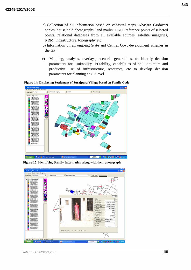
RADPFI Guidelines,2016 liii
a) Collection of all information based on cadastral maps, Khasara Girdavari
copies, house hold photographs, land marks, DGPS reference points of selected
points, relational databases from all available sources, satellite imageries,
NRM, infrastructure, topography etc;
b) Information on all ongoing State and Central Govt development schemes in
the GP;
c) Mapping, analysis, overlays, scenario generations, to identify decision
parameters for suitability, irritability, capabilities of soil; optimum and
productive use of infrastructure, resources, etc to develop decision
parameters for planning at GP level.
Figure 14: Displaying Settlement of Surajpura Village based on Family Code
Figure 15: Identifying Family Information along with their photograph
43349/2017/1003343

RADPFI Guidelines,2016 liv
Figure 16: Displaying Cadastral Map based on Survey Number
Figure 17: Displaying Cadastral Map based on Account Holder
43349/2017/1003344
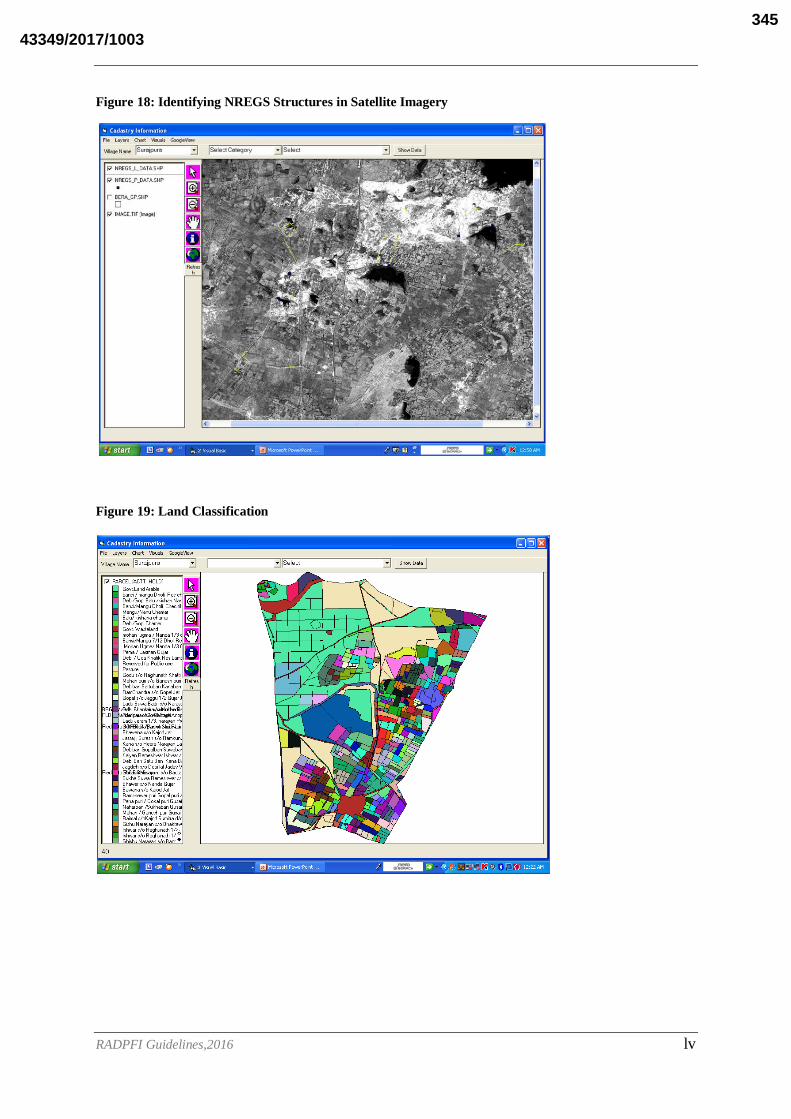
RADPFI Guidelines,2016 lv
Figure 18: Identifying NREGS Structures in Satellite Imagery
Figure 19: Land Classification
43349/2017/1003345
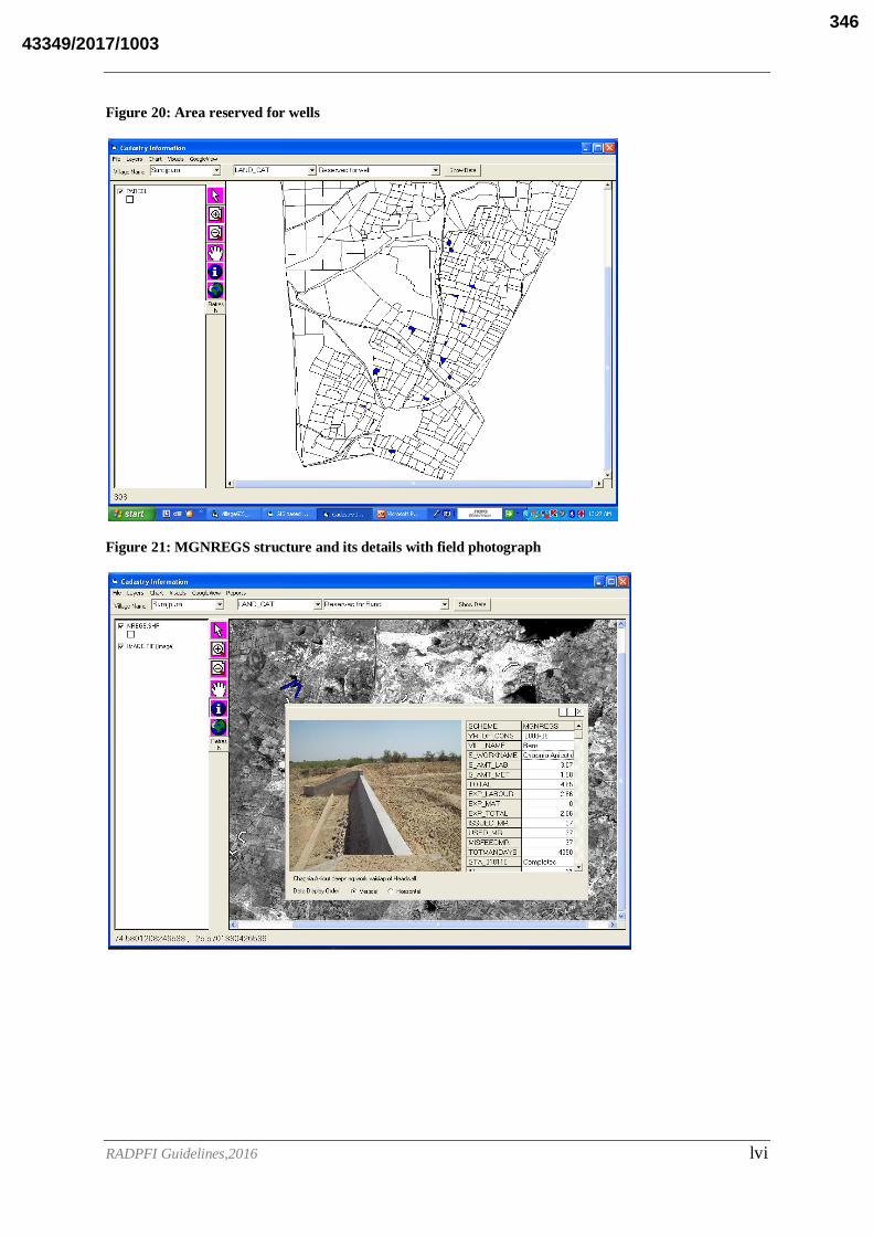
RADPFI Guidelines,2016 lvi
Figure 20: Area reserved for wells
Figure 21: MGNREGS structure and its details with field photograph
43349/2017/1003346

RADPFI Guidelines,2016 lvii
Conclusion
GIS based GP Planning is a comprehensive document with all analysis for the Gram
Panchayat planning for local people and for local decision support. The GIS based GP
Planning facilitates integration and convergence of all village layers up to cadastral and house
hold on real time mode. The GIS based GP Planning has inbuilt capabilities to capture All
Village Thematic layers generate modern GPS, Space Technology, Communication
Technology as an integral part of the GP development at grassroot level.
43349/2017/1003347

RADPFI Guidelines,2016 lviii
Kasare Gram Panchayat, Parner Taluka ,Ahmednagar District ,Maharashtra State.
Introduction
A well known fact is that India lives in her villages and would continue to do so. But rapid
urbanization and consequent haphazard growth of cities has resulted in neglecting of villages.
It lead to deterioration of infrastructure facilities, health hazards, loss of agricultural land and
water bodies, besides many micro-climatic changes disturbing the ecological balance.
Further, there is exodus of population, driven by lack of adequate facilities/opportunities in
villages, from rural to urban areas. Though the urban regions have developed faster as
compared to rural, the basic objective of a balanced development of different regions has still
remained a distant dream. Instead, this has widened the gulf between the developed (urban)
and the less developed regions (rural), thereby creating islands of prosperity. Hence there is
an urgent need to reduce the cleavage between the rural and the urban areas through
appropriate development planning for the villages.
The advent of space technology all pervading and the pace of ICT(Information
Communication and Technology) facilitating the data acquisition on almost real-time mode
gives opportunity for judicious decision making at all levels of governance for the developing
world for reduction of redundancy and time and for optimum utilization of the scarce
resources. The planning process has undergone a drastic change in recent years where
decentralized participatory decision-making is resorted to ensure sustainability. However for
this participatory decision-making, accessibility to a comprehensive data base which is easy
to access and understanding of land records, topography, resources, settlement patterns and
infrastructure new methodology and technology are needed. This is an area where spatial
technologies play a key role in generating timely and reliable information for planning and
decision-making at all levels. The use of GIS for a micro administrative unit for planning and
implementation was tested in an Action Research Project in one of the Panchayats in India,
where the knowledge base is developed up to cadastral level (land parcel level) and the house
hold socio economic data is embedded on this layer on a GIS platform, with all graphic
features of house type and house hold linked, to enable stakeholders take decisions in a
dynamic mode.
Planning requires association and integration of various activities with spatial (geo-
referenced) and non-spatial characteristics. Facility planning and management is one such an
important area. Geomatics-based approaches to facility planning and management have, of
late, gained prominence as they offer rational, efficient and effective solutions. Further, the
rapid advances in the hardware and software technologies coupled with a growing
competition among the related vendors have brought down the cost of Geomatics /GIS
technology by manifold, making it affordable for deployment on a large scale for use in
decentralized planning.
Even though it is widely recognized that the Geographic Information System (GIS) has the
capacity to analyze both spatial and temporal data on a cost effective manner for effective
planning and management, its application at the micro level for participatory planning and
management is limited.
43349/2017/1003348

RADPFI Guidelines,2016 lix
In view of this scenario, an attempt has been made to actually apply the GIS Package, simple,
user friendly, customized, local need based, interactive and can be handled by the local youth
and Village functionaries. It could be called Village GIS, which has all inbuilt features of
various decisions at the village level integrating various layers of information both spatial and
attribute pertaining to the Kasare village.
Planning:
Planning is a basic human activity that involves thinking ahead and organizing to achieve
given objectives. The function of the planning system is to regulate the development and use
of land in the public interest and to reconcile current requirements with the need to protect the
natural and historic environment.
GIS in Planning:
The usefulness in planning and management of resources of GIS technology cannot be
ignored. Country conditions in India provide plenty of opportunity to implement this
technology. However, some barriers to effective utilization do also exist, such as non-
availability of maps and cost of high resolution satellite data, and institutional and
organizational weakness and the present-day requirement for skilled personnel to handle GIS
software, but these barriers do not lessen the appropriateness of this technology.
The GIS technology is geared to prove most appropriate in every aspect of planning,
decision-making, modeling, disaster management, alternative scenario generation and as a
decentralized governance tool in India. Top administrators can be expected to employ a GIS
to obtain views of the future spatial development of an area. With these tools, planning
professionals will be able to provide high-quality services and information.
Objectives:
The objectives of the study are:
To prepare land base map for study area to analyze demographical and cadastral
information.
To prepare various types of thematic maps (land use and land cover,Drainage, soil
maps etc. on 1:10000 scale
To prepare a GIS based GP Plan
Study Area
The Study Area is taken as the Kasare GP of Parner Taluka in Ahmednagar District of
Maharashtra State.
District profile:
Ahmednagar is the largest district of Maharashtra State with geographical area of 17418
k.m., which is 5.66% of area of Maharashtra State. Out of total areas 391.5 sq. k. m. is urban
area and remaining 16,656.5 sq. k. m. is rural area. Ahmednagar is centrally located in
western Maharashtra. In Ahmednagar district there were 13 talukas and 1,581 villages and
43349/2017/1003349

RADPFI Guidelines,2016 lx
1,308 gram sabhas. The Ahmednagar district is laid between 18.2* to 19.9* North latitudes
and 73.9* to 57.5* East longitudes, and is bounded on the north by Nasik district, on the
north east by Aurangabad district, in the east by Beed and Osmanabad, on the south by
Solapur and in the south west by Thane and Pune district.
The climate of the district is characterized by a hot summer and general dryness during major
part of the year except during south-west monsoon season, when the relative humidity is
between 60% and 80% thereafter it decreases. Ahmednagar gets rain mainly from south-west
monsoon but the distribution is mostly uneven. The average rainfall in the district is 579 mm.
The study area is Parner Taluka which comes under Ahmednagar district of Maharashtra
state. Geographical location lies between 18.32 degree and 19.19 degree Northern Latitudes
and 76.15 degree and 74.24 degree Eastern Longitudes. As per 2001 census the total
population is 246535. It covers an area of 1,930 sq. km. The main study area is Kasare village
in Parner taluka of Ahmednagar district. This village is located near Takli Dhokeshwar.
Kasare is located at coordinates 19°8'21"N and 74°20'14"E. It covers an area of 8.2 sq.km
approx
Data Inputs:
Survey of India Toposheet 1:25,000 scale.
Figure 22: Toposheet
Soil Survey, Analysis and Sampling.
43349/2017/1003350
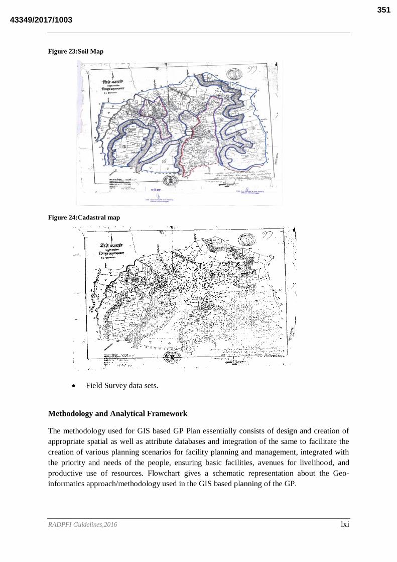
RADPFI Guidelines,2016 lxi
Figure 23:Soil Map
Figure 24:Cadastral map
Field Survey data sets.
Methodology and Analytical Framework
The methodology used for GIS based GP Plan essentially consists of design and creation of
appropriate spatial as well as attribute databases and integration of the same to facilitate the
creation of various planning scenarios for facility planning and management, integrated with
the priority and needs of the people, ensuring basic facilities, avenues for livelihood, and
productive use of resources. Flowchart gives a schematic representation about the Geo-
informatics approach/methodology used in the GIS based planning of the GP.
43349/2017/1003351

RADPFI Guidelines,2016 lxii
Methodology:
1. Land Base Map is prepared for the study area using the Geo-eye satellite imagery
with scale of 1:1000.
2. The data models were prepared for collecting the land base details like house address,
family information details etc.
3. For generation of thematic maps land use land cover, soil, slope etc. the merged data
of cartosat-1 and IRS P6 LISS IV images is used.
4. Taking SOI Toposheet as source, thematic layers like drainage and contours are
prepared at 1:25000 scale.
5. The Slope map is derived using SOI topographical sheets at 1:25000 scale with 20
meter Contour Interval;
6. Organising PRA through Resource Mapping, Need Analysis, priority analysis;
7. GP house hold data bases;
8. Study on Ongoing State and Central development schemes;
9. Study on finances and provisions, powers and functions of GP.
Figure 25:Methodology
Spatial database design:
GP Profile:
The study area consists of entire Kasare Gram Panchayat. It lies between 19°8'21"N
and 74°20'14"E of the Parner Taluka of Ahmednagar District of Maharashtra State.
Coordinate system
The coordinate system for the study area needs to represent the geographic features in
true shape and size. Since the capture of the spatial features is based on Survey of
43349/2017/1003352

RADPFI Guidelines,2016 lxiii
India (SOI) Toposheet (Scale-1: 50,000), UTM projection system has been followed
for the coordinate system as adopted by SOI. For convenience, the same coordination
system is used for Registration points also, thereby allowing proper integration of data
sets. Cadastral maps were integrated with the spatial coordinates of the Village.
Base Map
Base map isprepared from Survey of India Toposheet on 1:50,000 scale comprising
settlements, village administrative boundaries and road network.
Figure 26:Base Map of kasare Village
Drainage Map
The base map comprising of drainage network has been prepared using Survey of India
topographical maps on 1:50,000 scale. The study area is having streams, which are sparsely
located over the region. These streams are further classified based on stream ordering.
43349/2017/1003353

RADPFI Guidelines,2016 lxiv
Figure 27:Flow analysis and Drainage pattern of kasare Village
Figure 28:Flow analysis in 3D
Contour Map
A contour line joins points of equal elevation above a given level, such as mean sea level. It
is used to define the elevation of the region, through contour data the slope, elevation and
terrain of the region is known.
Kasare Village is an hilly terrain and the region falls under the elevation with minimum
height of 780 meters to 880 meters from MSL (Mean Sea Level). Contour map has been
prepared by using Survey of India topographical sheets at 1:50000 scale.
43349/2017/1003354

RADPFI Guidelines,2016 lxv
Figure 29:Contours of Kasare Village
Generation of TIN (Triangulated Irregular Network) and DEM (Digital Elevation
Model)
In order to establish flow accumulation raster and possible stream network an elevation
raster has to be created. For this contour datathus generated in the vector format has to be
used to generate TIN using Arc Map 3D analyst functions. Later this TIN has to be
converted to DEM (Elevation raster) raster form by using spatial analyst functions. Slope
map can be generated from the elevation raster by surface analysis tools under spatial
analyst functions.
Figure 30:TIN of kasare Village
43349/2017/1003355

RADPFI Guidelines,2016 lxvi
Figure 31:DEM of Kasare Village
Slope
Slope maps play a crucial role in addition to flow direction and flow accumulation in
hydrological modeling. Slope is one of the important terrain parameters which can be
explained by horizontal spacing of the contours. In general, in the vector form closely spaced
contours represent steeper slopes and sparse contours exhibit gentle slope where as in the
elevation output raster every cell has a slope value. Here, the lower slope values indicate the
flatter terrain (gentle slope) and higher slope values correspond to steeper slope of the terrain.
Figure 32:Slope Map of Kasare village
GIS Analysis
The hydrological analysis process in GIS is one of the effective methods in terms of cost and
time in proposing various water harvesting structures. This process deals with assessing
43349/2017/1003356
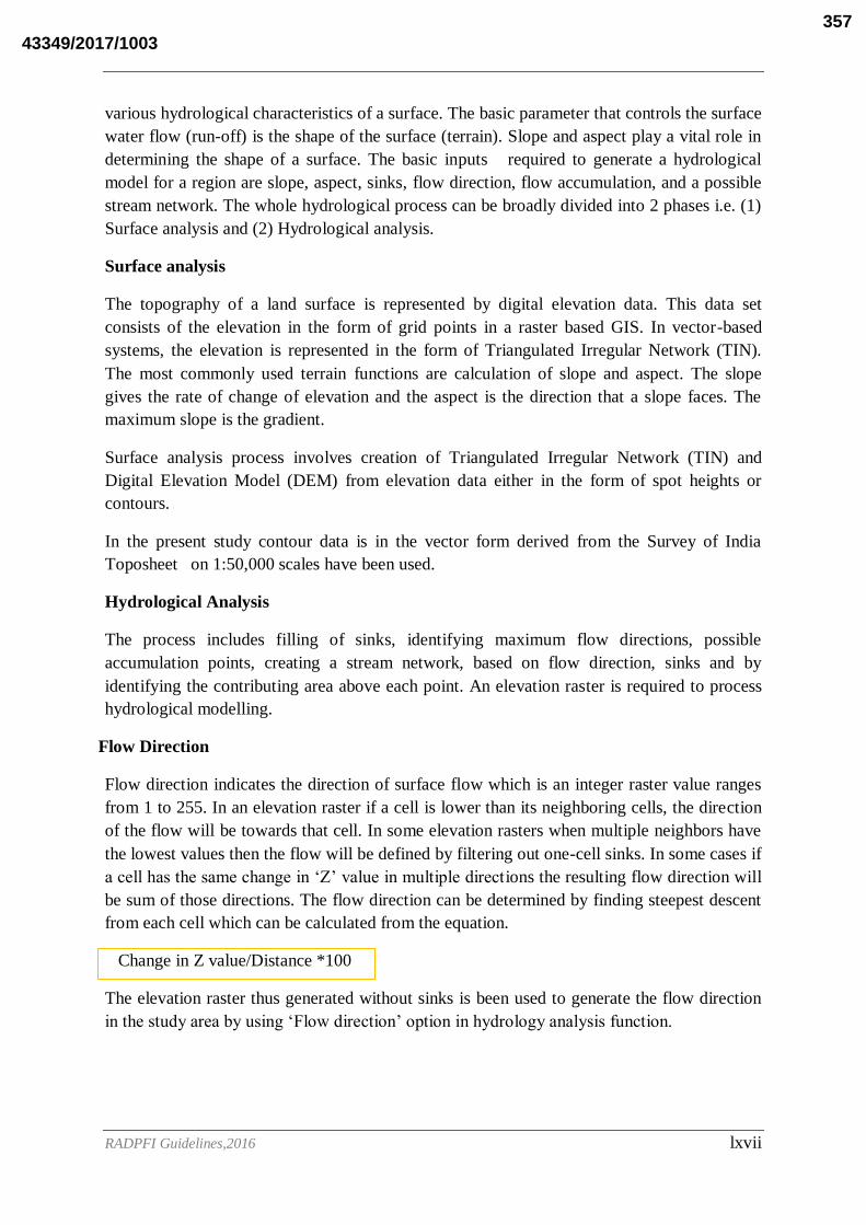
RADPFI Guidelines,2016 lxvii
various hydrological characteristics of a surface. The basic parameter that controls the surface
water flow (run-off) is the shape of the surface (terrain). Slope and aspect play a vital role in
determining the shape of a surface. The basic inputs required to generate a hydrological
model for a region are slope, aspect, sinks, flow direction, flow accumulation, and a possible
stream network. The whole hydrological process can be broadly divided into 2 phases i.e. (1)
Surface analysis and (2) Hydrological analysis.
Surface analysis
The topography of a land surface is represented by digital elevation data. This data set
consists of the elevation in the form of grid points in a raster based GIS. In vector-based
systems, the elevation is represented in the form of Triangulated Irregular Network (TIN).
The most commonly used terrain functions are calculation of slope and aspect. The slope
gives the rate of change of elevation and the aspect is the direction that a slope faces. The
maximum slope is the gradient.
Surface analysis process involves creation of Triangulated Irregular Network (TIN) and
Digital Elevation Model (DEM) from elevation data either in the form of spot heights or
contours.
In the present study contour data is in the vector form derived from the Survey of India
Toposheet on 1:50,000 scales have been used.
Hydrological Analysis
The process includes filling of sinks, identifying maximum flow directions, possible
accumulation points, creating a stream network, based on flow direction, sinks and by
identifying the contributing area above each point. An elevation raster is required to process
hydrological modelling.
Flow Direction
Flow direction indicates the direction of surface flow which is an integer raster value ranges
from 1 to 255. In an elevation raster if a cell is lower than its neighboring cells, the direction
of the flow will be towards that cell. In some elevation rasters when multiple neighbors have
the lowest values then the flow will be defined by filtering out one-cell sinks. In some cases if
a cell has the same change in ‘Z’ value in multiple directions the resulting flow direction will
be sum of those directions. The flow direction can be determined by finding steepest descent
from each cell which can be calculated from the equation.
Change in Z value/Distance *100
The elevation raster thus generated without sinks is been used to generate the flow direction
in the study area by using ‘Flow direction’ option in hydrology analysis function.
43349/2017/1003357

RADPFI Guidelines,2016 lxviii
The output flow direction raster shows eight (8) possible directions.
Figure 33:Flow Direction of Kasare village
Flow Accumulation
Flow accumulation is generated from the error free elevation raster data. The cells of
undefined flow directions other than (1 to 8) will only receive flow accumulation. The
accumulated flow in the raster output is calculated based upon the number of cells flowing
towards each cell. The high flow areas in the output raster are the areas of concentrated flow,
which are important to identify possible stream channels. Similarly, those areas with flow
accumulation value zero (low) are the areas, which are topographically high like ridges. A
stream network is created by using the results of the high-accumulated flow. Similarly, this
stream network is used as input to generate stream order, stream line and stream link.
32 64 128
16 1
8 4 2
43349/2017/1003358
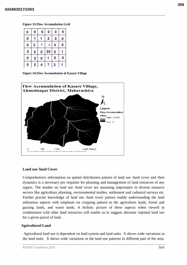
RADPFI Guidelines,2016 lxix
Figure 33:Flow Accumulation Grid
Figure 34:Flow Accumulation of Kasare Village
Land use /land Cover
Comprehensive information on spatial distribution pattern of land use /land cover and their
dynamics is a necessary pre requisite for planning and management of land resources of any
region. The studies on land use /land cover are assuming importance in diverse resource
sectors like agriculture planning, environmental studies, settlement and cadastral surveys etc.
Further precise knowledge of land use /land cover pattern enable understanding the land
utilization aspects with emphasis on cropping pattern in the agriculture lands, forest and
grazing lands, and waste lands. A holistic picture of these aspects when viewed in
combination with other land resources will enable us to suggest alternate /optimal land use
for a given parcel of land.
Agricultural Land
Agricultural land use is dependent on land system and land units. It shows wide variations in
the land units. It shows wide variations in the land use patterns in different part of the area.
43349/2017/1003359
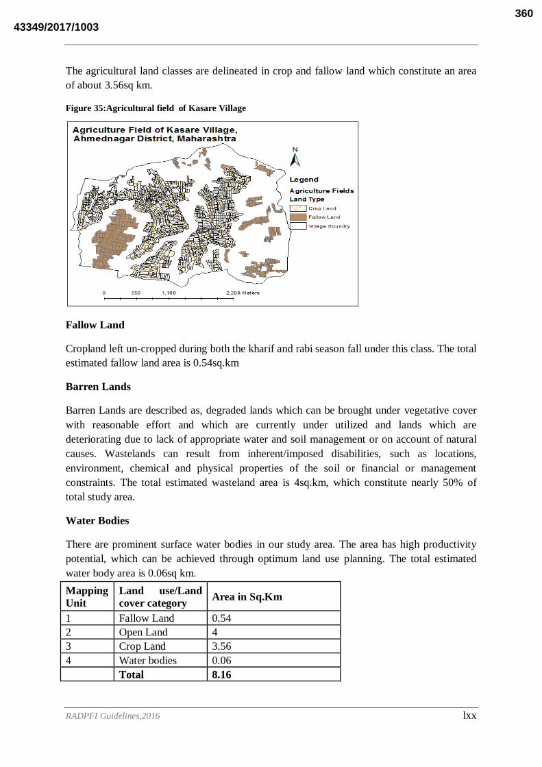
RADPFI Guidelines,2016 lxx
The agricultural land classes are delineated in crop and fallow land which constitute an area
of about 3.56sq km.
Figure 35:Agricultural field of Kasare Village
Fallow Land
Cropland left un-cropped during both the kharif and rabi season fall under this class. The total
estimated fallow land area is 0.54sq.km
Barren Lands
Barren Lands are described as, degraded lands which can be brought under vegetative cover
with reasonable effort and which are currently under utilized and lands which are
deteriorating due to lack of appropriate water and soil management or on account of natural
causes. Wastelands can result from inherent/imposed disabilities, such as locations,
environment, chemical and physical properties of the soil or financial or management
constraints. The total estimated wasteland area is 4sq.km, which constitute nearly 50% of
total study area.
Water Bodies
There are prominent surface water bodies in our study area. The area has high productivity
potential, which can be achieved through optimum land use planning. The total estimated
water body area is 0.06sq km.
Mapping
Unit
Land use/Land
cover category Area in Sq.Km
1 Fallow Land 0.54
2 Open Land 4
3 Crop Land 3.56
4 Water bodies 0.06
Total 8.16
43349/2017/1003360

RADPFI Guidelines,2016 lxxi
Figure 36:Land Use Land Cover Map of Kasare Village
Soil
Soil is a natural body differentiated into horizons of mineral and organic constituents usually
unconsolidated, of variable depth which differs from the parent material below, in
morphology, physical properties and constitution, chemical properties and composition as
well as biological characteristics.
Utilizing the soil resources based on their productivity and capability lead to food economic
and agricultural development of the region. The Soil, Land capability, Land Irrigability maps
of the study area has been prepared on 1:50,000 scale using satellite images and other
collateral data with limited field surveys.
Details of Soil Types
Sl.
No.
Soil Series Description Area
(sq.km)
1 Pimpalgaon
Rotha
Pimpalgaon Rotha- shallow soil, sandy
clay, very gently slope, moderate
erosion, dark brown, messa, cultivated
soil
1.27
2 Pimpalgaon
Rotha
Pimpalgaon Rotha- shallow soil,
gravelly clay, gently sloping, severe
erosion, very dark grayish brown, messa,
cultivated soil
0.94
3 Wadner Wadner- shallow soil, gravelly sandy
loam, moderate to steep, very severe
erosion, dark brown, Escarpment,
uncultivated soil
1.89
43349/2017/1003361
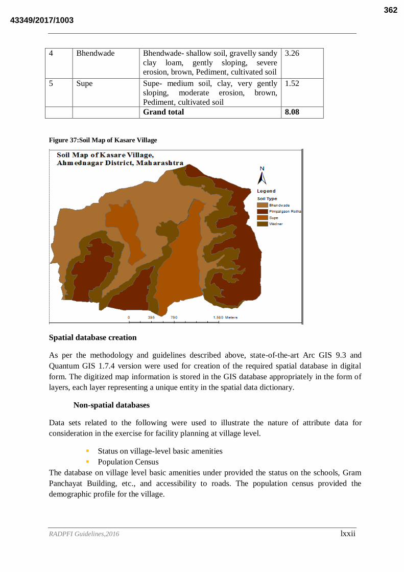
RADPFI Guidelines,2016 lxxii
4 Bhendwade Bhendwade- shallow soil, gravelly sandy
clay loam, gently sloping, severe
erosion, brown, Pediment, cultivated soil
3.26
5 Supe Supe- medium soil, clay, very gently
sloping, moderate erosion, brown,
Pediment, cultivated soil
1.52
Grand total 8.08
Figure 37:Soil Map of Kasare Village
Spatial database creation
As per the methodology and guidelines described above, state-of-the-art Arc GIS 9.3 and
Quantum GIS 1.7.4 version were used for creation of the required spatial database in digital
form. The digitized map information is stored in the GIS database appropriately in the form of
layers, each layer representing a unique entity in the spatial data dictionary.
Non-spatial databases
Data sets related to the following were used to illustrate the nature of attribute data for
consideration in the exercise for facility planning at village level.
Status on village-level basic amenities
Population Census
The database on village level basic amenities under provided the status on the schools, Gram
Panchayat Building, etc., and accessibility to roads. The population census provided the
demographic profile for the village.
43349/2017/1003362

RADPFI Guidelines,2016 lxxiii
Integration of spatial and non-spatial databases
For the purpose of integration of spatial and non-spatial databases, the attribute databases were
conveniently organized to correspond to required distinct areas of planning, which include
education, health, etc. These data sets are linked and integrated with the spatial databases to
facilitate the development of facility planning and management system.
Figure 38: Individual Information
Kasare GPMap
The figure shows the combined outcome of all layers such as Land Base Map, Soil Map,
Agricultural Fields, Water Bodies, Drainage Map, Wells, Slope, DEM etc.,
43349/2017/1003363
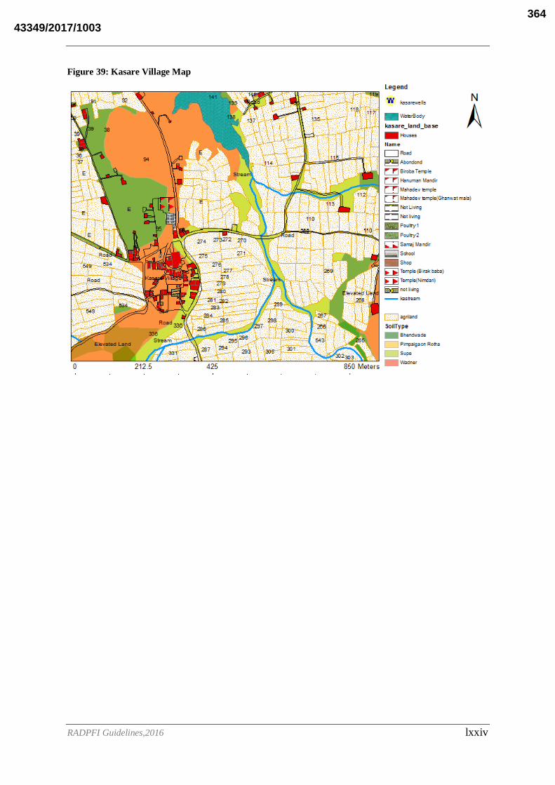
RADPFI Guidelines,2016 lxxiv
Figure 39: Kasare Village Map
43349/2017/1003364