Embed Size (px)
Citation preview

1
RunwayHD iPad Tablet
User Guide
iOS 9 & 10
2
Contents 1. iPad Tablet Support ................................................................................................................. 3
2. RunwayHD - Getting Started .................................................................................................... 5
1. Setup ................................................................................................................................... 5
2. Turning on RunwayHD ........................................................................................................ 5
3. Moving about the Map Screen – Panning & Zooming ........................................................ 5
1. One Finger ....................................................................................................................... 5
2. Two Fingers ..................................................................................................................... 5
3. Press & Hold .................................................................................................................... 5
4. Rotating the Map ............................................................................................................ 6
3. Downloading Charts via Wi-Fi .................................................................................................. 6
4. Screen Layout Guide ................................................................................................................ 7
1. Main Map Screen Guide ...................................................................................................... 7
5. RunwayHD Settings menu ..................................................................................................... 10
6. Display Settings ...................................................................................................................... 11
7. Aircraft Settings ..................................................................................................................... 13
8. RunwayHD Route Options ..................................................................................................... 14
9. Context Menu ........................................................................................................................ 16
10. Planning with RunwayHD .................................................................................................. 18
1. Create a route ................................................................................................................... 18
1. On the map.................................................................................................................... 18
2. Using Search to locate a potential waypoint ................................................................ 18
2. Adding a waypoint............................................................................................................. 19
1. To an existing route leg ................................................................................................. 19
3. Using the Virtual Measuring Tool ...................................................................................... 19
4. Viewing Route Information ............................................................................................... 20
5. Sharing Routes (via email) ................................................................................................. 20
6. Using RocketRoute to Submit a Flightplan ........................................................................ 20
7. Filing a GAR Form .............................................................................................................. 21
8. Checking NOTAM information .......................................................................................... 21
9. Checking weather information (TAF/METAR) ................................................................... 21
10. Side Profile Display ........................................................................................................ 22
11. Flying with RunwayHD ...................................................................................................... 22
1. Airspace Warnings ............................................................................................................ 22
2. Aircraft Icon ....................................................................................................................... 23
1. No GPS Indicator ........................................................................................................... 23

3
2. No GPS Troubleshooting ............................................................................................... 23
3. 5 minute Vector Line ..................................................................................................... 23
4. Track Up / North Up ...................................................................................................... 24
5. Track Aircraft ................................................................................................................. 24
6. Following a Route Leg ................................................................................................... 24
7. Waypoints ..................................................................................................................... 24
8. Scratch Pad .................................................................................................................... 24
9. Nearest Airfields ............................................................................................................ 25
12. Side Tabs ........................................................................................................................... 25
1. Airfield Tab ........................................................................................................................ 25
2. NOTAMs Tab ..................................................................................................................... 25
3. Weather Tab ..................................................................................................................... 26
4. Route Tab .......................................................................................................................... 26
5. Checklist Tab ..................................................................................................................... 26
13. Post Flight .......................................................................................................................... 27
1. Flight Logs ......................................................................................................................... 27
2. Documents / EFB ............................................................................................................... 27
14. Terrain Shading ................................................................................................................. 27
15. Power FLARM .................................................................................................................... 28
16. Pilot Aware ........................................................................................................................ 28
1. iPad Tablet Support Support and advice on using the iPad has been removed from this manual. For assistance we now recommend the following: Apple Support: https://www.apple.com/uk/support/ipad/ Or download the iBook ‘iPad User Guide for iOS x.x’ on your iPad from the iBooks Application.

4
Copyright and Proprietary Statement
This is a published work created in 2016, any copyright in which vests in Airbox Aerospace
Ltd (Abx). All rights reserved.
Overview
The RunwayHD app is a VFR planning and navigation device featuring a full airspace warning
system, access to NOTAMs, weather, airfield data and layered mapping.
Chart and airspace data can be downloaded to RunwayHD via Wi-Fi and/or a 3G network.
New Features
Dashboard
Get all the information you need from the new dashboard view when you open RunwayHD.
GAR
You can now file GAR forms for free from RunwayHD as part of your
pre-flight planning,
5 Airbox Aerospace Limited – RunwayHD Manual - +44 (0)1235 227 250
2. RunwayHD - Getting Started
1. Setup
After you download RunwayHD from the App Store, run RunwayHD by pressing on the icon.
You will need to login using your ThunderCloud details. If you have not already created an
account you can to do so - http://users.airboxaero.com/UserAccount/Registration.aspx
Select the appropriate base map for your region to download and allow the software to
FULLY download and install this.
The charts can be installed via Wi-Fi (Settings > Downloads).
Note that further help is available within the application by navigating to Documents and
selecting ‘Help’.
2. Turning on RunwayHD
To activate RunwayHD the User must select the RunwayHD icon from the Main Menu screen
on the tablet. The app will start up, displaying the Load Screen. If the device is connected to
the Internet and updates are available, the User will be given the opportunity to update the
airspace data or install new charts.
RunwayHD will display a screen showing when the last updates occurred for NOTAMs and
airspace. The User must acknowledge this information to continue to the Main Map Screen.
3. Moving about the Map Screen – Panning & Zooming
1. One Finger
Users can pan around the map, select buttons, and type when flight planning by just using
their finger.
2. Two Fingers
Placing two fingers on the map and holding them there produces a virtual ruler. The ruler
displays distance, time between two points and an estimated fuel burn.
3. Press & Hold
Pressing a finger on the map and holding for 1 second will open up a context menu relevant
to the point on the map which was pressed. From here a user can choose a number of options,
for instance Add Waypoint (to an existing route), Navigate To (the point on the map selected)
6 Airbox Aerospace Limited – RunwayHD Manual - +44 (0)1235 227 250
or he or she might want to view airfield information located at the point selected. See Context
Menu for full list of available options.
4. Rotating the Map
When the user has Track Up selected as On in the Display options (Settings > Display > Track
Up) he or she can rotate the map around a central point between their fingers.
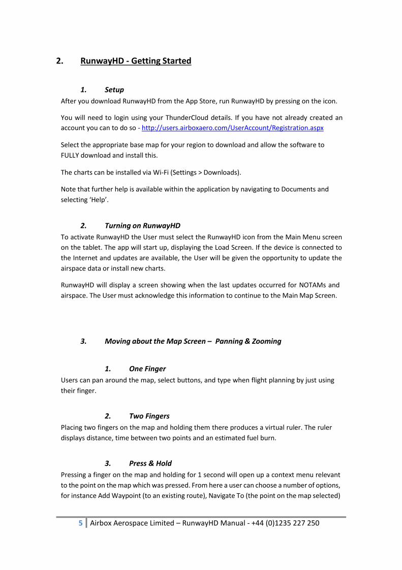
3. Downloading Charts via Wi-Fi
1) Select Settings menu.
2) Select Downloads.
3) Select the item you wish to download.

7 Airbox Aerospace Limited – RunwayHD Manual - +44 (0)1235 227 250
NOTE:
It is best to select items individually. Downloading large amounts of data at once can cause
downloads to fail. If this occurs we recommend selecting ‘Individual Items’ at the bottom of
the Downloads screen and choosing maps one at a time.
A progress bar at the top of the map screen will show download and then installation
progress. Following the download of some document files it is required to restart the
software.
Should the download fail then RunwayHD will notify you and will give the option to try again.
Should a download fail multiple times check internet and Wi-Fi connectivity and refer to the
service & support team.
4. Screen Layout Guide
1. Main Map Screen Guide

8 Airbox Aerospace Limited – RunwayHD Manual - +44 (0)1235 227 250
Centre Aircraft
The Centre Aircraft button, when pressed, turns blue to show
the feature is active. The map screen will now centre on the
aircraft allowing the map to scroll freely as the aircraft flies
from point A to B. If the User interacts with the screen in any
way, the feature unlocks and the User can pan round the map
freely. To re-center the view on the aircraft once more press
the button again. This can also be achieved by pressing the
orange arrow or on the aircraft icon.
Route Options
Pressing Route Options buttons opens the Route Options
menu and will display any currently planned route. Options
include Loading and Saving routes, receiving a narrow route
NOTAM brief and viewing Flight Logs and ability to build a
new route.
Settings
The Settings buttons opens the Settings Menu which allows
the user to fully customise RunwayHD to their personal
preferences.
Airspace Toggle
The Airspace toggle button allows users to turn on and off a
visual representation of the airspace around them. Airspace
warnings are still generated even if airspace is not visually
displayed.
Weather Toggle
The Weather button turns on and off the Weather access
button. This on-map button allows users to view, at a glance,
airfield weather, European Rainfall Radar and Winds Aloft.
NOTAMS Toggle
NOTAMs can, be viewed as visual circular representations on
the map when this feature is turned on. Pressing and holding
on a NOTAM will produce the context menu. Scroll down to
the bottom of the list to access the content of the NOTAM
under NOTAMs.
9 Airbox Aerospace Limited – RunwayHD Manual - +44 (0)1235 227 250
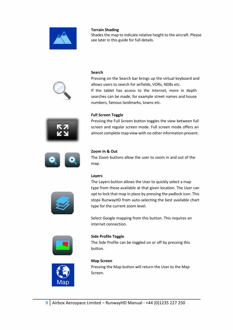
Terrain Shading Shades the map to indicate relative height to the aircraft. Please see later in this guide for full details.
Search
Pressing on the Search bar brings up the virtual keyboard and
allows users to search for airfields, VORs, NDBs etc.
If the tablet has access to the Internet, more in depth
searches can be made, for example street names and house
numbers, famous landmarks, towns etc.
Full Screen Toggle
Pressing the Full Screen button toggles the view between full
screen and regular screen mode. Full screen mode offers an
almost complete map view with no other information present.
Zoom In & Out
The Zoom buttons allow the user to zoom in and out of the
map.
Layers
The Layers button allows the User to quickly select a map
type from those available at that given location. The User can
opt to lock that map in place by pressing the padlock icon. This
stops RunwayHD from auto-selecting the best available chart
type for the current zoom level.
Select Google mapping from this button. This requires an
internet connection.
Side Profile Toggle
The Side Profile can be toggled on or off by pressing this
button.
Map Screen
Pressing the Map button will return the User to the Map
Screen.
10 Airbox Aerospace Limited – RunwayHD Manual - +44 (0)1235 227 250
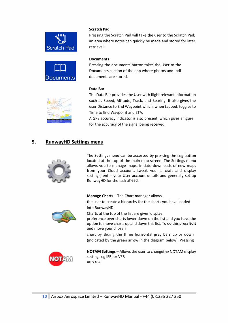
Scratch Pad
Pressing the Scratch Pad will take the user to the Scratch Pad;
an area where notes can quickly be made and stored for later
retrieval.
Documents
Pressing the documents button takes the User to the
Documents section of the app where photos and .pdf
documents are stored.
Data Bar
The Data Bar provides the User with flight relevant information
such as Speed, Altitude, Track, and Bearing. It also gives the
user Distance to End Waypoint which, when tapped, toggles to
Time to End Waypoint and ETA.
A GPS accuracy indicator is also present, which gives a figure
for the accuracy of the signal being received.
5. RunwayHD Settings menu
The Settings menu can be accessed by pressing the cog button located at the top of the main map screen. The Settings menu allows you to manage maps, initiate downloads of new maps from your Cloud account, tweak your aircraft and display settings, enter your User account details and generally set up RunwayHD for the task ahead.
Manage Charts – The Chart manager allows
the user to create a hierarchy for the charts you have loaded
into RunwayHD.
Charts at the top of the list are given display preference over charts lower down on the list and you have the option to move charts up and down this list. To do this press Edit and move your chosen
chart by sliding the three horizontal grey bars up or down
(indicated by the green arrow in the diagram below). Pressing
the Delete icon (indicated by the blue arrow in diagram below)
will allow you delete a chart.
NOTAM Settings – Allows the user to changethe NOTAM display settings eg IFR, or VFR only etc.

11 Airbox Aerospace Limited – RunwayHD Manual - +44 (0)1235 227 250
6. Display Settings
Track Up – When activated, orientates your position so that your icon is always pointing upwards and the map rotates when you change direction. This option also allows the user to, at any time, rotate the map with his or her fingers.
Maximise View Ahead – Positions the aircraft icon on the map screen to show as much forward facing map tile as possible.
Scale – Toggle map scale on and off.
Lat Long Grid – Toggles a Lat Long Grid over
the map
Navaids – Select which navaid types to see overlaid on the map. VRP, VOR, NDB & IFR intersections are all supported.
Saved Points of Interest – Allows POIs to be edited (press to edit) and deleted (swipe to delete). A POI is a user added icon which can be placed on the map as a tactical aid.
Documents – Toggles on/off the icons for documents overlaid on the map.
Custom Overlays – Displays all installed custom overlays on the device with the ability to turn each on or off or to delete them.
Units - Allows the user to change unit display
settings. E.g Knots or miles per hour & co- ordinates to OS
Grid or MGRS.

12 Airbox Aerospace Limited – RunwayHD Manual - +44 (0)1235 227 250
Coordinates – Toggles your position
coordinates on the map data bar.
Planning Top (ft) – Set a maximum altitude for airspace display when planning. Any airspace outside this range will not appear during planning.
Five Minute Line – Toggles on/off a straight line vector display which shows your position in five minutes time (Line split into five one minute segments).
Zoom In & Out - The Zoom buttons allow the user to zoom in and out of the map.
Offset on Drag – Offsets a waypoint from underneath a users’ finger so it can more easily be placed precisely on the map.
Show Rubber Band – Produces a virtual rubber band that always stretches from the aircraft icon to the next waypoint on a route.
Rubber Band to End – Stretches the virtual rubber band to the final end waypoint on a route.
Extended Centre Lines – Toggles the extended runway centre lines feature that produces runway centerlines for start and destination airfields (where such data exists).
Zoom on Destination – This feature zooms the map in on a destination end waypoint to improve situational awareness on approach. The feature works particularly well when different scales of chart are present (for example 500k, 250k and Ordnance Survey charting) or when approaching an airfield with an associated airfield diagram.
13 Airbox Aerospace Limited – RunwayHD Manual - +44 (0)1235 227 250
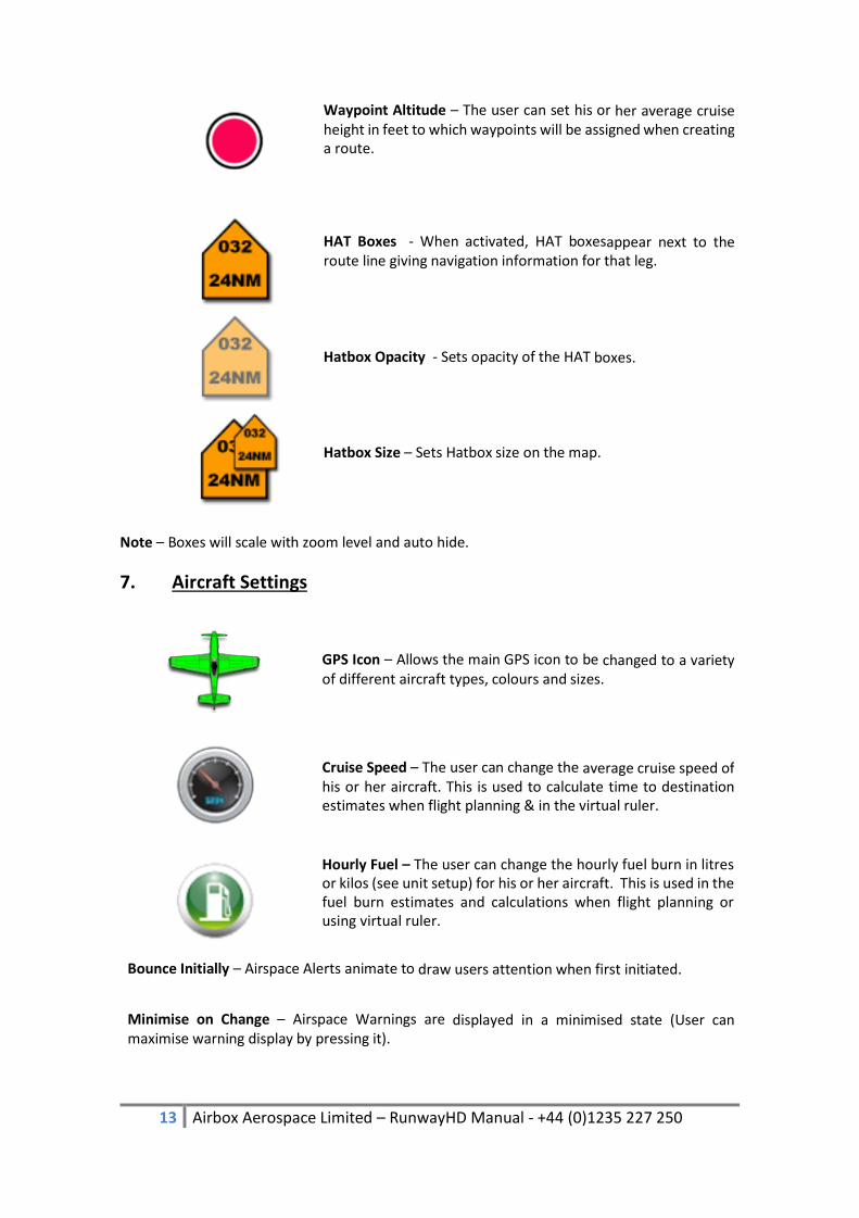
Waypoint Altitude – The user can set his or her average cruise height in feet to which waypoints will be assigned when creating a route.
HAT Boxes - When activated, HAT boxesappear next to the route line giving navigation information for that leg.
Hatbox Opacity - Sets opacity of the HAT boxes.
Hatbox Size – Sets Hatbox size on the map.
Note – Boxes will scale with zoom level and auto hide.
7. Aircraft Settings
GPS Icon – Allows the main GPS icon to be changed to a variety of different aircraft types, colours and sizes.
Cruise Speed – The user can change the average cruise speed of his or her aircraft. This is used to calculate time to destination estimates when flight planning & in the virtual ruler.
Hourly Fuel – The user can change the hourly fuel burn in litres or kilos (see unit setup) for his or her aircraft. This is used in the fuel burn estimates and calculations when flight planning or using virtual ruler.
Bounce Initially – Airspace Alerts animate to draw users attention when first initiated.
Minimise on Change – Airspace Warnings are displayed in a minimised state (User can maximise warning display by pressing it).

14 Airbox Aerospace Limited – RunwayHD Manual - +44 (0)1235 227 250
Demo Mode – Toggle Demo Mode on and off.
Arrival Time Guide – This feature is useful for display pilots or persons wishing to arrive at a designated waypoint at a specific time.
Show Status Bar – Toggle on-off for device Status Bar.
Draw Airspace Live – Draws airspace over the map as it is scrolled, panned and zoomed by the user.
Lock Tracking – Locks the Track Aircraft button so the user cannot scroll the underlying map when activated
Radius – Controls the search radius applied to web searches. I.e. Prevents showing search results for the whole world.
8. RunwayHD Route Options
Route options can be accessed by pressing the route image button located at the top left of the map screen.
Open Route – This allows you to load an existing saved route that is saved within RunwayHD
Save Current Route – If you’ve created a route, you can save it by pressing Save Current Route. Create a name for the route then press Save and the route is saved within RunwayHD for future retrieval.
Clear Current Route – Pressing this will delete the current route displayed on the map screen.
Reverse Route – Choose this option if you want to reverse the route you’ve just travelled.

15 Airbox Aerospace Limited – RunwayHD Manual - +44 (0)1235 227 250
Route Briefing – Once you’ve created a route, RunwayHD can generate a Route Briefing document, which is printable and shows all relevant information for your flight. This feature requires a Wi-Fi connection to the Internet in order to retrieve up to date wind data.
Enroute NOTAMs (Internet/Wi-Fi/3G
connection only) – When you’ve created a route, press
Enroute NOTAMs to produce a relevant NOTAM briefing. The
briefing corridor is approximately 5NM either side of your
route. Pressing the arrow shows the exact location of the
NOTAM displayed in the briefing.
Email Route (Internet/Wi-Fi/3G connection only) – Email routes as .gpx files to other pilots or to a GPS device that accepts .gpx file format.
Email must be setup on the device for this to work.
File Flightplan (requires RocketRoute login) available from - http://www.rocketroute.com/
(Internet/Wi-Fi/3G connection only) – This option will appear
if you’ve registered with RocketRoute and allows you to file a
flight- plan via RocketRoute’s servers. RocketRoute have a live
24/7 call centre to help with all aspects of National and
International flight planning and filing
Logged Flights/Tracks – This option allows
users to view all previously logged flights or tracks. Pressing
on a logged file will show it overlaid onto the map, whilst
swiping a log gives the user the option to delete it.

16 Airbox Aerospace Limited – RunwayHD Manual - +44 (0)1235 227 250
9. Context Menu
Pressing and holding on the map with either a
finger or stylus will produce the context menu.
This menu relates to all information at the point
pressed, for example if the User presses and
holds on an airfield, airfield data for that
location, including, if available, TAF and METAR
weather information, can be retrieved.
Add Waypoint
Allows the user to make a selected point on the map a waypoint
which is then added to the last waypoint created. If no
waypoints exist RunwayHD will add the solitary waypoint to the
map where it will be considered a start point for a route.
Note that when multiple legs exist on a route, one of the legs
will be blue, where the others will be magenta. The blue leg is
the active leg and the route information at the bottom of the
screen will relate to it.

17 Airbox Aerospace Limited – RunwayHD Manual - +44 (0)1235 227 250
Navigate To
Allows the user to navigate to the point selected on the map. A
magenta course line is created from the user’s current position
to the selected point.
Clear Route
If a route has been created, user can tap this option to delete
it.
Airfield Information
Where available, airfield information can be viewed via the
context menu. RunwayHD holds data on over 26,000 airfields
across the globe.
Add Points of Interest
The user can add a Point of Interest to the map, for example
a turnpoint or helipad.
To add a point of interest, select Add Point of Interest, choose
a suitable icon, add a Title (label) for the icon (optional) and a
description (optional) then press Save.
Place Document
Users can geo-place a document on the map from RunwayHD’s
document area at a specific location.
Adding a document is simple; Press and hold on the location
where the document is to be place. Select Place Documents.
Select a suitable icon to represent the document eg Picture.
Select Choose Document. Choose a document from the
Documents area or add a new one then press Set and Save.
To view a placed document, press and hold on the map, the icon
that represents the document to be viewed. Scroll down to
documents and select and open the
document.

18 Airbox Aerospace Limited – RunwayHD Manual - +44 (0)1235 227 250
NOTAMs (Internet/Wi-Fi/3G connection only)
If NOTAM view is turned on, the user can press on a NOTAM’d
location and view the data held on that NOTAM by pressing
and holding on the map then scrolling down the context menu
to NOTAM. Tap the NOTAM to view its contents.
10. Planning with RunwayHD
1. Create a route
Please note that a tutorial on creating a route which walks the user through route creating,
exists within the help menu (accessible from the documents tab).
1. On the map
You can create a route on the map screen by pressing on a destination point with a finger
and waiting for the Context Menu to appear.
Options to Add a Waypoint (either as a start position or to an existing route), or to Navigate
To which creates a route line from the current GPS position to the point pressed.
Waypoints can be added to the route created by either pressing and holding on a section of
a route until a green editing circle appears. The User, whilst maintaining contact with the
screen, can move the newly created waypoint to the desired position. When the user’s finger
is released from the screen the new waypoint anchors at that point.
2. Using Search to locate a potential waypoint
The User can use the Search box at the top right of the screen to search for a location.
When access to the Internet is available, Power Search is enabled which allows the user to
search for locations not held within the App, for example “Big Ben, London”. Almost any
location in the world can be searched this way.
When operated in offline mode, RunwayHD will search its databases. Typical information held
within RunwayHD offline is airfield locations, VOR, NDB, User-created Points of Interest etc.
RunwayHD will display all search results as follows:
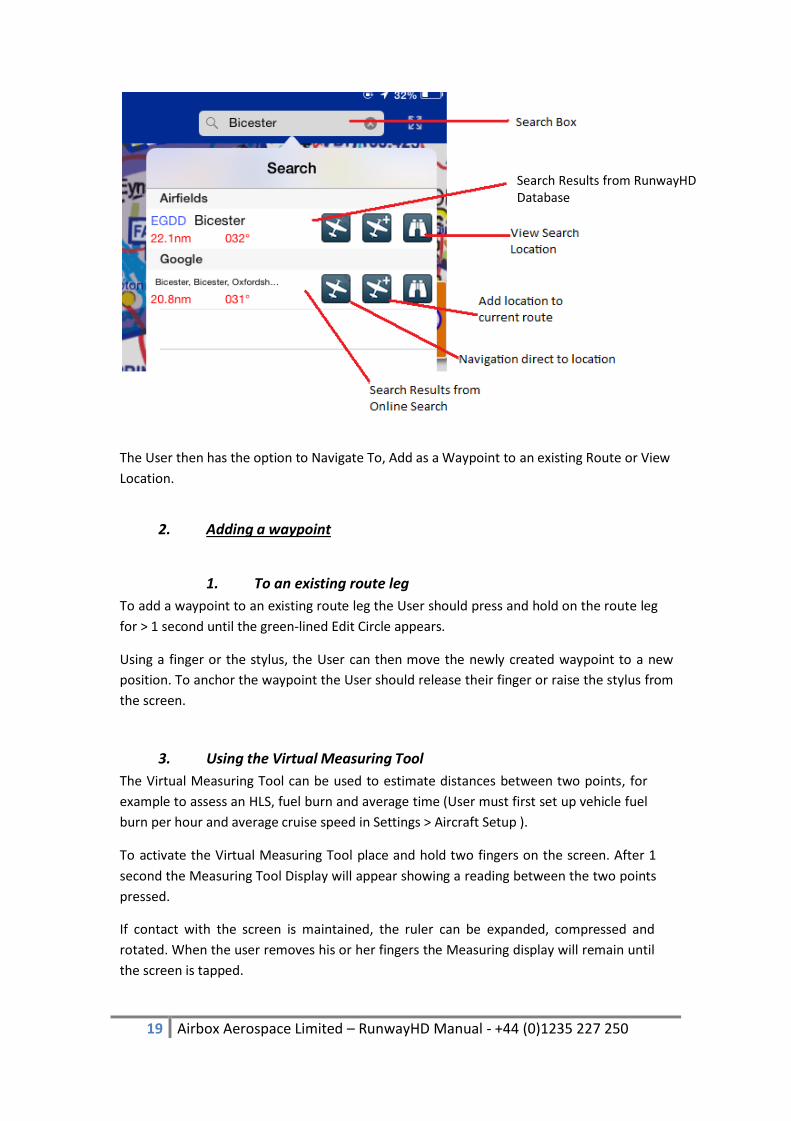
19 Airbox Aerospace Limited – RunwayHD Manual - +44 (0)1235 227 250
The User then has the option to Navigate To, Add as a Waypoint to an existing Route or View
Location.
2. Adding a waypoint
1. To an existing route leg
To add a waypoint to an existing route leg the User should press and hold on the route leg
for > 1 second until the green-lined Edit Circle appears.
Using a finger or the stylus, the User can then move the newly created waypoint to a new
position. To anchor the waypoint the User should release their finger or raise the stylus from
the screen.
3. Using the Virtual Measuring Tool
The Virtual Measuring Tool can be used to estimate distances between two points, for
example to assess an HLS, fuel burn and average time (User must first set up vehicle fuel
burn per hour and average cruise speed in Settings > Aircraft Setup ).
To activate the Virtual Measuring Tool place and hold two fingers on the screen. After 1
second the Measuring Tool Display will appear showing a reading between the two points
pressed.
If contact with the screen is maintained, the ruler can be expanded, compressed and
rotated. When the user removes his or her fingers the Measuring display will remain until
the screen is tapped.
Search Results from RunwayHD Database

20 Airbox Aerospace Limited – RunwayHD Manual - +44 (0)1235 227 250
Please note that setting the units will allow accurate measuring of both small and large
distances.
4. Viewing Route Information
Pressing the Route Information button produces the Route Information screen from where
users and view a currently created route, save and load existing routes, check enroute
NOTAMs etc.
5. Sharing Routes (via email)
Routes can be shared with other users by pressing Email Route. This function requires
access to the Internet and a valid email account set up within the tablet.
Routes are saved in the .gpx format, an internationally recognised format.
Likewise routes created on other RunwayHD devices can be emailed to the User’s device and
opened in RunwayHD to display on the map.
6. Using RocketRoute to Submit a Flightplan
RocketRoute enables you to use the route planning features in RunwayHD to submit a civil
flight plan. You will need to plan your route on the map first and ensure that a RocketRoute
login has been set in Settings > System > RocketRoute Account.
Select ‘File Flightplan’ from the Route menu, the first page will appear. Enter the details
required and progress through the pages.
21 Airbox Aerospace Limited – RunwayHD Manual - +44 (0)1235 227 250
7. Filing a GAR Form
The GAR form brings together three pieces of data relating to people, aircraft and journey. RunwayHD allows you to save multiple people so that you only have to submit data once and you just select the ones you need for the journey you are going on. It will then use the active aircraft and the planned route to complete the remaining details. GAR setup can be done in Settings Flight Plans & GAR, here you can add people and adjust the aircraft settings. This is also where you can adjust the current people for a trip. When you have planned a flight outside the UK, the GAR option will be available in the route menu. Fill out the timing details and then submit. A confirmation email will be sent to the email address you registered with Airbox, please ensure that it is correct. A GAR can be cancelled by copying the confirmation code and submitting it in the ‘Cancel GAR’ section in Route GAR.
8. Checking NOTAM information
A narrow route briefing for NOTAMs can be generated once a route has been planned by
going to Route File > Enroute NOTAMS.
This feature is available only when a valid connection to the Internet is available.
Displaying NOTAMs on the map is available at any time and will use the data last
downloaded.
9. Checking weather information (TAF/METAR)
Users can check up to date global TAF and METAR data quickly and easily when the tablet is
securely connected to the Internet.
When not connected to a live feed, TAF and METAR data is displayed with an indication of the age of the data in days, hours and minutes.
To view TAF and METAR data for an airfield (where available), press and hold on an airfield
to reveal the context menu. Airfield data is clearly displayed as a snapshot view.

22 Airbox Aerospace Limited – RunwayHD Manual - +44 (0)1235 227 250
For more in depth information, tap the weather display to reveal the full decoded and raw
TAF and METAR data.
When you press and hold on an airfield, the app will automatically try to retrieve the latest
METAR/TAF information.
10. Side Profile Display
The Side Profile display gives a side view of an aircraft’s track when flying, or when stationary will show a side profile snapshot of a planned route.
In flight the Side Profile is dynamic and will change as the aircraft changes track.
To toggle Side Profile on or off press the following on-map button
11. Flying with RunwayHD
1. Airspace Warnings
As the user flies a route, they may pass in close proximity to, or enter, airspace. Whenever
they are within 5 minutes, of projected entry to a piece airspace, or inside airspace,
RunwayHD will notify that user with an Airspace Warning message. The message contains
detailed information about the airspace including class, height and, where available, a
contact frequency. The user should look closely at the map display. If airspace is ahead of
the aircraft current course, an Orange alert will display on approach, turning Red when the
aircraft is within that airspace.
RunwayHD will generate airspace warnings across three dimensions as your aircraft moves
across the map if the aircraft’s altitude places it within the floor and ceiling limits of the

23 Airbox Aerospace Limited – RunwayHD Manual - +44 (0)1235 227 250
airspace. If the aircraft is 500 feet or more below or above the airspace RunwayHD will not
generate a warning however the airspace boundary will still appear on the map.
Airspace Warnings can be acknowledged by tapping the warning box, which is then
configured to minimise once tapped.
2. Aircraft Icon Users can select an aircraft icon and use it to represent their position on the map. Icons can
be selected from the Settings menu under Aircraft Setup.
Users can also change the size and colour of the icon to suit their requirements.
1. No GPS Indicator
If no GPS signal is being received by the tablet then RunwayHD will not be able to display a
valid position for the User’s location. This is indicator by a grey/pink aircraft icon with a red
cross over it.
2. No GPS Troubleshooting
Users with No GPS indication may wish to check the following:
1. Check the position of the tablet; the tablet’s internal GPS chip needs a clear view of
the sky for optimum reception.
2. Check Tablet Settings > Privacy > Location Service (ON) > RunwayHD (ON)
3. Check Tablet Settings > Airplane Mode > Tablet Setting should be OFF
4. Check you have a valid Airbox GPS Subscription.
5. Check your device is configured for GPS reception.
3. 5 minute Vector Line
A 5 minute vector line split into 1 minute segments can be toggled on and off (via the Settings
menu > Display > Five Minute Line). The line is designed to give pilots an indication of where
their position in 5 minutes.

24 Airbox Aerospace Limited – RunwayHD Manual - +44 (0)1235 227 250
4. Track Up / North Up
The User can configure the map to display their position either in Track Up mode or North
Up mode. Whilst in Track Up mode the User has the ability to rotate the screen with their
fingers (the map can be returned to North Up by tapping once on the compass).
5. Track Aircraft
In order for the map to track the user’s position, the Track Aircraft button needs to be
highlighted blue (see earlier in the manual for further information). Activating Track Aircraft
will show the User’s fix the aircraft icon on the centre of the map and show the map scrolling
beneath as the aircraft moves.
This function is disabled when the user interacts with the map in any way (the Track Aircraft
button will turn from blue black/grey) to indicate the Track Aircraft mode is disabled. The User
must press the Track aircraft button in order to re-enable the function.
6. Following a Route Leg
Users flying along a route will note that the current leg will appear as a blue line with the
remaining legs magenta in colour. Legs will automatically switch as the user moves along the
route.
7. Waypoints
Waypoints appear as red circles with white borders. Users can create a waypoint and add it
to a route by pressing on the screen and holding for the Context Menu to appear then
choosing Add Waypoint. This option either adds a waypoint to an existing route or adds a
solitary waypoint to the map if no route has been created.
To delete an existing waypoint users can either tap the waypoint in question; A delete indicator
appears which should then be selected. Users can also edit waypoints directly from the Route
Summary in the Route Menu.
8. Scratch Pad
The Scratch Pad is designed to give pilots a note making facility. Selecting Scratch Pad opens
up the Scratch Pad page where the User can select one of seven colours, an eraser or by using
the keyboard function on the Apple Device.
There are four blank pages available for note making.
To exit the Scratch Pad page select one of the other lower tab options (ie Map or
Documents)

25 Airbox Aerospace Limited – RunwayHD Manual - +44 (0)1235 227 250
9. Nearest Airfields
In flight the user can quickly find the nearest airfields to their current position by tapping
on the Side Tab on the left hand side of RunwayHD. If you have not got this Tab active
then you can toggle this on in Settings > Side Tabs. Nearest airfields are then displayed in
order of proximity with information about relative location shown. Each airfield displays
distance from current position.
12. Side Tabs Side Tabs; a new feature to RunwayHD 3.1. This includes Airfield, Weather, NOTAM, Route and Checklist information. This can be toggled on and off to your preference by Settings > Side Tabs and dragging the information you want into Enable or Disable.
1. Airfield Tab
This will give users a list of the nearby airfields from your current position. You will be able to create a route direct to an airfield, add a waypoint on that airfield or find out general information. You will also be able to report any incorrect Data/Fuel Price information.
2. NOTAMs Tab
If users have a route on the map screen this will provide the user with Enroute NOTAM information. Users can choose to hide the NOTAM from here and also access NOTAM Settings.

26 Airbox Aerospace Limited – RunwayHD Manual - +44 (0)1235 227 250
3. Weather Tab
If users have a route on the map screen this will provide users with Enroute Weather information.
4. Route Tab
This will give users a breakdown of route information. This area is similar to the option that users have on the top bar of RunwayHD. Users can Save, Load, Open, reverse, Share and Delete routes from here. Route Briefing and Logged Flight information is available as well as access to Rocket Route.
5. Checklist Tab
Allows users to do preflight checks, create your own checklist or use one of the ones that Airbox have provided.

27 Airbox Aerospace Limited – RunwayHD Manual - +44 (0)1235 227 250
13. Post Flight Post Flight; RunwayHD can be used to review previous tracks flown by aircraft.
1. Flight Logs
All flight tracks are recorded and can be viewed by accessing the Route Menu and pressing
Logged Flights (full instructions can be found earlier in this manual).
Flight logs can be deleted by swiping them left to right and pressing delete.
2. Documents / EFB
Uploading Documents to RunwayHD
Users can add .pdf documents for storage and retrieval within RunwayHD quickly and easily.
Documents do need to be in .pdf format to successfully add them to RunwayHD.
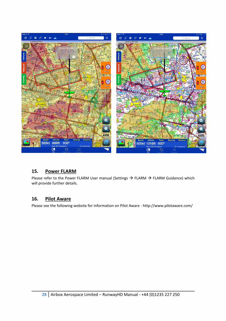
14. Terrain Shading Terrain Shading; RunwayHD will overlay 3 different shading colours to indicate terrain height during your flight by simply tapping on the Terrain icon in the top bar. NOTE – this is an advisory feature only and should not be used for terrain de-confliction. The screen shots below will give an example of the Terrain Shading feature in RunwayHD. The colours show relative height between the aircraft and the section of ground. For example:
Red is 200ft or less
Yellow is 200ft – 500ft
Green is 500ft – 1000ft
No shading is greater than 1000ft
28 Airbox Aerospace Limited – RunwayHD Manual - +44 (0)1235 227 250
15. Power FLARM Please refer to the Power FLARM User manual (Settings FLARM FLARM Guidance) which will provide further details.
16. Pilot Aware Please see the following website for information on Pilot Aware - http://www.pilotaware.com/