Embed Size (px)
Citation preview
Ruby Pipeline Project Land Exchange on Sheldon National Wildlife Refuge Supplemental Information to the Ruby Pipeline Project Final Environmental Impact Statement 6/9/2010 U.S. Department of the Interior U.S. Fish and Wildlife Service


Ruby Pipeline Project Land Exchange on Sheldon National Wildlife Refuge: Supplemental Information to the Ruby Pipeline Project Final Environmental Impact Statement
i
Table of Contents Introduction ......................................................................................................................... 1 Purpose and Need for Action .............................................................................................. 1 Affected Environment ......................................................................................................... 2
USFWS Exchange Lands ................................................................................................ 2 Ruby Exchange Lands .................................................................................................... 3
Effects of Exchange ............................................................................................................ 3 Potential Irretrievable and Irreversible Commitments .................................................... 5 Relationship between Short-term Uses of the Human Environment and Enhancement of Long-term Productivity .............................................................................................. 5
References ........................................................................................................................... 5
Attachments Attachment A – Figure 1 Attachment B – Transportation Plan for Use of Access Roads and Routes within Sheldon National Wildlife Refuge

1
Introduction This supplemental information pertains to the National Environmental Policy Act (NEPA) process conducted for the Ruby Pipeline Project (Project). The Ruby Pipeline Project Final Environmental Impact Statement (Project FEIS) was released to the public in January 2010. On April 5, 2010, the Federal Energy Regulatory Commission (FERC) released its finding and ordered the issuance of a certificate for the proposed pipeline route. The Project FEIS included an assessment of impacts related to access roads to/from the proposed pipeline route. Some of those access roads are located on the Sheldon National Wildlife Refuge (Sheldon Refuge). The project proponent, Ruby Pipeline, LLC (Ruby), has worked closely with Sheldon Refuge to develop a transportation plan for the use of the access roads within the Sheldon Refuge. A preliminary version of Ruby Pipeline’s Draft Transportation Plan for Use of Access Roads within Sheldon NWR (Sheldon Transportation Plan) was provided in Appendix X (Transportation Plans, Attachment C) of the Project FEIS. Since that preliminary draft release, Ruby and Sheldon Refuge have continued to refine the Sheldon Transportation Plan (Ruby Pipeline LLC, June 2010) including addition of details related to a proposed land exchange. The land exchange represents a connected action to the Project, which includes Ruby’s request to use refuge roads. The effects of the proposed land exchange are being disclosed in this document to satisfy U.S. Fish and Wildlife Service (USFWS or Service) NEPA requirements prior to issuing its Record of Decision. The information contained in this supplemental NEPA analysis relies heavily on the final version of the Sheldon Transportation Plan. Therefore, the final version of the Sheldon Transportation Plan is included as an attachment for reference while reviewing this supplemental material.
Purpose and Need for Action The Project, proposed by Ruby, is composed of approximately 675.4 miles of 42-inch-diameter natural gas pipeline, along with associated compression and measurement facilities, located between Opal, Wyoming, and Malin, Oregon. The pipeline would cross four states: Wyoming, Utah, Nevada, and Oregon. The proposed pipeline route would cross northern Nevada in an east-to-west direction. Part of the route would run approximately 1 to 1.5 miles south of the Sheldon Refuge, which is managed by the USFWS. The pipeline would not cross Sheldon Refuge lands; however, several roads in the southern portion of Sheldon Refuge are in close proximity to the pipeline. Ruby has requested the use of some roads on Sheldon Refuge to serve as access routes for pipeline construction vehicles traveling to and from the pipeline route. In response to the request from Ruby to use Sheldon Refuge roads, Sheldon Refuge is proposing to permit Ruby access, with stipulations, to most of the improved refuge roads that Ruby has requested to use. Ruby had also sought permission to use some unimproved (two-track) roads as well as Route 34A (an improved refuge road); those
Ruby Pipeline Project Land Exchange on Sheldon National Wildlife Refuge Supplemental Information to the Ruby Pipeline Project Final Environmental Impact Statement
2
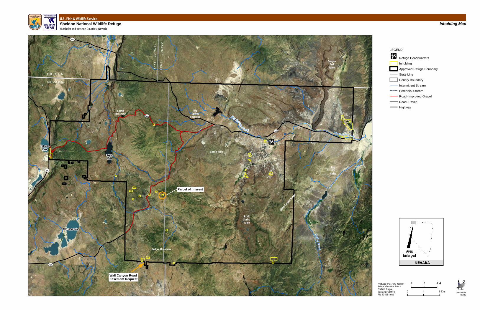
permissions have been denied. In order to gain the extent of access Ruby requires for pipeline construction, Ruby has acquired approximately 20 acres of private inholding land, previously owned by William and Linda Kennedy, and is proposing to exchange that property for an easement to approximately 3.64 acres of Sheldon Refuge lands, which Ruby would then use to access the pipeline route (see Figure 1). Acquiring the private inholding property would allow Sheldon Refuge to manage fish and wildlife resources on that property consistent with surrounding refuge lands. In addition, it would preclude the need to provide access to a private inholding, an action which would further fragment important fish and wildlife habitats. Authority of the USFWS for the proposed exchange derives from the National Wildlife Refuge Administration Act of 1966 (16 U.S.C. 668dd(a)(3)), as amended.
Affected Environment
USFWS Exchange Lands Refuge lands for which Ruby will receive an easement are located in the southeast quarter (SE ¼) of the southeast quarter (SE ¼) of Section 33 and the southwest quarter (SW ¼) of the southwest quarter (SW ¼) of Section 34, Township 43 North, Range 23 East, and the west half (W ½) of the northwest quarter (NW ¼) and east half (E ½) of the southwest quarter (SW ¼) of Section 3, Township 42 North, Range 23 East of the Mount Diablo Meridian. This 30-foot-wide tract of land extends along the centerline of Wall Canyon Road (W-1) in Washoe County, covering 3.64 acres at the southeast boundary of Sheldon Refuge. The information describing the characteristics of the proposed easement is summarized from Appendix X Attachment C: Transportation Plan for Use of Access Roads and Routes within Sheldon National Wildlife Refuge (Sheldon Transportation Plan) of the Project FEIS. This previous version of the Sheldon Transportation Plan has been updated (Ruby Pipeline LLC, June 2010) and is made available with this document on the land exchange (see Attachment B). Additional details may be found in that document. Sensitive resources have been identified within the approximately one-mile length of W-1 extending from Wall Canyon Spring to the Sheldon Refuge fence line. Vegetation surrounding the Sheldon Refuge proposed easement road is dominated by sagebrush steppe, with minimal riparian and pinion-juniper plant communities. Data collected by Ruby identify a wetland area at the northwestern portion of the proposed easement. According to mapped wildlife use areas developed from Sheldon Refuge records, the proposed easement area is important non-winter range for pronghorn antelope and is within the range of mule deer (USFWS 2009 [combined GIS files]). Data collected by Ruby also indicate greater sage grouse, an inactive lek has been observed near the northern portion of the proposed easement length, and three raptor nests have been identified within 1 mile line-of-sight of the proposed easement setting. There is no
Ruby Pipeline Project Land Exchange on Sheldon National Wildlife Refuge Supplemental Information to the Ruby Pipeline Project Final Environmental Impact Statement
3
suitable pygmy rabbit habitat identified within or adjacent to the proposed easement property.
Ruby Exchange Lands The property that Ruby has acquired and proposes to use in the land exchange is located in the south half (S ½) of the southwest quarter (SW ¼) of the southeast quarter (SE ¼) of Section 12, Township 44 North, Range 23 East of the Mount Diablo Base and meridian. This private inholding is a 20-acre property in Washoe County near the summit of Fish Creek Mountain and is wholly located within the Sheldon Refuge. There are no improvements or structures located on it. The elevation of the site ranges from approximately 6,200 to 6,800 feet above mean sea level. Vegetation mapping of Sheldon Refuge indicates the property is predominantly covered in mountain big sagebrush with areas of low sagebrush and Wyoming big sagebrush coverage (Tagestad 2009). The percentage of canopy coverage ranges from 10 percent to 30 percent throughout the property (Tagestad 2009). One spring or seep is present on the property. According to mapped wildlife use areas on the Sheldon Refuge, several species use the habitat and area in and around the property. Greater sage grouse use the area for non-lekking activities. Pygmy rabbit habitat, which is closely linked to big sagebrush species, is known to occur in and around the property. Important mule deer winter habitat is adjacent to the site. Habitat is also found at this site for a variety of migratory birds and other sagebrush-obligate species such as Brewer’s sparrow, sage thrasher, sage sparrow, kit fox, sagebrush vole, and Great Basin pocket mouse. The property is also located on the border of crucial pronghorn summer range (USFWS 2009 [combined GIS files]). Because this land has not been under the jurisdiction or ownership of Sheldon Refuge, no wildlife surveys have been conducted on the property. Sheldon Refuge may be required to provide and maintain access to private inholdings within refuge lands. In addition, Sheldon Refuge has no authority to exercise any control over the development of private inholdings located within its boundaries. For example, an inholding owner could develop a destination lodging or commercial enterprise on the property without regard to its location within a national wildlife refuge. The property is located in the center of Sheldon Refuge in a popularly traveled and used area. Development of the property would be inconsistent with the purpose of the surrounding refuge lands.
Effects of Exchange Positive effects would result from acquisition of the 20-acre Kennedy property. Currently, one percent of land within the Sheldon Refuge boundary consists of private inholdings, which are not afforded refuge protection or subject to its resource management strategies. The Ruby property is located more than 5 miles from the Sheldon Refuge boundary and is surrounded by refuge lands. Acquisition of this property would protect the habitat in a manner consistent with surrounding Sheldon Refuge lands. It would also aid the Service in achieving management objectives for species where habitat

Ruby Pipeline Project Land Exchange on Sheldon National Wildlife Refuge Supplemental Information to the Ruby Pipeline Project Final Environmental Impact Statement
4
loss or degradation is a major cause of decline or where buffers are needed to protect sensitive areas. Under private ownership, the 20-acre Kennedy property could be developed, resulting in negative impacts to Sheldon Refuge resources including wildlife, habitat integrity, and the viewshed. New dwellings, structures, and roads could be built by private landowners, resulting in impacts to surrounding habitats and downstream water sources, introducing and facilitating proliferation of invasive species, and serving as a deterrent to Sheldon Refuge visitors. Acquisition of the inholding would improve Sheldon Refuge’s ability to apply consistent management strategies with reduced fragmentation. Management of invasive species, fire suppression, habitat restoration, habitat connectivity, and protection of cultural and paleontological resources would be applied equally to the acquired property as it would to the existing Sheldon Refuge lands. Costs related to fencing around the private land, conducting land surveys, and maintaining access roads to the property would decrease because those measures would no longer be required nor implemented. Impacts associated with granting the road easement along an approximately 1-mile stretch of W-1 would also occur. Although Ruby is not proposing to construct any new roads on Sheldon Refuge, Ruby would use existing roads to access the pipeline road easement. Vehicle traffic on Sheldon Refuge roads would increase temporarily during pipeline construction, resulting in a corresponding increase in impacts to Sheldon Refuge resources. As discussed in the Transportation Plan, vehicle traffic can result in the following impacts: direct injury or death to wildlife from collisions; increased air pollution; high levels of heavy metals in adjacent soil and plants; and noise-related behavioral and physiological changes in animals. Increased traffic on access roads would increase this probability. However, the increase in traffic would be temporary and is not expected to result in a significant increase in the number of vehicle/animal collisions, accumulation of pollutants, or behavioral or physiological changes in animals sensitive to noise. The monetary appraised value of the Ruby exchange lands exceeds that of the USFWS exchange lands; consequently, the land exchange is also economically favorable to the public. The land exchange would allow Sheldon Refuge to absorb a 20-acre private inholding that is surrounded by refuge lands, restoring habitat connectivity and protection to this portion of the landscape. Whereas the 3.64-acre road easement, located at the southern boundary of Sheldon Refuge, is bordered on three sides by Bureau of Land Management lands that are not managed consistently with Sheldon Refuge strategies or afforded refuge protection. Although there are both positive and negative impacts related to the land exchange, the benefits that would be realized from the land exchange far outweigh any negative impacts.

Ruby Pipeline Project Land Exchange on Sheldon National Wildlife Refuge Supplemental Information to the Ruby Pipeline Project Final Environmental Impact Statement
5
Potential Irretrievable and Irreversible Commitments The anticipated increases in traffic and other human uses of Sheldon Refuge roads during pipeline construction may result in irretrievable and irreversible effects on resources, such as a reduction in biological, cultural, and paleontological resources in the vicinity of the road system. However, the protection and restoration emphasis of the mitigation elements in the Transportation Plan is expected to greatly diminish the potential for irretrievable and irreversible effects on these resources. Implementation of the biological agreements and conservation plans would protect and reduce impacts to wildlife and habitat resources (Appendix M of the Project FEIS). Implementation of the Unanticipated Discoveries Plan and Paleontological Resources Monitoring Plan filed by Ruby with FERC would reduce impacts to cultural and paleontological resources. The land exchange would be subject to all impact reduction plans associated with the Ruby Pipeline Environmental Impact Statement.
Relationship between Short-term Uses of the Human Environment and Enhancement of Long-term Productivity As described in preceding sections, implementation of the land exchange is expected to result in some short-term negative effects to refuge resources. These include temporary effects on habitat connectivity, localized wildlife use of the site, hydrology, and the physical environment. However, the following mitigation and enhancement actions are expected to improve long-term productivity within the refuge: restoration of native vegetation; improved hydrology with culvert replacement; management of invasive species; habitat connectivity through acquisition of the private inholding; and protection of cultural and paleontological resources.
References Tagestad, JD. 2009. Analysis and mapping of vegetation and habitat for the Sheldon National Wildlife Refuge. Pacific Northwest National Laboratory, Richland, WA. U.S. Fish and Wildlife Service. 2009.Combined Geographic Information System files: known Sheldon Refuge wildlife areas. Sheldon-Hart Mountain National Wildlife Refuge Complex Headquarters, Lakeview, OR. Ruby Pipeline LLC. June 2010. Transportation Plan for Use of Access Roads and Routes within Sheldon National Wildlife Refuge. Ruby Pipeline, LLC, Colorado Springs, CO.

Attachment A – Figure 1
BigSpring
ReservoirCatnip
Reservoir
SwanLake
Massacre Lake
CalcuttaLake
ContinentalLake
BogHot
Valley
Thousand Creek
Idaho Canyon R
ange
RockSpringTable
Gooch Table
Cra i ne C re ekBadger Mountains
OregonEnd
Table
Guan
o
Ri m
Pue b
l o
Mou n
t ai n
s
140
140
34
34A
8A
OR EG ON
N EVADA
LAKE
CO
UNTY
HARN
EY
COUN
TYHU
MBOL
DT CO
UNTY
WASH
OE C
OUNT
Y
Big Spring C reek
Parcel of Interest
Wall Canyon RoadEasement Request
U.S. Fish & Wildlife ServiceSheldon National Wildlife RefugeHumboldt and Washoe Counties, Nevada
Inholding Map
UTM Zone 5NNAD 83
Produced by USFWS Region 1Refuge Information BranchPortland, OregonMap Date: 4/2/2010File: 10-102-1.mxd
0 42 Mi
0 84 Km
LEGEND
Refuge HeadquartersInholdingApproved Refuge BoundaryState LineCounty BoundaryIntermittent StreamPerennial StreamRoad- Improved GravelRoad- PavedHighway

Attachment B – Transportation Plan for Use of Access Roads and Routes within Sheldon National Wildlife Refuge

Transportation Plan for Use ofAccess Roads and Routes withinSheldon National Wildlife Refuge
June 2010

RUBY PIPELINE PROJECT DRAFT TRANSPORTATION PLAN FOR USE OF ACCESS ROADSWITHIN SHELDON NATIONAL WILDLIFE REFUGE
i June 2010
Table of Contents
Section Page
1.0 Introduction ..............................................................................1-11.1 Sheldon National Wildlife Refuge........................................................ 1-3
2.0 Proposed Use of Roads and Other Access Routes...............2-12.1 Location and Characteristics of Roads and Routes Proposed for
Use 2-12.2 Proposed Duration and Intensity of Road/Route Use.......................... 2-2
3.0 Environmental Analysis and Terms of Access ......................3-73.1 Environmental Analysis of Roads/Routes and Terms of Access......... 3-73.2 Safety Analysis and Terms of Access ................................................. 3-83.3 Environmental Analysis of Wildlife and Terms of Access.................... 3-9
3.3.1 General Impacts to Wildlife....................................................... 3-93.3.2 Pronghorn and Mule Deer....................................................... 3-103.3.3 Feral Horses and Burros......................................................... 3-123.3.4 Special Status Species ........................................................... 3-12
3.3.4.1 Pygmy Rabbits........................................................... 3-133.3.4.2 Greater Sage-grouse ................................................. 3-143.3.4.3 Raptors and Migratory Birds ...................................... 3-163.3.4.4 Additional Special Status Species ............................. 3-20
3.4 Environmental Analysis of the Physical Environment and Termsof Access........................................................................................... 3-22
3.5 Environmental Analysis of Streams and Wetlands and Terms ofAccess............................................................................................... 3-23
3.6 Environmental Analysis of Vegetation and Terms of Access ............ 3-253.6.1 General Habitat Surrounding the Proposed Access Roads
and Routes ............................................................................. 3-253.6.2 Special Status Plant Species.................................................. 3-283.6.3 Noxious and Invasive Weeds ................................................. 3-283.6.4 Vegetation and Road Dust...................................................... 3-29
3.7 Environmental Analysis of Recreation and Wilderness StudyAreas and Terms of Access .............................................................. 3-293.7.1 Recreation .............................................................................. 3-293.7.2 Wilderness Study Areas ......................................................... 3-29
4.0 Cultural Resources ..................................................................4-14.1 Summary................................................................................................ 4-1
5.0 Additional Terms, Conditions, and Stipulations....................5-15.1 Graveling of Proposed Access Roads and Routes.............................. 5-15.2 Fencing and Signage........................................................................... 5-1

List of Tables (cont.)
Table Page
ii June 2010
5.3 Invasive Weed Management along 8A................................................ 5-15.4 Re-route Summit Lake/Badger Mountain Road (H-46B) ..................... 5-2
5.4.1 Construction Details.................................................................. 5-25.4.2 Habitat Assessment.................................................................. 5-25.4.3 Conservation Values................................................................. 5-2
6.0 Proposed Land Exchange to Preserve ConservationValue .........................................................................................6-16.1 Conservation Value of access route W-1 ............................................ 6-16.2 Assessment Approach......................................................................... 6-2
6.2.1 Environmental Setting............................................................... 6-26.2.2 Datasets.................................................................................... 6-2
6.3 Results ................................................................................................... 6-36.3.1 Existing Vegetation Cover......................................................... 6-36.3.2 Habitat Integrity......................................................................... 6-36.3.3 Visual ..................................................................................... 6-4
7.0 Summary of Terms of Access .................................................7-1
8.0 References................................................................................8-1
Appendix A Tables ...................................................................... A-1
Appendix B Figures................................................................... B-17
Appendix C Nevada Habitat Matrix ............................................ C-1

RUBY PIPELINE PROJECT DRAFT TRANSPORTATION PLAN FOR USE OF ACCESS ROADSWITHIN SHELDON NATIONAL WILDLIFE REFUGE
iii June 2010
List of Tables
Table Page
Table 2.1-1 Refuge Roads and Two-Tracks Proposed for Ruby ConstructionVehicle Use. ........................................................................................ 2-2
Table 2.2-2 Sheldon NWR Road/Route use Prior to Start of Construction -Approximate Start Date: May 1, 2010 ................................................. 2-3
Table 2.2-3 Sheldon NWR Road/Route Use after Start of Construction -Approximate Start Date: August 1, 2010 ............................................. 2-4
Table 2.2-4 Sheldon NWR Road/Route use after Construction – Approximatebegin date: Dec 1, 2010 ...................................................................... 2-6
Table 2.2-5 Vehicle Weight When at Maximum Capacity and Length .................... 2-6Table 3.1-1 Sheldon NWR Roads/Routes Proposed for Construction Vehicle
Use and Concerns Identified by USFWS, DOTs and Terms ofAccess................................................................................................. 3-7
Table 3.3-2 Pygmy Rabbit Burrow Colonies Within 66 feet of Road/RouteCenter Line Identified During Ruby Field Surveys 2009* .................. 3-14
Table 3.3-3 Pygmy Rabbit Sightings Within 66 feet of Access Road/RouteCenter Line during Ruby Field Surveys 2009 .................................... 3-14
Table 3.3-4 Greater Sage-grouse Leks within Two Miles of Access Road/RouteCenter Lines Identified During Ruby Field Surveys 2009 .................. 3-15
Table 3.3-5 Greater Sage-grouse Specimen and Scat Sightings within TwoMiles of Access Road/Route Center Lines during Ruby FieldSurveys 2008 and 2009..................................................................... 3-15
Table 3.3-5a Greater Sage-grouse Area Delineated by Sheldon NWR within TwoMiles of Access Road/Route Center Lines*....................................... 3-15
Table 3.3-6 2010 Raptor Nest Sightings within Two Miles of AccessRoad/Route Center Lines during Ruby Field Surveys 2010 .............. 3-16
Table 3.3-6a Raptor Nesting Areas Delineated by Sheldon NWR within TwoMiles of Access Road/Route Center Lines*....................................... 3-19
Table 3.3-7 Wildlife Sightings of Special Status Species* and/or Raptors within2 Miles of Access Road/Route Center Lines during Ruby FieldSurveys 2009..................................................................................... 3-20
Table 3.5-1 Streams within 66 feet of the Center Line of Proposed AccessRoads/Routes in Sheldon NWR ........................................................ 3-24
Table 3.5-2 Wetlands within 66 feet of the Center Line of Proposed AccessRoads/Routes in Sheldon NWR ........................................................ 3-25
Table 3.5-3 Existing Culverts on Proposed Access Roads/Routes in SheldonNWR.................................................................................................. 3-25
Table 3.6-1 Acreage of Habitat within 66 feet of Access Road 8A........................ 3-26Table 3.6-2 Acreage of Habitat within 66 feet of Access Road H-46 .................... 3-26Table 3.6-3 Acreage of Habitat within 66 feet of Access Route H-46A................. 3-26Table 3.6-4 Acreage of Habitat within 66 feet of Access Road H-46B.................. 3-26Table 3.6-5 Acreage of Habitat within 66 feet of Access Route H-50 ................... 3-27Table 3.3-6 Acreage of Habitat within 66 feet of Access Route W-1 .................... 3-27Table 4.1-1 Summary of Cultural Resource Sites Along Access Roads within
the Sheldon National Wildlife Refuge.................................................. 4-2
List of Tables (cont.)
Table Page
iv June 2010
Table 5.4-1 Habitat Quality for Road Realignment H-46B (Acres) as Defined bythe Nevada Habitat Matrix1.................................................................. 5-3
Table 6.2-1 Habitat Quality for Land Blocks 6c and 6d (Acres) as Defined bythe Nevada Habitat Matrix1.................................................................. 6-4
Table A-1 Mammals Found in Sheldon NWR.......................................................A-1Table A-2 Birds Found in Sheldon NWR ..............................................................A-3Table A-3 Amphibians and Reptiles Found in Sheldon NWR ..............................A-8Table A-4 Fish Found in Sheldon NWR ...............................................................A-9Table A-5 Species of Conservation Priority in Nevada .......................................A-10Table A-6 Special Status Plant Species that may occur in the Project Area in
Nevada ..............................................................................................A-15Table C-1 Nevada Habitat Matrix – July 29, 2009 Version .................................. C-2

RUBY PIPELINE PROJECT TRANSPORTATION PLAN FOR USE OF ACCESS ROADSWITHIN SHELDON NATIONAL WILDLIFE REFUGE
v June 2010
List of Figures
Figure Page
Figure B1 Sheldon NWR Access Roads Overview ............................................B-18Figure B2 Sheldon NWR Big Game Habitat.......................................................B-20Figure B3 Sheldon NWR Pygmy Rabbit Data ....................................................B-21Figure B4 Sheldon NWR Greater Sage-Grouse.................................................B-22Figure B5 Sheldon NWR Raptors.......................................................................B-23Figure B6 Sheldon NWR Wildlife .......................................................................B-24Figure B7 Sheldon Hydrological Features ..........................................................B-25Figure B8 Sheldon NWR Physical Features.......................................................B-26Figure B9 Sheldon NWR Vegetation and Noxious Weeds.................................B-27Figure B10 Sheldon NWR Access Road H-46B...................................................B-28Figure B11 Sensitive Features and Visible Areas H46B Reroute.........................B-28Figure B12 Sensitive Features and Visible Areas Sheldon W1 Access Road......B-29
RUBY PIPELINE PROJECT TRANSPORTATION PLAN FOR USE OF ACCESS ROADSWITHIN SHELDON NATIONAL WILDLIFE REFUGE
vi June 2010
List of Abbreviations and Acronyms
APE Area of Potential Effect
BLM Bureau of Land Management
CFR Code of Federal Regulations
DOT Department of Transportation
FERC Federal Energy Regulatory Commission
FRCC fire regime condition class
MBTA Migratory Bird Treaty Act
MOU Memorandum of Understanding
NHPA National Historic Preservation Act
NDOT Nevada Department of Transportation
NDOW Nevada Department of Wildlife
NRS Nevada Revised Statute
NWR National Wildlife Refuge
POD Plan of Development
Project Ruby Pipeline Project
ROW right-of-way
Ruby Ruby Pipeline, LLC
Sheldon NWR Sheldon National Wildlife Refuge
SNWR Transportation Plan Ruby Pipeline Sheldon National Wildlife Refuge TransportationPlan
SUP Special Use Permit
USFWS U.S. Fish and Wildlife Service
WSA Wilderness Study Area
RUBY PIPELINE PROJECT TRANSPORTATION PLAN FOR USE OF ACCESS ROADSWITHIN SHELDON NATIONAL WILDLIFE REFUGE
1-1 June 2010
1.0 Introduction
The Ruby Pipeline Project (Project), proposed by Ruby Pipeline, LLC (Ruby), is composed of
approximately 675.2 miles of 42-inch diameter natural gas pipeline, along with associated
compression and measurement facilities, located between Opal, Wyoming, and Malin, Oregon.
The Project includes an approximate 2.6-mile lateral, to be constructed from the pipeline
termination point north to the Malin Hub in Klamath County, Oregon. The pipeline right-of-way
(ROW) would cross four states: Wyoming, Utah, Nevada, and Oregon. Four new compressor
stations would also be installed as part of the Project.
The proposed route for the ROW would cross northern Nevada in an east-to-west direction.
Part of the route would run approximately 1 to 1.5 miles south of Sheldon National Wildlife
Refuge (Sheldon NWR), which is managed by the U.S. Fish and Wildlife Service (USFWS).
This transportation plan has been developed specifically for access to the proposed route
through the Sheldon NWR. The Sheldon NWR is located in the northern portions of Washoe
and Humboldt counties in northwestern Nevada and in the southeastern portion of Lake
County, Oregon (USFWS 2008a). It encompasses 575,813 acres of land; of this, 575,186
acres are in Nevada and 627 acres are in Oregon (USFWS 2008a).
The pipeline ROW would not enter the Sheldon NWR boundaries. However, several roads and
other access routes in the southern portion of the Sheldon NWR lead to the pipeline ROW and
have been proposed as access roads for pipeline construction vehicles traveling to and from
the ROW. Two-tracks in the Sheldon NWR are referred to as access routes. These routes are
unimproved travel lanes and are maintained through occasional passage. The USFWS would
require a Special Use Permit (SUP) for usage of access roads and routes on the Sheldon
NWR, as required by 50 Code of Federal Regulations (CFR) 25.21 under the National Wildlife
Refuge (NWR) Administration Act, see regulations below. Provided that the Ruby Sheldon
NWR Transportation Plan (SNWR Transportation Plan) includes complete environmental
information (including natural and cultural resource information) that can be included in the
Federal Energy Regulatory Commission’s (FERC’s) environmental impact statement (EIS), it
can also serve as the SUP application for access roads/routes within the Sheldon NWR. This
will ensure that the USFWS is compliant with the National Environmental Policy Act (NEPA)
requirements for actions and decisions involving the federal lands under its jurisdiction and
avoid the need for a separate NEPA process for the SUP.

RUBY PIPELINE PROJECT TRANSPORTATION PLAN FOR USE OF ACCESS ROADSWITHIN SHELDON NATIONAL WILDLIFE REFUGE
1-2 June 2010
50 C.F.R. 25.21 “When and how do we open and close areas of the National WildlifeRefuge System to public access and use or continue a use?
(a) Except as provided below, all areas included in the National Wildlife Refuge System areclosed to public access until and unless we open the area for a use or uses inaccordance with the National Wildlife Refuge System Administration Act of 1966 (16U.S.C. 668dd–668ee), the Refuge Recreation Act of 1962 (16 U.S.C. 460k–460k–4)and this subchapter C. See 50 CFR 36 for details on use and access restrictions, andthe public participation and closure process established for Alaska national wildliferefuges. We may open an area by regulation, individual permit, or public notice, inaccordance with §25.31 of this subchapter”.
USFWS policy on ROWs states, in part, that, “…short term and temporary use of an existing
road . . . can best be accommodated through special use permits” (340 FW 3).
The USFWS’ special use permit policy (5 RM 17) defines Ruby’s proposed use of the Sheldon
NWR for access to the pipeline as an economic use because it includes activities “involving the
use of a refuge or its resources for a profit.” Economic uses of a refuge are considered
specialized uses and are authorized through issuance of an SUP or an equivalent legal
document.
In reviewing the SUP application/Sheldon NWR Transportation Plan, the Refuge Project Leader
is required to heed the guidance of the National Wildlife Refuge System Administration Act of
1966, as amended by the National Wildlife Refuge System Improvement Act of 1997. The
following section summarizes that guidance.
National Wildlife Refuge System Administration Act (of 1966) as amended by theNational Wildlife Refuge System Improvement Act (of 1997)
The 1966 Act (16 U.S.C. 668dd) provides guidelines and directives for administration and
management of all areas in the system, including “wildlife refuges, areas for the protection and
conservation of fish and wildlife that are threatened with extinction, wildlife ranges, game
ranges, wildlife management areas, or waterfowl production areas.” This act gives the
Secretary of the Interior the authority to permit by regulations the use of any area within the
system provided “such uses are compatible with the major purposes for which such areas were
established.”
The 1997 amendment builds upon the National Wildlife Refuge System Administration Act of
1966 to ensure that the National Wildlife Refuge System is managed as a national system of
related lands, waters, and interests for the protection and conservation of the United States’
wildlife resources. The amendment provides guidance to the Secretary of the Interior for the
overall management of the Refuge System. The Act’s main components are a strong and
singular wildlife conservation mission for the Refuge System; a requirement that the Secretary
of the Interior maintain the biological integrity, diversity, and environmental health of the Refuge
System; a process for determining compatible uses of refuges; a recognition that wildlife-

RUBY PIPELINE PROJECT TRANSPORTATION PLAN FOR USE OF ACCESS ROADSWITHIN SHELDON NATIONAL WILDLIFE REFUGE
1-3 June 2010
dependent recreational uses involving hunting, fishing, wildlife observation and photography,
and environmental education and interpretation, when determined to be compatible, are
legitimate and appropriate public uses of the Refuge System; that these compatible wildlife-
dependent recreational uses are the priority general public uses of the Refuge System; and a
requirement for preparing comprehensive conservation plans.
The purpose of this transportation plan is to describe the proposed usage of roads and access
routes on the Sheldon NWR, the potential impacts from those uses, and the terms of access
that will be employed, where appropriate and feasible. The analysis in this plan will be
appended to the SUP application so that the USFWS will have adequate information upon
which to base its decision to grant a SUP to Ruby for the purpose of using specific access
roads and routes to the proposed pipeline route.
1.1 Sheldon National Wildlife Refuge
The Sheldon NWR is part of the high desert, which is characterized by wide, open spaces and
a variety of landforms, the most common of which are narrow canyons and broad, flat tables
(USFWS 2008b; USFWS 2009a). Elevations range from approximately 4,200 to 7,294 feet
(USFWS 2008b; USFWS 2009a). Annual precipitation averages 6 inches on the east side of
the Sheldon NWR and 13 inches on the west side. Most of this precipitation occurs in the form
of snow during the winter; surface water and soil moisture are scarce in the summer (USFWS
2008b). Soils are generally semiarid, very young, and poorly developed, with slow chemical
and biological soil development processes (USFWS 2008a). Sagebrush steppe is the most
abundant habitat type in the Sheldon NWR (USFWS 2008a; USFWS 2009a). However, when
sagebrush steppe is un-grazed by domestic livestock, as at the Refuge, this habitat is one of
the Nation’s more endangered ecosystems (Noss and Peters, Dec. 1995; Noss, R.F. et al.,
1995). For further discussion regarding sagebrush steppe please see section 3.6.
As a U.S. National Wildlife Refuge, the Sheldon NWR’s primary goal is wildlife conservation,
with biological integrity, diversity, and environmental health being the critical factors (USFWS
2008a). The Sheldon NWR was established by Executive Orders in 1931 and 1936, with
refinement of establishing purpose in 1976 (Game Range Act). These documents established
the following specific management goals:
Provide habitat for pronghorn (Antilocapra americana) (primary species) and other
native wildlife of the sagebrush ecosystem, such as mule deer (Odocoileus hemionus),
greater sage-grouse (Centrocercus urophasianus), and song birds (order
Passeriformes);
Conserve threatened and endangered species; and
Provide a migratory bird sanctuary (USFWS 2009a).
The sagebrush steppe ecosystem is currently one of North America’s most imperiled
ecosystems due to impacts from livestock grazing, alteration of natural fire regimes, and
RUBY PIPELINE PROJECT TRANSPORTATION PLAN FOR USE OF ACCESS ROADSWITHIN SHELDON NATIONAL WILDLIFE REFUGE
1-4 June 2010
invasion of non-native plant species (USFWS 2008a). Livestock were removed from the
Sheldon NWR in 1994. There are still feral horses and burros in the area, but a USFWS
management program attempts to limit the extent of their grazing pressure on the ecosystem
(USFWS 2008a).
A December 2008 plant inventory for both the Sheldon NWR and Hart Mountain NWR
(together, the Sheldon-Hart Mountain NWR Complex) identified over 800 plant species, with
forbs and graminoids (grasses, sedges, and rushes) exhibiting the greatest species diversity in
the area (USFWS 2008a). The most abundant species in the Sheldon NWR are big sagebrush
(Artemisia tridentata, including mountain, basin, and Wyoming forms); low sagebrush
(Artemisia arbuscula); rabbitbrush (Chrysothamnus spp. and Ericameria spp.); and bitterbrush
(Purshia tridentata). Mountain mahogany (Cercocarpus spp.) and western juniper (Juniperus
occidentalis) are found at high elevations, and aspens (Populus tremuloides) and willows (Salix
spp.) are found within a few limited areas around water sources or snow pockets at the refuge
(PNNL 2009 and Ruby field data). There are also approximately 30 species of non-native,
often noxious, vegetation documented at the Sheldon NWR, including cheatgrass (Bromus
tectorum) and perennial pepperweed (Lepidium spp.) (USFWS 2008a).
A survey for invertebrate fauna at the Sheldon NWR identified a plentiful diversity of
invertebrate species in the aquatic areas (USFWS 2008a). Fish habitat, however, is limited. Of
the 16 fish species present, only three are native: the Tui chub (Gila bicolor), the Alvord chub
(Gila alvordensis), and the Lahontan cutthroat trout (Oncorhynchus clarki henshawi), which is a
federally listed threatened species (USFWS 2008a).
Amphibian habitat is also limited due to the arid climate. The Great Basin spadefoot toad (Spea
intermontana) and the Pacific tree frog (Pseudacris regilla) are the only two native amphibian
species. The bullfrog (Rana catesbeiana) was introduced and is considered invasive (USFWS
2008a). Reptile diversity is greater than that of amphibians (see Table A-3, Appendix A).
The Sheldon NWR is regularly utilized by at least 192 different bird species, and another 27
species have also been recorded there (USGS 2006). The Sheldon NWR is designated as an
Important Bird Area in northwestern Nevada for greater sage-grouse and other sage obligate
avian species. The most abundant bird order at the Sheldon NWR is Passeriformes, the
perching birds and song birds (USFWS 2008a). Numerous passerine bird species of the Great
Basin have shown precipitous declines across their range. Those species readily found on the
Sheldon NWR are identified in table 3.3-1. Raptors with ideal nesting habitat at the Sheldon
NWR include golden eagles (Aquila chrysaetos), prairie falcons (Falco mexicanus), and red-
tailed hawks (Buteo jamaicensis). American kestrels (Falco sparverius), northern harriers
(Circus cyaneus), and owls (order Strigiformes) are also relatively common, and there is a small
number of bald eagles (Haliaeetus leucocephalus) (USFWS 2008a). Waterbirds include
various species of ducks (family Anatidae), Great Basin Canada geese (Branta canadensis),
swans (Cygnus spp.), killdeer (Charadrius vociferous), Virginia rail (Rallus limicola), common
snipe (Gallinago gallinago), and American coot (Fulica americana). Greater sage-grouse are

RUBY PIPELINE PROJECT TRANSPORTATION PLAN FOR USE OF ACCESS ROADSWITHIN SHELDON NATIONAL WILDLIFE REFUGE
1-5 June 2010
native to the Sheldon NWR and appear to have stable or increasing populations (USFWS
2008a). Mountain quail (Oreortyx pictus) is also native, while California quail (Callipepla
californica), chukar (Alectoris chukar), and gray partridge (Perdix perdix) are introduced
(USFWS 2008a).
There is an abundance of small mammals in the Sheldon NWR, including various rats, mice,
shrews, squirrels, bats, and others. American pika (Ochotona princeps) has been newly
rediscovered on the Sheldon NWR, found in talus areas on escarpments (Steblein 2009).
Pronghorn antelope and mule deer are the predominant large mammals at the Sheldon NWR.
Bighorn sheep (Ovis canadensis) were extirpated from the refuge, but have since been
reintroduced. A limited number of mountain lions (Puma concolor), bobcats (Lynx rufus), and
American badgers (Taxidea taxus) live at the Sheldon NWR, while coyotes (Canis latrans) are
relatively abundant. Feral horses (Equus ferus caballus) and burros (Equus africanus asinus)
are being managed to keep their numbers in check to limit the extent of their grazing pressure
on the ecosystem (USFWS 2008b).
For lists of species found at the Sheldon NWR, including mammals, birds, reptiles, amphibians,
and fish, please see Appendix A.

RUBY PIPELINE PROJECT TRANSPORTATION PLAN FOR USE OF ACCESS ROADSWITHIN SHELDON NATIONAL WILDLIFE REFUGE
2-1 June 2010
2.0 Proposed Use of Roads and OtherAccess Routes
2.1 Location and Characteristics of Roads and Routes Proposed for
Use
The USFWS has jurisdiction over all roads and routes within the Sheldon NWR. There is only
one paved road in the Sheldon NWR: Nevada State Route 140, which runs in a northwest-
southeast direction across the northern portion of the refuge in Humboldt County. The Nevada
Department of Transportation (NDOT) has a right-of-way for Highway 140, which grants them
authority to construct and maintain the roadway and allow highway-related uses. Nevada State
Route 140 will be used for the Project but will not be under the SUP because commercial traffic
is regulated by NDOT. Routes 34, 34A, 8A, and Summit Lake/Badger Mountain Road are
unpaved but improved with graded and drained gravel. Routes 34 and 34A will not be used for
the Project. The Sheldon NWR will only allow use of 34A for medical emergencies. Route 8A
and Summit/Lake Bader Mountain Road will be used for the Project and are under a joint use
agreement with the USFWS, Humboldt County, and Washoe County. The majority of the travel
routes on the Sheldon NWR are unimproved two-track. Roads and other access routes within
the Sheldon NWR that are proposed for Ruby construction vehicle use during pipeline
construction are shown in Figure B11
and listed in Table 2.1-1. The USFWS would require that
Ruby obtain an SUP prior to use or improvement of any road or route in the Sheldon NWR,
other than Nevada State Route 140. The USFWS will also require Ruby to post signs on
access roads, which will be signed as either Access or No Access. The area between access
road 8A and Knot Creek Road will be posted with the Sheldon NWR boundary blue goose
signs.
During an on-site field meeting between Ruby and the USFWS on September 14, 2009, it was
determined that access routes H-53 and H-54 would not be needed for the Project because the
USFWS has agreed to process Ruby’s application to use Route H-50 for light duty trucks only.
Ruby will take measures to avoid rutting and damaging the road (i.e., using matting over wet
areas). If damage occurs, Ruby will consult with the Sheldon NWR to seek approval to blade or
take other corrective action. Additionally, due to sensitive resources and recreation use, route
H-52 will not be used for the Project. There is a small portion of H-50 on the Sheldon NWR;
however, the actual fence line along the southern boundary of the Sheldon NWR excludes this
road from refuge’s boundaries. There is a mixture of ownership outside of the fence line, so
improvements will be low impact. Based on the ownership, H-50 will be included in the SUP. In
addition, the fence on the southern boundary excludes about two miles of access route W-1,
which is actually within the Sheldon NWR.
1All figures are located in Appendix B

RUBY PIPELINE PROJECT TRANSPORTATION PLAN FOR USE OF ACCESS ROADSWITHIN SHELDON NATIONAL WILDLIFE REFUGE
2-2 June 2010
Table 2.1-1 Refuge Roads and Two-Tracks Proposed for Ruby Construction VehicleUse.
AccessRoad/Route
Type of Road/Routeand Current
improvements
Road/RouteWidth (ft)
Road/RouteLength(miles)
Improvements Needed**
Nevada StateRoute 140
Paved two-lane;maintained
Standard two-lane highway
34.2 insideSheldon NWR None identified
8AImproved, unpaved;bladed and maintained 25–30
26.6 insideSheldon NWR Mowing at blind corners
W-1
Unimproved;previously bladed andditched on each side 8–10 4.56
Blade as needed; mat andbridge over two existingculverts
H-46 - east sideof Sheldon NWR(SummitLake/BadgerMountainRoad***)
Unimproved;previously bladed 10–12 3.43 Blade as needed
H-46AUnimproved;previously bladed 10–12 0.48
Gravel to prevent roaddegradation;
H-46B southcentral portion ofSheldon NWR(SummitLake/BadgerMountainRoad***)
Unimproved; bladedand maintained 10–12 18.54
Blade as needed; mowsagebrush and lay backeast edge of road at onelocation for visibility; matone dry wash
H-50Unimproved;previously bladed 10–12 0.60
Blade if significant ruttingor erosion occurs; mat acrossing over a spring.
Note:** Ruby conducted on-site assessments on September 29, 2009 to determine improvements that would needed
to each road/route utilized during construction.*** Summit Lake/Badger Mountain Road traverses south out of Sheldon NWR and crosses the ROW and then
turns north again. The Project will not utilize the portion of the road south of the ROW because it is on SummitLake Paiute Tribe land. For purposes of this report and for clarity, the two road names (H-46B and H-46) areused to delineate which road is being discussed.
2.2 Proposed Duration and Intensity of Road/Route Use
Construction of the Project would move progressively east to west down the ROW at
approximately one mile a day. The access roads and routes through the Sheldon NWR would
be used for approximately eight months, from May through December. The vehicle count would
vary from day to day. For the months before and after construction, the volume of traffic on the
roads/routes would be less. Use prior to construction (May–August) would be for the
construction companies to stage equipment as well as for the foreman and environmental
monitors to inspect and survey the ROW. Higher volume of vehicles on the roads/routes would
occur from approximately early August through early to mid-November. After construction
(December), construction companies would use roads/routes for revegetation and final clean-
up. Construction should be complete by the end of December 2010, approximately December
31, 2010. Tables 2.2-2 through 2.2-4 list the types and the potential number of vehicles that
would use the access roads/routes on a daily basis. Table 2.2-5 lists vehicle weight when at
maximum capacity and length.
RUBY PIPELINE PROJECT TRANSPORTATION PLAN FOR USE OF ACCESS ROADSWITHIN SHELDON NATIONAL WILDLIFE REFUGE
2-3 June 2010
Table 2.2-2 Sheldon NWR Road/Route use Prior to Start of Construction -Approximate Start Date: May 1, 2010
Type of VehicleApproximateNumber ofVehicles
RouteNumberof tripsper day
Daysof
use
TotalTrips
Stringing Trucks 30 Hwy 140, 8A 1 1 30Contractor Vehicles 40 Hwy 140, 8A 1 2 80Contractor Buses 13 Hwy 140, 8A 1 1 13Water Trucks 6 Hwy 140, 8A 1 1 6Fuel Trucks 3 Hwy 140, 8A 1 1 3Mechanic Trucks 5 Hwy 140, 8A 1 1 5Trucks using Flatbed Trailers 10 Hwy 140, 8A 1 12 120Trucks using Lowboy Trailers 10 Hwy 140, 8A 1 8 80Hydro Testing Equipment/Dryers andCompressors
4 Hwy 140, 8A 2 2 16
Motor Graders 2 Hwy 140, 8A 1 2 4Total 31 357
RUBY PIPELINE PROJECT TRANSPORTATION PLAN FOR USE OF ACCESS ROADS
WITHIN SHELDON NATIONAL WILDLIFE REFUGE
2-4 June 2010
Table 2.2-3 Sheldon NWR Road/Route Use after Start of Construction - Approximate Start Date: August 1, 2010
Type ofVehicle
ApproximateNumber ofVehicles
Route A
# oftripsperday
Daysof
UseRoute B
# oftripsperday
Daysof
UseRoute C
# oftripsperday
Daysof use
Route D
# oftripsperday
Daysof use
TotalTrips
Foreman Pick-up Trucks
10 Hwy 140,H40, H46
1 20 8A, H46B,H46A
1 20 8A, H46B,H46A, H50,W1
1 20 8A, W1 1 5 245
StringingTrucks
30 Hwy 140,H40, H46
2 7 8A, H46B,H46A
2 7 8A, H46B,H46A, H50,W1
1 10 8A, W1 2 5 454
Welding Rigs 25 Hwy 140,H40, H46
1 7 8A, H46B,H46A
1 7 8A, H46B,H46A, H50,W1
1 10 8A, W1 1 5 197
InspectorVehicles
28 Hwy 140,H40, H46
1 7 8A, H46B,H46A
1 7 8A, H46B,H46A, H50,W1
1 10 8A, W1 1 5 218
Environmentaland CulturalMonitorVehicles
10 Hwy 140,H40, H46
1 7 8A, H46B,H46A
1 7 8A, H46B,H46A, H50,W1
1 10 8A, W1 1 5 92
ContractorVehicles
40 Hwy 140,H40, H46
1 7 8A, H46B,H46A
1 7 8A, H46B,H46A, H50,W1
1 10 8A, W1 1 5 302
ContractorBuses
13 Hwy 140,H40, H46
1 7 8A, H46B,H46A
1 7 8A, H46B,H46A, H50,W1
1 10 8A, W1 1 5 113
Water Trucks 6 Hwy 140,H40, H46
2 10 8A, H46B,H46A
2 10 8A, H46B,H46A, H50,W1
2 14 8A, W1 2 7 182
Fuel Trucks 3 Hwy 140,H40, H46
2 7 8A, H46B,H46A
2 7 8A, H46B,H46A, H50,W1
2 10 8A, W1 2 5 86
MechanicTrucks
5 Hwy 140,H40, H46
1 7 8A, H46B,H46A
1 7 8A, H46B,H46A, H50,W1
1 10 8A, W1 1 5 57
Trucks usingFlatbedTrailers
1 Hwy 140,H40, H46
1 8 8A, H46B,H46A
1 10 8A, H46B,H46A, H50,W1
1 12 8A, W1 1 6 36
RUBY PIPELINE PROJECT TRANSPORTATION PLAN FOR USE OF ACCESS ROADS
WITHIN SHELDON NATIONAL WILDLIFE REFUGE
2-5 June 2010
Table 2.2-3 Sheldon NWR Road/Route Use after Start of Construction - Approximate Start Date: August 1, 2010
Type ofVehicle
ApproximateNumber ofVehicles
Route A
# oftripsperday
Daysof
UseRoute B
# oftripsperday
Daysof
UseRoute C
# oftripsperday
Daysof use
Route D
# oftripsperday
Daysof use
TotalTrips
Trucks usingLowboyTrailers
2 Hwy 140,H40, H46
1 8 8A ,H46B,H46A
1 10 8A,H46B,H46A,H50,W1
1 12 8A,W1 1 6 44
Hydro TestingEquipment/Dryers andCompressors
2 Hwy 140,H40, H46
2 7 8A, H46B,H46A
2 7 8A,H46B,H46A,H50,W1
2 10 8A,W1 2 5 72
Motor Graders 2 Hwy 140,H40, H46
1 8 8A, H46B,H46A
1 10 8A,H46B,H46A,H50,W1
1 10 8A,W1 1 5 41
Total 177 18 18 17 18 1894

RUBY PIPELINE PROJECT TRANSPORTATION PLAN FOR USE OF ACCESS ROADSWITHIN SHELDON NATIONAL WILDLIFE REFUGE
2-6 June 2010
Table 2.2-4 Sheldon NWR Road/Route use after Construction – Approximate begindate: Dec 1, 2010
Type of VehicleApproximateNumber ofVehicles
Route A
Numberof tripsper day
Days ofuse
TotalTrips
Stringing Trucks 30 8A, Hwy 140 1 1 30Welding Rigs 25 8A, Hwy 140 0Inspector Vehicles 28 8A, Hwy 140 0Environmental and CulturalMonitor Vehicles
208A, Hwy 140 0
Contractor Vehicles 40 8A, Hwy 140 1 2 80Contractor Buses 13 8A, Hwy 140 1 1 13Water Trucks 6 8A, Hwy 140 1 1 6Fuel Trucks 3 8A, Hwy 140 1 1 3Mechanic Trucks 5 8A, Hwy 140 1 1 5Trucks using Flatbed Trailers 10 8A, Hwy 140 1 12 120Trucks using Lowboy Trailers 10 8A, Hwy 140 1 12 120Hydro Testing Equipment/Dryersand Compressors
48A, Hwy 140 2 2 16
Motor Graders 2 8A, Hwy 140 1 2 4Total 35 397
Table 2.2-5 Vehicle Weight When at Maximum Capacityand Length
Type of VehicleWeight
(1000lbs)Length (feet)
Stringing Trucks 23 80Welding Rigs 5 15Inspector Vehicles PUs 15Environmental and Cultural MonitorVehicles
PUs 15
Contractor Vehicles 5-30 15-18Contractor Buses 20 60Water Trucks 15 35Fuel Trucks 25 35Mechanic Trucks 15 30Trucks using Flatbed Trailers 70 65Trucks using Lowboy Trailers 120 90Hydro Testing Equipment/Dryers andCompressors
75 65
Motor Graders 50 35KEY: PU – Pick up Truck
RUBY PIPELINE PROJECT TRANSPORTATION PLAN FOR USE OF ACCESS ROADSWITHIN SHELDON NATIONAL WILDLIFE REFUGE
3-7 June 2010
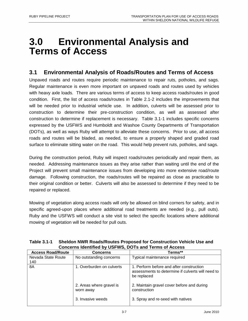
3.0 Environmental Analysis andTerms of Access
3.1 Environmental Analysis of Roads/Routes and Terms of Access
Unpaved roads and routes require periodic maintenance to repair ruts, potholes, and sags.
Regular maintenance is even more important on unpaved roads and routes used by vehicles
with heavy axle loads. There are various terms of access to keep access roads/routes in good
condition. First, the list of access roads/routes in Table 2.1-2 includes the improvements that
will be needed prior to industrial vehicle use. In addition, culverts will be assessed prior to
construction to determine their pre-construction condition, as well as assessed after
construction to determine if replacement is necessary. Table 3.1-1 includes specific concerns
expressed by the USFWS and Humboldt and Washoe County Departments of Transportation
(DOTs), as well as ways Ruby will attempt to alleviate these concerns. Prior to use, all access
roads and routes will be bladed, as needed, to ensure a properly shaped and graded road
surface to eliminate sitting water on the road. This would help prevent ruts, potholes, and sags.
During the construction period, Ruby will inspect roads/routes periodically and repair them, as
needed. Addressing maintenance issues as they arise rather than waiting until the end of the
Project will prevent small maintenance issues from developing into more extensive road/route
damage. Following construction, the roads/routes will be repaired as close as practicable to
their original condition or better. Culverts will also be assessed to determine if they need to be
repaired or replaced.
Mowing of vegetation along access roads will only be allowed on blind corners for safety, and in
specific agreed-upon places where additional road treatments are needed (e.g., pull outs).
Ruby and the USFWS will conduct a site visit to select the specific locations where additional
mowing of vegetation will be needed for pull outs.
Table 3.1-1 Sheldon NWR Roads/Routes Proposed for Construction Vehicle Use andConcerns Identified by USFWS, DOTs and Terms of Access
Access Road/Route Concerns Terms**Nevada State Route140
No outstanding concerns Typical maintenance required
8A 1. Overburden on culverts
2. Areas where gravel isworn away
3. Invasive weeds
1. Perform before and after constructionassessments to determine if culverts will need tobe replaced
2. Maintain gravel cover before and duringconstruction
3. Spray and re-seed with natives

RUBY PIPELINE PROJECT TRANSPORTATION PLAN FOR USE OF ACCESS ROADSWITHIN SHELDON NATIONAL WILDLIFE REFUGE
3-8 June 2010
Table 3.1-1 Sheldon NWR Roads/Routes Proposed for Construction Vehicle Use andConcerns Identified by USFWS, DOTs and Terms of Access
Access Road/Route Concerns Terms**4. Visibility 4. Mow sagebrush and post caution and speed
limit signsW-1 1. Passing of vehicles
2. Narrow and rocky areafrom Wall Canyon toSheldon NWR Boundary
3. Culvert needed at WallCanyonX: 301193.5, Y: 4607646.6
1. Pull-offs every mile or one-way traffic
2. Mow 2–3 feet on both sides of road, sheerrocks, where needed. Mowing will not occur forthe last mile of W-1 near Wall Canyon Ranch onlands owned by the Sheldon NWR.3. Use culvert or mats
H-46 - east side ofSheldon NWR(Summit Lake/BadgerMountain Road***)
No outstanding concerns Typical maintenance required
H-46A Deep two-track ruts Lay down road base where stabilization isneeded. Road base to remain after constructionand seed over top of it.
H-46B south centralportion of SheldonNWR(SummitLake/Badger MountainRoad***)
1. Boulders sticking out ofroad
2. Ten Mile Spring and feralhorse and vegetation study
3. Dry Wash before SummitLake Paiute Tribe land
4. Road curves and narrowareaX: 333996.3, Y: 4607434.7
1. Sheer rock before construction
2. Relocate road; coordinate the ripping andseeding o the abandoned portion of the roadwith the Sheldon NWR
3. Culvert or matting
4. Grade 2–3 feet up slope on north side ofroad.
H-50 1. Culvert neededX: 308033.3, Y: 4607172.4
2. Visibility Issues
1. Install culvert or 20-inch pipe or mats
2. Mow 2–3 feet on both sides of road, sheerrocks, where needed. Mowing will not occuroutside of the fence line where there is mixedownership.
Note:** Ruby conducted on-site assessments on September 29, 2009 to determine improvements that would needed to
each road utilized during construction.*** Summit Lake/Badger Mountain Road traverses south out of Sheldon NWR and crosses the ROW and then
turns north again. The Project will not utilize the portion of the road south of the ROW because it is on SummitLake Piute Tribe land. For purposes of this report and for clarity, the two road names are used to delineatewhich road is being discussed.
3.2 Safety Analysis and Terms of Access
The ability of the roads and routes within the Sheldon NWR to safely accommodate an increase
in traffic must be considered in Ruby’s analysis of access roads and routes for the Project. One
road in particular, 8A, has blind corners that Sheldon NWR and the DOTs have identified as a
safety risk. An increase in traffic on these roads/routes would further increase the danger at
these blind corners. Such safety concerns would be mitigated by mowing vegetation up to 10
RUBY PIPELINE PROJECT TRANSPORTATION PLAN FOR USE OF ACCESS ROADSWITHIN SHELDON NATIONAL WILDLIFE REFUGE
3-9 June 2010
feet up the side slope to give 100 feet of visibility, where feasible, as well as placing caution and
speed limit signs.
Additionally, most of the roads/routes at the Sheldon NWR are unpaved and, therefore,
dangerous when wet. A wet, unpaved road/route can have the same traction as an ice-covered
road (USDOI NPS May 2009). Unpaved roads/routes can also become muddy when wet, and
vehicles driving on them risk becoming stuck, especially if they are heavy or do not have four-
wheel drive. In the fall, winter, and spring, unpaved roads/routes at the Sheldon NWR may be
impassable due to snow drifts. Gravel has worn away from portions of 8A; Ruby would alleviate
any damage to these sections by performing pre-construction maintenance and continual
assessment/maintenance of the road during construction, as stated in Section 3.1. During rain
and/or snow conditions, dirt roads/routes or areas where gravel has worn away will rut when
driven on. If road conditions become unsafe on the Sheldon NWR access roads/routes, or
excessive ruts are created, then Ruby will use the pipeline ROW or will cease the use of these
roads/routes until rutting is no longer a concern or Ruby installs gravel to prevent rutting.
Ruby has a Fire Prevention and Suppression Plan (see Plan of Development [POD],
Appendix L) that identifies the procedures that will be used to prevent and suppress fires during
the construction of the Project and defines responsibilities for reporting, suppressing, and
investigating fire ignitions. The Fire Prevention and Suppression Plan delineates the minimum
requirements that shall be followed for Project construction activities. Ruby shall work with its
construction contractors to assign specific roles and responsibilities consistent with this Plan.
3.3 Environmental Analysis of Wildlife and Terms of Access
3.3.1 General Impacts to WildlifeRoads can affect wildlife in a number of ways. As discussed in other sections of this report,
they can impact the physical and vegetative environment, which ultimately impacts the wildlife
that depend on that habitat. Roads also produce habitat fragmentation, which impacts wildlife
by reducing landscape connectivity, and decreasing intra- and inter-specific interactions (USGS
2007). However, this effect “may be more pronounced where routes create major structural
gaps in forests than where the contrast between vehicular route corridors and the surrounding
landscape is more subtle, such as in shrublands” (USGS 2005). The sagebrush steppe habitat
in the Sheldon NWR is one such shrubland. Ruby is not proposing to construct any new roads
in the Sheldon NWR to access the pipeline ROW, so significant impacts contributing to habitat
fragmentation would not occur. The USFWS has requested Ruby to realign Summit
Lake/Badger Mountain Road where it traverses an area between Ten Mile Spring, and a feral
horse exclosure study area. For more details see Section 5.4.
Vehicles traveling on roads can cause direct injury or death to wildlife from collisions.
Increased traffic on the access roads/routes would increase this probability. However, this
increase would be temporary and is not expected to be great enough to significantly raise the
RUBY PIPELINE PROJECT TRANSPORTATION PLAN FOR USE OF ACCESS ROADSWITHIN SHELDON NATIONAL WILDLIFE REFUGE
3-10 June 2010
number of vehicle/animal collisions. The probability of such collisions would also be reduced by
ensuring that construction vehicles adhere to safe speeds.
Heavily traveled roads can lead to significant amounts of air pollution from vehicle exhaust, and
studies show that this can result in high levels of heavy metal in the soil and plants within 20 to
200 meters of the road (USGS 2005). The proposed increase in traffic on access roads/routes
would be temporary, lasting approximately eight months; however, the higher volume of traffic
would occur for 90 days. Due to the temporary nature of this increase, accumulation of
pollutants is not likely to be a problem for the access road/route corridors.
Vehicles traveling on roads produce noise, affecting animals that have behavioral and
physiological responses to noise (USFHWA 2004). Various species are affected by noise to
varying degrees. A noise may be undetected by one species, while another species might hear
it and respond to it. An increase in vehicles traveling on access roads/routes at the Sheldon
NWR would generate a corresponding increase in ambient noise levels. It is possible that
wildlife may hear the noise and move away from the roads/routes into other areas to avoid it.
As the increased traffic and noise would be temporary, these animals may return to the areas
near the access roads/routes after Project construction in the vicinity is complete.
A variety of studies have been conducted to determine the impacts of roads and road noise on
birds. While some bird species exhibit reduced density near roads, others demonstrate
increased density near roads (USFHWA 2004). For example, among the bird species
documented at the Sheldon NWR, turkey vultures (Cathartes aura) and house finches
(Cardodacus mexicanus) tend to move away from roads, while song sparrows (Melospiza
melodia) tend to have a greater population density near roads (USGS 2006; USFHWA 2004).
3.3.2 Pronghorn and Mule Deer
One of the Sheldon NWR’s specific goals is to provide habitat for pronghorn and mule deer.
Both often migrate annually between a summer range and a winter range, with the winter range
typically located at lower altitudes with less snow accumulation and a milder climate.
Pronghorn is the primary species for which the Sheldon NWR was created to provide habitat.
The refuge was initially established in 1931 as the Charles Sheldon Wild Life Refuge (Exec
Order [EO] 5540, 1931/01/26) and enlarged in 1936 (EO 7364, 1936/05/06). On December 21,
1936, EO 7522 established an additional protected area specific to the conservation of
pronghorn antelope and named it Charles Sheldon Antelope Range. In 1978, PLO 5630
consolidated the Refuge and Range into one: Sheldon National Wildlife Refuge. Pronghorn is
the only extant species of genus Antilocapra and is only found in North America (NDOW May
2003). Pronghorn typically live in groups of eight to ten individuals during the summer season
and twenty or more in the winter (NDOW May 2003).
Low sagebrush communities of the table and bench lands are the pronghorn’s preferred
habitats (NDOW May 2003). Big sagebrush and bitterbrush are important browse species for

RUBY PIPELINE PROJECT TRANSPORTATION PLAN FOR USE OF ACCESS ROADSWITHIN SHELDON NATIONAL WILDLIFE REFUGE
3-11 June 2010
the pronghorn in summer and fall (NDOW May 2003). In the winter, pronghorn will sometimes
inhabit salt desert shrub environments, which are characteristically dominated by shadscale
saltbush (Atriplex confertifolia) and four-wing saltbush (Atriplex canescens) (NDOW May 2003).
However, populations of pronghorn that find sagebrush to graze on in the winter may be less
likely to starve (Krejci et. al 2009).
Pronghorn prefer to feed on small amounts of a variety of plants (Krejci et. al 2009). Studies
have shown that although Nevada may have sufficient quantities of the pronghorn’s primary
browse species, it lacks diversity in forbs and grasses (NDOW May 2003).
At the Sheldon NWR, pronghorn typically gather at Swan Lake in the western portion of the
refuge in late summer and fall, spending winter at Big Springs Table in the north or on other
tables where the wind prevents snow from accumulating (USFWS March 2002).
Mule deer, like pronghorn, feed on sagebrush and bitterbrush. Other browse species utilized by
mule deer include serviceberry (Amelanchier spp.), snowbrush (Ceanothus velutinus), and
snowberry (Symphoricarpos spp.) (NDOW August 2004). Although they are ruminants, mule
deer have a limited ability to digest highly fibrous roughage and must eat approximately as
much herbaceous forage as woody forage (Misuraca 1999).
Trees such as pinyon pine (Pinus monophyla, Pinus edulis), western juniper, and mountain
mahogany provide valuable shelter for mule deer (NDOW August 2004; USFWS March 2002).
However, if pinyon-juniper habitat is not kept under control by wildfire, this habitat grows
unnaturally dense and reduces understory productivity and diversity, thereby reducing the mule
deer’s available food (NDOW August 2004). There is also typically a fair amount of mountain
mahogany in the Badger Mountain area in the southwestern portion of the refuge, which the
mule deer utilize for winter habitat. However, the mountain mahogany is currently recovering
from large wildfires in 1994 and 1999, making it less available as a winter food source (Steblein
July 2009).
With regards to the effect of roads on movement of these large game species, the results of a
study of pronghorn in Wyoming by the Wyoming Cooperative and Wildlife Research Unit at the
University of Wyoming showed that while unfenced roads did not appear to impede pronghorn
movement, fences did pose a serious barrier to movement, especially net wire fence (Sheldon
and Lindzey n.d.). The study recommended that if a fence must be used in pronghorn habitat,
a “wildlife friendly” fence with a gap between the bottom wire and the ground causes less
disruption to pronghorn movement (Sheldon and Lindzey n.d.). Although unfenced roads do
not generally impede pronghorn movement, heavy traffic on the roads could form barriers.
Habitat diversity is important to both species. As described in Ruby’s Upland Erosion Control,
Revegetation, and Maintenance Plan (POD, Appendix D) and the Noxious and Invasive Weed
Control Plan (POD, Appendix H), Ruby would revegetate all land disturbed by Project-related
activities with seed mixes recommended by local authorities, including the Sheldon NWR.
RUBY PIPELINE PROJECT TRANSPORTATION PLAN FOR USE OF ACCESS ROADSWITHIN SHELDON NATIONAL WILDLIFE REFUGE
3-12 June 2010
Access roads and routes on the Sheldon NWR would be revegetated with seed mixes approved
by the Sheldon NWR manager. The use of recommended seed mixes would help restore
habitat diversity, thereby providing food for pronghorn and mule deer. Treatment of invasive
weeds is detailed in the Noxious and Invasive Weed Control Plan (POD, Appendix H).
3.3.3 Feral Horses and BurrosFeral horses and burros are present at the Sheldon NWR, and in May 2008, the USFWS
signed a Finding of No Significant Impact for continuation of its feral horse and burro
management program in the refuge. The program is currently under review for modification as
part of the refuge’s comprehensive conservation planning process. The refuge controls the
feral horse and burro population by maintaining boundary fences and conducting horse gathers
using horseback wranglers and helicopters. See Section 5.0, Added Terms, Conditions, and
Stipulations, which addresses the southern boundary fence.
An increase in traffic on the Sheldon NWR access roads/routes would raise the potential of a
collision between a vehicle and a horse or burro. To reduce the chance of a vehicle collision
with a horse, burro, or any other animal, Ruby would post signs on the access roads/routes
alerting drivers of the animals’ possible presence in order to decrease the risk of accidental
vehicle/animal collisions. Ruby will implement strict operational prohibitions against cutting or
damaging fences along the boundary of the Sheldon NWR; fences are intended to define the
refuge boundary as well as to keep feral horses and burros from entering the Sheldon NWR
from adjacent lands. Ruby will also work with the refuge to maintain the integrity of the fences,
gates, and cattle guards. In addition, Ruby will ensure that workers and other site personnel
are educated regarding the legal status of feral horses and burros.
Currently, a biologist with the Sheldon NWR is conducting a study at Ten Mile Spring. This
area contains research plots that are fenced to keep horses from eating the vegetation.
Summit Lake/Badger Mountain Road traverses the area between the spring and the research
plots. Increased traffic will most likely deter the horses from accessing the spring, which would
skew the study results. The USFWS has requested Ruby to re-align this road due to the
increase in traffic during Project construction. For further details on the re-alignment of Summit
Lake/Badger Mountain Road, see Section 5.4.
3.3.4 Special Status SpeciesSpecial status species are those listed or proposed for listing as threatened, endangered, or
candidate species or that have no formal special status but are thought by experts to be rare or
in serious decline.
Ruby conducted wildlife surveys of special status species on all proposed access roads/routes.
Special status species encountered at the Sheldon NWR are shown in Figures B2 through B6,
and information about them is provided in Tables 3.3-2 through 3.3-7. Care would be taken not
to harm these or any other species during access road/route use. An overview of the regulatory

RUBY PIPELINE PROJECT TRANSPORTATION PLAN FOR USE OF ACCESS ROADSWITHIN SHELDON NATIONAL WILDLIFE REFUGE
3-13 June 2010
status of the special status species discussed in this section is given in Table 3.3-1. See Table
A-5 for a comprehensive list of species of conservation priority in Nevada.
Table 3.3-1 Regulatory Status of Special Status Wildlife Species Observed in theVicinity of Sheldon NWR Access Roads/Routes
Species Regulatory Status*Pygmy rabbit Petitioned for federal listingGreater sage-grouse Candidate SpeciesLoggerhead shrike Nevada State Sensitive, USFWS Birds of Conservation Concern
2008 (USFWS 2008c)Prairie FalconSage thrasher Nevada State Sensitive, USFWS Birds of Conservation Concern
2008 (USFWS 2008)Brewer’s sparrow Nevada State SensitiveLong-billed curlew USFWS Birds of Conservation Concern 2008 (USFWS 2008)Burrowing owl USFWS Birds of Conservation Concern 2008 (USFWS 2008)Golden eagle USFWS Birds of Conservation Concern 2008 (USFWS 2008)Short-eared owl USFWS Birds of Conservation Concern 2008 (USFWS 2008)Ferruginous hawk USFWS Birds of Conservation Concern 2008 (USFWS 2008)Sage Sparrow USFWS Birds of Conservation Concern 2008 (USFWS 2008)Note:*All species on Sheldon NWR are subject to the NWRS Administration Act. All migratory birds on theSheldon NWR are subject to Migratory Bird Treaty Act (MBTA). All MBTA-protected species are alsoprotected by the State of Nevada under the Nevada Revised Statutes (NRS) 501.
3.3.4.1 Pygmy RabbitsDuring Ruby wildlife surveys, colonies of pygmy rabbits (Brachylagus idahoensis) were
identified in the vicinity of access roads/routes H-46A and W-1 (Table 3.3-2), and individual
pygmy rabbits were sighted in the vicinity of access road/route W-1 (Table 3.3-3); see Figure
B3. It is currently unknown if the proposed access roads/routes would require improvement in
the specific areas containing pygmy rabbit burrows. Ruby proposes to conduct additional
evaluations in the spring of 2010 prior to construction to determine whether these pygmy rabbit
populations would be disturbed by required road/route improvements. If road/route
improvements are needed within pygmy rabbit colonies, those activities will be limited to the
footprint of the road/route. If potential impacts are demonstrated, Ruby would coordinate with
the Sheldon NWR to determine if conservation measures proposed for impacts to pygmy
rabbits along the Ruby ROW in other areas are appropriate for the Sheldon NWR as well.
RUBY PIPELINE PROJECT TRANSPORTATION PLAN FOR USE OF ACCESS ROADSWITHIN SHELDON NATIONAL WILDLIFE REFUGE
3-14 June 2010
Table 3.3-2 Pygmy Rabbit Burrow Colonies Within 66 feetof Road/Route Center Line Identified DuringRuby Field Surveys 2009*
AccessRoad/Route
Acreage of Pygmy Rabbit Colonies within the66-foot-wide Access Road/Route Buffer
8A 236.47
H-46A 24.16
H-46B 125.83
H-50 57.78
W-1 32.07Note: *Data from Sheldon NWR combined with Ruby field data. Data received
from Sheldon NWR were masked; therefore, the data were analyzed using
acreage to compare with Ruby field data.
Table 3.3-3 Pygmy Rabbit Sightings Within 66 feet of Access Road/Route Center Lineduring Ruby Field Surveys 2009
AccessRoad/Route
Distance of Animal fromAccess Road/Route Center Line
(Feet)Observation Type
Number ofIndividuals
W-1 34.28 Specimen and Pellets 1
W-1 6.02 Specimen 1
W-1 24.83 Specimen 1
Pygmy rabbits live in dense sagebrush and are reluctant to cross open areas such as roads
(Larrucea 2007). With regards to pygmy rabbits in the proximity of access roads, their
reluctance to cross the road makes them less likely to fall victim to collision-related mortality
(Larrucea 2007).
The Ruby Greater Sage-grouse and Pygmy Rabbit Conservation Measures Plan (POD,
Appendix S) lists conservation measures for pygmy rabbits that Ruby would implement based
on final input from federal and state agencies. Potential measures that could be used on
access roads/routes where pygmy rabbits are present include avoiding road expansion in areas
containing pygmy rabbit burrows, mowing prior to construction to encourage the pygmy rabbits
to move a safe distance away from the road, trapping and relocating pygmy rabbits to suitable
habitat a safe distance away from the road, and establishing off-site soil mounds that could be
used by pygmy rabbits impacted by construction.
3.3.4.2 Greater Sage-grouseGreater sage-grouse seasonal habitats, leks, and nesting areas occur in the sagebrush steppe
habitat at the Sheldon NWR. The Ruby Greater Sage-grouse and Pygmy Rabbit Conservation
Measures Plan (POD, Appendix S) lists conservation measures for greater sage-grouse in the
Project area. As appropriate, Ruby would implement conservation measures such as
minimizing activity when leks are active or when nesting and early brood rearing are occurring;
the time frame for this would be approximately mid-March to mid-June. Efforts will be made to
locate all Project facilities, including access roads/routes, at least two miles from the perimeter
of active leks; where this is not possible, human activity will be avoided between dawn and

RUBY PIPELINE PROJECT TRANSPORTATION PLAN FOR USE OF ACCESS ROADSWITHIN SHELDON NATIONAL WILDLIFE REFUGE
3-15 June 2010
10:00 a.m. from March 1 to May 15 within 0.25 miles of the perimeter of occupied leks. Greater
sage-grouse leks located within two miles of proposed access road/route center lines are listed
in Table 3.3-4; greater sage-grouse specimen and scat sightings are listed in Table 3.3-5; also
see Figure B5.
Table 3.3-4 Greater Sage-grouse Leks within Two Miles of AccessRoad/Route Center Lines Identified During Ruby Field Surveys2009
AccessRoad/Route Distance (miles) Lek Name
NDOWAgencyStatus
Ruby FieldSurvey Lek
Status8A* 0.01 Unnamed N/A N/A
H-46 0.1 Idaho Canyon North Historic InactiveH-46 0.16 Idaho Canyon Historic InactiveH-46 1.78 Crane Creek 2 Active Active
H-46B 0.14 Rodero Flat Historic InactiveW-1 0.14 Wall Canyon Historic InactiveW-1 0.16 Little Cottonwood Historic InactiveW-1 0.19 Wall Canyon Historic InactiveW-1 0.21 Wall Canyon Ranch Historic ActiveW-1 0.74 Badger Mountain Inactive InactiveW-1 1.37 Wall Canyon Upper Historic Inactive
Note: Source of data from NDOW. Ruby Field Surveys verified if leks were active or inactive.
* Masked Sheldon NWR Lek data.
Table 3.3-5 Greater Sage-grouse Specimen and Scat Sightings within Two Miles ofAccess Road/Route Center Lines during Ruby Field Surveys 2008 and 2009
AccessRoad/Route
Distance(Miles)
Observation Type(Specimen or Scat)
Number ofIndividuals
Year Observed
8A 0.56 Specimen 1 2009
H-46 0.54 Scat 0 2009
H-46A 0.35 Specimen 1 2009
Table 3.3-5a Greater Sage-grouse Area Delineated by SheldonNWR within Two Miles of Access Road/RouteCenter Lines*
Access Road/RouteArea
(Acreage)Data Source
8A 214.5 Sheldon NWR
H-46 56.8 Sheldon NWR
H-46A 147.11 Sheldon NWR
H-46B 11.65 Sheldon NWR
H-50 9.00 Sheldon NWR
W-1 32.12 Sheldon NWRNote: *Data received from Sheldon NWR. Sheldon NWR data were masked with atwo-mile buffer; therefore, they were analyzed in acreages.
RUBY PIPELINE PROJECT TRANSPORTATION PLAN FOR USE OF ACCESS ROADSWITHIN SHELDON NATIONAL WILDLIFE REFUGE
3-16 June 2010
3.3.4.3 Raptors and Migratory BirdsRuby conducted wildlife surveys of raptors and raptor nests on all proposed access
roads/routes; raptors and raptor nests encountered at the Sheldon NWR are shown in Figure
B5 and listed in Table 3.3-6. A protective buffer would be maintained around all raptor nests;
the size of the buffer would depend on the species of raptor. A description of raptor species
and their required spatial buffers can be found in the Ruby Biological Resources Conservation
Plan (POD, Appendix I), which also explains raptor best management practices.
Table 3.3-6 2010 Raptor Nest Sightings within Two Miles of Access Road/Route Center Linesduring Ruby Field Surveys 2010
AccessRoad/Route
Distance(miles) Raptor Nest Status
NestCondition
Numberof Eggs
Numberof
Young HabitatNest
Substrate
W-1 0.30PrairieFalcon
DID NOTLOCATE UNKNOWN 0 0
SagebrushSteppe Rock cavity
H-52 0.01Red-tailed
Hawk ACTIVE NEST EXCELLENT 0 0Sagebrush
Steppe Cliff
H-52 0.01Un-id
RaptorINAC ALT
NEST GOOD 0 0Sagebrush
Steppe Cliff
W-2 0.83Short-eared
Owl INAC NEST GOOD 0 0Sagebrush
Steppe Rock cavity
W-2 0.66Red-tailed
Hawk ACTIVE NEST EXCELLENT 0 3Sagebrush
Steppe Rocky ledge
W-2 0.60Un-id
RaptorDID NOTLOCATE GONE 0 0
SagebrushSteppe Rock cavity
W-2 0.66Un-id
RaptorINAC
DILAPIDATED REMNANTS 0 0Sagebrush
Steppe Rock cavity
W-1 0.10Un-id
Raptor INAC NEST GOOD 0 0Sagebrush
Steppe Rocky ledge
W-1 0.10Un-id
RaptorINAC
DILAPIDATED REMNANTS 0 0Sagebrush
Steppe Rocky ledge
W-1 0.09Long-eared
Owl INAC NEST EXCELLENT 0 0Sagebrush
Steppe Rocky ledge
H-50B 0.85Un-id
Raptor INAC NEST FAIR 0 0Sagebrush
Steppe Rocky ledge
H-50B 0.94Un-id
Raptor INAC NEST GOOD 0 0 Aspen Stands Aspen tree
H-10WS 0.20Un-id
Raptor INAC NEST GOOD 0 0 Riparian Willow
H-10WS 0.34Un-id
Raptor INAC NEST FAIR 0 0Sagebrush
Steppe Rocky ledge
H-50B 0.50Un-id
Raptor INAC NEST FAIR 0 0Sagebrush
Steppe Rocky ledge
H-52 0.73Un-id
RaptorINAC
DILAPIDATED REMNANTS 0 0Sagebrush
Steppe Rocky ledge
H-52 0.57Common
Raven ACTIVE NEST EXCELLENT 0 0Sagebrush
Steppe Rocky ledge
H-52 0.22PrairieFalcon
DID NOTLOCATE UNKNOWN 0 0
SagebrushSteppe Rock cavity
RUBY PIPELINE PROJECT TRANSPORTATION PLAN FOR USE OF ACCESS ROADSWITHIN SHELDON NATIONAL WILDLIFE REFUGE
3-17 June 2010
Table 3.3-6 2010 Raptor Nest Sightings within Two Miles of Access Road/Route Center Linesduring Ruby Field Surveys 2010
AccessRoad/Route
Distance(miles) Raptor Nest Status
NestCondition
Numberof Eggs
Numberof
Young HabitatNest
Substrate
H-52 0.04Un-id
Raptor INAC NEST FAIR 0 0Sagebrush
Steppe Rocky ledge
H-50 0.71Red-tailed
Hawk ACTIVE NEST EXCELLENT 2 0Sagebrush
Steppe Rocky ledge
H-50A 0.67Un-id
Raptor INAC NEST FAIR 0 0Sagebrush
Steppe Rocky ledge
H-47 0.60Un-id
Raptor INAC NEST EXCELLENT 0 0Sagebrush
Steppe Rocky ledge
H-47 0.69Un-id
Raptor INAC NEST FAIR 0 0Sagebrush
Steppe Rocky ledge
H-48 0.12Un-id
Raptor INAC NEST GOOD 0 0 Aspen Stands Aspen tree
H-45 0.02Un-id
RaptorINAC ALT
NEST GOOD 0 0Sagebrush
Steppe Aspen tree
H-45 0.07Un-id
RaptorINAC ALT
NEST GOOD 0 0 Aspen Stands Aspen tree
H-45 0.08Red-tailed
Hawk ACTIVE NEST EXCELLENT 0 2 Aspen Stands Aspen tree
H-46 0.96Un-id
Raptor INAC NEST FAIR 0 0Sagebrush
Steppe Rocky ledge
H-50 0.05Burrowing
OwlDID NOTLOCATE UNKNOWN 0 0 SAGEBRUSH GROUND
H-46B 0.66Un-id
Raptor INAC NEST EXCELLENT 0 0Sagebrush
Steppe Rocky ledge
H-50 0.24Common
Raven ACTIVE NEST EXCELLENT 0 0Sagebrush
Steppe Rocky ledge
H-46B 1.09Un-id
Raptor INAC NEST FAIR 0 0Sagebrush
Steppe Rock cavity
H-46B 0.54Un-id
Raptor INAC NEST FAIR 0 0Sagebrush
Steppe Rocky ledge
H-46B 0.61Un-id
Raptor INAC NEST FAIR 0 0Sagebrush
Steppe Rocky ledge
H-46B 0.61Un-id
Raptor INAC NEST FAIR 0 0Sagebrush
Steppe Rocky ledge
H-46B 0.91Peregrine
Falcon ACTIVE NEST EXCELLENT 0 3Sagebrush
Steppe Rocky ledge
H-46B 0.88Red-tailed
Hawk ACTIVE NEST EXCELLENT 3 0Sagebrush
Steppe Rocky ledge
H-46B 0.42Un-id
Raptor INAC NEST FAIR 0 0Sagebrush
Steppe Rocky ledge
H-46B 0.95Great
Horned Owl ACTIVE NEST EXCELLENT 0 0Sagebrush
Steppe Rocky ledge
H-46B 0.96Red-tailed
Hawk ACTIVE NEST EXCELLENT 0 0Sagebrush
Steppe Rocky ledge
H-46B 0.57Red-tailed
Hawk INAC NEST FAIR 0 0Sagebrush
Steppe Rocky ledge
RUBY PIPELINE PROJECT TRANSPORTATION PLAN FOR USE OF ACCESS ROADSWITHIN SHELDON NATIONAL WILDLIFE REFUGE
3-18 June 2010
Table 3.3-6 2010 Raptor Nest Sightings within Two Miles of Access Road/Route Center Linesduring Ruby Field Surveys 2010
AccessRoad/Route
Distance(miles) Raptor Nest Status
NestCondition
Numberof Eggs
Numberof
Young HabitatNest
Substrate
H-50 0.41Common
Raven ACTIVE NEST EXCELLENT 0 0Sagebrush
Steppe Rocky ledge
H-46B 0.45Common
Raven ACTIVE NEST EXCELLENT 0 0Sagebrush
Steppe Rocky ledge
H-46B 0.50Red-tailed
HawkINAC
DESTROYED REMNANTS 0 0Sagebrush
Steppe Rocky ledge
H-46B 0.15Un-id
Raptor INAC NEST FAIR 0 0Sagebrush
Steppe Rocky ledge
H-46B 0.11Un-id
Raptor INAC NEST GOOD 0 0Sagebrush
Steppe Rocky ledge
H-50B 0.75Common
Raven ACTIVE NEST EXCELLENT 0 0Sagebrush
Steppe Rocky ledge
H-50B 0.22Un-id
Raptor INAC NEST FAIR 0 0Sagebrush
Steppe Rocky ledge
H-50B 0.58Red-tailed
Hawk ACTIVE NEST EXCELLENT 0 0Sagebrush
Steppe Rocky ledge
H-50B 0.31Un-id
Raptor INAC NEST GOOD 0 0Sagebrush
Steppe Rocky ledge
W-1 0.15Common
Raven ACTIVE NEST EXCELLENT 7 0Sagebrush
Steppe Rocky ledge
W-1 0.20Common
Raven ACTIVE NEST EXCELLENT 0 0Sagebrush
Steppe Rocky ledge
W-1B 0.59Un-id
Raptor INAC NEST GOOD 0 0Sagebrush
Steppe Rocky ledge
W-1B 0.61Un-id
Raptor INAC NEST EXCELLENT 0 0Sagebrush
Steppe Rocky ledge
W-1B 0.68PrairieFalcon
DID NOTLOCATE UNKNOWN 0 0
SagebrushSteppe Rocky ledge
H-46C 0.47PrairieFalcon ACTIVE NEST EXCELLENT 0 3
SagebrushSteppe Rocky ledge
H-46C 0.12Common
Raven ACTIVE NEST EXCELLENT 0 0Sagebrush
Steppe Rocky ledge
H-46C 0.47Un-id
Raptor INAC NEST FAIR 0 0Sagebrush
Steppe Rocky ledge
H-46C 0.11Red-tailed
HawkINAC
DESTROYED REMNANTS 0 0Sagebrush
Steppe Rocky ledge
H-46C 0.41GoldenEagle
INAC ALTNEST GOOD 0 0
SagebrushSteppe Rocky ledge
H-46C 0.87GoldenEagle
INAC ALTNEST EXCELLENT 0 0
SagebrushSteppe Rocky ledge
H-46C 0.97Un-id
Raptor INAC NEST GOOD 0 0Sagebrush
Steppe Rocky ledge
H-46C 0.71Un-id
Raptor INAC NEST GOOD 0 0Sagebrush
Steppe Rocky ledge
H-46C 0.36Red-tailed
Hawk ACTIVE NEST EXCELLENT 0 2Sagebrush
Steppe Rocky ledge

RUBY PIPELINE PROJECT TRANSPORTATION PLAN FOR USE OF ACCESS ROADSWITHIN SHELDON NATIONAL WILDLIFE REFUGE
3-19 June 2010
Table 3.3-6 2010 Raptor Nest Sightings within Two Miles of Access Road/Route Center Linesduring Ruby Field Surveys 2010
AccessRoad/Route
Distance(miles) Raptor Nest Status
NestCondition
Numberof Eggs
Numberof
Young HabitatNest
Substrate
H-46B 0.11Un-id
Raptor INAC NEST GOOD 0 0Sagebrush
SteppeRock pillar/
pinnacle
H-46B 0.10Red-tailed
Hawk ACTIVE NEST EXCELLENT 2 0Sagebrush
SteppeRock pillar/
pinnacle
H-46B 0.83Red-tailed
Hawk ACTIVE NEST EXCELLENT 0 0Sagebrush
Steppe Rocky ledge
H-46B 0.71Un-id
Raptor INAC NEST FAIR 0 0Sagebrush
Steppe Rocky ledge
H-46B 0.74Red-tailed
Hawk ACTIVE NEST EXCELLENT 3 0Sagebrush
Steppe Rocky ledge
W-1 0.14PrairieFalcon
DID NOTLOCATE UNKNOWN 0 0
SagebrushSteppe Rocky ledge
W-1 0.46Common
Raven ACTIVE NEST EXCELLENT 0 0Sagebrush
Steppe Rocky ledge
H-45 0.01Un-id
RaptorINAC ALT
NEST GOOD 0 0Sagebrush
Steppe Aspen tree
H-45 0.01Un-id
RaptorINAC ALT
NEST GOOD 0 0Sagebrush
Steppe Aspen tree
H-45 0.00Red-tailed
Hawk ACTIVE NEST EXCELLENT 0 0 Riparian Aspen tree
H-45 0.01Un-id
RaptorINAC ALT
NEST GOOD 0 0Sagebrush
Steppe Aspen tree
H-45 0.01Un-id
RaptorINAC ALT
NEST GOOD 0 0Sagebrush
Steppe Aspen tree
H-45 0.00Red-tailed
Hawk ACTIVE NEST EXCELLENT 0 0 Riparian Aspen tree
H-45 0.00Common
Raven ACTIVE NEST EXCELLENT 0 0 Salt Desert ScrubManmadestructure
Table 3.3-6a Raptor Nesting Areas Delineated by Sheldon NWRwithin Two Miles of Access Road/Route CenterLines*
AccessRoad/Route
Area(Acreage)
Data Source
8A 77.20 Sheldon NWR
H-46 10.61 Sheldon NWR
H-46B 77.75 Sheldon NWR
H-50 44.97 Sheldon NWR
W-1 0.80 Sheldon NWRNote: *Data received from Sheldon NWR. Sheldon NWR data were masked
with a two-mile buffer, therefore analyzed in acreages.
Other migratory birds, such as song birds, were not surveyed. Ruby is in the process of
preparing a Memorandum of Understanding (MOU), as recommended by the USFWS, for the

RUBY PIPELINE PROJECT TRANSPORTATION PLAN FOR USE OF ACCESS ROADSWITHIN SHELDON NATIONAL WILDLIFE REFUGE
3-20 June 2010
protection of species protected by the Migratory Bird Treaty Act (MBTA) during construction.
Ruby will adhere to the terms and conditions outlined in the MBTA MOU, and any request for
waivers to the MOU will be approved by the USFWS Migratory Bird Office in Sacramento,
California. The Ruby Biological Resources Conservation Plan (POD, Appendix I) describes
temporal and spatial mitigation measures that would be employed to avoid harming and/or
harassing migratory bird species.
The construction of the Project has the potential to impact birds protected under the MBTA.
Habitat for one or more MBTA-protected nesting bird species is found along the Sheldon NWR
roads/routes.
During construction, Ruby would avoid both temporal and spatial direct impacts to birds
protected under the MBTA. The primary nesting season is from the beginning of April through
mid-July. In accordance with the MBTA and the MOU, migratory bird surveys will be conducted
from late May through mid-July. After July 15th, any nests that are active will be monitored until
the chicks fledge. After chicks fledge, construction will continue in those areas. This type of
temporal avoidance eliminates impact to nesting birds by constructing outside the nesting
season. This can be accomplished by starting construction prior to the onset of nesting, so that
nesting cannot be initiated that would then be impacted by construction. Spatial avoidance is
used when construction occurs during the nesting season and nests are present, but
construction would be avoided within a protective “buffer” around the nest.
3.3.4.4 Additional Special Status SpeciesThe remaining special status species surveyed in the vicinity of the Sheldon NWR are listed in
Table 3.3-7, along with all raptors surveyed. Birds, which are generally more mobile than other
fauna, would generally disperse safely away from access roads, provided that the construction
traffic vehicles maintain mandated safe speeds. All raptors, whether special status species or
not, are included because raptor nests have special protection afforded to them, as will be
discussed in the next section of this report. Common raven (Corvus corax) nests are also
included because some raptor species use established nests interchangeably with common
ravens from year to year. See Table A-5, for a comprehensive list of species of conservation
priority in Nevada.
Table 3.3-7 Wildlife Sightings of Special Status Species* and/or Raptors within 2Miles of Access Road/Route Center Lines during Ruby Field Surveys2009
AccessRoad/Route
Distance(Miles)
Common Name Scientific NameObservation
TypeNumber ofIndividuals
H-46 0.00 American kestrel Falco sparverius Specimen 1H-46B 0.00 Sage thrasher Oreoscoptes montanus Specimen 1H-46B 0.00 Sage thrasher Oreoscoptes montanus Specimen 2H-46B 0.01 Sage thrasher Oreoscoptes montanus Specimen 1H-46B 0.02 Mountain bluebird Sialia currucoides Specimen 2H-46B 0.03 Sage thrasher Oreoscoptes montanus Specimen 3H-50 0.00 American kestrel Falco sparverius Specimen 1

RUBY PIPELINE PROJECT TRANSPORTATION PLAN FOR USE OF ACCESS ROADSWITHIN SHELDON NATIONAL WILDLIFE REFUGE
3-21 June 2010
Table 3.3-7 Wildlife Sightings of Special Status Species* and/or Raptors within 2Miles of Access Road/Route Center Lines during Ruby Field Surveys2009
AccessRoad/Route
Distance(Miles)
Common Name Scientific NameObservation
TypeNumber ofIndividuals
H-50 0.00 Sage thrasher Oreoscoptes montanus Specimen 1W-1 0.00 American kestrel Falco sparverius Specimen 1W-1 0.00 Unidentified raptor Unidentified Specimen 1W-1 0.00 Golden eagle Aquila chrysaetos Specimen 1W-1 0.00 Unidentified Unidentified Nest in shrub 0W-1 0.00 Red-tailed hawk Buteo jamaicensis Specimen 1W-1 0.00 Loggerhead shrike Lanius ludovicianus Specimen 1
W-1 0.01Unidentified accipiter
species Accipiter species Specimen 1W-1 0.15 American kestrel Falco sparverius Specimen 1W-1 0.18 American kestrel Falco sparverius Specimen 1W-1 0.19 Prairie falcon Falco mexicanus Specimen 1W-1 0.23 Common raven Nonsensitive Nest on cliff 1W-1 0.68 Sage thrasher Oreoscoptes montanus Specimen 2W-1 0.81 Golden eagle Aquila chrysaetos Specimen 1W-1 0.90 American kestrel Falco sparverius Specimen 1
*Note: Distances of 0.00 are because individuals were seen in close proximity of the road.
Additionally, it should be noted that the Sheldon NWR contains American pika (Ochotona
princeps), white-throated swift (Aeronautes saxatalis), prairie falcon (in the cliff and talus
throughout the Sheldon NWR in particular areas at the McGee Mountain area) (Steblein July
2009), and nine species of bats, including big brown bat (Eptesicus fuscus), silver-haired bat
(Lasionycleris noctivagans), California myotis (Myotis californicus), western small-footed myotis
(Myotis ciliolabrum), western long-eared myotis (Myotis evotis), little brown bat (Myotis
lucifugus), long-legged myotis (Myotis volans), Yuma myotis (Myotis yumanensis), and
Brazillian free-tailed bat (Tadarida brasiliensis) (Collins 2009). The white-throated swift is a
Partners in Flight Species of Continental Importance. The prairie falcon, as listed in Table
3.3-1, is Nevada Department of Wildlife (NDOW) state-protected under NRS 501 and is a BLM
Special Status Species.
American PikaIn February 2010, the USFWS determined that listing the American pika as threatened or
endangered under the Endangered Species Act is not warranted. However, it is still a BLM
special status species in the Winnemucca district. American pika is a small mammal that
inhabits fields fringed by suitable vegetation in alpine and subalpine mountains. This species is
temperature sensitive and cannot survive in temperatures greater than 77.9 degrees (USFWS
2009b). Habitat for American pika on the Sheldon NWR has been delineated by the USFWS
and is exhibited in Figure B6.
BatsA bat species inventory began this summer on the Sheldon NWR. Mist nets and remote call
stations were set up in three locations. Sagebrush steppe is the most common habitat type
RUBY PIPELINE PROJECT TRANSPORTATION PLAN FOR USE OF ACCESS ROADSWITHIN SHELDON NATIONAL WILDLIFE REFUGE
3-22 June 2010
along access roads/routes and would represent the most substantial habitat alteration in terms
of area affected. The removal of sagebrush and other desert shrubs would remove potential
roosting sites for species like the California myotis; however, most species encountered on the
Sheldon NWR do not commonly roost in shrubs. Rather, many of these species would use
these open habitats to forage and would likely roost in caves, rock crevices, and any mines
present within the shrubland. Any bats roosting in nearby caves, crevices, and mines would be
subject to noise and visual disturbance during removal of vegetation. The severity of these
disturbances would depend on the proximity of the roost sites to the construction activities and
the species affected. Bats using the shrublands to forage would not likely be affected by these
disturbances as construction activities would primarily occur during daylight hours and bats are
crepuscular or nocturnal. Figure B6 shows wildlife sightings from field surveys and from
Sheldon NWR data.
3.4 Environmental Analysis of the Physical Environment and Terms
of Access
Roads and routes, whether paved or unpaved, affect the physical environment in a number of
ways, including.
Obstruction of the surface flow of natural watercourses;
Obstruction of the subsurface flow of water at road cuts;
Generation of more sediment runoff than the land would generate in the absence of a
road;
Alteration of soil chemistry when road dust is deposited on soil surfaces;
Potential for road to rut or to break through gravel by intense use of heavily loaded
vehicles; and
Potential clogging of soil pores, which reduces infiltration rates, when road dust is
deposited on soil surfaces (USGS 2007).
Ruby would employ a variety of maintenance measures to reduce or eliminate these effects on
the physical environment (see Table 3.1-1). Obstruction of surface and subsurface water flow
alters the pattern of flow and affects the hydrology of the area. Surface flow will be discussed
in Section 3.5.
Because soil compaction makes the surface of roads impervious, roads generate more
sediment runoff than the land would typically generate. Ruby does not propose to construct
any new roads to access the ROW, but Ruby has been requested by the Sheldon NWR to
realign Summit Lake/Badger Mountain Road 1,330 feet to avoid a sensitive area and ongoing
studys; see Section 5.4 for more details. In addition, pullouts may be necessary in limited areas
for safety purposes. Pullouts will be minimized by using strategic mowing wherever possible.
Actual mowing and pullout locations will be determined during a site visit with Ruby and the
Sheldon NWR. The refuge will approve all mowing and pullout locations and work with Ruby to
flag appropriate limits for those alterations. This would increase the impervious surface and,

RUBY PIPELINE PROJECT TRANSPORTATION PLAN FOR USE OF ACCESS ROADSWITHIN SHELDON NATIONAL WILDLIFE REFUGE
3-23 June 2010
therefore, increase the amount of sediment runoff. However, Ruby’s Traffic and Transportation
Management Plan (POD, Appendix O) includes a provision that, following construction, widened
roads/routes can be returned to their preconstruction condition at the discretion of the
landowner.
It should also be noted that areas of the semiarid and arid west with intense rainstorms typically
have relatively high sediment runoff from roads (USGS 2007). However, most precipitation at
the Sheldon NWR occurs in the form of snowfall (USFWS 2008a). Compared to other areas of
the semiarid and arid west, the general lack of intense rainstorms at the Sheldon NWR would
lessen the amount of sediment runoff. During the course of construction, erosion and sediment
control measures would be implemented to prevent the transport of sediment. In the event of
intense rainstorms, maintenance measures that may be employed include re-grading of
roads/routes, constructing swales along one side of the access road/route to collect and direct
runoff, and/or the halting of construction until roads/routes are dry enough to continue work. If
road conditions become unsafe on the Sheldon NWR access roads/routes, or excessive ruts
are created, Ruby will then use the pipeline ROW for access and will cease the use of these
roads/routes until rutting is no longer a concern or Ruby installs gravel to prevent rutting.
The alteration of soil chemistry and clogging of soil pores from road dust deposited on soil
surfaces can be reduced by effective dust control. Ruby has a Project-wide fugitive dust control
plan to meet state requirements for dust control (POD, Appendix N).
3.5 Environmental Analysis of Streams and Wetlands and Terms of
Access
Ruby conducted field surveys of streams and wetlands on all proposed access roads/routes.
Streams and wetlands in the vicinity of proposed access roads/routes in the Sheldon NWR are
shown in Figure B7 and listed in Tables 3.5-1 and 3.5-2. Ruby also surveyed for the presence
of check dams and culverts and places where culverts are needed. This information is shown
as construction obstacles in Figure B8 and is listed in Table 3.5-3. No check dams or places
needing culverts have been identified during the Ruby field surveys to date, but several existing
culverts have been mapped. If an access road has water flowing over the road bed at the time
of construction that would not require culvert placement, Ruby would place equipment mats to
help reduce rutting of the road bed. Prior to Ruby’s use of the access roads/routes, engineers
would survey the roads/routes to ensure that the existing culverts are of sufficient size and to
determine whether any additional culverts are needed. Proper installation of culverts is an
important way to ensure that surface water flows remain unobstructed.
Currently, Summit Lake/Badger Mountain Road traverses the area between Ten Mile Spring (a
perennial spring) and a feral horse study area where the USFWS is studying the effects of feral
horses on vegetation. Ruby would re-reroute a portion of this road to ensure that horses are
not disturbed by the increase in traffic along this road.
RUBY PIPELINE PROJECT TRANSPORTATION PLAN FOR USE OF ACCESS ROADSWITHIN SHELDON NATIONAL WILDLIFE REFUGE
3-24 June 2010
On Sheldon NWR lands, Ruby will not use herbicides or pesticides in or within 100 feet of a
wetland, except as allowed by the USFWS. In addition Ruby does not intend to use fertilizers;
however, if requested, Ruby will not use fertilizer, lime, or mulch in or within 100 feet of a
wetland unless required in writing by the USFWS. Further information regarding Ruby’s
approach to construction in the vicinity of waterbodies and wetlands is found in Ruby’s Wetland
and Waterbody Construction and Mitigation Procedures (POD, Appendix F).
Table 3.5-1 Streams within 66 feet of the Center Line of Proposed Access Roads/Routesin Sheldon NWR
AccessRoad/Route
Stream Name
StreamCrossesAccessRoad/Route
Flow TypeFlow
Direction
Depth at timeof Field
Survey Spring2009)
Naturalor Man-altered
County
H-50 Unnamed tributary toCottonwood Creek
Yes Ephemeral NE No WaterPresent
Man-altered
Humboldt
H-50 Unnamed tributary toCottonwood Creek
Yes Ephemeral NE No WaterPresent
Man-altered
Humboldt
H-50 Cottonwood Creek Yes Perennial S 0–6 inches Man-altered
Humboldt
W-1 Unnamed tributary toBadger Creek
No Ephemeral SW No WaterPresent
Natural Washoe
W-1 Unnamed tributary toBadger Creek
Yes Ephemeral NE No WaterPresent
Natural Washoe
W-1 Unnamed tributary toBadger Creek
No Ephemeral N No WaterPresent
Natural Washoe
W-1 Unnamed tributary toWall Canyon Creek
Yes Ephemeral NE No WaterPresent
Natural Washoe
W-1 Unnamed tributary toWall Canyon Creek
No Ephemeral SE No WaterPresent
Natural Washoe
W-1 Unnamed tributary toWall Canyon Creek
No Ephemeral E No WaterPresent
Natural Washoe
W-1 Unnamed tributary toWall Canyon Creek
No Ephemeral S No WaterPresent
Natural Washoe
W-1 Unnamed tributary toWall Canyon Creek
No Ephemeral S No WaterPresent
Natural Washoe
W-1 Unnamed tributary toWall Canyon Creek
Yes Ephemeral NE No WaterPresent
Natural Washoe
W-1 Unnamed tributary toWall Canyon Creek
Yes Ephemeral NE No WaterPresent
Natural Washoe
W-1 Unnamed tributary toWall Canyon Creek
Yes Ephemeral NE No WaterPresent
Natural Washoe
W-1 Unnamed tributary toWall Canyon Creek
No Ephemeral S No WaterPresent
Natural Washoe
W-1 Unnamed tributary toWall Canyon Creek
No Ephemeral S No WaterPresent
Natural Washoe
W-1 Unnamed tributary toWall Canyon Creek
Yes Ephemeral SE No WaterPresent
Natural Washoe
W-1 Unnamed tributary toWall Canyon Creek
No Ephemeral SE No WaterPresent
Natural Washoe
W-1 Unnamed tributary toWall Canyon Creek
Yes Ephemeral E No WaterPresent
Natural Washoe
W-1 Unnamed tributary toWall Canyon Creek
No Ephemeral S No WaterPresent
Natural Washoe
W-1 Unnamed tributary to No Ephemeral S No Water Natural Washoe
RUBY PIPELINE PROJECT TRANSPORTATION PLAN FOR USE OF ACCESS ROADSWITHIN SHELDON NATIONAL WILDLIFE REFUGE
3-25 June 2010
Table 3.5-1 Streams within 66 feet of the Center Line of Proposed Access Roads/Routesin Sheldon NWR
AccessRoad/Route
Stream Name
StreamCrossesAccessRoad/Route
Flow TypeFlow
Direction
Depth at timeof Field
Survey Spring2009)
Naturalor Man-altered
County
Wall Canyon Creek PresentW-1 Unnamed tributary to
Wall Canyon CreekYes Ephemeral SE No Water
PresentNatural Washoe
W-1 Wall Canyon Creek Yes Intermittent S 0 – 6 inches Man-altered
Washoe
Table 3.5-2 Wetlands within 66 feet of the Center Line ofProposed Access Roads/Routes in Sheldon NWR
AccessRoad/Route
Wetland Acreage within66 feet of center line
Distance of Nearest Part ofWetland to access road center
line (in feet)W-1 0.00 32.51W-1 0.01 7.60W-1 0.04 13.40W-1 0.03 1.20
Table 3.5-3 Existing Culverts on ProposedAccess Roads/Routes inSheldon NWR
Access
Road/RouteNumber of Existing Culverts
8A TBDH-46B 2W-1 2
3.6 Environmental Analysis of Vegetation and Terms of Access
3.6.1 General Habitat Surrounding the Proposed Access Roads and Routes
Roads affect vegetation in a number of ways. First, an increased roadbed footprint from the
creation and/or widening of roads eliminates vegetation and habitat. However, sometimes
there is increased vegetative productivity adjacent to roads because the land tends to be moist
from increased water runoff (USGS 2007; USGS 2005). In addition, roads and increased traffic
on roads have the potential to increase the risk of introducing invasive species. The general
types of habitat at the Sheldon NWR have been mapped and are shown in Figure B9. Tables
3.6-1 to 3.6-7 provide the acreage of the various types of habitat within 66 feet of the proposed
Ruby access roads/routes.

RUBY PIPELINE PROJECT TRANSPORTATION PLAN FOR USE OF ACCESS ROADSWITHIN SHELDON NATIONAL WILDLIFE REFUGE
3-26 June 2010
Table 3.6-1 Acreage of Habitat within 66 feet of Access Road 8A
Vegetation Cover TypeAcreage within 66
feet of AccessRoad
Basin Big Sagebrush 58.50
Columbia Plateau Low Sagebrush Steppe 42.33
Inter-Mountain Basins Big Sagebrush Shrubland 108.57
Inter-Mountain Basins Greasewood Flat 14.36
Inter-Mountain Basins Mixed Salt Desert Scrub 12.09
Inter-Mountain Basins Montane Sagebrush Steppe 46.69
Inter-Mountain Basins Playa 10.75
Inter-Mountain Basins Semi-Desert Grassland 5.46
North American Arid West Emergent Marsh 0.08Northern Rocky Mountain Lower Montane-Foothill DeciduousShrubland < 0.01Source: PNNL 2009.
Table 3.6-2 Acreage of Habitat within 66 feet of Access Road H-46
Vegetation Cover TypeAcreage within 66
feet of AccessRoad
Barren 0.11
Basin Big Sagebrush 3.39
Columbia Plateau Low Sagebrush Steppe 21.07
Inter-Mountain Basins Big Sagebrush Shrubland 44.86
Inter-Mountain Basins Greasewood Flat 3.39
Inter-Mountain Basins Mixed Salt Desert Scrub 8.40
Inter-Mountain Basins Montane Sagebrush Steppe 18.15
Inter-Mountain Basins Playa 0.10
Inter-Mountain Basins Semi-Desert Grassland 1.35Northern Rocky Mountain Lower Montane-Foothill DeciduousShrubland 0.15Source: PNNL 2009.
Table 3.6-3 Acreage of Habitat within 66 feet of Access Route H-46A
Vegetation Cover TypeAcreage within
66 feet of AccessRoute
Basin Big Sagebrush 0.016
Columbia Plateau Low Sagebrush Steppe 0.15
Inter-Mountain Basins Big Sagebrush Shrubland 0.72
Inter-Mountain Basins Juniper Savanna < 0.01
Inter-Mountain Basins Montane Sagebrush Steepe 22.98Northern Rocky Mountain Lower Montane-Foothill DeciduousShrubland 0.25
Rocky Mountain Aspen Forest and Woodland < 0.01Source: PNNL 2009.
Table 3.6-4 Acreage of Habitat within 66 feet of Access Road H-46B
RUBY PIPELINE PROJECT TRANSPORTATION PLAN FOR USE OF ACCESS ROADSWITHIN SHELDON NATIONAL WILDLIFE REFUGE
3-27 June 2010
Vegetation Cover TypeAcreage within 66
feet of AccessRoad
Basin Big Sagebrush 17.46
Columbia Plateau Low Sagebrush Steppe 26.12
Inter-Mountain Basins Big Sagebrush Shrubland 53.51
Inter-Mountain Basins Greasewood Flat 11.18
Inter-Mountain Basins Juniper Savanna 0.14
Inter-Mountain Basins Mixed Salt Desert Scrub 0.70
Inter-Mountain Basins Montane Sagebrush Steppe 24.61Inter-Mountain Basins Mountain Mahogany Woodland andShrubland 0.78
Inter-Mountain Basins Playa trace
Inter-Mountain Basins Semi-Desert Grassland 33.80
Rocky Mountain Aspen Forest and Woodland 0.18
Rocky Mountain Subalpine-Montane Mesic Meadow 0.11Source: PNNL 2009.
Table 3.6-5 Acreage of Habitat within 66 feet of Access Route H-50
Vegetation Cover TypeAcreage within 66
feet of AccessRoute
Basin Big Sagebrush 0.75
Columbia Plateau Low Sagebrush Steppe 30.44
Inter-Mountain Basins Big Sagebrush Shrubland 33.25
Inter-Mountain Basins Greasewood Flat 1.97
Inter-Mountain Basins Juniper Savanna <0.01
Inter-Mountain Basins Montane Sagebrush Steppe 33.21Inter-Mountain Basins Mountain Mahogany Woodland andShrubland 0.35
Inter-Mountain Basins Playa 0.22
Inter-Mountain Basins Semi-Desert Grassland 29.85
Rocky Mountain Aspen Forest and Woodland 0.05
Rocky Mountain Subalpine-Montane Mesic Meadow 0.82Source: PNNL 2009.
Table 3.3-6 Acreage of Habitat within 66 feet of Access Route W-1
Vegetation Cover TypeAcreage within 66
feet of AccessRoute
Basin Big Sagebrush 18.24
Columbia Plateau Low Sagebrush Steppe 14.40
Inter-Mountain Basins Big Sagebrush Shrubland 40.38
Inter-Mountain Basins Cliff and Canyon 0.06
Inter-Mountain Basins Greasewood Flat 2.45
Inter-Mountain Basins Mixed Salt Desert Scrub 0.47
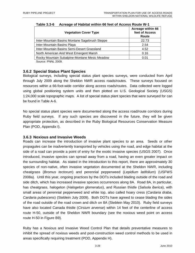
RUBY PIPELINE PROJECT TRANSPORTATION PLAN FOR USE OF ACCESS ROADSWITHIN SHELDON NATIONAL WILDLIFE REFUGE
3-28 June 2010
Table 3.3-6 Acreage of Habitat within 66 feet of Access Route W-1
Vegetation Cover TypeAcreage within 66
feet of AccessRoute
Inter-Mountain Basins Montane Sagebrush Steppe 22.73
Inter-Mountain Basins Playa 2.54
Inter-Mountain Basins Semi-Desert Grassland 4.52
North American Arid West Emergent Marsh 0.16
Rocky Mountain Subalpine-Montane Mesic Meadow 0.01Source: PNNL 2009.
3.6.2 Special Status Plant SpeciesBiological surveys, including special status plant species surveys, were conducted from April
through July 2009 along the Sheldon NWR access roads/routes. These surveys focused on
resources within a 66-foot-wide corridor along access roads/routes. Data collected were logged
using global positioning system units and then plotted on U.S. Geological Society (USGS)
1:24,000 scale topographic maps. A list of special status plant species that were surveyed for can
be found in Table A-6.
No special status plant species were documented along the access road/route corridors during
Ruby field surveys. If any such species are discovered in the future, they will be given
appropriate protection, as described in the Ruby Biological Resources Conservation Measure
Plan (POD, Appendix I).
3.6.3 Noxious and Invasive WeedsRoads can increase the introduction of invasive plant species to an area. Seeds or other
propagules can be inadvertently transported by vehicles using the road, and edge habitat at the
side of a road can provide a point of entry for the exotic invasive species (USGS 2007). Once
introduced, invasive species can spread away from a road, having an even greater impact on
the surrounding habitat. As stated in the introduction to this report, there are approximately 30
species of non-native, often invasive vegetation documented at the Sheldon NWR, including
cheatgrass (Bromus tectorum) and perennial pepperweed (Lepidium latifolium) (USFWS
2008a). Until this year, ongoing practices by the DOTs included blading outside of the road and
side ditch, which has increased invasive species occurrences along 8A. Road 8A, in particular,
has cheatgrass, halogeton (Halogeton glomeratus), and Russian thistle (Salsola iberica), with
small areas of perennial pepperweed and white top, also called hoary cress (Cardaria draba,
Cardaria pubescens) (Steblein July 2009). Both DOTs have agreed to cease blading the sides
of the road outside of the road crown and ditch on 8A (Steblein May 2010). Ruby field surveys
have also located Canada thistle (Cirsium arvense) within 14 feet of the centerline of access
route H-50, outside of the Sheldon NWR boundary (see the noxious weed point on access
route H-50 in Figure B9).
Ruby has a Noxious and Invasive Weed Control Plan that details preventative measures to
inhibit the spread of noxious weeds and post-construction weed control methods to be used in
areas specifically requiring treatment (POD, Appendix H).

RUBY PIPELINE PROJECT TRANSPORTATION PLAN FOR USE OF ACCESS ROADSWITHIN SHELDON NATIONAL WILDLIFE REFUGE
3-29 June 2010
3.6.4 Vegetation and Road DustAnother impact that roads can have on vegetation is that road dust settles on the leaves of
plants near the road, causing a reduction in photosynthetic rates (USGS 2007). This impact
can be reduced by effective dust control. Ruby has a Project-wide Fugitive Dust Control Plan
that will meet state requirements for dust control (POD, Appendix N). The objective of the
fugitive dust control plan is to identify potential dust emission sources and provide guidance
to construction and field personnel on measures to control the generation of fugitive dust
during construction activities associated with the Project. It will be the responsibility of Project
contractors, working with designated environmental inspectors, to identify all activities generating
fugitive dust, implement feasible control measures, and ensure compliance with applicable
fugitive dust regulations.
3.7 Environmental Analysis of Recreation and Wilderness Study
Areas and Terms of Access
3.7.1 RecreationThe use of access roads/routes in the Sheldon NWR would be in close proximity to
campgrounds. There are 14 campgrounds—12 semi-primitive, one developed (Virgin Valley),
and one private (Royal Peacock)—on the Sheldon NWR utilized for active and passive
recreation, including hunting, fishing, hiking, wildlife viewing, and photography, as well as users
attracted to the area for opal mining and rock hounding. Dispersed primitive camping is also
allowed with a permit. Recreationists may be inconvenienced and the quality of their visit
diminished by increased congestion, temporary loss of access, potential impacts to wildlife
(which would affect hunting and fishing activities), dust, and noise. Environmental analysis of
wildlife and terms of access are discussed in Section 3.3. Overall, effects would be short-term
and limited to the duration of construction. During construction, workers will be restricted to off-
site housing facilities. In the case of increased use of the campgrounds, workers will be
restricted to using the campgrounds for the stated purposes and durations. In addition, Ruby
would restore lands affected by the use of the access roads/routes and perform appropriate
reclamation in accordance with Ruby’s Upland Erosion Control, Re-Vegetation, and
Maintenance Plan (POD, Appendix D).
3.7.2 Wilderness Study AreasOf the nine Wilderness Study Areas (WSAs) in the Sheldon NWR, access routes would be
adjacent to two WSAs along 8A. Access routes H-52 and H-46A begin at the edge of Alkali
Peak WSA. Use of the roads/routes adjacent to WSAs would add to impacts on vegetation
because of dust settling on the leaves of plants near the road/route, causing a reduction in
photosynthetic rates (USGS 2007). This impact can be reduced by effective dust control. Ruby
has a Project-wide Fugitive Dust Control Plan that will meet state requirements for dust control
(POD, Appendix N).

RUBY PIPELINE PROJECT TRANSPORTATION PLAN FOR USE OF ACCESS ROADSWITHIN SHELDON NATIONAL WILDLIFE REFUGE
3-30 June 2010
Access road and route use by pipeline construction vehicles would also generate aesthetic
effects (noise and sights of human-created vehicles) that would penetrate the WSAs, reducing
the quality of their wilderness character.

RUBY PIPELINE PROJECT TRANSPORTATION PLAN FOR USE OF ACCESS ROADSWITHIN SHELDON NATIONAL WILDLIFE REFUGE
4-1 June 2010
4.0 Cultural Resources
4.1 Summary
FERC has been identified as the Ruby Pipeline Project lead federal agency and, per the Energy
Policy Act of 2005, is the agency responsible for coordinating all applicable federal
authorizations and for complying with NEPA. FERC is also the lead federal agency for National
Historic Preservation Act (NHPA) compliance. Although FERC is the lead federal agency, the
Bureau of Land Management (BLM) has substantial permitting responsibilities, and FERC is
coordinating with the USFWS and other federal agencies regarding historic preservation
compliance. Studies completed and reported herein were conducted principally to comply with
NEPA and Section 106 of the NHPA, consistent with FERC regulations at 18 CFR 380.12(f),
380.14, Appendix A to Part 380, and 385.2201 per section 7c of the Natural Gas Act.
Consulting agencies include the Nevada State Historic Preservation Office, USFWS, BLM, and
the U.S. Forest Service.
In the Sheldon NWR, Ruby proposes to use, maintain, and/or improve access roads to facilitate
construction and maintenance of the pipeline and related facilities. In most cases, however,
Ruby proposes to use these access roads “as is,” with no modifications. Such roads may
eventually require certain limited and localized construction modifications (e.g., pull-outs,
passing areas, or drainage or crossing features), at which point these locations will be identified
and subject to Section 106 site identification and treatment protocols, as outlined in the
Treatment Plan for cultural resources located in Nevada (Hildebrandt 2010a).
Some access roads, however, are more likely to require substantial modification (widening,
grading, straightening, etc.) in preparation for pipeline construction and are, therefore, included
in the current Area of Potential Effect (APE) and Class I and III inventory. The APE for this
class of access roads (the zone to which Ruby will limit all ground disturbances related to road
modification) is 30 feet (15 feet on each site of the road centerline). To provide added flexibility,
an additional 70-foot buffer (for a total of 50 feet on each side of the road centerline) was added
to the survey coverage of these roads.
Pacific Legacy, Inc., was tasked with conducting a Class I and Class III cultural resources
inventory survey of the proposed Ruby Sheldon NWR access roads/routes. The results of this
effort are reported in the Interim Survey and Evaluation Report prepared by Far Western
Anthropological Research Group (Hildebrandt 2010b).
Subsequent to the submittal of the Interim Survey and Evaluation Report in March of 2010,
there have been a number of design and engineering re-assessments of those roads that will
require substantial modifications. Some have been dropped from the list of Project access

RUBY PIPELINE PROJECT TRANSPORTATION PLAN FOR USE OF ACCESS ROADSWITHIN SHELDON NATIONAL WILDLIFE REFUGE
4-2 June 2010
roads (e.g., H-53 and H-54), while others have been re-assessed regarding their need for
substantial modifications (e.g., H-46, H46A, and H-46B). As of June 1, 2010, 54.3 miles of
access road have been identified in the Sheldon NWR that will require substantial modification.
Located within the APE of these roads are 28 sites (Table 4.1-1). As per the Interim Survey
and Evaluation Report (Hildebrandt 2010b), all of these sites have been determined eligible for
listing in the National Register of Historic Places. Prior to issuance of a Special Use Permit by
the USFWS, large-scale maps depicting the historic property and the proposed road
modification will be submitted to the USFWS. These sites can then be scheduled for data
recovery treatment as per the procedures and protocols outlined in the FERC-approved
Treatment Plan for Nevada (Hildebrandt 2010a).
While the design and engineering review of access roads in the Sheldon NWR is now mostly
complete, additional changes are still possible. Furthermore, some roads that are proposed for
use “as is” may eventually require certain limited and localized construction modifications (e.g.,
pull-outs, passing areas, or drainage or crossing features). Any such changes will require
review by Sheldon NWR cultural resources staff and be subject to the Adjustments to the Area
of Potential Effect clause in the Treatment Plan (Hildebrandt 2010a:34). In the event that
human remains or other unanticipated discoveries are made during the course of access road
improvements in the Sheldon NWR, procedural protocols will follow the Monitoring and Cultural
Resources Discovery Plan in the Treatment Plan (Hildebrandt 2010a:88–99).
Table 4.1-1 Summary of Cultural Resource Sites Along AccessRoads within the Sheldon National Wildlife Refuge
Temp No. Trinomial Components Owner
NV-SV-D-029 WA5086/WA5087Multi-Component BLM/USFWS/Private
NV-WN-B-172 Historical USFWS/PrivateNV-SV-D-038 Prehistoric BLM/USFWSNV-HR-D-027 HU1248 Prehistoric USFWSNV-HR-D-028 Prehistoric USFWSNV-HR-D-029 Prehistoric USFWSNV-HR-D-033 Prehistoric USFWS
NV-HR-E-028Multi-Component USFWS/Private
NV-SV-D-031 Prehistoric USFWSNV-SV-D-032 Prehistoric USFWSNV-SV-D-033 Prehistoric USFWSNV-SV-D-034 Prehistoric USFWS
NV-SV-D-035Multi-Component USFWS
NV-SV-D-036 Prehistoric USFWSNV-SV-D-037 Prehistoric USFWSNV-SV-E-013 Prehistoric USFWSNV-SV-E-014 Prehistoric USFWSNV-SV-E-015 Prehistoric USFWSNV-SV-E-017 Prehistoric USFWSNV-SV-E-018 Prehistoric USFWSNV-SV-E-019 Prehistoric USFWSNV-SV-E-020 Multi- USFWS

RUBY PIPELINE PROJECT TRANSPORTATION PLAN FOR USE OF ACCESS ROADSWITHIN SHELDON NATIONAL WILDLIFE REFUGE
4-3 June 2010
Table 4.1-1 Summary of Cultural Resource Sites Along AccessRoads within the Sheldon National Wildlife Refuge
Temp No. Trinomial Components OwnerComponent
NV-SV-E-021 Prehistoric USFWSNV-SV-E-022 Prehistoric USFWSNV-SV-E-023 Prehistoric USFWSNV-SV-E-024 Prehistoric USFWSNV-SV-E-025 Prehistoric USFWSNV-WN-B-161 HU1244 Prehistoric USFWS
RUBY PIPELINE PROJECT TRANSPORTATION PLAN FOR USE OF ACCESSROADS
WITHIN SHELDON NATIONAL WILDLIFE REFUGE
5-1 June 2010
5.0 Additional Terms, Conditions,and Stipulations
The USFWS has requested additional measures and conditions per the SUP. Ruby would
need to discuss these conditions with the USFWS to determine the appropriate level of
maintenance. Upon completion of construction, Ruby will request an additional SUP to allow
maintenance of block-valves within the Sheldon NWR.
5.1 Graveling of Proposed Access Roads and Routes
Roads and routes within the Sheldon NWR where gravel has been placed during seasonal
maintenance have been worn down. The USFWS has requested Ruby to gravel roads and
routes that are in need of new gravel.
5.2 Fencing and Signage
Fences along the southern boundary of the Sheldon NWR should be inspected to be sure
they are sturdy and would not need repair. The USFWS is particularly concerned that the
construction activities would push BLM-managed wild horses onto the refuge. The integrity
of the fences, cattle guards, and grates would need to be inspected to ensure that they
would resist extra pressure from horses, burros, cattle, and human traffic associated with
construction.
There are 33 miles along the southern boundary of the refuge that would need to be posted
with the Sheldon NWR signs to inform workers and contractors whether they are outside the
boundaries of the Sheldon NWR or on the refuge and, therefore, subject to different rules
and regulations. The USFWS has signs that Ruby would use for this purpose.
5.3 Invasive Weed Management along 8A
Invasive weeds along 8A include halogeton, Russian thistle, and small areas of hoary cress.
The USFWS has requested that Ruby spray these weeds prior to construction to prevent the
transport of weed seed along access roads/routes through the Sheldon NWR and to the
construction site. Post-construction, the USFWS has requested Ruby to re-seed the edges
of 8A with a native seed mix.
The Sheldon NWR Weed Plan states that the DOTs should discontinue the blading of roads
outside the road and roadside ditch (Bennett 2009). The blading has been occurring for 10
years, and the seed bed has been lost. Measures for invasive weed control would be to
spray and then either wait a year to see if natives come back, or re-seed. Due to the
RUBY PIPELINE PROJECT TRANSPORTATION PLAN FOR USE OF ACCESS ROADSWITHIN SHELDON NATIONAL WILDLIFE REFUGE
5-2 June 2010
scarcity of water, natives will most likely not come back in a year (Bennett 2009). Re-
seeding would be the more successful measure to control invasive weeds.
5.4 Re-route Summit Lake/Badger Mountain Road (H-46B)
The Sheldon NWR has requested Ruby to realign a small stretch of Summit Lake/Badger
Mountain Road near Ten Mile Spring to bypass an ongoing research study area. The
current location of Summit Lake/Badger Mountain Road traverses between Ten Mile Spring,
a perennial spring, and the study area. The study area has an electric fence around it to
keep feral horses out, so biologists can measure the effects horses have on riparian
vegetation. The Sheldon NWR has indicated that the increase in traffic will deter feral
horses from retreating to the spring for food and water, which would skew the results of the
study. The SUP will give Ruby authorization to realign the road in order to bypass the study
area (See Figure B10).
5.4.1 Construction Details
The realignment of Summit Lake/Badger Mountain Road would be approximately 1330 feet
in length and would be constructed as wide as the existing road, which is currently 16 feet.
The current alignment of the road is located at the foot of a hill on the south side; however,
to avoid the study and Ten Mile Spring, the road would have to be constructed uphill of the
existing alignment. The back slope would be bladed on the uphill side, to acquire a 2:1 slope
to prevent loose material from caving off. After realigning the road, 32 yards of road base
would be hauled in and spread out on the road.
The road would require two 24-inch elliptical culverts, or as needed for proper drainage and
a bar ditch to be cut in, along the uphill side (south side) of the road. The road would take
four to five days to construct in late July/early August. Restoration discussions are still
ongoing between Ruby and the Sheldon NWR.
5.4.2 Habitat Assessment
Surveys for biological and archeological features are complete for the re-alignment of
Summit Lake/Badger Mountain Road. Surveys did not detect sensitive species or features,
including sage-grouse leks, pygmy rabbit burrows, wetlands, springs, or streams. The
habitat is sagebrush steppe. Dominant vegetation includes; big sagebrush, bitterbrush,
rabbitbrush (Chrysothamnus nauseosus), Sandberg bluegrass (Poa secunda), and
intermediate wheatgrass (Agropyron intermidium). The soils are a sandy loam, and there is
less then 1% invasive species present.
5.4.3 Conservation Values
The current alignment of Summit Lake/Badger Mountain Road traverses through the
downward flow of water from Ten Mile Spring. The spring water moves in a northeast
direction, across the road and into the study area. The re-alignment of the road would avoid
the spring, allowing water to flow freely. After the new road construction is complete, the
abandoned portion of the road will be left in a roughened condition and will be reseeded.
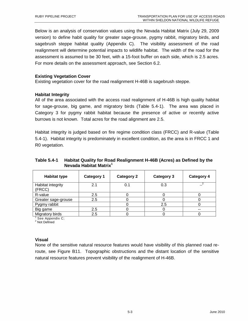
RUBY PIPELINE PROJECT TRANSPORTATION PLAN FOR USE OF ACCESS ROADSWITHIN SHELDON NATIONAL WILDLIFE REFUGE
5-3 June 2010
Below is an analysis of conservation values using the Nevada Habitat Matrix (July 29, 2009
version) to define habit quality for greater sage-grouse, pygmy rabbit, migratory birds, and
sagebrush steppe habitat quality (Appendix C). The visibility assessment of the road
realignment will determine potential impacts to wildlife habitat. The width of the road for the
assessment is assumed to be 30 feet, with a 15-foot buffer on each side, which is 2.5 acres.
For more details on the assessment approach, see Section 6.2.
Existing Vegetation CoverExisting vegetation cover for the road realignment H-46B is sagebrush steppe.
Habitat IntegrityAll of the area associated with the access road realignment of H-46B is high quality habitat
for sage-grouse, big game, and migratory birds (Table 5.4-1). The area was placed in
Category 3 for pygmy rabbit habitat because the presence of active or recently active
burrows is not known. Total acres for the road alignment are 2.5.
Habitat integrity is judged based on fire regime condition class (FRCC) and R-value (Table
5.4-1). Habitat integrity is predominately in excellent condition, as the area is in FRCC 1 and
R0 vegetation.
Table 5.4-1 Habitat Quality for Road Realignment H-46B (Acres) as Defined by theNevada Habitat Matrix
1
Habitat type Category 1 Category 2 Category 3 Category 4
Habitat integrity(FRCC)
2.1 0.1 0.3 --2
R-value 2.5 0 0 0Greater sage-grouse 2.5 0 0 0Pygmy rabbit 0 2.5 0Big game 2.5 0 0 --Migratory birds 2.5 0 0 01 See Appendix C;2 Not Defined
VisualNone of the sensitive natural resource features would have visibility of this planned road re-
route, see Figure B11. Topographic obstructions and the distant location of the sensitive
natural resource features prevent visibility of the realignment of H-46B.
RUBY PIPELINE PROJECT TRANSPORTATION PLAN FOR USE OF ACCESS ROADSWITHIN SHELDON NATIONAL WILDLIFE REFUGE
6-1 June 2010
6.0 Proposed Land Exchange toPreserve Conservation Value
Access route W-1 has sensitive resources located along the route from Wall Canyon Spring to
the Sheldon NWR fence line, about one mile in length. These resources include a spring and
high quality sagebrush steppe community, which provides habitat for sagebrush-obligate
species. This section of W-1 has quality resource values, and use as an access route may not
be compatible with the Sheldon NWR’s purposes. As such, the USFWS and Ruby are
exploring mutually beneficial solutions to allow Ruby access without losing collective refuge
resources. One such solution is a land exchange. In order for Ruby to acquire usage of the
route, a Compatibility Determination must be developed.
To date, one percent of land within the Sheldon NWR boundary is private and not protected by
the Sheldon NWR or subject to its resource management strategies. Development of these in-
holdings can cause disproportionate impact that can disrupt all other conservation values,
including viewshed, wildlife, habitat fragmentation, and the introduction of invasive weeds.
Private landowners can build new roads, as well as new dwellings and other structures. These
new development can cause impacts to surrounding habitats and downstream water sources,
introduce invasive species, and deter recreationalists from visiting the Sheldon NWR.
Ruby and the USFWS are working together to identify in-holdings within the Sheldon NWR
boundary that may be acquired from a willing seller. The in-holdings would have at least equal
fair market value, as well as at least equal conservation values. Ruby plans to participate in a
land exchange with Sheldon NWR for the use of the last mile of W-1. In exchange for acquiring
an inholding, the USFWS would grant Ruby an easement in perpetuity for the one-mile section
of W-1. Ruby would place bench marks at the start and end of the easement road and stake
the width limits of the easement road to clearly delineate the boundaries.
If the land exchange becomes implausible, Ruby may explore the possibility of building a spur
off of W-1 to avoid the last mile of sensitive habitat on the Sheldon NWR. Below is a
conservation value assessment of the blocks of land along W-1 where sensitive resources
exist.
6.1 Conservation Value of access route W-1
Access route W-1 is located within land blocks 6c and 6d and will be used by Ruby for access
pipeline ROW. Land blocks 6c and 6d are 96.4 and 236.1 acres, respectively. The
conservation value assessment will provide information to help determine the monetary value of
land blocks 6d and 6c.
RUBY PIPELINE PROJECT TRANSPORTATION PLAN FOR USE OF ACCESS ROADSWITHIN SHELDON NATIONAL WILDLIFE REFUGE
6-2 June 2010
6.2 Assessment Approach
6.2.1 Environmental Setting
The two land blocks occur in areas of sagebrush steppe, with basin big sagebrush (Artemisia
tridentate spp. Tridentate) and Wyoming big sagebrush (Artemisia tridentata Nutt. ssp.
Wyomingensis), bitterbrush, rabbitbrush, Sandberg bluegrass, bluebuch wheatgrass
(Agropyron spicatum), needle and thread grass (Hesperostipa comata), Thurber’s needlegrass
(Achnatherum thurberianum), Indian ricegrass (Achnatherum hymenoides), and bottleneck
squirreltail (Hordeum jubatum) as characteristic plant species. The area is important sage-
grouse and pronghorn habitat. Elevations vary from approximately 5,660 to 6,670 feet. Soil
textures range from clayey loams to sandy loams, with variable depths depending on
topographic positions.
6.2.2 Datasets
The Nevada Habitat Matrix (July 29, 2009 version) was used to define habitat quality for greater
sage-grouse, pygmy rabbit, migratory birds, and sagebrush steppe habitat quality (Appendix C).
The habitat matrix was developed in response to the USFWS’ request to define habitat quality
along the ROW for special management lands; federal and state threatened, endangered,
proposed, candidate species, and critical habitat; migratory birds; big game range; non-
Endangered Species Act–listed species; greater sage-grouse, pygmy rabbit; and habitat
integrity. The habitat matrix was developed by Ruby and then refined at meetings with the
BLM, NDOW, and USFWS. Category 1 represents high quality habitat, and Category 4
represents non-suitable habitat as defined.
LANDFIRE (www.landfire.gov) existing vegetation cover and FRCC datasets were used to
determine vegetation cover and habitat integrity for the two land blocks and road re-route.
FRCC was used to define habitat integrity. FRCC measures existing vegetation composition
with a reference condition such as pre-settlement vegetation or potential natural vegetation.
FRCC is divided into three classes: FRCC1 contains vegetation composition similar to the
reference condition and represents excellent quality habitat; FRCC2 contains vegetation
composition that is slightly altered from the reference situation and represents good habitat
condition; and FRCC3 contains vegetation composition that is greatly altered from the reference
condition and represents poor habitat quality.
Another way of evaluating habitat integrity of sagebrush steppe vegetation is by means of
R-value. R-value habitats were identified by NDOW as a way to prioritize habitat quality based
on the dominant plant type: R0 = intact sagebrush vegetation; R1 = perennial grass; R2 =
Wyoming big sagebrush; R2a = Wyoming big sagebrush with cheatgrass; and R2b =
cheatgrass. Within the habitat matrix, R-values are coded as follows: R0 = Category 1; R1 =
Category 2; R2 = Category 3; R2a and R2b = Category 4.
RUBY PIPELINE PROJECT TRANSPORTATION PLAN FOR USE OF ACCESS ROADSWITHIN SHELDON NATIONAL WILDLIFE REFUGE
6-3 June 2010
Datasets for the conservation value analysis for sage-grouse, pygmy rabbit, and R-values were
obtained from NDOW; big game data sets from NDOW and USFWS; and migratory bird
habitats from the Nevada State Steering Committee on the Intermountain West Joint Venture.
For the visual analysis a 10-meter Digital Elevation Model was downloaded from the USGS
website. This model was used to determine elevations and spatial relationships of the habitat
features and the proposed road upgrade.
Visibility analysis was conducted from the proposed Project to sensitive habitat features which
included:
Raptor points;
Habitat;
Hydro-features that included seeps/springs, ponds, and streams;
Rock outcrops; and
Sage-grouse and pygmy rabbit polygons.
A geographical information systems visibility analysis point was assigned to each line vertex
found on the existing two track roads considered for upgrade in two blocks of land known as 6c
and 6d. The visibility analysis “looked” across the landscape out to three miles to determine
what sensitive natural resource features would have visibility of the proposed Project. The
analysis focused on visibility from ground level of the proposed Project to the ground level of
the sensitive natural resource feature. Vegetation was not included as a potential obstruction to
visibility.
6.3 Results
6.3.1 Existing Vegetation Cover
Existing vegetation cover for the land blocks 6c and 6d is predominately sagebrush steppe, with
minimal riparian and pinion-juniper plant communities.
6.3.2 Habitat Integrity
All of the area in blocks 6c and 6d for greater sage-grouse, big game, and migratory birds is
high quality (Table 6.3-1). Total acreage for blocks 6c and 6d is 96.4 and 236.1, respectively.
Neither blocks 6c nor 6d are suitable pygmy rabbit habitat.
Habitat integrity is judged based on FRCC and R-value (Table 6.3-1). Habitat integrity for both
blocks 6c and 6d is in good or excellent or condition. FRCC 2, or good quality habitat covers,
71 and 74 percent of the areas in blocks 6c and 6d, respectively. FRCC, or excellent quality
habitat, accounts for 29 and 24 percent of blocks 6c and 6d, respectively. Sagebrush steppe
vegetation in both 6c and 6d is categorized as R0, high quality sagebrush vegetation.
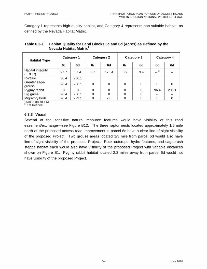
RUBY PIPELINE PROJECT TRANSPORTATION PLAN FOR USE OF ACCESS ROADSWITHIN SHELDON NATIONAL WILDLIFE REFUGE
6-4 June 2010
Category 1 represents high quality habitat, and Category 4 represents non-suitable habitat, as
defined by the Nevada Habitat Matrix.
Table 6.2-1 Habitat Quality for Land Blocks 6c and 6d (Acres) as Defined by theNevada Habitat Matrix
1
Category 1 Category 2 Category 3 Category 4Habitat Type
6c 6d 6c 6d 6c 6d 6c 6d
Habitat integrity(FRCC)
27.7 57.4 68.5 175.4 0.2 3.4 --2
--
R-value 96.4 236.1Greater sage-grouse
96.4 236.1 0 0 0 0 0 0
Pygmy rabbit 0 0 0 0 0 0 96.4 236.1Big game 96.4 236.1 0 0 0 0 -- --Migratory birds 96.4 229.1 0 7.0 0 0 0 01 See Appendix C;2 Not Defined
6.3.3 Visual
Several of the sensitive natural resource features would have visibility of this road
easement/exchange—see Figure B12. The three raptor nests located approximately 1/8 mile
north of the proposed access road improvement in parcel 6c have a clear line-of-sight visibility
of the proposed Project. Two grouse areas located 1/3 mile from parcel 6d would also have
line-of-sight visibility of the proposed Project. Rock outcrops, hydro-features, and sagebrush
steppe habitat each would also have visibility of the proposed Project with variable distances
shown on Figure B1. Pygmy rabbit habitat located 2.3 miles away from parcel 6d would not
have visibility of the proposed Project.
RUBY PIPELINE PROJECT TRANSPORTATION PLAN FOR USE OF ACCESS ROADSWITHIN SHELDON NATIONAL WILDLIFE REFUGE
7-1 June 2010
7.0 Summary of Terms of AccessRoads and the traffic traveling on them can impact the environment in a variety of ways.
Appropriate maintenance strategies can significantly reduce this impact. Below is a
comprehensive list of terms of access Ruby would employ, where appropriate. Ruby
understands that the Sheldon NWR’s primary goal is wildlife conservation and would work with
the USFWS to ensure environmentally responsible use of the refuge’s access roads and
routes. For some measures below, such as determining appropriate locations for mowing and
road blading/sheering, Ruby will consult with the refuge for express permission regarding
locations in which these measures could be implemented.
Road and Route Maintenance
Periodic maintenance throughout construction;
Blading and sheering of road/route, as needed, to ensure a properly graded road surface to
eliminate standing water;
Before and after assessments of culverts to determine if culverts will need to be replaced
after construction; and
Mowing of vegetation at blind corners for visibility.
Safety Placement of caution signs where there is a blind spot;
Placement of gravel in areas where the road/route is worn down to prevent the road/route
from becoming slippery when wet;
Pullouts may be necessary in limited areas; pullouts will be minimized by using strategic
mowing wherever possible. Actual mowing and pullout locations will be determined during a
site visit with Ruby and the Sheldon NWR; and
Use of Project ROW, as a contingency if roads/routes in the Sheldon NWR become unsafe
to drive.
Sensitive Areas Use of culverts or matting where streams or wetlands cross access road/route;
Re-alignment of Summit Lake/Badger Mountain Road to avoid a feral horse study area and
perennial spring;
Ensuring that construction vehicles adhere to speeds to reduce collisions with wildlife and
for safety;
Ensuring that workers are educated regarding protection of animals and habitat in the
NWR;
Revegetation of all land disturbed by Project-related activities with seed mixes
recommended by local authorities, including the Sheldon NWR;
Spraying of vehicles for cleaning, invasive weeds would be done in designated areas;

RUBY PIPELINE PROJECT TRANSPORTATION PLAN FOR USE OF ACCESS ROADSWITHIN SHELDON NATIONAL WILDLIFE REFUGE
7-2 June 2010
Use of herbicides and pesticides would not be allowed in or within 100 feet of a wetland,
except as allowed by the USFWS; and
Ruby does not intend to use fertilizer; however, if requested, fertilizer, lime, or mulch would
not be allowed in or within 100 feet of wetland unless required in writing by the USFWS.
Pygmy Rabbits
Mowing prior to road/route use to move the pygmy rabbits away from access roads/routes;
Trapping and relocating pygmy rabbits to suitable habitat away from access road/route; and
Planting of larger container sagebrush species within certain pygmy rabbit colonies to
establish habitat sooner.
Greater Sage-grouse
Identification of active leks in the Project route to avoid impacts;
Avoidance of construction activities when leks are active or nesting and early brood rearing
is occurring (approximately mid-March to mid-June);
Rehabilitation of the access roads/routes using native grasses, forbs, and big sagebrush
seed collected from the local vicinity to the greatest extent possible. Reclamation would
achieve composition, diversity, and cover similar to that of the surrounding vegetation
community;
Avoidance of human activity between dawn and 10:00 a.m. from March 1 to May 15 within
agency designated buffer or occupied leks; and
Prohibition of construction in known greater sage-grouse habitat during the following
months for:
Leks - February 15 to May 31 (2.0-mile buffer);
Winter Range/Concentration Area - November 1 to March 30;
Summer - June 1 to August 15.
Big Game Within big game winter ranges disturbed by the Project, Ruby would seed disturbed areas
with preferred big game forage species, as recommended by the Sheldon NWR;
Ruby would control noxious weeds along access roads/routes, including both summer and
winter rangelands, to help maintain native forage species; and
To reduce potential impacts to big game species, Ruby has agreed to avoid construction
activities in designated crucial winter big game ranges. Should Ruby find it necessary to
construct within this time period, it would seek written authorization. Crucial winter range
restrictions would include:
Mule Deer Winter - October 15 to March 15
Pronghorn Winter - November 1 to April 15 Migration Corridor restriction - April 1 to June 30.
RUBY PIPELINE PROJECT TRANSPORTATION PLAN FOR USE OF ACCESS ROADSWITHIN SHELDON NATIONAL WILDLIFE REFUGE
7-3 June 2010
Raptors Ruby has defined BMPs to be employed for raptor protection in its Voluntary
Conservation Measures in Furtherance of the Migratory Bird Treaty Act and Bald and
Golden Eagle Protection Act and Executive Order No. 13186 (an agreement with
USFWS). Those measures will be applied within the Sheldon NWR.
MBTA Ruby has defined best management practices to be employed for MBTA protection in its
Voluntary Conservation Measures in Furtherance of the Migratory Bird Treaty Act and
Bald and Golden Eagle Protection Act and Executive Order No. 13186 (an agreement
with the USFWS). These measures will be applied within the Sheldon NWR.
DustThe following specific control measures are to be used as needed to control fugitive dust
emissions for the Project:
Construction equipment and vehicles will be properly maintained;
Apply water one or more times per day to all affected unpaved roads/routes;
Reduce vehicle speeds on all unpaved access roads/routes;
Clean up track-out and/or carry-out areas at paved road access points at a minimum of
once every 48 hours;
Gravel pads may be installed adjacent to paved roadways to limit track-out, and clearly
established and enforced traffic patterns may be used to route traffic over track-out
control devices;
Cover all haul truck loads, or maintain at least six inches of freeboard space in each
cargo compartment. Ensure that all haul truck cargo compartments are constructed and
maintained to minimize spillage and loss of materials, and clean or wash each cargo
compartment at the delivery site after removal of the bulk materials; and
For temporary surfaces during periods of inactivity, restrict vehicular access by means
of either fencing or signage and apply water to comply with the stabilized surface
requirements.
Water trucks, using an off-refuge source, will be the primary means of dust abatement during
all phases of construction. Water spray will be controlled so that over-spraying and pooling
will be avoided, to the greatest extent possible. Where roads are paved, no dust mitigation
should be necessary.
Waste and Spill Prevention All Project-related waste would be removed or disposed of from the Sheldon NWR
Ruby shall provide immediate notice to the USFWS in the event of a spill or other
emergency.
All spills occurring on land or in watercourses (including intermittent and ephemeral
streams), regardless of quantity, shall be cleaned up immediately.
RUBY PIPELINE PROJECT TRANSPORTATION PLAN FOR USE OF ACCESS ROADSWITHIN SHELDON NATIONAL WILDLIFE REFUGE
7-4 June 2010
Contingency for Unforeseen ConditionsIn the event of unforeseen problems or issues arising during the Project that are not addressed
in the mitigation, resolution will be achieved through consultation among Ruby, its contractors,
and the USFWS.
Contingencies for Refuge Management NeedsThere may be occasional periods during which some access roads/routes will need to be closed
for refuge management purposes. Such periods may include but are not limited to aerial
refuge/species surveys, horse gather activities, and fire management actions. The refuge will
make every effort to communicate these time periods to Ruby with reasonable advance notice
so that temporary adjustments to travel plans can be made.
RUBY PIPELINE PROJECT TRANSPORTATION PLAN FOR USE OF ACCESS ROADSWITHIN SHELDON NATIONAL WILDLIFE REFUGE
8-1 June 2010
8.0 ReferencesBennett, M. October 2009. Telephone Communication with J. D’Avanzo, Ecology and
Environment, Inc.
Collins, G. September 2009. Email Correspondence via Staci MacCorkle (SWCA) with J.
D’Avanzo, Ecology and Environment, Inc.
Hildebrandt, William R., Kelly McGuire, Jerome King, and Charles Zeier 2010a Ruby PipelineFinal Interim Survey and Evaluation Report, Elko, Humboldt, and Washoe Counties, Nevada.Submitted to Ruby Pipeline, LLC, Colorado Springs, Colorado.
Hildebrandt, William R., Kelly McGuire, Jerome King, and Charles Zeier 2010b Final CulturalResources Treatment Plan for the Ruby Pipeline Project, Elko, Humboldt, and WashoeCounties, Nevada. Submitted to Ruby Pipeline, LLC, Colorado Springs, Colorado.
Krejci, K., T. Dewey, and L. Olson. 2009. “Antilocapra americana” (On-line), Animal Diversity
Web, University of Michigan Museum of Zoology.
http://animaldiversity.ummz.umich.edu/site/accounts/information/Antilocapra_americana.html
(Accessed August 2009).
Larrucea, Eveline Sequin. 2007. Distribution, Behavior, and Habitat Preferences of the Pygmy
Rabbit (Brachylagus idahoensis) in Nevada and California. A dissertation submitted in partial
fulfillment of the requirements for the degree of Doctor of Philosophy in Ecology, Evolution,
and Conservation Biology.
Misuraca, M. 1999. “Odocoileus hemionus” (On-line), Animal Diversity Web, University of
Michigan Museum of Zoology.
http://animaldiversity.ummz.umich.edu/site/accounts/information/Odocoileus_hemionus.html
(Accessed August 2009).
Nevada Department of Wildlife (NDOW). August 2004. Biological Bulletin No. 14. Mule Deer
Population Dynamics: Issues and Influences.
Nevada Department of Wildlife (NDOW). May 2003. Biological Bulletin No. 13. Nevada’s
Pronghorn Antelope Ecology, Management, and Conservation. First edition written By
George K. Tsukamoto in 1983.
Nevada Wildlife Federation. 2009 Sheldon National Wildlife Refuge.
http://www.nvwf.org/nevada/places/pl_sheld.htm (Accessed in July 2009).
RUBY PIPELINE PROJECT TRANSPORTATION PLAN FOR USE OF ACCESS ROADSWITHIN SHELDON NATIONAL WILDLIFE REFUGE
8-2 June 2010
Noss, R.F. and R.L. Peters. Dec 1995. Endangered Ecosystems, A Status Report onAmerica’s Vanishing Habitat and Wildlife. Defenders of Wildlife, Washington, DC.
Noss, R.F., E.T. LaRoe, and J. M. Scott. 1995. Endangered Ecosystems of the United States:A Preliminary Assessment of Loss and Degradation. Biological Report 28. NationalBiological Service, Washington, DC.
Pacific Northwest National Laboratory (PNNL). 2009. Analysis and Mapping of Vegetation and
Habitat for the Sheldon National Wildlife Refuge. Richland, Washinton
Sheldon, Daly and Fred Lindzey. n.d. Movement and distribution patterns of pronghorn in
relation to roads and fences in southwestern Wyoming. Study by the Wyoming Cooperative
and Wildlife Research Unit, University of Wyoming.
http://dot.state.wy.us/webdav/site/wydot/shared/Public%20Affairs/Movement%20and%20Distr
ibution%20Patterns%20of%20Pronghorn%20Antelope.pdf (Accessed August 2009)
Steblein, P. May 2010. Personal Comment. Comment in Draft Report dated 2010402.
Steblein, P. July 2009. Personal Communication. Meeting with J. Thornton and M. Alexander,
Ecology and Environment, Inc.
United States Department of the Interior, National Park Service (USDOI NPS). May 2009.
Your Safety. May 1, 2009. http://www.nps.gov/badl/planyourvisit/yoursafety.htm (Accessed
in August 2009).
United States Federal Highway Administration (USFHWA). 2004. Synthesis of Noise Effects
on Wildlife Populations. September 8, 2004.
http://www.fhwa.dot.gov/Environment/noise/effects/index.htm (Accessed in July 2009).
U.S. Fish and Wildlife Service. 2009a. Sheldon National Wildlife Refuge: About Us. April 3,
2009. http://www.fws.gov/sheldonhartmtn/sheldon/aboutus.html (Accessed in July 2009).
U.S. Fish and Wildlife Service. 2009b. Office of External Affairs. News Release: Fish and
Wildlife Service to Conduct Status Review of the American Pika. May 6, 2009.
http://www.fws.gov/mountain-prairie/pressrel/09-34.html (Accessed in October 2009)
U. S. Fish and Wildlife Service. 2008a. Sheldon-Hart Mountain Wildife Refuge Complex –
Master Species List. Revised.
U. S. Fish and Wildlife Service. 2008b. Environmental Assessment for Horse and Burro
Management at Sheldon National Wildlife Refuge. Revised, Final.
http://www.fws.gov/sheldonhartmtn/pdf/Sheldon%20Horse%20and%20Burro%20EA%20Mast
er%20Copy.draft%20final.7Apr08.pdf (Accessed in July 2009).
RUBY PIPELINE PROJECT TRANSPORTATION PLAN FOR USE OF ACCESS ROADSWITHIN SHELDON NATIONAL WILDLIFE REFUGE
8-3 June 2010
U.S. Fish and Wildlife Service. 2008c. Birds of Conservation Concern. December 2008.
http://www.fws.gov/migratorybirds/NewReportsPublications/SpecialTopics/BCC2008/BCC200
8.pdf (Accessed in May 2010).
U.S. Fish and Wildlife Service. March 2002. Sheldon National Wildlife Refuge. Brochure.
http://www.fws.gov/sheldonhartmtn/Sheldon/pdf/SheldonNWRbrochure.pdf (Accessed in
August 2009)_.
U.S. Geological Survey (USGS). 2007. Road Impacts on the Baca National Wildlife Refuge,
Colorado, with Emphasis on Effects to Surface- and Shallow Ground-Water Hydrology—A
Literature Review. U.S. Geological Survey Open-File Report 2007-1052. Prepared by
Anderson, Douglas C.
http://www.fort.usgs.gov/Products/Publications/pub_abstract.asp?PubID=21882 (Accessed
in July 2009).
U.S. Geological Survey. 2006. Bird Checklists of the United States: Sheldon National Wildlife
Refuge. August 3, 2006. http://www.npwrc.usgs.gov/resource/birds/chekbird/r1/sheldon.htm
(Accessed in July 2009).
U.S. Geological Survey. 2005. Ecological Effects of Vehicular Routes in a Desert Ecosystem.
Prepared by Brooks, Matthew L., and Bridget Lair, for the United States Geological Survey,
Recoverability and Vulnerability of Desert Ecosystems Program.
http://www.dmg.gov/documents/RPT_Eco_Effects_of_Veh_Routes_in_a_Desert_Ecosystem
_USGS_011604.pdf (Accessed in July 2009).
Wildlife Action Plan Team. 2006. Nevada Wildlife Action Plan. Nevada Department ofWildlife, Reno.

RUBY PIPELINE PROJECT TRANSPORTATION PLAN FOR USE OF ACCESS ROADSWITHIN SHELDON NATIONAL WILDLIFE REFUGE
A-1 June 2010
Appendix A Tables
Table A-1 Mammals Found in Sheldon NWRCommon Name Scientific Name
Preble’s Shrew* Sorex preblei
Merriam’s Shrew Sorex merriami
Trowbridge’s Shrew* Sorex trowbridgii
Vagrant Shrew Sores vagrans
Little Brown Myotis Myotis lucifugus
Yuma Myotis Myotis yumanensis
Long-eared Myotis Myotis evotis
Fringed Myotis* Myotis thysanodes
Long-legged Myotis* Myotis volans
California Myotis* Myotis californicus
Small-footed Myotis Myotis ciliolabrum
Silver-haired Bat Lasionycteris noctivagans
Western Pipistrelle Pipistrellus hesperus
Big Brown Bat* Eptesicus fuscus
Hoary Bat Lasiurus cinereus
Western Big-eared Bat* Plecotus townsendii
Pallid Bat Antrozous pallidus
Big Freetail Bat Nyctinomops macrotis
Raccoon Procyon lotor
Short-tailed Weasel Mustela erminea
Long-tailed Weasel Mustela frenata
Spotted Skunk Spilogale putorius
Striped Skunk Mephitis mephitis
Badger Taxidea taxus
Kit Fox Vulpes macrotis
Coyote Canis latrans
Mountain Lion Puma concolor
Bobcat Lynx rufus
Yellow-bellied Marmot Marmota flaviventris
Townsend’s Ground Squirrel Spermophilus townsendii
Belding’s Ground Squirrel Spermophilus beldingi
Golden-mantled Squirrel Spermophilus lateralis
Whitetail Antelope Squirrel Ammospermophilus leucurus
Least Chipmunk Tamias minimus
Townsend’s Pocket Gopher* Thomomys townsendii
Northern Pocket Gopher* Thomomys talpoides
Little Pocket Mouse* Perognathus longimembris
Great Basin Pocket Mouse Perognathus parvus
Dark Kangaroo Rat ??
Ord’s Kangaroo Rat Dipodomys ordii
Great Basin Kangaroo Rat Dipodomys microps
Merriam’s Kangaroo Rat* Dipodomys merriami
Beaver Castor canadensis

RUBY PIPELINE PROJECT TRANSPORTATION PLAN FOR USE OF ACCESS ROADSWITHIN SHELDON NATIONAL WILDLIFE REFUGE
A-2 June 2010
Table A-1 Mammals Found in Sheldon NWRCommon Name Scientific Name
Western Harvest Mouse* Reithrodontomys megalotis
Canyon Mouse* Peromyscus crinitus
Deer Mouse Peromyscus maniculatus
Pinon Mouse Peromyscus truei
Northern Grasshopper Mouse Onychomys leucogaster
Desert Woodrat Neotoma lepida
Bushy-tailed Woodrat Neotoma cinerea
Mountain Vole ??
Long-tailed Vole* Microtus longicaudus
Sagebrush Vole Lemmiscus curatus
House Mouse Mus musculus
Western Jumping Mouse* Zapus princeps
Porcupine Hystrix cristata
Pika Ochotona princeps
White-tailed Jackrabbit Lepus townsendii
Black-tailed Jackrabbit Lepus californicus
Mountain Cottontail Sylvilagus nuttallii
Pygmy Rabbit Brachylagus idahoensis
Mule Deer Odocoileus hemionus
Pronghorn Antelope Antilocapra americana
California Bighorn Sheep Ovis canadensis californicusSource: USGS 2006. Scientific names included by Ecology andEnvironment, Inc.
Notes:* - Mammals thought to occur on the refuge

RUBY PIPELINE PROJECT TRANSPORTATION PLAN FOR USE OF ACCESS ROADSWITHIN SHELDON NATIONAL WILDLIFE REFUGE
A-3 June 2010
Table A-2 Birds Found in Sheldon NWRCommon Name Scientific Name
Common Loon Gavia immer
Horned Grebe Podiceps auritus
Eared Grebe* Podiceps nigricollis
Western Grebe* Aechmophorus occidentalis
Clark’s Grebe* Aechmophorus clarkii
Pied-billed Grebe* Podilymbus podiceps
American White Pelican Pelecanus erythrorhynchos
Double-crested Cormorant Phalacrocroax auritus
Great Blue Heron Ardea herodias
Great Egret Ardea alba
Snowy Egret Egretta thula
Black-crowned Night-Heron* Nycticorax nycticorax
American Bittern* Botaurus lentiginosus
White-faced Ibis Plegadis chihi
Tundra Swan Cygnus columbianus
Canada Goose* Branta canadensis
Greater White-Fronted Goose Anser albifrons
Snow Goose Chen c. atlantica
Mallard* Anas platyrhnchos
Gadwall* Anas strepera
Northern Pintail* Anas acuta
Green-winged Teal* Anas c. carolinensis
Blue-winged Teal* Anas discors
Cinnamon Teal* Anas cyanoptera
American Wigeon*? Anas americana
Northern Shoveler* Anas clypeata
Wood Duck Aix sponsa
Redhead* Aythya americana
Ring-necked Duck Aythya collaris
Canvasback* Aythya valisineria
Lesser Scaup* Aythya affinis
Common Goldeneye Bucephala clangula
Bufflehead Bucephala albeola
Ruddy Duck* Ocyura jamaicensis
Hooded Merganser Lophpdytes cucullatus
Common Merganser Mergus merganser
Turkey Vulture* Cathartes aura
Northern Goshawk* Accipiter gentilis
Sharp-shinned Hawk* Accipiter striatus
Cooper’s Hawk* Accipiter cooperii
Red-tailed Hawk* Buteo jamaicensis
Swainson’s Hawk* Buteo swainsoni
Rough-legged Hawk Buteo lagopus
Ferruginous Hawk* Buteo regalis
Golden Eagle* Aquila chrysaetos
Bald Eagle Haliaeetus leucocephalus
Northern Harrier* Circus cyaneus
Osprey Pandion haliaetus
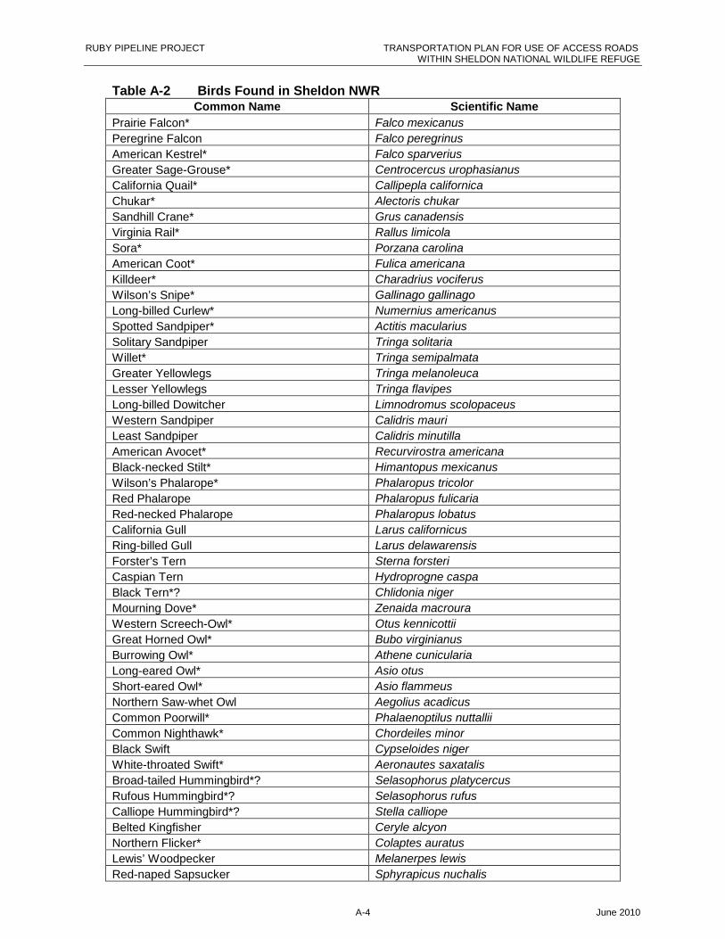
RUBY PIPELINE PROJECT TRANSPORTATION PLAN FOR USE OF ACCESS ROADSWITHIN SHELDON NATIONAL WILDLIFE REFUGE
A-4 June 2010
Table A-2 Birds Found in Sheldon NWRCommon Name Scientific Name
Prairie Falcon* Falco mexicanus
Peregrine Falcon Falco peregrinus
American Kestrel* Falco sparverius
Greater Sage-Grouse* Centrocercus urophasianus
California Quail* Callipepla californica
Chukar* Alectoris chukar
Sandhill Crane* Grus canadensis
Virginia Rail* Rallus limicola
Sora* Porzana carolina
American Coot* Fulica americana
Killdeer* Charadrius vociferus
Wilson’s Snipe* Gallinago gallinago
Long-billed Curlew* Numernius americanus
Spotted Sandpiper* Actitis macularius
Solitary Sandpiper Tringa solitaria
Willet* Tringa semipalmata
Greater Yellowlegs Tringa melanoleuca
Lesser Yellowlegs Tringa flavipes
Long-billed Dowitcher Limnodromus scolopaceus
Western Sandpiper Calidris mauri
Least Sandpiper Calidris minutilla
American Avocet* Recurvirostra americana
Black-necked Stilt* Himantopus mexicanus
Wilson’s Phalarope* Phalaropus tricolor
Red Phalarope Phalaropus fulicaria
Red-necked Phalarope Phalaropus lobatus
California Gull Larus californicus
Ring-billed Gull Larus delawarensis
Forster’s Tern Sterna forsteri
Caspian Tern Hydroprogne caspa
Black Tern*? Chlidonia niger
Mourning Dove* Zenaida macroura
Western Screech-Owl* Otus kennicottii
Great Horned Owl* Bubo virginianus
Burrowing Owl* Athene cunicularia
Long-eared Owl* Asio otus
Short-eared Owl* Asio flammeus
Northern Saw-whet Owl Aegolius acadicus
Common Poorwill* Phalaenoptilus nuttallii
Common Nighthawk* Chordeiles minor
Black Swift Cypseloides niger
White-throated Swift* Aeronautes saxatalis
Broad-tailed Hummingbird*? Selasophorus platycercus
Rufous Hummingbird*? Selasophorus rufus
Calliope Hummingbird*? Stella calliope
Belted Kingfisher Ceryle alcyon
Northern Flicker* Colaptes auratus
Lewis’ Woodpecker Melanerpes lewis
Red-naped Sapsucker Sphyrapicus nuchalis
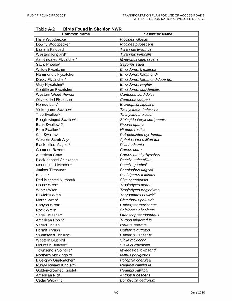
RUBY PIPELINE PROJECT TRANSPORTATION PLAN FOR USE OF ACCESS ROADSWITHIN SHELDON NATIONAL WILDLIFE REFUGE
A-5 June 2010
Table A-2 Birds Found in Sheldon NWRCommon Name Scientific Name
Hairy Woodpecker Picoides villosus
Downy Woodpecker Picoides pubescens
Eastern Kingbird Tyrannus tyrannus
Western Kingbird* Tyrannus verticalis
Ash-throated Flycatcher* Myiarchus cinerascens
Say’s Phoebe* Sayornis saya
Willow Flycatcher Empidonax t. extimus
Hammond’s Flycatcher Empidonax hammondii
Dusky Flycatcher* Empidonax hammondii/oberho.
Gray Flycatcher* Empidonax wrightii
Cordilleran Flycatcher Empidonax occidentalis
Western Wood-Pewee Cantopus sordidulus
Olive-sided Flycatcher Cantopus cooperi
Horned Lark* Eremophila alpestris
Violet-green Swallow* Tachycineta thalassina
Tree Swallow* Tachycineta bicolor
Rough-winged Swallow* Stelegidopteryx serripennis
Bank Swallow*? Riparia riparia
Barn Swallow* Hirundo rustica
Cliff Swallow* Petrochelidon pyrrhonota
Western Scrub-Jay* Aphelocoma californica
Black-billed Magpie* Pica hudsonia
Common Raven* Corvus corax
American Crow Corvus brachyrhynchos
Black-capped Chickadee Poecile atricapillus
Mountain Chickadee* Poecile gambeli
Juniper Titmouse* Baeolophus ridgwai
Bushtit* Psaltriparus minimus
Red-breasted Nuthatch Sitta canadensis
House Wren* Troglodytes aedon
Winter Wren Troglodytes troglodytes
Bewick’s Wren Thryomanes bewickii
Marsh Wren* Cistothorus palustris
Canyon Wren* Catherpes mexicanus
Rock Wren* Salpinctes obsoletus
Sage Thrasher* Oreoscoptes montanus
American Robin* Turdus migratorius
Varied Thrush Ixoreus naevius
Hermit Thrush Catharus guttatus
Swainson’s Thrush*? Catharus ustulatus
Western Bluebird Sialia mexicana
Mountain Bluebird* Sialia currucoides
Townsend’s Solitaire* Myadestes townsendi
Northern Mockingbird Mimus polyglottos
Blue-gray Gnatcatcher* Polioptila caerulea
Ruby-crowned Kinglet*? Regulus calendula
Golden-crowned Kinglet Regulus satrapa
American Pipit Anthus rubescens
Cedar Waxwing Bombycilla cedrorum
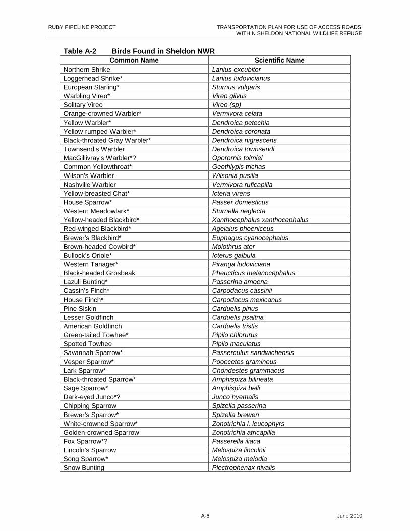
RUBY PIPELINE PROJECT TRANSPORTATION PLAN FOR USE OF ACCESS ROADSWITHIN SHELDON NATIONAL WILDLIFE REFUGE
A-6 June 2010
Table A-2 Birds Found in Sheldon NWRCommon Name Scientific Name
Northern Shrike Lanius excubitor
Loggerhead Shrike* Lanius ludovicianus
European Starling* Sturnus vulgaris
Warbling Vireo* Vireo gilvus
Solitary Vireo Vireo (sp)
Orange-crowned Warbler* Vermivora celata
Yellow Warbler* Dendroica petechia
Yellow-rumped Warbler* Dendroica coronata
Black-throated Gray Warbler* Dendroica nigrescens
Townsend’s Warbler Dendroica townsendi
MacGillivray's Warbler*? Oporornis tolmiei
Common Yellowthroat* Geothlypis trichas
Wilson's Warbler Wilsonia pusilla
Nashville Warbler Vermivora ruficapilla
Yellow-breasted Chat* Icteria virens
House Sparrow* Passer domesticus
Western Meadowlark* Sturnella neglecta
Yellow-headed Blackbird* Xanthocephalus xanthocephalus
Red-winged Blackbird* Agelaius phoeniceus
Brewer’s Blackbird* Euphagus cyanocephalus
Brown-headed Cowbird* Molothrus ater
Bullock’s Oriole* Icterus galbula
Western Tanager* Piranga ludoviciana
Black-headed Grosbeak Pheucticus melanocephalus
Lazuli Bunting* Passerina amoena
Cassin’s Finch* Carpodacus cassinii
House Finch* Carpodacus mexicanus
Pine Siskin Carduelis pinus
Lesser Goldfinch Carduelis psaltria
American Goldfinch Carduelis tristis
Green-tailed Towhee* Pipilo chlorurus
Spotted Towhee Pipilo maculatus
Savannah Sparrow* Passerculus sandwichensis
Vesper Sparrow* Pooecetes gramineus
Lark Sparrow* Chondestes grammacus
Black-throated Sparrow* Amphispiza bilineata
Sage Sparrow* Amphispiza belli
Dark-eyed Junco*? Junco hyemalis
Chipping Sparrow Spizella passerina
Brewer’s Sparrow* Spizella breweri
White-crowned Sparrow* Zonotrichia l. leucophyrs
Golden-crowned Sparrow Zonotrichia atricapilla
Fox Sparrow*? Passerella iliaca
Lincoln’s Sparrow Melospiza lincolnii
Song Sparrow* Melospiza melodia
Snow Bunting Plectrophenax nivalis
RUBY PIPELINE PROJECT TRANSPORTATION PLAN FOR USE OF ACCESS ROADSWITHIN SHELDON NATIONAL WILDLIFE REFUGE
A-7 June 2010
Table A-2 Birds Found in Sheldon NWRCommon Name Scientific Name
NOTES:
Source: USGS 2006Common names updated by current naming standards and scientific names included by Ecology and Environment,Inc.Notes:* - Birds known to nest in the area*? – Birds thought to nest in the area http://www.npwrc.usgs.gov/resource/birds/chekbird/r1/sheldon.htm
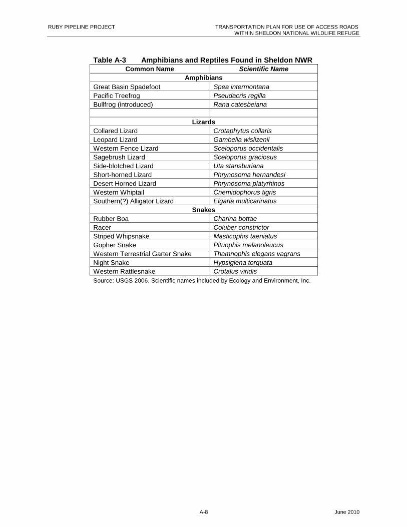
RUBY PIPELINE PROJECT TRANSPORTATION PLAN FOR USE OF ACCESS ROADSWITHIN SHELDON NATIONAL WILDLIFE REFUGE
A-8 June 2010
Table A-3 Amphibians and Reptiles Found in Sheldon NWRCommon Name Scientific Name
Amphibians
Great Basin Spadefoot Spea intermontana
Pacific Treefrog Pseudacris regilla
Bullfrog (introduced) Rana catesbeiana
Lizards
Collared Lizard Crotaphytus collaris
Leopard Lizard Gambelia wislizenii
Western Fence Lizard Sceloporus occidentalis
Sagebrush Lizard Sceloporus graciosus
Side-blotched Lizard Uta stansburiana
Short-horned Lizard Phrynosoma hernandesi
Desert Horned Lizard Phrynosoma platyrhinos
Western Whiptail Cnemidophorus tigris
Southern(?) Alligator Lizard Elgaria multicarinatus
Snakes
Rubber Boa Charina bottae
Racer Coluber constrictor
Striped Whipsnake Masticophis taeniatus
Gopher Snake Pituophis melanoleucus
Western Terrestrial Garter Snake Thamnophis elegans vagrans
Night Snake Hypsiglena torquata
Western Rattlesnake Crotalus viridis
Source: USGS 2006. Scientific names included by Ecology and Environment, Inc.
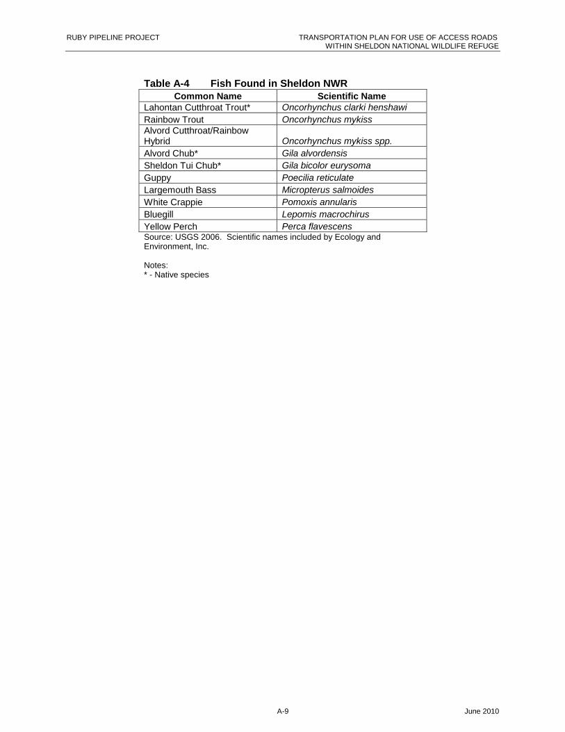
RUBY PIPELINE PROJECT TRANSPORTATION PLAN FOR USE OF ACCESS ROADSWITHIN SHELDON NATIONAL WILDLIFE REFUGE
A-9 June 2010
Table A-4 Fish Found in Sheldon NWRCommon Name Scientific Name
Lahontan Cutthroat Trout* Oncorhynchus clarki henshawi
Rainbow Trout Oncorhynchus mykissAlvord Cutthroat/RainbowHybrid Oncorhynchus mykiss spp.
Alvord Chub* Gila alvordensis
Sheldon Tui Chub* Gila bicolor eurysoma
Guppy Poecilia reticulate
Largemouth Bass Micropterus salmoides
White Crappie Pomoxis annularis
Bluegill Lepomis macrochirus
Yellow Perch Perca flavescensSource: USGS 2006. Scientific names included by Ecology andEnvironment, Inc.
Notes:* - Native species

RUBY PIPELINE PROJECT TRANSPORTATION PLAN FOR USE OF ACCESS ROADSWITHIN SHELDON NATIONAL WILDLIFE REFUGE
A-10 June 2010
Table A-5 Species of Conservation Priority in Nevada
Common Name Scientific Name
BIRDS
Ash-throated Flycatcher Myiarchus cinerascens
Bank Swallow Riparia riparia
Black-bellied Plover Pluvialis squatarola
Black-crowned Night-Heron Nycticorax nycticorax
Black-headed Grosbeak Pheucticus melanocephalus
Black-tailed Gnatcatcher Polioptila melanura
Black-throated Gray Warbler Dendroica nigrescens
Black-throated Sparrow Amphispiza bilineata
Blue Grosbeak Guiraca caerulea
Bonaparte’s Gull Larus philadelphia
Broad-tailed Hummingbird Selasphorus platycercus
Brown-crested Flycatcher Myiarchus tyrannulus
Cactus Wren Campylorhynchus brunneicapillus
California Gull Larus californicus
Calliope Hummingbird Stellula calliope
Clark’s Nutcracker Nucifraga columbiana
Cooper’s Hawk Accipiter cooperii
Dunlin Calidris alpina
Dusky Flycatcher Empidonax oberholseri
Flammulated Owl Otus flammeolus
Fox Sparrow Passerella iliaca
Grasshopper Sparrow Ammodramus savannarum
Gray Flycatcher Empidonax wrightii
Great Blue Heron Ardea herodias
Greater Yellowlegs Tringa melanoleuca
Green-tailed Towhee Pipilo chlorurus
Juniper Titmouse Baeolophus ridgwayi
Lesser Nighthawk Chordeiles acutipennis
Macgillivray’s Warbler Oporornis tolmiei
Marbled Godwit Limosa fedoa
Mountain Bluebird Sialia currucoides
Nashville Warbler Vermivora ruficapilla
Northern Pygmy-owl Glaucidium californicum
Orange-crowned Warbler Vermivora celata
Prairie Falcon Falco mexicanus
Red-naped Sapsucker Sphyrapicus nuchalis
Sage Thrasher Oreoscoptes montanus
Spotted Sandpiper Tringa macularia
Steller’s Jay Cyanocitta stelleri
Hooded Oriole Icterus cucullatus

RUBY PIPELINE PROJECT TRANSPORTATION PLAN FOR USE OF ACCESS ROADSWITHIN SHELDON NATIONAL WILDLIFE REFUGE
A-11 June 2010
Table A-5 Species of Conservation Priority in Nevada
Common Name Scientific Name
Summer Tanager Piranga rubra
Swainson’s Thrush Catharus ustulatus
Three-toed Woodpecker Picoides tridactylus
Vesper Sparrow Pooecetes gramineus
Western Bluebird Sialia mexicana
Western Sandpiper Calidris mauri
Western Scrub Jay Aphelocoma californica
Williamson’s Sapsucker Sphyrapicus thyroideus
Wilson’s Warbler Wilsonia pusilla
Yellow-breasted Chat Icteria virens
Yellow-headed Blackbird Xanthocephalus xanthocephalus
MAMMALS
Allen’s big-eared bat Idionycteris phyllotis
Allen’s chipmunk Tamias senex
American pika Ochotona princeps
American marten Martes americana
Aplodontia Aplodontia rufa
Mule deer Odocoileus hemionus
Ash Meadows montane vole Microtus montanus nevadensis
Big free-tailed bat Nyctinomops macrotis
Ringtail Bassaryscus astutus
Broad-footed mole Scapanus latimanus
Brush mouse Peromyscus boylei
California kangaroo rat Dipodomys californicus
California leaf-nosed bat Macrotus californicus
Cave myotis Myotis velifer
Desert kangaroo rat Dipodomys deserti
Desert pocket mouse Chaetodipus pencillatus
Desert Valley kangaroo mouse Microdipidops megacephalus nasutus
Fish Spring pocket gopher Thomomys bottae abstrusus
Fletcher dark kangaroo mouse Microdipidops megacephalus albiventer
Fringed myotis Myotis thysanodes
Hidden Forest Uinta chipmunk Tamias umbrinus nevadensis
Hoary bat Lasiurus cinereus
Humboldt yellow-pine chipmunk Tamias amoenus celeris
Inyo shrew Sorex tenellus
Little brown myotis Myotis lucifrugus
Long-eared myotis Myotis evotis
Merriam’s shrew Sorex merriami
Montane shrew Sorex monticolus
Mountain pocket gopher Thomomys monticola
Nelson bighorn sheep Ovis canadensis nelsoni
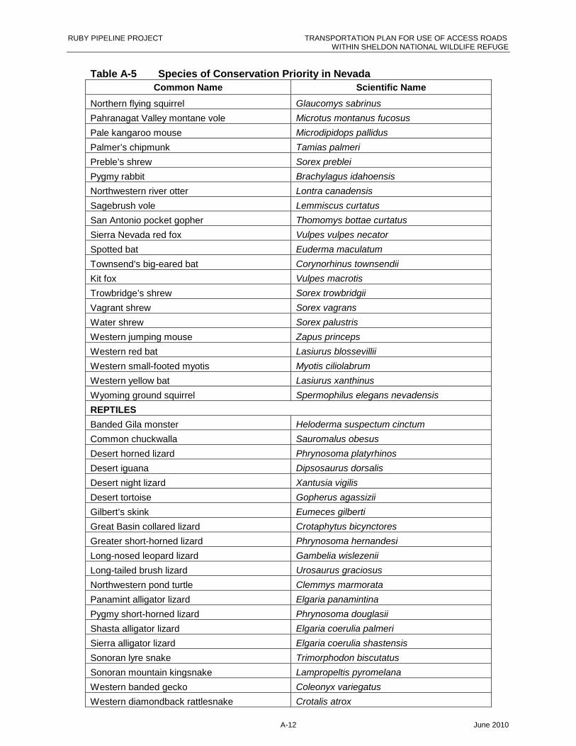
RUBY PIPELINE PROJECT TRANSPORTATION PLAN FOR USE OF ACCESS ROADSWITHIN SHELDON NATIONAL WILDLIFE REFUGE
A-12 June 2010
Table A-5 Species of Conservation Priority in Nevada
Common Name Scientific Name
Northern flying squirrel Glaucomys sabrinus
Pahranagat Valley montane vole Microtus montanus fucosus
Pale kangaroo mouse Microdipidops pallidus
Palmer’s chipmunk Tamias palmeri
Preble’s shrew Sorex preblei
Pygmy rabbit Brachylagus idahoensis
Northwestern river otter Lontra canadensis
Sagebrush vole Lemmiscus curtatus
San Antonio pocket gopher Thomomys bottae curtatus
Sierra Nevada red fox Vulpes vulpes necator
Spotted bat Euderma maculatum
Townsend’s big-eared bat Corynorhinus townsendii
Kit fox Vulpes macrotis
Trowbridge’s shrew Sorex trowbridgii
Vagrant shrew Sorex vagrans
Water shrew Sorex palustris
Western jumping mouse Zapus princeps
Western red bat Lasiurus blossevillii
Western small-footed myotis Myotis ciliolabrum
Western yellow bat Lasiurus xanthinus
Wyoming ground squirrel Spermophilus elegans nevadensis
REPTILES
Banded Gila monster Heloderma suspectum cinctum
Common chuckwalla Sauromalus obesus
Desert horned lizard Phrynosoma platyrhinos
Desert iguana Dipsosaurus dorsalis
Desert night lizard Xantusia vigilis
Desert tortoise Gopherus agassizii
Gilbert’s skink Eumeces gilberti
Great Basin collared lizard Crotaphytus bicynctores
Greater short-horned lizard Phrynosoma hernandesi
Long-nosed leopard lizard Gambelia wislezenii
Long-tailed brush lizard Urosaurus graciosus
Northwestern pond turtle Clemmys marmorata
Panamint alligator lizard Elgaria panamintina
Pygmy short-horned lizard Phrynosoma douglasii
Shasta alligator lizard Elgaria coerulia palmeri
Sierra alligator lizard Elgaria coerulia shastensis
Sonoran lyre snake Trimorphodon biscutatus
Sonoran mountain kingsnake Lampropeltis pyromelana
Western banded gecko Coleonyx variegatus
Western diamondback rattlesnake Crotalis atrox
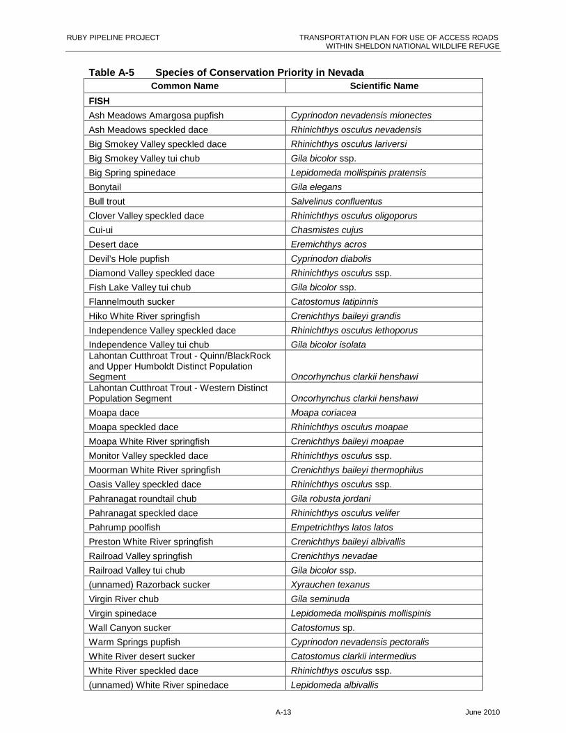
RUBY PIPELINE PROJECT TRANSPORTATION PLAN FOR USE OF ACCESS ROADSWITHIN SHELDON NATIONAL WILDLIFE REFUGE
A-13 June 2010
Table A-5 Species of Conservation Priority in Nevada
Common Name Scientific Name
FISH
Ash Meadows Amargosa pupfish Cyprinodon nevadensis mionectes
Ash Meadows speckled dace Rhinichthys osculus nevadensis
Big Smokey Valley speckled dace Rhinichthys osculus lariversi
Big Smokey Valley tui chub Gila bicolor ssp.
Big Spring spinedace Lepidomeda mollispinis pratensis
Bonytail Gila elegans
Bull trout Salvelinus confluentus
Clover Valley speckled dace Rhinichthys osculus oligoporus
Cui-ui Chasmistes cujus
Desert dace Eremichthys acros
Devil’s Hole pupfish Cyprinodon diabolis
Diamond Valley speckled dace Rhinichthys osculus ssp.
Fish Lake Valley tui chub Gila bicolor ssp.
Flannelmouth sucker Catostomus latipinnis
Hiko White River springfish Crenichthys baileyi grandis
Independence Valley speckled dace Rhinichthys osculus lethoporus
Independence Valley tui chub Gila bicolor isolataLahontan Cutthroat Trout - Quinn/BlackRockand Upper Humboldt Distinct PopulationSegment Oncorhynchus clarkii henshawiLahontan Cutthroat Trout - Western DistinctPopulation Segment Oncorhynchus clarkii henshawi
Moapa dace Moapa coriacea
Moapa speckled dace Rhinichthys osculus moapae
Moapa White River springfish Crenichthys baileyi moapae
Monitor Valley speckled dace Rhinichthys osculus ssp.
Moorman White River springfish Crenichthys baileyi thermophilus
Oasis Valley speckled dace Rhinichthys osculus ssp.
Pahranagat roundtail chub Gila robusta jordani
Pahranagat speckled dace Rhinichthys osculus velifer
Pahrump poolfish Empetrichthys latos latos
Preston White River springfish Crenichthys baileyi albivallis
Railroad Valley springfish Crenichthys nevadae
Railroad Valley tui chub Gila bicolor ssp.
(unnamed) Razorback sucker Xyrauchen texanus
Virgin River chub Gila seminuda
Virgin spinedace Lepidomeda mollispinis mollispinis
Wall Canyon sucker Catostomus sp.
Warm Springs pupfish Cyprinodon nevadensis pectoralis
White River desert sucker Catostomus clarkii intermedius
White River speckled dace Rhinichthys osculus ssp.
(unnamed) White River spinedace Lepidomeda albivallis
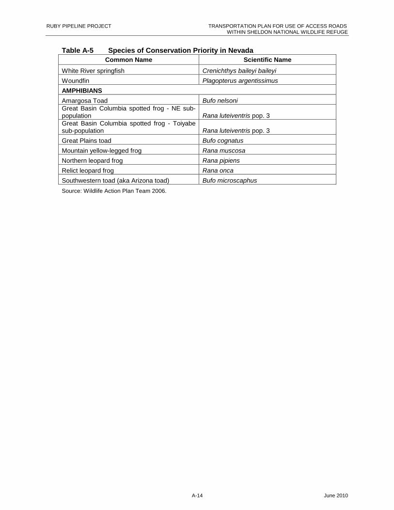
RUBY PIPELINE PROJECT TRANSPORTATION PLAN FOR USE OF ACCESS ROADSWITHIN SHELDON NATIONAL WILDLIFE REFUGE
A-14 June 2010
Table A-5 Species of Conservation Priority in Nevada
Common Name Scientific Name
White River springfish Crenichthys baileyi baileyi
Woundfin Plagopterus argentissimus
AMPHIBIANS
Amargosa Toad Bufo nelsoniGreat Basin Columbia spotted frog - NE sub-population Rana luteiventris pop. 3Great Basin Columbia spotted frog - Toiyabesub-population Rana luteiventris pop. 3
Great Plains toad Bufo cognatus
Mountain yellow-legged frog Rana muscosa
Northern leopard frog Rana pipiens
Relict leopard frog Rana onca
Southwestern toad (aka Arizona toad) Bufo microscaphus
Source: Wildlife Action Plan Team 2006.

RUBY PIPELINE PROJECT TRANSPORTATION PLAN FOR USE OF ACCESS ROADSWITHIN SHELDON NATIONAL WILDLIFE REFUGE
A-15 June 2010
Table A-6 Special Status Plant Species that may occur in the Project Area in NevadaStatus
Common Name Scientific NameUSFWS
WinnemuccaDistrict(BLM)
Surprise FieldOffice (BLM)
Nevada StateNDOW
Adobe parsley Lomatium roseanum SBarneby stemflower Caulanthus barnebyi SBlack Rock potentilla Potentilla basaltica SCandelariablazingstar
Mentzelia candelariaeS
Casick hyssop Agastache cusickii SCordeliabeardtongue
Penstemon floribundusS
Crosby buckwheat Eriogonum crosbyae S SGeyer’s milk-vetch Astragalus geyeri var.
geyeriS
Goodrich biscuitroot Cynopterus goodrichii SGoose Creekmilkvetch
Astragalus anserinusPet
Green buckwheat Eriogonum umbellatumvar. gladerrimum
S
Grimy ivesia Ivesia rhypara var.rhypara
S S
Holmgrensnelowskia
Smelowskia holmgreniiS
Howell’sthelypodium
Thelypodium howellii varhowellii
S
Little ricegrass Oryzopsis exigua SLahontan Basinbuckwheat
Eriogonum rubricauleS
Lahontanbeardtongue
Penstemon palmeri var.macranthus
S
Lahontan indigobush
Psorothamis kingiiS
Lahontan milkvetch Astragalus porrectus SLemmon buckwheat Eriogonum lemmonii SLonesome milkvetch Astragalus solitaries SModoc Bedstraw Galium glabrescens ssp.
modocenseNevada dunebeardtongue
Penstemon arenariusS
Obscurescorpionflower
Phacelia inconspicuaS SP
Oryctes Oryctes nevadensis SOsgood Mountainmilkvetch
Astragalus yoder-williamsii
S SP
Owyhee pricklyphlox
Leptodactylong glabrumS
Playa phacelia Phacelia inundata SProstrate buckwheat Eriogonum prociduum SPueblo Valleypeppergrass
Lepidium montanum var.nevadense
S
Rattlesnakestickseed
Hackelia ophiobiaS
Ravendale skullcap Scutellariaholmgreniorum
S

RUBY PIPELINE PROJECT TRANSPORTATION PLAN FOR USE OF ACCESS ROADSWITHIN SHELDON NATIONAL WILDLIFE REFUGE
A-16 June 2010
Table A-6 Special Status Plant Species that may occur in the Project Area in NevadaStatus
Common Name Scientific NameUSFWS
WinnemuccaDistrict(BLM)
Surprise FieldOffice (BLM)
Nevada StateNDOW
Sagebrush loeflingia Loeflingia squarrosa varartemisiarum
S
Sand cholla Opuntia pulchella S SPSchoolcraftbuckwheat
Eriogonum microthecumssp. Schoolcraftii
S
Schoolcraft catseye Cryptantha schoolcraftii S SSmooth stickleaf Mentzelia mollis SSoldier meadowscinquefoil/Black rockpotentilla
Potentilla basalticaFC
Steamboatbuckwheat
Erigeron ovalifolium var.williamsiae
FE
Succor Creekparsley
Lomatium packardiaeS
Sucksdorf milkvetch Astragalus pulsiferaevar. sucksdorfii
S
Tahoe yellow cress Rorippa subumbellata FCTiehm milkvetch Astragalus tiehmii S SWarner Mountainbedstraw
Galium serpenticum ssp.Warnerense
S
Webber’s ivesia Ivesia webberi FCWindlovingbuckwheat
Eriogonumanemophilum
S
Winged milkvetch Astragalus pterocarpus SKEY
E = State EndangeredFC = Federal Candidate for protection under the ESAFE Federal Endangered
Pet = Petitioned for listing under the ESAS = BLM Special Status species (includes BLM Sensitive Species, Nevada state-protected species, Nevada
Natural Heritage sensitive species)SP = State protected (under NAC 527.010)
T = State Threatened

RUBY PIPELINE PROJECT TRANSPORTATION PLAN FOR USE OF ACCESS ROADSWITHIN SHELDON NATIONAL WILDLIFE REFUGE
B-17 June 2010
Appendix B Figures
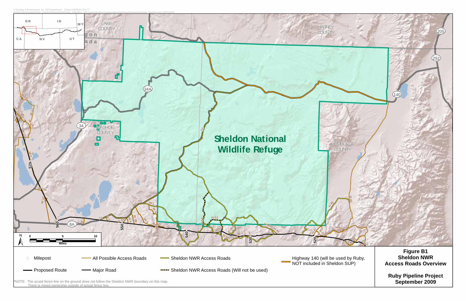
140
8A
34A
205
292
34
Sheldon NationalWildlife Refuge
HUMBOLDTCOUNTY
WASHOECOUNTY
HARNEYCOUNTY
LAKECOUNTY
OO rr ee gg oo nnNN ee vv aa dd aa
W-15
W-2A
H-42
W-3A
H-51
W-16
H-45AH-50A
W-8
W-5
H-52
W-13A
W-10
W-4
H-49
W-4A
W-7
W-10A
H-48
W-9
H-50
H-47
W-3B
H-46B
H-43
W-14A
H-53
H-54
H-45H-46
A
W-1
W-14
H-40
W-3W-2
W-13
H-46
140
8a
8a
530
520
570
560
550
540
© Ecology & Environment, Inc. GIS Department Project #002624.CI10.77\Prtbhp1\gis\Portland\Ruby_Pipeline\Maps\MXDs\Phase_2\Sheldon_Alternative\SheldonTransportationPlanReportFigures\Overview_Sheldon.mxd 09/25/2009
Milepost
Proposed Route
All Possible Access Roads
Major Road
Sheldon NWR Access Roads
Sheldon NWR Access Roads (Will not be used)
Highway 140 (will be used by Ruby,NOT included in Sheldon SUP)
*NOTE: The acutal fence line on the ground does not follow the Sheldon NWR boundary on this map. There is mixed ownership outside of actual fence line.
Figure B1Sheldon NWR
Access Roads Overview
Ruby Pipeline ProjectSeptember 2009
N VN V
I DI D
U TU T
O RO R
C AC A
W YW Y
0 5 10
Miles
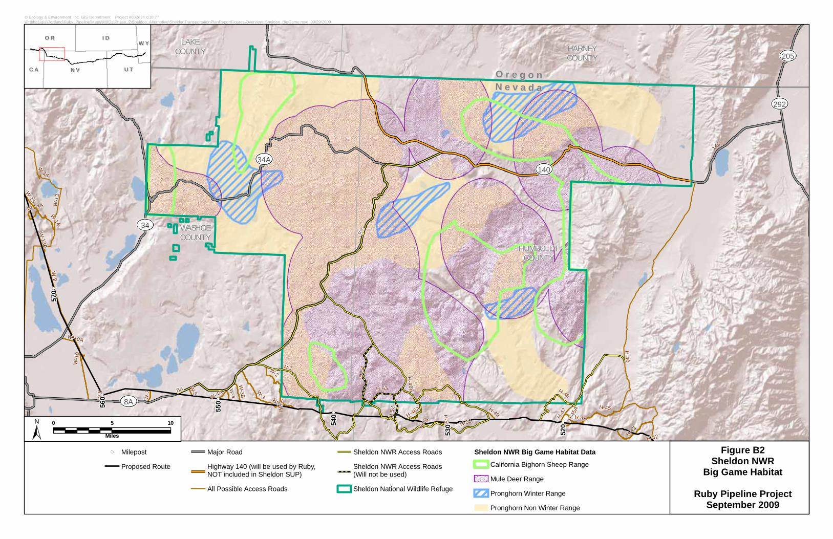
140
8A
34A
205
292
34
HUMBOLDTCOUNTY
WASHOECOUNTY
HARNEYCOUNTY
LAKECOUNTY
OO rr ee gg oo nnNN ee vv aa dd aa
W-2A
H-42
W-3A
H-51
W-16
H-45AH-50A
W-8
W-5
H-52
W-13A
W-10
W-4
H-49
W-4A
W-7
W-10A
H-48
W-9
H-50 H-47
W-3B
H-46BH-43
W-14A
H-53
H-54
H-45H-46A
W-1
W-14
H-40
W-3
W-2
W-13
H-46
W-15
140
8a
8a
530
520
570
560
550
540
© Ecology & Environment, Inc. GIS Department Project #002624.ci10.77\Prtbhp1\gis\Portland\Ruby_Pipeline\Maps\MXDs\Phase_2\Sheldon_Alternative\SheldonTransportationPlanReportFigures\Overview_Sheldon_BigGame.mxd 09/29/2009
MilepostProposed Route
Major RoadHighway 140 (will be used by Ruby,NOT included in Sheldon SUP)All Possible Access Roads
Sheldon NWR Access RoadsSheldon NWR Access Roads(Will not be used)Sheldon National Wildlife Refuge
Sheldon NWR Big Game Habitat Data
California Bighorn Sheep RangeMule Deer RangePronghorn Winter RangePronghorn Non Winter Range
Figure B2Sheldon NWR
Big Game Habitat
Ruby Pipeline ProjectSeptember 2009
N VN V
I DI D
U TU T
O RO R
C AC A
W YW Y
0 5 10
Miles

140
8A
34A
205
292
34
HUMBOLDTCOUNTY
WASHOECOUNTY
HARNEYCOUNTY
LAKECOUNTY
OO rr ee gg oo nnNN ee vv aa dd aa
W-2A
H-42
W-3A
H-51
W-16
H-45AH-50A
W-8
W-5
H-52
W-13A
W-10
W-4
H-49
W-4A
W-7
W-10A
H-48
W-9
H-50 H-47
W-3B
H-46BH-43
W-14A
H-53
H-54
H-45H-46A
W-1
W-14
H-40
W-3
W-2
W-13
H-46
W-15
140
8a
8a
530
520
570
560
550
540
© Ecology & Environment, Inc. GIS Department Project #002624.ci10.77\Prtbhp1\gis\Portland\Ruby_Pipeline\Maps\MXDs\Phase_2\Sheldon_Alternative\SheldonTransportationPlanReportFigures\Overview_Sheldon_PygmyRabbit.mxd 09/29/2009
MilepostProposed Route
Major RoadHighway 140 (will be used by Ruby,NOT included in Sheldon SUP)All Possible Access Roads
Sheldon NWR Access RoadsSheldon NWR Access Roads(Will not be used)Sheldon National Wildlife Refuge
Ruby Field Data
Specimen Sighting (3)
Pygmy Rabbit Burrow Complex (Currently Active)
Sheldon NWR Data
Pygmy Rabbit Areas
Figure B3Sheldon NWRPygmy Rabbit
Ruby Pipeline ProjectSeptember 2009
N VN V
I DI D
U TU T
O RO R
C AC A
W YW Y
0 5 10
Miles
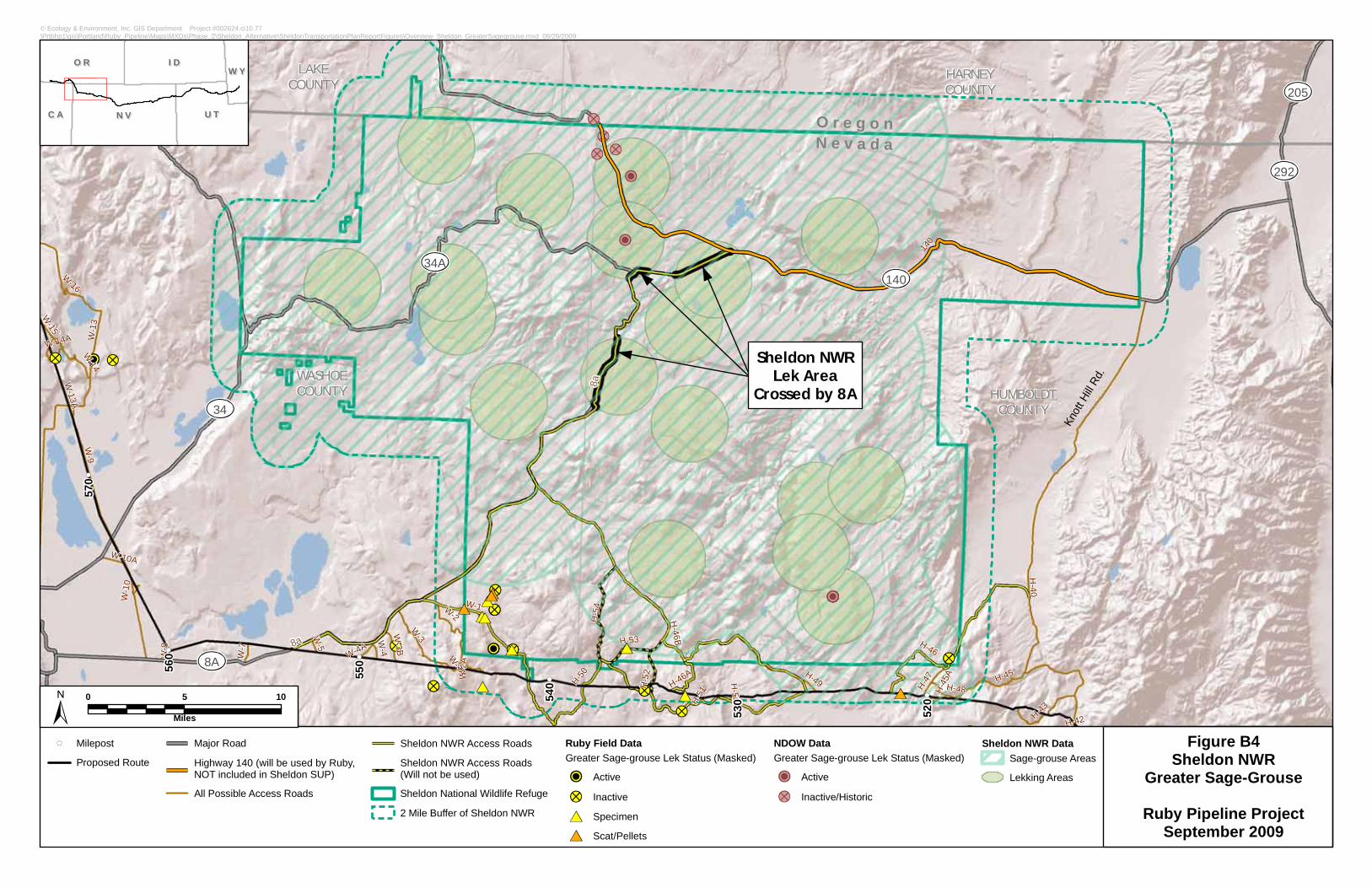
Knott
Hill R
d. Sheldon NWR
Lek AreaCrossed by 8A
140
8A
34A
205
292
34HUMBOLDT
COUNTY
WASHOECOUNTY
HARNEYCOUNTY
LAKECOUNTY
OO rr ee gg oo nnNN ee vv aa dd aa
W-2A
H-42
W-3A
H-51
W-16
H-45AH-50A
W-8
W-5
H-52
W-13A
W-10
W-4
H-49
W-4A
W-7
W-10A
H-48
W-9
H-50
H-47
W-3B
H-46BH-43
W-14A
H-53
H-54
H-45H-46A
W-1
W-14
H-40
W-3
W-2
W-13
H-46
W-15
140
8a
8a
530
520
570
560
550
540
© Ecology & Environment, Inc. GIS Department Project #002624.ci10.77\Prtbhp1\gis\Portland\Ruby_Pipeline\Maps\MXDs\Phase_2\Sheldon_Alternative\SheldonTransportationPlanReportFigures\Overview_Sheldon_GreaterSagegrouse.mxd 09/29/2009
MilepostProposed Route
Major RoadHighway 140 (will be used by Ruby,NOT included in Sheldon SUP)All Possible Access Roads
Sheldon NWR Access RoadsSheldon NWR Access Roads(Will not be used)Sheldon National Wildlife Refuge2 Mile Buffer of Sheldon NWR
Ruby Field DataGreater Sage-grouse Lek Status (Masked)
ActiveInactiveSpecimenScat/Pellets
NDOW DataGreater Sage-grouse Lek Status (Masked)
ActiveInactive/Historic
Sheldon NWR DataSage-grouse AreasLekking Areas
Figure B4Sheldon NWR
Greater Sage-Grouse
Ruby Pipeline ProjectSeptember 2009
N VN V
I DI D
U TU T
O RO R
C AC A
W YW Y
0 5 10
Miles
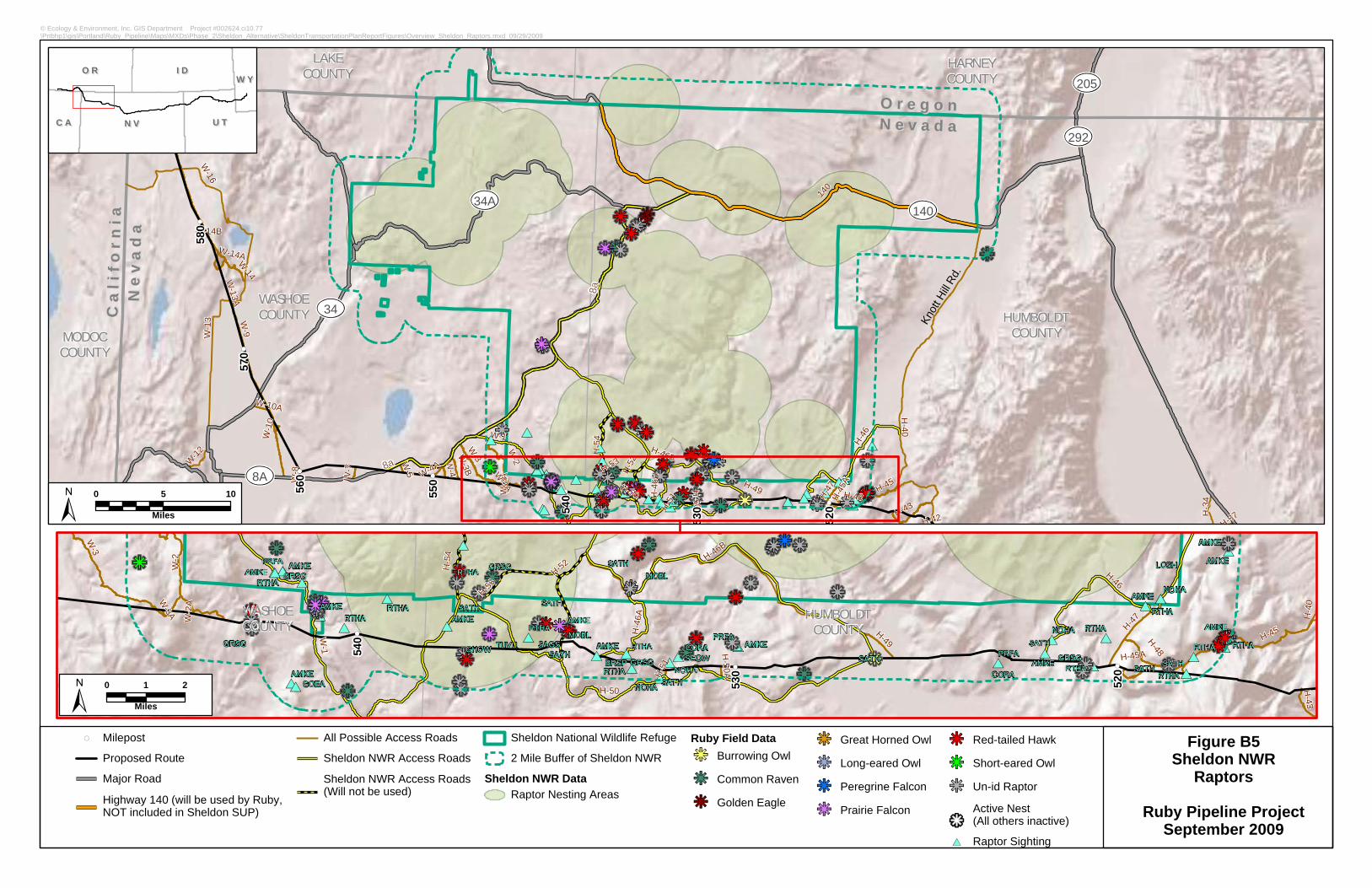
WASHOECOUNTY
HUMBOLDTCOUNTY H-49
W-2
H-46
A
W-3
W-1
W-2A
W-3A
H-51 H-45AH-50A
H-40
H-52
H-43
H-48
H-50
H-47
H-54 H-46B
H-46
H-53
H-45
520
530
540 TUVU
SATH
GHOW
RTHA
RTHA NOHA
CORASEOW
AMKEPRFAPRFA
CORA RTHA
RTHA
AMKEAMKE
MOBL
GRSGRTHA MOBLSATH
SATH
AMKE
RTHA
AMKESAGSBRSP
RTHA
LOSH
AMKE NOHA
RTHA
GRSGAMKE
RTHA
GRSGRTHA
NOHAAMKE AMKE
PRFA AMKE
RTHAAMKE
SATH
RTHA
SATHSATH
SATHNOHA
SATHGRSG
AMKEGOEA
AMKERTHA
GRSG
SATH
© Ecology & Environment, Inc. GIS Department Project #002624.ci10.77\Prtbhp1\gis\Portland\Ruby_Pipeline\Maps\MXDs\Phase_2\Sheldon_Alternative\SheldonTransportationPlanReportFigures\Overview_Sheldon_Raptors.mxd 09/29/2009
MilepostProposed RouteMajor RoadHighway 140 (will be used by Ruby,NOT included in Sheldon SUP)
All Possible Access RoadsSheldon NWR Access RoadsSheldon NWR Access Roads(Will not be used)
Sheldon National Wildlife Refuge2 Mile Buffer of Sheldon NWR
Sheldon NWR DataRaptor Nesting Areas
Ruby Field DataBurrowing OwlCommon RavenGolden Eagle
Great Horned OwlLong-eared OwlPeregrine FalconPrairie Falcon
Red-tailed HawkShort-eared OwlUn-id RaptorActive Nest(All others inactive)Raptor Sighting
Figure B5Sheldon NWR
Raptors
Ruby Pipeline ProjectSeptember 2009
Knott
Hill R
d.
34
8A
14034A
205
299
292
MODOCCOUNTY
HUMBOLDTCOUNTY
WASHOECOUNTY
HARNEYCOUNTY
LAKECOUNTY
OO rr ee gg oo nnCC
aall ii
ff oorr
nnii aa
NNee
vvaa
ddaa
NN ee vv aa dd aa
L-1D
W-2A
W-14B
W-15A
H-42
W-3A
L-1F
H-51 H-4
5A
H-37
H-50A
W-8 W-5 H-5
2
W-13A
W-10
W-4W-12
H-49W-4A
W-7
L-1B
W-10A
H-48
W-9
W-16
H-50 H-47
W-3B
H-46B
H-43 H-34
W-14A
H-53
H-54
H-45
H-46
A
W-1
W-15
W-14
H-40
W-3 W-2H-4
6
W-13
140
L-1EL-1A
8a
8a
580
590
570
520
560
550
540
530
N VN V
I DI D
U TU T
O RO R
C AC A
W YW Y
0 5 10
Miles
0 1 2
Miles

Wetland:WW-106-003
Wetland: WW-155-009
Wetland: WW-155-010
Wetland: WW-155-011
Wetland: WW-155-012
H-53
H-46
A
8a
H-50
H-52
H-54
W-1
H-46
H-46B
© Ecology & Environment, Inc. GIS Department Project #002624.ci10.77\Prtbhp1\gis\Portland\Ruby_Pipeline\Maps\MXDs\Phase_2\Sheldon_Alternative\SheldonTransportationPlanReportFigures\Overview_Sheldon_HydroFeatures.mxd 09/30/2009
MilepostProposed Route
Major RoadHighway 140 (will be used by Ruby,NOT included in Sheldon SUP)All Possible Access Roads
Sheldon NWR Access RoadsSheldon NWR Access Roads(Will not be used)Sheldon National Wildlife Refuge
Ruby Field Data
WetlandStream
Ruby Field Data
Culvert present
Seep/Spring
Figure B7Sheldon NWR
Hydrological Features
Ruby Pipeline ProjectSeptember 2009
Knott
Hill R
d.
34
8A
14034A
299
292
205
HUMBOLDTCOUNTY
WASHOECOUNTY
HARNEYCOUNTY
LAKECOUNTY
CCaa
ll iiff oo
rrnn
ii aaOO rr ee gg oo nn
NNee
vvaa
ddaa
NN ee vv aa dd aa
L-1A
H-5 45A
L-1D
W-2A
W-14B
W-15A
L-1E
W-3A
L-1F
H-43
W-8
H-34
W-5
W-13A
W-10
W-4
W-12
H-49W-4AW-
7
L-1B
W-10A
H-48
W-9
H-52
H-47
W-3B
H-46B
W-14A
H-53
H-54
H-45
H-46
A
W-1
W-15
W-14
W-16
H-40
W-3
W-2H-46
H-50
W-13
140
8a
550
40
590
580
570
560
N VN V
I DI D
U TU T
O RO R
C AC A
W YW Y
0 5 10
Miles
0 1 2
Miles
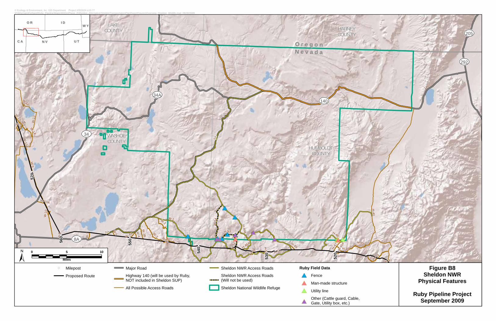
140
8A
34A
205
292
34
HUMBOLDTCOUNTY
WASHOECOUNTY
HARNEYCOUNTY
LAKECOUNTY
OO rr ee gg oo nnNN ee vv aa dd aa
W-2A
H-42
W-3A
H-51
W-16
H-45AH-50A
W-8
W-5
H-52
W-13A
W-10
W-4
H-49
W-4A
W-7
W-10A
H-48
W-9
H-50 H-47
W-3B
H-46BH-43
W-14A
H-53
H-54
H-45H-46A
W-1
W-14
H-40
W-3
W-2
W-13
H-46
W-15
140
8a
8a
530
520
570
560
550
540
© Ecology & Environment, Inc. GIS Department Project #002624.ci10.77\Prtbhp1\gis\Portland\Ruby_Pipeline\Maps\MXDs\Phase_2\Sheldon_Alternative\SheldonTransportationPlanReportFigures\Overview_Sheldon_Wildlife.mxd 09/30/2009
MilepostProposed Route
Major RoadHighway 140 (will be used by Ruby,NOT included in Sheldon SUP)All Possible Access Roads
Sheldon NWR Access RoadsSheldon NWR Access Roads(Will not be used)Sheldon National Wildlife Refuge
Ruby Field Data
FenceMan-made structureUtility lineOther (Cattle guard, Cable,Gate, Utility box, etc.)
Figure B8Sheldon NWR
Physical Features
Ruby Pipeline ProjectSeptember 2009
N VN V
I DI D
U TU T
O RO R
C AC A
W YW Y
0 5 10
Miles

140
8A
34A
205
292
34
HUMBOLDTCOUNTY
WASHOECOUNTY
HARNEYCOUNTY
LAKECOUNTY
OO rr ee gg oo nnNN ee vv aa dd aa
W-2A
H-42
W-3A
H-51
W-16
H-45AH-50A
W-8
W-5 H-52
W-13A
W-10
W-4
H-49
W-4A
W-7
W-10A
H-48
W-9
H-50
H-47
W-3B
H-46BH-43
W-14A
H-53
H-54
H-45H-46A
W-1
W-14
H-40
W-3
W-2
W-13
H-46
W-15
140
8a
8a
530
520
570
560
550
540
© Ecology & Environment, Inc. GIS Department Project #002624.ci10.77\Prtbhp1\gis\Portland\Ruby_Pipeline\Maps\MXDs\Phase_2\Sheldon_Alternative\SheldonTransportationPlanReportFigures\Overview_Sheldon_Vegetation.mxd 09/30/2009
MilepostProposed RouteMajor RoadHighway 140 (will be used by Ruby,NOT included in Sheldon SUP)All Possible Access Roads
Sheldon NWR Access RoadsSheldon NWR Access Roads(Will not be used)Sheldon National Wildlife Refuge
Ruby Field Data
Canada ThistleMalta Star thistleScotch Thistle
Sheldon NWR Vegetation Classification
ASPENBASIN BIG SAGEBRUSHCANYON VEGETATIONEMERGENT VEGETATIONGREASEWOOD
JUNIPERLOW SAGEBRUSHMOUNTAIN BIG SAGEBRUSHMOUNTAIN MAHOGANYMOUNTAIN SHRUBPERENNIAL GRASSLAND
SALT DESERTSPARSE VEGETATIONWATERWET MEADOWWYOMING BIG SAGEBRUSHUNCLASSIFIED
Figure B9Sheldon NWRVegetation andNoxious Weeds
Ruby Pipeline ProjectSeptember 2009
N VN V
I DI D
U TU T
O RO R
C AC A
W YW Y
0 5 10
Miles
Ruby noxious weeds field data not present within Sheldon NWR boundaries.
HUMBOLDTCOUNTY
© Ecology & Environment, Inc. GIS Department Project #L:\Portland\Ruby_Pipeline\Maps\MXDs\Phase_2\Sheldon_Alternative\SheldonTransportationPlanReportFigures\H46B_ARd_TenmileSpringReroute.mxd 06/10/2010
Milepost
Proposed Route
Sheldon Access Road H-46B Reroute
Major Road
Sheldon NWR Access Roads
Sheldon NWR Access Roads (Will not be used)
Tenmile Spring
Sheldon National Wildlife Refuge
Figure B10Sheldon NWR
Sheldon Access Road H-46BTenmile Spring Reroute
Ruby Pipeline ProjectSeptember 2009
N VN V
I DI D
U TU T
O RO R
C AC A
W YW Y
0 0.25 0.5
Miles
Figure B11Sensitive Features and Visible Areas
H46B RerouteRuby Pipeline
0 0.25 0.5 0.75 1
Miles
L:\Portland\Ruby_Assessment\Maps\MXD\Visual_Report\October29_2009\Viewshed H46B.mxd
H46B RerouteSheldon NWR3M Buffer of H46B rerouteVisible Areas
GrouseROCK OUTCROPPygmy
Raptor
Stream Line
8
Figure B12Sensitive Features and Visible Areas
Sheldon W1 Access RoadRuby Pipeline
0 0.25 0.5 0.75 1Miles
L:\Portland\Ruby_Assessment\Maps\MXD\Visual_Report\October29_2009\Viewshed H46B.mxd
Sheldon Access RoadSheldon NWR3M Buffer of Sheldon W1 ParcelVisible AreasSheldon W1 ParcelPygmy AreasPonds
GrouseRock OutcropSagebrush SteppePygmyRaptorStream Line

RUBY PIPELINE PROJECT TRANSPORTATION PLAN FOR USE OF ACCESS ROADSWITHIN SHELDON NATIONAL WILDLIFE REFUGE
C-1 June 2010
Appendix C Nevada Habitat Matrix
RUBY PIPELINE PROJECT TRANSPORTATION PLAN FOR USE OF ACCESS ROADSWITHIN SHELDON NATIONAL WILDLIFE REFUGE
C-2 June 2010
Table C-1 Nevada Habitat Matrix – July 29, 2009 VersionHabitat Categorization Category 1 Category 2 Category 3 Category 4Special ManagementLands, including: NationalWildlife Refuge, StateWildlife ManagementAreas, Areas of CriticalEnvironmental Concern,Wilderness or WildernessStudy Areas, ConservationAreas
Project route located withinspecial managementlands.
NOTE: Visual resourcesimpacts are not a concernper the Elko BLMrecreation specialist.There are no issues if thepipeline ROW can beviewed from a specialmanagement area. Theconcern would be if theROW was in a SMA.
Project route located withinone mile of specialmanagement lands.
Project route located oneto five miles from specialmanagement lands.
Project route located five toten miles from specialmanagement lands.
Federal and StateThreatened, Endangered,Proposed and Candidatespecies and CriticalHabitats.
Project route located indesignated or proposedCritical Habitat or recoveryhabitat per speciesmanagement plan and/orlocated in habitat known tosupport listed, proposed,candidate species.
Project route located inidentified recovery area orother habitat capable butnot formally identified assupporting listed, proposedor candidate species.
Project route located inhabitat marginally capableof supporting listed,proposed, or candidatespecies.
Project route located inhabitat shown to notsupport or be potentiallysuitable in the near futurefor listed, proposed, orcandidate species.
Migratory Birds
Habitat that support MBTA,Birds of ConservationConcern or other SensitiveBird Habitat Areas (e.g.,Audubon’s Important BirdAreas” and Partner’s InFlight “ConservationAreas”)
Project route located inhabitat known to supportspecies of concern orhabitat of high value forbirds of conservationconcern.
Habitat would include: Intact native habitat Habitat difficult to
require recover orreplace.
Project route locatedadjacent to or within 1 mileof Cat 1 habitat known tosupport species of concernor habitat of high value forbirds of conservationconcern.
Project route located within1 to 5 miles of Cat 1habitat that supportspopulations of morecommon species ofmigratory birds.
Project route located within5 to 10 miles of Cat 1habitat shown to notsupport or to not bepotentially suitable thateither does not support orsupports few populationsof more common speciesof migratory birds.

RUBY PIPELINE PROJECT TRANSPORTATION PLAN FOR USE OF ACCESS ROADS DSWITHIN SHELDON NATIONAL WILDLIFE REFUGE
C-3 June 2010
Table C-1 Nevada Habitat Matrix – July 29, 2009 VersionHabitat Categorization Category 1 Category 2 Category 3 Category 4
Nest density data from2008 survey
Aspen stands/riparianareas.
Rocky cliff
Big Game Range Project route located incrucial summer and winterranges and crucialmovement corridors.Crucial fawning and calvingarea.
Project route located intransition ranges andmigration routes. Noncrucial summer, winter,yearlong ranges.
Project route in dispersedor low density yearlongranges (all seasons).
Project route in non-suitable ranges byvegetation type orconverted to undesirablehabitat.
Non-ESA species’ Aquatic,Riparian, or WetlandHabitat
Project route in criticalreproduction, foraging,rearing, overwinteringhabitat for fish or otheraquatic/riparian species,contiguous, complex,unaltered riparian orwetland habitat, and knownagency enclosures areas.
Project route in riparianand wetland habitat that ismostly intact and has notbeen altered from energydevelopment,transportation, orrecreation, or lowpercentage ofinvasive/noxious species.
Project route inriparian and wetlandhabitat that has beenimpacted by moderatehuman activity (e.g.,energy development,recreation, roads) andmoderate occurrence ofinvasive/noxious species.
Project route in riparianand wetland habitat that isextremely degraded due toextensive humandevelopment (e.g., energyactivities, transportation,recreation housingdevelopment), and/or highpercentage ofinvasive/noxious species.
Sagebrush ObligatesHabitat – Sage-grouse
Project route overlays or iswithin two miles of one ormore active leks, wetmeadow, riparian/wetlandcomplexes comprising highuse late-summer brood-rearing habitat or knownwinter concentration areas.
Project route overlaysnesting/early brood-rearing, fall habitat.
Project route overlaysnesting/early brood-rearing, or dispersed falland winter range habitatswhich may becompromised byanthropogenic featuressuch as moderate-heavyuse roads, power lines,agriculture or other habitatfragmenting activities.
Project route overlaysfragmented sagebrush-steppe vegetation withinany seasonal range ofsage-grouse which hasbeen impacted byinvasive/noxious weedspecies, fire,anthropogenic features, orother factors which renderit of marginal value to anylife history requirements.
NONE: Outside identified
RUBY PIPELINE PROJECT TRANSPORTATION PLAN FOR USE OF ACCESS ROADS DSWITHIN SHELDON NATIONAL WILDLIFE REFUGE
C-4 June 2010
Table C-1 Nevada Habitat Matrix – July 29, 2009 VersionHabitat Categorization Category 1 Category 2 Category 3 Category 4
range of sage-grouseSagebrush ObligateHabitat – Pygmy Rabbit
Project route crosses aconcentration of 2 or moreactive or recently activecolonies.
Project route crosses oneisolated active or recentlyactive colony.
Project route crosses oneor more inactive colonieswith suitable soil andsagebrush habitatattributes.
Project route crosses non-suitable habitat.
Habitat Integrity
Vegetation types by acreswith a habitat integrity andhuman developmentratings.
Fire regime condition class(FRCC) would be themetric to define habitintegrity (i.e., health).Human development wouldincludes such things asroads, structures, fencing.
FRCC is a measure ofvegetation (i.e., habitat)integrity (i.e., health) anddata are obtained from aninteragency database(www.frcc.gov).FRCC 1 = vegetation thathas minimal departurefrom historical or potentialnatural vegetationcomposition (highintegrity).FRCC 2 = vegetation thathas moderate departurefrom historical of potentialnatural vegetation
Identify the following ashigh quality intact habitat:Fire regime condition class(FRCC) 1 lands and/orlands that areminimally impacted byhuman development within5 miles of pipeline
Minimally could mean lessthan 5 roads traversingthrough the area.
Number of developmentwould depend upon type ofdevelopment. There is notmuch in the way ofdevelopment along theProject route. Mostdevelopment is associatedwith ranching activitiessuch as fencing and two-track trails.
2. Once the 5,000 acre +tracts are identified theycould be broken down intosmall tracts and ranked(moderate to low valuehabitat) based upon localconditions such as number
FRCC 2 lands and/or landsthat are moderatelyimpacted by humandevelopment within 5 milesof pipeline.
FRCC 3 lands and/or landsthat are extensivelyimpacted by humandevelopment within 5 milesof pipeline.
RUBY PIPELINE PROJECT TRANSPORTATION PLAN FOR USE OF ACCESS ROADS DSWITHIN SHELDON NATIONAL WILDLIFE REFUGE
C-5 June 2010
Table C-1 Nevada Habitat Matrix – July 29, 2009 VersionHabitat Categorization Category 1 Category 2 Category 3 Category 4composition (moderateintegrity)FRCC 3 = vegetation thathas extreme departurefrom historical or potentialnatural vegetationcomposition (low integrity).
Low impact = <3 roadmiles and/or 1 structureper section.Moderate impact = 3-5road miles and/or 1-3structures per sectionHigh impact = >5 roadmiles and/or >3 structuresper section
of roads, fences, two-tracks, habitat degradation,importance to species ofconservation need, andrisk to habitat.


![Ruby on Rails [ Ruby On Rails.ppt ] - [Ruby - [Ruby-Doc.org](https://img.pdfslide.us/doc/110x75/5491e450b479597e6a8b57d5/ruby-on-rails-ruby-on-railsppt-ruby-ruby-docorg-.jpg)