Embed Size (px)
Citation preview

Chapter 14 Rub’al Khali
Umm er Radhuma- Dammam AquiferSystem (South)
How to citeUN-ESCWA and BGR (United Nations Economic and Social Commission for Western Asia; Bundesanstalt für Geowissenschaften und Rohstoffe). 2013. Inventory of Shared Water Resources in Western Asia. Beirut.
INVENTORY OF
SHARED WATER RESOURCES IN WESTERN ASIA (ONLINE VERSION)

368
CHAPTER 14 - UMM ER RADHUMA-DAMMAM AQUIFER SYSTEM (SOUTH): RUB’ AL KHALI
EXECUTIVE SUMMARY
The southern section of the Umm er Radhuma-Dammam Aquifer System extends from the Gulf coast in the north and the Oman Mountains in the south-east over about 800 km. It covers a total area of about 680,000 km2, stretching across the vast Rub’ al Khali Desert, the Dhofar-Najd Plain in Oman, and the north-eastern Hadhramaut-Al Mahra Plateau in Yemen. The aquifer system in this section comprises three Paleogene (Paleocene-Eocene) Formations: the Dammam, the Rus and the Umm er Radhuma, of which the Rus is the least important.
Groundwater flow is generally from the central Arabian Peninsula in the west towards the Gulf coast in the east. Further south and east, flow is mainly north and north-eastward from the Hadhramaut-Dhofar Mountains, and west- and south-west from the Oman Mountains. Most of the groundwater entered the system during the pluvial periods between 20,000 and 10,000 years ago, although there are indications of limited present-day recharge through the Oman Mountains and the Hadhramaut-Dhofar Mountains. Natural discharge occurs through springs emanating from the Umm er Radhuma Aquifer along the edge of the Hadhramaut-Al Mahra Plateau escarpment, or in the form of saline to hypersaline waters that form sabkhas in the lowlands.
At present, the only use of this aquifer system takes place in the Dhofar-Najd region in Oman and United Arab Emirates (UAE) where the water is used for agricultural and domestic purposes, and, to a lesser extent, for recreational or industrial purposes such as water injection for the oil industry.
BASIN FACTS
Oman, Saudi Arabia, UAE, YemenRIPARIAN COUNTRIES
Umm er Radhuma/Dammam, Hadhramaut Group
ALTERNATIVE NAMES
Very low to low (0-20 mm/yr)RENEWABILITY
WeakHYDRAULIC LINKAGE WITH SURFACE WATER
Fissured/karsticROCK TYPE
Unconfined to confinedAQUIFER TYPE
~680,000 km2EXTENT
Cenozoic (Paleogene)AGE
Mainly limestone and dolomite, with some evaporites
LITHOLOGY
Dammam: 60-490 mUmm er Radhuma: 50-550 m
THICKNESS
Oman: 45 MCM UAE: 7.7 MCM
AVERAGE ANNUAL ABSTRACTION
Najd area: 180-1,100 MCMSTORAGE
Fresh to hypersalineWATER QUALITY
Agricultural, domestic and oil injection in Oman
WATER USE
-AGREEMENTS
-SUSTAINABILITY
Umm er Radhuma- Dammam Aquifer System (South) Rub’ al Khali

369
INVENTORY OF SHARED WATER RESOURCES IN WESTERN ASIA - PART 2
!
!
!
!
!
!
!
!!
!
!
!
!
!
!
!
!
!
!
!
!
!
!
!
!
!
!
!
!
!
!
!
!
!
!!
!
!H
!H
!H
!H
F
M
F
F
F
F
M
F
FF
G u l f o f A d e n
R u b ' a l K h a l i D e s e r t
P e r s i a n G u l f
SabkhatMatti
Umm es SammimSabkha
Sabkhatas Salimiyah Jebe l H a f i t
a rea
Rub' a
l Khali
Dep
ressio
n
D h o f a r - N a j d P l a i n
H a d h r a m a u t - A l M a h r a
P l a t e a u
S u n a i n a hTr o u g h
Om
an Mo un t a i n s
Ara
bia
n S
hie
ld
Tr i p l e - J u n c t i o nB o r d e r a r e a
Hadhramaut Syncline
North Hadhramaut ArchH a d h r a m a u t - D h o f a r M o u n t a i n s
Sanaw
Sayhut
Thumrait
Ad Damman
Mukalla
Liwa
Doha Dubai
Daukah
Marmul
Habrut
Salalah
Al Mahra
Abu Dhabi
Hadhramaut
57°E54°E51°E48°E
24°N 24°N
21°N 21°N
18°N 18°N
15°N 15°N
0 150 30075km
S a u d i A r a b i a
O m a n
Y e m e n
U n i t e d A r a b E m i r a t e s
Umm er Radhuma-Dammam Aquifer System (South):Rub' al Khali
Capital!H
Selected city, town
International boundary
Approximate extent of exploitable areaIntermittent river, wadi
Direction of groundwater flow
Zone of agricultural development (selection)
Sabkha
F Anticline
SynclineM
Dammam and Rus Formations outcrop
Umm er Radhuma and Jeza Formations outcrop
Approximate subsurface extent of the aquifer formations
© UN-ESCWA - BGR Beirut 2013
Saudi Arabia
IranSaudi Arabia
Yemen
Oman
UAE
Kuwait
Qatar
Bahrain
Qat
ar A
r ch
Central Arabian Arch
Khu
rays
Ant
icl in
e
L imi t
o f Umm e
r Ra d h um a ( S )
R ub ' al K
h a l i
En N
ala
Gha
ww
ar A
ntic
line
Graben
Ant
iclin
e
Duk
han
A
ntic
line
DisclaimerThe boundaries and names shown and the designationsused on this map do not imply official endorsement oracceptance by the United Nations.
Inventory of Shared Water Resources in Western Asia
Q a t a r
OVERVIEW MAPUmm er Radhuma- Dammam Aquifer System (South) Rub’ al Khali

370
CHAPTER 14 - UMM ER RADHUMA-DAMMAM AQUIFER SYSTEM (SOUTH): RUB’ AL KHALI
CONTENTS
372INTRODUCTION373Location
373Area
373Climate
373Population
373Other aquifers in the area
373Information sources
374HYDROGEOLOGY - AQUIFER CHARACTERISTICS374Aquifer configuration
374Stratigraphy
375Aquifer thickness
375Aquifer type
376Aquifer parameters
377HYDROGEOLOGY - GROUNDWATER377Recharge
377Flow regime
377Storage
378Discharge
378Water quality
379Exploitability
380GROUNDWATER USE380Groundwater abstraction and use
380Groundwater quality issues
380Sustainability issues
382AGREEMENTS, COOPERATION & OUTLOOK382Agreements
382Cooperation
382Outlook
383NOTES
384BIBLIOGRAPHY

371
INVENTORY OF SHARED WATER RESOURCES IN WESTERN ASIA - PART 2
FIGURES
TABLES
BOXES
374Lithostratigraphy of the Umm er Radhuma-Dammam Aquifer System (South)FIGURE 1.
378Groundwater salinity map - Umm er Radhuma-Dammam Aquifer System (South)FIGURE 2.
381The Western Gravel AquiferFIGURE 3.
376Hydraulic parameters of the Dammam in OmanTABLE 1.
376Hydraulic parameters of the Umm er Radhuma-Dammam Aquifer System (South) in UAETABLE 2.
377Inter-aquifer flow in the Paleogene Aquifer System in the Najd region in OmanTABLE 3.
378Groundwater reserves in the Umm er Radhuma-Dammam Aquifer System in the Najd area in OmanTABLE 4.
381Mean annual precipitation in the Western Gravel Aquifer in UAE (1976-2004)TABLE 5.
381Average annual groundwater use from the Western Gravel Aquifer in the Al Ain area (1985)TABLE 6.
381Hydrogeological characteristics of the Western Gravel Aquifer in the Al Ain areaTABLE 7.
381The Western Gravel AquiferBOX 1.
372
CHAPTER 14 - UMM ER RADHUMA-DAMMAM AQUIFER SYSTEM (SOUTH): RUB’ AL KHALI INTRODUCTION
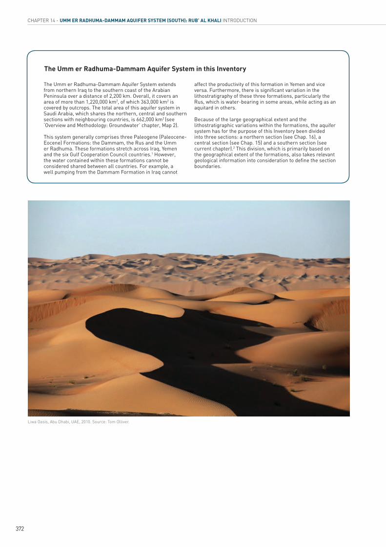
Liwa Oasis, Abu Dhabi, UAE, 2010. Source: Tom Olliver.
The Umm er Radhuma-Dammam Aquifer System extends from northern Iraq to the southern coast of the Arabian Peninsula over a distance of 2,200 km. Overall, it covers an area of more than 1,220,000 km2, of which 363,000 km2 is covered by outcrops. The total area of this aquifer system in Saudi Arabia, which shares the northern, central and southern sections with neighbouring countries, is 662,000 km2 (see ‘Overview and Methodology: Groundwater’ chapter, Map 2).
This system generally comprises three Paleogene (Paleocene-Eocene) Formations: the Dammam, the Rus and the Umm er Radhuma. These formations stretch across Iraq, Yemen and the six Gulf Cooperation Council countries.1 However, the water contained within these formations cannot be considered shared between all countries. For example, a well pumping from the Dammam Formation in Iraq cannot
affect the productivity of this formation in Yemen and vice versa. Furthermore, there is significant variation in the lithostratigraphy of these three formations, particularly the Rus, which is water-bearing in some areas, while acting as an aquitard in others.
Because of the large geographical extent and the lithostratigraphic variations within the formations, the aquifer system has for the purpose of this Inventory been divided into three sections: a northern section (see Chap. 16), a central section (see Chap. 15) and a southern section (see current chapter).2 This division, which is primarily based on the geographical extent of the formations, also takes relevant geological information into consideration to define the section boundaries.
The Umm er Radhuma-Dammam Aquifer System in this Inventory

373
INVENTORY OF SHARED WATER RESOURCES IN WESTERN ASIA - PART 2
LOCATION
The Umm er Radhuma-Dammam Aquifer System (South) extends over a distance of about 800 km from the Gulf coast in the north and the Oman Mountains in south-westerly direction towards the Dhofar-Najd Plateau, where the formations of this aquifer system are not present. It extends across the political borders of Oman, Saudi Arabia, the United Arab Emirates (UAE) and Yemen. Suggested boundaries for this section are the northern limit of the Rub’ al Khali Desert and the North Hadhramaut Arch (see Overview Map).
AREA
The southern section of the Umm er Radhuma-Dammam Aquifer System that is covered in this chapter represents around 53% of the aquifer system’s total area. Within the boundary of the suggested delineation, the aquifer system covers a total area of 678,000 km2, of which around 249,000 km2 lies in Oman, 296,000 km2 in Saudi Arabia, 61,000 km2 in the UAE and 72,000 km2
in Yemen. About 13% of the delineated area (90,000 km2) is covered by outcrops (Dammam-Rus Formations: 77,000 km2; Umm er Radhuma-Jeza Formations: 13,000 km2).
Three major physiographic regions can be identified within this section:
Rub’ al Khali Desert: the world’s largest continuous sand desert3 covering an area of 522,340 km2.
Hadhramaut-Al Mahra Plateau: elevated blocks of Paleogene strata dipping very gently in north and north-easterly directions.
Dhofar-Najd Plain: eastward extension of the Hadhramaut-Al Mahra Plateau consisting of an uplifted monoclinal area and a huge plateau of Tertiary rocks sloping gently in north and north-westerly directions.
CLIMATE
The aquifer system falls almost entirely within the Rub’ al Khali agro-climatic zone,4 which has a tropical arid climate.5 Rainfall lies below 10 mm/month for most of the year, except during autumn when it can rise to 50 mm over three months, resulting in a total of about 140 mm/yr. Average temperatures range from 14°C-16°C in January to 34°C-36°C in June.6
POPULATION
This section of the Umm er Radhuma-Dammam Aquifer System lies in one of the least populated areas in Western Asia. Population density is 0.1-1 inhab./km2 in the southern areas of Oman and Yemen, and 2-5 inhab./km2 in Saudi Arabia.7
OTHER AQUIFERS IN THE AREA
The Wasia-Biyadh (Middle Cretaceous) Aquifer System (see ‘Overview and Methodology: Groundwater’ chapter) underlies most of this region. The Wajid Aquifer System (Cambro-Permian) may also be present at great depths in the western area of this section (see Chap. 11). In the mountainous regions at the border between Oman and UAE, the Quaternary gravel plain aquifers are locally important (Box 1).
INFORMATION SOURCES
Limited information was available for the Umm er Radhuma-Dammam Aquifer System (South) in Saudi Arabia, where no development has taken place. Most of the information on the aquifer system was obtained from the central section of Umm er Radhuma-Dammam Aquifer System, which is being developed intensively (see Chap. 15). Data from the central Umm er Radhuma-Dammam was also used to assess groundwater resources in the Northern Hadhramaut Basin in Yemen.8 The Overview Map was delineated based on various local and regional references.9
Introduction

Shammar
CHAPTER 14 - UMM ER RADHUMA-DAMMAM AQUIFER SYSTEM (SOUTH): RUB’ AL KHALI HYDROGEOLOGY - AQUIFER CHARACTERISTICS
374
Hydrogeology - Aquifer Characteristics
AQUIFER CONFIGURATION
As a sedimentary basin, the Rub’ al Khali is bounded by a number of regional structural features:
The Qatar Arch to the north The Central Arabian Arch to the north-west The arched-up Arabian Shield to the west
(East Interior Homocline and Najd Graben) The North Hadhramaut Arch to the south
and south-east The Oman Mountains to the north-east10
The largest outcrops are found in the Hadhramaut-Al Mahra Plateau in Yemen and the Dhofar-Najd Plain in Oman, while smaller outcrops can also be found at the rim of the basin, e.g. at the foot of the Oman Mountains (Jebel Hafit). In accordance with the terrain, the regional aquifer system dips gently from the eastern parts of Yemen (about 800 m asl) to the north-east to the interior plains in the Gulf (approx. 100 m asl). The centre of the basin is overlain by Quaternary sediments and underlain by the Cretaceous Wasia-Biyadh Formations (see Chap. 10, Figure 3). In the north-east of the Arabian Peninsula, the aquifer system is highly fractured and might not be hydraulically connected in all places.
STRATIGRAPHY
The aquifer system within this section comprises three Paleogene (Paleocene-Eocene) Formations: the Umm er Radhuma, the Rus and the Dammam. Hydrogeologically, the Rus is the least important and is mostly considered an aquitard except where it is characterized by dolomitizations or has intercalations of carbonates. The Umm er Radhuma is the principal and most extensive aquifer, especially in the southern areas where it constitutes a continuous aquifer cropping out at the surface or covered by younger aquifer units. Figure 1 indicates that the lithology and stratigraphy of all three aquifer units across the section are similar, except for the fact that the Shammar shale at the base of the Umm er Radhuma is well developed in Oman and Yemen but not in Saudi Arabia and UAE. A more detailed description of the aquifer system in each country is given below.
Oman
Known as the Hadhramaut Group in Oman, the aquifer system extends over a large area from the coastal Dhofar Mountains in the south to the edge of the Oman Mountains in the north.11
Figure 1. Lithostratigraphy of the Umm er Radhuma-Dammam Aquifer System (South)
Source: Modified by ESCWA-BGR based on Alsharhan et al., 2001; Beydoun et al., 1998.
Upper
Middle
Paleogene
Pale
ogen
e
Eoce
ne
dĞƌƟĂƌLJ
Period
Dammam Rus Umm er Radhuma EŽŶͲĚĞƉŽƐŝƟŽŶ�Žƌ�ĞƌŽƐŝŽŶ
Epoch Saudi ArabiaWest UAE
(Abu Dhabi)Oman
�ĚŚ��ŚĂƌŝLJĂŚOman (Dhofar)
Gulf of Aden
Zuluma Fm
Aydim Fm
Taqa Fm
Hadh
ram
aut G
p
YemenGulf of Aden
Lower

INVENTORY OF SHARED WATER RESOURCES IN WESTERN ASIA - PART 2
375
The main aquifer within the group is the Umm er Radhuma, which constitutes a regional aquifer in southern and central Oman (Najd and Dhofar areas) and consists of fissured, partly karstic and partly dolomitized limestone.12 This aquifer is normally divided into Upper Umm er Radhuma (referred to as Aquifers B and C) and Lower Umm er Radhuma (referred to as Aquifer D). It is overlain by the Rus, which consists of bedded gypsum, chalky limestone and dolomitic limestone, and the Dammam, which is composed of crystalline, chalky limestone and dolomitic limestone.13 Together, the Rus and the Dammam Formations are referred to as Aquifer A. The Hadhramaut Group also occurs in north-western Oman (Sunainah Trough) where the Umm er Radhuma and Rus Formations are absent. Here, the Dammam Formation constitutes an aquifer in the Jebel Hafit area and extends across the Oman-UAE border.14
Saudi Arabia
In Saudi Arabia, the extensive Umm er Radhuma Formation forms the main aquifer throughout the Rub’ al Khali Desert.15 The Umm er Radhuma consists mainly of interbedded limestone and dolomite with intercalations of marl and chert, and is overlain by the Rus, which comprises bedded anhydrite, shale, limestone and dolomitic limestone. The Dammam Limestone also constitutes a useful aquifer towards north-western Oman in the Rub’ al Khali Desert and adjacent areas in UAE, and probably extends under the northern Rub’ al Khali.16 The upper part of the Dammam (Alat) is only present in the northern and central areas of the Rub’ al Khali, but is eroded in the west and south. The lower part of the Dammam (Khobar) has better water-bearing properties than the upper Dammam, which is a relatively poor, generally fine-grained aquifer with low porosity and low permeability.
UAE
In UAE, the aquifer system is located mainly in the emirate of Abu Dhabi. Here, the Umm er Radhuma is composed of four lithological units: a basal unit of shales and marls overlain by three units consisting of different proportions of limestones, dolomite, mudstones and wacke-stones. The Dammam is composed of dolomite with anhydrite in the upper part, packstone and grainstone in the middle part and shales and argillaceous limestone in the lower part.17 The Rus carbonates constitute an aquifer in the Al Ain region in the emirate of Abu Dhabi and are characterized by extensive dolomitization.18
Yemen
The basal Umm er Radhuma Formation of the Hadhramaut Group is prominent and consists predominantly of massive limestones19 with some marly and dolomitic beds.20 The Rus is widely developed as an aquifer and is composed predominantly of gypsum with intercalations of limestone and marl.21 In Yemen, the Jeza Formation, which consists of shales and fine-grained limestone, separates the Rus and the Umm er Radhuma and is considered part of the latter.22 The top unit of the group, the Habshiyah (the local name for the Dammam), consists of a lower part of shales and marl and an upper part of alternating beds of limestone and chalky limestone.23 The Habshiyah Formation is either not overlain by any younger deposits or only by superficial deposits.24 As a rule, it does not constitute an aquifer since it has been ‘dewatered’, except in some localities where thin perched water is found.25
AQUIFER THICKNESS
The total thickness of the aquifer system is only known in some areas:
In Oman, the Hadhramaut Group was penetrated over a thickness of up to 1,000 m in the Dhofar Mountains area, with a saturated thickness in the order of 400-500 m.26 Further east in the Najd area, the range of thicknesses obtained for aquifers A, B and C are 1-112 m, 1-43 m, and 31 m, respectively.
In Saudi Arabia, the Umm er Radhuma is about 150-400 m thick. The thickness of the Khobar is 30-67 m in the north, increasing in the eastern part to 76-90 m.27
In UAE, the Umm er Radhuma has a thickness of 300-550 m in the eastern Jebel Hafit area, while the Dammam ranges from 60-490 m in thickness, with a gradual thickening from west to east in the emirate of Abu Dhabi.28 The Dammam is 280 m thick in the south-western Liwa area.29
In Yemen, the Rus is about 100 m thick in the north-eastern part of the country,30 while the Umm er Radhuma is between 150 and 230 m thick in these areas.31
AQUIFER TYPE
In Oman, water-bearing horizons within the Hadhramaut Group have especially developed in the confined Umm er Radhuma.32 Aquifers B, C and D are all confined in the Najd area. In the vicinity of the Dhofar Mountains, all aquifer units

CHAPTER 14 - UMM ER RADHUMA-DAMMAM AQUIFER SYSTEM (SOUTH): RUB’ AL KHALI HYDROGEOLOGY - AQUIFER CHARACTERISTICS
376
within the group are essentially unconfined with locally “perched” water table conditions in the Dammam Formation where the Rus Formation acts as an aquitard.
In Saudi Arabia, the Umm er Radhuma-Dammam system is generally under artesian and sub-artesian conditions.33
In UAE, the aquifer system in the Jebel Hafit area belongs to the confined-flow carbonate aquifer.34
In Yemen, the limestones of the Rus are unconfined, while those of the Umm er Radhuma vary from unconfined in the western part to confined, artesian conditions with local pressure heads of 173-269 m in the eastern areas.35
AQUIFER PARAMETERS
Data on the hydraulic characteristics of the Umm er Radhuma-Dammam (South) Aquifer System come from Oman and UAE (Table 1 and 2). According to Omani sources,36 the yields of bore-holes completed in Aquifer C were consistently higher and much more reliable than those from Aquifers A and B.37
No aquifer parameter data was available for the southern section in Saudi Arabia, where there is
AQUIFER TRANSMISSIVITY (m2/s) STORATIVITY
A 5.6x10⁻³ 3.2x10⁻⁶
B 5.4x10⁻⁴ 1.0x10⁻⁶
C 5.2x10⁻³ 2.0x10⁻⁴
Table 1. Hydraulic parameters of the Dammam in Oman
Table 2. Hydraulic parameters of the Umm er Radhuma-Dammam Aquifer System (South) in UAE
Source: Compiled by ESCWA-BGR based on Ministry of Regional Municipalities and Water Resources in Oman, 2009; Alsharhan et al., 2001.
Source: Compiled by ESCWA-BGR based on Alsharhan et al., 2001.
AQUIFER TRANSMISSIVITY (m2/s) STORATIVITY
Dammam 3.6x10⁻⁵-6.5x10⁻⁵ ..
Umm er Radhuma 4.3x10⁻⁵-1.6x10⁻⁴ 9.0x10⁻⁴
no development. The information presented here comes from the Gulf Basin, where the aquifer system is intensively developed (see Chap. 15). Data from the Umm er Radhuma-Dammam Aquifer System (Centre) was also used to assess groundwater resources in the Northern Hadhramaut Basin in Yemen, where no data was available.38
Lake Hatta in the Oman Mountains, UAE, 2010. Source: Maarten Schäfer.

377
INVENTORY OF SHARED WATER RESOURCES IN WESTERN ASIA - PART 2
Hydrogeology - Groundwater
RECHARGE
The aquifer system is mainly replenished by freshwater descending from the Oman and Hadhramaut-Dhofar Mountains. Despite the extreme aridity, studies using remote sensing techniques have demonstrated that recharge does currently occur across the entire Rub’ al Khali Basin (650,000 km2).39 Recharge rates are estimated at 10%-25% of total precipitation with an average annual rate of 4-10 BCM/yr, which is equivalent to 6-16 mm/yr for the whole Rub’ al Khali Basin. While it is not clear how much of this recharge goes to the replenishment of the Paleogene Aquifer System in the section, isotope studies indicated the presence of a local recharge component from present-day rainfall in the Dammam Aquifer in Jebel Hafit in UAE, and the Dammam-Rus system (Aquifer A) in the Najd area in Oman.40 Estimates show an effective recharge in the order of 11.4 MCM over 300 km2 in the Najd region of Oman.41 This would be equivalent to 38 mm/yr and would be almost identical to the highest value (33 mm/yr) estimated for the recharge to the Umm er Radhuma-Dammam Aquifer System (Centre) section (see Chap. 15). This modern recharge is attributed to infrequent storm events that generate sufficient wadi flow to reach the Dammam outcrops and has been estimated to vary between 9.46 and 15.78 MCM/yr, or an average of 12 MCM/yr in the Najd area of Oman.42 If the recharge component from artesian flow is added (see below), total recharge could even be in the order of 40 mm/yr.
The bulk of the groundwater in the system is, however, believed to have been recharged during the pluvial periods between 20,000 and 10,000 years ago.43 Carbon-14 dating of Aquifer B in Oman suggests that the age of the groundwater varies from 9,000 to 11,000 years in the east to about 20,000 years in north-western Dhofar.44 Groundwater ages in Aquifer C were estimated at 4,000-16,000 years in the south (close to the Dhofar Mountains) to 30,000 years in the north-west towards the centre of the Arabian Peninsula. Similarly, ages for Aquifer D were in the order of 9,000 to 26,000 years. An apparent age-distance trend in the Paleogene aquifers from the outer eastern and southern parts toward the inner Rub’ al Khali Basin implies that recharge originates in the Umm er Radhuma outcrops of the Dhofar Mountains.45
FLOW REGIME
General flow directions
In the northern areas of the Rub’ al Khali, groundwater flow generally follows the main flow direction of the Umm er Radhuma-Damman Aquifer System (South), from the central Arabian Peninsula in the west towards the Persian Gulf in the east. This implies that groundwater in the Umm er Radhuma-Dammam Aquifer System may flow across the Saudi-UAE border. From the Hadhramaut-Dhofar Mountains, groundwater flow is mainly north and north-eastward. South of the North Hadhramaut Arch, it flows towards the Gulf of Aden. In the north-eastern part of the region, flow is west and south-westward from the Oman Mountains.46
Inter-aquifer flow
While upward groundwater flow has been observed from Aquifers B and C into the overlying aquifers via “leaking”, open bore-hole/wells or artesian surface flow, it has not been quantified.47 A comparison of three leakage scenarios (Table 3) indicates that about 10 MCM/yr of water may be flowing from the upper and middle confined areas of the Umm er Radhuma Aquifers (Aquifers B and C) into Aquifer A (Dammam and Rus) or infiltrate back into Aquifer A via the surface.
LEAKAGE(%)
VOLUME OF UPWARD LEAKAGE (MCM/yr)
RETURN FLOW FROM ARTESIAN SURFACE FLOW (MCM/yr)
5 0.79 1.26
15 2.40 3.70
25 4.10 6.39
Table 3. Inter-aquifer flow in the Paleogene Aquifer System in the Najd region in Oman
Source: Modified by ESCWA-BGR based on Carlson, 1994.
STORAGE
Retrievable groundwater for the three Paleogene aquifers was assessed for the Najd area, which covers an approximate area of 60,000 km2 (Table 4).
378
CHAPTER 14 - UMM ER RADHUMA-DAMMAM AQUIFER SYSTEM (SOUTH): RUB’ AL KHALI HYDROGEOLOGY - GROUNDWATER
!H
!H!H
Yemen
Gulf of Aden
Persian Gulf
Liwa
Sanaw
Habrut
Sayhut
Riyadh
Salalah
Thumrait
Abu Dhabi
Mukalla
54°E51°E48°E
24°N 24°N
21°N 21°N
18°N 18°N
15°N 15°N0 100 200 30050km
S a u d i A r a b i a
Ye m e n
Un i te d A ra bE m i r a t e s
Topographic contours
Groundwater salinity map TDS
1-3 g/L
3-5 g/L
<1 g/L
5-10 g/L
>10 g/L
Umm er Radhuma-Dammam Aquifer System (S)
Om a n
Sabkha
DisclaimerThe boundaries and names shown andthe designations used on this map do notimply official endorsement or acceptanceby the United Nations.
Inventory of Shared Water Resources in Western Asia
© UN-ESCWA - BGR Beirut 2013
The discrepancy in Table 4 may be ascribed to the fact that these studies applied different values of specific storativity/storage coefficient and defined different aquifer units. No further information was available on groundwater reserves in the Paleogene Aquifer System in this section.
Groundwater reserves in eastern Saudi Arabia were estimated at 190 BCM and 45 BCM for the Umm er Radhuma and the Dammam respectively.48
DISCHARGE
Natural discharge of the aquifer system occurs from springs in elevated areas or in saline to hypersaline waters, which form sabkhas in the lowlands. Springs from the Umm er Radhuma Aquifer emanate along the edge of the Hadhramaut Plateau.49 Numerous springs also emerge at the interface between the Dammam and the Rus, where the latter may act as a locally impervious layer.50 Further north to north-east, the Umm es Sammim Sabkha acts as a major discharge zone of saline groundwater from the Paleogene Aquifers in the eastern part of the section.51 The final discharge areas for the aquifer system are mainly the coastal sabkha (Sabkhat Matti) and the inland sabkha (Umm es Sammim Sabkha) and, to a lesser extent, the interior plains along the border of Oman, Saudi Arabia and UAE.
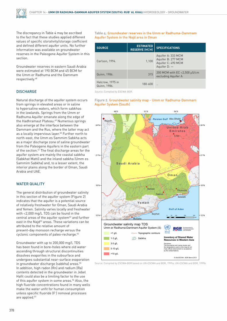
WATER QUALITY
The general distribution of groundwater salinity in this section of the aquifer system (Figure 2) indicates that the aquifer is a potential source of relatively freshwater for Oman, Saudi Arabia and Yemen. Salinity varies locally and freshwater with <2,000 mg/L TDS can be found in the central areas of the aquifer system52 and further east in the Najd53 areas. These variations can be attributed to the relative amount of present-day monsoon recharge versus the cyclonic components of paleo-recharge.54
Groundwater with up to 200,000 mg/L TDS has been found in bore-holes where old water ascending through structural discontinuities dissolves evaporites in the subsurface and undergoes substantial near-surface evaporation in groundwater discharge (sabkha) areas.55 In addition, high radon (Rn) and radium (Ra) contents detected in the groundwater in Jebel Hafit could also be a limiting factor to the use of this aquifer system in some areas.56 Also, the high fluoride concentrations found in many wells make the water unfit for human consumption unless specific fluoride (F-) removal processes are applied.57
Table 4. Groundwater reserves in the Umm er Radhuma-Dammam Aquifer System in the Najd area in Oman
Source: Compiled by ESCWA-BGR.
Source: Compiled by ESCWA-BGR based on UN-ESCWA and BGR, 1999a; UN-ESCWA and BGR, 1999b.
SOURCE ESTIMATED RESERVE (MCM) SPECIFICATIONS
Carlson, 1994. 1,100
Aquifer A: 333 MCM Aquifer B: 277 MCM Aquifer C: 490 MCM Aquifer D: —
Quinn, 1986. 315 200 MCM with EC <2,500 µS/cm excluding Aquifer A
Halcrow, 1975 in Quinn, 1986. 180-600 ..
Figure 2. Groundwater salinity map - Umm er Radhuma-Dammam Aquifer System (South)
379
INVENTORY OF SHARED WATER RESOURCES IN WESTERN ASIA - PART 2
EXPLOITABILITY
The following criteria were used to delineate the exploitable areas of this aquifer system:
Depth to top of aquifer: The top of the Cretaceous, which underlies the Paleogene Aquifer System, is generally between 200 and 1,200 m bgl,58 and bore-holes in the Najd area of Oman reach the Cretaceous at 400 m bgl.59 The most common depth to the Umm er Radhuma- Dammam Aquifer System in this section is 300-500 m bgl.60
Depth to water level: In the mid-1980s and early 1990s many wells surveyed in the vicinity of Thumrait and parts of the Najd area flowed at the surface or had a maximum depth of around 100 m bgl.61
Water quality: The TDS of the groundwater is generally below 10,000 mg/L except in the north-eastern areas where hypersaline conditions prevail in the vicinity of sabkhas.
Based on the above, it would appear that most of the aquifer system is exploitable except for the north-eastern part. The total exploitable area within the delineated basin (including the Jebel Hafit area) is around 392,000 km2: 82,000 km2 in Oman, 232,000 km2 in Saudi Arabia, 1,000 km2 in UAE and 77,000 km2 in Yemen.
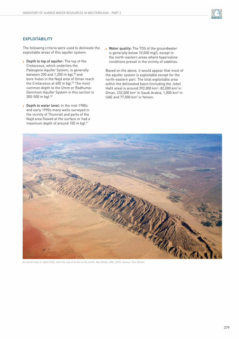
An aerial view of Jebel Hafit, with the city of Al Ain to the north, Abu Dhabi, UAE, 2010. Source: Tom Olliver.

380
CHAPTER 14 - UMM ER RADHUMA-DAMMAM AQUIFER SYSTEM (SOUTH): RUB’ AL KHALI GROUNDWATER USE
Groundwater UseGROUNDWATER ABSTRACTION AND USE
Abstraction from the Paleogene Aquifer System in the Rub’ al Khali Desert area that extends across the borders of all four countries is negligible, and essentially limited to the use of hand-dug wells for domestic purposes by nomadic populations. The only significant use of this aquifer system occurs in the Dhofar-Najd areas in Oman and the Jebel Hafit area in UAE, where it is being developed for agricultural and domestic use after treatment and, to a lesser extent, for industrial (water injection for the oil industry) and recreational purposes. The total amount of groundwater currently abstracted from the aquifer system in this section (45 MCM) is much lower than the amount abstracted from the central (Gulf: 720 MCM) and northern (Widyan-Salman: 350 MCM) sections of the Umm er Radhuma-Dammam Aquifer System.
Oman
The town of Thumrait in Najd (Oman) reportedly withdraws about 1.3 MCM/yr from the aquifer system for domestic purposes.62 The Petroleum Development of Oman (PDO) also produces more than 6 MCM/yr of groundwater in the Marmul area, 130 km north-east of Thumrait, of which about 1 MCM/yr is injected into the oil-producing horizon. In 1985, PDO established the first 40 ha pilot farm at Marmul, which was expanded by a further 60 ha in 1987.63
A number of feasibility studies64 were also prepared for agricultural development in the general area of Thumrait and northward to Daukah. The Omani Government is currently establishing three pilot agricultural projects at Hanfeet, Daukah and Bin Khawta, requiring an expected total abstraction of 75 MCM/yr in addition to the estimated 38 MCM/yr that is already being abstracted at present.65
UAE
Fifteen bore-holes in the Jebel Hafit area abstract about 7.7 MCM of groundwater from the Dammam Formation.66 This water is not suitable for drinking and other domestic purposes because it has high radium (Ra) and radon (Rn) content, high temperature (36.5°C-51.4°C), and
high salinity (3,900-6,900 mg/L TDS). While the water is currently only used for recreational purposes, there are plans to use it for health and therapeutic purposes as well as for the production of salt-tolerant crops.67
GROUNDWATER QUALITY ISSUES
A number of issues related to the natural composition of the aquifer formations and/or progressive exploitation may be of concern in this area (Figure 2):
In areas where the groundwater is relatively fresh, inter-aquifer flow and upconing of thermal saline water is likely to impact the quality of the shallow groundwater system (e.g. Jebel Hafit).68
The injection of about 1 MCM of groundwater into the oil-bearing formation in the Marmul area represents a potential source of pollution for the overlying aquifer system.69
SUSTAINABILITY ISSUES
The aquifer system already shows signs of over-abstraction locally, especially in the major Aquifer C in the Najd area of Oman, where the water level is dropping at a rate of 2.05 m/yr.70 Hence sustainability of the use of the aquifer system will become an issue.
Lake Hatta in the Oman Mountains, UAE, 2010. Source: Maarten Schäfer.

!H
#
Mahdah
Buraimi
Ar Rawdah
Al Ain
Al Wagan
Al Hayer
Al Dhaid
Al Shwaib
Abu Dhabi
56°E
24°N 24°N
22°N 22°N0 50 10025km
The Western Gravel Aquifer
P e r s i a nG u l f G u l f o f
O m a n
Om
an Moun t a in s
(Al H
a j a r a l Gh a rb i )
Wadi Dank
Jebel Hafit
United ArabEmira tes
Oman
Wadi Ajran
Wadi al Sayfah
SaudiArabia
Al Dhahirah region
Inventory of Shared Water Resources in Western Asia
© UN-ESCWA - BGR Beirut 2013
DisclaimerThe boundaries and names shown and the designationsused on this map do not imply official endorsement oracceptance by the United Nations.
381
INVENTORY OF SHARED WATER RESOURCES IN WESTERN ASIA - PART 2
Figure 3. The Western Gravel Aquifer
Source: Compiled by ESCWA-BGR based on Rizk and Alsharhan, 2008; Ministry of Regional Municipalities and Water Resources in Oman, 2005.
Table 5. Mean annual precipitation in the Western Gravel Aquifer in UAE (1976-2004)
Table 7. Hydrogeological characteristics of the Western Gravel Aquifer in the Al Ain area
Source: Compiled by ESCWA-BGR based on Rizk and Alsharhan, 2008.
Source: Compiled by ESCWA-BGR based on Rizk and Alsharhan, 2008.
PRECIPITATION (mm/yr) AL DHAID AL AIN AL WAGAN
Maximum 414.8 291.1 161.2
Mean 127.4 95.1 66.1
Minimum — 0.6 1
DEPTH OF WELLS (m) DEPTH TO WATER (m bgl) TRANSMISSIVITY (m2/s) STORATIVITY SALINITY (mg/L TDS)
30-90 15-30 2.9x10⁻⁴-4.6x10⁻³ 9.2x10⁻⁴ 500-6,000
The Western Gravel Aquifer
The Western Gravel Aquifer (WGA) is located along the border of Oman and UAE (Figure 3). It extends from the western side of the Oman Mountains (Al Hajar al Gharbi) where wadis descending from the mountains form several alluvial fans that coalesce to constitute a stony, westward-sloping plain.
INFORMATION SOURCESMost of the information featured in this box is drawn from scientific studies published about UAE.71 Limited information was also found in official sources from Oman.72
SEDIMENTOLOGICAL PROPERTIESThe aquifer consists of conglomerates, gravel and sand with intercalations of clay and silt. These sediments, which generally show decreasing particle size away from the mountains, were mainly deposited by wadis cutting through the Ophiolite rocks in the Oman Mountains.
HYDROLOGICAL FEATURESTable 5 indicates that there is a significant seasonal and geographic variation in rainfall within the area of WGA. Most of the rain falls between November and March. Some of the rain infiltrates through a large number of buried alluvial channels to recharge the aquifer system. Evaporation rates are usually between 2,400 and 2,600 mm/yr.
HYDROGEOLOGICAL CHARACTERISTICSThe base of WGA sediments forms a wedge that increases in thickness towards the west. Average thickness is around 60 m but a thickness of about 400 m has been reported west of Jebel Hafit.73 Recharge of these sediments along the gravel plain has been estimated at about 30 MCM/yr,74 of which about 50% takes place south of the town of Al Ain in an area that constitutes a shared aquifer. This shared part of the aquifer has a storage of 2.6 BCM of freshwater and 18 BCM of brackish water.75
GROUNDWATER USEAs the most important aquifer in UAE,76 WGA is heavily exploited in the Al Ain area, where most of the abstracted water is used for irrigation purposes (Table 6). In 1985, about 95% of total water use in this area relied on WGA.77 In Oman, WGA is exploited in the Al Dhahirah region, mainly through the aflaj system. The groundwater in the alluvial aquifers in this region has traditionally been used for agriculture, and to meet the domestic water demand of the rural population. Rising groundwater salinity limits the usability of WGA. The development of the oil industry in recent years has led to increased water demand from the industrial sector for the purpose of reservoir flooding and enhanced oil recovery.78
SUSTAINABILITY AND MANAGEMENT ASPECTSThe water table in WGA has declined significantly since the 1970s, especially in the Al Ain area where a number of water well-fields have been established, some of them with more than 100 wells.79 A reported decline of up to 50 m west of the city of Al Ain80 indicates that the aquifer is being substantially overdrafted. Landsat satellite images taken in 1995 as part of a German Technical Cooperation project81 were used to assess the impact of over-abstraction from the aquifer in UAE, including a decline in water table and an increase in salinity. Efforts to launch a joint management strategy for the aquifer have failed to bear any concrete results.82
BOX
1
USE FRESHWATER (MCM)
BRACKISH WATER (MCM)
TOTAL
MCM %
Domestic 22.3 — 22.3 5
Recreational 24.1 — 24.1 5.5
Irrigation 70 327 397 89.5
Total 116.4 327 443.4 100
Table 6. Average annual groundwater use from the Western Gravel Aquifer in the Al Ain area (1985)
Source: Compiled by ESCWA-BGR based on Hyde, 1992 cited in Rizk and Alsharhan, 2008.

382
CHAPTER 14 - UMM ER RADHUMA-DAMMAM AQUIFER SYSTEM (SOUTH): RUB’ AL KHALI AGREEMENTS, COOPERATION & OUTLOOK
Agreements, Cooperation & Outlook
AGREEMENTS
There are no water agreements in place for the southern part of the Umm er Radhuma-Dammam Aquifer System which is shared between Oman, Saudi Arabia, UAE and Yemen.
COOPERATION
No information was available regarding cooperation between the riparian countries on the aquifer system.
OUTLOOK
This aquifer system is in an early stage of development and would therefore constitute a good opportunity to initiate a comprehensive joint management strategy in order to avoid sustainability issues in the long term. From the point of view of shared water resources, the following two areas could be of interest:
The Jebel Hafit area where the Dammam and Rus Formations constitute a highly fractured aquifer along the UAE-Oman border. The aquifer here presents high transmissivity and relatively low salinity levels in the upper layers, which appear to receive freshwater recharge directly from local rainfall.83
The Triple-Junction Border area (see Overview Map) where the Umm er Radhuma- Dammam-Rus constitute the main water supply source for nomads and small settlements in the vast desert area between Oman, Saudi Arabia and Yemen.
Rub’ al Khali Desert, Oman, 2011. Source: Philipp Weigell.

383
INVENTORY OF SHARED WATER RESOURCES IN WESTERN ASIA - PART 2
Notes1. Bahrain, Kuwait, Oman, Qatar, Saudi Arabia, United
Arab Emirates.
2. This division was based on UN-ESCWA and BGR, 1999b.
3. Edgell, 2006. According to Encyclopædia Britannica, 2013 “Rub’ al Khali is a vast desert in the southern Arabian Peninsula […] in a structural basin lying mainly in southeastern Saudi Arabia, with lesser portions in Yemen, Oman and UAE”.
4. As defined by the Ministry of Agriculture and Water in Saudi Arabia, 1995 as cited in Vincent, 2008.
5. PSRCE, 2007.
6. Vincent, 2008.
7. CIESIN, 2010.
8. Rybakov et al., 1995, p. V-44.
9. ESCWA-BGR based on UN-ESCWA and BGR, 1999b; UN-ESCWA and BGR, 1999a; Edgell, 2006; Christian, 2000; Van der Gun and Ahmed, 1995.
10. Edgell, 2006.
11. Ministry of Regional Municipalities and Water Resources in Oman, 2009.
12. Ibid.
13. Alsharhan et al., 2001; Alsharhan and Naim, 1997, p. 426.
14. Ministry of Regional Municipalities and Water Resources in Oman, 2009.
15. Edgell, 1997.
16. Ibid.
17. Alsharhan et al., 2001, p. 94.
18. Alsharhan et al., 2001.
19. Van der Gun and Ahmed, 1995.
20. Beydoun et al., 1998, p. 212.
21. Rybakov et al., 1995, p. V-43.
22. Van der Gun and Ahmed, 1995.
23. Beydoun et al., 1998, p. 80-81.
24. Ibid., p. 83.
25. Rybakov et al., 1995.
26. Ministry of Regional Municipalities and Water Resources in Oman, 2009.
27. UN-ESCWA and BGR, 2001.
28. Alsharhan et al., 2001.
29. Al-Mutawa, 1993 cited in UN-ESCWA and BGR, 1999b.
30. Rybakov et al., 1995.
31. Beydoun et al., 1998, p. 215.
32. Ministry of Regional Municipalities and Water Resources in Oman, 2009.
33. UN-ESCWA and BGR, 2001.
34. Alsharhan et al., 2001, p. 95.
35. Pichugin et al, 1984 cited in Rybakov et al., 1995, p. V-44.
36. Ministry of Regional Municipalities and Water Resources in Oman, 2011.
37. Ibid., 2009.
38. Rybakov et al., 1995, p. V-44.
39. Sultan et al., 2008.
40. Rizk and Alsharhan, 1999, Quinn, 1986.
41. Quinn, 1986.
42. Ibid.
43. Al Lamki and Terken, 1996.
44. Clark et al., 1987 cited in UN-ESCWA and BGR, 2001.
45. UN-ESCWA and BGR, 2001.
46. Al Lamki and Terken, 1996.
47. Carlson, 1994.
48. Dabbagh and Abderrahman, 1997 as cited in UN-ESCWA and BGR, 1999b. A pumping depth of 300 m bgl is taken into account as a limiting factor.
49. Beydoun et al., 1998, p. 216.
50. Ministry of Regional Municipalities and Water Resources in Oman, 2009, p. 61.
51. Edgell, 2006; UN-ESCWA and BGR, 2001.
52. Sultan et al., 2008.
53. Quinn, 1986.
54. Ibid.
55. Sultan et al., 2008.
56. Alsharhan et al., 2001.
57. Binnie and Partners, 1992.
58. Christian, 2000.
59. Rippon and Public Authority for Water Resources in Oman, 1985.
60. Ministry of Defense in Oman and Sir M. Macdonald Partners, 1990; Ministry of Water Resources in Oman, 1994a; Ministry of Water Resources in Oman, 1994b.
61. Ibid.
62. Binnie and Partners, 1992.
63. Mott MacDonald International Ltd., 1991.
64. Ibid.
65. Ministry of Regional Municipalities and Water Resources in Oman, 2011.
66. Alsharhan et al., 2001, p. 95.
67. Ibid.
68. Rizk and Alsharhan, 2008.
69. Ministry of Regional Municipalities and Water Resources in Oman, 2005, p. 72; Ministry of Water Resources in Oman, 1993.
70. Ministry of Regional Municipalities and Water Resources in Oman, 2011.
71. Rizk and Alsharhan, 2008; Alsharhan et al., 2001.
72. Ministry of Regional Municipalities and Water Resources in Oman, 2005.
73. Rizk and Alsharhan, 2008.
74. Hyde, 1992 cited in Rizk and Alsharhan, 2008.
75. Ibid.
76. Rizk and Alsharhan, 2008.
77. Ibid.
78. Ministry of Regional Municipalities and Water Resources in Oman, 2005.
79. Rizk and Alsharhan, 2008.
80. Khalifa 2004, cited in Rizk and Alsharhan, 2008.
81. UN-ESCWA and BGR, 2001.
82. Ibid.
83. Rizk and Alsharhan, 2008.

384
CHAPTER 14 - UMM ER RADHUMA-DAMMAM AQUIFER SYSTEM (SOUTH): RUB’ AL KHALI BIBLIOGRAPHY
BibliographyAl Lamki, M. S. S. and Terken, J. J. M. 1996. The Role of Hydrogeology in Petroleum Development Oman. GeoArabia, 1(4): p. 495.
Alsharhan, A. S. and Naim, A. E. M. 1997. Sedimentary Basins and Petroleum Geology of the Middle East. Published by Elsevier. Amsterdam/New York.
Alsharhan, A. S., Rizk, Z. A., Nairn, A. E. M., Bakhit, D. W., et al. 2001. Hydrogeology of an Arid Region: The Arabian Gulf and Adjoining Areas. 1st ed. Published by Elsevier. Amsterdam/New York.
Beydoun, Z. R., As-Saruri, M. A. L., El-Nakhal, H., Al-Ganad, I. N., et al. 1998. International Lexicon of Stratigraphy. Published by the Ministry of Oil and Mineral Resources in Yemen. Sana’a.
Binnie and Partners. 1992. Water Supply to Thumrait. In Stage Two Report - Part I. Published by the Development Council in Oman, Office of the Secretary General. Muscat.
Carlson, D. 1994. An Appraisal of Inter-Aquifer Flow in the Najd. Issued by the Ministry of Water Resources in Yemen.
Christian, L. 2000. Middle East Geological Map Series (MEG-Maps). Published by Gulf PetroLink. Manama, Bahrain.
CIESIN (Center for International Earth Science Information Network). 2010. Population Density Future Estimates 2010. Available at: http://sedac.ciesin.columbia.edu/gpw/. Accessed on June 6, 2011.
Edgell, H. S. 1997. Aquifers of Saudi Arabia and their Geological Framework. The Arabian Journal for Science and Engineering, Water Resources in the Arabian Peninsula: Part I, 22(1C): p. 3.
Edgell, H. S. 2006. Arabian Deserts: Nature, Origin and Evolution. Published by Springer. Dordrecht.
Encyclopædia Britannica. 2013. Rub’ al Khali. Available at: http://global.britannica.com/EBchecked/topic/511779/Rub-al-Khali. Accessed on May 26, 2013.
Ministry of Defense in Oman and Sir M. Macdonald Partners. 1990. Re-Appraisal of Ground Water Supply-Thumrait. Ruwi.
Ministry of Regional Municipalities and Water Resources in Oman. 2005. Water Resources in Oman.
Ministry of Regional Municipalities and Water Resources in Oman. 2009. Guidebook on Hydrogeological Map at Scale 1:1,000,000. Published by the Directorate General of Water Resources Assessment in Oman.
Ministry of Regional Municipalities and Water Resources in Oman. 2011. Country Consultation with Sultanate of Oman. In Country Consultations for the Inventory of Shared Water Resources in Western Asia 2011-2012. Beirut.
Ministry of Water Resources in Oman. 1993. Najd Water Quality Assessment First Draft. In Hydrogeochemistry Section Job Report.
Ministry of Water Resources in Oman. 1994a. Test Pumping Analyses and Hydrochemistry at JICA Farm, Dhofar. In Nejd Regional Assessment. Published by Directorate General of Water Resources Assessment.
Ministry of Water Resources in Oman. 1994b. Test Pumping Analyses and Hydrochemistry at West Hanfeet, Dhofar. In Nejd Regional Assessment. Published by Directorate General of Water Resources Assessment.
Mott MacDonald International Ltd. 1991. Detailed lnvestigations for Development of up to 1000 ha of Irrigated Land: Najd Region. In Hydrogeology. Published by the Ministry of Agriculture and Fisheries in Oman. Ruwi.
PSRCE (Prince Sultan Research Center for Environment). 2007. Space Images, Saudi Arabia. Published by King Fahd National Library Cataloguing. Riyadh.
Quinn, O. 1986. Regional Hydrogeological Evaluation of The Najd. Issued by the Public Authority for Water Resources in Yemen.
Rippon, P. and Public Authority for Water Resources in Oman. 1985. Preliminary Results of Exploratory Drilling in the Najd Area, Southern Region, Sultanate of Oman. Unpublished work.
Rizk, Z. A. and Alsharhan, A. S. 1999. Application of Natural Isotopes for Hydrogeological Investigations in United Arab Emirates. In WSTA 4th Gulf Water Conference, Water in the Gulf, Challenges of the 21st Century. Manama.
Rizk, Z. A. and Alsharhan, A. S. 2008. Water Resources in the United Arab Emirates. Published by Ethraa Publishing. Amman.
Rybakov, V. S., Tkachenko, R. I., Mikhailin, N. N., Gamal, N., et al. 1995. Groundwater Resources Available for Development; Explanatory Note to the Potential Exploitational Groundwater Resources Map. Published by the International Academy of Sciences on Nature and Society in Russia and the Ministry of Oil and Mineral Resources in Yemen. Sana’a/Moscow.
Sultan, M., Sturchio, N., Alsefry, S., Milewski, A., et al. 2008. Geochemical, Isotopic, and Remote Sensing Constraints on the Origin and Evolution of the Rub Al Khali Aquifer System, Arabian Peninsula. Journal of Hydrology, 356(1-2): p. 70-83.
UN-ESCWA and BGR (United Nations Economic and Social Commission for Western Asia; Bundesanstalt für Geowissenschaften und Rohstoffe). 1999a. GIS Database on Hydrogeological Maps of the ESCWA Countries.
UN-ESCWA and BGR (United Nations Economic and Social Commission for Western Asia; Bundesanstalt für Geowissenschaften und Rohstoffe). 1999b. Groundwater Resources in Paleogene Carbonate Aquifers in the ESCWA Region: Preliminary Evaluation. New York.
UN-ESCWA and BGR (United Nations Economic and Social Commission for Western Asia; Bundesanstalt für Geowissenschaften und Rohstoffe). 2001. Activity Report “Enhancement of Interstate Cooperation on Transboundary Water Resources in Selected ESCWA Countries”. In Advisory Service to ESCWA Member States in the Field of Water Resources.
Van der Gun, J. A. M. and Ahmed, A. A. 1995. The Water Resources of Yemen: A Summary and Digest of Available Information. In Water Resources Assessment Yemen. Published by the Ministry of Oil and Mineral Resources in Yemen and the Ministry of Foreign Affairs in The Netherlands. Sana’a/ Delft.
Vincent, P. 2008. Saudi Arabia: An Environmental Overview. Published by Taylor & Francis. London/New York.