Embed Size (px)
Citation preview
1 | P a g e
RTCA, Inc. 1150 18th Street, NW, Suite 910
Washington, DC 20036 Phone: (202) 833-9339
Fax: (202) 833-9434 www.rtca.org
RTCA Paper No. 077-18
TOC-040
March 20, 2018
Meeting Summary, March 1, 2018
Tactical Operations Committee (TOC)
The nineteenth meeting of the Tactical Operations Committee (TOC), held on March 1, 2018, convened at 09:00 a.m. Eastern Standard Time. The meeting discussions are summarized below. The following attachments are referenced:
Attachment 1 – List of Attendees Attachment 2 – Presentations for the Committee (containing detailed content of the meeting) Attachment 3 – Summary of the December 5, 2018 TOC Meeting Attachment 4 – FAA Briefing on AIMM Segment 3 Attachment 5 – Recommendations on Intentional GPS Interference Welcome and Introductions
Committee Co-Chairs, Capt. Bart Roberts, JetBlue, and Mr. Jeff Woods, National Air Traffic Controllers Association (NATCA), called the meeting to order and welcomed the TOC members and others in attendance. All TOC members and attendees from the public were asked to introduce themselves (TOC members and General Public Attendees are identified in Attachment 1).
Capt. Roberts and Mr. Woods then reviewed the agenda and began the proceedings of the meeting. (The briefing charts from the meeting are included as Attachment 2.)
Designated Federal Official Statement
Ms. Jodi McCarthy, Vice President of Mission Support for the Air Traffic Organization (ATO), and the Designated Federal Official of the TOC, read the Federal Advisory Committee Act notice governing the open meeting.
Approval of December 5, 2017 Meeting Summary
The Chairs asked for and received approval of the written summary for the December 5, 2017 meeting. This is included as Attachment 3.
2 | P a g e
FAA Update
Ms. McCarthy provided the FAA update. Ms. McCarthy began by informing the TOC of key personnel changes. She noted that Mr. Dan Elwell was named as Acting Administrator while Mr. Carl Burleson was named Acting Deputy Administrator. She also mentioned that Mr. Bailey Edwards had been named Assistant Administrator for Policy, International and Environmental Affairs. Additionally, she informed the TOC that the Air Traffic Organization had filled the following roles: Jeff Planty (DVP System Operations), Jay Merkle (DVP Program Management Organization), Ed Donaldson (DVP Air Traffic Services) and Jeff Vincent (VP Safety and Technical Training).
Regarding controller and technician hiring, Ms. McCarthy told the TOC that the FAA was at 51% of its hiring target through the first six months of FY2018.
On the budget, Ms. McCarthy noted that the FAA was on a Continuing Resolution (CR) through March 23rd and this included over $100 Million for hurricane and disaster recovery. The FY2019 budget was submitted by the President in February and the House and Senate would conduct its markups during May and June of this year.
Ms. McCarthy informed the TOC that there were four remaining Metroplex projects in the NAS. Additionally, the FAA had placed an administrative hold on new .41 projects as the FAA worked through budgetary issues. The FAA would have more information to share on this issue in June.
Future of the TOC
Ms. McCarthy next explained to the TOC that the Committee would be sunset. She informed the TOC that given FAA budget challenges, the FAA could no longer support the TOC going forward. She informed the TOC that the FAA intended to continue working on open TOC recommendations and report out in CDM. She also said that for participants who were not CDM members (such as AOPA), reporting would be done at the Aeronautical Charting Forum (ACF).
TOC Members engaged in lengthy discussion regarding the sunsetting of the TOC. A summary of member comments is presented below:
• Members noted that the TOC was created because it met an open need in collaborative work between FAA and industry. The news of the TOC being sunset was met with Committee disappointment. Members commented that in budget constrained environments, the work of a collaborative body like the TOC was necessary.
• Members doubted that CDM or ACF were the appropriate forums for reporting out on recommendations. These organizations have different focus: CDM is focused on Traffic Flow Management at a technical level and ACF is focused on charting. Members believed that participants in CDM/ACF would not engage in status reporting given the lack of knowledge/history with the work and their different focus. Others wondered whether this reporting would dilute the already busy and important work of these other groups. Additionally, Members were concerned that venues like CDM/ACF would not provide the

3 | P a g e
appropriate visibility for reporting out. The TOC suggested utilizing the NAC Subcommittee for those recommendations requiring greater visibility.
• Members commented that as the NAS moves towards the 2020 ADS-B mandate and implementation of other new tools and technologies, the need for a body like the TOC will increase. With new technology, policy and procedures, there was Member concern of where such issues would be worked in the future.
• Some members expressed optimism that the Committee would be resurrected in the future.
The discussion concluded with TOC member understanding that the FAA would consider comments raised in this discussion and provide further detail to the TOC on how report outs would be handled for the five open recommendations.
FAA Responses to Previous Recommendations
The FAA next provided a series of briefings with updates on previous recommendations. These are summarized below:
PBN Route System
Ms. Christine Chesak of the FAA provided an update of the FAA’s evaluation of the PBN RS recommendations. Ms. Chesak’s briefing material may be found on pages 17-29 of Attachment 2. She informed the TOC that her Detail to AJV to evaluate TOC recommendations would be concluding and the future evaluation of this recommendation would be handled by a different individual in the future. One TOC Member commented that given the TOC will be sunset, Ms. Chesak’s departure from this role left concern about handoff of this recommendation and how effectively the next individual would be able to properly evaluate the recommendations.
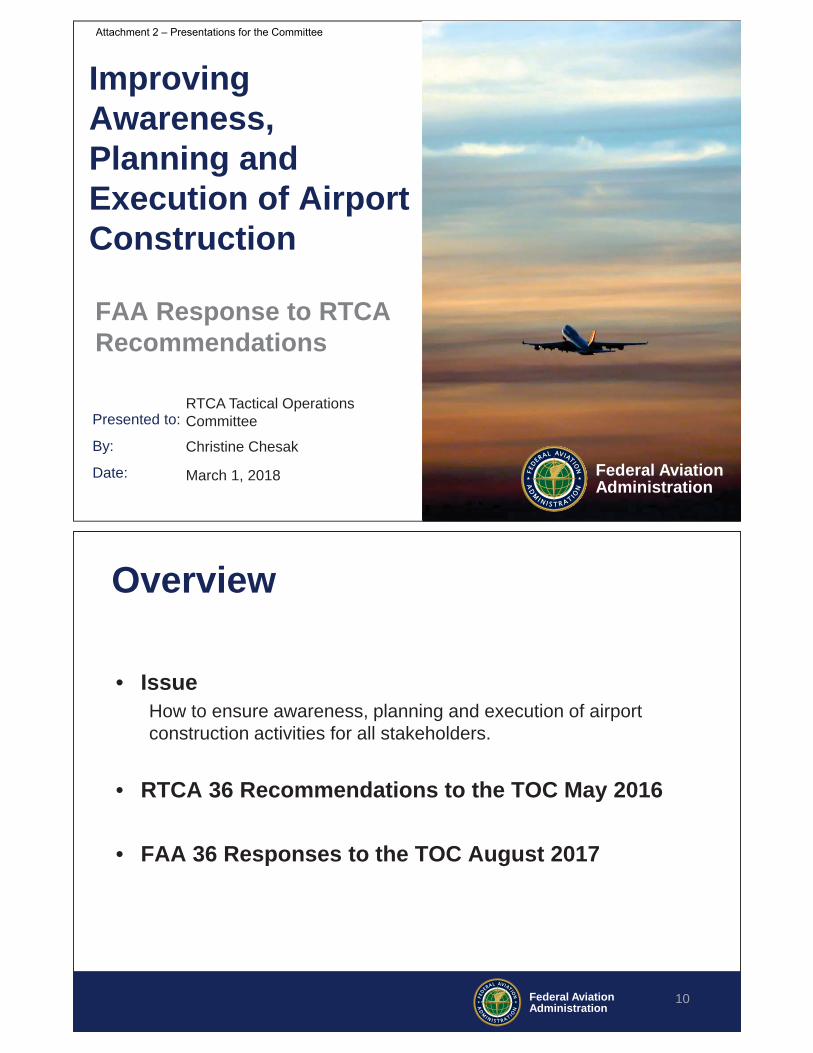
Airport Construction
Ms. Chesak also provided an update to TOC members on the Airport Construction recommendations. Her charts may be found on pages 9-16 of Attachment 2. She noted that the FAA is implementing based on its response to recommendations provided in August 2017. Operators gave positive feedback on the construction reports provided for the Core 30 airports and were optimistic about the forthcoming information on construction at small and medium airports. TOC members noted that further reporting on airport construction would be appropriate for the National Customer Forum (NCF) meetings. Another TOC member noted that there was suggested follow-on tasking related to exploration of the provision of lat/long information about construction cranes. The Member requested this issue not be abandoned because it was a safety concern for operators.
Evaluation of Ligado Proposal
Mr. Ken Alexander, FAA, next provided a response to the TOC’s evaluation of the Ligado proposal. His briefing materials may be found on pages 30-31 of Attachment 2. Mr. Alexander informed the TOC that if Ligado is approved to transmit, their publicly recognized plan is to limit power to a range that is acceptable to certified aviation receivers. However, the Ligado plan is to increase power over time
4 | P a g e
with the end state being the same power levels as the 2011 plan submitted by LightSquared. One TOC Member commented that industry understands any approval for an initial plan would also include ‘creep’ between power levels at the start and power levels at mature states. The Member noted that industry will have a strong concern on this issue and will watch it closely.
Aeronautical Information Management Modernization (AIMM) Segment 3
Mr. Bob McMullen, FAA, briefed the TOC on the status of recommendations regarding AIMM Segment 3. Mr. McMullen’s briefing materials may be found in Attachment 4. A TOC Member inquired about funding status for AIMM. Mr. McMullen advised that Segment 2 is fully funded and Segment 3 is also funded at this time. Another Member inquired about what the FAA’s plans were for the Special Use Airspace (SUA) web portal and whether such information would be provided both on and off SWIM in the future. Mr. McMullen advised that such information would be available in both ways in the future.
Caribbean
Ms. Andrea Freeburg, FAA, briefed the TOC on activities in the Caribbean. Ms. Freeburg’s briefing materials may be found on pages 33 to 37 in Attachment 2. She noted that funds in the Caribbean continue to be focused on hurricane recovery. A TOC Member commented that an update from the FAA on reconstruction would be appreciated.
Common Support Services – Flight Data
Mr. Ray Ahlberg, FAA, briefed the TOC on recommendations regarding CSS-FFD. Mr. Ahlberg’s briefing materials may be found on pages 40 to 57 in Attachment 2. Responding to a question from a TOC Member, Mr. Ahlberg explained that the CSS FD Program had previously worked with the Future Concept Team (FCT) in CDM but came to the TOC with this request to further understand the business case for CSS FD. He mentioned that in the future, the FAA is considering the CDM Automation Team (CAT) or the SWIFT group for further engagement. A TOC Member commented that if CSS FD has dependencies on industry investments, the FAA will seek assurances of investment before continuing. The Member noted that industry engagement is critical moving forward and this should include decision makers who can make appropriate commitments. Another TOC Member commented that CSS FD has great significant in the potential change in flight planning and investments. The Member commented that future discussion around this topic should be ‘up-leveled’ to the NACSC.
Class B Airspace
Mr. Kenny Ready, FAA, briefed the TOC on recommendations regarding Class B Airspace. Mr. Ready’s briefing materials may be found on pages 58 to 64 in Attachment 2. Mr. Ready noted that with new criteria for Class B airspace as well as criteria for cancellation, 11 current Class B’s may not be retained as Class B in the future. The TOC effort and its results were hailed as a collaboration success for its recommendations and ensuring implementation.
Graphical TFRs
Mr. Scott Jerdan, FAA, provided an update to the FAA’s evaluation of recommendations on Graphical TFRs. Mr. Jerdan’s briefing materials may be found on pages 65 to 79 in Attachment 2. He noted that

5 | P a g e
some recommendations involve automation changes that are expensive. The FAA’s approach is to make the underlying data available first and ensure the quality of the data. After doing this, the FAA plans to work to make the information available graphically.
Consideration of Recommendations on Intentional GPS Interference
Mr. Rune Duke, AOPA, and Mr. Wes Googe, American Airlines, Co-Chairs of the Intentional GPS Interference Task group provided a high level overview of the recommendations for GPS Interference. The briefing slides used by Mr. Duke and Mr. Googe may be found on pages 81 to 99 of Attachment 2.
Mr. Duke informed the TOC that the Department of Defense carries out intentional GPS interference according to a Presidential Director. In the last 5 years, the number of tests as well as the number of unique test locations has increased in the NAS. The TOC was tasked to evaluate the operational impacts of such interference testing. The Task Group that developed the report included representatives from commercial airlines, general aviation, business aviation, pilot and controller labor groups, the DoD and multiple lines of business in the FAA.
The recommendation report includes 25 recommendations that address the following issues:
• Interference event scheduling • Notification of interference events • Impacts during event – to operations, aircraft, NAS equipment, pilots/controllers/dispatchers
and mitigations • Concerns for NextGen • Additional industry concerns beyond scope of the task
The recommendations highlight the fact that interference, whether scheduled DoD tests or anything else, are all of concern to operators. While these recommendations focus on DoD testing, the industry must remain concerned about all sources of interference. Industry concern for resiliency is of prime importance.
Mr. Duke and Mr. Googe also highlighted specific recommendations relating to improving depiction of interference impact regions, gathering operational data on impacts, defining expected impacts to aircraft systems and improving guidance for pilots, dispatchers and controllers.
A TOC Member commented that the time period when testing actually occurs is different from the time period included in the interference NOTAM. There is conservatism built into the time. ATC awareness is critical for real time awareness of testing and advising the aircraft.
Another TOC Member commented that work is underway to provide an option for aircraft that lose GPS and ADS-B due to interference to continue operating despite the 91.227 regulation. Mr. Duke noted that recommendations also include the need for operators to increase training and data collection to complement FAA efforts.
• Committee Action: The Committee agreed by consensus to accept the “Operational Impacts from Intentional GPS Interference”. Attachment 5 to this report is the final and approved report that

6 | P a g e
the TOC transmitted to the FAA. With this report, the work of this Task Group was complete and the group was sun set.
Adjourn
Chairmen Roberts and Woods ended the meeting of the Committee at 2:00 p.m.
Next Meeting
This was the final meeting of the Tactical Operations Committee, and it will be sunset on March 31, 2018.

Attendees: March 1 2018 Meeting of the Tactical Operations Committee(Note: Committee member names appear in italics)
Name CompanyAbrahamsen, Thor The MITRE CorporationAhlberg, Ray Federal Aviation AdministrationAlexander, Ken Federal Aviation AdministrationBertapelle, Joe JetBlue AirwaysByus, Greg Federal Aviation AdministrationChen, Linda Federal Aviation AdministrationChesak, Christine Federal Aviation AdministrationCirillo, Michael Airlines for AmericaDecker, Bob Federal Aviation AdministrationDuke, Rune Aircraft Owners and Pilots AssociationFord, JoAnn Federal Aviation AdministrationFowler, Kimberly Federal Aviation AdministrationFreeburg, Andrea Federal Aviation AdministrationGooge, Wes American AirlinesHamel, Christophe L-3 CommunicationsHopkins, Mark Delta Air Lines, Inc.Jerdan, Scott Federal Aviation AdministrationMcCarthy, Jodi Federal Aviation AdministrationMcMullen, Bob Federal Aviation AdministrationMitra, Trin RTCA, Inc.Morse, Glenn United Airlines, Inc.Murphy, Bill International Air Transport AssociationNarowski, Tiffany Federal Aviation AdministrationNarvid, Juan Federal Aviation AdministrationPennington, Darrell Air Line Pilots Association (ALPA)Planty, Jeff Federal Aviation AdministrationReady, Ken Federal Aviation AdministrationRichardson, Mike Federal Aviation AdministrationRoberts, Bart JetBlue AirwaysShort, Rico Beacon Management GroupSolley, Edwin Southwest AirlinesSteinbicker, Mark Federal Aviation AdministrationTennille, Greg The MITRE CorporationTownsend, Brian American Airlines, Inc.Williams, Heidi National Business Aviation AssociationWoods, Jeff National Air Traffic Controllers Association
Attachment 1 - Attendees Mar 1 2018 Meeting

Nineteenth Meeting of the RTCA Tactical Operations Committee
March 1, 2018RTCA Inc.
Washington, DC
Welcome and Introductions
Co-Chairs:
Bart Roberts, JetBlue
Jeff Woods, NATCA
2
Attachment 2 – Presentations for the Committee

PUBLIC MEETING ANNOUNCEMENTRead by: Designated Federal Officer Jodi McCarthy
Tactical Operations Committee (TOC)March 1, 2018
In accordance with the Federal Advisory Committee Act, this Advisory Committee meeting is OPEN TO THE PUBLIC.
Notice of the meeting was published in the Federal Register on:
February 7, 2018
Members of the public may address the committee with PRIOR APPROVAL of the chairman. This should be arranged in advance.
Only appointed members of the Advisory Committee may vote on any matter brought to a vote by the Chairman.
The public may present written material to the Advisory Committee at any time.
3
Review and Approval of:
December 5, 2017Meeting Summary
4
Attachment 2 – Presentations for the Committee

Future of the TOC
FAA Update
FAA Response on Previous Recommendations
Intentional GPS Interference Recommendations
5
Topical Agenda
Future of the TOC
Jodi McCarthyVice President, Mission Support Services
Air Traffic Organization
6
Attachment 2 – Presentations for the Committee

FAA Report
Jodi McCarthyVice President, Mission Support Services
Air Traffic Organization
7
FAA Response on Previous Recommendations
• PBN Route System – Chris Chesak, FAA
• Airport Construction – Chris Chesak, FAA
• Ligado/Lightsquared Tasks – Ken Alexander, FAA
• AIMM Segment 3 – Bob McMullen, FAA
• Caribbean airspace – Krista Berquist & Andrea Freeburg, FAA
8
Attachment 2 – Presentations for the Committee
Presented to:
By:
Date: Federal AviationAdministration
Improving Awareness,Planning and Execution of Airport Construction
FAA Response to RTCA Recommendations
RTCA Tactical Operations Committee
Christine Chesak
March 1, 2018
Federal AviationAdministration
Overview
• IssueHow to ensure awareness, planning and execution of airport construction activities for all stakeholders.
• RTCA 36 Recommendations to the TOC May 2016
• FAA 36 Responses to the TOC August 2017
10
Attachment 2 – Presentations for the Committee

Federal AviationAdministration
Collaboration at the AirportCollaboration is an interactive process conducted by people, preferably in person, in which ideas can be exchanged and policies, targets, measures and metrics can be shaped and reshaped from people’s input based on their experience and knowledge.
Talk OftenAnd
Talk Early11
Federal AviationAdministration
What’s Happening (1/4)• Capital Project Reports
– Quarterly Report on the Core 30 + airports– Report on the Medium / Small airport (soon)
• Education and Training– FAA Support for Airport Construction Brochure– Airport Construction Desk Guide (soon)– ACI-NA 2018 Airports @ Work Conference
12
Attachment 2 – Presentations for the Committee

Federal AviationAdministration
What’s Happening (2/4)
• Construction Notice NOTAM Manager– 1155 airports activated and converted overall– 100-150 airports in conversation process overall– 300-350 airports not interested overall– Of the 365 “complex”, approx. 60 not converted
• Advisory Circular Updates– AC 150/5370-2G published Dec 2017
13
Federal AviationAdministration
What’s happening (3/4)
• Integration of Projects– CPI with ATO and to ARP, Next Gen
• GIS Survey Data – Internal Workgroup actively meeting
• Magnetic Variation Tolerance Data– Internal initiatives taking place
14
Attachment 2 – Presentations for the Committee
Federal AviationAdministration
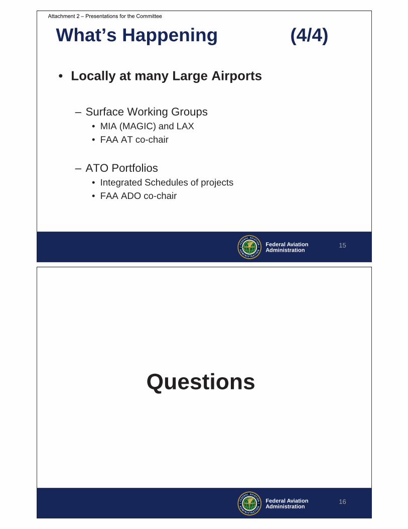
What’s Happening (4/4)
• Locally at many Large Airports
– Surface Working Groups• MIA (MAGIC) and LAX• FAA AT co-chair
– ATO Portfolios• Integrated Schedules of projects• FAA ADO co-chair
15
Federal AviationAdministration
Questions
16
Attachment 2 – Presentations for the Committee

Presented to:
By:
Date:
Federal AviationAdministrationPerformance
Based Navigation Route StructureCon Ops
FAA Response to RTCA Recommendations
17
RTCA TOC
Christine Chesak
March 1, 2018
Federal AviationAdministration
RTCA Tasks from the TOC
1. Use broader expertise and data to refine or validate CONOPs problem statement.
2. Recommend refinement to the criteria-based methodology for establishing low and high altitude PBN route structure.
3. Recommend a NAS wide point to point navigation strategy
4. Recommend alternatives to the proposed approach for design and implementation.
18
Attachment 2 – Presentations for the Committee

Federal AviationAdministration
PBN RS RTCA Task Groups
19
High Altitude26 recommendations
CONUS Low Altitude43 recommendations
FL180
92 recommendations, some of which will require additional analysis and cross-LOB vetting
Alaska Low Altitude23 recommendations
Federal AviationAdministration
Recommendation Response Strategy
20
In CONOPS Already
• Agree with recommendation and identify location in ConOps
• Respond
Agree but not in CONOPS
• Agree with recommendation
• Respond and incorporate in CONOPS as needed
Vetting thru a Few Lines of
Business
• Prepare recommendation for vetting with relevant information and proposed response
• Respond and incorporate in CONOPS as needed
Vetting thru Multiple Lines of
Business
• Prepare recommendation for vetting with relevant information and proposed response
• Respond and incorporate in CONOPS as needed
Analysis Required then Vetting thru
Lines of Business
• Identify and begin necessary analysis
• Prepare recommendation for vetting with relevant information and proposed response
• Respond and incorporate in CONOPS as needed
92 Recommendations
Estimated response to all recommendations: Sep 30, 2018
Does Not Apply to Route Structure
• Out of scope for route structure tasking
Attachment 2 – Presentations for the Committee

Federal AviationAdministration
Recommendation Categories
21
Federal AviationAdministration
Recommendations underway
• #5 – GPS Interference– RTCA GPS Interference Recommendations
• #17 – Low MEAs– T-222 Notional Design
• # 19 – OROCA– July 2018 OROCA change going on Alaska charts
• # 22 – PT to PT Education– AOPA/NATCA AIM document change proposal
submitted
22
Attachment 2 – Presentations for the Committee

Federal AviationAdministration
23
Federal AviationAdministration
BACK UP DATA SLIDES
24
Attachment 2 – Presentations for the Committee

Federal AviationAdministration
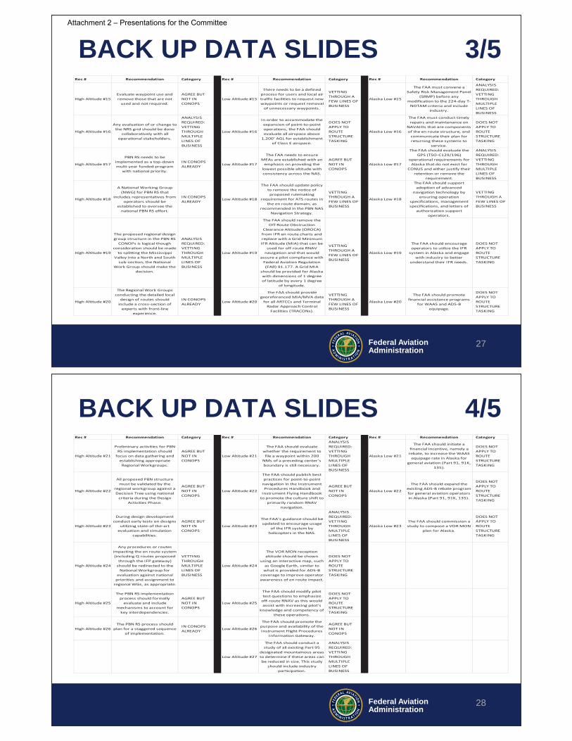
BACK UP DATA SLIDES 1/5
25
Rec # Recommendation Category Rec # Recommendation Category Rec # Recommendation Category
High Altitude #1
There is a compelling need for the PBN Route System but
consideration should be made to adjusting the CONOPs
Problem Statement as noted below.
VETTING THROUGH A FEW LINES OF BUSINESS
Low Altitude #1
The Task Group supports utilizing the JO 7100.41
process for PBN RS development and
recommends geographically separating the work by Service
Center and Alaska.
IN CONOPS ALREADY
Alaska Low #1
The FAA should comprehensively evaluate the en route navigation needs of Alaska and ensure a baseline
level of service is being provided as part of the PBN RS
CONOPs implementation.
IN CONOPS ALREADY
High Altitude #2
The PBN Route System CONOPs should provide a high level depiction of the expected
future state when implemented.
VETTING THROUGH A FEW LINES OF BUSINESS
Low Altitude #2
The FAA should create, remove, optimize, or retain
route structures based on the criteria detailed in the decision
trees below.
AGREE BUT NOT IN CONOPS
Alaska Low #2
The FAA should task the TOC to evaluate the long-term
terminal IFR infrastructure needs of Alaska as part of the
development of an Alaska terminal CONOPs.
DOES NOT APPLY TO ROUTE STRUCTURE TASKING
High Altitude #3Structure in the NAS should be implemented and utilized at a
segment level.
AGREE BUT NOT IN CONOPS
Low Altitude #3Future new low altitude routes
in CONUS should solely be RNAV routes.
IN CONOPS ALREADY Alaska Low #3
The FAA should add AWOS surface weather reporting
stations to those airports that contain instrument
approaches, but lack certified weather reporting, given the
improvements to en route weather forecasting that they
would provide.
DOES NOT APPLY TO ROUTE STRUCTURE TASKING
High Altitude #4
There should be a mechanism to ensure operators are aware of which routes are required,
where and at what times.
AGREE BUT NOT IN CONOPS
Low Altitude #4
A new RNAV route should be implemented in conjunction
with the removal of pre-existing routes.
AGREE BUT NOT IN CONOPS
Alaska Low #4
The FAA should transition the Alaskan en route navigation
structure away from any dependency on NDBs.
ANALYSIS REQUIRED: VETTING THROUGH MULTIPLE LINES OF BUSINESS
High Altitude #5
In addition to PBN ATS routes, a more agile form of structure should also be utilized in PBN
RS.
VETTING THROUGH A FEW LINES OF BUSINESS
Low Altitude #5
The FAA should more accurately define the impacts
of GPS intentional interference events as they relate to real-time navigation, and improve the process of communicating the impacts of these events to
internal and external stakeholders-- including providing interference
advisories on the Notice to Airmen (NOTAM) Search
website.
VETTING THROUGH MULTIPLE LINES OF BUSINESS
Alaska Low #5
The FAA should evaluate all Colored Airways for: (a) direct
replacement (i.e., overlay) with a T-Route that offers a
similar or lower MEA; (b) the replacement of the colored airway with a T-Route in an
optimized but similar geographic area while
retaining similar or lower MEA; or (c) removal with no
route structure (T-Route) restored in that area because value was determined to be
insignificant.
VETTING THROUGH MULTIPLE LINES OF BUSINESS
High Altitude #6
Airspace boundary realignment should be
considered as the PBN route system evolves.
VETTING THROUGH A FEW LINES OF BUSINESS
Low Altitude #6
Colored Federal Airways should be transitioned out of the CONUS en route structure
(excludes the Caribbean).
AGREE BUT NOT IN CONOPS
Alaska Low #6
The FAA’s criteria to identify the priority of removal of an
NDB from the en route structure should include
operational considerations.
ANALYSIS REQUIRED: VETTING THROUGH MULTIPLE LINES OF BUSINESS
High Altitude #7 Structure requires regular review and maintenance.
IN CONOPS ALREADY
Low Altitude #7
While international NDB airways will remain in the CONUS, the FAA should
ensure these airways are maintained.
VETTING THROUGH A FEW LINES OF BUSINESS
Alaska Low #7
The FAA should ensure there is a process for operator and air traffic feedback prior to decommissioning a Colored
Airway that would not be replaced with a T-Route
(should there not be redundant routes available).
IN CONOPS ALREADY
Federal AviationAdministration
BACK UP DATA SLIDES 2/5
26
Rec # Recommendation Category Rec # Recommendation Category Rec # Recommendation Category
High Altitude #8Expansion of the network of DMEs should move forward.
IN CONOPS ALREADY Low Altitude #8
The FAA needs to request a larger allocation of RNAV
Routes.
ANALYSIS REQUIRED: VETTING THROUGH MULTIPLE LINES OF BUSINESS
Alaska Low #8The FAA should maintain all VORs and Victor Airways in
Alaska.
VETTING THROUGH A FEW LINES OF BUSINESS
High Altitude #9
The FAA should develop and publish national guidance that defines criteria for establishing high altitude route structure.
IN CONOPS ALREADY Low Altitude #9
The FAA should identify the areas projected to lack
surveillance coverage in 2025 and evaluate the benefit of
expanding ADS-B coverage to surveil these areas.
ANALYSIS REQUIRED: VETTING THROUGH MULTIPLE LINES OF BUSINESS
Alaska Low #9
The FAA should install additional ADS-B radio
stations to expand coverage of surveillance and broadcast
products.
DOES NOT APPLY TO ROUTE STRUCTURE TASKING
High Altitude #10The NRS grid should not be
removed from the NAS.
ANALYSIS REQUIRED: VETTING THROUGH MULTIPLE LINES OF BUSINESS
Low Altitude #10
The FAA should solicit industry input into the Airport
Surveillance Radar (ASR) decommissioning CONOPs.
DOES NOT APPLY TO ROUTE STRUCTURE TASKING
Alaska Low #10
The FAA should work with industry to help create the
ADS-B expansion benefits case and evaluate where coverage
is needed.
DOES NOT APPLY TO ROUTE STRUCTURE TASKING
High Altitude #11
The NRS grid training process for pilots and controllers should be evaluated and
improved to ensure front-line personnel are familiar with the
grid.
ANALYSIS REQUIRED: VETTING THROUGH MULTIPLE LINES OF BUSINESS
Low Altitude #11
The FAA should ensure there is a long-term, funded
sustainment plan for those NAVAIDs determined to be
integral to the NAS.
DOES NOT APPLY TO ROUTE STRUCTURE TASKING
Alaska Low #11
The FAA should utilize the Flight Procedures waiver
process to provide relief to overly restrictive airway
design requirements in areas with a justifiable equivalent
level of safety.
AGREE BUT NOT IN CONOPS
High Altitude #12En route displays should allow Air Traffic Controllers to view NRS grid points for reroutes.
ANALYSIS REQUIRED: VETTING THROUGH MULTIPLE LINES OF BUSINESS
Low Altitude #12
The FAA should consider the MON needing to be in place beyond 2045 so must put in
place an infrastructure recapitalization plan.
DOES NOT APPLY TO ROUTE STRUCTURE TASKING
Alaska Low #12
The FAA should provide lower MEAs on certain segments of
an airway to increase the likelihood of breaking out in
VFR conditions.
VETTING THROUGH A FEW LINES OF BUSINESS
High Altitude #13
Evaluate concepts that optimize grid density in a
manner that is operationally acceptable to controllers and Flight Management System
capabilities.
ANALYSIS REQUIRED: VETTING THROUGH MULTIPLE LINES OF BUSINESS
Low Altitude #13
For those VOR MON NAVAIDs that are decommissioned and
those airways that are correspondingly removed,
create an RNAV waypoint at the previous NAVAID location
and retain all fixes and intersections along that route
currently in place by amending their definition to that of an
RNAV waypoint.
IN CONOPS ALREADY
Alaska Low #13
The FAA should expand communication coverage to areas identified by industry and consider the role that Remote Communications
Outlets (RCOs) serve for en route operations.
DOES NOT APPLY TO ROUTE STRUCTURE TASKING
High Altitude #14 Explore international harmonization of the NRS grid.
ANALYSIS REQUIRED: VETTING THROUGH MULTIPLE LINES OF BUSINESS
Low Altitude #14
The FAA should: (a) retain the existing five letter
pronounceable name for the conventional
intersections/fixes that are transitioned to RNAV
waypoints; (b) if no NAVAID is to be retained, create an RNAV waypoint at that same lat/long
and evaluate utilizing a five letter pronounceable name
that is related to the NAVAIDs original name; and (c) if the DME is retained, continue to
utilize its three letter identifier.
VETTING THROUGH A FEW LINES OF BUSINESS
Alaska Low #14
The FAA should formalize a process to allow air traffic communication gaps along
routes in areas where the MEA would be positively reduced
and the FAA should chart these communication gaps.
ANALYSIS REQUIRED: VETTING THROUGH MULTIPLE LINES OF BUSINESS
Attachment 2 – Presentations for the Committee
Federal AviationAdministration
BACK UP DATA SLIDES 3/5
27
Rec # Recommendation Category Rec # Recommendation Category Rec # Recommendation Category
High Altitude #15Evaluate waypoint use and remove those that are not
used and not required.
AGREE BUT NOT IN CONOPS
Low Altitude #15
There needs to be a defined process for users and local air traffic facilities to request new waypoints or request removal
of unnecessary waypoints.
VETTING THROUGH A FEW LINES OF BUSINESS
Alaska Low #15
The FAA must convene a Safety Risk Management Panel
(SRMP) before any modification to the 224-day T-
NOTAM criteria and include industry.
ANALYSIS REQUIRED: VETTING THROUGH MULTIPLE LINES OF BUSINESS
High Altitude #16
Any evaluation of or change to the NRS grid should be done
collaboratively with all operational stakeholders.
ANALYSIS REQUIRED: VETTING THROUGH MULTIPLE LINES OF BUSINESS
Low Altitude #16
In order to accommodate the expansion of point-to-point operations, the FAA should evaluate all airspace above
1,200’ AGL for establishment of Class E airspace.
DOES NOT APPLY TO ROUTE STRUCTURE TASKING
Alaska Low #16
The FAA must conduct timely repairs and maintenance on
NAVAIDs that are components of the en route structure, and
communicate their plan for returning these systems to
service.
DOES NOT APPLY TO ROUTE STRUCTURE TASKING
High Altitude #17
PBN RS needs to be implemented as a top-down multi-year funded program
with national priority.
IN CONOPS ALREADY Low Altitude #17
The FAA needs to ensure MEAs are established with an
emphasis on providing the lowest possible altitude with consistency across the NAS.
AGREE BUT NOT IN CONOPS
Alaska Low #17
The FAA should evaluate the GPS (TSO-C129/196)
operational requirements for Alaska that do not exist for
CONUS and either justify their retention or remove the
requirement.
ANALYSIS REQUIRED: VETTING THROUGH MULTIPLE LINES OF BUSINESS
High Altitude #18
A National Working Group (NWG) for PBN RS that
includes representatives from operators should be
established to oversee the national PBN RS effort.
IN CONOPS ALREADY
Low Altitude #18
The FAA should update policy to remove the notice of proposed rulemaking
requirement for ATS routes in the en route domain, as
recommended in the PBN NAS Navigation Strategy.
VETTING THROUGH A FEW LINES OF BUSINESS
Alaska Low #18
The FAA should support adoption of advanced
navigation technology by ensuring operation
specifications, management specifications, and letters of
authorization support operators.
VETTING THROUGH A FEW LINES OF BUSINESS
High Altitude #19
The proposed regional design group structure in the PBN RS
CONOPs is logical though consideration should be made
to splitting the Mississippi Valley into a North and South
sub-section; the National Work Group should make the
decision.
ANALYSIS REQUIRED: VETTING THROUGH MULTIPLE LINES OF BUSINESS
Low Altitude #19
The FAA should remove the Off Route Obstruction
Clearance Altitude (OROCA) from IFR en route charts and replace with a Grid Minimum IFR Altitude (MIA) that can be
used for off route RNAV navigation and that would
assure a pilot compliance with Federal Aviation Regulation (FAR) 91.177. A Grid MIA
should be provided for Alaska with dimensions of 1 degree of latitude by every 1 degree
of longitude.
VETTING THROUGH A FEW LINES OF BUSINESS
Alaska Low #19
The FAA should encourage operators to utilize the IFR
system in Alaska and engage with industry to better
understand their IFR needs.
DOES NOT APPLY TO ROUTE STRUCTURE TASKING
High Altitude #20
The Regional Work Groups conducting the detailed local
design of routes should include a cross-section of
experts with front-line experience.
IN CONOPS ALREADY
Low Altitude #20
The FAA should provide georeferenced MIA/MVA data
for all ARTCCs and Terminal Radar Approach Control
Facilities (TRACONs).
VETTING THROUGH A FEW LINES OF BUSINESS
Alaska Low #20
The FAA should promote financial assistance programs
for WAAS and ADS-B equipage.
DOES NOT APPLY TO ROUTE STRUCTURE TASKING
Federal AviationAdministration
BACK UP DATA SLIDES 4/5
28
Rec # Recommendation Category Rec # Recommendation Category Rec # Recommendation Category
High Altitude #21
Preliminary activities for PBN RS implementation should
focus on data gathering and establishing appropriate Regional Workgroups.
AGREE BUT NOT IN CONOPS
Low Altitude #21
The FAA should evaluate whether the requirement to file a waypoint within 200
NMs of a preceding center’s boundary is still necessary.
ANALYSIS REQUIRED: VETTING THROUGH MULTIPLE LINES OF BUSINESS
Alaska Low #21
The FAA should initiate a financial incentive, namely a
rebate, to increase the WAAS equipage rate in Alaska for
general aviation (Part 91, 91K, 135).
DOES NOT APPLY TO ROUTE STRUCTURE TASKING
High Altitude #22
All proposed PBN structure must be validated by the
regional workgroup against a Decision Tree using national
criteria during the Design Activities Phase.
AGREE BUT NOT IN CONOPS
Low Altitude #22
The FAA should publish best practices for point-to-point
navigation in the Instrument Procedures Handbook and
Instrument Flying Handbook to promote the culture shift to
primarily random RNAV navigation.
AGREE BUT NOT IN CONOPS
Alaska Low #22
The FAA should expand the existing ADS-B rebate program for general aviation operators in Alaska (Part 91, 91K, 135).
DOES NOT APPLY TO ROUTE STRUCTURE TASKING
High Altitude #23
During design development conduct early tests on designs
utilizing state-of the-art evaluation and simulation
capabilities.
AGREE BUT NOT IN CONOPS
Low Altitude #23
The FAA’s guidance should be updated to encourage usage
of the IFR system by helicopters in the NAS.
ANALYSIS REQUIRED: VETTING THROUGH MULTIPLE LINES OF BUSINESS
Alaska Low #23The FAA should commission a study to compose a VOR MON
plan for Alaska.
DOES NOT APPLY TO ROUTE STRUCTURE TASKING
High Altitude #24
Any procedures or routes impacting the en route system (including Q routes proposed
through the IFP gateway) should be redirected to the
National Workgroup for evaluation against national
priorities and assignment to regional WGs, as appropriate.
VETTING THROUGH MULTIPLE LINES OF BUSINESS
Low Altitude #24
The VOR MON reception altitude should be shown
using an interactive map, such as Google Earth, similar to what is provided for ADS-B
coverage to improve operator awareness of en route impact.
DOES NOT APPLY TO ROUTE STRUCTURE TASKING
High Altitude #25
The PBN RS implementation process should formally
evaluate and include mechanisms to account for
key interdependencies.
AGREE BUT NOT IN CONOPS
Low Altitude #25
The FAA should modify pilot test questions to emphasize
off-route RNAV as this would assist with increasing pilot’s
knowledge and competency of these operations.
DOES NOT APPLY TO ROUTE STRUCTURE TASKING
High Altitude #26The PBN RS process should
plan for a staggered sequence of implementation.
IN CONOPS ALREADY Low Altitude #26
The FAA should promote the purpose and availability of the Instrument Flight Procedures
Information Gateway.
AGREE BUT NOT IN CONOPS
Low Altitude #27
The FAA should conduct a study of all existing Part 95
designated mountainous areas to determine if these areas can be reduced in size. This study
should include industry participation.
ANALYSIS REQUIRED: VETTING THROUGH MULTIPLE LINES OF BUSINESS
Attachment 2 – Presentations for the Committee

Federal AviationAdministration
BACK UP DATA SLIDES 5/5
29
Rec # Recommendation Category Rec # Recommendation Category
Low Altitude #28
The FAA should chart all NAVAIDs that are
permanently out of service with the crosshatched pattern to indicate shutdown status.
ANALYSIS REQUIRED: VETTING THROUGH MULTIPLE LINES OF BUSINESS
Low Altitude #36The FAA should support an
increase in the number of PBN co-leads.
DOES NOT APPLY TO ROUTE STRUCTURE TASKING
Low Altitude #29
The FAA should have a unified, national approach to develop and implement public RNAV
routes that meet the needs of the helicopter community.
AGREE BUT NOT IN CONOPS
Low Altitude #37
FAA prioritization of route development should include
factors such as propensity for icing, alternate forms of
access, etc., and not solely driven by usage.
ANALYSIS REQUIRED: VETTING THROUGH MULTIPLE LINES OF BUSINESS
Low Altitude #30
The FAA should establish an initiative to promote their
ability to conduct helicopter route construction including automation to handle those
requests efficiently.
ANALYSIS REQUIRED: VETTING THROUGH MULTIPLE LINES OF BUSINESS
Low Altitude #38
The Instrument Flight Procedures Information
Gateway should be better tailored to route submittals.
VETTING THROUGH A FEW LINES OF BUSINESS
Low Altitude #31
The FAA should initiate a demonstration project
implementing an RNP 0.3 helicopter route.
ANALYSIS REQUIRED: VETTING THROUGH MULTIPLE LINES OF BUSINESS
Low Altitude #39The FAA should interconnect RNAV routes with adjoining
ANSPs where beneficial.
IN CONOPS ALREADY
Low Altitude #32
The FAA should initiate a program to assume the ongoing maintenance
requirements for public-use and special (privately
developed) helicopter routes.
AGREE BUT NOT IN CONOPS
Low Altitude #40
Real time SAA status must be made available and provided to operators in a variety of ways, including directly to
pilots by NOTAM Search, in a manner ingestible by industry via System Wide Information
Management (SWIM), to Flight Service, and via Flight
Information Services-Broadcast (FIS-B).
ANALYSIS REQUIRED: VETTING THROUGH MULTIPLE LINES OF BUSINESS
Low Altitude #33
In areas with high potential for IFR helicopter operations, the
FAA should establish (a) additional ADS-B radio
stations to enable surveillance coverage to altitudes equal to
that of the controller MIA/MVA and (b) radio sites
where reception issues regularly require the
helicopter to operate above MIA/MVA.
ANALYSIS REQUIRED: VETTING THROUGH MULTIPLE LINES OF BUSINESS
Low Altitude #41
The FAA should provide ATC LOAs/SOPs on the NOTAM Search website and make
them available in a manner ingestible by industry.
ANALYSIS REQUIRED: VETTING THROUGH MULTIPLE LINES OF BUSINESS
Low Altitude #34
Add GNSS MEAs to existing conventional routes and
evaluate user demand for RNAV-only routes.
ANALYSIS REQUIRED: VETTING THROUGH MULTIPLE LINES OF BUSINESS
Low Altitude #42
The FAA should provide greater visibility/advertising of unique SAA LOA requirements
that facilitate relief for operators.
ANALYSIS REQUIRED: VETTING THROUGH MULTIPLE LINES OF BUSINESS
Low Altitude #35
The FAA should make several improvements to the JO
7100.41 process to better capture low altitude operator
input.
VETTING THROUGH A FEW LINES OF BUSINESS
Low Altitude #43
The FAA should evaluate an affordable solution for general
aviation to receive IFR clearances via their mobile
device.
ANALYSIS REQUIRED: VETTING THROUGH MULTIPLE LINES OF BUSINESS
Federal AviationAdministrationLigado
Presented To: RTCA Tactical Operations Committee
Presented By: Ken Alexander
Date: March 1, 2018
FAA Response to RTCA
Attachment 2 – Presentations for the Committee

Federal AviationAdministration
What’s Happening
31
•No FCC proceedings—awaiting NTIA position
•NTIA awaiting PNT Executive Committee (EXCOM) chaired by Deputy Secretary (was scheduled for 25 Jan, but cancelled due to Monday’s lapse in funding)—reschedule currently in work.
•DOT Adjacent Band Compatibility Report (including FAA analysis)—anticipate public release in Feb 2018.
AIMM Segment 3 – Response on Previous Recommendations
32
Bob McMullen, FAA
Attachment 2 – Presentations for the Committee

Presented to:
By:
Date:
Federal AviationAdministration
Federal Aviation Administration
RTCA Eastern Regional Task Group Tactical Operations Committee
Andrea Freeburg
March 1, 2018
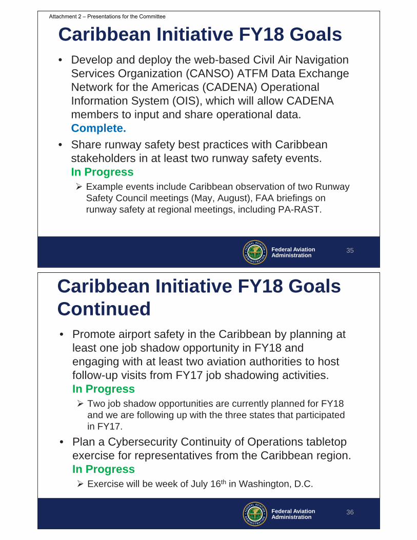
Caribbean Initiative Update
Federal AviationAdministration
• Caribbean Initiative started in FY16 • Through the Caribbean Initiative, FAA’s
technical experts work with our Caribbean partners to: – improve air traffic flow management through
collaborative decision-making– increase airport safety and certification in the region
34
Caribbean Initiative Background
Attachment 2 – Presentations for the Committee
Federal AviationAdministration
Caribbean Initiative FY18 Goals
35
• Develop and deploy the web-based Civil Air Navigation Services Organization (CANSO) ATFM Data Exchange Network for the Americas (CADENA) Operational Information System (OIS), which will allow CADENA members to input and share operational data. Complete.
• Share runway safety best practices with Caribbean stakeholders in at least two runway safety events. In Progress
Example events include Caribbean observation of two Runway Safety Council meetings (May, August), FAA briefings on runway safety at regional meetings, including PA-RAST.
Federal AviationAdministration
Caribbean Initiative FY18 Goals Continued • Promote airport safety in the Caribbean by planning at
least one job shadow opportunity in FY18 andengaging with at least two aviation authorities to host follow-up visits from FY17 job shadowing activities. In Progress
Two job shadow opportunities are currently planned for FY18 and we are following up with the three states that participated in FY17.
• Plan a Cybersecurity Continuity of Operations tabletop exercise for representatives from the Caribbean region. In Progress
Exercise will be week of July 16th in Washington, D.C.
36
Attachment 2 – Presentations for the Committee
Federal AviationAdministration
Contacts
37
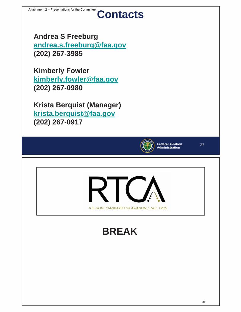
Andrea S [email protected](202) 267-3985
Kimberly [email protected](202) 267-0980
Krista Berquist (Manager)[email protected](202) 267-0917
BREAK
38
Attachment 2 – Presentations for the Committee

FAA Response on Previous Recommendations
• CSS FD – Ray Ahlberg, FAA
• Class B airspace – Scott Rosenbloom & Ken Ready, FAA
• Graphical TFRs – Scott Jerdan, FAA
39
Presented to:
By:
Date:
FAA Common Support Services- Flight Data (CSS-FD)Update in response to TOC Report
RTCA Tactical Operations Committee (TOC)
FAA AJV-73
March 1, 2018
Attachment 2 – Presentations for the Committee

Agenda
Quick Overview of CSS-FDCSS-FD ScheduleSummary of TOC Recommendations and FindingsFAA Plans to Address the Recommendations
41
CSS-FD Overview
42
Attachment 2 – Presentations for the Committee
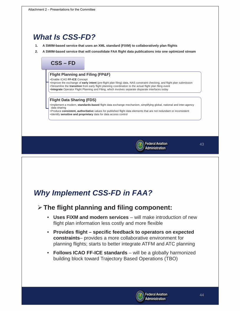
What Is CSS-FD?
43
1. A SWIM-based service that uses an XML standard (FIXM) to collaboratively plan flights
2. A SWIM-based service that will consolidate FAA flight data publications into one optimized stream
CSS – FD
Flight Planning and Filing (FP&F)•Enable ICAO FF-ICE Concept• Improve the exchange of early intent (pre-flight plan filing) data, NAS constraint checking, and flight plan submission•Streamline the transition from early flight planning coordination to the actual flight plan filing event• Integrate Operator Flight Planning and Filing, which involves separate disparate interfaces today
Flight Data Sharing (FDS)• Implement a modern, standards-based flight data exchange mechanism, simplifying global, national and inter-agency data sharing
•Produce consistent, authoritative values for published flight data elements that are not redundant or inconsistent• Identify sensitive and proprietary data for data access control
Why Implement CSS-FD in FAA?
44
The flight planning and filing component:• Uses FIXM and modern services – will make introduction of new
flight plan information less costly and more flexible
• Provides flight – specific feedback to operators on expected constraints– provides a more collaborative environment for planning flights; starts to better integrate ATFM and ATC planning
• Follows ICAO FF-ICE standards – will be a globally harmonized building block toward Trajectory Based Operations (TBO)
Attachment 2 – Presentations for the Committee

Why Implement CSS-FD in FAA?
45
The flight data sharing component:• Uses FIXM and modern services – will make management of
new flight plan information easier and more flexible
• Simplifies the stream of flight data provided by the FAA – Flight data will be easier and more understandable for users; less redundancy
Affected Interfaces, Before CSS-FD
46
ATC Automation for Specific ARTCCATC Automation for Specific ARTCCATC Automation for Specific ARTCCTFM Automation ATC Automation – ARTCC A
OperatorsOperators
Operators Automation
•Departure clearance
Flight Plan FilingFlight Planning Flight Execution
•Submit early intent •File flight plan
AFTNCDM Net
Attachment 2 – Presentations for the Committee
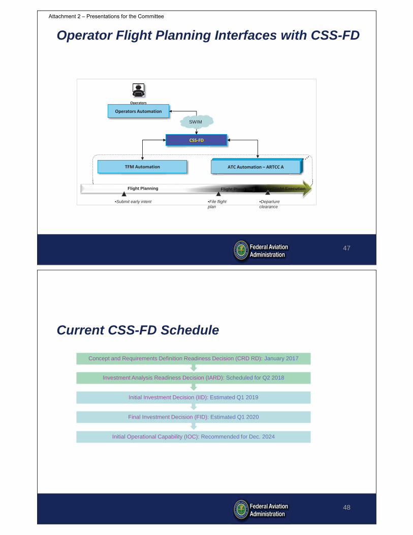
Operator Flight Planning Interfaces with CSS-FD
47
ATC Automation for Specific ARTCCATC Automation for Specific ARTCCATC Automation for Specific ARTCCTFM Automation ATC Automation – ARTCC A
OperatorsOperators
Operators Automation
•Departure clearance
Flight Plan FilingFlight Planning Flight Execution
•Submit early intent •File flight plan
CSS-FD
SWIM
Current CSS-FD Schedule
Initial Operational Capability (IOC): Recommended for Dec. 2024
Final Investment Decision (FID): Estimated Q1 2020
Initial Investment Decision (IID): Estimated Q1 2019
Investment Analysis Readiness Decision (IARD): Scheduled for Q2 2018
Concept and Requirements Definition Readiness Decision (CRD RD): January 2017
48
Attachment 2 – Presentations for the Committee

Summary of TOC Recommendations
49
50
• More predictable operations– With improved operator provided information, trajectory models and
flight plan feedback, system knowledge of trajectory and times should be improved
• Possible reduction in fuel carried and/or increase in payload– Improved information should more precisely align planned and actual
fuel required• Reduction in workload to Dispatchers
– Monitoring service post-filing that alerts based on change in constraint– Capability to electronically coordinate changes
Potential Benefits Identified by Workgroup
Attachment 2 – Presentations for the Committee

51
• CSS-FD feedback is valuable to operators to make strategicflight planning decisions that optimize its network
• The group suggested an initial prioritization of the types of information of most value; but indicated that more work is necessary to quantify the value and accurately assess what is needed
TOC Workgroup CSS-FD Findings
TOC Workgroup CSS-FD Findings (cont’d)
• The ability for operators to submit a route adjustment after lockout time has high operational value, in terms of safety and efficiency
52
Attachment 2 – Presentations for the Committee

TOC Workgroup CSS-FD Findings (cont’d)
• Alignment of investment decision-making between FAA and industry is the underlying driver of success for CSS-FD
• The work group therefore recommends further collaborative analysis on the impacts of flight plan feedback between FAA and industry
53
FAA Plans to Address the Recommendations
• Continue alignment with Industry to:– Develop benefit analysis and business cases with
potential CSS-FD users– Prioritize program requirements
• Industry as well as FAA investment is necessary; we must ensure the service provided is worth the investment
54
Attachment 2 – Presentations for the Committee
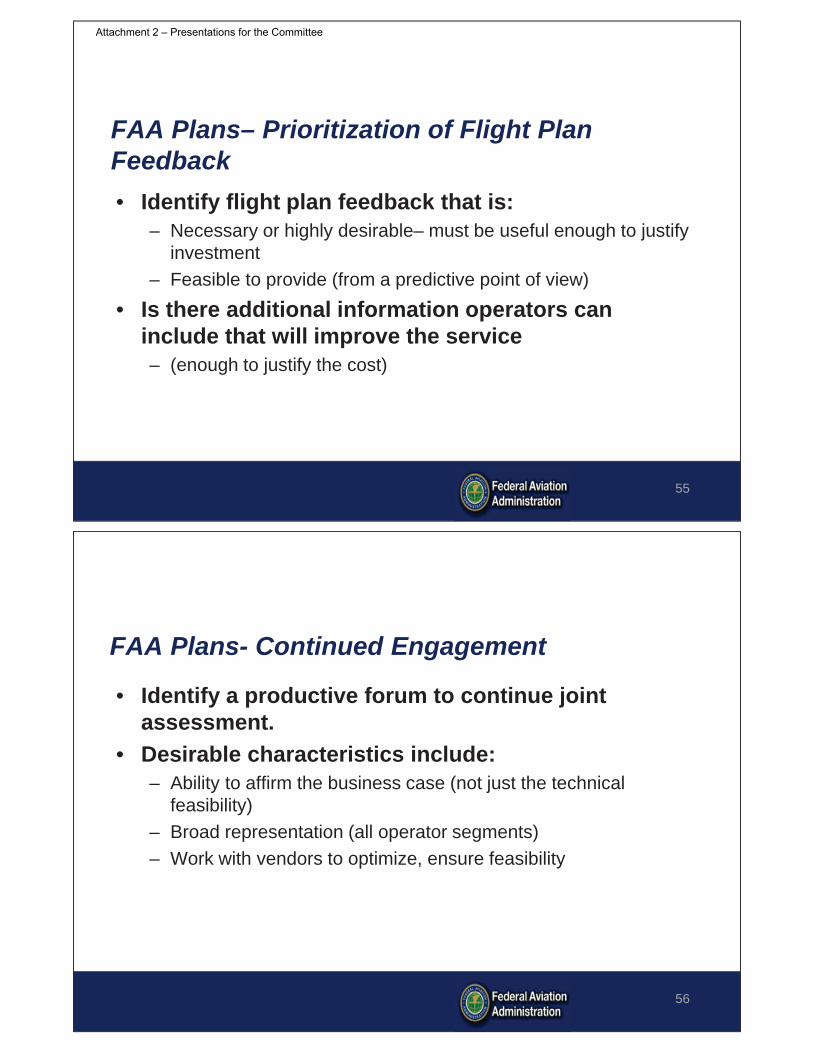
FAA Plans– Prioritization of Flight Plan Feedback• Identify flight plan feedback that is:
– Necessary or highly desirable– must be useful enough to justify investment
– Feasible to provide (from a predictive point of view)
• Is there additional information operators can include that will improve the service– (enough to justify the cost)
55
FAA Plans- Continued Engagement
• Identify a productive forum to continue joint assessment.
• Desirable characteristics include:– Ability to affirm the business case (not just the technical
feasibility)– Broad representation (all operator segments)– Work with vendors to optimize, ensure feasibility
56
Attachment 2 – Presentations for the Committee

Questions?
57
Presented to:
By:
Date:
Federal AviationAdministrationClass B Airspace:
Designation, Design and Evaluation FAA Response to RTCA
RTCA TOCKenny Ready, Airspace and Rules Team (AJV, 113) March 1, 2018
Attachment 2 – Presentations for the Committee

Federal AviationAdministration
Background/Timeline• Sept. 2015: FAA reviewed the RTCA Tactical Operations Committee
(TOC) Report from September 2015 titled, “Class B Airspace: Designation, Design and Evaluation”
• Feb. 2016: FAA briefed TOC on initial response with the need for a working group due to lack of Class B experience in AJV-113
• Jan. 2017: FAA’s Mission Support Services established Class B Working Group compromised of representatives and stakeholders from various lines of business (LOBs) within the FAA
• Oct. 2017: 10 of the 18 recommendations are current in Change 1 of the 7400.2 (Recommendations 2, 5, 6, 7, 8, 9, 10, 11, 13, 14)
• July 2017: Class B Working Group Report submitted• March 2018: Document Change Process (DCP) for 4 recommendations
59
Federal AviationAdministration
Workgroup OutcomesOf the 18 recommendations:• Non-concurred with 4 recommendations • Partially concurred with 3 recommendations• Concurred with 11 recommendations
60
Attachment 2 – Presentations for the Committee

Federal AviationAdministration
Non-Concur• Recommendation 4: “Criteria should be developed for airports with strong seasonal or time of
day demand surges.”o Concerns
ChartingNotifying UsersStaffing ATC facilities
• Recommendation 12: “Recommend introduction of an altitude buffer between protected Instrument Flight Rules (IFR) airplanes and Visual Flight Rules (VFR) aircraft.”o Concerns
De facto expansion of the Class BContinual lowering of the floor with every redesign
o RecommendationsEducate Class B aircraft and VFR aircraft of operating within close proximity of each otherChart high traffic areas as “Hot Spots” around Class B airspace
• Recommendation 17: “Conduct further public engagement before implementation of any design, designation and evaluation changes to Class B guidance.”o Concerns
Current DCP process engages FAA and National Air Space (NAS) stakeholders as appropriate• Recommendation 18: “Whether communicating draft language or a Final Rule of changes to the
Class B guidance, the group recommends the FAA utilize one centralized and consistent package of information across all public engagements.”o Concerns
The current DCP process is sufficientAny Class B designation or revocation will follow JO 7400.2 policy and the regulatory rulemaking process allowing the public to comment
61
Federal AviationAdministration
Partially Concur• Recommendation 1: “The FAA should remove the enplanement and air carrier/air taxi
quantitative criteria.”o 300,000 operations is the right threshold with 240,000 of which are air carrier or air taxi
Eliminates potential for a busy General Aviation airporto Enplanements of 5 million passengers annually was discussed extensively, whereas the group
agreed enplanements relative to safety and a data point for regulatory costo 220,000 operations when secondary airports are considered
• Recommendation 2: “Total Airport operations counts should also include traffic from secondary airport and overflights.”o Airports within 15 nautical miles, 50% of airport’s itinerant traffic count, if 15K annual itinerant opso Airports within 16-30 nautical miles, 25% of airport’s itinerant traffic count, if 15K annual itinerant opso Overflights not considered due to data unavailable reference altitude (may be above Class B)
• Recommendation 3: “An airspace complexity index should be developed to address airspace considerations beyond that of Total Airport Operations.”o Balancing potential complexity factors with manageable policy changes was the main considerationo 15 factors were considered however the complexity of the TRACON was considered most relativeo See secondary airports above as additional considerations
• Note: Recommendations 1, 2 and 3 were considered together for criteria
62
Attachment 2 – Presentations for the Committee
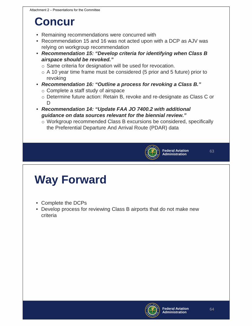
Federal AviationAdministration
Concur• Remaining recommendations were concurred with• Recommendation 15 and 16 was not acted upon with a DCP as AJV was
relying on workgroup recommendation• Recommendation 15: “Develop criteria for identifying when Class B
airspace should be revoked.”o Same criteria for designation will be used for revocation.o A 10 year time frame must be considered (5 prior and 5 future) prior to
revoking• Recommendation 16: “Outline a process for revoking a Class B.”
o Complete a staff study of airspaceo Determine future action: Retain B, revoke and re-designate as Class C or
D• Recommendation 14: “Update FAA JO 7400.2 with additional
guidance on data sources relevant for the biennial review.”o Workgroup recommended Class B excursions be considered, specifically
the Preferential Departure And Arrival Route (PDAR) data
63
Federal AviationAdministration
Way Forward
• Complete the DCPs• Develop process for reviewing Class B airports that do not make new
criteria
64
Attachment 2 – Presentations for the Committee
Presented To:
Federal AviationAdministration
By:
Date:
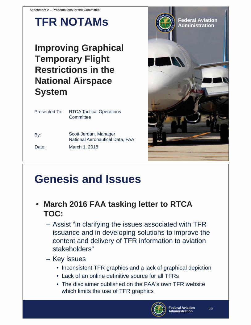
TFR NOTAMs
Improving Graphical Temporary Flight Restrictions in the National Airspace System
March 1, 2018
RTCA Tactical Operations Committee
Scott Jerdan, ManagerNational Aeronautical Data, FAA
Federal AviationAdministration
Genesis and Issues
• March 2016 FAA tasking letter to RTCA TOC: – Assist “in clarifying the issues associated with TFR
issuance and in developing solutions to improve the content and delivery of TFR information to aviation stakeholders”
– Key issues• Inconsistent TFR graphics and a lack of graphical depiction• Lack of an online definitive source for all TFRs• The disclaimer published on the FAA’s own TFR website
which limits the use of TFR graphics
66
Attachment 2 – Presentations for the Committee
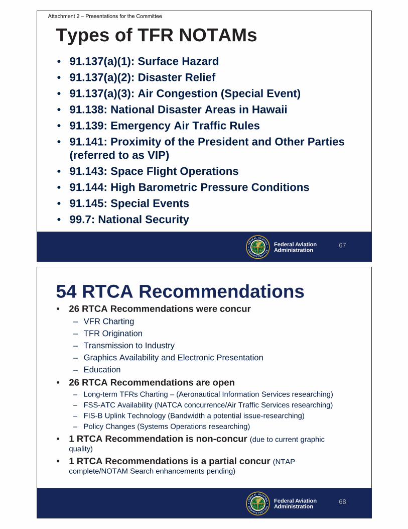
Federal AviationAdministration
Types of TFR NOTAMs• 91.137(a)(1): Surface Hazard• 91.137(a)(2): Disaster Relief • 91.137(a)(3): Air Congestion (Special Event)• 91.138: National Disaster Areas in Hawaii• 91.139: Emergency Air Traffic Rules• 91.141: Proximity of the President and Other Parties
(referred to as VIP)• 91.143: Space Flight Operations• 91.144: High Barometric Pressure Conditions• 91.145: Special Events• 99.7: National Security
67
Federal AviationAdministration
54 RTCA Recommendations• 26 RTCA Recommendations were concur
– VFR Charting– TFR Origination– Transmission to Industry– Graphics Availability and Electronic Presentation– Education
• 26 RTCA Recommendations are open– Long-term TFRs Charting – (Aeronautical Information Services researching)– FSS-ATC Availability (NATCA concurrence/Air Traffic Services researching)– FIS-B Uplink Technology (Bandwidth a potential issue-researching)– Policy Changes (Systems Operations researching)
• 1 RTCA Recommendation is non-concur (due to current graphic quality)
• 1 RTCA Recommendations is a partial concur (NTAP complete/NOTAM Search enhancements pending)
68
Attachment 2 – Presentations for the Committee

Federal AviationAdministration
Questions
69
Federal AviationAdministration
Background
70
Attachment 2 – Presentations for the Committee
Federal AviationAdministration
RTCA TOC Recommendations
71
Category Sub Category TOC TFR Recommendations Lead Organization(s) Agency Position Status
1. Long-term TFRs should be charted on Sectional and Terminal Area Charts. AJV-5 OpenAJV-5 to form working group to review
request
2. Long-term TFRs should be identified using standardized criteria. AJV-5 OpenAJV-5 to form working group to review
request3. The FAA should retain the issuance process for long-term TFR NOTAMs, regardless of part-time or full-time activation, even after that TFR NOTAM has been charted.
AJR-B11 (USNOF Operations and Policy
Group) Concur with recommendation Supported by AJR-B11Sporting Event TFRs
4. The FAA depiction is adequate and the FAA should sustain their sporting venue charting effort. AJV-5 Currently implemented by AJV-5. Implemented5. The FAA should standardize the charting requirement documents for TFRs to ensure consistency and to reduce pilot confusion. AJV-5 Open
AJV-5 to form working group to review request
6. The FAA should modernize the Sectional and Terminal Area Chart production process to achieve a 56 day charting cycle. AJV-5
Concur with recommendation and will implement upon completion of the VFR chart automation project
FAA Charting (VFR Sectional/TAC)
Long Term TFRs
Charting Specifications
Federal AviationAdministration
RTCA TOC Recommendations
72
Category Sub Category TOC TFR Recommendations Lead Organization(s) Agency Position Status7. Any tools the FAA utilizes to generate TFR NOTAMs should produce a standard output. PMO and AJR
Concur with recommendation and will implement pending funding
8. Any new or existing TFR NOTAM entry tool should, in general, tightly constrain the use of freeform text and not allow its use for the geographic definition. The use of dropdown menus should be maximized to ensure consistent output. PMO and AJR
Concur with recommendation and will implement pending funding
9. TFR NOTAM templates should be centrally managed electronically for all users. AJR and PMO
Concur with recommendation and will implement pending funding
10. The TFR submission tool should render its output in a format recommended by industry - AIXM 5.X with GML AJR and PMO
Concur with recommendation and will implement pending funding
11. The TFR submission tool should provide a graphical depiction of the impacted area to all affected ATC agencies. AJR and PMO
Concur with recommendation and will implement pending funding
12. The FAA should designate a 24x7 operational office with the authority to review, reissue, or cancel any TFR in real-time, prior to its broadcast, to ensure: (a) accurate graphical depiction and (b) conformance with NOTAM policy and FAA orders. AJR
Concur with recommendation and will implement pending funding ATO Top 5
13. The automation tool utilized for TFR NOTAM submission should produce and display an electronic graphical depiction for each TFR containing a clearly defined geographical area and include a required user verification step where the affected geographical area is verified to be accurate/correct.
PMO, AJR, AJT, and AJV-11
Concur with recommendation and will implement pending funding
TFR Origination
Standardized Entry Method
TFR NOTAM Oversight (text and graphic)
Attachment 2 – Presentations for the Committee

Federal AviationAdministration
RTCA TOC Recommendations
73
Category Sub Category TOC TFR Recommendations Lead Organization(s) Agency Position StatusDigital with AIXM/GML 14. The FAA should provide TFR NOTAMs in AIXM/GML digital format. PMO
Concur with recommendation and will implement pending funding
15. Authoritative TFR NOTAM data should be provided in AIXM 5.X with GML over multiple nodes in SWIM. PMO
Concur with recommendation and will implement pending funding
16. The FAA must ensure that the SWIM onboarding process is efficient/timely for all approved “partners”. PMO Concur 17. Legacy Esri shapefiles of each TFR should remain available. PMO Concur
Format of GML Portrayal Script
18. Prototype testing of GML Portrayals Scripts by the FAA and multiple vendors should be done and circulated to investigate 1) the range of graphical interpretations of AIXM data and 2) the interoperability of SLD/SE portrayal scripts for AIXM. PMO Open
Notification Process for Changes 19. The FAA should communicate changes to TFR NOTAM policy to industry. AJR-B11, PMO Concur ATO Top 5
Transmission to Industry
Standard and Authoritative Method of Machine to Machine TFR
Federal AviationAdministration
RTCA TOC Recommendations
74
Category Sub Category TOC TFR Recommendations Lead Organization(s) Agency Position Status20. The FAA should sunset their graphical TFR website. The electronic depictions (graphics) for all TFRs and Special Use Airspace (SUA) should be provided simultaneously with the text for public consumption via the FAA's NOTAM Search website (https://notams.aim.faa.gov/notamSearch/). PMO
Concur with recommendation and will implement pending funding
21. Changes should be made in NOTAM Search to improve consumption of TFR information. PMO
Concur with recommendation and will implement pending funding
22. Each TFR should have a stand-alone graphic (a static image with the option of either a Sectional or Low Altitude Enroute chart background), with textual comments on the graphic. PMO
Concur with recommendation and will implement pending funding
23. The FAA should have a standard for displaying TFR overlay graphics on its website. PMO
Concur with recommendation and will implement pending funding
24. Dissemination of the Notices to Airmen Publication (NTAP) should include the previously available HTML option to make it easier for operators to access this information, and all information in the NTAP should be available in NOTAM Search. AJV-8 and PMO
Partially Concur/AJV-8 is working to provide NTAP in HTML format
NOTAM Policy and Operations owns the other parts of the request
25. After adding TFR graphics to NOTAM Search, the disclaimer should explicitly state that TFR graphics can be relied upon for navigation. PMO, AGC, AJR, and AJT
Concur with recommendation and will implement pending funding
26. The FAA should explicitly state that the TFR graphic is equal to the NOTAM’s geographical textual description. PMO, AGC, AJR, and AJT
Concur with recommendation and will implement pending funding
Sporting Event Blanket TFR
27. For each sporting event venue, the FAA should graphically display on NOTAM Search the lateral and vertical dimensions, along with valid times. The locations for projected sporting event TFRs should also be displayed. PMO, AJV-5
Concur with recommendation and will implement pending funding
Accuracy of FAA TFR Depictions Provided Online 28. All TFR graphics being displayed should have a correctly oriented chart. PMO
Concur with recommendation and will implement pending funding
Industry Standard for Electronic Depiction
29. The FAA should establish industry standards for electronic depiction of TFRs by tasking the appropriate groups, contractors and/or committees. PMO, AJR, and AJV-5 Open
Graphics Availability and Electronic Presentation
FAA TFR Graphical Website-Human to Machine
Disclaimer for FAA Produced Online Graphic
Attachment 2 – Presentations for the Committee

Federal AviationAdministration
RTCA TOC Recommendations
75
Category Sub Category TOC TFR Recommendations Lead Organization(s) Agency Position Status30. The FAA should ensure controller automation (ERAM, STARS) can visually display TFRs on the controller scope. PMO, AJT Open Coordinating response31. The FAA should implement ERAM/STARS enhancement that allows the drawing of a TFR on one scope and pushing it to another. PMO, AJT Open Coordinating response32. Controller guidance regarding coordination with a TFR proponent, such as firefighting agencies and pilots, should be clarified to better detail responsibilities and how “by ATC authorization” should be employed. AJI, AJR Open33. Interpretation of TFR restrictions and what ATC can authorize should be standardized among facilities. AJI, AJR Open34. The FAA should depict sporting event venues with over 30,000 seats on ATC radar maps. AJV-5, AJT Open Coordinating response35. The FAA should depict long-term TFRs on ATC radar maps. AJV-5, AJT Open Coordinating response
Briefing NOTAM Order Changes
36. There should be a clear communication process to brief changes of NOTAM policy to ATC positions that create TFR NOTAMs prior to implementation, and there should be sufficient time to allow technical requirements for parsing to be updated. AJT, AJI Open ATO Top 5
Standard Manner of Providing Graphic to Specialists
37. The FAA should make sporting event venues and their 3 NM radius lateral rings available on controller charts. AJV-5, AJT Open Coordinating response
FSS and ATC Availability for FSS and ATC
Federal AviationAdministration
RTCA TOC Recommendations
76
Category Sub Category TOC TFR Recommendations Lead Organization(s) Agency Position Status38. The FAA should standardize the language and format of TFR NOTAMs to facilitate the effective transfer of critical information to pilots. AJR Open Meet with AJR-B11 again; 39. The FAA should restructure the TFR NOTAM format to be consistent across all types to allow pilots to have a standardized reading pattern and improve the understanding of restrictions. AJR Open Meet with AJR-B11 again; 40. The FAA should remove from the NOTAM, to the extent possible, all extraneous information and publish that information elsewhere or at the end of the NOTAM. AJR Open Meet with AJR-B11 again; 41. The FAA should ensure automated plain language interpretation for all TFRs can be accomplished. AJR Open Meet with AJR-B11 again42. The cut out or exception area language should be published in a standardized format. AJR Open Meet with AJR-B11 again43. The FAA should expand their NOTAM issuance policy to allow TFR NOTAMs to be published seven days ahead of the activation time, instead of the usual three days, when the information is available. AJR Open
Meet with AJR-B11 again; Concur AJR-B11
44. The FAA should publish a single standard for the latitude/longitude format that can be stated in a TFR NOTAM. AJR Open
Meet with AJR-B11 again; Concur AJR-B11
Textual Format
Attachment 2 – Presentations for the Committee
Federal AviationAdministration
RTCA TOC Recommendations
77
Category Sub Category TOC TFR Recommendations Lead Organization(s) Agency Position StatusRange of Transmission
45. The FAA should increase the FIS-B radio station look ahead range for the NOTAM-TFRs. ANG Open
FIS-B Text 46. The FAA should task the appropriate committee (e.g., SC-206 SG-5) to investigate undoing the change to the FIS-B radio stations that truncates uplinked NOTAM-TFR text records. ANG Open
Graphic Legality 47. The FAA should evaluate the use of FIS-B NOTAM-TFR graphics to meet regulatory requirements for navigation and operational use in the cockpit. ANG, AFS, AIR, AGC Concur
FIS-B Uplink
Federal AviationAdministration
RTCA TOC Recommendations
78
Category Sub Category TOC TFR Recommendations Lead Organization(s) Agency Position StatusWritten Questions for Airmen
48. The FAA should consider additional knowledge exam questions on TFRs that emphasize checking NOTAMs, comprehension of restrictions, avoidance, and the process of requesting ingress/egress permission. AFS Concur49. The FAA should publicize the best practices for TFR awareness and avoidance in appropriate pilot guidance as well as in the Flight Instructor Refresher Course, pilot flight reviews, and in the FAA’s WINGS program. AFS Concur
50. The FAA should work to publicize how pilots can meet the requirements of FAR 91.103 using graphics and how pilots need not call Flight Service to feel they have met their preflight obligations concerning TFR awareness. AFS, AJR
Non-concur at this time Current TFR NOTAM graphics do not meet the requirements of 91.103. Pilots need to contact Flight Service or review FAA originated textual TFR NOTAMs
51. The FAA should conduct additional outreach and education to unmanned aircraft remote pilots to ensure they understand their responsibility to avoid TFRs. AFS, AJR Open52. Law Enforcement Organizations (LEO) should be provided a single online resource for guidance on responding to intruder unmanned aircraft. AJR Open
TFR Outreach and Communications
53. The FAA should promote the importance of proactively engaging industry at all levels of TFR issuance and at all TFR issuing facilities. AJR, AJT Concur ATO Top 5
Education
Pilot Guidance
Unmanned Aircraft Guidance
Attachment 2 – Presentations for the Committee

Federal AviationAdministration
RTCA TOC Recommendations
79
Category Sub Category TOC TFR Recommendations Lead Organization(s) Agency Position Status54. The FAA should work with industry to develop implementation guidelines for congressional language on new TFRs in order to avoid creating a patchwork of TFRs across the country that could have a negative impact on aviation. AJR Open
Additional TFR Considerations
LUNCH
80
Attachment 2 – Presentations for the Committee

Consideration of Recommendations on Intentional GPS Interference
81
Rune Duke, AOPA & Wes Googe, American Airlines
Co-Chairs Intentional GPS Interference Task Group
Introduction to Intentional Interference
GPS is a key technology component for NextGen navigation and surveillanceDoD requirements related to GPS include• Title 10, Section 2281, to provide a GPS system that
is reliable and available for civil use • National Security Presidential Directive 39 to train and
test in conditions that include denial of GPS
DoD carries out intentional GPS interference • Discrete events, specific locations, public notified• May degrade GPS signals to civilian aircraft
82
Attachment 2 – Presentations for the Committee

Intentional Interference is Increasing
Number tests and locations increasing in NAS
Industry need to better understand the operational impacts of intentional interference
83
Location of All Intentional Interference Events in 2017
TOC Tasking
TOC requested to study the impact of intentional interference on operations in the NAS:• Evaluate interference events, quantify NAS impact• Recommend tracking and metrics• Way for events to be defined and depicted • Standard minimum weather requirement/criteria for airfields that
have only GPS approach procedures• Effectiveness of the alerting processes• Guidance/training material for controllers and pilots
Scope limited only to intentional GPS interference conducted by the DoD and its impact on manned civil aviation
84
Attachment 2 – Presentations for the Committee
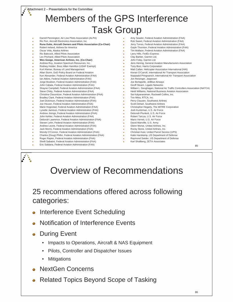
Members of the GPS Interference Task Group
85
Darrell Pennington, Air Line Pilots Association (ALPA)Ric Peri, Aircraft Electronics Association, Inc.Rune Duke, Aircraft Owners and Pilots Association (Co-Chair)Robert Ireland, Airlines for AmericaOscar Vela, Alaska AirlinesRic Babcock, Allied Pilots AssociationLev Prichard, Allied Pilots AssociationWes Googe, American Airlines, Inc. (Co-Chair)Andrew Roy, Aviation Spectrum Resources, Inc.Rodney Holder, Booz Allen Hamilton (USAF Exempt)Kurt Kleiner, Bureau of Land ManagementAllan Storm, DoD Policy Board on Federal AviationKen Alexander, Federal Aviation Administration (FAA)Ian Atkins, Federal Aviation Administration (FAA)Jorge Boubion, Federal Aviation Administration (FAA)John Cabala, Federal Aviation Administration (FAA)Shayne Campbell, Federal Aviation Administration (FAA)Steve Chitty, Federal Aviation Administration (FAA)Christina Clausnitzer, Federal Aviation Administration (FAA)Bradley Clark, Federal Aviation Administration (FAA)Joel Dickinson, Federal Aviation Administration (FAA)Joe Heuser, Federal Aviation Administration (FAA)Marie Hogestad, Federal Aviation Administration (FAA)Lynette Jamison, Federal Aviation Administration (FAA)Andrew Jinings, Federal Aviation Administration (FAA)John Kehler, Federal Aviation Administration (FAA)Deborah Lawrence, Federal Aviation Administration (FAA)Steven Lehn, Federal Aviation Administration (FAA)Andrew Leone, Federal Aviation Administration (FAA)Jack Morris, Federal Aviation Administration (FAA)Wendy O’Connor, Federal Aviation Administration (FAA)Charles (Doug) Phifer, Federal Aviation Administration (FAA)Roger Rapier, Federal Aviation Administration (FAA)Shelli Sabatini, Federal Aviation Administration (FAA)Eric Saldana, Federal Aviation Administration (FAA)
Amy Seador, Federal Aviation Administration (FAA)Rob Sweet, Federal Aviation Administration (FAA)Jerry Torres, Federal Aviation Administration (FAA)Gayle Thornton, Federal Aviation Administration (FAA)Tim Wallace, Federal Aviation Administration (FAA)Larry Hills, FedEx ExpressClay Barber, Garmin Ltd.John Foley, Garmin Ltd.Jens Hennig, General Aviation Manufacturers AssociationTony Boci, Harris CorporationMatt Callan, Helicopter Association International (HAI)Kieran O'Carroll, International Air Transport AssociationNoppadol Pringvanich, International Air Transport AssociationJon Reisinger, JeppesenJoe Bertapelle, JetBlue AirwaysGeoff Stearn, Ligado NetworksWilliam L Geoghagan, National Air Traffic Controllers Association (NATCA)Heidi Williams, National Business Aviation AssociationSai Kalyanaraman, Rockwell Collins, Inc.Trin Mitra, RTCA, Inc.Perry Clausen, Southwest AirlinesScott Dehart, Southwest AirlinesChristopher Hegarty, The MITRE CorporationJosh Kuntzman, U.S. Air ForceDeborah Plunkett, U.S. Air ForceRobert Tarcza, U.S. Air ForceMario Verrett, U.S. Air ForceDavid Manville, U.S. ArmyGlenn Morse, United Airlines, Inc.Rocky Stone, United Airlines, Inc.Christian Kast, United Parcel Service (UPS)Katie Harskamp, US Department of DefenseRaymond Swider, US Department of DefenseKarl Shallberg, ZETA Associates
Overview of Recommendations
86
25 recommendations offered across following categories:
Interference Event Scheduling
Notification of Interference Events
During Event• Impacts to Operations, Aircraft & NAS Equipment
• Pilots, Controller and Dispatcher Issues
• Mitigations
NextGen Concerns
Related Topics Beyond Scope of Tasking
Attachment 2 – Presentations for the Committee
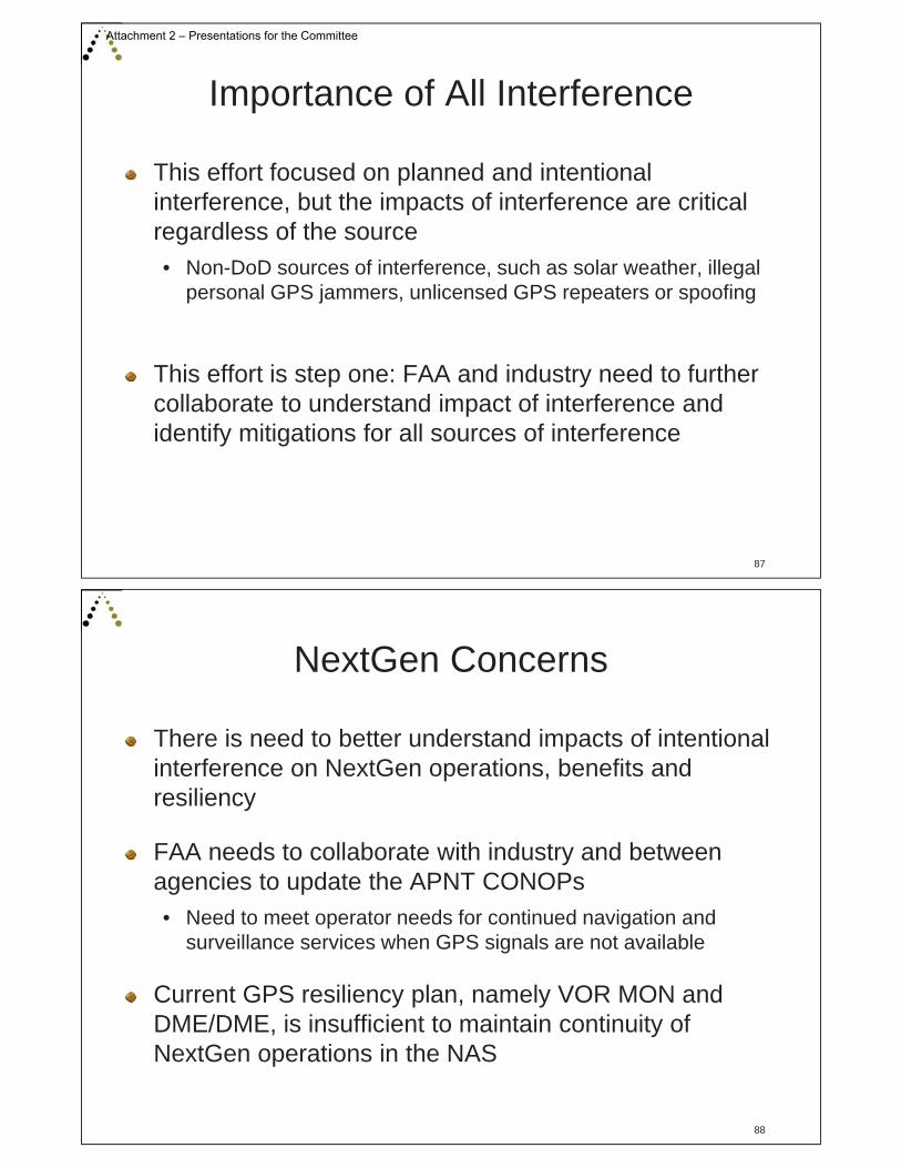
Importance of All Interference
87
This effort focused on planned and intentional interference, but the impacts of interference are critical regardless of the source• Non-DoD sources of interference, such as solar weather, illegal
personal GPS jammers, unlicensed GPS repeaters or spoofing
This effort is step one: FAA and industry need to further collaborate to understand impact of interference and identify mitigations for all sources of interference
NextGen Concerns
88
There is need to better understand impacts of intentional interference on NextGen operations, benefits and resiliency
FAA needs to collaborate with industry and between agencies to update the APNT CONOPs• Need to meet operator needs for continued navigation and
surveillance services when GPS signals are not available
Current GPS resiliency plan, namely VOR MON and DME/DME, is insufficient to maintain continuity of NextGen operations in the NAS
Attachment 2 – Presentations for the Committee
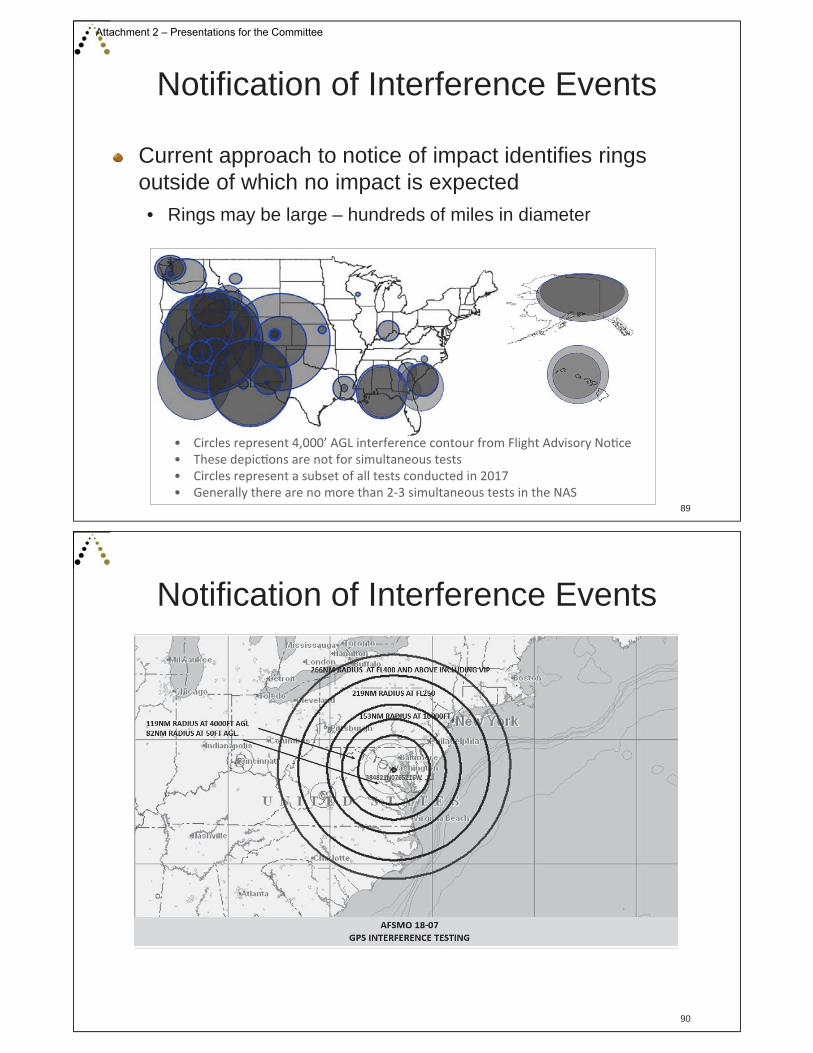
Notification of Interference Events
89
Current approach to notice of impact identifies rings outside of which no impact is expected• Rings may be large – hundreds of miles in diameter
Notification of Interference Events
90
Attachment 2 – Presentations for the Committee

Notification of Interference Events
91
Recommendations relating to notification include:
Modify current NOTAM so it provides pilots and controllers improved expectation of where operators would expect interference for different equipment capabilities
Consolidation of resources for notification
Provide graphical representation in NOTAM Search along with impacted airways and airports
During Event – Data Gathering
92
Current processes do not effectively collect data on frequency of impact from interference
Both pilot and controller reporting processes need examination to ensure reports are collected, sent to the appropriate office and support data analysis and trend identification
Attachment 2 – Presentations for the Committee

Opportunity to Leverage ADS-B Data
93
ADS-B ground stations receive Navigation Integrity Category (NIC) from aircraft that may be leveraged to identify where and when individual aircraft actually experience interference• Opportunity to closely study this actual data on loss of GPS
Track Data from UTTR 17-01 - May 3, 2017
ADS-B Track of Cessna Citation with Map Shift
AOI Outage Polygon with Altitude Slices and Waypoints
During Event – Operational Impacts
94
For recent large events, facilities are beginning to proactively manage the system, impacting operational efficiency
Memo from facility:NOTAM for ZWY:
Attachment 2 – Presentations for the Committee
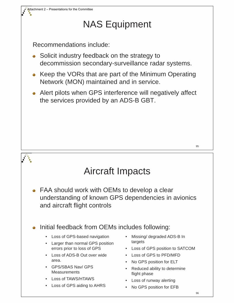
NAS Equipment
95
Recommendations include:
Solicit industry feedback on the strategy to decommission secondary-surveillance radar systems.
Keep the VORs that are part of the Minimum Operating Network (MON) maintained and in service.
Alert pilots when GPS interference will negatively affect the services provided by an ADS-B GBT.
Aircraft Impacts
96
FAA should work with OEMs to develop a clear understanding of known GPS dependencies in avionics and aircraft flight controls
Initial feedback from OEMs includes following:• Loss of GPS-based navigation • Larger than normal GPS position
errors prior to loss of GPS • Loss of ADS-B Out over wide
area.• GPS/SBAS Nav/ GPS
Measurements• Loss of TAWS/HTAWS• Loss of GPS aiding to AHRS
• Missing/ degraded ADS-B In targets
• Loss of GPS position to SATCOM• Loss of GPS to PFD/MFD• No GPS position for ELT• Reduced ability to determine
flight phase• Loss of runway alerting• No GPS position for EFB
Attachment 2 – Presentations for the Committee

Pilots, Dispatchers & Controllers
97
Guidance for pilots, dispatchers and controllers all require updates• Terminology, location of resources, AC for GPS interference and
resiliency, controller responsibility during event, etc.
Clarification required for pilot authorization to deviate from FAR 91.227 within affected area and for the duration of that flight• Multiple observations of aircraft losing GPS and never regaining
Flight track and ADS-B NIC/NAC Degradation Inside and Outside of Interference Event Area
DISCUSSION
Attachment 2 – Presentations for the Committee
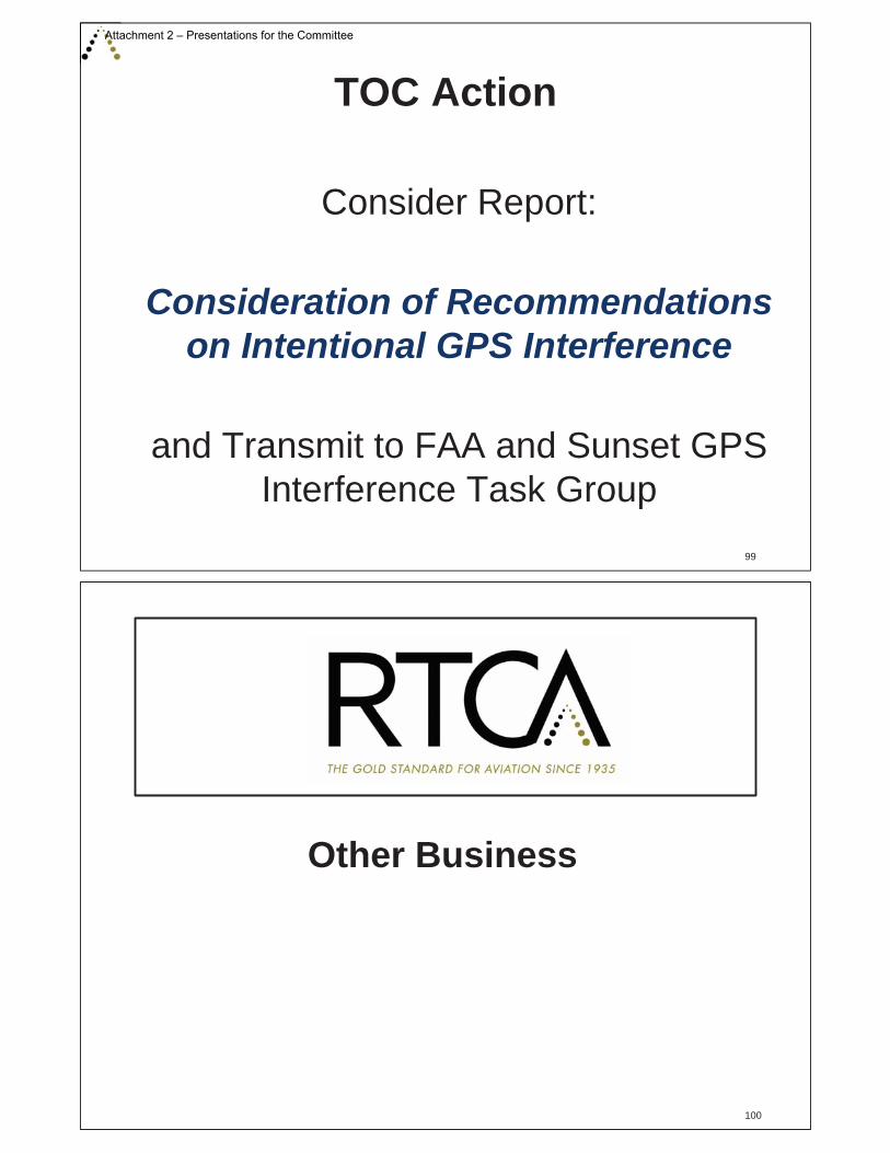
TOC Action
Consider Report:
Consideration of Recommendations on Intentional GPS Interference
and Transmit to FAA and Sunset GPS Interference Task Group
99
Other Business
100
Attachment 2 – Presentations for the Committee

Closing Comments
Co-Chairs:Bart Roberts, JetBlueJeff Woods, NATCA
Designated Federal Officer:Jodi McCarthy, Federal Aviation Administration
101
Adjourn
102
Attachment 2 – Presentations for the Committee

1 | P a g e
RTCA, Inc. 1150 18th Street, NW, Suite 910
Washington, DC 20036 Phone: (202) 833-9339
Fax: (202) 833-9434 www.rtca.org
RTCA Paper No. 041-18
TOC-038
February 12, 2018
Meeting Summary, December 5, 2017
Tactical Operations Committee (TOC)
The eighteenth meeting of the Tactical Operations Committee (TOC), held on December 5, 2017, convened at 09:00 a.m. Eastern Standard Time. The meeting discussions are summarized below. The following attachments are referenced:
Attachment 1 – List of Attendees Attachment 2 – Presentations for the Committee (containing detailed content of the meeting) Attachment 3 – Summary of the August 22, 2017 TOC Meeting Attachment 4 – Recommendations for Focus in the CSS-FD Program Attachment 5 – Letter from TOC Member Inquiring about OEI/Obstacles Task for the TOC Attachment 6 - Briefing on the Drone Advisory Committee Attachment 7 - Briefing on Awareness and Operational Impact (AOI) Tool Attachment 8 - Briefing on NOTAM Task Force Attachment 9 - Draft Industry Perspective on AIS Welcome and Introductions
Committee Co-Chairs, Capt. Bart Roberts, JetBlue, and Mr. Jeff Woods, National Air Traffic Controllers Association (NATCA), called the meeting to order and welcomed the TOC members and others in attendance. All TOC members and attendees from the public were asked to introduce themselves (TOC members and General Public Attendees are identified in Attachment 1).
Capt. Roberts and Mr. Woods then reviewed the agenda and began the proceedings of the meeting. (The briefing charts from the meeting are included as Attachment 2.)
Designated Federal Official Statement
Ms. Jodi McCarthy, Vice President of Mission Support for the Air Traffic Organization (ATO), and the Designated Federal Official of the TOC, read the Federal Advisory Committee Act notice governing the open meeting.
Attachment 3 – Summary of the December 5, 2018 TOC Meeting

2 | P a g e
Approval of August 22, 2017 Meeting Summary
The Chairs asked for and received approval of the written summary for the August 22, 2017 meeting (Attachment 3).
FAA Update
Ms. McCarthy provided the FAA update. Ms. McCarthy began by informing the TOC of key personnel changes. She noted that FAA Administrator Michael Huerta’s 5 year term would be ending on January 5, 2018. Additionally, she mentioned that Mr. Mike Romanowski would be leaving his position in the Office of Commercial Space to become the Director of Policy and Innovation in the Aircraft Certification directorate.
Regarding controller and technician hiring, Ms. McCarthy told the TOC that the FAA had exceeded its goal of hiring controllers by 6% and 1,880 new hires were added in FY2017. She also noted that the FAA exceeded its goal on the technician side by 7.5%.
Ms. McCarthy spoke about fire and hurricane relief and recovery efforts, particularly in California, the Southern US and the Caribbean. The FAA had received $70 million to assist in disaster relief. She informed the TOC that in Puerto Rico, the Tower and CERAP had returned to full capacity within 6 days of Hurricane Maria. A team across the Air Traffic Organization had been deployed to San Juan to assist in the recovery, with operators providing multiple flights between the mainland and Puerto Rico. Given the devastation on the islands, all efforts related to the Caribbean initiative were on hold. The FAA’s focus in this region has been on restoral of infrastructure and ensuring the safety and well being of its people. A member of the TOC commended the FAA and its employees in Puerto Rico for their speed and commitment to restoral of operations in the Caribbean after the hurricanes. The member offered thanks from the industry to all of the controllers, technicians and other personnel for their contributions.
Finally, Ms. McCarthy provided updates about a variety of topics:
• A wrong surface landing alert system has been developed to alert if an aircraft was at risk of inadvertently landing on a taxiway
• A commercial space Aviation Rulemaking Committee (ARC) was established regarding spaceport categorization with Mr. Mike Cirillo (A4A) and Mr. Carl Burleson (FAA) leading
• There is ongoing litigation related to implementation of the SoCal Metroplex. Formal mediation was in process and a settlement was possible.
• A working group was developing 9 new RNAV westbound Standard Instrument Departures (SIDs) for Phoenix
Consideration of Recommendations for Common Support Service – Flight Data Task Group (CSS-FD)
Ms. Tammy Bowe, Jeppesen, and Mr. Tim Stull, American Airlines, Co-Chairs of the CSS FD Task Group provided a high level overview of the recommendations for CSS-FD. The briefing slides used by Ms. Bowe and Mr. Stull may be found on page 7 to 19 of Attachment 2.
Attachment 3 – Summary of the December 5, 2018 TOC Meeting

3 | P a g e
The work of the Task Group focused on ensuring alignment of investment decision-making between the FAA and industry as the underlying driver of success for CSS-FD. In support of this objective, the report provided recommendations on the value of the following:
• Specific flight plan feedback data elements • A flight plan monitoring service including push notifications of changes to a flight plan • Capability for operators to communicate more information about their intended flight plan • Improved capability to update flight plans after current lockout time
Additionally, the Task Group provided perspective on the key risks associated with successful implementation of the CSS-FD concept.
A Committee member inquired if the approach to operations management and coordination would change as a result of CSS-FD. The Chairs responded that yes, operations and coordination would indeed evolve with CSS-FD. However, the CSS-FD concept had not yet matured from a concept of operations to a concept of use, so determination of how operations would evolve remained as future work for CSS-FD.
Another Committee member commented that the work of CSS FD was relevant to all operators – passenger airlines, cargo airlines, business aviation and general aviation. However, the member noted the concept was relevant for different reasons and the concept needed to remain sensitive to the different business objectives of different types of operators. For example, cargo operators have one opportunity per day to move their packages, hence completion of a flight on a timely basis could be a higher priority for such operators than others.
A Committee member raised a concern that some operators are highly engaged with working with the FAA on collaborative planning while other operators are not as engaged. One operator commented that for operators to invest in automation to collaborate as per the CSS-FD concept, operational personnel would have to secure significant funding from their finance departments. The individual noted that industry and the FAA should continue to work collaboratively to develop business cases for CSS FD that inform both FAA as well as operator investment. Additionally, a representative of a flight planning third party vendor commented that such vendors would be able to cater to smaller operators who would not develop their own automation.
Another member reinforced that acquiring funding for investment is a significant challenge for operators. It will be challenging for operators to specifically quantify exactly what costs are saved by participation in CSS-FD. Hence, industry and FAA collaborating to identify and quantify the operational impact will be valuable for operators. Additionally, the effort should not lose focus on the highest priority information elements that will drive the greatest benefits early on in the process.
• Committee Action: The Committee agreed by consensus to accept the “Recommendations for Focus in the CSS-FD Program”. Attachment 4 to this report is the final and approved report that the TOC transmitted to the FAA. With this report, the work of this Task Group was complete and the group was sun set.
Update on Intentional GPS Interference Task
Attachment 3 – Summary of the December 5, 2018 TOC Meeting

4 | P a g e
Ms. Rune Duke, AOPA, and Co-Chair of the Intentional GPS Interference Task Group provided an update on the work of this group. Mr. Duke’s briefing slides may be found from page 20 to 28 of Attachment 2. One Committee member noted that the education component of the group’s recommendations needed to include education for Dispatchers as they were key participants in the flight planning and routing process.
Areas of Future TOC Interest
Ms. McCarthy next provided an update to the TOC on topics of interest. For PIREPs, she noted that the FAA was not planning a tasking for the TOC but recognized the need to work with stakeholders on the issue. An industry member requested an update on the status of the FAA’s work on PIREPs and Ms. McCarthy stated that she would provide an update on this. Ms. McCarthy next informed the TOC that the FAA was not planning a task for the TOC Alaska Terminal operations. Finally, she commented that she had received a letter from industry members inquiring about a possible TOC task to address One Engine Inoperative operations and obstacle clearance. This letter is included as Attachment 5. Ms. McCarthy said that she had not yet had an opportunity to review the letter and would plan to do so prior in preparation for the March 2018 TOC meeting.
Updates on the NextGen Advisory Committee (NAC) and Drone Advisory Committee (DAC)
Mr. Andy Cebula and Mr. Al Secen, both of RTCA, provided updates to the TOC on the work of the NAC and the DAC. Mr. Cebula’s briefing slides may be found on pages 33 to 40 of Attachment 2. Mr. Secen’s slides may be found as Attachment 6. Overview of Awareness and Operations Impact (AOI)
Mr. Ron Stroup, FAA, next provided an overview and demonstration of the FAA’s AOI tool. Mr. Stroup’s briefing slides may be found in Attachment 7. FAA Response to Previous Recommendations
The FAA next provided a series of briefings responding to previous recommendations. PBN Route System Ms. Chris Chesak, FAA, provided an update on the PBN Route System recommendations which were delivered to the FAA in August 2017. Ms. Chesak’s briefing slides may be found on pages 43 to 47 of Attachment 2. Ms. Chesak noted that the FAA had much work to do to fully assess the 92 recommendations provided in the PBN RS report. She estimated that the FAA would have a full
Attachment 3 – Summary of the December 5, 2018 TOC Meeting
5 | P a g e
response by September 30, 2018 given the level of coordination that would be required across lines of business in the FAA. Graphical TFRs Mr. Scott Jerdan, FAA, next provided an update on recommendations on Graphical Temporary Flight Restrictions (TFRs). Mr. Jerdan also noted that he was conducting coordination across multiple lines of business in the FAA to evaluate the TFR recommendations. He estimated the full assessment would be completed by December 2018. As of December 2017, the FAA concurred with 26 recommendations and 26 recommendations were open. One recommendation was a non-concur and one was partially concur. For the recommendation that was non-concurred (recommendation #50), one TOC member raised concern about identifying a specific solution as the only answer (i.e., contacting flight service). The member noted that there may be multiple methods to address the underlying need. National Procedure Assessment Mr. Mark Adams and Mr. Lonnie Everhart, FAA, provided an update on the National Procedure Assessment initiative. Briefing materials for this discussion may be found on pages 70 to 76 of Attachment 2. During this discussion, a TOC member discussed concerns about canceling procedures given recent glitches in Flight Management System software. The glitch had removed approximately 10,000 procedures in the National Airspace System and the member was concerned about removing any procedure given the scale of missing procedures. Another Committee member inquired about what the collaborative process was for operators to weigh in on candidates for cancellation. The FAA requested further clarity on who would need to be involved in the assessment process when a candidate procedure was planned for cancellation. While the FAA appreciates that outreach to the operator community is appropriate, they lacked clarity on how to accomplish this and whom to notify. Currently procedures subject to cancellation appear for cancellation based on their date for periodic review. Hence, there is no current process that periodically identifies a batch of procedures due for cancellation. Operators identified a desire to receive periodic notification of a consolidated list of procedures set for cancellation. Some member organizations expressed an interest to receive such notices. These included AOPA, ALPA, NBAA and A4A. Briefing on NOTAMs
Mr. Jerry Torres, FAA, next briefed the TOC on NOTAMs. Mr. Torres’s briefing materials may be found in Attachment 8. Mr. Torres provided an update on both the NOTAM Task Force activity as well as the FAA’s approach and plans to improve NOTAMs more generally.
Attachment 3 – Summary of the December 5, 2018 TOC Meeting
6 | P a g e
One TOC member cautioned Mr. Torres and the Task Force from applying a ‘one size fits all’ policy for mitigations on NOTAMs. The member noted that particularly for small to medium sized airports, solutions to improve NOTAMs may have different requirements than for larger airports.
Additionally, Mr. Torres commented that Airspace Information Services (AIS) had multiple issues that were of concern to operators. Mr. Torres informed the TOC that he had received a draft white paper from operators documenting some of the concerns about AIS. This white paper is included as Attachment 9.
Adjourn
Chairmen Roberts and Woods ended the meeting of the Committee at 2:00 p.m.
Next Meeting
The next meeting of the TOC is planned for March 1, 2018.
Attachment 3 – Summary of the December 5, 2018 TOC Meeting

Federal AviationAdministration
Aeronautical Information ManagementModernizationSegment 3(AIMM S3)
Presented to: RTCA TOCBy: Bob McMullen
FAA PMODate: March 1, 2018
Federal AviationAdministration
AIMM S3 RTCA TOC3/1/2018
Briefing Topics
2
• Decision Requested• Description and Scope of Initiative
– Milestones– AIMM Strategy Roadmap– Approach & Scope
• Identification of the Shortfalls– Operational View, Capabilities, Shortfalls & Alternatives
• Monetized, Quantified, and Qualified Shortfalls• Affordability – Budget Summary• Risks• Issues and Action Items• Decision Requested
Attachment 4 – FAA Briefing on AIMM Segment 3

Federal AviationAdministration
AIMM S3 RTCA TOC3/1/2018
CRDRDMar 2016
IARDJan 2018
FID*Sep 2019
FY16 FY17 FY18 FY19 FY20+
Q1 Q2 Q3 Q4 Q1 Q2 Q3 Q4 Q1 Q2 Q3 Q4 Q1 Q2 Q3 Q4
Development
On Track Activity
Concept
Completed Activity
AJV-7ATO Operational
Concepts, Validation,& Requirements Directorate
AJM-3ATO Program Management Office
Enterprise Services DirectorateIARD
SA CRD FIA
3
Description & Scope of Initiative - AIMM S3 Milestones
AIMM S3 is Targeted for Completion in 2023
* IID is not required for programs with Software Enhancement (SE) ACAT designation
Federal AviationAdministration
AIMM S3 RTCA TOC3/1/2018
Activities
• Investment Analysis to get Final Investment Decision Approval
• Systems Engineering Proofs of Concept• Community of Interest Meetings with
Stakeholders• Coordination with NAS Automation Systems
4
Attachment 4 – FAA Briefing on AIMM Segment 3
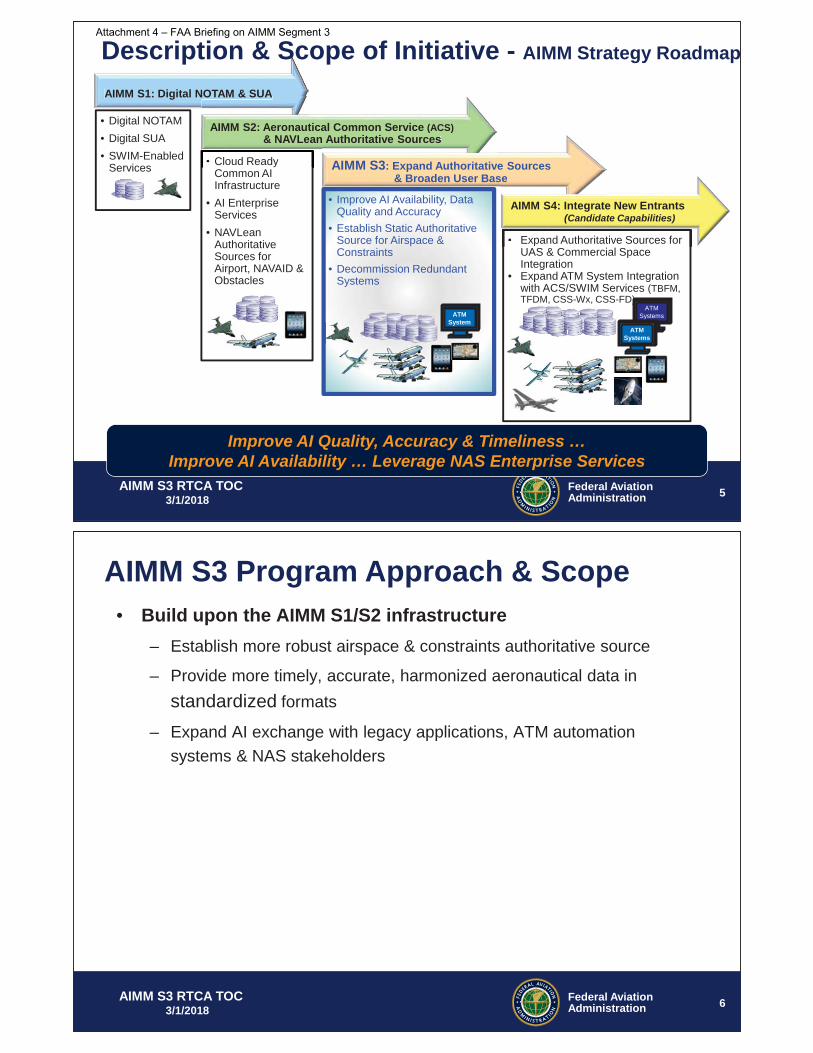
Federal AviationAdministration
AIMM S3 RTCA TOC3/1/2018
AIMM S1: Digital NOTAM & SUA
• Digital NOTAM• Digital SUA • SWIM-Enabled
Services • Cloud Ready Common AI Infrastructure
• AI Enterprise Services
• NAVLean Authoritative Sources for Airport, NAVAID & Obstacles
NOTAM & SUA
• Cloud Ready
AIMM S2: Aeronautical Common Service (ACS)& NAVLean Authoritative Sources Authoritative Sources
AIMM S3: Expand Authoritative Sources& Broaden User Base
• Improve AI Availability, Data Quality and Accuracy
• Establish Static Authoritative Source for Airspace & Constraints
• Decommission Redundant Systems
ATM System
• Expand Authoritative Sources for UAS & Commercial Space Integration
• Expand ATM System Integration with ACS/SWIM Services (TBFM, TFDM, CSS-Wx, CSS-FD)
e
• Expand Authoritative Sources for
AIMM S4: Integrate New Entrants(Candidate Capabilities)
Improve AI Quality, Accuracy & Timeliness … Improve AI Availability … Leverage NAS Enterprise Services
5
ATM Systems
ATM Systems
Description & Scope of Initiative - AIMM Strategy Roadmap
Federal AviationAdministration
AIMM S3 RTCA TOC3/1/2018
• Build upon the AIMM S1/S2 infrastructure– Establish more robust airspace & constraints authoritative source
– Provide more timely, accurate, harmonized aeronautical data in standardized formats
– Expand AI exchange with legacy applications, ATM automation systems & NAS stakeholders
6
AIMM S3 Program Approach & Scope
Attachment 4 – FAA Briefing on AIMM Segment 3

Federal AviationAdministration
AIMM S3 RTCA TOC3/1/2018
Use Enterprise Services to Manage & Disseminate Authoritative Data(AIMM S1-S4)
Identification of the Shortfall - AIMM Operational View
7
Federal AviationAdministration
AIMM S3 RTCA TOC3/1/2018
Identification of the Shortfall - AIMM S3 Capabilities
RTCA Perspectives• SOP/LOA Airspace
ConstraintsImprove planned trajectoryEnhance flight planning systemsIncrease safety & situational awareness
• SAA Integration:Improve flight efficiencyIncrease safety & situational awareness Enhance airspace utilization
Future of the NAS• “digital exchange of all NAS
information is a vital component to ensuring a common understanding of demand and capacity”
• sharing of digital data is … a necessary precursor for effective negotiation required to make trajectory operations work
• Capabilities for collection, integration, and dissemination of data; SAA management capabilities; information management based on global standard information exchange models; and on-demand access to static and dynamic information
AIMM S3 Capabilities
Airspace & SOP/LOA
Constraints
NOTAM System Status
SAA Integration
AIMM S3 Supports Government/Industry Goals & Objectives
8
Attachment 4 – FAA Briefing on AIMM Segment 3

Federal AviationAdministration
AIMM S3 RTCA TOC3/1/2018
Identification of the Shortfall - Capabilities & Shortfalls
9
Capability Primary Sponsor Capability Description Shortfall Descriptions
Aeronautical Data Enhancements
Airspace Description and SOP/LOA Static Airspace Constraints Management
NextGen
1. Establish an Aeronautical Data Origination Tool (ADOT) on the One Stop Shop (OSS) using Aeronautical Common Services (ACS) services to create data, orchestrate workflow, and manage the Airspace authoritative source.
2. Establish a single authoritative source for airspace descriptions using standardized business rules, data conventions, and formats.
3. Modernize Facility Directives Repository (FDR) as the authoritative source for SOP/LOA documents.
4. Establish an ADOT using ACS services to create data, orchestrate workflow, and manage SOP/LOA documents and static airspace constraints.
5. Establish an authoritative source for static airspace constraints and use ACS/SWIM services to query, filter, notify, and distribute static airspace constraints.
1. Airspace descriptions are created and managed inefficiently using redundant processes and tools with manual methods.
2. Airspace descriptions are stored in multiple sources using incompatible formats and inconsistent data conventions.
3. SOP/LOA documents and static airspace constraints are managed using manual, labor-intensive processes.
4. SOP/LOA static airspace constraints are not distributed in searchable and readily consumable formats.
ARTCC Cartography AJT
1. Migrate to a single platform for design and development of ARTCC charting products.
2. Establish SOPs and comprehensive training for ARTCC Cartographers.
1. ARTCC Cartographers use redundant tools to design and document charting products.
2. ARTCC cartography staff lack comprehensive training and procedures.
Federal AviationAdministration
AIMM S3 RTCA TOC3/1/2018 10
Identification of the Shortfall - Capabilities & Shortfalls (conclusion)
Capability Primary Sponsor Capability Description Shortfall Descriptions
SAA Status Integration
NextGen
1. Upgrade ATM Systems to electronically disseminate and receive authoritative SAA status.
2. Integrate SAA status in SAMS and disseminate status using ACS/SWIM services.
1. SAA status exchange between ATM Service Providers is triggered by verbal request.
2. SAA status data is not broadly disseminated to NAS Users.
SAA Descriptions Correlation
1. Correlate SAA legal descriptions with locally adapted nomenclature.
1. Incompatible SAA descriptions and nomenclature impair data correlation between SAMS and ATM systems.
NOTAM System Status NextGen 1. Electronically notify consumers near real-time
when FNS has experienced a system outage.1. Consumers are not notified when FNS is experiencing a system outage.
Attachment 4 – FAA Briefing on AIMM Segment 3
Federal AviationAdministration
AIMM S3 RTCA TOC3/1/2018
Why AI Modernization
AIMM S3 Capabilities
Enabler
InfrastructureElement
Enhanced User Benefit
Advanced tools and Services
Strategic Vision
11
• Allows Display of Airspace (in polygon) and Other AI
• Provides Foundation for Commercial Space Airspace Integration and UAS Integration
• Integral to Flight Planning and Operation
• Utilizes SWIM for Information Exchange
• Built on Cloud Ready Architecture
• Provides Improved Situational Awareness
• Enables Better Flight Planning• Reduces Miles In-Trail • Enables Users to Filter and Extract
AI to Support Specific Needs
• Reduces Manual Errors• Increases Efficiency• Facilitates Improved Decision
Making• Automated Delivery of AI• Consolidates Redundant Tools
• Achieves the agency goals by modernizing Authoritative sources and meeting the needs of Information Management
• Realizes Agency Goals for Enterprise Wide Solution
AIMM Contributes to Achieving NextGen Goals
Federal AviationAdministration
AIMM S3 RTCA TOC3/1/2018
Alignment to FAA Strategic Initiatives
• Make Aviation Safer and Smarter– Improve standardization, data access, and modeling integration
for aeronautical data– Enhance decision making process for NAS Users and ATM
Service Providers• Deliver Benefits through Technology and Infrastructure
– Focus to achieve benefits of NextGen ODNI OIs:• 103306-01 – Static Airspace Constraints• 103306-02 – Tailored NAS Status via Digital NOTAMs for Air Navigation
Service Provider (ANSP)• 108207-21 – Planned Airspace Constraints• 108212-11 – ANSP Real-Time Status for Special Activity Airspace (SAA)
• Enhance Global Leadership – Ensure global interoperability of NextGen through the use of
international standards
12
Attachment 4 – FAA Briefing on AIMM Segment 3
Federal AviationAdministration
AIMM S3 RTCA TOC3/1/2018
Special Activity Airspace (SAA) Utilization
Issues:• SAA schedule/status
information is not integrated
• Limited distribution of “Hot”/“Cold” status impacts SAA usage
• Excess Miles in flight
Workaround: • Aircraft avoid
scheduled SAA that are not reported “Hot”
ght
SAA Integration Supports Safety & Flight Efficiency
13
Federal AviationAdministration
AIMM S3 RTCA TOC3/1/2018
On-Demand NAS Information (ODNI)
TBFM • Airport Configuration• Aeronautical reference
information
Separation Management• Cross Domain Automation System • Enhancements to Improved • Situational Awareness and System• Processing
PBN• Airport Configuration• Aeronautical reference information
Surface• Airport Configuration• Aeronautical reference
information
CATM• SAA Information• Digital NOTAMs
NAS Infrastructure• TFMS, TFDM, TBFM, CATMT• ERAM, ATOP, E-IDS• AIMM, SWIM, FTI
Energy and Environment
• Reduced fuel consumption • More efficient routes
Improved Multiple RunwayOperations / LoVis• Airport Configuration• Aeronautical reference information
Safety• Increased situational awareness
through deployment of a common operational picture reduces opportunities for misinformation and inefficiencies in the operation
AIMM
ODNI
14
AIMM Contributes to Achieving NextGen Goals
Target 2023Completion
Attachment 4 – FAA Briefing on AIMM Segment 3

1 | P a g e I m p a c t s o f I n t e n t i o n a l G P S I n t e r f e r e n c e
Approved by the Tactical Operations
Committee March 2018
Operational Impacts of Intentional GPS Interference
A Report of the Tactical Operations Committee in Response to
Tasking from the Federal Aviation Administration
March 2018
Attachment 5 – Recommendations on Intentional GPS Interference

2 | P a g e I m p a c t s o f I n t e n t i o n a l G P S I n t e r f e r e n c e
Operational Impacts of Intentional GPS Interference
Contents
Executive Summary ....................................................................................................................................... 3
Summary of Recommendations ................................................................................................................ 5
Introduction .................................................................................................................................................. 7
Background ................................................................................................................................................... 8
Methodology ............................................................................................................................................... 10
Interference Event Issues and Impacts ....................................................................................................... 11
Interference Event Scheduling ................................................................................................................ 11
Notification of Interference Events ........................................................................................................ 13
During Event ............................................................................................................................................ 22
Operational Impacts............................................................................................................................ 22
Aircraft Impacts ................................................................................................................................... 23
NAS Equipment ................................................................................................................................... 26
Pilots and Dispatchers ......................................................................................................................... 28
Controllers ........................................................................................................................................... 31
Mitigations .......................................................................................................................................... 34
NextGen Concerns ...................................................................................................................................... 35
Related Topics Beyond Scope of Tasking .................................................................................................... 37
Acronyms and Definitions ........................................................................................................................... 38
Appendix A: Tasking Letter ......................................................................................................................... 40
Appendix B: Participants in the GPS Interference Task Group ................................................................... 43
Appendix C: AJV-8 Memos of Interpretation .............................................................................................. 45
Attachment 5 – Recommendations on Intentional GPS Interference

3 | P a g e I m p a c t s o f I n t e n t i o n a l G P S I n t e r f e r e n c e
Executive Summary The Federal Aviation Administration is implementing the Next Generation Air Transportation System (NextGen) based on the foundation of satellite-based technology, and the Global Positioning System is a key technology component for navigation and surveillance in NextGen. The DoD is mandated by Title 10, Section 2281, to provide a GPS system that is reliable and available for civil use but DoD is also required by National Security Presidential Directive 39 to train and test U.S. military forces and national security capabilities in operationally realistic conditions that include denial of GPS. The DoD carries out intentional GPS interference that are notified to the public and can result in degradation of GPS signals to civilian aircraft.
The number of tests and unique locations has been increasing in recent years, and operators in the National Airspace System would like to better understand the operational impacts of intentional interference. The RTCA Tactical Operations Committee was tasked to study these impacts and this report serves as the Committee’s recommendations on the matter.
The FAA’s current approach to notification of interference events presents a NOTAM with contours, represented by circles of different radii at different altitudes. The contours represent an area outside of which operators should expect no interference impact. They can be large, often hundreds of nautical miles wide. Both operators and FAA contend that most aircraft experience no interference impact even inside the contours. Operators recommend the FAA evaluate options to provide pilots and controllers improved understanding of where to expect interference impacts based on different equipment capabilities. Operators would integrate such information in their flight planning processes. NOTAMs and any enhanced information about interference events should be consolidated and provided in graphical formats.
There is wide variation in the impact of interference experienced by the aircraft based on different avionics, altitude and attitude of the aircraft, terrain, exact location at time of highest power output of the test, etc. The effects may include complete loss of GPS navigation, position errors, loss of ADS-B and/or impact to GPS-dependent systems such as TAWS, ELTs, etc. Perhaps the most well documented example of interference impact was in April 2016 when a business jet lost all GPS signal due to an interference event and, due to downstream effect to the flight controls, entered a Dutch Roll resulting in an emergency descent. This specific issue has been addressed by the aircraft and avionics manufacturers. However, the FAA and OEMs should maintain a clear understanding of known GPS dependencies in avionics and aircraft flight controls and educate pilots on what to expect if GPS becomes unavailable during flight. Given the impacts on ADS-B in particular, the FAA should confer with industry prior to decommissioning any secondary surveillance radar systems, ensure VORs in the MON are in service and alert pilots about impacts to ADS-B services.
During interference events, individual aircraft may experience interference while operational efficiency in a region may be impacted when capacity on PBN routes is restricted. This can drive Traffic Management Initiatives and delay. Additionally, some operators’ such as photographers and surveyors are completely reliant on GPS and interference may have financial impacts. Intentional interference is often most impactful during high volume periods, in periods of overnight cargo traffic, in ADS-B only
Attachment 5 – Recommendations on Intentional GPS Interference

4 | P a g e I m p a c t s o f I n t e n t i o n a l G P S I n t e r f e r e n c e
airspace or when events are conducted back-to-back with other events. Operators encourage FAA to conduct outreach with civil aviation stakeholders around significant interference events to build a process of education, particularly for the events that are most impactful.
Pilots, dispatchers and controllers all require improved education and guidance regarding how intentional interference can impact them and the tools, information and mitigations available. Specifically, pilots require clarification on whether an intentional interference NOTAM provides authorization to deviate from FAR 91.227 within the affected area until arrival. There is limited data today on the frequency of operational impacts of interference, and pilots and controllers should be educated and encouraged to centrally report impacts in the operation. Additionally, data collected at the over 600 ADS-B ground stations on aircraft NIC/NAC values holds promise to inform real-time understanding of the effects of interference on individual aircraft.
Looking forward, operators would like to better understand the impacts intentional interference will have on NextGen operations, benefits and resiliency. Operators recommend the FAA collaborate with industry and between agencies to update the APNT CONOPs in a way that meets industry operator needs for continued navigation and surveillance services in the NAS when GPS signals are not available. The FAA’s current GPS resiliency plan, namely VOR MON and DME/DME, is insufficient to maintain continuity of NextGen operations in the NAS.
Ultimately, whether GPS interference is from a known source or not, the FAA and operators need to collaborate to understand the impacts and mitigations for all types of interference. This report focuses on the DoD’s intentional and planned events, but there are non-DoD sources such as solar weather, illegal personal GPS jammers, unlicensed GPS repeaters or spoofing that must be considered as well.
Attachment 5 – Recommendations on Intentional GPS Interference
5 | P a g e I m p a c t s o f I n t e n t i o n a l G P S I n t e r f e r e n c e
Summary of Recommendations Interference Event Scheduling
Recommendation 1. When scheduling interference events, the FAA should coordinate with DoD to avoid GPS interference events from taking place: (a) during high volume traffic periods; (b) during high periods of overnight cargo traffic; (c) in airspace that only has ADS-B surveillance; and (d) back-to-back with other events.
Recommendation 2. The FAA should define a process and identify an appropriate forum to conduct outreach to civil aviation stakeholders on significant intentional GPS interference events such as those during conditions identified in Recommendation #1 and/or large events.
Notification of Interference Events
Recommendation 3. The FAA should pursue modifications to the current NOTAM so it provides pilots and controllers improved expectation of where operators would expect interference for different equipment capabilities.
Recommendation 4. The FAA should consolidate the preflight resources that disseminate GPS interference event information to the NOTAM Search and ADS-B SAPT website and ensure the NOTAM’s graphical information be available in legacy KML as well as AIXM formats.
Recommendation 5. The Flight Advisory notice and process should be modified to be more effective for users: (a) relocate the notices from the FAA Safety Team website to NOTAM Search; (b) incorporate a link to the Flight Advisory notice within the NOTAM on NOTAM Search; and (c) change paragraph E in the notice to encourage anomaly reporting.
Recommendation 6. The FAA should display the interference area defined in the NOTAM graphically on the NOTAM Search map page, and incorporate a list of airways and airports potentially affected.
Recommendation 7. The FAA should have a process to ensure underlying air traffic facilities receive real-time notification when interference is taking place.
During Event
Recommendation 8. The FAA should work with OEMs to develop a clear understanding of known GPS dependencies in avionics and aircraft flight controls.
Recommendation 9. Operators should be informed of known avionics and aircraft flight control GPS dependencies and what should be expected if GPS becomes unavailable during flight.
Recommendation 10. The FAA should solicit industry feedback on the strategy to decommission secondary-surveillance radar systems.
Recommendation 11. The FAA must keep the VORs that are part of the Minimum Operating Network (MON) maintained and in service.
Recommendation 12. The FAA should proactively alert pilots when GPS interference will negatively affect the services provided by an ADS-B GBT.
Attachment 5 – Recommendations on Intentional GPS Interference
6 | P a g e I m p a c t s o f I n t e n t i o n a l G P S I n t e r f e r e n c e
Recommendation 13. The FAA should update pilot guidance: (a) AIM/PCG should be reviewed for consistency of terms; (b) AIM should list resources for preflight information (i.e., NOTAM Search and ADS-B SAPT website); and (c) the FAA should publish an Advisory Circular specific to GPS interference and the resiliency of the NAS (VOR MON and NextGen DME).
Recommendation 14. The FAA should clarify that a GPS interference NOTAM gives pilots authorization to deviate from FAR 91.227 within the affected area and for the duration of that flight.
Recommendation 15. The FAA should review and streamline the report process pilots use involving failures or malfunctions to GPS dependent systems to ensure all reports are collected and sent to the correct FAA office.
Recommendation 16. The FAA should have the ability to correlate ADS-B NIC/NAC degradation to an interference event for improved data collection/metrics.
Recommendation 17. The FAA should disassociate the process of collecting and verifying pilot reported GPS malfunction or failures from the process used for pilot reported NAVAID
malfunctions. Recommendation 18. The FAA should ensure controllers document pilot reported GPS malfunctions or
failures in a manner that supports data analysis and trend identification. Recommendation 19. The FAA should update controller guidance to clarify controller responsibilities
during a GPS interference event. Recommendation 20. The FAA should educate controllers about the purpose of intentional GPS
interference, how aircraft may be impacted, how to respond to a pilot reported GPS malfunction or failure, published mitigations, the controller’s responsibilities for reporting, and best practices for assisting aircraft that have lost GPS navigation capability.
Recommendation 21. The weather requirement for GPS only airports (WX less than 5,000’ ceiling and/or 5 miles visibility) is sufficient but must be enforced.
NextGen Concerns
Recommendation 22. The FAA should collaborate with industry and between agencies to update the APNT CONOPs in a way that meets industry operator needs for continued navigation and surveillance services in the NAS when GPS signals are not available.
Recommendation 23. The FAA should evaluate and document the impact of GPS interference on current and future NextGen capabilities and operator equipage in NextGen business plans and strategies.
Related Topics Beyond Scope of Tasking
Recommendation 24. The FAA should consider future taskings, of appropriate committees, to investigate the impact of GPS interference on emerging technologies and new entrants to the NAS.
Recommendation 25. The FAA should work collaboratively with industry to understand the impact of and identify mitigations for unexpected and unintentional GPS interference, GPS system spoofing, and IFF events.
Attachment 5 – Recommendations on Intentional GPS Interference

7 | P a g e I m p a c t s o f I n t e n t i o n a l G P S I n t e r f e r e n c e
Introduction The Federal Aviation Administration (FAA) is implementing the Next Generation Air Transportation System (NextGen) based on the foundation of satellite-based technology. The Global Positioning System (GPS) enables aircraft to navigate accurately and reliably in narrower containment areas than previously possible with conventional navigation aids. Instrument procedures based on GPS allow cost effective access to more airports and lower minimums to most runway ends in the National Airspace System (NAS). GPS technology is fundamental to a more efficient surveillance system, called Automatic Dependent Surveillance – Broadcast (ADS-B), which allows for faster update rates for controllers and reduced separation standards over radar. Commercial and general aviation (GA) have universally adopted GPS as the core technology that will allow safer and more efficient operations.
The FAA is mandated by Title 49 of the U.S. Code to develop and maintain a sound regulatory system that is responsive to the air transportation system and national defense. This responsibility includes ensuring a safe and efficient NAS that supports both civil and military users. The FAA works closely with the Department of Defense (DoD) and other agencies to ensure each other’s mission can be accomplished safely.
The DoD is mandated by Title 10, Section 2281, to provide a GPS system that is reliable and available for civil use. The DoD is also required by National Security Presidential Directive 39 to train and test U.S. military forces and national security capabilities in operationally realistic conditions that include denial of GPS. Intentional GPS interference, also referred to as jamming or testing, is carried out by the DoD in support of their directive. The GPS interference that the DoD conducts intentionally degrades or denies the GPS signal for training and testing. Interference can also result in the loss of GPS as a reliable position source for navigation or surveillance by all civil users. For purposes of this report, the definition of the term “interference” ranges from minor degradation of the GPS position accuracy that may not be obvious to the pilot, to obvious affects, such as total loss of GPS satellite tracking. Although the DoD is not the only government agency that conducts GPS interference, they are the principal user and account for most of the impact experienced by civil aviation.
Stakeholders generally acknowledge that intentional GPS interference has an operational impact on the NAS. This impact is increasing as more aircraft equip with systems that depend upon GPS being available, like ADS-B, Wide Area Augmentation System (WAAS), and Ground-Based Augmentation System (GBAS). For some operators, GPS is the only navigation equipment required to fly under Instrument Flight Rules (IFR)1 and no alternative means of navigation may be available. Regulatory and operational restrictions further compound the impact of flying through an area publicized as subject to interference. The impacts of GPS interference on safety and efficiency are addressed throughout this report.
1 Operators flying under FAR 91
Attachment 5 – Recommendations on Intentional GPS Interference

8 | P a g e I m p a c t s o f I n t e n t i o n a l G P S I n t e r f e r e n c e
In response to stakeholder concerns regarding the impact of intentional interference on operations in the NAS and on NextGen, the FAA tasked the RTCA Tactical Operations Committee (TOC) to review these events and make recommendations on six topics:
1. Evaluate GPS interference events and quantify the NAS impact 2. Recommend effective tracking and metrics to assess the impact of GPS interference events with
NAS impact, including the economic impact on airports during the event 3. Evaluate and recommend an effective way for interference events to be defined and depicted
based on the likelihood of interference and the level of impact 4. For interference events, recommend standard minimum weather requirement/criteria for
airfields that have only GPS approach procedures and/or no cooperative terminal surveillance radar/Wide Area Multilateration (WAM) coverage
5. Evaluate the effectiveness of the alerting processes, including issuance of Notices to Airmen (NOTAM), used by air traffic and the notification process for pilots and make recommendations for improvements as needed
6. Recommend guidance/training material needed for controllers and pilots to increase understanding and awareness for current and proposed mitigations
The scope of this effort was limited only to intentional GPS interference conducted by the DoD and its impact on manned civil aviation. It does not address non-DoD sources of interference, such as solar weather, illegal personal GPS jammers, unlicensed GPS repeaters or spoofing2. Additionally, this group did not review Identification Friend or Foe (IFF) activity3 which pilots sometimes confuse as interference.
Background The DoD conducts GPS interference in coordination with military exercises, system testing, and research and design of new systems. GPS interference is routinely conducted to ensure weapons systems can operate in a GPS degraded environment as GPS is inherently vulnerable due to its low signal power. Military aircraft must be able to navigate and their weapons operate in a degraded environment which can only be replicated in a realistic environment that includes purposeful denial of the signal.
The DoD, FAA, and other government agencies have developed guidelines via formal memorandums of agreement that facilitate intentional GPS interference in the National Airspace System under strict conditions and with certain mitigations required to be in place. Each interference event is coordinated
2 Spoofing is the surreptitious replacement of a true satellite signal with a manipulated satellite signal that can cause a GPS receiver to output an erroneous position and time. Efforts are underway, including in RTCA’s SC-159, Navigation Equipment Using the Global Navigation Satellite System (GNSS), to review and mitigate these events. 3 Identification Friend or Foe (IFF) events normally occur during U.S. Department of Defense and Joint Coalition exercises when many interrogators (i.e., navy ships, military aircraft, ground systems) operate in close proximity to each other operate simultaneously. The increase in the number of interrogations on 1030 MHz and replies on 1090 MHz generated by these events can degrade the capabilities of NAS equipment that depend on the integrity of these frequencies (i.e. Secondary Surveillance Radar, Transponders, TCAS, mulilateration systems, Precision Runway Monitors, and ADS-B). There has never been a Stop Buzzer called for an IFF activity.
Attachment 5 – Recommendations on Intentional GPS Interference
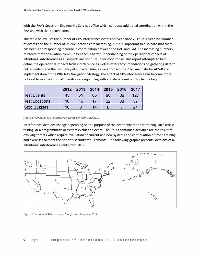
9 | P a g e I m p a c t s o f I n t e n t i o n a l G P S I n t e r f e r e n c e
with the FAA’s Spectrum Engineering Services office which conducts additional coordination within the FAA and with civil stakeholders.
The table below lists the number of GPS interference events per year since 2012. It is clear the number of events and the number of unique locations are increasing, but it is important to also note that there has been a corresponding increase in coordination between the DoD and FAA. The increasing numbers reinforce that the aviation community needs a better understanding of the operational impacts of intentional interference as all impacts are not fully understood today. This report attempts to help define the operational impacts from interference as well as offer recommendations on gathering data to better understand the frequency of impacts. Also, as we approach the 2020 mandate for ADS-B and implementation of the PBN NAS Navigation Strategy, the effect of GPS interference has become more noticeable given additional operators are equipping with and dependent on GPS technology.
Figure 1 Number of GPS Interference Events per Year Since 2012
Interference locations change depending on the purpose of the event, whether it is training, an exercise, testing, or a programmatic or system evaluation event. The DoD’s continued activities are the result of evolving threats which require evaluation of current and new systems and continuation of troop training and exercises to meet the nation’s security requirements. The following graphic presents locations of all intentional interference events from 2017:
Figure 2 Location of All Intentional Interference Events in 2017
Attachment 5 – Recommendations on Intentional GPS Interference

10 | P a g e I m p a c t s o f I n t e n t i o n a l G P S I n t e r f e r e n c e
The following graphic presents a summary depiction of the 4,000’ Above Ground Level (AGL) contour4 for some of interference events from 2017 (Alaska, Hawaii and CONUS not shown at the same scale). Any one interference event may have hundreds of miles of impact in the NAS.
Figure 3 Summary Depiction of 4,000’ AGL Contour for Non-Simultaneous Interference Events in 2017 (not all shown)
The interference normally originates from a ground-based system but can also be produced from airborne platforms like a helicopter or airplane. Each event is unique as the location of the interference transmitter, surrounding terrain, and power output (wattage) all impact how far and at what altitude the interference may be experienced. For the purposes that DoD conducts these interference events, the interference cannot always be contained to small geographic areas.
Methodology The GPS interference Task Group was created by compiling a team of subject matter experts from industry representing general aviation, business aviation, air carriers, air traffic control, avionics manufacturers, and GPS experts. Government participation included the DoD and FAA subject matter experts who are involved in the day-to-day interference events and overall policy. Other committees, including the Communications, Navigation and Surveillance (CNS) Task Force and Performance-based Operations Aviation Rulemaking Committee (PARC), were briefed to increase awareness of the tasking.
4 This represents one altitude slice presented in the NOTAM for interference events. NOTAMs for interference also include higher altitudes.
Attachment 5 – Recommendations on Intentional GPS Interference
11 | P a g e I m p a c t s o f I n t e n t i o n a l G P S I n t e r f e r e n c e
Many anecdotal pilot reports of loss of GPS signal were reviewed, such as NASA Aviation Safety Reporting System (ASRS) reports. Several reports were further investigated using tools provided by the FAA’s Surveillance and Broadcast Services (SBS) Program Office. The Task Group reviewed previous work done on this topic including case studies like the Embraer Phenom 3005. Through examination of case studies, review of previous work and group discussion, the Task Group developed a recommendation report comprised of defined GPS interference issues and recommendations.
Interference Event Issues and Impacts
Interference Event Scheduling The FAA’s process for GPS interference coordination is defined in the JO 7610.4, which is not publicly available. A redacted version is available but makes no mention of intentional GPS interference. The Air Route Traffic Control Center (ARTCC) is the focal point for determining what times of the day and week are acceptable for interference events based on volume of traffic expected. “Red times” (i.e., hours of the day when interference would have substantial operational impact) and “green times” (i.e., times that interference is acceptable) are provided in advance to the FAA Spectrum Engineering office and the Air Traffic Technical Advisory Group for negotiation with the interference proponent. The following graphic presents red and green times for various ARTCCs, which are updated at least once per year. ARTCCs not listed are all green times.
5 In April 2016, an Embraer Phenom 300 (EMB-505) equipped with a Garmin G3000 integrated flight deck lost all GPS signal due to an interference event. The loss of GPS eventually resulted in a miscompare between the dual Attitude and Heading Reference Systems (AHRS) and subsequent yaw damper and ventral rudder yaw stability augmentation system disengagement. The aircraft entered a Dutch Roll, resulting in an emergency descent. In February 2017, Embraer and Garmin implemented an improvement to the yaw damper algorithm allowing it to continue operating should an AHRS miscompare develop.
Attachment 5 – Recommendations on Intentional GPS Interference
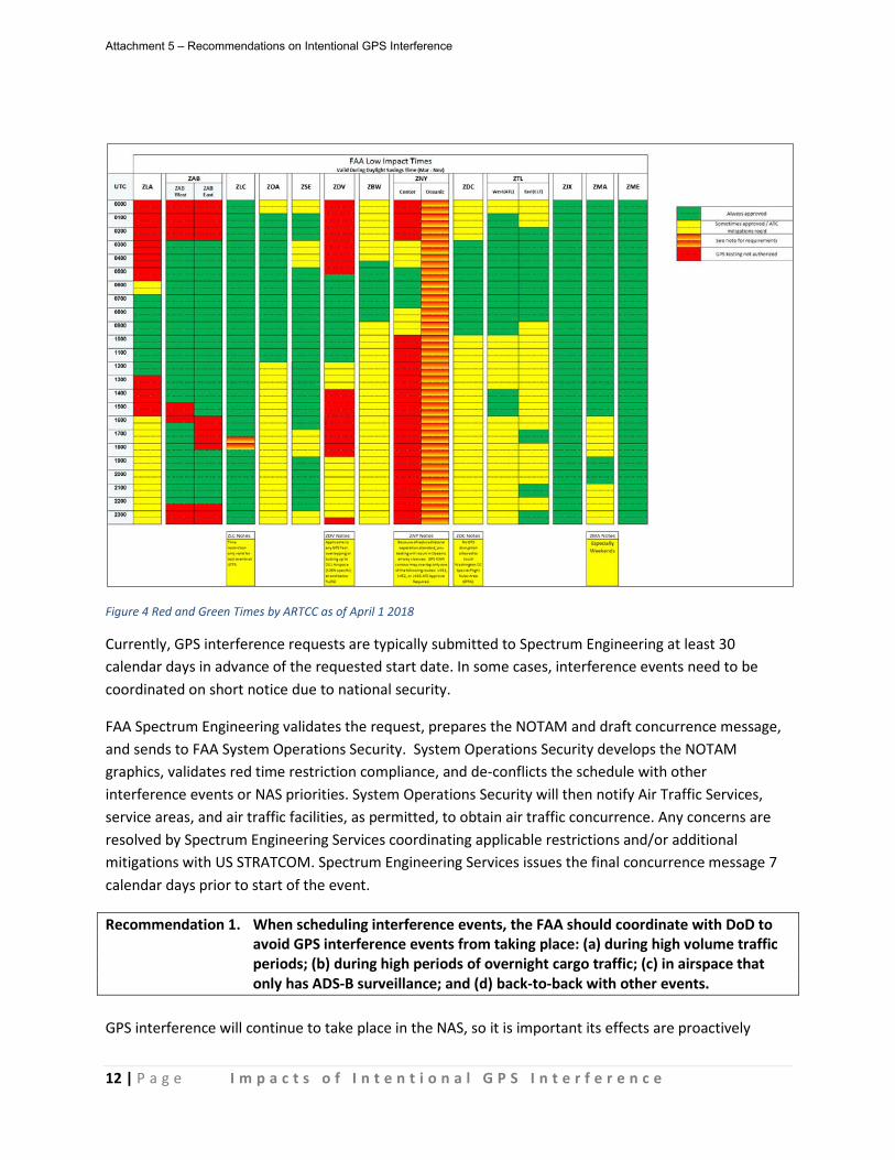
12 | P a g e I m p a c t s o f I n t e n t i o n a l G P S I n t e r f e r e n c e
Figure 4 Red and Green Times by ARTCC as of April 1 2018
Currently, GPS interference requests are typically submitted to Spectrum Engineering at least 30 calendar days in advance of the requested start date. In some cases, interference events need to be coordinated on short notice due to national security.
FAA Spectrum Engineering validates the request, prepares the NOTAM and draft concurrence message, and sends to FAA System Operations Security. System Operations Security develops the NOTAM graphics, validates red time restriction compliance, and de-conflicts the schedule with other interference events or NAS priorities. System Operations Security will then notify Air Traffic Services, service areas, and air traffic facilities, as permitted, to obtain air traffic concurrence. Any concerns are resolved by Spectrum Engineering Services coordinating applicable restrictions and/or additional mitigations with US STRATCOM. Spectrum Engineering Services issues the final concurrence message 7 calendar days prior to start of the event.
Recommendation 1. When scheduling interference events, the FAA should coordinate with DoD to avoid GPS interference events from taking place: (a) during high volume traffic periods; (b) during high periods of overnight cargo traffic; (c) in airspace that only has ADS-B surveillance; and (d) back-to-back with other events.
GPS interference will continue to take place in the NAS, so it is important its effects are proactively
Attachment 5 – Recommendations on Intentional GPS Interference
13 | P a g e I m p a c t s o f I n t e n t i o n a l G P S I n t e r f e r e n c e
mitigated. Certain locations in the NAS are more susceptible and adversely impacted by GPS interference due to the reliance on ADS-B for surveillance, such as the Gulf of Mexico and Alaska. High volume traffic periods are also more impactful due to the inability to rely on GPS procedures, including those implemented during the Metroplex process.
Recommendation 2. The FAA should define a process and identify an appropriate forum to conduct outreach to civil aviation stakeholders on significant intentional GPS interference events such as those during conditions identified in Recommendation #1 and/or large events.
Today, interference proponents do not regularly conduct advanced coordination of significant GPS interference events directly with impacted NAS operators. A significant event consists of interference being conducted contrary to Recommendation 1. Coordinating these events with industry stakeholders like airlines and trade associations at forums like the National Customer Forum (NCF), would provide opportunity to reduce the adverse impact by increasing awareness.
The US Air Force (USAF) in Alaska conducts outreach and has even altered event times based on user feedback. The Task Group believes pre-coordination with the US Coast Guard (USCG) and helicopter operators in the Gulf of Mexico is particularly important whenever interference is planned to take place in the Gulf. In the case of interference in the Gulf and in Alaska, additional dialogue with civil stakeholders would be beneficial.
Additionally, the FAA should consider reinstating their annual stakeholder Working Group meetings that included DoD testers, ARTCC reps, regional FAA spectrum, DoD spectrum, and HQ FAA spectrum and Air Traffic. The purpose of these meetings were operational in nature and allowed DoD and FAA individuals to meet and discuss their respective GPS interference test programs, procedures, and policies highlighting challenges and their operational requirements. The face to face interaction and the opportunity for extensive transparent discussion on any other concerns or issues was invaluable. Airlines and pilots could also be included in such an activity in the future.
Notification of Interference Events FAA Spectrum Engineering evaluates each test event request package to ensure engineering technical accuracy and completeness. The request package includes computer modeled graphics commonly referred to as “interference contours” or “bug splats”. These contours are designed to predict where aviation certified GPS receivers are “not” expected to experience interference during these test events (the areas outside of the contours). They are not designed or intended to depict where specific aircraft will experience interference, as this is impractical due to the large performance variations in specific GPS receivers, modeling limitations, and real-time factors that cannot be predicted or used in the modeling, such as environmental factors and aircraft attitudes that can greatly impact receiver interference levels.
Although the contours cannot predict where interference will occur, they provide a “relative” indication of where it is more likely to occur: the closer an aircraft is to the center, the more likely it is to
Attachment 5 – Recommendations on Intentional GPS Interference
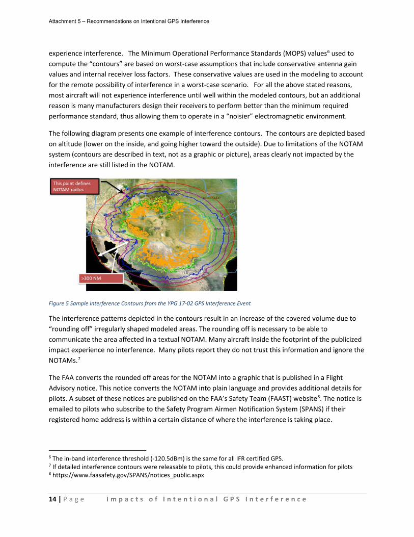
14 | P a g e I m p a c t s o f I n t e n t i o n a l G P S I n t e r f e r e n c e
experience interference. The Minimum Operational Performance Standards (MOPS) values6 used to compute the “contours” are based on worst-case assumptions that include conservative antenna gain values and internal receiver loss factors. These conservative values are used in the modeling to account for the remote possibility of interference in a worst-case scenario. For all the above stated reasons, most aircraft will not experience interference until well within the modeled contours, but an additional reason is many manufacturers design their receivers to perform better than the minimum required performance standard, thus allowing them to operate in a “noisier” electromagnetic environment.
The following diagram presents one example of interference contours. The contours are depicted based on altitude (lower on the inside, and going higher toward the outside). Due to limitations of the NOTAM system (contours are described in text, not as a graphic or picture), areas clearly not impacted by the interference are still listed in the NOTAM.
Figure 5 Sample Interference Contours from the YPG 17-02 GPS Interference Event
The interference patterns depicted in the contours result in an increase of the covered volume due to “rounding off” irregularly shaped modeled areas. The rounding off is necessary to be able to communicate the area affected in a textual NOTAM. Many aircraft inside the footprint of the publicized impact experience no interference. Many pilots report they do not trust this information and ignore the NOTAMs.7
The FAA converts the rounded off areas for the NOTAM into a graphic that is published in a Flight Advisory notice. This notice converts the NOTAM into plain language and provides additional details for pilots. A subset of these notices are published on the FAA’s Safety Team (FAAST) website8. The notice is emailed to pilots who subscribe to the Safety Program Airmen Notification System (SPANS) if their registered home address is within a certain distance of where the interference is taking place.
6 The in-band interference threshold (-120.5dBm) is the same for all IFR certified GPS. 7 If detailed interference contours were releasable to pilots, this could provide enhanced information for pilots 8 https://www.faasafety.gov/SPANS/notices_public.aspx
Attachment 5 – Recommendations on Intentional GPS Interference

15 | P a g e I m p a c t s o f I n t e n t i o n a l G P S I n t e r f e r e n c e
An example of such a graphic is presented below. This is the depiction provided with the YPG 17-02 Flight Advisory notice and associated NOTAM:
Figure 6 Graphic with YPG 17-02 Flight Advisory
NOTAMs are published by FAA System Operations Security (AJR-2) 72 to 96 hours in advance of a GPS interference event. GPS interference status information that is NOTAMed is publicly available on several websites including the FAAST website, ADS-B Service Availability Prediction Tool (SAPT) website9, and Coast Guard Navigation Center website10. FAA websites that are no longer supported that display GPS interference information, including the WAAS Test Team website11 and FAA WAAS website12, were identified by the Task Group and, subsequently, the out-of-date links were removed from public view.
Recommendation 3. The FAA should pursue modifications to the current NOTAM so it provides pilots and controllers improved expectation of where operators would expect interference for different equipment capabilities.
The existing contours indicate where interference will not occur and are thus poor indicators of where interference will be experienced. The corresponding NOTAMs are overly conservative and lead to many pilots simply ignoring them. The FAA should consider alternative calculation methods that reduce the size of the interference contours and focus on higher probabilities of impact being experienced. The NOTAMs need to be realistic and allow operators to make operational decisions, e.g., reroutes, based on their information. The Task Group discussed several opportunities worthy of evaluation to improve the NOTAMs and how the interference potential is described to pilots; however, this Task Group did not have the time or expertise to conduct this investigation to point to a definitive conclusion. The options discussed included: 9 http://sapt.faa.gov/default.php 10 https://www.navcen.uscg.gov/pdf/gps/gpsnotices/GPS_Interference.pdf 11 http://www.nstb.tc.faa.gov/ 12 http://waas.faa.gov/static/sog/notam/index.html
Attachment 5 – Recommendations on Intentional GPS Interference

16 | P a g e I m p a c t s o f I n t e n t i o n a l G P S I n t e r f e r e n c e
• Likelihood of interference could be based on data analysis performed by the SBS office related to actual interference experienced by ADS-B equipped aircraft and the impact on the ADS-B Ground-Based Transceiver (GBT)13. The SBS office could include data provided by the Awareness & Operational Impact (AOI) systems data analysis (NIC/NAC levels of aircraft, WAAS PDOP, GBT’s GPS logs).
• Consider changes to the contour calculation based on modifying knife edge diffraction and body masking14. Modernize the spectrum analysis tool. Any changes would involve multiple perspectives from within the FAA, including, but not limited to, aircraft certification, safety organizations, legal, etc.
• Investigate increased probability/risk of impact for the contours. This option could be investigated by an RTCA working group. Any effort to deliver a more probabilistic depiction of interference is a non-trivial task that would involve appropriate time and resources to effectively study the issue.
Discussion of this Task Group suggests that most pilots who fly through the impact area identified in the NOTAM do not experience any noticeable effect. Part of this is how the NOTAM is calculated, i.e., worst case scenario, and how the bug splat must be “rounded out” for the NOTAM. The DoD and FAA understand that the real world effects are substantially lower than what the model predicts. It is important the probability of the impact be closer to the real world effect.
While some pilots simply ignore these NOTAMs, several operators have proactively changed their operation when the NOTAM affects an area they fly in. One airline reported they cease all RNP operations in an area NOTAMed as affected by GPS interference. One ARTCC had previously shut off the ADS-B feed to controller scopes to proactively mitigate any map shifts. The operational impacts are inconsistent and the self-imposed mitigations may be causing further adverse effects.
The Task Group was able to validate that intentional GPS interference does in fact impact some operations through study of pilot reports, SBS data analysis, and the interference contours. It is clear that different aircraft, real-time conditions (e.g., environment, flight attitude, interference antenna orientation), and equipment combinations will cause variations in the degradation of GPS satellite tracking, which results in scenarios where one aircraft loses navigation and ADS-B capability and another aircraft flying at the same time and in the same area experiences no issues.
The following graphic shows ADS-B track data from an interference event, UTTR 17-01, on May 3, 2017 with multiple aircraft losing GPS reception while others are not affected. When the ADS-B Navigation Integrity Category (NIC) value exceeds the acceptable threshold, the track appears green. When the NIC value reported by the aircraft drops below the acceptable threshold, the color changes from green.
13 GBTs make up the infrastructure of the ADS-B network for surveillance, and TIS-B and FIS-B broadcasts. GBTs have two GPS systems and can be impacted by interference events. 14 Knife edge diffraction refers to the reflecting of interference off of terrain, and body masking refers signal loss due to the orientation of the airframe and the GPS antenna in relation to the interference source.
Attachment 5 – Recommendations on Intentional GPS Interference
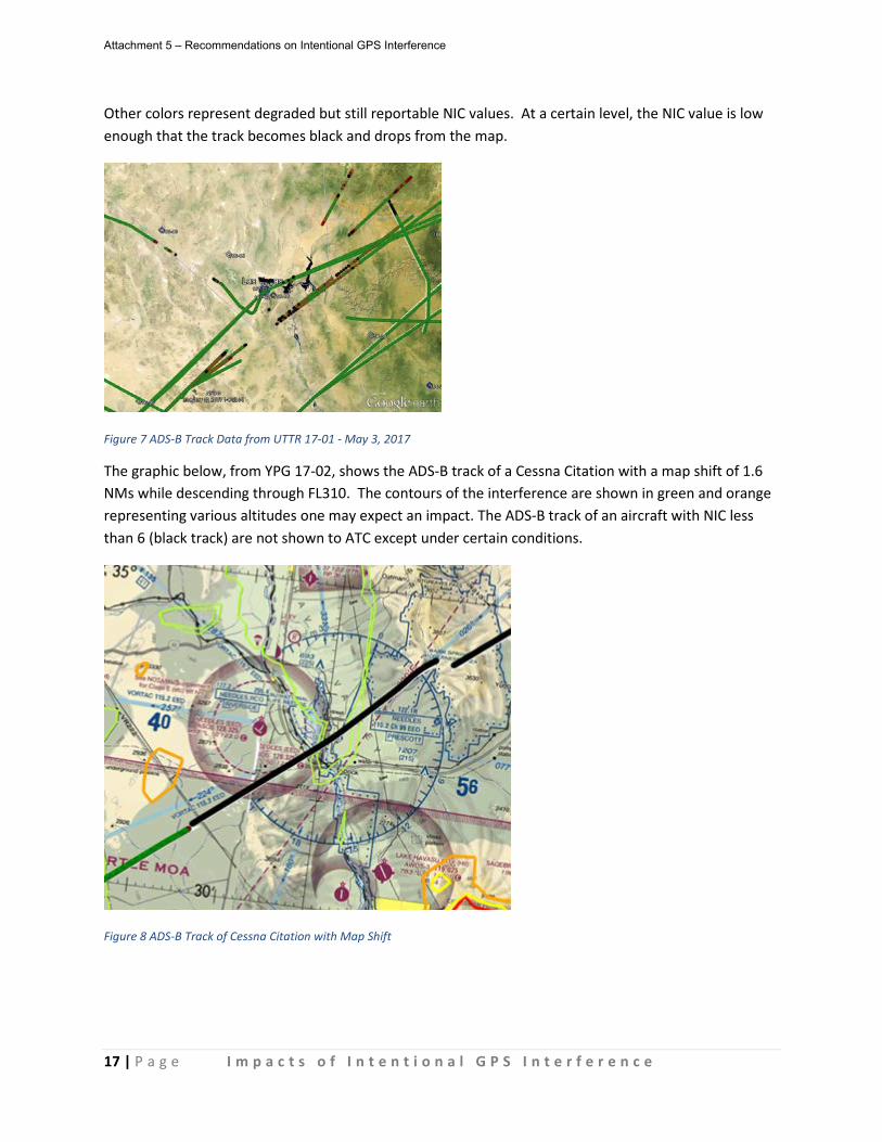
17 | P a g e I m p a c t s o f I n t e n t i o n a l G P S I n t e r f e r e n c e
Other colors represent degraded but still reportable NIC values. At a certain level, the NIC value is low enough that the track becomes black and drops from the map.
Figure 7 ADS-B Track Data from UTTR 17-01 - May 3, 2017
The graphic below, from YPG 17-02, shows the ADS-B track of a Cessna Citation with a map shift of 1.6 NMs while descending through FL310. The contours of the interference are shown in green and orange representing various altitudes one may expect an impact. The ADS-B track of an aircraft with NIC less than 6 (black track) are not shown to ATC except under certain conditions.
Figure 8 ADS-B Track of Cessna Citation with Map Shift
Attachment 5 – Recommendations on Intentional GPS Interference
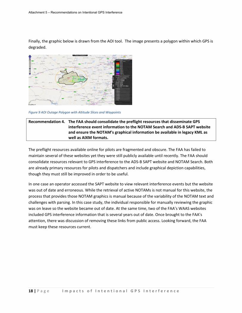
18 | P a g e I m p a c t s o f I n t e n t i o n a l G P S I n t e r f e r e n c e
Finally, the graphic below is drawn from the AOI tool. The image presents a polygon within which GPS is degraded.
Figure 9 AOI Outage Polygon with Altitude Slices and Waypoints
Recommendation 4. The FAA should consolidate the preflight resources that disseminate GPS interference event information to the NOTAM Search and ADS-B SAPT website and ensure the NOTAM’s graphical information be available in legacy KML as well as AIXM formats.
The preflight resources available online for pilots are fragmented and obscure. The FAA has failed to maintain several of these websites yet they were still publicly available until recently. The FAA should consolidate resources relevant to GPS interference to the ADS-B SAPT website and NOTAM Search. Both are already primary resources for pilots and dispatchers and include graphical depiction capabilities, though they must still be improved in order to be useful.
In one case an operator accessed the SAPT website to view relevant interference events but the website was out of date and erroneous. While the retrieval of active NOTAMs is not manual for this website, the process that provides those NOTAM graphics is manual because of the variability of the NOTAM text and challenges with parsing. In this case study, the individual responsible for manually reviewing the graphic was on leave so the website became out of date. At the same time, two of the FAA’s WAAS websites included GPS interference information that is several years out of date. Once brought to the FAA’s attention, there was discussion of removing these links from public access. Looking forward, the FAA must keep these resources current.
Attachment 5 – Recommendations on Intentional GPS Interference
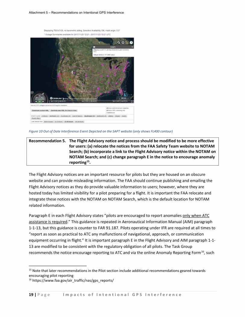
19 | P a g e I m p a c t s o f I n t e n t i o n a l G P S I n t e r f e r e n c e
Figure 10 Out of Date Interference Event Depicted on the SAPT website (only shows FL400 contour)
Recommendation 5. The Flight Advisory notice and process should be modified to be more effective for users: (a) relocate the notices from the FAA Safety Team website to NOTAM Search; (b) incorporate a link to the Flight Advisory notice within the NOTAM on NOTAM Search; and (c) change paragraph E in the notice to encourage anomaly reporting15.
The Flight Advisory notices are an important resource for pilots but they are housed on an obscure website and can provide misleading information. The FAA should continue publishing and emailing the Flight Advisory notices as they do provide valuable information to users; however, where they are hosted today has limited visibility for a pilot preparing for a flight. It is important the FAA relocate and integrate these notices with the NOTAM on NOTAM Search, which is the default location for NOTAM related information.
Paragraph E in each Flight Advisory states “pilots are encouraged to report anomalies only when ATC assistance is required.” This guidance is repeated in Aeronautical Information Manual (AIM) paragraph 1-1-13, but this guidance is counter to FAR 91.187. Pilots operating under IFR are required at all times to “report as soon as practical to ATC any malfunctions of navigational, approach, or communication equipment occurring in flight.” It is important paragraph E in the Flight Advisory and AIM paragraph 1-1-13 are modified to be consistent with the regulatory obligation of all pilots. The Task Group recommends the notice encourage reporting to ATC and via the online Anomaly Reporting Form16, such
15 Note that later recommendations in the Pilot section include additional recommendations geared towards encouraging pilot reporting 16 https://www.faa.gov/air_traffic/nas/gps_reports/
Attachment 5 – Recommendations on Intentional GPS Interference
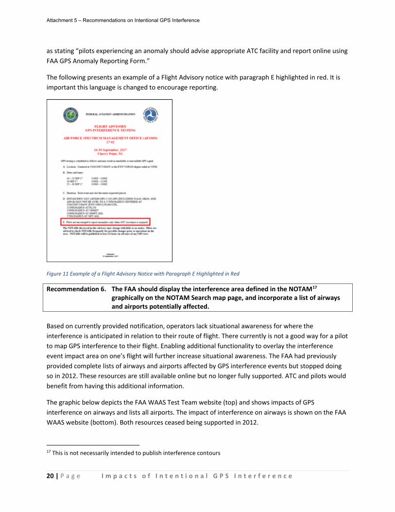
20 | P a g e I m p a c t s o f I n t e n t i o n a l G P S I n t e r f e r e n c e
as stating “pilots experiencing an anomaly should advise appropriate ATC facility and report online using FAA GPS Anomaly Reporting Form.”
The following presents an example of a Flight Advisory notice with paragraph E highlighted in red. It is important this language is changed to encourage reporting.
Figure 11 Example of a Flight Advisory Notice with Paragraph E Highlighted in Red
Recommendation 6. The FAA should display the interference area defined in the NOTAM17 graphically on the NOTAM Search map page, and incorporate a list of airways and airports potentially affected.
Based on currently provided notification, operators lack situational awareness for where the interference is anticipated in relation to their route of flight. There currently is not a good way for a pilot to map GPS interference to their flight. Enabling additional functionality to overlay the interference event impact area on one’s flight will further increase situational awareness. The FAA had previously provided complete lists of airways and airports affected by GPS interference events but stopped doing so in 2012. These resources are still available online but no longer fully supported. ATC and pilots would benefit from having this additional information.
The graphic below depicts the FAA WAAS Test Team website (top) and shows impacts of GPS interference on airways and lists all airports. The impact of interference on airways is shown on the FAA WAAS website (bottom). Both resources ceased being supported in 2012.
17 This is not necessarily intended to publish interference contours
Attachment 5 – Recommendations on Intentional GPS Interference

21 | P a g e I m p a c t s o f I n t e n t i o n a l G P S I n t e r f e r e n c e
Figure 12 Resources for GPS Interference where Support has Ceased
This recommendation is consistent with FAA plans to implement graphical Temporary Flight Restrictions (TFR) on the NOTAM Search map page in 2018. This enhancement was a recommendation of the TOC’s “Improving Graphical Temporary Flight Restrictions in the National Airspace System” report provided in December 2016 because greater situational awareness is needed for pilots to understand where a TFR is in relation to their specific route.
Recommendation 7. The FAA should have a process to ensure underlying air traffic facilities receive real-time notification when interference is taking place.
The current process for notification of an interference event is for the interference proponent to contact the impacted ARTCC(s) via telephone in advance of interfering with the GPS signal. However, there is no process to ensure the status of the interference is also communicated to other impacted air traffic facilities such as TRACONs or underlying airport towers. A consistent and comprehensive communication process is needed for controllers to maintain awareness of an event. The DoD coordinator involved with the interference event will call the ARTCCs involved to give a 90 minutes advanced notice before conducting any interference and when they are finished. The existing process
Attachment 5 – Recommendations on Intentional GPS Interference

22 | P a g e I m p a c t s o f I n t e n t i o n a l G P S I n t e r f e r e n c e
limits the real-time awareness for controllers on position at other facilities who may need this knowledge to ensure mitigations are being properly utilized, such as the Stop Buzzer.
During Event
Operational Impacts Large intentional interference events can generate significant system impacts that affect operational efficiency. The NAS is experiencing an increasing reliance on Performance Based Navigation (PBN) through use of Area Navigation (RNAV) Standard Instrument Departures (SIDs) and Standard Terminal Arrival Procedures (STARs) and Q routes as well as Metroplex implementations that may involve use of GPS for navigation. If interference impacts use of PBN routes and procedures, this can drive a loss of throughput, particularly in airspace, that can drive Traffic Management Initiatives (TMIs) and delay during high volume periods.
During a recent Red Flag event at the Nevada Test and Training Range, air traffic facilities informed operators about the potential for operational impact from the event. Los Angeles Air Route Traffic Control Center (ZLA) provided the following overview to operators of the anticipated effects of the Red Flag event:
Aircraft operating in ZLA airspace may be affected and experience navigational disruption. Arrivals and departures from airports within the Las Vegas, NV area may be issued Non-RNAV re-routes. Possibility of increased disruption of traffic flow in the vicinity of LAS may require airborne re-routes to the south and east of the affected area. Descend-via and Climb-via procedures may be suspended during affected times. Non-RNAV SIDs and STARs may be issued within ZLA airspace in the event of increased navigational disruption. Possible increased airborne mile-in-trail and departure mile-in-trail TMIs.
Arrival and departure delays may exceed 30 minutes during periods of peak demands in the initial implementation and during peak traffic periods – especially Thursday, Friday and Sunday nights
Arrival TMI’s including GDP, AFP, GS, CFR, Metering, speed restrictions and MIT are possible during high volume periods. Departure TMIs are expected during the scheduled events.
The following procedures may be required: tactical re-routes for fix balancing; possible ATCSCC Playbook routes (Rocky South 2 partial; Hill City HLC Partial; Springs West Partial; Mojave East Partial).
The need for TMIs will be continuously evaluated throughout the duration of the event with heaviest impact expected during the first 7 days
An additional event affecting New York Oceanic airspace (ZWY) resulted in air traffic facilities imposing a pre-emptive closure of non-radar airways. One NOTAM (A0090/18) informed operators that “GPS Testing in the New York Center Oceanic CTA/FIR will be conducted” and that during the test period of 1300-1500 Zulu time, “the following non-radar airways will be closed west of 75W: M202, L375, L435,
Attachment 5 – Recommendations on Intentional GPS Interference
23 | P a g e I m p a c t s o f I n t e n t i o n a l G P S I n t e r f e r e n c e
L451.” A second NOTAM (A0091/18) informed operators of additional route closures at other times of the day.
Aircraft Impacts Intentional GPS Interference has multiple potential impacts on aircraft systems. However, given the variety of systems operating in the NAS, the impacts will not be homogenous across all fleets and equipage. A generalized assessment of aircraft impact is presented below with focus on identification of categories of aircraft impacts that NAS stakeholders may anticipate.
The most common impact is complete loss of GPS reception, which results in loss of GPS position, velocity, and time (PVT). In some cases the GPS signal may be degraded but not completely lost, resulting in decreased position accuracy.
Receiver autonomous integrity monitoring (RAIM) and fault detection and exclusion (FDE) ensure that position errors are bounded by the horizontal alert limit (HAL) unless a position failure is annunciated within the time to alert (TTA). GPS position errors may exceed the HAL for a period before the required TTA. TTA is generally 8 seconds, but can be up to 30 seconds for some Enroute applications. HAL Thresholds are 2NM for En Route, 1 NM for Terminal and 0.3 NM for LNAV and LNAV/VNAV final approach.
The following table presents an overview of different potential impacts from GPS interference. This is a snapshot of impacts based on input from two manufacturers and not intended to be a comprehensive list of all impacts:
Effect Affected Operations
Impact
Loss of GPS-based navigation
Enroute/ Terminal/ Approach NAV
Loss of all RNAV and Required Navigation Performance (RNP). Higher end aircraft with Inertial Reference Unit (IRU) or Distance Measuring Equipment (DME)/DME may have degraded RNP/RNAV.
May result in missed approaches for GPS-based or low RNP procedures with associated increase in flight crew workload. May use conventional approach (ILS, VOR Minimum Operating Network).
Risk of diverting if Instrument Landing System (ILS) (lower minimum) not available.
Simultaneous loss of GPS navigation in a wide area could increase ATC workload.
Larger than normal GPS position errors prior to loss of GPS
Enroute/ Terminal NAV
Interference could cause the GPS position to be pulled off but not exceed the HAL (2NM or 1NM for enroute and terminal, respectively).
There could be navigation impacts such as causing VNAV descent on a STAR significantly before or after the intended top of descent.
Technical Standard Order (TSO) GPS receivers incorporate integrity monitors that will prevent these errors from persisting longer than the required time-to-alert.
Attachment 5 – Recommendations on Intentional GPS Interference

24 | P a g e I m p a c t s o f I n t e n t i o n a l G P S I n t e r f e r e n c e
Loss of ADS-B Out over wide area.
Surveillance Loss of all surveillance in areas such as Alaska where there are large gaps in Secondary Surveillance Radar (SSR) coverage.
GPS/SBAS Nav/ GPS Measurements
Surveillance If aircraft depends on Satellite Based Augmentation System (SBAS) and is in areas without primary or secondary radar coverage, this will cause a larger airspace management issue. Some aircraft use GPS-Inertial blended solutions to support ADS-B needs.
Loss of TAWS/HTAWS
Enroute/ Terminal NAV
Reduced situational awareness and safety for equipped aircraft. Terrain Awareness and Warning System (TAWS) is required equipment for turbine-powered airplanes > 6 passengers. Helicopter TAWS (HTAWS) is required for helicopter air ambulance.
Loss of GPS results in loss of terrain/obstacle alerting. Position errors as GPS degrades can result in false or missed alerts.
Loss of GPS aiding to AHRS
Flight Control
Can result in degradation of AHRS pitch and roll accuracy with potential downstream effects such as was experienced by a Phenom 300 flight.
Missing/ degraded ADS-B In targets
All flight phases
Complete loss of GPS in an ADS-B Out equipped aircraft will cause that aircraft to be lost as a target for ADS-B In systems. ADS-B In systems with Traffic Collision Avoidance System (TCAS) will continue to display target. If GPS position accuracy exceeds reported NACp prior to loss of GPS, ADS-B In systems with TCAS may display multiple symbols for the same target. Overall impact is reduced situational awareness. TCAS II systems with hybrid surveillance will be unaffected because target position will be validated with active interrogations.
Loss of GPS position to SATCOM
Communica-tions, Surveillance
Geosynchronous satellite networks generally require valid position to attach a SATCOM terminal to the network. If position is not available, connectivity will not be enabled. Primarily a concern at system startup on ground or for in-air satellite handoffs. During all flight phases, SATCOM position reporting could be impaired with associated impacts to aircraft fleet tracking.
Loss of GPS to PFD/MFD
All flight phases
Can result in: - Loss of synthetic vision display and flight path marker on PFD - Loss of airplane icon on lateral and vertical electronic map
displays, georeferenced charts, and airport surface maps without DME-DME or IRU
- Loss of airspace alerting and nearest waypoint information without DME-DME or IRU
Overall loss of situational awareness to flight crew and increased workload.
No GPS Search and GPS provides increased position accuracy to newer Emergency Locator
Attachment 5 – Recommendations on Intentional GPS Interference

25 | P a g e I m p a c t s o f I n t e n t i o n a l G P S I n t e r f e r e n c e
position for ELT rescue Transmitters (ELTs). Loss of GPS could result in larger search radius. Reduced ability to determine flight phase
Terminal NAV
GPS-derived ground speed is a key component in determining the current phase of flight to perform workload-reducing functions such as entertainment audio or telephone audio muting. Loss of this feature could increase crew workload when preparing to land.
Loss of runway alerting
Approach, On-Ground, Takeoff
Loss of GPS results in loss of runway alerting (wrong runway, taxiway landing/takeoff, runway too short). Reduced situational awareness and safety for equipped aircraft.
No GPS position for EFB
Situational Awareness
Loss of own-ship position for Electronic Flight Bag (EFB)
Recommendation 8. The FAA should work with OEMs to develop a clear understanding of known
GPS dependencies in avionics and aircraft flight controls. Modern GPS equipment is required to recover from interference conditions that cause loss of position/navigation18. However, older GPS equipment may not have been developed to similar requirements19.
Additionally, as part of meeting their obligations under 2x.1309 “Equipment, systems, and installations”20, aircraft and equipment manufacturers are required to consider foreseeable “loss of” failure conditions and “misleading information” failure conditions and to develop appropriate mitigations for both types of failures.
Today, the FAA and operators do not have a clear understanding of what critical aircraft systems have GPS dependencies and what the impact of interference and GPS failure would be on each of those systems. It is important that known GPS dependencies for aircraft primary and secondary systems, such as those described to back up any system, are identified in the context of a failure of that GPS system and what may be impacted following such a failure. The FAA should work with aircraft and equipment manufacturers to develop a clear understanding of known GPS dependencies in avionics and aircraft flight controls. These dependencies are important to be communicated to the DoD for awareness purposes, and to operators so that they can be properly trained (see following recommendation).
18 For example, TSO-C145( )/TSO-C146( ) GPS/SBAS equipment must meet the requirements of DO-229C/D/E section 2.1.1.12 “Integrity in the Presence of Interference” that includes (emphasis added):
“The GPS/SBAS equipment shall satisfy the applicable integrity requirement within the time-to-alert (…) for the output of misleading information in the presence of interfering signals higher in power than the values specified in Appendix C. Under these extreme conditions, it is acceptable to output a navigation alert, but not to output misleading information. The equipment shall autonomously return to steady state accuracy (…) within 5 minutes after the interference conditions return to those specified in Appendix C for initial acquisition.”
TSO-C196 GPS equipment must meet the same requirements in DO-316 section 2.1.1.10. 19 For example, TSO-C129( ) does not have similar requirements to recover from interference conditions that cause loss of position/navigation. 20 Part 23 Amendment 23-64 moved requirements for consideration of failure conditions to 23.2510.
Attachment 5 – Recommendations on Intentional GPS Interference
26 | P a g e I m p a c t s o f I n t e n t i o n a l G P S I n t e r f e r e n c e
Recommendation 9. Operators should be informed of known avionics and aircraft flight control GPS dependencies and what should be expected if GPS becomes unavailable during flight.
The FAA’s existing guidance may not be sufficient to address the dependencies identified in the table in the Aircraft Impacts section. Additional updates to the FAA Advisory Circular (AC) 20-138D or other ACs may be required as an outcome of Recommendation 8.
FAA AC 20-138D Chg 2 “Airworthiness Approval of Positioning and Navigation Systems”, section 15-4 “Documenting Effects of GNSS Outage” describes GNSS outages as “a normal operating condition in areas with routine interference testing, and can occur anywhere in the NAS due to unintentional interference.” AC 20-138D section 15-4 also provides several examples of systems dependent on GNSS including “TAWS/HTAWS, synthetic vision systems, ADS-B, and micro-electro-mechanical system (MEMS) accelerometers/sensors in air data attitude heading reference system (ADAHRS) inputs to electronic primary flight displays.” This section also describes the AFM(S)/RFM(S) content that must be documented to describe aircraft-level effects as well as information TSO equipment manufacturers should include in their operating guide and installation instructions.
Other FAA ACs dedicated to functions that are dependent on GNSS include more specific guidance about what should be included in the AFM(S)/RFM(S) relative to those functions. Examples of these ACs include but are not limited to:
• AC 20-165B “Airworthiness Approval of Automatic Dependent Surveillance – Broadcast OUT Systems” section 2.2
• AC 20-167A “Airworthiness Approval of Enhanced Vision System, Synthetic Vision System, Combined Vision System, and Enhanced Flight Vision System Equipment” Appendix F and Appendix H, section H.6
• AC 23-18 “Installation of Terrain Awareness and Warning System (TAWS) Approved for Part 23 Airplanes” section 7.f.(1)(c)
• AC 25-23 “Airworthiness Criteria for the Installation Approval of a Terrain Awareness and Warning System (TAWS) for Part 25 Airplanes” section 11.a.(g)
NAS Equipment Recommendation 10. The FAA should solicit industry feedback on the strategy to decommission
secondary-surveillance radar systems. This recommendation echoes Recommendation 10 published in the “Performance Based Navigation (PBN) Route System” report published by the TOC in August 2017. The SBS program office is considering decommissioning more than 80% of terminal radars in CONUS as ADS-B equipage increases. Without radar as a backup, areas prone to GPS interference will experience increased periods of inefficient non-radar or procedural separation as the position source for ADS-B may be degraded. Concerns regarding
Attachment 5 – Recommendations on Intentional GPS Interference

27 | P a g e I m p a c t s o f I n t e n t i o n a l G P S I n t e r f e r e n c e
this drawdown were also recently raised in a January 2018 Government Accountability Report21. Once the FAA drafts the decommissioning CONOPs, industry should be involved in its validation.
Recommendation 11. The FAA must keep the VORs that are part of the Minimum Operating Network (MON) maintained and in service.
Given the impacts experienced during interference events, it is critical the resiliency plan in place be effective. Many VORs that are part of the MON are out of service, sometimes for years at a time. The FAA must make an effort to keep these systems functional for the MON to be useful. This recommendation is similar to Recommendation 11 from the “Performance Based Navigation (PBN) Route System” that stated “the FAA should ensure there is a long-term, funded sustainment plan for those NAVAIDs determined to be integral to the NAS.”
Recommendation 12. The FAA should proactively alert pilots when GPS interference will negatively affect the services provided by an ADS-B GBT.
Large GPS interference events can negatively affect the ability of GBTs in a given service volume to provide the services pilots are expecting. Interference can negatively affect the system’s ability to provide ADS-Rebroadcast (ADS-R), Traffic Information Services- Broadcast (TIS-B) and Flight Information Services-Broadcast (FIS-B), which should be communicated to pilots via NOTAM in advance.
Below is an example of how the FAA can model a GBT outage. The FAA is implementing new NOTAM policy that will allow for outage information to be disseminated to pilots. This is an example NOTAM:
!FDC #/#### ZAN SVC ADS-R, TIS-B, and FIS-B MAY NOT BE AVBL WI AN AREA DEFINED AS 50NM RADIUS OF 334500N0900504W (MEM F/R/D) SFC-UNL. AFFECTED AIRSPACE MAY INCLUDE RNV, M37, IDL, GNV. YYMMDDhhmm-YYMMDDhhmm
21 GAO-18-177; https://www.gao.gov/assets/690/689478.pdf
Attachment 5 – Recommendations on Intentional GPS Interference
28 | P a g e I m p a c t s o f I n t e n t i o n a l G P S I n t e r f e r e n c e
This Graphic shows the airports affected by a GBT outage.
Pilots and Dispatchers Recommendation 13. The FAA should update pilot guidance: (a) AIM/PCG should be reviewed for
consistency of terms; (b) AIM should list resources for preflight information (i.e., NOTAM Search and ADS-B SAPT website); and (c) the FAA should publish an Advisory Circular specific to GPS interference and the resiliency of the NAS (VOR MON and NextGen DME).
The guidance published in the AIM/Pilot Controller Glossary (PCG) is inconsistent in the use of terms, does not point operators to important resources, and is counter to pilot’s regulatory obligations. The FAA should update these resources to provide effective and consistent guidance for pilots and dispatchers.
The Task Group identified several issues with the current AIM guidance. The use of “unreliable” is outdated and should be replaced with the correct phrase of “may not be available.” There is a note stating “GPS interference or outages associated with known testing NOTAMs should not be reported to ATC.” However, pilots must always report malfunctions to navigation equipment per FAR 91.187. AIM guidance should also be updated to alert pilots of the availability of the ADS-B SAPT website, NOTAM Search, and the Flight Advisory notices.
The Task Group believes GPS interference and the resiliency plan should be discussed in greater detail in an Advisory Circular or other form of guidance document. Without clear guidance, operators will continue to overcompensate (not fly, operational impact) or undercompensate (no planning or pilot training) in the face of planned interference event. The following topics from an operational/pilot perspective should be covered in the guidance:
• GPS interference background; • The FAA’s mitigations for GPS interference events, particularly for those airports dependent on GPS
approaches (i.e., weather less than 5,000’ ceiling and/or 5 miles visibility); • The safety concerns related to GPS interference identified in the APNT CONOPs, such as lack of
understanding of back-up systems and inability to smoothly transition to reversionary systems, should be addressed with realistic scenarios and in the context of the VOR MON and NextGen DME navigation;
• GPS interference’s impact on various systems (see OEM contributions), including map shifts and vertical navigation changes;
• Scenario training (See FAA’s 2012 Alternative Position, Navigation, Timing (APNT) CONOPs); • How to communicate and report interference to ATC; • The availability of GPS approaches during periods of interference; • FAR 91 equipment requirements and operator best practices.
Operators are not given adequate education on the impact of GPS interference to their systems. In the example depicted below from a 2017 Red Flag military exercise, an Alaskan operator that tracks their ADS-B equipped fleet for safety reasons witnessed a significant shift in position from an aircraft. This
Attachment 5 – Recommendations on Intentional GPS Interference

29 | P a g e I m p a c t s o f I n t e n t i o n a l G P S I n t e r f e r e n c e
shift, although not provided to ATC, raises questions for search and rescue, and the reliance of some operators on GPS for monitoring aircraft.
Figure 13 ADS-B Position Shift During 2017 Red Flag exercise
Recommendation 14. The FAA should clarify that a GPS interference NOTAM gives pilots authorization to deviate from FAR 91.227 within the affected area and for the duration of that flight.
The FAA has not yet provided a process for operators to be informed they are exempt from FAR 91.227 requirements when GPS and/or WAAS may not be available due to intentional interference. FAR 91.227 details the performance requirements for ADS-B Out systems including the required position accuracy. When GPS interference is taking place, an operator may have their position accuracy (NIC/NAC) go below that required by the regulation. The FAA’s current guidance, AC 90-114, ADS-B Operations, states:
It may be necessary for ATC to authorize operations in airspace for which ADS-B Out is required at times when the required performance cannot be met. During interference outages of [GPS] (scheduled or unscheduled), the FAA may revert to alternate surveillance, as necessary, for affected areas. ATC will issue a Notice to Airmen (NOTAM) that authorizes such operations and identifies the airspace and time periods that the authorization is in effect. ATC will also issue a NOTAM to authorize performance outages when the FAA-provided preflight availability prediction tool is not available.
The FAA has not yet issued guidance to operators as to when and where they are exempt from compliance with FAR 91.227. The Task Group believes a lack of exemption from this requirement would have significant impacts including delaying flights until performance requirements can be met, changing flight routing to avoid the affected area, or flight cancellation.
Attachment 5 – Recommendations on Intentional GPS Interference

30 | P a g e I m p a c t s o f I n t e n t i o n a l G P S I n t e r f e r e n c e
It is important the notification provide an exemption from ADS-B performance requirements for the duration of the flight as it is apparent that some GPS systems22 may not recover while airborne from the interference despite no longer being exposed to the effects23. Example phraseology for the NOTAM could be “pilots transiting area are exempt from 14 CFR Section 91.227 requirements for duration of flight.” The notification of exemption from FAR 91.227 should be included in the NOTAM, on NOTAM Search, and on the SAPT website. Air traffic controllers will also need to be notified of a specific aircraft’s exemption status.
The image below is of a commercial airline flight during a May 2017 GPS event. Note the red and yellow flight track which indicates the ADS-B NIC/NAC values were degraded below performance specifications during this interference event. The system remains degraded through the region identified by the NOTAM as well as outside the NOTAM area. The system never recovered even when outside the interference area.
Figure 14 Flight track and ADS-B NIC/NAC Degradation Inside and Outside of Interference Event Area
Recommendation 15. The FAA should review and streamline the report process pilots use involving failures or malfunctions to GPS dependent systems to ensure all reports are collected and sent to the correct FAA office.
The FAA office that needs to know in real-time, or after the fact, about an adverse impact from GPS interference is not receiving all relevant reports today. The 7210.3 and 7110.10 note the Traffic Management Unit (TMU) should be informed of GPS anomaly reports so that the TMU can pass these reports to the appropriate FAA office with responsibility: currently the WAAS Operations-East Desk at the ATCSCC in Warrenton, Virginia. It is clear from the ATCSCC’s annual report numbers that those reports verbally given to ATC and Flight Service rarely make it to the ATCSCC.
22 While modern GPS equipment is required to recover from interference conditions, older GPS equipment may not have been developed to similar requirements (see footnotes 18 and 19). Recovery time will vary based on the system and the dependencies connected to that system. 23 The lack of restoration of navigation and ADS-B equipment on board aircraft has been reported via several sources: (a) ASRS reports; (b) individual air carrier crew reports; and (c) the SBS office’s ADS-B data analysis.
Attachment 5 – Recommendations on Intentional GPS Interference

31 | P a g e I m p a c t s o f I n t e n t i o n a l G P S I n t e r f e r e n c e
To have a representative picture of how many aircraft are experiencing an impact from intentional interference, the reporting process should be reviewed and improved upon to ensure all reports from pilots are correctly being passed on to the ATCSCC. Additionally, the ATCSCC should have a pathway to receive relevant pilot reports submitted via the NASA ASRS system or through an airline reporting system, as well as any Mandatory Occurrence Reports (MORs) or Air Traffic Safety Action Program (ATSAP) reports. It is not widely known among pilots that their report, if submitted via ASRS or to the airline, may not be reviewed by the appropriate FAA office.
The FAA should work with industry to emphasize the need for pilots to report GPS navigation and ADS-B malfunctions via the online Anomaly Reporting Form. Consolidating guidance to focus on this online reporting form should improve the collection of data. This online form also needs to be updated for it to be effective for the ATCSCC. For example, the questionnaire asks the reporter to state the time the event occurred; however, it is not clear if the time is UTC or local. The FAA should implement the recommendations of the ATCSCC to improve the data collection of pilot reports.
Recommendation 16. The FAA should have the ability to correlate ADS-B NIC/NAC degradation to an interference event for improved data collection/metrics.
The FAA relies on subjective anecdotes to identify interference despite aircraft automatically reporting the elements necessary to determine a real-time picture of GPS interference in the NAS. These reports are inconsistent and frequently are not provided to those in the FAA who need them. Automatic ADS-B aircraft messages provide information on where GPS signals are degraded and where recovery occurs. This data can form the foundation for data-driven decision making. The FAA should leverage the reports automatically provided by ADS-B aircraft and the over 600 GBTs to gauge the impact of GPS interference. Improving data processing will facilitate the ability to identify trends, improve metrics, and attribute the cause. Anecdotal pilot reports will continue to inform the extent of the impacts.
Controllers
Controllers are instructed to record when an aircraft reports an issue with GPS or WAAS. The controller will then request a report from a second aircraft. This information may then be passed to a supervisor or controller-in-charge for inclusion on the 7230-4, Daily Record of Facility Operation. The second aircraft may be receiving a GPS or WAAS signal and, in that case, no action may be taken. As noted earlier, most pilot reported GPS malfunctions or failures are not reported from the controller who receives it to the appropriate FAA Office . It is important all data and reports collected are passed to this office so trends and metrics can be identified.
Recommendation 17. The FAA should disassociate the process of collecting and verifying pilot reported GPS malfunction or failures from the process used for pilot reported NAVAID24 malfunctions.
24 The Pilot/Controller Glossary defines a NAVAID as any visual or electronic device airborne or on the surface which provides point-to-point guidance information or position data to aircraft in flight.
Attachment 5 – Recommendations on Intentional GPS Interference

32 | P a g e I m p a c t s o f I n t e n t i o n a l G P S I n t e r f e r e n c e
In the JO 7110.65, paragraph 2-1-10, the FAA defines how controllers are to collect and verify pilot reported NAVAID malfunctions or failures. However, this paragraph creates an inadvertent and incorrect connection between a ground-based NAVAID and a GPS malfunction. Specifically, this paragraph makes it appear that two aircraft reports noting malfunction or failure are required before any formal action will be taken to forward the reports to those who need them. We believe this paragraph is contributing to the underreporting of pilots reports provided to controllers.
The FAA could address this paragraph in the controller order by:
a) Reorganizing it to ensure a GPS anomaly report is not treated like a pilot reported ground-based NAVAID malfunction;
b) Adding guidance that promotes the passing of all GPS anomaly reports to the appropriate office at the ATCSCC via the process outlined in the JO 7210.3, paragraph 3-5-3;
c) Emphasizing two pilot reports for a GPS anomaly are not required and may have no bearing on the validity of the first aircraft’s impact; and
d) Removing the outdated term “unreliable” and replacing it with the phrase “may not be available.”
The Task Group has learned through this process that GPS interference is affected by terrain, aircraft altitude, aircraft attitude, direction of flight reference the center of the interference, distance from the center of the interference, equipage, and many other factors. Asking a second aircraft may have no bearing on the validity of the other aircraft’s experience. The GPS interference NOTAMs can cover large areas with aircraft experiencing vastly different effects depending on where they are. In one NOTAM, the smallest footprint was at 50FT AGL with a radius of 172NM. This is an area of 120,687 square miles or an area roughly the size of the State of New Mexico or the States of Florida and Georgia combined.
Recommendation 18. The FAA should ensure controllers document pilot reported GPS malfunctions or
failures25 in a manner that supports data analysis and trend identification. Documenting a pilot reported GPS malfunction or failure in the Daily Record of Facility Operation does not allow for efficient evaluation of the impact GPS interference has on the NAS. The FAA should ensure these reports are documented in such a way that the reports can easily be identified and additional details ascertained. The Task Group recommends this type of report should be a MOR item and GPS interference given its own category on the form to allow easy keyword searching.
Recommendation 19. The FAA should update controller guidance to clarify controller responsibilities during a GPS interference event.
Controller guidance provided in JO 7110.65, paragraph 4-8-1(k) and (m), is out of date and has proven to be confusing to controllers. This paragraph is clear, when a NOTAM is published affecting GPS in the
25 These reports should be submitted regardless of whether a NOTAMed interference event is active
Attachment 5 – Recommendations on Intentional GPS Interference
33 | P a g e I m p a c t s o f I n t e n t i o n a l G P S I n t e r f e r e n c e
area, “Do not resume RNAV Approach operations until certain that GPS interference is no longer a factor or such GPS testing exercise has ceased.” But this is further complicated in guidance provided by two memos (See Appendix C) from FAA Department AJV-8, Air Traffic Procedures, dated July 17, 2015 that state:
3. During testing, if a pilot indicates that they wish to proceed with a GPS instrument approach, can a controller clear them to do so?
Yes. If the pilot has determined that he/she is receiving a GPS signal and requests a GPS-dependent RNAV approach, the controller may issue it.
And in a second memo from AJV-8, dated the same day:
If a pilot advises the controller that he/she still wants the RNAV approach, is the controller allowed to issue the RNAV approach?
Yes. If a pilot is receiving a signal, it is useable. Under 14 CFR Part 91.3 (a): The pilot in command of an aircraft is directly responsible for, and is the final authority as to, the operation of that aircraft.” Therefore, if the pilot has determined that he/she is receiving a suitable GPS signal and requests a GPS-based RNAV approach, the controller may issue it.
This is a very important topic as the implementation of the VOR MON and the decommissioning of almost all of the remaining Non-Directional Beacons (NDBs) means many airports only have GPS approaches. A pilot may leave on a flight, meet the requirements for verifying RAIM, meet all of the requirements for checking the NOTAMs at his airport of departure and intended destination, and, despite maybe never having experience interference before, have a GPS malfunction or failure due to a GPS interference event. It may be that their alternate also lies inside the area covered by the GPS interference NOTAM and that there is no approach which is unaffected by the interference.
A controller may advise the pilot of the NOTAM and that GPS “may not be available.” The pilot may be receiving the GPS signal suitable for navigation and decide to attempt the approach. Per the AJV-8 memo, the controller is allowed to issue the approach clearance. But the Task Group has learned that the interference may be done at different power levels, terrain can have a big influence, and that interference may start and stop at any time during the approved window. In this case, a pilot who decides to fly an approach may find his signal abruptly lost or degraded.
With ADS-B Out beginning to be used by more aircraft, the GPS interference begins to take on an even greater significance. ADS-B Out sends the aircraft’s location to the controller. If, as has been the case with many aircraft, the aircraft loses its ability to process GPS as a result of flying over or near one of the test sites, the ability for that aircraft to properly report its position via ADS-B Out is lost. If this is in an area of ADS-B only coverage, radar contact with the aircraft will be lost and controllers will be limited in what, if any services they can offer.
Attachment 5 – Recommendations on Intentional GPS Interference
34 | P a g e I m p a c t s o f I n t e n t i o n a l G P S I n t e r f e r e n c e
Recommendation 20. The FAA should educate controllers about the purpose of intentional GPS interference, how aircraft may be impacted, how to respond to a pilot reported GPS malfunction or failure, published mitigations, the controller’s responsibilities for reporting, and best practices for assisting aircraft that have lost GPS navigation capability.
The FAA does not provide operational context or best practices to controllers on a topic that is a near daily occurrence in the NAS. Educating controllers on these important topics would promote more effective reporting and controller responses in the future. The FAA should also work with field facilities to compile best practices.
Additional education topics the Task Group believes should be emphasized include:
• The effect interference has on GPS navigation systems and ADS-B receivers, and the fact these system may not recover quickly or at all inflight;
• The impact on air traffic and the flight crew if ADS-B surveillance is lost; • What mitigations the FAA has in place and the controller’s responsibility for when and how to
employ those mitigations; • Why a loss of GPS for one aircraft may not translate to another aircraft in the same area also
losing GPS; • Best practices for alerting pilots of active GPS interference in the area; • The reporting process and how all reports need to go to ATCSCC and be captured as MOR; • How enroute and terminal facilities can effectively coordinate with one another to ensure real-
time awareness of interference events; • For air traffic facilities regularly affected, annual training on GPS interference events and
mitigations.
Mitigations The FAA does not publicize the mitigations in effect during intentional GPS interference but there would be operational value in doing so (see Recommendation 9). Those mitigations that are known are listed below.
• Interference occurs during ARTCC “green times” (considered low impact times) • Moratorium for interference events during Thanksgiving and Christmas holidays • The FAA will de-conflict other NAS priorities and other regional priorities (e.g., special events,
space rocket launch) • Restrict GPS testing events from overlapping at FL250 and below • A NOTAM is published at least 72 hours in advance of the event • The Flight Advisory notice is disseminated to HAI, BLM, AOPA, and NBAA and emailed to
subscribers of SPANS who live within a certain distance of the event; notice sometimes published on FAAST website
Attachment 5 – Recommendations on Intentional GPS Interference
35 | P a g e I m p a c t s o f I n t e n t i o n a l G P S I n t e r f e r e n c e
• FAA SAPT website and Coast Guard Navigation Center website publish information on NOTAMed GPS interference
• Interference proponent and ATC monitor Guard frequencies • No critical NAVAIDs or radars out of service during interference event • Stop Buzzer can be called by ARTCC with immediate initiation of cessation of interference.
Reasons include: o Safety of flight issue identified o VIP flight enters the airspace o Firefighting activities that indicate a need for protection o Weather that requires aircraft to be able to self-navigate (e.g., thunderstorms) o Traffic flow into airports dependent on GPS approaches (WX less than 5,000 foot ceiling
and/or 5 SM visibility)
Recommendation 21. The weather requirement for GPS only airports (WX less than 5,000’ ceiling and/or 5 miles visibility) is sufficient but must be enforced.
The FAA does not have clear guidance as to when the 5,000 and 5 weather requirement should be enforced. There is confusion in the field related to this mitigation and its use. For example, should a Stop Buzzer be called proactively when an aircraft is landing at an airport with only GPS procedures and that aircraft has not reported any navigation malfunction? Should a Stop Buzzer only be called for commercial airports or does this policy apply to any airport? Most TRACONs do not see the concurrence message for interference events so miss out on the reminder of this mitigation being available. The FAA should provide clear guidance to facilities so that this mitigation is effective.
Initiating a Stop Buzzer can take time due to the coordination process within an air traffic facility. In some cases, an FAA manager must call the DoD after being alerted to an issue from a controller working traffic or another supervisor. In many cases, a Stop Buzzer is called in response to increased controller workload. The Stop Buzzer protocol is important to maintain during intentional interference events, although the Task Group considers a Stop Buzzer as a reaction to a hazard already being present, and a Stop Buzzer may not always be effective. There are several examples of aircraft GPS systems never recovering from interference, which could be dangerous in areas where there is no backup system such as Alaska and the Gulf of Mexico. The Stop Buzzer is effective when used proactively such as when a medevac aircraft needs to transit the affected airspace.
NextGen Concerns Recommendation 22. The FAA should collaborate with industry and between agencies to update the
APNT CONOPs in a way that meets industry operator needs for continued navigation and surveillance services in the NAS when GPS signals are not available.
The Task Group understands the PBN NAS Navigation Strategy defined the resiliency plan for operators as the VOR MON and NextGen DME; however, we believe this is insufficient long-term and are
Attachment 5 – Recommendations on Intentional GPS Interference

36 | P a g e I m p a c t s o f I n t e n t i o n a l G P S I n t e r f e r e n c e
concerned that it was never clearly articulated to industry that the work on APNT had ceased progressing. An APNT solution is still needed that will meet the APNT program objectives: (1) RNP backup to GPS; (2) enable RNP-0.3 for terminal operation outside the final approach fix; and (3) provide backup ADS-B positioning. VOR MON and NextGen DME were considered by operators to be part of a transitional phase as an APNT solution was fielded. The FAA should lead in the multi-agency effort to find an APNT solution.
The APNT CONOPs is from 2012 and its conclusions need validation. New requirements by operators may need to be considered, such as providing a minimum NIC/NAC value of 6 to allow ADS-B enabled interval management. A timeline for APNT implementation should be briefed to industry.
There are several APNT solutions being discussed in different forums, including eLORAN, enhanced DME, and hybrid ranging (WAM and Pseudolite Network), and it is important the FAA take a leading role to determine the strategic direction that will work for aviation. GPS degradation must be appropriately factored into the development of the resiliency plan and work on APNT should be expedited to ensure efficient operations continue when GPS is unavailable or unreliable.
Recommendation 23. The FAA should evaluate and document the impact of GPS interference on
current and future NextGen capabilities and operator equipage in NextGen business plans and strategies.
NextGen relies on GPS for accurate aircraft position reports for the modern air traffic and aircraft automation systems being implemented; however, the business plans supporting these NextGen program do not fully consider the disincentive intentional interference is for operators equipping with applicable technology. There is concern among operators that the business case for equipage could be impacted by knowing that intentional GPS interference will continue. As the interference is predominantly occurring in the southwestern US, there is at least a regional concern certain NextGen programs may not deliver all the benefits originally envisioned.
FAA programs like Metroplex where new RNAV and RNP instrument flight procedures replace conventional procedures create the opportunity for better throughput and efficiency, but impacting the navigation system used to fly these procedures could result in high workloads for controllers and pilots while decreasing efficiency. New decision-support tools like Time Based Flow Management (TBFM) rely on GPS to work most effectively. ADS-B, Flight Interval Management, and other programs also rely on GPS. It is important the FAA consider the impact of the continued interference on operator decision making as they determine whether to equip.
Attachment 5 – Recommendations on Intentional GPS Interference

37 | P a g e I m p a c t s o f I n t e n t i o n a l G P S I n t e r f e r e n c e
Related Topics Beyond Scope of Tasking Recommendation 24. The FAA should consider future taskings, of appropriate committees, to
investigate the impact of GPS interference on emerging technologies and new entrants to the NAS.
This Task Group did not review the impact of intentional GPS interference on operators other than commercial and general aviation. However, the Task Group is aware of the reliance on GPS among other users like Unmanned Aircraft Systems (UAS) and commercial space operations. The future strategies and business plans for these operators likely does not account for a GPS system that is routinely interfered with. The criticality of GPS to these users may not be fully appreciated by the FAA. For example, many UAS rely on GPS for geofencing, navigation, and lost-link/return to station functions. The FAA should engage with these users to conduct outreach and education, and to determine other necessary mitigations.
Recommendation 25. The FAA should work collaboratively with industry to understand the impact of and identify mitigations for unexpected and unintentional GPS interference, GPS system spoofing, and IFF events.
Intentional GPS interference events represent the bulk of the impact to the aviation community today, but news reports and international events highlight the need for preparedness for other types of unexpected interference. GPS spoofing is one example of a hazard that pilots get limited training on and may have little awareness for how to identify an event. Additionally, IFF events, which impact spectrum bandwidth, should be evaluated for their actual impact to aviation systems and to determine if public notification is even warranted.
Attachment 5 – Recommendations on Intentional GPS Interference

38 | P a g e I m p a c t s o f I n t e n t i o n a l G P S I n t e r f e r e n c e
Acronyms and Definitions ADAHRS Air data attitude heading reference system ADS-B Automatic Dependent Surveillance – Broadcast ADS-R ADS-Rebroadcast AGL Above Ground Level AHRS Attitude and Heading Reference Systems AIM Aeronautical Information Manual AOI Awareness & Operational Impact APNT Alternative Position, Navigation, Timing ARTCC Air Route Traffic Control Center ASRS Aviation Safety Reporting System ATSAP Air Traffic Safety Action Program CNS Communications, Navigation and Surveillance DME Distance Measuring Equipment DoD Department of Defense EFB Electronic Flight Bag ELTs Emergency Locator Transmitters FAA Federal Aviation Administration FAAST FAA’s Safety Team FDE Fault detection and exclusion FIS-B Flight Information Services-Broadcast GA General aviation GBAS Ground-Based Augmentation System GBT Ground-Based Transceiver GNSS Global Navigation Satellite System GPS Global Positioning System HAL Horizontal alert limit HTAWS Helicopter Terrain Awareness and Warning System IFF Identification Friend or Foe IFR Instrument Flight Rules ILS Instrument Landing System IRU Inertial Reference Unit MEMS micro-electro-mechanical system MON Minimum Operating Network MOPS Minimum Operational Performance Standards MOR Mandatory Occurrence Report NAS National Airspace System NCF National Customer Forum NDBs Non-Directional Beacons
Attachment 5 – Recommendations on Intentional GPS Interference

39 | P a g e I m p a c t s o f I n t e n t i o n a l G P S I n t e r f e r e n c e
NextGen Next Generation Air Transportation System NIC Navigation Integrity Category NOTAM Notices to Airmen PARC Performance-based Operations Aviation Rulemaking Committee PBN Performance Based Navigation PCG Pilot Controller Glossary PVT position, velocity, and time RAIM Receiver autonomous integrity monitoring RNP Required Navigation Performance SAPT Service Availability Prediction Tool SBS Surveillance and Broadcast Services SIDs Standard Instrument Departures SPANS Safety Program Airmen Notification System SSR Secondary Surveillance Radar STARs Standard Terminal Arrival Procedures TAWS Terrain Awareness and Warning System TBFM Time Based Flow Management TCAS Traffic Collision Avoidance System TIS-B Traffic Information Services- Broadcast TMIs Traffic Management Initiatives TMU Traffic Management Unit TOC Tactical Operations Committee TSO Technical Standard Order TTA Time to alert USAF US Air Force USCG US Coast Guard WAAS Wide Area Augmentation System WAM Wide Area Multilateration ZLA Los Angeles Air Route Traffic Control Center
Attachment 5 – Recommendations on Intentional GPS Interference

40 | P a g e I m p a c t s o f I n t e n t i o n a l G P S I n t e r f e r e n c e
Appendix A: Tasking Letter
Attachment 5 – Recommendations on Intentional GPS Interference
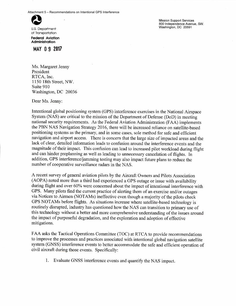
Attachment 5 – Recommendations on Intentional GPS Interference
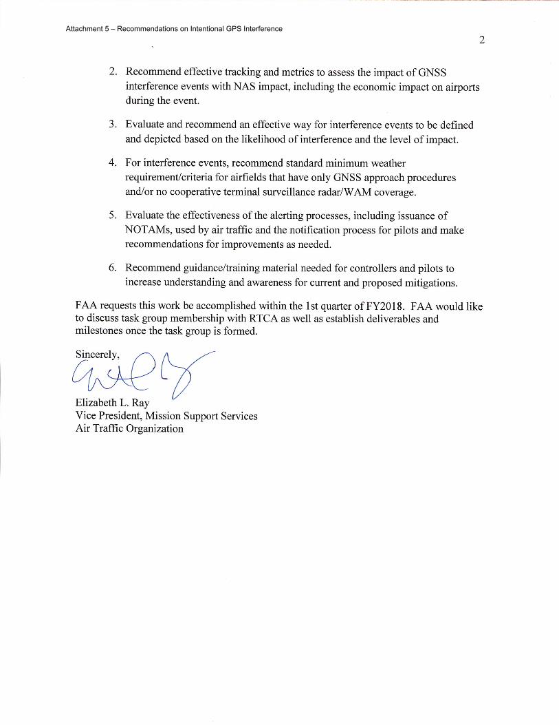
Attachment 5 – Recommendations on Intentional GPS Interference

43 | P a g e I m p a c t s o f I n t e n t i o n a l G P S I n t e r f e r e n c e
Appendix B: Participants in the GPS Interference Task Group Darrell Pennington, Air Line Pilots Association (ALPA)
Ric Peri, Aircraft Electronics Association, Inc.
Rune Duke, Aircraft Owners and Pilots Association (Co-Chair)
Robert Ireland, Airlines for America
Oscar Vela, Alaska Airlines
Ric Babcock, Allied Pilots Association
Lev Prichard, Allied Pilots Association
Wes Googe, American Airlines, Inc. (Co-Chair)
Andrew Roy, Aviation Spectrum Resources, Inc.
Rodney Holder, Booz Allen Hamilton (USAF Exempt)
Kurt Kleiner, Bureau of Land Management
Allan Storm, DoD Policy Board on Federal Aviation
Ken Alexander, Federal Aviation Administration (FAA)
Ian Atkins, Federal Aviation Administration (FAA)
Jorge Boubion, Federal Aviation Administration (FAA)
John Cabala, Federal Aviation Administration (FAA)
Shayne Campbell, Federal Aviation Administration (FAA)
Steve Chitty, Federal Aviation Administration (FAA)
Christina Clausnitzer, Federal Aviation Administration (FAA)
Bradley Clark, Federal Aviation Administration (FAA)
Joel Dickinson, Federal Aviation Administration (FAA)
Joe Heuser, Federal Aviation Administration (FAA)
Marie Hogestad, Federal Aviation Administration (FAA)
Lynette Jamison, Federal Aviation Administration (FAA)
Andrew Jinings, Federal Aviation Administration (FAA)
John Kehler, Federal Aviation Administration (FAA)
Deborah Lawrence, Federal Aviation Administration (FAA)
Steven Lehn, Federal Aviation Administration (FAA)
Andrew Leone, Federal Aviation Administration (FAA)
Jack Morris, Federal Aviation Administration (FAA)
Wendy O’Connor, Federal Aviation Administration (FAA)
Charles (Doug) Phifer, Federal Aviation Administration (FAA)
Roger Rapier, Federal Aviation Administration (FAA)
Shelli Sabatini, Federal Aviation Administration (FAA)
Attachment 5 – Recommendations on Intentional GPS Interference

44 | P a g e I m p a c t s o f I n t e n t i o n a l G P S I n t e r f e r e n c e
Eric Saldana, Federal Aviation Administration (FAA)
Amy Seador, Federal Aviation Administration (FAA)
Rob Sweet, Federal Aviation Administration (FAA)
Jerry Torres, Federal Aviation Administration (FAA)
Gayle Thornton, Federal Aviation Administration (FAA)
Tim Wallace, Federal Aviation Administration (FAA)
Larry Hills, FedEx Express
Clay Barber, Garmin Ltd.
John Foley, Garmin Ltd.
Jens Hennig, General Aviation Manufacturers Association
Tony Boci, Harris Corporation
Matt Callan, Helicopter Association International (HAI)
Kieran O'Carroll, International Air Transport Association
Noppadol Pringvanich, International Air Transport Association
Jon Reisinger, Jeppesen
Joe Bertapelle, JetBlue Airways
Geoff Stearn, Ligado Networks
William L Geoghagan, National Air Traffic Controllers Association (NATCA)
Heidi Williams, National Business Aviation Association
Sai Kalyanaraman, Rockwell Collins, Inc.
Trin Mitra, RTCA, Inc.
Perry Clausen, Southwest Airlines
Scott Dehart, Southwest Airlines
Christopher Hegarty, The MITRE Corporation
Josh Kuntzman, U.S. Air Force
Deborah Plunkett, U.S. Air Force
Robert Tarcza, U.S. Air Force
Mario Verrett, U.S. Air Force
David Manville, U.S. Army
Glenn Morse, United Airlines, Inc.
Rocky Stone, United Airlines, Inc.
Christian Kast, United Parcel Service (UPS)
Katie Harskamp, US Department of Defense
Raymond Swider, US Department of Defense
Karl Shallberg, ZETA Associates
Attachment 5 – Recommendations on Intentional GPS Interference

45 | P a g e I m p a c t s o f I n t e n t i o n a l G P S I n t e r f e r e n c e
Appendix C: AJV-8 Memos of Interpretation
Attachment 5 – Recommendations on Intentional GPS Interference
Attachment 5 – Recommendations on Intentional GPS Interference

Attachment 5 – Recommendations on Intentional GPS Interference

Attachment 5 – Recommendations on Intentional GPS Interference

Attachment 5 – Recommendations on Intentional GPS Interference