Embed Size (px)
Citation preview
Latest revision: revision 5th May 2010 Page 1 of 31
RSPO NEW PLANTING PROCEDURES
Summary Report of SEIA and HCV assessments 1. Executive Summary
PT. Cipta Davia Mandiri (CDM) is a subsidiary company of REA Holdings plc, which has been a
member of the Roundtable on Sustainable Palm Oil (RSPO) since November 2007 (membership
number 1-0045-07-000-00). PT. CDM is located in both the Muara Ancalong and Long Mesangat sub-
districts of the Kutai Timur district of East Kalimantan. Nine villages are located within or in close
proximity to the PT. CDM concession: Kelinjau Ulu, Long Nah, Muara Bengkal Hulu, Benua Baru, Batu
Balai, Sumber Agung, Sumber Sari, Mukti Utama and Tanah Abang. Four of these villages were created
as part of the Indonesian governments transmigration programme, namely: Sumber Agung, Tanah
Abang, Sumber Sari and Mukti Utama. Although PT. CDM was issued with a location permit of
22,500Ha by the Head of Kutai Timur district on 9 April 2007 (Keputusan Bupati Kutai Timur Nomor
142/02.188.45/HK/IV/2007), REA Holdings Plc only obtained ownership of this company on 20
March 2008. On 26 April 2010, 9,784 Ha of land within the location permit was converted to a land
use title (Decree number 25/HGU/BPN/RE/2010 tanggal 26 April 2010 with certificate number 109,
110 and 111. Following the expiration of the original location permit in 2010, a new location permit
covering 6,280 Hectares of the land within the original location permit but outside of the land use title
was issued in February 2014 (No. 525.26/K.146/HK/II/2014).
In accordance with Indonesian law, an Environmental Impact Assessment (“AMDAL”) was completed
and approved on 21 February 2008, prior to any commercial development of the land within the
concession 45/660/BUP-Kutim/II/2009, 21 Februari 2008. In addition to this, conservation reserves
were designated as a result of surveys by REA’s conservation team. However, a formal High
Conservation Value (HCV) assessment was not completed prior to the initiation of land clearing by
REA in April 2008. When in November 2012 it came to REA’s attention that the internal biodiversity
assessment conducted may not be sufficient to comply with the requirements of Criterion 7.3, the
RSPO secretariat was informed of this potential non-compliance in writing. Following the response
from the RSPO secretariat, the RSPO approved HCV assessors the Malaysian Environment Consultants
(MEC) were engaged to conduct both an independent HCV assessment and Social Impact assessment
(SIA) for the PT. CDM concession. HCV compensation is being undertaken for all land clearing which
took place prior to the completion of this HCV assessment on 15 August 2014. As part of this process,
a Land Use Change Analysis (LUCA) to assess REA’s HCV Compensation Liability in relation to PT. CDM
has been completed by the remote sensing specialists SarVision and was submitted to the RSPO
secretariat in October 2014.

Latest revision: revision 5th May 2010 Page 2 of 31
2. Scope of the SEIA and HCV Assessments:
Table 1. Organizational information and contact persons
Name of company PT. Cipta Davia Mandiri subsidiary of REA Holdings plc
Ltd.
RSPO membership number 1-0045-07-000-00 (REA Holdings plc)
Location Muara Ancalong and Long Mesangat sub-districts of the Kutai Timur district in
East Kalimantan, Indonesia.
Area 22,500 Ha covered by the original location permit, which has now expired 9,784 Ha converted to land title in 2010 6,320 Ha of additional land covered by the current location permit
Administrative Address
Jl. Hasan Basri No,21A, Samarinda 75117, Kalimantan Timur
Tax registration number
(NPWP)
01.997.572.1-722.000
Contact Person Head of Sustainability, REA Kaltim Plantations Group: Purwantoro
Email Address: [email protected]
Geo Coordinate 0° 30' 36.1" S 116° 39' 41.1" E
Table 2 List of Legal documents, regulatory permits and property deeds related to the areas assessed
No Legal Documents Issued by Number and Date
1 Company registration (Tanda Daftar Perusahaan)
Department of Industry and Trade in Samarinda
17.01.1.01.02224 26-Mar-2014
2 Plantation Permit (Izin Usaha Perkebunan)
District Head of Kutai Timur
Decree of District Head of Kutai Timur No. 560/02.188.45/HK/X/2007 29 October 2007
3 Trading business license (Surat Izin Usaha Perdagangan Besar)
Department of Industry and Trade in Samarinda
503/00108/17-01/PB/BPPTSP-C/IV/2014 22 April 2014
4 Domicile permit (Surat Izin Tempat Usaha Umum)
Samarinda government 503/3688/2210.A/BPPTSP- C/X/2013 16 Oct 2013
5 Location Permit +/- 20,000Ha (Izin Lokasi)
District Head of Kutai Timur
142/02.188.45/HK/IV/2007 9 April 2007
6 Extension of Location Permit +/- 20,000Ha
District Head of Kutai Timur
180.4.45/230/HK/IV/2008 30 April 2008
7 Extension of Location Permit +/- 20,000Ha
District Head of Kutai Timur
188.4.45/321/HK/VI/2009 25 June 2009
8 Ammendment of Location Permit to 6,280Ha (Izin Lokasi)
District Head of Kutai Timur
No. 525.26/K.146/HK/II/2014 05-Feb-2014
9 Land Use Title (Hak Guna Usaha)
National Land Agency (Badan Pertanahan Nasional)
25/HGU/BPN RI/2010 26 April 2010
10 Approval of Environmental Impact Assessment, Monitoring & Management plans (AMDAL)
District Head of Kutai Timur
45/660/BUP-Kutim/II/2009 21 Februari 2008

Latest revision: revision 5th May 2010 Page 3 of 31
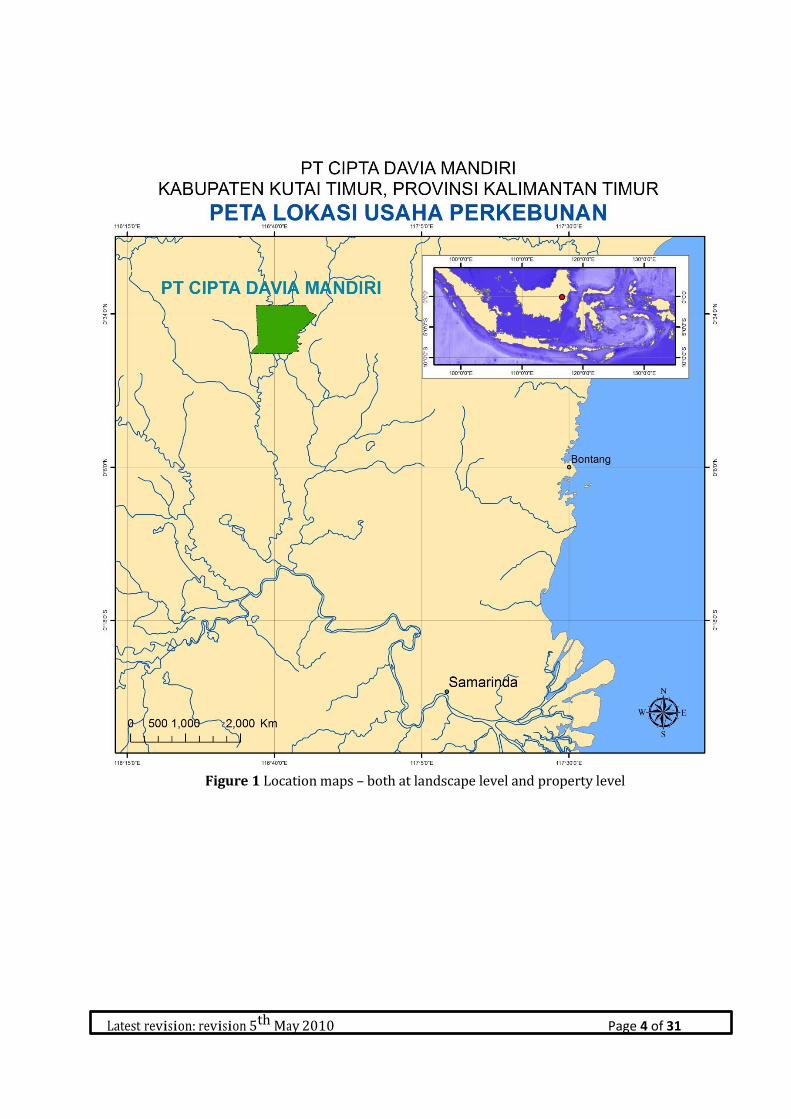
PT. CDM is situated on the northern branch of the Mahakam river, in the area where the name of the
river changes from the Kelangkepala to the Kelinjau. Though CDM does not share a common boundary
with any protected area, it is ecologically connected by the river system and contiguous vegetation.
Along the western boundary, the CDM site is separated by a narrow buffer from the boundary with an
area of Production Forest (Hutan Produksi). The land to the east of the CDM site has been developed
for agricultural use by both the local community and commercial plantations. Much of the western
section of the CDM site and most of the alluvial plain downstream is swampy. The relatively dry land
is on the river berms built up from accreting river sediments and in the north eastern section.
Latest revision: revision 5th May 2010 Page 4 of 31
Figure 1 Location maps – both at landscape level and property level

Latest revision: revision 5th May 2010 Page 5 of 31
Figure 2 Land Suitability PT CDM

Latest revision: revision 5th May 2010 Page 6 of 31
Figure 3. Indikatif Moratorium Maps, 2012

Latest revision: revision 5th May 2010 Page 7 of 31
Due to the fact that land clearing in the PT. CDM concession was initiated prior to the 1 January 2010,
this area is categorised as an Ongoing Planting for the purposes of complying with the RSPO New
Plantings Procedure (NPP).
Table 3 Schedule for development of PT. CDM
3. Assessment process and procedures
3.1. Environmental Impact Assessment ( AMDAL )
The Indonesian regulations (Peraturan Menteri Negara Lingkungan Hidup No. 11 Tahun 2006) require
that an Environmental Impact Assessment (Analisis Mengenai Dampak Lingkungan or AMDAL) is
conducted prior to the development of an oil palm plantation or palm oil mill. Therefore, an AMDAL,
encompassing both areas inside and outside the location permit, was carried out by independent,
government-approved consultants in early 2008. The result of this assessment are used as the basis
for developing an environmental monitoring and management plan to ensure the potential adverse
environmental impact associated with the development are mitigated.

Latest revision: revision 5th May 2010 Page 8 of 31
The EIA was carried out by the following assesors ;
1. Team leader : Ir. Sulaeman, MP.
2. Biology sub-team leader. Ir. Zainal Mutaqin. MP.
3. Geology sub-team leader : Drs. Daniel, Msi
4. Community health sub-team leader : Dr. Helsis Simbolon
5. Biology team member & mapping : Agus Nurhadi S. Hut
6. Social team member & Mapping : Febri Mauladsyah
7. Team member : Mangadat Marbun
The following data was collected as part of this assessment:
A: Geophysical and Chemical data
Information about the geological, physical and chemical characteristics of the study area was collected
before CDMs operations began. The primary data collected includes: regional climate, micro-climate,
air quality, noise, physiography, soil characteristics and hydrology.
B: Biological data
The land use change which will result from PT. CDMs operations has the potential to have a significant
impact on the biology and ecology of the study area. Primary data concerning the terrestrial biota
(flora, fauna, plant pests & diseases) and aquatic biota (plankton, benthos & nekton) was therefore
collected as part of this study.
C: Social data
Social data is needed to determine the impact of PT.CDMs proposed development on the surrounding
communities. Data concerning the demography, economy and culture of these communities was
collected as part of this assessment.
D: Public health data
Data concerning disease vectors, sanitation, health facilities, incidence of disease and public health
behaviour.
Both direct and indirect methods were used to collect the data relating to each component of this
assessment. The geophysical and chemical information was obtained from fieldwork (primary data).
The information concerning socio-economic status and public health of the surrounding communities
was collected through both fieldwork (primary data) and desktop analysis (secondary data).
The potential impact of each stage in process of developing an oil palm plantation and palm oil mill
(preparation phase, construction & operation) on each aspect of concern (geophysical & chemical,
biological, social & public health) was assessed as part of this study. The estimated magnitude of the

Latest revision: revision 5th May 2010 Page 9 of 31
impact of each stage of development on each aspect of concern was calculated by comparing the
condition before and after the proposed activities.
Magnitude of impact =KLP - KLRLA
Where: KLP is the condition of the environment once the proposed activity is in progress/completed
KLRLA is the condition of the environment before the activity takes place
The condition of the environment prior to development and during/after each stage of the
development process is given a score of between 1 and 5, based on the following definitions:
Scale Environmental condition/quality
1 Very bad
2 Bad
3 Ok
4 Good
5 Very good
The difference between the environmental condition before and after each stage of development is
used to determine the magnitude of the impact, either positive or negative. This is defined as follows:
4 : Very high impact
3 : High impact
2 : Medium impact
1 : Low impact

Latest revision: revision 5th May 2010 Page 10 of 31
3.2 Social Impact Assessment ( SIA)
The Social Impact Assessment (SIA) for PT. CDM was conducted between 12 – 17 November 2012 and
the 25 – 27 July 2013 by the Malaysian Environment Consultants (MEC), Kuala Lumpur, Malaysia. The
people involved in this assessment and their credentials are summarised in Table 4.
Table 4: Assessors involved in the Social Impact Assessment and their credentials
Name Role Experience & Qualifications
1 Kishokumar Jeyaraj
RSPO approved HCV
assessor – team leader
Kisho has a degree in Forest Management from
Oxford University, United Kingdom. His expertise
lies in forest management and plant conservation
ecology. He is also an expert in vegetation mapping
using GIS and Remote Sensing. His core
competency also lies in natural resource
management and planning. He has worked
throughout Malaysia, Indonesia and Laos and has
been involved in many HCV assessments.
2 Tunku Mohammed
Nazim
RSPO approved HCV
assessor – Mapping
specialist
Tunku’s educational background is in Biology and
Ecology. He has worked on a number of projects in
the field of natural heritage management,
plantation management, waste industry
management and landscape and species
management. He is an applied GIS Specialist with
the ability to analyze spatial information for both
conservation and management planning. His core
competency lies in natural resource management
and planning. He has been involved in more than
20 HCV assessments.
3 Dr Lim Meng Tsai
RSPO approved HCV
assessor – forest
ecology and
management
Dr Lim has a degree in Forest Ecology from the
University of Edinburgh, United Kingdom. He has
been involved in many HCV assessments and has
broad experience in species management, forest
ecology, botany and dendrology.
4 Herculana Ersinta
RSPO approved HCV
assessor – social
specialist
Herculana has a degree in Management from the
faculty of economics, Tanjungpura University. She
has broad experience in community development
and training in Indonesia especially in Kalimantan
Barat. She has been the Director for Yasasan Dian
Tama Pontianak since 2009.

Latest revision: revision 5th May 2010 Page 11 of 31
5 Anatalia Sri Lestari Social expert Undergraduate degree in economics
7 Maradu Panjaitan Social expert Undergraduate degree in forest management
8 Martalena Ayong Social expert Diploma in Surveying
9 Siti Norazlina Binti Mohd
Nordin
Documentation Undergraduate degree in science based natural
resource management
10 Yuliantini Social expert Undergraduate degree in forest management
The purpose of the social impact assessment is to determine the way in which the socio-economic
status, culture and welfare of different stakeholders may be affected by the development of the CDM
concession with both nucleus and plasma oil palm plantings. This was achieved by interviewing
representatives from the communities and government institutions from villages located within and
in close proximity to the CDM concession, namely: Kelinjau Ulu, Long Nah, Muara Bengkal Hulu, Benua
Baru, Batu Balai, Sumber Agung, Sumber Sari, Mukti Utama and Tanah Abang. Four of these villages
were created as part of the Indonesian governments transmigration programme, namely: Sumber
Agung, Tanah Abang, Sumber Sari and Mukti Utama. Table 5 shows the schedule for the assessment,
whilst Table 6 summarises the methods used, the target groups and the type of data obtained.
Table 5: Schedule for the Social Impact Assesment
No Village Schedule
1 Sumber Sari 12 - 13 November 2012
2 Tanah Abang 12 – 13 November 2012
3 Sumber Agung 12 – 13 November 2012
4 Batu Balai 12 – 13 November 2012
5 Kelinjau Ulu 14 – 17 November 2012
6 Muara Bengkal Hilir 14 – 17 November 2012
7 Benua Baru 14 – 17 November 2012
8 Long Nah 25 – 27 Juli 2013
9 Mukti Utama 27 Juli 2013
Table 6: A summary of the methods used in the Social Impact Assessment
Method Target group Data Data type
In-depth
interviews
(structured &
semi-
structured)
Key informants such as village
heads, village secretary,
customary heads, village elders,
fishermen, farmers, etc.
Village history, social impacts, social
issues land use, fulfillment of basic
needs, harvesting trends, availability
of alternatives
Descriptive/
Qualitative and
quantitative
Field
observation
Local informants, e.g. shaman,
healer, village elders, farmers
-Village description, dependency on
resources,
-Attitudes and perceptions of the
local peoples with respect to their
land and natural resources
Qualitative

Latest revision: revision 5th May 2010 Page 12 of 31
Method Target group Data Data type
Participatory
mapping
Key informants such as village
heads, village secretary,
customary heads, village elders,
fishermen, farmers, women
Land use and distribution of natural
resources used by communities and
other stakeholders
Qualitative
Focus group
discussions
Village elders, village committee,
customary heads, women
Validation of data collected in the
study.
Qualitative and
quantitative
Document
review
Company staff, local government
and the village committee
Company management practices in
relation to community engagement,
community development and
smallholder schemes. Government
regulations and policies relating to
oil palm. Village history,
demography, culture and socio-
economy.
Quantitative and
qualitative
3.3 High Conservation Value ( HCV ) Assessment
The HCV assessment for PT. CDM was conducted 12 November 2012 until 19 April 2014 by the
Malaysian Environment Consultants (MEC), Kuala Lumpur, Malaysia. The people involved in this
assessment and their credentials are summarised in Table 7.
Table 7: The people involved in the HCV assessment and their credentials
Name Role Experience & Qualifications
1 Kishokumar Jeyaraj
RSPO approved HCV
assessor – team leader
Kisho has a degree in Forest Management from
Oxford University, United Kingdom. His expertise
lies in forest management and plant conservation
ecology. He is also an expert in vegetation
mapping using GIS and Remote Sensing. His core
competency also lies in natural resource
management and planning. He has worked
throughout Malaysia, Indonesia and Laos and has
been involved in many HCV assessments.
2 Tunku Mohammed Nazim
RSPO approved HCV
assessor – Mapping
specialist
Tunku’s educational background is in Biology and
Ecology. He has worked on a number of projects
in the field of natural heritage management,
plantation management, waste industry
management and landscape and species
management. He is an applied GIS Specialist with
the ability to analyze spatial information for both
conservation and management planning. His core
competency lies in natural resource management
Latest revision: revision 5th May 2010 Page 13 of 31
and planning. He has been involved in more than
20 HCV assessments.
3 Dr Lim Meng Tsai
RSPO approved HCV
assessor – forest
ecology and
management
Dr Lim has a degree in Forest Ecology from the
University of Edinburgh, United Kingdom. He has
been involved in many HCV assessments and has
broad experience in species management, forest
ecology, botany and dendrology.
4 Herculana Ersinta
RSPO approved HCV
assessor – social
specialist
Herculana has a degree in Management from the
faculty of economics, Tanjungpura University. She
has broad experience in community development
and training in Indonesia especially in Kalimantan
Barat. She has been the Director for Yasasan Dian
Tama Pontianak since 2009.
6 Ambriansyah Team member - botany Undergraduate degree in Forest Management
7 Doddy Aryadi Team member –
wildlife & ecology
Undergraduate degree in Forest Management
8 Eka Kurnia Pambudi Team member - botany Undergraduate degree in forest management
9 Muhammad Firdaus Team member –
wildlife (bird expert)
Undergraduate degree in forest management
10 Siti Norazlina Binti Mohd
Nordin
Team member -
documentation
Undergraduate degree in science based natural
resource management
11 Yuliantini
Team member - social
expert (HCV 5 & 6)
Undergraduate degree in forest management
The purpose of the HCV assessment is to determine the presence, status and distribution of the
biodiversity, essential ecological functions and social cultural values which are considered to be of
High Conservation Value (HCV) and the management actions that must be taken in order to maintain
and enhance these values. The definition of the six High Conservation Values (HCVs), as well as the
methodology used to conduct the assessment, is in line with the HCV Toolkit for Indonesia, which was
finalised in 2008.

Latest revision: revision 5th May 2010 Page 14 of 31
Table 8: The six High Conservation Values, as defined by the HCV Toolkit for Indonesia (2008)
HCV
HCV1 Areas with Important Levels of Biodiversity
HCV 1.1 Areas that Contain or Provide Biodiversity Support Function to Protection or
Conservation Areas
HCV 1.2 Critically Endangered Species
HCV 1.3 Areas that Contain Habitat for Viable Populations of Endangered, Restricted Range or
Protected Species
HCV 1.4 Areas that Contain Habitat of Temporary Use by Species or Congregations of Species
HCV2. Natural Landscapes & Dynamics
HCV 2.1 Large Natural Landscapes with Capacity to Maintain Natural Ecological Processes and
Dynamics
HCV 2.2 Areas that Contain Two or More Contiguous Ecosystems
HCV 2.3 Areas that Contain Representative Populations of Most Naturally Occurring Species
HCV3 Rare or Endangered Ecosystems
HCV4 Environmental Services
HCV 4.1 Areas or Ecosystems Important for the Provision of Water and HCV Prevention of
Floods for Downstream communities
HCV 4.2 Areas Important for the Prevention of Erosion and Sedimentation
HCV 4.3 Areas that Function as Natural Barriers to the Spread of Forest or Ground Fire
HCV5 Natural Areas Critical for Meeting the Basic Needs of Local People
HCV6 Areas Critical for Maintaining the Cultural Identity of Local Communities
There are several stages involved in an HCV assessment. The first step is to carry out a desktop
analysis of relevant secondary data that is available for area of interest and the surrounding
landscape. This includes topography, soil and land use maps, satellite images, aerial photos and
published scientific papers and grey literature. GIS is used to integrate and analyse the information
available in order to stratify the area and identify potential transects and sampling points for the field
survey. The second step is to conduct a field survey to collect more detailed, primary data concerning
the species, vegetation types, physical features and socio-cultural values present within the area of
interest. Four field surveys were conducted at CDM, on the following dates:
Latest revision: revision 5th May 2010 Page 15 of 31
1. First field survey: 12 – 19 November 2012
2. Second field survey: 24 – 27 March 2013
3. Third field survey: 23 – 31 July 2013
4. Fourth field survey: 7 – 19 April 2014
The methods employed to assess HCV 1 – 4 included the establishment of vegetation plots and various
rapid biodiversity assessments along transects and at various sampling points. Both direct
observations of species and indirect indicators of their presence, such as calls, faeces, prints and
markings, were recorded. The transects and sampling points used in the field survey of CDM are
shown in Figure 4. In order to assess HCV 5 & 6 a rapid socio-economic and cultural assessment was
conducted. This involved various field survey techniques such as field observation; transect walks, in-
depth interviews with key informants, participatory community mapping (developing sketch maps)
and focus group discussions. Field data was validated by triangulation of the different types of data.
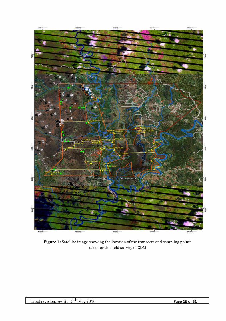
Latest revision: revision 5th May 2010 Page 16 of 31
Figure 4: Satellite image showing the location of the transects and sampling points
used for the field survey of CDM

Latest revision: revision 5th May 2010 Page 17 of 31
4. Summary of Assessment Findings Public Consultation , Two joint public consultation of the findings from the HCV assessment SIA were conducted by the the Malaysian Environment Consultans (MEC). The first public consultation was held on 07 December was held on 15 August 2014 in the office of the Long Mesangat sub-district and attended the stakeholder.
4.1. Environmental Impact Assesment (EIA) The results of this holistic assessment of the magnitude of the potential impact of each stage of the development process on each component of the environment show that the development of an oil palm plantation and palm oil mill by PT. CDM has the potential to have a significant impact, both positive and negative. Important positive impacts predicted:
1. Socialisation & public consultation 2. Development of facilities and infrastructure, 3. Soil and water conservation 4. Nursery 5. Employment 6. Development of the mill 7. Harvesting and transport of oil palm Fresh Fruit Bunches FFB and operation of a palm oil mill
Meanwhile, the negative impacts predicted are:
1. Geophysical & chemical: reduction in air quality, noise pollution, reduction in the quality of surface water, increase in soil erosion, increase in sedimentation, increased risk of fire and the production of waste liquids.
2. Biological: disturbance of flora and fauna, disturbance of aquatic biota 3. Social: social conflicts, negative perception of the company by the community and changes in
community values and cultural norms 4. Public health: negative impacts on the health of the surrounding communities
However, several of the potential negative impacts can be mitigated if the proposed environmental management actions are taken. It is therefore hoped that the negative impacts will be reduced, mitigated and even prevented. In relation to the potential positive impacts associated with the proposed development, the aim should be to maximise these in order to improve the welfare of the whole society without having a negative impact on the environment. Based on this, PT. CDMs plans to develop an oil palm plantation and palm oil mill are eligible for development from an environmental perspective as long as the appropriate measures are taken to monitor and manage their environmental impact. 4.2 Social Impact Assessment (SIA) The potential positive and negative impacts on the socio-economic status, culture and welfare of the various stakeholders likely to be affected by the development of the CDM concession with oil palm are summarised below. Measures to mitigate the adverse impacts and maximise the positive impacts have also been identified. Positive impacts
1. Employment and creation of business opportunities: the development of the PT. CDM
concession has provided both direct employment as well as demand for services from both the
company and its employees which can be provided by local contractors or small businesses,
Latest revision: revision 5th May 2010 Page 18 of 31
such as transporting FFB, shops, restaurants, garages and transport.
2. The development of oil palm by PT. CDM has inspired members of the local communities to
plant oil palm in additional to their existing rubber plantings, thus boosting the income they are
able to generate from their land.
3. The improvements made to the local infrastructure by PT.CDM, particularly the road network,
have improved the access for local communities to other villages, markets to buy and sell goods
and services such as health care and education.
4. The employment and business opportunities created by PT. CDM on the local economy have
increased the spending power of the local communities, which has in turn further boosted the
surrounding economy by creating increased demand for a wider range of better quality goods
and services in the area.
Negative impacts
1. Reduction of land available to the community. The transfer of community rights to use the land to
PT. CDM has reduced the land available to the community for their own agricultural activities and
to pass on to their children.
2. Insufficient community engagement and socialisation. Some members of the community feel that
PT. CDMs plans for developing oil palm, and the potential impacts of this on their lives, have not
been adequately communicated to them. Some feel that their opinion has been neglected by PT.
CDM and that they have been unfairly treated in the land compensation process. This has left
some people with a negative perception of PT. CDM.
3. The activities of PT. CDM are likely to have contributed to the scarcity of clean water in the area,
especially in the dry season, which has been caused by the various changes in land use in the area,
including the development of oil palm and forestry plantations. The reduction in the quantity and
quality of water available has increased the time, energy and money which the local communities
have to spend in order to obtain water to meet their daily needs. The villages most affected by the
shortage of water are the transmigration villages.
4. Decline of traditional values and change in lifestyles. The development of PT. CDM in the area has
encouraged communities to transition from more traditional lifestyles, based on communal living
and co-operation, to a more modern system based on purchase of the goods and services
necessary to meet individual needs.
Measures identified to manage the social impacts
1. Ensure that waste from PT. CDMs operations does not pollute the rivers in order that local
communities continue to have access to clean water and the fish populations the fisherman
depend on do not decline.

Latest revision: revision 5th May 2010 Page 19 of 31
2. The company should design the HCV management areas carefully to ensure that the fish
populations which the fisherman depend on are maintained.
3. The company must push the local government produce definitive boundary maps for the villages
which overlap with the PT. CDM, in order that this can be used as the basis for defining the area
and location of the plasma which will belong to each co-operative. PT. CDM must then work with
the co-operatives to develop clear plans and time lines for plasma development and MoUs
concerning the management of these smallholder schemes. CDM must invest significant amounts
of time and energy in regularly socialising the plasma scheme, the progress of its development and
providing training to ensure that the co-operatives are well managed.
4. CDM should ensure that the local communities understand the process for land compensation by
preparing a document which explains this and socialising it
5. Develop a short term and long term programme for community development, which is based on
an assessment of each communities’ needs.
6. Contribute to the development of basic infrastructure for the community (such as for education,
health, clean water, information technology) to improve the quality of life for the community.
7. Be proactive in communicating with the local communities, particularly the village heads. These
efforts need not be formal as they might be more effective if informal. These will be seen as
important in building trust with the local community.
4.3 High Conservation Value (HCV) Assessment
Based on the integration of the data obtained through the desktop analysis and the field surveys the
presence and distributionof HCV 1 to 6 was identified, as shown I Table X and Tabel X respectively.
HCV 1 relates to habitat known to support rare, threatened and endangered species, as well as the
locations where Critically Endangered species were identified to be present during the field surveys.
For mobile species such as the orangutan, hoofed and arboreal mammals, the concern is to safeguard
habitat and the connectivity with other areas of suitable habitat that remains both within and in the
area surrounding the concession. For less mobile species, such as the crocodiles, it is essential to
protect any breeding sites identified as well as habitat known to support resident populations.
The areas where HCV 3 is present within the concession are more extensive, covering the ecosystems
and the processes that stabilize the regional ecology. These processes include the natural controls of
insect pests that would otherwise threaten commercial and subsistence agriculture. An analysis of the
successional stage of the habitats which support HCV 3 was used as a way to determine the areas
which should be setaside as conservation reserves in order to maintain these values. This is because,
in general, late succession stages are ecologically more complex and thus more able to support
populations and natural processes.
The project area is subject to seasonal flooding which varies in frequency, extent and time each year.

Latest revision: revision 5th May 2010 Page 20 of 31
2013 experienced frequent flood for extended periods, while 2014 has seen little flooding to date.
The HCV 4 identified during this assessment therefore primarily concerns natural and physical
features of the landscape that play an important role in mitigating flooding, such as the raised banks of
rivers and the low-lying areas behind them which hold flood waters.
The presence of HCV5 denotes the presence of resources which are used by local communities to meet
their basic needs. The National Land Agency (BPN) have acknowledged the importance of the riverine
areas for settlement and economic use by the local communities by enclaving these areas from PT.
CDMs land use title (HGU). These areas have been classified as HCV 5. HCV 5 was also identified in
areas of forest that are used for the collection of Non-Timber Forest Products (NTFPs), such as rattan.
Whilst the communities have cultivated crops in areas close to the roads that have been built within
the PT. CDM Land Use Title (HGU), whether or not these areas are deemed to support HCV5 will be
determined by the outcome of the FPIC process for compensation for land acquisition. HCV 6 was
only recorded outside the HGU among the villages (desa) which are within the additional Izin Lokasi
in the north east (transmigrant area). These areas still fall under the responsibility of the project
proponents. Table 9: HCVs identified within the area of interest
HCV Survey findings
Reference & potential
Stakeholders with
interests
HCV
1.1
There is no Protected Conservation Area overlapping or adjacent
to the site.
Not applicable
HCV
1.2
At least four CR species of trees- Dipterocarpus cornutus, D validus,
Shorea balangeran and Vatica rassak – and crocodile, Crocodylus
siamensis currently synonymous with C. raninus are found in the
CDM.
IUCN (Critically Endangered
species)
HCV
1.3
Several species of plants and animals that are threatened and/or
protected are found in the site. These include the Proboscis
monkey (Nasalis larvatus), Mueller’s gibbon (Hylobates muelleri),
and Pangolin (Manis javanica) which habitat needs to be
protected.
IUCN;
Govt of Indonesia (protected
species)
HCV
1.4
While not directly surveyed, it is likely that the natural areas with
forests and water bodies will be used for nesting and breeding by
fishes, amphibians, reptiles and birds. The presence of crocodiles
suggests seasonal breeding /nesting sites need to be maintained.
WWF Indonesia (breeding
sites)
HCV
2.1
The project area is part of the larger natural ecosystems in the
landscape. Although disturbed, there are ‘wetlands’ like peat
swamps and freshwater swamps that are considered critical
ecosystems requiring protection and appropriate management
response.
CBD,
Govt of Indonesia (Protected
areas)
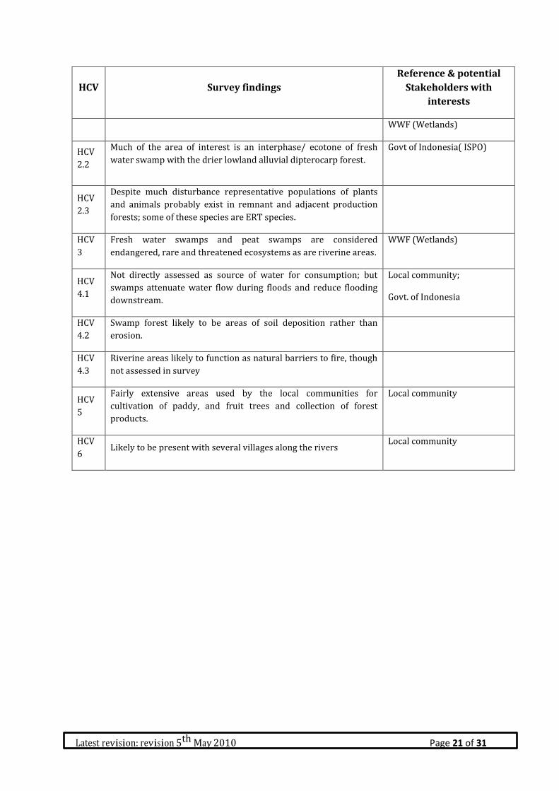
Latest revision: revision 5th May 2010 Page 21 of 31
HCV Survey findings
Reference & potential
Stakeholders with
interests
WWF (Wetlands)
HCV
2.2
Much of the area of interest is an interphase/ ecotone of fresh
water swamp with the drier lowland alluvial dipterocarp forest.
Govt of Indonesia( ISPO)
HCV
2.3
Despite much disturbance representative populations of plants
and animals probably exist in remnant and adjacent production
forests; some of these species are ERT species.
HCV
3
Fresh water swamps and peat swamps are considered
endangered, rare and threatened ecosystems as are riverine areas.
WWF (Wetlands)
HCV
4.1
Not directly assessed as source of water for consumption; but
swamps attenuate water flow during floods and reduce flooding
downstream.
Local community;
Govt. of Indonesia
HCV
4.2
Swamp forest likely to be areas of soil deposition rather than
erosion.
HCV
4.3
Riverine areas likely to function as natural barriers to fire, though
not assessed in survey
HCV
5
Fairly extensive areas used by the local communities for
cultivation of paddy, and fruit trees and collection of forest
products.
Local community
HCV
6 Likely to be present with several villages along the rivers
Local community

Latest revision: revision 5th May 2010 Page 22 of 31
Figure 5: High Conservation Value Area HCV 1.

Latest revision: revision 5th May 2010 Page 23 of 31
Figure 6: High Conservation Value Area HCV 2.
Latest revision: revision 5th May 2010 Page 24 of 31
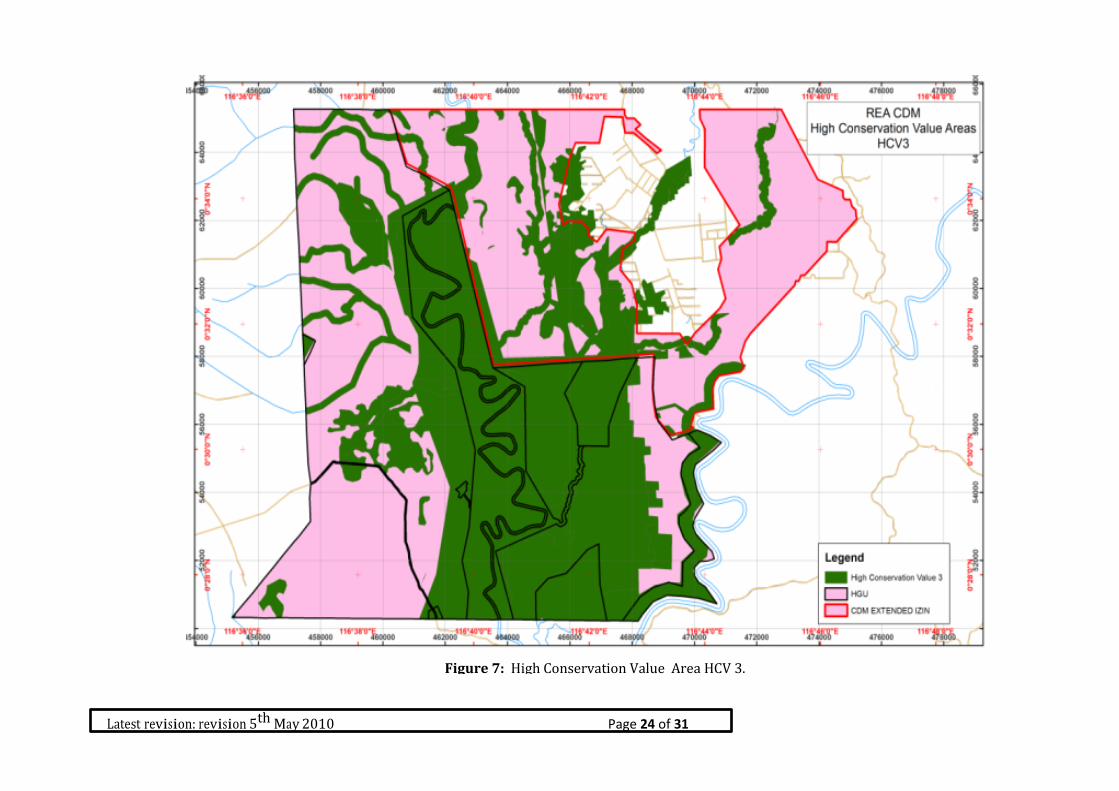
Figure 7: High Conservation Value Area HCV 3.

Latest revision: revision 5th May 2010 Page 25 of 31
Figure 8: High Conservation Value Area HCV 3.
Figure 8: High Conservation Value Area HCV 4.

Latest revision: revision 5th May 2010 Page 26 of 31
Figure 9: High Conservation Value Area HCV 5 & 6.

Latest revision: revision 5th May 2010 Page 27 of 31
Figure 10: High Conservation Value CDM result
Latest revision: revision 5th May 2010 Page 28 of 31
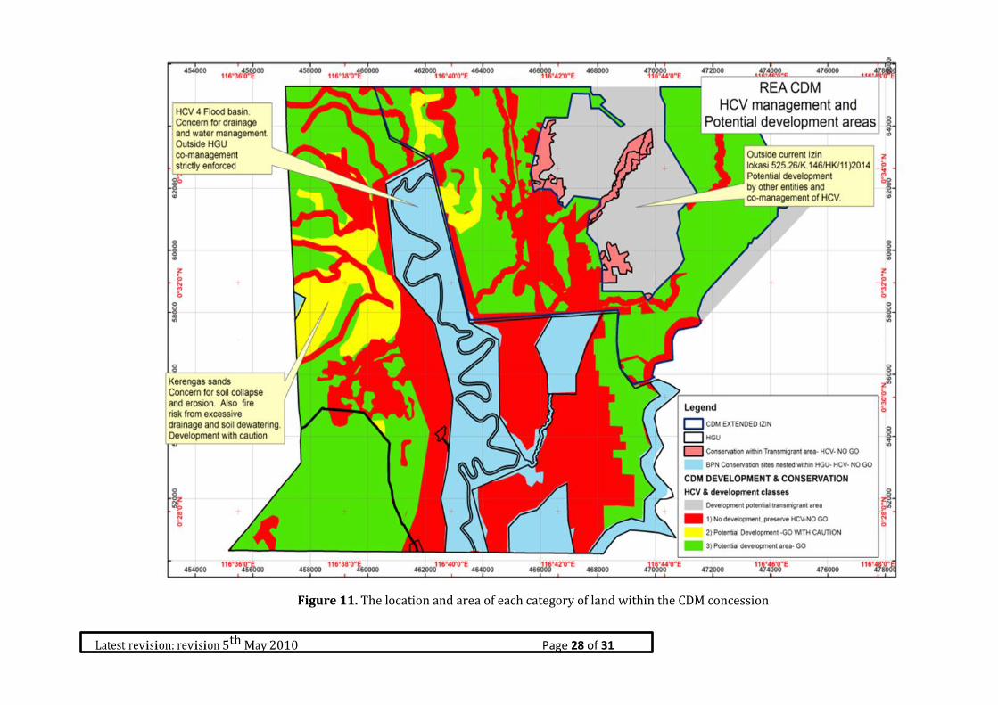
Figure 11. The location and area of each category of land within the CDM concession

Latest revision: revision 5th May 2010 Page 29 of 31
Once the likely presence, status and distribution is better known as a result of the field
survey and subsequent data analysis, the next step is to determine the management actions
necessary to ensure that the HCVs present within the concession and wider landscape are
maintained and enhanced. This is critical because it will inform the land use plan for the
development of the concession. To facilitate this process, three different categories of land
have been identified within this concession:
1) ‘No Go’ Areas - HCV Management Areas which must be setaside for conservation
2) Areas potentially suitable for oil palm development – can be developed as long as
measures are taken to maintain any HCV encountered
3) Areas available for oil palm development if agrononomically suitable (no HCV constraints
to development)