Embed Size (px)
Citation preview

52B10SW0001 2.15848 MOSS 010
REPORT ON THE PROSPECTING CARRIED OUT IN 1994 (OPAP)
BY TED AHO (1013968 ONTARIO LTD)
2. 1584 8
By: Claude LaroucheOvalbay Geological Services Inc.1070 Lithium Drive, Unit 6Thunder Bay, OntarioP7B 6G3Tel: (807)623-3770 Fax': (807) 623-2335
December 21, 1994

52B10SW0001 2.15848 MOSS Q-l QQ
TABLE OF CONTENTS
Table of Contents . . . . . . .... . . . . . .. .... . . . . ..... .. . . . . . . . . .. 2
Introduction ............................................... 3Location and Access ... .. . . . .... . .. . ....... . . . . . ...... . .. . . . 4
Figure 1: Location Map ................................ 5Claims ..................................................... 6
Figure 2: Sketch of Claims ............................ 7Previous Work ......................................... ..... 8Regional Geology ............. ..............................11
Figure 3: Regional Geology ............................12Property Geology ...........................................13
Figure 4: Property Geology ............................15Mineralization .............................................16Recent Work ................................................17
Figure 5: Trench on claim 1H ..........................21Conclusions and Recommendations ............................22Cost of Work ...............................................25
List of AppendicesAppendix 1: Assay Results from MNDM sampling Appendix 2: Assay Certificates (1994 prospecting) Appendix 3: Description of Samples Appendix 4: Discussion from Prospector Appendix 5: Results from property visit (Cameco)
List of Maps (in pocket)Map 1: Detailed sampling (Beaver vein area)

INTRODUCTION
Ovalbay Geological Services Inc of Thunder Bay, was commissioned by Ted Aho, prospector also from Thunder Bay, Ontario to update the previous report done by Ovalbay on the Ardeen Mine property, following the results of the 1994 summer prospecting, stripping and sampling. This 1994 summer program was financed by an OPAP Grant to Ted Aho.
Informations available in the files at the Resident Geologist's office in Thunder Bay have already been studied carefully and the information in this report is based largely on the compilation reports completed on the mining property to date.
The prospecting program was successful at locating numerous new gold showings to the east on what might be the Beaver vein extension and a secondary parallel zone to the north was also discovered.
Detailed prospecting, hand stipping, drilling and blasting was completed. Sampling returned significant gold assays from some of the trenches. The prospecting was located to the east of the known Beaver vein following the discovery of numerous old trenches which were not known.
LOCATION AMD ACCESS
The property is located in Moss Township, approximately 75 miles west of Thunder Bay, Ontario. The claims are situated on NTS block 52B/10 and the area is enclosed on claim map # G-676. The mining claims (see list for numbers) are all located within the Thunder Bay Mining Division.
Access to the property is obtained by driving west from Thunder Bay on Highway # 11 to the Swamp Road intersection, approximately 10 miles west of Kashabowie, Ontario. From this intersection, numerous bush roads lead to different portions of the property. The reader is referred to the attached map (Figure 1) for location.
N.T.S.: 52B/10Longitude: 9O0 44'Latitude: 48O 32'Claim Map: G-676Township: MossMining Division: Thunder Bay
ACdccn Cold Mino Property
Lake Superior
Scale l inch - 2 5 miles

CLAIMS
The property under study comprises two (2) mining locations HI and 33B along with 12 contiguous non-patented claims numbered (figure 2):
TB-677468 TB-677469 TB-677470 TB-677471677472 677473 677474 677475677476 677477 677478 677479
The claims are recorded with the Thunder Bay Recorder's office and were transferred from Belore Mines Ltd to:
1013968 ONTARIO LTD 618 Van Norman St. Thunder Bay, Ontario P7A 3X3
Figure 2: Sketch of claims
993185
993130
X l
1120066
i f993182 1120065 1835310
835308 '.835309993186
8353051835307 j t -/-- , -———,
873522"!8353041835306 l
835311
835313
33B
993184
993179s
j873517
835312 873516 873519
873515
993IB3
'-v
993178
873518
873520
7m
677476 1677472 J67747b 167746Q
6774771677473 j 677471~~~~~l ~~
l6774781677474
l
677479 1677475 l
677469
t
x..--
(l
CLAIM MAP
l"= 2640'
N

8
PREVIOUS WORK
The original gold discovery in Moss township was made by a trapper in 1871. The first surface work was done by Peter McKellar, a prospector from Fort Williams ( now Thunder Bay).
In 1882, the Huronian Mining Company of Ontario looked over the property , cut a road and brought a stamp mill. Production amounted to 700 tons with a recovery of $11.00 per ton in gold and silver (0.31 opt Au equivalent).
In 1925, the property was acquired by the Shield Development Company Ltd., who formed Moss Mines Ltd in 1927. Mining and milling machinery were brought in and the mine was developed to the 750 foot level.
The company Ardeen Gold Mines Ltd look over the property in 1933, and developed the mine to the 1,000 foot level. In 1936, the shaft was deepened to 1,275 feet vertical. Between January 1st 1936 and November 30th 1936, the 200 ton cyanide mill treated 39,545 tons of ore with an average recovery of $5.95 ( 0.17 opt Au) . In December 1936, Ardeen went bankrupt and operations ceased.
Up to 1936, when production ceased, a 1,275 foot shaft had been sunk and development carried out to the 1,000 foot level. Production was from a narrow, composite quartz vein ranging in width from a few inches to 8 feet, occuring in a wide shear zone. The ore is in the form of tellurides and as native gold associated with pyrite, chalcopyrite, galena amd sphalerite. Reports states that the ratio of silver to gold was 7 to 1.
It is reported that the presence of brittle chert in the drifts near the shaft # 2 on the 1,000 foot level might provide opening for gold mineralization if fractured much in the same manner as postulated for the base metals at the North Coldstream Mine. Assays given for the chert are in the order of $1.00 to ?4.00 Au at 534.00 and silver at 50.50. Assuming a ratio of 7 to l for silver to gold, it means the grade would vary from 0.03 to 0.11 opt Au.
From the assay plan on the 1,000 foot level, a rough calculation of one section defined a zone as follows:
length : 110 feetaverage width: 5.0 feetaverage grade: 6.3 dwt/ton (0.32 opt Ay)
In 1937, Kerry Gold Mines Ltd was incorporated to operate the property but the mine was never reopened. Surface exploration was done, in 1957, by Noranda Mines and in 1970 - 72 by Belore Mines who was the new recorded holder of the claims. Both programmes consisted of geophysical surveys and limited diamond drilling of conductive targets. For the most part, these holes were barren of economic mineralization.
It is not known when Belore Mines acquired the property, but in 1970, the company had lines cut and geophysical surveys completed ( magnetic and electromagnetic VLF-Em 16 ) over a portion of the property, northeast of the old workings. In 1972, additional geophysical work was done.
During the winter of 1970 - 71, fives holes were drilled , having an aggregate length of 1,354 linear feet. In 1972,an additional seven holes were drilled making an overall total of 3,000 feet drilled by Belore Mines. One hole drilled by Belore Mines intersected three separate gold - bearing zones which assayed 1.12, 0.56 and 0.56 oz Au per ton, all over separate five foot sections. A parallel hole drilled fifty feet to the west was essentially barren (0.08 opt Au over 5 feet) while a hole fifty feeet to the east cut 0.66 oz Au per ton and 0.88 oz Ag per ton over a two foot section along with a section grading O.18 opt Au per ton over 5 feet. The possibility exists that wide zones of most consistent grade could be found along strike of or parallel to the old workings.
Hermiston Ltd of Cobalt took an option on the dump in 1976. It is not known if they evaluated the recoverable metal content of the dump. Lacana did sample the tailings and dump in 1976. Results were not located at this time.
From 1973 to 1974, Dome Exploration Limited optioned some claims from Belore including Mining location HI. Geological and geophysical surveys were carried out as well as a diamond drilling programme which was completed in 1974. The option was later dropped following diamond drilling of 17 holes.
In 1973, the claims covering the southwestern portion ofthe study area were optioned to a 50 - 50 joint venture by Lynx -Canada Exploration Ltd and Fort Reliance Minerals Ltd.
Geophysical surveys were completed on the claims along withdetailed sampling.
In 1975, Nichro Mines Ltd., drilled two holes for 550 metres (1,804 feet) north of # 2 shaft.
10
Consolidated Montclerc Mines Limited in June of 1983 advanced funds to Belore Mines Limited and Huronian Mines Limited, for settlings debts and providing interim working capital. Southwest claims covered by a detailed magnetometer and VLF-Em 16 surveys.
Belore Mines Limited carried out detailed magnetometer and VLF-Em 16 surveys on the claims around the shaft in 1984.
From 1986 to 1987 Matt Berry Mines optioned the property. They carried out surface work including some 25 diamond drill holes. Core is well stored on the property, but assay results were not as good as expected.
Claims optioned to International Geo-Ventures from Belore Mines. Noranda Exploration optioned the claims from Geo-Ventures in 1988 and 1989. Work included numerous trenches, but no detailed exploration work was completed beside a magnetometer test survey south of # 2 shaft and detailed sampling over most of the claims.
In 1990, Landore Exploration Inc. optioned the property and drilled five holes, three holes southwest of the shaft # 3 and two holes east of # 2 shaft. Landore dropped their option being unable to maintain cash payments.
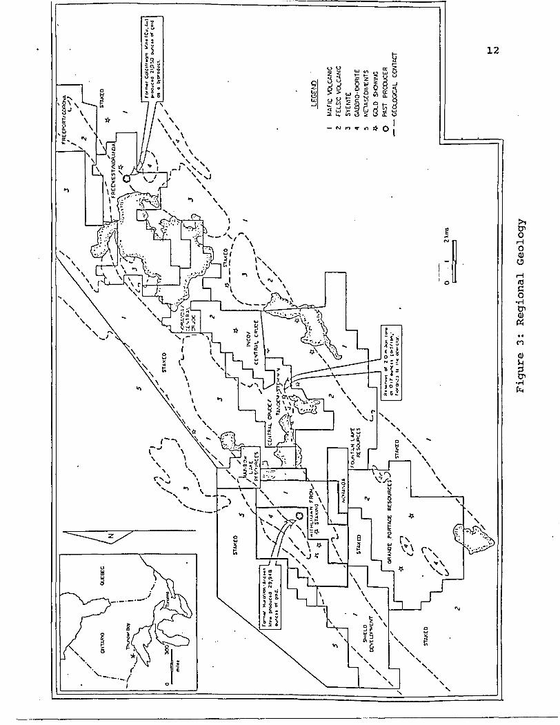
11REGIONAL GEOLOGY
The western part of the Shebandowan Greenstone Belt was first mapped by Tanton (1938), and later incorporated in a 1:253,440 compilation map by Pye and Fenwick (1965). Several areas within the belt were re-mapped on a 1:31,680 scale, Gibbon (1970), Hodgkinson (1968), Harris (1968, 1970), Morin (1970). Srivastavo and Fenwick (1973) produced a 1:15,840 scale preliminary map of part of Duckworth Township. Many university studies ( Weinstock 1973, Beakhouse 1974, Bau 1979, Stott and Schwerdtner 1981, Morton 1982, Brown 1985 and Stott 1985) have produced more detailed and 7 or more specialized maps of parts of the Greenstone Belt.
The Shebandowan Greenstone Belt forms part of the Wawa Subprovince of the Superior Structural Province of the Canadian Shields. The Wawa Subprovince extends eastward through Thunder Bay to the eastern side of Lake Superior. The western half of the greenstone belt, characterized by greenschist facies metavolcanic rocks, partly encircles a terrane of plutonic and amphibolite facies gneissic rocks to the south, referred to as the Sunbar - Batwing Lake Complex (Schwerdtner and Goodwin 1977). The metasedimentary Quetico subprovince abuts the Shebandowan belt to the north, and Proterozoic rocks unconformably overlap the southern part of the greenstone belt and the Sunbar - Batwing Lakes Complex.
The Shebandowan Greenstone Belt (figure 3) is predominately underlain by metavolcanic rocks, which have been divided into two broadly contrasting age groups: (1) the older metavolcanic suites with proportionaly subordinate metasedimentary intercalations, thought to be older than about 2,700 Ma: and (2) the younger metavolcanic assemblages associated with voluminous metasedimentary rocks, both thought to be younger than 2,700 Ma. The younger metavolcanic and metasedimentary rocks, which lie unconformably on the older metavolcanic rocks and appear representative of a different depositional environment, are referred to as Timiskaming "- type in this report.
™v\*
l M
AFI
C
VO
LCA
NIC
Z FE
LSIC
VO
LCA
NIC
3 S
YE
NIT
E
1 GA
ECnO
-DCf
ilTE
5G
O.D
O
PAST
PR
ODUC
ER
— —
GEO
LOGI
CAL
CONT
ACT to
Figure 3:
Regional Geology

13
PROPERTY GEOLOGY
The area under study (Figure 4) is occupied by two (2) contrasting suites of older metavolcanic rocks: mafic to intermediate metavolcanics rocks, iron formation and intermediate ash flow rocks in the west and felsic metavolcanic rocks in the east. Metadiabase sills, emplaced mainly, if not solely, in the mafic metavolcanic terrain, are considered the oldest intrusions exposed. Metadiabase and both mafic and felsic metavolcanic rocks are cut by dikes and stocks of feldspar and feldspar-quartz porphyry, hornblende lamprophyre, quartz syenite and larger bodies of hornblende gabbro to diorite.
The deformation is very heterogeneous, partitioned mainly along narrow, very schistose, northeasterly striking high strain zones which are closely space in the Ardeen Mine area. These zones are characterized by a strong lineation which mainly plunges gently southwest. Carbonate and sericite schists are characteristics of segments of some of the zones. The various shear zones in the Ardeen Mine area and the intersection of brittle fracture zones and one of the northeast trending carbonatized shear zone at Snodgrass Lake appear to exert the most significant influence on the localization of gold.
In the southwest part of the claims, three (3) showings exist and merit special attention. They are:
- Minoletti pits
The Minoletti zone in the central portion of the southwestern claims comprises eight (8) trenches on a feldspar-quartz porphyry dike cutting the hornblende-phyric mafic metavolcanic rocks.
In 1973, the trenches were cleaned out by Lynx-Canada Exploration Ltd and Forth Reliance Minerals Ltd. They were sampled across 12 intermittent sections over a strike length of 456 feet. The assays reported by Bondar-Clegg b Company ranged from 0.02 ounce gold per ton, 0.08 ounce silver per ton across 12 inches to 0.72 ounces gold per ton, 4.38 ounces silver per ton across 36 inches. The average width and assay over the 456 foot strike length was 22.8 inches, grading 0.196 ounces gold per ton and 1.26 ounces silver per ton.
The auriferous quartz veins contain iron carbonate and albite as secondary younger minerals, and pyrite, galena, telluride, sphalerite and chalcopyrite. Eight (8) grab samples analyzed by the Ontario Geological Survey in 1987 assayed between 440 ppb Au and 24,600 ppb Au. Schistose mafic

14
metavolcanic rocks and feldspar porphyry are highly replaced by carbonate and sericite for up to 0.5 metres from the vein and mineralized with disseminated pyrite.
— Beaver vein
The Beaver vein has been recently rediscovered and consists of a shear zone 4 to 8 feet wide of chlorite-sericite schist, highly silicified with abundant quartz stringers and veins. The shear zone cuts across mafic to intermediate volcanics and has been followed for 1,000 feet on surface. Assays of up to 0.11 opt Au over 4.0 feet were returned. The zone is sub- vertical to slightly dipping south.
Another pit some 250 feet north of the east end of the Beaver vein returned 0.36 opt Au over 1.0 foot in a quartz vein within intermediate volcanics. These 2 structures were reported in the old reports but their exact location was not known.
- Porphyry zone
A mass of porphyry unknown extend has been discovered in the central portion of the southwest claim block. The feldspar porphyry is variable in composition, highly fractured and altered on surface. Quartz stringers and veins are abundant in the porphyry and one of the vein returned 0.21 opt Au over 1.0 foot. The porphyry itself is highly anomalous in gold with assays of 21 to 173 ppb. This new discovery is very promising, so far outcrops of porphyry have been mapped over an area of 400 feet by 100 feet.
They represent the prospecting targets for the next program. There potential, as gold bearing structures, are excellent and their extensions should be studied in order to prove a deposit of economic interest. .

fJ'
f' '.y.
'-;-'.
' :'^'
:-~-v
y
v.vv
'^^-
Vvo-
'i']
'!.
•Ji\iiD
l/
' v'
T
v1
^f li/
( X
7/
'/.wl
.'ir\
iV/X
X-'W
^'
"^
'10.JB
g/Tonne
Au
s^^/^'-i
Production 19
32 to
1J
36143,724 Tonnes
grad
ing
0.21 o.
p. t. AU and
i.J o
.p.t
. Ag
N
Figure 4
:
Property G
eolo
gy Map
1:
31,6
80
1F:
Iron F
ormation
1:
Hetasediments
2:
Fels
ic t
o In
term
edia
teHetavolcanics
3:
Mafic
to I
ntermediate
Hetavolcanics
4:
Hafi
c In
trus
ive
\
IA11
DORE
1990 DRILL HOLE
PREVIODS DRILL HOLE
16
MINERALIZATION
At the Ardeen Mine during the period 1932 to 1936 a total of 143,724 tons of ore were milled which permitted recovery of 29,629 ounces of gold and 170,463 ounces of silver.
The gold bearing quartz vein is on the southeastern side of a steep ravine, 150 feet deep, which trends north 55 degrees east. The vein ranges from a few inches to 8 feet wide and is usually a composite vein with narrow stringers of quartz, separated by chlorite schist. This vein is not continuous, but forms lenses in the shear zone, from 2 feet to 100 feet long. The lenses are arranged in an "en echelon" manner with the ends overlapping.
The vein is closely associated with a sill of feldspar porphyry from 2 to 8 feet wide. This sill forms one wall of the vein in many parts of the mine. A ten-foot sill of sheared pink feldspar porphyry is exposed on the southeastern side of the ravine near the No. l shaft. The sill contains disseminated pyrite and magnetite and is in contact with chlorite schists to the southeast. A grey feldspar porphyry sill is exposed in a trench 100 feet east of the No. 3 shaft. The 25 foot thick sill contains subhedral crystals of plagioclase, approximately 3% pyrite and is cut by a stock work of narrow quartz veins.
Within the main Ardeen shear, it is reported that the quartz vein contains chalcopyrite, galena, sphalerite, pyrite, telluride and possibly small amounts of native gold. The quartz lenses are 0.6 to 60 metres long and 0.3 to 1.8 metres thick. The lenses are at an acute angle to the shearing and are "en echelon" with a rake of 35 to 40 degrees to the northeast (see Figure 6). Two (2) distinct varieties of quartz are present in the mine. The older quartz is milky white, with a glassy appearance, and contains only pyrite.
This quartz cuts the feldspar porphyry and contains fragments of feldspar porphyry up to l foot across. The second variety of quartz cuts the older quartz and contains gold along with accessory sulphides. Stringers of calcite and dolomite cutboth types of quartz and have carbonatized the nearby rocks.
Surface trenching and pitting along the strike of the main vein have been implemented at various time, mostly in the early years, but most sampling results do not seem to have survived.
The recent exploration (mainly prospecting trenching and sampling) was carried out on the south west extension of the Ardeen shear and also on the Beaver vein extension.

17
RECENT WORK
During the period of May lith 1994 to December 28th 1994, an exploration programme including mainly prospecting, trenching and sampling was undertaken by Ted Aho and partners. The work was concentrated to the southwest of the Ardeen Gold Mines on the extensions of the recently discovered Beaver Vein.
Most of the prospecting, trenching and sampling was conducted by:
Theodore Aho 646 Dawson Street Thunder Bay, Ontario P7A 3X3
During the field work, the following persons supplied their services as helpers:
Terry Olford Daniel Blouchier and Douglas Blouchier 310 TAIT CRESCENT R.R.I, 1st Side Road APT. 102 SASKATOON Murillo, Ontario SASKATCHEWAN S7H 5L2
The prospecting permitted to locate old trenches on the eastern extension of the Beaver Vein across a swamp. Following this discovery, a detailed exploration programme was concentrated in the immediate area. A base line was cut at azimuth 235 degrees from claim post # 677469-1 and heading south west. This line was used as reference station for the prospecting and locations of the trenches and the detailed sampling.
A total of 11 pits have been cleaned ( some were old pits) or drilled and blasted. A zone of shearing up to 23 feet wide and oriented at 070 degrees passes through pits l to # 4. A second, less important zone of shearing, passes through pits #5 to #8. Two pits were located on an Iron Formation with fractures filled with quartz and large pyrite cubes.
It is not known for certain which one of the zones would correspond to the eastern extension of the Beaver Vein and even if these structures are the eastern extension of the Beaver Vein. Nevertheless the mineralization in the Beaver Vein is represented mainly by pyrite and minor chalcopyrite within a highly sheared zone 4 feet wide. The shear is highly injected with quartz and carbonate. The newly discovered gold showings are characterized by zones of shearing injected by quartz veins. The presence of chalcopyrite and sphalerite in some of the veins is more comparable to the veins found at the Ardeen Shaft # 2 itself and within the east - trending shear zones present to the east of Shaft # 2.

18
This would imply that the Beaver vein might be present to the south of the recently discovered showings and the recent gold showings would be located between the Ardeen Shear and the Beaver Vein. In the area of the Ardeen Mine, numerous similar veins south of the Ardeen shear, have been mapped and sampled in the past. Furthermore, to the south of the quartz vein in pits # 1A, 2 and 3, a feldspar porphyry outcrops to the south of the vein, it is possible that this porphyry is the same as the one just north of the Beaver Vein on the west side of the access road. This would also indicate that these newly discovered structures are not the Beaver vein but secondary zones of shearing to the north of the Beaver Vein.
The pits and geological informations are presented on the accompanying map at the metric scale of l ** 500. The following lines give a brief description of the pits.
- Pit # l Sheared mafic volcanics, zone in trench is characterized by chlorite schists, highly carbonated ; schistosity is oriented at 70 degrees with steep dip to the north. Two quartz veins are present within the trench, they are 20 and 40 cm wide, parallel to the schistosity but dip 60 degrees to the south. Reddish alteration zone close to the quartz veins which are brecciated and filled with secondary quartz. Disseminated pyrite and trace of chalcopyrite within the veins and their wall rocks.
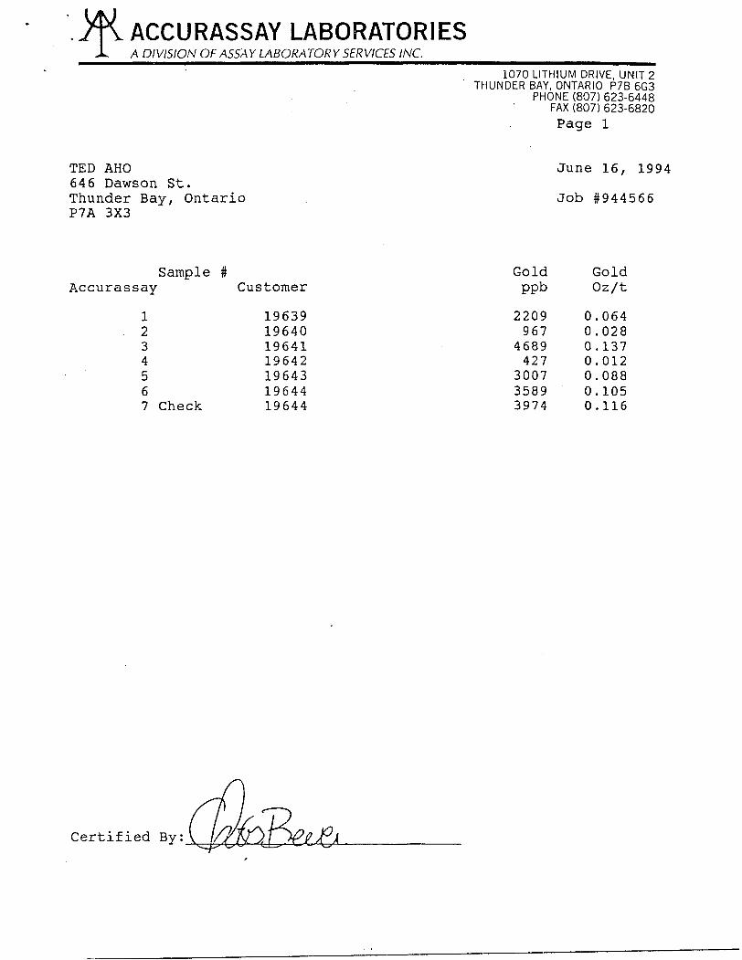
Sampling # opt Au width19640 0.028 10 inches19641 0.137 2.5 feet
- Pits #1A fit 2 Quartz vein up to 5 feet wide, but folded and "boudinage" present. The quartz vein is hosted within highly sheared mafic volcanics (chlorite schists) with irregular quartz - carbonate stringers generally parallel to schistosity. Vein dips 75 degrees south. To the south of the vein, feldspar porphyry outcrops.
Sampling # opt Au width19639 0.064 2.0 feet19642 0.012 grab19643 0.088 2.5 feet
- Pit #3 Chlorite - carbonate schists with possibly " lapillis" and minor disseminated pyrite. A quartz vein 70 cm wide cut the south part of the trench and is in contact with porphyry to the south. Schistosity is 70 degrees with dip of 85 degrees north. A shear zone oriented at 130 with dip 80 west is present and is also parallel to a similar shear east of pit # 1. There is a slight displacement but not significant.
Sampling # opt Au width19644 0.116 grab
19
- Pit #4 Sheared mafic volcanics over width of 23 feet, locally highly silicified and injected by quartz veins. The mafic volcanics are mainly chlorite schists with frafments of "lapillis" size. The quartz veins are irregular and show " boudinage". Beside the quartz veins, quartz stringers are abundant and are usually parallel to schistosity 070 - SON.
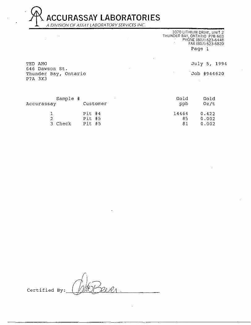
Sampling # opt Au width3455 0.012 grab3456 0.105 grab pit 4 0.422 grab pit 5 tr grab 1/94 0.009 grab 2/94 0.122 grab 3/94 0.121 grab 94-P4-08 0.021 90 cm 94-P4-09 0.006 140 cm 94-P4-10 tr 130 cm 94-P4-11 tr 90 cm 94-P4-01 0.0685 70 cm 94-P4-02 0.0105 40 cm 94-P4-03 0.383 grab 94-P4-03A 0.131 70 cm 94-P4-04 0.050 grab 94-P4-05 0.022 grab 94-P4-06 0.120 grab
- Pit # 5 Old pit sunk on highly sheared mafic volcanics, carbonated, quartz injections with numerous stringers, rare pyrite, and one 10 cm quartz vein. Schistisity is oriented at 070 - SON
Sampling # opt Au width3453 0.005 grab 1/96 0.005 grab 2/96 0.040 grab
- Pit # 6 Sheared volcanics cut by a 25 cm quartz vein,schistosity oriented at 65, dip 90.
Sampling # opt Au width3/96 tr grab
- Pit # 7 Sericite schist within chloritic schist with quartz - carbonate injections and minor pyrite.
Sampling # opt Au width3451 0.007 grab 7/94/94-1 tr grab
- Pit # 8 Sheared volcanics cut by a siliceous shear zone oriented at 70 degrees with dip 80 degrees to the north, the shear zone is injected by a 18 cm quartz vein.
Sampling # opt Au width
20
3452 0.087 grab
- Pit # 9 Sheared mafic volcanics with one 20 cm wide quartz vein.
Sampling # opt Au width012 0.026 grab
- Pit #10 Highly sheared mafic volcanics, silicified with numerous quartz stringers.
No sampling
- Pit #11 Sheared and altered intermediate to mafic volcanics cut by one irregular 30 cm wide quartz vein.
Sampling # opt Au width10 0.049 grab
Another trench was blasted on the main Ardeen claim 1H (figure 5) . Sampling did not returned any significant gold values except for one sample of highly silicified chert breccia which returned 0.053 opt Au/ton.

21
Figure 5: Trench on claim 1H
f-0O O OJ
oJ
cr
u
H
(5
a)
D-
en
o)
cD
\0
LL
22
CONCLUSIONS AND RECOMMENDATIONS
On the Ardeen Property, it is recommended to concentrate the systematic exploration on the known structures namely:
- The iron formation south of the shaft
one (1) hole by Dome in 1974 intersected the iron formation with a section grading 0.22 opt Au over 4.7 feet, another hole by Matt-Berry in 1987, some 1,500 feet to the west cut this iron formation at low angle, assays of 1.10 opt Au over 4.2 feet and 0.26 opt Au over 8.2 feet are reported. This iron formation dips roughly at 45O to the north and it is anticipated that at depth the vertical Ardeen shear and this mineralized iron formation will intersect. This may represent a good exploration target.
— The east—west mineralized shear zone
east of shaft # 2. This silicified shear zone has been trenched by Noranda and assays from grab samples ran up to 15.4 grams per ton Au. This silicified shear zone has been traced over a distance of over 800 feet and meet with the Ardeen shear at the west end. It is possible that the intersection of this secondary mineralized shear and the Ardeen shear corresponds exactly to the high grade stopes mined in the mid thirties.
It is also important to note that silver, copper, zinc and lead values are present in the mineralized shear zone with ratios very similar to the mineralization encountered in the old mine workings.
The high grade quartz veins NE of # 2 Shaft
to date, three (3) veins have been uncovered in an area 600 feet to 1,000 feet north east of the # 2 shaft. The veins strike from 090O to 130O and are sub vertical. The variation in the strike reflect possibly different rocks types intersected. Values of 0.22 opt Au over 1.0 foot, 0.62 opt Au over 1.0 foot and 0.84 opt Au over 1.0 foot have been returned from surface sampling. Hole 90-7 drilled by Landore Exploration Inc. in 1990, intersected one (1) of the vein at depth and returned 0.33 opt Au over 5.0 feet. The western extension of these veins and the Ardeen shear represent here again an excellent exploration targets.

23
Main Ardeen shear SW of the # 2 shaft
the Main Ardeen shear has not been explored systematically. To the northeast of # 2 shaft, no information is available on the previous exploration works completed. It is reported that the grade and width of the gold mineralization was improving at depth in the lower levels of the underground operation.
Minoletti pits
They have been detailed in 1973, in a joint Venture between Lynx Canada Exploration Ltd and Fort Reliance Minerals Ltd. The twelve (12) trenches were sampled over a strike length of 456 feet with an average width of 22.8 inches grading 0.196 ounces gold per ton and 1.26 ounces of silver per ton. The mineralization is very similar the Ardeen Mine with significant quantities of chalcopyrite sphalerite and galena.
Beaver vein
The Beaver vein has been recently rediscovered and consists of a shear zone 4 to 8 feet wide of chlorite- sericite schist, highly silicified with abundant quartz stringers and veins. The shear zone cuts across mafic to intermediate volcanics and has been followed for 1,000 feet on surface. Assays of up to 0.11 opt Au over 4.0 feet were returned. The zone is sub-vertical to slightly dipping south.
Another pit some 250 feet north of the east end of the Beaver vein returned 0.36 opt Au over 1.0 foot in a quartz vein within intermediate volcanics. These 2 structures were reported in the old reports but their exact location was not known.
Porphyry zone
A mass of porphyry unknown extend has been discovered in the central portion of the southwest claim block. The feldspar porphyry is variable in composition, highly fractured and altered on surface. Quartz stringers and veins are abundant in the porphyry and one of the vein returned 0.21 opt Au over 1.0 foot. The porphyry itself is highly anomalous in gold with assays of 21 to 173 ppb. This new discovery is very promising, so far outcrops of porphyry have been mapped over an area of 400 feet by 100 feet.
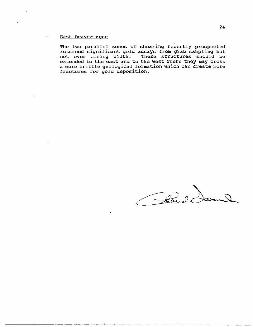
24
East Beaver zone
The two parallel zones of shearing recently prospected returned significant gold assays from grab sampling but not over mining width. These structures should be extended to the east and to the west where they may cross a more brittle geological formation which can create more fractures for gold deposition.

COST OF WORK
Prospecting Ted Aho 42 days . . . . . . . ... . . . . . . .. . . $ 6,300.00Daniel Blouchier 8 days ............. $ 1,200.00Douglas Blouchier 5 days ........ .... ^ 750.00Terry Olford 11 days ............... ^ 1,650.00
Assays July 20 ........................... . $ 94.59June 16 .......;..................... $ 94.59JulyS ..... . . . . . . . . . . . . . . . . . . . . . . . . . ^ 39.64Sept 6 .............................. $ 109.46Oct 21 .............................. $ 79.72Nov 11 .............................. ^ 108.66Oct 17 ......................... . . . . . ^ 108.34
Rental Gas plugger .............................. $ 75.00
Travel 42 trips (249.3 km roud trip ) @ $0.30/km . $ 3,141.40
Food 42 days @ $15.00/day . . . . . . . .. . . . . . . . . . . . . . . . $ 630.00
Blasting powder ...... ............................ $ 546.05
Report 3 days Ted Aho . . . . . . . . . . . . . . . . . . . . . . . . . . . . $ 450.00
Report Ovalbay Geol Serv. . . . . . . . . . . . . . . . . . . . . . . . . $ 1,000.00
Photocopies and reproduction ........ . . . . . .. .. . . .. $ 24.50
$16,401.95

APPENDIX 1: ASSAY RESULTS FROM MNDM SAMPLING

8/3/94
JOB ; DAILIES NO:CLIENT:DATE REPORTED:DATE APPROVED:ANALYST:
FIRE ?A SS/4 YiffEPORTii
D94-0074SCOTT
Aug 03/94 Aug 03/94 P. PRINCE
CODE: FA Procedure No. MS14
Approved by M. Moore for Dr. Jean Richardson, C. Chem. QA Manager, Geoscience Labs •705-670-5645
JOB y DAILY NO. SAMPLE NO. ;oz
D94-0074 ctfS 30 90 —————————————— W^, ——————
^u Ag IICERTIFIED VALUESfton oz/ton Au oz/ton |Ag oz/ton
n* ' 1-
D94-0074 JFS-31-94 TRACE ^ .l-^G: — — -tf'^V-eir) ^1, C hi
D94-0074 JFS-31D-94 TRACE <0.1
D94-0074 JFS-32-94 N n -— "P 1 P -\ ^ f '
D94-0074 JFS-33-94 TRACE - -,-e: —— ^| p ^. C^ A/^^^lfi
D94-0074 JFS-34-94 0
D94-0074 JFS-34D-94 0
36 "l5 T
32 1.3 ' ' 1
D94-0074 JFS-35-94 TRACE -~ -^^ \J b\ t. *~ ^ t t( ^"^ U
D94-0074 JFS-36-94 N.D. - ^; . p, f Q\f Jf. Q 4-, -
QC MRB26 0.37 9.7 0.33 11.2
QC MRB27 0.013 44.5 0.02 47.5
QC RBLK N.D. - N.D.
|QC NOTES
1. "Trace", presence of gold detected but below fire assay limit." n.d." not detected by this method.2. Duplicates (D) are to assess variability. Standards (STD) have known compositions.3. Method determination limits are 0.067 oz/ton Au, 0.1 oz/ton Ag.4. At the 95 07o confidence level, precision is + 1- 1 0 07o at 3x the determination limit (0.2 oz/ton).5. Accuracy is +A 3 07o at 3 times the determination limit (0.2 oz/ton).6. Usually, precision and accuracy improve as the Au and Ag content increase.7. A sample weight of 1 assay ton ( 29.166 grams) is now used on all samples.

APPENDIX 2: ASSAY CERTIFICATES FROM SAMPLING (OPAP 94)

ACCURASSAY LABORATORIESA DIVISION OF ASSAY LABORATORY SERVICES INC.
1070 LITHIUM DRIVE, UNIT 2THUNDER BAY, ONTARIO P7B 6G3
- " ' PHONE (807) 623-6448FAX (807) 623-6820Page l
f
TED AHO July 20, 1994 646 Dawson StreetThunder Bay, Ontario Job #944694 P7A 3X3
Sample # Gold GoldAccurassay Customer - ppb Oz/t
1 3451 228 0.0072 3452 2993 0.0873 3453 127 0.0044 3454 32 ^.0015 3455 407 0.0126 ' 3456 3603 0.1057 Check 3456 3616 0.105
Certified
.M^ACCURASSAY LABORATORIESJL A DIVISION OF ASSAY LABORATORY SERVICES INC.^^^^^^^^^^^^^^^^^^
1070 LITHIUM DRIVE, UNIT 2THUNDER BAY, ONTARIO P7B 6G3
PHONE (807) 623-6448FAX(807)623-6820Page l
TED AHO June 16, 1994 646 Dawson St.Thunder Bay, Ontario Job #944566 P7A 3X3
Sample # Gold GoldAccurassay Customer ppb Oz/t
1 19639 2209 0.0642 19640 967 0.0283 19641 4689 0.1374 19642 427 0.0125 19643 3007 0.0886 19644 3589 0.1057 Check 19644 3974 0.116
Certified By:
ACCURASSAY LABORATORIES-L A DIVISION OF ASSAY LABORATORY SERVICES INC.
1070 LITHIUM DRIVE UNIT 2THUNDER BAY, ONTARIO P7B6G3
PHONE (807) 623-6448FAX (807)623-6820Page l
TED AHO July 5, 1994 646 Dawson St.Thunder Bay, Ontario 'Job #944620 P7A 3X3
Sample # Gold GoldAccurassay Customer ppb Oz/t
1 Pit #4 14464 0.4222 Pit #5 85 0.0023 Check Pit #5 81 0.002
Certified By: ( P ft/?A
ACCURASSAY LABORATORIESA DIVISION OF ASSAY LABORATORY SERVICES INC.
1070 LITHIUM DRIVE, UNIT 2THUNDER BAY, ONTARIO P7B 6G3
PHONE (807) 623-6448FAX (807) 623-6820Page l
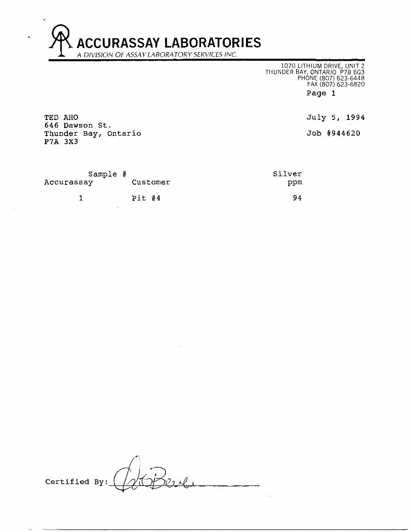
TED AHO July 5, 1994 646 Dawson St.Thunder Bay, Ontario Job #944620 P7A 3X3
Sample # SilverAccurassay Customer ppm
l Pit #4 94
Certified By;

ACCURASSAY LABORATORIESA DIVISION OF ASSAY LABORATORY SERVICES INC.
1070 LITHIUM DRIVE, UNIT 2THUNDER BAY, ONTARIO P7B 6G3
PHONE (807) 623-6448FAX (807) 623-6820
Page l
TED AHO September 6, 1994 646 Dawson St.Thunder Bay, Ontario Job #944922 P7A 3X3
Sample # Gold GoldAccurassay Customer ppb Oz/t
F/T" V l 1/94 294 0.009fir* 2 2/94 4185 0.122
'TH 1 3 /94 4159 0.1217 4 1/96 138 0.004rs 2/96 1358 0.040
'-C 6 3/96 44 O.OOJ.*piT-Jl 7 /94/94-1 10 *C0.001
8 Check 7/94/94-1 7 KO.OOl
Certified By:

ACCURASSAY LABORATORIESA DIVISION OF ASSAY LABORATORY SERVICES INC.
1070 LITHIUM DRIVE, UNIT 2THUNDER BAY, ONTARIO P7B 6G3
PHONE (807) 623-6448FAX (807) 623-6820
Page l
TED AHO 646 Dawson St. Thunder Bay, Ontario P7A 3X3
October 21, 1994
Job #9441235
Sample # Accurassay Customer
1234J5 ^—— 6 Check
0809
010011.012012
Gold ppb
12.2.2062145
891
Gold Oz/t
0.0210.006^.0010.001
904 0.026ft HI r '-
Certified By:

ACCURASSAY LABORATORIESA DIVISION OF ASSAY LABORATORY SERVICES INC.
1070 LITHIUM DRIVE, UNIT 2THUNDER BAY, ONTARIO P7B 6G3
PHONE (807) 623-6448FAX (807) 623-6820
Page l
TED AHO 646 Dawson St. Thunder Bay, Ontario P7A 3X3
November 11, 1994
Job #9441353
Sample # Accurassay Customer
1234567 Check
12345
1010
Gold ppb
2785
118219
181615861666
Gold Oz/t
0.002 L 0.003 T 0.006
0.0460.049 ./T
33.8
Certified By:

Chem
ex L
abs
Ltd.
Anal
ytic
al C
hem
ists
" G
eoch
emis
ts" R
egist
ered
Ass
ayer
s51
75Ti
mbe
rlea
Blvd
., M
ississ
auga
,O
ntar
io, C
anad
a L4
W 2
S3P
HO
NE
: 905
-624
-280
6 K
.
To:
AH
O,
TED
646
DA
WS
ON
ST.
TH
UN
DE
R B
AY
, ON
P
7A 3
X3
Pro
ject
:C
omm
ents
: A
TTN
: TE
D A
HO
Page
Num
ber
: 1
Tota
l Pag
es
: 1
Cer
tific
ate
Date
: 18-
OCT
-94
Invo
ice N
o.
: 194
2854
2 P.
O. N
umbe
r :
Acco
unt
:MEK
'"
' CE
RTIF
ICAT
E O
F AN
ALYS
IS
A94
2854
2
SAM
PLE
94
-P4
-01
94-P
4-0
2
94-P
4-0
3
94
-P4
-03
A
94
-P4
-04
94-P
4-0
5
94-P
4-0
6
PR
EP
C
OD
E
20*;
20
5
20
5
20
5
20
S
20
5
20
5
226
226
226
226
226
226
226
Au
oz/
T
FA-1-
AA
0.0
68
5
0.0
10
5
J-0.3
50
0
0.1
310
O.O
50
0
0.0
220
0.1
20
0
Ag
ppm
A
qua
R
67
.0
Au
FAO
Z/T 0.3
83
^
y A/
p K
——
——
——
— 4
rf
CE
RTI
FIC
i

APPENDIX 3: SAMPLE DESCRIPTIONS

APPENDIX # 3
Sample # DESCRIPTION OF SAMPLES
3451
3452
3453
3454
3455
3456
19639
19640
19641
19642
Grab sample of quartz bearing volcanics from pit # 7 , 20 cm quartz vein with pyrite within a 80 cm siliceous shear. Au: 228 ppb
Grab sample from pit #8, 45 cm pink quartz veinwith minor pyrite.Au: 2993 ppb ( 0.087 opt)
Grab sample from pit #5, 70 cm quartz vein in siliceous shear zone with minor pyrite. Au: 127 ppb
Grab sample from iron formation, quartz vein carrying large pyrite cubes ( lcm ) and cutting across the I.F. Au: 32 ppb
Grab sample from pit # 4, quartz vein with pyrite and galena from middle section of the pit Au: 407 ppb
Grab sample of quartz vein from pit # 4, same asabove # 3455Au: 3616 ppb ( 0.105 opt )
Chip sample over 2.0 feet, Beaver vein, pit 1A, quartz vein with pyrite and galena Au: 2209 ppb ( 0.064 opt )
Chip sample over 10 inches, Beaver Vein extension, pit # l, same vein as # 19639, 12 feet wide shear volcanics with 2 quartz veins 40 and 10 cm wide of pink quartz. Au: 967 ppb ( 0.028 opt )
Chip sample over 2.5 feet, Beaver vein extension, Pit # l, same as # 19640 Au: 4689 ppb ( 0.137 opt )
Grab sample, Beaver vein extension, Pit # 2, 70 cm quartz vein with pyrite + galena. Porphyry in contact to the south. Au: 427 ppb ( 0.012 opt )

19643
19644
Pit # 4
Pit # 5
1/94
2/94
3/94
1/96
2/96
3/96
7/94/94-1
08
Chip sample over 2.5 feet, Beaver vein extension, Pit # 2, same as # 19642 Au: 3007 ppb ( 0.088 opt )
Grab sample quartz vein, Pit #3, 70 cm quartz veinwith pyrite and galena. Sheared volcanics northside.Au: 3589 ppb ( 0.105 opt )Check 3974 ppb ( 0.116 opt )
Grab sample from pit # 4. Quartz vein (40 cm wide)grey to white in colour with sericite - chloritebands folded. Up to 15% pyrite, trace ofchalcopyrite. May be tellurites in certain layers,much carbonate.Au: 14,464 ppb ( 0.422 opt )Ag: 94 ppm ( 2.74 opt )
Grab sample from pit # 4. Quartz vein breccia with chlorite schist. The quartz vein is irregular with minor pyrite cubes (5%) Au: 85 ppb
Grab sample, south end of pit # 4. Taken at south end of pit 7.7 meters long, l meter wide. Sheared volcanics with small quartz stringers at south end of pit. Au: 294 ppb ( 0.009 opt )
North end of pit # 4. Grab sample taken north of pit, quartz with minor pyrite and galena. Au: 4185 ppb ( 0.122 opt )
Middle of pit # 4. Grab sample of quartz withpyrite and galena.Au: 4159 ppb ( 0.121 opt )
Pit # 5, grab sample of quartz vein after blast Au: 138 ppb
Grab sample same as above #1/96, pit # 5 Au: 1358 ppb ( 0.04 opt )
Grab sample pit # 6, taken from quartz vein afterblast.Au: 44 ppb
Pit # 7, grab sample of quartz vein after blast Au: 10 ppb
Chip sample pit # 4, over 90 cm sheared mafic volcanics with minor quartz stringers. Au: 722 ppb ( 0.021 opt )

09 Chip sample pit # 4, over 140 cm, sheared mafic volcanics with minor quartz stringers. Au: 206 ppb ( 0.006 opt )
010 Chip sample pit # 4, over 1340 cm, sheared mafic volcanics. Au: 21 ppb
011 Chip sample pit # 4, over 90 cm, highly sheared mafic volcanics. -*- Au: 45 ppb
012 Grab sample Pit # 9, 25 cm wide quartz vein. Au: 904 ppb ( 0.026 opt )
1 On claim HI, grab sample from chert breccia, ironformation (south part of outcrop). Au: 27 ppb
2 Same as sample # l (south central part of outcrop) Au: 85 ppb
3 Same as sample # l, close to slight silicification( middle part of outcrop) Au: 118 ppb
4 Same as sample # l, slightly more silicified ( northcentral part of outcrop) Au: 219 ppb
5 Same as sample # l, minor quartz injection and traceof pyrite (north part of outcrop) Au: 1816 ppb ( 0.053 opt )
10 Pit # 11, grab sample from west side of beaver pond, west extension of Beaver vein, badly weathered quartz vein, much carbonate, trace pyrite. Au: 1586 ppb ( 0.046 opt ) Check: 1666 ppb ( 0.049 opt )
94-P4-01 Pit # 4, chip sample over 70 cm, siliceous shearzone with quartz vein hosting pyrite and galena, north end of pit. Au: 0.0685 opt
94-P4-02 Pit # 4, chip sample over 40 cm, sheared volcanics with minor stringers of quartz. Au: 0.0105 opt
94-P4-03 Grab sample from quartz vein with much pyrite and galena, pit # 4 Au: 0.383 opt

94-P4-03A Grab sample same as # 94-P4-03Au: 0.1310 opt
94-P4-04 Grab sample quartz vein with pyrite, pit # 4 Au: 0.050 opt
94-P4-05 Grab sample half inch pyrite stringer within sheared volcanics, pit # 4 Au: 0.0220 opt
94-P4-06 Grab sample pit # 4, darker pyrite north of pitAu: 0.1200 opt
APPENDIX 4: DISCUSSION FROM PROSPECTOR


APPENDIX 5: RESULTS FROM PROPERTY VISIT "CAMECO"

C O K P O H A T l O M
District Office 1349 Kelly Lake Road Telephone: (705) 523-4555 Unit #6 Facsimile: (705) 523-4571 Sudbury, Ontario Canada P3E 5P5
November 17, 1994
Mr. Ted Aho 646 Dawson Street Thunder Bay, Ontario P7A 3X3
Dear Ted:
Enclosed are the documents that you lent me on your Ardeen property and the results of the samples I took. The areas that I was most interested in did not respond to my sampling and I am sorry to say that Cameco will not be able to make you an offer for these claims. A description of the sample locations is as follows:
ON-253-1 - stop by road and Noranda drillingON-253-2 - Stormin ground trench-porphyry with ankeriteON-253-3 - Stormin grd-porphyry contact with felsicsON-253-4 - Stormin grd-east end of trench, siliceous materialON-253-5 - Stormin grd-blasted material 100m south of aboveON-253-6 - Stormin grd-blasted material 25m south of 2-4ON-253-7 - Pit 4, sheared agglomerate next to qtz vn-8% pyON-253-8 - Pit 4 quartz veinON-253-9 - Pit 4 50cm away from quartz veinON-253-10 - mineralized-4%py-porphyry on road 1km SW of Pit 4ON-253-11 - bulldozed otc 2km W Ardeen mine-felsic volc-8%pyON-253-12 - ditto 11 but 5 * pyON-253-13 - ditto 11 graphitic and 10?; pyON-253-14 - 300m south of 11-13-trc sulph-on your ground ON-253-15 - ditto 11-13 but 10% py
As you can see, the most interesting values came from your pit 4 where you had got some good grades before. Unfortunately as I indicated to you that day, this type of target is difficult to develop significant tonnage because of the narrow width. Even if the zone was mineralized over 2m and graded .3 opt Au, a strike length of 1km and a depth of 1km would be needed to meet Cameco's threshold for a minimum sized deposit. From what I saw, the mineralization at pit 4 is less than 1m, lower grade, and there are indications that continuity maybe a problem.

Che
mex
Lab
s Lt
d,An
alyt
ical C
hem
ists
" Geo
chcm
lsw"
Regi
ster
ed A
ssay
ers
212
Broo
ksba
nk A
vo..
Nor
th V
nnco
uvor
Br
itish
Col
umbi
n. C
anad
a V7
J 2C
1 PH
ON
E: 6
04-0
04-0
221
To:
CAM
ECO
CO
RPO
RAT
ION
1349
KE
LLY
LAK
E R
D.,
UN
IT //
6 SU
DBU
RY,
ON
P3E
5P5
Proj
ect :
Com
men
ts:
ATT
N:
BAR
RY
CO
OPE
R
Page
Num
ber
!"B
To
kil P
ages
l
Cer
tific
ate
Da!
o:7-
NO
V-0
Invo
ice
No.
I-B
4S78
I P.
O. N
umbe
r :
Acc
ount
:
SAMP
LE
DESC
RIPT
ION
mmjijj
Kbli
liip
*Sf
fiBili
SKK
^^^^
^^^^
^^M
V
JN25
3-2
1N25
3-4
W25
3-5
:)N
253-
6)n
-c j j
r
W25
3-8
W25
3-9
:)N
253-
10:)
N25
3-1I
. )n
4. J
J "
l f.
3N25
3-L
3 O
N25
3-N
if
^fife
flfyg
sJa n
m vB
TCH
BSH
lEyi
Bt
MO
*H
nB•H
raL
B? f
*M
HD
^PH
^P
D^^^
^^^V
&K
ijcoi 205 205
205
205
20.1
205
205
20 5
205
205
205
205
205
205
205
j®*
~05
f M 5
205
'205 205
205
205
205
205
205
205
205
.705
SP
)E 226
226
226
226
226
226
226
226
226
226
226
226
226
226
226
226
226
226
226
L M
o N
a Vi
P Pb
Sb
SC
^ pp
m f-
- \
. ppm
. .
ppm
ppm
ppm
ppm
•' '- .
8 0
.01
78
260
4 2
15l
0.0
8
19
450
< 2
< 2
1
132
0.1
5
195
240
48
8 4
19
0.0
1
28
410
36
2 2
^ 0.0
}
1.5
420
< 2
< 2
1<
1 0.
11.
H
440
2 <
2 2
2 0.0
2
98
370
12
2 11
10
0.0
7
91
190
1360
6
81
n.O
l 10
6 4)0
4
4 11
1
0.1
1
11
780
26
2 3
1 <
0.0
1
27
170
6 4
11
0.0
4
37
160
2 4
2
3 (
0.01
21
15
0 32
6
11
0.0
7
46
150
'.2
<
2 5
1 0.
01
32
190
16
6 2
*1
0.0
}
15
' 56
0 4
2 3
1 0.0
4
3 22
0 64
4
1
2 0.0
2
2 16
0 22
2
(1
1 O
.OJ
4 30
0 6
12
22
0.0
2
2 17
0 31
0 (.
2
l 1
0.0
2
19
330
46
1
CERT
IFIC
ATE
OF
AN
ALY
SIS
A94
2976
2
Sr
Ti
Tl
D V
W Zu
Au
PA
ppm
l pp
m pp
m pp
ra pp
m pp
m g/
t : ,:
33
0.03
<
10
< 10
12
8 <
10
58 --
——
v
: ';.
i61
<
0.01
<
10
< 10
1.6
<
10
42
——
r-
:; .,
17
< 0.
01
< 10
(
10
12
*. 10
74
--
- ——
;-
11
< 0.
01
* 10
(1
0
9 <
10
212
----
i-
120
< 0.
01
< 10
(
10
10
t 10
28
- —
——
191
( 0.
01
(10
(
10
18
CIO
16
—
——
—
221
0.01
(
10
( 10
82
'/i
10 x
BO
—
——
—
127
( 0.
01
(10
(1
0
45
(10
52
10
.97
169
0.01
(
10
(10
78
( 10
70
--
-~90
(
0.01
(1
0
( 10
31
(1
0
64 --
~-
7 (
0.01
(
10
(UO
6
(10
50
8 --
- —
59
( 0.
01
( 10
(.
10
8
( 10
60
—
——
—
8 (
0.01
(1
0
(10
4
(10
78
6 --
---
41
0.1
2
( 10
(1
0
50
( 10
25
2 --
- —
3 (
0.01
(1
0
(10
II
(10
11
6 --
---
24
( 0.
01
( 10
(
10
27
( 10
78
—
——
—33
(
0.01
(
10
( 10
4
( 10
32
—
——
7 (
0.01
(1
0
(10
( 1
( 10
46
--
- —
9 0.
10
( 10
(
10
42
( 10
Id
--
- —
63
( 0,
01
(10
(1
0
1 (1
0
802
----
-8
( 0.
01
( 10
(
10
4 (
10
16
17.7
9

Che
mex
Lab
s Lt
d,An
alyt
ical
Che
mls
is "
Geo
chem
fe)t3
" Ro
tjfcii
cfod
Ass
nyer
s21
2 B
rook
sbnn
k.A
vo.,
Nor
th V
anco
uver
B
ritis
h C
olum
bia.
Cnn
nda
V7J
2C
I P
HO
NE
: 00
4-00
4-02
21
To:
CA
ME
CO
CO
RP
OR
ATI
ON
1349
KE
LLY
LA
KE
RD
.. U
NIT
//6
SU
DB
UR
Y.
ON
P3
E 5P
5
Pro
jocl
:C
omm
ents
: A
TTN
: B
AR
RY
CO
OP
ER
Pago
Num
ber
l-A
Tota
l Pag
os
l C
erlili
calo
Dat
e:7-
NOV-
04
Invo
ico
No.
I-D42
0762
P.
O. N
umbe
r, :
Acco
unt
:
CER
TIFI
CA
TE O
F A
NA
LYSI
SA
9429
762
Cd
Co
Ci
Cupp
m pp
m pp
m pp
m
*rn
rirt
n A
T i

Ministry ofNorthern Developmentand Mines
Ontario
Report of Work Conducted After Recording Claim
Mining Act
Transaction Number
Personal information collected on this form is obtained under the authority of the Mi this collection should be directed to the Provincial Manager, Mining Lands, Mini: Sudbury, Ontario. P3E 6A5, telephone (705) 670-7264.
Instructions: - Please type or print and submit in duplicate. '^S^~~t^'~'~~~"~"~ 900- Refer to the Mining Act and Regulations for requirements of filing assessment work or consult the Mining
Recorder.- A separate copy of this form must be completed for each Work Group.- Technical reports and maps must accompany this form in duplicate.- A sketch, showing the claims the work is assigned to, must accompany this form.
Recorded Holders)
/O l^.
Qo laClient No.
300Address -, _
oT -T:Telephone No.
Mining Division)ft-y
Township/AreaMoss
M or G Plan No.
Dates Work Performed
From: *\ .A f Y 1
t ] l y o o i i l *f 1 V
Work Performed (Check One Work Group Only)Work Group
Geotechnical Survey'
Physical Work, Including Drilling
Rehabilitation
Other Authorized Work
Assays
Assignment from Reserve
Type
/f^SpexTTTfoc- fei ft fULiMc rV^~f7foc \ .5/9-WN /3^/AJ C-A- .^ _ J
RECEIVED
—— L F& i * —— 1 00^ ———r ne V^D
MINING LANDS BRANCH
1
Total Assessment Work Claimed on the Attached Statement of Costs 1Note: The Minister may reject for assessment work credit all or part of the assessment work submitted if the recorded
holder cannot verify expenditures claimed in the statement of costs within 30 days of a request for verification.
Persons and Survey Company Who Performed the Work (Give Name and Address of Author of Report)Name Address
-t- DoofcU-S ftfcl Steltee. flfUlLU o/JTFoR d 3/O C/Q At /oft.
7 *\
r\A- r\o 6/B
(attach a schedule if necessary)
Certification of Beneficial Interest * See Note No. 1 on reverse sidel certify that at the time the work was performed, the claims covered in this work report were recorded in the current holder's name or held under a beneficial interest by the current recorded holder.
Date or Agent (Signature)
Certification of Work Reportl certify that l have a personal knowledge of the facts set forth in this Work report, having performed the work or witnessed same during and/or after its completion and annexed report is true.
j Name and Address of Person Certifying
^or Office Use OnlyTotal Value Cr. Recorded Date Recorded Mining RecordeV
Date Approved
Date Notice for Amendments Sent
MI VIM-RECEIVED \
JA'I 51995 PM:12131415
)241
c 1584 8 f *
S*O — x:
•-o
O
.n o-cO O
-c O
o oc O"l
O O
O
O ^-C
•O ^3-C
c**•O O
O
-CSe•3
H- CO i2. w 9.3
11!!
IIis
SJ
0oCP
8 o oCOO O
COoo o
0
1-
r
''-ii f-1 '/
CD O0
ktcEB9
ri L/ l
eo0 0
imw
CP 0o
;D5
V
i
D0
i000D
ftoT^
oa0 0
00 0 0
Ip5' o S
Oo-g'gST-* 'D. S.
s1s
l
-1
20
i
CO 0 0
r 5l Is
^
000000
{js.y
NJ
Sil!l3 I s
D)-n 0 ^,, E&OOc g jroi*!oiSSS*(D
Credits you are claiming in this report may be cut back. In order to minimize the adverse effects of such deletions, please indicate from which claims you wish to priorize the deletion of credits. Please mark (^) one of the following:
1. D Credits are to be cut back starting with the claim listed last, working backwards.2. D Credits are to be cut back equally over all claims contained in this report of work.3. ffl^Credits are to be cut back as priorized on the attached appendix. C- L (c'f/Hvj
In the event that you have not specified your choice of priority, option one will be implemented.
Note 1: Examples of beneficial interest are unrecorded transfers, option agreements, memorandum of agreements, etc., with respect to the mining claims.
Note 2: If work has been performed on patented or leased land, please complete the following:
l certify that the recorded holder had a beneficial interest in the patented or leased land at the time the work was performed.
Signature Date

Ontario
Ministry ofNorthern Developmentand Mines
Ministere du Developpement du Nord et des mines
Statement of Costs for Assessment Credit
Etat des couts aux fins du credit devaluation
Mining Act/Loi sur les mines
Transaction No./N 0 de transaction
2.1584 8Personal information collected on this form is obtained under the authority of the Mining Act. This information will be used to maintain a record and ongoing status of the mining claim(s). Questions about this collection should be directed to the Provincial Manager, Minings Lands, Ministry of Northern Development and Mines, 4th Floor, 159 Cedar Street, Sudbury, Ontario P3E 6A5, telephone (705) 670-7264.
Les renseignements personnels contenus dans la presente formule sont recueillis en vert j de la Loi sur les mines et serviront A tenir b jour un registre des concessions minieres. Adresser toute quesiton sur la collece de ces renseignements au chef provincial des terrains miniers, ministere du Developpement du Nord et des Mines, 159, rue Cedar, 4e etage, Sudbury (Ontario) P3E 6A5, telephone (705) 670-7264.
1. Direct Costs/Couts directs
Type
Wages Salaires
Contractor's and Consultant's Fees Droits de ('entrepreneur et de I'expert- consell
Supplies Used Fournitures utilisees
Equipment Rental l Location de materiel
Description
Labour Main-d'oeuvreField Supervision Supervision sur le terrain
Typen -jKf^OoAT-
Type
Ass/v-l ^
/cjvui t^
l~J\D\~hc.rft(?J*U
P?" Oi^*^ r^oGGtR
Amount Montant
C) CJCO
htfe/COD
6?)5SH b
a.T
75-
Total Direct Costs Total des couts directs
Totals Total global
IQ3&
/oco
J^ok
nslap/
2. Indirect Costs/Couts indirects* * Note: When claiming Rehabilitation work Indirect costs are not
allowable as assessment work.Pour le remboursement des travaux de rehabilitation, les couts indirects ne sont pas admissibles en (ant que travaux devaluation.
Type
Transportation Transport
riFood and i Lodging j Nourriture ei hebergemerf ;Mobilizatlonjand Demobllizatlbn Moblllsatlonjel,. demobilisatiliDi'Jli
DescriptionType
R**±
iECglVED j
^ ______
NGLANOiGPANCu} ^ •••.... .M.JI 11^,^^.^ ^ " ' - f
Amount Montant
^im
(a 30
Sub Total of Indirect Costs Total partie! des coOts Indirects
Amount Allowable (not greater than 20tHi of Direct Costs) Montant admissible (n'excedant pas 20 ^ des couts directs)Total Value of Assessment Credit Valeur totale du credit Total of Direct and Allowable d'evaluation
Indirect costs) (Total des coOts direct*
Totals Total global
3N/
&2P
•—
37?4JXffD-fc
/5J57et Indirect* admissible*
Note: The recorded holder will be required to verify expenditures claimed in this statement of costs within 30 days of a request for verification. If verification is not made, the Minister may reject for assessment work all or part of the assessment work submitted.
Note : Le titulaire enregislre sera tenu de verifier les depenses demandees dans le present etat des couts dans les 30 jours suivant une demande a cet effet. Si la verification n'est pas effectuee, le ministre peut rejeter tout ou une partie des travaux devaluation presentes.
Filing Discounts
1. Work filed within two years of completion is claimed at 10007o of the above Total Value of Assessment Credit.
Remises pour depot
1. Les travaux deposes dans les deux ans suivant leur achievement sont rembourses a 100 "/o de la valeur totale susmentionnee du credit devaluation.
2. Work filed three, four or five years after completion is claimed at 5007o of the above Total Value of Assessment Credit. See calculations below:
Total Value of Assessment Credit Total Assessment Claimed
x 0.50
2. Les travaux deposes trois, quatre ou cinq ans apres leur achievement sont rembourses a 50 "/o de la valeur totale du credit devaluation susmentionne. Voir les calculs ci-dessous.
Valeur totale du credit devaluation
x 0,50
Evaluation totale demandee
Certification Verifying Statement of Costs
l hereby certify:that the amounts shown are as accurate as possible and these costs were incurred while conducting assessment work on the lands shown on the accompanying Report of Work form.
that as(Recorded Holder, Agent, Position in Company)
to make this certification
Attestation de l'etat des couts
J'atteste par la presente :que les montants indiques sont le plus exact possible et que ces depenses ont et6 engagees pour effectuer les travaux d'evaluation sur les terrains indiques dans la formule de rapport de travail ci-joint.
am authorized Et qu'a litre de je suis autorise(titulaire enregistre, representant. posts occup6 dans la compagnie)
a faire cette attestation.
t;
Signature^ s
^\ C]lv -Date
0212 (04/91) Nota : Dans cette formule. lorsqu'ir designs des cersonnes, le masculin est utilis6 au sens neutre.

OntarioMinistry ofNorthern Developmentand Mines
Ministere duDeveloppement du Nord et des Mines
February 21, 1995
Geoscience Approvals Office 933 Ramsey Lake Road 6th Floor Sudbury, Ontario P3E 6B5
Telephone: (705) 670-5853 Fax: (705) 670-5863
Our File: 2.15848 Transaction #: W9540.00005
Mining RecorderMinistry of Northern Development St Mines435 James Street SouthSuite B003Thunder Bay, OntarioP7E 6E3
Dear Mr. Weirmeir:
Subject: APPROVAL OF ASSESSMENT WORK CREDITS ON MINING CLAIM 677469 IN MOSS TOWNSHIP
Assessment work credits have been approved as outlined on the report of work form. The credits have been approved under Section 9 (Prospecting) and Section 17 (Assays) of the Mining Act Regulations.
The approval date is February 20, 1995.f '
If you have any questions regarding this correspondence, please contact Steven Beneteau at (705) 670-5858.
ORIGINAL SIGNED BY:
Ron C. GashinskiSenior Manager, Mining Lands Section Mining and Land Management Branch Mines and Minerals Division
SBB/jl Enclosure:
cc: Resident GeologistThunder Bay, Ontario
ssessment Files Library Sudbury, Ontario

REFERENCES
TILir LAKE G-562 S G-642BURCHELL LAKE G-
180.0III42I5O
M42I47
l 1,42151 11,42,52
:I723I6 '(172319.-. L---
1174214 I||723S9
'86239E Y1X862393
1174213 l
T --j-- ~ -\———\ 630924 6309l3yl6309,l ' 630797
63O9I6 ;63O9IO l
4- - - L — ' j.*^"-^ -.u _' 630922^r -- i i
i 3/53,85 993,84 j 993183MI4I240 l 1,4,235/- --^--v--Si-I 45B
M R F
.- - - - - -63O933 630931 ^630927,
874341 874340,874339
196 j Mg.809 Jg
111227 IIOOII38 |OOII39
874331 l 873839 y
l l
l 8298681 829879'1202302 8738381 873637 \ 873836 l 873835 i 873834,
811237 l 82H39 , 821438 ' ' 3221 7 ' 1*1
H Z 8,22491 812247 | 329869l 993186 '835308
1 18346761 83O462 l 811236MOSS o \ LAIfEt Cedar Id. i /f 'v* 2 88295
612239)8122901612246
1209480 l 63J305 i 835307
829141 8122671 812260,812258, 812251 | 812245 ,834680-^834877 834878 '834879
812266 j 812261 1812257, 8I2252J_ — _ i_ _ _ i _ — _ _
8,2265 l 812262 8,2256I ,0839M I 1083957 834677 1 834673|
830479 8,2264 812263 812255 | a.-ftl - 17] 9420I7 1 942014 ' 942OI3'
34671830090l 83048I 830480 9407O4 94O703' &S] l*-' | ' ' 9420^ I
j . __^L.9104I5J !^?4J.4 j 4 8^Jf 01 * ; 942012830077 i^——-S*^~\ j j i j ,--^j l o
830076 ' 940705 . 94O7O6,9407071 94O708 l 94*420 ,94O4I9 l Ol 1204871
829104 l 828643 828644 i 828643 j 830233 | 830232
120943983O07S l 940709 i 94O7IO
1830093 8300881828648 ' 82e647
830230 830087
1141,63 1,14
Q^ l '8,3157 l 8,3158 .8,3,59 , 8,3160
I8S0080l __ __ __ __ __
1.65,79 1,163,781,63,77
828654 82B6S3 ' 828652786329 1786528 l 78652 l | 813166 l- ———— -f - -
|,14,170 |II4II69^ ^ ^ ^^ ^^ — — —j- j.%—|l m
CD
HI4II76 |,I4II77 1,65186 j 5/B6526 1786541 J786542l 1010067 i 10,0066 ,OiOl ~
|2052OT —
M4..79 ( |6S|89 | ||M|88 ,| 65 ,87l 828662 l 828661 , 828660 l.j, J tJ ,i 1010093 j 1010092 ^ I,OIOOBE|
— l— — — — — — — — —\\ — — 4~- — — — — -——l——-4---11162394 l 1162393 1162396
74696 11411*8 II4IM7————— LI 'I —i
l 40.00
W*st Ast
POWELL LAKE G-549 NELSON LAKE G-745
1995
REFERENCES
MOTICE:The information that appears on this map has been complied from various sources, and accuracy Is not guaranteed "" hose wishing to stake mining claims should consult with the Mining Recorder. Ministry of Northern Development and Mines, for additional Information on the status of the lands shown here on.
LEGENDHI'iH'AA i AM i l', i l i
O l H t * Ri A H
f M A 1 1 (,
SI. l' '. l r f i , 'M
TuWNVi't '- M-'- .1
L t il j M'fj '. , ' l -
i "j f M 1
UNSURVfc f bhtill l iTjt ,
PAH( t I Ci " TJhAi, ,MllMINu i.l AiM'i f f
RAILWAY AMI' KlljH l m A '' .
l II 1 1 l T i l l W S
NON Pt HhNNI A l Si H b A M
F LUOUINu o H M OuUiNG HIGH l S
SUBDIVISION OR COMPOblTI- H AN
RESERVATIONS
ORIGINAL SHORE! INt
MARSH OR MUSK. K,
MINES
TRAVERSE MONUMENT
DISPOSITION OF CROWN LANDS
TYPE OF DOCUMENT
PATbN l SURF ACE K, M INI No HIGH IS
SURfACt HlbHTSONLY
WININO MIGHTS ONLY
LtASt SURFACf 81 M INING RIGHTS
SURKACt RIGHTSONLY
MINING HloHTSONLY
LICLNLh Of On uHA, ION
ORDER IN COUNCIL
RESERVATION
CANCELLED
SAND S GRAVEL
LAND USE PERMITS FOR COMMERCIAL TOURISM OUTPOST CAMPS ,NOTE M INING Hlf.HTS IN P ARC! IS PATENIl D PHI O R T') MAY 6
1913 VfcbTED I N ORH.INAL P ATENItE BY I HE Ci HI 1C LANDS A CT HSO 197O CHAP 380 Sf ( 63 S uHbtL l
SYMBOL
*eQm my
-. v . oc
©
SCALE 1 INCH 40 CHAINS
(l '.DO OOU1584
OCIOl i K M
TOWNSHIP
MOSSMMR ADMINISTRATIVE DISTRICT
THUNDER BAYMINING DIVISION
THUNDER BAYLAND TITLES/ REGISTRY DIVISION
THUNDER BAYMmistryofNatural
Resources BranchOntario
DatiMARCH 1982
N ii m fa a (
!n Service Sep 27/94. G-676
200

fr\
?, r
— (T\r-•yr-r-0
1'c-JO
O-p.r*r-
i.tt
d
t *
posT -i
x
LV7
5IP
\Jf-i
c A
y
T. F.
A rw vQ
o u
f,T" 5
opt fiv0,00 5"
c. A L
c*. to.
^ /e A b
opT flv0,096
^P,r * lo
pt/).Oyft ^ W
/o"flu
o.ooy A
C* A b
0,^87
8.15848 FEB9 1 995
MINING LANDS iJhAHrn
A h O
SoJtK -TOWNSHIP: SCALE: soo
EXECUTED BY C.
INTERPRETED BY -^
APPROVED
DRAWN
BY
BY
DATE
DATE
DATE
DATE
MAP No. N.T.S.
52B10SW0012 2 15848 MOSS 210
r


![Compiler Design by Ullman Aho]](https://img.pdfslide.us/doc/110x75/548c487ab4795902248b45a0/compiler-design-by-ullman-aho.jpg)