Embed Size (px)
Citation preview

43A11SEei3e 2,6631 HOYLE010
REPORT
ON
PROTON MAGNETOMETER SURVEY
PORCUPINE
MINING DIVISION
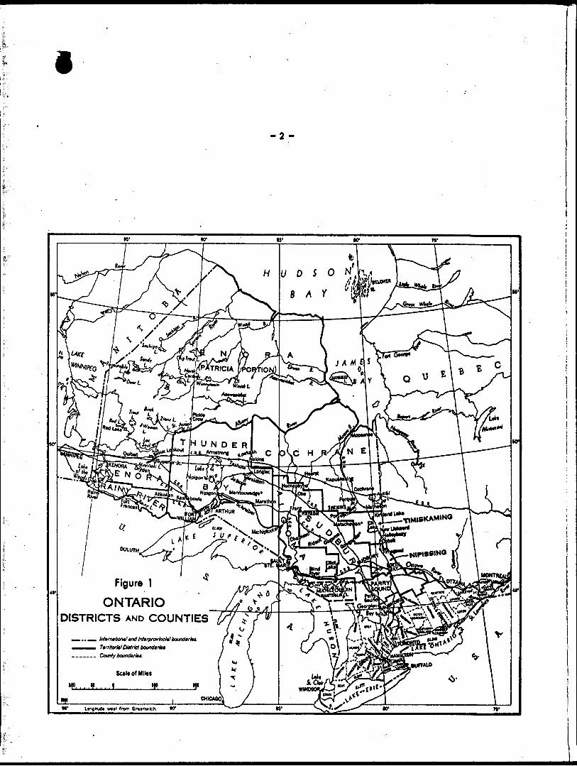
DISTRICT OF COCHRANE
KARPOVITCH ROUSSEAU GROUP, HOYLE TOWNSHIP
RECEIVEDAPR " 91984
MINING LANDS SECTION
TIMMINS, ONTARIO
MARCH, 1984
BRUCE T. EVANS.
KERR ADDISON MINES LTD.
42A11SE0138 2.6601 HOYLE 010C
TABLE OF C... ....
INTRODUCTION
LOCATION AND ACCESS
LINECUTTING
PROTON MAGNETOMETER SURVEY
MAGNETOMETER SURVEY RESULTS
CONCLUSION AND RECOMMENDATIONS
CERTIFICATE
GEOPHYSICAL TECHNICAL DATA STATEMENT
APPENDIX A. PROTON MAGNETOMETER SPECIFICATIONS
iINTRODUCTION
In February of 1984, Kerr-Addison Mines Limited contracted
Exsics Exploration Limited of Timmins to perform a Proton Mag
netometer Survey of 20 claims located in Hoyle Township,
District of Cochrane, Porcupine Mining Division. The claims
are listed below and their locations shown on Fig. 3.
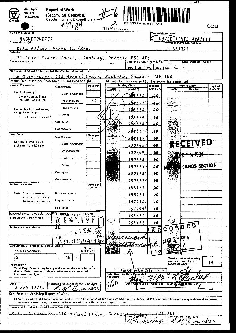
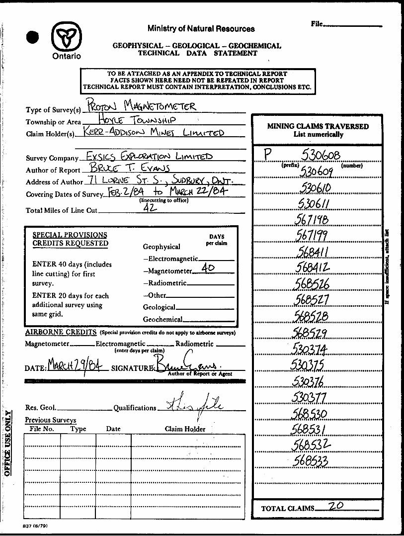
P 530608 P 568528530609 568529530610 530374530611 530375567198 530376567199 530377568411 568530568412 568531568526 568532568527 568533
The grid plan and contoured magnetometer results are includ
ed in this report and are located in the back pocket.
LOCATION AND ACCESS
The 20 claim block is located in central Hoyle Township,
Concessions 3 and 4, Lot 7 and 8.
Access to the property is by gravel road from South Porcupine
to the Canamax Bell Creek property, then 2 miles by snowmobile
on a winter road ends on the property.
LINECUTTING
42 miles of line were cut over the entire property. The base
line is cut at 180 azimuth along the east boundary of the prop
erty and a tie line at 180 along the west boundary. The cross
lines are cut at 270O and at 200 foot intervals, from L26S to
L52N. The crosslines are chained at 100 foot station intervals.
i-2 -
Figure 1
ONTARIODISTRICTS AND COUNTIES f// ̂'
.— ..^ Innmlnntl mo Imtrpnvlnclil eoundirlti
County bourtdvin.
SctliofMIki
N* Longitudt wiir from 6r*inwlch (O*
•:..-"01-a
.
. : ,/ ./- ;,-,-.-a
-t-....--\ S
, " ..f. !
i l-''i
"y-^
" J n
il1
~5
\ ^
TV
"1
\^}~
j
y
f '
:r——
-x
X
:U-—
—.
1 /
. :Y
_
:.
^*i i
p i* t -.i
..^v^rr-^-f^rh^s
XV
"1!**-
-s ^v
U-^,/
^ J—
——
"' s is ^—
- j v---" *--i—
-4X
^'4—-t—
~4^z—
-fs

...VL ^ -Sf — - *HOt't-cV cQioic1 (aiQicl
^flSSjwiLlSJH^
^;- ;
(SU5ottu^\
^*ttan*
PROTON MAGNETOMETER SURVEY
An EDA PPM 350 Portable Proton Magnetometer was used during
the field survey. Corrections for diurnal variation were made
with the use of an EDA PPM 400 Base Station Proton Magaetometer
located in Mountjoy Township. Field resolution and correction
were made to jh 0.1 gammas.
Technical and operational specifications of the EDA PPM 350
and 400 Proton Magnetometers are included as Appendix A of this
report.
MAGNETOMETER SURVEY RESULTS
Throughout this survey, a relatively flat magnetic response
was encountered, with total magnetic relief at the extremities
being 220 gammas. Contouring of the data to a 5 gamma contour
interval revealed only one feature, be it structural or format-
ional. The single magnetic feature strikes NW/SE from LZON/
0+OOW to L5ZN/45+OOW and has a surface magnetic width of 1200
ft. A weak magnetic low lineation strikes due north from L26S/
14+OOW.
CONCLUSIONS AND RECOMMENDATIONS
The entire claim block is covered with a thick layer of clay
ey, sandy overburden, up to 120 feet in places, thus impairing
a good geological interpretation. To help further understanding
of the structure a deep EM survey such as Max Min or EM37 is
recommended. Further to. continued geophysical surveys, diamond
drilling is recommended to determine what unite are being dealt
with.
The close proximity of several gold showings, Canamax Bell
Creek, Broulan Reef, and the Hallnor deposit to this property
makes it worth examination, especially when to this point little
work has been performed on this ground and presently there is
a poor understanding of the geology in this area.
CERTIFICATE
I, Bruce T. Evans, hereby certify that:
1) I am a 1982 graduate geologist, of the 6.S.C. (Hons)
Geological Sciences program at Queen's University at Kingston,
and I have worked in my field since graduation, and for the
past year I have been in the employ of Kerr Addison Mines
Limited as a geologist.
2) The field work described in the attached report was carried
out under contract by Exsics Exploration Limited of Timmins,
Ontario. The interpretations and conclusion written in this
report are based on my training and professional experience.
BRUCE T. EVANS
KERR ADDISON MINES LIMITED.
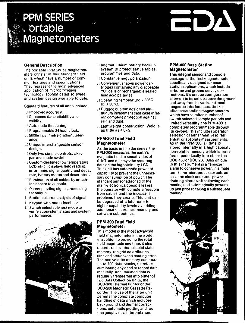
PPM SERIES.brtable Magnetometers
General DescriptionThe portable PPM Series magnetom eters consist of four standard field units which have a number of com mon features and specifications. They represent the most advanced application of microprocessor technology, sophisticated software and system design available to date.
Standard features of all units include:L! Improved accuracy.: Enhanced data reliability and
validity.L l Automatic fine tuning.L i Programmable 24 hour clock.U 5000nT per metre gradient toler
ance.l.} Unique interchangeable sensor
design.Only two simple controls, a key pad and mode switch. Custom-designed low temperature LCD which displays field reading, error, time, signal quality and decay rate, battery status and descriptors. Elimination of all cables by attach ing sensor to console. Patent pending signal processing technique.Statistical error analysis of signal. Keypad with audio feedback. Switch selectable test mode to verify subsystem status and system performance.
L l I nternal lithium battery back-up system to protect status tables, programmes and data.
11 Constant energy polarization.L] Convenient snap-in power car
tridges containing any disposable "C" cells or rechargeable sealed lead acid batteries.
. J Operating temperature - 300 C to -t-500 C.
L l Rugged custom designed alu minum investment cast case offer ing complete protection against rain and dust.
i J Lightweight construction. Weighs as little as 4.0kg.
PPM-200 Total Field MagnetometerAs the basic unit in the series, the PPM-200 measures the earth's magnetic field to sensitivities of 0.1 nT and displays the resulting data on the high visibility LCD. This unit has automatic power-off capability to prevent the unneces sary consumption of power. The standard sensor attached to the main electronics console leaves the operator with complete freedom from cables and the incessant problems they create. This unit can be upgraded at a later date to higher capability levels by adding additional electronics, memory and software subroutines.
PPM-300 Total Field MagnetometerThis model is the most advanced field magnetometer in the world. In addition to providing the total field magnitude and time, it also records on its internal solid state memory, the grid co-ordinates (line and station) and reading error. The non-volatile memory can store up to 700 data blocks, therefore eliminating any need to record data manually. Accumulated data is regularly transferred into either of two Data Collection Units, the DCU-100 Thermal Printer or the DCU-200 Magnetic Cassette Re corder. The use of the latter unit permits the complete computer handling of data which includes background and diurnal correc tions, automatic plotting and rou tine geophysical interpretation.
PPM-400 Base Station MagnetometerThis integral sensor and console package is the first magnetometer specifically designed for base station applications, which include airborne and ground survey cor rections. It's unique configuration allows it to be set up above the ground and away from hazards and local magnetic interferences. Unlike other base station magnetometers which have a limited number of switch selected sample periods and limited versatility, the PPM-400 is completely programmable through its keypad. This includes operator selection of either relative (differ ential) or absolute measurements. As in the PPM-300, all data is stored internally in a high capacity non-volatile memory which is trans ferred periodically into either the DCU-100 or DCU-200. Also unique to this instrument is a "snooze" alarm to conserve power. In simple terms, the microprocessor acts as an alarm clock and turns power- draining circuits of f following each reading and automatically powers up just prior to taking a subsequent reading.

SpecificationsDynamic RangeSensitivityStatistical Error ResolutionStandard Memory CapacityAbsolute Accuracy
Display Resolution Capture Range
Display
Gradient Tolerance Sensor
Sensor Cable
Operating Environmental Range
Power Supply
Battery Cartridge Life
Weight and Dimensions Instrument Console only Lead Acid Battery Cartridge Sensor
System Complement
18,000 to 93,000 gammas ±0.02 gamma 0.01 gamma1383 data blocks or readings ±15 ppm at 23 0 C, 50 ppm over the operating temperature range 0.1 gamma± 2 5 07o relative to ambient field strength of last stored value Custom-designed, ruggedized liquid crystal display with an operating temperature range from -350 C to-f55 0 C5,000 gammas per meter Optimized miniature design. Magnetic cleanliness is consistent with the specified absolute accuracy Remains flexible in temperature range; includes low strain connector-35 0 C to -h 55 0 C; Q-100% relative humidity; weather-proof Non-magnetic rechargeable sealed lead acid battery cartridge or belt; or, Disposable "C" cell battery car tridge or belt2,000 to 5,000 readings, depending upon ambient temperature and rate of readings
3.4 kg, 238 x 150 x 250 mm1.9kg1.2 kg, 56 mm diameter x 200 mmElectronics console; sensorwith 3-meter cable; sensor staff;power supply; harness assembly;operation manual.
EDA is a pioneer in the development of advanced geophysical systems and has created many innovations that increase field productivity and lower survey costs.
EDA's OMNIMAC series consists of the PPM-350 Total Field Magne tometer, PPM-400 Base Station Magnetometer, and the PPM-500 Vertical Gradiometer. Contact us now for details.
EDA Instruments Inc. 1 Thorncliffe Park Drive Toronto, Ontario Canada M4H109 Telex: 06 23222 EDA TOR Cable: Instruments Toronto UJ16) 425-7800
In USAEDA Instruments Inc5151 Ward RoadWheat Ridge, ColoradoUSA 800?3Telex 00 450681 DVR(503)422-9112
Printed in Canada
KERR ADDISON MINES LIMITEDE STREET SOUTH, SUDBURY, ONTARIO
TELEPHONE (705) 673-1335
MAILING ADDRESS: P.O. BOX 1375 SUDBURY, ONT.
P3E 5K4
S, 1984.
Mi.n-i.ng Land* Section,M -i, n /t .6 -tt y o fi NaturalRoom 6610, W hi.tne.y Block,
Toronto, Ontario. M7A 1 W3
Peat M-t. Matthe-WA :
Ple.a*e. {,i.nd e,ncloAe.d 2 c op-tei eac^i o f, two Ma.gne.tomz.te.fi Su.nve.yt> in Hoyle. T oww^^i/cp, Timmins,
aie. me.ant to fial^ll partial wonk ie.qu*itie.me.ntA on the. clatm^ c.ove.titd by tht Ifi you should kave. any que-AtionA you. may contact me. at (705) 673-1335.
tiuly,
R.K. Ge/tmand^on, P hVV4.6ttL4.Ct Ge.OlOQ4.4t.
RECEIVEDAPR" 9 W
MINING UND5 SECTION
43A11SE0138 2 .668) HOYLE O2O
NTS 42A/7J
WORK REPORT ON CLAIMS
P5S060B i 609; P530374-377;PSS5124 t 125} P56719B t J 99PS6Z411 i 4-12} ?56t526^S32
KERR APPIS0N MIWES L TV,
HOVLE TOWWSHJP, ONTARIO
RECEIVEDAPR - 9 1984
AWNING UNDS SECTION
.K, G e/imundion, '* 79*4
42AHSE0138 3.6601 HOYLE 0S0C
IWTROPUCTIOW.... . ......... ...,. . ......, . V........ , .....,... I
PREVIOUS WORK... . .... ...,, .... . ...,...... ... .... ..., .., ....2
PHYSIOGRAPHY.. . . , . . . . . ,., . . . . . . . , , . . , .. . . , ., . .. . . , .. , . , , , . .3
LIWECUTTIWG......................... , . . . . . , , , , . . . . , , . ......4
GROUWP MAGWETOMETER SURl/E^... . . . . . . , . . . . . ... . .. . ,, ., . . . .... 5
MAGWETOMETER RESULTS...................,..............,..,. 6
CONCLUSIONS i R ECOMMEWPATIOWS-MAGWETOMETER SURl/EV. .. .., ... . 7
APPEWPIX........,..........,...,.....,....,......... ...... . S
STATEMEWT........,........................,,,...,,..... f ,..9
LOCATIOW MAP........................,............,.....,...?a
MAGWETOMETER MAP....................................,..;..

foity fioufi (44) contiauou* claim* in Hoyle, Tou)n*hip a/ie hzid unde.fi option by Ke.ii, Addi*on Mine.* Limited, 71 Lome, Stie.e.t South, Sudbury Ontario, P 3C 4 P2, ^nom R . R ouA6e.au and Ed K atipovitch 0 jJ Timmins. The. p*iope.tity i* tocattd about m. mile.* notitke.a.*t o^ the. C anamex, B ttl C ^eefe Pfioptity and 6 notith ofi Pofic-upine., The. claim* we/ie o ption&d in 1983.
Between M aich 2^ and kpnit I S , J 9 S3, Ke.M. AddisonLimited ne.- Qtiiddzd and fian a magne.tome.te.tL Auive.y ove.1 att oh. ofj t he. fioiJLowinQ 19 claim* ofi the, pn.ope.tLty.
P530608 and P530609 P530374 to P530377 PS5S124 and PSSS12S PSO&S26 to P568532
, The. above, claim* a/te n e,Qi*te.n.e.d unde,n. Ed Katipovitch, 185 5 Avenue, Timmin*, Ontario, Q4N 5L1 .
P567198 and P 556J99 P568411 and P568412
The. above. {2} claim* a/te n e.ai*te.fie.d undei Bob Rouleau 225 R OA* A venue, Timmin*, Ontario P 4W 4 M6.
Two dn.Ul hole.* (KH-83-1 and KH-83-2) totalling 1406 6e.e.t we/ie c omple.te.d during ApJiil 1983.
-2-
PREVI0US WORK
Ptie.v4.ouA tie.potite.d wotik w a* done b y a Au.c.c.e.AAlon ofi Companie.A o n a-C-d o n. position* O jJ -tne ptiope.tity 4 -tnce J965,
1) P/ioe-ttu M/tneia-td, 1965: Mag. t E .M. ove/i the, *oathe.fin ^ o\ Lot* 611 , Conce^A/con If,
2) C on&otJidattd Manitoba, 1969; M ag. 2 E. M,3) Sa^o and A^oc-ca-te.*, J969; Mag. t E .M. ove/t
-the n oith k o tf Lo^: 7, Conce^A^on 3,Alto, 19S1} l/LF E.M.
Wo A^ttong E.M. c onductor a /te p/ie^en-t b ut a a e/u.e.6anomo^-ce^ ^/tend n otithwe.Ate.tily thtioaah the.
notithe.ti patit ofi the. claims in thiAA tie,- analytic o^ the. magne.tome.te.ti Autive.y by ConAol*idate,d
Manitoba 4 now4 a Almilati notithwe.Ate.tily ttitnd ove.ti the. notithe.tin patit ofi the. ptiope.tity.
Mo tiock e.xpoAu.tie.A atie. ptie.Ae.nt on the. ptiope.tity.
-3-
The. en^Ue claim atita i.* fitat and JO.*.* within iwamp a nd ma^feeg, Wo dtbtino.*. d/ia-tnape^ ant p/teien-t.
-4-
The. osii.Q4.nal Consolidated Manitoba. gtiid {400 ^oot] was Ae-blazed a nd c.haine.d. N ew i*ine.A weie blazed and Ragged .60 that the. gild line.* a/ie 2 00 tfee-t apait. Station* on the, g -tx.d
a^.e 1 00 6e.e.t apant and ie.ad'ingA we/te taktn e.ve,iy 50 ^e.e,t, Atation* and tine.4 atie. numbe/ied on the. i ame ba^ei a* that
^on. Consolidated M -cnei including, e x-ten^/con OjJ ^^nei on-to claim* S68411 t 412, and 567198 and 7 99 { originally dane, by Salo and AAAociate.*) . L ine.* w e^e e.AtabliAhe.d by Mike. Vanai and M a^ife Lew/t-6.
...5
-5-
5 R O U W P-M A G W E T O M E T E R-i-——--.
The. lnAttiume.nt u*ed wa-6 a Sc-int/iex Mode-t MP-2/en conjunction with a Sclnttie,*. M ode-6 MBS-2 faa^e
magnetometer,. The -tn4tr.ument.4 a^te accurate to - one gamma.
FOA ea^e o fi plotting data the, p/ie^x "59" wai omitted 40 that 59304 gamma* l* thown a* 304. The ^.eiu^t* M)er.e contoured at 5 g amma IntzivalA by G e/tmundion who 4uper.u-c.-6ed the ope/tato/14, M-i-fee ^ana^. and Mar.fe Lew-c*.
i i i O

-7-
PfLe.fLe.qa4.A4.te.A ^on de.64.n4.ng dH4.it tange-tA ate. bate.d apon the. 4,nte.fi4,e.o.t4.onA ofi nofith-Aoath Atfiac.tafie.4 and votcan-ia. and on Ae.dime.ntafLy b ed^. T ht notLtn-Aoath Qfi4.d it* not c owduC'Cue ^o-t d e.64.n4.ng A4.gn4.64.o.ant notith-Aoath. ttie.nd4.ng
Vnion. to add4.t4.onat dotting tnit pon.t4.on O jJ the, pnope,n,ty Anoatd b e A atLve.ye.d magne.t4.c.atty ating an e,a4t-u)e,4t gti4.d,
Te.ntat4.ve. dnilt tax.ge.t4 inctadt 1 ) the. fie.tat4.ve.ty 4,nte.n*e. magne.t4.c high-tow ty-ing pfL4.mafL4.ty4.nc.ta4.mA 520606 and 5 3037.7.
The. Aabtte. magne.t4.c. tow tne.nd e.xte,nd4.ng nofith rf.ft.om 20W 4.n c.ta4.m 56841 1 into dtaim 568529 may be. fie.tate,d to a tow ae,fio- magne-tia. tne.nd which c^o44e^ n ofLth-toath thfioagh mac.h o rf H oyte. Township,
Sabmitte-d,
R. K. Ge.fimandAon, PhD Ge.otog4.At,
RKG:pt
*
f:
l
lI; l

w 073^2 7721/3 w? w vo uoyy.vv'dy.yv
-31*70(7701/04 ?o
QU
/5q
•- m•t :, f
4;
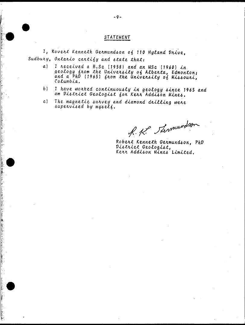
-9-
STATEMENT
I, R ove.tit Ke.nne.th G ei.mund.6on o fi 110 Hytand Sudbury, Ontario o.e.tit'ifiy and state. that:
a) l /lece-cved a B . Se (195*) and an MSc ( 1960) -en ae.otogy ^non\ the. Uni\je.tiAity ofi ktb&nta, and a P hV ( 1965) ^ lorn the. Untve.iA'ity o\ Cotumbla.
b] I have, wo/ifeed continuous t y In gtotogy Ainct 1965 and am V4.Atti4.o.t Ge.otoQJ.At (Jo/t Ke^.4 Add-onc) T he. magne-tlc Autive.y and diamond dotting
Robe.it Ke.nne.th Gtimundton, PhV lct Ge.otoQiAt, Addison Mine.6 Llmlte.d.

/fe'/f/f
HOYLE TWR '
•'lv'
CLAIMS LOCATIONtt^Lf^f^ . . ' —j
LOT
WHITWFY TU/P
Ministry ofNaturalResources
Ontario
Report of Work(Geophysical, Geological, Geochemical and Expenditures)
42A!1SEei3e 2.6681 HOYLE
The Minii.g 900Type of Survey(s)
MAGNETOMETERClaim HolderU)
Ke.il A dd-on M *ine.A L'imi.te.d,
Township or Area
CTH0!aT*)(WTS 42A/7in i - frtffpector's Licence No.
A35072
M
Address
77 L ome. Stie.e.t South, Sudbum. Ontai4.o P 3C 4P2Survey Company Date of S
Day | 1
urvey (from 4 to) Total Miles of line
rio. l Vr. j Day | Mo. l Yr.
Cut
Name end Address of Author (of Geo-Technica! report) - '
Ken Ge.imund.60K, 770 H uiand Vii.ve., Su.dbu.in. OntaiJio P 3E JR6Credits Requested per Each Claim in Columns at right Mining Claims Traversed (List in numerical sequence)Special Provisions
For first survey:Enter 40 days. (This includes line cutting)
For each additional survey: \using the same grid: ;
Enter 20 days (for each) \
Man Days
Complete reverse side and enter total(s) here
Airborne Credits
Note: Special provisions ; Electromagnetic credits do not apply to Airborne Surveys, i Magnetometer
Expenditures (excludes pov e?Type of Work Performed
Performed on Claim(s)
Calculation of Expenditure Day
Total Expenditures
S
Date
Ma*cfe 1 4/84
InstructionsTotal Days Credit! may be apportioned et the claim holder's choice. Enter number of days credits per claim selected in columns at right.
Certification Verifying Report of Workl hereby certify that l have a personal and intimate knowledge of the facts set forth in the Report of Work annexed hereto, having performed the work or witnessed same during and/or after its completion and the annexed report is true.
Name and Postal Address of Person Certifying
1-0-Certified by (Signature)

Ministry ofNaturalResources
Ontario
Report of Work(Geophysical, Geological, r : "'' Geochemical and Expenditures)
Mining Act
Instructions: - P lease type or print, ;" : ~.'/'"•""-•-'- If number of mining claims traversed
exceeds space on this form, attach a list. Note: — Only days credits calculated in the
"Expenditures" section may be entered in the "Expend. Days Cr." columns.
Type ot S urvey(s)
Claim Hoider(s)
wothip
UoYuS'^ "Jpro^pector's Licence tfo.
Survey Company
Name and Address of Author (of Geo-Technical report), — - - f**™- f t *Ev/vos , 7c
..^ . ~ i. TOate
e^-- __ . l dh
. ~ i-.-TOate of Survey (from Si to)
ffiiffirt'^
. y 7/ /g^
—.. -—-—fTptsl Miles of line Cut
Credits Requested per Each Claim in Columns at right Mining Claims Traversed (List in numerical sequence)
.".' CvMirv tn?: l \ \i v -j a i.^-rbon;-:. rmc. ;ptmiato knowifocit o* tn-.- ieicii se: fortn m the Rcpori of Vvork annexed nt-r.si:;: s.'irne Ciurmn PHO o r rift'":" its completion and the annexed report is true.
; pcnforme'l tne work
IN^me ana Postal Address i
.y 7/
Ontario
Ministry of Natural ResourcesGEOPHYSICAL - GEOLOGICAL - GEOCHEMICAL
TECHNICAL DATA STATEMENT
File.
TO BE ATTACHED AS AN APPENDIX TO TECHNICAL REPORTFACTS SHOWN HERE NEED NOT BE REPEATED IN REPORT
TECHNICAL REPORT MUST CONTAIN INTERPRETATION, CONCLUSIONS ETC.
Type of Survey(s) Township or Area Claim Holder(s)—
Survey fhmpany
Author of Report Address of Anrhm- 71
Covering Dates of
"T-
ST- S - 34o
Total Miles of Line Cut.(linecutting to office)42-
SPECIAL PROVISIONS CREDITS REQUESTED
ENTER 40 days (includes line cutting) for first survey.ENTER 20 days for each additional survey using same grid.
Geophysical —Electromagnetic.
DAYS per ci aim
—Radiometric-Other,——-Geological.Geochemical.
AIRBORNE CREDITS (Special provision credit* do not apply to airborne lurveyi)
Magnetometer. -Electromagnetic. . Radiometric
DATE:
(enter dayt per daim)
. SIGNATURE
Jaim) S\
C-PvLuxjCyUAuthor of Report or Agent
Res. Geo!.. .QualificationsPrevious Surveys
File No. Type Date Claim Holder
MINING CLAIMS TRAVERSED List numerically
(number)
ias
i * * fft 9f^n J* vn * '
TOTAL CLAIMS.
837 (B/79)
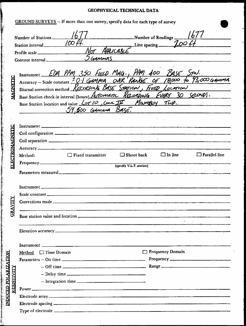
GEOPHYSICAL TECHNICAL DATA
GROUND SURVEYS — If more than one survey, specify data for each type of survey
l G l l ________________Number of Readings l O f fNumber of Stations
Station interval —— /O® PT'
MorNumber of Readings —Line spacing ____ J-~O® ^~T
Contour interval.
4oo
Station location and value CQ7"'/^ j
ELECTROMAGNETICInstrument
flnjl mn f i gil ra t inn
Arrnrary
Method: D Fixed transmitter D Shoot back D In lineFrpqiienry
D Parallel line
(ipedfy V.L.F. itation)
Para metprs mea snrerl
Instrument.constant
made.
Base station value and location.
Elevation
Instrument
INDUCED POLARIZATION
Method D Time DomainParameters — On time
H - Off tjmp5* — Delay time ..... —i— i '
V. H Power
Electrode array ————————————————————Electrode spacing . —————————————————Tvne of electrode . ........ . ———————————
Q Frequency Domain FrequencyRange
SELF POTENTIAL
Instrument_______________________________________ Range.
Survey Method ———————————————————————————————————————————
Corrections made.
RADIOMETRIC
Instrument——-Values measured,Energy windows (levels)——.—^———————.^^———.^——-—..—^-^--——.—.^..
Height of instrument___________________________Background Count.
Size of detector—^————^——^—^————.————.^--..-—--^^^—^™--—.--—-
Overburden _____________________________________________(type, depth — include outcrop map)
OTHERS (SEISMIC, DRILL WELL LOGGING ETC.)
Type of survey^————^—.-..——^^—————-.^——-————————-
Instrument —^^—-——————-^^——————-—.^^————————
Accuracy————————————————————————————————————
Parameters measured.
Additional information (for understanding results).
AIRBORNE SURVEYS
Type of survey(s) ̂ —— Instrument(s) —————
(specify for each type of survey) Accuracy——^———————-^—
(specify for each type of survey) Aircraft used ——^^—^^————~.^^————.^^——^—^———
Sensor altitude.
Navigation and flight path recovery method.
Aircraft altitude______________________________Line Sparing
Miles flown over total area________________________Over claims only.

GEOCHEMICAL SURVEY - PROCEDURE RECORD
Numbers of claims from which samples taken.
Total Number of Samples. Type of Sample.
(Nature of Material) Average Sample Weight———————
Method of Collection————————
Soil Horizon Sampled. Horizon Development. Sample Depth———— Terrain——^—————
Drainage Development——————————— Estimated Range of Overburden Thickness.
ANALYTICAL METHODSValues expressed in: per cent
p.p. m. p. p. b.
aDa
Cu, Pb,
Others_
Zn, Ni, Co, Ag, Mo, As.-(circle)
Field Analysis (.Extraction Method. Analytical Method- Reagents Used——
Field Laboratory AnalysisNo. .—————^^—
SAMPLE PREPARATION(Includes drying, screening, crushing, ashing)
Mesh size of fraction used for analysis————
Extraction Method. Analytical Method . Reagents Used——
Commercial Laboratory (- Name of Laboratory^ Extraction Method—— Analytical Method—— Reagents Used————
.tests)
.tests)
.tests)
General. General.

Ontario
1 Ministry of Natural Resources
GEOPHYSICAL - GEOLOGICAL - GEOCHEMICAL TECHNICAL DATA STATEMENT
File.
TO BE ATTACHED AS AN APPENDIX TO TECHNICAL REPORTFACTS SHOWN HERE NEED NOT BE REPEATED IN REPORT
TECHNICAL REPORT MUST CONTAIN INTERPRETATION, CONCLUSIONS ETC.
Type of Survey (s). Township or Area. Claim Holder(s)_
o Vi e
Survey Company
Author of Report A- A^ @- z rt S* V M /J •rt A)Address of Author 1 10Covering Dates of Survey
Total Miles of Line Cut ..(linecutting to office)
SPECIAL PROVISIONS CREDITS REQUESTED
ENTER 40 days (includes line cutting) for first survey.ENTER 20 days for each additional survey using same grid.
Geophysical —Electromagnetic.
DAYS per ci aim
—Radiometric-Other—Geological.Geochemical.
AIRBORNE CREDITS (Special provision credits do not apply to airborne surveys)
Magnetometer. .Electromagnetic. . Radiometric
DATE:.
(enter day* per claim)
SIGNATURE:.Author of Report or Agent
Res. Geol.. .Qualifications.Previous Surveys
File No. Type Date Claim Holder
MINING CLAIMS TRAVERSED List numerically
(number)
•M
l
y "7
"7
TOTAL CLAIMS.
837 (6/79)

GEOPHYSICAL TECHNICAL DATA
GROUND SURVEYS — If more than one survey, specify data for each type of survey
Number of Stations Station interval—— Profile scale____
mg. -.ht f - nttAAup sWA o Q i . i^ y ^
Number of Readings l *2 b •*~.ane spacing. i
J
Contour interval.
r: Instrument ^c-wrtfe* /tf r- 4 It
Accuracy — Scale constant. Diurnal correction method.
V-a.*,e
Base Station check-in interval (hours). Base Station location and value ___
S
00 C) -e-GNETIC
RO
E
InstrumentCoil configuration Coil separation —. Accuracy _____ Method: Frequen cy ____
d Fixed transmitter Shoot back D In line CD Parallel line
Parameters measured.(specify V.L.F. nation)
GRA
Instrument.Scale constant.Corrections made.
Base station value and location
z;c1•^NH"
tt<
2QeQ3
Hb>OH
bM(fiMcA
Elevation accuracy.
Instrument ——————^— Method D Time Domain Parameters — On time ———
- Off time ——time,
— Integration time.Power _Electrode array — Electrode spacing . Type of electrode
d Frequency Domain—- Frequency ————— Range _______
SELF POTENTIAL
Instrument————————————————————————————————————— Range.Survey Method ___________________________________________
Corrections made.
RADIOMETRIC
Instrument .^-^Values measured.
Energy windows (levels)_____________________________________ Height of instrument____________________________Background Count.
Size of detector^^———-———————^-——————.^^——.^—----..--^.-...-^.Overburden —————————--.———^^^-—^—-——..-..——.....—.———....—.—-————
(type, depth — include outcrop map)
OTHERS (SEISMIC, DRILL WELL LOGGING ETC.)
Type of survey———————————————————————Instrument .̂ —^^^——————————^—^^————
Accuracy————————.—.——^-—...^^^——.-—.Parameters measured.
Additional information (for understanding results).
AIRBORNE SURVEYS
Type of survey(s) ———
Instrument(s) —————(specify for each type of lurvey)
Accuracy—^—^—————^—————(specify for each type of survey)
Aircraft used—-^^^^^^^———^————^—-——-————————
Sensor altitude-Navigation and flight path recovery method.
Aircraft altitude______________________________Line Sparing Miles flown over total area________________________Over claims only.
GEOCHEMICAL SURVEY - PROCEDURE RECORD
Numbers of claims from which samples taken.
Total Number of Samples. Type of Sample.
(Nature of Material)
Average Sample Weight——————— Method of Collection————————
Soil Horizon Sampled. Horizon Development. Sample Depth———— Terrain————————
Drainage Development——————————— Estimated Range of Overburden Thickness.
Mesh size of fraction used for analysis.
ANALYTICAL METHODSValues expressed in: per cent Q
p. p. m. Dp.p. b. D
Cu, Pb,
Others—
Zn, Ni, Co, Ag, Mo, As.-(circle)
Field Analysis (.Extraction Method. Analytical Method. Reagents Used——
Field Laboratory AnalysisNo. —————————.
SAMPLE PREPARATION(Includes drying, screening, cruihing, aihing)
Extraction Method. Analytical Method . Reagents Used ——
Commercial Laboratory (. Name of Laboratory—— Extraction Method—— Analytical Method—— Reagents Used————
.tests)
.tests)
-tests)
General. General.
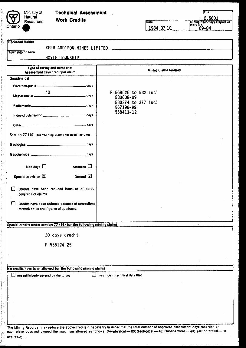
jrr~^ Ministry ot Technical Assess* IVVl Natural ... , . ... V2x Resources Work Credit*Ontario /j^
ment "n* 2.6601
Date Mining Recorder* Report of 1984 07 10 I&-84
Recorded Holder KERR ADDISON MINES LIMITED
Township or Area HOYLE TOWNSHIP
Type of survey and number of Assessment days credit per claim
Geophysical
Electromagnetic dsys
40
nth*r riay.
Section 77 (19) See "Mining Claim* Asmted" column
Geological., .... .... ~. . days
Man days CD Airborne O
Special provision OH Ground 60
CD Credits have been reduced because of partial coverage of claims.
D Credits have been reduced because of corrections to work dates and figures of applicant.
Mining Claims Attested
P 568526 to 532 incl 530608-09 530374 to 377 1nd 567198-99 568411-12
Special credits under section 77 (16) for the following mining claims
20 days credit
P 555124-25
Yo credits have been allowed for the following mining claim!
L-) not sufficiently covered by the survey LJ Insufficient technical data filed
The Mining Recorder may reduce the above credits if necessary in order that the total number of approved assessment days recorded on each claim does not exceed the maximum allowed as follows: Geophysical — 80; Geological — 40; Geochemical — 40; Section 77 (19)—60:828 (83/6)
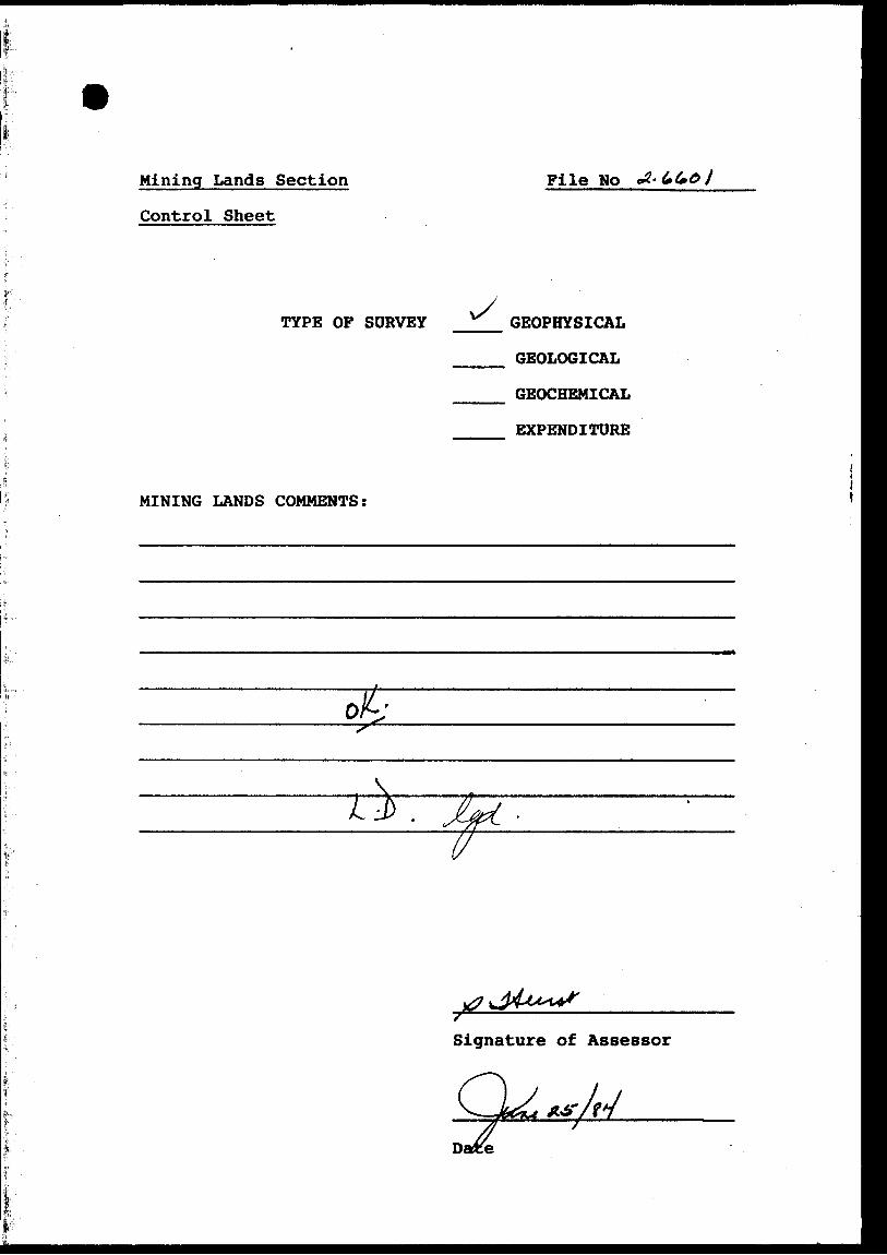
Mining Lands Section
Control Sheet
Pile No
TYPE OF SURVEY GEOPHYSICAL
GEOLOGICAL
GEOCHEMICAL
EXPENDITURE
MINING LANDS COMMENTS:
17
Signature of Assessor
Date

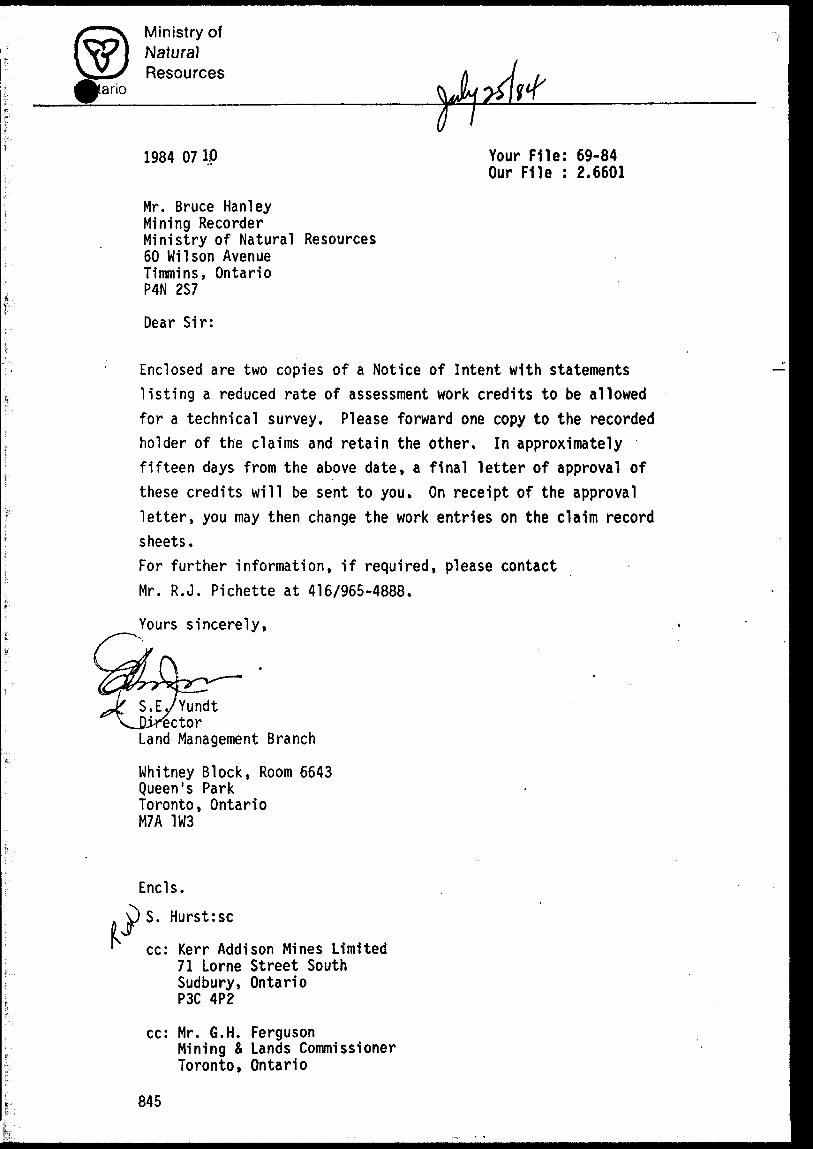
1984 08 08 Your File: 69-84 Our File: 2.6601
Mr. Bruce HanleyMining RecorderMinistry of Natural Resources60 Wilson AvenueTlMRlns, OntarioP4N 257
Dear Sir:
RE: Notice of Intent dated July 10, 1984.Geophysical (Magnetometer) Survey on Mining Claims P 530608 et al In the Township of Hoyle,
The assessment work credits as listed with the above mentioned Notice of Intent, have been approved as of the above date.
Please Inform the recorded holder of these mining claims and so Indicate on your records.
Yours sincerely,
S.E. YundtDirectorLand Management Branch
Whitney Block, Room 6643Queen's ParkToronto, OntarioM7A 1W3Phone: (416) 965-6918
S. Hurst:se
cc: Kerr Addison Mines Limited 71 Lorne Street South Sudbury, Ontario P3C 4P2
cc: Mr. 6.H. FergusonMining 4 Lands Commissioner Toronto, Ontario
cc: Resident Geologist Timmins, Ontario
Ministry ofNaturalResources
ano
1984 0710 Your File: 69-84Our File : 2.6601
Mr. Bruce HanleyMining RecorderMinistry of Natural Resources60 Wilson AvenueTimmins, OntarioP4N 2S7
Dear Sir:
Enclosed are two copies of a Notice of Intent with statements listing a reduced rate of assessment work credits to be allowed for a technical survey. Please forward one copy to the recorded holder of the claims and retain the other. In approximately fifteen days from the above date, a final letter of approval of these credits will be sent to you. On receipt of the approval letter, you may then change the work entries on the claim record sheets.For further information, if required, please contact Mr. R.J. Pichette at 416/965-4888.
Yours sincerely,
'Yundt "ector
Land Management Branch
Whitney Block, Room 6643 Queen's Park Toronto, Ontario M7A 1W3
Encls.
S. Hurst:sc
cc: Kerr Addison Mines Limited 71 Lorne Street South Sudbury, Ontario P3C 4P2
cc: Mr. G.H. FergusonMining S Lands CommissionerToronto, Ontario
845
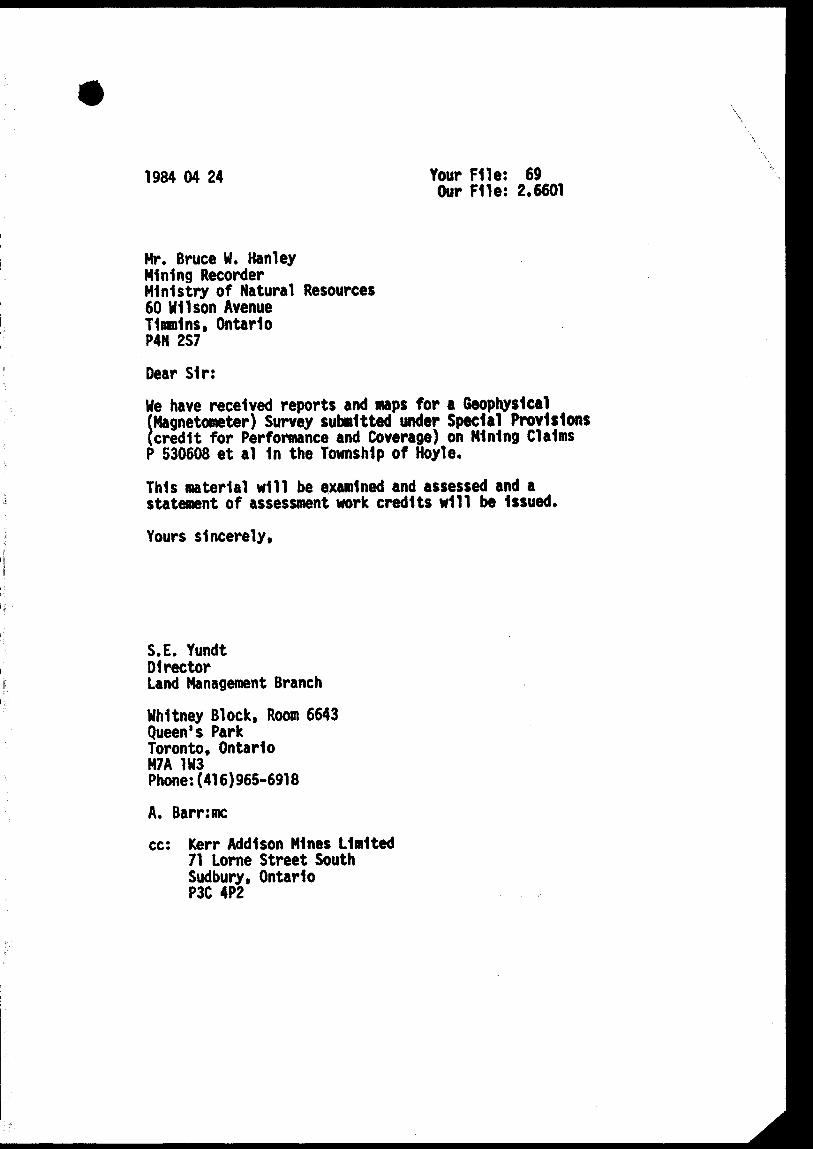
1984 04 24 Your File: 69 Our File: 2.6601
Mr. Bruce W. HanleyMining RecorderMinistry of Natural Resources60 Wilson AvenueTlmnlns, OntarioP4N 2S7
Dear Sir:
We have received reports and maps for a Geophysical (Magnetometer) Survey submitted under Special Provisions (credit for Performance and Coverage) on Mining Claims P 530608 et al 1n the Township of Hoyle.
This material will be examined and assessed and a statement of assessment work credits will be Issued.
Yours sincerely.
S.E. YundtDirectorLand Management Branch
Whitney Block, Room 6643 Queen's Park Toronto, Ontario M7A 1W3 Phone:(416)965-6918
A. Barr:me
cc: Kerr Addison Mines Limited 71 Lorne Street South Sudbury, Ontario P3C 4P2
Ministry ofNaturalResources
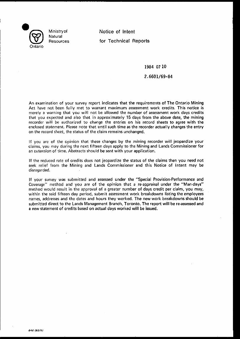
Notice of Intent
for Technical ReportsOntario
1984 0710
2.6601/69-84
An examination of your survey report indicates that the requirements of The Ontario Mining Act have not been fully met to warrant maximum assessment work credits. This notice is merely a warning that you will not be allowed the number of assessment work days credits that you expected and also that in approximately 15 days from the above date, the mining recorder will be authorized to change the entries on his record sheets to agree with the enclosed statement. Please note that until such time as the recorder actually changes the entry on the record sheet, the status of the claim remains unchanged.
If you are of the opinion that these changes by the mining recorder will jeopardize your claims, you may during the next fifteen days apply to the Mining and Lands Commissioner for an extension of time. Abstracts should be sent with your application.
If the reduced rate of credits does not jeopardize the status of the claims then you need not seek relief from the Mining and Lands Commissioner and this Notice of Intent may bedisregarded.
If your survey was submitted and assessed under the "Special Provision-Performance and Coverage" method and you are of the opinion that a re-appraisal under the "Man-days" method would result in the approval of a greater number of days credit per claim, you may, within the said fifteen day period, submit assessment work breakdowns listing the employees names, addresses and the dates and hours they worked. The new work breakdowns should be submitted direct to the Lands Management Branch, Toronto. The report will be re-assessed and a new statement of credits based on actual days worked will be issued.

•A-
v/
* SO (e 0? y/vX
33037*1S

C5\o
vP-s^
OA^ o^ -^^\
^\v^ s-
- /*aa-.
;~-.^^"v .
^-'^^r*;t^ff-t ' ^-i',';-'2V'"lLl :.Stt-irJ*ffR^*' " ' ,- ' **fP? ;;^-,*:-W^s-^jp ,, ' *^s^t^J***-C'-'S i :"!'X
Jlfe^-fe
-i--H— l
tfLfptSlttk- fl
HOYLE TWR
CLAIMS LOCATION
Xiw
-yteV "P L ,'jc
O -w 'O- foe 6*;
2.00 *
2W/
*3\
^/0V
-*.'ft*
o 3 -c
- je*.-a*-/ '^. -v^ ~ - .
. spf•#•3
• •JcV ^ . - '
' - Se/
•^f? -'"
- f*.?~ - - ' - j ay -
. 3*7
" ."a**-
•/f^
• 4of
•90?
x ̂ 0-—— -,/'
' *i?fl•^w•2^
7 ; ^: :'^y ;. 3 00- ' . ~ . , - ^
^3,o
-•*off
- - •"'5tfV~ " " - '
. - S^V k -' V5 /' \ 'War " j-i/e- ^01^ .^^•^-j,' '3o4
•50-7^ __ 30? - --.-30^'
•3oJ,
"3J*, - - 3ojr- - -
'J?i ~ " - 3oj-, .•3^
•a**- 303, *W3
30^.3c^
30*
•30-,-
3oo
3C3
,3o-3AS*' ~. '',3oo ^' ,. . '.^a.
c , '1 A' - - -
'•i M ; ( .J, i
' ^C,'*,' ' S? 1'
• 9a^ ^i^ 'i
- ??v
• •9o*;l i ''5o*
' -lot
, to'/ \ S \ ^ '
^3/ o f- i'1 ' ,-
.tP• 3 *?-' y
40V
&0V
3o,
t*Z
O^tf"W
;19?
2-?^
• /w ^ .t?*
&V
00 /3Z. Z
- -^5
i
2*v^r\s-
.a^o /OS
"A
C ' 5-V'2f-3
^ '' -ztv
•ji.ft
• o.*.•Mn"
•2-3 i
• i*-*
•2*5
'-2*'
'JVa
u2**
a v-s
r*--*1,u
'.wr-r** 1 ? -.r-'L./'F',.' v
. 5.6-7 'fi,-'.^-f;.K-— Hftttf* V:-
0t
m;:^ -,- ,j#?i**i--f- i-
42M;"E;;i a-*" 1 HOYLE
200
KERR ADD ISQtf M fA/fS/^'?
/?/
OD
^;^*
ipQVlTCH-tiOUSttHOYLE ~n
O A/T/r/f
G-tif-rOtfcKe 6'O P G Wut Q t~S ' f' 1 ^
Ay; ATA/ ?S3- /., A7
•/f. -,'At-x, -w^tv^-
o*^ o PT/ w
sbtfvzy
^' ArA/;,
.H r?--*?*. J --1 '- -:
/ J K t.* ,*vr- D1
7 ^ w i^(j /c^ 6 W -7 V*/
i
1
-x (
' *si f* i i /*
^
- O~~ *- -^s,'*f *i i 'i ,l.-v
;; VV^'7 -*/
i .ji i iM -v*i* ~-\'v *V v V-J\, ^
- ,, *;
"^^n
^
.•r. . .— —*
.
'
*
'
.
'
-
'
*
^-\ ^\
•J*Jt
HI
It)
8*1
Iff
ty
^tfW ' \
S \
2^ \V \ ' '̂ t \ ^ '
lf'^ \ \ ^ • 1*'?-'-" h V
fl^j i '\ -3**- -" \ ^
14* ^s, V \ 'W3\ ~— — ..— ^ — _2i*S ; ' '.2^
^^s ' (' -'a^^ -. ; ' Ji** -, \ \ v ^-VX -A^ \ N —— -2fr-? \^.'d?? '^*^~. ~- -
l-^- . v '27/
i*Vi^,.- T/ . -1^7 ^
*rt^ ^ -^if^- ̂ -LSis -,v C; -:^,^r" ~" - ~~^~^- - -
i ̂ 1 -' '
' '^7
^2y-7'"S^) 1, .
t 1' 2^ 1h ^ ..^ ; '
^ \ : i o-\ ;^:V— * W* '
iV^ -^^.-C:^- ~ -•^•Jt?A-~' ?C/
*JW
^XC5^•OV
^-^•^x
'4 -t
^290 .'2-^i,
•J3*? ,J,* 3 '^ij.,/ - ^^ x' "^ ~-,/ -- ^'**t"" j/ '^-V "^~-
~ - - " -^ - - ,s V - 1 ' '-3 ''li .~ 'i'A* . /^ -^
- - ~----' JH ^--"' ' ' /^*2/^ , ^' ^^ ' VTC•- ' '-— --^ **\'\'2?t 'Z72. "'"\ \\\
\ ' ' '•i?" ^^3 j jj
•2?'' .' -277* , l 'A v.r j A'^y^.fo ' - z^? - \s
,-'' -2??? , - Avi' '^^((M/ \;^.."^-j.^ "^^--.^^- -. - " ''29-7 \ " ^ - a*a ^ . - -^
?A'i ' "^ t ltof^' S•— - - J J r JL/ . X f. fi ̂ B^,., \ '^™ ^
i - - ̂ fe' -f -3^^ \' **?3 \ v^- - x - \.-- — - "^ -w ^/X?^ r ~ --^rfrf-rr' ' '/l^'^-, - " ^ -*^^ - - "" J\,
, ' (^^2?.' V ^ x ' ^ **^' ; - -̂ ̂ * , "- 't*r^. . '*- v ' '^'f* - XI ' 525 - /^^^ - j~" . '**.y , ^ - ---— .~..~— -"^ ^ ^ ^^\. ^ ^^^ -~^ ^a^TV^'O v -* ^V — "^^--— . •Jt3^- -7~-"-~---''~ -"^" ~-
•,1'oJ ---^,9^ ^-"*"" ^~ 2?tf —--^
' " *~ " "
. ,' ' 1 *7 *Mt/ — -v iA^-, t " ^' '^sj' -i*/ V
' /"^'1?9 * ?tf*. "v
/'i
/'
* ^
•( a*ff-- - - . ^^ - aji y ^ x - , - — 4?j^-'-' ,*^WI V*X- ' - -^-94 '- ' ~ - v l-aw-^" -^ ?-T, ; ^ -'^V-A^^ti: - ] /' ^-'' '^ - '•tf***. "-y ' j/ f -'w ''te*
(*t*-t. , ' i i ^'o. ^ ,S ^ /, ' '^7 '^rW:/.' i . ,' " S^1 j , j. S -^ ( '^i\\'V\-w '^N A*V . \ t : . - ^.w . ,wf 1•T M /' .' Su*t^ ' r l' l * z*?? *vn/l * ^ l t i ^ '. -T " --^
ife //' / ,fi**9lT^\ ( s (iw^*s^'/'-'///^' \ ~XV- "^^ ^5-ju^--^ - ' '/'/'A' ' ^'^'" ' '^~245- -"' , V^^?o? ,' ^* Zffc. . -*K*j^sS' .w ' //;^jtfv**
fc. --::"- ' ^ V ; 'V": '" ! '( ( -JL-!^--^' " ^ ^v'-.y "'r ' xT2̂ -"-::^^7?rrr- ~r -.4^:7^:^^^;•',^'Ai ^ -- - - V^-^ "'-''i*- .".5-^",'-;,-^
v^ \v. iT-^^^-v^- ^rr^f s Vi S ~ - 3^c —— ~-- -- N , i W, \ V \1 \i i7^" —— ̂ -^J .?^ ) ' /,~ ~~' *"\ v v\ A i ' '^ ' Vi/' /'
•^V Y\V\;(J^ _ -. ^''fV^V' /^. w^\\ j ^ i i'tj^T^:^ .y//*^) ; j ; . '^^ *** '"'^^' ''^H'\ ' 1 Vte '-'^-3 ''J;'//'/ ; J ' ^ '-'i 'val ' f f l , - - - - - - - - ^
-
-(t j
-
*
-i'-l ao s" iia.
.^f,X " 'iff
^ ,, -"3. *yt^J 3. ^-j-
' 2.^
* ^ 7i?
.' ' * -Z-??'^^'^
*2?9
- ?-6Cx
•* , 3*i
P ^BJ ^^ ^~^-n- /;X /y
x "'''.'^3 15,3.'^/' 'X•V /'•''bi'Z.
'sd ' ' S
' '^~ ~z~f '
r.^-'" '^.* i
'/.'Sf&H?
' ,7,.0'n 'l i /r .(f f 'ji ;' ! -^t'li i '!i*m
' / ,' (*77//' '* ^,/'.//•••* -
•?e 2-

52 W
O W
52 M
i*- "2I/I Ul L/l
12 S
14 S
16 S
18 S
20 S
22 S
24 S
.52 N
Location Map
N~\
— ^ _ i| i^ _ i_ j^
Scale 1:20000
200' O 200300'
BL 00
26 S
26 S
52 W W J8 W J2 W W 20 W 14 W GW o w
KARPOVITCH.KOUSSfc'AU,
H O Y L t T W P M~S 4 ? A/ 11
LEGEND
Total Magnttir F-eld /in gammas! ' 59600
Base Station Location Lot 10 Cone 4Mountjoy Township
Contour Interval 5 gammas
Instruments : EDA PPM PROTON MAGS
Base Station Mag : PPM 400
Field Mag ; PPM 350
Magnetic Depression
KEY
Claim Posts
Claim Line
Drill Hole:.
CLIENT: KERR ADDISON
GRID -. HOYLE TOWNSHIP
SURVEY-. MAGNETOMETER
Date: March: 1984
Scale: 1 - 200 ft
Drafting : Y. Collin
Interpretation: J.Grant
EXSICS EXPLORATION LTD
BOX 1880
TIMMINS ONTARIO
J705] 267 4151
4EAllSE0l3a 2.E601 HOYLE