Embed Size (px)
Citation preview
41P11NE2002 2.18720 KNIGHT 010 "2.18720
REPORT ON
GEOPHYSICAL WORK
TYRRELL PROPERTY
KNIGHT S TYRRELL TOWNSHIPS
NTS: 41-P-14
JANUARY 1998 D. LONDRY
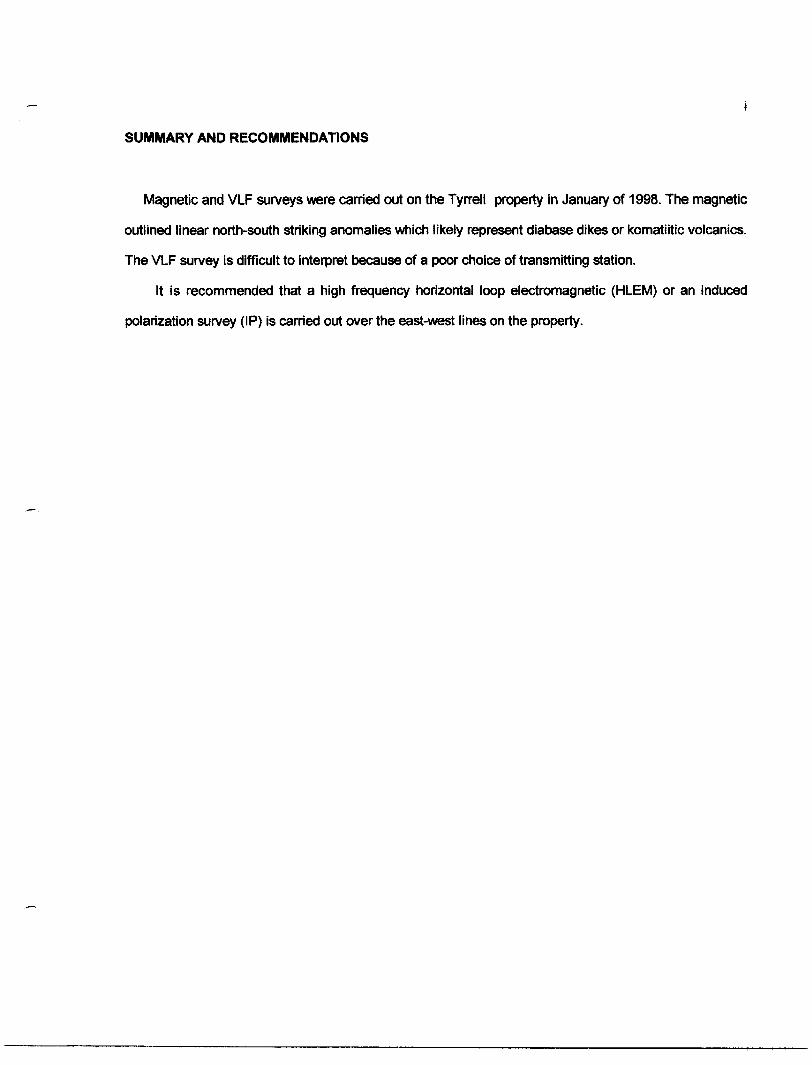
SUMMARY AND RECOMMENDATIONS
Magnetic and VLF surveys were carried out on the Tyrrell property in January of 1998. The magnetic
outlined linear north-south striking anomalies which likely represent diabase dikes or komatiitic volcanics.
The VLF survey is difficult to interpret because of a poor choice of transmitting station.
It is recommended that a high frequency horizontal loop electromagnetic (HLEM) or an induced
polarization survey (IP) is carried out over the east-west lines on the property.
41P11NE2002 2.18720 KNIGHT 0 10C
ii
TABLE OF CONTENTS
page
SUMMARY AND RECOMMENDATIONS........................................................................................... i
INTRODUCTION............................................................................................................................... 1
GENERAL GEOLOGY...................................................................................................................... 3
PREVIOUS WORK........................................................................................................................... 3
SURVEY DESCRIPTIONS............................................................................................................... 3
MAGNETIC RESULTS..................................................................................................................... 4
VLF RESULTS................................................................................................................................. 6
REFERENCES................................................................................................................................ 10
LIST OF FIGURES
page
1.(a) LOCATION MAP...................................................................................................................... 2
(b) CLAIM MAP.............................................................................................................................. 3
2. COLOUR IMAGE OF TOTAL MAGNETIC FIELD .......................................................................... 5
LIST OF TABLES
page
1. CLAIM DESCRIPTIONS................................................................................................................. 1
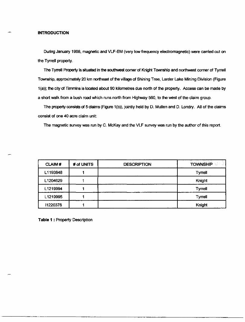
INTRODUCTION
During January 1998, magnetic and VLF-EM (very low frequency electromagnetic) were carried out on
the Tyrrell property.
The Tyrrell Property is situated in the southwest corner of Knight Township and northwest comer of Tyrrell
Township, approximately 20 km northeast of the village of Shining Tree, Larder Lake Mining Division (Figure
1 (a)); the city of Timmins is located about 90 kilometres due north of the property. Access can be made by
a short walk from a bush road which runs north from Highway 560, to the west of the claim group.
The property consists of 5 claims (Figure 1(b)), jointly held by D. Mullen and D. Londry. All of the claims
consist of one 40 acre claim unit:
The magnetic survey was run by C. McKay and the VLF survey was run by the author of this report.
CLAIM*
L1 193848
L1 204629
L1 2 19994
L1219995
11220378
# of UNITS
1
1
1
1
1
DESCRIPTION TOWNSHIP
Tyrrell
Knight
Tyrrell
Tyrrell
Knight
Table 1 : Property Description
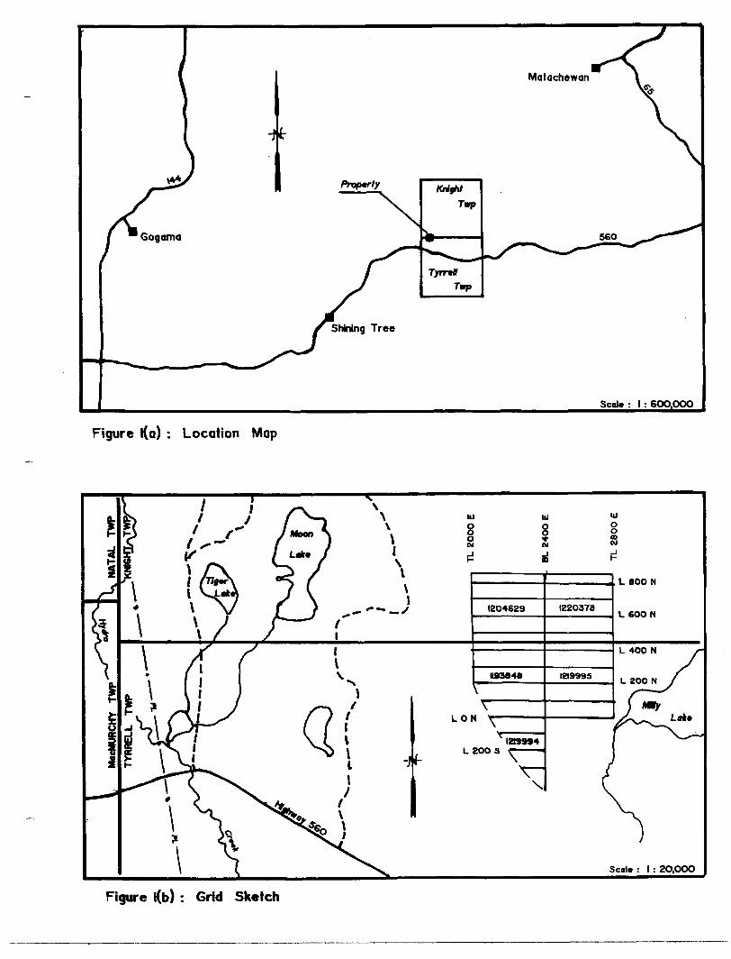
Figure l(o) : Location Map
Figure l(b) : Grid Sketch
GENERAL GEOLOGY
The area is underlain by a typical greenstone belt assemblage of mafic to felsic volcanic flows and tuffs,
intercalated with minor sedimentary horizons (Carter, 1977,1983,1987). Komatiites are present in minor
amounts as well as alkalic rocks. Diabase dykes cut northward across the volcanic stratigraphy. Outliers
of Proterozoic Gowganda Formation and Nipissing Diabase occur locally.
PREVIOUS WORK
The area near the property has been explored for gold since the early 1900's. Numerous gold showings
have been found, three of which have seen significant development. The Tyranite Mine, located two
kilometres to the east of the property produced over 30,000 ounces of gold in the early 1940's, while the
Matona, one kilometre to the south and the Gordon Lake showing, three kilometres to the southeast had
shafts sunk on them. With the advent of flow-through financing during the mid 1980's, all three of these
properties were re-examined by surface trenching, diamond drilling and some underground development.
A fourth property, immediately to the west of the claim block was drill tested during the same period; gold
values of up to .496 ounces/ton over 3 feet were returned.
The Ontario Geological Survey flew airborne magnetic and electromagnetic surveys over the entire
Shining Tree area which included Knight and Tyrrell Townships in 1990 (OGS, 1990).
SURVEY DESCRIPTION
The grid on the property consists of east-west lines spaced every 100 metres and picketed every 20
metres.
The magnetic readings were taken every 12.5 metres with a Scintrex IGS-2/MP-4. This instrument is a
4
proton precession magnetometer which measures the earth's total magnetic field to an accuracy of 0.1
gammas. Diurnal variations were monitored every 10 seconds with a Scintrex MP-3 base station
magnetometer located to the south of the property; the base station value, to which all readings were
levelled to, is 58800 nl. A total of 668 readings were taken along 8.1 kilometres of line.
The VLF-EM readings were taken every 25 metres with the Crone Radem. This instrument measures the
dip angle of the vertical secondary field. The transmitter station used on all of the lines was Cutler, Maine
which transmits at a frequency of 24.0 kHz. A total of 339 stations were read along 8.1 kilometres of line.
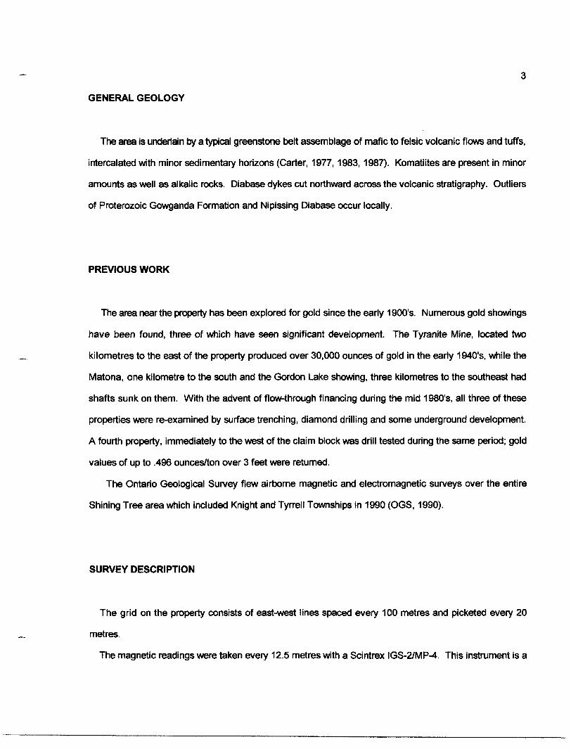
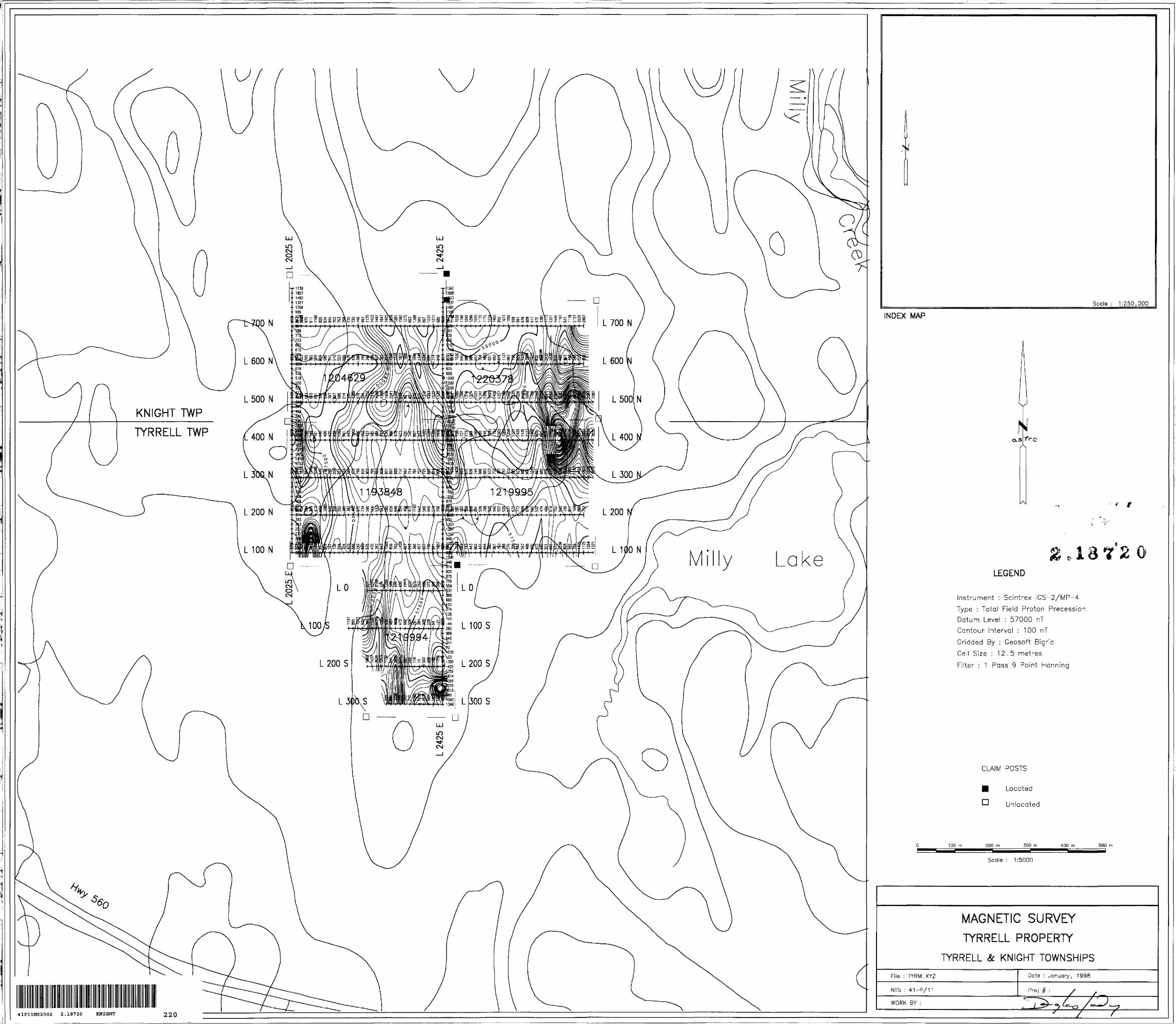
MAGNETIC RESULTS
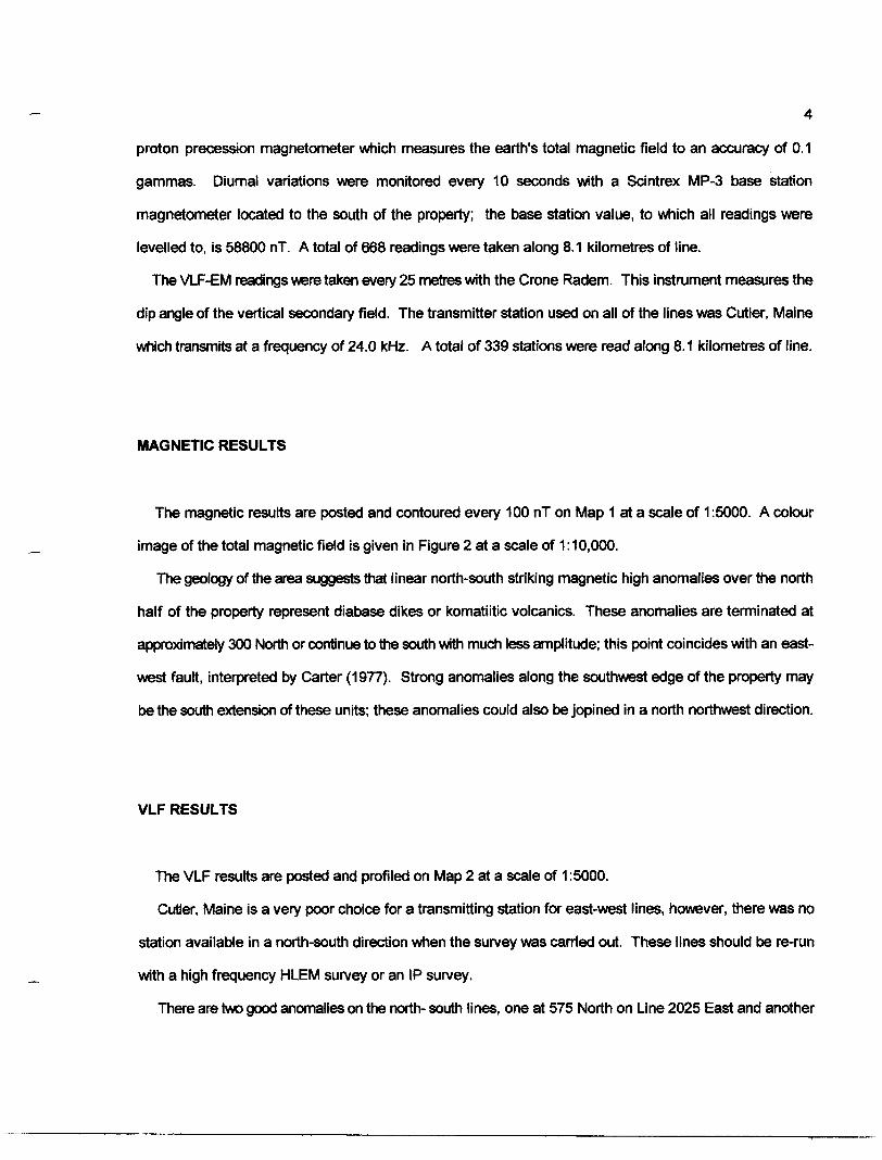
The magnetic results are posted and contoured every 100 nT on Map 1 at a scale of 1:5000. A colour
image of the total magnetic field is given in Figure 2 at a scale of 1:10,000.
The geology of the area suggests that linear north-south striking magnetic high anomalies over the north
half of the property represent diabase dikes or komatiitic volcanics. These anomalies are terminated at
approximately 300 North or continue to the south with much less amplitude; this point coincides with an east-
west fault, interpreted by Carter (1977). Strong anomalies along the southwest edge of the property may
be the south extension of these units; these anomalies could also be jopined in a north northwest direction.
VLF RESULTS
The VLF results are posted and profiled on Map 2 at a scale of 1:5000.
Cutler, Maine is a very poor choice for a transmitting station for east-west lines, however, there was no
station available in a north-south direction when the survey was carried out. These lines should be re-run
with a high frequency HLEM survey or an IP survey.
There are two good anomalies on the north- south lines, one at 575 North on Line 2025 East and another
LEGEND
tr/iment : Scintrex IGS-2/MP--4
DC : Total Reid Proton Precession
ridded By : Geosoft Bigrid
Cell Size : 20 metres
Filter : 1 Pass 9 Point Manning
Contour Interval : 200 nT
10.000
Figure 2 : Colour image of total magnetic field
6
at 300 North on Line 2425 East. Results along the east-west lines suggest that these anomalies could be
joined.
DATE D. LONDRY
REFERENCES
Carter, M.W.1977: Geology of MacMurchy and Tyrrell Townships, Districts of Sudbury and Timiskaming; Ontario
Division of Mines, Geological Report 152, 69p. Accompanied by Map 2365, Scale 1:31,680.
1983: Geology of Natal and Knight Townships, Districts of Sudbury and Timiskaming; OntarioGeological Survey, Geological Report 225, 74p. Accompanied by Map 2465, Scale 1:31,680.
1987: Geology of the Shining Tree Area, Districts of Sudbury and Timiskaming; Ontario Geological Survey Report 240, 48p. Accompanied by Map 2510, Scale 1:50,000.
Ontario Geological Survey1990: Airborne Electromagnetic and Total Intensity Magnetic Survey, Shining Tree Area; Ontario
Geological Survey, Maps 81420, 81421 and 81427, Scale 1:20,000.
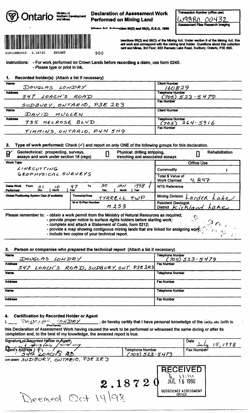
Declaration of Assessment Work Performed on Mining Land
1MO
Transaction Number (offlc* UM)
Assesament Flw Research Imaging
bsectfons 65(2) and 66(3) of the Mnlng Act. Under section 8 of the Mining Act. this lent work and correspond with the mining land holder. Questions about this collection nant and Mnes. 3rd Floor. 933 Ramsay Lato Road. Sudbury. Ontario, P3E 6B5.
41P11NE2002 2.18720 KNIGHT 900
Instructions: - For work performed on Crown Lands before recording a claim, use form 0240. - Please type or print in ink.
1. Recorded holder(s) (Attach a list if necessary)Name
Address5^7 /.o AC,/-/ 's /Zoft'~D
Su32BOS.y i O *J ?V? /E lO j "P3tE 2i C 3Name
AcktrBM735" Aff^#os6 8 LV~D
-nnrt,*J5 t o^TfiXto, P VA/ 5 H?
Client Numberi t ̂ * f] ^ CJ
X t? Cx cj *^ 7^
Telephone Number tros} S 23 -5 y 7*2
Fax Number
Client Number
Telephone Number
Fax Number
2. Type of work performed: Check (/) and report on only ONE of the following groups for this declaration.
Geotechnical: prospecting, surveys, assays and work under section 18 (regs) Q Physical: drilling stripping,
trenching and associated assaysRehabilitation
Work Type
/'
Gf
Data* Workfla.finaal a JKenorrned
Global Postle
A* 6 C f T T/ tJ G,
top nys i c/9^. sej&^f.ys
From o i1 /O 97 To -^C JflfJ 1*118 7 D*y | Month | Year Day J Month | YMT
nfawi fivKtAfn Data flf avanal^il Tnuunchln/Ania _ .
MofO-PlanNumbernzss
Office Use
Commodity \Total S Value of Work Claimed ^f ft^T"
NTS Reference
Mining Division l̂ eti-sifA LSLJC^ J
Resident Geologist , District ^ t'rk/asid A tf A^L-*
Please remember to: - obtain a work permit from the Ministry of Natural Resources as required; r,.- provide proper notice to surface rights holders before starting work;- complete and attach a Statement of Costs, form 0212;- provide a map showing contiguous mining lands that are linked for assigning wpc^;- include two copies of your technical report.
3. Person or companies who prepared the technical report (Attach a list if necessary)Name
Address54? LOACH s R.Qft'D, sozt&uK-y, O/JT. P3CxC3
Name
Address
Name
Address
Telephone Number
Fax Number
Telephone Number
Fax Number
Telephone Number
Fax Number
4. Certification by Recorded Holder or Agentl, __ , do hereby certify that l have personal knowledge of the facia set forth in
(Print Name)
this Declaration of Assessment Work having caused the work to be performed or witnessed the same during or after its completion and, to the best of my knowledge, the annexed report is true.Signature^ fiagorded H0fder or Date
-1*4,
,/ S Telephone Number Fax
yt
18 7 2 CRECEIVED
JUl 1 6 1993
GEOSCIENCE ASSESSMENT OFFICE -
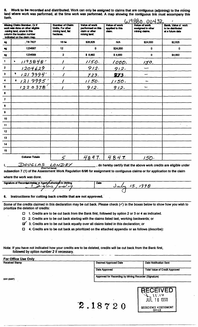
S. Work to be recorded and distributed. Work can only be assigned to claims that are contiguous (adjoining) to the mining land where work was performed, at the time work was performed. A map showing the contiguous link must accompany this form.
LJ1Mining Claim Number. Or Ifwork was done on other elglble mining tend, shew in thte column the location number indicated on the claim map.
eg
*g
eg
1
2
3
4
5
6
7
8
9
10
11
12
13
14
15
.TB7827
1234567
1234568
* //930y#'120V&29
' 1 21 JWJ'
' /2l 9995"13.2 c* S7&'
Column Totals
Number of Claim Untts. For other mining land, 1st hectares.
16 ha
12
2
1
l
l
f
l
5
Value of workperformed on this claim or other mining land.
526,825
0
9 8 ,892
1 1 f G.
912.
723.It S'O.
9/2-
H& 1 T
Value of work applied to tt* cWm.
N/A
924,000
S 4,000
/00O.
912-
8J3S '50.
9/2.
^84T
86G.0043Z. -Value of work assigned to other mining dakns.
124.000
0
0
J50.
~-
-~
150-
Bank. Value of work to be Distributed at a future date
52,825
0
K892
I.. , do hereby certify that the above work credits are eligible under(Print Full NMW)
subsection 7 (1) of the Assessment Work Regulation 6/96 for assignment to contiguous claims or for application to the claim
where the work was done.
Signature of Recordad-Hsldarw AgentAutnoriati In V*Wng ^ 1 ^j^ — j LC~O /c~o/ ̂
Date ^4 '998r6. Instructions for cutting back credits that are not approved.
Some of the credits daimed in this declaration may be cut back. Please check ("O in the boxes below to show how you wish to prioritize the deletion of credits:
D 1. Credits are to be cut back from the Bank first, followed by option 2 or 3 or 4 as indicated. D 2. Credits are to be cut back starting with the daims listed last, working backwards; or B^ 3. Credits are to be cut back equally over all daims listed in this declaration; or D 4. Credits are to be cut back as prioritized on the attached appendix or as follows (describe):
Note: If you have not indicated how your credits are to be deleted, credits will be cut back from the Bank first, followed by option number 2 if necessary.
For Office Use OnlyReceived Stamp
0241(03/87)
Deemed Approved Date
Date Approved
Date Notification Sent
Total Value of Credit Approved
Approved for Recording by Mining Recorder (Signature)
18 7 2 O
RECEIVED
JUL 1 6 1333
GEOSCIENCE ASSESSMENT OfflCE______
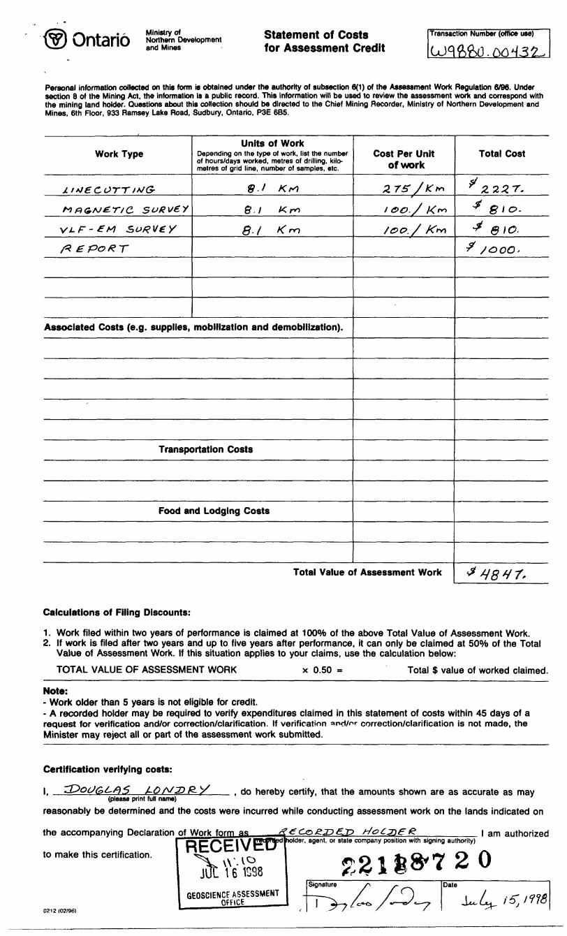
Ministry ofNorthern Development and Mjnes
Statement of Costs for Assessment Credit
Transaction Number (office use)
Personal information collected on this form is obtained under the authority of subsection 6(1) of the Assessment Work Regulation 6/96. Under section 8 of the Mining Act, the information is a public record. This information will be used to review the assessment work and correspond with the mining land holder. Questions about this collection should be directed to the Chief Mining Recorder, Ministry of Northern Development and Mines, 6th Floor, 933 Ramsey Lake Road, Sudbury, Ontario, P3E 6B5.
Work Type
J.i*J6COTT t*JG-
MG&M&T/C suRvZV
vi-F-frt surveyfrepoRT
Units of WorkDepending on the type of work, list the number of hours/days worked, metres of drilling, kilo metres of grid line, number of samples, etc.
9. i Krt
8.1 Km
S-/ Km
Associated Costs (e.g. supplies, mobilization and demobilization).
Transportation Costs
Food and Lodging Costs
Cost Per Unit of work
2.75- /Kt"
1 00. / K
/O0./ K*r*\
Total Value of Assessment Work
Total Cost
^222 r.* gio.
J &IO.
f SGOO*
J vsvr.
Calculations of Filing Discounts:
1. Work filed within two years of performance is claimed at 10044) of the above Total Value of Assessment Work.2. If work is filed after two years and up to five years after performance, it can only be claimed at SOo/fo of the Total
Value of Assessment Work. If this situation applies to your claims, use the calculation below:
TOTAL VALUE OF ASSESSMENT WORK x 0.50 Total $ value of worked claimed.
Note:- Work older than 5 years is not eligible for credit.- A recorded holder may be required to verify expenditures claimed in this statement of costs within 45 days of a request for verification and/or correction/clarification. If verification and/or correction/clarification is not made, the Minister may reject all or part of the assessment work submitted.
Certification verifying costs:
l r , do hereby certify, that the amounts shown are as accurate as may(please print full name)
reasonably be determined and the costs were incurred while conducting assessment work on the lands indicated on
the accompanying Declaration j)f Work form as
to make this certification.
0212(02/96)
JUL 1 6 1038
GEOSCIENCE ASSESSMENT OfFiCE______
lolder, agent, or state company position with signing authority)l am authorized
OntarioMinistry of Ministere duNorthern Development Developpement du Nordand Mines et des Mines
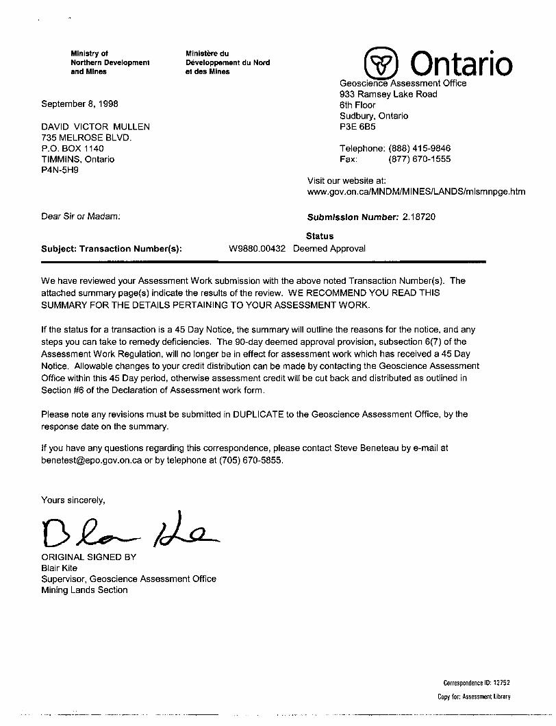
Geoscience Assessment Office 933 Ramsey Lake Road
Septembers, 1998 6th FloorSudbury, Ontario
DAVID VICTOR MULLEN P3E 6B5735 MELROSE BLVD.P.O. BOX 1140 Telephone: (888) 415-9846TIMMINS, Ontario Fax: (877)670-1555P4N-5H9
Visit our website at: www.gov.on.ca/MNDM/MINES/LANDS/mlsmnpge.htm
Dear Sir or Madam: Submission Number: 2 .18720
Status Subject: Transaction Number(s): W9880.00432 Deemed Approval
We have reviewed your Assessment Work submission with the above noted Transaction Number(s). The attached summary page(s) indicate the results of the review. WE RECOMMEND YOU READ THIS SUMMARY FOR THE DETAILS PERTAINING TO YOUR ASSESSMENT WORK.
If the status for a transaction is a 45 Day Notice, the summary will outline the reasons for the notice, and any steps you can take to remedy deficiencies. The 90-day deemed approval provision, subsection 6(7) of the Assessment Work Regulation, will no longer be in effect for assessment work which has received a 45 Day Notice. Allowable changes to your credit distribution can be made by contacting the Geoscience Assessment Office within this 45 Day period, otherwise assessment credit will be cut back and distributed as outlined in Section #6 of the Declaration of Assessment work form.
Please note any revisions must be submitted in DUPLICATE to the Geoscience Assessment Office, by the response date on the summary.
If you have any questions regarding this correspondence, please contact Steve Beneteau by e-mail at [email protected] or by telephone at (705) 670-5855.
Yours sincerely,
ORIGINAL SIGNED BYBlair KiteSupervisor, Geoscience Assessment OfficeMining Lands Section
Correspondence ID: 12752
Copy for: Assessment Library
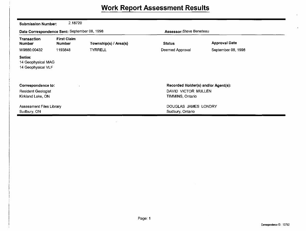
Work Report Assessment Results
Submission Number: 2 .18720
Date Correspondence Sent: September 08, 1998 Assessor: Steve Beneteau
Transaction Number
W9880.00432
Section:14 Geophysical MAG 14 Geophysical VLF
First Claim Number
1193848
Township(s) l Area(s)
TYRRELL
Status
Deemed Approval
Approval Date
September 08,1998
Correspondence to:Resident Geologist Kirkland Lake, ON
Assessment Files Library Sudbury, ON
Recorded Holder(s) and/or Agent(s):DAVID VICTOR MULLEN TIMMINS, Ontario
DOUGLAS JAMES LONDRY Sudbury, Ontario
Page: 1
Correspondence ID: 12752
--/-HF y*^MH; \
\ .. ; \V—-S ' fcJi;\V "
ittKI^I? 1 ]
T22JQ2312179431
*" ~" ~ 7121*7939
\ r.- J'-''A ^
1220211 179371X.I2t7936- :
' t 3iA n. , . i. ,
'\ !^l j!
r* i r r/* i 1, i /i. -
1207211! J l f l ^ \ vA
'' ^J^x;j\v^|if/! /-KV\
u - . -. T''1 / \ ^l
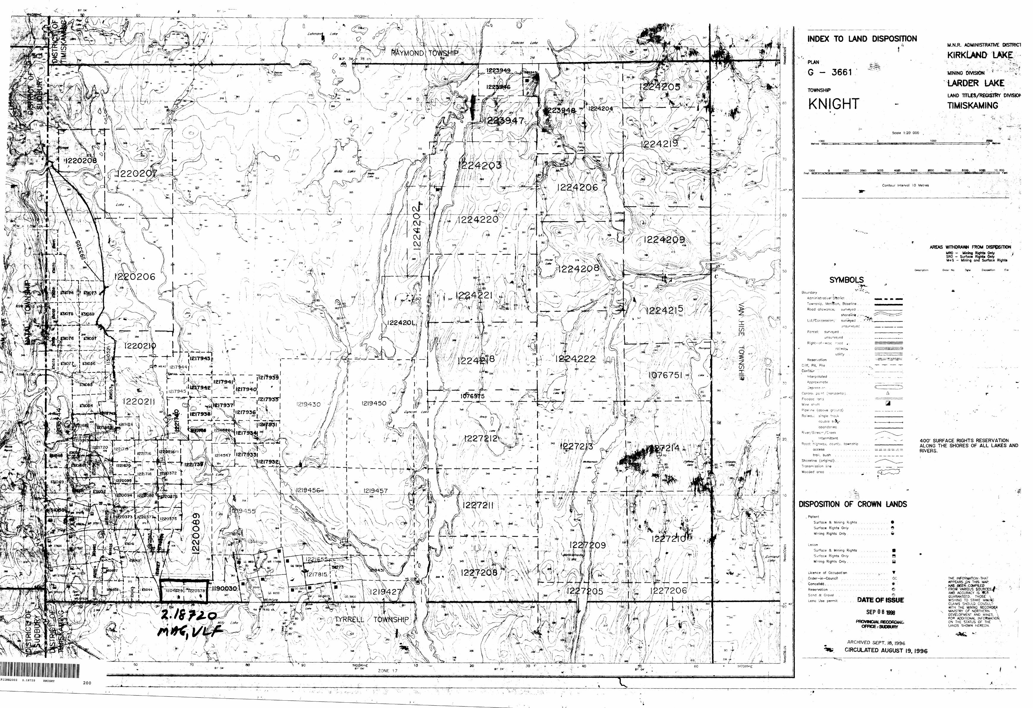
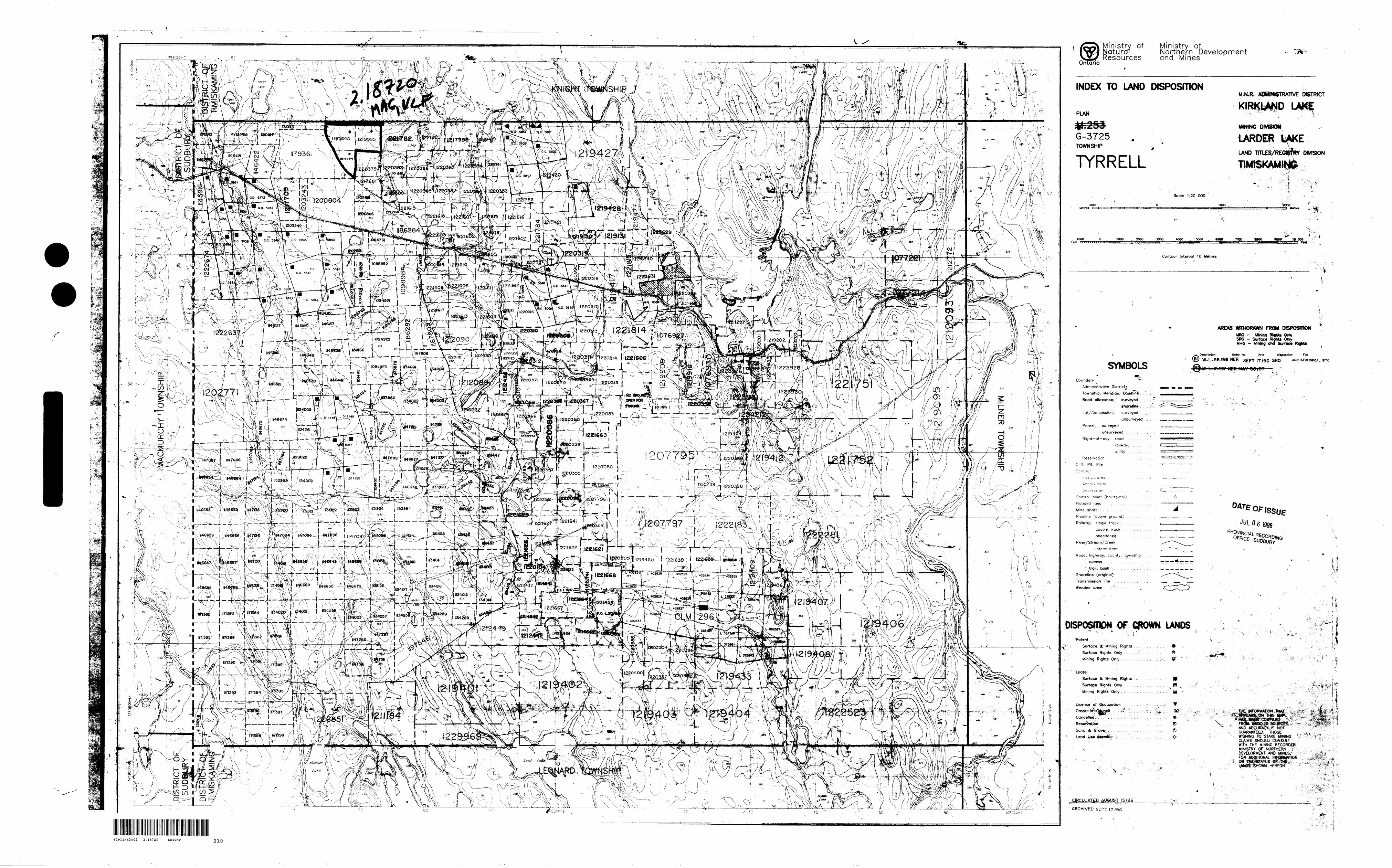
41P11NE2002 2.18720 KNIGHT
INDEX TO LAND DISPOSITION; ' ' r M.N.R. ADMINISTRATWE DISTRICT
KIRKLA*4iy LAKE/.'
G - 3661S^:
MINING DIVISIONffiV^-;
...' '"S'
TOWNSHIP
KNIGHT
LARDER LAKE. ."t 1 ' '
LAND -nTLES/RECtSTfrf DIVISION
TIMISKAMING
*'
"S-4
' fir.
ScQS* 1:20 000
Metres1000 1000 ZMO"
1000 1000 2000 . 3000 4000 5000 .SOOO 7000 8000, ^ 9096 10 000F*et-
Contour Interval 10 Metres
AREAS WITHDRAW FROM DISPOSmONMRO - Mining Ritfrts Only ,SRO - Surface Righto OnlyM+S - Mining and Surface Rightt
Description Order No, Disposition Fi l*
SYMBOLSV
Boundary ,
Adm;nistrative-;'"Dfetrict . . . .
Townsnip, Meridian, Baseline . .
Road allowance; surveyed . .
Lot/Concessior.y' surveyed . . * . V'
unsurveyed
Parcel; surveyed . . . . . . . .
Right of-wcy; road , .
* railway, . . .
utility . . . .
Reservation . . . . . . .
Cliff, Pit, Pile . . . , . . . . .
ConTour Y . , . . . . . . . . . . , .
interpolated . . . . . . . . .
Approximate . . . .
Depress o r-. . ,
Control point (nonzontoij .
F'oodec !ond . . . . .
Mine s-cft . . . .
Pioe ! ine (above qroijnd)
Railway; single track . .
aouble trd^K. . . .
abandoned . . ,
River/S tree "'/Creek
Intermittent
Reed; hignway. county, township
access . . . . . . , . . , .
troll, bush , . . . . . . .
Shoreline (originat). . . . .
Transmission line . . , .
Wooded area . . . . . . .
t '. i
A
W
400' SURFACE RIGHTS RESERVATION ALONG THE SHORES OF ALL LAKES AND RIVERS.
DISPOSITION OF CROWN LANDS. Potent
Surface 3c Mirring Rights
Surface Rights Only . .
Mining Rights Only . , .
Lease
Surface 3t M ining Rights
Surface Rights Only
Mining Rights Only . . . .
Licence of Occupation . .
.Order in Council ,. . . . . .
Conceded. . , , , . . . . . . .
Reservation . . , . . . . . . .Sand Se G rove! . . . . .
Lana Use permit . .
e Q
H B
V oc
o
THE .INFORMATION ^THAT APPEARS J)N THfS MAP
DATE OF ISSUE
SEP O 8 1998
PROVWCWL HECORDlNtOFRCE r SUDBURY
ARCHIVED SEPT. 18, 1996
CIRCULATED AUGUST 19, 1996
FROrt' VWWOUS- AND ACCURACY IS GUARANTEED. THOSE \ WISHING TO STAKE MINING' CLAIMS SHOULD CONSULT' WITH THE MINING. RECORQ&R MINISTRY OF NORTHERN \ DEVELOPMENT AND MINES, \ f OP . ADDITIONAL iNFORMATSON, ON THE STATUS OF THE LANDS SHOWN HEREON.
/
cO)Ea.20)>(D
D
r,
T
i
jio.x
Oo
*')
CM
Q-
LUo:
"eoQ
wJ
ol
i,.;.,.i ; liji'i'r'iri*'-
-' .t ..tWv
•ft;^S'-^;;
.^fe
;-1
' f&J-
w tfl 21
* i ',3 3
* W
l t
t
i W
l O
t J
, S
LU j
6z
H(O- ^co
;;c w
l
f J, .1
li ip
LU 3
Wli
-i
pa
CO
O
lIsft
•fe
IIi\\1t111
i1i1
V-piiiS
f-\
!' h
He. d
e ©
o
M l
l l 5
Vol
•o :*~
a) (D
:~ >
c o0) oo o
Op
-o
*S
O
r?
Js O
O
11 ren
n *o l
c oN
ooCL
ce
c
OD
Ul
Ol
(K
D.ii o
J?-D
ID-oO
O
-x o ofi.e o(O "C
I
c-8cE
-y:4} 0.)
.c mco.
^cO
ox w
o
u.
.E o
01 ^
.9- '6
o. tt
o
EE off-4-1
CO
(LI
C
(U
iro o
a: i-fo
K l4)
l
C/l
C
V.2
fiS
*e "Son
-Sc
Oo
ot *
4^
" 0ir1
g
!q t. s^ •S
" .sKg
,in^.S1O
f
' .rc48
JK1is.i1ctS
^omiOfo
,.. y
, .
. .
!' H
S;. ,*
"
* S."'^' :
: :,-:
n
MJ .* '
' ^ tfe:
, j:|i;-:
: 11'ff^
^
' *r
! E
'•^**''
•-..'•'B^
'!'-9-*
''S S
in,
LO ffi
LU
O
U
ni
~
T
-? f
TS
-t
-^
,5
(5!*Sc3
^SC
X
O
*
T
3 -6
*i -S
c B
c e
U
C
O*
O
oJj
O
O tt
to -i
O
oH
CN
KNIGHT TWP
TYRRELL TWP
N
INDEX MAPScale : 1:250,000
0.3
f t
LEGEND
Instrument : Scintrex IGS-2/MP-4
Type : Total Field Proton PrecessionDatum Level : 57000 nTContour Interval : 100 nTGridded By : Geosoft Big ridCell Size : 12.5 metres
Filter : 1 Pass 9 Point Manning
CLAIM POSTS
l Located
l—l Unlocated
100 m 200 m 300 m 400 m 500 m
Scale : 1:5000
MAGNETIC SURVEYTYRRELL PROPERTY
TYRRELL A K NIGHT TOWNSHIPS
41P11NE2002 2.18720 KNIGHT 220

KNIGHT TWP
TYRRELL TWP
N
INDEX MAPScale : 1:250,000
LEGEND
Instrument : Crone Radem
Transmitter : Cutler, Maine Frequency : 24.0 k Hz
Profile Scale : 1 cm = 25
8
s DIP N DIP
Conductor Axis
Dip Angle
CLAIM POSTS
B Located
EJ Unlocated
100 m 200 m 300 m 400 m 500 m
Scale : 1:5000
VLF SURVEY
TYRRELL PROPERTYTYRRELL A: KNIGHT TOWNSHIPS
File : TYRV.XYZ
NTS : 41-P/11
Date : January, 1998
WORK BY :
41P11NE2002 2,18720 KNIGHT 230
![FAMILY HISTORY SOCIETY · 2/2/2015 · 30 Tyrrell Family History Society Management Committee 2015 Chairman: Mike Tyrrell [828] chairman@tyrrell-fhs.org 32 Wren Crescent, Addlestone,](https://img.pdfslide.us/doc/110x75/606bbf549248a35c2265948f/family-history-society-222015-30-tyrrell-family-history-society-management.jpg)