Embed Size (px)
Citation preview
52K07SW2006 2.28538 GLIDER LAKE 010
•RECEIVEDOCT 1 5 200*1
GEOSCIENCE ASSESSMENT OFFICE
CHAHELTECHMCAL SERVICESENGINEERING AND PROJECT MANAGEMENT
104 GOVERNMENT ROAD. BOX 485 KEEWATIN. ONTARIO
POX ICO
PHONE: 1007) 547 3680FAX: 18071 547 3580E nail: [email protected]
Introduction:
877578 Ontario Inc. (henceforth referred to as the Company) has a number of mining claims in North-western Ontario that exhibit unique colours and textures of granite and were originally staked for their dimension stone potential. Subsequently, it was realized that even if bulk sampling should determine that some of those deposits do not have a suitable structure for block production, they might still have market potential as an aggregate.
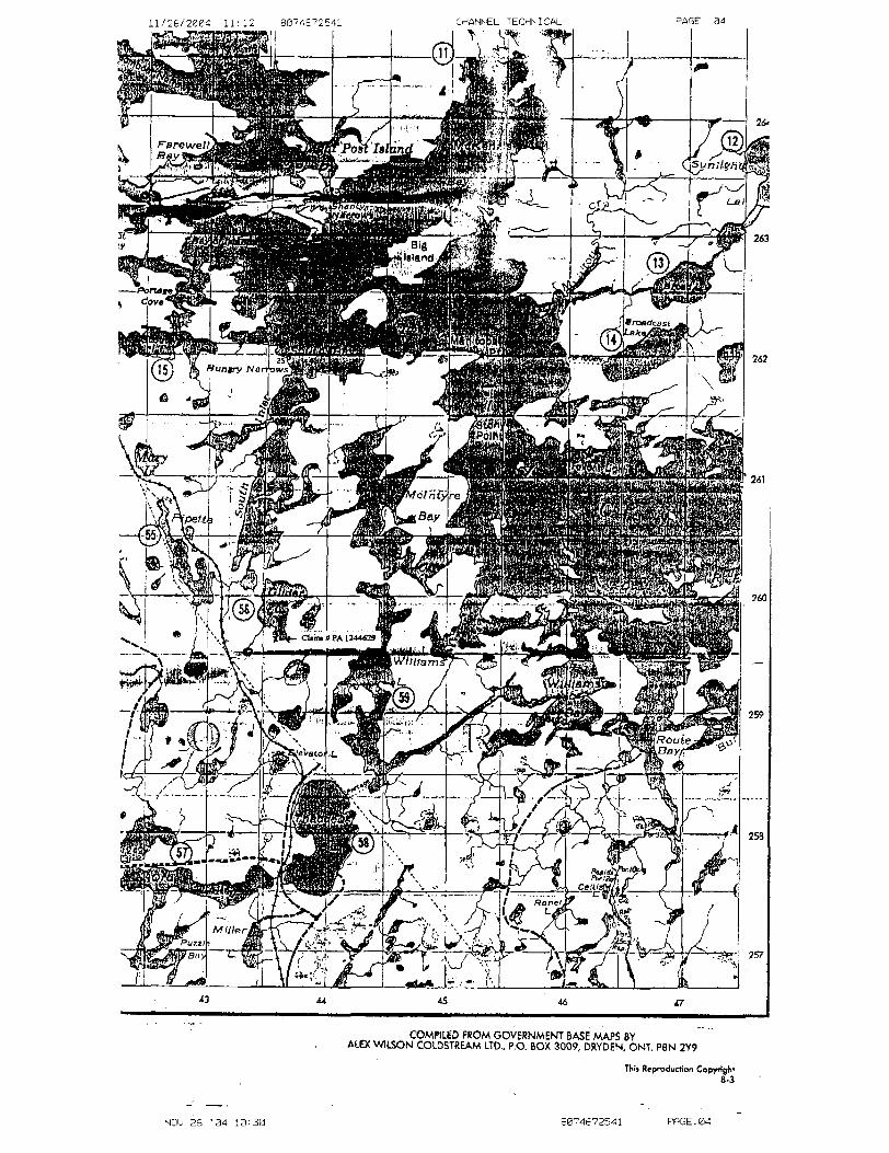
Claim # PA 1244629 holds one of those granite deposits.
Location;
The property is located approximately 50 kms south-southeast of the community of Ear Falls, Ontario. The claim block is located at 92.a923980-west longitude, 50.26960^01111 latitude. The UTM co-ordinates are: Zone 15, 505417 m E, 5568609 m N.
The property is accessed via Highway 105, 28.5 kms south from Ear Falls. At this point, the CNR road transects the highway and leads-southeast 20 kms to the vicinity of the property. Here an abandoned tertiary road intersects the road to the North. The site is found by following the road up and over a smooth rock hill at l km then for l 1/2 km until a fork in the road is reached. The left fork in the road leads 3A km to Glider Lake. The claim is found approximately Vz km west of the beach at the landing.
Sampling Program:
The aggregate sampling program consisted of removing small pieces that could be broken off of bedrock using a sledgehammer and pry bar. These samples weighed approximately 200 - 250 Ibs and were reduced to -3" using a sledgehammer, removed from the bush and crushed to l" minus in size. Samples were then screened by hand to 4 sizes: -t- 3/4", - 3/4' - Y2\ - Vz" - VS\ and - Vi". Of particular interest to potential customers was the smallest - Vi" size, in that it approaches the size iraction utilized by pre-casters, and manufacturers of composite stone products.
Geology
The "greenstone" rocks of the Superior Province of the Canadian Shield dominate the geology of North-western Ontario. Sub-Provinces in the region take the form of east-west trending belts known as the Wabigoon, Winnipeg River, Bird River, English River, Uchi and Berens River belts (from south to north). These belts are Archean in age and comprised mainly of vertically dipping volcanic, sedimentary and sub-volcanic intrusive rocks. These rocks themselves tend to be highly deformed and are therefore not likely to host granitoid rocks that would be favourable for dimension stone deposits.
Neo-meso Archean Intrusive Complexes:
After the development of the Archean basement rocks that form the major greenstone belts, a regional scale tectonic event (the Kenoran Orogeny) took place over time. Initially, this structural event was responsible for significant deformation of pre-existing lithologies; however, the last stages of this event were accompanied by voluminous late- tectonic felsic plutonism. It is these late felsic plutons that have endowed the North western Ontario with its legacy of high quality, imdefbrmed granite resources (i.e. the Lount Lake Complex part of the Winnipeg River Subprovince).
The Winnipeg River Subprovince consists of predominantly granitoid rocks and is bounded on the north by the English River and Bird River Subprovinces and on the south by the Wabigoon Subprovince. The Winnipeg River Subprovince comprises four rock suites, these are tonalitic gneisses and plutons and syn to post tectonic granitic and mafic suites.
The neo to meso Archean intrusive suite includes massive granodiorite and granites, diorite, monzonites, muscovite bearing granitic rocks, ̂ isuite of foliated tonalite intrusives and gneissic tonalites between the ages of 2.5 to 2.9 Ga.
Geology of the Deposit:
Stone Description:
Fine grained, reddish coloured granite with five percent mafic minerals and ninety-five percent burgundy feldspar and accessory quartz. The fine-grained texture and rich, dark red colour makes it very appealing as both an ornamental and a dimension stone. Since it is fine grained, its use as a dimension stone will indude monuments.
Site Physiography:
The outcrop is a massive hill of granite that rises steeply from the shore of Glider Lake and reaches a height of over 60 m. There is a steep cliff face of solid granite visible above the trees on the east side that is a very prominent feature of the landscape. The claim is a portion of a hill that is 400 m x 1000 m and is adjacent to other, similar topographic features.
The knoll is rounded on the sides with a flat top that is approximately 150 m x 600 m with good exposure approaching 50 - 6007o. The side slopes adjacent to the lake are completely free of overburden with lOO'M) exposure over an area of 50 m x 200 m. The steep slopes in this area approach a 5Q07o grade, which while it makes it difficult to traverse, allows runoff water to continually wash the slope.
The remainder of the hill has a series of ledges that rise steeply and are 3 -5 m high. The only overburden is shallow at 1A m deep, and often is only moss and lichens. Although
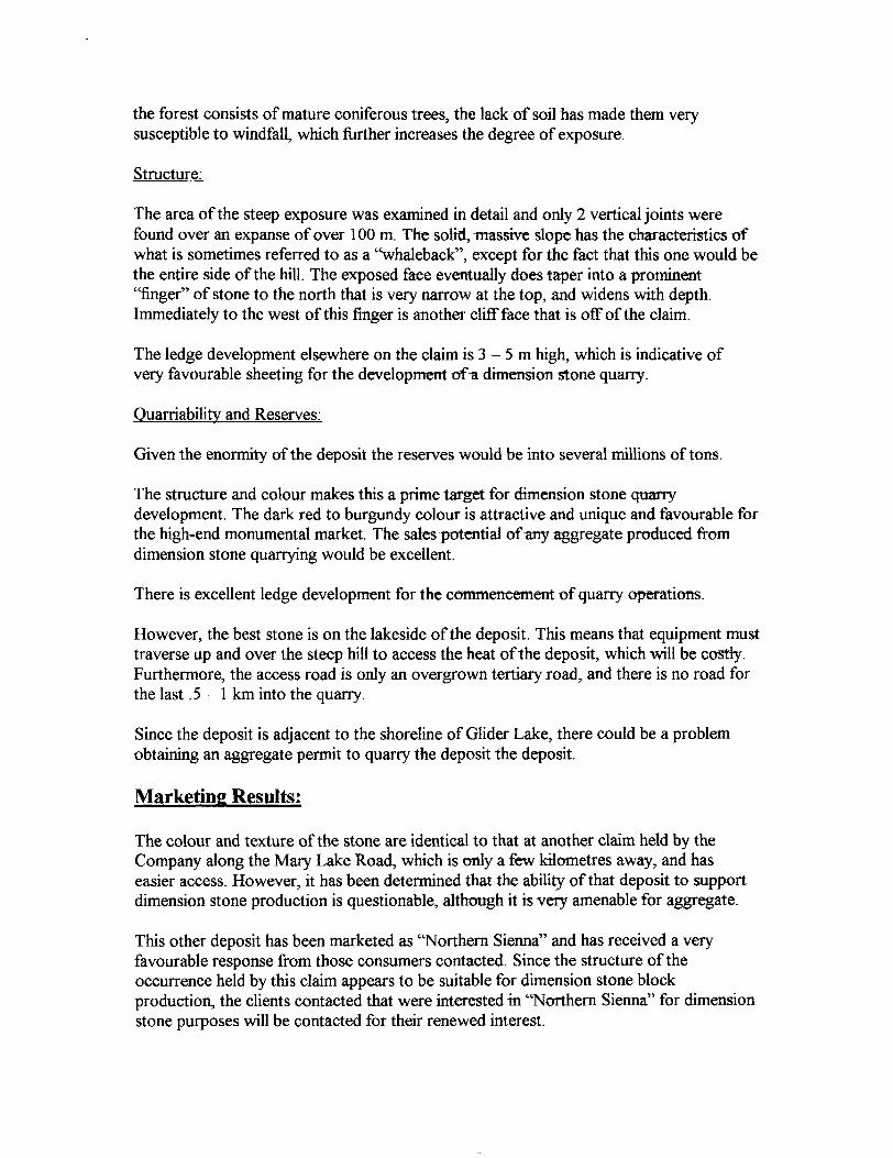
the forest consists of mature coniferous trees, the lack of soil has made them very susceptible to windfall, which further increases the degree of exposure.
Structure:
The area of the steep exposure was examined in detail and only 2 vertical joints were found over an expanse of over 100 m. The solid, massive slope has the characteristics of what is sometimes referred to as a "whaleback", except for the fact that this one would be the entire side of the hill. The exposed face eventually does taper into a prominent "finger" of stone to the north that is very narrow at the top, and widens with depth. Immediately to the west of this finger is another cliff face that is off of the claim.
The ledge development elsewhere on the claim is 3 - 5 m high, which is indicative of very favourable sheeting for the development of a dimension stone quarry.
Quarriability and Reserves:
Given the enormity of the deposit the reserves would be into several millions of tons.
The structure and colour makes this a prime target for dimension stone quarry development. The dark red to burgundy colour is attractive and unique and favourable for the high-end monumental market. The sales potential of any aggregate produced from dimension stone quarrying would be excellent.
There is excellent ledge development for the commencement of quarry operations.
However, the best stone is on the lakeside of the deposit. This means that equipment must traverse up and over the steep hill to access the heat of the deposit, which will be costly. Furthermore, the access road is only an overgrown tertiary road, and there is no road for the last .5-1 km into the quarry.
Since the deposit is adjacent to the shoreline of Glider Lake, there could be a problem obtaining an aggregate permit to quarry the deposit the deposit.
Marketing Results:
The colour and texture of the stone are identical to that at another claim held by the Company along the Mary Lake Road, which is only a few kilometres away, and has easier access. However, it has been determined that the ability of that deposit to support dimension stone production is questionable, although it is very amenable for aggregate.
This other deposit has been marketed as "Northern Sienna" and has received a very favourable response from those consumers contacted. Since the structure of the occurrence held by this claim appears to be suitable for dimension stone block production, the clients contacted that were interested in "Northern Sienna" for dimension stone purposes will be contacted for their renewed interest.
Appendix
i A thus ^___
HM^
CURRICULUM VITAE
SCOTT SCHELSKE
EDUCATION
1975 Queen's University, Kingston, Ontario B.Se. (Mine Engineering)
ADDITIONAL COLLEGE EDUCATION
1980 Queen's University, Kingston, OntarioApplied Slope Engineering
1992 Lakehead University, Thunder Bay, OntarioEnvironmental Assessment Certification
1995 McGill University, Montreal, QuebecMineral Project Evaluation Techniques Seminar
1995 Cambrian College, Sudbury, OntarioGeophysical Work Shop
ADDITIONAL TRAINING tfe CERTIFICATES
1986 Ministry of Skills DevelopmentCertified Industrial Trainer
1986 St. John AmbulanceFirst Aid Instructor
1990 Danatec Educational Services Ltd.Dangerous Goods Handling Certification
1991 Canadian Institute of Mining & Metallurgy Mining fe the Environment Program
1992 Ministry of EnvironmentEnvironmental Officer Training Certification
1993 Ministry of Northern Development A Mines Investigative Skills Training
1994 Ministry of Municipal Affairs Planning Act Training
1995 Work Place Health & Safety AssociationCore Certification Instructor
1998 Geomcom Soft Ware InternationalComputerized Mine Planning - Core 8c Exploration Programs
2002 Liberty Tax SchoolsCertified Tax Consultant Levels I, H, fc III
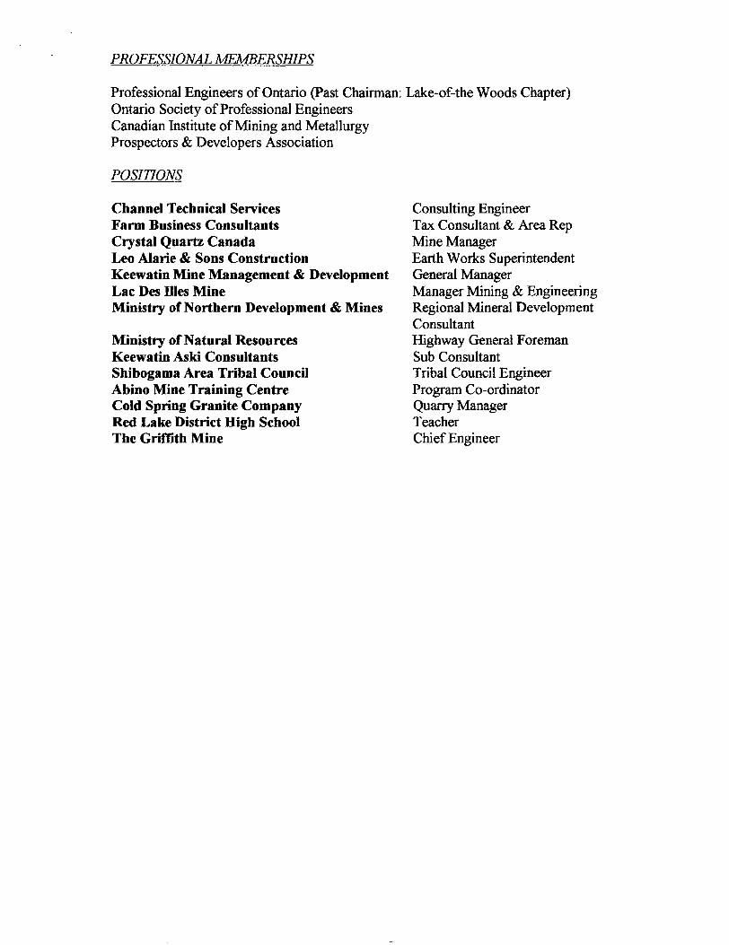
PROFESSIONAL MEMBERSHIPS
Professional Engineers of Ontario (Past Chairman: Lake-of-the Woods Chapter) Ontario Society of Professional Engineers Canadian Institute of Mining and Metallurgy Prospectors SL Developers Association
POSITIONS
Channel Technical ServicesFarm Business ConsultantsCrystal Quartz CanadaLeo Alarie Si Sons ConstructionKeewatin Mine Management & DevelopmentLac Des Dies MineMinistry of Northern Development A Mines
Ministry of Natural Resources Keewatin Aski Consultants Shibogama Area Tribal Council Abino Mine Training Centre Cold Spring Granite Company Red Lake District High School The Griffith Mine
Consulting EngineerTax Consultant fc Area RepMine ManagerEarth Works SuperintendentGeneral ManagerManager Mining & EngineeringRegional Mineral DevelopmentConsultantHighway General ForemanSub ConsultantTribal Council EngineerProgram Co-ordinatorQuarry ManagerTeacherChief Engineer
11/26/2064 11:12 8074672541 CHANNEL TECHNICAL PAGE 34
COMPiLID FROM GOVERNMENT BASE MAPS BY AIEX WILSON COLDSTREAM LTD., P.O. BOX 3009, DRYDEN, ONT. P8N 2Y9
s Reproduction Copyright 8-3
NOU 26 '04 10:30 80^4672541 PPGE.04
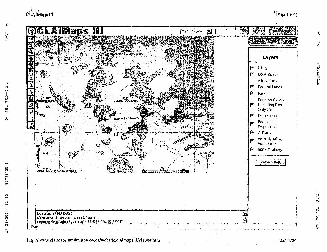
600k Roads Alienations Federal Lands
UTM: Zone 15, 505258m E, 5568735m N[deqreei)^-92,92621 D yi/, 50.27P740 W
Pan
R: Parks
Pendrig Claims Including Filed Only ClaimsDepositions Pending Dispositions G-PlansAdministrative Boundaries600 K Drainage
r* i* P ifc
'^J^EsfeW^'ij ;/ J"? l^-^-^Z^;: vi./.- ' l
ir* sLJLD
CL
in r\j oIXI
o m
(Mri
\r s
'XIr\j
o
http://vvww.dj aimaps.nindm.gov.on.caAvebsife/claimapsiii/viev^er.htm 23/11/04
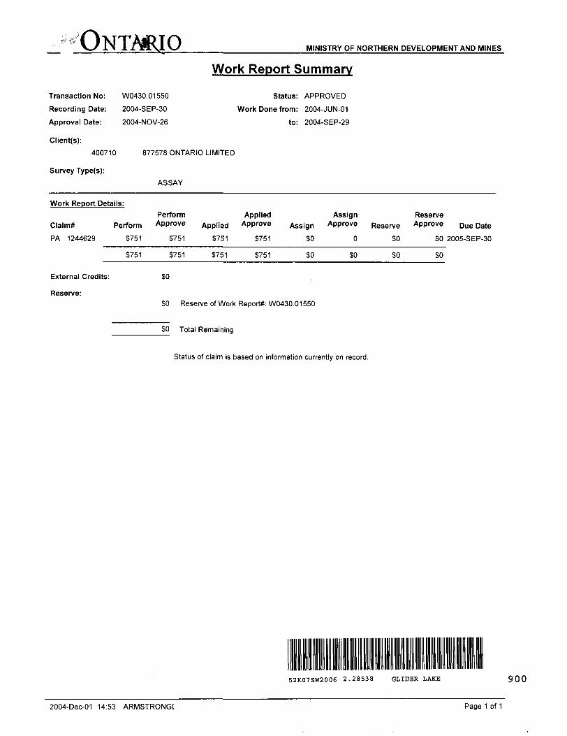
ONTARIO MINISTRY OF NORTHERN DEVELOPMENT AND MINES
Work Report Summary
Transaction No: W0430.01550 Status: APPROVED
Recording Date: 2004-SEP-30 Work Done from: 2004-JUN-01
Approval Date: 2004-NOV-26 to: 2004-SEP-29
Client(s):400710 877578 ONTARIO LIMITED
Survey Type(s):
ASSAY
Work Report Details:
Claim*PA 1244629
PerformS751
S751
Perform Approve
S751
S751
Applied3751
3751
Applied Approve
S751
S751
Assignsoso
Assign Approve
0
30
ReserveSO
SO
Reserve Approve
SO
so
Due Date2005-SEP-30
External Credits: 30
Reserve:
SO Reserve of Work Report*: W0430.01550
SO Total Remaining
Status of claim is based on information currently on record.
52K07SW2006 2.28538 GLIDER LAKE 9QO
2004-Dec-OI 14:53 ARMSTRONG! Page 1 of 1
Ministry ofNorthern Developmentand Mines
Date: 2004-NOV-26
Ministers du Developpement du Nord et des Mines Ontario
GEOSCIENCE ASSESSMENT OFFICE 933 RAMSEY LAKE ROAD, 6th FLOOR SUDBURY, ONTARIO P3E 6B5
877578 ONTARIO LIMITED P.O. BOX 72 160KINGCROSSDR. KING CITY, ONTARIO L7B1A4 CANADA
Tel: (888) 415-9845 Fax:(877)670-1555
Dear Sir or Madam
Submission Number: 2.28538 Transaction Number(s): W0430.01550
Subject: Approval of Assessment Work
We have approved your Assessment Work Submission with the above noted Transaction Number(s). The attached Work Report Summary indicates the results of the approval.
At the discretion of the Ministry, the assessment work performed on the mining lands noted in this work report may be subject to inspection and/or investigation at any time.
If you have any question regarding this correspondence, please contact STEVEN BENETEAU by email at [email protected] or by phone at (705) 670-5855.
Yours Sincerely,
/P.Ron C. GashinskiSenior Manager, Mining Lands Section
Gc: Resident Geologist
877578 Ontario Limited (Claim Holder)
Assessment File Library
877578 Ontario Limited (Assessment Office)
Scott Schelske (Agent)
Visit our website at http://www.gov.on.ca/MNDM/LANDS/mlsmnpge.htm Page: 1 Correspondence ID:20080
ONTMIIOCANADAMINISTRY OF NORTHERN DEVELOPMENT AND MINES
PROVINCIAL MINING RECORDER'S OFFICE
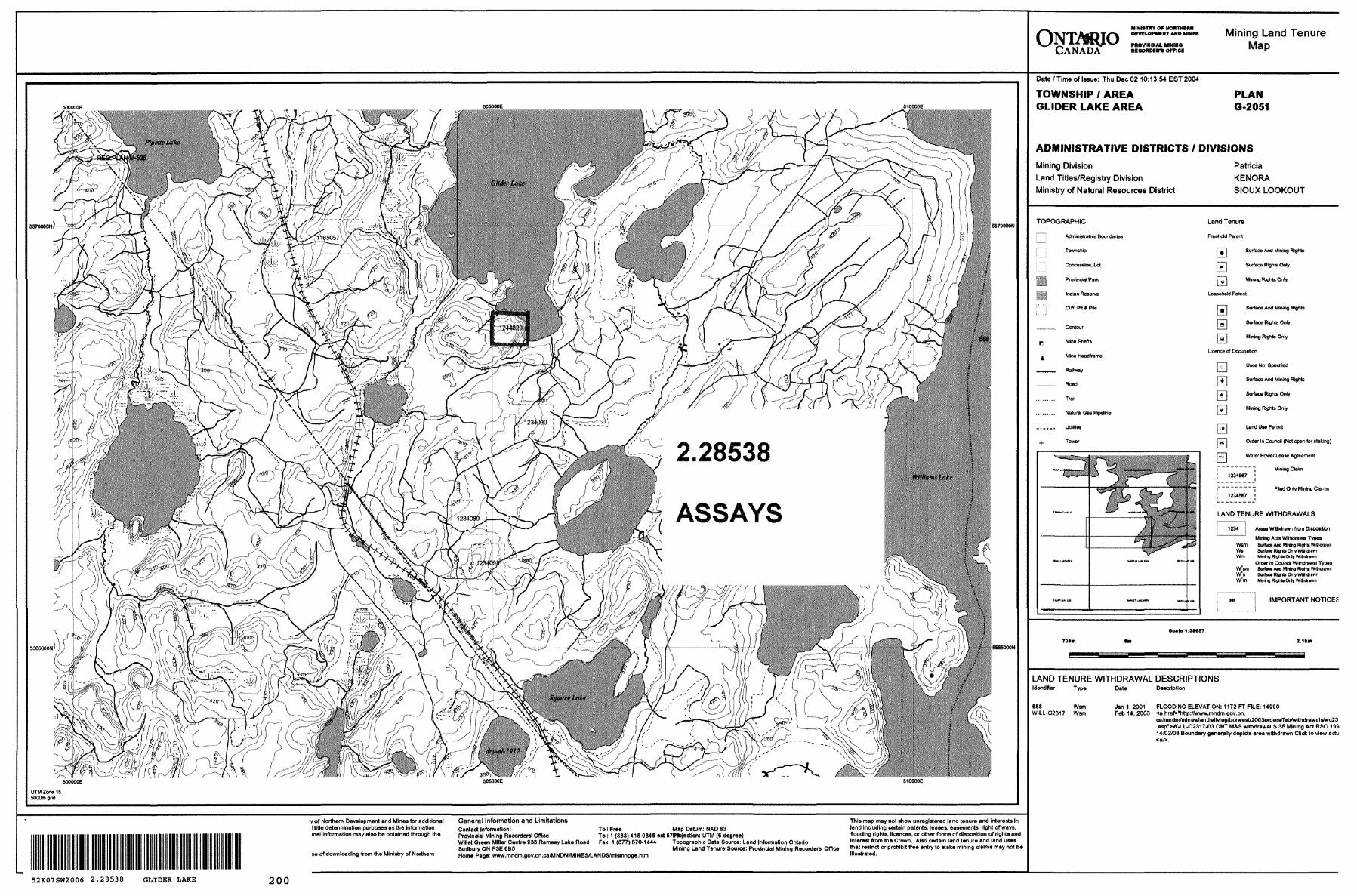
Mining Land Tenure Map
5570000NJ
ASSAYS
5570000N
J5S65000N
UTM Zone 15 6000m grid
"~\ e500000E
Date l Time of Issue: Thu Dec 02 10:13:54 EST 2004
TOWNSHIP l AREA PLAN GLIDER LAKE AREA 6-2051
ADMINISTRATIVE DISTRICTS 7 DIVISIONS
Mining DivisionLand Titles/Registry DivisionMinistry of Natural Resources District
Patricia KENORA SIOUX LOOKOUT
TOPOGRAPHIC
l i Administrative Boundaries
! j Township
Concession, Lot
111 Provincial Park
ill Indian Reserve
l" ": aw, Pit 8 Pite
m
•V
Contcur
Mine Shafts
Mine Headframe
Railway
Road
Trail
Natural Gas Pipeline
Utilities
Tower
Land Tenure
Freehold Palent
j - j Surface And Mining Rights
nn Surface Righte Only
nj"l Minino recite Only
Leasehold Patent
F B 'l Surface And Mining Rights
r^l Surface Rights Only
Tg l Mining Rishb Only
Licence of Occupation
rri Uses Not Specified
PH Surface And Mining Rights
[Z! Surface Rights Only
G"j Mining Rights Only
niT] ^"a Use Permit
f^n Order In Council (Not open for staking)
j w j Water Power Lease Agreement
Mining Claim
Filed Only Mining Claims
LAND TENURE WITHDRAWALS
1234 i Areas Withdrawn from Disposition" Mining Acts Withdrawal Types
Wsm Surtax Ana Mining Rights WithdrawnWe Susce Warns Only WUidrawnWm Mfninfl Right* Only Wfidrawn
Onto In Cound Withdrawal Types vrsrn Surtax Ara Mmng RIOMS Wlfidmwr, W08 SurlK* Riohls Only VWfidriwvn Wam Minino ffionta Oily Withdrawn
IMPORTANT NOTICES
Sctto 1.SH57
LAND TENURE WITHDRAWAL DESCRIPTIONSIdentifier Type Date Description
688 WsmW-U-C2317 Wsm
Jan 1,2001 FLOODING ELEVATION: 1172 FT FILE: 14990 Feb14,2003 *a href-"http:rywww.mndm.gov.on.
.asp^W-LL-C2317-03 OrJT MSS withdrawal S.35 Mining Act RSO 199 14/02/03 Boundary generally depicts area withdrawn Click to view actu
v of Northern Development and Mines for additional General Information and Limitations l title determination purposes as the Information Contact Information: inal information may also be obtained through the
ne of downloading from the Ministry of Northern
This map may not show unregistered land tenure and interests inToll Free Map Datum: NAD 83 lond including certain patents, leases, easements, right of ways,
Provincial Minino Recorders' Office Tel: 1 (888) 415-9846 ext S7*fciection: UTM (6 degree) flooding rights, licences, or other forms of disposition of rights and Willet Green Miller Centre 933 Ramsey Lake Road Fax: 1 (877) 670-1444 Topographic Data Source: Land Information Ontario Interest from the Crown. Also certain land tenure and land uses Sudbury ON P3E 6B6 Mining Land Tenure Source: Provincial Mining Recorders' Office ^at restrict or prohibit free entry to stake mining claims may not be Home Page: www.mndm.gov.on.ca/MNDM/MINES/LANDSAnlsmnpge.htm Illustrated.
52K07SW2006 2.28538 GLIDER LAKE 200