Embed Size (px)
Citation preview

42A86NE8344 2.14609 SHAW010
Report of Exploration Activities
on the
Shaw Township Property
Porcupine Mining Division, Ontario
2.14609
RECEIVEDJUN111992
MINING LANDS BRANCH
December, 1990 Henry Hutteri H.BSc
Ed Korba
o
42*e6NE8344 Z . 1 4689 SHAW 010C
Table of Contents
Introduction............,..,,..,.................... lProperty Description..............................., lLocation and Access...,...................,......... lPrevious Wor k.. . . . . . . . . . . . . . . . . . . . . . . . ........... . . . 2Regional Geology . ................................... 4
Gold Occurrences................................. 5Carshaw Prospect..........,................... 5Tommy Burns Prospect.......................... 5Puissance Corp . . . . . , . , . . . . . . . . . . . . . . . . . . . . . . . . 5
Property Geology.........................,. . . . . . . . . . 6Geophysical Surveying... . . . . . . . . . . . . . . . . . . . . . . . . . . . . 7
Linecutting.. . . . . . . . . . . . . . . , . . . . . . . . . . , . . . . . . . . . . 7VLF-EM Survey..... . . . . . . . . . . . . . . . . . . . . . . . . . . . . . . . 7Magnetometer Survey.............................. 8
Soil Geochemical Survey............................. 8Trenching Program........................... . . . . . . . . 9Conclusions and Recommendations.....................10References................,... .. . . . . . . . . . . . . . . . . . . . .11
List of Figures
Figure l......................... . . .Regional Location MapFigure 2 . . . . . . . . . .... . ..............Claim Location MapFigure 3............................Trench Map SPT-1Figure 4............................Trench Map SPT-2Figure 5............................Trench Map SPT-3Figure 6............................Trench Map SPT-4Figure 7.........,,...,.............Trench Map SPT-5Figure 8............................Trench Map SPT-6Figure 9............................Trench Map SPT-7Figure 10...........................Trench Map SPT-8Figure 11..............,............Trench Map SPT-9
List of Maps
Map l............................Geology MapMap 2...................... . ... . .VLF Profile MapMap 3............................Contoured Magnetic MapMap 4............................Soil Geochem Map
Appendices
Appendix A.......................Analytical ResultsAppendix B . . . ....................Table of Anomalous
Gold Values
-1-
INTRODUCTION
A program of linecutting, prospecting, geological mapping, magnetometer and VLF electromagnetic surveying, soil geochemical sampling and mechanical trenching was carried out on the Shaw Township Property, located 2 .5 miles southeast of South Porcupine, Ontario.
The program was designed to define bedrock lithologies, locate new areas of alteration and gold mineralization and to verify the existence of previously reported gold occurrences on the property.
The field work was carried out by Henry Mutter i and Edward Korba from May to October 1990. The mechanical trenching was performed by Denis Piche Dozer and Backhoe Services Ltd. of Timmins, Ontario, using a John Deer 760 Backhoe. Swastika Laboratories of Timmins, Ontario was used for all of the analytical work.
PROPERTY DESCRIPTION
The property is comprised of 5 contiguous, unpatented mining claims within Shaw Township, Porcupine Mining Division, Ontario. The claims are numbered as follows:
Claim Number No . of Claims Expiry Date 1130882 l March 19 19911130883 l March 191130884 l March 191130885 l March 191130886 l March 19
1991199119911991
All claims are currently registered to Henry Hutteri , Box 59 Porcupine, Ontario, PON ICO, and are held jointly with Edward Korba of R. R. l, Connaught, Ontario, PON 1AO.
LOCATION AND ACCESS
The Shaw Property is located within the north-central portion of Shaw Township, approximately 2.5 miles southeast of South Porcupine, Ontario.
Access to the claims is readily gained by travelling southward from South Porcupine along the Langmuir Mine Road, an all-weather gravel road a few miles to the Goose Lake Road. From this point a poorly maintained secondary road passes eastward onto the claim group after a distance of one half mile (figure 2).
The topography in the area is relatively flat with a relief of approximately 50 feet.

Whitney Township
Deloro
Township
SHAW TOWNSHIP
PROPERTY
SCALE 1 = 50 000 Figure 2

-2-
Approximately one quarter of the property has been recently clearcut (southwest corner). The remaining forest cover consists of stands of poplar, birch, spruce and jackpine.
The Shaw Township Property is located within the city limits of Timmins, Ontario, a major gold mining centre, where equipment and trained mine personnel are available. Sufficient aggregate, water and hydro electric power are available within a few miles of the property for construction and mine operations.
PREVIOUS WORK
The general area was intensively prospected during the early 1900's, around the time of the initial gold discoveries in the Porcupine Mining Camp.
1925: The first work recorded on the property was by Hudson Bay Mines Limited which sunk two 60 foot shafts.
1930: Bay Lake Gold Mines Limited held a group of 9 claims and claim fractions covering the subject property. Trenching and abundant sampling was carried out. The company reported that: drill core samples taken years earlier from around one of the shafts averaged 512 Au and SI.06 Ag per ton @ 520.67 gold, the average assay for the trenches was 58.70 per ton @ 520.67 gold, 4 test pits averaged 59.80 per ton @ 520.67 gold with visible gold reported in each pit, and that 4 bulk samples near one of the shafts averaged 558.66 per ton @ 535.00 per ounce of gold.
1940: Sylvanite Gold Mines Limited optioned the property from Bay Lake Gold Mines Limited. Several "bulk samples" were taken from the property, however, the best result achieved was 0.05 ounces of gold per ton and the property option was dropped.
1966: Flint Rock Mines Limited staked the ground covering the property after the claims reverted to the Crown, A drill program saw approximately 12 of 14 holes sunk on the property from 1972 to 1974. Two of these holes (#8 a #11) were located near a shaft located near the eastern boundary of the property. The other 10 holes were along the Main Carbonate Zone. The results of
-3-
sampled Flintrock core are listed below.
HOLE # LENGTH Au OZ/TON HOST ROCK
1 6' 0.36 mineralized tuff
4.5' 0.25 pyritic quartz stringersin andesite
2 6' 0.12 mineralized tuff
5' 0.19 pyritic quartz stringersin andesite
3 3' 0 .16 mineralized tuff
4.5' 0.02 pyritic quartz stringersin andesite
4 2.5' 0.02 mineralized tuff
4" 0.09 mineralized tuff
5' 0.07 pyritic andesite
5 3 ' 0 .21 mineralized tuff
6 2.5" 0.02 mineralized tuff
3' 0,08 mineralized tuff
3.5' 0.05 pyritic andesite
7 2' 0.04 pyritic quartz vein
3' 0.14 pyrite, chalcopyrite inandesite
8 5' 0.21 pyritic quartz vein
15' 0.24 pyritic quartz vein
10 6.5' 0.38 quartz carbonate zonewith pyrite and chalcopyrite
*No assays available for Holes 81, 82, B3.
1980: Lacana Mining Corporation took an option on the claims belonging to Flint Rock Mines Limited. A magnetic survey was completed on the property and a total of 6 diamond drill holes were sunk. Four of these holes tested the Northern Carbonate Zone while the

other two holes tested the Main Carbonate Zone. In the latter two holes the best results were 0.06 ounces of Au per ton over 10 feet (sludge sample), and a 2.5 foot core sample of 0.03 ounces of Au per ton. The property option was subsequently dropped
1987: Findore Minerals Inc. carried out line- cutting, magnetometer and VLF dip angle surveying over a small group of claims covering the "main showing" area. Several geophysical anomalies were outlined and additional work was recommended. No further work was performed and the claims subsequently lapsed .
REGIONAL GEOLOGY
The Porcupine Camp in which the subject property is situated, lies within the Abitibi greenstone belt of the Precambrian Shield. The lithologies are dominantly Archean in age with the exception of a few diabase dykes. The metavolcanics within the area are divided into two groups, the Deloro and Tisdale Groups. The Deloro group is believed to be the older one of the two and consists of basal komatiitic flows overlain by calc-alkalic basalts and andesites and felsic pyroclastic rocks. Oxide and sulphide iron formations are found interbedded within the felsic volcanics at the top of this group. The overlying Tisdale Group consists of a basal sequence of ultramafic to basaltic komatiitic and magnesium tholeiitic basalt flows overlain by iron-tholeiitic basalts and an upper sequence of felsic, calc-alkalic pyroclastic rocks. Metasediments within the Tisdale and Deloro Groups form a turbidite sequence consisting dominantly of interlayered wacke, siltstone and lesser conglomerate (Fyon and Crocket, 1983).
Ultramafic sills and dykes occur within the Deloro Group metavolcanics which may have been the magma source for the Tisdale Group komatiitic flows (Pyke, 1982).
Several quartz-feldspar porphyry bodies occur along the base of the Tisdale Group which may represent rhyolitic vents and domes (Pyke, 1982). Several gold mines within the Porcupine Camp are found near these porphyry bodies.
A major structural break, the Destor-Porcupine Fault passes through the Porcupine Camp approximately four miles northwest of the Shaw Township Gold Property.
-5-
Gold Occurrences
Carshaw Gold Prospect:
This gold property is located in the southeast corner of Shaw and adjacent Carman Townships. Here, banded iron formation is interbedded in Keewatin basalts. These rock units are intruded by porphyry dykes and small plugs of serpentinite. The iron formation extends for at least 2200 feet and consists of chert interbedded with magnetite with seams of pyrrhotite and disseminated pyrite. Quartz- carbonate veins and stockworks are present in the iron formation with minor mineralization consisting of pyrite, pyrrhotite., galena and gold.
Reserves within the iron formation were calculated to contain 93,000 tons of 0.375 ounces of gold per ton. Further drilling in 1948 indicated a total of 230,000 tons averaging 0.257 ounces of gold per ton (O.D.M. Open File Report 5012). This property is presently being worked by Marshall Minerals.
Tommy Burns Prospect:
This gold property is located in the southeast part of Shaw Township. Here, Keewatin basalts are interbedded with iron formation and rhyolitic agglomerate, which are cut by porphyry dykes. One of two units of iron formation, referred to as the "Sulphide Zone" consists of thin bands of chert interbedded with hematite and magnetite. Gold bearing quartz stringers form crosscutting veinlets with pyrite and pyrrhotite developed adjacent to these veinlets. The "Sulphide Zone" strikes N20 E, dips 25 E and is 1600 feet long. Ore tonnage was estimated to be 70-80,000 tons averaging 0.23 ounces of gold per ton. In 1917, 21 tons of ore were milled which produced 14 ounces of gold.
The ground is presently held by Marshall Minerals who also hold the adjoining Carshaw property.
Puissance Corporation:
This gold property consists of twelve claims within the northeast section of Deloro Township. The claims are underlain by mafic metavolcanic and pyroclastic rocks with interbedded iron formation. An easterly trending fuchsitic ankerite zone extends across the property. Within it, quartz stringers host visible gold although sulphide mineralization is weak.
-6-
PROPERTY GEOLOGY
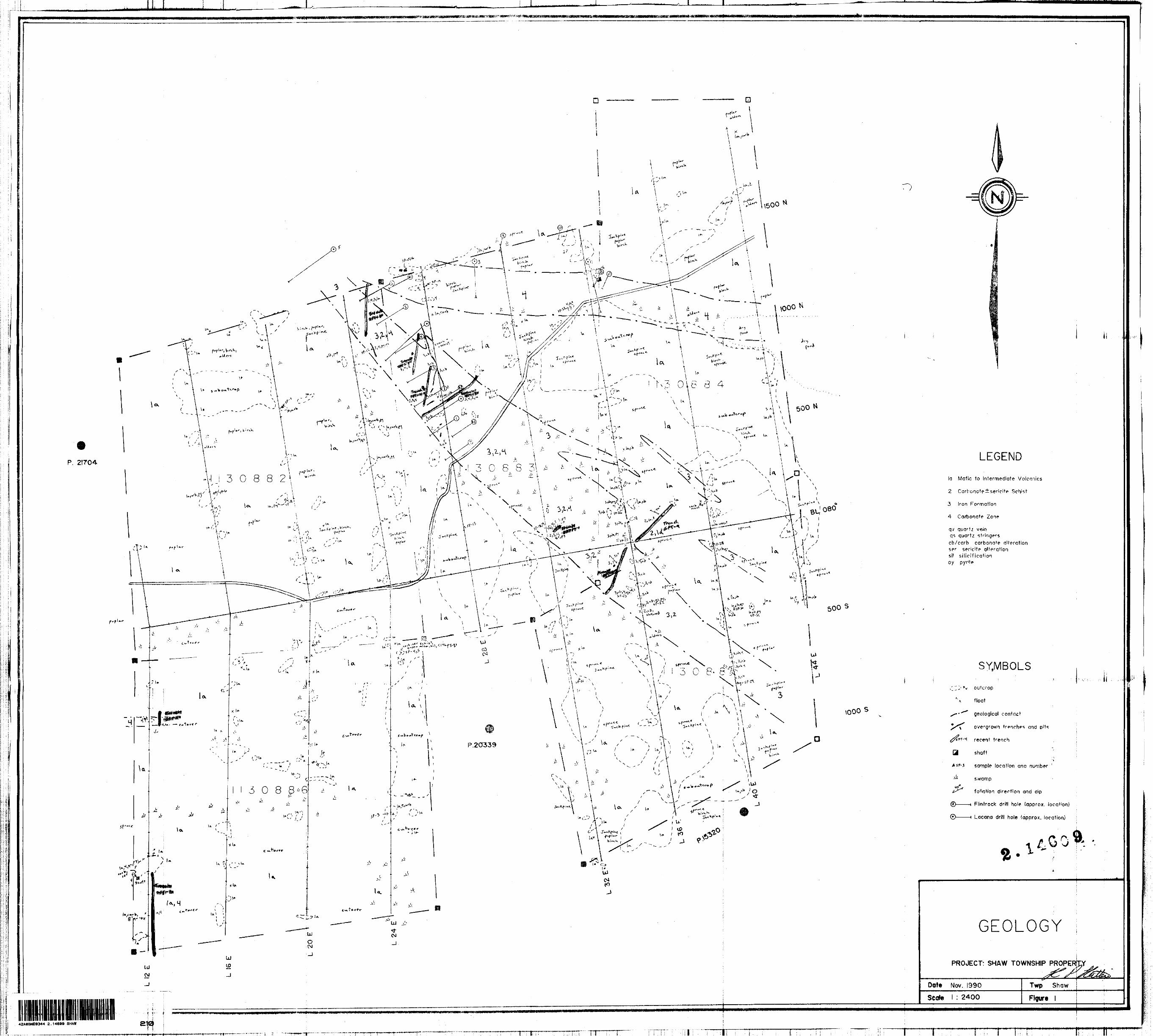
Geological mapping and prospecting was carried out on the Shaw Township Property at a scale of 1:2400 (Map 1). The work was carried out by the author and Edward Korba. A grid was established prior to the survey. All grid lines and areas of outcrop adjacent to and between the lines were walked during the course of the survey.
The mining claims were found to be underlain primarily by mafic to intermediate volcanic flows (la) and lesser carbonate H-/- sericite schists (2), banded magnetite iron formations (3), and carbonate altered zones (4). The rocks observed on the property have been metamorphosed to upper greenschist facies.
The mafic to intermediate volcanic rocks were generally fine grained, massive to weakly foliated with a medium green fresh surface and a variable medium green to slightly whitish weathered surface. The rocks occasionally had a peppered texture with up to J.0% dark green, chloritic l-3mm clots throughout. Large, unstretched, poorly preserved pillow structures (2'x3') were observed in one outcrop only. Calcite filled vesicles were also noted in a few bedrock exposures. Pervasive calcite and weak iron carbonate alteration was frequently encountered during the mapping and prospecting. Only moderate to strong iron carbonate altered areas were indicated on the accompanying geology map.
Carbonate-sericite schists (2) were encountered in the northeast half of the claim group in close association with and parallel to the strong carbonate zones and iron formations. They generally weathered a rusty brownish colour, were soft and had a variable schistosity from weak to strong and friable. Weak, fine grained greenish sericite alteration was observed intermittently throughout these units. Moderate to strong sericite alteration was noted within these schists only in a few locations (Trench SPT-3,4) adjacent to or in close proximity to the strong carbonate zones. A dark green spotty texture was encountered within the schists similar to that found within the mafic to intermediate volcanics. Sulphides and quartz stringers were rare. The carbonate -t-/- sericite schists on the property most likely represent altered and sheared mafic to intermediate volcanic rocks.
Iron formations up to 80 feet wide were encountered in the northeast half of the property. They had an average strike of 130c to 1400 and fairly shallow dips of 30"to 450 to the northeast. The iron formation was typically composed of reddish, white and grey sugary, well laminated chert with thin magnetite bands and occasional green chloritic laminations. Folding, brecciation, silicification and moderate to strong iron carbonate alteration were commonly
-7-
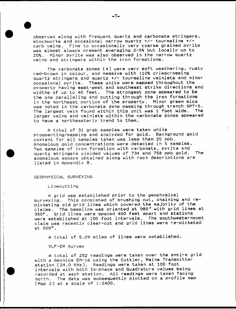
observed along with frequent quartz and carbonate stringers, stockworks and occasional narrow quartz +X- tourmaline +X- carb veins. Fine to occasionally very coarse grained pyrite was almost always present averaging 2-5* but locally up to 203;. Minor pyrite was also observed in the narrow quartz veins and stringers within the iron formations.
The carbonate zones (4) were very soft weathering, rusty red-brown in colour, and massive with ^(^ crisscrossing quartz stringers and quartz +X- tourmaline veinlets and minor occasional pyrite. These units were mapped throughout the property having east-west and southeast strike directions and widths of up to 40 feet. The strongest zone appeared to be the one paralleling and cutting through the iron formations in the northeast portion of the property. Minor green mica was noted in the carbonate zone passing through trench SPT-5. The largest vein found within this unit was l foot wide. The larger veins and veinlets within the carbonate zones appeared to have a northeasterly trend to them.
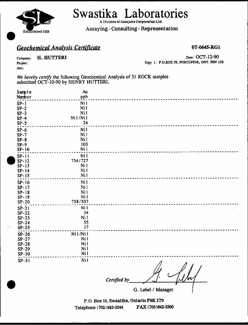
A total of 31 grab samples were taken while prospecting/mapping and analyzed for gold. Background gold content for all samples taken was less than 20 ppb. Anomalous gold concentrations were detected in 5 samples. Two samples of iron formation with carbonate, pyrite and quartz stringers yielded values of 734 and 758 ppb gold. The anomalous assays obtained along with rock descriptions are listed in Appendix B.
GEOPHYSICAL SURVEYING
Linecutting
A grid was established prior to the geophysical surveying. This consisted of brushing out, chaining and re- picketing old grid lines which covered the majority of the claims. The baseline was oriented at 080" with grid lines at 350" . Grid lines were spaced 400 feet apart and stations were established at 100 foot intervals. The southwesternmost claim was recently clear-cut and grid lines were re-picketed at 000".
A total of 5.09 miles of lines were established.
VLF-EM Survey
A total of 252 readings were taken over the entire grid with a Geonics EM-16 using the Cuttler , Maine Transmitter station (24.0 KHz). Readings were taken at 100 foot intervals with both In-phase and Quadrature values being recorded at each station. All readings were taken facing north. The data was subsequently plotted on a profile map (Map 2) at a scale of 1:2400.
-8-
The VLF survey outlined several southeast trending conductive zones, most of which appear to have bedrock sources. Zone A passes southeasterly across the property, has a strong magnetic association and is probably caused by the magnetite iron formations. Zone B is fairly weak, has a weak magnetic association and probably represents a weakly magnetic iron formation. Zones C and D do not have any magnetic correlation but probably have bedrock sources. Zones E and F strike easterly, have coincident low, swampy areas and most likely are caused by conductive overburden.
Magnetometer Survey
A total of 395 readings were collected using a Geometric 816 Proton Precession magnetometer with a l gamma sensitivity. Readings were taken at 100 foot intervals over all grid lines. Additional readings at 50 and 25 foot intervals were taken between stations in areas where the magnetic readings increased or decreased sharply. The field data was corrected for diurnal drift using the base line looping method and subsequently plotted on a map at a scale of 1:2400 and contoured at 500 gamma Intervals (Map 3).
The magnetometer survey outlined a series of moderate to strong, southeast trending magnetic highs on the northeast half of the property which most likely represent banded magnetite iron formations. The highest readings taken over these anomalies was 61826 gammas. This magnetic feature is disturbed with strike deflections in the southeast corner of the claim group suggesting possible folding. The remainder of the property is magnetically flat. The several moderate to strong carbonate alteration zones crossing east and southeasterly through the claim group appear to have corresponding magnetic lows of ^00 gammas. A broad and extensive magnetic low passing easterly from 30E 7 1500N to L44E / 1000N encompasses the main shaft on the property. The main southeast striking carbonate zone associated with the main band of iron formation is not magnetically distinct.
SOIL GEOCHEMICAL SURVEY
A total of 138 B horizon soil samples were taken from the Shaw Township Property and analyzed for gold by Swastika Laboratories of Timmins, Ontario. The samples were taken at 100 foot intervals along grid lines except in swampy, poorly drained areas or areas of bedrock exposure (no soil). The ground sampled was generally well drained with a well developed B horizon.
Background gold appeared to be less than 7 ppb. Several weakly anomalous gold values ranging from 9 to 43 ppb were obtained mainly from the eastern half of the property. One

-9-
highly anomalous gold value of 1742 ppb gold was obtained at L36E/BLO. The results of the soil sampling are plotted on the Soil Geochem Map (4) at a scale of 1:2400. The anomalous soil geochem results are summarized in Appendix B.
TRENCHING PROGRAM
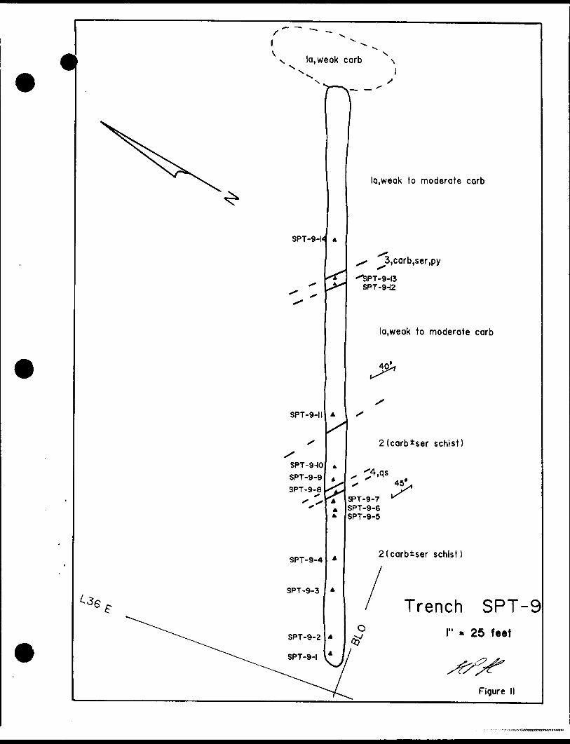
A mechanical trenching program was conducted on the property after the completion of the mapping/prospecting, geophysical surveying and soil geochemical sampling. A total of 9 trenches and 2001 feet of trenching was completed using a John Deer 760 backhoe from Denis Piche Dozer and Backhoe Services Ltd. of Timmins, Ontario.
The trenching was carried out over various carbonate and sericite alteration zones, sulfidized and structurally deformed iron formations, soil geochemical anomalies, magnetic lows and quartz veined areas throughout the property.
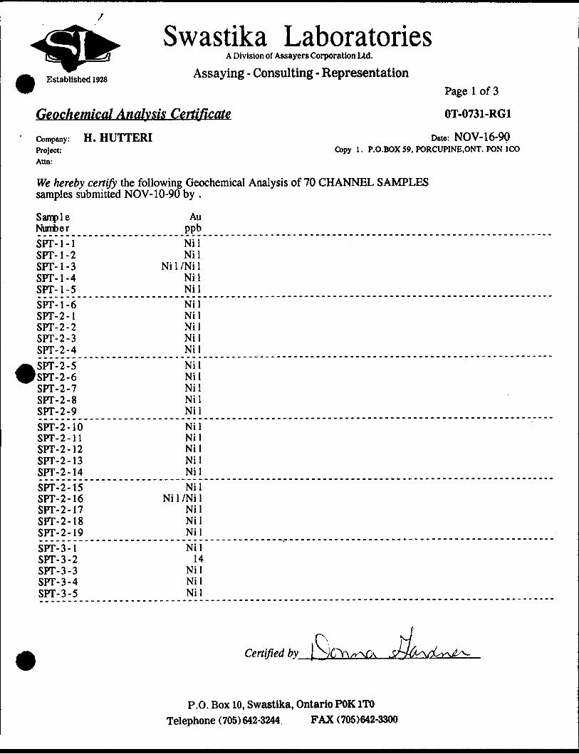
A total of 148 grab and chip samples were taken and analyzed for gold content by Swastika Laboratories of Timmins, Ontario. The trenches were mapped in detail and the maps are included in this report (figures 3 to 11). Washing of the trenches was not achieved due to the lack of a nearby water supply.
The highest gold value obtained from the trench sampling was 0.35 opt gold from a grab sample of iron formation with 203; pyrite. Numerous anomalous values were also obtained from trenches SPT-3 to 9. These results along with sample descriptions are summarized in Appendix B.
woler
N 4,qsx
SPT-l-4
SPT-l-5A
SPT-l-6
SPT-l-3
SPT-l-i
SPT-I-I
Legendla Mafic to Intermediate volcanics
2 Carbonate t sericite schist
3 Iron Formation
4 Carbonate Zone
qv quartz vein qs quartz stringer carb carbonate ser sericite tour tourmaline i sarnie location
water
5'
la,weak carb
4, 2"qv,qs,minor ser
•Id
la,weak to moderate carb
Trench SPT-- 500 S
lil M
l" - 10 feel
Rgure 3

Ul
OJ
blast rock from shoft-SPT-2-ll to W
N
deep ovb
la.weak carb
\ \
old trench -I'qv.ser.corb.chl
I400S
s-.-
1500 S
\ 4(shear zone),2"qv,py -SPT-2-17 to 19
ia,weak carb
la
water
,. la,mod.carb,6"qv "" -SPT-2-4 to 8
SPT-2-3 (2"QV)
la
SPT-2-2(5"qv)SPT-2-1
la
strike II3V70 S*
Trench SPT-250feet
Figure 4
la
xH !V 2(carb-chl schist)
SPT-3-13 to 17
SPT-3-18 *
SPT-3-19
SPT-3-32
3,carb,chl,py
la,weak carb
2(carb schist)SPT-3-28
3,carb,chl,pySPT-3-23 to 27
2(carb schist)
' 3,carb,py 2(carb schist)
3.carb,py
4.qs,qv,tour,py,green micaSPT-3-1 to 10,20 to 22
schist) 2(carbtser"SchlsJ)
3,carb,py-folding and brecciation
}y* l 2(carb schist)
deep ovb
Trench SPT-3l" - 50 feet
Figure 5
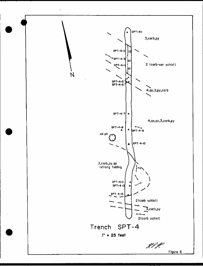
i. SPT-4-1
3,carb,py
SPT-4-2
SPT-4-3
SPT-4-^
XSPT-4-5' SPT-4-6x
SPT-4-7
SPT-4-9A
old pit
O
2 (corb-ser schist)
-4,qs,3,py,carbX
4,qs,qv,3,carb,py
SPT-4-8
ISPT-4-IO
3,carb,py,qs -strong folding
SPT-4-II SPT-4-12
SPT 4-13
V-/ 2(carb schist)
Trench SPT-4l" - 25 feet
Figure 6
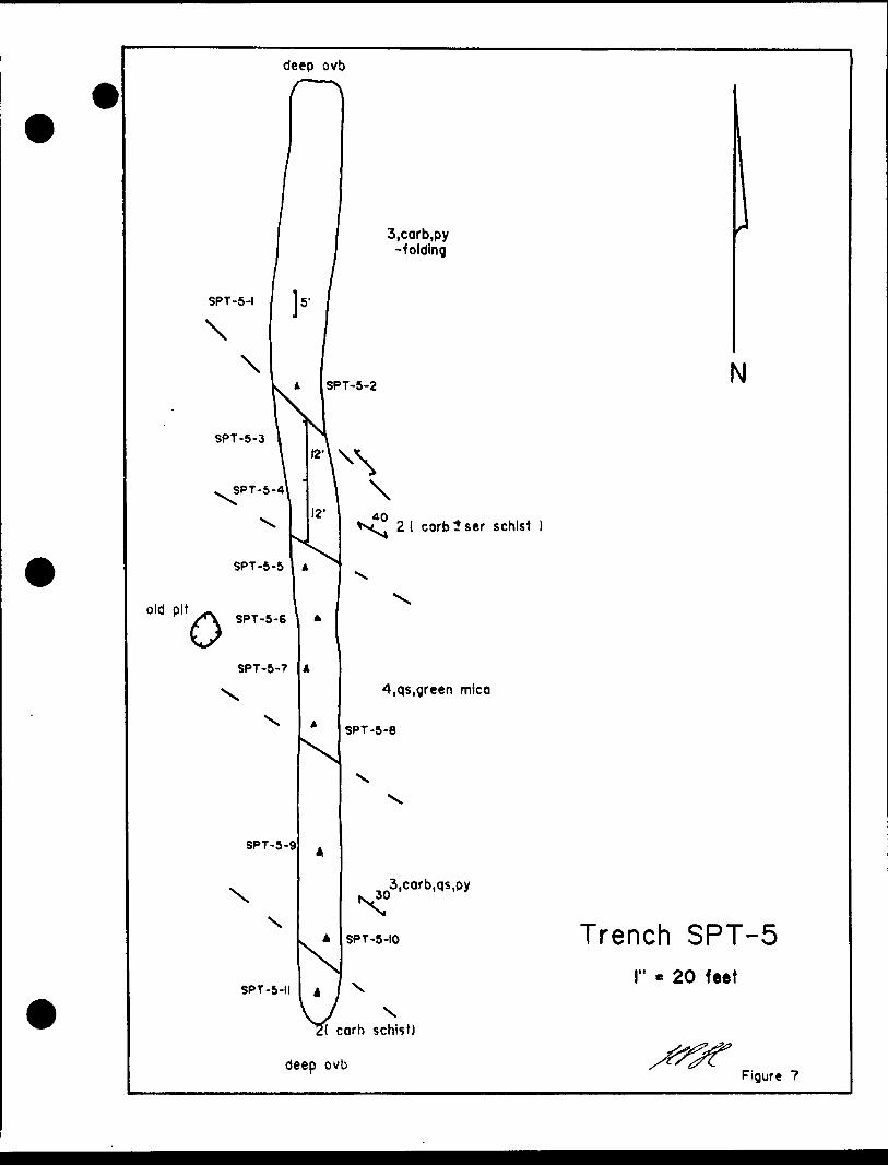
deep ovb
old pit
3,carb,py -folding
2( corblser schist
SPT-5-7
SPT-5-9
4,qs,green mica
SPT-5-8
3,corb,qs,py
SPT-5-II 4
SPT-5-10
\ carb schist)
deep ovb
N
Trench SPT-520 feet
Figure 7
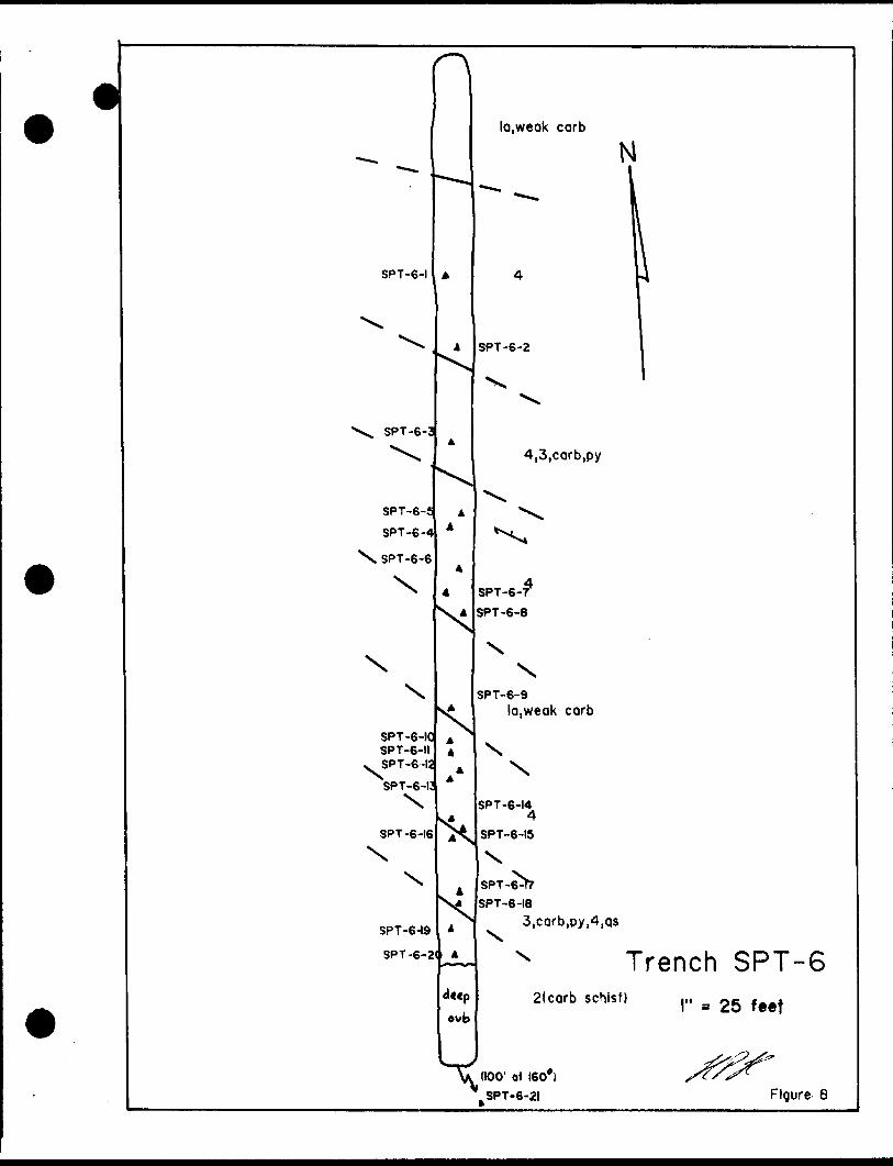
SPT-6-1
SPT-6-3
SPT-6-f SPT-6-
\SPT-6-6
.
\
SPT-6-! SPT-6-IISPT-6-1SPT-6-
SPT-6-16
SPT-6-19 SPT-6-
la.weok carb
SPT-6-2
4,3,carb,py
SPT-6-T SPT-6-8
SPT-6-9la,weak carb
N
SPT-6-14
SPT-6-15
N-6^?SPT
SPT-6-18
ovb
3,carb,oy,4,qs
x Trench SPT-62(carb schist) ,,. - Oe ^ce*
(100' at 160*) SPT-6-21 Figure 8
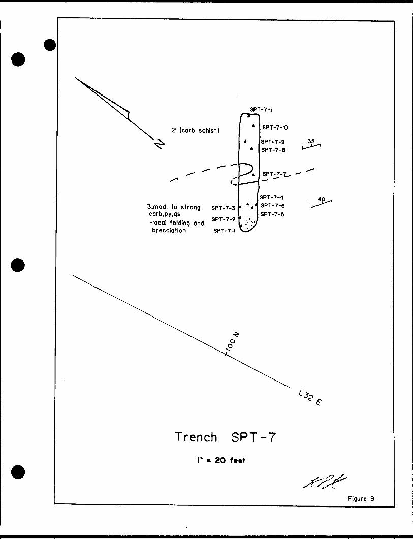
2 (carb schist)
SPT-7-II
3,mod. to strong carb,py,qs-local folding and brecciation SPT-7-i
SPT-7-3
SPT-7-2
SPT-7-10
SPT-7-9 SPT-7-8
SPTjJ-7^.
SPT-7-4
SPT-7-6
SPT-7-5
40
Trench SPT-7
20 feet
Figure 9

Legend
la Mafic to Intermediate volcanics
2 Coronate t sericite schist
3 Iron Formation
4 Carbonate Zone
qv quartz vein qs quartz stringer carb carbonate ser sericite tour tourmaline
A sample location
SPT-8-2
SPT-8-3
SPT-8-4
JvSPT-8-l
SPT-8-6 SPT-8-?
SPT-lTe SPT-8-9
SPT-8-1!
spT-e-12
SPr-8-14
SPT-8-IS
3,carb,r -breccial
2 (carb-ser schist;
SPT-8-10
r3,corb,oy -strong folding
35
40
2 (carb schist)
SPT-8-2!
3,carb,py
2 (carb*ser schist)
Trench SPT-8l" - 25 feet
Figure 10
la,weak carbs
SPT-9-1
SPT-9-1
SPT-9-10 SPT-9-9 SPT-9-8
SPT-9-4
SPT-9-3
la,weak to moderate carb
3,carb,ser,py
•"iSPT-9-13 SPT-9H2
lo,weak to moderate carb
2(carb ser schist)
SPT-9-7 SPT-9-6 SPT-9-5
2(carbtser schist)
Trench SPT-9l" ^ 25 feet
Figure

-10-
CONCLUSIONS AND RECOMMENDATIONS
A program of linecutting, prospecting, geological mapping, VLF and magnetometer surveying, soil geochemical sampling and mechanical trenching has been completed on the Shaw Township Property. The claim group was found to be underlain predominantly by mafic to intermediate volcanic flows and lesser carbonate +X- sericite schists, banded magnetite iron formations and carbonate alteration zones.
The geophysical surveys outlined several bands of iron formation, a number of magnetic lows which often represented carbonatized zones and a few new conductive zones which warrant further investigation.
The trenching and sampling program was successful in exposing most of the selected targets with the exception of the 1742 ppb soil anomaly which was marginal to a swamp. Numerous anomalous gold values up to 0.35 opt were obtained mainly from samples of sulfidized and carbonatized iron formation. Quartz veining was generally narrow ( <l'*) a nd contained minor pyrite, carbonate, sericite and tourmaline occasionally. Fine quartz stringers and stockworks are common within the carbonate zones and deformed, sulfidized iron formations. The 3 foot wide quartz vein previously reported on claim 1130883 was not observed during the course of the program.
The sulfidized iron formations appear to be the most favorable target on the Shaw Township Property and are similar to those hosting significant gold mineralization further to the south at the Carshaw and Tommy Burns gold prospects. Additional detailed prospecting along the iron formations appears to be warranted as well as washing and channel sampling in areas where anomalous gold has been detected. In areas covered by overburden, an Induced Polarization survey would be useful in detecting additional sulfidized zones prior to drilling.
Respectfully Submitted,
Henry P. Hutteri, H.BSc.
-11-
REFERENCES
Burrows, A.G. (1924) The Porcupine Gold Area, O.D.M. Report #33 part 2.
Carlson, H.D. (1967) Geology of Ogden, Deloro and Shaw Townships, District of Cochrane, Ontario, O,D.M. Open File Report 5012, with maps P-341 to P-343.
Ferguson, S.A. et al. Gold Deposits of Ontario, part l, Cochrane District. Reprint of M,R.C. #13, 1971.
Fyon, J.A. fe Crocket, J.H. (1983) Gold Exploration in the Timmins Area-Using Field and Lithogeochemical Characteristics of Carbonate Alteration Zones. O.G.S. Study #26.
Pyke, D.R. (1982) Geology of the Timmins Area, District of Cochrane. O.G.S. Report #219 with map 2455.
Pertinent Assessment Files.

Appendix A
Established 1928
Swastika LaboratoriesA Division of Assayers Corporation Ltd.
Assaying - Consulting - Representation
Geochemical Analysis Certificate
Company:Project:Attn:
H. HUTTERI
OT-0645-RG1
Date: OCT-12-90 Copy l. P.O.BOX 59, PORCUPINE, ONT. PON ICO
We hereby certify the following Geochemical Analysis of 31 ROCK samples submitted OCT-10-90 by HENRY HUTTERI.
Sample NumberSP-1 SP-2 SP-3 SP-4 SP-5
SP-6 SP-7 SP- 8 SP-9 SP- 10SP- 11 SP- 12 SP- 13 SP- 14 SP- 15SP- 16 SP- 17 SP-18 SP- 19 SP-20SP-21 SP-22 SP-23 SP-24 SP-25SP-26 SP-27 SP-28 SP-29 SP-30SP-31
Au ppbNil Nil Nil
Ni 1 /Ni 1 24
Nil Nil Nil 103 NilNil
734/727 Nil Nil NilNilNil Nil Nil
758/507Nil 34
Nil 55 17
Ni 1 /Ni 1 Nil NilNil Nil
Nil x
Certified by.
G. Lebel f Manager
P.O. Box 10, Swastika, Ontario POK1TO Telephone (705) 642-3244 FAX (705)642-3300
Swastika LaboratoriesA Division of Assayers Corporation Ltd.
Established 1928 Assaying - Consulting - RepresentationPage l of 3
Geochemical Analysis Certificate OT-0731-RG1Company: H . HUTTERI Date: NOV-16-9Q Project: Copy 1. P.O.BOX 59, PORCUPINE.ONT. PON ICO Attn:
We hereby certify the following Geochemical Analysis of 70 CHANNEL SAMPLES samples submitted NOV-10-90 by .
Sample NumberSPT- 1 - 1 SFT-1-2 SPT- 1-3 SPT- 1-4 SPT- 1-5
SPT- 1-6 SPT-2-1 SPT-2-2 SPT-2-3 SPT-2-4SPT-2-5 SPT-2-6 SPT-2-7 SPT-2-8 SPT-2-9
SPT-2-10 SPT-2-11 SPT-2-12 SPT-2-13 SPT-2-14
SPT-2-15 SPT-2-16 SPT-2-17 SPT-2-18 SPT-2-19SPT-3-1 SPT-3-2 SPT-3-3 SPT-3-4 SPT-3-5
Au ppbNil Nil
Ni 1 /Ni 1 Nil NilNil NilNil Nil NilNil Nil NilNil NilNil Nil NilNil NilNil
Ni 1 /Ni 1 NilNil NilNil 14
Nil Nil Nil
Certified by
P.O. Box 10, Swastika, Ontario POK1TO Telephone (705) 642-3244 FAX (705)642-3300
Swastika LaboratoriesA Division of Assayers Corporation Ltd.
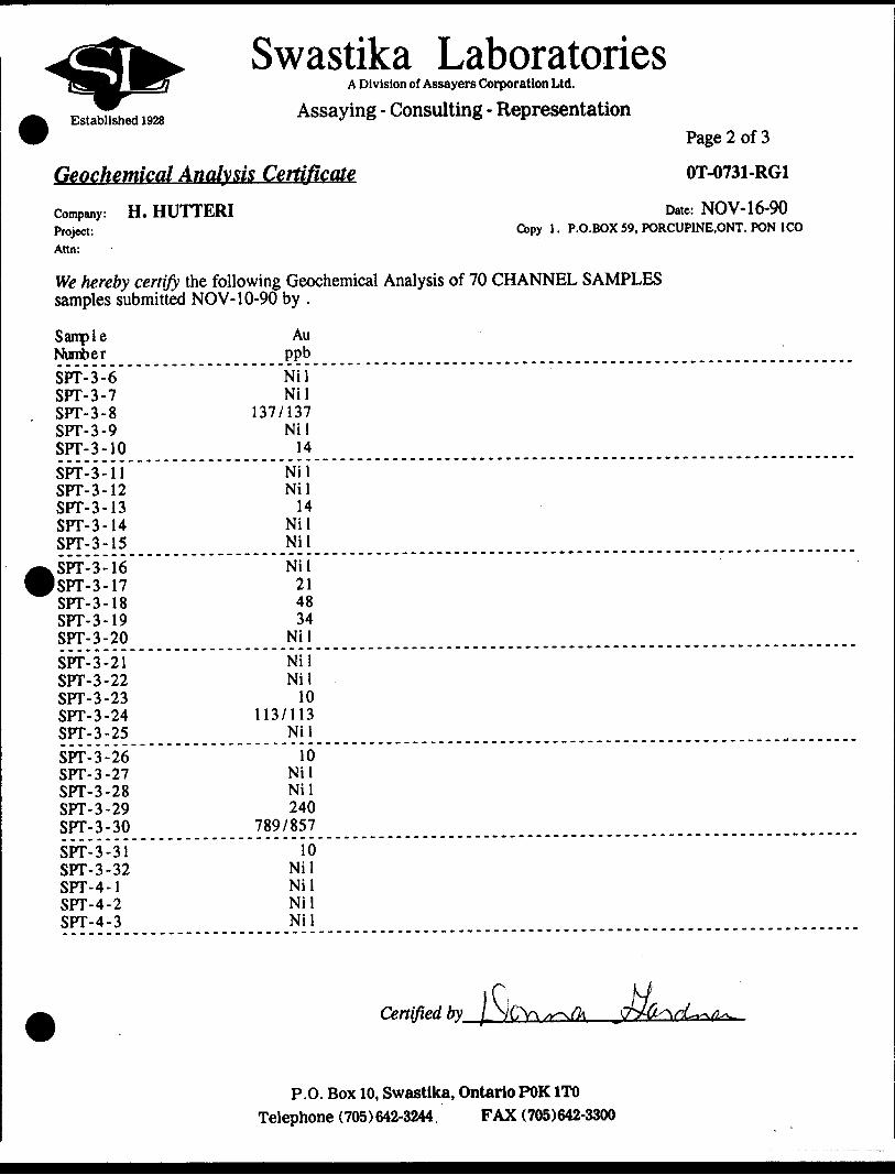
Assaying - Consulting - RepresentationPage 2 of 3
Geochemical Analysis Certificate OT-0731-RG1
Company: H . HUTTERI Date: NOV-16-90
Project: Copy l. P.O.BOX 59, PORCUPINE.ONT. PON ICO Ann:
We hereby certify the following Geochemical Analysis of 70 CHANNEL SAMPLES samples submitted NOV-10-90 by .
Sample NumberSPT-3-6 SPT-3-7 SPT-3-8 SPT-3-9 SPT-3-10
SPT-3-11 SPT-3-12 SPT-3-13 SPT-3-14 SPT-3-15
ISPT-3-16 SPT-3-17 SPT-3-18 SPT-3-19 SPT-3-20
SPT-3-21 SPT-3-22 SPT-3-23 SPT-3-24 SPT-3-25
SPT-3-26 SPT-3-27 SPT-3-28 SPT-3-29 SPT-3-30
SPT-3-31 SPT-3-32 SFT-4-1 SPT-4-2 SPT-4-3
Au ppbNil Nil
137/137 Nil 14
Nil Nil 14
Nil NilNil 21 48 34
NilNil Nil 10
113/113 Nil10
NilNil 240
789/85710
Nil Nil Nil Nil
Certified by
P.O. Box 10, Swastika, Ontario POK1TO Telephone (705) 642-3244 FAX (705)642-3300
Established 1928
Swastika LaboratoriesA Division of Assayers Corporation Ltd.
Assaying - Consulting - Representation
Geochemical Analysis Certificate
Company: H . HUTTERIProject:Ann:
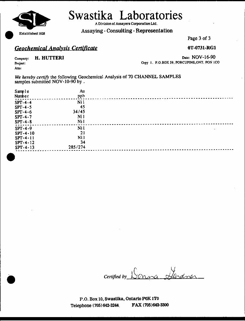
Page 3 of 3
OT-0731-RG1
Date: NOV-16-90 Copy l. P.O.BOX 59, PORCUPINE.ONT. PON ICO
We hereby certify the following Geochemical Analysis of 70 CHANNEL SAMPLES samples submitted NOV-10-90 by .
Sample NumberSPT-4-4 SFT-4-5 SPT-4-6 SPT-4-7 SPT-4-8SFT-4-9 SPT-4-10 SFT-4-11 SPT-4-12 SPT-4-13
Au ppbNil 45
34/45 Nil NilNil 21
Nil 34
285/274
Certified by_iC 'VIsjflVx/v^ .M^\
P.O. Box 10, Swastika, Ontario POK1TO Telephone (705) 642-3244. FAX (705)642-3300

Swastika LaboratoriesA Division of Assayers Corporation Ltd.
Established 1928 Assaying - Consulting - RepresentationPage l of 3
Geochemical Analysis Certificate OT-0732-RG1Company: H . HUTTERI Date: NOV-19-90 Project: Copy l. P.O.BOX 59, PORCUPINE, ONT. PON ICO Attn:
We hereby certify the following Geochemical Analysis of 78 CHANNEL samples submitted NOV-10-90 by HENRY HUTTERI.
Sample NumberSPT-5-1 SPT-5-2 SPT-5-3 SPT-5-4 SPT-5-5SPT-5-6 SPT-5-7 SFT-5-8 SPT-5-9 SPT-5-10
(SFT-5-11
SPT-6-1 SPT-6-2 SPT-6-3 SFT-6-4SPT-6-5 SFT-6-6 SFT-6-7 SPT-6-8 SFT-6-9
SPT-6-10 SPT-6-11 SPT-6-12 SFT-6-13 SPT-6-14
SPT-6-15 SPT-6-16 SPT-6-17 SPT-6-18 SPT-6-19
Au Au Au ppb g/ tonne oz/tonNil 14
Nil Nil NilNil 10
Nil Nil
302/278Nil 14 17
21/17 Nil38 14
Nil 5
NilNil Nil 10
Nil NilNil 14 5
58 Nil
Certifie
P.O. Box 10, Swastika, Ontario POK1TO Telephone (705) 642-3244, FAX (705)642-3300

Established 1928
Swastika LaboratoriesA Division of Assayers Corporation Ltd.
Assaying - Consulting - Representation
Geochemical Analysis Certificate
Company:Project:Ann:
H. HUTTERI
Page 2 of 3
OT-0732-RG1
Date: NOV-19-90 Copy l. P.O.BOX 59, PORCUPINE, ONT. PON ICO
We hereby certify the following Geochemical Analysis of 78 CHANNEL samples submitted NOV-10-90 by HENRY HUTTERI.
Sample NumberSPT-6-20 SPT-6-21 SPT-7-1 SPT-7-2 SPT-7-3SFT-7-4 SPT-7-5 SPT-7-6 SPT-7-7 SPT-7-8SPT-7-9 SPT-7-10 SPT-7-11 SPT-8-1 SPT-8-2SPT-8-3 SPT-8-4 SPT-8-5 SPT-8-6 SFT-8-7SPT-8-8 SPT-8-9 SPT-8-10 SPT-8-11 SFT-8-12
SFT-8-13 SPT-8-14 SPT-8-15 SFT-8-16 SPT-8-17
Au Au Au ppb g/tonne oz/tonNil
593/408 24
1087 6586
14400 12.10 .353 58
Nil 27
Nil Nil 10
Nil 10
Nil 14
Nil 10
Nil312 Nil
254/223 Nil 48
250/319 Nil Nil Nil 487
Certified by-
P.O. Box 10, Swastika, Ontario POK1TO Telephone (705) 642-3244 FAX (705)642-3300
Established 1928
Swastika LaboratoriesA Division of Assayers Corporation Ltd.
Assaying - Consulting - Representation
Geochemical Analysis Certificate
Company: H . HUTTERIProject:Attn:
Page 3 of 3
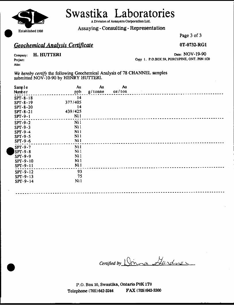
OT-0732-RG1
Date: NOV-19-90 Copy l. P.O.BOX 59, PORCUPINE, ONT. PON ICO
We hereby certify the following Geochemical Analysis of 78 CHANNEL samples submitted NOV-10-90 by HENRY HUTTERI.
Sample NumberSPT-8-18 SPT-8-19 SPT-8-20 SPT-8-21 SPT-9-1SPT-9-2 SPT-9-3 SPT-9-4 SPT-9-5 SPT-9-6
ISPT-9-7 SPT-9-8 SPT-9-9 SPT-9-10 SPT-9-11
SPT-9-12 SPT-9-13 SPT-9-14
Au Au ppb g/ tonne14
377/405 14
439/425 NilNil Nil Nil Nil NilNilNil Nil Nil Nil93 75
Nil
Au oz/ton
Certified by LNf
P.O. Box 10, Swastika, Ontario POK1TO Telephone (705) 642-3244 FAX (705)642-3300
Established 1928
Swastika LaboratoriesA Division of Assayers Corporation Ltd.
Assaying - Consulting - Representation
Geochemical Analysis Certificate
HENRY HUTTERI
HENRY HUTTERI
Company:Project:Attn:
Page l of 3
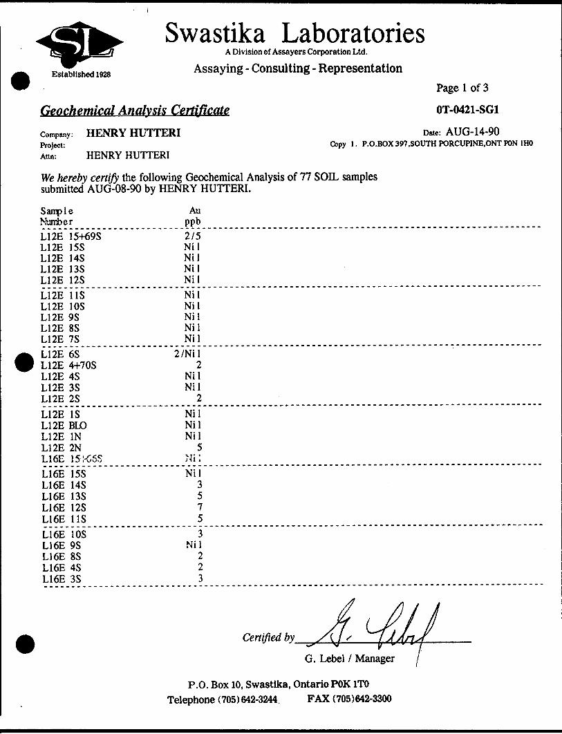
OT-0421-SG1
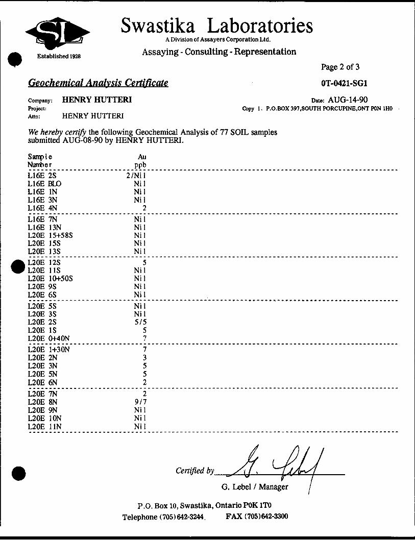
Date: AUG-14-90 Copy 1. P.O.BOX 397,SOUTH PORCUPINE.ONT POM 1HO
We hereby certify the following Geochemical Analysis of 77 SOIL samples submitted AUG-08-90 by HENRY HUTTERI.
Sample NumberL12E 15+69S L12E 15S L12E 14S L12E 13S L12E 12SL12E US L12E 10S L12E 9S L12E 8S L12E 7SL12E 6S L12E 4+70S L12E 4S L12E 3S L12E 2S
L12E IS L12E BID L12E IN L12E 2N L16E 15J-C6SL16E 15S L16E 14S L16E 13S L16E 12S L16E USL16E 10S L16E 9S L16E 8S L16E 4S L16E 3S
Au ppb2/5 Nil Nil Nil NilNil Nil NilNil Nil
2 /Nil 2
Nil Nil
2Nil Nil Nil
5 NilNil
3 5 7 53
Nil2 2 3
Certified by
G. Lebel l Manager
P.O. Box 10, Swastika, Ontario POK1TO Telephone (705) 642-3244. FAX (705)642-3300
Established 1928
Swastika LaboratoriesA Division of Assayers Corporation Ltd.
Assaying - Consulting - Representation
Geochemical Analysis Certificate
Company: HENRY HUTTERIProject:Attn: HENRY HUTTERI
Page 2 of 3
OT-0421-SG1
Date: AUG-14-90 Copy l. P.O.BOX 397.SOUTH PORCUPINE.ONT PON 1HO
We hereby certify the following Geochemical Analysis of 77 SOIL samples submitted AUG-08-90 by HENRY HUTTERI.
Sample NumberL16E 2S L16E BLO L16E IN L16E 3N L16E 4NL16E 7N L16E 13N L20E 15+58S L20E 15S L20E 13SL20E 12S L20E US L20E 1 Of SOS L20E 9S L20E 6SL20E 5S L20E 3S L20E 2S L20E IS L20E (H40NL20E 1+30N L20E 2N L20E 3N L20E 5N L20E 6NL20E 7N L20E 8N L20E 9N L20E ION L20E UN
Au ppb
2 /Nil Nil Nil Nil
2Nil Nil Nil Nil Nil
5 Nil Nil Nil NilNil Nil5/5
5 7
7 3 5 522
9/7 Nil Nil Nil
Certified by.
G. Lebel l Manager
P.O. Box 10, Swastika, Ontario POK1TO Telephone (705) 642-3244 FAX (705)642-3300
Established 1928
Swastika LaboratoriesA Division of Assayers Corporation Ltd.
Assaying - Consulting - Representation
Geochemical Analysis Certificate
Company: HENRY HUTTERIProject:Attn: HENRY HUTTERI
Page 3 of 3
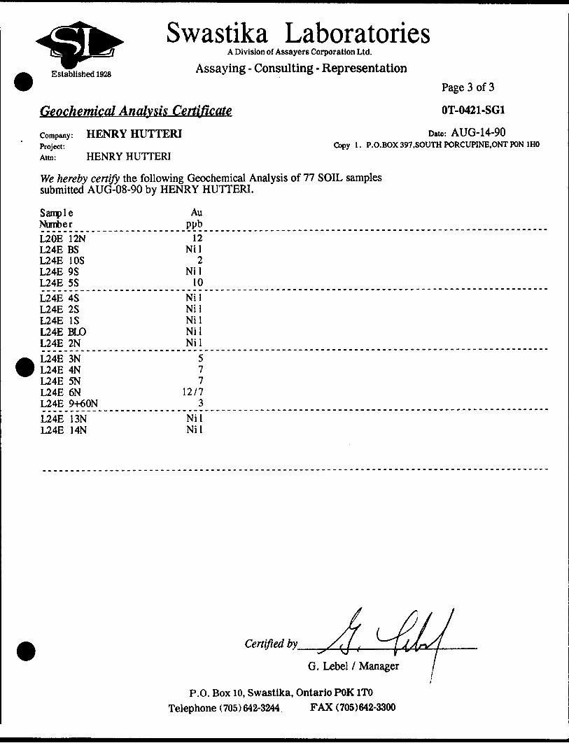
OT-0421-SG1
Date: AUG-14-90 Copy 1. P.O.BOX 397.SOUTH PORCUPINE.ONT PON 1HO
We hereby certify the following Geochemical Analysis of 77 SOIL samples submitted AUG-08-90 by HENRY HUTTERI.
Sample NumberL20E 12N L24E BS L24E 10S L24E 9S L24E 5SL24E 4S L24E 2S L24E IS L24E BLO L24E 2NL24E 3N L24E 4N L24E 5N L24E 6N L24E 9+60NL24E 13N L24E 14N
Au ppb12
Nil 2
Nil 10
Nil Nil Nil Nil Nil
57 7
12/7 3
Nil Nil
Certified by
G. Lebel l Manager
P.O. Box 10, Swastika, Ontario POK1TO Telephone (705)642-3244 FAX (705)642-3300
Established 1928
Swastika LaboratoriesA Division of Assayers Corporation Ltd.
Assaying - Consulting - Representation
Geochemical Analysis Certificate
HENRY HUTTERI
HENRY HUTTERI
Company:Project:Attn:
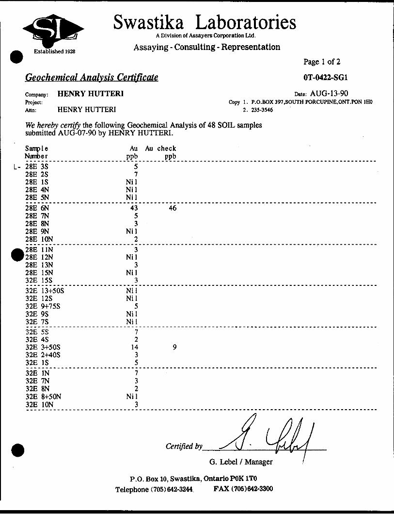
Page l of 2
OT-0422-SG1
Date: AUG-13-90Copy l, P.O.BOX 397.SOUTH PORCUPINE.ONT.PON 1HO
2. 235-3546
We hereby certify the following Geochemical Analysis of 48 SOIL samples submitted AUG-07-90 by HENRY HUTTERI.
Sample Number
L- 28E 3S 28E 2S 28E IS 28E 4N 28E 5N28E 6N 28E 7N 28E 8N 28E 9N 28E ION
28E UN 28E 12N 28E 13N 28E 15N 32E 15S32E 13+50S 32E 12S 32E 9+75S 32E 9S 32E 7S32E 5S 32E 4S 32E 3+50S 32E 2+40S 32E IS32E IN 32E 7N 32E 8N 32E 8+50N 32E ION
Au ppb
57
Nil Nil Nil43 5 3
Nil 23
Nil 3
Nil 3
Nil Nil
5 Nil Nil
7 2 14 3 57 3 2
Nil3
Au check Ppb
46
9
Certified by
G. Lebel l Manager
P.O. Box 10, Swastika, Ontario POK1TO Telephone (705) 642-3244. FAX (705)642-3300
Established 1928
Swastika LaboratoriesA Division of Assayers Corporation Ltd.
Assaying - Consulting - Representation
Geochemical Analysis Certificate
HENRY HUTTERI
HENRY HUTTERI
Company:Project:Attn:
Page 2 of 2
OT-0422-SG1
Date: AUG-13-90Copy l. P.O.BOX 397.SOUTH PORCUPINE.ONT.PON 1HO
2. 235-3546
We hereby certify the following Geochemical Analysis of 48 SOIL samples submitted AUG-07-90 by HENRY HUTTERI.
Sample Number
L-32E 13N 32E 14N 36E 13+50S 36E 9S 36E 7+80S
36E 2S 36E IS 36E BLO 36E IN
^36E 2N P36E 13N
40E IN 40E 2+20N 40E 4N
40E UN 40E 12N
Au PPb
7 Nil
3 Nil
2
17 10
1742 3
3 7 3
Nil
32
Au check PPb
1299
Certified by
G. Lebel l Manager
P.O. Box 10, Swastika, Ontario POK 1TO Telephone ( 705) 642-3244 FAX (705)642-3300

Established 1928
Swastika LaboratoriesA Division of Assayers Corporation Ltd.
Assaying - Consulting - Representation
Geochemical Analysis CertificateCompany: HENRY HUTTERIProject:Ann: ED KOREA l H . HUTTERI
OT-0490-SG1
Date: SEP-07-90 Copy 1. BOX 397,SOUTH PORCUPINE.ONT. POM 1HO
We hereby certify the following Geochemical Analysis of 13 SOILS samples submitted AUG-30-90 by .
Sample Number
Au ppb
2 2
Nil Nil 9/3
L-40E-5+50 S L-40E-2+50 S L-40E-13 N L-40E-15 N L-40E-16 NL-44E-4 S L-44E-3 N L-44E-4 N L-44E-7 N L-44E-10 N
NilNil
2NilNil
L-44E-11 NJL-44E-12 NL-44E-15 N
Nil Nil Nil
Certified by.
G. Lebel l Manager
P.O. Box 10, Swastika, Ontario POK1TO Telephone (705) 642-3244, FAX (705)642-3300
Appendix B
SIGNIFICANT RESULTS FROM PROSPECTING (grabs)
Sample # Au (ppb ) Description
SP-9 103 la, carb, 1-2* py, qs
SP-12 734 IF, sil, carb, 3-5* eg py, qs
SP-20 758 IF, qs, carb, py
SP-22 34 IF, carb, py, qs
SP-24 55 l' qv with coarse py

SIGNIFICANT SOIL GEOCHEM RESULTS "8 Horizon"
Location Au (ppb)
L20E X 8N 9
L20E X 12N 12
L24E X 5S 10
L24E X 6N 12
L28E X 6N 43
L32E X 3+50S 14
L36E X 2S 17
L36E X IS 10
L36E X BLO 1742
L40E X 16N 9

Sample # Au ( ppb ) Description
SPT-8-8 312 IF, carb, 1-2* py
SPT-8-10 254 rusty yellow qv (float)
SPT-8-12 48 IF, carb, 2-3* py
SPT-8-13 250 eg py in l' yellow qv
SPT-8-17 487 20* py in IF
SPT-8-19 377 3-5* py in 1-2' IF, carb
SPT-8-21 439 l* py, qs in IF, carb
SPT-9-12 93 IF, carb, ser
SPT-9-13 75 1-2* py in IF, carb
SIGNIFICANT RESULTS FROM TRENCHES (grabs)
Sample tt
SPT-3-8
SPT-3-18
SPT-3-19
SPT-3-24
SPT-3-29
SPT-3-30
SPT-4-5
SPT-4-6
SPT-4-12
SPT-4-13
SPT-5-10
SPT-6-5
SPT-6-18
SPT-6-21
SPT-7-2
SPT-7-3
SPT-7-4
SPT-7-5
SPT-7-6
Au (ppb)
137
48
34
113
240
857
45
45
34
285
302
38
58
593
1087
65
86
14,400 (0.353 opt)
58
Description
6" qv in carb zone
2-3* py in qs St qv in IF with carb
carb schist
3-5* py in chloritic IF
2-33; py in IF, carb
5% py in chloritic IF
carb zone X IF with qs, a* py
carb zone / I F with qs, a* py
2-3" qv in IF with coarse py in vein (float)
2-3* py i qs in IF, carb
2-3* py in IF, carb-few qs with py
2" qv in carb zone
IF, carb, l* py
IF/carb zone, siliceous, qs, l* py
1-2* coarse py in IF, carb
l* py, 40* qv St qs with eg py in IF, carb
qv S qs in carb altered IF, 1-2* py
20* eg py 8t minor qs in IF, carb
qv i qs in IF, carb, minor py
Ministry ofNorthern Development
MinesOntario
andM
Report of Work Conducted After Recording Claim
Mining Act
Transaction Number
Personal Information collected on this form Is obtained under the authority of the Mining Act. This Information will be used for correspondence. Questions about this collection should be directed to the Provincial Manager, Mining Lands, Ministry of Northern Development and Mines, Fourth Floor, 168 Cedar Street, Sudbury, Ontario, P3E 6A5, telephone (705) 670-7264. ..^-' ,
Instructions: - Please type or print and submit In'duplicate.- Refer to the Mining Act and Regulations for reqi
Recorder.- A separate copy of this form must be completed- Technical reports and maps must accompany th- A sketch, showing the claims the work is assign
.14609
2.14689 SHAW
Recorded HolderM,
tf? rt
Silent No. /TJiW*/'*33*1
'elephone Ra'Addresst f#
"leoMining Division
HTownihlp/ M or Q Plan No.
DatesUliMl*WOTKPerformed
From: u* z? ?*.v7 Work Performed (Check One Work Group Only)
Work Group
Geotechnical Survey
Physical Work,Including Drilling
Rehabilitation
Other Authorized Work
AssaysAssignment fromReserve .
Type
j
Hoct as^sxvs
' i r
1 ' ' .. \- - l- '4,:.-^- ' ?
ABECORDED i.'•i. ' . 1
; JUN -9 1992- j i
Porotpf ' —— — '" —" ————— —— •™—
' ' '
iji- '. -
' . i ':i..'.. L . .
t
i j
Total Assessment Work Claimed on the Attached Statement of Costs
Note: The Minister may reject for assessment work credit all or part of the assessment work submitted if the recorded holder cannot verify expenditures claimed in the statement of costs within 30 days of a request for verification.
Persons and Survey Company Who Performed the Work (Give Name and Address of Author of Report)
(anach a schedule If necessary) MINING LANDS BRANCH
Certification of Beneficial Interest * See Note No. i on reverse side
\ certify that at the time the work was performed, the claims covered In this work report were recorded In the current holder's name or held under a benefidal Interest by the current recorded holder.
Date Recorded Holder or Agent (Signature)
Certification of Work Reportl ctmity mat i have a ^fstmal knowledge of the facts set forth In this Work report, having performed the work or witnesses same duiing and/or after
Hs completion and annexed report Is true. __ _______________-j___^^^^^^
Name and Address of Pereon C
For Office Use Only
Ni si
KSI
2)
4- -E
f*'a;
ir3d
:'
M
OQr
Ws
x\ iv
i,*
." r
5:ill
N l..•M
'Jl
N l
VED
199;:
Mlsll
NGLA
NDSB
dANC
H
Cred
its yo
u ar
e cla
iming
In th
is re
port
may b
e cut
bac
k. In
orde
r to
minim
ize th
e ad
verse
effe
cts o
f suc
h de
letion
s, ple
ase
indica
te fr
om
which
clai
ms
you
wish
to p
rioriz
e the
dele
tion
of c
redit
s. Pl
ease
mar
k (x
) one
of t
he fo
llowi
ng:
1. Ca
Cre
dits
are
to b
e cu
t bac
k st
artin
g wi
th th
e cla
im li
sted
last
, wor
king
back
ward
s.2.
D C
redit
s ar
e to
be
cut b
ack
equa
lly o
ver a
ll clai
ms
cont
ained
in th
is re
port
of w
ork.
3. D
Cre
dits
are
to b
e cu
t bac
k as
prio
rized
on
the a
ttach
ed a
ppen
dix.
- In
the
even
t tha
t you
hav
e no
t spe
cified
you
r cho
ice o
f prio
rity,
optio
n on
e wi
ll be
imple
mente
d.
Not*
1: Ex
ampl
es of
bene
ficial
Inte
rest
are u
nrec
orde
d tra
nsfe
rs, o
ptio
n ag
reem
ents
, mem
oran
dum
of ag
reem
ents
, etc
., with
resp
ect
to th
e m
inin
g cl
aim
*.v-
^f
tt i^.
;.-
' .
. \
* . .
Not*
2:
If wo
rk h
as b
een
perfo
rmed
on
pate
nted
or l
ease
d lan
d, p
lease
com
plete
the
follo
wing
:
l cer
tify th
at th
e re
cord
ed h
older
had
a b
enefi
cial I
nteres
t In
the p
atente
d or
leas
ed la
nd a
t the
time
the
work
was
perfo
rmed
.Si
gnatu
reDa
te
Ontario
Ministry ofNorthern Developmentand Mines
De ppement du Nord et des mines
Statement of Costs for Assessment Creditttat des coOts aux fins du credit d'evaluatlon
Mining Act/Lol sur les mines
NO./N* da transaction. a transacon *
0. OOOVV
tiXsC.OO&tZ
Personal information collected on this form is obtained under the authority of the Mining Act. This Information will be used to maintain a record and ongoing status of the mining claim(s). Questions about this collection should be directed to the Provincial Manager, Minings Lands, Ministry of Northern Development and Mines, 4th Floor, 159 Cedar Street, Sudbury, Ontario P3E 6AS, telephone (705) 670-7264.
Les renseignements personnels contenus dans la presente formule sont recuelllis en vertu de la Lo) sur lea mints et servlront a tenlr a Jour un reglstre des concessions mlnleres. Adresser toute queslton sur la collece de cos renseignements au chef provincial des terrains mlniers, minlstere du Developpemenl du Nord et des Mines, 159, rue Cedar, 4* etage, Sudbury (Ontario) P3E 6A5, telephone (705) 670-7264.
1. Direct Costs/CoOts directs
Type
Wages Salalres
Contractor's and Consultant's Fees Drolls de ('entrepreneur et de ('expert- consell
Supplies Used Foumltures utilities
Equipment Rents! Location de materiel
RE
Description
Labour "^ f*f ' 'n7 Maln-d'oeuvre^/iy//Field Supervision Supervision sur le terrain
TuftA ** tk '.K'yp* ^vii/rf*'*'! tc* Tre chinab"*K*i W'W
Type
ftUcLUi'hafrockj7 J
'
TypeR L I -W 1
CEIVF.D
Amount Montant
1 Trtf
lloo•i SO
•li 01
j
^4
ii in 1 i irtfto T 0181 Direct vOSts j11 IN 1 t iwviv A , t .jt
Totals Total global
* 75'o*7SD
HSO1'65Zfr2J03
*
^3
-
?t72??7S
)
2. Indirect Costs/Gouts Indlrects* * Note: When claiming Rehabilitation work Indirect costs are not
allowable as assessment work. Pour le remboursement des travaux de rehabilitation, les coots Indirects ne sont pas admisslbles en tant que travaux d'evaluatlon.
Type
Transportation Transport
Food and Lodging Nourrlture et h4bergementMobilization am Demobilization Mobilisation et demobilisation
FM
Description
^r —
i RECORDED .
.IUN - 9 1992
ZSSSSSsammmmmmmf
Amount Montant
*30fi
am
Sub Total of indirect Costs Total partlel des coOts Indlrects
Amount Allowable (not greater than 20H of Direct Costs) Montant admissible (n'excedant pas 20 H des coOts directs]Total Value of Assessment Credit Valeur totale du credit,? (Total of Direct end Allowable d'evaluatlon /7 Indirect coitt) (Total dm coOti dlrtelt
Totals Total global
*306
' 3O6
32*1
MINING LANDS BRANCHNote: The recorded holder will be required to verify expenditures claimed in
this statement of costs within 30 days of a request for verification. If verification Is not made, the Minister may reject for assessment work all or part of the assessment work submitted.
tt MlrecU edmlMlbtot
Note : Le titulaire enregistre sera tenu de verifier les depenses demandees dans le present etat des coOts dans les 30 Jours sulvant une demande a eel effet. SI la verification n'est pas effectuee, le minlstre peut rejeter tout ou une partle des travaux d'evaluatlon presentee.
Filing Discounts
1. Work filed within two years of completion Is claimed at lOOift of the above Total Value of Assessment Credit.
Remises pour depot
1. Les travaux deposes dans les deux ans suivant leur achievement sont rembourses a 100 "to de la valeur totale susmentionnee du credit devaluation.
2. Work filed three, four or five years after completion Is claimed at 50*Vfe of the above Total Value of Assessment Credit. See calculations below:
Total Value of Assessment Credit Total Assessment Claimedx 0.50 -
2. Les travaux deposes trois, quatre ou cinq ans apres leur achievement sont rembourses a 50 ft de la valeur totale du credit devaluation susmentionne. Volr les calculs cl-dessous.
Valeur totale du credit d'evaluatlon Evaluation totale demandeex 0,50 -
Certification Verifying Statement of Costs
l hereby certify:that the amounts shown are as accurate as possible and these costs were Incurred while conducting assessment work on the lands shown on the accompanying Report of Work form.
that as (Recorded Holder, Agent, Position In
to make this certification
Attestation de I'etat des coOts
J'atteste par la presente :que les montants Indiques sont le plus exact possible et que ces depenses ont ete engagees pouY effectuer les travaux d'evaluatlon sur les terrains Indlques dans la formule de rapport de travail cl-jolnt.
l am authorized Et qu'a tltre de . le suls autorise(titulaire enreglttrt, representant, pott* occup* dans la compagnle)
a falre cette attestation.Date
fl+f&k
Signature
0213(0491) Nota : Dans cette formule, lorequMI designs des personnes, le masculln est utilise au sens rieutre.
Ontario
Ministry ofNorthern Developmentand Mines
Ministere du Developpement du Nord et des Mines
Geoscience Approvals SectionMining Lands Branch159 Cedar Street, 4th FloorSudbury, OntarioP3E 6A5
Telephone: (705) 670-7265 Fax: (705) 670-7262
Our File: 2. 14609 Transaction #: W9260. 00044
September 2, 1992
Mining RecorderMinistry of Northern Developmentand Mines60 Wilson AvenueTimmins, OntarioP4N 2S7
Dear Sir:
RE: Approval of Assessment Work on mining claim P 1130882 et al. in Shaw Township,
The Assessment Credits for ASSAYS, section 17 of the Mining Act Regulations, as listed on the original Report of Work, have been approved as of SEPTEMBER l, 1992.
Please indicate this approval on the claim record sheets.
If you have any questions please call Clive Stephenson at (705) 670-7251.
Yours sincerely ,
Ron C. GashinskiSenior Manager, Mining Lands BranchMines and Minerals DivisionCMCDS/j l Enclosures:
ONTARIO GEOLOGICAL SURVEY GIS- ASSESSMENT FILES
SEP 221992
RECEIVED.
CC: /Assessment Files Office Toronto, Ontario
Resident Geologist Timmins, Ontario
MAP SYM80LOGY
Aerial Cableway
Boundary4
l itsrnotlonoJ l
Int*rprav1nc l ot
Di itrict , To iniNi f Indian ft*t*ri*
i flDpronmoti
Lol , CoiicM*ion
BridQt -t——Head, Hal Ira**
Building L—1
Chfmnty 0 Cliff, Pit, PH* Contourt —— t .InlfrpolltM
Control Point*AOIT740U
o joo.oi
Culvfft Foil*Otktlt lint nmr
F. ne*, Hftdgt wall rFtotur* O ut l i n* .....1C**0fiitH*w t*l**r**, l l
f lootfttf Landtoe kWoffh o r S wamp *Moil #.Mint H*od Pram* mOutcrop 0.7-
Pipetin*(otov* g round]
Roi l roadSingii Track
OouOli T rot*
AOandanvd
Turilabli
RoodHivnvoy , County
ccti* (rood ol d nainlt none* or
Trail, t*lh (to**(pnrtaf* . aJlty t
RapidsDoubli lm* river it*
Dbublt lia* nitvr l ', •.••'j^fpt• it* ••itlpl* r at!4i \ '--\
— '. ftiMrioirRtttrvoir (^33 Rivir, Striom, Conol
Hock
Spot Eltvotiondo,. .I...K.f..)
Tow* r B
Trantmlttion tfn*
Tunntl —*
Utility Poltft Whorf ,0ock, P itr Wood*d
AREAS WITHDRAWN FROM DISPOSITION
M,R,0, - MINING RIGHTS ONLY S.H.O. - SURFACE R IGHTS ONLY M^S, - MINING AND SURFACE R IGHTS
Vh^^Bh^^AAiAH ^^^im* ^^^ n^^K m^^^^^tf^t^ C^^ VMBf^KMn tMW l^fc IMVB UHPWRWn rW9
Hit P\i*f MC l ALA
ll/ii/T? 8.RO. B40M
SAND GRAVEL
•t itHAtflL 696**
S) WIAVEL
THIS TWR SUBJECT TO FOREST ACTIVITY IN 1991/92
FURTHER INFORMATION AVAILABLE ON FILE.
l—-*J^P**
JUN 8 199?
THE INFORMATION THAT APPEARS ON THIS MAP HAS BEEN COMPILED FROM VARIOUS SOURCES, AND ACCURACY IS NOT SUARANTEEO. THOSE WISHING TO STAKE MIN ING CLAIMS SHOULD CON SULT WITH THE MINING RECORDER, MINISTRY OF NORTHERN DEVELOP MENT AND MINES, FOR AD DITIONAL INFORMATION ON THE STATUS OF THE LANDS SHOWN HEREON.
WHITNEY TWP.
5366OOO mN 53660oo mN
-i-——.... .-.ha
T 13243 l P. 1*777
1 I \ — u M----Lm T
^ 889 -[ \9jB3 yP- YI704B* R 22584 \R 2 Si P 26784
30 4 MrTfftfNITS
si/I l V3i7l2 |\ 32713
N J 10^*99 ^\ \
.-X,--,U—-f
ELDORADO l TWP.
LEGENDHIGHWAY AND ROUTE No
OTHER ROADS
TRAILS
SURVEYED LINESTOWNSHIPS, BASE LINES. ETCLOTS. MINING CLAIMS, PARCELS. ETC
UNSURVEYED LINESLOT LINESPARCEL BOUNDARYMINING CLAIMS ETC
RAILWAY AND RIGHT OF WAY
UTILITY LINES
NON-PERENNIAL STREAM '
FLOODING OR FLOODING RIGHTS
SUBDIVISION OR COMPOSITE PLAN
RESERVATIONS
ORIGINAL SHORELINEMARSH OR MUSKEG ^"-~*
MINES TRAVERSE MONUMENT
DISPOSITION OF CROWN LANDS
. TYPE OF DOCUMENT
PATENT. SURF ACE ft MINING RIGHTS
" . SURFACE RIGHTS ONLY......MINING RIGHTS ONLY_...
LEASE. SURFACE fit MINING RIGHTS-
SYMBOL
e o
" .SURFACE RIGHTS ONLY.,...............,...—— B" .MINWG RIGHTS ONLY.............™^^........ B
LICENCE OF OCCUPATION ................,.™.......-. TORDER IN COUNCIL ........................,........M™"OCRESERVATION .__,..........^......^™...r.......w ©CANCELLED __.................................™-™ *SAND S* GRAVEL ......,...................._...........f)
NOTE: MINING RIGHTS IN PARCELS PATENTED f*to* TOMAV e.1913, V ESTED I N ORIGINAL PATENTEE B Y TH| PUHLM3 LANDS ACT. R .S,O. 1 970, CHAP 3*0, W C 63, *U MSEC 1.
500
10 10 20 W M W M 70Chains Chalm
500 O 1000 2000 3000 4000 MMFeet
SCALE 1:20 000GRID ZONE* IT-
RECEIVED
JUN111992
MINING LANDS BRANCH
TOWNSHIP
SHAW4
MN R ADMINISTRATIVE D ISTRICT
TIMMINSMINING D IVISION
PORCUPINE1AND T ITLES/ REGISTRY DIVISION
COCHRANEMinistryof LandNatural Management
Resources BranchOntario
ORIGINAL COMPILATION
JULY 1984
INREVISED
J Y
Number
G-3999
/
,l-
42Ae6NE3344 2.14609 SHAW
•MM
nrmr r imr -in— nrr—— •••-•"Tti-iirpi TnTfrmnniumn *T- iTraiirmniiir mr tnmnanwiiii on in i TB j jiMiiiiimii i. n
P. 21704
N \ f^r'"" x *,\-, BU'O80
e r p\*r
3 016 8
.;u-i -*; \ ) i i \*
500 S
. 42A9BNE0344 2.14609 SHAW
LEGEND
la Matic to Intermediate Volcanics
2 Carbonoteiserici+e Schist
3 Iron Formation
4 Carbonate Zone
qv quarts veinqs quartz stringerscb/carb carbonate alterationser sericite alterationsil silicificationpy pyrite
SYBOLS
outcrop
float
geological contact
overgrown trpnches and pit*;
recent trench
shaft•*
sample location and number ;
swamp
fo'iaNon direction and dip
Flintrock drill hole (approx. lecaron)
Lacana drill hole (approx. location)
G r*^
GEOLOGY
PROJECT: SHAW TOWNSHIP PROPERLY
Dot* N ov. 1990
Scale l : 2400Twp S haw l
Figure
ir