Embed Size (px)
Citation preview

ROYAL ROADS CORP. – RRO - TSX-V 20th Floor Purdy’s Wharf Tower II Suite 2001
1969 Upper Water Street Halifax Nova Scotia B3J 3R7 Canada Local Phone: (902) 444-3637 Toll Free Phone (877) 444-7774 Fax: (902) 444-3296
March 31, 2009 Department of Natural Resources Mines Branch, Mineral Lands Division P.O. Box 8700 50 Elizabeth Avenue Natural Resources Bldg., 3rd Floor St. John’s, NL A1B 4J6 Attention: Jim Hinchey, Manager - Mineral Rights Re: 6548M, 12369M, 12370M, 12371M, 15311M, 15312M, 15313M, 15377M, & 15378M
Enclosed, please find Royal Roads’ Report of Work for the above licences meeting the current assessment requirements for all licences. A statement of expenditures is attached which documents eligible assessment expenditures to be filed for assessment with this report. You may notice expenditures outside of the licences covered by borehole PEM surveys. These expenditures (analytical costs) are related to ongoing storage of metallurgical samples and disposal of various assay samples from the property as well as minor salary items related to general management of the above licences. If there any problems with our documentation, please contact me immediately at (709) 738-7384. Respectfully, Paul Moore Vice President Exploration Encl. cc: D. Butler
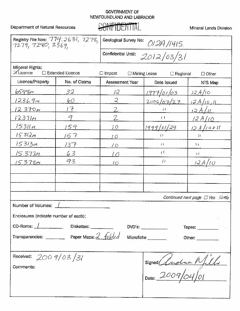
Assessment Expenditures to March 31, 2009
Licence Geology Drilling Surveys Assays Misc Subtotal 15% Admin TOTAL
6548M 77.76 0.00 0.00 0.00 334.86 412.62 61.89 474.51
12369M 145.80 0.00 0.00 0.00 627.87 773.67 116.05 889.72
12370M 41.31 0.00 0.00 0.00 177.90 219.21 32.88 252.09
12371M 21.87 0.00 0.00 0.00 94.20 116.07 17.41 133.48
15311M 340.90 0.00 26,732.98 11,707.68 0.00 38,781.56 5,817.23 44,598.79
15312M 1,185.53 0.00 11,141.80 7,512.56 0.00 19,839.89 2,975.98 22,815.87
15313M 340.91 0.00 0.00 0.00 0.00 340.91 51.14 392.05
15323M 3,720.00 0.00 0.00 0.00 0.00 3,720.00 558.00 4,278.00
15377M 340.91 0.00 0.00 0.00 0.00 340.91 51.14 392.05
15378M 340.91 0.00 0.00 0.00 0.00 340.91 51.14 392.05
6,555.90 0.00 37,874.78 19,220.24 1,234.83 64,885.75 9,732.86 74,618.61

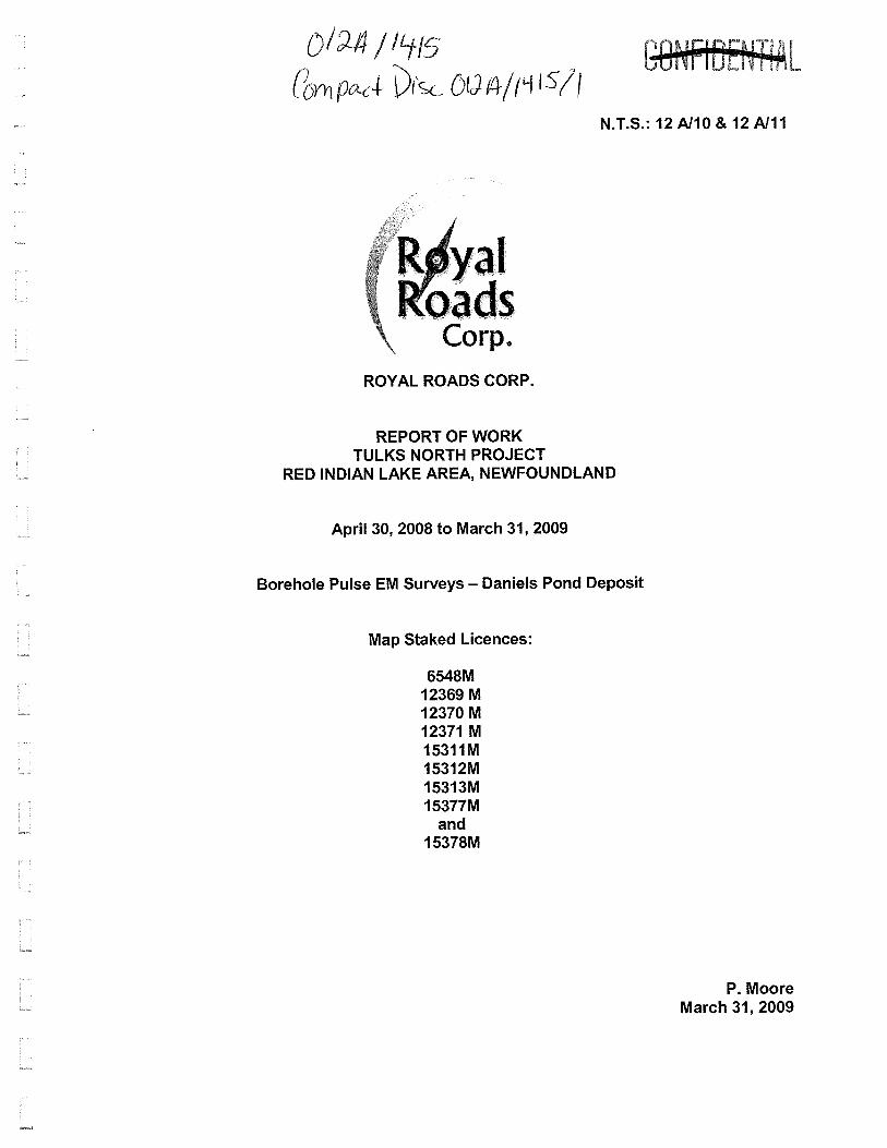

N.T.S.: 12 A/10 & 12 A/11
ROYAL ROADS CORP.
REPORT OF WORK TULKS NORTH PROJECT
RED INDIAN LAKE AREA, NEWFOUNDLAND
April 30, 2008 to March 31, 2009
Borehole Pulse EM Surveys – Daniels Pond Deposit
Map Staked Licences:
6548M 12369 M 12370 M 12371 M 15311M 15312M 15313M 15377M
and 15378M
P. Moore March 31, 2009

SUMMARY
The property consists of nine map staked mineral licenses acquired to explore for
polymetallic volcanogenic massive sulphide deposits within the Tulks Volcanic Belt of central
Newfoundland. The property includes claims acquired by Royal Roads in 1999 through an option
and earn-in agreement between Noranda (now Xstrata) and Royal Roads’ predecessor, Kelmet
Resources, as well as claims subsequently staked by Royal Roads in 2006. The entire property is
owned 100% by Royal Roads Corp.; however, most of the claims are subject to an option and
earn-in agreement that allows Noranda to retain a 1.5% Net Smelter interest in the property as well
as certain back-in rights. The back-in rights grant Noranda the option to earn a 50% interest in the
property on condition that a single deposit of 15,000,000 tonnes or greater is discovered and
deemed economic upon completion of a preliminary feasibility study.
Royal Roads earned a 100% interest in the original 16,075 hectare property after spending
the required CDN$1.8 million in exploration expenses and issuing 250,000 common shares to
Noranda before February 8, 2004 (Royal Roads March 5, 2004 Press Release). In the event
Noranda elects to exercise its back-in right, Noranda must pay Royal Roads an amount equal to
two times its expenditures plus CDN$3 million when commercial production is achieved.
The property hosts the Daniels Pond volcanogenic massive sulphide deposit which is
estimated to host a National Instrument (NI) 43-101 compliant Indicated Resource totaling 929,000
tonnes grading 5.13% Zn, 2.5% Pb, 0.34% Cu, 101.40 g/t Ag and 0.63 g/t Au at a 2% Zn cut-off as
well as 332,000 tonnes Inferred Resource grading 4.61% Zn, 2.13% Pb, 0.30% Cu, 85.86 g/t Ag
and 0.53 g/t Au at a 2% Zn cut-off Zn (Webster et el., 2008).
Work completed since filing of a 2008 Supplementary Report of Work in June 2008 (Moore
and Butler 2008b) is limited to Borehole Pulse EM surveys of some of the deeper holes beneath
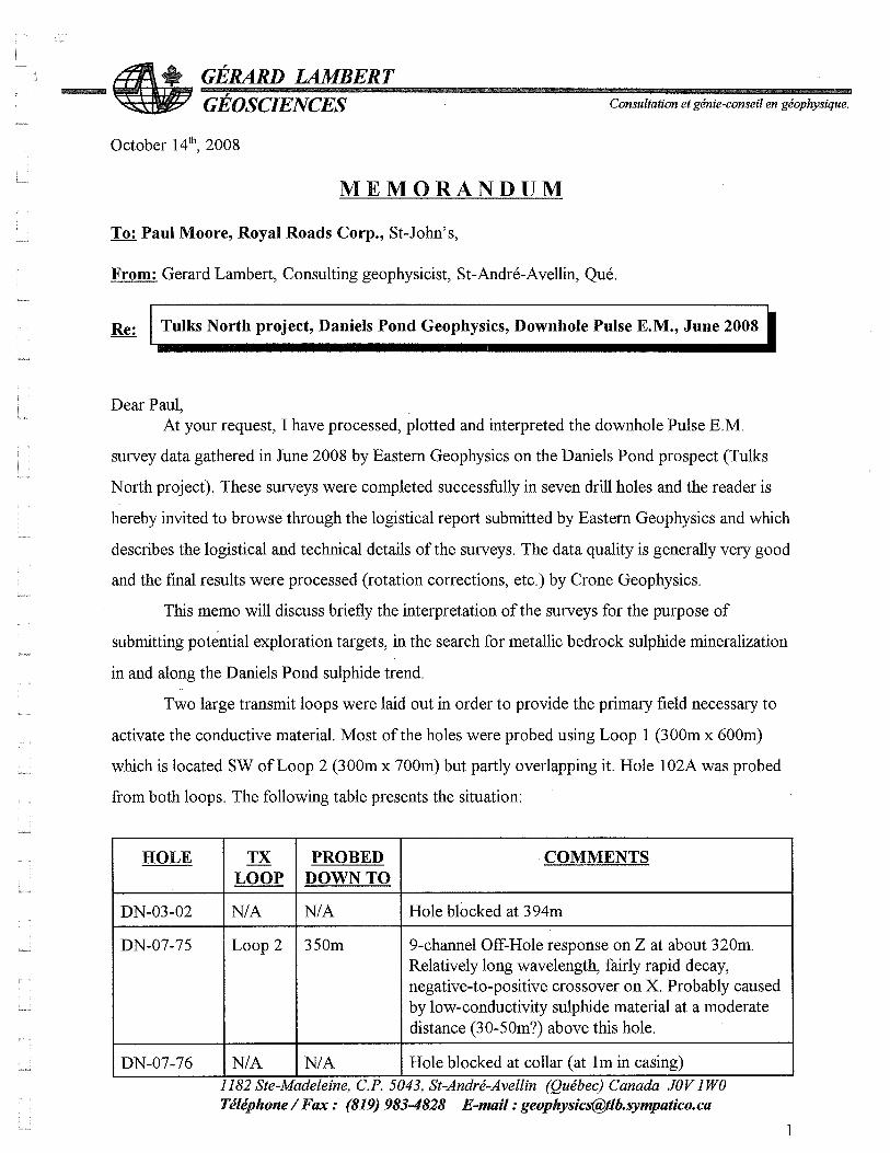
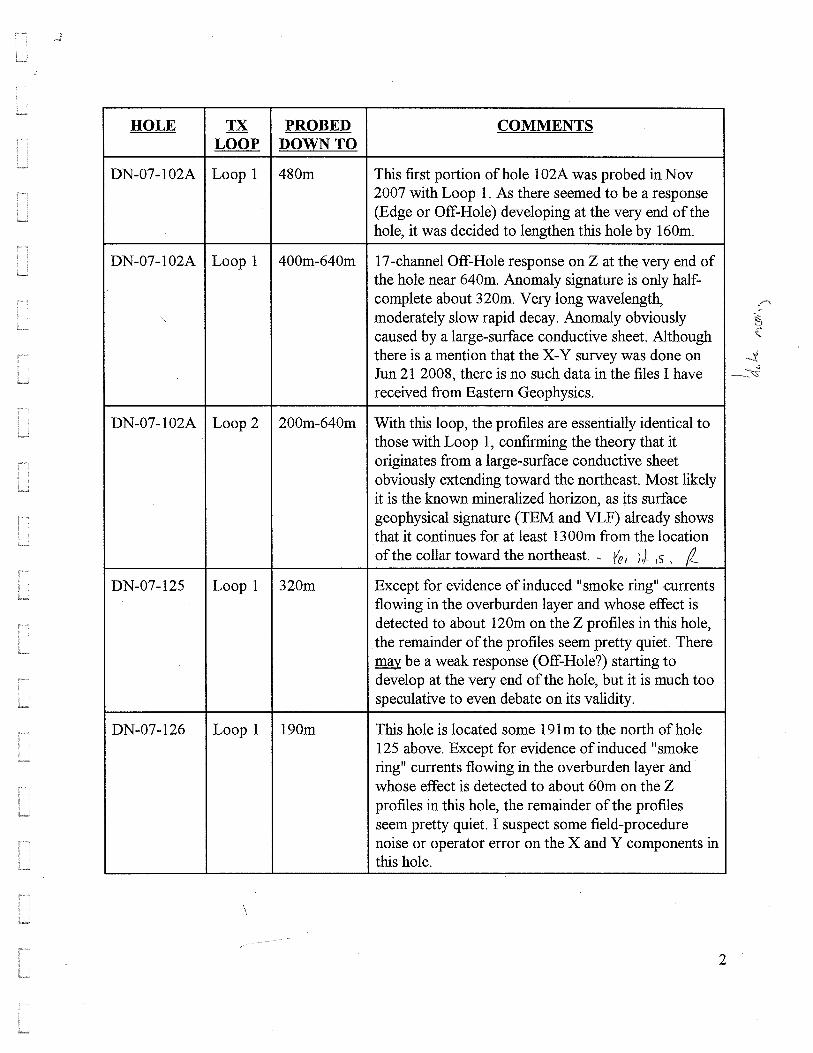
the Daniels Pond deposit, including holes DN-03-02, DN-07-75, DN-07-76, DN-102A, DN-07-125,
DN-07-126, DN-07-127, DN-07-128A, and DN-07-129. The work was undertaken by Eastern
Geophysics Limited of West Pubnico, Nova Scotia over the period from June 16 to 25, 2008 using
the Crone Pulse EM system. Results of the surveys were subsequently reviewed and interpreted

ii
by consultant geophysicist, Gerard Lambert, P. Eng., of St. Andre-Avellin, Quebec.
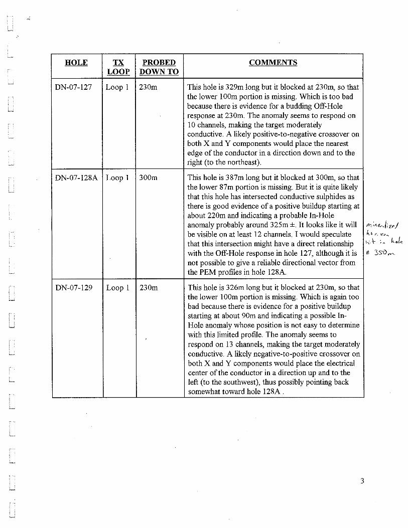
Unfortunately several key drill holes below the deposit were blocked and were not completely
surveyed (blocked holes include DN-03-02, DN-07-75, DN-07-127, DN-07-128A, DN-07-129).
Results indicate potential for successful infill drilling along the northeast plunge of the deposit’s
Northeast Lobe (above hole DN-075) as well as beneath the Northeast Lobe above holes DN-092A
and DN-129.
Further work is warranted at the Daniels Pond deposit including additional diamond drilling
to test the depth extension of the Northeast Lobe. Other additional work is recommended for the
greater Tulks North property as previously recommended by Moore and Butler (2008b).

TABLE OF CONTENTS
INTRODUCTION...........................................................................................................................1 ACKNOWLEDGEMENTS .............................................................................................................3 LOCATION, ACCESS AND PHYSIOGRAPHY.............................................................................4 CLAIMS.........................................................................................................................................6 PREVIOUS WORK........................................................................................................................1 REGIONAL GEOLOGY.................................................................................................................4 PROPERTY GEOLOGY................................................................................................................7 MINERALIZATION ........................................................................................................................9 Daniels Pond Deposit................................................................................................................. 10 Parking Lot Prospect .................................................................................................................. 13 Daniels Extension (Daniels Pond Extension) ............................................................................. 15 Jack’s Pond Alteration Zone and Cathy’s Pond Horizon............................................................ 17 2008 EXPLORATION PROGRAM ................................................................................................1 Borehole Pulse EM Surveys..........................................................................................................1 RECOMMENDATIONS .................................................................................................................2 REFERENCES..............................................................................................................................4 TABLES Table 1. Tulks North Project, Personnel and Contractors..................................................................... 3
Table 2. Summary of Claims – Tulks North Property........................................................................... 7
Table 3. Summary of tonnage and grade for VMS deposits of the Tulks Volcanic Belt....................... 7

iv
FIGURES Figure 1. Communities and Tulks North Property Location, Island of Newfoundland. ......................... 5
Figure 2. Tulks North property, claims location map. .......................................................................... 1
Figure 3. Simplified Geology of the Victoria Lake Supergroup (after Hinchey, 2007). ........................ 6
Figure 4. Simplified Property Geology and VMS Sulphide Prospects ................................................. 1
Drawings Location Map 1. Daniels Pond Borehole PEM Surveys (1:2,000) ..................................................... In Pocket Map 2. Daniels Pond Longitudinal Mineralized Schematic Looking North (1:1,000) .......... In Pocket
APPENDICES Titles Location I Eastern Geophysics Limited, Logistics Report Borehole EM Survey Daniels Pond Grid, Tulks North Property Central NL. In Report* II Gerard Lambert Geosciences , Memorandum. Tulks North Property, Daniels Pond Geophysics, Borehole Pulse EM, June 2008. In Report* * digital files including data and documents are included on CD submitted with this assessment report.

INTRODUCTION
This report documents work completed by Royal Roads Corp., on the Tulks North
property in central Newfoundland over the period of April 30, 2008 to March 31, 2009 (Figures
1 & 2). The property consists of map-staked claims registered to Royal Roads Corp., (RRO)
who acquired the properties to explore for polymetallic volcanogenic massive sulphide deposits
within Ordovician volcanic rocks of the Tulks Volcanic Belt of the Victoria Lake Supergroup.
The property hosts the Daniels Pond volcanogenic massive sulphide deposit. The deposit is
estimated to host a National Instrument 43-101 compliant Indicated Resource totaling 929,000
tonnes grading 5.13% Zn, 2.5% Pb, 0.34% Cu, 101.40 g/t Ag and 0.63 g/t Au at a 2% Zn cut-off;
as well as Inferred Resources totaling 332,000 tonnes grading 4.61% Zn, 2.13% Pb, 0.30% Cu,
85.86 g/t Ag and 0.53 g/t Au at a 2% Zn cut-off Zn (Webster et el., 2008). The deposit was
discovered by BP Resources in 1989 by trenching and drilling of a coincident soil geochemical
anomaly and VLF-EM conductor (Barbour et al, 1990; NFLD1970). The deposit extends to
surface with the bulk of the resource occurring at depths of less than 200 m below surface. The
resource is comprised of two lobes of base metal-bearing, semi-massive to massive sulphides;
a weaker mineralized Northeast Lobe and a stronger mineralized Southwest Lobe. Both lobes
dip steeply to the southeast and have a combined strike length of approximately 1,100 m.
Potential exists to expand the deposit both down dip and along strike of both lobes. In addition
to the Daniels Pond deposit, the Tulks North property hosts a number of prospective targets
identified by past explorers including the Parking Lot, Daniels Extension, Roebuck’s, Tim’s
Creek, Bobby’s Pond (alteration zone), Bobby’s Pond South (alteration zone), Jack’s Pond,
Black Jack and Sutherland’s Pond prospects.
The mineral potential of the Victoria Lake Supergroup is demonstrated by the many base
metal sulphides deposits previously discovered in the region, including Teck Cominco’s
(TEK:TSX) Duck Pond mine, located 25 km to the east of the Tulks North property. The Duck
Pond mine started production in early 2007 and was reported to have initially hosted proven and

2
probable reserves (including the Boundary deposit) of 5.48 million tonnes grading 5.8% Zn,
0.9% Pb, 3.3% Cu, 59.0 g/t Ag, and 0.8 g/t Au (Thundermin Resources Inc., press release
dated May 16, 2001). The deposit is hosted by the Tally Pond Volcanics, a separate volcanic
belt of Cambrian age, located within the Victoria Lake Supergroup (Evans et al., 1990). Other
deposits discovered within the same volcanic belt of the Victoria Lake Supergroup that underlies
the Tulks North property (i.e. Tulks Volcanic Belt) include Mountain Lake Resources’
(MOA:TSXV) Bobby’s Pond deposit, located approximately 8 km northeast of the Daniels Pond
deposit. A NI 43-101 mineral resource estimate for the Bobby’s Pond deposit of July 31, 2008
by Scott Wilson RPA includes an Indicated Resource of 1,095,000 tonnes averaging 0.86% Cu,
4.61% Zn, 0.44% Pb, 16.6 g/t Ag, and 0.2 g/t Au and an Inferred Resource of 1,177,000 tonnes
of 0.95% Cu, 3.75% Zn, 0.27% Pb, 10.95 g/t Ag and 0.06 g/t Au (Agnerian, 2008a).
Recent discoveries made in the belt highlight the belt’s outstanding exploration potential
and include Messina Minerals Inc’s (MMI:TSXV), Boomerang, Domino and Hurricane deposits,
located 35 km southwest of the Daniels Pond deposit. These deposits were found since
December 2004. In 2007, Messina announced a National Instrument 43-101 compliant
Indicated Mineral Resource estimate for the Boomerang and Domino deposits totaling 1.4
million tonnes averaging 7.1% Zn, 3.0% Pb, 0.5% Cu, 110.4 g/t Ag and 1.7 g/t Au at
Boomerang, and an Inferred Mineral Resource estimate of 0.41 million tonnes of 6.3% Zn, 2.8%
Pb, 0.4% Cu, 94 g/t Ag and 0.6 g/t Au at the adjacent Domino deposit (De Mark and Dearin,
2007).
Another advanced project within the Tulks Volcanic Belt that Royal Roads holds an
indirect interest in is the Tulks Hill deposit, currently being explored under a joint venture
between Prominex Resource Corp. (PXR:TSXV) and Royal Roads. This project is located 25
km southwest of the Daniels Pond deposit and hosts the Tulks Hill deposit comprised of four
massive sulphide lenses reported to host uncategorized, historic resources aggregating 720,000
tonnes (McKenzie et al., 1993) averaging 5.6% Zn, 2.0% Pb, 1.3% Cu, 41 g/t Ag and 0.4 g/t Au

3
(resource estimate is not compliant with NI-43-101 and should not be relied upon). On July 17th
2008, Prominex announced NI-43-101 resource estimates compiled by Scott Wilson RPA for
the T-3 lens at Tulks Hill (Agnerian, 2008b). The main portion of the T-3 lens, located above a
historic adit driven into a cliff below the main lens, is estimated to hosts an Indicated Resource
of 320,000 tonnes averaging 0.87% Cu, 4.81% Zn, 1.96% Pb, 40.94 g/t Ag and 1.18 g/t Au
(Agnerian, 2008b). Additional Indicated Resources occur below the adit, below the main lens,
totaling 111,000 tonnes averaging 0.94% Cu, 1.55% Zn, 0.60% Pb, 18.24 g/t Ag and 1.15 g/t Au
(Agnerian, 2008b).
Work completed on the property and described within this report of work is limited to
Borehole Pulse EM surveys completed within some of the deeper holes beneath the Daniels
Pond deposit and subsequent interpretation of these data by independent consulting
geophysicist, Gerard Lambert, P. Eng.
ACKNOWLEDGEMENTS
A list of personnel and contractors who worked on the Tulks North Property during the
reporting period is presented in Table 1 below.
Table 1. Tulks North Project, Personnel and Contractors
RRO PERSONNELName Position Residence Paul Moore, P. Geo. Vice President Exploration St. John’s, Newfoundland David Butler, P. Geo. Exploration Manager St. John’s, Newfoundland Linda Snow Administration Manager Cape Broyle, Newfoundland
CONTRACTORSCompany/ Individual Service Location Mercator Geoscience Consultants Exploration Contractors Dartmouth, Nova Scotia
Peter Webster, P.Geo. (NL) Mercator Geological consultant Dartmouth, Nova Scotia Jim Barr Mercator Geological consultant Dartmouth, Nova Scotia
MapInfo/ DIGEOS GIS software & support Paradise, NL Waymar Communications Communications Grand Falls-Windsor, NL Eastern Geophysics Limited Borehole PULSE EM Surveys West Pubnico, Nova Scotia Gerard Lambert. P. Eng. Geophysical Interpretation St. Andre-Avellin, Quebec
4
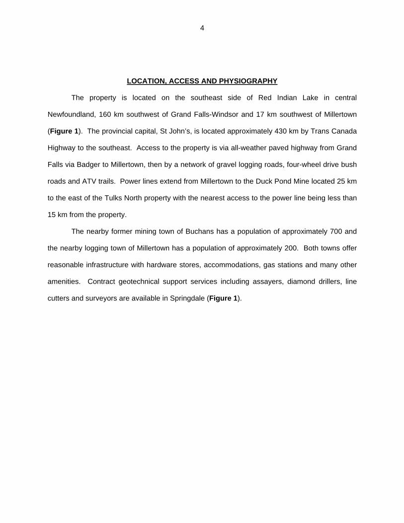
LOCATION, ACCESS AND PHYSIOGRAPHY
The property is located on the southeast side of Red Indian Lake in central
Newfoundland, 160 km southwest of Grand Falls-Windsor and 17 km southwest of Millertown
(Figure 1). The provincial capital, St John’s, is located approximately 430 km by Trans Canada
Highway to the southeast. Access to the property is via all-weather paved highway from Grand
Falls via Badger to Millertown, then by a network of gravel logging roads, four-wheel drive bush
roads and ATV trails. Power lines extend from Millertown to the Duck Pond Mine located 25 km
to the east of the Tulks North property with the nearest access to the power line being less than
15 km from the property.
The nearby former mining town of Buchans has a population of approximately 700 and
the nearby logging town of Millertown has a population of approximately 200. Both towns offer
reasonable infrastructure with hardware stores, accommodations, gas stations and many other
amenities. Contract geotechnical support services including assayers, diamond drillers, line
cutters and surveyors are available in Springdale (Figure 1).
5
40
0,0
00 m
E
80
0,0
00 m
E
5,600,000 mN
5,200,000 mN
5,400,000 mN
BuchansBuchansBuchansBuchansBuchansBuchansBuchansBuchansBuchansGrand FallsGrand FallsGrand FallsGrand FallsGrand FallsGrand FallsGrand FallsGrand FallsGrand Falls
St. John'sSt. John'sSt. John'sSt. John'sSt. John'sSt. John'sSt. John'sSt. John'sSt. John's
SpringdaleSpringdaleSpringdaleSpringdaleSpringdaleSpringdaleSpringdaleSpringdaleSpringdale
Tulks North PropertyTulks North PropertyTulks North PropertyTulks North PropertyTulks North PropertyTulks North PropertyTulks North PropertyTulks North PropertyTulks North Property
50 0 50 100
Kilometers
Atlantic OceanAtlantic OceanAtlantic OceanAtlantic OceanAtlantic OceanAtlantic OceanAtlantic OceanAtlantic OceanAtlantic Ocean
MillertownMillertownMillertownMillertownMillertownMillertownMillertownMillertownMillertown
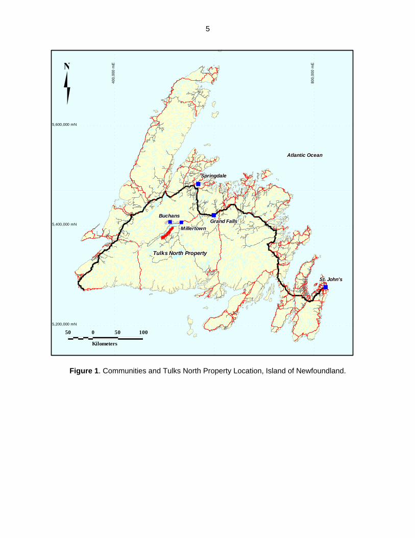
Figure 1. Communities and Tulks North Property Location, Island of Newfoundland.

6
The project covers an area of 182 km2 within an area measuring 35 km by 7 km and
encompasses the northwest portion of NTS sheet 12 A/10 and the eastern portion of 12A/11
(Figure 2). The approximate geographic center of the project is located at UTM coordinates
506400 E, 5385000 N, in UTM zone 21, NAD 27 projection for Canada. All subsequent UTM
coordinates presented in this report refer to this map projection unless otherwise stated.
Topographic relief typically ranges between 160 m and 410 m above mean sea level,
though the majority of the property occurs between elevations of 250 and 300 m above mean
sea level. The glaciated terrain is rolling with vegetation consisting of northern softwoods and
local stands of birch. Numerous wet areas occur as open grassy bogs in areas of poor drainage
and low-lying areas adjacent to streams and ponds throughout the region. Overburden
thickness is assumed to be less than 3 metres throughout most of the property. Large areas of
the property have been clear-cut at one time or another during the past 30 years, with large
tracts logged in the 1980’s and 1990’s, leaving large open areas of scrubby bush dominated by
alders and young softwood. The dominant directions of glacial movement are interpreted to
have been towards the southwest and northeast, with the northeast movement postdating
earlier southwest flow (Liverman et al., 2006). There are also indicators of southward ice flow,
south of Red Indian Lake (Liverman et al., 2006).
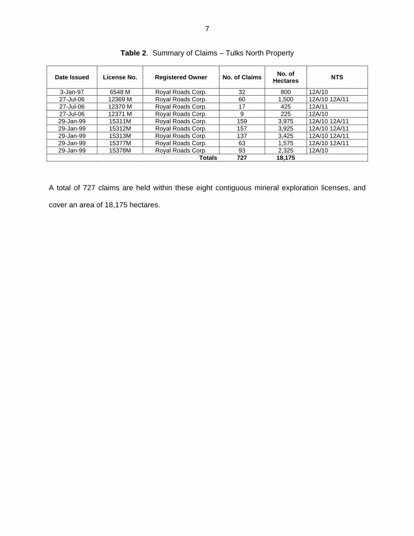
CLAIMS
This report covers exploration activities on the following mineral licenses (Table 2 &
Figure 2):
7
Table 2. Summary of Claims – Tulks North Property
Date Issued License No. Registered Owner No. of ClaimsNo. of
Hectares NTS
3-Jan-97 6548 M Royal Roads Corp. 32 800 12A/10 27-Jul-06 12369 M Royal Roads Corp. 60 1,500 12A/10 12A/11 27-Jul-06 12370 M Royal Roads Corp. 17 425 12A/11 27-Jul-06 12371 M Royal Roads Corp. 9 225 12A/10 29-Jan-99 15311M Royal Roads Corp. 159 3,975 12A/10 12A/11 29-Jan-99 15312M Royal Roads Corp. 157 3,925 12A/10 12A/11 29-Jan-99 15313M Royal Roads Corp. 137 3,425 12A/10 12A/11 29-Jan-99 15377M Royal Roads Corp. 63 1,575 12A/10 12A/11 29-Jan-99 15378M Royal Roads Corp. 93 2,325 12A/10
Totals 727 18,175
A total of 727 claims are held within these eight contiguous mineral exploration licenses, and
cover an area of 18,175 hectares.

Figure 2. Tulks North property, claims location map.

PREVIOUS WORK
The Tulks North area has been explored by numerous companies for more than a
century. The earliest work was recorded in 1875, when Howley travelled from the Bay of
Exploits to La Poile along the Exploits and Lloyds Rivers, and returned along the Victoria River
system (Murray, 1875). The following is a brief chronological history of the Tulks North Area
and is substantially excerpted or summarized from Chisholm (1999), and Regular (2006).
1905-1926: In 1905 the Anglo-Newfoundland Development Company (AND) was granted
timber, water and mineral rights to a 6,000 km2 (2300 sq. mi.) land package (the Terra Nova or Charter lands) in south central Newfoundland. Shortly afterward, prospectors found showings of lead, zinc and barite in the Buchans River area. These showings eventually led to the discovery of the Buchans mine. In 1906, the Victoria Mine deposit was also found by prospecting.
1926: Asarco entered into Cotenancy Agreement with the AND Company for the Buchans
deposit and surrounding area with exclusive exploration rights for the next fifty years to the area within a 48 km (30 mile) radius of the deposit.
1926-1960: Asarco put the Buchans mine into production in 1929. By 1947 depleting ore
reserves forced the company to do intensive exploration in the mine area. Two new orebodies, Rothermere and MacLean were discovered in 1947 and 1950, respectively. These deposits kept the mine in production until it closed in 1984. Due to poor access, apart from 1:12,000 mapping, little exploration was conducted in the Tulks North area during this period.
1960-1975: Asarco initiated various exploration programs including soil geochemical, ground
EM and magnetic surveys, geological mapping and diamond drilling. Tulks Hill deposit (Figure 3) was found in 1961. At the end of 1975, the Terra Nova properties reverted from Asarco back to Abitibi-Price the successor company to AND.
1976-1984: Abitibi flew two Questor AEM surveys over the Tulks area (1976 and 1979) and
continued detailed ground follow-up exploration and drilling. This work led to the discovery of the Tulks East and Jacks Pond deposits in 1977 and 1980 respectively.
1985-1991: BP Resources Canada Ltd. (BP) purchased the mineral rights to Abitibi’s Terra
Nova properties. Though interested in base metals, BP’s primary focus was gold. Apropos of this, it prepared a compilation of all previous exploration and had all (available) sample rejects from previous soil sampling, trenching and drilling analyzed for gold. BP flew an Aerodat AEM survey over the Tulks North area in 1988 and continued with programs of ground geophysical and geochemical surveys and drilling. These programs combined with detailed soil and basal till sampling of prospective zones led to the discovery of the Daniels Pond deposit in 1989 (Figure 3). BP suspended all exploration activities in 1991 and put all its Terra Nova property assets up for sale.
1992-1997: Noranda Inc. purchased the mineral rights to the Terra Nova properties (the
Charter Lands) and conducted extensive regional and local lithogeochemical sampling to

2
identify and delineate prospective alteration zones. This was followed up with systematic geochemical screening of isolated and/or formational AEM conductors along the Tulks belt. This work led to new discoveries including the Roebuck Alteration Zone, Cathy’s Pond Zone, Parking Lot Showing, Daniels Extension, Bobbys Pond South Alteration Zone and Sutherlands Pond Alteration Zone (Figures 2 and 3). Preliminary drilling returned encouraging results and further work was recommenced to fully evaluate many of these targets.
1998: Noranda elected to farm out all its central Newfoundland mineral properties. 1999: Kelmet Resources Ltd. optioned the Tulks North property and completed 106.6 km of cut
or flagged grid lines, prospecting, VLF-EM ground surveys, 2,513 soil samples and drilled five diamond drill holes totaling 895.8 metres.
2000: Kelmet Resources Ltd. completed linecutting, prospecting, VLF-EM surveys, rock
sampling, geological mapping and diamond drilling. Drilling consisted of 8 holes totaling 2,031.4 metres.
2001: Kelmet Resources Ltd. completed linecutting, prospecting, VLF-EM surveys, geological
mapping and diamond drilling totaling 498.8 metres in three holes. 2002: RRO completed 134.65 km of linecutting on three grids, 87.31 km of VLF-EM surveys,
75.2 km of geological mapping /prospecting, and 3,014.7 m of diamond drilling in 15 holes.
2003: RRO completed line cutting, VLF-EM/magnetometer surveys, MMI geochemical survey
and diamond drilling on Jacks Pond alteration zone, and five diamond drill holes on the Daniels Pond base metal deposit. Prospecting/rock sampling was also undertaken elsewhere on the property.
2004: RRO undertook no work on the property. 2005: RRO completed 2,163 m of diamond drilling with 15 holes on the Daniels Pond, Harbour
Round Pond and Daniels Extension prospects. Line cutting and gravity survey were completed over the Daniels Extension and the Bobbys Pond alteration zone areas.
2006: Acadian Gold (now Acadian Mining) completes a friendly take over bid for Royal Roads
and purchases 51% of RRO’s shares. Under new management, Royal Roads Corp. contracted Mercator Geological Services to complete a compilation of all data for the Tulks North property including construction of a MapInfo digital GIS database. Taiga Consultants Ltd. of Calgary were contracted to prepare an updated resource estimate for the Daniels Pond deposit incorporating all previous drilling completed up to 2006.
2007: Royal Roads hires new technical management team and initiates further exploration on the Tulks North property focused largely on the Daniels Pond deposit. Other exploration work included line cutting, soil geochemical surveys, HLEM and gravity geophysical surveys and diamond drilling (Daniels Pond deposit and Parking Lot prospect). Royal Roads also initiates baseline environmental work and metallurgical studies to permit initial economic assessment of the Daniels Pond deposit. The company also completed two phases of diamond drilling totaling 13,175.61 m in 71 holes (DN-07-53 to 07-123)

3
designed to further test and expand the Daniels Pond deposit as well as test the Parking Lot prospect (838 m in 4 holes, PL-07-01 to 07-04). While the Parking Lot program was essentially unsuccessful, drilling at Daniels Pond extended the mineralization to new depths and helped determine the limits of the shallow mineralization. Based upon results to the end of 2007, Mercator Geological Services compiled the currently disclosed Indicated and Inferred resource estimates for the Daniels Pond deposit (includes drilling results up to and including hole DN-07-123).
2008: Royal Roads undertook further exploration on the Tulks North property focused largely
on drilling the Daniels Pond deposit (2,050 in 8 holes, including holes DN-08-124 to 08-129 as well as extending historic holes DN-07-102A and DN-03-02). Additional drilling was also undertaken to test the Daniels Extension and Harbour Round prospects. While drilling at the Daniels Extension prospect and nearby gravity anomalies failed to return significant results, drilling in the Harbour Round Pond area met with encouraging results (Royal Roads press release dated May 7, 2008). The Harbour Round prospect was drilled with only one hole designed to test an historic, one kilometre long (minimum length), base metal in soil anomaly as defined by zinc in soil values of up to 1,220 ppm. The hole, HRP-08-01, intersected stringer stockwork base metal sulphide mineralization assaying up to 1.83% combined base metals (Cu+Pb+Zn) comprised of 1.02% copper 0.01% lead and 0.80% zinc over a core length of 1.50 metres. These results were considered particularly significant based upon their anomalous copper assays which compare favorably with stringer stockwork mineralization located immediately below the high-grade Daniels Pond deposit, located 2.5 kilometres to the northeast. It has also been postulated that the zone may represent an along strike extension of alteration and mineralization associated with the Daniels Pond deposit. On completion of the 2008 program, further work was recommended for the Harbour Round Pond prospect (renamed Caribou by Royal Roads) including deep seeking geophysics to be completed over the large soil anomaly and surrounding area. This work was not undertaken as the corporate priorities of Royal Roads shifted in July 2008 when it completed a takeover of Buchans River Limited and in light of subsequent pronounced negative market conditions and decreased base metal prices, the company has not undertaken further exploration of this priority area.
The last work completed by Royal Roads in 2008 consisted of borehole Pulse EM surveys completed in June 2008. That work is the subject of this report.
4
REGIONAL GEOLOGY
The property is located within the Dunnage Zone of the Newfoundland Appalachians and
represents vestiges of Cambro-Ordovician continental and intra-oceanic crusts, back-arc
basins, and ophiolites that formed in the Iapteus Ocean (Williams, 1979; Kean et al., 1981;
Swinden, 1990, Williams 1995). The zone is divided by an extensive fault system (the Red
Indian Line) into a western peri-Laurentian segment (Notre Dame and Dashwoods subzones),
and an eastern peri-Gondwanan segment (Exploits Subzone). In the immediate property area,
the Red Indian Line separates rocks of the Buchans Group (Notre Dame Subzone), which
formed on the Laurentian or North American side of the Iapetus Ocean, from rocks of the
Victoria Lake Supergroup (Exploits Subzone), which formed on the Gondwanan side of Iapetus.
Deformation associated with the final closure of Iapetus culminated during the Late Silurian
(Colman-Sadd et al., 1992), at which time, thrusting and folding juxtaposed these initially
geographically distinct volcanic belts. The two main subzones of the Dunnage Zone (i.e., Notre
Dame and Exploits subzones) have been conclusively differentiated based on stratigraphic,
structural, faunal, and isotopic characteristics (Williams et al., 1988).
The Tulks Volcanic Belt (TVB) forms part of the Exploits Subzone, and represents
remnants of one or more bimodal Cambrian to Ordovician volcanic-arc sequences. Together
with adjacent volcanic and sedimentary belts of variable tectonic affinities and ages, it belongs
to the informally defined Victoria Lake supergroup (VLSG), Evans and Kean (2002). Evans and
Kean (2002) subdivide the VLSG into the Tulks Volcanic Belt (TVB) (ca. 498 Ma), the Long
Lake belt (dominated by volcanic and volcaniclastic rocks, ca. 505 Ma), and the Tally Pond
Volcanic belt (ca. 515 Ma). In addition to these age differences, Evans and Kean characterize
and differentiate belts of the VLSG based upon their inherent tectonic affinities as defined by
trace element geochemistry of basaltic rocks within the various belts (e.g., active arc, arc-rift,
back-arc, and mature arc as categorized by Swinden, 1991).
5
The TVB covers an area of approximately 8 by 65 km, trending from northeast to
southwest. It is a bimodal volcanic belt dominated by felsic volcanics (flows, pyroclastics and
epiclastic rocks) and variable amounts of intermixed mafic volcanics and sedimentary rocks.
The age of the TVB is constrained by a U/Pb age of 498 +6/-4 from a small felsic subvolcanic
porphyry located near the Tulks Hill deposit (Evans et al., 1990). More recent geochronological
data collected in the belt by the GSC (van Stall et al., 2005) suggests younger rocks also occur
in the belt, including volcanic rocks dated at ca. 487 Ma, 462 Ma, 453 Ma (e.g. Hinchey, 2007
and references therein).
The most common rock types of the TVB are grey to white, quartz ± feldspar porphyritic
submarine volcanic rocks, including felsic fragmentals ranging from massive flows through to
coarse, blocky, flow breccias, lapilli and ash tuffs, to epliclastic deposits, as well as lesser mafic
volcanics comprised of flows, breccias and epiclastic rocks. Felsic subvolcanic porphyries have
also been mapped locally (e.g., Evans et al., 1990). The belt is also host to formational
sedimentary units which often include carbonaceous/graphitic sediments that in some cases are
intimately associated with mineralized horizons hosting volcanogenic massive sulphide (VMS)
style mineralization (e.g., Daniels Pond deposit). Many of these formational sedimentary belts
are well mapped by historical airborne electromagnetic surveys flown throughout the belt by
past explorers.

6
Figure 3. Simplified Geology of the Victoria Lake Supergroup (after Hinchey, 2007).

7
The TVB hosts several significant VMS deposits, as well as numerous prospects and
showings (numbers 1 to 18, Figure 3; Figure 4) of which the larger deposits typically occur in
clusters of multiple sulphide lenses. The main deposits in the belt include, from south to north,
the recently discovered Boomerang deposit (includes the Domino and Hurricane lenses), the
Tulks Hill deposit (a cluster of four separate sulphide lenses, T-1 to T-4) and the Tulks East
deposit in the southern half of the TVB. The main deposits of the northern half of the TVB
include the Jacks Pond, Daniels Pond and Bobbys Pond deposits. Of these, the Jacks Pond
and Daniels Pond deposits are located within Royal Roads’ Tulks North property. A summary
table showing historical and current NI 43-101 compliant resource estimates for the
aforementioned deposits is presented in Table 3.
Table 3. Summary of tonnage and grade for VMS deposits of the Tulks Volcanic Belt. Victoria Lake Supergroup VMS Deposits - Tonnage & Grades
Deposit Tonnes Zn (%) Pb (%) Cu (%) Ag (g/t) Au (g/t) Cut Off CriteriaNI43-101
Compliant ReferenceBoomerang - Indicated 1,364,600 7.09 3.00 0.51 110.4 1.66 1% Zn Yes De Mark & Dearin, 2007 (Snowden)Boomerang - Inferred 278,100 6.72 2.88 0.44 96.5 1.29 1% Zn Yes De Mark & Dearin, 2007 (Snowden)
Domino - Inferred 411,200 6.3 2.8 0.4 94 0.6 1% Zn Yes De Mark & Dearin, 2007 (Snowden)
Tulks Hill T-3 Indicated (above & below adit) 431,000 3.97 1.61 0.89 35.09 1.17
1.1% Cu equiv. min. 2 m horizontal thickness Yes Agnerian (2008) (Scott Wilson RPA)
Tulks East (historic estimate)
A Zone 5,000,000 1.50 0.12 0.24 8.50 n/a none No Barbour & Thurlow, 1982B Zone 230,000 8.69 1.26 0.66 58.7 0.14 none No Barbour & Thurlow, 1983C Zone 900,000 n/a n/a n/a n/a n/a <1% combined Zn+Pb+Cu No Barbour & Thurlow, 1984
Jacks Pond (historic estimate) none No Barbour & Thurlow, 1982Daniels Pond - Indicated 929,000 5.13 2.50 0.34 101.40 0.63 2% Zn Yes Mercator, 2008 (for RRO)Daniels Pond - Inferred 332,000 4.61 2.13 0.03 85.86 0.53 2% Zn Yes Mercator, 2008 (for RRO)Bobbys Pond - Indicated 1,095,000 4.61 0.44 0.86 16.6 0.200 1.1% Cu equivalent Yes Agnerian (2008) (Scott Wilson RPA)Bobbys Pond - Inferred 1,177,000 3.75 0.27 0.95 11 0.06 1.1% Cu equivalent Yes Agnerian (2008) (Scott Wilson RPA)
Four sulphide lenses, termed A, B, C and D comprise the Jacks Pond deposit. The lenses range in size from 200 000 to 900 000 tonnes
PROPERTY GEOLOGY
The Royal Roads property covers the northern half of the Tulks Volcanic Belt, where the
belt is dominated by submarine felsic, intermediate and mafic volcanic rocks, comprised of felsic
flows and fragmentals, ranging from massive flows through to coarse, blocky, flow breccias,
8
lapilli and ash tuffs, epliclastic deposits, and lesser mafic volcanic, predominantly comprised of
pillowed to massive flows, breccias and lesser epiclastic rocks. Associated intrusive rocks
include amygdaloidal mafic dykes and sills, while associated sedimentary rocks include
graphitic argillite and greywacke. These rocks have been metamorphosed to greenschist facies
and have endured moderate to strong deformation, resulting in tight isoclinal folding and
development of multiple penetrative cleavages of which the dominant cleavage is generally sub-
parallel to bedding, and strikes northeast-southwest (e.g. Rogers et al., 2005). Tight to isoclinal
folds are reported to possess highly variable plunges with respect to direction and dip, and
evidence of large-scale folding is sparse (e.g. Rogers et al., 2005). Stratigraphy strikes
northeast-southwest and typically dips very steeply northwest to locally southeast, where it is
overturned as at the Daniels Pond deposit. The belt is transected by late shear zones and
brittle faults.
Massive sulphide mineralization within the property appears to be associated with quartz
± feldspar phyric felsic volcanic rocks, including rhyolite flows and fragmentals, as well as
epliclastic rocks. Alteration associated with massive sulphide mineralization includes broad
semi-conformable sericite-sulphide (predominantly disseminated to stringer pyrite) alteration, as
well as more proximal and discrete chlorite alteration which ranges from pervasive weak to
moderate chloritization and sericitization, to more local strong chloritization and sericitization
with local development of base metal sulphide-bearing chlorite stockworks immediately below
massive sulphide mineralization, as observed locally beneath the Daniels Pond deposit.
Referred to here as sericite alteration, pale light green micaceous/clay alteration observed in the
hanging wall and footwall of the Daniels Pond deposit has been noted by Hinchey (2007b) to
also locally include pyrophyllite. Chlorite stockworks observed by the authors locally host grey
to white carbonate veining described as “chaotic carbonate” in other VMS deposits of the VLSG
(e.g., Duck Pond, Squires et al., 2001; Boomerang, Hinchey, 2007a).
9
MINERALIZATION
Below is presented a brief description of the main prospects located within the current
property (Figure 4). Royal Roads has yet to initiate significant work at most of these prospects,
and therefore descriptions are based largely on those of previous workers and published
sources including summaries found in what is locally referred to as the “Noranda Data Book”; an
internal Noranda Company report (Noranda, 1998) that was compiled by the company as a
selling document when Noranda was seeking to joint venture their entire land holdings within
the Victoria Lake and Buchans areas. This document is now in the public domain from the files
of the Newfoundland Geological Survey as Geofile Number [012A/1231]. Mineralization in the
northern part of the TVB is also described by McKenzie et al. (1993), and most recently by
Hinchey (2007a & b). From an exploration perspective, the description by Noranda (1988)
appears to be perhaps the most useful, and is summarized below.
Most deposits in the northern half of the Tulks Volcanic Belt are sulphide lenses
underlain by an extensive semi-conformable siliceous stockwork with associated sericite-silica,
pyrite and less frequent sphalerite and galena. The Jacks Pond deposits grade laterally into a
chloritic sulphide stringer (pyrite+chalcopyrite) zone that is, in turn, enveloped by a siliceous
stockwork. The present shape and relative position of these alteration zones is interpreted to be
a by-product of transposition related to intense deformation (McKenzie et al., 1993).
The majority of the deposits within the north half of the TVB appear to sit on or near the
contact of a thick felsic pile and an overlying conductive sequence (McKenzie et al., 1993).
Their immediate hanging wall sequences appear quite variable; Jacks Pond which sits at the
same stratigraphic level as the Tulks East deposit, is overlain by mafic volcanics and minor
pyroclastic rocks intercalated with fine grained sedimentary rocks (McKenzie et al., 1993).
Daniels Pond is overlain by a polylithic fragmental (debris flows) containing clasts of massive
sulphide and/or fine grained sediments commonly which are graphitic and locally sulphidic as
well as finer grained sedimentary rocks. The Bobbys Pond deposit is overlain by strongly

10
altered andesite and basalt, intercalated with rhyolite breccia and felsic flows. Alteration in
these mafic rocks comprises hematization and intense silicification (Noranda, 1988).
Numerous discontinuous silica-sericite-pyrite alteration zones are found along the
northeast portion of the Tulks Volcanic Belt. They appear to occupy at least three distinct
stratigraphic levels that can be traced discontinuously over several kilometres. Regionally, all
these stratigraphic levels have evidence of massive sulphide accumulation. These are the
Dragon Pond sulphide occurrence along the Dragon Pond Horizon, the Tulks Hill-Tulks East-
Jacks Pond Horizon and the Bobby’s Pond Deposit. The altered rocks are bleached with an
average of 2-3% fine grained disseminated and stringer pyrite. All known massive sulphide
occurrences are reported (Noranda, 1988) to be associated with altered rocks that are
distinguishable using commonly used whole rock alteration indices (e.g., high Ishikawa Indices).
Daniels Pond Deposit
The Daniels Pond deposit is located 21 km northeast of Tulks East deposit and is
interpreted by Noranda (1998) to occur along the same stratigraphic horizon as the Tulks East
and Cathys Pond massive sulphide prospects. McKenzie et al., (1993), however, interpret the
deposit to be hosted by a different stratigraphic horizon. The deposit is currently estimated to
host a NI 43-101-compliant Indicated Resource totalling 929,000 tonnes grading 5.13% Zn,
2.5% Pb, 0.34% Cu, 101.40 g/t Ag and 0.63 g/t Au at a 2% Zn cut-off as well as 332,000
tonnes Inferred Resource grading 4.61% Zn, 2.13% Pb, 0.30% Cu, 85.86 g/t Ag and 0.53
g/t Au at a 2% Zn cut-off Zn (Webster et el., 2008). The bulk of these resources occur within
200 m of surface in two lobes of mineralization, the weaker mineralized Northeast Lobe and the
stronger mineralized Southwest Lobe, respectively. The lobes range from less than a metre to
up to greater than 5 metres in thickness, dip steeply to the northeast, and have a combined
strike length of 1,100 m. Both lobes contain multiple bands or banded sections of semi-massive
to massive base metal sulphides, and adjacent disseminated to stringer base metal sulphide

11
mineralization (typically in the footwall). The South East Lobe is recognized to typically host
higher grades and widths overall, and both lobes have been drill tested to depths of 350-400
metres and may remain open down dip and down plunge. Some of the best drilled intersections
include composite assay intervals containing multiple adjacent semi-massive to massive
sulphide bands and have yielded assays of up to 17.70% Zn, 7.89% Pb, 0.98% Cu, 273.6 g/t
Ag and 0.96 g/t Au over an estimated true width of 7.44 m in hole DN-07-111 (Southwest
Lobe, Royal Roads November 28, 2007 news release). Adjacent disseminated to stringer
mineralization (Southwest and Northeast lobes) as well as lower grade massive pyrite sections
(Northeast Lobe) locally yield composite assays over large widths, as demonstrated by assays
of 2.36% Zn, 0.76% Pb, 0.28% Cu, 37.6 g/t Ag and 0.77 g/t Au over an estimated true width
of 17.21 m in hole DN-07-088 (Northeast Lobe, Royal Roads October 10, 2007 news release).
High grade layers and bands of argentiferous Zn-Pb-Cu sulphides range from a few centimetres
up to 7.5 metres wide, and are primarily composed of sphalerite and galena with minor pyrite
and chalcopyrite. Barite is an important gangue mineral with barium concentrations often
ranging between 1,000 and 10,000 ppm. Minor sulphide species observed microscopically
within the bands include tenantite-tetrahedrite and native silver (McKenzie et al., 1993).
The Northeast Lobe is hypothesized to have perhaps been produced more distally from
the same vent which produced the thicker, and more base metal-rich, Southwest Lobe. This
interpretation is supported by the presence of a large lens of essentially barren massive pyrite
adjacent to the Northeast Lobe, as well as deposits of debris containing fragments of both
barren massive sulphides and base metal-rich massive sulphides, hosted by variably graphitic
siltstone and argillite in the north eastern portion of the deposit. The massive pyrite lens has
been described by previous workers (e.g. McKenzie et al., 1993) as having a strike of just over
100 m and a minimum dip extent of 350 m. They further describe the pyrite lens as possessing
an undeformed, featureless, fine grained texture, and hosting low concentrations of Au and Zn
(500 to 1,500 ppb Au and 0.5% to 2% Zn) as well as minor chalcopyrite as remobilized veinlets

12
along fractures often associated with quartz. McKenzie et al., (1993) suggest this lens may be
related to the host sedimentary rocks as opposed to the Daniels Pond deposit. Drilling since
completed by Royal Roads suggests a more intimate relationship between the massive pyrite
and the base metal sulphide mineralization at Daniels Pond, with conformable contacts
observed locally as base metal-rich banded sulphides sitting stratigraphically directly above the
massive pyrite. Royal Roads has also noted base metal sulphides, including sphalerite, as
veins cutting the massive pyrite, and suggests the massive pyrite lens in part represents
previously vented massive sulphides deposited at the paleo-seafloor upon which subsequent
sulphide hot spring activity vented base metal-rich material, potentially without a significant
break (or hiatus) in the hotsprings’ activity. It has also been noted that banded base metal-
bearing semi-massive sulphides are locally observed stratigraphically below the massive pyrite
lens, well below the massive pyrite’s lower contact. While the massive pyrite lens is in itself not
considered an economic exploration target, Royal Roads believes the lens warrants further
deep exploration, as it may represent the barren fringe of a much larger accumulation of
predominantly base metal-rich massive sulphides related to the Daniels Pond mineralizing
system.
The Daniels Pond deposit is hosted by a bi-modal sequence of felsic and mafic volcanic
rocks predominantly overlain by fragmental, feldspar-phyric mafic volcanic and fine grained
(graphitic) sedimentary rocks. The graphitic sediments give the host horizon a conductive
character that can be traced along the majority of the deposit’s strike using conventional
electromagnetic geophysical techniques (e.g. VLF-EM); though graphitic sediments are
volumetrically more prolific stratigraphically above the deposit’s Northeast Lobe. The entire
deposit is typically underlain by a thin siliceous stockwork unit associated with sericite-silica and
base metal stringers (i.e. “grey pyritic volcanic”). Evidence of strong deformation is observed in
the deposit, and it has been suggested by previous workers that the deposit may consists of
structurally disaggregated boudins within a narrow zone of high strain (e.g., McKenzie et al.,

13
1993). Macroscopic, parasitic fold closures are also visible in drill core suggesting the deposit
has been affected by folding. Royal Roads now interprets there to also be primary facies
changes along the length of the deposit with a transition from intact laminated, base metal-rich
sulphides occurring within the southeast half of the deposit, while massive barren pyrite and
fragmental base metal-rich and barren pyrite deposits occur to the northeast, east of grid line
7500 West. This transition is considered to be a primary feature and may be associated with
some, as yet, unrecognized, syn-volcanic fault that may have created a fault scarp or
topographic apron, active during the time of sulphide deposition and subsequent seafloor
erosion.
Royal Roads’ identification of mineralized chlorite stockworks, locally hosting
chalcopyrite and or “chaotic carbonate”, stratigraphically directly beneath the massive base
metal-rich sulphide mineralization (Southwest Lobe), confirms the mineralization is proximal to
its footwall alteration, faces west, and is overturned. In the hanging wall, fragmental and
feldspar-phyric mafic volcanic rocks predominate. The unit immediately stratigraphically
overlying the massive sulphide ranges from a polylithic fragmental unit containing clasts (debris)
of barren to basemetal-bearing massive sulphides to fine grained sediments (commonly
graphitic and sulphidic). Structurally below the mineralized zone is a buff and gray, foliated,
typically quartz-phyric felsic tuff. This unit is moderately sericitized, contains from 3% to 5%
disseminated pyrite, and is often referred to as the “grey pyritic volcanic” unit in drill logs.
Parking Lot Prospect
The Parking Lot prospect, located 1.5 km northeast of the Daniels Pond deposit, was
discovered by Noranda in 1993 while prospecting along the side of a logging road. The
prospect is described by Noranda (1998) as consisting of a narrow band (2-5 cm) of
chalcopyrite within a broader (30-40cm), boudinaged massive pyrite lens hosted by altered
felsic volcanic rocks. Grab samples from the initial roadside outcrop returned analyses of 5.1%

14
and 6.74% Cu. Trenching by Noranda outlined a 200 metre long mineralized zone open to the
northeast. Mineralization in this zone is described as millimetre to decimetre sulphide veinlets
hosted by strongly foliated, silicified, sericitized, and locally chloritized felsic volcanic rocks. The
overall sulphide content is about 10% pyrite with trace chalcopyrite. Base metal sulphides
(chalcopyrite, galena and sphalerite) were observed in all the trenches; however, the strongest
mineralization is located in the original roadside outcrop. Chalcopyrite content varies from trace
to 10% (in veinlets) and is often associated with chloritic alteration in this outcrop.
Alteration, from the roadside outcrop to the most eastern trench, changes gradually from
moderately silicified, sericitized and chloritized, to strong carbonate alteration that overprints the
altered and mineralized felsic unit. Associated with the carbonatization is a strong cleavage
sub-orthogonal to the regional fabric, causing the rock to exhibit a “french fry-like” texture.
Further evidence of deformation includes numerous parasitic folds, kinks and dismembered
massive sulphide (20-30 cm long) boudins (Noranda 1998).
Assay results of grab and channel samples collected from the main showing (i.e.,
roadside outcrop) returned up to 1.95% Cu over 3.0 m and 0.3% Cu over 1.5 metres
respectively, from two channel samples collected 20 metres apart, and across strike. The width
of the mineralized zone is about 25 metres along the road. Base metal sulphides were
observed in each of the five trenches. Anomalous Cu and Zn values were also returned from
select grab samples taken from the trenches (excludes main roadside outcrop), with values
ranging up to 2.2% Zn and 2.0% Cu. Noranda (1998) interpreted the zone to be at least 70
metres wide and over 200 m long, and based on the distribution of anomalous base metal
values, suggested the zone remains open in all directions.
Noranda (1998) also noted a narrow, chloritic, fragmental unit (containing massive
sulphide clasts) 10 metres north of the main showing. This unit was interpreted (Noranda.
1998) to resemble locally chloritic, heterolithic tuff-breccia-agglomerate observed immediately
15
stratigraphically above the Daniels Pond deposit. One hole, Hole DN-33, drilled about 150
metres west of the main showing, intersected 0.3 metres of the fragmental breccia.
Royal Roads personnel examined the roadside exposure during the 2007 field season
and interpret the mineralization to be entirely composed of stringer pyrite and chalcopyrite
mineralization where individual stringers achieve massive sulphide concentrations. The
associated alteration in the roadside exposure is also characterized as being chloritic. Several
of the former trenches located to the east were also investigated, and although bedrock
exposure was no longer available, trenched bedrock debris was readily visible and composed of
very weakly mineralized and weakly sericitized felsic volcanic rocks that appears to have been
affected by a pervasive, carbonate alteration (overprint?), the latter of which may not have
genetic connotations with the VMS-style stringer mineralization observed in the roadside
exposure. Royal Roads completed a four-hole, 838 metre, drilling program in the vicinity of this
prospect without significant results. A description of the program and its findings were
submitted in a previous assessment report filed for the Tulks North property on February 29,
2008 (Moore and Butler, 2008a).
Daniels Extension (Daniels Pond Extension)
This area, located 5 kilometres northeast of the Parking Lot prospect, covers a weak
VLF-EM conductor which may represent the northeast extension of the Daniels Pond
mineralized horizon. Geologic mapping by Noranda (1998) initially determined felsic flows
underlie a large area in this part of the property and include a smaller, eastern area underlain by
altered felsic pyroclastics potentially located along strike of the Bobby’s Pond Alteration Zone.
In 1997, Noranda established a grid (Snow Shoes Grid) to cover this alteration and completed
soil geochemical, magnetic and VLF-EM surveys without further geological mapping completed.
Results of the soil survey include definition of a multi-element soil geochemical anomaly
on two adjacent lines with an associated weak, isolated VLF-EM conductor. Values included 29

16
ppm Cu, 146 ppm Pb, 288 ppm Zn, 160 ppm As and 3.6 ppm (g/t) Ag on line 1300W; and 87
ppm Cu, 2,473 ppm Pb, 1,246 ppm Zn, 86 ppm As and 6.4 ppm (g/t) Ag on line 1500W. The
Daniels Pond deposit was found by following up a single station soil geochem anomaly
returning 152 ppm Cu, 1,131 ppm Pb, 377 ppm Zn, 160 ppm As and 6.5 g/t Ag. Subsequent
soil geochemical and basal till sampling by Royal Roads (Regular, 2005) defined a multi-line,
base metal/silver anomaly, which is also coincident with the VLF-EM conductor. Drilling of four
diamond drill holes by Royal Roads in 2005 tested the coincident geochemical/geophysical
anomaly and intersected anomalous base metal values (Regular, 2005). A gravity survey was
also completed over the area in 2005, and subsequent processing of the data in 2007 (this
report) failed to yield definitive anomalies in the immediate area.
Of particular importance to further exploration of this target is the recent recognition
(Moore and Butler 2008a) of laminated, semi-massive to massive pyritic sulphides in hole DPX-
05-01 between 39.84 and 40.47 m (0.63 m core length) which returned assays of 0.19% Cu,
220 ppm Pb, 75 ppm Zn, 0.69 g/t Au and 6.9 g/t Ag, with adjacent altered and mineralized felsic
volcanics in adjacent holes also yielding anomalous base metal assays including an interval
assaying 0.57% Zn over a core length of 4.5 m, including 2.68% Zn, 1.30% Pb, 0.06% Cu, 0.08
g/t Au and 16.8 g/t Ag over 0.6 m (assays found in Regular, 2005). Based on recognition of a
potentially exhalative massive sulphide horizon hosting anomalous base metals and the
presence of altered and mineralized felsic volcanic in the area; Royal Roads completed
additional surveys over the prospect in 2007 and early 2008, including line cutting and HLEM
geophysical surveys in preparation for a 2008 winter drilling program. The results of this drill
program were in part inconclusive as not all of the proposed holes could be completed in
advance of deteriorating field conditions associated with the 2008 spring break-up. Results
from the completed drilling were; however, largely negative (Moore and Butler 2008b).
Several other alteration zones and massive sulphide prospects occur throughout the
property, and are the subject of a digital compilation completed by Mercator Geological Services
17
of Dartmouth, Nova Scotia under contract to Royal Roads. These other target areas and
prospects are discussed by previous workers (e.g. Noranda, 1998). Royal Roads Corp
undertook no additional field work on these targets in 2007 or 2088, as it was determined that a
full compilation was required in advance of planning further exploration of these targets. These
other prospects and target areas include, but are not limited to: (i) Jacks Pond-Cathys Pond
massive sulphide deposit and alteration zone, (ii) Costigan prospect, (iii) Bear alteration zone,
(iv) New Grid prospect area, (v) Roebucks alteration zone, (vi) Blue Grid target area, (vii)
Sutherlands Pond alteration zone, (viii) Tim’s Creek/ Blackjack prospects, and (ix) the Bobbys
Pond alteration zone. The Jacks Pond-Cathys pond prospect area is the most advanced of
these other targets, and is described briefly below.
Jack’s Pond Alteration Zone and Cathy’s Pond Horizon
The Jacks Pond alteration zone is located 12.5 kilometres northeast of the Tulks East
massive sulphide deposit and is interpreted by Barbour and Thurlow (1982) and Noranda (1998)
to occupy the same stratigraphic setting. The Cathys Pond horizon is a separate exploration
target located 250 metres to the north and is currently interpreted to potentially represent a cap
or exhalative horizon related to the Jacks Pond system (McKenzie et al., 1993). The Jacks
Pond alteration zone contains four massive sulphide lenses (A, B, C, D) hosted in a complex
and extensive, 1 x 3.5 km, alteration system that is believed to be the largest in the Tulks
Volcanic Belt (McKenzie et al., 1993). Barbour and Thurlow (1982) estimate the lenses to range
in size from 200,000 to 900,000 tonnes. The alteration zone occurs at the transition from felsic
volcanics to intercalated sediments and mafic volcanics. The zone is marked by an Mg-chlorite
and carbonate-rich core, enveloped by a pervasive zone of silica-sericite alteration (Evans,
1986).

18
The Jacks Pond alteration zone has been interpreted to in part represent a structurally
modified, classic discordant chloritic feeder-pipe enveloped by a sub-concordant pyrite and
sphalerite bearing siliceous stockwork (McKenzie et al, 1993).
Of the sulphide lenses, the A and B zones are considered to potentially represent part of
a robust stringer sulphide system locally hosing massive sulphides, while the C and D zones are
considered to represent banded, exhalative or replacement massive sulphides peripheral to the
main alteration zone. The D and C lenses also contain traces of chalcopyrite, sphalerite and
galena as well as sections of bedded pyrite with clastic textures (Barbour and Thurlow, 1982).
The Cathys Pond horizon is comprised of northeasterly dipping felsic volcanics that
display locally intense, variable alteration and mineralization. Stratiform base metal
mineralization containing pyrite, sphalerite and galena are hosted by strongly sericitized felsic
tuff. Workers have suggested that this horizon may represent a cap to the Jacks Pond
mineralized zone (McKenzie et al., 1993). The zone is characterized by northwesterly dipping,
intensely altered and mineralized felsic volcanics. Previous drilling of this horizon intersected
stacked sulphide horizons consisting of massive pyrite (to 70%) with minor sphalerite in silica
veins near the top of the sulphide zone. These results, coupled the size and intensity of
alteration seen within the nearby Jacks Pond alteration zone demonstrate the area warrants
further exploration and should remain a priority of future exploration in 2008.
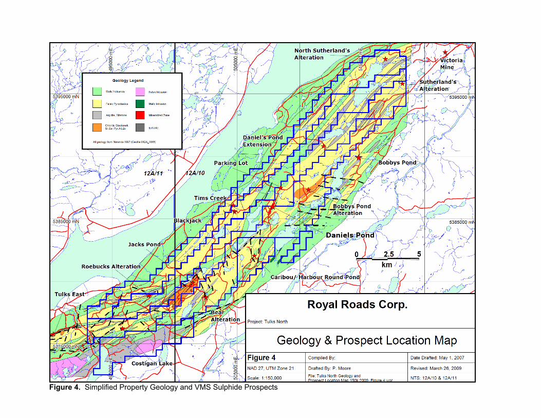
Figure 4. Simplified Property Geology and VMS Sulphide Prospects

2008 EXPLORATION PROGRAM
The portion of the 2008 exploration program discussed herein was limited to Borehole
Pulse EM surveys of some of the deeper holes beneath the Daniels Pond deposit. The work
was undertaken to explore the deeper portions of the deposit for possible extensions to the
mineralized zones, or discover new zones down dip or down plunge of the known lenses.
Results of the surveys were subsequently reviewed and interpreted by consultant geophysicist,
Gerard Lambert, P. Eng., of St. Andre-Avellin, Quebec. The surveys, including results, are
further described below.
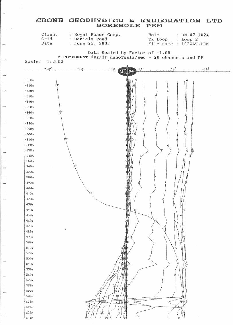
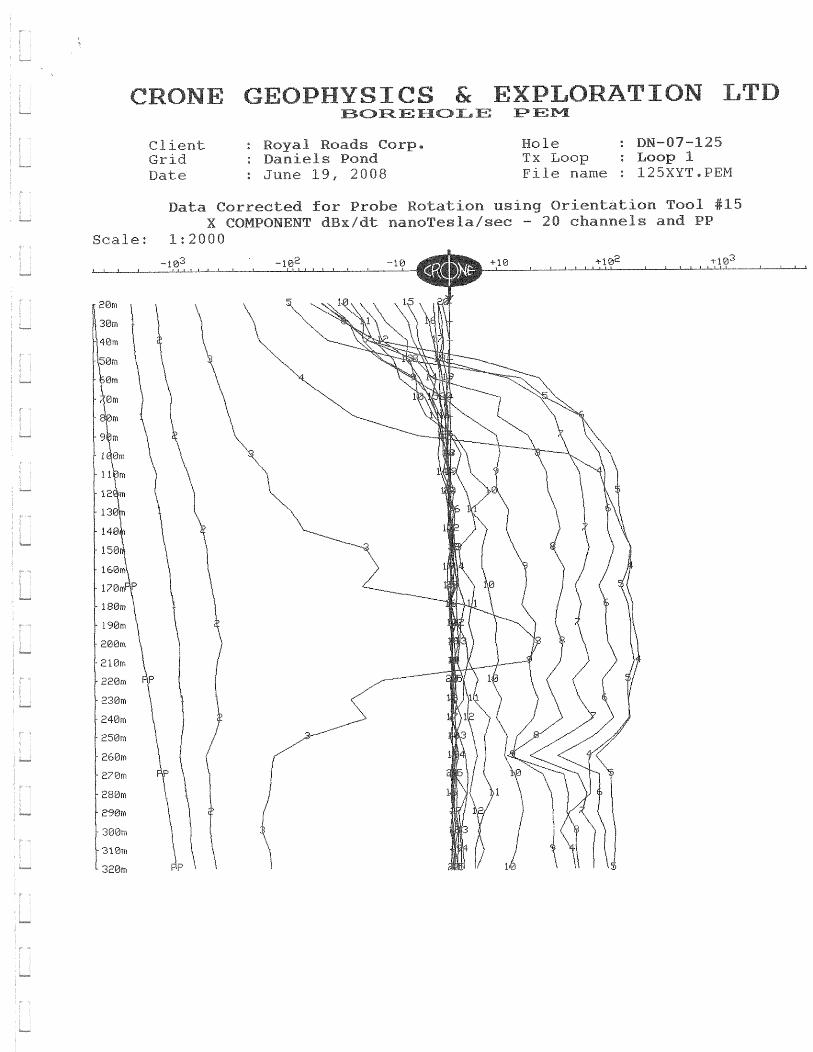
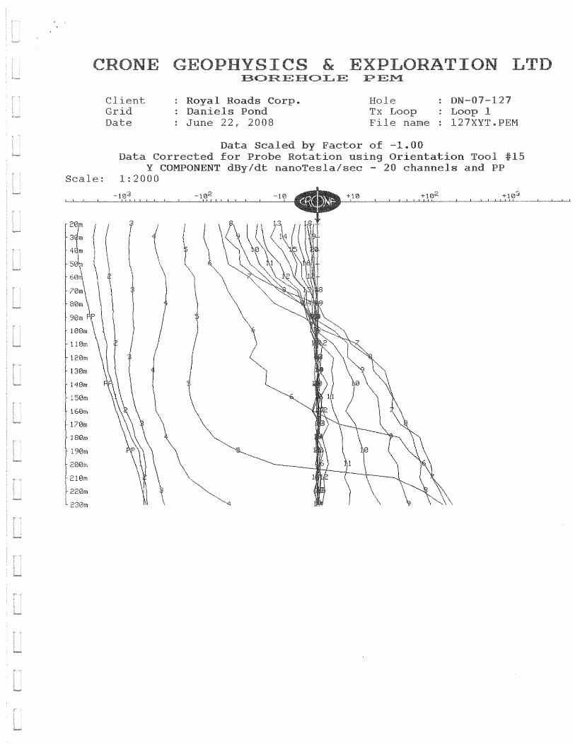
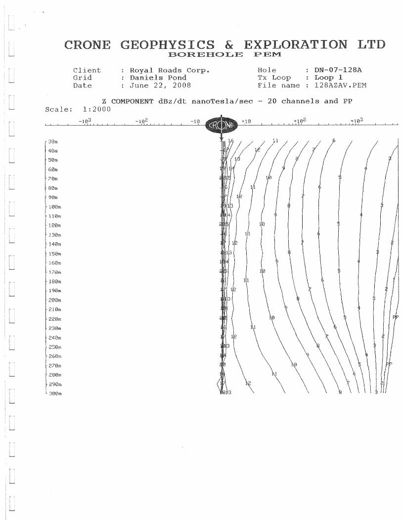
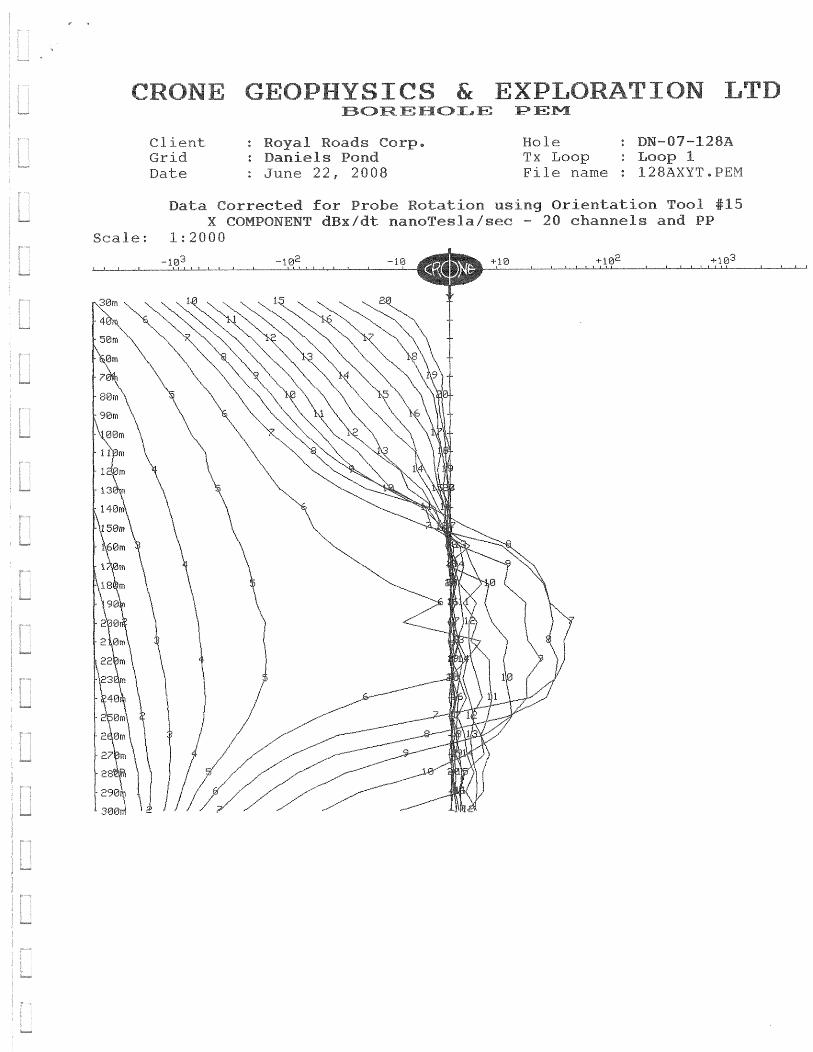
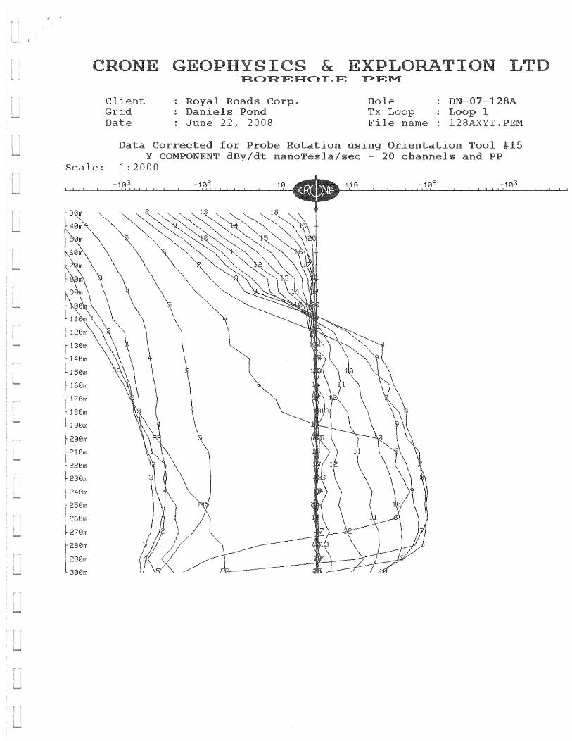
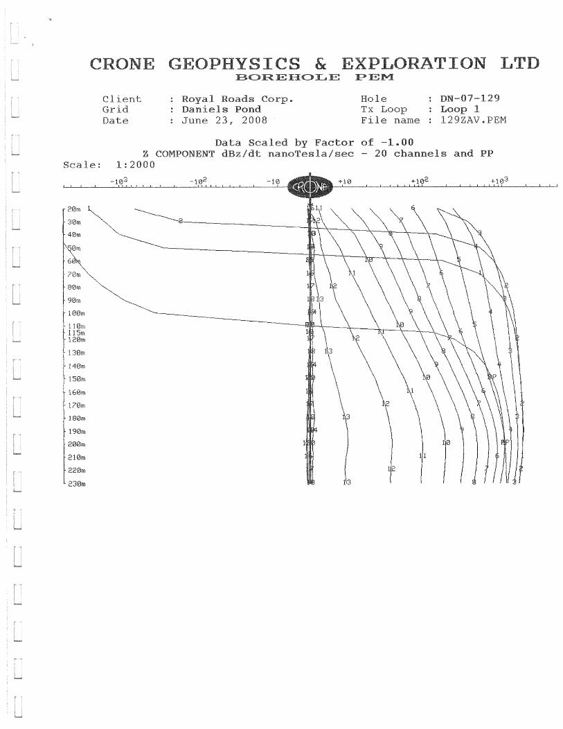
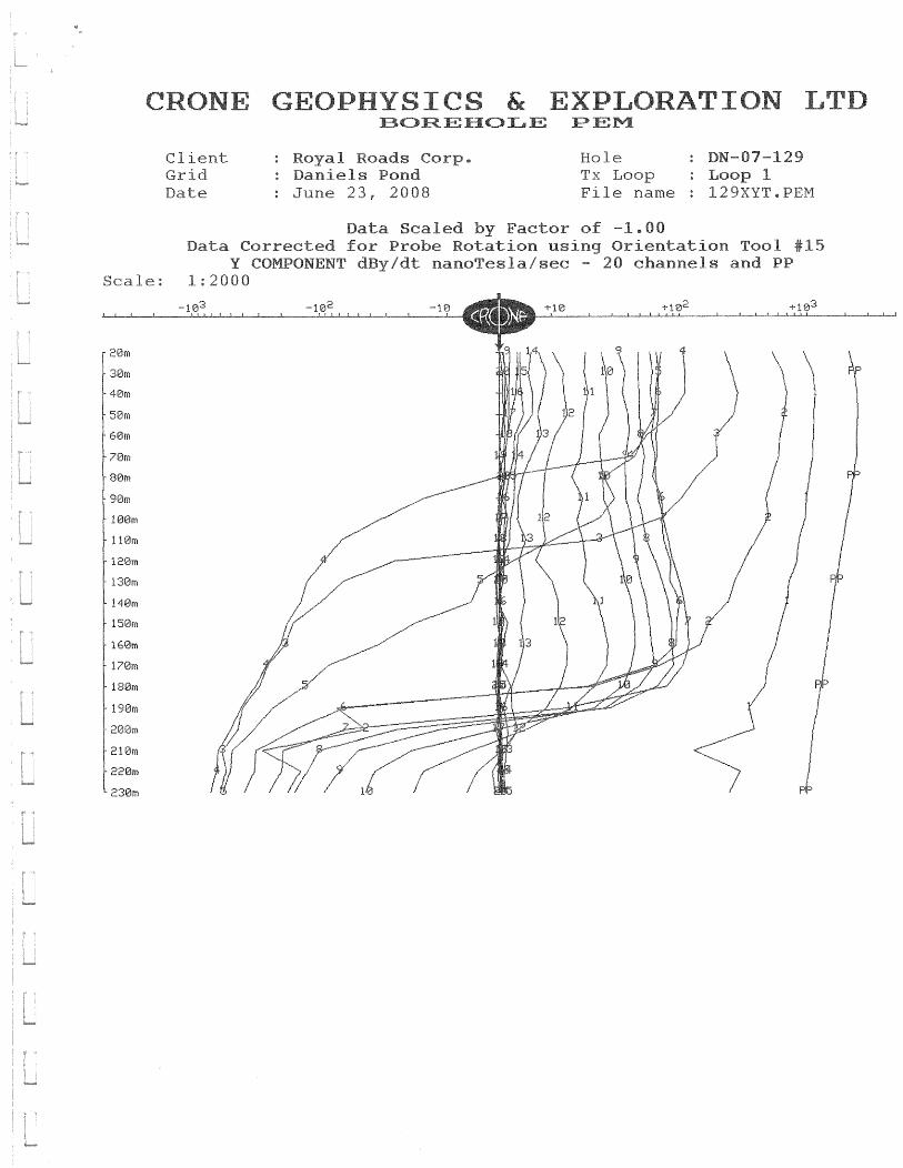
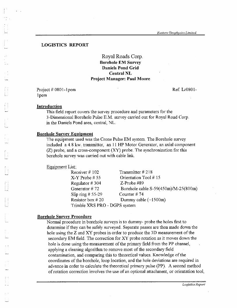
Borehole Pulse EM Surveys
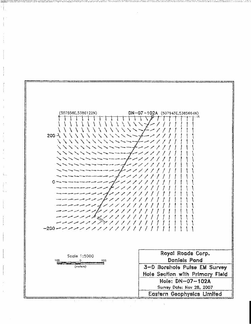
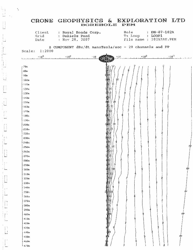
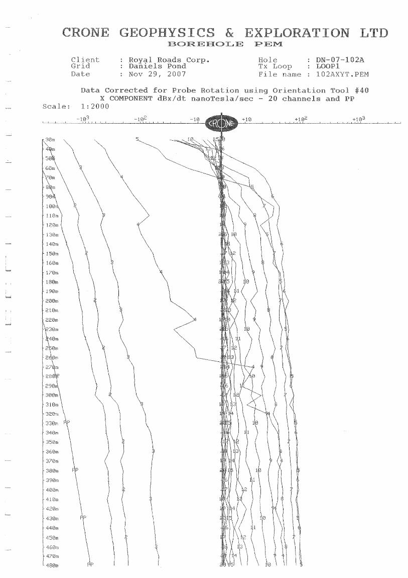
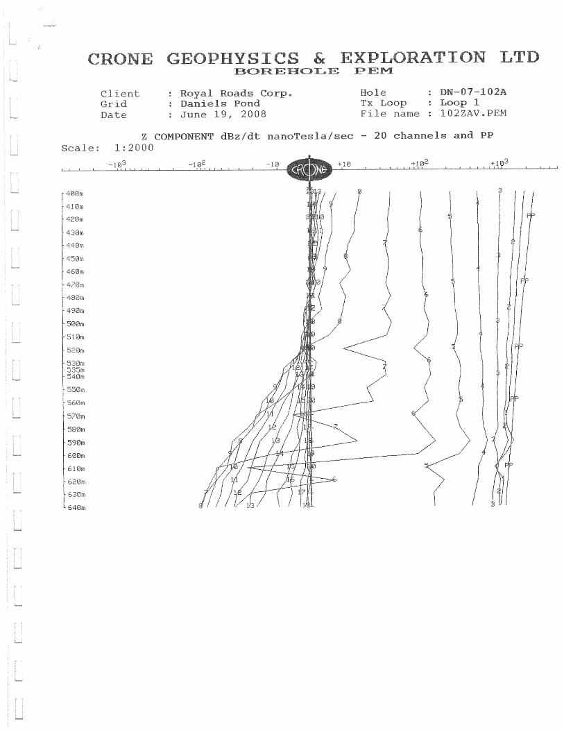
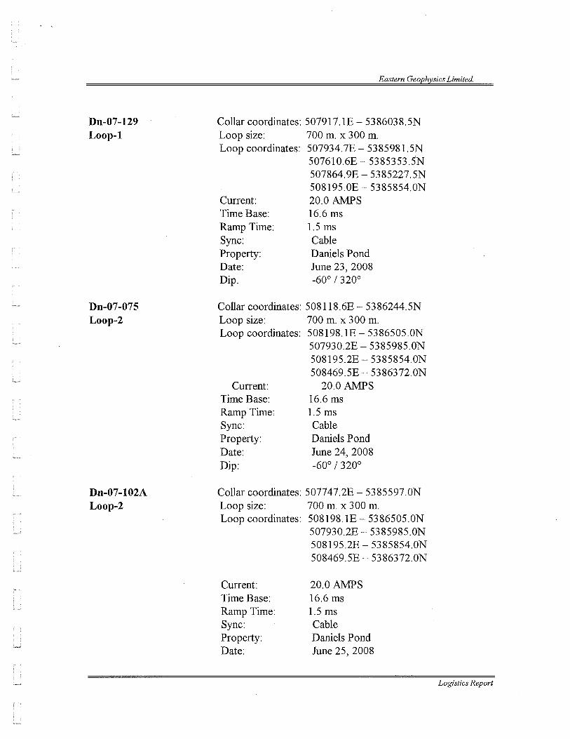
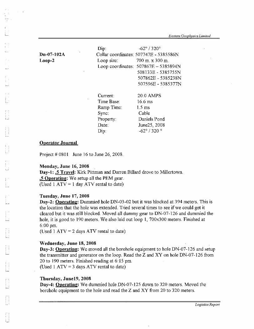
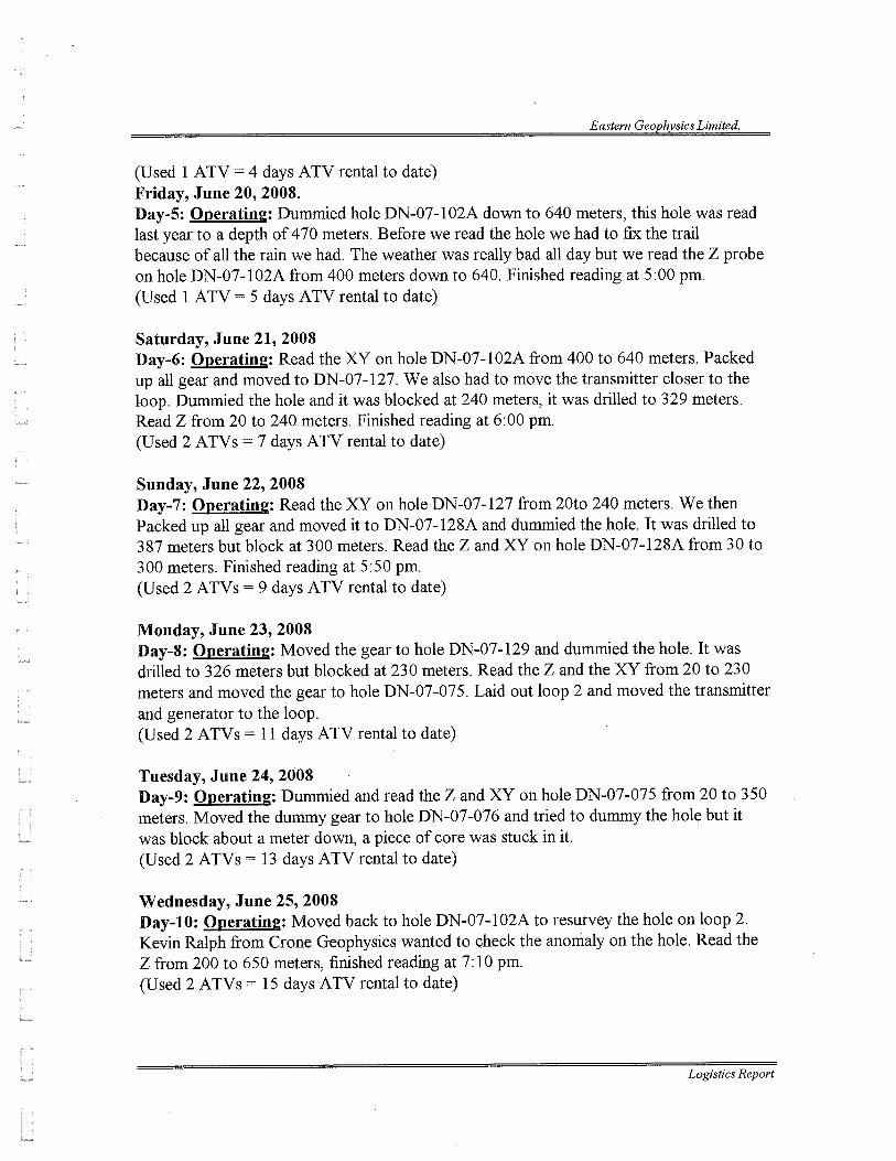
Borehole Pulse EM surveys were attempted in several deeper drill holes beneath the
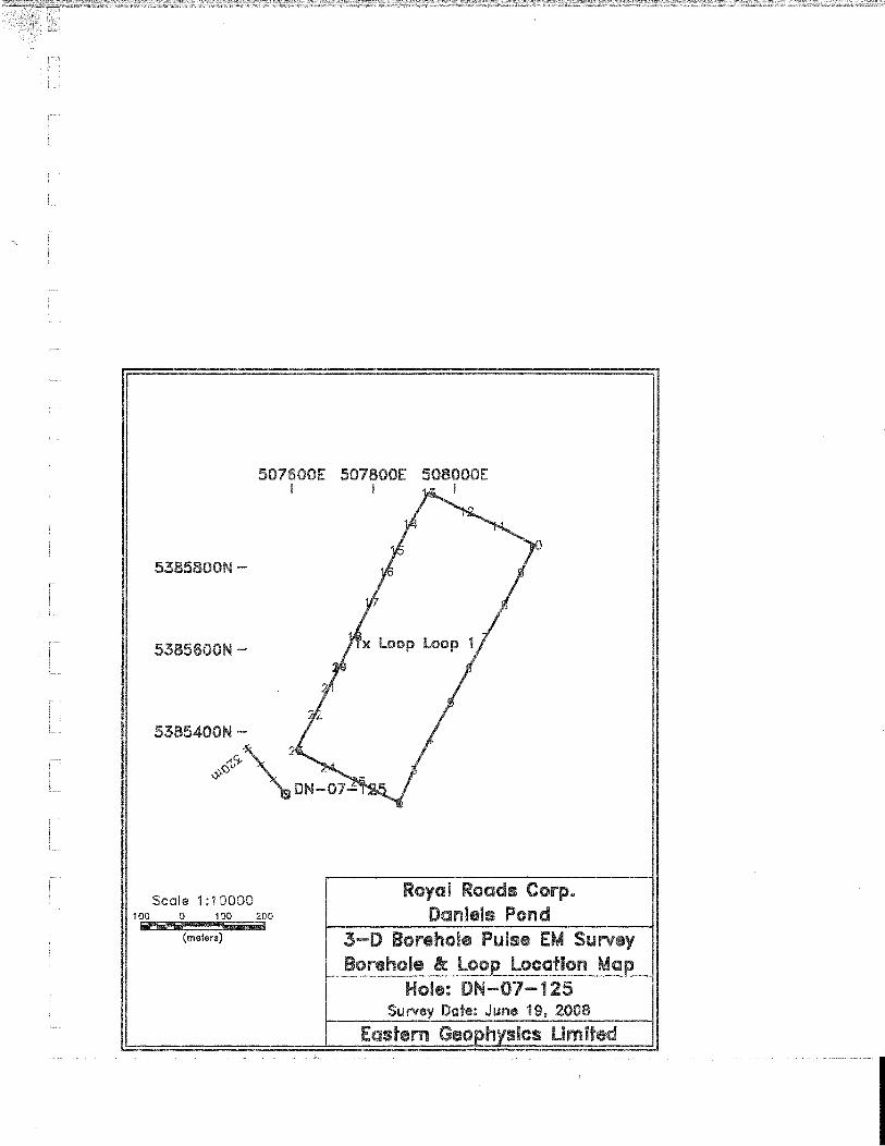
Daniels Pond deposit including holes DN-03-02, DN-07-75, DN-07-76, DN-102A, DN-07-125,
DN-07-126, DN-07-127, DN-07-128A, and DN-07-129. The surveys were undertaken by
Eastern Geophysics Limited of West Pubnico, Nova Scotia over the period from June 16 to 25,
2008 using the Crone Pulse EM system. Eastern’s logistics report describing the surveys,
including technical specifications and data, is appended to this report as Appendix I. Results of
the surveys were subsequently reviewed and interpreted by consultant geophysicist, Gerard
Lambert, P. Eng., of St. Andre-Avellin, Quebec. Mr. Lambert’s findings, including
recommendations for further work, are presented in a memorandum appended to this report as
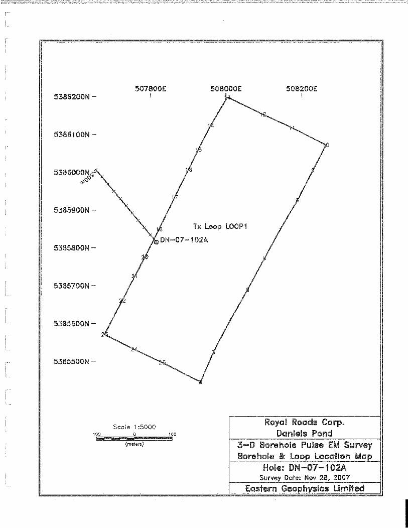
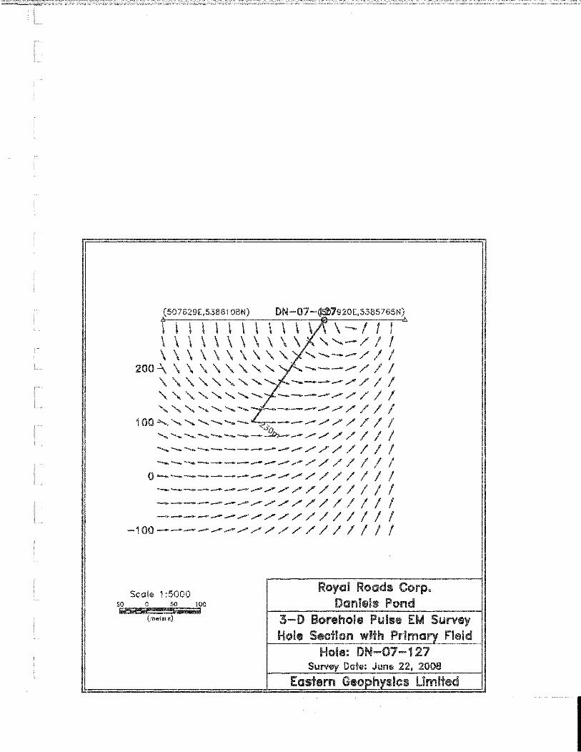
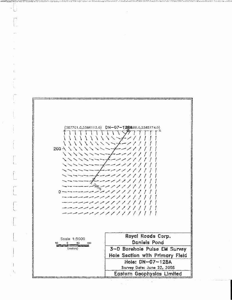
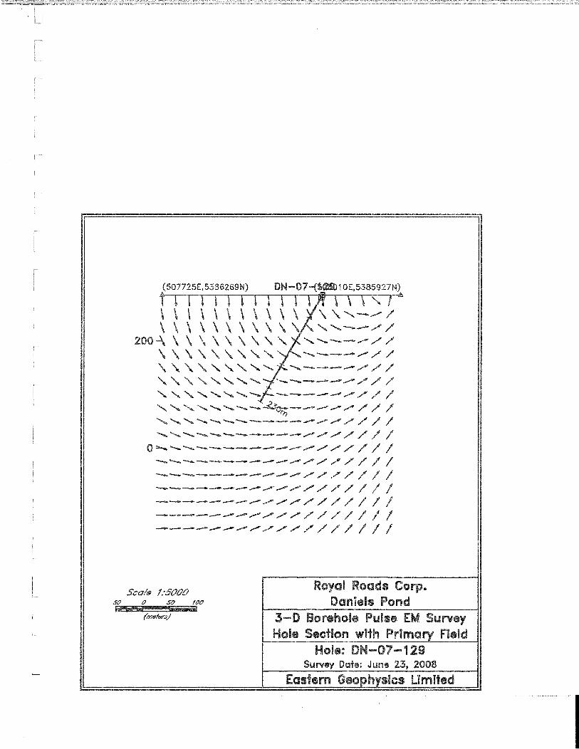
Appendix II. A map showing the location of the surveyed drill holes relative to the survey loops
and Daniels Pond deposit is presented as Map 1 (in pocket). A longitudinal projection showing
the approximate pierce points, including notes on the results for each hole surveyed is
presented on Map 2 (in pocket).
Unfortunately, the surveys were largely in effective as several key drill holes were found
to be blocked at the time of surveying. Blocked or partially blocked holes included DN-03-02,
DN-07-75, DN-07-127, DN-07-128A, and DN-07-129).
Results indicate potential for successful infill drilling along the northeast plunge of the
deposit’s Northeast Lobe (above hole DN-075) as well as beneath the Northeast Lobe above
holes DN-092A and DN-129.
RECOMMENDATIONS
Results of Borehole Pulse EM surveys conducted in 2008 are suggest further drilling is
warranted, in the area of the Northeast Lobe, as survey results suggest additional drilling in this
are would likely yield additional intersections in areas where additional tonnes would be added
to existing inferred and Indicated Resources. Furthermore, Results from drilling completed
since December 2007 (i.e. holes DN-08-124 to 08-129) returned several intersections meeting
requirements for inclusion into the resource estimates which may be augmented by drilling of
the anomalies identified by the borehole PEM surveys.
After completion of exploration programs during 2007 and 2008 at Daniels Pond, it is
evident that good exploration potential remains both along strike and down dip of the known
deposit, and future work is recommended to explore these areas; Borehole TDEM surveys
would help increase the effective search radius laterally and below each hole drilled to depths
below 200 m from surface, and consideration should be given to surveying several of the
blocked holes that could not be surveyed in 2008, when a drill returns to the deposit area as
large areas adjacent to the known lenses remain open in areas yet to be surveyed by borehole
PEM surveys (e.g., DN-03-02 and DN-07-076).
Drilling in 2008 was prematurely suspended due to break-up conditions on March 30,
with approximately 1,200 m of the 2008 proposed program remaining to be drilled at the
deposit. As a result several; holes remain to be drilled to test the deposit, particularly in the
area down-plunge to the northeast of the deposit’s Northeast Lobe. This work should be
undertaken in the future as this drilling has potential to yield discovery of significant new
mineralization.
Other remaining exploration targets of merit include known sulphide zones which remain
poorly tested by previous diamond drilling, including the Jack’s Pond and Cathys Pond
prospects, as well as several previously recognized alteration zones and untested soil and
geophysical anomalies identified by Royal Roads 2007 compilation (Moore and Butler 2008a,
2008b) and other sources. It is recommended that future exploration efforts be expanded to
advance and prioritize exploration of these target areas.
Respectfully Submitted: Royal Roads Corp. Paul Moore, M.Sc. P. Geo Vice President Exploration

REFERENCES
Agnerian, H., 2008a: Technical Report on the Bobby’s Pond Pb-Zn deposit, Newfoundland and Labrador,
Canada. Prepared for Mountain Lake Resources Inc., by Scott Wilson Roscoe Postle Associates Inc. Dated July 31, 2008. 110 pp.
Agnerian, H., 2008b: Technical Report on the TULKS HILL Cu-Zn Project, Newfoundland & Labrador,
Canada. Prepared for the Tulks Hill Joint Venture between Prominex Resources Corp (Operator) and Buchans River Limited., by Scott Wilson Roscoe Postle Associates Inc. Dated July 22, 2008. 111 pp.
Barbour, D.M., and Thurlow, J.G., 1982: Case histories of two massive sulphide discoveries in central Newfoundland. In
Prospecting in Areas of Glaciated Terrain. P. Davenport (editor), Canadian Institute of Mining and Metallurgy, p. 300-320.
Colman-Sadd, S.P., Dunning, G.R., and Dec, T., 1992: Dunnage-Gander relationships and Ordovician orogeny in central Newfoundland; a
sediment provenance and U/Pb age study. American Journal of Science, Vol. 292, p. 317-355.
De Mark, P. and Dearin, C., 2007: Messina Minerals Inc.: Tulks South Property, Central Newfoundland, Canada. Technical
Report, August 2007. Prepared for Messina Minerals Inc., by Snowden. 97 pp. Evans, D.T.W. and Kean, B.F., 2002: The Victoria Lake supergroup, central Newfoundland – its definition, setting and
volcanogenic massive sulphide mineralization. Newfoundland Department of Mines and Energy, Geological Survey, Open File NFLD/2790, 68 pp.
Evans, D.T.W., Kean, B.F., and Dunning, G.R., 1990: Geological studies, Victoria Lake Group, central Newfoundland. In Current Research.
Newfoundland Department of Mines and Energy, Geological Survey Branch, Report 90-1, p. 131-144.
Evans, D.T.W., 1986: Geology of the Jacks Pond volcanogenic massive sulphide prospects, Victoria Lake
Group, central Newfoundland. In Current Research. Newfoundland Department of Natural Resources, Geological Survey, Report 86-1, p. 59-64.
Hinchey, J.G., 2007b: In Report of activities 2007, Pereira, C.P.G., (Editor), Government of Newfoundland and
Labrador, Department of Natural Resources, Mines Branch, 62 pp.

Hinchey, J.G., 2007a: Volcanogenic Massive Sulphides of the Southern Tulks Volcanic Belt, Central
Newfoundland: Preliminary findings and overview of styles and environments of mineralization. In Current Research. Newfoundland Department of Natural Resources, Geological Survey, Report 07-1, p. 117-143.
Jameison, M., 2006: Technical Report on the Bobby’s Pond Pb-Zn deposit, Newfoundland and Labrador,
Canada. Prepared for Mountain lake Resources Inc., by Scott Wilson Roscoe Postle Associates Inc. 111 pp.
Kean, B. F., Dean, P.L., and Strong, D.F., 1981: Regional geology of the Central Volcanic Belt of Newfoundland. Geological Association
of Canada, Special Paper 22, p. 65-78. Liverman, D., Batterson, M., Bell, T., Nolan, L., Marich, A., and Putt, M., 2006: Digital elevation models from shuttle radar topography mission data – New insights into
the Quaternary history of Newfoundland. In: Current Research. Newfoundland and Labrador Department of Natural Resources, Geological Survey, Report 06-1, p. 177-189.
McKenzie, C.B., Desnoyers, D.W., Barbour, D., Graves, R.M., 1993: Contrasting Volcanogenic-hosted Massive Sulfide Styles in the Tulks Belt, Central
Newfoundland. Canadian Institute of Mining, Exploration Mining Geology, Vol. 2, No. 1, p. 73-84.
Moore, P.J. and Butler, D.J., 2008a: Tulks North Mineral Assessment Report, for 2006-2007 programs on Exploration
licenses 6548M, 10400M, 10402M, 10410M, 10411M, 12369M, 12370M & 12371M, Royal Roads Corp.
Moore, P.J. and Butler, D.J., 2008b: Supplementary Report of Work, Tulks North Project, Red Indian lake Area, central
Newfoundland. December 2007 to April 30, 2008. Digital compilation, NI-43-101 Property Holdings Report and Resource Estimate, whole rock geochemistry and diamond drilling. Unpublished assessment report, prepared for Royal Roads Corp. 40 pp.
Noranda, 1998: Precious and base metal properties available for option in central Newfoundland,
Summary Report. Internal company report. Newfoundland Department of Natural Resources Geofile Number 012A/1231. 500 pp.
Regular, M.B., 2005: Sixth Year assessment report of diamond drilling on the exploration license 10411M,
Daniel’s Pond Extension, Tulks North property, Red Indian Lake area, central Newfoundland. Unpublished assessment report, prepared for Royal Roads Corp., Newfoundland and Labrador Geofile Number 012A/10/1218. 35 pp.
Rogers, N., van Staal, C.R., McNicoll, V.J., Squires, G.C. Pollock, J., and Zagorevski, A., 2005: Geology, Lake Ambrose and Part of Buchans, Newfoundland and Labrador. Geological
Survey of Canada, Open File 4544, Scale 1:50,000. NTS Sheet 12A/10: Squires, C.G., Brace, T.D., and Hussey, A.M., 2001: Newfoundland’s polymetallic Duck Pond deposit: earliest Iapetan VMS mineralization,
formed within a sub-seafloor, carbonate-rich alteration system. In Geology and Mineral Deposits of the Northern Dunnage Zone, Newfoundland Appalachians. Edited by D.T.W. Evans and A. Kerr. Geological Association of Canada – Mineralogical Association of Canada Field Trip Guide A2 (Part 1), p. 167-187.
Swinden, H.S., 1991: Regional Geology and Metallogeny of Central Newfoundland. In Metallogenic
Framework of Base and Precious Metal Deposits, central and Western Newfoundland (Field Trip 1) Geological Survey of Canada, Open File 2156, p. 1-27.
Swinden, H.S., 1991: Paleotectonic settings of volcanogenic massive sulphide deposits in the Dunnage Zone,
Newfoundland Appalachians. CIM Bulletin, vol. 84, No. 946, p. 59-69. van Staal, C.R., Valverde-Vaquero, P., Zagorevski, A., Rogers, N., Lissenberg, .J., and McNicoll, V.J., 2005: Geology, Victoria Lake. Newfoundland and Labrador. Geological Survey of Canada,
Open File 1667, Scale 1:50,000. Williams, H., 1995: Geology of the Appalachian-Caledonian Orogen in Canada and Greenland. Geological
Survey of Canada, Geology of Canada: Temporal and Spatial Divisions; Chapter 2, p. 21-44.
Williams, H., Colman-Sadd, S.P. and Swinden, H.S., 1988: Tectono-Stratigraphic subdivisions of central Newfoundland. In Current Research, Part
B. Geological Survey of Canada, Paper 88-1B, p. 91-98. Williams, H., 1979: Appalachian Orogen in Canada. Canadian Journal of Earth Sciences, Tuzo Wilson
Volume, vol. 16, p. 792-807. Webster, P.C., Barr, J.F., and Cavalcanti de Albuquerque, R., 2008: Technical report on the Daniels Pond deposit and property holdings of Royal Roads
Corp, Red Indian Lake area, Newfoundland, Canada. Prepared for Royal Roads Corp. by Mercator Geological Services Limited, Effective Date: April 29, 2008. 170 pp.
PROFESSIONAL CERTIFICATION
I, Paul J. Moore, with business address at Suite E-130, 120 Torbay Road, St. John’s,
Newfoundland certify that:
1) I am a graduate (1990) of Memorial University, with a Master of Science degree in Earth
Sciences.
2) I am a registered member, in good standing, of the Professional Engineers and
Geoscientists of Newfoundland.
3) I have practiced my profession for approximately 20 years in Newfoundland and
Labrador, New Brunswick and Ontario.
4) This report is based on my direct involvement with the Tulks North Property through
fieldwork and data compilation. I have no interest in mineral claims in Newfoundland
and Labrador.
5) I hold securities of Royal Roads Corp., though shares purchased by me as well as
options granted me by the company.
Dated in St. John’s, Newfoundland this 31st day of March 2009.
Paul Moore, M.Sc. P. Geo.
Vice President Exploration
Royal Roads Corp.

APPENDIX I
Eastern Geophysics Limited, Logistics Report Borehole EM Survey
Daniels Pond Grid, Tulks North Property Central NL.


APPENDIX II
Gerard Lambert Geosciences , Memorandum. Tulks North Property,
Daniels Pond Geophysics, Borehole Pulse EM, June 2008.