Embed Size (px)
Citation preview
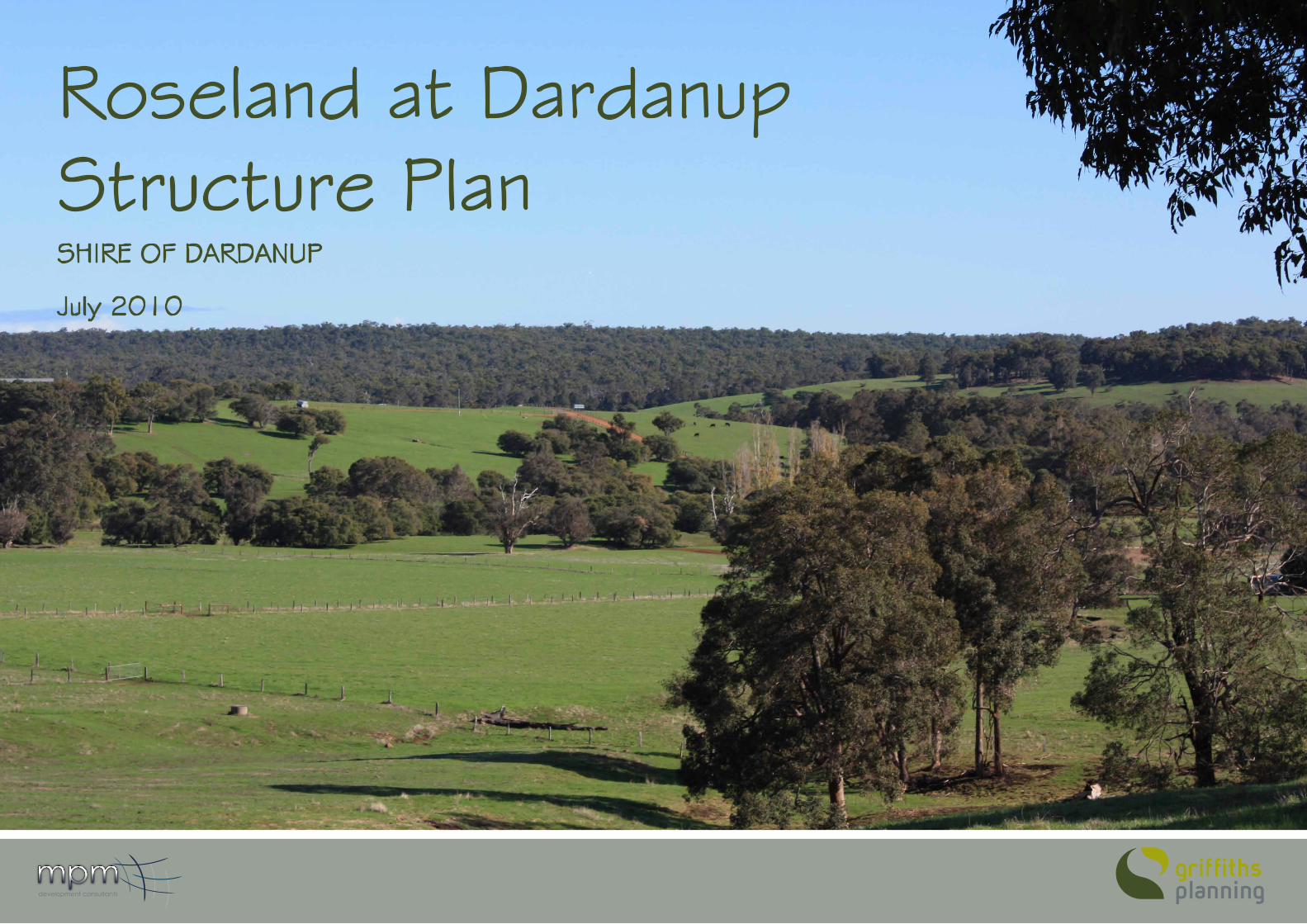
Roseland at Dardanup Structure PlanSHIRE OF DARDANUP
July 2010
development consultants
ROSELAND AT DARDANUP STRUCTURE PLAN July 2010 2
TITLE: Roseland at Dardanup Structure PlanPREPARED FOR: Shire of DardanupPREPARED BY: Griffiths PlanningREFERENCE: GP-090801 AUTHORS: Janine Eriksson, Andrew McRobertGRAPHIC DESIGN: Steven JaniecAPPROvED BY: Janine Eriksson
Griffiths Planning would like to acknowledge MPM Development Consultants in the preparation of the Roseland at Dardanup Structure Plan
DISCLAIMER & COPYRIGHT
This document was prepared by Grifftiths Planning and intended for planning advice to the Shire of Dardanup. Griffiths Planning takes the utmost care and professionalism in preparing this document and always endeavours to represent the profession of town planning services in high accord. The information provided has been compiled from a number of sources using a variety of methods but we cannot attempt to verify complete accuracy or validity supplied by external sources.
CITATION
This document should be cited as follows:
Eriksson, G. et al (2010). Roseland at Dardanup Structure Plan July 2010. Griffiths Planning. © Griffiths Planning, 2010ABN 22 922 578 924
Phone (08) 9795 6250 Mobile 0408901192PO Box 1404, Bunbury WA 6231Email: [email protected]
ROSELAND AT DARDANUP STRUCTURE PLAN July 2010 3
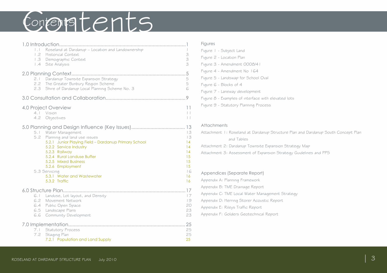
ContentsContents1.0 Introduction............................................................................................ 1 1.1 Roseland at Dardanup – Location and Landownership 1 1.2 Historical Context 3 1.3 Demographic Context 3 1.4 Site Analysis 3
2.0 Planning Context................................................................................... 5 2.1 Dardanup Townsite Expansion Strategy 5 2.2 The Greater Bunbury Region Scheme 5 2.3 Shire of Dardanup Local Planning Scheme No. 3 6
3.0 Consultation and Collaboration.......................................................... 9
4.0 Project Overview 11 4.1 vision 11 4.2 Objectives 11
5.0 Planning and Design Influence (Key Issues)....................................... 13 5.1 Water Management 13 5.2 Planning and land use issues 13
5.2.1 Junior Playing Field – Dardanup Primary School 14 5.2.2 Service Industry 14 5.2.3 Railway 14 5.2.4 Rural Landuse Buffer 15 5.2.5 Mixed Business 15 5.2.6 Employment 15
5.3 Servicing 16 5.3.1 Water and Wastewater 16 5.3.2 Traffic 16
6.0 Structure Plan......................................................................................... 17 6.1 Landuse, Lot layout, and Density 17 6.2 Movement Network 19 6.4 Public Open Space 20 6.5 Landscape Plans 23 6.6 Community Development 23
7.0 Implementation..................................................................................... 25 7.1 Statutory Process 25 7.2 Staging Plan 25
7.2.1 Population and Land Supply 25
FiguresFigure 1 - Subject Land
Figure 2 - Location Plan
Figure 3 - Amendment 0008/41
Figure 4 - Amendment No 164
Figure 5 - Landswap for School Oval
Figure 6 - Blocks of 4
Figure 7 - Laneway development
Figure 8 - Examples of interface with elevated lots
Figure 9 - Statutory Planning Process
Attachments Attachment 1: Roseland at Dardanup Structure Plan and Dardanup South Concept Plan
and Tables
Attachment 2: Dardanup Townsite Expansion Strategy Map
Attachment 3: Assessment of Expansion Strategy Guidelines and PPS
Appendices (Separate Report)Appendix A: Planning Framework
Appendix B: TME Drainage Report
Appendix C: TME Local Water Management Strategy
Appendix D: Herring Storer Acoustic Report
Appendix E: Rileys Traffic Report
Appendix F: Golders Geotechnical Report

ROSELAND AT DARDANUP STRUCTURE PLAN July 2010 4
ROSELAND AT DARDANUP STRUCTURE PLAN July 2010 1
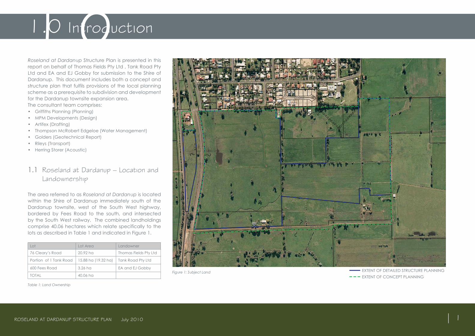
Roseland at Dardanup Structure Plan is presented in this report on behalf of Thomas Fields Pty Ltd , Tank Road Pty Ltd and EA and EJ Gobby for submission to the Shire of Dardanup. This document includes both a concept and structure plan that fulfils provisions of the local planning scheme as a prerequisite to subdivision and development for the Dardanup townsite expansion area.The consultant team comprises:• Griffiths Planning (Planning) • MPM Developments (Design) • Artifex (Drafting)• Thompson McRobert Edgeloe (Water Management)• Golders (Geotechnical Report)• Rileys (Transport)• Herring Storer (Acoustic)
1.1 Roseland at Dardanup – Location and Landownership
The area referred to as Roseland at Dardanup is located within the Shire of Dardanup immediately south of the Dardanup townsite, west of the South West highway, bordered by Fees Road to the south, and intersected by the South West railway. The combined landholdings comprise 40.06 hectares which relate specifically to the lots as described in Table 1 and indicated in Figure 1.
Lot Lot Area Landowner
76 Cleary’s Road 20.92 ha Thomas Fields Pty Ltd
Portion of 1 Tank Road 15.88 ha (19.32 ha) Tank Road Pty Ltd
600 Fees Road 3.26 ha EA and EJ Gobby
TOTAL 40.06 ha
Table 1: Land Ownership
Figure 1: Subject Land
1.0 Introduction1.0
South Western Highw
ay
EXTENT OF DETAILED STRUCTURE PLANNING EXTENT OF CONCEPT PLANNING
ROSELAND AT DARDANUP STRUCTURE PLAN July 2010 2
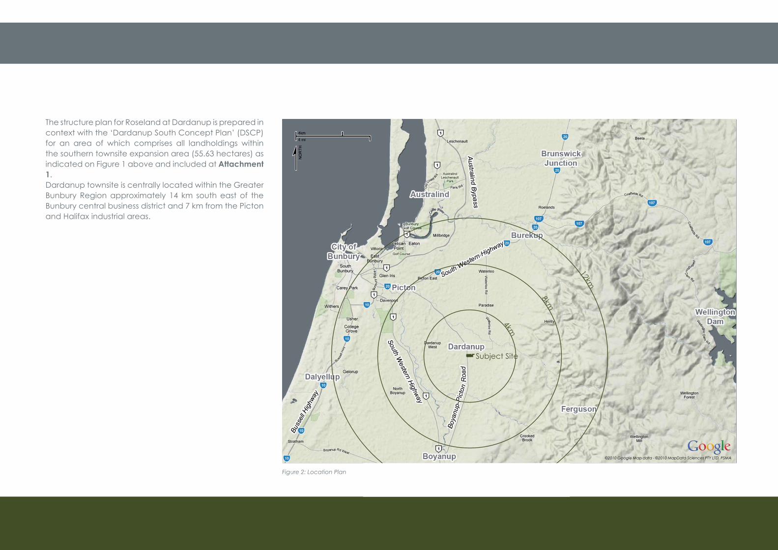
The structure plan for Roseland at Dardanup is prepared in context with the ‘Dardanup South Concept Plan’ (DSCP) for an area of which comprises all landholdings within the southern townsite expansion area (55.63 hectares) as indicated on Figure 1 above and included at Attachment 1. Dardanup townsite is centrally located within the Greater Bunbury Region approximately 14 km south east of the Bunbury central business district and 7 km from the Picton and Halifax industrial areas.
Figure 2: Location Plan
©2010 Google Map data - ©2010 MapData Sciences PTY LTD, PSMA
Subject Site
4km
8km
12km
ROSELAND AT DARDANUP STRUCTURE PLAN July 2010 3
1.2 Historical Context Dardanup was first settled by Thomas Little around 1852. Little built a homestead named “Dardanup Park” thought to be a variation of the Aboriginal word “Dudingup”. Little gave land to the Catholic Church and attracted other settlers to the area, and a small community soon developed.The 1890’s saw the construction of the railway through the district, which was used to transport timber to Dardanup. Land at Dardanup was privately owned and developed, however in the 1920’s the government acquired and subdivided land for closer settlement and the townsite of Dardanup was gazetted in 1923.The subject land has been irrigated pasture since 1933 and the land yield by the early settlers was largely subsistence farming, growing their own vegetables, producing their own meat and selling some of their produce in Bunbury. The Fees family were the original pioneers of the subject land and named their property ‘Roseland’ which gives rise to the structure plan name.Dardanup townsite was the administrative centre of the Shire of Dardanup until the relocation of the Shire offices in 1999.
1.3 Demographic Context
The Shire of Dardanup produced a document describing Population and Demographics (October 2009). This document was developed using software provided by the Australian Bureau of Statistics (ABS). Dardanup townsite population was estimated to be just over 370 in 2006 ABS. Based on the Shires report, Dardanup townsite is likely to have a significant increase in its population from 2011 to 2021 due growth as supported by the Dardanup Townsite Expansion Strategy. From
2021, it is projected that there will be a fairly progressive population growth but at a slower rate to the preceding years. While the Shires population reports suggest a population of approximately 2,253 by 2026, the townsite expansion strategy estimates that the population may reach between 2000- 4000 by 2031 depending on densities achieved and market demand. Population projections are based on an occupancy rate of 2.8 persons per household. The Shire projects that 21% of the Dardanup townsite population in 2011 will be aged over 55 and will gradually increase to 26% of the total population in 2026. However, in 2011 61% of Dardanup’s population may be dependents and this proportion is projected to gradually decrease to 54% in 2026. Dependents are those aged 0 to 14 years and over 65.
The ratio of the aged and dependent population has implications for Council in terms of the facilities and services available to the community. Having a higher proportion of aged people results in the requirement for facilities used by this population group, such as health and welfare services, social activity centres, and aged accommodation. Having a high ratio of dependents aged 0-14 also results in demand for services and facilities such as health, child, youth, and recreation facilities.
1.4 Site Analysis
The subject site is flat cleared land with a covering of grass and sparse trees, and therefore does not contain any significant natural areas. The townsite of Dardanup and adjacent land is situated on clay soils which results in slow absorption of surface water. The site is intersected by three irrigation drainage channels at approximately one metre deep. The Golders Geotechnical Report included
in Appendix F confirms that the site is capable and suitable for residential development subject to acceptable and best practice management drainage solutions being implemented.

ROSELAND AT DARDANUP STRUCTURE PLAN July 2010 5
The existing planning framework and policy context provides support for preparation of the Roseland at Dardanup structure plan particularly as it is consistent with the Greater Bunbury Region Scheme (GBRS), Local Planning Scheme (LPS) and the Dardanup townsite expansion strategy as described in sections 2.1-2.3 described below. A further detailed review of the planning context and assessment of the proposal within the broader and relevant policies of the state planning framework is provided in Appendix A.The key policies discussed at Appendix A include:• State Planning Policy 3.0 – Urban Growth and
Settlement• State Planning Policy 5.4 – Road and Rail Transport • Noise and Freight Land use Planning• State Planning Policy 2.9 – Water Resources• Liveable Neighbourhoods
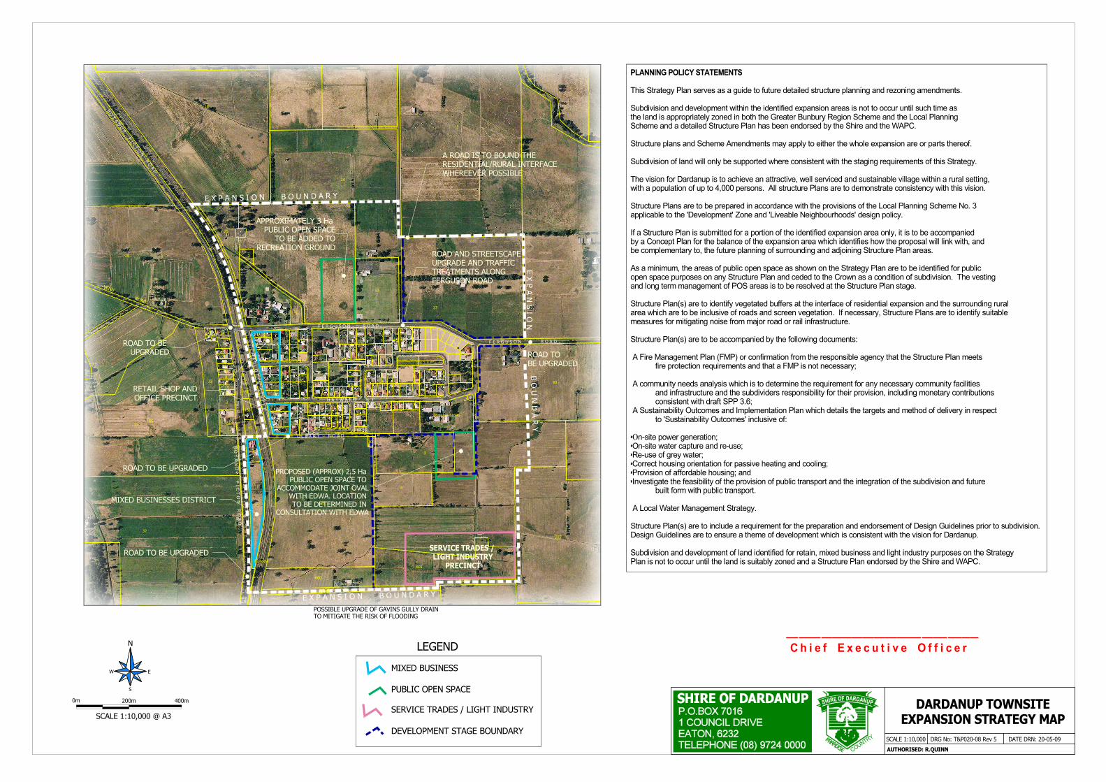
2.1 Dardanup Townsite Expansion Strategy
The Shire of Dardanup townsite expansion strategy endorsed by the Western Australian Planning Commission (WAPC) on 27 July 2009 provides the framework for orderly and proper expansion of the Dardanup townsite. The strategy proposes to facilitate expansion of the town by approximately 100 hectares to satisfy estimated population demand until 2031 and requires that this is controlled by detailed structure planning and staging of subdivision. The key outcomes of the strategy are reflected in guidance provided through Section 5: Expansion Strategy and Section 6: Planning Policy Statements of the document which are summarised on the Dardanup Townsite Expansion Map (See Attachment 2).The Dardanup South Concept Plan (DSCP) and Roseland at Dardanup Structure Plan (Attachment 1) address
each relevant guideline and planning policy statement indicating overall compliance with the intent of the strategy. All issues and elements of the structure plan have been addressed thoroughly in consultation with key agencies as described in section 3.0 of this report. Section 5 of this report presents discussion of the design and planning issues in response to the strategy. Section 6 of this report describes and provides rationale for each of the structure plan components. Attachment 3 includes a table which references each provision of the Dardanup Townsite Expansion Strategy and where these have been addressed in this report or on the structure plan.The DSCP significantly influences future townsite development as it represents over 50% of the growth area, and the structure plan for Roseland at Dardanup comprises over a third of the anticipated future development. Section 7.2 of this report addresses the staging requirements for subdivision.
2.2 The Greater Bunbury Region Scheme
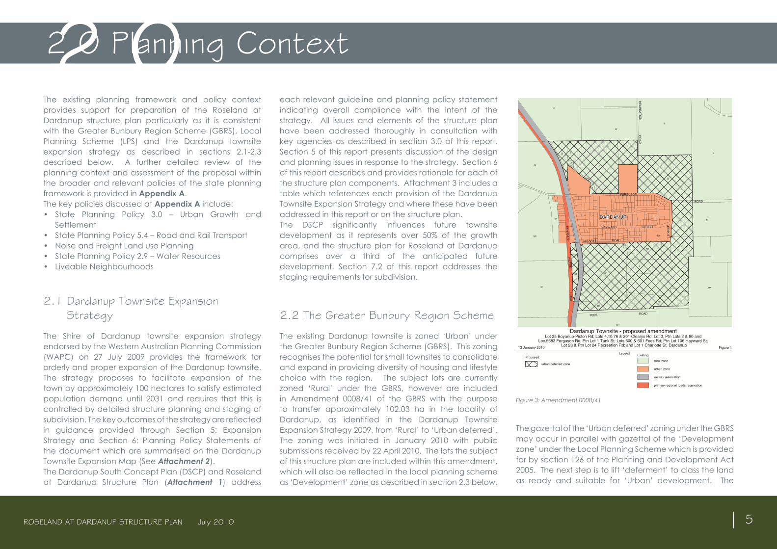
The existing Dardanup townsite is zoned ‘Urban’ under the Greater Bunbury Region Scheme (GBRS). This zoning recognises the potential for small townsites to consolidate and expand in providing diversity of housing and lifestyle choice with the region. The subject lots are currently zoned ‘Rural’ under the GBRS, however are included in Amendment 0008/41 of the GBRS with the purpose to transfer approximately 102.03 ha in the locality of Dardanup, as identified in the Dardanup Townsite Expansion Strategy 2009, from ‘Rural’ to ‘Urban deferred’. The zoning was initiated in January 2010 with public submissions received by 22 April 2010. The lots the subject of this structure plan are included within this amendment, which will also be reflected in the local planning scheme as ‘Development’ zone as described in section 2.3 below.
Figure 3: Amendment 0008/41
The gazettal of the ‘Urban deferred’ zoning under the GBRS may occur in parallel with gazettal of the ‘Development zone’ under the Local Planning Scheme which is provided for by section 126 of the Planning and Development Act 2005. The next step is to lift ‘deferment’ to class the land as ready and suitable for ‘Urban’ development. The
2.0 Planning Context2.0
Figure 1
NScale 1:7500
0
metres
LegendProposed:
Existing:
dardanup urban deferred.dgn14 Jan 2010
Base information supplied by Western Australian Land Information Authority LI430-2009-2
GEOCENTRIC DATUM OF AUSTRALIA
13 January 2010
200
rural zone
railway reservation
primary regional roads reservation
urban deferred zone
urban zone
Dardanup Townsite - proposed amendment
BO
YA
NU
PP
ICT
ON
RO
AD
DARDANUP
FERGUSON
ROAD
16
24
5
3
80
227
601
32
185
33
26
25
23
23
106
201
4 1
601
600
7676
1
Produced by Cartographic Section, South West Planning,Department of Planning onn behalf of the Western Australian Planning Commission, Perth WA
FEES ROAD
RE
CR
EA
TIO
NR
OA
D
CLEARYS ROAD
HAYWARD STREET
10
TA
NK
ST
.
3
5683
Lot 25 Boyanup-Picton Rd; Lots 4,10,76 & 201 Clearys Rd; Lot 3, Ptn Lots 2 & 80 andLoc.5683 Ferguson Rd; Ptn Lot 1 Tank St; Lots 600 & 601 Fees Rd; Ptn Lot 106 Hayward St;
Lot 23 & Ptn Lot 24 Recreation Rd; and Lot 1 Charlotte St, Dardanup
ROSELAND AT DARDANUP STRUCTURE PLAN July 2010 6
WAPC Guidelines for Lifting of Urban Deferment state that the ‘Urban deferred’ zone indicates that land is physically and locationally suitable for urban purposes, however before agreeing to transfer land to the urban zone the WAPC will require evidence that:
• The land is capable of being provided with essential services and agreement has been reached between the developers and service providers with regard to the staging and financing of services;
• Planning is sufficiently advanced to depict an acceptable overall design to guide future development;
• The proposed urban development represents a logical progression of development;
• Regional requirements (such as regional roads, open space and public purposes) have been satisfied or provision made for them; and
• Any constraints to urban development can be satisfactorily addressed.
The transfer of land from the ‘Urban deferred’ zone to the ‘Urban’ zone may be initiated by the landowner, the local government or any public authority and referred to the local government and WAPC in the form of a detailed structure plan indicating the future development and servicing of the land.
Each of the criteria for lifting of deferment as stated above is addressed through the DSCP and Roseland at Dardanup Structure Plan (Attachment 1) and report.
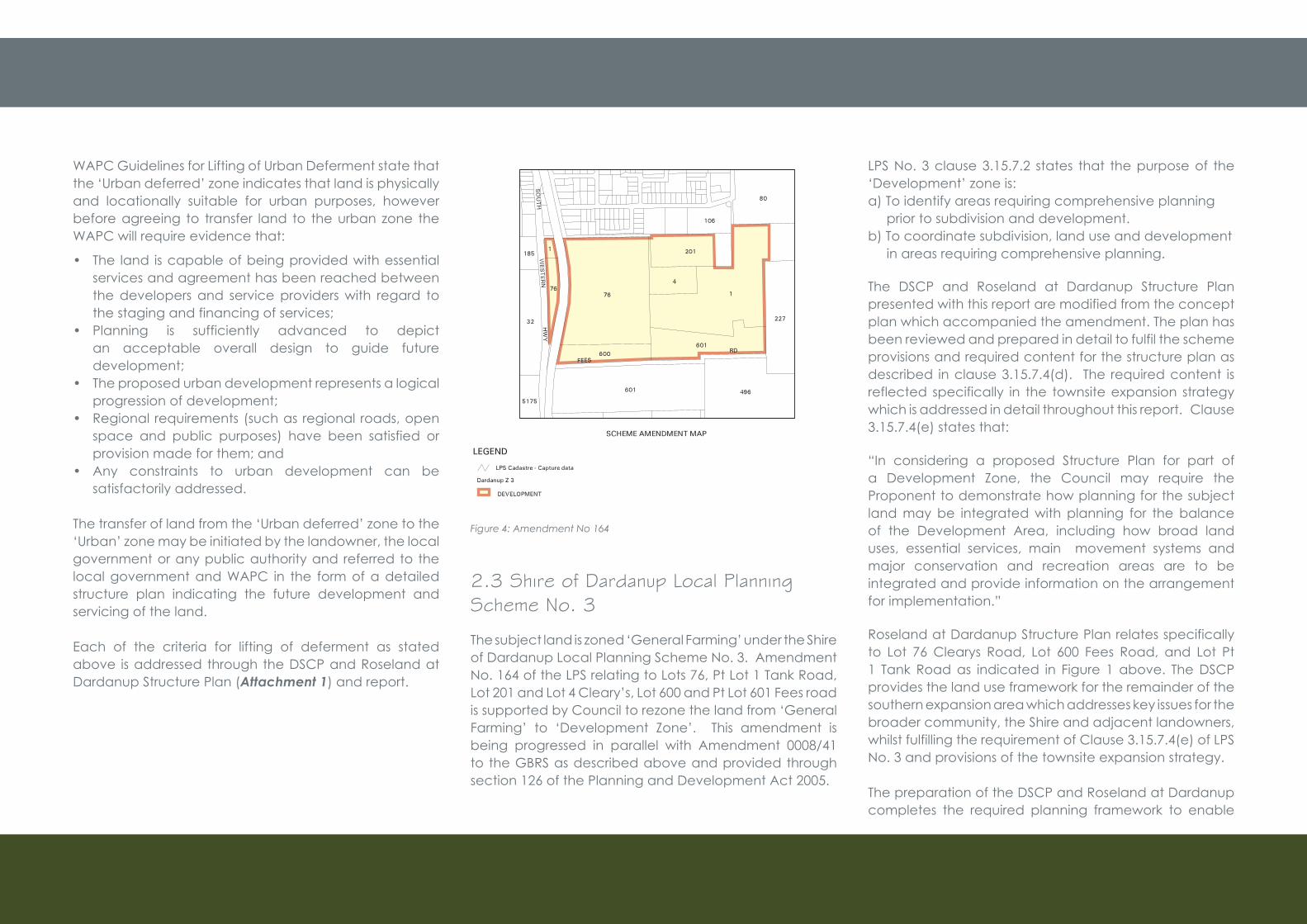
Figure 4: Amendment No 164
2.3 Shire of Dardanup Local Planning Scheme No. 3
The subject land is zoned ‘General Farming’ under the Shire of Dardanup Local Planning Scheme No. 3. Amendment No. 164 of the LPS relating to Lots 76, Pt Lot 1 Tank Road, Lot 201 and Lot 4 Cleary’s, Lot 600 and Pt Lot 601 Fees road is supported by Council to rezone the land from ‘General Farming’ to ‘Development Zone’. This amendment is being progressed in parallel with Amendment 0008/41 to the GBRS as described above and provided through section 126 of the Planning and Development Act 2005.
LPS No. 3 clause 3.15.7.2 states that the purpose of the ‘Development’ zone is:a) To identify areas requiring comprehensive planning prior to subdivision and development.b) To coordinate subdivision, land use and development in areas requiring comprehensive planning.
The DSCP and Roseland at Dardanup Structure Plan presented with this report are modified from the concept plan which accompanied the amendment. The plan has been reviewed and prepared in detail to fulfil the scheme provisions and required content for the structure plan as described in clause 3.15.7.4(d). The required content is reflected specifically in the townsite expansion strategy which is addressed in detail throughout this report. Clause 3.15.7.4(e) states that:
“In considering a proposed Structure Plan for part of a Development Zone, the Council may require the Proponent to demonstrate how planning for the subject land may be integrated with planning for the balance of the Development Area, including how broad land uses, essential services, main movement systems and major conservation and recreation areas are to be integrated and provide information on the arrangement for implementation.”
Roseland at Dardanup Structure Plan relates specifically to Lot 76 Clearys Road, Lot 600 Fees Road, and Lot Pt 1 Tank Road as indicated in Figure 1 above. The DSCP provides the land use framework for the remainder of the southern expansion area which addresses key issues for the broader community, the Shire and adjacent landowners, whilst fulfilling the requirement of Clause 3.15.7.4(e) of LPS No. 3 and provisions of the townsite expansion strategy.
The preparation of the DSCP and Roseland at Dardanup completes the required planning framework to enable
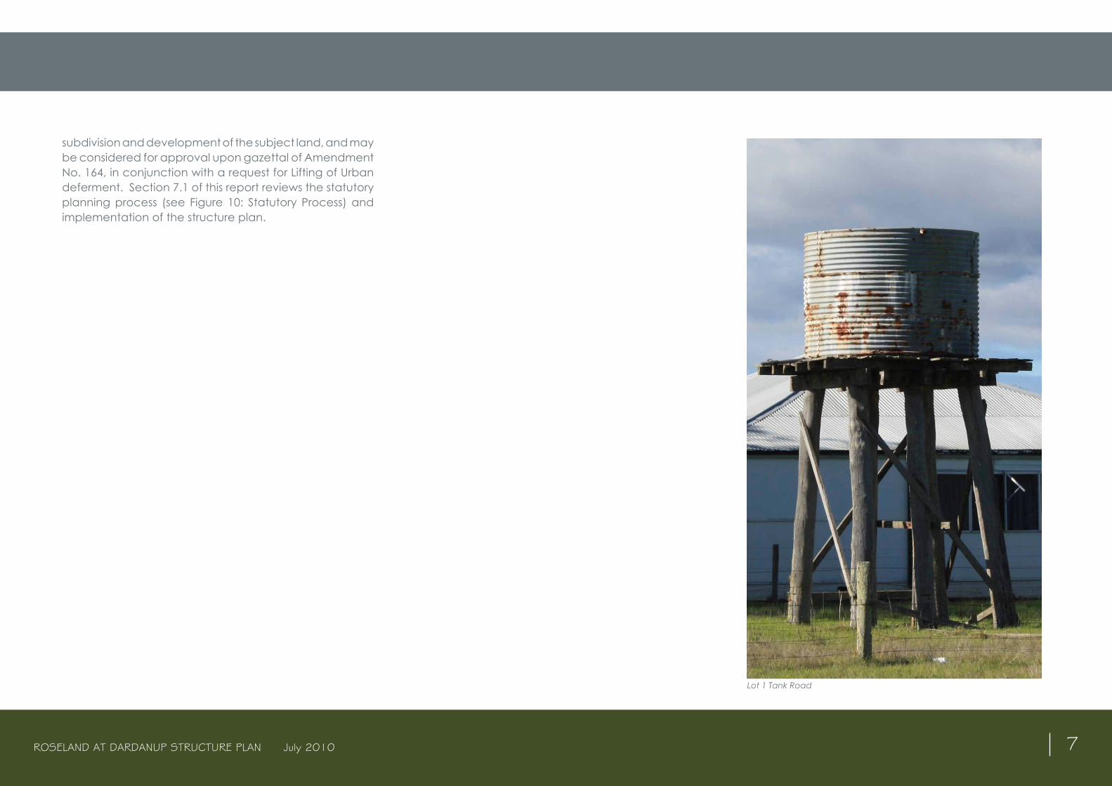
ROSELAND AT DARDANUP STRUCTURE PLAN July 2010 7
subdivision and development of the subject land, and may be considered for approval upon gazettal of Amendment No. 164, in conjunction with a request for Lifting of Urban deferment. Section 7.1 of this report reviews the statutory planning process (see Figure 10: Statutory Process) and implementation of the structure plan.
Lot 1 Tank Road

ROSELAND AT DARDANUP STRUCTURE PLAN July 2010 8
ROSELAND AT DARDANUP STRUCTURE PLAN July 2010 9
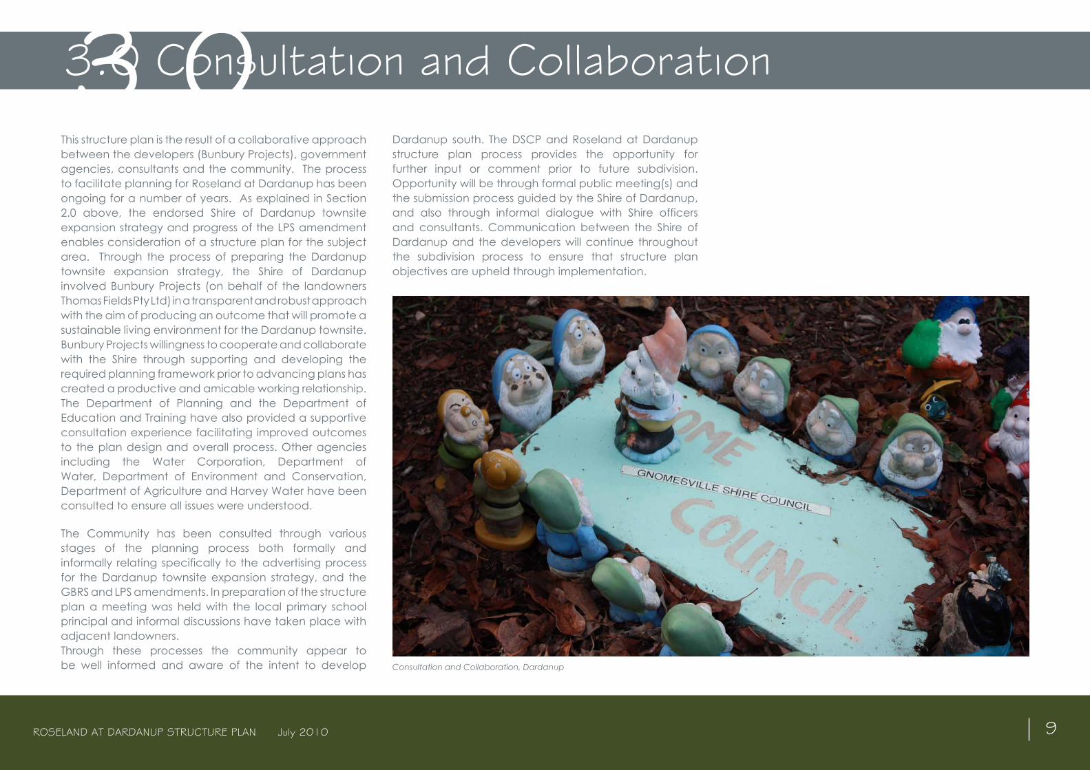
This structure plan is the result of a collaborative approach between the developers (Bunbury Projects), government agencies, consultants and the community. The process to facilitate planning for Roseland at Dardanup has been ongoing for a number of years. As explained in Section 2.0 above, the endorsed Shire of Dardanup townsite expansion strategy and progress of the LPS amendment enables consideration of a structure plan for the subject area. Through the process of preparing the Dardanup townsite expansion strategy, the Shire of Dardanup involved Bunbury Projects (on behalf of the landowners Thomas Fields Pty Ltd) in a transparent and robust approach with the aim of producing an outcome that will promote a sustainable living environment for the Dardanup townsite. Bunbury Projects willingness to cooperate and collaborate with the Shire through supporting and developing the required planning framework prior to advancing plans has created a productive and amicable working relationship. The Department of Planning and the Department of Education and Training have also provided a supportive consultation experience facilitating improved outcomes to the plan design and overall process. Other agencies including the Water Corporation, Department of Water, Department of Environment and Conservation, Department of Agriculture and Harvey Water have been consulted to ensure all issues were understood.
The Community has been consulted through various stages of the planning process both formally and informally relating specifically to the advertising process for the Dardanup townsite expansion strategy, and the GBRS and LPS amendments. In preparation of the structure plan a meeting was held with the local primary school principal and informal discussions have taken place with adjacent landowners. Through these processes the community appear to be well informed and aware of the intent to develop
Dardanup south. The DSCP and Roseland at Dardanup structure plan process provides the opportunity for further input or comment prior to future subdivision. Opportunity will be through formal public meeting(s) and the submission process guided by the Shire of Dardanup, and also through informal dialogue with Shire officers and consultants. Communication between the Shire of Dardanup and the developers will continue throughout the subdivision process to ensure that structure plan objectives are upheld through implementation.
3.0 Consultation and Collaboration3.0
Consultation and Collaboration, Dardanup
ROSELAND AT DARDANUP STRUCTURE PLAN July 2010 10
ROSELAND AT DARDANUP STRUCTURE PLAN July 2010 11
4.1 vision
Roseland at Dardanup provides an example in sustainable rural townsite development through combining innovative design and traditional concepts which fosters local identity, respects heritage, and surrounding rural landscapes whilst providing diversity in lifestyle, community development and environmentally sensitive technologies valued by residents and visitors.
4.2 Objectives
Roseland at Dardanup and the Dardanup South Concept Plan (DSCP) embraces the intent and specific recommendations of the Shire of Dardanup townsite expansion strategy, the local planning scheme and general principles embodied in the Liveable Neighbourhoods Community Design Code. The concept and structure plan responds to the flat landscape, high water table, and clay soils by incorporating elements that achieve amenity and functional objectives. The plan creates linkages and focal points through setting aside land for open space and drainage within a traditional grid pattern road network. The design provides an attractive interface and connection with the existing town and an outlook to the rural landscape and Ferguson Valley beyond.
The structure plan objectives are to:• Facilitate the expansion of Dardanup as a rural
townsite defined by living streams, open space, and landscape.
• Promote collaborative involvement with the community, non-governmental organisations and state and local government agencies.
• Be innovative in the application of the Liveable Neighbourhoods Community Design Codes;
• Provide connections and cohesion with the existing town in all elements of the design and planning to add vibrancy to the existing centre.
• Encourage a townsite environment that respects the rural setting through the use of design guidelines and landscaping.
• Support the growth of Dardanup as a rural townsite and integrate the proposal with the existing town providing support for improved district playing facilities, expansion of the school playing field, and public open space.
• Support community development initiatives and contribute to the provision of appropriate community facilities.
• Provide for living streams through the design in catering for drainage and creating areas of interest as focal points for the community.
• Provide a balanced range of lot sizes and lifestyle opportunities located on the basis of access to open space, community facilities, landscape vistas and amenity.
• Provide a sustainable focus to the future community with water sensitive design, reticulated water and waste water systems, rain water harvesting, solar orientated lots, encouragement of solar passive building design, use of native endemic species in landscaping and grey water recycling.
• Provide an interconnected movement network that balances the needs of pedestrian, cyclists and vehicles within the neighbourhood and into the existing town.
• Retain the townsite character and heritage values, whilst providing the opportunity for more people to experience the qualities of living in a rural townsite, the regions tourist tapestry region, and scenic backdrop to the darling ranges.
• Facilitate the development of a mixed business site between the rail line and Roseland at Dardanup
which will compliment the function of the existing town centre commercial area.
• Increase local population catchment to support the existing commercial, retail and tourist ventures in the town and locality.
4.0 Project Overview4.0


ROSELAND AT DARDANUP STRUCTURE PLAN July 2010 13
5.1 Water Management
The process of developing the Dardanup townsite expansion strategy and preparation of the GBRS and the LPS amendments highlighted management of surface water as the key influence to design and development. Existing drainage issues within the existing townsite should not be replicated through the expansion, and may be improved through the drainage strategies at the interface of the existing town and the future development area. Dardanup South is previously irrigated farm land which includes irrigation channels and therefore drainage from surrounding farmland will need to be separated from the urban environment.
The Drainage Study includes recommendations for:• Redirection of irrigation channels to the periphery of
the structure plan area;• Recommendations for increased fill to provide for
permeation and movement of surface water through the living streams;
• Recommendations and cross sections associated with the interface between the existing town to the north and the rural land to the east and south.
• Attenuation of existing Dardanup townsite runoff within the Dardanup South Concept Plan area.
The concept and structure plan design addresses water management and is accompanied by a Local Water Management Strategy (LWMS) (Appendix C) which meets the requirement of SPP 2.9 and the Better Water Management Framework (described in Appendix A). The Dardanup South Concept Plan Local Water Management Strategy articulates the range of management practices that are being considered for the proposed subdivision development site. The objective of this LWMS is to detail a development that manages the total water cycle in
a sustainable manner. This includes water conservation, flood protection, stormwater management, water quality, groundwater and irrigation management and management of associated water dependent ecosystems as outlined below and detailed in Appendix C.
Water Conservation• Building awareness for water conservation measures • Encourage target water use per person through
installation of rainwater tanks, Greywater reuse systemsandwaterefficientfixturesandfittingsforallbuildings constructed.
• Public open spaces, multiple use corridors, bioretention units and street landscaping will have a strong focus on using locally suitable native Waterwise species.
Flood Protection• All road and lots levels have been designed to maintain
a minimum 500mm separation clearance between habitablebuildingsandthe1:100ARIfloodlevels.
• Thedrainagenetworkwillflowatcapacityandexcesswater will be conveyed to the multiple use corridors (MUCs), with partial storage at localised low points on roads and in public open space (POS).
• Trickle flows between MUCs will convey runoff toGavin’s Gully.
Stormwater Management• The 1:1 year event will be treated and stored at the
source with water sensitive urban design (WSUD) mechanisms, such as bioretention gardens within the road reserves, and rainwater tanks or soak wells on properties..
• A minor pipe network will convey 1:5 runoff to MUCs, which will be designed as open drains to provide attenuation and conveyance of stormwater runoff.
Water Quality• Water sensitive urban designs include bioretention
gardens, living streams within the multiple use corridors,
and soak wells to reduce sediments, large debris and nutrients from all water runoff from impervious surfaces.
• The public open spaces will be planted predominantly with appropriate local native plants, and minimal grassed areas will be constructed to minimise the quantity of fertiliser application required.
• Households will be informed regarding nutrient wise garden practices, and be given packages to educate themselves about minimising lawn area and construction of Waterwise and nutrient wise gardens.
Groundwater Management• Treatedinflowtothegroundwaterincludesbioretention
gardens, MUCS and soak wells.• Theentiresitewillbefilledabovethecurrentground
level to ensure adequate separation of the houses, WSUD drainage and soak wells from the current average annual maximum groundwater level.
• Use of soil amelioration products and treatment of water prior to infiltration, and ensuring that thesurfacewaterinfiltratingintothegroundwaterisofanappropriate quality.
Irrigation Flow Management• Measures will be introduced within the southern
drainage network to ensure that outflows from thedevelopment drainage network satisfy the Water Corporation’sspecificationsforGavin’sGullydrainagesupply to irrigators downstream of the development.
5.2 Planning and land use issues
Issue identification and consideration occurred through consultation and discussions primarily with the Shire officers, the Shire Council, Department for Planning Department of Education, Department of Environment and Conservation, Department of Agriculture, service agencies, landowners, and other consultants.
5.0 Planning and Design Influence (Key Issues)5.0
ROSELAND AT DARDANUP STRUCTURE PLAN July 2010 14
Discussions confirmed that to create a development which revitalises and harmonises with the existing townsite requires a range of elements such as creating focal points, a sense of place, balance of movement networks for pedestrian and vehicles, and provision of community facilities. It was agreed that a range of densities is essential to cater for a variety of housing choices to respond to the demographics projected by the Shire. It was also concluded that the smaller high density lots should generally be clustered around the school or public open space areas. Section 6.0 addresses the structure plan components in detail, however the following issues were required to be addressed prior to finalising the design.
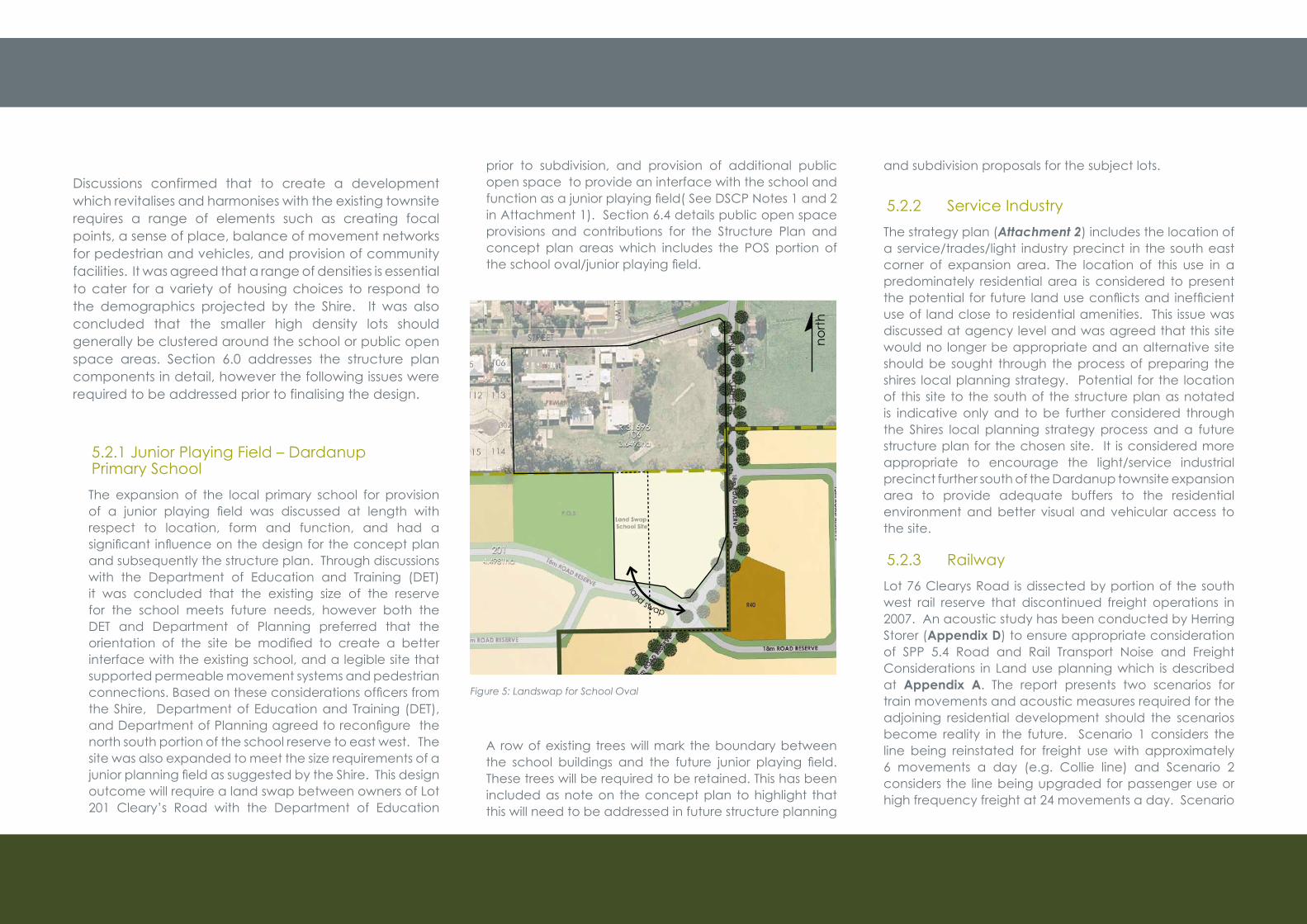
5.2.1 Junior Playing Field – Dardanup Primary SchoolThe expansion of the local primary school for provision of a junior playing field was discussed at length withrespect to location, form and function, and had a significant influenceonthedesignfortheconceptplanand subsequently the structure plan. Through discussions with the Department of Education and Training (DET) it was concluded that the existing size of the reserve for the school meets future needs, however both the DET and Department of Planning preferred that the orientation of the site be modified to create a betterinterface with the existing school, and a legible site that supported permeable movement systems and pedestrian connections.Basedontheseconsiderationsofficersfromthe Shire, Department of Education and Training (DET), andDepartmentofPlanningagreedtoreconfigurethenorth south portion of the school reserve to east west. The site was also expanded to meet the size requirements of a juniorplanningfieldassuggestedbytheShire.Thisdesignoutcome will require a land swap between owners of Lot 201 Cleary’s Road with the Department of Education
prior to subdivision, and provision of additional public open space to provide an interface with the school and functionasajuniorplayingfield(SeeDSCPNotes1and2in Attachment 1). Section 6.4 details public open space provisions and contributions for the Structure Plan and concept plan areas which includes the POS portion of theschooloval/juniorplayingfield.
Figure 5: Landswap for School Oval
A row of existing trees will mark the boundary between the school buildings and the future junior playing field.These trees will be required to be retained. This has been included as note on the concept plan to highlight that this will need to be addressed in future structure planning
and subdivision proposals for the subject lots.
5.2.2 Service IndustryThe strategy plan (Attachment 2) includes the location of a service/trades/light industry precinct in the south east corner of expansion area. The location of this use in a predominately residential area is considered to present thepotential for future landuseconflictsand inefficientuse of land close to residential amenities. This issue was discussed at agency level and was agreed that this site would no longer be appropriate and an alternative site should be sought through the process of preparing the shires local planning strategy. Potential for the location of this site to the south of the structure plan as notated is indicative only and to be further considered through the Shires local planning strategy process and a future structure plan for the chosen site. It is considered more appropriate to encourage the light/service industrial precinct further south of the Dardanup townsite expansion area to provide adequate buffers to the residential environment and better visual and vehicular access to the site.
5.2.3 RailwayLot 76 Clearys Road is dissected by portion of the south west rail reserve that discontinued freight operations in 2007. An acoustic study has been conducted by Herring Storer (Appendix D) to ensure appropriate consideration of SPP 5.4 Road and Rail Transport Noise and Freight Considerations in Land use planning which is described at Appendix A. The report presents two scenarios for train movements and acoustic measures required for the adjoining residential development should the scenarios become reality in the future. Scenario 1 considers the line being reinstated for freight use with approximately 6 movements a day (e.g. Collie line) and Scenario 2 considers the line being upgraded for passenger use or high frequency freight at 24 movements a day. Scenario
land swap
north
ROSELAND AT DARDANUP STRUCTURE PLAN July 2010 15
1isconsideredtobethemorelikelyscenariotoinfluenceadjacent residential development. The acoustic report highlights that the existing distance from the train line to thefirstrowofhousesmeetstherequirementsofPolicySPP5.4 and therefore provisions relating to noise attenuation are not required.
The Herring Storer report states that scenario 2 would onlybepossibleiftherewasasignificantupgradetotheexisting line and in that instance a 2.0 metre high bund would need to be accommodated in the existing reserve to ameliorate noise to any adjacent development. Shouldthegovernmentsupportasignificantupgradetothe line in the long term future for passenger rail or high frequency freight, clause 5.4 Redevelopment proposals for existing major road and rail infrastructure of SPP 5.4 would be pertinent for consideration by the infrastructure agency (see discussion in Appendix A- Section 5.5). The acoustic report indicates that the bund should be placed as close to the rail as possible within the existing reserve, and that there is area in the reserve for this to be provided.
5.2.4 Rural Landuse Buffer
The interface with rural uses is highlighted in section 6.11 of the townsite expansion strategy. Prescriptive land use buffer distances apply in situations where intensive agricultural pursuits (eg. vineyard, horticulture, dairy, poultry) are being undertaken or where there is demonstrated capability for these uses. In this instance, low intensive grazing is the capability of the adjoining land, and it is considered that the vegetated drainage swales proposed on the south and eastern boundaries provide dual purpose as a land use buffer to any noise or nuisance that may result from rural activities. The 40 metre vegetated buffer described as a guide in the expansion strategy is met on the southern edge of the structure plan and DSCP through the combined distance of the drainage swale and the Fees road reserve. The separation along the extent of the eastern boundary relies
on the 10m vegetated drainage reserve and the ability to restrict agriculture uses through the subdivision process on the portion of Lot 1 Tank road which will remain rural. A dwelling is situated east of the drainage reserve further southwhichwillinfluencetheintroductionsensitiveusesinthat location. Notwithstanding these measures to ensure landuse separation, the scheme prohibits any intensive farming uses in the ‘General Farming’ zone which ensures the amenity will be protected. Therefore it is considered that demarcation of the Townsite by the vegetated drainage swale provides adequate visual separation and buffer to the existing rural use.
5.2.5 Mixed Business
The Dardanup townsite strategy incorporates a mixed business site located on portion of Lot 76 Clearys Road and Lot 1 Charlotte Street between the south western highway and the rail reserve. This is included in the structure plan design and provides an extension to the town centre and further support to the revitalising the townsite, also providing employment opportunities for future and existing residential areas. Prior to development, a ‘Detailed area plan’ will address appropriate commercial floorspace,andotheracceptablelandusesforthesite.The types of uses considered appropriate for this site are showrooms, warehouses, trade displays, hardware, farm supplies, art/craft studios and sales, plant nursery and veterinary clinic. The detailed design of site will ensure thatheritagevalues,drainage,publicopenspace,trafficmanagement, parking, pedestrian linkages, and design guidelines are integrated. This plan should be developed in consultation with key stakeholders and community.
The existing use of a veterinary clinic on Lot 1 Charlotte Street has recently obtained Council approval to operate as a veterinary hospital. Section 5.7 on the townsite strategy states that separation distances are not required tobeincludedinthestructureplan,howevernotificationon title for future residences within 500 metres should be
included notifying landowners that they may experience potential noise or nuisance from the veterinary clinic (based on the Environmental Protection Authority (EPA) separation distances for dog kennels.) EPA separation distances do not prescribe a separation distance required between a veterinary hospital and residential uses and Councildoesnothaveabylawtoprescribenotificationforthisuse.Thereforeincludingnotificationontitles(within500m or less) is not considered necessary particularly in view of the fact that existing dwellings are located within 100 metres of the use indicating low level concern for the impact of future operations.
5.2.6 Employment
The townsite of Dardanup is ideally located to provide existing and future residents access to a diversity of employment opportunities. The hinterland provides employment opportunities in service, tourism and agricultural industries.
There are (limited) employment opportunities within the town centre and education services that support Dardanup. The proposed mixed business site west of the rail line will provide new services and employment opportunities also. The location of a service industrial site in close proximity to the townsite to be addressed through the Shires local planning strategy will provide medium to long term employment opportunities.
The town is centrally located within the Greater Bunbury region, within proximity to significant employmentgenerators. A 14 km trip to the Bunbury Central Business District hosts a range of existing employment opportunities. The Picton and Halifax Industrial areas are located 7 km from the Dardanup town site. The long-term expansion and development of the Preston Industrial Park will provide significantemploymentopportunities just 4 kmsnorth west of town.
ROSELAND AT DARDANUP STRUCTURE PLAN July 2010 16
Inter regional commuting of workers to Industrial and mining operations is occurring from Bunbury to outlying areas such as Wagerup, Collie, and Capel Sands. Dardanup townsite provides an accommodation option for this working population.
Further, the Tourism industry may respond to state government tourism initiatives to boost the industry in the region. The location of the town as the entrance to the Ferguson Valley provides opportunities for accommodation for employees of hospitality and tourism.
The five industry employment opportunities highlightedabove may provide a population increase greater than predicted for the Shire and locality, and therefore accommodation needs will increase. The location of the Dardanup Townsite is well located to access employment as described, and also provides an environment for support of home businesses.
5.3 Servicing
The technical reports provide certainty of the suitability and capability for the planning and development of Dardanup south for residential purposes subject to acceptable and best practice management solutions being implemented. The Golders Geotechnical Report included in Appendix F provides confirmation of the land capability.
5.3.1 Water and Wastewater
Reticulated water, sewer, power and telecommunications are available to the subject site. Section 3.5.2 of the Shire of Dardanup Townsite expansion strategy requires connection of the future development to reticulated sewer services and water supplies. The Water Corporation hasconfirmedthatexpansionoffacilitiesissuitableinthis
location, and capacity can be made available through system upgrades. The existing Water Corporation sewer pump station is located in the north east corner of Lot 76 Cleary’s Road. Water Corporation are able to provide services for approximately 20 new services per year, however advise that this capacity can easily be increased through some upgrades by developers. The pump station operates on a gravity feed system which provides ready access to extending services for the development.
It is recognized that the existing town’s water supply pressure is an issue for the community. To ensure the situation is not worsened through increasing services, the developer intends to work with the Water Corporation to develop a system which will have adequate water pressure at a level that provides for sustainable and efficientwateruse.Although reticulated water services are available to the area, rain water tanks should be encouraged in constructing each dwelling to serve the drinking water suppliesofindividuals’householdstosupportefficientuseof water resources and advocate sustainability principles. Along with incorporating rainwater tanks, grey water recycling should be encouraged (where capable of being approved by the Department of Health WA). PleasenotethatdiscussionwithFESAandconfirmationthataservicedsubdivisionwillnotrequireafiremanagementplan addresses the following Planning Policy statement included on the Structure Plan:“A fire management plan (fmp) or confirmation fromtheresponsibleagencythattheStructurePlanmeetsfireprotection requirements and that a FMP is not necessary”.
5.3.2 Traffic
Riley’s consulting prepared a traffic study specificallyfor Lot 76 Clearys Road which is included at Appendix D. The study recommends that access to the southern areas will be from Cleary’s Road to the north and Fees
Road to the south. Generally the recommendations include that the internal road networks should follow the guidelines provided in Liveable Neighbourhoods. The recommendation for this structure plan area is to include two tiers of the road hierarchy including neighbourhood connectors and access streets.
The upgrade of access points to the south west highway from Clearys Road and into the existing town through Brett Place and Tank Road will be necessary at the early stages of development. The structure plan indicates the provision of a roundabout at the intersection of Clearys and Charlotte street forming the entrance to the structure plan area. The details of upgrades will be addressed throughpreparationofatrafficstudypriorsubdivision.
ROSELAND AT DARDANUP STRUCTURE PLAN July 2010 17
Roseland at Dardanup will comprise a residential cell to support the existing and continued uses in the townsite. The design enhances and builds upon the existing nature of the townsite focussing on connections to the town centre, playing fields, and primary school as the places of community identification. The inclusion of a junior playing field as indicated on the concept plan combined with the primary school, pockets parks, and a mixed business site adds to the townsite facilities. The structure plan offers a degree of flexibility to enable innovative and creative response to any future issues or needs that may arise. It is intended to operate as a guiding framework for subdivision and development that can evolve and adapt over time, rather than a rigid, finalised design.
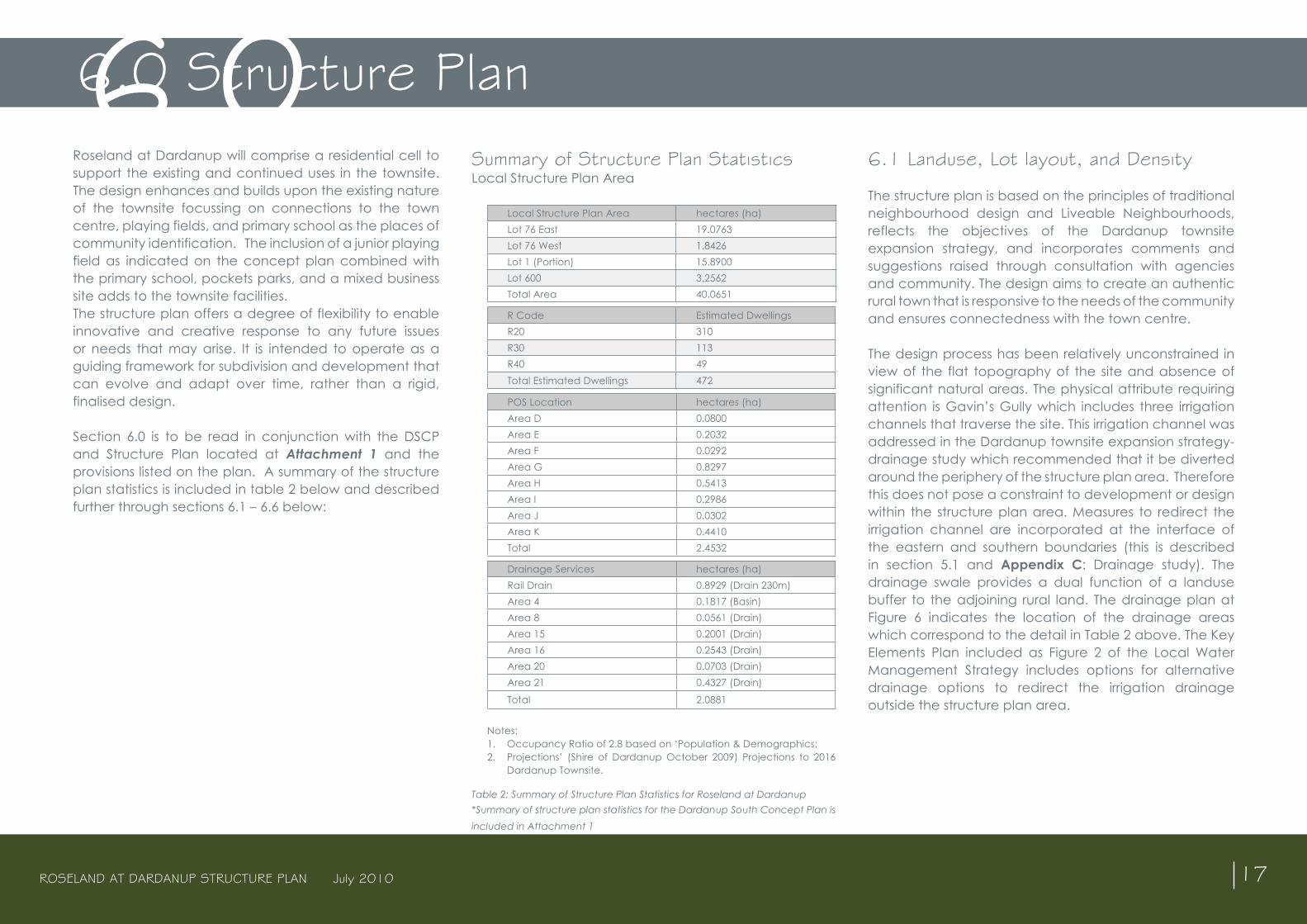
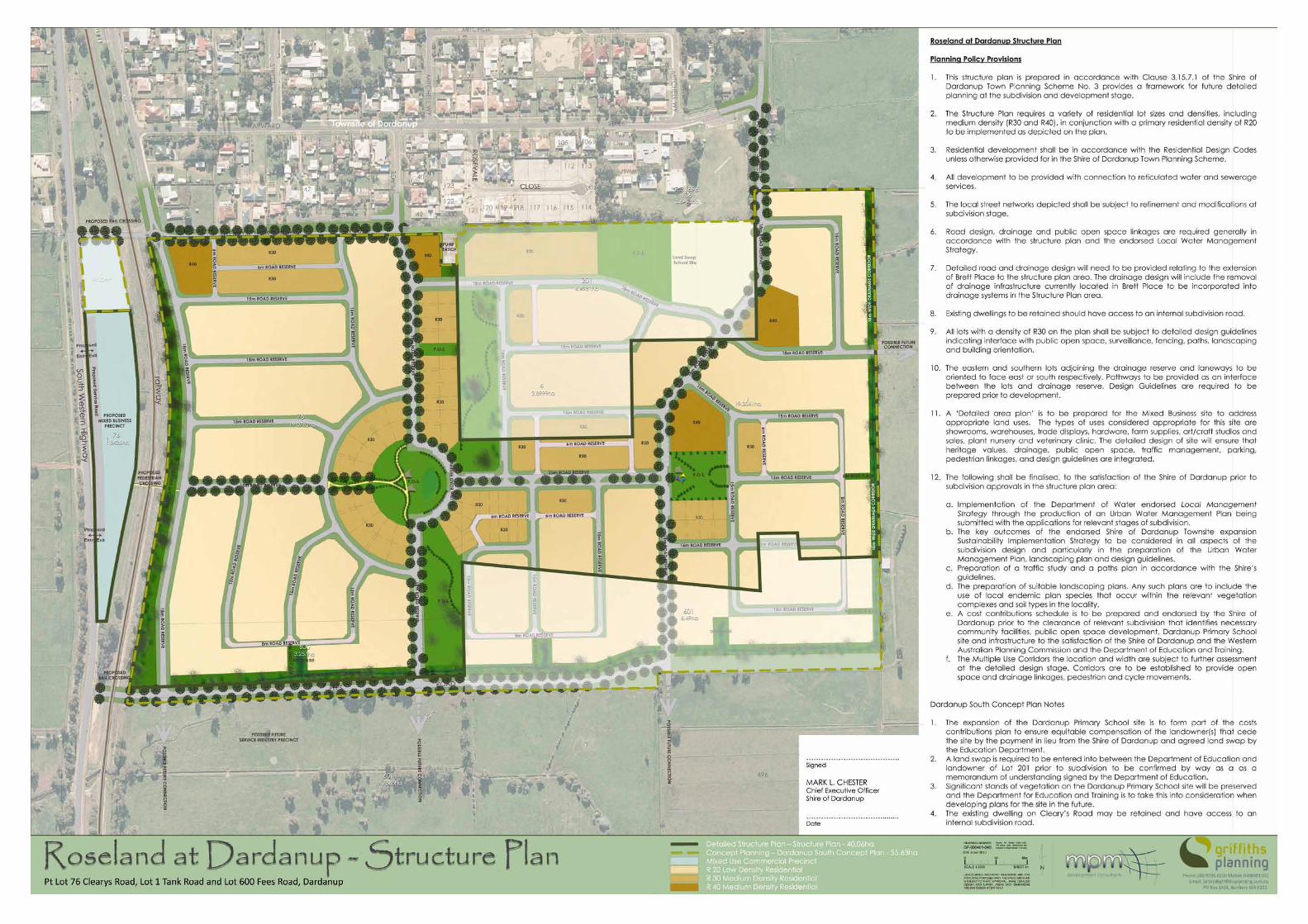
Section 6.0 is to be read in conjunction with the DSCP and Structure Plan located at Attachment 1 and the provisions listed on the plan. A summary of the structure plan statistics is included in table 2 below and described further through sections 6.1 – 6.6 below:
6.1 Landuse, Lot layout, and Density
The structure plan is based on the principles of traditional neighbourhood design and Liveable Neighbourhoods, reflects the objectives of the Dardanup townsite expansion strategy, and incorporates comments and suggestions raised through consultation with agencies and community. The design aims to create an authentic rural town that is responsive to the needs of the community and ensures connectedness with the town centre.
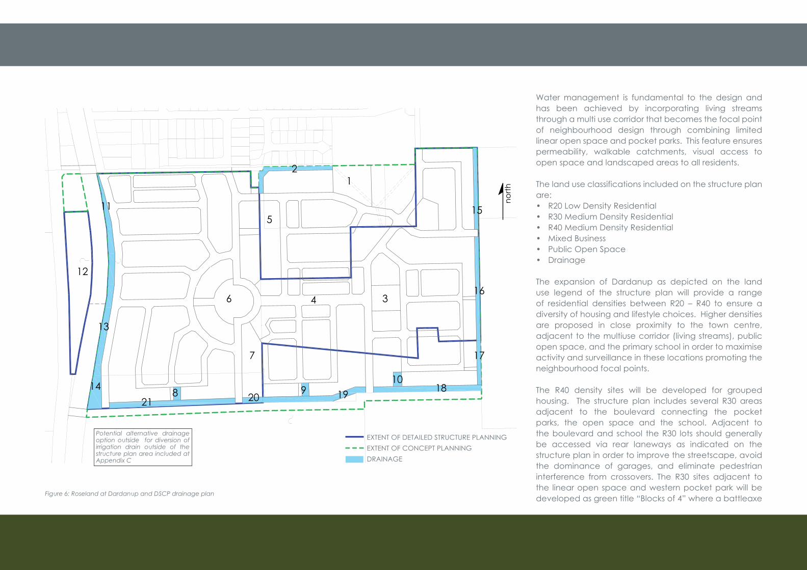
The design process has been relatively unconstrained in view of the flat topography of the site and absence of significant natural areas. The physical attribute requiring attention is Gavin’s Gully which includes three irrigation channels that traverse the site. This irrigation channel was addressed in the Dardanup townsite expansion strategy- drainage study which recommended that it be diverted around the periphery of the structure plan area. Therefore this does not pose a constraint to development or design within the structure plan area. Measures to redirect the irrigation channel are incorporated at the interface of the eastern and southern boundaries (this is described in section 5.1 and Appendix C: Drainage study). The drainage swale provides a dual function of a landuse buffer to the adjoining rural land. The drainage plan at Figure 6 indicates the location of the drainage areas which correspond to the detail in Table 2 above. The Key Elements Plan included as Figure 2 of the Local Water Management Strategy includes options for alternative drainage options to redirect the irrigation drainage outside the structure plan area.
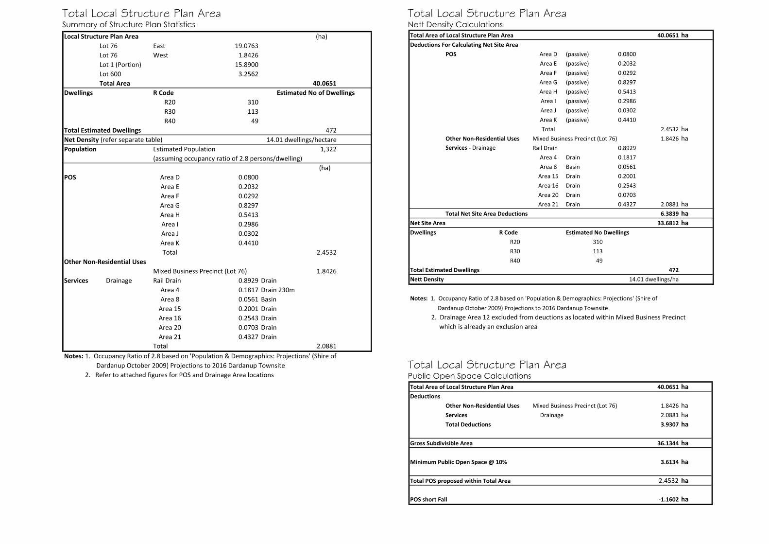
6.0 Structure Plan6.0Summary of Structure Plan Statistics Local Structure Plan Area
Local Structure Plan Area hectares (ha)Lot 76 East 19.0763Lot 76 West 1.8426Lot 1 (Portion) 15.8900Lot 600 3.2562 Total Area 40.0651
R Code Estimated DwellingsR20 310R30 113R40 49Total Estimated Dwellings 472
POS Location hectares (ha)Area D 0.0800Area E 0.2032Area F 0.0292Area G 0.8297Area H 0.5413Area I 0.2986Area J 0.0302Area K 0.4410Total 2.4532
Drainage Services hectares (ha)Rail Drain 0.8929 (Drain 230m)Area 4 0.1817 (Basin)Area 8 0.0561 (Drain)Area 15 0.2001 (Drain)Area 16 0.2543 (Drain)Area 20 0.0703 (Drain)Area 21 0.4327 (Drain)
Total 2.0881
Notes: 1. Occupancy Ratio of 2.8 based on ‘Population & Demographics: 2. Projections’ (Shire of Dardanup October 2009) Projections to 2016
Dardanup Townsite.
Table 2: Summary of Structure Plan Statistics for Roseland at Dardanup *Summary of structure plan statistics for the Dardanup South Concept Plan is included in Attachment 1
ROSELAND AT DARDANUP STRUCTURE PLAN July 2010 18
Figure 6: Roseland at Dardanup and DSCP drainage plan
Water management is fundamental to the design and has been achieved by incorporating living streams through a multi use corridor that becomes the focal point of neighbourhood design through combining limited linear open space and pocket parks. This feature ensures permeability, walkable catchments, visual access to open space and landscaped areas to all residents.
The land use classifications included on the structure plan are:• R20 Low Density Residential• R30 Medium Density Residential• R40 Medium Density Residential• Mixed Business • Public Open Space• Drainage
The expansion of Dardanup as depicted on the land use legend of the structure plan will provide a range of residential densities between R20 – R40 to ensure a diversity of housing and lifestyle choices. Higher densities are proposed in close proximity to the town centre, adjacent to the multiuse corridor (living streams), public open space, and the primary school in order to maximise activity and surveillance in these locations promoting the neighbourhood focal points.
The R40 density sites will be developed for grouped housing. The structure plan includes several R30 areas adjacent to the boulevard connecting the pocket parks, the open space and the school. Adjacent to the boulevard and school the R30 lots should generally be accessed via rear laneways as indicated on the structure plan in order to improve the streetscape, avoid the dominance of garages, and eliminate pedestrian interference from crossovers. The R30 sites adjacent to the linear open space and western pocket park will be developed as green title “Blocks of 4” where a battleaxe
7
north
EXTENT OF DETAILED STRUCTURE PLANNING EXTENT OF CONCEPT PLANNINGDRAINAGE
Potential alternative drainage option outside for diversion of irrigation drain outside of the structure plan area included at Appendix C
11
12
13
14
5
6
218 20
4 3
1
910
19 18
17
16
15
2
ROSELAND AT DARDANUP STRUCTURE PLAN July 2010 19
lot will provide access to each lot that will have frontage to the road reserve or to the public open space. The lots will meet the requirements for green title subdivision and be included in the overall subdivision concept. All R30 lots will require design guidelines prepared prior to consideration of subdivision. These concepts are described further in section 6.5.
As indicated in Table 2 above, Roseland at Dardanup depicts a yield in the order of 472 dwellings. The DSCP (inclusive of Roseland at Dardanup) may facilitate the development of 592 dwellings providing an overall density of 13.26 dwelling per hectare. The net density of residential development at Roseland at Dardanup achieves a higher density of 14.01 dwellings per hectare. The net site area and density is detailed in table 3 below:
Table 3 : Net Density CalculationsNet density Calculations for the Dardanup South Concept Plan are included in Attachment 1.
*Dwelling yield is approximate and subject to detailed design and WAPC subdivision approval and development approval by the Shire of Dardanup.
Subdivision staging and potential population is described in section 7.1
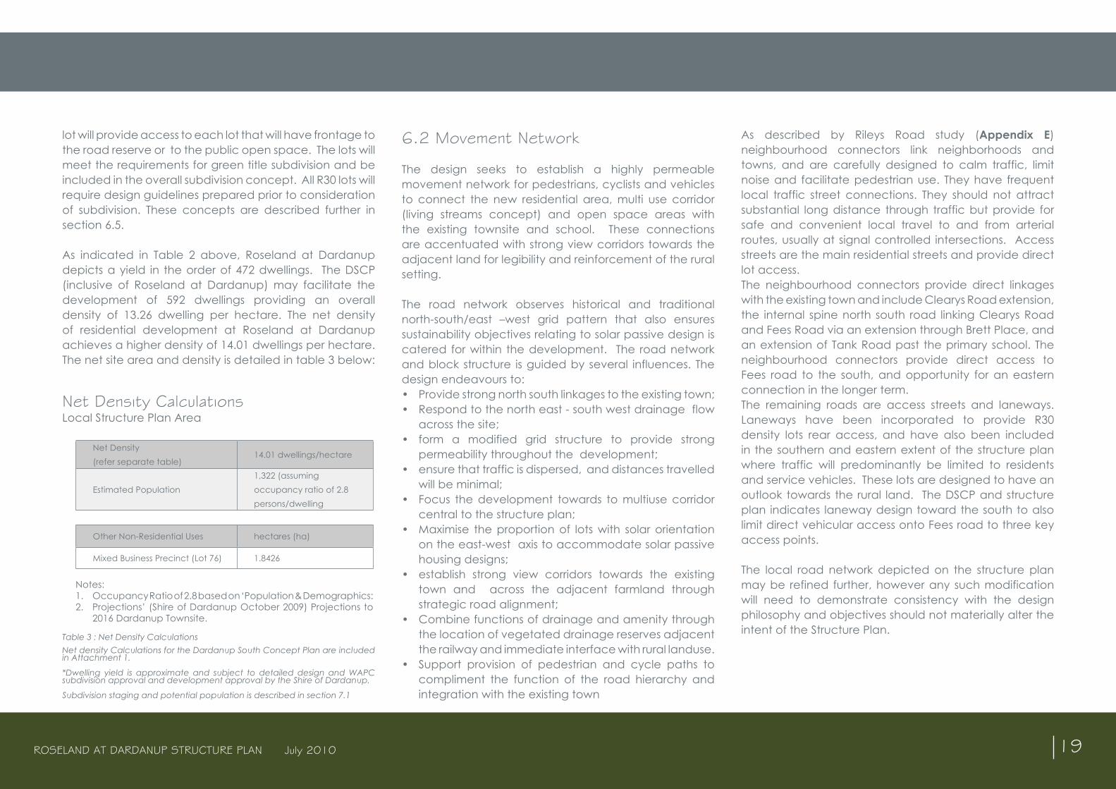
6.2 Movement Network
The design seeks to establish a highly permeable movement network for pedestrians, cyclists and vehicles to connect the new residential area, multi use corridor (living streams concept) and open space areas with the existing townsite and school. These connections are accentuated with strong view corridors towards the adjacent land for legibility and reinforcement of the rural setting.
The road network observes historical and traditional north-south/east –west grid pattern that also ensures sustainability objectives relating to solar passive design is catered for within the development. The road network and block structure is guided by several influences. The design endeavours to:• Provide strong north south linkages to the existing town;• Respond to the north east - south west drainage flow
across the site;• form a modified grid structure to provide strong
permeability throughout the development;• ensure that traffic is dispersed, and distances travelled
will be minimal;• Focus the development towards to multiuse corridor
central to the structure plan;• Maximise the proportion of lots with solar orientation
on the east-west axis to accommodate solar passive housing designs;
• establish strong view corridors towards the existing town and across the adjacent farmland through strategic road alignment;
• Combine functions of drainage and amenity through the location of vegetated drainage reserves adjacent the railway and immediate interface with rural landuse.
• Support provision of pedestrian and cycle paths to compliment the function of the road hierarchy and integration with the existing town
As described by Rileys Road study (Appendix E) neighbourhood connectors link neighborhoods and towns, and are carefully designed to calm traffic, limit noise and facilitate pedestrian use. They have frequent local traffic street connections. They should not attract substantial long distance through traffic but provide for safe and convenient local travel to and from arterial routes, usually at signal controlled intersections. Access streets are the main residential streets and provide direct lot access. The neighbourhood connectors provide direct linkages with the existing town and include Clearys Road extension, the internal spine north south road linking Clearys Road and Fees Road via an extension through Brett Place, and an extension of Tank Road past the primary school. The neighbourhood connectors provide direct access to Fees road to the south, and opportunity for an eastern connection in the longer term. The remaining roads are access streets and laneways. Laneways have been incorporated to provide R30 density lots rear access, and have also been included in the southern and eastern extent of the structure plan where traffic will predominantly be limited to residents and service vehicles. These lots are designed to have an outlook towards the rural land. The DSCP and structure plan indicates laneway design toward the south to also limit direct vehicular access onto Fees road to three key access points.
The local road network depicted on the structure plan may be refined further, however any such modification will need to demonstrate consistency with the design philosophy and objectives should not materially alter the intent of the Structure Plan.
Net Density CalculationsLocal Structure Plan Area
Net Density (refer separate table)
14.01 dwellings/hectare
Estimated Population1,322 (assuming occupancy ratio of 2.8 persons/dwelling
Other Non-Residential Uses hectares (ha)
Mixed Business Precinct (Lot 76) 1.8426
Notes: 1. Occupancy Ratio of 2.8 based on ‘Population & Demographics: 2. Projections’ (Shire of Dardanup October 2009) Projections to
2016 Dardanup Townsite.
ROSELAND AT DARDANUP STRUCTURE PLAN July 2010 20
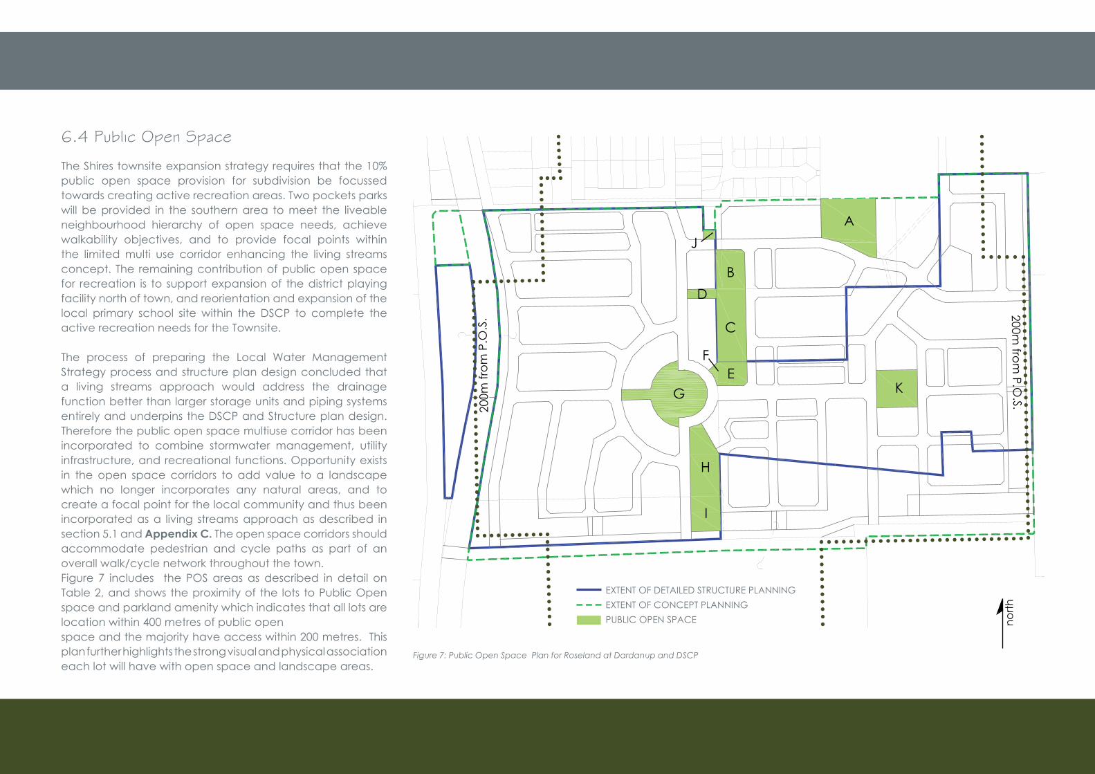
6.4 Public Open Space
The Shires townsite expansion strategy requires that the 10% public open space provision for subdivision be focussed towards creating active recreation areas. Two pockets parks will be provided in the southern area to meet the liveable neighbourhood hierarchy of open space needs, achieve walkability objectives, and to provide focal points within the limited multi use corridor enhancing the living streams concept. The remaining contribution of public open space for recreation is to support expansion of the district playing facility north of town, and reorientation and expansion of the local primary school site within the DSCP to complete the active recreation needs for the Townsite.
The process of preparing the Local Water Management Strategy process and structure plan design concluded that a living streams approach would address the drainage function better than larger storage units and piping systems entirely and underpins the DSCP and Structure plan design. Therefore the public open space multiuse corridor has been incorporated to combine stormwater management, utility infrastructure, and recreational functions. Opportunity exists in the open space corridors to add value to a landscape which no longer incorporates any natural areas, and to create a focal point for the local community and thus been incorporated as a living streams approach as described in section 5.1 and Appendix C. The open space corridors should accommodate pedestrian and cycle paths as part of an overall walk/cycle network throughout the town.Figure 7 includes the POS areas as described in detail on Table 2, and shows the proximity of the lots to Public Open space and parkland amenity which indicates that all lots are location within 400 metres of public openspace and the majority have access within 200 metres. This plan further highlights the strong visual and physical association each lot will have with open space and landscape areas.
Figure 7: Public Open Space Plan for Roseland at Dardanup and DSCP
A
B
C
D
EF
G
H
I
K
J
north
EXTENT OF DETAILED STRUCTURE PLANNING EXTENT OF CONCEPT PLANNINGPUBLIC OPEN SPACE
200m
from
P.O
.S. 200m
from P.O
.S.
ROSELAND AT DARDANUP STRUCTURE PLAN July 2010 21
Table 4 above presents the public open space (POS) schedule which confirms ( based on the Structure Plan Statistics table 2) that a total of 2.45ha of the structure plan area is proposed to be ceded as public open space (POS). This presents a shortfall of 1.16ha in POS. Through the implementation phase of the structure plan and detailed preparation of the subdivision there may be some review of this shortfall should a credit for some of the drainage areas be supported. The schedule does not
include this potential as the exact details of the drainage design needs to be known for this calculation. The total agreed shortfall will then be paid as cash in lieu to Council in support of other public open space areas.
The distribution and sizing of the proposed public open space ensures that future residents have convenient access to useable recreational areas. The public open space areas of Roseland at Dardanup will have primarily a passive recreation function, although the two local pocket parks will be designed to accommodate informal active recreation. The formal active recreation pursuits will be well catered for through the junior and district playing fields planned for the townsite. Roseland at Dardanup completes the desired public open space hierarchy and the 400 metre “ped shed” of Liveable neighbourhoods through providing linear public open space, a neighbourhood park and local park that supports the junior playing field (neighbourhood park) whilst providing cash in lieu to support the Shires expansion of the District open space north of town as recommended in section 3.4.3 of the Dardanup Townsite expansion strategy.
6.5 Affordability, Built Form and Detailed Plans
Measures to improve housing affordability are provided by the structure plan design which allows for a wide variety of lot sizes and subsequently greater diversity in housing typologies. Lots may predominantly be designed to provide for the development of single storey houses, which are typically more affordable than double storey, however double storey housing will be encouraged to offer interest to the streetscape and will be actively encouraged in areas of higher density. The higher density
areas may range from traditional single or double storey dwellings to smaller, single and double storey cottages and terraces. The built form controls will be carefully prepared to ensure compatibility with the materials and methods used by local builders to avoid the incursion of any significant additional costs. The built form controls for the smaller lots will also have consideration for the requirements of public housing providers.
Design guidelines will be required to be prepared for all R30 lots which include the R30 laneway lots and green title “Blocks of four” to address aspects of fencing, dwelling orientation, streetscape, building materials, access and setbacks. Laneway lots on the eastern periphery overlooking the landscaped drainage swale will also require preparation of design guidelines. Paths will be required adjacent to lots where there is an interface directly with a drainage swale or public open space.
Public Open Space CalculationsLocal Structure Plan Area
Deductions (Other Non-Residential Uses)
hectares (ha)
Mixed Business Precinct (Lot 76) 1.8426Drainage Services 2.0881Total Deductions 3.9307
Gross Subdivisible Area 36.1344 ha
POS Location hectares (ha)Area D 0.0800Area E 0.2032Area F 0.0292Area G 0.8297Area H 0.5413Area I 0.2986Area J 0.0302Area K 0.4410Total 2.4532
Minimum Public Open Space @ 10% 3.6134 haTotal POS proposed within Total Area 2.4532 haPOS short Fall -1.1602 ha
Table 4: Roseland at Dardanup Structure Plan Public Open Space *The POS schedule for the Dardanup South Concept plan is included at Attachment 1.
ROSELAND AT DARDANUP STRUCTURE PLAN July 2010 22
Figure 8: Blocks of 4
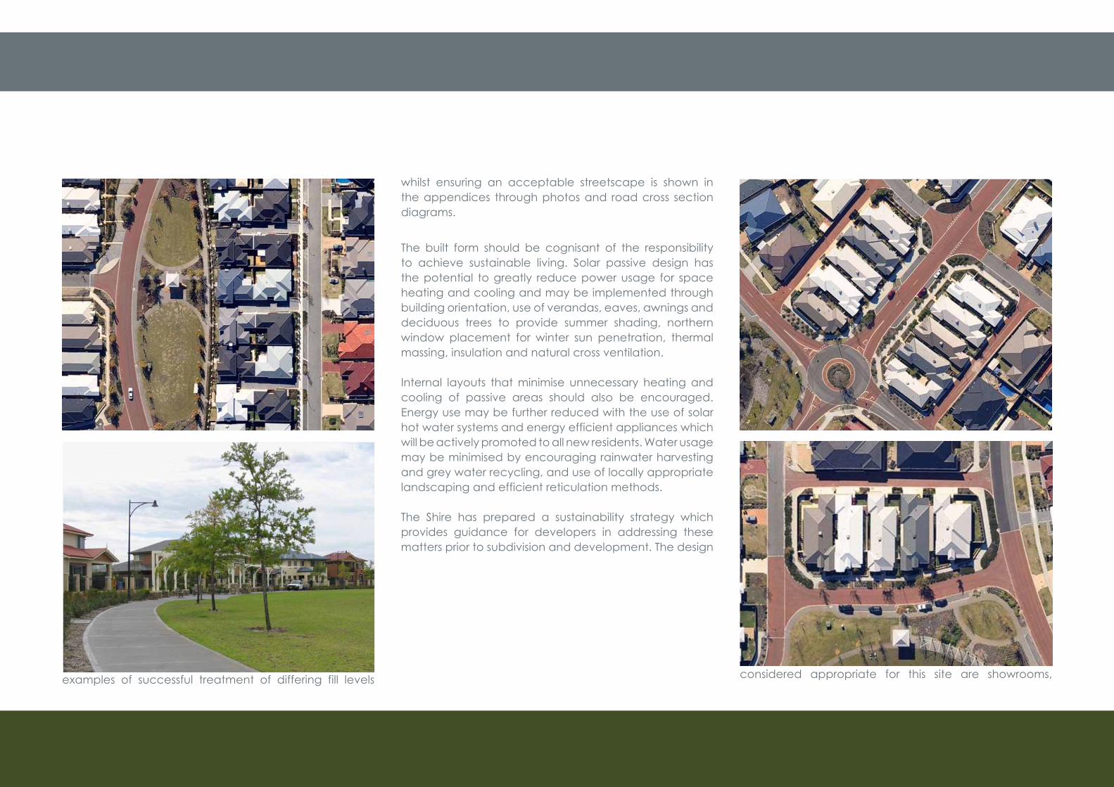
The Drainage Study and Local Water Management Strategy (Appendix B and C) consider the issue of fill, and this requires careful treatment at the interface with the existing town where the levels opposite will be lower than the proposed development. The design solves the appearance of the elevated lots by providing low retaining walls along Clearys road with steps/gates for front access and is rear loaded for vehicle and service access. Some examples of successful treatment of differing fill levels
whilst ensuring an acceptable streetscape is shown in the appendices through photos and road cross section diagrams.
The built form should be cognisant of the responsibility to achieve sustainable living. Solar passive design has the potential to greatly reduce power usage for space heating and cooling and may be implemented through building orientation, use of verandas, eaves, awnings and deciduous trees to provide summer shading, northern window placement for winter sun penetration, thermal massing, insulation and natural cross ventilation.
Internal layouts that minimise unnecessary heating and cooling of passive areas should also be encouraged. Energy use may be further reduced with the use of solar hot water systems and energy efficient appliances which will be actively promoted to all new residents. Water usage may be minimised by encouraging rainwater harvesting and grey water recycling, and use of locally appropriate landscaping and efficient reticulation methods.
The Shire has prepared a sustainability strategy which provides guidance for developers in addressing these matters prior to subdivision and development. The design
Figure 9: Laneway development
guidelines may need to incorporate recommendations of the sustainability strategy to achieve sustainable living objectives.
A detailed area plan (DAP) is required for the Mixed Business site (Pt Lot 76 and Lot 1 Charlotte Road) which is discussed in section 5.2.5 and guided by provisions 3.15.7.24 – 3.15.7.27 of the Shire LPS. The types of uses considered appropriate for this site are showrooms,
ROSELAND AT DARDANUP STRUCTURE PLAN July 2010 23
warehouses, trade displays, hardware, farm supplies, art/craft studios and sales, plant nursery and veterinary clinic.
6.5 Landscape Plans
Prior to clearance of subdivision the developer will prepare suitable landscaping plans. The landscape strategy is to provide a readily useable, aesthetic and liveable environment for future residents that embodies the local character and identity of Dardanup and responds to the limited water resources of the region. Open space areas will incorporate design elements and facilities that promote a sense of community and social interaction, and provide strong pedestrian linkages throughout the Structure Plan area. The detailing of landscape elements such as pedestrian paths, furniture and walls will be designed to reflect the character of the local area.
6.6 Community Development
The Shire of Dardanup recognised through the preparation of the Dardanup townsite expansion strategy that a community needs analysis was required to identify developer contributions to support provision of community facilities.The Shire is preparing a Development contribution plan for the Dardanup townsite expansion area in accordance with SPP No. 3.6 Development Contributions for Infrastructure described in section 5.4 of Appendix 1. The Shire will progress an amendment to the local planning scheme to provide a statutory context for
community facility contributions. Should the mechanism not be introduced into the LPS prior to approval of the structure plan, a private arrangement between the land owner and the Shire may be entered into. Contributions may be used primarily towards upgrade /redevelopment of the Dardanup Townsite community centre.
ROSELAND AT DARDANUP STRUCTURE PLAN July 2010 24
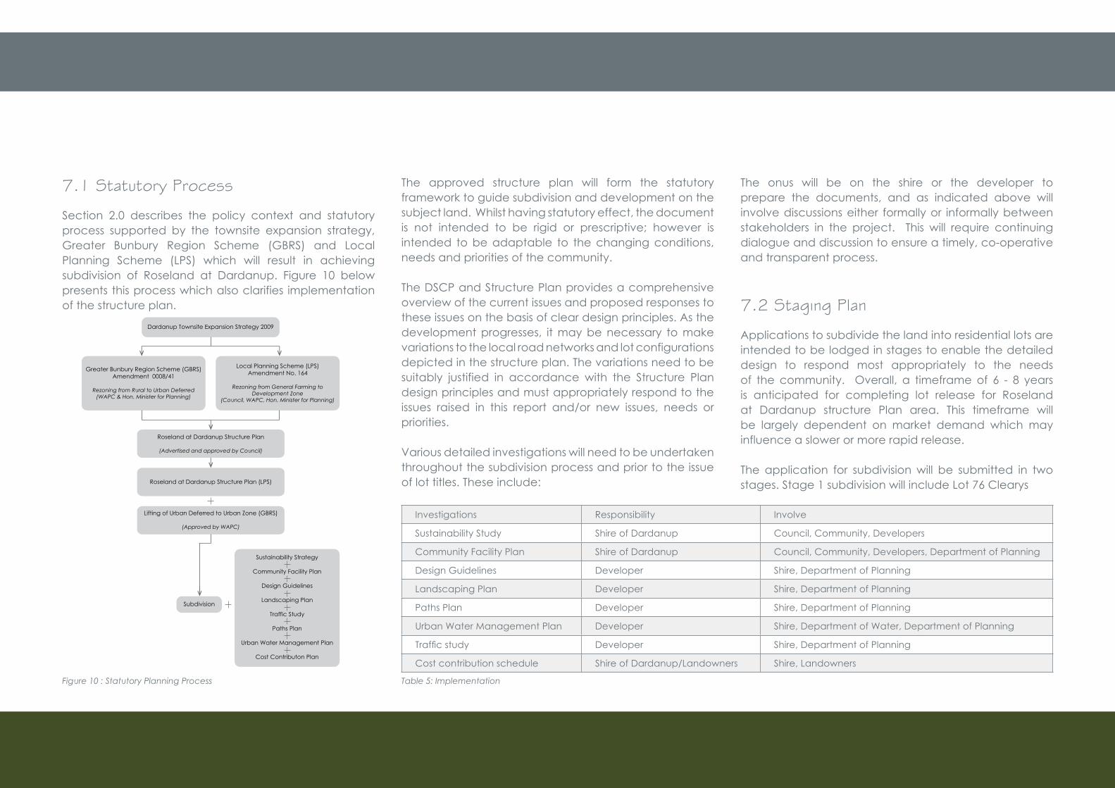
7.1 Statutory Process
Section 2.0 describes the policy context and statutory process supported by the townsite expansion strategy, Greater Bunbury Region Scheme (GBRS) and Local Planning Scheme (LPS) which will result in achieving subdivision of Roseland at Dardanup. Figure 10 below presents this process which also clarifies implementation of the structure plan.
Figure 10 : Statutory Planning Process
The approved structure plan will form the statutory framework to guide subdivision and development on the subject land. Whilst having statutory effect, the document is not intended to be rigid or prescriptive; however is intended to be adaptable to the changing conditions, needs and priorities of the community.
The DSCP and Structure Plan provides a comprehensive overview of the current issues and proposed responses to these issues on the basis of clear design principles. As the development progresses, it may be necessary to make variations to the local road networks and lot configurations depicted in the structure plan. The variations need to be suitably justified in accordance with the Structure Plan design principles and must appropriately respond to the issues raised in this report and/or new issues, needs or priorities.
Various detailed investigations will need to be undertaken throughout the subdivision process and prior to the issue of lot titles. These include:
Investigations Responsibility Involve
Sustainability Study Shire of Dardanup Council, Community, Developers
Community Facility Plan Shire of Dardanup Council, Community, Developers, Department of Planning
Design Guidelines Developer Shire, Department of Planning
Landscaping Plan Developer Shire, Department of Planning
Paths Plan Developer Shire, Department of Planning
Urban Water Management Plan Developer Shire, Department of Water, Department of Planning
Trafficstudy Developer Shire, Department of Planning
Cost contribution schedule Shire of Dardanup/Landowners Shire, Landowners
Table 5: Implementation
The onus will be on the shire or the developer to prepare the documents, and as indicated above will involve discussions either formally or informally between stakeholders in the project. This will require continuing dialogue and discussion to ensure a timely, co-operative and transparent process.
7.2 Staging Plan
Applications to subdivide the land into residential lots are intended to be lodged in stages to enable the detailed design to respond most appropriately to the needs of the community. Overall, a timeframe of 6 - 8 years is anticipated for completing lot release for Roseland at Dardanup structure Plan area. This timeframe will be largely dependent on market demand which may influence a slower or more rapid release.
The application for subdivision will be submitted in two stages. Stage 1 subdivision will include Lot 76 Clearys
Dardanup Townsite Expansion Strategy 2009
Greater Bunbury Region Scheme (GBRS)Amendment 0008/41
Rezoning from Rural to Urban Deferred(WAPC & Hon. Minister for Planning)
Local Planning Scheme (LPS)Amendment No. 164
Rezoning from General Farming toDevelopment Zone
(Council, WAPC, Hon. Minister for Planning)
Sustainability Strategy
Community Facility Plan
Design Guidelines
Landscaping Plan
Traffic Study
Paths Plan
Urban Water Management Plan
Cost Contributon Plan
Lifting of Urban Deferred to Urban Zone (GBRS)
(Approved by WAPC)
Roseland at Dardanup Structure Plan (LPS)
Subdivision
Roseland at Dardanup Structure Plan
(Advertised and approved by Council)
ROSELAND AT DARDANUP STRUCTURE PLAN July 2010 25
Road which will be released as soon as practicable within a timeframe of approximately 2-4 years (generally each release will be 30 lots at a time). Stage 2 will comprise Pt Lot 1 Tank road and Lot 600 Fees Road may be submitted in 2012 for release over 3-6 years. It is anticipated that all lots within the structure plan area will be released by 2016 – 2018 providing the opportunity for full occupation by 2020.
Stage 1 and Stage 2 proposed through the adoption of Roseland at Dardanup Structure Plan advances the first stages of subdivision for the Dardanup Townsite expansion area. These initial subdivision stages contain the critical components for the townsite expansion as it: • Represents a logical southern expansion of the town
based on the location of the wastewater services, • Provides the entry statement to the expansion area
and access for development of the mixed business site,
• Provides the two key neighbourhood connectors (through Brett Place and Tank Road) which provide the movement systems to support future development of the school junior playing field and development of the multiuse corridor essential for management of surface water and improvement at the interface with the existing town,
• Contributes to upgrading and expansion of the district playing facility and community centre.
7.2.1 Population and Land SupplyThe Shires Population and Demographics report estimates population growth for the town of Dardanup as shown in Table 7 below. However, it is also noted that the townsite expansion strategy suggests a population of up to 4,000
persons may be achieved by 2031. To achieve the population of 4000 by 2031 would require a higher growth rate and dwelling yield than projected by the Shires report included in Table 7 below.
2006 2011 2016 2021 2026363 369 978 1,607 2,253
Table 6: Extract from the Shire of Dardanup Population and Demographics (2009)
Density Lot/Dwelling Yield
Ratio of persons
Projected Population
DSCP 568 2.8 1660
Roseland at Dardanup 432 2.8 1322
Table 7: Lot Yield and Population Projection
Based on conservative growth estimates of the townsite included in Table 6, the town will need to provide homes for an additional 1244 people by 2021. As indicated in Table 7, Roseland at Dardanup may provide homes for a population of approximately 1322. The anticipated release of lots by 2016/2018 at Roseland at Dardanup will cater for this population growth providing the necessary timeframe for dwelling approval and construction to enable occupancy by 2020/2021.
Should growth rates and demand exceed the projections under the Shires Population and Demographics report as suggested in the townsite strategy, lot release at Roseland at Dardanup may progress at a more rapid rate, whilst planning for the remaining expansion area is progressed.
7.0 Implementation7.0

ROSELAND AT DARDANUP STRUCTURE PLAN July 2010
Attachment 1Roseland at Dardanup Structure Plan and Dardanup South Concept Plan and Tables


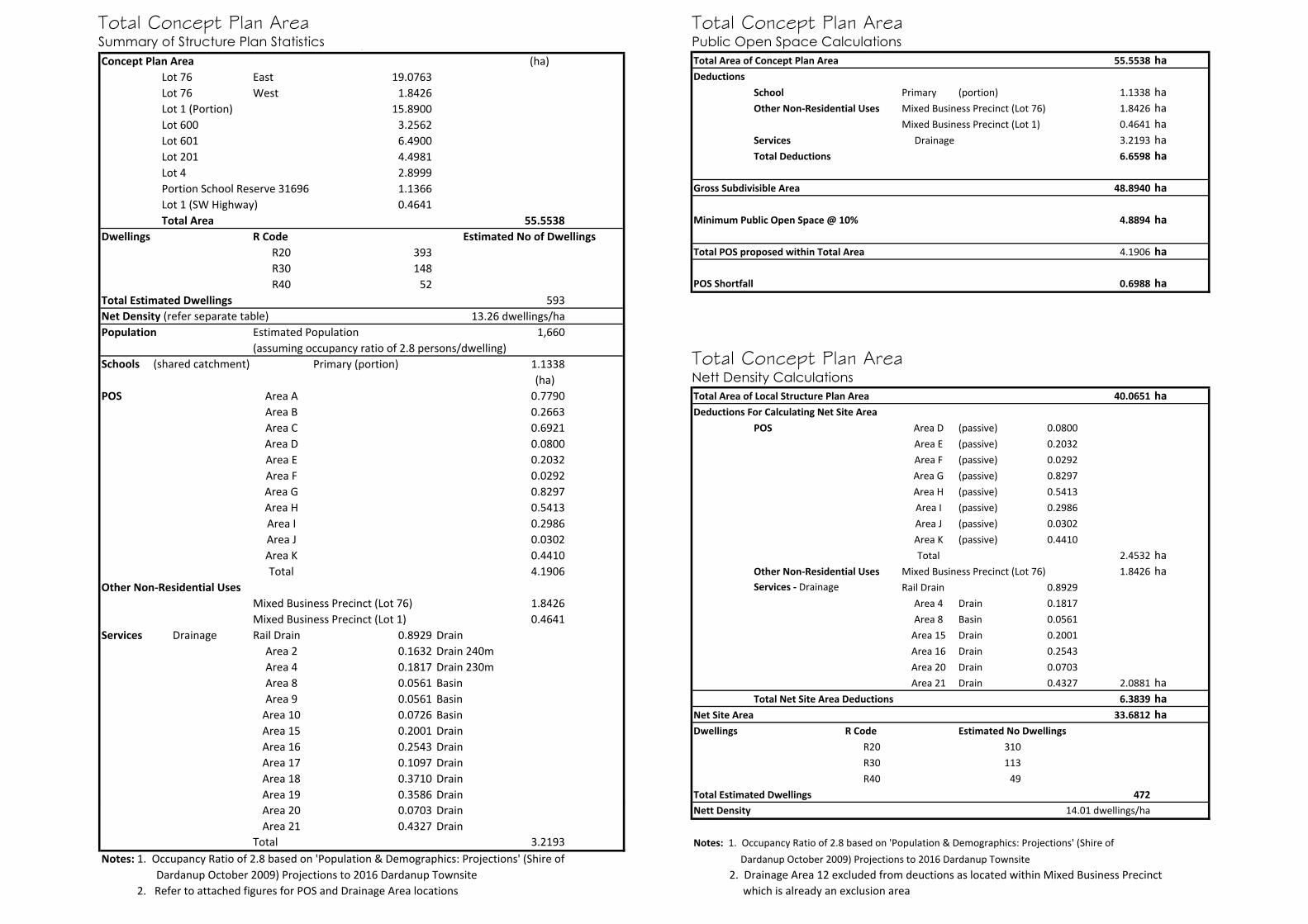
Concept Plan Area (ha)Lot 76 East 19.0763Lot 76 West 1.8426Lot 1 (Portion) 15.8900Lot 600 3.2562Lot 601 6.4900Lot 201 4.4981Lot 4 2.8999Portion School Reserve 31696 1.1366Lot 1 (SW Highway) 0.4641Total Area 55.5538
Dwellings R CodeR20 393R30 148R40 52
Total Estimated Dwellings 593Net Density (refer separate table) 13.26 dwellings/haPopulation Estimated Population 1,660
(assuming occupancy ratio of 2.8 persons/dwelling) Schools (shared catchment) Primary (portion) 1.1338
(ha)POS Area A 0.7790
Area B 0.2663Area C 0.6921Area D 0.0800Area E 0.2032Area F 0.0292Area G 0.8297Area H 0.5413Area I 0.2986Area J 0.0302Area K 0.4410Total 4.1906
Other Non-Residential UsesMixed Business Precinct (Lot 76) 1.8426Mixed Business Precinct (Lot 1) 0.4641
Services Drainage Rail Drain 0.8929 DrainArea 2 0.1632 Drain 240mArea 4 0.1817 Drain 230mArea 8 0.0561 BasinArea 9 0.0561 Basin
Area 10 0.0726 BasinArea 15 0.2001 DrainArea 16 0.2543 DrainArea 17 0.1097 DrainArea 18 0.3710 DrainArea 19 0.3586 Drain
Estimated No of Dwellings
Summary of Structure Plan StatisticsTotal Concept Plan Area
Area 20 0.0703 DrainArea 21 0.4327 Drain
Total 3.2193Notes: 1. Occupancy Ratio of 2.8 based on 'Population & Demographics: Projections' (Shire of Dardanup October 2009) Projections to 2016 Dardanup Townsite 2. Refer to attached figures for POS and Drainage Area locations
Total Area of Concept Plan Area 55.5538 haDeductions
School Primary (portion) 1.1338 haOther Non-Residential Uses Mixed Business Precinct (Lot 76) 1.8426 ha
Mixed Business Precinct (Lot 1) 0.4641 haServices Drainage 3.2193 haTotal Deductions 6.6598 ha
Gross Subdivisible Area 48.8940 ha
Minimum Public Open Space @ 10% 4.8894 ha
Total POS proposed within Total Area 4.1906 ha
POS Shortfall 0.6988 ha
Public Open Space Calculations - Total Concept Plan AreaTotal Concept Plan Area Summary of Structure Plan Statistics
Total Concept Plan Area Public Open Space Calculations
Total Area of Local Structure Plan Area 40.0651 haDeductions For Calculating Net Site Area
POS Area D (passive) 0.0800Area E (passive) 0.2032Area F (passive) 0.0292Area G (passive) 0.8297Area H (passive) 0.5413Area I (passive) 0.2986Area J (passive) 0.0302Area K (passive) 0.4410Total 2.4532 ha
Other Non-Residential Uses Mixed Business Precinct (Lot 76) 1.8426 haServices - Drainage Rail Drain 0.8929
Area 4 Drain 0.1817Area 8 Basin 0.0561
Area 15 Drain 0.2001Area 16 Drain 0.2543Area 20 Drain 0.0703Area 21 Drain 0.4327 2.0881 ha
Total Net Site Area Deductions 6.3839 haNet Site Area 33.6812 haDwellings R Code Estimated No Dwellings
R20 310R30 113R40 49
Total Estimated Dwellings 472Nett Density 14.01 dwellings/ha
Notes: 1. Occupancy Ratio of 2.8 based on 'Population & Demographics: Projections' (Shire of Dardanup October 2009) Projections to 2016 Dardanup Townsite 2. Drainage Area 12 excluded from deuctions as located within Mixed Business Precinct which is already an exclusion area
Net Density Calculations - Local Structure Plan AreaTotal Concept Plan Area Nett Density Calculations

Local Structure Plan Area (ha)Lot 76 East 19.0763Lot 76 West 1.8426Lot 1 (Portion) 15.8900Lot 600 3.2562Total Area 40.0651
Dwellings R CodeR20 310R30 113R40 49
Total Estimated Dwellings 472Net Density (refer separate table) 14.01 dwellings/hectarePopulation Estimated Population 1,322
(assuming occupancy ratio of 2.8 persons/dwelling) (ha)
POS Area D 0.0800Area E 0.2032Area F 0.0292Area G 0.8297Area H 0.5413Area I 0.2986Area J 0.0302Area K 0.4410Total 2.4532
Other Non-Residential UsesMixed Business Precinct (Lot 76) 1.8426
Services Drainage Rail Drain 0.8929 DrainArea 4 0.1817 Drain 230mArea 8 0.0561 Basin
Area 15 0.2001 DrainArea 16 0.2543 DrainArea 20 0.0703 DrainArea 21 0.4327 Drain
Total 2.0881Notes: 1. Occupancy Ratio of 2.8 based on 'Population & Demographics: Projections' (Shire of Dardanup October 2009) Projections to 2016 Dardanup Townsite 2. Refer to attached figures for POS and Drainage Area locations
Estimated No of Dwellings
Summary of Structure Plan StatisticsTotal Local Structure Plan Area
Total Local Structure Plan Area Summary of Structure Plan Statistics
Total Area of Local Structure Plan Area 40.0651 haDeductions For Calculating Net Site Area
POS Area D (passive) 0.0800Area E (passive) 0.2032Area F (passive) 0.0292Area G (passive) 0.8297Area H (passive) 0.5413Area I (passive) 0.2986Area J (passive) 0.0302Area K (passive) 0.4410Total 2.4532 ha
Other Non-Residential Uses Mixed Business Precinct (Lot 76) 1.8426 haServices - Drainage Rail Drain 0.8929
Area 4 Drain 0.1817Area 8 Basin 0.0561
Area 15 Drain 0.2001Area 16 Drain 0.2543Area 20 Drain 0.0703Area 21 Drain 0.4327 2.0881 ha
Total Net Site Area Deductions 6.3839 haNet Site Area 33.6812 haDwellings R Code Estimated No Dwellings
R20 310R30 113R40 49
Total Estimated Dwellings 472Nett Density 14.01 dwellings/ha
Notes: 1. Occupancy Ratio of 2.8 based on 'Population & Demographics: Projections' (Shire of Dardanup October 2009) Projections to 2016 Dardanup Townsite 2. Drainage Area 12 excluded from deuctions as located within Mixed Business Precinct which is already an exclusion area
Net Density Calculations - Local Structure Plan AreaTotal Local Structure Plan Area Nett Density Calculations
Total Area of Local Structure Plan Area 40.0651 haDeductions
Other Non-Residential Uses Mixed Business Precinct (Lot 76) 1.8426 haServices Drainage 2.0881 haTotal Deductions 3.9307 ha
Gross Subdivisible Area 36.1344 ha
Minimum Public Open Space @ 10% 3.6134 ha
Total POS proposed within Total Area 2.4532 ha
POS short Fall -1.1602 ha
Public Open Space Calculations - Local Structure Plan AreaTotal Local Structure Plan Area Public Open Space Calculations

ROSELAND AT DARDANUP STRUCTURE PLAN July 2010
Attachment 2Dardanup Townsite Expansion Strategy Map

601
185
600
350
0
3
5
32
1110
2
987
15
6543
141312
33
32
31
3
24
25
16
26
45
123
45
DRG No: T&P020-08 Rev 5SCALE 1:10,000
AUTHORISED: R.QUINN
DATE DRN: 20-05-09
DARDANUP TOWNSITEEXPANSION STRATEGY MAP
B O Y A N U P P I C T O N R O A D
ROAD
B O Y A N
U P P I C T O
N R
O A D
VENN
ROAD
ROAD TO BE UPGRADED
MIXED BUSINESSES DISTRICT
ROAD TO BE UPGRADED
ROAD TO BE UPGRADED
APPROXIMATELY 3 Ha PUBLIC OPEN SPACE
TO BE ADDED TORECREATION GROUND
A ROAD IS TO BOUND THERESIDENTIAL/RURAL INTERFACEWHEREEVER POSSIBLE
ROAD AND STREETSCAPE UPGRADE AND TRAFFIC TREATMENTS ALONGFERGUSON ROAD
SERVICE TRADES / LIGHT INDUSTRY
PRECINCT
POSSIBLE UPGRADE OF GAVINS GULLY DRAINTO MITIGATE THE RISK OF FLOODING
RETAIL SHOP ANDOFFICE PRECINCT
E X P A N S I O N B O U N D A R Y
E X P A N S I O
N
E X P A N S I O N B O U N D A R Y
COUNTRY
FEES
Railway
PROPOSED (APPROX) 2.5 Ha PUBLIC OPEN SPACE TO
ACCOMMODATE JOINT OVALWITH EDWA. LOCATION TO BE DETERMINED IN
CONSULTATION WITH EDWA
PLANNING POLICY STATEMENTS
This Strategy Plan serves as a guide to future detailed structure planning and rezoning amendments.
Subdivision and development within the identified expansion areas is not to occur until such time as the land is appropriately zoned in both the Greater Bunbury Region Scheme and the Local Planning Scheme and a detailed Structure Plan has been endorsed by the Shire and the WAPC.
Structure plans and Scheme Amendments may apply to either the whole expansion are or parts thereof.
Subdivision of land will only be supported where consistent with the staging requirements of this Strategy.
The vision for Dardanup is to achieve an attractive, well serviced and sustainable village within a rural setting, with a population of up to 4,000 persons. All structure Plans are to demonstrate consistency with this vision.
Structure Plans are to be prepared in accordance with the provisions of the Local Planning Scheme No. 3 applicable to the 'Development' Zone and 'Liveable Neighbourhoods' design policy.
If a Structure Plan is submitted for a portion of the identified expansion area only, it is to be accompanied by a Concept Plan for the balance of the expansion area which identifies how the proposal will link with, and be complementary to, the future planning of surrounding and adjoining Structure Plan areas.
As a minimum, the areas of public open space as shown on the Strategy Plan are to be identified for public open space purposes on any Structure Plan and ceded to the Crown as a condition of subdivision. The vesting and long term management of POS areas is to be resolved at the Structure Plan stage.
Structure Plan(s) are to identify vegetated buffers at the interface of residential expansion and the surrounding rural area which are to be inclusive of roads and screen vegetation. If necessary, Structure Plans are to identify suitable measures for mitigating noise from major road or rail infrastructure.
Structure Plan(s) are to be accompanied by the following documents:
A Fire Management Plan (FMP) or confirmation from the responsible agency that the Structure Plan meets fire protection requirements and that a FMP is not necessary;
A community needs analysis which is to determine the requirement for any necessary community facilities and infrastructure and the subdividers responsibility for their provision, including monetary contributions consistent with draft SPP 3.6; A Sustainability Outcomes and Implementation Plan which details the targets and method of delivery in respect to 'Sustainability Outcomes' inclusive of:
On-site power generation;On-site water capture and re-use;Re-use of grey water;Correct housing orientation for passive heating and cooling;Provision of affordable housing; andInvestigate the feasibility of the provision of public transport and the integration of the subdivision and future built form with public transport.
A Local Water Management Strategy.
Structure Plan(s) are to include a requirement for the preparation and endorsement of Design Guidelines prior to subdivision. Design Guidelines are to ensure a theme of development which is consistent with the vision for Dardanup.
Subdivision and development of land identified for retain, mixed business and light industry purposes on the Strategy Plan is not to occur until the land is suitably zoned and a Structure Plan endorsed by the Shire and WAPC.
S
W E
N
0m 200m 400m
SCALE 1:10,000 @ A3
C h i e f E x e c u t i v e O f f i c e r
227
10
3
4
3
2
23
55
80
1
7676
1
Reserve 31696
13
H A Y W A R D S T
F E R G U S O N R O A D
C H A R L O
T T E S T R E E T
C L E A R Y R O A D
ROAD TO BE UPGRADED
F E R G U S O N R O A D
B O U
N D
A R Y
LEGEND
MIXED BUSINESS
PUBLIC OPEN SPACE
SERVICE TRADES / LIGHT INDUSTRY
DEVELOPMENT STAGE BOUNDARY

ROSELAND AT DARDANUP STRUCTURE PLAN July 2010
Attachment 3Assessment of Expansion Strategy Guidelines and PPS


Assessment of Expansion Strategy Guidelines and Planning Policy statements A number has been allocated to each Planning Policy Statement indicated on the Townsite expansion strategy map (Attachment 2) and referred to in the following table as PPS (No).
Relevant Guideline/Planning Policy Statement
Comply (C)
Variance(V)
Report/Structure Plan Reference
5.1 Residential Expansion Area
C Attachment 1 DSCP 2.0 Planning Context 6.3 Residential 7.2 Staging
5.2 Accessibility and convenience C 1.1 Location
6.2 Movement Networks
Appendix E Rileys Traffic Report
5.3 Traffic and Road Capacities C 5.3.2 Traffic
6.2 Movement Networks
Attachment 1 Structure Plan (provisions 3,4,5 and 11 x)
Appendix E Rileys Traffic Report
5.5 Mixed Business Precinct C 5.2.5 Mixed Business
6.5 Affordability, Built form and Detailed Plans
5.6 Service Trades/Light Industrial Precinct (P29)
6.6 Service Trades/Light Industrial Precinct (P31)
V 5.2.2 Service Industry
5.7 Veterinary Clinic
6.9 70A notification
5.2.5 Mixed Business
Attachment 1 (provision x)
5.8 Greater Bunbury Region Scheme C 2.2 The Greater Bunbury Region Scheme
7.1 Statutory Process
6.1 Framework For Future Development
C 2.0 Planning Context
7.0 Implementation
Appendix A
6.2 Residential C Section 6.0,
Attachment 1
Appendix A – Section 6.0 Liveable Neighbourhoods
6.3 Public Open Space C
Partial V
5.2.1 Junior Playing Field- Dardanup Primary School
6.4 Public Open Space
Attachment 1 DSCP and Structure Plan
Appendix A – Section 6.0
6.7 Service Infrastructure C 5.3 Servicing
Attachment 1- provision 2
Appendix F – Golders Geotehnical Report
Appendix E - Rileys Traffic Report
Appendix D- TME Drainage Study
6.8 Infrastructure Upgrades C 5.3 Servicing
6.2 Movement Networks
6.6 Community Development
Attachment 1 – provision 11
Appendix C- TME Drainage
6.11 Land use Buffers C
5.2.3 Railway
5.2.4 Rural Landuse Buffer
Appendix A – 5.5 SPP 5.4
Appendix D – Herring Storer Acoustic Report
Planning Policy Statements
PPS(1) Guide to Structure Plan and Rezoning
C Section 7.0 Implementation
Attachment 1 – provision 1
PPS(2) Subdivision and Development timing
C 2.0 Planning context
7.0 Implementation
PPS (4) Subdivision Staging` C 7.2 Staging
PPS(5) Strategy Population/Structure Plan
C 7.2.1 Population and Land Supply
PPS(6) Structure Plan- LPS and Liveable Neighbourhoods
C 2.0 Planning Framework
6.0 Structure Plan
Appendix A – 6.0 Liveable Neighbourhoods
PPS(3) (7) Concept Plan to accompany Structure Plan
C 2.1 Dardanup Townsite Expansion Strategy
Attachment 1- DSCP and Structure Plan
PPS(8) POS and Implementation C As per 6.3
PPS(9) Buffers and Rail C As per 6.11
PPS(10) Roads C As per 6.7 and 8.8
PPS (11) Community Needs,
Fire Management
Sustainability
LWMS
C
C
Section
5.3.1 Servicing
7.0 Implementation
Attachment 1 – Provision 11
Appendix C – TME LWMS strategy
PPS(12) Design Guidelines C 6.3 Residential
6.5 Affordability, Built form and Detailed Plans
Attachment 1 – provision 7
PPS(13) Subdivision mixed business C As per 5.5