Embed Size (px)
Citation preview

THE
RO
MA
NROAD
Great Chesterford
HaverhillLinton
Babraham
Cambridge
Fulbourn
Wilbraham
Routes of the ancientIcknield Way
Known Roman roads
Possible Roman roads
Clay high ground
Rammed chalk Gravel road surface
Earth from ditches
14 m
3 m
Britain had roads and tracks when the Romans arrived. The
most important historic route in East Anglia was the Icknield
Way, a network of tracks running along the edge of the chalk
from Norfolk to Wiltshire. Many settlements in this area lie
on routes of the Icknield Way, connected by tracks running
between them.
The Romans probably improved an existing track to create
our Roman Road. It linked Cambridge with a road from Great
Chesterford (roughly on the line of the modern A11), then
continued southeast towards Haverhill.
To build this relatively minor road they rammed chalk rubble
onto the surface of the existing track to form a mound or agger
up to 1m high. Water ran off the agger into roadside ditches
about 14m apart. On the section from Cambridge to Worsted
Lodge the chalk rubble was surfaced with gravel to provide
a good all-weather surface but there is no evidence of this
further southeast, where it may have carried only local traffic.
A cross-section of a typical Roman Road
The Friends of the Roman Road and Fleam Dyke were set up
in 2001 in order to maintain and enhance the areas of chalk
grassland which remained on these two SSSIs. In previous
centuries Fleam Dyke was maintained by grazing. Travelling
shepherds brought their flocks to the Dyke, and at night folded
them in the adjoining fields where their dung enriched the
soil. The track of the Roman Road was kept clear by riders,
walkers and wagons taking people from place to place, or
goods to market. Cattle and sheep might be driven to market
or to a new home. Astonishingly, geese were driven all the
way to London along such roads. However, with the advent
of vehicular traffic, the A1307 was surfaced with tarmac,
leaving the Roman Road to be maintained by local farmers,
who used it for getting to adjoining land or to nearby roads.
Walkers and horses were the main visitors.
Who owns these sites?
Cambridgeshire County Council owns the surface of the Roman
Road to a notional depth of two spits, about two feet. The
land on either side of the central line belongs to the respective
landowners. Natural England is involved in decisions about
the management of the sites and Historic England has a
controlling interest in any work which would affect the Ancient
Monument.
Roman Road wildlife
The chalk grassland is at its best between May and
August but the species in flower will change throughout
the season. In early summer watch out for bright yellow
Common Rock Rose and Horseshoe Vetch, delicate
white Dropwort and the tight green flowerheads of
Salad Burnet. Summer flowers include lilac-blue Small
Scabious and the larger, lilac Field Scabious, the feathery
yellow flowers of Lady�s Bedstraw and sky-blue
Harebells. Knapweeds have thistle-like bright purple
flowers on tall stems; Greater Knapweed may be
accompanied by the strange brown flowerspike of its
remarkable parasite, Knapweed Broomrape. The pinks
and mauves of Wild Basil and Restharrow add to the
array of colours.
This variety of flowers brings a profusion of insects.
Bees and bumblebees, solitary wasps, butterflies,
moths, hoverflies, beetles and others compete for nectar
and pollen from the flowers. There are also many less
visible species (including spiders, grasshoppers and
ants) living here. Some of these are only found on chalk
grassland.
This abundance of plants and insects in turn attracts
larger species. Listen for birds singing in the hedgerows:
Chaffinch, Blackcap, Whitethroat, Yellowhammer
(�A little bit of bread and no cheeeeese�), and Corn
Bunting, which has a song like a bunch of keys being
shaken. Meadow Pipit, Skylark, Swallow, Buzzard,
Kestrel, Sparrowhawk and many more may be seen
from the Roman Road. Rabbits and their burrows are
easy to spot but shrews, voles, moles and other mammals
are less obvious; watch for their burrows and tracks.
Hares can often be seen in the adjoining fields.
Corn Bunting
Yellowhammer
Hare
Small Scabious
Agrimony
Greater KnapweedLady�s Bedstraw
Meadow Brown
De
sig
n &
ill
ust
rati
on
s: w
ww
.mic
ha
elc
wo
od
.co
.uk
Today the Roman Road is home to a variety of plants
and animals that were once found everywhere in the
chalk grasslands of southern Cambridgeshire.
Why is the Chalk special?
During the Cretaceous period, about 100 million years
ago, this part of Britain lay under several hundred metres
of warm seawater. The chalk on which you walk is
actually made of fossils, the skeletons of tiny algae and
other organisms that rained down on the seafloor for
millions of years.
Chalk is porous, which means water runs down through
it to layers of impermeable clay, then along the top of
the clay to appear as springs lower down in the valleys.
Routes such as the Roman Road took advantage of high,
dry chalk ridges, while villages grew up where water
was available, near the springs.
Chalk grassland
True chalk grassland is full of wildflowers, including
many special plants able to survive on shallow, dry
infertile soil. Once, much of Cambridgeshire between
the fens and the clay-capped higher ground to the
southeast was covered with grassland. Sheep grazed here
for centuries, eating tree and shrub seedlings and thus
maintaining the open downland. Large areas of grassland
were ploughed when arable farming became more
profitable than sheep. Relatively little grassland survived,
mainly remnants that were impractical to farm - including
ancient tracks such as the Roman Road. Rabbit-grazing
helped to maintain the grassland until myxomatosis
arrived in the 1950s.
Since that time the trees and scrub have taken over until
relatively few areas of good chalk grassland survive
along the Roman Road, the best being from Copley Hill
to Mount Farm and then along some of the verges from
Worsted Lodge to Deadman Hill.
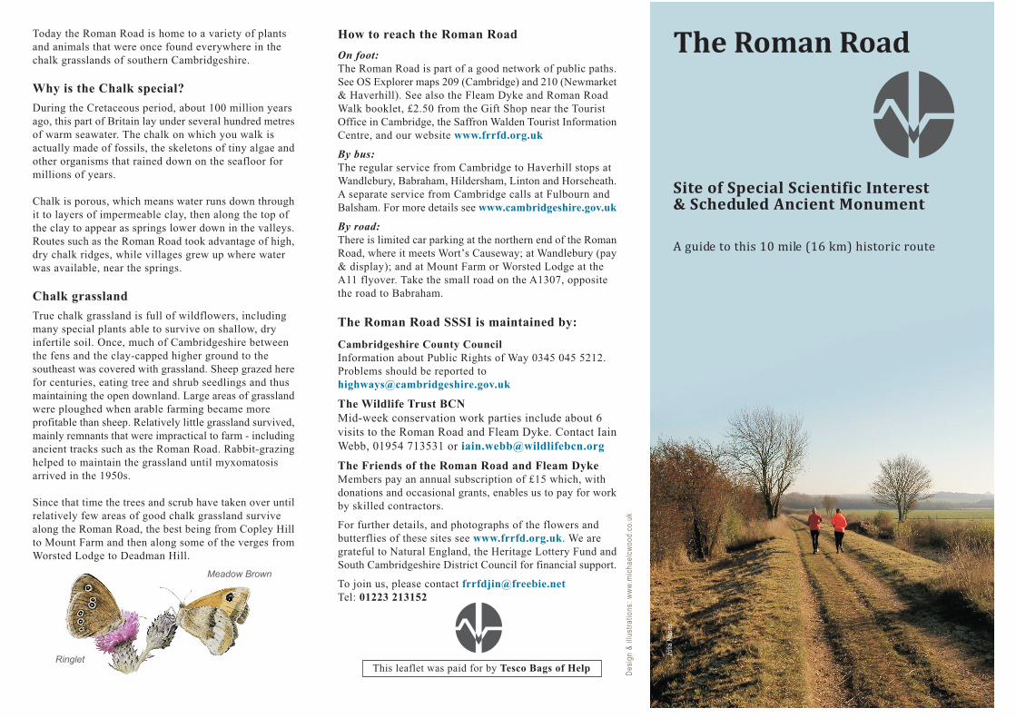
The Roman Road
Site of Special Scientific Interest& Scheduled Ancient Monument
A guide to this 10 mile (16 km) historic route
Julia
Na
pie
r
How to reach the Roman Road
On foot:
The Roman Road is part of a good network of public paths.
See OS Explorer maps 209 (Cambridge) and 210 (Newmarket
& Haverhill). See also the Fleam Dyke and Roman Road
Walk booklet, £2.50 from the Gift Shop near the Tourist
Office in Cambridge, the Saffron Walden Tourist Information
Centre, and our website www.frrfd.org.uk
By bus:
The regular service from Cambridge to Haverhill stops at
Wandlebury, Babraham, Hildersham, Linton and Horseheath.
A separate service from Cambridge calls at Fulbourn and
Balsham. For more details see www.cambridgeshire.gov.uk
By road:
There is limited car parking at the northern end of the Roman
Road, where it meets Wort�s Causeway; at Wandlebury (pay
& display); and at Mount Farm or Worsted Lodge at the
A11 flyover. Take the small road on the A1307, opposite
the road to Babraham.
The Roman Road SSSI is maintained by:
Cambridgeshire County Council
Information about Public Rights of Way 0345 045 5212.
Problems should be reported to
The Wildlife Trust BCN
Mid-week conservation work parties include about 6
visits to the Roman Road and Fleam Dyke. Contact Iain
Webb, 01954 713531 or [email protected]
The Friends of the Roman Road and Fleam Dyke
Members pay an annual subscription of £15 which, with
donations and occasional grants, enables us to pay for work
by skilled contractors.
For further details, and photographs of the flowers and
butterflies of these sites see www.frrfd.org.uk. We are
grateful to Natural England, the Heritage Lottery Fund and
South Cambridgeshire District Council for financial support.
To join us, please contact [email protected]
Tel: 01223 213152
Ringlet This leaflet was paid for by Tesco Bags of Help

P
P
P
0 1 2 3 km
Land over 100m Public Footpath
Land over 75m Public Bridleway
Land over 50m
Babraham
The Abingtons
Hildersham
LintonHorseheath
West Wickham
Balsham
Fulbourn
CAMBRIDGE
Mag�s HillGog Magog Hills
Meg�sMount
Worsted Lodge
BalshamWood
Borley Wood
HareWood
OverWood
Site ofHorseheath Hall
Streetly End
ROMANSETTLEMENT
MARK�SGRAVE
ROMANSETTLEMENT
Rivey Hill
Chilford Hall
ROMANSETTLEMENT
Furze Hill
A 11
A 11
Magog Down
WandleburyCountry Park
Megg�s Hill
Signal Hill
CopleyHill
Lodge Fm
MIL
E R
OA
D
WORT�S CAUSEWAY
The BeechwoodPARK & RIDE
BRONZE AGESITE
BALSHAM ROAD
A 1307
A 1307
Limepit Hill
BA
BR
AH
AM
RO
AD
1
2
3
4
56
7
8
9
10
11
12
13
A 1307
Mount Fm
Gunner�s Hall
Rat Hall Fm
Charterhouse Plantation
Dotterell Hall
Heath Fm
Valley Fm
Burgoyne�sPlantation
Rectory Fm
Yole Fm
The GrangeDeadman Hill
Co
nta
ins
Ord
na
nce
Su
rve
y D
ata
© C
row
n C
op
yrig
ht
an
d D
ata
ba
se R
igh
t 2
01
7
Chalkhill Blue
Bloody-nosed Beetle
Marjoram
Skylark
Kestrel
Orange Tip
Horseshoe Vetch
Cowslip
Gatekeeper
St John�s Wort
Common Rock Rose
Dwarf Thistle
Salad Burnet
Th
e Ro
man
Ro
ad
The Roman RoadThe Roman Road runs along the chalk ridge to avoid
heavy soils and mud on lower ground. Known as Woles
or Wolves Street in the 13th century, later records
refer to the Roman Road as Woolstreet Way. This
suggests that traders in wool, sheep or worsted yarn
(probably from Norfolk) used the road, from which
it is also known as Worsted Street. Its third name, the
Via Devana, was invented by 18th century historians
who assumed the road ran from Colchester to Roman
Deva, now Chester.
1People lived and worked in this landscape
long before the Romans arrived. The remains of
what may be a prehistoric religious site were found here
at the Park & Ride site. Some barrows and other
prehistoric features still survive along the Roman Road
- a reminder that people have walked this route for
thousands of years.
2The Beechwood and Wandlebury are nature
reserves near the Roman Road; a third in Fulbourn
includes the site of a medieval moated house. For more
information visit www.wildlifebcn.org
3 The Gog Magog Hills may have been named
after the mythical giants that lived in Albion, or
after two tribes of barbarians who, according to the
Bible, will appear as a sign of the Last Days. However,
Lord Godolphin at Wandlebury used the older name of
Hogmagog, as did the last owner, Lady Gray.
4 Wandlebury Country Park and Nature Reserve
contains an Iron Age hill fort that may have
controlled the Icknield Way, the valley of the Cam and
the settlement that became Cambridge. The two circular
banks were levelled in the 18th century when the Earl
Godolphin built his mansion here, (much changed later),
leaving only one circular ditch. In 1954 the estate was
purchased by the Cambridge Preservation Society,
following a public appeal to �Save the Gogs�. There was
not enough money for necessary repairs, and the old
house was pulled down; but the stables, famed as the
home of the Godolphin Arabian, an ancestor of the
modern thoroughbred racehorse, were converted to offices
and accommodation. See www.cambridgeppf.org and
�The Godolphin Arabian� by Wendy Clark.
8 The Roman Road joined another road running
north from Great Chesterford on the line of the
modern A11. Archaeological work here found that the
remainder of the Road, running south-east towards
Haverhill, is less well-built.
6The ditches on either side of the track are
typical of the bank and ditch structure of a Roman
road. Best seen opposite Signal Hill.
7This curving patch of woodland, mistakenly
known as Signal Hill, like Telegraph Hill at
Wandlebury, is one of several places marked on old maps
for a pole or post. These have been interpreted as
semaphore stations dating from the Napoleonic War (1802-
1815), but Bill Clark has shown them to be just the sites
of unconnected beacons. During WWII a decoy runway
was laid out in the field between Signal Hill and the
Roman Road to lure German bombers away from Duxford.
Meg�s Mount (near the point where the Roman Road
crosses the A11) was a searchlight site.
9 Chilford Hall was bought in 1966 by Sam Alper,
designer of the Sprite Caravan and founder of the Little
Chef Restaurants. Bistro, teas, wine tasting, Thursday - Sunday,
10 - 5pm. The estate contains the oldest established vineyard in
England and the largest in East Anglia with 18 acres of vines
producing award-winning wines. www.chilfordhall.co.uk
10 Borley, Rivey Hill, Balsham and Hare Woods are
listed as �ancient woods� because they are shown on
15th century maps, but they are probably far older. These may
have been woodlands when the Romans arrived but the native
trees of Borley Wood have been replaced by planted pines. A
possible Roman barrow survives at the edge of the wood.
11 Mark�s Grave is a mystery: we don�t know who
Mark was. Perhaps an old parish boundary marker
was mistaken for a gravestone!
12 Recorded as Stretliae in 1086, Streetly means
�clearing by a Roman road or street�. Many Roman
finds have been reported from this area.
13 At 112m above sea level this is the highest point
on the Roman Road. The great Cedar of Lebanon is
all that remains of the second Horseheath Hall. In the 17th
century, its owners bankrupted themselves on the house, gardens
and lavish parties. The new owners demolished the house in the
1790s and the last remnants of the gardens were destroyed in
1991. The beautiful wrought iron back gate of Trinity College
and the side gate of St John�s College were salvaged from here.
See www.frrfd.org.uk Newsletters 12 & 13.
5 Mile Road, a pleasant green lane, is actually a
Romanised prehistoric track. A complex of Roman
buildings once stood in the field to the north-west, while
the field to the south-east is a Scheduled Monument
preserving the site of Bronze Age livestock enclosures
and a barrow or burial mound. Copley Hill, at the junction
of Mile Road and the Roman Road, is a natural chalk
knoll topped by what may be a barrow.