Embed Size (px)
DESCRIPTION
rohtak
Citation preview
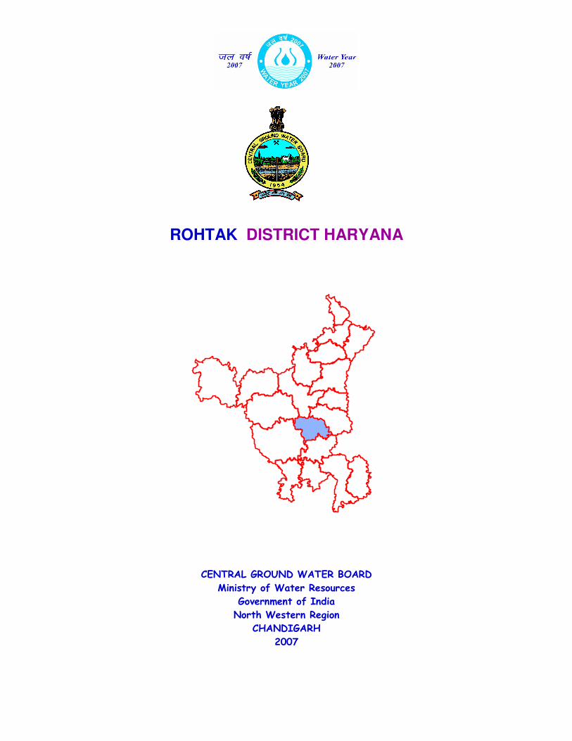
ROHTAK DISTRICT HARYANA
CENTRAL GROUND WATER BOARD
Ministry of Water Resources
Government of India
North Western Region
CHANDIGARH
2007
Contributors
S.A.Khan
Scientist-‘B’
Prepared under supervision of
Sushil Gupta
Regional Director
Our Vision
“Water Security through Ground water
Management”
GROUND WATER INFORMATION BOOKLET, ROHTAK DISTRICT, HARYANA.
C O N T E N T S
DISTRICT AT A GLANCE
1.0 INTRODUCTION
2.0 RAINFALL &CLIMATE
3.0 GEOMORPHOLOGY &SOIL TYPES
4.0 GROUND WATER SCENARIO
4.1 HYDROGEOLOGY
4.2 GEOPHYSICAL STUDIES
4.3 GROUND WATER RESOURCES
4.4 GROUND WATER QUALITY
4.5 STATUS OF GROUND WATER DEVELOPMENT
5.0 GROUND WATER MANAGEMENT STRATEGY
5.1 GROUND WATER DEVELOPMENT
5.2 WATER CONSERVATION & ARTIFICIAL RECHARGE
6.0 GROUND WATER RELATED ISSUES & PROBLEMS
6.1 WATER LOGGING
6.2 SALINITY
6.3 HIGH FLUORIDE
7.0 RECOMMENDATIONS
MAPS
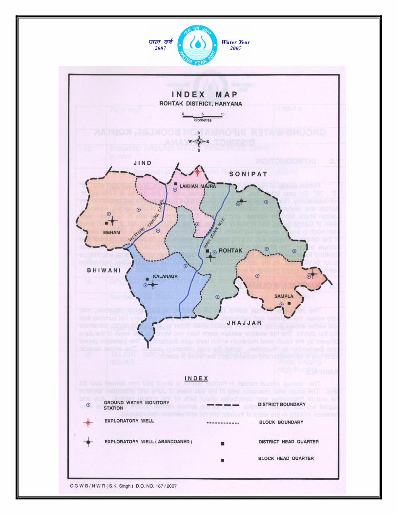
Index map
Depth to water ( May 2006 ).
Depth to water( Nov. 2006 ).
Ground water development potential and categorization of Blocks.
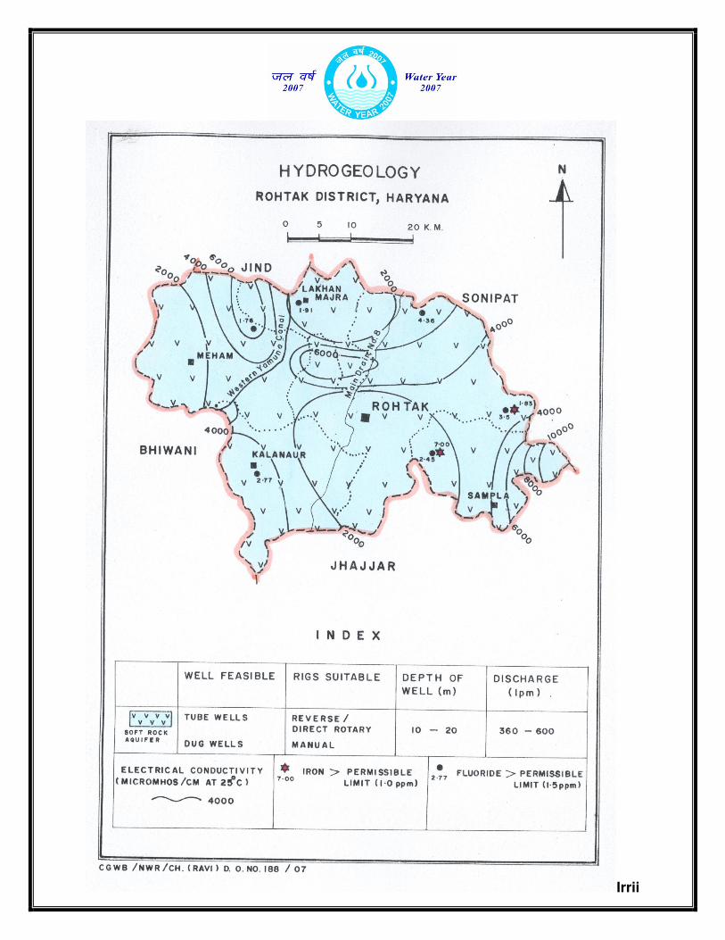
Hydrogeology
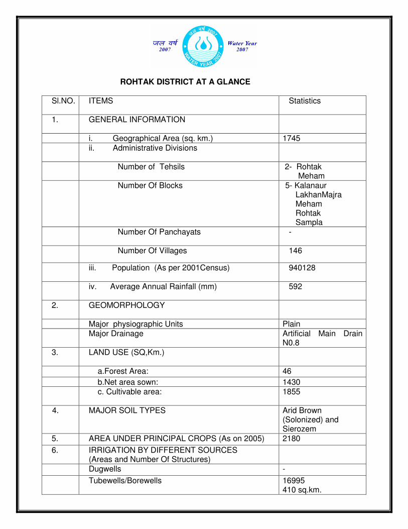
ROHTAK DISTRICT AT A GLANCE
Sl.NO.
ITEMS Statistics
1. GENERAL INFORMATION
i. Geographical Area (sq. km.) 1745
ii. Administrative Divisions
Number of Tehsils
2- Rohtak Meham
Number Of Blocks
5- Kalanaur LakhanMajra Meham Rohtak Sampla
Number Of Panchayats
-
Number Of Villages 146
iii. Population (As per 2001Census) 940128
iv. Average Annual Rainfall (mm)
592
2. GEOMORPHOLOGY
Major physiographic Units Plain Major Drainage Artificial Main Drain
N0.8 3. LAND USE (SQ,Km.)
a.Forest Area: 46
b.Net area sown: 1430 c. Cultivable area:
1855
4. MAJOR SOIL TYPES Arid Brown (Solonized) and Sierozem
5. AREA UNDER PRINCIPAL CROPS (As on 2005) 2180
6. IRRIGATION BY DIFFERENT SOURCES (Areas and Number Of Structures)
Dugwells -
Tubewells/Borewells 16995 410 sq.km.
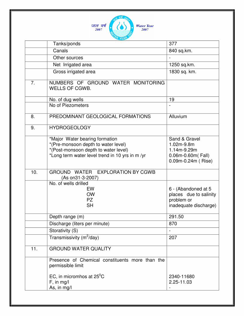
Tanks/ponds 377
Canals 840 sq.km.
Other sources -
Net Irrigated area 1250 sq.km.
Gross irrigated area
1830 sq. km.
7. NUMBERS OF GROUND WATER MONITORING WELLS OF CGWB.
No. of dug wells 19 No of Piezometers
-
8. PREDOMINANT GEOLOGICAL FORMATIONS
Alluvium
9. HYDROGEOLOGY
*Major Water bearing formation *(Pre-monsoon depth to water level) *(Post-monsoon depth to water level) *Long term water level trend in 10 yrs in m /yr
Sand & Gravel 1.02m-9.8m 1.14m-9.29m 0.06m-0.60m( Fall) 0.09m-0.24m ( Rise)
10. GROUND WATER EXPLORATION BY CGWB (As on31-3-2007)
No. of wells drilled EW OW PZ SH
6 - (Abandoned at 5 places due to salinity problem or inadequate discharge)
Depth range (m) 291.50
Discharge (liters per minute) 870
Storativity (S) -
Transmissivity (m2/day)
207
11. GROUND WATER QUALITY
Presence of Chemical constituents more than the permissible limit EC, in micromhos at 250C F, in mg/l As, in mg/l
2340-11680 2.25-11.03 -
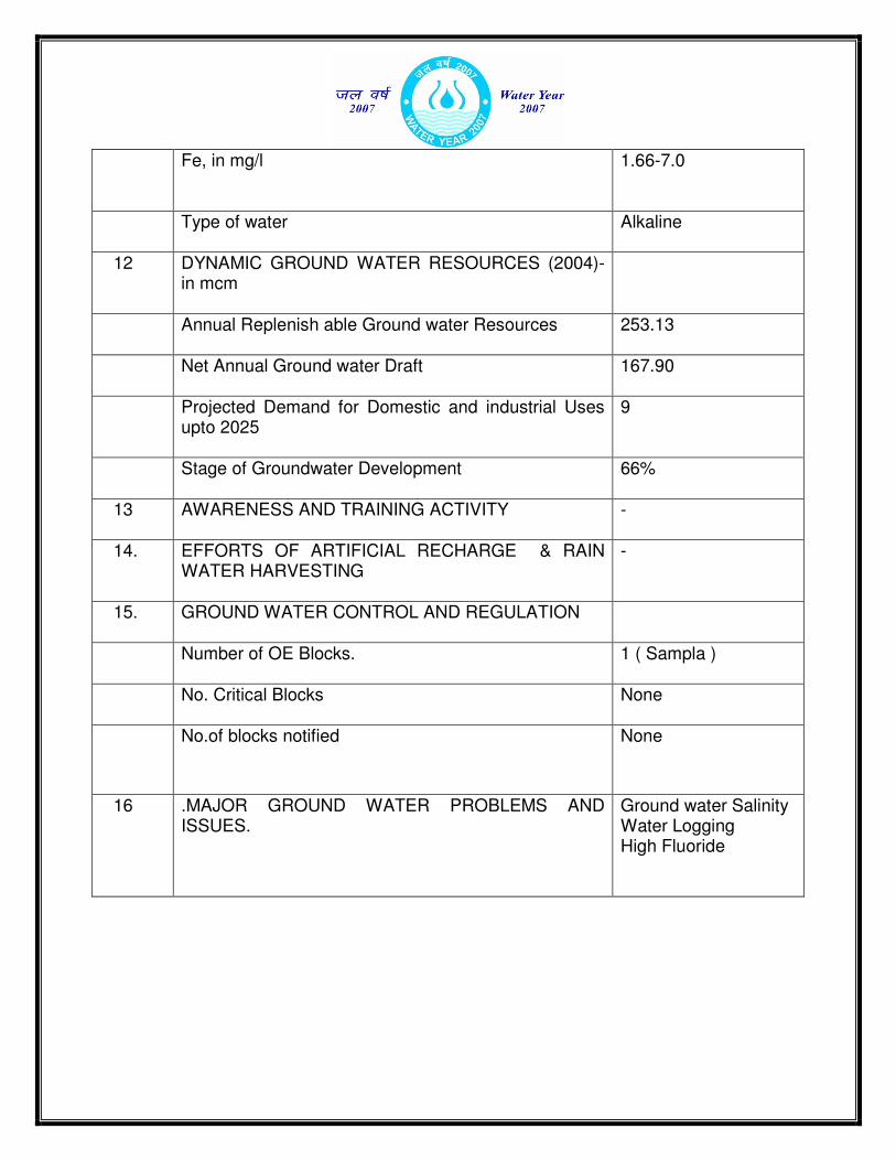
Fe, in mg/l
1.66-7.0
Type of water
Alkaline
12 DYNAMIC GROUND WATER RESOURCES (2004)-in mcm
Annual Replenish able Ground water Resources
253.13
Net Annual Ground water Draft
167.90
Projected Demand for Domestic and industrial Uses upto 2025
9
Stage of Groundwater Development
66%
13 AWARENESS AND TRAINING ACTIVITY
-
14. EFFORTS OF ARTIFICIAL RECHARGE & RAIN WATER HARVESTING
-
15. GROUND WATER CONTROL AND REGULATION
Number of OE Blocks.
1 ( Sampla )
No. Critical Blocks
None
No.of blocks notified
None
16 .MAJOR GROUND WATER PROBLEMS AND ISSUES.
Ground water Salinity Water Logging High Fluoride

GROUND WATER INFORMATION BOOKLET, ROHTAK
DISTRICT, HARYANA
1.0 INTRODUCTION
Rohtak district of Haryana lies between 28o 40’ : 29o 05’ north latitudes and 76o 13’ : 76o 51’ east longitudes. Total geographical area of the district is 1745 sq.km. Administratively, Rohtak division controls the district. It is divided into two tehsils namely Rohtak and Meham, and sub-divided into 5 development blocks namely Kalanaur, Lakhan Majra. Meham Rohtak and Sampla. The district area falls in Yamuna sub-basin of Ganga basin, and is mainly drained by the artificial drain No. 8 which flows from north to south. Jawahar Lal Nehru feeder and Bhalaut sub Branch are main canals of the district. Bhalaut sub branch irrigate the area falling in Kalanaur, Rohtak and Sampla blocks. The Bhiwani sub branch and Kahnaur distributary irrigates the areas covering Kalanaur, Meham and Lakhan Majra blocks. Area under Canal irrigation is about 84193 hact. in the district. CGWB has carried out ground water exploration besides other hydro geological and geophysical studies in the district.
2.0 RAINFALL & CLIMATE
The climate of Rohtak district can be classified as subtropical monsoon, mild &dry winter, hot summer and sub-humid which is mainly dry with very hot summer and cold winter except during monsoon season when moist air of oceanic origin penetrate into the district. The hot weather season starts from mid March to last week of the June followed by the south west monsoon which lasts upto September. The transition period from September to November forms the post monsoon season. The winter season starts late in November and remains upto first week of March. RAINFALL
The normal annual rainfall in Rohtak district is about 592 mm spread over 23 days. The south west monsoon sets in the last week of June and withdraws towards the end of September and contributes about 84% of the annual rainfall. July and August are the wettest months. 16% of the annual rainfall occurs during the non-monsoon months in the wake of thunder storms and western disturbances.
Normal Annual Rainfall : 592 mm Normal monsoon Rainfall : 499 mm
Temperature Mean Maximum : 40.5°C(May &June)
Mean Minimum : 7°C(January) Normal Rainy days : 23
3.0 GEOMORPHOLOGY AND SOILTYPES
The district area is occupied by Indo-Gangetic alluvium. There are no surface
features worth to mention. Physiographically the area is flat terrain. The area slopes towards northeast to southwest with an average gradient of 0.19 m/km.The general elevation in the district varies between 215 m to 222m above MSL. The soils of the district arefine to medium textured. It comprises sandy loam in Rohtak, Sampla, and Lakhan Majra blocks whereas it is loamy sand with occasional clay loam in Kalanaur and Meham Blocks. High potassium, medium phosphorus and low nitrogen occur in the soils. The soils of the district are classified as arid brown (Solemnized) and sierozem.
4.0 GROUND WATER SCENARIO 4.1 HYDROGEOLOGY
The district is occupied by Indo-Gangetic alluvial plain of Quaternary age, and
falls in Yamuna sub –basin of Ganga basin. The Central Ground Water Board has drilled 6 exploratory boreholes to delineate and determine potential aquifer zones, evaluation of aquifer characteristics. The permeable granular zones comprising fine to medium grained sand and occasionally coarse sand and gravel. Their lateral and as well as vertical extent is limited. The borehole data reveals that clay group of formations dominate over the sand group in the district area. The bed rock in the district area was encountered at a depth of 370.0 m at Hasangarh in Sampla block. The boreholes drilled in the district were abandoned either due to bad quality of water or poor discharge. Ground water in the district occurs in the alluvium under water table and semi confined to confined conditions. Two to four granular zones with aggregate thickness from 23m to 52m are present in the area up to bed rock. There has however been a successful well at Sondhi, Rohtak block, tapping the zones27m-34m,37m-40m, and46m-52m. The discharge of the well was 870lpm at a drawdown of 7.5m. The transmissivity ‘T’ value 207m2 /day was determined. Shallow tube wells for irrigation use are generally constructed upto a depth of 20 m ,and are of cavity type. The discharge of these shallow tubewells/ cavity wells range 360 -600 litres per minutes. Deep tube wells are not constructed in the district due to salinity which increases with depth.
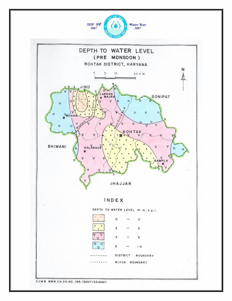
Water level behavior
The depth to water level ranges from less than 1.02 m bgl to 9.8 m bgll during
pre monsoon period, and1.14m to 9.29 m during post monsoon period. The long-term (10 years) water level trend during pre monsoon period indicates average fall of 0.13m/year,,and also showing a rise at places ranging from 0.01m to 0.07m during the same period. There is a decline of 0.17 m per year , and a rise at places in the order of
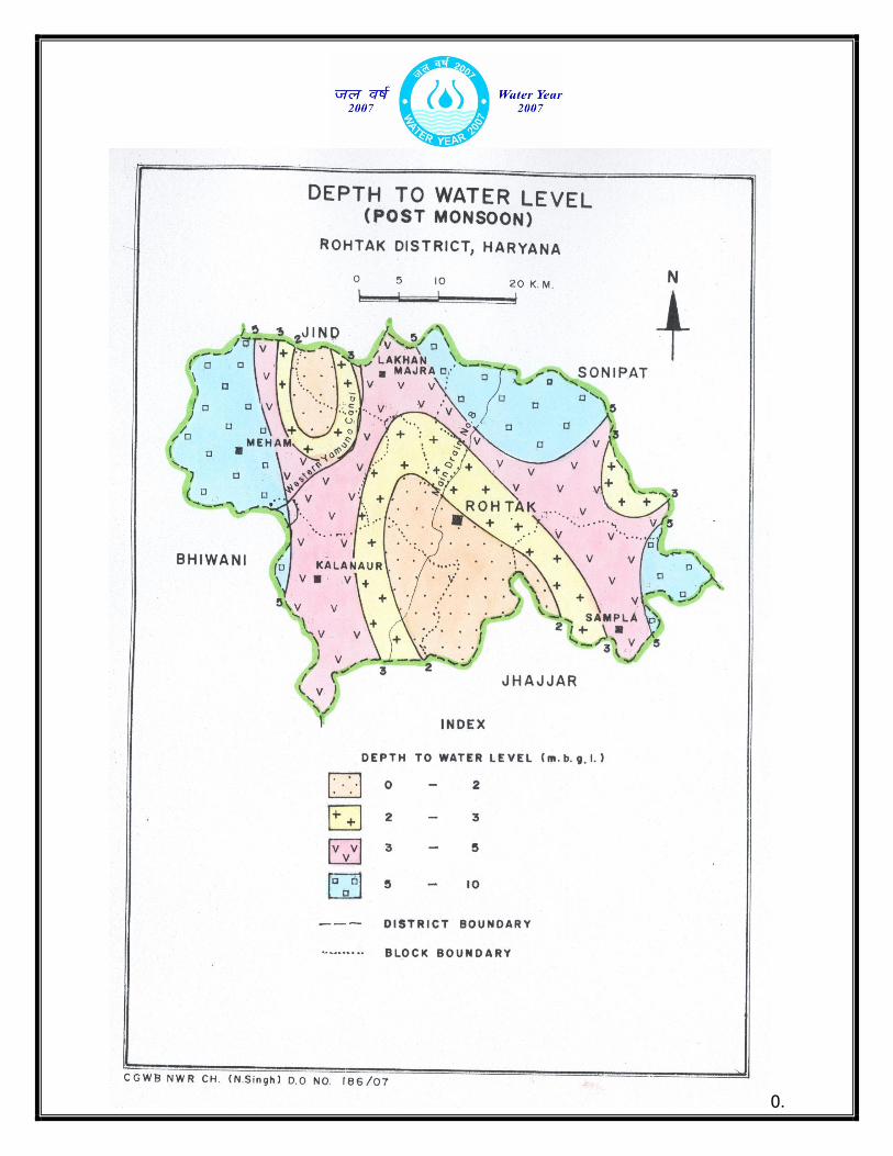
0.
02m to 0.15m during the post monsoon period. The long term water level trend is showing a decline as well as rise in district area but not of much significance as the
figures are very low.
Ground water flow The elevation of the water table in the district varies from 206 m to 218 m above
mean sea level. The average gradient of the water table is of the order of 1 m/km. The overall flow of ground water is from north to south direction.
4.2 GROUND WATER RESOURCES
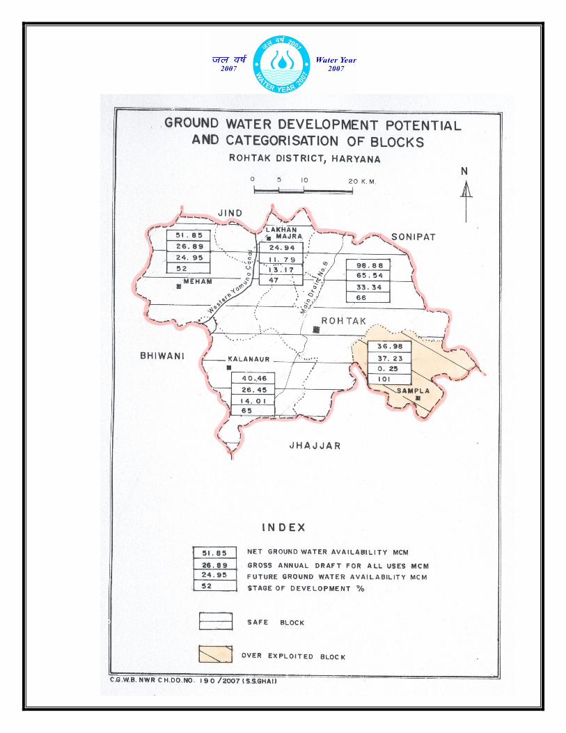
The blockwise ground water resource potential in the district has been assessed as per GEC-97. The stage of ground water development ranges between 47% (block-Lakhan Majra) to 101% (block-Sampla). The total replenish able ground water resource in the district is 253.13 mcm, while the existing ground water draft is 167.90 mcm. Ground water availability for future irrigation development is 85.22 mcm. The stage of ground water development in the district is 66% GROUND WATER RESOURCES OF ROHTAK DISTRICT ,HARYANA.
4.3 GROUND WATER QUALITY
CGWB has carried out studies for chemical quality of ground water in the district area. The range of mineral concentration is tabulated below. The ground water of the district is alkaline in nature. About 33% shallow waters have EC more than 3000
Assessment Unit/Block
Net Annual Ground Water
Availabi- Lity
(Ham)
Existing Gross
Ground Water Draft
for irrigation (Ham)
Existing Gross
Ground Water Draft
for Domestic and
Industrial water supply
(ham)
Existing Gross
Ground Water
Draft for all uses (Ham)
Allocation domestic
industrial upto next 25 years
(Ham)
Net Ground Water
Availability for
future irrigation developm
ent (Ham)
Stage Ground Water
Develop ment
(%)
C A T E G O R Y of
Block
Rohtak 9888 6554 0 6554 0 3334 66 Safe
Kalanaur
4046 2645 0 2645 0 1401 65 Safe
Lakhan Majra
2494 1179 0 1179 0 1317 47 Safe
Meham 5185 2689 0 2689 0 2495 52 Safe
Sampla 3698 3723 0 3723 9 -25 101 Over Exploited
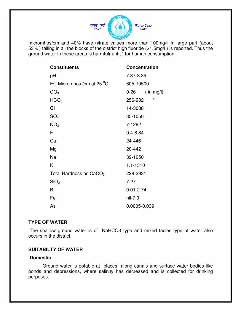
micromhos/cm and 40% have nitrate values more than 100mg/ll In large part (about 53% ) falling in all the blocks of the district high fluoride (>1.5mg/l ) is reported. Thus the ground water in these areas is harmful( unfit ) for human consumption.
Constituents Concentration
pH 7.37-8.39
EC Micromhos /cm at 25 0C 605-10500
CO3 0-26 ( in mg/l)
HCO3 256-932 “
Cl 14-3088
SO4 35-1050
NO3 7-1292
F 0.4-8.84
Ca 24-446
Mg 20-442
Na 39-1250
K 1.1-1310
Total Hardness as CaCO3 228-2931
SiO2 7-27
B 0.01-2.74
Fe nil-7.0
As 0.0005-0.039
TYPE OF WATER
The shallow ground water is of NaHCO3 type and mixed facies type of water also occurs in the district.
SUITABILTY OF WATER
Domestic
Ground water is potable at places along canals and surface water bodies like ponds and depressions, where salinity has decreased and is collected for drinking purposes.
Irrii
irrigation
The shallow ground water to a depth of 20m is by and large fresh and fit for irrigation. The deep ground water is saline and salinity increases with depth and that water is not fit for irrigation.
4.4 STATUS OF GROUND WATER DEVELOPMENT
The drinking water supply is mainly canal water based in the district.. The short
fall in water supply to the towns, cities and villages is met with the installation of hand pumps by the public individually as spot and convenient source of water. There are 16995 minor irrigation units with the depth ranging from 15 m to 20m and 410 sq.km.area is irrigated by these tube wells in the district. Most of these shallow tube wells are cavity type and either run by diesel engines or electric motors.The proper drainage system created and regulated over the years has helped in maintaining proper balance between soil moisture and air thereby water logging, salinity and marshy condition associated with ground water at places has considerably declined in the district.
4.5 GEOPHYSICAL STUDIES
CGWB has carried out geophysical studies in Rohtak district to delineate the fresh and saline aquifers.The findings of surface geophysical studies show that ground water is saline at all levels in major part of the district area ,however there are few patches where fresh to marginally saline ground water within 10 m depth occurs.Ground water is saline below 20 m in most of the district area. However, in the vicinity of the canals, fresh to marginally saline water occurs and the results indicate deterioration of ground water quality away from the canals. One of the exception noticed was in village Maina near Rohtak where quality of ground water is saline at the places adjacent to canal. Around 12 to 25 m thickness of granular zones bearing fresh to marginally saline water is expected in Rohtak city, Bahu Jamalpur and Kharkhora.
5.0 GROUND WATER MANAGEMENT STRATEGY
5.1 GROUND WATER DEVELOPMENT
The hydrogeological data generated through exploratory test drilling has provided vital information regarding identification of aquifer systems, demarcation of their vertical and lateral extent, delineation of potential aquifer characteristics. However these studies have proved that the district area is by and large saline and salinity increases with depth, thus the area is not fit for deep ground water exploitation. The shallow ground water can extensively be exploited through shallow tube wells( Cavity Type ) and the yield of these 15 m to 20 m deep tube wells varies from 480-600 lpm.
PVC pipes are commonly used for constructing these tube wells. Drilling technique used for boring the shallow wells is locally developed.
5.2 WATER CONSERVATION STRUCTURES
There are about 377 tank/pond and their recharging contribution in the district. is as follows-
LAKES AND PONDS
Average water
spread area(ha) No of days water is
available Recharge in Ha.m.
during No. of
Tank/Pond
monsoon non-
monsoon monsoon
non-monsoon
monsoon non-
monsoon
377 750 375 450 1050 97.2 113.4
6.0 GROUND WATER RELATED ISSUES & PROBLEMS
Water Logging
The phenomenon of water logging is associated with clayey formation, which causes rise of water levels and salinity in the area. The canal net work in the district is dense, which is another cause of water logging. Water logged areas vary from pre monsoon to post monsoon period. The water logged areas of the district is however reducing year after year due to manifold increase in exploitation of shallow ground water mainly through cavity type shallow tube wells. Thus there has been a check on the rise of water level in the district despite salinity, the main cause of rising trend of water levels.
Salinity
The twin problem of water logging and salinity is associated with clay formation at shallow depth, which results in increased evaporation and evapotranspiration from shallow water table. The improper management of ground water by users in the area has also contributed to ground water salinity. This has also damaged surface soils in the area and aggravated the problem of ground water salinity.In absence of natural drainage the rain water accumulates in the natural depressions and artificial drains. This undrained flood water creates ponds and marshes.There however a good net work of artificial drains keep proper balance between soil moisture and air to a considerable extent, and has been very helpful in removing excess water and salt from the soils.
Fluoride
High fluoride (F) content, more than the permissible limit of 1.5mg/l, is present in the shallow ground water of the district. About 44% of the district area is plagued with high fluoride(1.65mg/l-11.03mg/l) , thus making the water harmful (unfit)for human consumption.
7.0 RECOMMENDATIONS
• There is a rise in water level along canals due to seepage which creates water-logging conditions. Water logging can be checked by adopting suitable measures to reduce the recharge and increase discharge from the phreatic aquifer. In the problematic areas construction of surface drains, lining of canals and water courses, village ponds, optimum use of irrigation water, a forestation along canals, drains, rails and roads, and pumpage of ground water to drains and canals are some of the remedial measures suggested.
• High fluoride areas can be mapped and the public be educated about its harmful effect on human body. Small defluoridation plants can be used and mixing of water can be practiced.
• PVC pipe assembly may be used in case of shallow tubewells.
• It is necessary to notify the Sampla block of the district for registration of all ground water abstraction structures and for the construction of any tubewell, prior permission should be sought from the Central Ground Water Authority. Local populace to be educated regarding consequences of mining of ground water and need for its effective and beneficial use.