Embed Size (px)
Citation preview
ROCKY MOUNTAIN AREA FIRE WEATHER
ANNUAL OPERATING PLAN
2008
Colorado Kansas
Nebraska South Dakota
Wyoming
Rocky Mountain Area Fire Weather Annual Operating Plan 4/30/2008 - 2 -
ROCKY MOUNTAIN AREA FIRE WEATHER ANNUAL OPERATING PLAN 2008
SECTION................................................................................................................................PAGE I. INTRODUCTION.................................................................................................................... 3 II. SIGNIFICANT CHANGES SINCE PREVIOUS PLAN ........................................................ 3 III. SERVICE AREAS AND ORGANIZATIONAL DIRECTORY ............................................ 3 IV. NATIONAL WEATHER SERVICE SERVICES AND RESPONSIBILTIES ...................... 7
A. Basic Services ............................................................................................................... 7 1. Routine Fire Weather Planning Forecast (FWF) ............................................... 8 2. Spot Forecast.................................................................................................... 10 3. Red Flag Program ............................................................................................ 13 4. NFDRS Forecast .............................................................................................. 15 5. Participation in Interagency Groups ................................................................ 16
B. Special Services........................................................................................................... 16 C. Forecaster Training ..................................................................................................... 16 D. Individual Forecast Office Information ...................................................................... 16
1. Northeast Colorado – Boulder, CO.................................................................. 16 2. Southeast Colorado – Pueblo, CO ................................................................... 18 3. Western Colorado – Grand Junction, CO ........................................................ 21 4. Northern/Central/Southwest Wyoming – Riverton, WY................................. 24 5. Northern Big Horn Mountains – Billings, MT ................................................ 26 6. Southeast Wyoming/Nebraska Panhandle – Cheyenne, WY .......................... 28 7. Northeast Wyoming/Western South Dakota – Rapid City, SD ....................... 30 8. North Central/Northeast South Dakota – Aberdeen, SD ................................. 32 9. South Central/Southeast South Dakota – Sioux Falls, SD............................... 33 10. West Central/South Central Nebraska – North Platte, NE ............................ 35 11. East Central Colorado/Northwest Kansas – Goodland, KS........................... 37 12. South Central Nebraska/North Central Kansas- Hastings, NE...................... 38 13. Southwest Kansas- Dodge City, Kansas........................................................ 40 14. Eastern Nebraska/Southwest Iowa- Omaha, Nebraska.................................. 42 15. Northeast Kansas- Topeka, Kansas................................................................ 43 16. Central/Southeast Kansas- Wichita, Kansas .................................................. 45
V. WILDLAND FIRE AGENCY SERVICES AND RESPONSIBILITIES .............................. 47 A. Predictive Services and Products ................................................................................. 47 B. Program Management ................................................................................................. 48 C. Monitoring, Feedback and Improvement .................................................................... 48 D. Technology Transfer ................................................................................................... 49 E Agency Computer Systems .......................................................................................... 48 F. Fire Weather Observations .......................................................................................... 49 G. Technical Specialists................................................................................................... 49 H. Reimbursement of NWS for on-site support and training assistance ......................... 49 I. Fuel Information Support ........................................................................................... 49
Rocky Mountain Area Fire Weather Annual Operating Plan 4/30/2008 - 3 -
VI. JOINT RESPONSIBILITIES ................................................................................................ 50 A. Training....................................................................................................................... 50 B. Incident Response ....................................................................................................... 50 C. Briefings ...................................................................................................................... 51 D. Conference Calls ......................................................................................................... 51 E. WIMS IDs for NFDRS Stations .................................................................................. 51
VII. RMA Predictive Service Area and NWS Fire Weather Zones ........................................... 52 A. RMA Predictive Service Area Map ............................................................................ 52
B. NWS Fire Weather Zone Map ................................................................................... 53 VIII. EFFECTIVE DATES OF AOP.......................................................................................... 54 IX. AGENCY SIGNATURES................................................................................................. 54 Rocky Mountain Area Interagency Fire Weather Operating Plan – 2008
I. INTRODUCTION
This document serves as the Interagency Fire Weather Annual Operating Plan (AOP) for the Rocky Mountain Geographic Area. The general relationship between NWS and the interagency fire management community is set forth in the National Interagency Agreement for Meteorological Services. The AOP provides specific procedural and policy information about the responsibilities of both NWS offices and land management offices regarding meteorological services provided to the fire management community in the Rocky Mountain Area, as contained within the umbrella of the National Agreement. References will include:
• National Weather Service Directives NWSI 10-4: Fire Weather Services • Interagency Agreement for Meteorological Services (National MOA or National
Agreement) • Rocky Mountain Area and National Mobilization Guides
II. SIGNIFICANT CHANGES SINCE LAST YEAR A. Wyoming Zone 274 was transferred to Billings Fire Weather on July 16, 2007. B. Katie Burtis has assumed the Fire Weather focal point position as of January 1, 2008
replacing Fred Stasser C. James Murray is the new IMET Trainee at Sioux Falls, South Dakota D. Predictive Services will continue to issue an experimental Wind Change Chart product in
2008.
III. SERVICE AREA AND ORGANIZATIONAL DIRECTORY A. Fire weather services in the Rocky Mountain Area are provided by the NWS forecast
offices, RMA Predictive Services, and States listed below
Boulder, CO Riverton, WY North Platte, NE
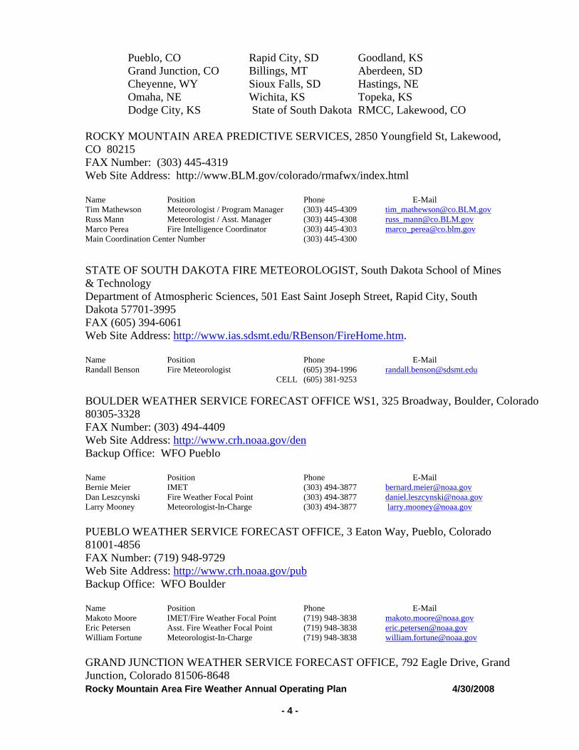
Rocky Mountain Area Fire Weather Annual Operating Plan 4/30/2008 - 4 -
Pueblo, CO Rapid City, SD Goodland, KS Grand Junction, CO Billings, MT Aberdeen, SD Cheyenne, WY Sioux Falls, SD Hastings, NE Omaha, NE Wichita, KS Topeka, KS Dodge City, KS State of South Dakota RMCC, Lakewood, CO
ROCKY MOUNTAIN AREA PREDICTIVE SERVICES, 2850 Youngfield St, Lakewood, CO 80215 FAX Number: (303) 445-4319 Web Site Address: http://www.BLM.gov/colorado/rmafwx/index.html Name Position Phone E-Mail Tim Mathewson Meteorologist / Program Manager (303) 445-4309 [email protected] Mann Meteorologist / Asst. Manager (303) 445-4308 [email protected] Perea Fire Intelligence Coordinator (303) 445-4303 [email protected] Coordination Center Number (303) 445-4300 STATE OF SOUTH DAKOTA FIRE METEOROLOGIST, South Dakota School of Mines & Technology Department of Atmospheric Sciences, 501 East Saint Joseph Street, Rapid City, South Dakota 57701-3995 FAX (605) 394-6061 Web Site Address: http://www.ias.sdsmt.edu/RBenson/FireHome.htm. Name Position Phone E-Mail Randall Benson Fire Meteorologist (605) 394-1996 [email protected] CELL (605) 381-9253 BOULDER WEATHER SERVICE FORECAST OFFICE WS1, 325 Broadway, Boulder, Colorado 80305-3328 FAX Number: (303) 494-4409 Web Site Address: http://www.crh.noaa.gov/den Backup Office: WFO Pueblo Name Position Phone E-Mail Bernie Meier IMET (303) 494-3877 [email protected] Leszcynski Fire Weather Focal Point (303) 494-3877 [email protected] Mooney Meteorologist-ln-Charge (303) 494-3877 [email protected] PUEBLO WEATHER SERVICE FORECAST OFFICE, 3 Eaton Way, Pueblo, Colorado 81001-4856 FAX Number: (719) 948-9729 Web Site Address: http://www.crh.noaa.gov/pubBackup Office: WFO Boulder Name Position Phone E-Mail Makoto Moore IMET/Fire Weather Focal Point (719) 948-3838 [email protected] Petersen Asst. Fire Weather Focal Point (719) 948-3838 [email protected] Fortune Meteorologist-In-Charge (719) 948-3838 [email protected] GRAND JUNCTION WEATHER SERVICE FORECAST OFFICE, 792 Eagle Drive, Grand Junction, Colorado 81506-8648
Rocky Mountain Area Fire Weather Annual Operating Plan 4/30/2008 - 5 -
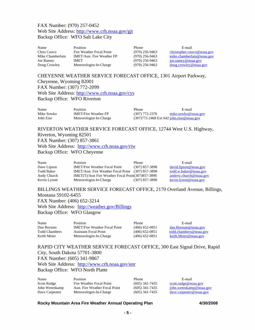
FAX Number: (970) 257-0452 Web Site Address: http://www.crh.noaa.gov/gjtBackup Office: WFO Salt Lake City Name Position Phone E-mail Chris Cuoco Fire Weather Focal Point (970) 256-9463 [email protected] Chamberlain IMET/Asst. Fire Weather FP (970) 256-9463 [email protected] Joe Ramey IMET (970) 256-9463 [email protected] Crowley Meteorologist-In-Charge (970) 256-9463 [email protected] CHEYENNE WEATHER SERVICE FORECAST OFFICE, 1301 Airport Parkway, Cheyenne, Wyoming 82001 FAX Number: (307) 772-2099 Web Site Address: http://www.crh.noaa.gov/cysBackup Office: WFO Riverton Name Position Phone E-mail Mike Sowko IMET/Fire Weather FP (307) 772-2376 [email protected] Eise Meteorologist-In-Charge (307)772-2468 Ext 642 [email protected] RIVERTON WEATHER SERVICE FORECAST OFFICE, 12744 West U.S. Highway, Riverton, Wyoming 82501 FAX Number: (307) 857-3861 Web Site Address: http://www.crh.noaa.gov/riwBackup Office: WFO Cheyenne Name Position Phone E-mail Dave Lipson IMET/Fire Weather Focal Point (307) 857-3898 [email protected] Baker IMET/Asst. Fire Weather Focal Point (307) 857-3898 [email protected] Church IMET(T)/Asst Fire Weather Focal Point(307)857-3898 [email protected] Lynott Meteorologist-In-Charge (307) 857-3898 [email protected] BILLINGS WEATHER SERVICE FORECAST OFFICE, 2170 Overland Avenue, Billings, Montana 59102-6455 FAX Number: (406) 652-3214 Web Site Address: http://weather.gov/BillingsBackup Office: WFO Glasgow Name Position Phone E-mail Dan Borsum IMET/Fire Weather Focal Point (406) 652-0851 [email protected] Chambers Assistant Focal Point (406) 652-0851 [email protected] Meier Meteorologist-In-Charge (406) 652-0851 [email protected] RAPID CITY WEATHER SERVICE FORECAST OFFICE, 300 East Signal Drive, Rapid City, South Dakota 57701-3800 FAX Number: (605) 341-9867 Web Site Address: http://www.crh.noaa.gov/unrBackup Office: WFO North Platte Name Position Phone E-mail Scott Rudge Fire Weather Focal Point (605) 341-7435 [email protected] Wetenkamp Asst. Fire Weather Focal Point (605) 341-7435 [email protected] Carpenter Meteorologist-In-Charge (605) 341-7435 [email protected]
Rocky Mountain Area Fire Weather Annual Operating Plan 4/30/2008 - 6 -
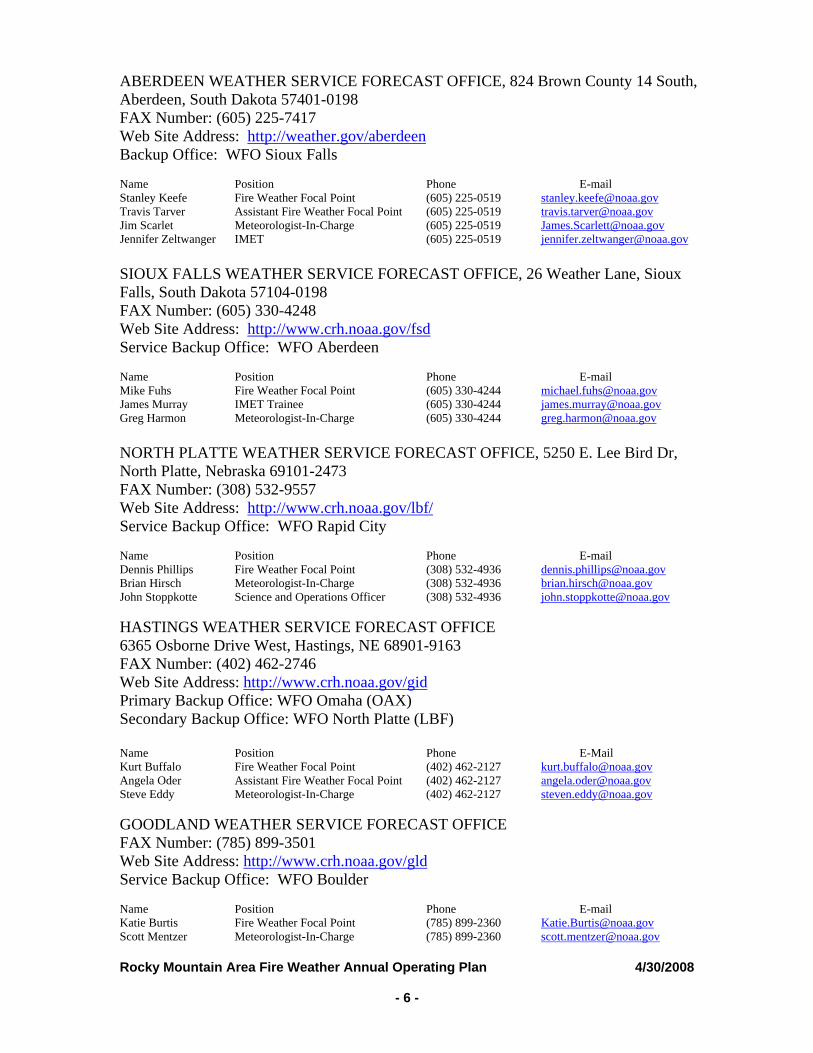
ABERDEEN WEATHER SERVICE FORECAST OFFICE, 824 Brown County 14 South, Aberdeen, South Dakota 57401-0198 FAX Number: (605) 225-7417 Web Site Address: http://weather.gov/aberdeenBackup Office: WFO Sioux Falls Name Position Phone E-mail Stanley Keefe Fire Weather Focal Point (605) 225-0519 [email protected] Tarver Assistant Fire Weather Focal Point (605) 225-0519 [email protected] Scarlet Meteorologist-In-Charge (605) 225-0519 [email protected] Zeltwanger IMET (605) 225-0519 [email protected] SIOUX FALLS WEATHER SERVICE FORECAST OFFICE, 26 Weather Lane, Sioux Falls, South Dakota 57104-0198 FAX Number: (605) 330-4248 Web Site Address: http://www.crh.noaa.gov/fsdService Backup Office: WFO Aberdeen Name Position Phone E-mail Mike Fuhs Fire Weather Focal Point (605) 330-4244 [email protected] Murray IMET Trainee (605) 330-4244 [email protected] Harmon Meteorologist-In-Charge (605) 330-4244 [email protected] NORTH PLATTE WEATHER SERVICE FORECAST OFFICE, 5250 E. Lee Bird Dr, North Platte, Nebraska 69101-2473 FAX Number: (308) 532-9557 Web Site Address: http://www.crh.noaa.gov/lbf/Service Backup Office: WFO Rapid City Name Position Phone E-mail Dennis Phillips Fire Weather Focal Point (308) 532-4936 [email protected] Hirsch Meteorologist-In-Charge (308) 532-4936 [email protected] Stoppkotte Science and Operations Officer (308) 532-4936 [email protected] HASTINGS WEATHER SERVICE FORECAST OFFICE 6365 Osborne Drive West, Hastings, NE 68901-9163 FAX Number: (402) 462-2746 Web Site Address: http://www.crh.noaa.gov/gid Primary Backup Office: WFO Omaha (OAX) Secondary Backup Office: WFO North Platte (LBF) Name Position Phone E-Mail Kurt Buffalo Fire Weather Focal Point (402) 462-2127 [email protected] Oder Assistant Fire Weather Focal Point (402) 462-2127 [email protected] Eddy Meteorologist-In-Charge (402) 462-2127 [email protected] GOODLAND WEATHER SERVICE FORECAST OFFICE FAX Number: (785) 899-3501 Web Site Address: http://www.crh.noaa.gov/gldService Backup Office: WFO Boulder Name Position Phone E-mail Katie Burtis Fire Weather Focal Point (785) 899-2360 [email protected] Mentzer Meteorologist-In-Charge (785) 899-2360 [email protected]
Rocky Mountain Area Fire Weather Annual Operating Plan 4/30/2008 - 7 -
DODGE CITY WEATHER SERVICE FORECAST OFFICE 104 Airport Rd, Dodge City, KS 67801 FAX Number: (620) 227-2288 Web Site Address: http://www.crh.noaa.gov/ddc Backup Office: WFO Goodland Name Position Phone E-Mail Matt Gerard Fire Weather Focal Point (620) 227-3700 [email protected] Jonathan Finch Asst Fire Weather Focal Point (620) 227-3700 [email protected] Larry Ruthi Metereologist-ln-Charge (620) 227-3700 [email protected] OMAHA WEATHER SERVICE FORECAST OFFICE 6707 N. 288th St., Valley, Nebraska 68064-9443 FAX Number: (402) 359-5368 Web Site Address: http://www.crh.noaa.gov/oax Backup Office: WFO Hastings Name Position Phone E-Mail Scott Dergan Fire Weather Focal Point (402) 359-2394 [email protected] Meyer Meteorologist-In-Charge (402) 359-2394 [email protected] TOPEKA WEATHER SERVICE FORECAST OFFICE 116 NE Strait Avenue, Topeka, KS 66616-1698 FAX Number: (785) 232-3632 Web Site Address: http://weather.gov/topekaBackup Office: WFO Wichita Name Position Phone E-mail Kris Craven Fire Weather Focal Point (785) 232-1495 [email protected] Harding Meteorologist-In-Charge (785) 232-1495 [email protected] WICHITA WEATHER SERVICE FORECAST OFFICE 2142 S. Tyler Rd., Wichita, KS 67209-3016 FAX Number: (316) 945-9553 Web Site Address: http://weather.gov/wichita Backup Office: WFO Topeka Name Position Phone E-mail Mary-Beth Schreck Fire Weather Focal Point (316) 945-3687 [email protected] Kleinsasser Asst. Fire Weather Focal Point (316) 945-3687 [email protected] Elder Meteorologist-In-Charge (316) 945-3687 [email protected]
IV. NATIONAL WEATHER SERVICE SERVICES AND RESPONSIBILITIES A. Basic Services – The following constitute the current operational Fire Weather Planning
Forecast products provided by NWS offices in the RMA. Significant changes to these forecast services or deployment of new operational forecast products and services will be coordinated through Rocky Mountain Area Predictive Services (Reference NWSI 10-403) and local users within the County Warning Forecast Area (CWFA) of the NWS office that would like to make the change. Any non-operational forecast products will be clearly labeled as “Experimental” or “Prototype”. Basic meteorological services include:
Rocky Mountain Area Fire Weather Annual Operating Plan 4/30/2008 - 8 -
1. Fire Weather Planning Forecasts (FWF) All NWS offices serving the Rocky Mountain Area issue routine Fire Weather Planning Forecasts. The FWF is a zone-type product used by land management personnel primarily for input in decision-making related to pre-suppression and other planning (NWSI 10-401) Unless otherwise noted, the format of the FWF will conform to NWSI 10-401. Note: User should review 2008 NWS Zone Map located at the end of the AOP to determine NWS office zone responsibility.
Standard Issuance Times and Dates –
Colorado: Start/Stop Dates: Once daily starting around April 1 or first Monday of April through April 30 by 5:00 p.m. Twice daily by 800 a.m. and 5:00 p.m. local time from around May 1 through around October 31. Beginning and ending dates are general guidelines to incorporate the majority of prescribed burn and wildfire season, and are flexible.
Wyoming: NWS Start/Stop Dates: Twice daily by 7:00 a.m. and 5:00 p.m. local time from around May 1 through October 31. Beginning and ending dates are general guidelines to incorporate the majority of prescribed burn and wildfire season, and are flexible. Exception: Cheyenne NWS will issue twice daily around June 1st through September 30th. Once per day around October 1st through May 31st.
South Dakota: Rapid City South Dakota Start/Stop Dates: Once daily around March 15 through October 31 by 8:00 a.m. twice daily around July 1 through around September 30 by 8:00 a.m. and 5:00 p.m. Beginning and ending dates are general guidelines to incorporate the majority of prescribed burn and wildfire season, and are flexible.
Sioux Falls South Dakota Start/Stop Dates: Twice Daily around April 1 through May 31 by 8:00 a.m. and 4:00 p.m. Once daily around June 1 through August 14 by 8:00 a.m. twice daily around August 15 through October 31 by 8:00 a.m. and 4:00 p.m. Beginning and ending dates are general guidelines to incorporate the majority of prescribed burn and wildfire season, and are flexible.
Aberdeen South Dakota Start/Stop Dates: Twice daily around April 1 through October 31 by 8:00 a.m. and 4:00 p.m. Beginning and ending dates are general guidelines to incorporate the majority of prescribed burn and wildfire season, and are flexible.
Nebraska: North Platte Nebraska Start/Stop Dates: Twice daily around April 1 through October 31 by 8:00 a.m. and 4:00 p.m. Beginning and ending dates are general
Rocky Mountain Area Fire Weather Annual Operating Plan 4/30/2008 - 9 -
guidelines to incorporate the majority of prescribed burn and wildfire season, and are flexible.
Hastings Nebraska Start/Stop Dates: The Fire Weather Planning Forecast (FWF) will be issued by 0600 year-round. Omaha Nebraska Start/Stop Dates: The Fire Weather Planning Forecast (FWF) will be issued by 0600 year-round. Kansas: Topeka Kansas Start/Stop Dates: The Fire Weather Planning Forecast (FWF) will be issued by 0600 year-round. Wichita Kansas Start/Stop Dates: The Fire Weather Planning Forecast (FWF) will be issued by 0600 local time, daily, year-round. Dodge City Kansas Start/Stop Dates: The Fire Weather Planning Forecast (FWF) will be issued by 0600 year-round. Goodland Kansas Start/Stop Dates: Once daily April 1 through October 31 for fire weather zones 252, 253 and 254 under the Goodland NWS). Note: Some offices in the Rocky Mountain Area provide Fire Weather Planning Forecasts outside these dates, based on local needs. Please see individual office information for FWF services outside these core dates.
Issuance Outside Regular Times and Dates- NWS offices will issue FWF’s for their CWFA outside regular times and dates when: A Fire Weather Watch or Red Flag Warning has been issued from the servicing NWS office. Note: Offices may issue the FWF for only those zones in the watch or warning area.
Large fire activity is occurring (100 acres in timber, 300 in grass/sage) within the servicing office CWFA and is expected to last more than 24 hours (less than 100% contained), Note: In this case, Land Agency Meteorologists will request an earlier start date, or an extension to the stop date. Also, offices may issue an FWF for a specific zone or zones in lieu of the entire forecast area if weather forecast trends indicate that significant weather changes will reduce fire potential within 24 hours, or current conditions (fuels, weather, high elevation snowpack) do not support elevated fire potential.
Forecast Updates- The FWF will be updated when: 1) A Fire Weather Watch or a Red Flag Warning is issued or updated, 2) The current forecast does not depict the NWS forecaster’s vision of current or predicted weather conditions, or 3) A significant typographical/format error is detected. Note: The NWS office will notify the local dispatch offices when the FWF is updated.
Rocky Mountain Area Fire Weather Annual Operating Plan 4/30/2008 - 10 -
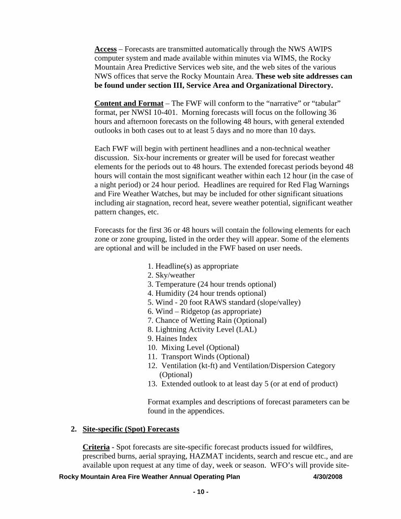
Access – Forecasts are transmitted automatically through the NWS AWIPS computer system and made available within minutes via WIMS, the Rocky Mountain Area Predictive Services web site, and the web sites of the various NWS offices that serve the Rocky Mountain Area. These web site addresses can be found under section III, Service Area and Organizational Directory.
Content and Format – The FWF will conform to the “narrative” or “tabular” format, per NWSI 10-401. Morning forecasts will focus on the following 36 hours and afternoon forecasts on the following 48 hours, with general extended outlooks in both cases out to at least 5 days and no more than 10 days.
Each FWF will begin with pertinent headlines and a non-technical weather discussion. Six-hour increments or greater will be used for forecast weather elements for the periods out to 48 hours. The extended forecast periods beyond 48 hours will contain the most significant weather within each 12 hour (in the case of a night period) or 24 hour period. Headlines are required for Red Flag Warnings and Fire Weather Watches, but may be included for other significant situations including air stagnation, record heat, severe weather potential, significant weather pattern changes, etc.
Forecasts for the first 36 or 48 hours will contain the following elements for each zone or zone grouping, listed in the order they will appear. Some of the elements are optional and will be included in the FWF based on user needs.
1. Headline(s) as appropriate 2. Sky/weather 3. Temperature (24 hour trends optional) 4. Humidity (24 hour trends optional) 5. Wind - 20 foot RAWS standard (slope/valley) 6. Wind – Ridgetop (as appropriate) 7. Chance of Wetting Rain (Optional) 8. Lightning Activity Level (LAL) 9. Haines Index 10. Mixing Level (Optional) 11. Transport Winds (Optional) 12. Ventilation (kt-ft) and Ventilation/Dispersion Category
(Optional) 13. Extended outlook to at least day 5 (or at end of product) Format examples and descriptions of forecast parameters can be found in the appendices.
2. Site-specific (Spot) Forecasts
Criteria - Spot forecasts are site-specific forecast products issued for wildfires, prescribed burns, aerial spraying, HAZMAT incidents, search and rescue etc., and are available upon request at any time of day, week or season. WFO’s will provide site-
Rocky Mountain Area Fire Weather Annual Operating Plan 4/30/2008 - 11 -
specific (spot) forecast services upon request of any qualified user agency to support land management activities associated with wildland fire (including prescribed burning). Providing non-federal, non-wildfire spots will be restricted to purposes directly related to personnel, equipment, fuels reduction projects (prescribed burns or spraying) for public safety, or interagency protection agreements providing such involvement).
A spot forecast will be assigned high priority by the receiving NWS office. Normally, a request should be provided to the requestor in less than 60 minutes of the receipt of the request. During heavy spot loads 60 minutes may be exceeded.
Site-specific forecasts are considered one-time requests, and are not routinely updated. However, spot forecasts should be updated when representative observations are available to the forecaster and he/she deems the current forecast does not adequately represent current or expected weather conditions. Land management personnel may contact the appropriate WFO for a spot update if forecast conditions appear unrepresentative of the actual weather conditions.
Spot forecasts will not be updated for changes within the third period of the forecast, because at this point spot forecasts will be 24 hours old, or nearly so, and a new spot forecast request should be submitted.
Priority for the update of spot forecasts is as follows:
• Wildfires • Prescribed burns or Wildland Fire Use (WFU) • Spot forecasts for non-critical operations, aerial spraying, etc
Site-specific forecasts for Wildfires managed for resource benefit (those fires with little or no suppression efforts). Initially, spot forecasts will be issued under the same guidelines as spot forecasts for a declared wildfire. The requesting agency should provide the local NWS office with an idea of how long the fire is expected to burn, and what weather conditions are critical to the prescription. With the initial spot forecast request, the requesting agency should set up a schedule for providing fire line weather observations to the NWS and requesting follow-on spot forecasts for the duration of the fire. The requesting agency is encouraged to also request more detailed long-range weather forecasts to aid in the planning and control efforts. Be sure to discuss these needs with the fire weather forecaster.
The spot forecast will be corrected when a significant typographical/format error is detected. Corrections should be delivered to users in the same manner as the original spot forecast when possible.
Spot forecast requests and updates will be responded to according to the instructions of the requesting agency. Web based spot forecast requests (from NWS web sites) are preferred, and will generally result in more efficient and timely feedback. The WFO will contact the local user by phone whenever the spot forecast is updated.
Rocky Mountain Area Fire Weather Annual Operating Plan 4/30/2008 - 12 -
Content and Format – Spot forecasts will contain the required minimum elements, unless otherwise specified upon request:
1. Headline (required when Red Flag Warning / Fire Weather Watch) 2. Discussion 3. Sky/weather (including chance of rain) 4. Temperature 5. Relative humidity 6. 20 foot winds
Optional elements (including transport winds, mixing depth, smoke dispersal, LAL, Haines index, etc.) may be included upon request. The valid time will be determined at the time of the request. Most spots contain three periods, usually “TODAY”, “TONIGHT”, and “NEXT DAY”, e.g., “TODAY”, “TONIGHT”, and “THURSDAY”.
Procedures – Internet-based NWS Spot is the standards for requesting and retrieving spot forecasts and should be used when available. They are accessible via web sites of the various NWS offices that serve the Rocky Mountain Area. Links to the web based spot program can be found under Section IV-D, individual forecast office information. In times when internet access is hindered or not possible, spot forecasts may be requested and disseminated via phone or fax using the backup spot forecast request form found in the appendices. In most cases, spot forecasts should be available in less than 60 minutes from the time the appropriate NWS office receives the request. The NWS should be contacted if a spot forecast is not available within this time frame. The requesting agency will provide information about the location, topography, fuel type(s), elevation(s), size, ignition time, contact name(s), and telephone number(s) of the responsible land management personnel.
Weather Observations- Quality representative weather observation(s) at, or within close proximity of the project should be made available to the responsible WFO along with the request for a spot forecast(s). At the beginning of a project, a nearby RAWS site may be used for the initial spot request if it is at a similar elevation, aspect, and sheltering, and has been shown to be very representative of the actual project. The requesting agency should provide the fire weather meteorologist with as many observations from the project as possible to help provide detail in the spot forecasts which will aid in fire behavior predictions. The best observations to send are those that show the maximum temperature, minimum humidity, and character of the winds from the previous afternoon. Additionally, a morning observation depicting the humidity recovery and downslope/downvalley wind is recommended. Failing to provide on-site complete observations, may result in a less accurate forecast.
However, there are special circumstances where fire personnel are unable to provide
on-site weather observation. Land Agencies should communicate to the responsible WFO when on-site weather observations are not possible.

Rocky Mountain Area Fire Weather Annual Operating Plan 4/30/2008 - 13 -
Certain prescribed burns will be considered high risk in Colorado for significant smoke impacts, as determined by the Smoke Risk Rating Worksheet for Prescribed Fire Projects which is part of the Colorado Memorandum of Understanding (MOU). These burns could either be Category III or IV burns, and requires detailed observations at least 3 days prior to burn as well as feedback. Consult with the Fire Weather Program Manager at the appropriate WFO well in advance of the scheduled burn date for further information.
Spot Forecast Feedback – Timely feedback on forecast performance (both positive and negative) is requested, and should be given whenever possible by the requesting agency.
3. Red Flag Program
The Red Flag program is a means by which the weather forecaster informs the land management agencies of the combination of dry fuels and critical weather conditions that support extreme fire behavior. Identification of Red Flag events is a primary responsibility of the forecaster producing the Fire Weather Planning Forecasts. A Red Flag Warning informs agencies of the imminent or actual occurrence of Red Flag conditions. A Red Flag Warning will be issued when there is high confidence that Red Flag criteria will be met within the next 24 hours, or when those criteria are already being met or exceeded. A warning may be issued for all, or portions of a fire weather zone or region. A Fire Weather Watch alerts agencies to the high potential for development of a Red Flag event in the 12-72 hours. A watch may only be issued (or continued) in the first 12-hour time period for dry thunderstorm events. The watch may be issued for all, or portions of a fire weather zone or region.
Criteria – The criteria for issuing of Fire Weather Watches and Red Flag Warnings in the Rocky Mountain Area are a combination of weather and fuels conditions (as determined by fire management) for any 3 hours or more in a 12 hour period. These criteria are defined as the following:
Fuel Criteria: -Fuel characteristics are favorable for large fire growth as determined by field level fire management using the Red Flag Fuels Support Page (Link Below).
http://www.blm.gov/colorado/rmafwx/fuel_status/public/index.php
It is the responsibility of field level fire management personnel to update the Red Flag Support Page every Monday by noon during typical NWS operations outlined in the AOP. Fuel status will be updated more often if fuel condition warrants. The fuel condition on the red flag support page will default to “Yes” if the assigned field level FMO or Fuel Specialist for the specific fire weather zone fails to update the fuel condition within a 7-day period. Additionally, the local NWS office has the option to contact the field level FMO, Fuel Specialist or agency representative responsible for
fuel input when their respective fire weather zones have not been updated, or use the “Yes” default as described above. Other tools or processes can also be utilized to determine fuel conditions (See below).
If the Red Flag Fuel Support Page has not been updated or is determined to be ineffective for NWS field offices, the NWS can utilize other tools to determine fuel conditions during the red flag decision process. These other tools include: 1) Fire Danger Indices as determined by NFDRS observations (Very High to Extreme); 2) Standardized fire season dates; 3) Direct phone conversation to local fire managers or dispatch; 4) Grassland Fire Danger Index (GFDI); 5) or other tools derived by local NWS offices and fire managers.
RMA Predictive Services will provide IT support including, logins and passwords, and internet support for the online fuel status program. RMCG representatives will contact RMA Predictive Services when positions are vacated. RMCG representatives will provide updated contact information for replacement personnel.
RMA Predictive Services will provide the local NWS office with a list of contacts assigned to their fire weather zones and responsible for updating the fuel status program.
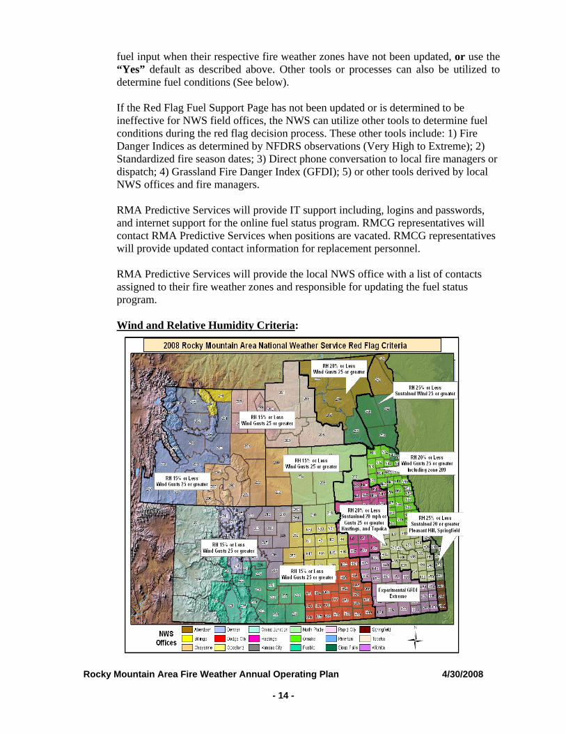
Wind and Relative Humidity Criteria:
Rocky Mountain Area Fire Weather Annual Operating Plan 4/30/2008 - 14 -
Rocky Mountain Area Fire Weather Annual Operating Plan 4/30/2008 - 15 -
Dry Thunderstorms Criteria: A fire weather watch or red flag warning will be issued for dry thunderstorm coverage of 15% or more, constituting an LAL of 6.
Issuing Fire Weather Watches and Red Flag Warning-A fire weather watch or red flag warning will be issued when fuel characteristics are “Yes” as determined and relayed by land agencies using the fuel status web page, and one of the weather criteria (as stated under 2 and 3 above) is met.
Additional Red Flag Factors:- In addition to the basic criteria above, a combination of other elements may result in Red Flag conditions. Haines Index of 5 or 6, wind shifts associated with cold frontal passages, significant wind shifts, microburst winds, first significant lightning (wet or dry, 15% coverage of thunderstorms or more) event after an extended hot and dry period, and poor RH recovery.
Note: The decision to issue a Fire Weather Watch or Red Flag Warning can be difficult and complicated at times. Coordination with neighboring NWS offices and Land Agencies will play a vital role in the final decision.
Product Format and Contents – An RFW product will be issued whenever a Fire Weather Watch or Red Flag Warning is issued, updated, extended, or canceled. The RFW message will include:
1. A standard UGC header coding, as mandated within the NWSI 10-401, including the fire weather zone number and expiration time
2. A headline, as mandated within NWSI 10-401 3. A short, but detailed discussion on the causes and nature of event, including
weather element values.
Procedures and Access - When Fire Weather Watches and Red Flag Warnings are issued, they will be headlined in spot forecasts, the general Fire Weather Planning Forecast (FWF) and appropriate zone sections within the FWF. The headline will be in the same descriptive format as on the RFW product itself. The FWF will be updated if a Fire Weather Watch or Red Flag Warning is issued, canceled, or expires. Red Flag Warnings and Fire Weather Watches will remain in effect through the expiration time noted in the forecast, or until canceled or extended. Red Flag Warnings and Fire Weather Watches are available within minutes of issuance via WIMS, the Rocky Mountain Area Predictive Services page and the web sites of the various NWS offices that serve the Rocky Mountain Area. These links can be found in the office directory (Section III) of this document.
Notification – When a Fire Weather Watch or Red Flag Warning is issued or updated (non-routine), NWS offices will verbally notify affected zone dispatch centers that fall under the watch or warning area. Also, the NWS will verbally notify the Rocky Mountain Area Coordination Center at (303)445-4300.
4. NFDRS Forecasts -
The National Weather Service provides 24-hour weather forecasts for NFDRS that
Rocky Mountain Area Fire Weather Annual Operating Plan 4/30/2008 - 16 -
allow the NFDRS software to predict the next day’s fire danger indices.
Observational Requirements –NFDRS observations must be complete and available in WIMS by 1350 LST (1450 LDT) local time to be received by NWS in time to produce a forecast. NFDRS stations that do not have valid observations in WIMS on time will not have next day fire danger indices available.
Content and Format – Complies with NWSI 10-401 and is outlined in Appendix A for reference. The actual NWS NDFRS forecast product is used only by WIMS and is not viewed directly by fire management.
Procedures – For every NFDRS observation received from WIMS at the 1350 local time collective, forecast weather parameters for 1300 local time the next day will be produced.
5. Participation in Interagency Groups -
NWS offices and land management providing service within the Rocky Mountain Area should provide representation at the regional AOP meeting held annually. Proxy representation is acceptable. NWS offices should host at least one meeting each year with local fire management units, or visit local fire management units once per year.
B. Special Services – Special meteorological services include mobile unit and other on-site
meteorological services, participation in user agency training activities, weather observer training, and weather observation station visits requested by user agencies, as time and office staffing permits. The services are usually provided away from the office or on overtime. As stated in the Interagency Agreement for Meteorological Services among the Interagency Wildland Fire Agencies and the National Weather Service, the user agencies will pay overtime, travel, and per diem costs for these special services. The NWS and Land Agencies will provide and maintain a cadre of trained IMETs to provide on-site incident meteorological support.
C. Forecaster Training - The NWS recognizes the need for specialized training in fire
weather meteorology for forecasters. All NWS meteorologist producing fire weather products will have met the requirements set forth in NWSI 10-405.
D. Individual Forecast Office Information
1. North Central and Northeast Colorado – Boulder, CO Unless otherwise
mentioned, it is to be assumed that services provided by NWS Boulder for units in northeast Colorado will follow the regional policies and procedures set forth in the Rocky Mountain Area Fire Weather AOP.
General Information The National Weather Service in Boulder, CO is responsible for providing Fire Weather support for north central and northeast Colorado. The area of responsibility covers Fire Weather Planning Forecast zones 211 through 218, and 238 through 251. The Boulder office is staffed with 13 meteorologists trained in fire weather
Rocky Mountain Area Fire Weather Annual Operating Plan 4/30/2008 - 17 -
forecasting, one of which is designated as an Incident Meteorologist. All fire weather forecasters are trained to produce all the routine fire weather products and spot forecasts. A Fire Weather Forecaster will be on duty 24 hours a day…seven days a week year round.
2008 changes: The Boulder office has a new IMET.
Training request procedures have been updated. Fire Weather Planning Forecasts (FWF) The fire weather planning forecast (FWF) will be issued by 0800 and 1600 during the designated fire season. Spot ForecastsThe Boulder office will prepare spot weather forecasts for prescribed burns and wildfires upon request for locations within the office’s county warning area (CWA). The primary means of requesting and disseminating spot forecasts is the NWSSpot Internet-based spot request and reply program. During your follow-up telephone call to ensure receipt, tell the forecaster that your reply is for a wildfire. If you have not received your spot after 60 minutes, call the WFO to check on the status of your spot or to determine if there has been a communications system failure. The NWS strongly encourages land agencies to use the “REMARKS” section within NWSSpot to provide feedback with all follow-up spot requests. NWSSpot for Boulder can be accessed at: http://spot.nws.noaa.gov/cgi-bin/spot/spotmon?site=bou When internet or computer capabilities are not available, fax, phone or telefax will be used to request a spot forecast. When requesting a non-wildfire spot forecast, it is STRONGLY SUGGESTED that requests during the fire season NOT be made between 1100 and 1500. Requests made during this time will occur during the key preparation period for the afternoon Fire Weather Planning Forecasts and will result in a much longer delay between the request and receipt of a spot forecast. Certain prescribed burns will be considered high risk for significant smoke impacts, as determined by the Smoke Risk Rating Worksheet for Prescribed Fire Projects which is part of the Colorado Memorandum of Understanding (MOU). These burns could either be Category III or Category IV burns, and requires detailed observations at least 3 days prior to burn as well as feedback. Consult with the Fire Weather Program Manager well in advance of the scheduled burn date for further information. Red Flag Warnings / Fire Weather Watches Red Flag Warnings and Fire Weather Watches will be issued as required for Colorado narrative zones 211 through 218, and 238 through 251 after coordination and collaboration with customers and adjacent NWS offices.
Rocky Mountain Area Fire Weather Annual Operating Plan 4/30/2008 - 18 -
Smoke Management Forecasts (SMF) This forecast is routinely issued no later than 1600 during the fire season. It is a separate product from the afternoon forecast and is valid for the tonight and tomorrow periods. The Smoke Management Forecast includes a brief discussion of airmass stability and any meteorological parameter that may affect smoke dispersal. The forecast also includes a forecast of transport winds, mixing heights and a ventilation forecast for the tonight and tomorrow time periods. NFDRS Forecasts This product is issued by 1515 during the fire season and is an separate product from the afternoon forecast. The forecasts are used as input to the National Fire Danger Rating System (NFDRS) through WIMS to compute fire danger indices. IMET Services The Boulder office has an IMET available for dispatch to major wildland fires and projects. Training There are three fire meteorologists available to handle fire weather training requests from north central/northeast Colorado customers. Training requests outside the area will be handled on case-by-case bases. All requests should be forwarded in writing to the office as early as possible to help ensure the request can be satisfied. Every attempt will be made to meet training requests. However, staffing limitations will need to be considered, and consequently, each request will be reviewed on a case by case basis. Additional Information The Boulder office maintains a Fire Weather Page on its web site home page. This page contains links to the FWF, RFW, Spot Forecasts, SMF, Public Fire Danger Statements, RAWS observations, the annual operating plan, and other fire weather related sites. A clickable map is provided to obtain a narrative FWF. Simply click on the map within the region of interest. To go directly to the Boulder fire weather web site, use the following url: http://www.crh.noaa.gov/bou/awebphp/fireindx.php BACK-UP The primary service backup for NWS Boulder is NWS Pueblo and the secondary backup is NWS Grand Junction (Please See Service Area and Organizational Directory). The servicing NWS office will notify their local dispatch centers and RMACC when the office is in or plans to be in backup mode. To receive a spot from a backup office, customers should access the web based spot program of the office that is providing the backup service.
2. South Central and Southeast Colorado - Pueblo, CO
Unless otherwise mentioned, it is to be assumed that services provided by NWS
Rocky Mountain Area Fire Weather Annual Operating Plan 4/30/2008 - 19 -
Pueblo will follow the regional policies and procedures set forth in the Rocky Mountain Area Fire Weather AOP. General Information The National Weather Service office in Pueblo provides fire weather support for most of south central and southeast Colorado. This area covers fire weather zones 220 through 237. The Pueblo office has a staff of 13 meteorologists, two of which are designated as the Incident Meteorologist (IMET). All fire weather forecasters are trained to produce all the routine fire weather products and spot forecasts. A Fire Weather Forecaster will be on duty 24 hours a day…seven days a week year round. 2008 changes: None Digital Web-Based Products WFO Pueblo continues to add services to the fire weather community through their web site weather.gov/pub. Information is derived from the Digital Forecast Database to develop graphical and digital products that are tailored to fire weather customers. Graphical fire weather and smoke management parameters are available by clicking on Fire Weather, in the left hand margin under Forecasts. This link will take you to the Fire Weather page where you will find links to our new graphical and digital products. These products are currently listed as experimental but they are part of our mainstream forecast process, and will be updated along with our Fire Weather Zones forecasts and other forecast products. Information available in graphical format includes all of the normal forecast parameters, and in addition includes the following parameters that are tailored to the fire weather community: Max and Min Relative Humidity Mixing Height Haines Index 10,000 ft Winds Transport Winds Ventilation Rate Lightning Activity Level 8-14 Day Temperature and Precipitation Outlook Critical Fire Weather Potential Graphic Digital text information is available for all RAWS sites by clicking on the link to the Experimental Fire Weather Point Forecast Matrix (PFM). This link will take you to a list of RAWS sites that you can click on to get a digital forecast with all fire weather forecast parameters. The NWS would appreciate your comments and opinions about these new, experimental, products. Each page has a link to a survey that will be sent to the
Rocky Mountain Area Fire Weather Annual Operating Plan 4/30/2008 - 20 -
National Weather Service Office in Pueblo. These surveys are anonymous and are designed to help us improve our services to the fire weather community. Fire Weather Planning Forecasts (FWF)Narrative Fire Weather Planning Forecasts will be issued by 0800 and 1600 each day during the designated fire season. The standard start and stop dates are outlined in the basic services. Spot Forecasts The Pueblo office will prepare spot weather forecasts for prescribed burns and wildfires as requested for locations within the office’s fire weather service area. The primary means of requesting and disseminating spot forecasts will be through the NWS Spot Internet based forecast/reply program. NWS Spot for Pueblo can be accessed at: http://spot.nws.noaa.gov/cgi-bin/spot/spotmon?site=pub When internet or computer capabilities are not available, fax, phone or telefax will be used to request a spot forecast. When requesting a non-wildfire spot forecast, it is STRONGLY SUGGESTED that requests during the fire season NOT be made between 1100 and 1500. Requests made during this time will occur during the key preparation period for the afternoon Fire Weather Planning Forecasts and will result in a much longer delay between the request and receipt of a spot forecast. To ensure receipt by the fire weather forecaster, the requester should call the NWS after submitting each spot request. During this follow-up telephone call, please be sure to tell the forecaster if the request is for a wildfire so it can receive the proper priority. Certain prescribed burns will be considered high risk for significant smoke impacts, as determined by the Smoke Risk Rating Worksheet for Prescribed Fire Projects which is part of the Colorado Memorandum of Understanding (MOU). These burns could either be Category III or Category IV burns, and requires detailed observations at least 3 days prior to burn as well as feedback. Consult with the Fire Weather Program Leader well in advance of the scheduled burn date for further information. Red Flag Warnings / Fire Weather WatchesRed Flag Warnings and Fire Weather Watches will be issued as required for Colorado narrative zones 220 through 237 after coordination and collaboration with customers and adjacent NWS offices. Smoke Management Forecasts (SMF)This forecast is issued no later than 1600 during the fire season. It is a separate product from the afternoon forecast and is valid for the first 48 hours.
Rocky Mountain Area Fire Weather Annual Operating Plan 4/30/2008 - 21 -
The Smoke Management Forecast includes a brief discussion of airmass stability and any meteorological parameter that may affect smoke dispersal. The forecast also includes a forecast of transport winds, mixing heights and a ventilation forecast. NFDRS ForecastsThis product is issued at 1515 during the fire season and is a separate product form the afternoon forecast. The forecasts are used as input to the National Fire Danger Rating System (NFDRS) through WIMS to compute fire danger indices. IMET Services The Pueblo office has 2 IMETs available for dispatch to major forest fires and projects. Training Services The fire weather program leader/IMET or assistant fire weather program leader, may be available to handle fire weather training requests from south central/southeast Colorado customers. Training requests outside the area will be handled on case-by-case bases. Refer all training requests or technical support questions to the Program Leader or his Assistant. Additional Information The Pueblo office maintains a Fire Weather Page on its web site home page. This page contains links to forecasts (FWF), RFW, Spot Forecasts, SMF, RAWS observations, the annual operating plan, and other fire weather related sites. A clickable map is provided to obtain a narrative FWFs. Simply click on the map within the region of interest. To go directly to the Pueblo fire weather web site, use the following url: http://weather.gov/pub?n=/fire/index.php BACK-UPThe primary service backup for NWS Pueblo is NWS Boulder and the secondary backup is NWS Goodland (Please See Service Area and Organizational Directory). The servicing NWS office will notify there local dispatch centers and RMACC when the office is in or plans to be in backup mode. To receive a spot from a backup office, customers should access the web based spot program of the office that is providing the backup service.
3. Western Colorado – Grand Junction, CO
Unless otherwise mentioned, it is to be assumed that services provided by NWS Grand Junction will follow the regional policies and procedures set forth in the Rocky Mountain Area Fire Weather AOP. General InformationThe Grand Junction Weather Forecast Office (WFO) provides fire weather support for western Colorado and eastern Utah. Its area of responsibility covers Colorado fire
Rocky Mountain Area Fire Weather Annual Operating Plan 4/30/2008 - 22 -
weather zones 201, 203, 205, and 207. Refer to the map at the end of this section. The Grand Junction office is staffed with 10 meteorologists trained in fire weather forecasting, two of which are certified Incident Meteorologists (IMET). All forecasters have been trained to produce all the routine fire weather products, warnings, watches, and spot forecasts. 2008 changesNone Fire Weather Planning ForecastsThe fire weather planning forecast (FWF) will be issued by 0800 and 1600 during the designated fire season. Spot ForecastsThe Grand Junction office prepares spot weather forecasts for prescribed burns and wildfires as requested for locations within the office’s county warning area (CWA). There is one exception: WFO Grand Junction provides spot forecasts for that part of the Gunnison National Forest within northwest Saguache County, as per an agreement with the Gunnison National forest and the Grand Junction and Pueblo WFOs. The primary means of requesting and disseminating spot forecasts is the NWSSpot Internet-based spot request and reply program. To ensure receipt by the fire weather forecaster, the requester should call the NWS after submitting each spot request. If you have not indicated on the spot request, during your follow-up telephone, please tell the forecaster that your request is for a wildfire or a prescribed burn, so that your request can receive the proper priority. This call to the WFO will also allow the fire weather forecaster to ask any questions he/she might have, and inform you if multiple spot requests may delay completing your forecast. WFO Grand Junction will show the same courtesy by calling the requesting agency after each completed spot forecast is transmitted. The NWS strongly encourages land agencies to use the “REMARKS” section within NWSSpot to provide feedback with all follow-on spot requests. NWS Spot for Grand Junction can be accessed at: http://spot.nws.noaa.gov/cgi-bin/spot/spotmon?site=gjt When internet or computer capabilities are not available, fax or phone can be used to request a spot forecast. When requesting a non-wildfire spot forecast any time of year, it is strongly suggested that requests NOT be made between 1100 and 1500. Requests made during this time will occur during the key preparation period for the afternoon routine weather forecasts and will result in a delay in completing the spot forecast. Certain prescribed burns will be considered high risk for significant smoke impacts, as determined by the Smoke Risk Rating Worksheet for Prescribed Fire Projects,
Rocky Mountain Area Fire Weather Annual Operating Plan 4/30/2008 - 23 -
which is part of the Colorado Memorandum of Understanding (MOU). These burns could either be Category III or Category IV burns, and REQUIRE detailed observations at least 3 days prior to burn. Consultation with the fire weather program leader or assistant program leader, well in advance of the scheduled burn date, daily feedback, and fire line observations throughout the course of the project are required by the Smoke Risk Rating Worksheet and the Colorado MOU. Red Flag Warnings / Fire Weather WatchesWFO Grand Junctions issues Red Flag Warnings and Fire Weather Watches as required for its all part of its County Warning Area (CWA), after coordination and collaboration with customers and adjacent NWS offices as outlined in the Basic Services section of this AOP. Smoke Management Forecasts (SMF) This forecast is issued no later than 1600 during the fire season. It is a separate product from the afternoon forecast and is valid for the tonight and tomorrow periods. The Smoke Management Forecast includes a brief discussion of airmass stability and meteorological parameters that may affect smoke dispersal. The forecast also includes a forecast of transport winds, mixing heights and a ventilation index (clearing index for eastern Utah) for the tonight and tomorrow time periods. NFDRS ForecastsThis product is issued at 1515 during the fire season and is a separate product from the afternoon forecast. The forecasts are used as input to the National Fire Danger Rating System (NFDRS) through WIMS to compute fire danger indices. IMET ServicesThe Grand Junction office has two certified IMETs available for dispatch to major forest fires and incidents. Dispatch for significant prescribed burn projects, i.e., CAT III and CAT IV burns, will only be possible when coordination with the fire weather program leader and WFO Meteorologist- in- Charge (MIC) has been accomplished well in advance (months in advance) of the project and only when NWS manpower and resources permit. Training ServicesThe fire weather program leader, assistant fire weather program leader, IMETs, or MIC may be available for fire weather training requests from western Colorado and eastern Utah customers. Training requests outside the area will be handled on case-by-case bases. Refer all training requests or technical support questions to the program leader, assistant program leader, and MIC. Additional InformationThe Grand Junction office maintains a Fire Weather Page on its web site home page. This page contains links to forecasts, warning and watches, spot forecasts, RAWS observations, the annual operating plan, and other fire weather related sites. A clickable map is provided to obtain a narrative forecast. Simply click on the map at the point of interest or input the exact latitude and longitude to get a forecast. To go directly to the Grand Junction fire weather web site, use the following url:
Rocky Mountain Area Fire Weather Annual Operating Plan 4/30/2008 - 24 -
http://www.crh.noaa.gov/gjt/fire.php BACK-UPThe primary service backup for NWS Grand Junction is NWS Salt Lake City and the secondary backup is NWS Boulder (Please See Service Area and Organizational Directory). The servicing NWS office will notify there local dispatch centers and RMACC when the office is in or plans to be in backup mode. To receive a spot from a backup office, customers should access the web based spot program of the office that is providing the backup service.
4. Western-Central-Northern, Wyoming- Riverton, Wyoming
Unless otherwise mentioned, it is to be assumed that services provided by NWS Riverton will follow the regional policies and procedures set forth in the Rocky Mountain Area Fire Weather AOP.
General InformationThe National Weather Service in Riverton is responsible for providing fire weather support for western-central-northern Wyoming. Its area of responsibility covers Wyoming fire weather zones 140, 275 through 283, 285 through 289, and 414 through 416. The Riverton office is staffed with 14 meteorologists trained in fire weather forecasting, two are designated as Incident Meteorologists (IMETs). All fire weather forecasters are trained to produce all the routine fire weather products and spot forecasts. 2008 changesFire Weather Zone 274 - Sheridan County is now handled by NWS Billings. FARSITE data will be generated with every spot request. The data can be accessed from the NWS Riverton Fire Weather homepage. Fire Weather Planning ForecastsThe Riverton office will issue routine Fire Weather Planning Forecasts (FWF) for its zones by 0700 and 1500 during the prescribed burn and wildfire seasons outlined in this AOP. The Riverton office will provide a noon update to the FWF that will focus on changes to the afternoon and early evening forecast. If no changes are expected, the morning forecast shall be retransmitted with NO CHANGES TO THE MORNING FORECAST added to the beginning of the discussion.
Spot ForecastsThe Riverton office issues spot forecasts in support of wildfire and prescribed fire operations within its area of responsibility. Normally, spots forecasts will be provided to you within 30 to 45 minutes of the receipt of the request for wild fire and for prescribed burns when prior notification has been provided. Forecasts can be requested and retrieved at the web site below:
Rocky Mountain Area Fire Weather Annual Operating Plan 4/30/2008 - 25 -
http://spot.nws.noaa.gov/cgi-bin/spot/spotmon?site=riw
When internet or computer capabilities are not available, fax or phone will be used to request a spot forecast. Red Flag Warnings / Fire Weather WatchesRed Flag Warnings and Fire Weather Watches will be issued as appropriate for Wyoming fire weather zones 140, 275 through 283, 285 through 289, and 414 through 416. Smoke Management Forecasts (SMF)The Riverton office does not issue a separate SMF. Smoke management forecast elements (transport winds, mixing height and ventilation or dispersion) are located within the Fire Weather Planning Forecasts (FWF). NFDRS ForecastsNational fire danger rating system trend forecasts are routinely issued seven days a week from May 1st to November 1st of each year as observations are provided by the Land Management Agencies. The trend forecasts shall be prepared by 1600 each afternoon. Requests for spot forecasts in the afternoon may delay the issuance of the trend forecasts, as spot forecasts shall take priority over the trend forecasts. IMET Services The Riverton office has two IMETs available for dispatch. Incident response meteorologist services (IMET dispatch) are usually available locally upon request 24 hours a day, seven days a week throughout the year. Due to scheduling conflicts and leave, at times an IMET from WFO Riverton may not be available for dispatch. If this is the case another IMET within the Rocky Mountain Area, the Eastern Great Basin Area or the Northern Rockies Area will usually be available. IMET dispatches shall be coordinated through the National Interagency Fire Coordination Center (NIFC). Training Services There are five fire meteorologists available to assist the user agencies with training at fire behavior and other weather related courses. A request should be forwarded in writing to the office as early as possible to help ensure the request can be satisfied. Every attempt will be made to meet training requests. However, staffing limitations will need to be considered, and consequently, each request will be reviewed on a case by case basis.
Additional Information
The Riverton office maintains a Fire Weather Page on its web site home page. This Page contains links to forecasts (FWF), RFW, Spot Forecasts, FARSITE, RAWS observations, the annual operating plan, and other fire weather related sites. A clickable map is provided to obtain a narrative FWFs. Simply click on the map within the region of interest. To go directly to the Riverton fire weather web site, use the following url:
Rocky Mountain Area Fire Weather Annual Operating Plan 4/30/2008 - 26 -
http://www.crh.noaa.gov/riw/fire.htm
BACK-UP The primary service backup for NWS Riverton is NWS Cheyenne and the secondary backup is NWS Billings (Please See Service Area and Organizational Directory). The servicing NWS office will notify there local dispatch centers and RMACC when the office is in or plans to be in backup mode. To receive a spot from a backup office, customers should access the web based spot program of the office that is providing the backup service.
5. Northern Bighorn Mountains/Bighorn Canyon Rec. Area – Billings, MT
Unless otherwise mentioned, it is to be assumed that services provided by NWS Billings will follow the regional policies and procedures set forth in the Rocky Mountain Area Fire Weather AOP.
General Information The National Weather Service in Billings is responsible for providing Fire Weather support for the Northern Bighorn Mountains of Wyoming (zone 284), the remainder of Sheridan County (zone 274) and the Wyoming portion of the Bighorn Canyon Recreation Area (zone number 129). The Billings office is staffed with 12 meteorologists trained in fire weather forecasting, one of which is designated as Incident Meteorologist (IMET). All fire weather forecasters are certified to produce all the routine fire weather products and spot forecasts. 2008 changes Inclusion of fire zone 274 which was transferred to Billings in July 2007. Fire Weather Planning Forecasts Forecasts commence in late March or early April, ending in November. The active fire season typically lasts from July through October. All dates are flexible and determined with user input. Typical forecast issuance times: Early spring Morning Daily 0700 May1 thru October 31 Mornings Daily 0700 Afternoons Daily 1500 - 1530 November Mornings Daily 0700 Spot Forecasts The Billings office will prepare spot weather forecasts for prescribed burns and wildfires as requested for locations within the office’s fire weather service area. The primary means of requesting and disseminating spot forecasts will be through the NWS Spot internet forecast/reply program which can be accessed at:
http://spot.nws.noaa.gov/cgi-bin/spot/spotmon?site=byz
Rocky Mountain Area Fire Weather Annual Operating Plan 4/30/2008 - 27 -
When internet or computer capabilities are not available fax or phone will be used to request a spot forecast. During your follow-up telephone call to ensure receipt of the request, please be sure to tell the forecaster if your request is for a wildfire. Red Flag Warnings / Fire Weather Watches Red Flag Warnings and Fire Weather Watches will be issued as required for Billings narrative zones 129, 274 and 284 after coordination and collaboration with customers and adjacent NWS offices. Smoke Management Forecasts The Billings office issues a graphical Clearing Index Forecast which is available on the internet web site.
NFDRS Forecasts This product is issued at 1515 during the fire season and is a separate product from the afternoon forecast. The forecasts are used as input to the National Fire Danger Rating System (NFDRS) through WIMS to compute fire danger indices. IMET Services The Billings office has one IMET available for dispatch. Training Services The office has a cadre of meteorologists that may be available to handle fire weather training requests from northern Wyoming customers. Training requests outside the area will be handled on case-by-case basis. Refer all training requests or technical support questions to the Focal Point or his Meteorologist in Charge. Fire Weather Web Page The Billings Fire Weather Web http://www.wrh.noaa.gov/byz/fire.php contains links to forecasts, Red Flag Warnings and Fire Weather Watches, Spot Forecasts, RAWS and other observations, digital and graphical products, planning tools and the annual operating plan. FARSITE Data Support NWS Billings offers automatic 7-day FARSITE weather data support with wildfire spot forecast issuances. For prescribed burn spot forecasts, FARSITE data will be produced at the request of the agency. Please call the NWS office issuing the prescribed burn forecast directly to request this service, or place the request in the “Remarks Section” of the spot request form. All FARSITE data will be available from the internet via the appropriate NWS office Fire Weather Page. Check for a “FARSITE Forecasts” button near the Spot Forecast Request link. The data will be in simple ASCII format. Examples of the two FARSITE support outputs (“weather” and “wind”) are below.
Weather:
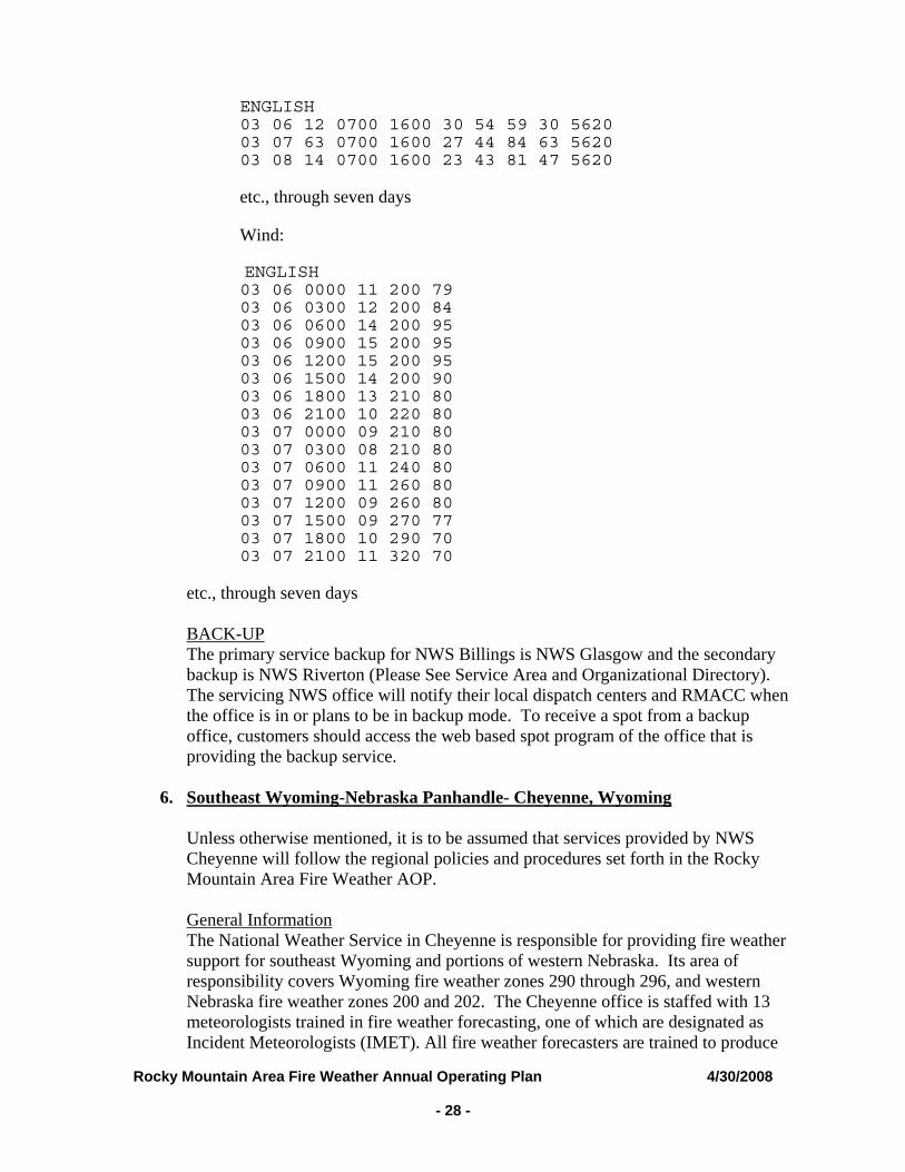
Rocky Mountain Area Fire Weather Annual Operating Plan 4/30/2008 - 28 -
ENGLISH 03 06 12 0700 1600 30 54 59 30 5620 03 07 63 0700 1600 27 44 84 63 5620 03 08 14 0700 1600 23 43 81 47 5620
etc., through seven days
Wind:
ENGLISH 03 06 0000 11 200 79 03 06 0300 12 200 84 03 06 0600 14 200 95 03 06 0900 15 200 95 03 06 1200 15 200 95 03 06 1500 14 200 90 03 06 1800 13 210 80 03 06 2100 10 220 80 03 07 0000 09 210 80 03 07 0300 08 210 80 03 07 0600 11 240 80 03 07 0900 11 260 80 03 07 1200 09 260 80 03 07 1500 09 270 77 03 07 1800 10 290 70 03 07 2100 11 320 70
etc., through seven days BACK-UP The primary service backup for NWS Billings is NWS Glasgow and the secondary backup is NWS Riverton (Please See Service Area and Organizational Directory). The servicing NWS office will notify their local dispatch centers and RMACC when the office is in or plans to be in backup mode. To receive a spot from a backup office, customers should access the web based spot program of the office that is providing the backup service.
6. Southeast Wyoming-Nebraska Panhandle- Cheyenne, Wyoming
Unless otherwise mentioned, it is to be assumed that services provided by NWS Cheyenne will follow the regional policies and procedures set forth in the Rocky Mountain Area Fire Weather AOP.
General Information The National Weather Service in Cheyenne is responsible for providing fire weather support for southeast Wyoming and portions of western Nebraska. Its area of responsibility covers Wyoming fire weather zones 290 through 296, and western Nebraska fire weather zones 200 and 202. The Cheyenne office is staffed with 13 meteorologists trained in fire weather forecasting, one of which are designated as Incident Meteorologists (IMET). All fire weather forecasters are trained to produce
Rocky Mountain Area Fire Weather Annual Operating Plan 4/30/2008 - 29 -
all the routine fire weather products and spot forecasts. 2008 changes None Fire Weather Planning Forecasts The Cheyenne office will issue routine Fire Weather Planning Forecasts (FWF) for its zones by 0700 and 1430 during the prescribed burn and wildfire seasons outlined in this AOP. Spot Forecasts The Cheyenne office issues spot forecasts in support of wildfire and prescribed fire operations within its area of responsibility. Normally, spots forecasts will be provided to you within 30 to 45 minutes of the receipt of the request for wild fire and for prescribed burns when prior notification has been provided. http://spot.nws.noaa.gov/cgi-bin/spot/spotmon?site=cys Red Flag Warnings / Fire Weather Watches NWS Cheyenne issues Red Flag Warnings and Fire Weather Watches as appropriate for the fire weather zones in its fire weather service area. Smoke Management Forecasts (SMF) The Cheyenne office does not issue a separate SMF. Smoke management forecast elements (transport winds, mixing height and ventilation) are located within the Fire Weather Planning Forecasts (FWF). NFDRS Forecasts National fire danger rating system trend forecasts are routinely issued seven days a week from May 1st to November 1st of each year as observations are provided by the Land Management Agencies. The trend forecasts shall be prepared by 1600 each afternoon. Requests for spot forecasts in the afternoon may delay the issuance of the trend forecasts, as spot forecasts shall take priority over the trend forecasts. IMET Services The IMETs at NWS Cheyenne has primary responsibility for incident response in Southeast Wyoming. Training Services The fire weather program leader, assistant fire weather program leader, or IMET may be available to handle fire weather training requests from southeast Wyoming customers. Training requests outside the area will be handled on case-by-case bases. Refer all training requests or technical support questions to the Focal Point or his Assistant Additional Information The Cheyenne office maintains a Fire Weather Page on its web site home page. This
Rocky Mountain Area Fire Weather Annual Operating Plan 4/30/2008 - 30 -
page contains links to forecasts (FWF), RFW, Spot Forecasts, RAWS observations, the annual operating plan, and other fire weather related sites. A clickable map is provided to obtain a narrative FWFs. Simply click on the map within the region of interest. To go directly to the Cheyenne fire weather web site, use the following url: http://www.crh.noaa.gov/cys/firewx.php BACK-UP The primary service backup for NWS Cheyenne is NWS Riverton and the secondary backup is NWS Rapid City (Please See Service Area and Organizational Directory). The servicing NWS office will notify there local dispatch centers and RMACC when the office is in or plans to be in backup mode. To receive a spot from a backup office, customers should access the web based spot program of the office that is providing the backup service.
7. Northeast Wyoming – Western South Dakota- Rapid City, SD
Unless otherwise mentioned, it is to be assumed that services provided by NWS Rapid City will follow the regional policies and procedures set forth in the Rocky Mountain Area Fire Weather AOP. General Information The National Weather Service in Rapid City is responsible for providing fire weather support for portions of Northeast Wyoming and Western South Dakota. Its area of responsibility covers Northeast Wyoming fire weather zones 259, 297, 298, and 299, and Western South Dakota fire weather zones 260 through 266. The Rapid City office is staffed with 9 meteorologists trained in fire weather forecasting. All fire weather forecasters are trained to produce all fire weather products. Changes for 2008 None. Fire Weather Forecasts The Rapid City office will issue routine Fire Weather Planning Forecasts (FWF) for all of its fire zones by 0700 LT, March 15 through October 31, and both 0700 LT and 1430 LT July 1 through September 30. Requests for an early start or an extension to the FWF product season should be made in writing to: David M. Carpenter Meteorologist in Charge 300 East Signal Drive Rapid City, SD 57701-3800 Spot Forecasts The Rapid City office issues spot forecasts in support of wildfire and prescribed fire operations within its area of responsibility. Normally, spots forecasts will be provided to you within 30 to 45 minutes of the receipt of the request for wild fire and for prescribed burns when prior notification has been provided.
Rocky Mountain Area Fire Weather Annual Operating Plan 4/30/2008 - 31 -
http://spot.nws.noaa.gov/cgi-bin/spot/spotmon?site=unr Red Flag Warnings / Fire Weather Watches NWS Rapid City issues Red Flag Warnings and Fire Weather Watches as appropriate for the fire weather zones in its fire weather service area. Smoke Management Forecasts (SMF) Smoke management forecast elements (transport winds, mixing height and ventilation) are included in the Fire Weather Planning Forecasts (FWF). NFDRS Forecasts National fire danger rating system trend forecasts are routinely issued seven days a week from May 1st to November 1st of each year as observations are provided by the Land Management Agencies. The trend forecasts shall be prepared by 1600 each afternoon. Requests for spot forecasts in the afternoon may delay the issuance of the trend forecasts, as spot forecasts shall take priority over the trend forecasts. IMET Services The Rapid City office does not have a trained IMET. Training Services Fire Meteorologists are available for all training requests. Please send a letter to the Rapid City NWS Office requesting these services with the time, date, and place of the training. David M. Carpenter Meteorologist in Charge 300 East Signal Drive Rapid City, SD 57701-3800 Additional Information The Rapid City office maintains a Fire Weather Page on its web site home page. This page contains links to fire weather planning forecasts (FWF), Red Flag Warning and Fire Weather Watch (RFW), Spot Forecasts, South Dakota Grassland Fire Danger, the Annual Operating Plan, and other fire weather related information. A clickable map is provided to obtain the narrative FWF for each Fire Zone. Simply click on the map within the region of interest. To go directly to the Rapid City fire weather web site, use the following URL: http://www.crh.noaa.gov/unr/?n=firewx BACK UP Primary back up of the Rapid City office for all Fire Weather Products will be done by the North Platte NWS office, and the Cheyenne NWS office as a secondary back up office. Contact numbers for these offices can be found in the main body of the Rocky Mountain Area Fire Weather AOP.
Rocky Mountain Area Fire Weather Annual Operating Plan 4/30/2008 - 32 -
8. Central, North Central, and Northeast South Dakota – Aberdeen, SD
Unless otherwise mentioned, it is to be assumed that services provided by WFO Aberdeen for its area of responsibility in South Dakota will follow the regional policies and procedures set forth in the Rocky Mountain Area Fire Weather AOP.
General Information The National Weather Service in Aberdeen is responsible for providing fire weather support for portions of central, north central and northeast South Dakota, and two counties in west central Minnesota. Its area of responsibility covers South Dakota fire weather zones 267 through 273 and Minnesota fire weather zones 036 and 046. The Aberdeen office is staffed with 9 meteorologists trained in fire weather forecasting. All fire weather forecasters are trained to produce all the routine fire weather products and spot forecasts. Changes for 2008 None Fire Weather Planning Forecasts The Aberdeen office will issue routine Fire Weather Planning Forecasts (FWF) for its zones by 0700 and 1630 during the prescribed burn and wildfire seasons -- typically April 1 through October 31. However, these dates are general guidelines and are flexible depending upon weather and fuels conditions, thus beginning and ending dates may be later or earlier than listed above. Spot Forecasts Aberdeen will issue spot forecasts upon request for locations within its fire weather service area. The primary means of requesting and disseminating spot forecasts will be through the internet based NWSpot forecast/reply program. NWSpot for WFO Aberdeen can be accessed at: http://spot.nws.noaa.gov/cgi-bin/spot/spotmon?site=abr When internet or computer capabilities are not available, fax or phone will be used to request a spot forecast. Red Flag Warnings / Fire Weather Watches NWS Aberdeen issues Red Flag Warnings and Fire Weather Watches as appropriate for the counties in its fire weather service area. Appropriate fire weather products will contain a statement as to the impact of such warnings/watches on the applicable fire weather zones. Rangeland Fire Danger Statement WFO Aberdeen issues a Rangeland Fire Danger (RFD) Statement as appropriate when the rangeland fire danger index reaches the very high or extreme categories. The RFD is issued for applicable counties. This statement serves the public, media
Rocky Mountain Area Fire Weather Annual Operating Plan 4/30/2008 - 33 -
and user agencies with a product that defines burning conditions which are severe or extreme, but with conditions not as critical as under a Red Flag Warning. In addition to this statement, a Rangeland Fire Danger map is posted daily on the WFO Aberdeen fire weather website during the prescribed burn and wildfire seasons as described above. To display the Rangeland Fire Danger Statement for a specific county, click on the applicable county in the map. NFDRS Forecasts National fire danger rating system trend forecasts are routinely issued seven days a week from April 1st to October 31st of each year as observations are provided by the Land Management Agencies. The trend forecasts shall be prepared by 1600 each afternoon. Requests for spot forecasts in the afternoon may delay the issuance of the trend forecasts, as spot forecasts shall take priority over the trend forecasts. IMET Services The Aberdeen office has one IMET available for dispatch. Training Services Fire Meteorologists may be available for training requests from customers within the WFO Aberdeen area of responsibility. Training requests outside the area will be handled on case-by-case bases. Refer all training requests or technical support questions to the Fire Weather Focal Point or Assistant Fire Weather Focal Point. Additional Information The Aberdeen office maintains a Fire Weather Page on its internet webpage. This page contains links to the FWF, RFW, RFD, Spot Forecasts, RAWS observations, the annual operating plan, and other fire weather related sites. A clickable map is provided to obtain a narrative FWF. Simply click on the map within the region of interest. To go directly to the Aberdeen fire weather web site, use the following URL: http://www.crh.noaa.gov/abr/FireWeather/fire_danger.htm BACK-UP The primary service backup for WFO Aberdeen is WFO Sioux Falls and the secondary backup is WFO Bismarck (Please See Service Area and Organizational Directory). During the prescribed burn and wildfire seasons, the servicing NWS office will notify their local dispatch centers and RMACC when the office is in or plans to be in backup mode. To receive a spot from a backup office, customers should access NWSpot via the backup office’s fire weather webpage.
9. South Central-Southeast South Dakota – Sioux Falls, South Dakota
Unless otherwise mentioned, it is to be assumed that services provided by NWS Sioux Falls will follow the regional policies and procedures set forth in the Rocky Mountain Area Fire Weather AOP.
General Information The National Weather Service in Sioux Falls is responsible for providing fire weather
Rocky Mountain Area Fire Weather Annual Operating Plan 4/30/2008 - 34 -
support for the southeast quadrant, a small portion of south central South Dakota, southwest Minnesota, extreme northeast Nebraska, and northwest Iowa. Its area of responsibility covers South Dakota fire weather zones 255 through 258, and Minnesota fire zone 900, Nebraska fire weather zone 249 and Iowa fire weather zone 300 and 301. The Sioux Falls office is staffed with 10 meteorologists and one hydro-meteorological technician trained in fire weather forecasting. All fire weather forecasters are trained to produce all the routine fire weather products and spot forecasts. Changes for 2008 None. Fire Weather Planning Forecasts The Sioux Falls office will issue routine Fire Weather Planning Forecasts (FWF) for its zones with “no later than” issuance times of 0700 and 1600 during the prescribed burn and wildfire seasons, which closely correlate to April 1st through May 31st, and again from August 15th through October 31st. From June1st through August 14th, only the morning Fire Weather Planning Forecast will be issued unless directed otherwise through interagency agreement. This is due to radically decreased burning conditions during the “green” period in the true summer months. Spot Forecasts Spot forecasts prepared by the Sioux Falls weather office are available by request, 24 hours a day, 7 days per week, for locations within the office’s fire weather service area. The primary means of requesting and disseminating spot forecasts will be through the internet based NWSpot forecast/reply program. NWSpot for Sioux Falls can be accessed at: http://spot.nws.noaa.gov/cgi-bin/spot/spotmon?site=fsd When internet or computer capabilities are not available, fax or phone will be used to request a spot forecast. Red Flag Warnings / Fire Weather Watches NWS Sioux Falls issues Red Flag Warnings and Fire Weather Watches as appropriate for fire weather zones within its fire weather service area. All attempts at coordination with involved user agencies are first attempted. Grassland Fire Danger Statement NWS Sioux Falls issues a Grassland Fire Danger Statement as appropriate when the grassland fire danger index reaches the very high or extreme categories. This statement serves the public, media and user agencies with a product that defines burning conditions which are severe or extreme, but with conditions not as critical as under a Red Flag Warning. In addition to this formal statement, a Grassland Fire Danger map is posted daily on the Sioux Falls fire weather website (see the additional information section below for the URL) from April 1st through October 31st no matter what the index rates.
Rocky Mountain Area Fire Weather Annual Operating Plan 4/30/2008 - 35 -
NFDRS Forecasts None IMET Services The Sioux Falls office has an IMET in training Training Services The fire weather focal point is available for training services in resident courses with user agencies in the Sioux Falls forecast area. Specific user agency responsibilities in the reimbursement of costs associated with travel, per diem and overtime, are detailed in the National Interagency Agreement for Meteorological Services. Additional Information The Sioux Falls office maintains a Fire Weather Page on its web site home page. This page contains links to the Fire Weather Planning Forecast (FWF), Grassland Fire Danger Index, Spot Forecasts, Red Flag Warnings/Fire Weather Watches, products from the Storm Prediction Center, RAWS observations, the annual operating plan, and other fire weather related sites. A clickable map is provided to obtain a narrative FWF. Simply click on the map within the region of interest. To go directly to the Sioux Falls fire weather web site, use the following URL: http://www.crh.noaa.gov/fsd/firewx.htm BACK-UP The primary service backup for NWS Sioux Falls is NWS Aberdeen and the secondary backup is NWS Minneapolis (Please See Service Area and Organizational Directory). The servicing NWS office will notify there local dispatch centers and RMACC when the office is in or plans to be in backup mode. To receive a spot from a backup office, customers should access the web based spot program of the office that is providing the backup service.
10. Western and North Central Nebraska – North Platte, Nebraska
Unless otherwise mentioned, it is to be assumed that services provided by NWS North Platte will follow the regional policies and procedures set forth in the Rocky Mountain Area Fire Weather AOP. General Information The National Weather Service in North Platte is responsible for providing fire weather support for portions of Western and North Central Nebraska. Its area of responsibility covers Nebraska fire weather zones 204, 206, 208, 209, 210, and 219. The North Platte office is staffed with 9 meteorologists trained in fire weather forecasting. All fire weather forecasters are trained to produce all the routine fire weather products and spot forecasts. 2008 changes None
Rocky Mountain Area Fire Weather Annual Operating Plan 4/30/2008 - 36 -
Fire Weather Planning Forecasts The North Platte office will issue routine Fire Weather Planning Forecasts (FWF) for it’s zones twice daily by 0700 and 1600 during the prescribed and wildfire season. The FWF product may also be reduced to one issuance by 0700, or suspended, after coordination between NWS North Platte and our users. This most likely will occur during green up and abnormally wet periods when extreme fire behavior is minimal. Spot Forecasts The North Platte office prepares spot weather forecasts for prescribed burns and wildfires as requested for locations within the office’s county warning area (CWA). The primary means of requesting and disseminating spot forecasts is the NWSSpot Internet-based spot request and reply program. Internet requests are preferred and once sent, will alarm at the forecaster workstation. Phone calls to the WFO are welcome to ensure receipt of the spot request by the fire weather forecaster. If you have not received your spot forecast after 60 minutes, call the WFO to check on the status of your spot or to determine if there has been a communications system failure. The NWS strongly encourages land agencies to use the “REMARKS” section within NWSSpot to provide feedback with all follow-on spot requests. NWS Spot for North Platte can be accessed at: http://spot.nws.noaa.gov/cgi-bin/spot/spotmon?site=lbf When internet or computer capabilities are not available, fax or phone can be used to request a spot forecast. Red Flag Warnings / Fire Weather Watches NWS North Platte issues Red Flag Warnings and Fire Weather Watches as appropriate for the fire weather zones in its fire weather service area. Critical fire weather conditions occurring outside the normal fire season will be relayed to the local customers via the Hazardous Weather Outlook (OMAHWOLBF) product for RH values at 20 percent or less. A phone call to the users will be utilized if RH values drop below 15 percent. NFDRS Forecasts WFO North Platte currently has one forecast point located at the Bessey Ranger District, in the Nebraska National Forest near Halsey. This product is issued around 1530 during the fire season and is used as input to the National Fire Danger Rating System (NFDRS) through WIMS to compute fire danger indices. IMET Services The North Platte office does not have a trained IMET. Training Services The fire weather program leader, SOO, or MIC may be available to handle fire weather training requests from customers within the WFO North Platte CWA.
Rocky Mountain Area Fire Weather Annual Operating Plan 4/30/2008 - 37 -
Training requests outside the area will be handled on a case-by-case basis. Refer all training requests or technical support questions to the fire weather program leader, SOO, or MIC. Additional Information The North Platte office maintains a Fire Weather Page on its web site home page. This page contains links to the FWF, Spot Forecasts, RAWS observations, this operating plan, and other fire weather related sites. A clickable map is provided to obtain a narrative forecasts. Simply click on the map within the region of interest. To go directly to the North Platte fire weather web site, use the following url: http://www.crh.noaa.gov/lbf/firewx/firewx.php BACK-UP The primary service backup for NWS North Platte is NWS Rapid City and the secondary backup is NWS Hastings (Please See Service Area and Organizational Directory). The servicing NWS office will notify there local dispatch centers and RMACC when the office is in or plans to be in backup mode. To receive a spot from a backup office, customers should access the web based spot program of the office that is providing the backup service.
11. East Central CO/Northwest KS/SW Nebraska – Goodland, Kansas
Unless otherwise mentioned, it is to be assumed that services provided by NWS Goodland will follow the regional policies and procedures set forth in the Rocky Mountain Area Fire Weather AOP. General Information The National Weather Service in Goodland is responsible for providing fire weather support for portions of extreme eastern Colorado, southern Nebraska and northwest Kansas. Its area of responsibility covers Colorado fire weather zones 252, 253, and 254; Nebraska zones 79, 80 and 81 and also Kansas zones 1-4, 13-16, 27-29 and also 41 and 42. The Goodland office is staffed with 9 meteorologists trained in fire weather forecasting. All fire weather forecasters are trained to produce all the routine fire weather products and spot forecasts. 2008 changes Katie Burtis has assumed the Fire Weather focal point position as of January 1, 2008 replacing Fred Stasser. Fire Weather Planning Forecasts The Goodland office will issue routine Fire Weather Planning Forecasts (FWF) for its zones by 0700 during the prescribed burn and wildfire seasons outlined in this AOP. Due to a lack of fuels, local fire weather planners, and a limited amount of state or federal lands, the FWF will be issued only once a day. Forecasts will be updated as appropriate. Twice daily FWFs will be issued if requested by the RMA Predictive Services during critical fire weather situations.
Rocky Mountain Area Fire Weather Annual Operating Plan 4/30/2008 - 38 -
Spot Forecasts Goodland will issue a spot weather forecast upon request from all local, state, and federal land management agencies in support of wildland fires and prescribed burns. Spot forecasts are requested and retrieved using the following web address: http://spot.nws.noaa.gov/cgi-bin/spot/spotmon?site=gld. Red Flag Warnings / Fire Weather Watches NWS Goodland issues Red Flag Warnings and Fire Weather Watches as appropriate for fire weather zones within its fire weather service area. NFDRS Forecasts Not currently issued. IMET Services The Goodland office does not have a trained IMET. Training Services Fire Meteorologists are available for training requests. Additional Information The Goodland office maintains a Fire Weather Page on its web site home page. This page contains links to forecasts (FWF), RFW, Spot Forecasts, and other fire weather related sites. A clickable map is provided to obtain a narrative FWFs. Simply click on the map within the region of interest. To go directly to the Goodland fire weather web site, use the following url: http://www.crh.noaa.gov/gld/?n=/firewx/index.php BACK-UP The primary service backup for NWS Goodland is NWS Dodge City (phone number 620-227-3700) and the secondary backup is NWS Pueblo (Please See Service Area and Organizational Directory). The servicing NWS office will notify there local dispatch centers and RMACC when the office is in or plans to be in backup mode. To receive a spot from a backup office, customers should access the web based spot program of the office that is providing the backup service.
12. Central and South Central Nebraska and North Central Kansas, Hastings, NE
Unless otherwise mentioned, it is to be assumed that services provided by NWS Hastings for units in central and south central Nebraska and north central Kansas will follow the regional policies and procedures set forth in the Rocky Mountain Area Fire Weather AOP. General Information The National Weather Service in Hastings, NE is responsible for providing fire weather support for central and south central Nebraska and north central Kansas. The area of responsibility covers fire weather zones 39–41, 46–49, 60–64, 72–77, and 82–
Rocky Mountain Area Fire Weather Annual Operating Plan 4/30/2008 - 39 -
87 in central and south central Nebraska, and zones 5–7 and 17–19 in north central Kansas. The Hastings office is staffed with 12 meteorologists trained in fire weather forecasting. All fire weather forecasters are trained to produce all the routine fire weather products and spot forecasts. A Fire Weather Forecaster will be on duty 24 hours a day, seven days a week year-round. 2008 Changes: A Grassland Fire Danger Statement (RFD) will be issued for the WFO Hastings area of responsibility. Fire Weather Planning Forecasts (FWF) The Fire Weather Planning Forecast (FWF) will be issued once daily by 0600 year-round for fire weather zones 39–41, 46–49, 60–64, 72–77, and 82–87 in central and south central Nebraska, and zones 5–7 and 17–19 in north central Kansas. The FWF will be updated as necessary. Smoke Management Forecasts (SMF) Not issued. NFDRS Forecasts Not issued. Spot Forecasts The Hastings office will prepare spot weather forecasts for prescribed burns and wildfires upon request for locations within the office’s county warning area (CWA). The primary means of requesting and disseminating spot forecasts is the NWS Spot Internet-based spot request and reply program. To ensure receipt of a spot request by the fire weather forecaster, the requester should call the NWS after submitting the spot request. During this follow-up telephone call to ensure receipt, please tell the forecaster if the request is for a wildfire so it can be handled with the proper priority. If you have not received your spot forecast after 60 minutes, call the WFO to check on the status of your spot or to determine if there has been a communications system failure. The NWS strongly encourages land agencies to use the “REMARKS” section within NWS Spot to provide feedback with all follow-up spot requests. NWS Spot for Hastings can be accessed at: http://spot.nws.noaa.gov/cgi-bin/spot/spotmon?site=gid When internet or computer capabilities are not available, fax or phone will be used to request a spot forecast. Red Flag Warnings / Fire Weather Watches Red Flag Warnings and Fire Weather Watches will be issued as required for Nebraska fire weather zones 39–41, 46–49, 60–64, 72–77, and 82–87, and Kansas fire weather zones 5–7 and 17–19 after coordination and collaboration with customers and adjacent NWS offices. Grassland Fire Danger Statement (RFD)
Rocky Mountain Area Fire Weather Annual Operating Plan 4/30/2008 - 40 -
The Grassland Fire Danger Statement (RFD) will be issued for Nebraska fire weather zones 39–41, 46–49, 60–64, 72–77, and 82–87, and Kansas fire weather zones 5–7 and 17–19. The RFD will be issued once daily by 0600 year-round, and updated as necessary. IMET Services The Hastings office is not staffed with an IMET. Training The fire weather program leader or assistant fire weather program leader may be available to handle fire weather training requests from central and south central Nebraska and north central Kansas customers. Training requests outside the area will be handled on case-by-case bases. Refer all training requests or technical support questions to the fire weather program leader or assistant fire weather program leader. Additional Information The Hastings office maintains a Fire Weather Page on its web site home page. This page contains links to the FWF, RFW, RFD, Spot Forecasts, Graphical Fire Weather Forecasts, the annual operating plan, and other fire weather related sites. To go directly to the Hastings fire weather web site, use the following url: http://www.crh.noaa.gov/gid/?n=firewx BACK-UP The primary service backup office for NWS Hastings is NWS Omaha and the secondary backup office is NWS North Platte. The servicing NWS office will notify their local dispatch centers and RMACC when the office is in, or plans to be in, backup mode. To receive a spot forecast from a backup office, customers should access the web-based spot program of the office that is providing the backup service.
13. Southwest Kansas - Dodge City, Ks
Unless otherwise mentioned, it is to be assumed that services provided by NWS Dodge City for units in southwest Kansas will follow the regional policies and procedures set forth in the Rocky Mountain Area Fire Weather AOP. General Information The National Weather Service in Dodge City, KS is responsible for providing Fire Weather support for southwest Kansas. The area of responsibility covers Fire Weather Planning Forecast zones 030, 031, 043-046, 061-066, 074-081, 084-090. The Dodge City office is staffed with 13 meteorologists trained in fire weather forecasting. All fire weather forecasters are trained to produce all the routine fire weather products and spot forecasts. A Fire Weather Forecaster will be on duty 24 hours a day…seven days a week year round. 2008 Changes None
Rocky Mountain Area Fire Weather Annual Operating Plan 4/30/2008 - 41 -
Fire Weather Planning Forecasts The Fire Weather Planning Forecast (FWF) will be issued once daily by 0400 year-round for fire weather zones 030, 031, 043-046, 061-066, 074-081, 084-090. The FWF will be updated as necessary. Spot Forecasts The Dodge City office will prepare spot weather forecasts for prescribed burns and wildfires upon request for locations within the office’s county warning area (CWA). The primary means of requesting and disseminating spot forecasts is the NWSSpot Internet-based spot request and reply program. During your follow-up telephone call to ensure receipt, tell the forecaster that your reply is for a wildfire. If you have not received your spot after 60 minutes, call the WFO to check on the status of your spot or to determine if there has been a communications system failure. The NWS strongly encourages land agencies to use the “REMARKS” section within NWSSpot to provide feedback with all follow-up spot requests. NWSSpot for Dodge City can be accessed at: http://spot.nws.noaa.gov/cgi-bin/spot/spotmon?site=ddc When internet or computer capabilities are not available, fax, phone or telefax will be used to request a spot forecast. Red Flag Warnings / Fire Weather Watches Red Flag Warnings and Fire Weather Watches will be issued as required for Kansas narrative zones 030, 031, 043-046, 061-066, 074-081, 084- 090 after coordination and collaboration with customers and adjacent NWS offices. Smoke Management Forecasts (SMF) Not currently issued. NFDRS Forecasts Not currently issued. IMET Services The Dodge City office does not have a trained IMET. Training The fire weather program leader or assistant fire weather program leader may be available to handle fire weather training requests from southwest Kansas customers. Training requests outside the area will be handled on a case-by-case basis. Refer all training requests or technical support questions to the fire weather program leader or assistant. Additional Information The Dodge City office maintains a Fire Weather Page on its web site home page. This page contains links to the FWF, RFW, Spot Forecasts, Public Fire Danger Statements, RAWS observations, the annual operating plan, and other fire weather related sites. A
Rocky Mountain Area Fire Weather Annual Operating Plan 4/30/2008 - 42 -
clickable map is provided to obtain a narrative FWF. Simply click on the map within the region of interest. To go directly to the Dodge City fire weather web site, use the following url: http://www.crh.noaa.gov/ddc/?n=firewx BACK-UP The primary service backup for NWS Dodge City is NWS Goodland and the secondary backup is NWS Wichita (Please See Service Area and Organizational Directory). The servicing NWS office will notify their local dispatch centers and RMACC when the office is in or plans to be in backup mode. To receive a spot from a backup office, customers should access the web based spot program of the office that is providing the backup service.
14. Eastern Nebraska and Southwestern Iowa – Omaha, NE
Unless otherwise mentioned, it is to be assumed that services provided by NWS Omaha for units in eastern Nebraska and southwestern Iowa will follow the regional policies and procedures set forth in the Rocky Mountain Area Fire Weather AOP. General Information The National Weather Service in Omaha, NE is responsible for providing Fire Weather support for eastern Nebraska and southwestern Iowa. The area of responsibility covers Fire Weather Planning Forecast zones 11, 12, 15-18, 30-34, 42-45, 50-53, 65-68, 78, and 88-93 in Nebraska; and zones 43, 55, 56, 69, 79, 80, 90 and 91 in Iowa. The Omaha office is staffed with 14 meteorologists trained in fire weather forecasting. All fire weather forecasters are trained to produce all the routine fire weather products and spot forecasts. A Fire Weather Forecaster is on duty 24 hours a day…seven days a week year round. 2008 Changes None Fire Weather Planning Forecasts (FWF) The fire weather planning forecast (FWF) will be issued by 0700 during the designated fire season. Spot Forecasts The Omaha office will issue a spot weather forecast upon request from all local, state, and federal land management agencies in support of wildland fires and prescribed burns in eastern Nebraska. Spot forecasts are requested and retrieved using the following web address: http://spot.nws.noaa.gov/cgi-bin/spot/spotmon?site=oax The NWS strongly encourages land agencies to use the “REMARKS” section within NWS Spot to provide feedback with all follow-up spot requests.
Rocky Mountain Area Fire Weather Annual Operating Plan 4/30/2008 - 43 -
When internet or computer capabilities are not available, fax or phone will be used to request a spot forecast. Red Flag Warnings / Fire Weather Watches Red Flag Warnings are issued as required for Nebraska and Iowa Fire Weather Zones served by WFO Omaha after coordination and collaboration with customers and adjacent NWS offices. Grassland Fire Danger (RFD) The Grassland Fire Danger Forecast is issued by 0700 and updated by 1200 throughout the year. Smoke Management Forecasts (SMF) Not issued. NFDRS Forecasts Not issued. IMET Services The Omaha office does not have a trained IMET. Training The fire weather program leader may be available to handle fire weather training requests from customers served by WFO Omaha. Training requests outside the area will be handled on case-by-case basis. Refer all training requests or technical support questions to the fire weather program leader. Additional Information The Omaha office maintains a Fire Weather Page on its web site home page. This page contains links to the FWF, RFW, RFD, Spot Forecasts, the annual operating plan, and other fire weather related sites. A clickable map is provided to obtain a narrative FWF. Simply click on the map within the region of interest. To go directly to the Omaha fire weather web site, use the following url: http://www.crh.noaa.gov/oax/?n=oaxfirewx BACK-UP Primary service backup for NWS Omaha is NWS Hastings and the secondary backup is NWS Sioux Falls. The servicing NWS office will notify their local dispatch centers and RMACC when the office is in, or plans to be in, backup mode. To receive a spot from a backup office, customers should access the web based spot program of the office that is providing the backup service.
15. Northeast Kansas- Topeka, KS
Unless otherwise mentioned, it is to be assumed that services provided by NWS
Rocky Mountain Area Fire Weather Annual Operating Plan 4/30/2008 - 44 -
Topeka will follow the regional policies and procedures set forth in the Rocky Mountain Area Fire Weather AOP. General Information The National Weather Service in Topeka is responsible for providing fire weather support for portions of north central, east central, and northeast Kansas. Its area of responsibility covers Kansas fire weather zones 8>12, 20>26, 34>40, 54>56, 58 and 59. The Topeka office is staffed with 12 meteorologists trained in fire weather forecasting. All fire weather forecasters are trained to produce all the routine fire weather products and spot forecasts. 2008 Changes None Fire Weather Planning Forecasts The Topeka office will issue routine Fire Weather Planning Forecasts (FWF) for its zones once daily by 0600 during the prescribed burn and wildfire seasons outlined in this AOP. Forecasts will be updated as appropriate. Spot Forecasts Topeka will issue a spot weather forecast upon request from all local, state, and federal land management agencies in support of wildland fires, and for agencies in the interagency agreement for prescribed burns. Spot forecasts are requested and retrieved using the following web address: http://spot.nws.noaa.gov/cgi-bin/spot/spotmon?site=top Internet requests are preferred. Phone calls to the WFO are welcome to ensure receipt of the spot request by the fire weather forecaster. If you have not received your spot forecast after 60 minutes, call the WFO to check on the status of your spot or to determine if there has been a communications system failure. The NWS strongly encourages agencies to use the “REMARKS” section within NWSSpot to provide feedback with all follow-on spot requests, or to provide additional information or updated observations. Phone calls to the NWS with updated on site weather information during the burn are also appreciated. Red Flag Warnings / Fire Weather Watches NWS Topeka issues Red Flag Warnings and Fire Weather Watches as appropriate for fire weather zones within its fire weather service area. Rangeland Fire Danger Statement The Rangeland Fire Danger Statement represents the grassland fire danger across Kansas. NWS Topeka collects fire danger information from NWS Wichita, NWS Goodland and NWS Dodge City, and produces a collective Rangeland Fire Danger Statement for the state of Kansas. (This does not include the easternmost row of counties along the Missouri border.) The statement will be issued by 0500 each day, and updated as necessary.
Rocky Mountain Area Fire Weather Annual Operating Plan 4/30/2008 - 45 -
Fire Weather Point Planning Forecast The Point Planning forecast is issued by 0600, for Kansas fire zones 058, 024 and 012. NFDRS Forecasts Not currently issued. IMET Services The Topeka office does not have a trained IMET. Training Services The fire weather program leader, SOO, or MIC may be available to handle fire weather training requests from customers within the WFO Topeka CWA. Refer all training requests or technical support questions to the fire weather program leader, SOO, or MIC. Additional Information The Topeka office maintains a Fire Weather Page on its web site home page. This page contains links to the Fire Weather Planning forecast, Spot Forecasts, Fire Weather Watches / Red Flag Warnings, Rangeland Fire Danger Statement, Graphical Fire Weather forecasts, and other fire weather related sites. A clickable map is provided to obtain a narrative FWF. Simply click on the map within the region of interest. To go directly to the Topeka fire weather web site, use the following url: http://www.crh.noaa.gov/top/?n=fire BACK-UP The primary service backup for NWS Topeka is NWS Wichita and the secondary backup is NWS Pleasant Hill (Please See Service Area and Organizational Directory). To receive a spot from a backup office, customers should access the web based spot program of the office that is providing the backup service.
16. Central-Southeast Kansas – Wichita, Kansas
General Information
The National Weather Service in Wichita, KS is responsible for providing Fire Weather support for central and southeast Kansas. The area of responsibility covers Fire Weather Planning Forecast zones 32,33, 47-53, 67-72, 82-83, 91-96, and 98-100. The Wichita office is staffed with 10 meteorologists trained in fire weather forecasting. All fire weather forecasters are trained to produce all the routine fire weather products and spot forecasts. A Fire Weather Forecaster will be on duty 24 hours a day…seven days a week year round.
2008 Changes The Rangeland Fire Danger Index will be discontinued as of April 9, 2008.
The Wichita office will prepare a Grassland Fire Danger Index beginning April 9, 2008. This product will be issued once each day by 4am and updated as needed. A
Rocky Mountain Area Fire Weather Annual Operating Plan 4/30/2008 - 46 -
graphical version of the product will be available on the NWS Wichita Local Digital Forecast Database (http://www.crh.noaa.gov/ndfd/graphical/sectors/ictFireDay.php#tabs). The text product will include 3-hourly forecasts for each county for 6 days.
Red Flag Watches and Warnings will be issued when the Grassland Fire Danger Index reaches the “Extreme” category in the next 24 to 36 hours.
Fire Weather Planning Forecasts (FWF) The fire weather planning forecast (FWF) will be issued by 0600 daily year round. Spot Forecasts
The Wichita office will prepare spot weather forecasts for prescribed burns and wildfires upon request for locations within the office’s county warning area (CWA). The primary means of requesting and disseminating spot forecasts is the NWSSpot Internet-based spot request and reply program. During your follow-up telephone call to ensure receipt, tell the forecaster that your reply is for a wildfire. If you have not received your spot after 60 minutes, call the WFO to check on the status of your spot or to determine if there has been a communications system failure. The NWS strongly encourages land agencies to use the “REMARKS” section within NWSSpot to provide feedback with all follow-up spot requests. NWSSpot for Wichita can be accessed at:
http://spot.nws.noaa.gov/cgi-bin/spot/spotmon?site=ict
When internet or computer capabilities are not available, fax, phone or telefax will be used to request a spot forecast.
Red Flag Warnings / Fire Weather Watches
Red Flag Warnings and Fire Weather Watches will be issued as required for Kansas narrative zones 32,33, 47-53, 67-72, 82-83, 91-96, and 98-100 when the maximum value of the Grassland Fire Danger Index is “Extreme”.
Training
The fire weather program leader or assistant fire weather program leader may be available to handle fire weather training requests from central/southeast Kansas customers. Training requests outside the area will be handled on case-by-case bases. Refer all training requests or technical support questions to the fire weather program leader or assistant.
Additional Information
The Wichita office maintains a Fire Weather Page on its web site home page. This page contains links to the FWF, RFW, Grassland Fire Danger Index, Spot Forecasts, Public Fire Danger Statements, RAWS observations, the annual operating plan, and other fire weather related sites. To go directly to the Wichita fire weather web site, use the following url:
http://www.weather.gov/ict/?n=firewx
Rocky Mountain Area Fire Weather Annual Operating Plan 4/30/2008 - 47 -
BACK-UP
The primary service backup for NWS Wichita is NWS Topeka and the secondary backup is NWS Dodge City (Please See Service Area and Organizational Directory). The servicing NWS office will notify their local dispatch centers and RMACC when the office is in or plans to be in backup mode. To receive a spot from a backup office, customers should access the web based spot program of the office that is providing the backup service.
V. WILDLAND FIRE AGENCY SERVICES AND RESPONSIBILITIES A. Predictive Services Products and Services
Wildland Fire Agencies’ programs provide Geographic Area and national products for the strategic role of resource prioritization and utilization. Some specific responsibilities of Wildland Fire Agencies are listed below. Interagency Fire Meteorologists at RMCC combine forecast information from NWS, local weather analysis, and other sources into area-wide summaries and briefings (briefings to fire management on a local or geographical level). The meteorologists work in conjunction with Fire Intelligence to form the Predictive Services group, which produces integrated fire weather/fire danger assessments for the entire Rocky Mountain Area. The intent of Predictive Services is to provide strategic, regional and sub-regional information to assist in the preparedness, movement and allocation of firefighting resources. RMA Predictive Services is the exclusive provider of fire danger and potential forecasts within the Rocky Mountain Area beyond the next day NFDRS forecasts provided by NWS. All products and services are available online and can be obtained from the RMA Predictive Services homepage at:
http://www.blm.gov/colorado/rmafwx/index.html
1. Day 1 and Day 2 RMA Fire Weather Outlooks: This product is a combination of graphic and text, based on a summarization forecasted Fire Weather conditions across the RMA by the RMA Predictive Services Meteorologists. The product outlines and highlights significant fire weather elements that may have impact on fire operations. This product is also used for briefings.
Issuance Schedule: Issued twice daily by 800 a.m. and 4:00 pm, from approximately mid May – September 30 (or as wildfire potential warrants outside the core dates).
2. 7-Day Significant Fire Potential Outlook:. Forecast Dryness Levels that’s
correlated to historical fire data. A three tier system is used including “Moist” (Green), “Dry” (Yellow), and “Very Dry” (Brown).
Issuance Schedule: Approximately mid May – September 30, (or as wildfire
potential warrants outside the core dates).
3. Southwest Monsoon Outlook: This product is a combination of graphics and text that outlines and discusses the current and forecasted moisture flux and patterns
Rocky Mountain Area Fire Weather Annual Operating Plan 4/30/2008 - 48 -
associated with the Southwest Monsoon. The Southwest Monsoon plays a significant role the severity of the RMA fire season. RMA Predictive Services analysis is solely responsible for this product.
Issuance Schedule: Approximately mid June – late August/early September.
Updated every Wednesday and Sunday afternoon by 1500 MDT.
4. Wind Change Chart (Experimental for 2008): This product will provide frontal current location and future location speed guidance to firefighters in 3 hour increments.
Issuance Schedule: Approximately June 1st – September 30th. This product is
experimental for 2008 and should be issued the day before an expected frontal passage; updated the morning of the day of the frontal passage, and updated around noon the day of the frontal passage.
5. Monthly and Seasonal Fire Potential Outlooks. Utilizes all available weather,
climate and fire danger information to make longer-term predictions of fire business potential. Outlooks will highlight time frames and potential for large fire activity and resource utilization relative to normal. The product will be issued by National Predictive Services, however RMA Predictive Services will provide input
Issuance Schedule: Year round, a few days before the end of each month.
B. Program Management - Management of federal land management and fire agencies’
fire weather programs and responsibilities.
1. RAWS – Station owners will quality control RAWS data and adhere to NWCG guidelines and agency specific program guidance. RMA Predictive Services will occasionally quality control RAWS data and will make the appropriate contacts when data is suspect or when a station appears to be malfunctioning.
2. Liaison - Predictive Services Fire Weather Program Manager will act as a liaison
between fire managers and various service providers, including NWS, the private sector and the research community. Fire Managers and the NWS will try to resolve conflicts at the local level. Predictive Services will be notified by the NWS and Fire Managers of all conflicts and resolutions. Fire Managers may choose to have Predictive Services Meteorologist represent them or act as a liaison when conflicts arise.
C. Monitoring, Feedback and Improvement of Fire Weather Information – RMCC
meteorologists will monitor all sources of fire weather information to ensure consistency, quality and applicability. Where issues arise, data will be archived and brought to the attention of the provider to enhance awareness and work towards improvement. Some priorities include:
1. General forecast parameter consistency across the Rocky Mountain Area, especially across forecast area and land management unit boundaries.
Rocky Mountain Area Fire Weather Annual Operating Plan 4/30/2008 - 49 -
2. Accuracy and applicability of Red Flag Warnings 3. Overall adherence to policies and procedures set forth in AOP
D. Technology Transfer – RWCC meteorologists will work to integrate advanced technology analytical and prediction systems into fire management planning and operations. Some efforts will include:
1. Regional numerical modeling of weather and smoke dispersion 2. Proper use of RAWS and NFDRS 3. Developing an NFDRS/RMA fuels map in support of the Red Flag Program 4. Research and development to advance fire meteorology
E. Agency Computer Systems - Where fire management computer systems like WIMS are
locally available, access to the systems will be granted to NWS to provide or develop services, as needed. Costs will be borne by the Interagency Wildland Fire Agencies for requirements that are beyond the distribution of weather information through a central communications gateway.
F. Fire Weather Observations
1. RAWS & NFDRS Observations Fire weather observations for stations that desire next day forecasts will be entered into WIMS no later than 1350 LST (1450 LDT). Observations from Remote Automated Weather Stations (RAWS) sites will be the latest data available from the satellite interrogation. RAWS and NFDRS stations are expected to be sited and maintained according to NWCG PMS 426-3 “National Fire Danger Rating System Weather Station Standards”. Proper siting of all stations is a goal in the Rocky Mountain Area rather than an operational reality. In practice, some long standing NFDRS stations will remain improperly sited due to extensive fire danger histories. Any new or relocated stations will be correctly sited in a long-term effort to address this issue. Regardless of station age or location, annual RAWS maintenance requirements will be strictly adhered to.
2. Fire-line Observations Fireline observations should be taken prior to requesting a spot forecast. Fire management agency personnel should take standard fireline observations of temperature, humidity, wind speed and direction and weather/sky condition consistent with guidance provided in NFES 2140 "Weather Station Handbook - an Interagency Guide for Wildland Managers". Under limited circumstances RAWS observations may be provided to the NWS for an initial spot forecast request on a multi-day project, but only if the RAWS site is located at a similar elevation, aspect, and sheltering as the burn site and has been shown to have weather conditions that are representative of the at the burn site.
G. Technical Specialist- Land Agency Meteorologist can be dispatched to incidents or
prescribed burns as a Technical Specialist H. Reimbursement for NWS Provided On-site Support and Training Assistance –
Rocky Mountain Area Fire Weather Annual Operating Plan 4/30/2008 - 50 -
Federal agencies will reimburse NWS for all costs incurred by the agency for IMET support and training assistance, per the procedures set forth in the National Agreement. Non-federal agencies do not have blanket reimbursable agreements under the national agreement.
I. Fuel Information Support-
Land Agencies will provide fuel information in support of the NWS Red Flag Program. See fuel criteria on page 13-14.
VI. JOINT RESPONSIBILITIES
A. Training – Meteorological training assistance for NWCG and other courses will be
provided jointly. Requests for training from NWS offices should be directed to that office’s fire weather focal point or assistant fire weather focal point, followed by a formal written request sent to the Meteorologist-in-Charge. Requests for training from RMA fire meteorologists should be directed to the Predictive Services Group Fire Weather Program Manager. In all cases, sufficient advance notice should be given to allow for scheduling and proper preparation. Costs incurred by NWS in providing training assistance will be borne by the requesting agency.
B. Incident Response - Costs incurred by NWS in providing IMET support will be borne by the requesting agency. Qualified (Under NWS or Land Agency Qualifications) fire management agency IMETs may be utilized under special circumstances, and to maintain qualifications. All requests for IMETs will be processed through RMCC. The following information will be provided to the requested IMET:
1. Name of fire 2. Location of fire 3. Directions to location where the IMET is to report and Fire Camp Location 4. Name of Incident Commander, Plans Chief and Fire Behavior Analyst if available, and telephone contacts at the ICP. 5. Request and Resource Order number for IMET 6. If the IMET resource order is delayed, NWS offices may call the RMCC meteorologists, who will ensure the order process is expedited.
Note: If the IMET resource order is delayed, NWS offices may call the RMCC meteorologists, who will insure the order is expedited.
Additionally, the user agency is responsible for providing adequate shelter to allow the equipment and fire weather meteorologist to function efficiently. This would include a location free of excessive dust, heat and moisture, protection from wind and other elements, table and chair. Transportation and shelter arrangements should be made at the time of request. 120 volt AC power is desirable.
IMETs will carry their own communications equipment and will no longer need a separate order for an All Hazards Meteorological Response System (AMRS). An Atmospheric Theodolite Meteorological Unit (ATMU) may be ordered by the IMET from the incident. Below is a list of IMETs and ATMUs in the Rocky Mountain Area.
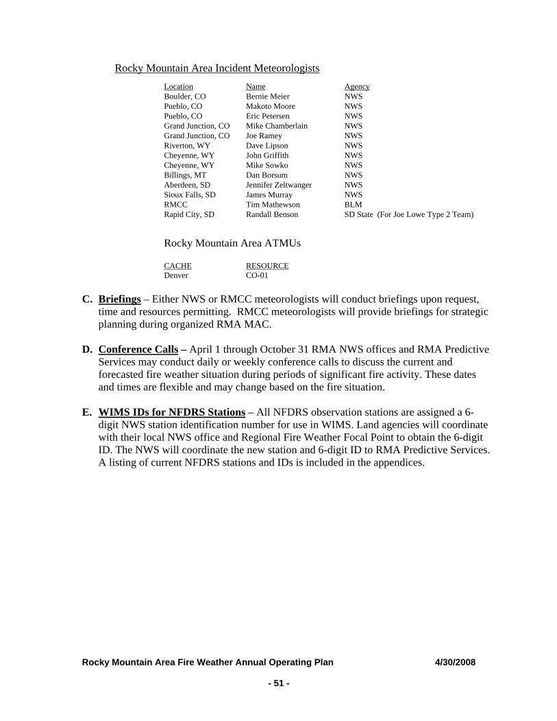
Rocky Mountain Area Fire Weather Annual Operating Plan 4/30/2008 - 51 -
Rocky Mountain Area Incident Meteorologists
Location Name Agency Boulder, CO Bernie Meier NWS Pueblo, CO Makoto Moore NWS Pueblo, CO Eric Petersen NWS Grand Junction, CO Mike Chamberlain NWS Grand Junction, CO Joe Ramey NWS Riverton, WY Dave Lipson NWS Cheyenne, WY John Griffith NWS Cheyenne, WY Mike Sowko NWS Billings, MT Dan Borsum NWS Aberdeen, SD Jennifer Zeltwanger NWS Sioux Falls, SD James Murray NWS RMCC Tim Mathewson BLM Rapid City, SD Randall Benson SD State (For Joe Lowe Type 2 Team) Rocky Mountain Area ATMUs
CACHE RESOURCE Denver CO-01
C. Briefings – Either NWS or RMCC meteorologists will conduct briefings upon request,
time and resources permitting. RMCC meteorologists will provide briefings for strategic planning during organized RMA MAC.
D. Conference Calls – April 1 through October 31 RMA NWS offices and RMA Predictive
Services may conduct daily or weekly conference calls to discuss the current and forecasted fire weather situation during periods of significant fire activity. These dates and times are flexible and may change based on the fire situation.
E. WIMS IDs for NFDRS Stations – All NFDRS observation stations are assigned a 6-
digit NWS station identification number for use in WIMS. Land agencies will coordinate with their local NWS office and Regional Fire Weather Focal Point to obtain the 6-digit ID. The NWS will coordinate the new station and 6-digit ID to RMA Predictive Services. A listing of current NFDRS stations and IDs is included in the appendices.
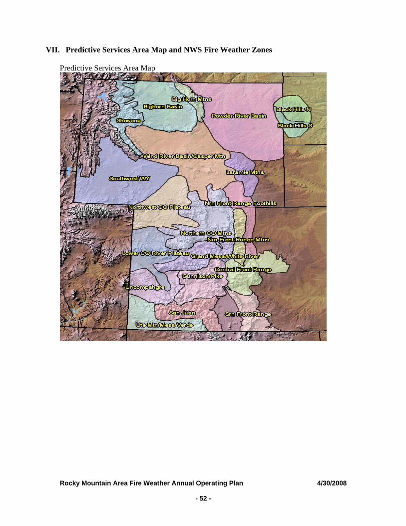
VII. Predictive Services Area Map and NWS Fire Weather Zones
Predictive Services Area Map
Rocky Mountain Area Fire Weather Annual Operating Plan 4/30/2008 - 52 -
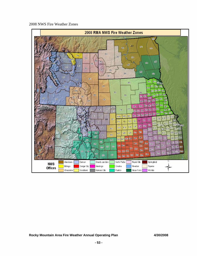
2008 NWS Fire Weather Zones
Rocky Mountain Area Fire Weather Annual Operating Plan 4/30/2008 - 53 -
Rocky Mountain Area Fire Weather Annual Operating Plan 4/30/2008 - 54 -
VIII. EFFECTIVE DATES ON THE AOP
April 15, 2008 to April 15, 2009 This AOP shall be effective on the date the last signature is placed on the signature section and it will remain in effect until the date the last signature is placed on the signature page the following year. Updates or amendments may be added in the interim upon agreement of all signatories.
IX. AGENCY SIGNATURES (On file) /s/David Carter __________________ _____4/15/08 __ Chair Date Rocky Mountain Area Coordinating Group /s/Michael Looney _____4/15/08____ Chief, Meteorological Services Division Date NWS Central Region Headquarters /s/Gary C. Schmeling ______4/15/08__ Manager, Regional Fire and Aviation Programs Date NWS Central Region Headquarters /s/Jim Fletcher ____________________ _______4/15/08__ Rocky Mountain Area Coordination Center Manager Date BLM Colorado State Office /s/Timothy Mathewson _____________________ _______4/15/08__ Fire Weather Manager, RMA Predictive Services Date BLM Colorado State Office