Embed Size (px)
Citation preview
Rock Correlation Lab 1
Regents Earth Science Name___________________________ Earth’s History Section__________________
Rock Correlation Lab Lab#__________ Introduction: The Cayuga Lake Basin contains one of the scenic Finger Lakes of central New York State. During the Devonian Period, this area was under a warm, shallow sea. Sediments deposited on this seafloor led to the formation of sedimentary rock up to 1200 meters thick. Many quarries, road cuts, and spectacular gorges allow the study of these rock layers. By correlating the rocks of different outcrops, geologists have been able to determine the order in which the layers were formed. A stratigraphic column shows all the rocks in an area in this order. Objectives: In this activity you will construct a stratigraphic column for the Cayuga Lake Basin, using information from nine outcrops. Materials:
• Scissors • Glue • Colored Pencils • Textbook (p. 676) – from back of room
Procedure:
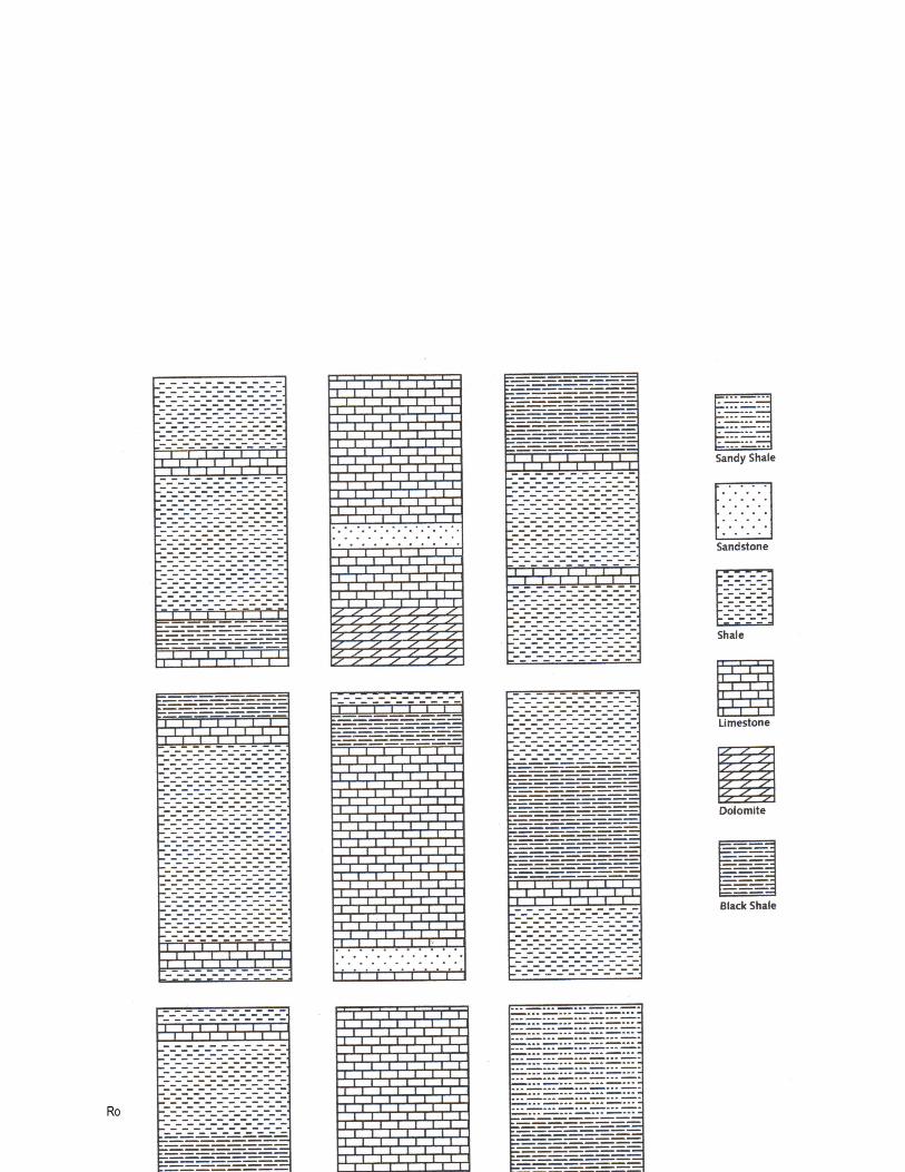
1. Page 4 shows cross sections of nine outcrops in Cayuga Lake Basin. On the back of each cross section, draw an arrow pointing to the top of the page (you will need the arrow to identify which way is “up”).
2. Turn the page back over and assign a color to each of the different rock layers
listed on the right side of the page. Go through each of the cross sections and color the rock layers as you have just assigned them. Then carefully cut out each cross section.
3. Lay the cross sections on your desk and move them around to horizontally
match the rocks of one outcrop with similar rocks in other outcrops. Use the colored layers to help you. Make sure each cross section has their arrows pointing upward.
Rock Correlation Lab 2
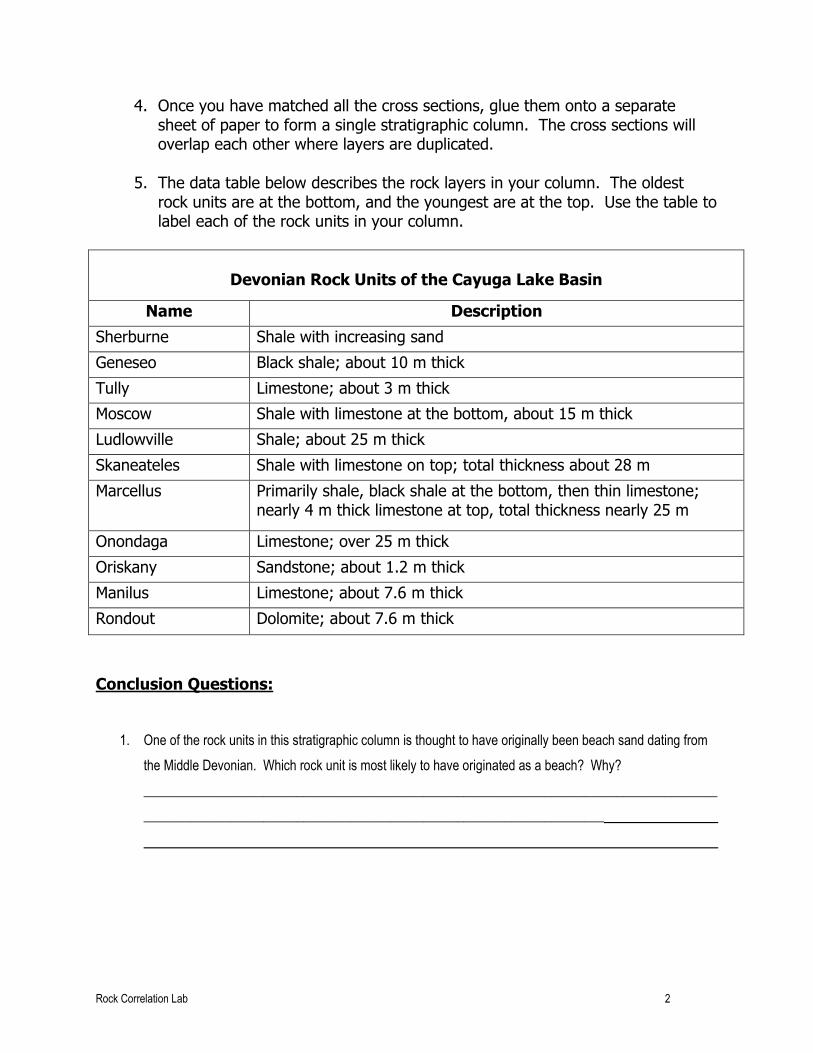
4. Once you have matched all the cross sections, glue them onto a separate sheet of paper to form a single stratigraphic column. The cross sections will overlap each other where layers are duplicated.
5. The data table below describes the rock layers in your column. The oldest
rock units are at the bottom, and the youngest are at the top. Use the table to label each of the rock units in your column.
Devonian Rock Units of the Cayuga Lake Basin
Name Description
Sherburne Shale with increasing sand
Geneseo Black shale; about 10 m thick
Tully Limestone; about 3 m thick
Moscow Shale with limestone at the bottom, about 15 m thick
Ludlowville Shale; about 25 m thick
Skaneateles Shale with limestone on top; total thickness about 28 m
Marcellus Primarily shale, black shale at the bottom, then thin limestone; nearly 4 m thick limestone at top, total thickness nearly 25 m
Onondaga Limestone; over 25 m thick
Oriskany Sandstone; about 1.2 m thick
Manilus Limestone; about 7.6 m thick
Rondout Dolomite; about 7.6 m thick
Conclusion Questions:
1. One of the rock units in this stratigraphic column is thought to have originally been beach sand dating from
the Middle Devonian. Which rock unit is most likely to have originated as a beach? Why?
______________________________________________________________________________________
_____________________________________________________________________
Rock Correlation Lab 3
2. The Tully is a prominent rock layer of the Cayuga Lake Basin. It stands out visibly between the Moscow
below it and the Geneseo above it. What could cause this difference in the appearance of the rock layers?
______________________________________________________________________________________
______________________________________________________________
3. The Onondaga contains an abundance of coral fossils, along with crinoids, brachiopods, and trilobites. Why
are fossils of ferns, rushes, and primitive conifers unlikely to be found in these rocks?
4. According to the Earth Science Reference Tables, between which two cities in New York State would the
oldest surface bedrock be found?
A) Jamestown and Rochester C) Utica and Binghamton
B) Plattsburgh and Watertown D) Syracuse and Albany
5. During which period was most of the surface bedrock that separates the Adirondacks from the Catskills
formed?
6. Why are ancient volcanic ash deposits important to geologists?
A) They form resistant rock layers containing fossils .
B) They are easily dated using carbon-14.
C) They serve as good geological time makers.
D) They indicate major areas where earthquakes occurred.
7. Which feature in a rock layer is older than the rock layer?
A) mineral veins C) rock fragments
B) igneous intrusions D) faults
Rock Correlation Lab 4
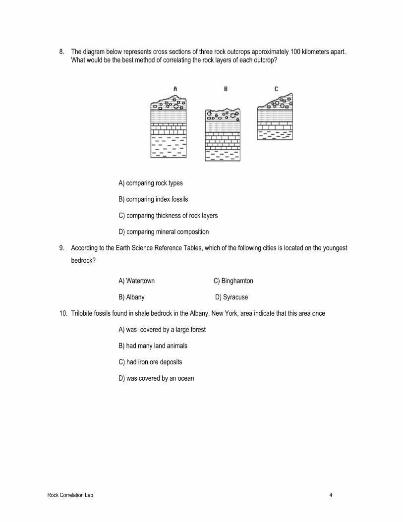
8. The diagram below represents cross sections of three rock outcrops approximately 100 kilometers apart. What would be the best method of correlating the rock layers of each outcrop?
A) comparing rock types
B) comparing index fossils
C) comparing thickness of rock layers
D) comparing mineral composition
9. According to the Earth Science Reference Tables, which of the following cities is located on the youngest
bedrock?
A) Watertown C) Binghamton
B) Albany D) Syracuse
10. Trilobite fossils found in shale bedrock in the Albany, New York, area indicate that this area once
A) was covered by a large forest
B) had many land animals
C) had iron ore deposits
D) was covered by an ocean
Rock Correlation Lab 5