Embed Size (px)
Citation preview
Roc-1 Exploration & Appraisal Drilling
Environment Plan Summary
0 8/10/15 Issued to NOPSEMA GS SM -
A 02/10/15 Issued for Review GS SM -
REV DATE DESCRIPTION BY CHK EM/PM
Roc-1 Exploration & Appraisal Drilling 2 of 242
CONTENTS
1. INTRODUCTION ............................................................................................................................... 4
1.1 Compliance.................................................................................................................................... 4
1.2 Activity Duration and Timing.......................................................................................................... 4
2. ACTIVITY LOCATION......................................................................................................................... 5
3. DESCRIPTION OF THE ACTIVITY ........................................................................................................ 6
3.1.1 Activities ..................................................................................................................................... 6
3.1.2 MODUs ....................................................................................................................................... 6
3.1.3 Exploration and appraisal wells. ................................................................................................... 6
3.1.4 Temporary Abandonment (suspension) ........................................................................................ 7
3.1.5 Well abandonment ...................................................................................................................... 7
3.1.6 Drilling Discharges ....................................................................................................................... 7
3.1.7 Well evaluation and testing .......................................................................................................... 7
3.1.8 Support Vessels ........................................................................................................................... 7
3.1.9 Helicopters.................................................................................................................................. 7
3.1.10 ROV Operations......................................................................................................................... 8
3.1.11 Waste ....................................................................................................................................... 8
3.1.12 Fuel and Chemical Handling ....................................................................................................... 8
4. DESCRIPTION OF ENVIRONMENT ..................................................................................................... 9
4.1 Environment that May Be Affected (EMBA) .................................................................................... 9
4.1.1 Physical environment and habitats ..............................................................................................11
4.1.2 Habitats .....................................................................................................................................11
4.1.3 Protected and Significant Areas ...................................................................................................11
4.1.4 Hot Spots ...................................................................................................................................14
4.1.5 Marine Fauna .............................................................................................................................17
4.2 Socio-economic Environment ........................................................................................................24
5. STAKEHOLDER CONSULTATION .......................................................................................................27
5.1 Addressing consultation feedback .................................................................................................28
5.2 Summary ......................................................................................................................................28
6. ENVIRONMENTAL HAZARDS AND CONTROLS ..................................................................................31
6.1 ALARP Evaluation .........................................................................................................................32
6.2 Acceptability Evaluation................................................................................................................32
7. MANAGEMENT APPROACH.............................................................................................................41
8. HYDROCARBON SPILL RESPONSE ARRANGEMENTS..........................................................................42
8.1 Net Environmental Benefit Analysis ..............................................................................................45
8.2 Oil Spill Response Resources .........................................................................................................45

Roc-1 Exploration & Appraisal Drilling 3 of 242
9. CONTACT DETAILS ..........................................................................................................................46
10. REFERENCES .................................................................................................................................47
Roc-1 Exploration & Appraisal Drilling 4 of 242
1. INTRODUCTION
Quadrant Energy Australia Pty Ltd (Quadrant) is the registered operator for Petroleum Production Licence WA-437-P. Quadrant Energy plan to develop the oil reserves of the Bedout Basin region in Commonwealth waters within permit area WA-437-P through drilling an exploration and appraisal well.
Quadrant Energy proposes to drill the Roc-1 exploration and appraisal well in this permit area using a mobile offshore drilling unit (MODU). The Roc-1 exploration well, located in the Bedout Basin, will be drilled to assess the lithology and presence of hydrocarbons in the Upper & Lower Barret, as well as the Locker formations
1.1 Compliance
The overall purpose of the Roc-1 Environment Plan (EA-00-RI-10117) (the EP) is to comply with statutory requirements of the Commonwealth Offshore Petroleum and Greenhouse Gas Storage (Environment) Regulations 2009 (OPGGS (E) Regulations) and to ensure that the Activity is planned and conducted in line with Quadrant environmental policies and standards, including the corporate Environmental Policy . The EP was assessed and accepted by the National Offshore Petroleum Safety and Environmental Management Authority (NOPSEMA) on the 29th September 2015. This EP summary has been prepared in accordance with the requirements of regulation 11 (4) of the OPGGS (E) Regulations.
1.2 Activity Duration and Timing
The time required to drill the well is expected to vary from approximately 40 to 85 days. In the event that re-entry and well testing is undertaken (at a later date) an additional 40 days may be required, totalling up to approximately 125 days.
During the activity, operations will be 24 hours per day. The Activity is scheduled to commence in quarter four 2015 if required subsequent re-entry and well testing will be undertaken within 12 months.
Roc-1 Exploration & Appraisal Drilling 5 of 242
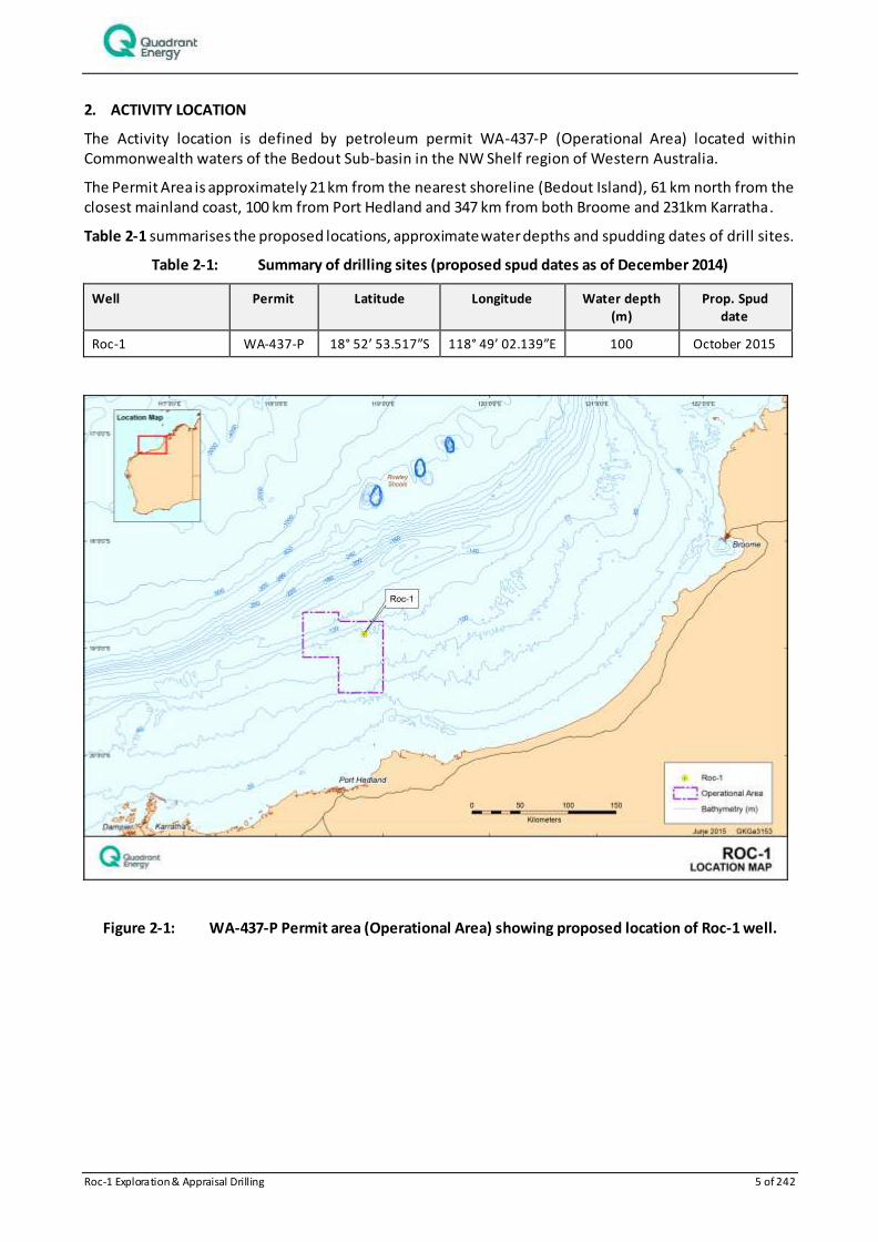
2. ACTIVITY LOCATION
The Activity location is defined by petroleum permit WA-437-P (Operational Area) located within Commonwealth waters of the Bedout Sub-basin in the NW Shelf region of Western Australia.
The Permit Area is approximately 21 km from the nearest shoreline (Bedout Island), 61 km north from the closest mainland coast, 100 km from Port Hedland and 347 km from both Broome and 231km Karratha.
Table 2-1 summarises the proposed locations, approximate water depths and spudding dates of drill sites.
Table 2-1: Summary of drilling sites (proposed spud dates as of December 2014)
Well Permit Latitude Longitude Water depth (m)
Prop. Spud date
Roc-1 WA-437-P 18° 52’ 53.517”S 118° 49’ 02.139”E 100 October 2015
Figure 2-1: WA-437-P Permit area (Operational Area) showing proposed location of Roc-1 well.
Roc-1 Exploration & Appraisal Drilling 6 of 242
3. DESCRIPTION OF THE ACTIVITY
3.1.1 Activities
The EP covers drilling, evaluating, completing, and abandonment activities related to exploration and appraisal drilling, namely:
Drilling of top hole sections (riserless where assessed appropriate) including setting and cementing of casing strings;
Installation of a blow-out preventer (BOP);
Commencement of drilling of lower well intervals using Water Based Muds (WBM);
Contingency use of Lost Circulation Materials as required;
Installation of lower and upper completions, if applicable;
Perforating operations and flowback/clean up, if applicable;
Use of completion and production appraisal chemical (brines as required);
Setting and cementing of additional casing strings if required;
Wireline logging;
Contingent Vertical Seismic Profiling (VSP);
Contingent acquisition of core samples;
Abandonment of exploration wells, or suspending1, or handing well over to production teams;
Periodic well testing (sampling, clean up, and flaring);
Side tracking and/or redrilling sections of wells due to operational difficulties or scope change to acquire additional well evaluation data.
Activities that are not covered in the EP include but are not limited to installation, production and decommissioning activities as well as vessel based seismic surveys.
3.1.2 MODUs
Drilling is proposed to be undertaken using a Jack-up MODU which will remain at location (i.e. drilling site) for the duration of each of the activities.
3.1.3 Exploration and appraisal wells.
These well will be drilled in three sections: surface, intermediate, and production. The surface section will be drilled using seawater and bentonite sweeps and discharges will be returned to the seabed in this uncased section. The intermediate and production sections will be drilled with inhibited polymer water based mud (WBM). The extracted cutting and recoverable fluids (WBM) generated while drilling the lower two well intervals will be brought to the MODU through the riser, before being treated by solids cont rol equipment to separate the drilling fluid from the cuttings before discharge of cuttings to the marine environment at sea surface.
The riserless sections of the well will be drilled with seawater and gel sweeps, the drill cuttings can only be discharged to the seabed. Once the conductor/surface string is installed however, cuttings are returned to
1 If no discovery is made the well be permanently abandoned and the planned activity is complete.
If a discovery is made then the well may be temporarily suspended and the planned first activity will be complete.
Following necessary regulatory approvals, the rig will return as a separate activity (within approx. 12 months) and re-enter Roc-1 to perform a side track and well test.
Roc-1 Exploration & Appraisal Drilling 7 of 242
the surface with the drilling fluid and are screened by the MODU shakers to remove the entrained cuttings. The recovered mud is then pumped to the mud tanks for reuse during the drilling program.
3.1.4 Temporary Abandonment (suspension)
Should Quadrant Energy choose to suspend the well enabling well testing and appraisal at a later date (within 12 months of suspension), down hole barriers (such as cement) will be ins talled and tested to isolate any open formations, as would be performed for a permanent abandonment. Approximately 2m of 30” diameter casing would be left protruding from the seabed to allow re -establishment in a subsequent programme. The casing contents will be inhibited WBM, and there will be no hydrocarbon inventory in the well.
3.1.5 Well abandonment
After final well operations, the Roc-1 well will be permanently abandoned by installing and testing down hole barriers (such as cement) prior to severing all casing strings below seabed.
3.1.6 Drilling Discharges
Drilling discharges account for:
Drill cuttings;
Drilling fluids and solids;
Brines; and
Cement (set or unset).
A heat exchanger/heater may also be used in well testing and heated water (i.e. fresh or seawater) will be discharged to sea.
3.1.7 Well evaluation and testing
Well testing and evaluation involves the collection of data on the well and surrounding formation. Wireline logging will be conducted during drilling activities and it is also possible that VSP will be used.
In some cases, the hydrocarbons in the reservoir may need to be tested to appraise their type, quantity and flow rate. To do this, the hydrocarbon from the reservoir is flowed at varying rates for periods ranging from a few hours to a few days. As there are no production handling facilities on the drilling rig, it is customary to dispose of the produced gas and/or oil by burning.
During well testing formation water may be produced from the reservoir. Any formation water produced would be discharged to the marine environment following oil filtration.
3.1.8 Support Vessels
The MODU will be assisted by up to four support vessels that will transfer food, bulk drilling fluid materials, diesel and equipment used in the drilling process.
A support vessel standby mooring may be installed for the activity period.
3.1.9 Helicopters
Crew changes for personnel aboard the MODU will involve transfer by helicopter between the MODU and the regional airports of Karratha. These flights will occur several times a week dependent on the progress of the drilling program and logistical constraints.
Roc-1 Exploration & Appraisal Drilling 8 of 242
3.1.10 ROV Operations
Remotely operated vehicle (ROV) operations and surveys will occur periodically throughout the Activity to determine the condition of subsea infrastructure (including submerged parts of the MODU), monitor drilling operations, manipulate subsea equipment, and confirm site adequacy (site survey if required).
3.1.11 Waste
In addition to the drilling discharges (above), other operational waste streams from the MODU and support vessels are likely to include:
Deck drainage;
Putrescible waste and sewage;
Oily water;
Cooling water from operation of engines;
Desalination plant effluent (brine) and backwash water discharge;
Ballast water; and
Solid and liquid waste.
3.1.12 Fuel and Chemical Handling
The main engines and equipment (e.g. pumps, cranes, winches, power packs, generators) used on MODUs, and support vessels require diesel for fuel, hydraulic fluid and lubricating oils for operation and maintenance of moving parts.
Roc-1 Exploration & Appraisal Drilling 9 of 242
4. DESCRIPTION OF ENVIRONMENT
4.1 Environment that May Be Affected (EMBA)
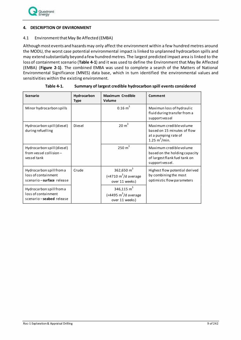
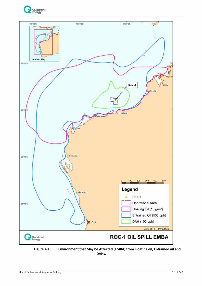
Although most events and hazards may only affect the environment within a few hundred metres around the MODU, the worst case potential environmental impact is linked to unplanned hydrocarbon spills and may extend substantially beyond a few hundred metres. The largest predicted impact area is linked to the loss of containment scenario (Table 4-1) and it was used to define the Environment that May Be Affected (EMBA) (Figure 2-1). The combined EMBA was used to complete a search of the Matters of National Environmental Significance (MNES) data base, which in turn identified the environmental values and sensitivities within the existing environment.
Table 4-1. Summary of largest credible hydrocarbon spill events considered
Scenario Hydrocarbon Type
Maximum Credible Volume
Comment
Minor hydrocarbon spills 0.16 m3 Maximun loss of hydraulic
fluid during transfer from a
support vessel
Hydrocarbon spill (diesel) during refuelling
Diesel 20 m3
Maximum credible volume based on 15 minutes of flow at a pumping rate of 1.25 m
3/min.
Hydrocarbon spill (diesel)
from vessel coll ision – vessel tank
250 m3
Maximum credible volume
based on the holding capacity of largest flank fuel tank on support vessel.
Hydrocarbon spill from a loss of containment
scenario – surface release
Crude 362,650 m3
(<4710 m3/d average
over 11 weeks)
Highest flow potential derived by combining the most
optimistic flow parameters
Hydrocarbon spill from a loss of containment scenario – seabed release
346,115 m3
(<4495 m3/d average
over 11 weeks)
Roc-1 Exploration & Appraisal Drilling 10 of 242
Figure 4-1. Environment that May be Affected (EMBA) from Floating oil, Entrained oil and DAHs.
Roc-1 Exploration & Appraisal Drilling 11 of 242
4.1.1 Physical environment and habitats
Physical environment
North West Shelf (NWS) waters are usually thermally stratified with a marked change in water density at approximately 20 m (SSE, 1993). Surface temperatures vary annually, being warmest in March (32˚C) and coolest in August (19˚C). During summer (October–March), the prevailing non-storm winds are from the southwest, west and northwest at an average speed of less than 10 knots, peak ave rage speeds of 15–25 knots, and maximum speeds of 30 knots. Non-storm winds prevail from the north-east through to south-east at average speeds of 5–6 knots, peak average speeds of 10–15 knots, and maximum speeds of 20 knots. The wave climate is generally composed of locally generated wind waves (seas) and swells that are propagated from distant area (WNI, 1995; 1996). In the open ocean, sustained winds result in wind-forced currents of approximately 3% of the wind speed (Holloway and Nye, 1985).
Tidal and wind-forcing are the dominant contributions to local sea surface currents. The tides of the NWS have a strong semi-diurnal signal with four tide changes per day (Holloway and Nye, 1985) and a spring tidal range of 1.9 m and a highest astronomical tide of 2.9 m (Chevron Australia, 2010). The dominant sea surface offshore current (typically seaward of the 200 m isobath) is the Leeuwin Current, which carries warm tropical water south along the edge of WA's continental shelf, reaching its peak strength in winter and becoming weaker and more variable in summer. The current is described as a sea surface current, extending in depth to 150 m (BHPB, 2005; Woodside, 2005). Closer to the coast, the Ningaloo Current flows in a northerly direction, in the opposite direction to the Leeuwin Current, along the outside of the Ningaloo Reef and across the inner shelf from September to mid-April (BHPB, 2005; Woodside, 2005). The Indonesian Throughflow is the other important current influencing the upper 200 m of the outer NWS (Woodside, 2005). This current brings warm and relatively fresh water to the region from the western Pacific via the Indonesian Archipelago.
Offshore drift currents are represented as a series of interconnected eddies and connecting flows that can generate relatively fast (1–2 knots) and complex water movement. These offshore drift currents also tend to persist longer (days to weeks) than tidal current flows (hours between reversals) and thus will have greater influence upon the trajectory of slicks over time scales exceeding a few hours (APASA, 2014).
4.1.2 Habitats
The Operational Area occurs completely within the Northwest Shelf Province.
This bioregion is located primarily on the continental shelf in water depths from 0 to 200 m (DEWHA 2008). The sandy substrates on the shelf within this bioregion are thought to support low density benthic communities of bryozoans, molluscs and echinoids (DEWHA 2008). Sponge communities are also sparsely distributed on the shelf, but are found only in areas of hard substrate. The region between Dampier and Port Hedland has been described as a hotspot for sponge biodiversity (Hooper & Ekins 2004).
The Operational Area does not contain shoreline habitat, and the nearest land is Bedout Island 21 km away. Available data indicates that the benthic habitat across the Operational Area comprises mostly sand and subtidal soft bottom communities. The benthic habitats within the Operational Area are widely represented at a regional scale on the NWS.
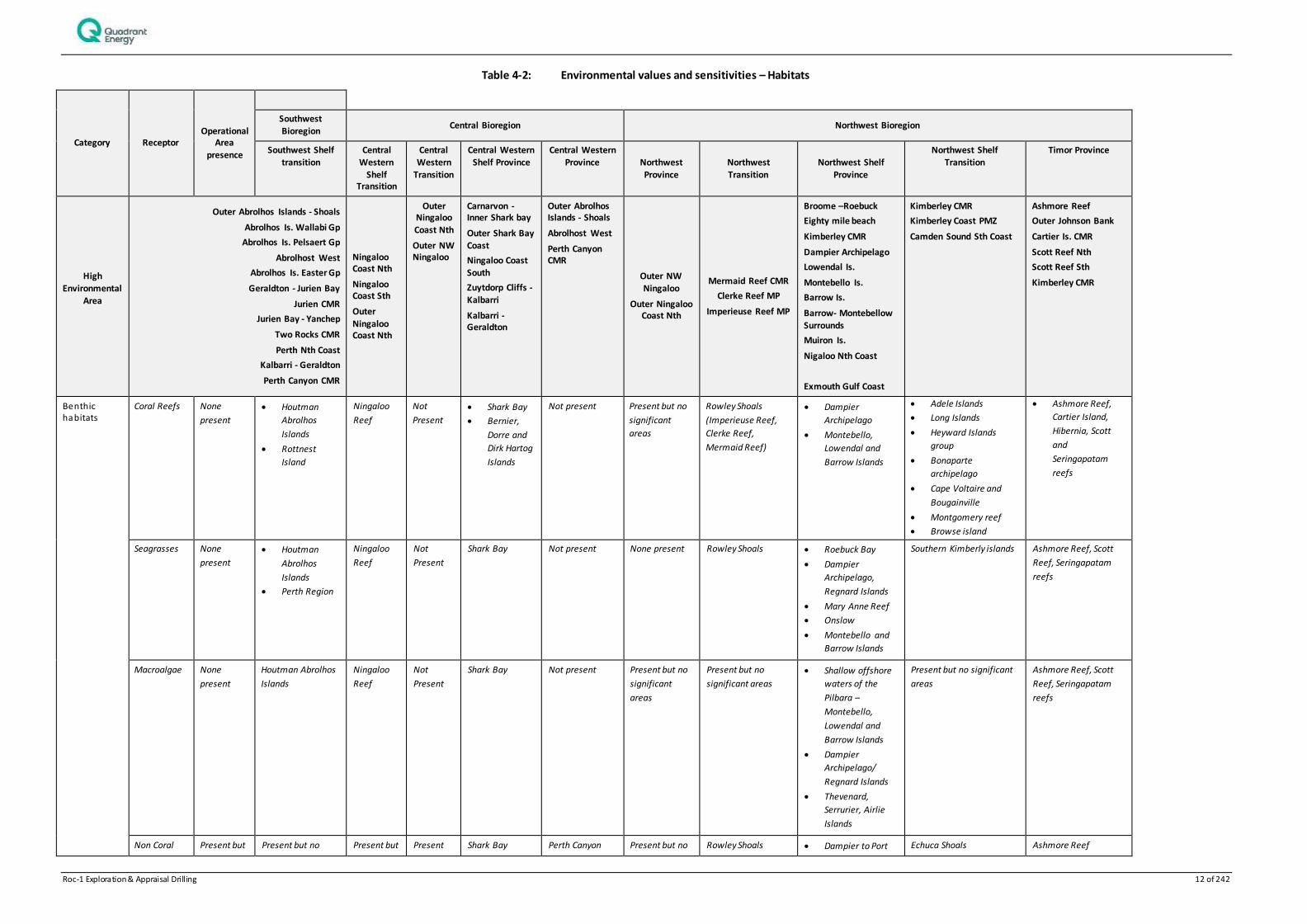
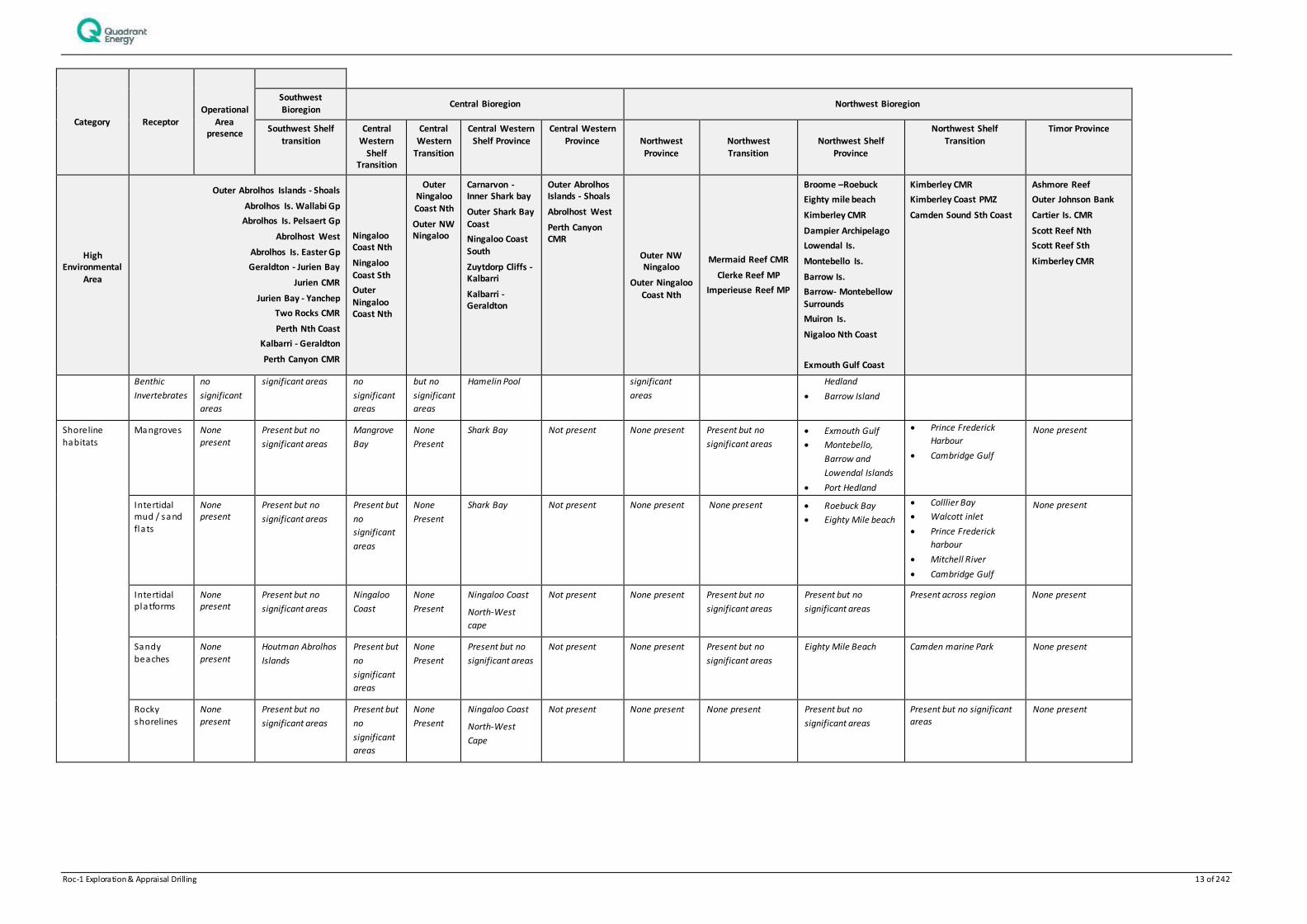
4.1.3 Protected and Significant Areas
Protected and significant areas with the potential to be impacted by this program have also been identified in Table 4-2.
Roc-1 Exploration & Appraisal Drilling 12 of 242
Table 4-2: Environmental values and sensitivities – Habitats
Category Receptor Operational
Area presence
Southwest Bioregion
Central Bioregion Northwest Bioregion
Southwest Shelf transition
Central Western
Shelf Transition
Central Western
Transition
Central Western Shelf Province
Central Western Province Northwest
Province
Northwest
Transition
Northwest Shelf
Province
Northwest Shelf Transition
Timor Province
High Environmental
Area
Outer Abrolhos Islands - Shoals
Abrolhos Is. Wallabi Gp
Abrolhos Is. Pelsaert Gp
Abrolhost West
Abrolhos Is. Easter Gp
Geraldton - Jurien Bay
Jurien CMR
Jurien Bay - Yanchep
Two Rocks CMR
Perth Nth Coast
Kalbarri - Geraldton
Perth Canyon CMR
Ningaloo Coast Nth
Ningaloo Coast Sth
Outer
Ningaloo Coast Nth
Outer Ningaloo
Coast Nth
Outer NW Ningaloo
Carnarvon - Inner Shark bay
Outer Shark Bay Coast
Ningaloo Coast South
Zuytdorp Cliffs -
Kalbarri
Kalbarri - Geraldton
Outer Abrolhos Islands - Shoals
Abrolhost West
Perth Canyon CMR
Outer NW Ningaloo
Outer Ningaloo Coast Nth
Mermaid Reef CMR
Clerke Reef MP
Imperieuse Reef MP
Broome –Roebuck
Eighty mile beach
Kimberley CMR
Dampier Archipelago
Lowendal Is.
Montebello Is.
Barrow Is.
Barrow- Montebellow
Surrounds
Muiron Is.
Nigaloo Nth Coast
Exmouth Gulf Coast
Kimberley CMR
Kimberley Coast PMZ
Camden Sound Sth Coast
Ashmore Reef
Outer Johnson Bank
Cartier Is. CMR
Scott Reef Nth
Scott Reef Sth
Kimberley CMR
Benthic habitats
Coral Reefs None
present
Houtman
Abrolhos
Islands
Rottnest
Island
Ningaloo
Reef
Not
Present
Shark Bay
Bernier,
Dorre and
Dirk Hartog
Islands
Not present Present but no
significant
areas
Rowley Shoals
(Imperieuse Reef,
Clerke Reef,
Mermaid Reef)
Dampier
Archipelago
Montebello,
Lowendal and
Barrow Islands
Adele Islands
Long Islands
Heyward Islands
group
Bonaparte
archipelago
Cape Voltaire and
Bougainville
Montgomery reef
Browse island
Ashmore Reef,
Cartier Island,
Hibernia, Scott
and
Seringapatam
reefs
Seagrasses None
present
Houtman
Abrolhos
Islands
Perth Region
Ningaloo
Reef
Not
Present
Shark Bay
Not present None present Rowley Shoals Roebuck Bay
Dampier
Archipelago,
Regnard Islands
Mary Anne Reef
Onslow
Montebello and
Barrow Islands
Southern Kimberly islands Ashmore Reef, Scott
Reef, Seringapatam
reefs
Macroalgae None
present
Houtman Abrolhos
Islands
Ningaloo
Reef
Not
Present
Shark Bay Not present Present but no
significant
areas
Present but no
significant areas
Shallow offshore
waters of the
Pilbara –
Montebello,
Lowendal and
Barrow Islands
Dampier
Archipelago/
Regnard Islands
Thevenard,
Serrurier, Airlie
Islands
Present but no significant
areas
Ashmore Reef, Scott
Reef, Seringapatam
reefs
Non Coral Present but Present but no Present but Present Shark Bay Perth Canyon Present but no Rowley Shoals Dampier to Port Echuca Shoals Ashmore Reef
Roc-1 Exploration & Appraisal Drilling 13 of 242
Category Receptor Operational
Area presence
Southwest
Bioregion Central Bioregion Northwest Bioregion
Southwest Shelf
transition
Central
Western Shelf
Transition
Central
Western Transition
Central Western
Shelf Province
Central Western
Province Northwest Province
Northwest Transition
Northwest Shelf Province
Northwest Shelf
Transition
Timor Province
High Environmental
Area
Outer Abrolhos Islands - Shoals
Abrolhos Is. Wallabi Gp
Abrolhos Is. Pelsaert Gp
Abrolhost West
Abrolhos Is. Easter Gp
Geraldton - Jurien Bay
Jurien CMR
Jurien Bay - Yanchep
Two Rocks CMR
Perth Nth Coast
Kalbarri - Geraldton
Perth Canyon CMR
Ningaloo Coast Nth
Ningaloo Coast Sth
Outer
Ningaloo Coast Nth
Outer Ningaloo
Coast Nth
Outer NW Ningaloo
Carnarvon - Inner Shark bay
Outer Shark Bay Coast
Ningaloo Coast South
Zuytdorp Cliffs - Kalbarri
Kalbarri - Geraldton
Outer Abrolhos Islands - Shoals
Abrolhost West
Perth Canyon CMR
Outer NW Ningaloo
Outer Ningaloo
Coast Nth
Mermaid Reef CMR
Clerke Reef MP
Imperieuse Reef MP
Broome –Roebuck
Eighty mile beach
Kimberley CMR
Dampier Archipelago
Lowendal Is.
Montebello Is.
Barrow Is.
Barrow- Montebellow Surrounds
Muiron Is.
Nigaloo Nth Coast
Exmouth Gulf Coast
Kimberley CMR
Kimberley Coast PMZ
Camden Sound Sth Coast
Ashmore Reef
Outer Johnson Bank
Cartier Is. CMR
Scott Reef Nth
Scott Reef Sth
Kimberley CMR
Benthic
Invertebrates
no
significant
areas
significant areas no
significant
areas
but no
significant
areas
Hamelin Pool significant
areas
Hedland
Barrow Island
Shoreline habitats
Mangroves None present
Present but no
significant areas
Mangrove
Bay
None
Present
Shark Bay Not present None present Present but no
significant areas
Exmouth Gulf
Montebello,
Barrow and
Lowendal Islands
Port Hedland
Prince Frederick
Harbour
Cambridge Gulf
None present
Intertidal mud / sand flats
None present
Present but no
significant areas
Present but
no
significant
areas
None
Present
Shark Bay Not present None present None present Roebuck Bay
Eighty Mile beach
Colllier Bay
Walcott inlet
Prince Frederick
harbour
Mitchell River
Cambridge Gulf
None present
Intertidal platforms
None present
Present but no
significant areas
Ningaloo
Coast
None
Present
Ningaloo Coast
North-West
cape
Not present None present Present but no
significant areas
Present but no
significant areas
Present across region None present
Sandy beaches
None present
Houtman Abrolhos
Islands
Present but
no
significant
areas
None
Present
Present but no
significant areas
Not present None present Present but no
significant areas
Eighty Mile Beach Camden marine Park None present
Rocky shorelines
None present
Present but no
significant areas
Present but
no
significant
areas
None
Present
Ningaloo Coast
North-West
Cape
Not present None present None present Present but no
significant areas
Present but no significant areas
None present
Roc-1 Exploration & Appraisal Drilling 14 of 242
Commonwealth Marine Reserves, State Marine Parks, Marine Management Areas, World Heritage Areas, Wetlands of International Importance, Commonwealth or National Heritage Places and Key Ecological Features present within the EMBA are listed in Table 4-3. None of these areas were identified within, or nearby, the Operational Area for the Activity, with the exception of the 125m Ancient Coastline.
Ancient coastline at 125 m depth contour
The shelf of the North-west Marine Region contains several terraces and steps which reflect changes i n sea level that occurred over the last 100,000 years. The most prominent of these features occurs at a depth of 125 m as an escarpment along the North West Shelf and Sahul Shelf (DSEWPaC 2012). Where the ancient submerged coastline provides areas of hard substrate it may contribute to higher biological diversity. Little detailed knowledge is available, but the hard substrate of the escarpment is likely to support sponges, corals, crinoids, molluscs, echinoderms (DSEWPaC 2012).
Parts of the ancient coastline are thought to provide biologically important habitats in areas otherwise dominated by soft sediments. The topographic complexity of these escarpments may also facilitate vertical mixing of the water column providing a relatively nutrient-rich environment for species present on the escarpment (DSEWPaC 2012).
Additional information on KEFs and Commonwealth Protected Areas and Heritage places listed in Table 4-3 is available at the following link:
http://www.environment.gov.au/topics/marine/marine-bioregional-plans/north-west
Additional information on state Marine Parks listed in Table 4-3 is available at the following link:
http://www.dpaw.wa.gov.au/management/marine/marine-parks-and-reserves
4.1.4 Hot Spots
The locations that have been ranked priority 1,2 or 3 (identified in Quadrant Energy’s Environmental Sensitivities and Priorities for Protection guidelines EA-91-ZI-10008) that occur within the EMBA are also listed in Table 4-2. These areas are considered regionally to have High Environmental Values (HEVS).
Table 4-3: Environmental values and sensitivities –protected/significant areas
Value/Sensitivity Distance from
Operational Area (km) EMBA presence
Commonwealth Marine Reserves
960 Abrolhos Commonwealth Marine Reserve
102 Argo-Rowley Terrace Commonwealth Marine Reserve
833 Ashmore Reef Commonwealth Marine Reserve
855 Carnarvon Canyon Commonwealth Marine Reserve
838 Cartier Island Commonwealth Marine Reserve
149 Dampier Commonwealth Marine Reserve
9.5 Eighty Mi le Beach Commonwealth Marine Reserve
503 Gascoyne Commonwealth Marine Reserve
1,578 Geographe Commonwealth Marine Reserve
1,252 Jurien Commonwealth Marine Reserve
291 Kimberley Commonwealth Marine Reserve
180 Mermaid Reef Commonwealth Marine Reserve
261 Montebello Commonwealth Marine Reserve
510 Ningaloo Commonwealth Marine Reserve
Roc-1 Exploration & Appraisal Drilling 15 of 242
1,011 Oceanic Shoals Commonwealth Marine Reserve
1,419 Perth Canyon Commonwealth Marine Reserve
322 Roebuck Commonwealth Marine Reserve
787 Shark Bay Commonwealth Marine Reserve
1,607 South West Corner Commonwealth Marine Reserve
1,378 Two Rocks Commonwealth Marine Reserve
State Marine Parks (MP) and Marine Management Areas (MMA)
566 La lang garram/Camden Sound MP
112 Rowley Shoals MP
795 Shark Bay MP
1,239 Jurien Bay MP
1,398 Marmion MP
1,455 Shoalwater Island MP
353 Barrow Island MP
323 Barrow Island MMA
310 Montebello Islands MP
508 Ningaloo MP
487 Muiron Islands MMA
77 Eighty Mi le Beach MP
1,602 Ngari Capes MP
187 Proposed Dampier Archipelago MP
250 Proposed Regnard MMA
233 Proposed Roebuck Bay MP
World Heritage 487 The Ningaloo coast
795 Shark Bay
Wetlands of International Importance (Ramsar)
333 Roebuck Bay
833 Ashmore Reef National Nature Reserve
1,468 Becher Point Wetlands
97 Eighty Mi le Beach
1,628 Hosnies Springs
1,486 Peel -Yalgorup system
1,638 “the dales” Christmas Island
1,605 Vasse-Wonerup system
National Heritage Places
1,068 HMAS Sydney II and HSK Kormoran Shipwreck Sites
308 Barrow Island and the Montebello – Barrow Islands Marine Reserve
(See s tate and commonwealth reserves)
287 The West Kimberley
1,159 Beekeepers-Leseur-Coomallo Area and Nambung National Park
1,624 Chris tmas Island Natural Areas
Roc-1 Exploration & Appraisal Drilling 16 of 242
487 The Ningaloo Coast (see World Heritage)
205 Dampier Archipelago (including Burrup peninsula)
1,115 Batavia Shipwreck Site and Survivor Camps Area 1629 – Houtman Abrolhos
885 Dirk Hartog Landing Site 1616 – Cape Inscription Area
800 Shark Bay (see World Heritage)
Commonwealth
Heritage Places 592 Scott reef and Surrounds
646 Seringapatam Reef and Surrounds
833 Ashmore Reef National Nature Reserve (see Commonwealth Marine Reserves)
1,625 Chris tmas Island Natural Areas
86 Mermaid Reef - Rowley Shoals (see Commonwealth Marine Reserves)
510 Ningaloo Marine Area - Commonwealth Waters (see Commonwealth Marine Reserves)
Threatened Ecological Communities
827 Subtropical and Temperate Coastal Saltmarsh
Key ecological feature (KEF)
Overlaps Ancient coastline at 125 m depth contour
1,063 Ancient Coastline at 90m-120m depth
835 Ashmore Reef and Cartier Island and surrounding Commonwealth waters
1,411 Carbonate Bank and terrace system of the Van Diemen Rise
1,614 Cape Mentelle Upwelling
477 Canyons linking the Argo Abyssal Plain with Scott Plateau
462 Canyons linking the Cuvier Abyssal Plain with the Cape Range
Peninsula
911 Carbonate bank and terrace system of the Sahul Shelf
1,085 Commonwealth marine environment surrounding the Houtman Abrolhos Islands (and adjacent shelf break)
1,064 Commonwealth marine environment within and adjacent to the west coast inshore lagoons
1,573 Commonwealth marine environment within and adjacent to Geographe Bay
508 Commonwealth waters adjacent to Ningaloo Reef
297 Continental slope demersal fish communities
407 Exmouth Plateau
157 Glomar Shoals
104 Mermaid Reef and Commonwealth waters surrounding Rowley Shoals
1,127 Perth Canyon and adjacent shelf break, and other west-coast canyons
1,031 Pinnacles of the Bonaparte Basin
Roc-1 Exploration & Appraisal Drilling 17 of 242
580 Seringapatam Reef and Commonwealth waters in the Scott Reef complex
1,011 Wallaby Saddle
939 Western Demersal slope and associated fish communities (of the Centra l Western Province)
1,030 Western rock lobster
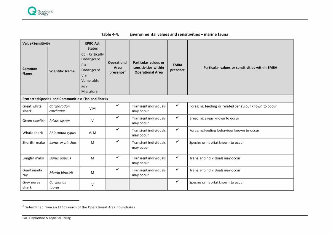
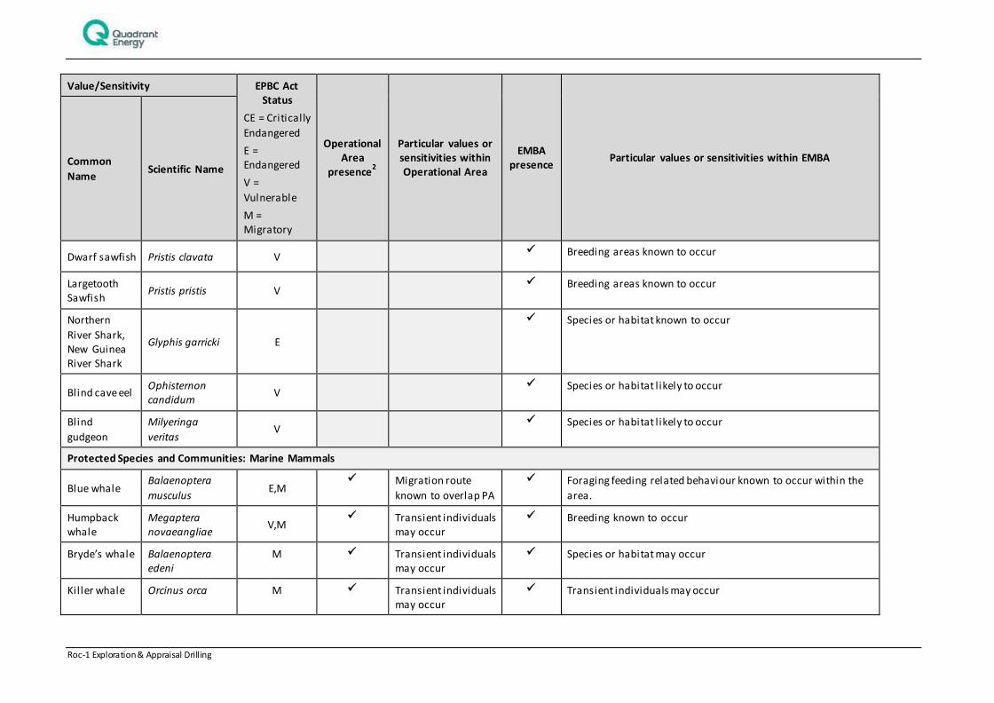
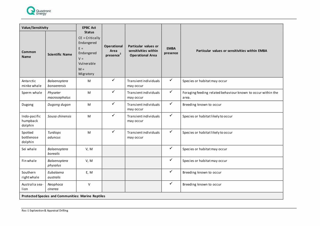
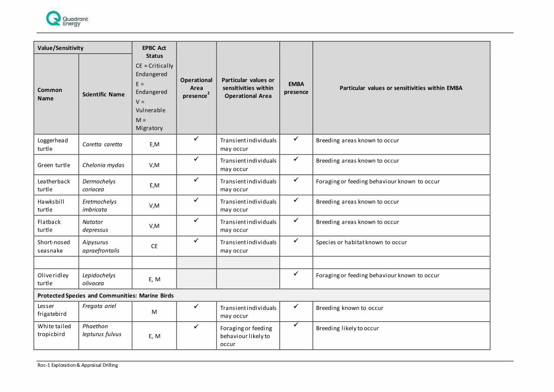
4.1.5 Marine Fauna
Desktop searches of the Operational Area and larger EMBA were undertaken using DoE’s Protected Matters Search Tool for the purposes of identifying species listed under the EPBC Act. The search identified 100 Listed Threatened Species (LTS) and 95 Listed Migratory Species (LMS) as having the potential to occur within the EMBA .
An assessment of all the marine and coastal species was undertaken to identify if these species have the potential to occur in either the Operational Area or larger EMBA. Those listed threatened or vulnerable species that have been identified as likely to be present in the Operational Area or EMBA are summarised in Table 4-4. Migratory species are only listed for the Operational Area only.
Roc-1 Exploration & Appraisal Drilling 18 of 242
Table 4-4: Environmental values and sensitivities – marine fauna
Value/Sensitivity EPBC Act
Status
CE = Critically Endangered
E =
Endangered
V = Vulnerable
M = Migratory
Operational
Area presence
2
Particular values or
sensitivities within Operational Area
EMBA
presence Particular values or sensitivities within EMBA Common
Name Scientific Name
Protected Species and Communities: Fish and Sharks
Great white shark
Carcharodon carcharias
V,M Transient individuals
may occur
Foraging, feeding or related behaviour known to occur
Green sawfish Pristis zijsron V Transient individuals
may occur
Breeding areas known to occur
Whale shark Rhincodon typus V, M Transient individuals
may occur
Foraging feeding behaviour known to occur
Shortfin mako Isurus oxyrinchus M Transient individuals
may occur
Species or habitat known to occur
Longfin mako Isurus paucus M Transient individuals may occur
Transient individuals may occur
Giant manta ray
Manta birostris M Transient individuals
may occur
Transient individuals may occur
Grey nurse
shark
Carcharias
taurus V
Species or habitat known to occur
2 Determined from an EPBC search of the Operational Area boundaries
Roc-1 Exploration & Appraisal Drilling 19 of 242
Value/Sensitivity EPBC Act Status
CE = Critically
Endangered
E = Endangered
V =
Vulnerable
M = Migratory
Operational Area
presence2
Particular values or sensitivities within Operational Area
EMBA presence
Particular values or sensitivities within EMBA Common
Name Scientific Name
Dwarf sawfish Pristis clavata V Breeding areas known to occur
Largetooth Sawfish
Pristis pristis V Breeding areas known to occur
Northern
River Shark, New Guinea River Shark
Glyphis garricki E
Species or habitat known to occur
Blind cave eel Ophisternon candidum
V Species or habitat l ikely to occur
Blind
gudgeon
Milyeringa
veritas V
Species or habitat l ikely to occur
Protected Species and Communities: Marine Mammals
Blue whale Balaenoptera
musculus E,M
Migration route
known to overlap PA
Foraging feeding related behaviour known to occur within the
area.
Humpback whale
Megaptera novaeangliae
V,M Transient individuals
may occur
Breeding known to occur
Bryde’s whale Balaenoptera edeni
M Transient individuals may occur
Species or habitat may occur
Kil ler whale Orcinus orca M Transient individuals may occur
Transient individuals may occur
Roc-1 Exploration & Appraisal Drilling 20 of 242
Value/Sensitivity EPBC Act Status
CE = Critically
Endangered
E = Endangered
V =
Vulnerable
M = Migratory
Operational Area
presence2
Particular values or sensitivities within Operational Area
EMBA presence
Particular values or sensitivities within EMBA Common
Name Scientific Name
Antarctic
minke whale
Balaenoptera
bonaerensis
M Transient individuals
may occur
Species or habitat may occur
Sperm whale Physeter
macrocephalus
M Transient individuals
may occur
Foraging feeding related behaviour known to occur within the
area.
Dugong Dugong dugon M Transient individuals may occur
Breeding known to occur
Indo-pacific humpback dolphin
Sousa chinensis M Transient individuals may occur
Species or habitat l ikely to occur
Spotted
bottlenose dolphin
Turdiops
aduncus
M Transient individuals
may occur
Species or habitat l ikely to occur
Sei whale Balaenoptera borealis
V, M Species or habitat may occur
Fin whale Balaenoptera physalus
V, M Species or habitat may occur
Southern
right whale
Eubalaena
australis
E, M Breeding known to occur
Australia sea-lion
Neophoca cinerea
V Breeding known to occur
Protected Species and Communities: Marine Reptiles
Roc-1 Exploration & Appraisal Drilling 21 of 242
Value/Sensitivity EPBC Act Status
CE = Critically
Endangered
E = Endangered
V =
Vulnerable
M = Migratory
Operational Area
presence2
Particular values or sensitivities within Operational Area
EMBA presence
Particular values or sensitivities within EMBA Common
Name Scientific Name
Loggerhead
turtle Caretta caretta E,M
Transient individuals
may occur
Breeding areas known to occur
Green turtle Chelonia mydas V,M Transient individuals
may occur
Breeding areas known to occur
Leatherback turtle
Dermochelys coriacea
E,M Transient individuals
may occur
Foraging or feeding behaviour known to occur
Hawksbill turtle
Eretmochelys imbricata
V,M Transient individuals
may occur
Breeding areas known to occur
Flatback turtle
Natator depressus
V,M Transient individuals
may occur
Breeding areas known to occur
Short-nosed
seasnake
Aipysurus
apraefrontalis CE
Transient individuals
may occur
Species or habitat known to occur
Olive ridley turtle
Lepidochelys olivacea
E, M Foraging or feeding behaviour known to occur
Protected Species and Communities: Marine Birds
Lesser frigatebird
Fregata ariel M
Transient individuals may occur
Breeding known to occur
White tailed tropicbird
Phaethon lepturus fulvus E, M
Foraging or feeding behaviour l ikely to occur
Breeding likely to occur
Roc-1 Exploration & Appraisal Drilling 22 of 242
Value/Sensitivity EPBC Act Status
CE = Critically
Endangered
E = Endangered
V =
Vulnerable
M = Migratory
Operational Area
presence2
Particular values or sensitivities within Operational Area
EMBA presence
Particular values or sensitivities within EMBA Common
Name Scientific Name
Lesser
crested tern
Sterna
bengalensis M Transient individuals
may occur
Breeding known to occur
Roseate tern Sterna dougallii M
Transient individuals
may occur
Breeding known to occur
Brown booby Sula leucogaster M
Transient individuals may occur
Breeding known to occur
Austral ian lesser noddy
Anous tenuirostris melanops
V Breeding known to occur
Streaked
Shearwater
Calonectris
leucomelas M Transient individuals
may occur
Species of species habitats may occur
Northern royal albatross
Diomedea epomophora sanfordi
E Foraging or feeding behaviour known to occur
Amsterdam albatross
Diomedea exulans
amsterdamensis
E Species or habitat may occur
Tristan albatross
Diomedea exulans exulans (D. dabbenena)
E Species or habitat may occur
Wandering albatross
Diomedea exulans (sensu
lato)
V Foraging or feeding behaviour known to occur
Sooty Albatross
Phoebetria fusca V Species or species habitat may occur in area
Roc-1 Exploration & Appraisal Drilling 23 of 242
Value/Sensitivity EPBC Act Status
CE = Critically
Endangered
E = Endangered
V =
Vulnerable
M = Migratory
Operational Area
presence2
Particular values or sensitivities within Operational Area
EMBA presence
Particular values or sensitivities within EMBA Common
Name Scientific Name
Northern
giant-petrel
Macronectes
halli V Species or habitat may occur
Soft-
plumaged petrel
Pterodroma
mollis V Foraging or feeding behaviour known to occur
Blue petrel Halobaena caerulea
V Species or habitat may occur
Australian Painted Snipe
Rostratula australis
E Species or habitat l ikely to occur
Australian
fairy tern
Sternula nereis
nereis V Species or habitat known to occur
Indian yellow-nosed albatross
Thalassarche carteri V
Foraging or feeding behaviour may occur
Shy albatross Thalassarche cauta cauta
V Foraging or feeding behaviour l ikely to occur
White-capped
albatross
Thalassarche
cauta steadi V Foraging or feeding behaviour l ikely to occur
Black-browed albatross
Thalassarche melanophris
V Species or habitat may occur
Campbell albatross
Thalassarche melanophris impavida
V Species or habitat may occur
Roc-1 Exploration & Appraisal Drilling 24 of 242
4.2 Socio-economic Environment
Socio-economic activities that may occur within the Roc-1 EMBA include commercial fishing, shipping and
oil and gas exploration and production (Table 4-5).
Table 4-5: Environmental (Socioeconomic) Values and Sensitivities in the Roc-1 EMBA
Category Receptor within EMBA Present in
Operational area
Present
in EMBA
Commonwealth Commercial
fisheries
North West Slope Trawl Fishery
Western Tuna and Billfish Fishery
Skipjack Tuna (Western) Fishery
Western Deepwater Fishery
Southern Bluefin Tuna Fishery
State Commercial Fisheries
Marine Aquarium Fish Fishery
Northern Demersal Scalefish Managed Fishery
Pilbara Line Fishery
Nickol Bay Prawn Managed Fishery
Broome Prawn Managed Fishery
Onslow Prawn Managed Fishery
Pilbara Fish Trawl Managed Fishery
Pearl Oyster Managed Fishery
Pilbara Trap Managed Fishery
Aquaculture Pearling Sites
Specimen Shell Managed Fishery
Beche‐de‐mer Fishery
Mackerel Managed Fishery (Area 2 – Pilbara and Area 3 ‐ Gascoyne/West Coast)
Octopus
West Coast Deep Sea Crab (Interim) Managed Fishery
Kimberley Prawn Managed Fishery (KPMF)
The Kimberley Gillnet and Barramundi Managed Fishery
(KGBF)
Gascoyne Demersal Scalefish Fishery
Exmouth Gulf Prawn Fishery
West Coast Rock Lobster Fishery
Shark Bay Prawn and Scallop Limited Entry Fishery
Roc-1 Exploration & Appraisal Drilling 25 of 242
Category Receptor within EMBA Present in
Operational area
Present in EMBA
Shark Bay Crab Interim Managed Fishery
Abrolhos Islands and Mid West Trawl Managed Fishery (AIMWTMF)
West Coast Demersal Scalefin Interim Managed Fishery
West Coast Rock Lobster Fishery
Shipping The Roc-1 permit area is located within reasonable proximity to a designated shipping route (AMSA 2014) with two north-south oriented lanes servicing Port Hedland.
Commercial shipping moves through the offshore waters en route
to or from the marine terminals at, Barrow and Varanus Islands. Shipping using NW Shelf waters includes iron ore carriers, oil tankers and other vessels proceeding to or from the ports of
Dampier, Port Walcott and Port Hedland; however, these are predominantly heading north from these ports. Large cargo vessels carrying freight bound or departing from Fremantle, transit along the WA coastline heading north and south in deeper
waters.
Recreational fishing
Within the North Coast Bioregion, recreational fishing is experiencing significant growth, with a di stinct seasonal peak in winter when the local population increases significantly. Increased recreational fishing has also been attributed to those involved in
the construction or operation of developments within the region.
Consultation has indicated recreational fishing hotspots include Eighty Mile Beach, the Montebello Islands, Barrow Island, the
Lowendal Islands, the Muiron Islands, Dampier Archipelago, the Broome North Coast and the Ningaloo and Exmouth Coast are of high value to recreational fishers. Charter Boat and tourism operators also frequent those areas not easy accessible by
recreational fishers including Mermaid Reef, Imperieuse Reef, Clerke Reef, Camden Sound, the Lacepede Islands and the Kimberley Coast.
Oil and Gas The area of the NW Shelf is a major oil and gas hub in Australia, with several companies operating on the Shelf. The area of activity occurs in a particularly isolated area of the NW Shelf with respect to the main oil and gas operational and exploratory fields.
There are currently no operating fields in the Operational Area. The nearest operating facil ity is Woodside’s Angel oil field and associated infrastructure, located > 171 km southwest from the
Operational Area
Tourism In the waters immediately surrounding the Operational Area,
tourism activities are l imited due to its distance from the mainland and island shorelines.
However, there are many sources of marine-based tourism within the environment that may be affected. Aquatic recreational activities such as boating, diving and fishing occur near the coast and islands off of the Pilbara and Ningaloo coasts. These activities
are concentrated in the vicinity of the population centres such as Broome, Roebuck Bay, Exmouth, Dampier and Onslow.

Roc-1 Exploration & Appraisal Drilling 26 of 242
Category Receptor within EMBA Present in
Operational area
Present in EMBA
Cultural Heritage No known sites of Cultural Heritage significance within the operational area or wider environment.
Roc-1 Exploration & Appraisal Drilling 27 of 242
5. STAKEHOLDER CONSULTATION
Quadrant recognises that its development activities have the potential to impact the community and the environment, particularly in locations which feature or are near sensitive receptors, or that overlap with other economic, cultural or community uses.
To facilitate informed assessment by stakeholders of the likely potential impact of Quadrant activities, Quadrant seeks to establish long-term and meaningful dialogue with those stakeholders who have an interest in its present and planned future activities in Australia.
Quadrant clearly articulates engagement and consultation standards, goals, and mechanisms, seeks to effectively manage change during the life of its projects and activities, and strives to continuously improve all aspects of its stakeholder engagement processes. The key stakeholders identified for the activity are based on the operational area and EMBA and are provided in Table 5-1.
Table 5-1: Summary of Key Stakeholders Consulted for the Activity
Group Stakeholder
Marine Conservation Department of Fisheries (DoF)
Department of Parks and Wildlife (DPaW)
Marine Parks and Reserves Authority
Shipping safety and security Australian Maritime Safety Authority (AMSA)
Department of Defence (DoD)
Department of Transport (DoT)
Adjacent regulator Department of Mines and Petroleum (State)
Fishing groups A Raptis and Sons
Austral Fisheries Australian Fisheries Management Authority (AFMA)
Commonwealth Fisheries Association (CFA)
Marine Tourism WA
MG Kailis
Pearl Producers Association
Recfishwest
Shark Bay Seafoods
Western Australian Fishing Industry Council (WAFIC)
WestMore Seafoods
Individual Fishing Licence Holders
Port Hedland Stakeholder
Reference Group
Pilbara Port Authority
Town of Port Hedland
Quadrant maintains a comprehensive stakeholder database, which is overseen by a dedicated Consultation Coordinator. The purpose of the database is to enable the identification, initial and ongoing contact with an appropriate group of stakeholders for any given project, and to facilitate the building of long-term and meaningful dialogue with those stakeholders with whom Quadrant has regular contact.
Details of the Roc-1 drilling program were included in the second, third and fourth editions of Quadrant Energy’s Jack Up Drilling Campaign Consultation Package (distributed by Apache Energy at the time) which was distributed to stakeholders quarterly from October 2014 to April 2015. Stakeholders were additionally issued a Consultation Package regarding five-year drilling activities in the Bedout Basin on March 12, 2015.
Quadrant circulated to relevant stakeholders a Consultation Update regarding this EP on September 8, 2015, to ensure stakeholders were aware this EP covered temporary abandonment (suspension) and the chance of returning to the well location with a rig for well testing, at a later date. Given stakeholders h ad a minimal time period to review this Consultation Update prior to EP submission, stakeholders who were identified as potentially being at higher risk of impact by this activity were contacted by phone.
Roc-1 Exploration & Appraisal Drilling 28 of 242
5.1 Addressing consultation feedback
Quadrant’s Consultation Coordinator is available before, during and after completion of the proposed activity to ensure opportunities for stakeholders to provide feedback are available. Consultation feedback is provided to relevant activity personnel to ensure the Quadrant Energy business has a thorough understanding of how the activity is being received by relevant persons.
Prior to commencement of an activity covered by this EP, a risk assessment will be undertaken to identify potentially affected stakeholders. This stakeholder set will be notified prior to commencement of the activity, ensuring that any commitments arising from the consultation process are recognised as performance standards required for that activity.
5.2 Summary
Quadrant Energy considers that consultation with regulators and key stakeholders for this activity has been adequate; all stakeholders and relevant parties have been actively engaged by Quadrant Energy regarding it’s activities on the NW Shelf (including this Activity) and also, where applicable the proposed oil spill response strategies for these activities.
No concerns with the Roc-1 activity were raised during this consultation period.
All correspondence with external stakeholders is recorded in the stakeholder database and Quadrant Energy will remain available before, during and after completion of the development activity. Concerns will be listed against contact details for the relevant project personnel. Consultation material will be provided to relevant personnel and is summarised in Table 5-2.Quadrant Energy has detailed communications procedures for the life of the project and will maintain two-way communications with stakeholders regarding the Activity and all current or proposed activities undertaken on the NW Shelf. Many stakeholders have stated that they will contact Quadrant Energy by exception, that is, if upon receiving the Stakeholder Information Package they feel the activity poses a risk to them, they will contact Quadrant Energy.
Table 5-2: Consultation summary for activity
Stakeholder Assessment of Consultation Undertaken
Commercial Fishers
Australian Fisheries Management Authority
AFMA received the Bedout Basin Consultation Package and did not provide comment on the activity.
AFMA have received all Quarterly Project Updates. Previous interaction with stakeholder has reassured Quadrant Energy that a response would only be received in the event of concern. No response was received on this consultation.
Department of Fisheries DoF provided advice for permit WA-437-P on August 24, 2015, which included fishing
activities in the area, pollution emergency plans, fish spawning grounds and biosecurity. This information was included in the production of this EP. DoF previously provided advice in relation to the Roc-1 well dated December 8, 2014.
Western Australian Fishing Industry Council
WAFIC received the Bedout Basin Consultation Package and did not provide comment on the activity.
WAFIC have received all Quarterly Project Updates.
No response on this consultation was received. WAFIC has previously suggested Quadrant Energy consult directly with fishing licence holders which Quadrant Energy commenced by providing all relevant l icence holders with the Quarterly Project Update.
Commonwealth Fishing
Association
The CFA received the Bedout Basin Consultation Package and did not provide comment
on the activity.
The CFA have received all Quarterly Project Updates. No response on this consultation was received.
A Raptis and Sons A Raptis and Sons received the Bedout Basin Consultation Package and did not provide
Roc-1 Exploration & Appraisal Drilling 29 of 242
Stakeholder Assessment of Consultation Undertaken
comment on the activity, and have received all Quarterly Project Updates. Stakeholder has previously confirmed that no response means ‘no concern’ with the given activity. No response had been received.
Austral Fisheries Austral Fisheries received the Bedout Basin Consultation Package and did not provide comment on the activity and have received all Quarterly Project Updates. Stakeholder
has previously confirmed that no response means ‘no concern’ with the given activity. No response had been received.
WestMore Seafoods & Shark Bay Seafoods
These fishers received the Bedout Basin Consultation Package and did not provide comment on the activity, and have received all Jack Up Rig Schedule documents and have all Quarterly Project Updates.
Gary Kessell at Westmore Seafoods also represents Shark Bay Seafood, and operates within the Western Deep Water Trawl Fishery, North West Slope Trawl Fishery, Shark Bay Prawn Fishery, Pilbara Fish Trawl, Nickol Bay Prawn Fishery and the Kimberley Prawn
Fishery zones. Stakeholder has previously confirmed that no response means ‘no concern’ with the given activity. No response had been received.
MG Kailis MG Kailis received the Bedout Basin Consultation Package and did not provide comment on the activity.
Pearl Producers Association
The PPA received the Bedout Basin Consultation Package and did not provide comment on the activity.
The PPA have engaged with Quadrant Energy regarding concerns raised in consultation on other projects, particularly around dril l ing and seismic work in Quadrant Energy permits WA 437P and WA 438P. It is noted that diving operations of the Pearl Producers Association (PPA) may occur up to the 40 m bathymetric contour.
As this activity occurs beyond the PPA’s area of interest, consultation for this activity is considered adequate.
Individual fishing licence holders
Licence holders have received Quarterly Project Updates by post (which included the Roc-1 well); no response has been received regarding this Activity. Quadrant Energy does not anticipate a response from licence holders given the locations distance offshore and
short duration of the Activity. License holders are represented by WAFIC, Recfishwest, The Charter Boat Association and DoF, who have all been consulted.
Recreational Fishers
Recfishwest Recfishwest received the Bedout Basin Consultation Package and did not provide comment on the activity, and have received all Quarterly Project Updates, and provided no comment on the Roc-1 activity.
Marine Tourism WA MTWA received the Bedout Basin Consultation Package and did not provide comment on
the activity and have received all Quarterly Project Updates. No comment has been received relating to Roc-1; previous interaction with stakeholder has reassured Quadrant Energy that a response would only be received in the event of concern.
Marine Conservation
Department of Parks and Wildlife
DPaW have received all Jack Up Rig Schedule documents and noted the projects significant distance from shore and Bedout Island means the activity does not raise
concern for DPaW in email consultation on November 12, 2014.
DPaW received the Bedout Basin Consultation Package and did not provide comment on the activity.
Shipping safety and security
Australian Maritime Safety Authority
AMSA provided updated shipping traffic plots for the Roc-1 location via email on May 22, 2015.
Quadrant Energy ensures control measures are in place during dril l ing activities to
Roc-1 Exploration & Appraisal Drilling 30 of 242
Stakeholder Assessment of Consultation Undertaken
manage and minimise risk in relation to the presence of other sea users, marine navigation and vessel safety. Quadrant Energy undertakes extensive consultation, and has developed a strong working relationship, with AMSA regarding vessel movements.
This will continue throughout the duration of this activity.
Department of Defence Defence responded to the Bedout Basin Consultation Package on March 30, 2015 with
no objection.
The Hydrographic Office receives updates regarding vessel movements, prior to acti vity commencement, as requested.
Hydrocarbon spill response
Australian Marine Oil Spil l Centre
AMOSC received the Bedout Basin Consultation Package and did not provide comment on the activity, and have received all Jack Up Rig Schedule documents and have received
all Quarterly Project Updates. Previous interaction with stakeholder has reassured Quadrant Energy that a response would only be received in the event of concern.
No response received on this consultation. Roles and responsibil ities of AMOSC have
been clearly defined in prior consultation relating to Quadrant Energy OPEPs. Quadrant Energy are working with AMOSC to have an MOU in place for support in relation to all of Quadrant Energy’s oil spil l response plans for the NWS. Currently AMOSC are engaged specifically for their support to each plan.
Department of Foreign
Affairs and Trade
DFaT have been provided an activity summary for activities in the Bedout Basin,
including Roc-1 Exploration Dril l ing, with spil l modelling map at their request to show potential impact to international waters. Information is provided to DFaT as a courtesy. DFaT have responded with thanks for the information on January 14, 2015, and not raised any concern at time of submission.
Department of Transport DoT responded to the Bedout Basin Consultation Package on March 16, 2015 with no
objection and noted they would review the OPEP at the appropriate time.
The DoT has received all Quarterly Project Updates and advice received through previous consultation and interaction with DoT regarding Quadrant Energy’s OPEPs has been adopted by Quadrant Energy in the preparation of this OPEP.
Adjacent Regulators
State Department of
Mines and Petroleum
DMP were provided extensive consultation material on this activity as per DMP’s
Consultation Guidelines. DMP responded to this information on 1/7/15 noting no additional information was required from Quadrant Energy. Quadrant Energy commits to providing a pre-start and cessation notification for all Roc-1 activities.
DMP regularly receive all Quarterly Project Updates which includes updates on Roc-1 and
will continue until the activity is completed.
Roc-1 Exploration & Appraisal Drilling 31 of 242
6. ENVIRONMENTAL HAZARDS AND CONTROLS
The impact and risk assessment approach is consistent with the requirements of AS/NZS ISO 31000:2009 Risk Management – Principles and guidelines and ISO/IEC 31010 Risk management – Risk management techniques. The approach can be mapped to the requirements of the OPGGS (E) Regulations for an EP, as described by NOPSEMA (N4700-GN1074 Rev 1 2013). The key steps are illustrated in Figure 6-1.
Figure 6-1: Risk and Impact Process
An assessment against the Activity was undertaken and the environmental hazards or aspects were then identified. The risk assessment identified 4 potential unplanned events and 8 planned events. Environmental aspects/hazards identified for the Activity are summarised in Table 6-1 and
Describe the activity and hazards (planned and unplanned events) arising from the activity
Identify receptors in the environment for the activity that will or may be impacted and determine the nature and scale of impacts (consequence)
EPO's and Controls Measures
Make evaluation on impacts (planned events) and risks (unplanned events) based on standard controls and implement further controls as needed to reduce to ALARP
Determine residual impact and consequence/risk ranking
Evaluate ALARP and Acceptabil ity of impacts and risks .

Roc-1 Exploration & Appraisal Drilling 32 of 242
Table 6-2.
The extent of actual or potential impacts from each planned or unplanned event is assessed using, where required, modelling (e.g. for hydrocarbon spill modelling) and scientific reports . Impact mechanisms and any thresholds for impact are determined and described, using scientific literature and modelling where required. This step looks at the causal effect between the aspect/hazard and the identified receptor. Impact thresholds for different critical life stages are also identified where relevant.
The consequence level of the impact is then determined for each planned and unplanned events based on the severity of the impact to relevant receptors. This process determines a consequence level based on set criteria for each receptor category and takes into consideration the duration and extent of the impact, receptor recovery time and the effect of the impact at a population, ecosystem or industry level.
For unplanned events, a risk ranking is also determined using an assessment of the likelihood (likelihood ranking) of the event as well as the consequence level of the potential impact should that event occur .
For each planned and unplanned event a set of Environmental Performance Outcome(s), Environmental Performance Standards and Measurement criteria are identified. The definitions of the performance outcomes, standards and measurement criteria are consistent with the OPGGS (E) Regulations . For planned and unplanned events, an ALARP and Acceptability assessment is also undertaken.
6.1 ALARP Evaluation
The ALARP principle is that the residual impacts and risk shall be ‘as low as reasonably practicable’. It has particular connotations as a route to reduce risks when considering law, regulation and standards.
For an impact or risk to be ALARP it must be possible to demonstrate that the cost involved in reducing the impact or risk further would be grossly disproportionate to the benefit gained. The ALARP principle arises from the fact that infinite time, effort and money could be spent on the attempt of reducing a risk to zero. It should not be understood as simply a quantitative measure of benefit against detriment. It is more a best common practice of judgement of the balance of impact or risk and societal benefit.
For planned and unplanned events, an ALARP assessment is undertaken to demonstrate that control measures adopted reduce the impact or risk to as low as reasonably practicable (ALARP) . This process relies on demonstrating that further potential control measures would require a disproportionate level of cost/effort for the level of impact or risk reduction they would provide. If this cannot be demonstrated then the further controls are implemented. The level of detail included within the ALARP assessment is based upon the nature and scale of the potential impact and risks. .
6.2 Acceptability Evaluation
Quadrant consider the impacts or risks associated with the program to be acceptable if they meet the following set of criteria:
1. A consequence from a planned event is ranked as A or B; or a risk of impact from an unplanned event is ranked low to medium/high;
2. An assessment has been completed to determine if further information/studies are required to support or validate the consequence assessment;
3. Performance standards are consistent with legal and regulatory requirements;
4. Performance standards are consistent with Quadrant Environmental Management Policy;
5. Performance standards are consistent with stakeholder expectations; and
6. Performance standards have been demonstrated to reduce the impact or risk to ALARP.
Table 6-1 and

Roc-1 Exploration & Appraisal Drilling 33 of 242
Table 6-2 summarise the identified hazards and potential impacts associated with the activity. The table also lists the controls to prevent or mitigate impacts such that impacts and risks are reduced to ALARP and are at acceptable levels.
Roc-1 Exploration & Appraisal Drilling 34 of 242
Table 6-1: Environmental Risk Treatment Summary for Planned Events
Event Potential Impacts Consequence Management Controls Effectiveness Control
Physical Presence/seabed disturbance
The presence of the project vessels and the operational area could potentially inhibit
commercial shipping, fishing and other oil and gas activities, and the presence of vessels could pose a collision
risk and inconvenience to fishing practices during these operations. Disturbance of the seabed as a result of
planned activities, leading to disturbance of benthic habitat and associated
marine flora and fauna.
IMs can be introduced by
vessels carrying IMS on external biological fouling, internal systems (sea chests, seawater systems etc.), on
marine equipment (ROVs etc.), or through ballast water exchange. Cross
contamination between vessels can also occur. Some IMS pose a significant risk to environmental values,
biodiversity, ecosystem health, human health, fisheries, aquaculture,
shipping, ports and tourism.
Negligible Maritime notices
Regulatory notifications
Quadrant Energy Stakeholder Consultation
Strategy
MODU identification system
MODU move procedure
MODU station keeping system
Standby vessel
Biofouling vessel risk assessment (VRASS)
Australian Quarantine Inspection Service (AQIS) clearance to be in Australian waters.
Information provided on MODU arrival and departure so that the maritime industry is aware of petroleum activities (including how the site is left)
Stakeholders are aware in advance of proposed activities to reduce the impact to them.
MODU has a RACON (radar transponder) or
Automatic Identification System (AIS) to aid in its detection at sea. This will minimise impacts from physical presence.
No accidental contact with the seabed and subsea infrastructure during the MODU move limiting seabed disturbance.
An international and domestic (interstate) plying MODU or support vessel has a completed biofouling vessel risk assessment (VRASS) to
reduce the risk of introduced marine species.
Roc-1 Exploration & Appraisal Drilling 35 of 242
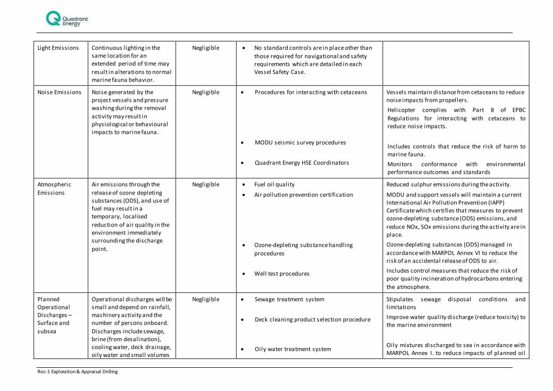
Light Emissions Continuous lighting in the same location for an extended period of time may
result in alterations to normal marine fauna behavior.
Negligible No standard controls are in place other than
those required for navigational and safety requirements which are detailed in each Vessel Safety Case.
Noise Emissions Noise generated by the project vessels and pressure washing during the removal
activity may result in physiological or behavioural impacts to marine fauna.
Negligible Procedures for interacting with cetaceans
MODU seismic survey procedures
Quadrant Energy HSE Coordinators
Vessels maintain distance from cetaceans to reduce noise impacts from propellers.
Helicopter complies with Part 8 of EPBC
Regulations for interacting with cetaceans to reduce noise impacts.
Includes controls that reduce the risk of harm to marine fauna.
Monitors conformance with environmental performance outcomes and standards
Atmospheric
Emissions
Air emissions through the
release of ozone depleting substances (ODS), and use of fuel may result in a temporary, localised
reduction of air quality in the environment immediately surrounding the discharge
point.
Negligible Fuel oil quality
Air pollution prevention certification
Ozone-depleting substance handling
procedures
Well test procedures
Reduced sulphur emissions during the activity.
MODU and support vessels will maintain a current International Air Pollution Prevention (IAPP) Certificate which certifies that measures to prevent ozone-depleting substance (ODS) emissions, and
reduce NOx, SOx emissions during the activity are in place.
Ozone-depleting substances (ODS) managed in
accordance with MARPOL Annex VI to reduce the risk of an accidental release of ODS to air.
Includes control measures that reduce the risk of poor quality incineration of hydrocarbons entering
the atmosphere.
Planned Operational Discharges – Surface and
subsea
Operational discharges will be small and depend on rainfall, machinery activity and the number of persons onboard.
Discharges include sewage, brine (from desalination), cooling water, deck drainage, oily water and small volumes
Negligible Sewage treatment system
Deck cleaning product selection procedure
Oily water treatment system
Stipulates sewage disposal conditions and limitations
Improve water quality discharge (reduce toxicity) to the marine environment
Oily mixtures discharged to sea in accordance with MARPOL Annex I. to reduce impacts of planned oil
Roc-1 Exploration & Appraisal Drilling 36 of 242
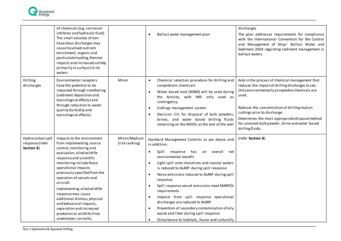
of chemicals (e.g. corrosion inhibitor and hydraulic fluid). The small volumes of non-
hazardous discharges may cause localised nutrient enrichment, organic and particulate loading, thermal
impacts and increased salinity primarily in surface (<5 m) waters.
Ballast water management plan
discharges
The plan addresses requirements for compliance with the International Convention for the Control
and Management of Ships’ Ballast Water and Sediment 2004 regarding sediment management in ballast waters.
Dril l ing
discharges
Environmental receptors
have the potential to be impacted through smothering (sediment deposition and toxicological effects) and
through reduction to water quality (turbidity and toxicological effects).
Minor Chemical selection procedure for dril l ing and
completions chemicals
Water based mud (WBM) will be used during
the Activity, with NAF only used as contingency;
Cuttings management system
Decision list for disposal of bulk powders,
brines, and water based dril l ing fluids remaining on the MODU at the end of the well
Aids in the process of chemical management that
reduces the impact of dril l ing discharges to sea. Only environmentally acceptable chemicals are used.
Reduces the concentration of dril l ing mud on cuttings prior to discharge.
Determines the most appropriate disposal method for unmixed bulk powder, brine and water based
dril l ing fluids.
Hydrocarbon spill response (refer Section 8)
Impacts to the environment from implementing source control, monitoring and evaluation, oiled wildlife
response and scientific monitoring include those operational impacts previously specified from the
operation of vessels and aircraft.
Implementing oiled wildlife
response may cause additional distress, physical and behavioral impacts, separation and increased
predation to wildlife if not undertaken correctly.
Minor/Medium (risk ranking)
Standard Management Controls as per above, and in addition;
Spill response has an overall net
environmental benefit
Light spil l onto shorelines and coastal waters
is reduced to ALARP during spill response
Noise emissions reduced to ALARP during spill
response
Spill response vessel emissions meet MARPOL
requirements
Impacts from spill response operational
discharges are reduced to ALARP
Prevention of secondary contamination of oily
waste and litter during spill response
Disturbance to habitats, fauna and culturally
(refer Section 8)
Roc-1 Exploration & Appraisal Drilling 37 of 242
sensitive areas during spill response is reduced to ALARP
Additional impacts from dispersant
application are reduced to ALARP
Reduce disruption to other users of marine
and coastal areas and townships during spill response is reduced to ALARP

Roc-1 Exploration & Appraisal Drilling 38 of 242
Table 6-2: Environmental Impact Treatment Summary for Unplanned Events
Event Potential Impacts Consequence Management Controls
Effectiveness of control
Marine Operations
(Collision with
marine fauna )
During the Activity, use of a MODU and support vessels have the
potential to result in direct impacts to fauna through collisions with marine mega fauna (cetaceans, whale sharks, turtles).
Low Procedures for interacting with
cetaceans
Quadrant Energy HSE
Coordinators
Vessels maintain distance from cetaceans to reduce noise impacts
from propellers.
Helicopter complies with Part 8 of EPBC Regulations for interacting with cetaceans to reduce noise impacts.
Monitors conformance with environmental performance outcomes and standards
Non-hydrocarbon release (surface) –
l iquid
An accidental release of chemicals and other non-hydrocarbon liquids
into the marine environment may result in a reduction of water quality and potential toxicity impacts to local marine fauna.
Ballast exchange may also result in the unplanned introduction of marine species (IMS).
Low
Dropped object prevention
procedures
Bulk l iquid transfer procedures
[DC-CM
Hazardous chemical management
procedures
Maritime Dangerous Goods Code
Biofouling vessel risk assessment
Ballast water management plan
Minimises drop object risk during MODU lifting operations that may
cause secondary spill (discharges) resulting in reduction in water quality
Reduces risk of accidental discharge to
sea
Reduces the risk of spil ls and leaks (discharges) to the sea by controlling
the storage, handling. and clean up.
Dangerous goods managed in accordance with International Maritime Dangerous Goods Code
(IMDG Code) to reduce the risk of an environmental incident, such as an accidental release to sea or
unintended chemical reaction
Aids in the process of chemical management that reduces the risk of accidental discharge to sea.
Any international and domestic (interstate) MODU or support vessel
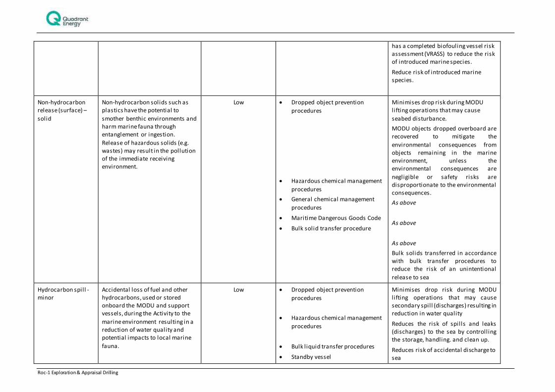
Roc-1 Exploration & Appraisal Drilling 39 of 242
has a completed biofouling vessel risk assessment (VRASS) to reduce the risk of introduced marine species.
Reduce risk of introduced marine species.
Non-hydrocarbon release (surface) –
solid
Non-hydrocarbon solids such as plastics have the potential to
smother benthic environments and harm marine fauna through entanglement or ingestion.
Release of hazardous solids (e.g. wastes) may result in the pollution of the immediate receiving environment.
Low Dropped object prevention
procedures
Hazardous chemical management
procedures
General chemical management
procedures
Maritime Dangerous Goods Code
Bulk solid transfer procedure
Minimises drop risk during MODU lifting operations that may cause
seabed disturbance.
MODU objects dropped overboard are recovered to mitigate the
environmental consequences from objects remaining in the marine environment, unless the environmental consequences are
negligible or safety risks are disproportionate to the environmental consequences.
As above
As above
As above
Bulk solids transferred in accordance with bulk transfer procedures to reduce the risk of an unintentional
release to sea
Hydrocarbon spill - minor
Accidental loss of fuel and other hydrocarbons, used or stored onboard the MODU and support vessels, during the Activity to the
marine environment resulting in a reduction of water quality and potential impacts to local marine
fauna.
Low Dropped object prevention
procedures
Hazardous chemical management
procedures
Bulk l iquid transfer procedures
Standby vessel
Minimises drop risk during MODU lifting operations that may cause secondary spill (discharges) resulting in reduction in water quality
Reduces the risk of spil ls and leaks (discharges) to the sea by controlling the storage, handling. and clean up.
Reduces risk of accidental discharge to sea
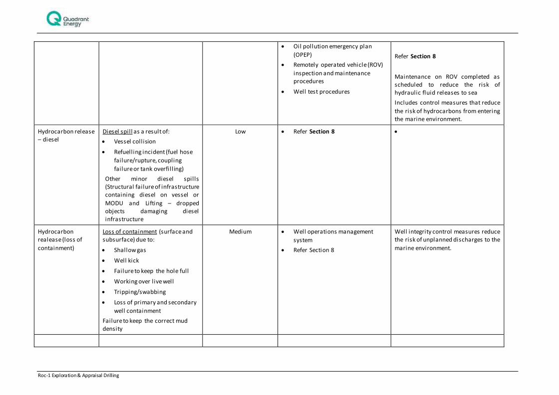
Roc-1 Exploration & Appraisal Drilling 40 of 242
Oil pollution emergency plan
(OPEP)
Remotely operated vehicle (ROV)
inspection and maintenance procedures
Well test procedures
Refer Section 8
Maintenance on ROV completed as scheduled to reduce the risk of hydraulic fluid releases to sea
Includes control measures that reduce
the risk of hydrocarbons from entering the marine environment.
Hydrocarbon release – diesel
Diesel spil l as a result of:
Vessel coll ision
Refuelling incident (fuel hose
failure/rupture, coupling
failure or tank overfi l l ing)
Other minor diesel spil ls (Structural failure of infrastructure containing diesel on vessel or
MODU and Lifting – dropped objects damaging diesel infrastructure
Low Refer Section 8
Hydrocarbon realease (loss of
containment)
Loss of containment (surface and subsurface) due to:
Shallow gas
Well kick
Failure to keep the hole full
Working over l ive well
Tripping/swabbing
Loss of primary and secondary
well containment
Failure to keep the correct mud density
Medium Well operations management
system
Refer Section 8
Well integrity control measures reduce the risk of unplanned discharges to the
marine environment.
Roc-1 Exploration & Appraisal Drilling 41 of 242
7. MANAGEMENT APPROACH
The Roc-1 drilling activity will be managed in compliance with all measures and controls detailed within the EP accepted by NOPSEMA under the OPGGS (E) Regulations, other environmental legislation and Quadrant’s Management System (e.g. Environmental Management Policy).
The objective of the EP is to ensure that potential adverse environmental impacts associated with unplanned events and planned events associated with the survey, are identified and assessed, and to stipulate mitigation measures to avoid and/or reduce any adverse impacts to the environment to ALARP.
The EP details specific performance objectives, standards and procedures, and identifies the range of controls to be implemented (consistent with the standards) to achieve the performance objectives. The controls for the activities are summarised in Section 6. The EP also identifies the specific measurement criteria and records to be kept to demonstrate the achievement of each performance objective.
As described in the EP, the implementation strategy includes the relevant details of the following:
1. Environmental management policy
2. Environmental performance standards and outcomes
3. Environmental Management System including ownership and objectives, audits, monitoring and
review
4. Leadership and responsibilities
5. Workforce training and competency
6. Performance review and continuous improvement
7. Records
8. Management and review of the EP
9. Routine and incident reporting
During the period that activities described in this EP are undertaken, Quadrant will ensure environmental performance is managed through an inspection and monitoring regime undertaken by Quadrant representatives or delegates based on the MODU or vessels.
Environmental compliance of an activity with the EP (and the EPO’s) is measured using planned and systematic audits or inspections to identify weaknesses and non-conformances in the system and processes so that they can be identified. Improvement opportunities identified through monitoring, audits and incident investigations are implemented in a controlled manner and communicated to all relevant workforce, contractors and relevant third parties. Audits and inspections are in place to identify possible incidents and actions taken to prevent them from happening.
Non-conformances found are addressed and resolved by a systematic corrective action process and are reported to NOPSEMA where relevant.
Senior Quadrant and vessel contractor personnel will be accountable for ensuring conformance with environmental performance outcomes and standards and all personnel will be empowered to ‘stop-the-job’ to ensure the activity is being implemented in an environmentally responsible manner. The EP identifies specific responsibilities for each role during the activity.
Incident notification and reporting to NOPSEMA and other regulators will be conducted as per the OPGGS (E) Regulations, as detailed within the EP. Reported HSE incidents and hazards will be communicated to personnel during daily operational meetings.
Roc-1 Exploration & Appraisal Drilling 42 of 242
8. HYDROCARBON SPILL RESPONSE ARRANGEMENTS
Credible hydrocarbon spill scenarios are identified in Table 4-1. In the event of a spill, initial actions will be undertaken by the Rig OIM/Vessel Master in line with the MODU/ vessel Shipboard Oil Pollution Emergency Plan (SOPEP). Should the spill require further action, such responsibilities will be taken over by the Combat Agency, in this instance Quadrant Energy in accordance with the Roc-1 Drilling Oil Pollution Emergency Plan (OPEP) (EA-00-RI-10117.02).
The following response strategies may be applied to credible spill scenarios:
Monitor and evaluate: surveillance and spill fate modelling;
Source control: relief well and well intervention including the use of a capping stack. Subsurface dispersant operations will be required in association with the source control strategy of capping stack;
Containment and recovery of oil;
Mechanical dispersion of floating oil: mechanical dispersion through use of vessels;
Chemical dispersion of floating oil;
Wildlife operations: including hazing and capture/treatment;
Shoreline operations for protection/deflection and clean-up; and
Operational and scientific monitoring: to determine extent of spill and impact and recovery assessment of sensitive marine receptors exposed to oil – tier 3 spills.
A justification and description of the strategies is provided in Table 8-1.
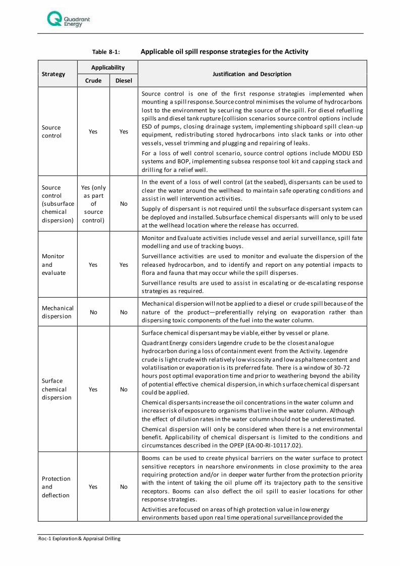
Roc-1 Exploration & Appraisal Drilling 43 of 242
Table 8-1: Applicable oil spill response strategies for the Activity
Strategy Applicability
Justification and Description Crude Diesel
Source control
Yes Yes
Source control is one of the first response strategies implemented when mounting a spil l response. Source control minimises the volume of hydrocarbons
lost to the environment by securi ng the source of the spill . For diesel refuelling spil ls and diesel tank rupture (collision scenarios source control options include ESD of pumps, closing drainage system, implementing shipboard spill clean-up equipment, redistributing stored hydrocarbons into slack tanks or into other
vessels, vessel trimming and plugging and repairing of leaks.
For a loss of well control scenario, source control options include MODU ESD systems and BOP, implementing subsea response tool kit and capping stack and
dril l ing for a relief well.
Source control (subsurface chemical
dispersion)
Yes (only as part
of source
control)
No
In the event of a loss of well control (at the seabed), dispersants can be used to
clear the water around the wellhead to maintain safe operating conditions and assist in well intervention activities.
Supply of dispersant is not required until the subsurface dispersant system can
be deployed and installed. Subsurface chemical dispersants will only to be used at the wellhead location where the release has occurred.
Monitor
and evaluate
Yes Yes
Monitor and Evaluate activities include vessel and aerial surveillance, spil l fate modelling and use of tracking buoys.
Surveillance activities are used to monitor and evaluate the dispersion of the
released hydrocarbon, and to identify and report on any potential impacts to flora and fauna that may occur while the spill disperses.
Surveillance results are used to assist in escalating or de-escalating response strategies as required.
Mechanical dispersion
No No
Mechanical dispersion will not be applied to a diesel or crude spill because of the
nature of the product—preferentially relying on evaporation rather than dispersing toxic components of the fuel into the water column.
Surface
chemical dispersion
Yes No
Surface chemical dispersant may be viable, either by vessel or plane.
Quadrant Energy considers Legendre crude to be the closest analogue hydrocarbon during a loss of containment event from the Activity. Legendre
crude is l ight crude with relatively low viscosity and low asphaltene content and volatil isation or evaporation is its preferred fate. There is a window of 30-72 hours post optimal evaporation time and prior to weathering beyond the ability
of potential effective chemical dispersion, in which s urface chemical dispersant could be applied.
Chemical dispersants increase the oil concentrations in the water column and increase risk of exposure to organisms that l ive in the water column. Although
the effect of dilution rates in the water column should not be underestimated.
Chemical dispersion will only be considered when there is a net environmental benefit. Applicability of chemical dispersant is l imited to the conditions and circumstances described in the OPEP (EA-00-RI-10117.02).
Protection and
deflection
Yes No
Booms can be used to create physical barriers on the water surface to protect
sensitive receptors in nearshore environments in close proximity to the area requiring protection and/or in deeper water further from the protection priority with the intent of taking the oil plume off its trajectory path to the sensitive
receptors. Booms can also deflect the oil spil l to easier locations for other response strategies.
Activities are focused on areas of high protection value in low energy environments based upon real time operational surveillance provided the
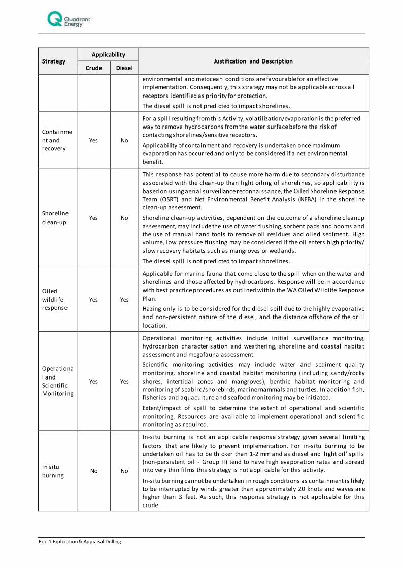
Roc-1 Exploration & Appraisal Drilling 44 of 242
Strategy Applicability
Justification and Description Crude Diesel
environmental and metocean conditions are favourable for an effective implementation. Consequently, this strategy may not be applicable across all
receptors identified as priority for protection.
The diesel spil l is not predicted to impact shorelines.
Containme
nt and recovery
Yes No
For a spil l resulting from this Activity, volatil ization/evaporation is the preferred way to remove hydrocarbons from the water surface before the risk of contacting shorelines/sensitive receptors.
Applicability of containment and recovery is undertaken once maximum evaporation has occurred and only to be considered if a net environmental benefit.
Shoreline
clean-up Yes No
This response has potential to cause more harm due to secondary disturbance
associated with the clean-up than light oil ing of shorelines, so applicability is based on using aerial surveillance reconnaissance, the Oiled Shoreline Response Team (OSRT) and Net Environmental Benefit Analysis (NEBA) in the shoreline clean-up assessment.
Shoreline clean-up activities, dependent on the outcome of a shoreline cleanup assessment, may include the use of water flushing, sorbent pads and booms and the use of manual hand tools to remove oil residues and oiled sediment. High volume, low pressure flushing may be considered if the oil enters high priority/
slow recovery habitats such as mangroves or wetlands.
The diesel spil l is not predicted to impact shorelines.
Oiled
wildlife response
Yes Yes
Applicable for marine fauna that come close to the spill when on the water and shorelines and those affected by hydrocarbons. Response will be in accordance with best practice procedures as outlined within the WA Oiled Wildlife Response
Plan.
Hazing only is to be cons idered for the diesel spil l due to the highly evaporative and non-persistent nature of the diesel, and the distance offshore of the dril l
location.
Operationa
l and Scientific Monitoring
Yes Yes
Operational monitoring activities include initial surveillanc e monitoring, hydrocarbon characterisation and weathering, shoreline and coastal habitat assessment and megafauna assessment.
Scientific monitoring activities may include water and sediment quality
monitoring, shoreline and coastal habitat monitoring (incl uding sandy/rocky shores, intertidal zones and mangroves), benthic habitat monitoring and monitoring of seabird/shorebirds, marine mammals and turtles. In addition fish, fisheries and aquaculture and seafood monitoring may be initiated.
Extent/impact of spil l to determine the extent of operational and scientific monitoring. Resources are available to implement operational and scientific monitoring as required.
In situ burning
No No
In-situ burning is not an applicable response strategy given several l imiti ng
factors that are l ikely to prevent implementation. For in‐situ burning to be undertaken oil has to be thicker than 1‐2 mm and as diesel and 'l ight oil’ spil ls (non-persistent oil ‐ Group II) tend to have high evaporation rates and spread into very thin fi lms this strategy is not applicable for this activity.
In‐situ burning cannot be undertaken in rough conditions as containment is l ikely to be interrupted by winds greater than approximately 20 knots and waves ar e higher than 3 feet. As such, this response strategy is not applicable for this crude.
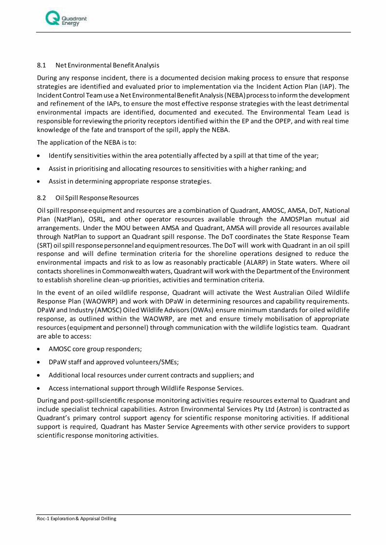
Roc-1 Exploration & Appraisal Drilling 45 of 242
8.1 Net Environmental Benefit Analysis
During any response incident, there is a documented decision making process to ensure that response strategies are identified and evaluated prior to implementation via the Incident Action Plan (IAP). The Incident Control Team use a Net Environmental Benefit Analysis (NEBA) process to inform the development and refinement of the IAPs, to ensure the most effective response strategies with the least detrimental environmental impacts are identified, documented and executed. The Environmental Team Lead is responsible for reviewing the priority receptors identified within the EP and the OPEP, and with real time knowledge of the fate and transport of the spill, apply the NEBA.
The application of the NEBA is to:
Identify sensitivities within the area potentially affected by a spill at that time of the year;
Assist in prioritising and allocating resources to sensitivities with a higher ranking; and
Assist in determining appropriate response strategies.
8.2 Oil Spill Response Resources
Oil spill response equipment and resources are a combination of Quadrant, AMOSC, AMSA, DoT, National Plan (NatPlan), OSRL, and other operator resources available through the AMOSPlan mutual aid arrangements. Under the MOU between AMSA and Quadrant, AMSA will provide all resources available through NatPlan to support an Quadrant spill response. The DoT coordinates the State Response Team (SRT) oil spill response personnel and equipment resources. The DoT will work with Quadrant in an oil spill response and will define termination criteria for the shoreline operations designed to reduce the environmental impacts and risk to as low as reasonably practicable (ALARP) in State waters. Where oil contacts shorelines in Commonwealth waters, Quadrant will work with the Department of the Environment to establish shoreline clean-up priorities, activities and termination criteria.
In the event of an oiled wildlife response, Quadrant will activate the West Australian Oiled Wildlife Response Plan (WAOWRP) and work with DPaW in determining resources and capability requirements. DPaW and Industry (AMOSC) Oiled Wildlife Advisors (OWAs) ensure minimum standards for oiled wildlife response, as outlined within the WAOWRP, are met and ensure timely mobilisation of appropriate resources (equipment and personnel) through communication with the wildlife logistics team. Quadrant are able to access:
AMOSC core group responders;
DPaW staff and approved volunteers/SMEs;
Additional local resources under current contracts and suppliers; and
Access international support through Wildlife Response Services.
During and post-spill scientific response monitoring activities require resources external to Quadrant and include specialist technical capabilities. Astron Environmental Services Pty Ltd (Astron) is contracted as Quadrant’s primary control support agency for scientific response monitoring activities. If additional support is required, Quadrant has Master Service Agreements with other service providers to support scientific response monitoring activities.

Roc-1 Exploration & Appraisal Drilling 46 of 242
9. CONTACT DETAILS
Further information about the Roc-1 drilling Activity can be obtained from:
Ashlee Crabbe
Consultation Coordinator
100 St Georges Terrace, Perth, 6000
6218 4972
Roc-1 Exploration & Appraisal Drilling 47 of 242
10. REFERENCES
Apache 2014. “Phoenix Area [Bedout Basin] EP Blowout Modelling Report”. Unpublished/Internal document.
APASA (2014a). “Bedout Basin EP: Quantitative Spill Risk Assessment”. J0327 – Apache Bedout Basin EP QSRA – Rev 0.
APASA (2014b). “Roc-1 Quantatative Spill Risk Assessment – Stochastic modelling – Summer Result n”. J0356 – Apache Roc-1 EP Rev 0.
BHPB 2005. Pyrenees Development. Draft EIS. BHP Billiton Petroleum. Perth.
Chevron 2010. Draft Environmental Impact Statement/Environmental Review and Management Programme for the Proposed Wheatstone Project Volume 1 (Chapters 1 to 6), 6.0 Overview of Existing Environment. Chevron Australia Pty Ltd, Perth, Western Australia
DPaW (2013a) New and proposed marine parks and reserves. Online, retrieved 23rd April 2014. Available at: http://www.dpaw.wa.gov.au/management/marine/marine-parks-and-reserves/69-new-and-proposed-marine-parks-and-reserves.
DEWHA 2008. The North-west Marine Bioregional Plan: Bioregional profile: A Description of the Ecosystems, Conservation Values and Uses of the North-West Marine Region. Department of the Environment Water, Heritage and the Arts, Canberra, ACT
DSEWPaC (2012) Marine bioregional plan for the North-west Marine Region. Department of Sustainability, Environment, Water, Population and Communities, Canberra, ACT. 269 pp.
DoE (2014) Commonwealth marine reserves. Department of the Environment, Canberra, Act. Available at http://www.environment.gov.au/topics/marine/marine-reserves [Accessed on 02 April 2014]
Director of National Parks (2012a) Concerning the Proposed Proclamation of 40 Commonwealth marine reserves (and the related revocation of seven existing Commonwealth reserves and the revocation of the Coral Sea Conservation Zone); and The amendment of the names of four existing Commonwealth marine reserves. Report to the Director of National Parks under the Environment Protection and Biodiversity Conservation Act 1999 Section 351.
Fletcher, W J and Santoro, K. (2013) Status Reports of the Fi sheries and Aquatic Resources of Western Australia 2012/13 (eds).: The State of the Fisheries. Department of Fisheries, Western Australia.
Hooper JNA, Ekins M (2004)‘Collation and validation of museum collection databases related to the distribution of marine sponges in Northern Australia. Unpublished report to the National Oceans Office, Hobart
Holloway, PE and Nye, HC 1985 Leeuwin current and wind distributions on the southern part of the Australian North West Shelf between January 1982 and July 1983. Australian Journal of Marine and Freshwater Research 36(2): 123–137
WNI 1995. Preliminary report on ambient and non-cyclonic design criteria for the Stag location. WNI Science & Engineering. December 1995
WNI 1996. Metocean Conditions on the North West Shelf of Australia, Cape Lambert to the North West Cape Relating to Jack-up Drilling Operation. (DR-50-ED-001). July 1996
Woodside (2005). The Vincent Development. Draft EIS. EPBC Referral 2005/2110.