Embed Size (px)
Citation preview

Robson Valley Land and Resource Management
Plan
Summary - April 30, 1999
Robson Valley Land And Resource Management Plan - Introduction
The approved Robson Valley Land and Resource Management Plan (LRMP) provides broad direction for the sustainable use of Crown land and resources in the Robson Valley area. The plan, developed through a local planning process and in consultation
with various sectors, balances economic, ecological, spiritual, recreational and cultural interests. It will help to provide greater land use certainty, preserve natural areas for future generations, maintain resource-sector jobs for local workers and increase
opportunities for tourism and recreation.
Now that it has been approved by government, the Robson Valley LRMP will be implemented by government agencies, including the provincial ministries of Forests; Environment, Lands and Parks; Energy and Mines; and Employment and Investment.
The approved plan will guide a variety of resource management programs and activities, such as forest development planning under the Forest Practices Code.
The Planning Area
All aspects of land and resource management were considered for this area in east central British Columbia. The plan area includes the 1.2 million hectare (ha) Robson
Valley timber supply area and the adjacent 223,000 ha Mount Robson and Mount Terry Fox provincial parks. About 4,000 people live in the area, which includes the major communities of McBride and Valemount.
The Planning Process
The Robson Valley LRMP recommendations and options were developed over a three year period by people representing more than 30 interest sectors. Every aspect of the plan was negotiated at the Robson Valley Round Table and the planning team was able to agree to the majority of the recommendations they developed. However, in some
cases, the table members could not agree and the conservation and resource sectors submitted options for government‟s consideration. Provincial government staff then conducted consultations with environmental groups, forest industry and labour
representatives and local government to ensure that all concerns were considered. The approved plan builds on the agreements that were reached at the planning table and
incorporates these consensus recommendations and government's decisions on specific issues where the table members did not reach consensus.
Decisions Reached
In the few areas where consensus could not be reached, the provincial government‟s decisions strike a balance between conservation and resource development values. In
some cases, the government has created subzones within resource management areas
that will be managed in ways that take into account specific environmental concerns within those areas. For example, the Upper Goat area has been designated a subzone
within a general resource management zone. Within this subzone, there will be harvesting of at least 445,000 m3 of timber during the first pass (6-10 years), and joint sign-off by the Ministry of Forests and the Ministry of Environment, Lands and Parks for
the 1999-2000 harvest and future forest development plans. This will ensure the management of non-timber resource values, such as wildlife and recreation, in the Upper Goat area.
The provincial government also reviewed all of the proposed protected areas to ensure
their boundaries reflected appropriate placement. In some cases, for example in the West Twin, the recommended boundaries included some private lands, agricultural land reserve and other tenures that would conflict with managing the new protected areas.
The government therefore altered some proposed boundaries to better follow the natural landscape and improve the protected areas.
Who Was Involved?
The Robson Valley LRMP was developed by community groups, industry representatives, environmental representatives, government agencies and interested
individuals. Participants represented a range of values, including water, fisheries, heritage, culture, recreation, tourism, timber, agriculture and environmental interests. All round table meetings were also open to the public.
First Nations
Two First Nation groups, the Shuswap Nation Tribal Council and the Lheidli T'enneh, were kept apprised of the LRMP progress through personal contacts, formal communications and meeting minutes which were distributed to all participants. The
Shuswap Nation Tribal Council also attended and made presentations at several round table meetings. Three other bands, the Williams Lake Band, the Canim Lake Band and the Red Bluff Band expressed interest over the plan area towards the end of the
process.
Participants
The Robson Valley Round Table involved more than 30 public sectors and government agencies, including:
Civic Advisory Group
Commercial Heliskiing/Helihiking Sector
Crescent Spur - Loos Community Association
Dunster Community Association
Environment Subcommittee
Farmers Institute
Forest Industry Subcommittee
Forest Workers for Sustainable Forests
Headwaters Unfragmented Biodiversity Ecosystem Coalition
IWA Canada 1-417
Interagency Management Committee
Jasper National Park
Lheidli T'enneh Nation
Outdoor Recreation Subcommittee
Range/Habitat Subcommittee
Resource Advisory Group
Robson Valley Category 2 Small Business Forest Enterprise Program Holders
Robson Valley Independent Harvesting Group
Robson Valley Mill Workers
Shuswap Nation Tribal Council
Snowmobile Association
Tete Jaune Community Club
Tourism Subcommittee
Village of McBride
Village of Valemount
Youth Subcommittee
BC Parks
BC Assets and Lands
Department of Fisheries and Oceans
Ministry of Agriculture
Ministry of Employment and Investment, Energy and
Mines Division
Ministry of Environment, Lands and Parks
Ministry of Forests
Ministry of Small Business, Tourism and Culture
Plan Highlights
The LRMP divides the plan area into 23 resource management zones (RMZs), each of which falls into one of five different categories. Some of these RMZs are further
classified into subzones.
Resource Development Emphasis
(31.4 % of plan area)

These RMZs are identified for intensive development of resources, such as timber and minerals, while managing for other values.
General Resource Management
(19.3 % of plan area)
In these RMZs, one use is not emphasized over another. Areas will be managed for a wide array of resource values, such as wildlife, recreation and timber.
Special Management
(24.0 % of plan area)
These are areas for which the conservation of one or more values such as water quality,
habitat, recreation and scenery are a priority. The community watersheds for McBride and Valemount are included in this category. Resource development activities in Special Management RMZs are subject to more comprehensive resource conservation
strategies.
Settlement / Agriculture
(4.9 % of plan area)
This RMZ is essentially the main valley floor of the Rocky Mountain Trench. It includes agricultural and settlement areas and is consistent with the Crown Land Plan for the
Robson Valley.
Protected Areas
(20.4 % of plan area)
Ten areas have been designated as new protected areas (4.9 % of the plan area), in addition to the existing Mount Robson and Terry Fox provincial parks (15.5 %). This
increases the amount of protected area by about 69,000 ha, for a total of approximately 292,000 ha of protected areas in the Robson Valley plan area.
New Protected Areas
(all areas are approximate)
Betty Wendle (14,415 ha) is comprised of the Betty Wendle Creek watershed system upstream of the eastern boundary of Bowron Lake Provincial Park. The area has
important visual, wildlife, fishery and water quality values and provides a link to the adjacent park.

Cariboo River (6,060 ha) lies adjacent to the easternmost boundary of Bowron Lake Provincial Park and includes areas considered visually sensitive when viewed from the
park.
Foster Arm (952 ha) is situated along the north side of the Foster Creek Inlet on the west side of Kinbasket Lake. This area was a strong candidate for protection due to the diverse tree species and superior growing conditions present on the site. The presence
of healthy western white pine throughout this area was an important factor in the decision, as well as the opportunity to protect an area that represents the Kinbasket Lake ecosystems.
Holliday Creek Arch (397 ha) is a magnificent natural sedimentary rock arch in the
Rocky Mountains. The protected area will preserve more of the surrounding terrain that is critical to the integrity of this special feature.
Jackman Flats (615 ha) has long been recognized for its provincially significant ecosystem representation. It is an unusual area with sand dunes and unique plants
which has intrigued local residents since the early part of the century.
Lower Raush (1,259 ha) is situated in the lower stretch of the Raush River between four and eight kilometres upstream from the confluence with the Fraser River. The area is on the west side of the Raush River and runs up steep slopes through three different
biogeoclimatic zones before ending in alpine tundra and rock cliffs.
Small River Caves (1,849 ha) is located near the headwaters of Small River; it contains a cave complex with multiple openings.
Swiftcurrent River (6,038 ha) is an addition to Mount Robson Provincial Park along
its west boundary. The river provides additional representation of interior cedar-hemlock and has high recreational values.
Upper (Middle) Raush (5,408 ha) is located about half way up the Raush River drainage; it has significant interior cedar-hemlock representation and wildlife values.
West Twin (32,494 ha) was chosen for its rich wildlife, wide biogeoclimatic
representation and because it is the only protected corridor across the Robson Valley trench. The area runs from the Cariboo Mountains in the south, through the main Robson Valley trench, and up the front ranges of the Rocky Mountains. Boulder
Mountain and Ozalenka Creek are popular recreation sites within this area.
Forestry Considerations
This land and resource management plan clarifies which areas of Crown Land are available for timber harvesting in the Robson Valley area. Many of the constraints on the timber supply in the region were identified in the 1996 timber supply review, before
the completion of the LRMP. The LRMP decision will be considered in the next timber supply review, which will take place during 1999. The timber supply analysis is one of several factors considered by the Chief Forester in determining the allowable annual
cut.

No forestry jobs are expected to be lost as a result of the LRMP, however, a small number of jobs could be lost over the next few decades due to timber supply
limitations. These jobs would be impacted whether or not there was an LRMP.
Operational forestry and range use activities that take place within the land use plan will be regulated by the Forest Practices Code. Government agencies will work together to determine which components of the LRMP should be declared higher level plans
under the code.
Environmental Considerations
The approved LRMP addresses many environmental considerations and encourages a sustainable environment for the Robson Valley. The plan provides increased protection for wildlife habitat through zones, objectives and strategies. For example, protected
areas and special management zones have been created in such a way as to maintain viable grizzly bear populations. Mountain goats and woodland caribou will also receive greater conservation. The plan also improves protection for old growth forests,
domestic water quality and biodiversity.
1.0 INTRODUCTION
This report comprises the Land and Resource Management Plan (LRMP) for the Robson Valley. As part of British Columbia‟s Land Use Strategy, the Robson Valley LRMP provides direction for the management of all Crown land in the plan area for the next
ten years.
The plan was developed through a local planning process consistent with provincial government policy on Land and Resource Management Planning, as described in the Provincial Land Use Charter (1992) and A Statement of Principles and Process (1993).
The Robson Valley planning group, known as the Robson Valley Round Table (RVRT),
included representatives from interest groups, public, aboriginal peoples and government agencies. The RVRT reached partial agreement and published a report in December 1996, the Recommended Land and Resource Management Plan and
Recommended Options Report. Government reviewed the RVRT report and recommended a single land and resource management plan which incorporated much of the RVRT agreement and interests, published in the Recommended Robson Valley Land
and Resource Management Plan, June 1997.
These recommendations were accepted by government on April 30, 1999 with one significant change, namely, that the Upper Goat area be designated a subzone of the
Goat River general resource management zone.
All land use, resource development and resource management activities within the Robson Valley LRMP area are subject to legislation, policies and regulations for Crown
land and resource management. The Forest Practices Code of BC Act provides standards for sustainable forest management practices and requires integrated planning
through the establishment of a number of more detailed level plans. As a cabinet-approved plan, the LRMP provides direction for more detailed level plans developed and implemented under the Forest Practices Code and other government agency programs
and policy.
Early in the process, the Table agreed to promote a diverse, balanced and sustainable use of land and resources, which meets human needs and supports healthy, viable and stable communities and ecosystems in the Robson Valley. The direction of the Robson
Valley LRMP will further enhance land and resource uses by integrating resource values to promote long term sustainability.
1.1 Physical and Environmental Description
The Robson Valley LRMP covers approximately 1.4 million hectares and lies within the boundaries of the Robson Valley Forest District. The LRMP area is bounded to the west by three contiguous provincial parks including Bowron Lake, Wells Gray and the new
Mitchell Lake-Niagara protected area that link them. East of the Fraser River situated on part of the northern boundary is Kakwa Recreation Area. Along the eastern edge of the plan area lies the Willmore Wilderness Area, Mount Robson Provincial Park, Mount Terry
Fox Provincial Park and Jasper National Park. Although not technically in the Timber Supply Area (TSA), Mount Terry Fox and Mount Robson provincial parks are considered existing protected areas within the LRMP planning area.
The Robson Valley is characterized by the Fraser River that runs through the main
valley and the surrounding steep, mountainous terrain. The plan area is represented by three dominant ecosections:
The Upper Fraser Trench (UFT) ecosection extends the length of the valley floor from Crescent Spur to
Valemount. The UFT has undergone extensive agricultural and forest development and was altered by the creation of the Kinbasket reservoir. The remaining forests are
dominated by hemlock and cedar in the northern portion of the planning area and lodgepole pine in the south. Highway 16 and the CN Railway traverse the northern
half of the UFT.
The North Cariboo Mountains (CAM) lie west of the Fraser River. This is an area of rugged high relief characterized
by large areas of alpine tundra, rock and ice, Engelmann spruce-subalpine fir forests on steep slopes and cedar-hemlock forests on lower slopes. Because of high snow
falls and short cool summers, large glaciers occur throughout these ecosections above 2,200 metres.
The Northern Park Ranges (NPK) ecosection lies east of the Fraser River and is characterized by moderately rugged terrain and wide valleys including the Morkill and
Holmes River. There are extensive areas of alpine tundra,
Engelmann spruce-subalpine fir and interior cedar-hemlock forests on lower slopes. Although the area
receives extensive snowfall, it is relatively drier and supports fewer glaciers than the CAM ecosection.
In addition, the plan area contains four minor ecosections including the Columbia Park Ranges (CPK), the Northern Kootenay Mountains (NKM), the Big Bend Trench (BBT)
situated in the extreme south and the Hart Ranges (HAR) in the north.
Within the seven ecosections, fourteen biogeoclimatic subzones/variants are recognized. These are described on the following pages.
Biogeoclimatic Zone Descriptions
Alpine Tundra (AT)
The rugged terrain of the Robson Valley is reflected in the large amount (45% of plan area) of alpine tundra present in the plan area. Exposed to severe weather conditions, the alpine tundra zone is characterized by strongly weathered and eroded bedrock, glaciers and snowfields. Many unique plants and animals are found in the alpine tundra
zone and are considered sensitive to disturbance.
Engelmann Spruce-Subalpine Fir (ESSF)
This biogeoclimatic unit is the uppermost forested zone and occurs on mid and upper slope positions. The ESSF is dominated by colluvial material, a reflection of the steep
slopes found in many V-shaped valleys. Due to cooler temperatures, most precipitation falls as snow. The ESSF occurs extensively throughout the Valley and comprises the second most abundant zone (37%) of the plan area. Forests of the ESSF are dominated
by subalpine fir and Engelmann spruce. At the upper elevations, where the climate is cooler and receives more snow, the forests become more clumpy and form a mosaic of open and stunted subalpine fir trees known as parkland. Four subzones occur within the
plan area including the ESSF mm2 (Robson Moist Mild) variant which is unique to the Robson Valley and occurs only in Mount Robson Provincial Park. The ESSF mm1 (Raush Moist Mild) is the predominant subzone and occurs at middle to upper elevations in the
Rocky Mountain Trench and the majority of adjacent side tributaries and to the south in Howard, Foster, Dawson and Harvey creeks. A small amount of the ESSF wk2/wc3 occurs at mid to upper elevations on the west side of the lower Morkill River.
Interior Cedar-Hemlock (ICH)
The ICH zone comprises about 12% of the plan area and occurs on lower slopes and valley bottom positions where, historically, mature stands were usually uneven-aged or multi-storied even-aged. On mid to lower slope positions morainal blankets derived
from glacial processes are common. In the lower slope and valley bottom positions, finer textured glaciolacustrine and glaciofluvial sediments are commonly found and susceptible to erosion. The ICH mm (Moist Mild) subzone represents the majority of the
ICH biogeoclimatic zone and occurs along the lower slopes of the trench between Lamming Mills and the Kinbasket Reservoir. This subzone also extends along the valley
bottoms in the Castle, Raush, Lower Holmes and Canoe Rivers. The ICH mm is relatively dry, receiving less precipitation than other ICH subzones partly because of the
rainshadow effect of the Premier Range. The dominant climax tree species in this subzone are western redcedar and western hemlock. Douglas-fir, lodgepole pine and trembling aspen occur in seral stands. At present, seral stands are relatively common in
this subzone due to the drier climate and susceptibility to wildfires as well as past land uses practices (i.e., burning) during the railroad construction period about 90 years ago. The ICH wk3 (Goat Wet Cool) variant is found in the northern portion of the
planning area where it occurs on the lower slopes and the valley floor in a relatively wide band between Ptarmigan Creek and Clyde Creek. The ICH wk1 (Wells Gray Wet Cool) variant occurs on lower slopes near the southern end of the Canoe Reach. On the
west side of the lake it enters Howard and Foster Creeks and on the east side it enters Dawson and Harvey Creeks. This subzone is considerably moister than other ICH subzones within the plan area. The dominant tree species found are western redcedar
and western hemlock. Cottonwood is commonly found on fluvial flood plains and Western yew sporadically occurs in a variety of sites. Small amounts of the ICH wk2 (Missinchinka Wet Cool) are found in the valley bottoms of the Cariboo River and Betty
Wendle Creek.
Sub-Boreal Spruce (SBS)
The SBS is divided into three subzones that make up about 6% of the plan area. It occurs in the valley bottoms where finer textured glaciolacustrine and glaciofluvial
sediments are commonly found and susceptible to erosion. The SBS dh (Dry Hot) variant represents the predominant SBS subzone in the LRMP plan area. It occurs along the valley bottom in the Rocky Mountain Trench between Dunster and Valemount and
east along Highway 16 to Jasper. Because of the extensive fire history of this subzone, a mosaic of even-aged regenerating stands, ranging in size from hundreds to thousands of hectares with remnant mature forest patches, occur. The dominant tree species are
lodgepole pine and Douglas-fir. The SBS vk (Very Wet Cool) variant is found in the northern portion of the plan area where it occurs in narrow bands along the Fraser River and confluences of the Morkill and Fraser Rivers. It is the wettest of the SBS
subzones and forests are predominantly a mix of white spruce and subalpine fir. A small amount of the SBS wk1 (Willow Wet Cool) variant occurs along the valley bottom of
Betty Wendle Creek.
Other Environmental Values
The rugged peaks and spectacular scenery of the Robson Valley offers numerous commercial recreation opportunities including heliskiing, helihiking, backcountry skiing and snowmobiling.
Although not considered part of the Timber Supply Area, Mount Robson Provincial Park
exists within the plan area. Mount Robson Provincial Park was established in 1913 to protect Mount Robson, which is the highest peak (3,954 m) in the Canadian Rockies. In 1990 the park was added to the Canadian Rocky Mountain Parks World Heritage Site
(UNESCO) and was chosen for its outstanding mountain scenery and diversity of wildlife habitats. Together with six other mountain parks (Banff, Jasper, Yoho, Kootenay National Parks and Mount Assiniboine and Hamber provincial parks), Mount Robson

Provincial Park contributes to this contiguous chain of parks which form one of the largest protected areas in the world.
The Robson Valley contains over 200 of British Columbia‟s 430 bird species including
one red-listed species (western grebe) and nine blue-listed bird species. Over 50 mammal species occupy the plan area including four blue-listed species (woodland caribou, grizzly bear, wolverine and fisher).
Regionally significant populations of mountain goats occur in high elevation habitats in
the Horsey Creek area adjacent to Mount Robson. Other ungulates such as moose, deer and elk can be found in the valley bottoms primarily in the main valley and floodplain habitats of the Morkill and Raush rivers. Many factors limit the distribution of ungulates
in the Robson Valley including steep-sided valleys, high snowfalls and the loss of summer and key winter range from agricultural land development and the flooding of the Kinbasket Reservoir. Because of these limitations, the plan area supports moderate
populations of moose, mule deer and white-tailed deer. Elk have increased recently in the plan area and can be found in the valley bottoms of the Holmes River as well as agricultural areas near McBride and Tete Jaune Cache.
Small populations of woodland caribou (mountain ecotype) can be found in the West
Twin Creek and East Twin Creek areas. These caribou live primarily in high elevation subalpine habitats where they feed on arboreal lichens (tree lichens) during the winter. Other caribou can also be found east of the Fraser River in the Rocky Mountains during
summer. These caribou migrate from Alberta (Willmore Wilderness Area) to the Robson Valley during calving and rutting seasons. Areas that receive the highest use include
the upper subalpine and alpine elevations around the Morkill, Forgetmenot and Cushing creeks. Relatively high densities of grizzly bears occur throughout many of the drainages in the plan area, most notably in the Morkill River, Cushing Creek, Goat River
and Hugh Allan Creek.
Although no large lakes exist in the Robson Valley, small lakes such as La Salle, Shere, Cedarside and Little Lost Lake provide recreational trout fishing opportunities. In addition, many alpine and subalpine lakes including Loren Lake are unique special
features that contribute to the high wilderness and recreational opportunities in the valley.
Several sites within the plan area are known class A fish habitat including the Fraser River and all its tributaries. Blue listed Bull Trout habitat exists on Hugh Allan Creek.
Significant Chinook salmon spawning areas include the flood plain reaches of the Morkill, Goat, East Twin, West Twin, McKale, Holmes, Nevin, Holliday, Horsey, McLennan and Swift drainages. Public viewing opportunities of spawning salmon exist in
the Fraser River below Rearguard Falls in the Tete Jaune area, in Swift Creek at Valemount and along the Holmes River near McBride.
1.2 Social and Economic Description
The Robson Valley LRMP planning area, comprised of the Robson Valley Timber Supply Area (TSA), covers approximately 1.2 million hectares. Mount Robson and Mount Terry Fox provincial parks, adjacent to the TSA, total approximately 223,000 hectares. The
population of the Robson Valley is currently about 4,000. Roughly half live in Valemount and McBride, the two largest and only incorporated communities, with the other half
living in other smaller communities (Dunster, Tete Jaune, Crescent Spur and Loos, in rough order of size) and more rural area. Yellowhead Highway 16, connecting Prince George with Jasper National Park, and Highway 5, connecting Tete Jaune with
Kamloops, are the main transportation routes through the Valley. The CN Railway runs parallel to both highway routes.
Valemount, with a population of about 1,200 and located near the junction of the two highways, is the region‟s primary growth centre. McBride, with a population of about
719, is located 80 km northwest of Valemount on Highway 16. There are no First Nations communities in the planning area, although the Lheidli T‟enneh and the North Thompson Band claim traditional territories in much of the valley. The Canim Lake Band
and Williams Lake Band, both part of the Cariboo Tribal Council, and the Red Bluff Band have similar territorial interests in the plan area.
Total population in the Robson Valley declined about 14% over the 1981-91 period, likely due to declines in forestry employment. Based on more recent estimates for
Valemount and McBride, population appears to have grown slowly since 1991, due to immigration of retirees and “urban refugees”. These trends will likely continue in the future.
Forestry has been the single most important sector in the Valley‟s economy, directly
and indirectly accounting for about one third of income and employment. Many farmers are loggers and truckers. However, over the 1981-1991 period, employment in forestry
due to technological change in sawmilling has declined. There are two sawmills, one plywood veneer plant and several smaller facilities. The region currently imports about one third of its timber requirements, primarily private supplies from Alberta and other
parts of BC. Harvest reductions in the TSA are likely to occur over time because of the decline in timber supply as indicated in the 1994 Timber Supply Review. However, the employment impacts of these trends could be mitigated by timber imports, higher
utilization of waste and problem forest types, the Forest Renewal Program and growth in value added activities. Forestry will remain a dominant economic sector, but will continue to decline in relative importance.
Tourism, which accounts for about 6% of income and 16% of employment in the Valley,
is the strongest growth factor in the regional economy. This potential is based on a diversity of recreation opportunities, spectacular scenery and proximity to Mount Robson and Jasper parks. These parks help to draw about one million visitors annually
through the Valley. Data provided on park use and by commercial operators also indicate strong historical growth in recreation demand. Tourism-related growth is expected to be particularly important to the Valemount economy.
Agriculture, which accounts for about 6% of employment and 13% of income, is an
important source of livelihood in more rural areas of the Valley. Little growth is expected in dairy and beef agriculture due to the highly competitive nature of the industry. There is some potential in more intensive, higher value agriculture activities
such as greenhouse/market gardening operations. Agriculture and tourism are more important as sources of employment than income because of lower average annual incomes in these sectors.
Local, provincial and federal government employment, and government transfer payments directly and indirectly account for about 27% of the Valley‟s income, second
in importance only to forestry. These sources of income have been an important stabilizing factor in the region‟s economy. Pension and investment income accounts for about 11% of total income in the Valley. Miscellaneous construction, transportation and
manufacturing (unrelated to other “basic” sectors such as forestry) together comprise about 17% of regional income.
Historically, mining and energy have not been significant components of the Valley‟s economy. There are a variety of mineral occurrences throughout the plan area including
some precious metals and a variety of industrial minerals. There are past producing areas of silica and mica in the Valemount area as well as potential for gypsum in the upper Forgetmenot Creek. No major developments are expected in the Valley in the
short term, but there are some promising longer term possibilities in industrial minerals and small scale hydro.
There has been a gradual historical trend from goods-producing to service industries in the Valley. This has been caused by declines in forestry employment, tourism growth,
aging population, in-migration of “urban refugees” and retirees, and displacement of some imported goods and services by local entrepreneurs. Although these trends will likely continue, average per capita income has declined as the lower wage service
sector has grown. These changes are generally consistent with province-wide trends. Unemployment rates for the Valley appear to be higher than average for BC, not
uncommon for areas more dependent on cyclical and seasonal industries.
A socio-economic base case (1993) prepared for the Robson Valley Round Table, and a socio-economic analysis for the Timber Supply Review (1994) provide more detailed descriptions of the region‟s current and anticipated social and economic characteristics.
1.3 PROCESS
An Overview of the Process
Land and Resource Management Planning (LRMP) is a sub-regional strategic resource planning process which applies the Provincial Land Use Strategy principles and policies to develop more specific objectives and guidelines for land use. LRMP considers all
resource values and interests and requires public participation, interagency coordination and consensus based decision-making to develop recommendations on land and resource management for Cabinet and/or designated Cabinet Ministers' consideration.
Once approved, and in accordance to Higher Level Plans: Policy and Procedures, the Land and Resource Management Plan will give strategic direction to planning activities and operations at a lower level.
In the spring of 1993, a study was conducted to determine the feasibility of a Land and
Resource Management Planning process for the Robson Valley. After meetings, interviews and research with stakeholders of the Valley, it was concluded a plan would proceed and a negotiating table, the Robson Valley Round Table (RVRT), was formed.
The Robson Valley Land and Resource Management Plan covers all Crown land in the Robson Valley Timber Supply Area. The purpose of the plan is to set directions for land
use and specify resource management objectives and strategies. Throughout the process, the Table used a consensus building process for its deliberations and applied a shared decision making model to public participation activities. The Protected Area
Strategy was also addressed by the RVRT.
The Round Table was comprised of thirty sectors, including citizen groups, industry and various government agencies, each holding a seat at the Table to represent their various interests. Sectoral representatives were spokespersons for their interest group
and were the consistent communication link between the Table and their group. The Table met most months from April 1993 to July 1996. When needed, Round Table sectors formed sub-committees which met more frequently to tackle more challenging
issues like biodiversity and visual management. Sub-committees reported back to the Round Table where final discussions took place. The Interagency Planning Team (IPT), composed of local and regional provincial and federal resource managers, provided
project management and technical support.
Planning Participation at the Round Table
The Robson Valley Round Table involved thirty sectors, including:
BC Environment
BC Lands
BC Parks
Civic Advisory Group
Crescent Spur - Loos Community Association
Department of Fisheries and Oceans
Dunster Community Association
Environment Subcommittee
Farmer‟s Institute
Forest Industry Subcommittee
Forest Workers for Sustainable Forests
Headwaters Unfragmented Biodiversity Ecosystem Coalition
Heliski / Helihiking
IWA Canada 1-417
Lheidli T'enneh
Ministry of Employment and Investment, Energy and
Minerals Division
Ministry of Forests
Ministry of Small Business, Tourism and Culture
Outdoor Recreation Subcommittee
Range / Habitat Subcommittee
Resource Advisory Group
Robson Valley Category 2 SBFEP Holders
Robson Valley Independent Harvesting Group
Robson Valley Mill Workers
Shuswap Nation Tribal Council
Snowmobile Association
Tete Jaune Community Club
Tourism Subcommittee
Village of McBride
Village of Valemount
Youth Subcommittee
*Note:Public or industry mining sector was not present at the Table, likely because of the low level of present mining activity in the plan area.
Planning Sequences
The Commission on Resources and the Environment (CORE) and the Prince George Interagency Management Committee (IAMC) agreed to proceed with the Robson Valley
LRMP as a pilot project of the Commission in March 1993. The general planning sequence followed eight steps:
1. March - July 1993 Preliminary Organization
public participation assessment conducted
Robson Valley Round Table formed; interagency planning team formed
2. August – Nov. 1993 Terms of Reference
Terms of Reference document developed
3. Dec. 1993 - Nov. 1994 Information Assembly and RMZ Information
issues and overall goals defined
resource and land use issues identified and qualitative or
quantitative resource mapping information gathered
land base divided into resource management zones
4. July 1994 - June 1995 Scenario Development
alternative land and resource management plans with area specific management objectives and strategies for
each resource developed
5. July - Dec. 1995 Scenario Evaluation
resource and multiple accounts analysis of land use and management scenarios and effects on social, economic and environmental conditions undertaken
6. Jan. - July 1996 Building Agreement
consensus on a land use plan and/or agreement on
options
7. Oct. 1996 Preparation of Recommendation Plan and Options Report
agreement recommendations and options for approval submitted to government
8. May 1997 Preparation of Recommendation Report
single recommended land and resource management plan submitted to senior government for approval
Vision
The vision of this planning process was to produce a Land and Resource Management
Plan that would:
result in an overall land use strategy for Crown lands which embraces the principle of sustainability, meeting
the needs of the present without compromising the ability of future generations to meet their own needs;
be the result of comprehensive integrated Land and
Resource Management Planning, identifying and considering all resource values, along with social, economic and environmental needs; and
provide a forum for shared decision-making by interest groups, public, aboriginal peoples and government agencies that is based on consensus.
Objectives
To achieve this vision, the following objectives directed this planning process:
1. To provide interest groups, the public, aboriginal peoples
and government agencies with opportunities for
participation throughout the planning process. A cooperative team approach in which participants are
viewed as equal partners was used in the planning process.
2. To seek consensus among participants when developing
recommendations on management and use of resources. Where consensus could not be reached, the areas of disagreement would be documented and handled through
the dispute resolution process.
3. To assemble and use the most relevant biological, physical and socio-economic information in the
development of the plan. If the Table decided that the information lacking is critical to the decision, the Table would then decide how to proceed.
4. To use integrated planning principles to identify interest, needs and goals, select and evaluate scenarios and recommend strategies for sustainability.
5. To develop a planning process with enough flexibility to allow for incorporation of new directions in integrated resource planning.
6. To provide a mechanism for ensuring that the final plan would be implemented, monitored, evaluated and
updated as required.
7. To make every reasonable effort to develop the Land and Resource Management Plan in a timely fashion.
Interests of Some Sectors at the Table
One of the first tasks of the sectors at the Table, defining interests concerning
resources and Crown land in the Robson Valley, was a key part of the interest-based negotiation process. The lists permitted each sector to evaluate and compare proposed land uses with their own interests. Some interests shared by a number of different
sectors at the table were:
planning for beneficial and sustainable land uses
maintaining biodiversity
maintaining natural water quality, chemistry, flows and
temperature
maintaining and promoting the economic and social health of our communities
maintaining or enhancing visual quality and clean air
providing more jobs by exploring opportunities for value added products
reducing conflicts between backcountry users
integrating all local industries to promote jobs and high quality natural environment for future generations
security of forest tenure and consistent allowable annual cut over time
maintaining and increasing fish and wildlife populations
for consumptive and non-consumptive uses
Communications
The key element of the Robson Valley Round Table process was public participation. In order to ensure an informed public and to encourage discussion of the land use issues, the Round Table made use of various communication methods including:
initial open house and organizational public meeting
all meetings were open to the public
open seat at Round Table for general public presentation/discussion
prior to each monthly meeting, minutes from the previous meeting and background information would be forwarded to each sector representative
meeting summaries and notice of upcoming meetings were published in the Valley Sentinel, the local newspaper, after each meeting
development of a newsletter (distributed throughout the valley) to inform the public about the process
LRMP display booth at the 1995 Robson Valley Trade Show in Valemount
1.4 FIRST NATIONS
Involvement
Aboriginal rights exist in law and are recognized and affirmed under the Constitution Act 1982. The 1993 Court of Appeal decision in Delgamuukw clarified that blanket extinguishment of aboriginal rights did not occur prior to 1871 and, therefore, these
rights continue to exist in British Columbia today. As such, they cannot be unjustifiably infringed by activities of the Crown.
The provincial government is working toward settlement of land claims with First Nations in British Columbia. In developing the Robson Valley LRMP, the government
reaffirms that all decisions are without prejudice to aboriginal rights. Land use decisions contained within the Robson Valley LRMP form the basis of the provincial government‟s position during treaty negotiations.
When the planning process first began, the Shuswap Nation Tribal Council (SNTC) and
the Lheidli T'enneh, both whose traditional territories cover almost the entire plan area, were invited to participate. The Shuswap First Nation, Secwepemc, has participated

when possible throughout the process. The Lheidli T'enneh also expressed interest in participating and meeting to discuss the Plan.
In April 1996, the Robson Valley Round Table was informed of an updated Cariboo
Tribal Council Territorial Map. The Canim Lake Band traditional territory overlaps with the Raush Valley and McBride-Dunster area. The Williams Lake Band traditional territory overlaps with a small area at the headwaters of Castle Creek.
Secwepemc (Shuswap) Participation
The Secwepemc attended several meetings throughout the process to ensure that their
interests are represented. A map showing Secwepemc traditional territory and a statement of Secwepemc interests in the LRMP area that overlaps their traditional territory follows.
Figure 1. The Secwepemc (Shuswap) Traditional Territory
Secwepemc Interests in Land Uses and Resource Management
Secwepemc people respect and support the efforts of non-aboriginal people to plan for sustainable, integrated resource management but are concerned that their own rights be respected. The general Secwepemc position regarding land use and resource
management is based on the following principles:
Inherent Secwepemc aboriginal rights and title, and the right of Secwepemc communities to exercise jurisdiction over their traditional lands and resources, must be
recognized by non-aboriginal government agencies and interest groups. This is essential to land and resource management planning in Secwepemc traditional territory.
The Secwepemc Nation and its agencies constitute a distinct order of government, not an “interest group”. Current non-aboriginal land use and resource
management planning processes are designed to be forums for interest groups and various agencies involved in land use planning. Interest groups and non-aboriginal
government agencies do not have aboriginal rights, whereas the Shuswap Nation does.
Provincially-mandated land use/resource management processes are not appropriate for negotiating aboriginal
right and title. Secwepemc aboriginal title and rights will be negotiated on a government-to-government basis between Secwepemc government representatives and
representatives of British Columbia and Canada, respectively.
Land use proponents, planners and policy makers should
be aware that their decisions regarding land use zones, allocation of resource tenures and resource management strategies will be impacted by future treaty negotiations.
Secwepemc communities will negotiate a treaty with British Columbia and Canada to resolve the issues of aboriginal rights and title, and Secwepemc self-
government. They do not want future treaty negotiations to be limited, prejudiced or compromised by current provincial land use/resource management processes.
Secwepemc government agencies must be equipped with the same technical resources for Land and Resource Management Planning, resource management and treaty
research as non-aboriginal governments and interest groups. This is a pre-condition for resolving the issue of
unextinguished aboriginal rights and title.
Submissions to the Robson Valley Round Table
In January 1994, Chief Nathan Matthew presented and provided written information to the Table which outlined the Secwepemc interests in the Robson Valley Round Table process. These interests can be summarized as follows:
meaningful consultation before decisions are made
continuation of traditional uses
economic developments
joint planning
revenue sharing from resource extraction
tenure opportunities
public education about Shuswap interests
involvement in land use decisions
In February 1996, Councilor Ron Matthew presented and provided a memo to the Round Table that identified statements to be incorporated into the Plan, including the following statements of:
recognition of Secwepemc traditional territory, including a
map
rights to their traditional territory and the natural resources within the territory
recognition of unresolved Secwepemc land rights within the Robson Valley LRMP area
rights to have access to hunt, fish, pick berries and roots,
use medicines and carry on various traditional activities within their territory which is protected by law
interests in maintaining occupation sites at Tete Jaune
Cache
interests in the salmon runs in the Fraser River and its tributaries
support the maintenance of diverse populations of all plant and animal species in the area
maintenance of water quality in all watersheds
1.5 ROBSON VALLEY LRMP PRODUCT
The principal products of the process include:
plan document and Resource Management Zone map
proposed protected areas
overall goal statements
objectives and strategies for the whole plan area
objectives and strategies for area specific Resource Management Zones
social, economic and environmental assessment
implementation, monitoring and amendment
economic strategy
policy and administrative recommendations
compendium of all resource value maps used by the RVRT to develop the LRMP
1.6 SCENARIOS CONSIDERED
The Four Plan Scenarios
Midway through the negotiation process, four Plan Scenarios were developed by the Round Table. The purpose of the scenarios was to create a range of land use proposals, analyze and compare them to each other and then utilize the information to negotiate
one land use plan. These scenarios showed different combinations of RMZs and related objectives and strategies. An important issue incorporated within these scenarios was the negotiation of setting biodiversity objectives. A social, economic and environmental
analysis of resource impacts was then completed. The Plan Scenarios were compared to current management practices (the status quo or Base Case). A summary of the Plan Scenarios and their analyses are shown in Appendix II of this report.
2.0 MANAGEMENT DIRECTION
Numerous legislative and policy initiatives affect management in the LRMP planning area. Examples of some recent initiatives are the Protected Areas Strategy, Forest Practices Code, Community Watershed Guidelines and Commercial Backcountry
Recreation Policy. More detailed levels of planning will take strategic direction from this plan. These will need to be consistent with the LRMP and will continue to be evaluated through the normal referral processes.
The recommendations outlined in the Recommended Robson Valley Land and
Resource Management Plan (June 1997) on which this document is based were accepted by government on April 30, 1999 with one significant change, namely, that the Upper Goat area be designated a subzone of the Goat River general resource
management zone. Specific decisions made at that time are as follows:
Resource Management Zones and Subzones
The 23 resource management zones and their associated objectives were approved, as were the five recommended subzones and their associated objectives. The subzone for
the Upper Goat area was also approved. Within the Upper Goat subzone there will be harvesting of at least 445,000 m3 of timber during the first pass (6-10 years). There will be joint sign-off by the Ministry of Forests and Ministry of Environment, Lands and
Parks for the 1999-2000 harvest and future forest development plans.
Protected Areas
The recommended new protected areas were approved.
Economic Development
The economic development component of the LRMP that was presented to government was approved, recognizing that both ministry and FRBC funds have become increasingly
restricted.
Fraser River Riparian Zone
A 50 metre riparian reserve plus a 50 metre riparian management zone above the high water mark in provincial forests for fish and wildlife habitat and recreational purposes
was approved. Partial cutting systems will be used in the riparian management zone.
Biodiversity
Review and consider the RVRT information (see Appendix I) and concerns when final biodiversity emphasis choices are established for each landscape unit. Future
biodiversity objectives will be set in accordance to the Forest Practices Code Biodiversity guidelines and government objectives. Due to the importance of this issue, social, economic, and environmental implications of biodiversity emphasis choices
should be assessed before government approval and implementation.
Domestic Water Use
Joint approval of forest development plans in areas of domestic water use is not required, however, there will be mandatory referral of forest development plans to the Ministry of Environment, Lands and Parks water manager for review and comment.
Access Management
Specific strategies guiding recreation access outside of protected areas, which is consistent with the plan, will not be used to determine or defer industrial road access approval or permitting.
Herbicide Use Along Highways
There is no formal requirement for the Ministry of Transportation and Highways to post signs along the highway right-of-way when using herbicides, other than those required under any herbicide application permit. However, the ministry is encouraged to undertake a more vigorous and active consultation and public notice program in the
Robson Valley.
Visuals
Existing visual quality objectives (VQOs), which have been established under the Forest Practices Code (FPC), should guide commercial timber harvesting while recognizing the need for further public input at more detailed levels of planning.
No staking reserves
No staking reserves (NSRs) should now be lifted where they are no longer needed for proposed protected areas. There should continue to be NSRs in place for all of the new protected areas.
Forest Land Reserve
The LRMP table did not provide specific recommendations on Crown land areas of the plan that should be designated as Forest Land Reserve (FLR). Provincial policy on designating FLR is still underway at the headquarters level. Once provincial direction is
available, the Interagency Planning Team (IPT) will develop a FLR proposal that is consistent with the economic strategy and guided by government policy direction on Crown FLRs.
Higher Level Plan Declaration
The LRMP table did not discuss or provide recommendations on a higher level plan declaration. Consistent with the provincial direction, a higher level plan (HLP) will likely be declared for those provisions which pertain to forest resources, are required to
provide direction for Code operational plans and are outside of normal Code management. In addition to the Fraser River riparian measures and the joint sign-off
for the Upper Goat Subzone, a review for the LRMP provisions will be undertaken by the IPT to determine if there are other provisions that meet these criteria and should be
declared a HLP.
Deferral of Commercial Timber Harvesting in High Value Caribou Habitat
The current practice of deferring commercial timber harvesting in areas identified as having high habitat value for mountain caribou is approved. This deferral will continue for 10 years from the date of approval (April 30, 1999). Forest harvesting in high value
caribou habitats would then be allowed after 10 years unless research indicates unacceptable impacts on caribou. This deferral does not extend to incidental timber harvesting for the purpose of mineral, natural gas and petroleum exploration and
development.
How To Use This Plan
In order to keep the length of this report manageable, information that is common to more than one RMZ has been presented only once. It is therefore critical that, in
reviewing a particular RMZ, the reader review all sections that obtain, including:
1. RMZ Specific Objectives and Strategies
2. Common Objectives and Strategies
3. Overall Goals, Values, Objectives and Strategies
2.1 BIODIVERSITY EMPHASIS
Biological diversity, or biodiversity, is the diversity of plants, animals and other living
organisms and the processes that link them. It is a key indicator of the health of an ecosystem. As natural ecosystems become modified by human activities, biodiversity is altered and the risk of losing native species increases.
In order to maintain biodiversity within managed forests, the Forest Practices Code
(FPC) Biodiversity Guidebook has been developed. It outlines an ecosystem management approach for conserving biodiversity and is based on the rationale that the more a managed forest resembles a natural forest, the more biodiversity will be
maintained. This objective is achieved by using natural disturbance patterns, or natural disturbance types such as wildfires, windstorms, pests and landslides, as a model for management practices.
In order to determine the management practices for the LRMP area, proposed landscape units within the plan area were delineated and identified. Each landscape unit was then evaluated and rated as to the biodiversity emphasis that it would have. Three
choices, Lower, Intermediate and Higher, permitted a different level of natural biodiversity and a different risk of losing elements of natural biodiversity, as described in the following table:
U
R
LOWER
BIODIVERSITY
INTERMEDIATE
BIODIVERSITY
HIGHER
BIODIVERSITY
P
R
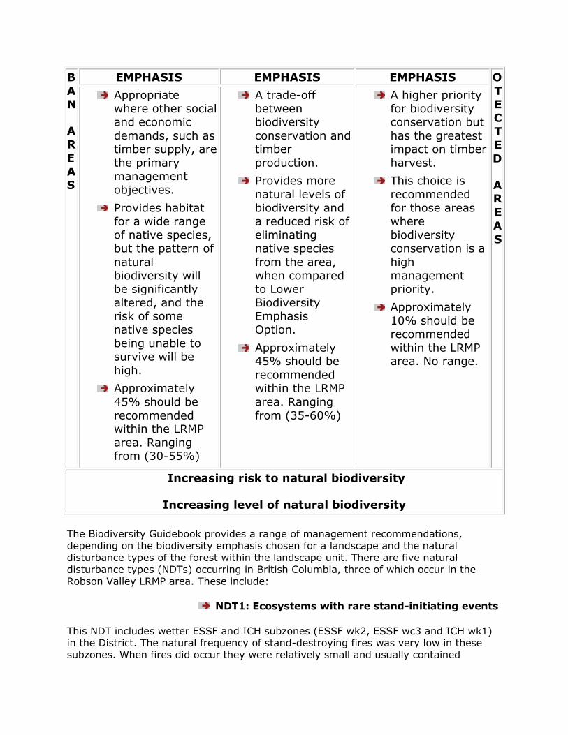
B
A N
A R
E A
S
EMPHASIS EMPHASIS EMPHASIS O
T E
C T
E D
A R
E A
S
Appropriate
where other social and economic
demands, such as timber supply, are
the primary management
objectives.
Provides habitat for a wide range
of native species, but the pattern of
natural biodiversity will
be significantly altered, and the
risk of some native species
being unable to survive will be
high.
Approximately
45% should be
recommended within the LRMP
area. Ranging from (30-55%)
A trade-off
between biodiversity
conservation and timber
production.
Provides more
natural levels of
biodiversity and a reduced risk of
eliminating native species
from the area, when compared
to Lower Biodiversity
Emphasis Option.
Approximately 45% should be
recommended within the LRMP
area. Ranging
from (35-60%)
A higher priority
for biodiversity conservation but
has the greatest impact on timber
harvest.
This choice is
recommended
for those areas where
biodiversity conservation is a
high management
priority.
Approximately
10% should be recommended
within the LRMP area. No range.
Increasing risk to natural biodiversity
Increasing level of natural biodiversity
The Biodiversity Guidebook provides a range of management recommendations, depending on the biodiversity emphasis chosen for a landscape and the natural
disturbance types of the forest within the landscape unit. There are five natural disturbance types (NDTs) occurring in British Columbia, three of which occur in the Robson Valley LRMP area. These include:
NDT1: Ecosystems with rare stand-initiating events
This NDT includes wetter ESSF and ICH subzones (ESSF wk2, ESSF wc3 and ICH wk1) in the District. The natural frequency of stand-destroying fires was very low in these subzones. When fires did occur they were relatively small and usually contained
unburned remnants of mature forest. Within the old forest, regeneration occurred within gaps created by the death of individual trees or small groups of trees, resulting
in uneven-aged stands. This disturbance pattern produced a landscape dominated by contiguous, uneven-aged, old forest, surrounding small to medium sized stands or younger even-aged forest.
NDT2: Ecosystems with infrequent stand-initiating
events
This NDT includes the ICH mm, ICH wk3, ESSF mm1, ESSF mm2 and SBS vk subzones in the Robson Valley. These forests experienced stand destroying events (fires, hemlock looper etc.) on average about every 200 years. That disturbance pattern resulted in a
landscape dominated by old and mature even-aged stands, although there was a greater proportion of younger stands than in NDT1. Some of the older stands were beginning to develop uneven-aged characteristics, and all stands contained either
patches or individual veteran trees that survived the stand initiating event.
NDT3: Ecosystems with frequent stand-initiating events
This NDT includes the SBS dh1 subzone which occurs in some of the valley bottoms of the Robson Valley. These forests experienced wildfires on average every 100-150
years. Many of these fires were very large in size, but most fires left unburned patches of mature forest. Consequently, the landscape consisted of a mosaic or large regenerating even-aged stands, with mature forest patches contained within the
younger matrix.
Once the biodiversity emphasis is established for a landscape unit, the Biodiversity Guidebook provides recommended objectives for:
old forest retention and ecosystem representation
patch size distribution (size of cutblocks and leave areas)
mature forest connectivity
stand structure, and
seral stage distribution
species composition
Robson Valley LRMP Resource Management Zones (with Subzones)

2.2 OVERALL GOALS, VALUES, OBJECTIVES AND STRATEGIES
Land and resource management strategic planning establishes direction for land use and specifies broad resource management objectives and strategies. Early in the process, the RVRT Planning Team agreed to overall goals for the plan. The Overall and
Resource Management Zone objectives and strategies define how to meet the overall goals of the process. Many of the resource management objectives and strategies put forward by the Planning Team apply throughout the planning area. These are
categorized as Overall Goals, Values, Objectives and Strategies and are designed to provide integrated sustainable management of land, water, ecosystems and resources. Management for any one of the resources described under Overall Goals, Values,
Objectives and Strategies must take into consideration the needs and interests of all users and values. Area specific objectives and strategies are found under the Resource Management Zone (RMZ) section of this report.
The objectives and strategies outlined in this section apply to all agencies, resources
and activities on Crown lands and are the fundamental building blocks of the plan. They are enhanced and supported by a large array of complementary legislation, policies, processes and operational guidelines. These include:
existing legislation such as the Forest Practices Code
(FPC) of BC Act, Federal Fisheries Act, Waste Management Act, Agricultural Land Reserve Act, Mineral Tenure Act, Mines Act, Soil Conservation Act, Park Act,
Wildlife Act and Land Act.
lower level detailed plans, including Local Resource Use
Plans (LRUPs), Integrated Watershed Management Plans (IWMPs), Official Community Plans (OCPs) and Crown Land Plans; and
existing regulations, standards and guidelines for the resource agencies.
OVERALL PROCESS GOAL
To promote a planning process based on the best available information, identifies all resource values, strives to integrate those values and culminates in the
preparation of a Land and Resource Management Plan
which minimizes the conflicts between resource users, respects First Nations‟ rights and provides clear guidance
to resource managers while still providing options to manage on a site-specific basis.
To recognize the importance of security of tenure for
existing, licensed users of land and resources.
To encourage enforcement of existing laws, regulations and guidelines, and personal, professional and
governmental accountability for land and resource management.
To apply integrated management of land and resources
and minimize conflicts between incompatible land uses, and negative impacts of resource development / uses on adjacent areas.
To increase community influence over land and resource management.
OBJECTIVE STRATEGY
Increase community
influence over resource management and
information availability
to the public
Ensure formation of a LRMP implementation
committee to monitor the implementation and recommend amendments or adjustments to it
as necessary
Implementation committee should continue consensus and team approach to resolving
issues and preparing recommendations
During the public review process, proposed
silvicultural prescriptions as part of development plans should be available for
public viewing at the McBride Ministry of Forests and Valemount Government Agent
offices as well as at originating Licensees offices
Community Associations will be notified where Forest Development plans affect their areas.
Specific silvicultural prescriptions in known areas of special interest, as determined by the
District Manager, will be advertised for public
comment
Promote harmonious
co-existence among
Increase the understanding and acceptance of
different interests
communities and interest groups in this
planning area
Promote public education, understanding and acceptance of resource industries
Ensure opportunities for development of strategies to address future needs of people in
the region
Transition strategies for the land and resource
management plan should be implemented in a manner sensitive to social, economic and
environmental conditions in the Robson Valley
Continue ongoing information sharing
OVERALL ACCESS MANAGEMENT GOAL
To manage access in a manner to allow a balanced,
environmentally sound, sustainable use of land and resources.
OBJECTIVE STRATEGY
Manage road access in a manner that minimizes
disturbance to wildlife values, allows recreation opportunities
and protects fragile alpine
environments
Reduce predator access into critical wildlife habitat by minimizing or
eliminating snow plowed roads and managing packed trails in cooperation
with snowmobilers and other users
Manage road access to reduce wildlife disturbance, displacement, habitat loss
and increased mortality rates due to poaching and other human activities
Access will be allowed and maintained when and where needed for timber
harvesting operations, silvicultural or research operations, range and in order
to address fire, insect, disease or blowdown situations
Wherever feasible, design road access so that motorized recreational use
minimizes encroachment into traditional hiking destination areas and
alpine environments.
Early stage mineral exploration in alpine areas should use helicopter
access only. Proposed road access in

alpine areas will be referred to the appropriate agencies with opportunity
for local public input
Start a public information program
about the importance of all aspects of access management
Where gates are used, have a sign posted to explain the importance of
value(s) being managed
Where gates are used, motorized
access beyond the gate will be allowed to government authorized (licences,
permits, etc.) users for land and resource use and management
purposes
Provide opportunities for local public
input and utilize a full range of access
management tools
Berms, excavations, gates and other
access control structures must be strategically located to prevent detours
from being developed
If gates prove ineffective, more
effective methods will be considered
Adjacent park managers may assist in
access management planning
Minimize conflicts between
motorized and non-motorized recreational uses
Lower level interagency planning team
should identify local public input issues around motorized and non-motorized
uses on Crown land, priorize areas of greatest concern and propose solutions
through a management plan
Post signs at designated trailheads stating motorized use is inappropriate
OVERALL BIODIVERSITY GOAL
To ensure the abundance and natural diversity of native species and their natural habitats throughout the Robson
Valley.
To identify, protect and recover native, endangered, threatened and vulnerable species and ecosystems.
To ensure that environmentally sensitive areas are managed or left intact to respect their sensitivity and maintain their inherent value.
VALUE OBJECTIVE STRATEGY
GENERAL
BIODIVERSITY
Maintain or enhance
species, structural characteristics and
species compositions in managed forests
that are present in
natural forests
Identify and protect small, unique areas
of unusual and rare species
Where possible maintain linkages to
enable the flow of species, their genetic
attributes, diversity and nutrients
between undeveloped areas
Mimic type, degree and
frequency of natural disturbances when logging.
Make use of selection and group selection systems and
clear cut only in appropriate
timber types and situations
Where possible, retain natural
levels of snags, residual dominant trees, coarse woody
debris etc.
Develop special management
prescriptions for special habitats such as glacier lilies,
bat caves and flying squirrel habitat
Manage red listed communities and/or species of plants and
animals by protecting habitat from disturbance and loss
Manage blue listed species of
plants and animals and their habitat to minimize loss of
habitat and disturbance
Identify and protect
representative areas of macro-lichen forest (e.g., establish
sensitive areas) with local public input
Forest harvesting patterns should be designed to maintain
the connectivity of mature forests across and along all
watersheds. Special emphasis should be given to maintaining
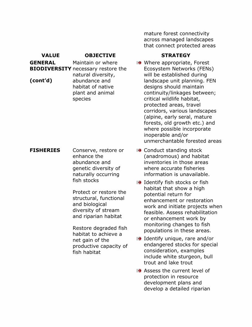
mature forest connectivity across managed landscapes
that connect protected areas
VALUE OBJECTIVE STRATEGY
GENERAL
BIODIVERSITY
(cont’d)
Maintain or where
necessary restore the natural diversity,
abundance and habitat of native
plant and animal species
Where appropriate, Forest
Ecosystem Networks (FENs) will be established during
landscape unit planning. FEN designs should maintain
continuity/linkages between; critical wildlife habitat,
protected areas, travel corridors, various landscapes
(alpine, early seral, mature forests, old growth etc.) and
where possible incorporate
inoperable and/or unmerchantable forested areas
FISHERIES Conserve, restore or enhance the
abundance and genetic diversity of
naturally occurring fish stocks
Protect or restore the
structural, functional
and biological diversity of stream
and riparian habitat
Restore degraded fish habitat to achieve a
net gain of the productive capacity of
fish habitat
Conduct standing stock (anadromous) and habitat
inventories in those areas where accurate fisheries
information is unavailable.
Identify fish stocks or fish
habitat that show a high potential return for
enhancement or restoration work and initiate projects when
feasible. Assess rehabilitation or enhancement work by
monitoring changes to fish
populations in these areas.
Identify unique, rare and/or
endangered stocks for special consideration, examples
include white sturgeon, bull trout and lake trout
Assess the current level of protection in resource
development plans and develop a detailed riparian
management plan for sensitive areas that may require
additional protection
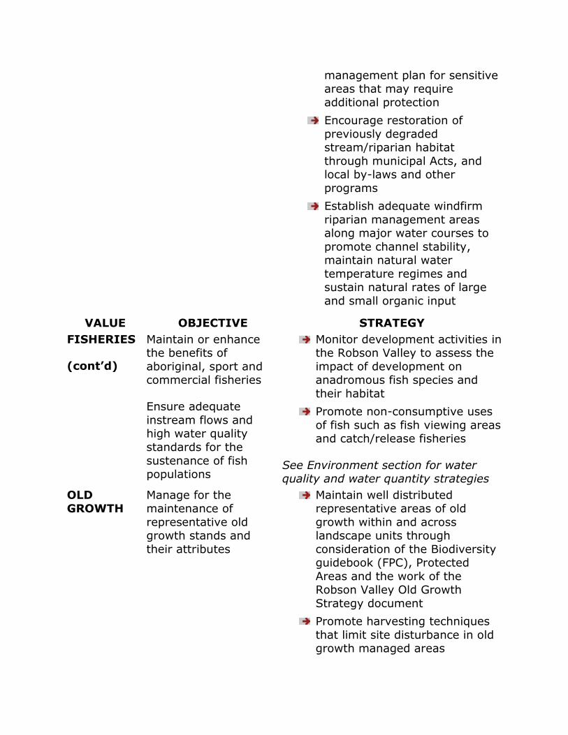
Encourage restoration of
previously degraded stream/riparian habitat
through municipal Acts, and local by-laws and other
programs
Establish adequate windfirm
riparian management areas along major water courses to
promote channel stability, maintain natural water
temperature regimes and sustain natural rates of large
and small organic input
VALUE OBJECTIVE STRATEGY
FISHERIES
(cont’d)
Maintain or enhance the benefits of
aboriginal, sport and commercial fisheries
Ensure adequate
instream flows and high water quality
standards for the
sustenance of fish populations
Monitor development activities in the Robson Valley to assess the
impact of development on anadromous fish species and
their habitat
Promote non-consumptive uses
of fish such as fish viewing areas and catch/release fisheries
See Environment section for water quality and water quantity strategies
OLD GROWTH
Manage for the maintenance of
representative old growth stands and
their attributes
Maintain well distributed representative areas of old
growth within and across landscape units through
consideration of the Biodiversity guidebook (FPC), Protected
Areas and the work of the Robson Valley Old Growth
Strategy document
Promote harvesting techniques
that limit site disturbance in old growth managed areas
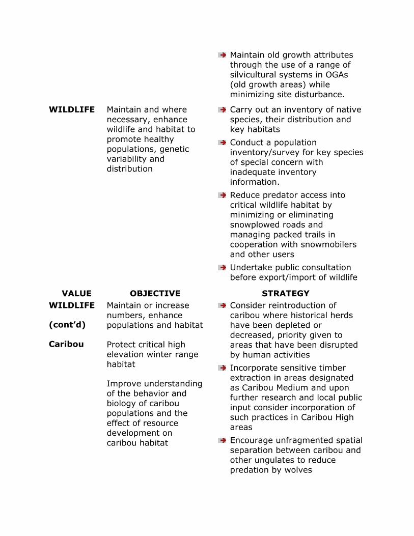
Maintain old growth attributes through the use of a range of
silvicultural systems in OGAs (old growth areas) while
minimizing site disturbance.
WILDLIFE Maintain and where
necessary, enhance wildlife and habitat to
promote healthy populations, genetic
variability and distribution
Carry out an inventory of native
species, their distribution and key habitats
Conduct a population inventory/survey for key species
of special concern with inadequate inventory
information.
Reduce predator access into
critical wildlife habitat by minimizing or eliminating
snowplowed roads and
managing packed trails in cooperation with snowmobilers
and other users
Undertake public consultation
before export/import of wildlife
VALUE OBJECTIVE STRATEGY
WILDLIFE
(cont’d)
Caribou
Maintain or increase
numbers, enhance populations and habitat
Protect critical high elevation winter range
habitat
Improve understanding of the behavior and
biology of caribou populations and the
effect of resource development on
caribou habitat
Consider reintroduction of
caribou where historical herds have been depleted or
decreased, priority given to areas that have been disrupted
by human activities
Incorporate sensitive timber
extraction in areas designated
as Caribou Medium and upon further research and local public
input consider incorporation of such practices in Caribou High
areas
Encourage unfragmented spatial
separation between caribou and other ungulates to reduce
predation by wolves
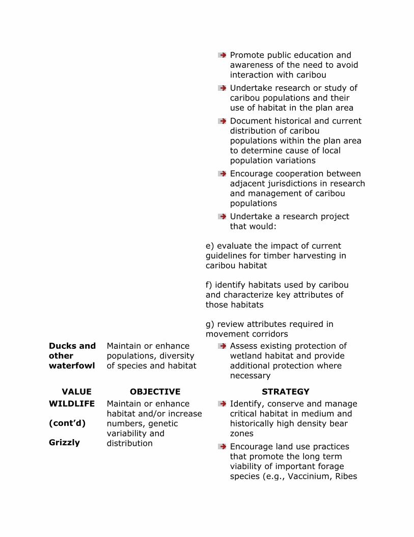
Promote public education and awareness of the need to avoid
interaction with caribou
Undertake research or study of
caribou populations and their use of habitat in the plan area
Document historical and current distribution of caribou
populations within the plan area to determine cause of local
population variations
Encourage cooperation between
adjacent jurisdictions in research and management of caribou
populations
Undertake a research project
that would:
e) evaluate the impact of current guidelines for timber harvesting in caribou habitat
f) identify habitats used by caribou
and characterize key attributes of
those habitats
g) review attributes required in movement corridors
Ducks and other
waterfowl
Maintain or enhance populations, diversity
of species and habitat
Assess existing protection of wetland habitat and provide
additional protection where necessary
VALUE OBJECTIVE STRATEGY
WILDLIFE
(cont’d)
Grizzly
Maintain or enhance
habitat and/or increase numbers, genetic
variability and distribution
Identify, conserve and manage
critical habitat in medium and historically high density bear
zones
Encourage land use practices
that promote the long term viability of important forage
species (e.g., Vaccinium, Ribes
etc.)
Manage road access into grizzly
high habitat to reduce disturbance, displacement,
habitat loss and mortality rates due to poaching and other
human activities.
Consider establishing grizzly
bear management areas and other land use designations that
benefit grizzly bear populations
Ensure the continued existence
of adequate seasonal foraging sites with adjacent cover
Minimize bear displacement from preferred habitat by preventing
habitat fragmentation
Where feasible locate roads to avoid avalanche paths,
especially on south facing slopes. Road locations close to
avalanche paths should avoid allowing a clear line of sight
between road and path
Where important avalanche
paths are identified, a total reserve of 100 metres should be
left on each side of the path. Selective harvesting will be
considered pending further research
Be aware of concentrated
seasonal bear use in an area and whenever possible, time human
activities (cruising, planting, mining exploration,
recreation/tourism) to avoid conflicts
Moose, elk and deer
winter
Maintain or enhance populations and habitat
Promote vegetation management strategies that
maintain the quality and
range quantity of browse species (e.g., willow and red osier dogwood,
Saskatoon berries, hazel nuts) during stand management
activities
Maintain critical habitat
attributes by establishing guidelines for areas where
winter range is identified.
VALUE OBJECTIVE STRATEGY
WILDLIFE
(cont’d)
Mountain goats
Maintain or enhance
populations and habitat
Identify and conserve travel
corridors between alpine areas and low elevation habitat.
Develop a management plan that includes inventories of goat
populations and habitat,
addresses access issues and develops strategies to maintain
winter range habitat.
Consider re-introduction to
historical use areas
OVERALL ECONOMY GOAL
To promote the diverse, balanced and sustainable use of land and resources, which meets human needs, and supports healthy, viable and stable communities and
ecosystems in the Robson Valley.
To seek full employment through “value-added” enterprises that enhance other economic benefits to local
communities.
To establish a secure resource land base that can provide and sustain an abundance of raw materials and other
economic resources by identifying and maintaining areas that are particularly suitable for agriculture/range/food production; forestry; fisheries; trapping, hunting and
gathering; tourism and recreation; and energy, minerals, aggregate and petroleum resources.
To maintain lands and resources in a manner that
increases economic, environmental and social benefits.
VALUE OBJECTIVE STRATEGY

GENERAL ECONOMY
Promote the economic and social health of
communities in the Robson Valley
Maximize economic
return to the community and the
province for resources harvested
Diversify the local economy
Maintain the potential
and encourage the development of
environmentally sensitive small hydro-
electric development
Honour existing resource tenures
Provide opportunities for contracts and licences to local
residents and promote local processing of timber harvested
in the Plan Area
Minimize waste levels in the
planning, harvesting and processing of timber
Increase and encourage tourism activities
Encourage small business development, such as cottage
industries
Promote Crown land development for a variety of
land uses by adoption and implementation of the Robson
Valley Crown Land Plan
Use proactive planning
processes to promote the maximum number and
diversity of jobs
Ensure opportunity for local
public consultation before hydro-electric development
occurs.
Promote local
employment through value added and
economic activities
and to maximize economic returns to
local communities
Recognize other potential economic
activities (e.g., botanical products,
potable water,
Encourage local hiring by
contractors, licensees, government and crown
corporations where permitted
by policy
Encourage viable labor
intensive methods of harvesting, processing,
silvicultural activities, tourism related activities, (e.g., horse
and selective logging, non-chemical brushing and
medicinal plants) consistent with other
resource objectives
weeding)
Encourage stand tending to
favor future quality of the stand over quantity of fibre by,
for example, management activities such as pruning to
promote clear saw logs and determining rotation ages on
the basis of desired quality of final product.
Promote and encourage value added wood processing to
maximize the end value of all wood harvested. Encourage
viable industries and management activities which
have a high labor to volume
ratio
Increase number and
encourage operation of small sawmills by:
f) allowing on site milling for very small systems
g) increasing the number of small
timber sales at reduced volumes
h) supporting the creation of a log yard to sell small quantities of sorted
timber and distribute timber to the best end user to give the highest
social and economic return
i) encourage flow of wood through
value added processes before chipping
When a new economic activity
is identified, the responsible agency or proponent will
identify the area of interest;
the scope of the project; the
impact to other resource values; and create a
management plan to address issues
Other agencies and users will work to incorporate other
economic activities to enhance overall economic activity
AGRICULTURE
VALUE
OBJECTIVE STRATEGY
Maintain or enhance
opportunities for use
of Crown Land, vegetation, and water
resources for agriculture, fisheries
and food production
Support the purpose and intent
of the Agricultural Land
Reserve (ALR)
Preserve and maintain the
quality of soil within the ALR through appropriate legislation
Support the Robson Valley Crown Land Plan and its
designated Agricultural Development Areas
Allow Crown lands with suitable agricultural potential to be
alienated for agricultural uses via the Crown Agricultural
Lease policy
Improve mechanisms for
identifying Crown land areas
adjacent to private agricultural operations that are of interest
for future alienation for agricultural uses
ENERGY Maintain opportunities and access for
exploration, development and
transport of energy resources
Allow exploration, development and transportation of energy
resources within the appropriate regulatory
framework
FOREST
MANAGEMENT
Identify areas that are particularly suitable
for forestry and
Assess opportunities for expanding the timber
timber production to maintain a sustainable
forest sector
Maintain or enhance opportunities for
timber harvesting which will contribute
to sustainable levels within the TSA
harvesting land base.
Improve forest inventory
information
Establish the Forest Land
Reserve (FLR) outside the Agricultural Land Reserve
(ALR) and non-provincial forest designations in the Robson
Valley Crown Land Plan
Explore opportunities for
increasing utilization standards provided other values are not
compromised
Investigate timber supply
alternatives that may offset possible AAC decline identified
in the Timber Supply Review,
September 1994
Maintain or enhance
forest productivity on the timber harvesting
land base
Maintain an ongoing supply of old growth
wood for harvest
Identify opportunities to apply
a wide range of stand tending and improvement treatments
to enhance timber values emphasizing non-chemical
means
Identify opportunities for
intensive forest management
If larger planting stock (e.g.,
415B) will outgrow its competition then this stock
should be used. Use sound natural regeneration practices
or plant ecologically suited
species to maintain natural diversity
Monitor and manage epidemic levels of disease and insects
Encourage more woodlots in areas with a suitable age class
structure to support ongoing management.
Manage for natural levels of soil structure, nutrient levels,
hydrological patterns, climate regimes, soil communities and
ecosystem functioning to maximize soil and general
ecosystem health.
Reforest all accessible backlog
not sufficiently restocked sites by 2005
Allow the control of competing brush to optimize growth,
through effective vegetation management techniques
Conduct annual aerial reconnaissance and follow-up
field assessments where
appropriate to determine severity of insect and/or
disease attack and design appropriate salvage efforts
Use appropriate silvicultural systems and harvesting
equipment suited to terrain, soils and forest cover
Extend rotation period of some stands
Assess and manage epidemic or potentially epidemic
outbreaks of disease and pests
Identify important
values other than
timber and wherever possible, conduct
forest management in a manner that is
compatible with those values
Harvesting design should
consider visual quality and
windfirmness and experiment with contouring and feathered
edges to minimize windthrow potential.
Assess the current level of protection in resource
development plans and develop a detailed riparian
management plan for sensitive

areas that may require additional protection
Establish adequate windfirm riparian management areas
along major water courses to promote channel stability,
maintain natural water temperature regimes and
sustain natural rates of large and small organic input
Cutblock design and harvest methods should incorporate,
where appropriate, single tree and patch retention adjacent to
and within the cutover area. For example: patches can be
concentrated around snags,
wetter areas, wildlife habitat, younger forest or non-
productive portions of the block. Blocks should be shaped
to maintain wildlife habitat, biodiversity, viewscape quality
(FPC)
Timber harvesting plans must
consider identified trail opportunities depending on
scenic values and anticipated levels of use.
Timber harvesting and management strategies will be
designed to manage losses to
fire, wind, insects and disease.
Assess and manage epidemic
or potentially epidemic outbreaks of disease and pests
If any trees and healthy advanced regeneration do not
pose a problem to seedling survival, then leave as many
stems as possible on site for wildlife habitat after
harvesting. For example: large cottonwood, cedar and other
wildlife trees should be left as long as they pose no danger to
forest workers or other users.
During the public review
process, silvicultural prescriptions as part of
development plans should be available for public viewing at
the McBride Forestry office, and the Valemount
Government Agent‟s office as well as at the originating
licensee‟s office
Maintain watershed
integrity and stability
Where necessary, or under
direction of resource agencies,
identify and map terrain hazard areas within the Robson
Valley TSA to provide long-term direction for road design
and forest harvesting plans
Encourage watershed
restoration
MINING Maintain or enhance
opportunity for environmentally
sensitive exploration and development of
mineral resources, particularly industrial
minerals
Ensure subsurface
resource potential and the hidden nature of
the resource are considered in Land
and Resource Management Planning
Respect resource
Integrate mineral exploration
and development activities with other resource activities
Promote and encourage mineral exploration through a
timely and efficient permitting process
Implement revisions to
standards of practice and the permitting process to provide
consistency with the Forest Practices Code and other
relevant legislation
Ensure opportunity for local
public participation in review of small mine development in
areas where concerns are
tenure rights expressed
RMZ objectives will be
addressed through the appropriate mine
development/environmental assessment review processes
Ensure that management plans for all zones other than
Protection RMZs clearly convey that responsible mineral
exploration and mining are acceptable activities
Maintain a current mineral resource database
Monitor and review, as per government policy, lands
closed to mineral and placer
exploration (e.g., no staking reserves) and recommend
lifting NSRs where review determines they are no longer
needed
Provide for security of tenure
in designations open to exploration and mining
Maintain environmentally
acceptable access by the mining sector to
mineral lands
Encourage educational
and recreational geologic activities
Minimize site disturbance during the exploration stage.
Extensive logging may occur only after mine development
and/or production plans are approved. Falling of timber on
exploration or development
sites shall be consistent with the stage of property
development
New access will be coordinated
with access requirements of other resource users as much
as possible
The appropriate location of
exploration access will be

designed to minimize impacts on sensitive wildlife habitat
Road building to access mineral properties in currently
unroaded areas will be allowed only when sufficient
exploration demonstrates that road access is required for
further development
Proposed mine development,
access and visual quality concerns will be addressed in
the appropriate mine development/environmental
assessment review processes
Early stage mineral exploration
in alpine areas should use
helicopter access only. Proposed road access in alpine
areas will be referred to the appropriate agencies with
opportunity for local public input.
Identify areas for potential geologic recreational activities
RANGE Ensure that all watersheds are
protected from adverse impacts of
domestic animals
All permits and leases will require Range Use Plans that
identify goals for the area, inventories of plant
communities, prescribe level of use and set a grazing schedule.
Maintain or enhance
opportunities for grazing use
Where terrain and soils are
suitable, allow grazing on all blocks while managing in
consideration of all users including: recreation,
silviculture, forest protection, fish and wildlife needs.
Cattle and sheep grazing activity should avoid alpine
environments. Maintain long
term forage access by shifting tenures from maturing
cutblocks to new suitable cutover areas, roads and
landings
All range users will require a
grazing management plan
Support manual control
(cultural, mechanical and biological) of noxious weeds.
Chemical measures will be used only when other methods
are not viable due to terrain, herbaceous type, density and
cost.
When reclamation seeding, use
indigenous grass blends
subject to availability and cost.
Allow for new range
opportunities without significantly compromising
other resource values.
Range use will be managed to
minimize the effects on riparian areas
Based on capability and sustainability, develop target
AUM levels for the plan area
TOURISM Maintain a balance
between commercial recreation, public
recreation and other
users through the protection and
maintenance of backcountry areas
Commercial backcountry
recreation proposals will be assessed for environmental
impacts and will include public
consultation.
All commercial backcountry
operations should be licenced
Promote environmentally
sustainable tourism
Provide opportunities
Identify and promote tourism opportunities within the plan
area
In more detailed levels of
planning, identify acceptable
for growth within the tourism industry
Provide for a diverse
range of tourism opportunities
practices and potential conflicts associated with sustainable
tourism
Commercial recreation will
minimize conflicts with fish and wildlife, particularly in high
elevation areas with caribou values.
Allocate/permit and manage tourism opportunities through
the Commercial Backcountry Recreation Policy.
Ensure local public participation in the review of
tourism opportunities and allocation of permits
c) ensure balance with public recreation opportunities
d) ensure public accessibility to
backcountry areas where access does not compromise other values
e) ensure local opportunities and interests in commercial tourism
Conduct an inventory of
existing and potential tourism opportunities.
Identify suitable tourism areas
and maintain future tourism opportunities
Prepare a tourism development strategy for the plan area
Promote the plan area as a year-round destination
When reviewing commercial backcountry proposals,
recognize those that provide the greatest benefit to the local
community
Develop access management
plans in conjunction with tourism and recreation groups
in the valley
OVERALL ENVIRONMENT GOAL
To reduce and work to eliminate pollution of land, water and air.
To protect soil and soil fertility by minimizing activities
that cause soil erosion and degradation.
To protect the quality and quantity of ground and surface water and to reduce and work to eliminate water pollution
and sedimentation caused by human activities. To improve water quality where it has been degraded. To manage natural stream flow levels to safe guard fisheries,
wildlife, recreational values, domestic agricultural and ecosystem functioning.
To minimize practices that cause changes to local climate,
wind patterns and precipitation regimes.
VALUE OBJECTIVE STRATEGY
GENERAL ENVIRONMENT
Minimize use of herbicides and
pesticides
Reduce the need for herbicides and
pesticides by using
appropriate management
strategies
Public health concerns to be the highest priority when
considering herbicide or pesticide use
Maintain a shade component to reduce brush on a site
specific basis
Encourage the use of
techniques that will cause less forest floor disturbance and
will not expose the soil on
brush prone sites (e.g., cable yarding, more winter
emphasis, reduce large scale scarification and burning)
Plant trees as soon as possible after harvest to get a head
start on brush on a site specific basis
Herbicides should only be used on a site specific basis and
only as a last resort when there are no viable
alternatives, determined on the basis of terrain,
herbaceous type and density, and cost
Work to eliminate herbicides for brush control, minimize use
for noxious weeds and encourage manual/biological
controls
Raise public awareness of and
participation in noxious weed control through signage and
public information
There is no formal requirement for the Ministry of
Transportation and Highways to post signs along the
highway right-of-way when using herbicides, other than
those required under any herbicide application permit.
However, the ministry is encouraged to undertake a
more vigorous and active consultation and public notice
program in the Robson Valley
Identify and designate some
no spray zones (e.g.,
recreation sites, berry picking sites etc.)
Conserve soil quality
Minimize the use of slash burning to
protect air quality
Protect soil fertility, structure and avoid unnatural erosion
Burning should be assessed on a site specific basis and
utilized only when other methods are not viable
Promote harvesting practices

that reduce slash
Where possible, leave non-
merchantable timber standing
Encourage mulching instead of
burning
Notify local communities of
burning plans
WATER
QUALITY
Protect or enhance
surface water quality
Protect ground water
quality
Establish windfirm Riparian
Management Areas along water courses (will promote
channel stability, maintain natural water temperature
regimes and sustain large and small organic debris)
Ensure, through erosion
control, and maintenance of natural runoff and drainage
patterns, that prevention of stream contamination from
pesticides and fertilizers is implemented for all streams
Identify high terrain hazard areas and manage
development in these areas to minimize erosion and slope
failures
Assess and monitor road
development and deactivation plans to minimize the potential
for road failures by ensuring the maintenance of natural
drainage patterns.
Limit the use of pesticides, herbicides, fertilizers and
petroleum products adjacent to water bodies and prevent
entry of contaminants into the water cycle
Design policy and direction for management of ground water

quality
Under the Watershed
Restoration Program, restore sites where water quality has
been degraded
Protect the full range
of values for alpine lakes
Alpine lakes greater than five
hectares in size will be assessed and classified
accordingly. These lakes will be managed as a minimum of
class C lake until formally classified, as per the Prince
George Region Lakeshore Management Guidebook
(PGRLMG)
Should resource development
occur, more detailed planning
must identify and include provisions to address or
maintain recreation values associated with lakes
WATER QUANTITY
Protect or restore water quantity and
natural hydrologic regime of each
watershed
Prevent loss of life
and property due to flooding and erosion
Priorize and conduct watershed cumulative effects
analysis in fish bearing and community watersheds.
Where necessary, limit further development according to a
rate of cut for each watershed to prevent further changes to
natural rates of direct runoff, groundwater runoff, evapo-
transpiration and stream flow
Assess the present condition of each watershed in the
planning area
Apply zoning and bylaw
conditions to new Crown land, subdivisions and other
developments
Prevent encroachment on the
floodplain through appropriate

development setbacks and covenants
OVERALL FIRST NATIONS GOAL
To recognize aboriginal interests in the planning area and to encourage awareness of aboriginal rights the Robson
Valley
OBJECTIVE STRATEGY
Identify, acknowledge and respect aboriginal interests
Provide opportunities for meaningful consultations with
First Nations groups before decisions are made
Avoid infringement of traditional uses: fishing, hunting,
gathering, travel, camping, occupation, special cultural and
sacred areas and benefits from the environmentally responsible
extraction of resources
Support First Nations economic
development: jobs, training,
joint ventures
Support public education about
First Nations interests
Provide an equal opportunity for
First Nations involvement in public input land use processes:
protected areas, special management areas, integrated
management, settlement planning
OVERALL PRESERVATION/CULTURAL HERITAGE GOAL
To preserve wilderness which is representative of the
natural diversity of ecosystems, as well as the special, natural, cultural heritage and recreational features in the Robson Valley, in their natural state, for the sake of
maintaining their intrinsic, scientific, holistic and spiritual values, and for the enjoyment and education of present and future generations.
OBJECTIVE STRATEGY
Maintain large, natural, and
undisturbed places. Recognize the intrinsic value of nature
Protected Areas Strategy
Consider sensitive area designation where special
scientific, wilderness, cultural, holistic and spiritual values are
identified
Before resource activities are
approved adjacent to protected
areas, referral comments from BC Parks will be considered
Preserve the natural, cultural and recreational values within the plan
area and especially within existing provincial parks, recreation areas and
ecological reserves
Ensure that local public input is solicited and incorporated into
land management plans and Provincial Park Master Plans
Manage impacts to cultural heritage
resources including archaeological sites and traditional use sites
Manage impacts to
archeological sites through application of relevant
legislation and policy (e.g., Forest Practices Code, Heritage
Conservation Act, Protocol Agreement on the
Management of Cultural
Heritage Resources and the British Columbia
Archaeological Impact Assessment Guidelines)
First Nations will be consulted to determine the location and
significance of traditional use sites
Archaeological impact assessments may be
undertaken if required during more detailed levels of planning
OVERALL RECREATION GOAL
To maintain the recreational values in the Robson Valley and to enhance recreational opportunities, particularly to enjoy wildlife and scenic surroundings.
OBJECTIVE STRATEGY
Protect, maintain or enhance
opportunities for public recreation
Where compatible with other
values, maintain access to fishing, hunting and gathering
opportunities (i.e., berries, mushrooms)
Update the existing recreation trail inventory and protect
existing public recreation trails
Designate traditional horseback trails and develop
improvements to enhance the resource and manage impacts
on the alpine resource.
Set visual landscape
management objectives to ensure resource extraction
activities are compatible with public recreational use (See
visual quality strategies)
Inventory, assess and map
special features within the Robson Valley plan area.
Establish a map notation or
other designation to identify those values.
Support and promote traditional snowmobile use
areas
Where a point of interest exists
resource development will consider potential recreation
trails
Whenever possible, future trail
locations should be in non-operable timbered areas
Create more forest recreation sites and hiking trails
Signs on logging roads should
indicate level of current industrial use (i.e., active,
none, some)
Manage some high value
backcountry areas for non-motorized public recreation
Promote public recreation stewardship and safety
responsibilities
Promote environmentally sustainable
public recreation
Wherever feasible, design road
access so that motorized recreational use minimizes
encroachment into traditional hiking destination areas and
alpine environments
Protect sensitive areas from
motorized use
Minimize damage from off-road vehicles
OVERALL SUSTAINABILITY GOAL
To achieve sustainable levels of use including harvesting of resources, through land use decisions that promote
and encourage such use, for the benefit of present and future generations
OBJECTIVE STRATEGY
Limit harvest of all natural renewable
resources to sustainable levels (including old growth timber)
Undertake land and resource
management planning that balances social, economic and
environmental values
OVERALL VISUAL QUALITY GOAL
To maintain and/or enhance the scenic beauty and visual quality of the planning area with particular attention to the Robson Valley Settlement Corridor.
OBJECTIVE STRATEGY
Identify and
manage some areas to maintain
extremely high
Conduct an inventory of areas and/or features of
unique scenic beauty and pay particular attention to current and future opportunities for
commercial and public backcountry recreation,

scenic values guide-outfitting, snowmobiling, hiking and ski touring
Address visual quality concerns in
resource extraction and development
areas.
Forest development plans will address visual quality through choice of silvicultural system,
block design and layout of patch retention where possible
Exploration, mine development and other land uses that affect visual quality will utilize existing
topography and ground conditions to reduce impact on visual values
Development activities must have a plan for visual management which is available for local
public input. For example hydro lines, railroads, pipelines, highways and gravel pits
Maintain a visual landscape inventory
At more detailed levels of planning and in concert with other visual management strategies in this
plan, the Ministry of Forests recommended and currently approved VQOs which will guide
commercial timber harvesting, recognizing that the public has access to further input
2.3 RESOURCE MANAGEMENT ZONES
Resource Management Zones (RMZs), part of the designation system used in this strategic plan, are large contiguous geographic areas within the planning area with a
common label. RMZ labels indicate which resource uses or objectives are to be given priority or emphasized over others within the zone. Resource management zone labels reflect the average level or type of management within the zone. Within any given RMZ
designation, there will likely be small areas managed to a different standard than the overall average, because at this scale of planning RMZs cover large tracts of land on which there is considerable natural variability of resource values, qualities and
opportunities. For example, within the Resource Development Emphasis RMZ there may be smaller areas managed like areas designated special management and vice versa.
Resource Management Zones, along with objectives and management strategies for each zone are the basis of the Land and Resource Management Plan. The labels given
to the zones, and the associated objectives and strategies, represent the planning team‟s priorities for use and management of the planning area. It should be noted that many of the RMZ strategies were developed by addressing where resource values were
in conflict (constrained). These strategies give direction for resource development and are listed under the resource value that would be impacted.
There are also six subzones within the plan area. Subzones are smaller geographic areas within a RMZ. There are usually one or two unique values identified within the
subzone that require specific management direction.
Unless otherwise noted, the overall objectives and strategies in this report, provincial legislation, policies and guidelines for land and resource management are to be followed in each zone.
The Resource Management Zones (RMZs) have been categorized into five classifications
and are broadly defined in the following table:
CATEGORY OF RMZ DESCRIPTION
RESOURCE DEVELOPMENT
EMPHASIS
those areas identified, on the basis of suitability, for intensive development of
resources such as timber and minerals
resource development activities are subject to
all provincial regulations and policy (e.g., the Forest Practices Code of British Columbia Act)
guidelines for managing other resource values will be applied in a way that recognizes the
resource development priority of the zone
investments in resource development and
enhancement are encouraged
CATEGORY OF
RMZ
DESCRIPTION
GENERAL these areas are to be managed for a wide array of resource values and
permissible uses
guidelines for non-extractive resource
values may modify resource development activities
investments in resource development
and enhancement are encouraged where these do not conflict with other
management objectives
SPECIAL these areas for which the conservation of one or more resource

values, such as habitat, recreation,
scenery and community watersheds, are a priority
resource development activities may be subject not only to provincial
regulations and guidelines, but also to more comprehensive resource
conservation strategies
these areas are frequently a high
priority for the completion of more detailed local plans
SETTLEMENT/
AGRICULTURE
currently used or proposed for
settlement use by an Official Community Plan, Robson Valley
Crown Land Plan or LRMP
primarily private land planned and
managed by local government under
the Municipal Act
resource development is encouraged
and permitted while being consistent with zone objectives
may include lands currently used for agriculture, water supply, mining,
forestry and other settlement purposes (residential, commercial,
transportation, industrial, institutional)
lands in the Agricultural Land Reserve and other lands, including foreshore
and water source and storage areas, currently used or proposed by this
LRMP for use in food production
activities
PROTECTION areas protected for their natural, cultural and/or recreational values as
defined by the Protected Areas Strategy
logging, mining, hydro-electric dams and oil and gas developments are
prohibited
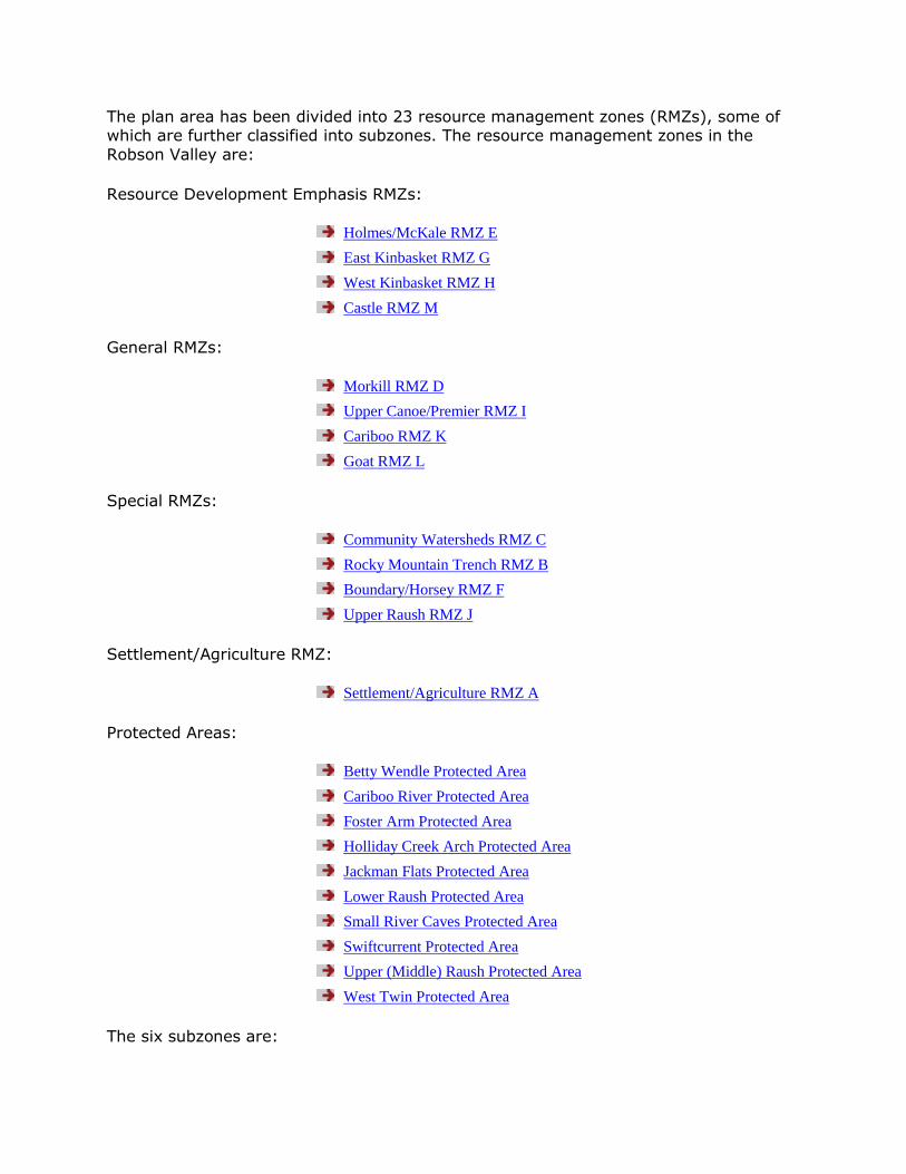
The plan area has been divided into 23 resource management zones (RMZs), some of which are further classified into subzones. The resource management zones in the
Robson Valley are:
Resource Development Emphasis RMZs:
Holmes/McKale RMZ E
East Kinbasket RMZ G
West Kinbasket RMZ H
Castle RMZ M
General RMZs:
Morkill RMZ D
Upper Canoe/Premier RMZ I
Cariboo RMZ K
Goat RMZ L
Special RMZs:
Community Watersheds RMZ C
Rocky Mountain Trench RMZ B
Boundary/Horsey RMZ F
Upper Raush RMZ J
Settlement/Agriculture RMZ:
Settlement/Agriculture RMZ A
Protected Areas:
Betty Wendle Protected Area
Cariboo River Protected Area
Foster Arm Protected Area
Holliday Creek Arch Protected Area
Jackman Flats Protected Area
Lower Raush Protected Area
Small River Caves Protected Area
Swiftcurrent Protected Area
Upper (Middle) Raush Protected Area
West Twin Protected Area
The six subzones are:
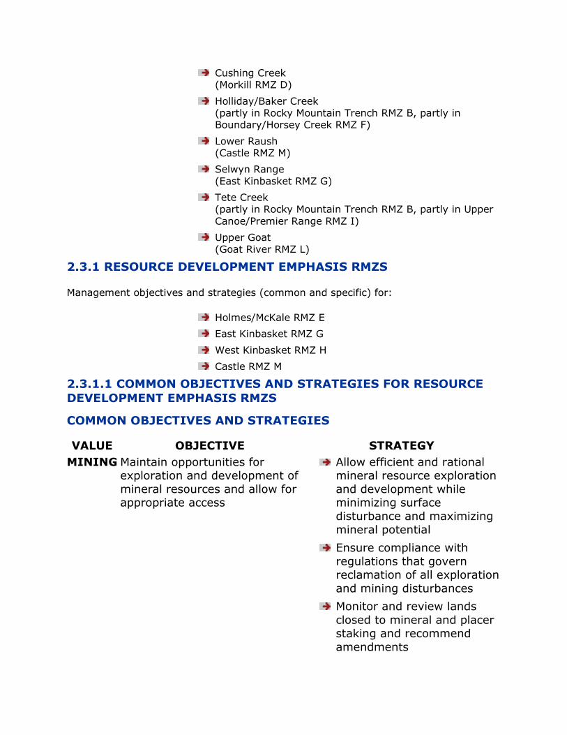
Cushing Creek (Morkill RMZ D)
Holliday/Baker Creek (partly in Rocky Mountain Trench RMZ B, partly in Boundary/Horsey Creek RMZ F)
Lower Raush (Castle RMZ M)
Selwyn Range
(East Kinbasket RMZ G)
Tete Creek (partly in Rocky Mountain Trench RMZ B, partly in Upper
Canoe/Premier Range RMZ I)
Upper Goat (Goat River RMZ L)
2.3.1 RESOURCE DEVELOPMENT EMPHASIS RMZS
Management objectives and strategies (common and specific) for:
Holmes/McKale RMZ E
East Kinbasket RMZ G
West Kinbasket RMZ H
Castle RMZ M
2.3.1.1 COMMON OBJECTIVES AND STRATEGIES FOR RESOURCE
DEVELOPMENT EMPHASIS RMZS
COMMON OBJECTIVES AND STRATEGIES
VALUE OBJECTIVE STRATEGY
MINING Maintain opportunities for exploration and development of
mineral resources and allow for appropriate access
Allow efficient and rational mineral resource exploration
and development while minimizing surface
disturbance and maximizing mineral potential
Ensure compliance with
regulations that govern reclamation of all exploration
and mining disturbances
Monitor and review lands
closed to mineral and placer staking and recommend
amendments
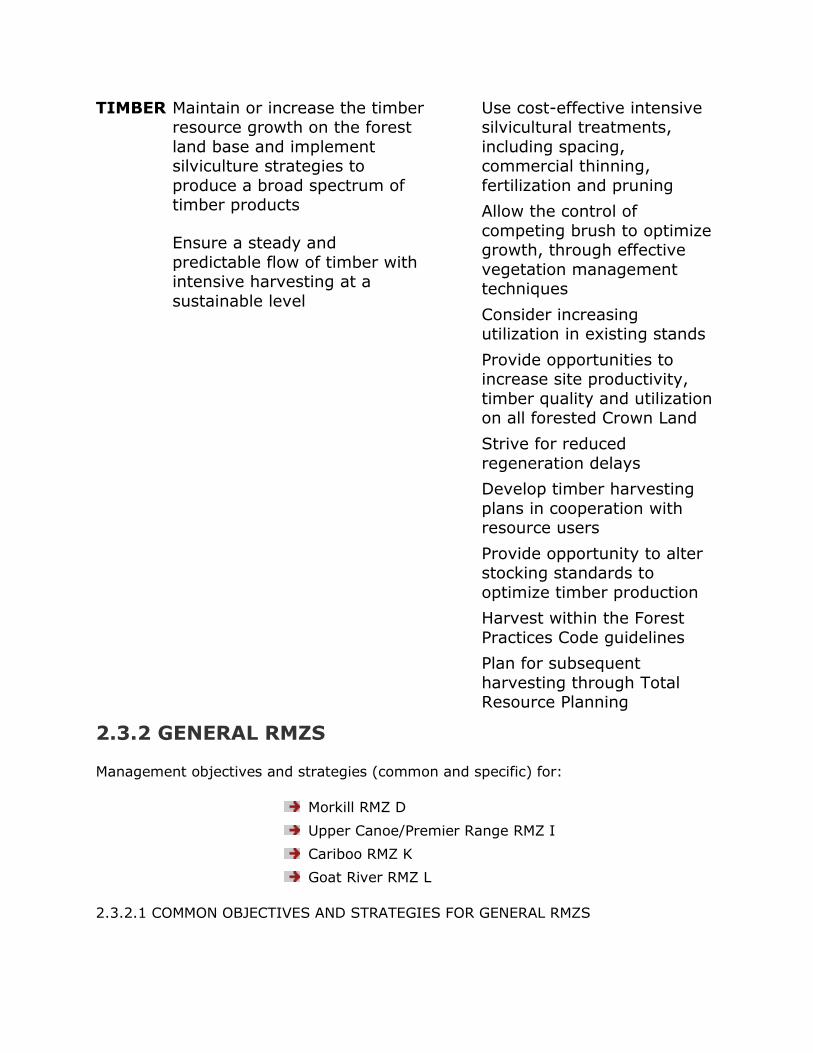
TIMBER Maintain or increase the timber resource growth on the forest
land base and implement silviculture strategies to
produce a broad spectrum of timber products
Ensure a steady and
predictable flow of timber with intensive harvesting at a
sustainable level
Use cost-effective intensive silvicultural treatments,
including spacing, commercial thinning,
fertilization and pruning
Allow the control of
competing brush to optimize growth, through effective
vegetation management techniques
Consider increasing utilization in existing stands
Provide opportunities to increase site productivity,
timber quality and utilization on all forested Crown Land
Strive for reduced
regeneration delays
Develop timber harvesting
plans in cooperation with resource users
Provide opportunity to alter stocking standards to
optimize timber production
Harvest within the Forest
Practices Code guidelines
Plan for subsequent
harvesting through Total Resource Planning
2.3.2 GENERAL RMZS
Management objectives and strategies (common and specific) for:
Morkill RMZ D
Upper Canoe/Premier Range RMZ I
Cariboo RMZ K
Goat River RMZ L
2.3.2.1 COMMON OBJECTIVES AND STRATEGIES FOR GENERAL RMZS
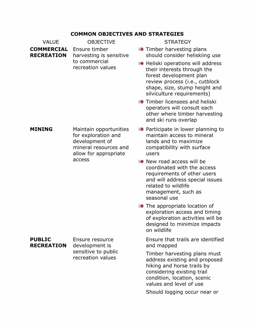
COMMON OBJECTIVES AND STRATEGIES
VALUE OBJECTIVE STRATEGY
COMMERCIAL
RECREATION
Ensure timber
harvesting is sensitive to commercial
recreation values
Timber harvesting plans
should consider heliskiing use
Heliski operations will address
their interests through the forest development plan
review process (i.e., cutblock
shape, size, stump height and silviculture requirements)
Timber licensees and heliski operators will consult each
other where timber harvesting and ski runs overlap
MINING Maintain opportunities for exploration and
development of mineral resources and
allow for appropriate access
Participate in lower planning to maintain access to mineral
lands and to maximize compatibility with surface
users
New road access will be
coordinated with the access requirements of other users
and will address special issues
related to wildlife management, such as
seasonal use
The appropriate location of
exploration access and timing of exploration activities will be
designed to minimize impacts on wildlife
PUBLIC RECREATION
Ensure resource development is
sensitive to public recreation values
Ensure that trails are identified and mapped
Timber harvesting plans must address existing and proposed
hiking and horse trails by considering existing trail
condition, location, scenic
values and level of use
Should logging occur near or
over identified hiking trails, the trail condition and quality
of access must be maintained or relocate the trail if
necessary
Management activities will
consider the type and use of trails (i.e., access or visual)
TIMBER Optimize timber growth consistent
with resource value objectives
Consider where necessary, total resource planning to
integrate other values
Determine sites where water
and wildlife will not be affected significantly by intensive
silvicultural practices
Strive for reduced
regeneration delays
Enhance the productive capacity of forest stands by
using appropriate silviculture systems
Utilize cost effective intensive silvicultural treatments,
including spacing, commercial thinning, fertilization and
pruning, on a site specific basis
Utilize improved seedlings where appropriate, while
maintaining genetic diversity
2.3.3 SPECIAL RMZS
Management objectives and strategies (common and specific) for:
Community Watersheds RMZ C
Rocky Mountain Trench RMZ B
Boundary/Horsey RMZ F
Upper Raush RMZ J

2.3.3.1 COMMON OBJECTIVES AND STRATEGIES FOR SPECIAL RMZS
COMMON OBJECTIVES AND STRATEGIES
VALUE OBJECTIVE STRATEGY
COMMERCIAL
RECREATION
Ensure timber
harvesting is sensitive to
commercial recreation values
Timber harvesting plans should
consider heliskiing use
Heliski operations will address
their interests through the forest development plan review
process (i.e. cutblock shape,
size, stump height and silviculture requirements)
Timber licensees and heliski operators will consult each other
where timber harvesting and ski runs overlap
MINING Ensure flexible resource
management will accommodate the
localized impacts of site access,
advanced exploration and mining activity
Incorporate natural, visual and
recreational values in exploration planning
through the permitting process of
the appropriate resource agency
Mitigate potential land use conflicts with visual and natural
values by ensuring compliance with mineral exploration
guidelines and zone management objectives
Ensure that exploration and site access is undertaken with
sensitivity to the primary values
for which these zones are identified; minimize disturbance
in sensitive wildlife areas and ensure appropriate reclamation
is conducted
PUBLIC RECREATION
Ensure resource development is
sensitive to public
recreation values
Timber harvesting plans must address existing and proposed
hiking and horse trails by
considering existing trail conditions, locations, scenic
value and level of use
Management activities will
consider the type and use of

trail (i.e. access or visual)
TIMBER Allow timber
harvesting with silviculture systems
that are compatible with designated
priority emphasis resource values
Manage logging and silviculture
to resemble natural age class distribution over the landscape
and in accordance with biodiversity objectives
Determine sites where water, wildlife and other resource
values will not be affected significantly by intensive
silvicultural practices
TOURISM Maintain the natural
character of the area and provide
opportunities for tourism in a
backcountry/
wilderness setting
Manage the type and intensity
of tourism activities to minimize impacts on
backcountry/wilderness values
Develop coordinated access
management agreement
between stakeholders
Ensure balance with public
recreation opportunities
Forest development plans will
address visual quality through choice of silvicultural system,
block design, layout of patch retention where possible
VISUAL QUALITY
Address visual quality concerns in
resource extraction and development
areas
Explore opportunities to incorporate larger retention
patches into cutblocks
2.3.4 SETTLEMENT / AGRICULTURE RMZ A
Total area: 69,587 hectares
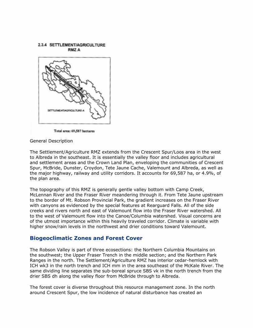
General Description
The Settlement/Agriculture RMZ extends from the Crescent Spur/Loos area in the west
to Albreda in the southeast. It is essentially the valley floor and includes agricultural and settlement areas and the Crown Land Plan, enveloping the communities of Crescent Spur, McBride, Dunster, Croydon, Tete Jaune Cache, Valemount and Albreda, as well as
the major highway, railway and utility corridors. It accounts for 69,587 ha, or 4.9%, of the plan area.
The topography of this RMZ is generally gentle valley bottom with Camp Creek, McLennan River and the Fraser River meandering through it. From Tete Jaune upstream
to the border of Mt. Robson Provincial Park, the gradient increases on the Fraser River with canyons as evidenced by the special features at Rearguard Falls. All of the side creeks and rivers north and east of Valemount flow into the Fraser River watershed. All
to the west of Valemount flow into the Canoe/Columbia watershed. Visual concerns are of the utmost importance within this heavily traveled corridor. Climate is variable with higher snow/rain levels in the northwest and drier conditions toward Valemount.
Biogeoclimatic Zones and Forest Cover
The Robson Valley is part of three ecosections: the Northern Columbia Mountains on the southwest; the Upper Fraser Trench in the middle section; and the Northern Park Ranges in the north. The Settlement/Agriculture RMZ has interior cedar-hemlock with
ICH wk3 in the north trench and ICH mm in the area southeast of the McKale River. The same dividing line separates the sub-boreal spruce SBS vk in the north trench from the drier SBS dh along the valley floor from McBride through to Albreda.
The forest cover is diverse throughout this resource management zone. In the north
around Crescent Spur, the low incidence of natural disturbance has created an

abundance of old growth cedar and hemlock type stands. Mostly located in the northern part of the Fraser River Corridor, some old-growth areas have been identified near the
Canoe River. In the south near Valemount, where the climate is far drier, there is frequent fire disturbance and the lodgepole pine and Douglas-fir stands are considerably younger. Much of the land development in the early part of the century
involved burning and extensive areas along the valley corridor have regenerated to deciduous species (aspen, birch, cottonwood). Some of the best growing conditions available within the greater LRMP area are found in the Settlement/Agriculture RMZ.
Wildlife and Fishery Values
Wildlife diversity and values are very significant within this RMZ. Many of the mid-slopes have been dropped from high to moderate density and the valley floor was dropped two rating classes to low due to logging activity, agricultural clearing and
related access. A significant caribou travel corridor runs from the West Twin/Legrand area across the valley floor and up East Twin/Fleet creeks. This zone provides key winter range for moose, elk, mule deer and white-tailed deer in the plan area, and is
also important as summer range for bears, ungulates and many other species. Due to the relatively mild conditions, low snow pack and diverse forest cover, many wildlife species only occur in the Settlement/Agriculture and Rocky Mountain Trench zones.
Fisheries values are very significant within the Agriculture/Settlement zone. Sensitive
aquatic habitat is noted along the Fraser and McLennan Rivers, Swift Creek, Camp Creek, Lost Lake and Cranberry Marsh. Several of the larger tributaries of the Fraser are noted for aquatic habitat. The McLennan River, Swift Creek, Canoe River and Camp
Creek are known class A fish habitat, as is the Fraser River and all its major tributaries.
This RMZ has the highest concentration of salmon in the entire Robson Valley Forest District. There is known chinook spawning in the Fraser River main stream and the flood plain reaches of the Morkill, Catfish, Snowshoe, Goat, East Twin, West Twin,
McKale, Holmes, Nevin, Holliday, Horsey, McLennan and Swift Creek. There is a major spawning ground in the Fraser River around Tete Jaune Cache. Sockeye salmon have been noted spawning in the Holmes River, albeit infrequently; plus, Kokanee spawn
regularly in Camp Creek. There are resident fisheries values throughout this RMZ, including bull trout, a blue listed species. There are possible sturgeon and burbot
populations in the Fraser River. Important lake fisheries are noted in Shere, Cedarside and Little Lost Lake with ongoing stocking programs. Kinbasket Lake provides suitable fish habitat when lake levels are high enough.
Resource Development
Logging has been important in this area since the railroad was built in 1912-14, when logs were needed for bridge timbers, decking and railroad ties. Many areas were selectively logged for specific products such as telephone poles. In recent years, Slocan licensees have actively logged in these zones, although most of the area remains to be
allocated.
Most of the zone has primitive road access from logging or agricultural development. Highways 16 and 5, which meet at Tete Jaune, provide access in and out of the valley.
There is high visual sensitivity throughout this corridor. Forest health concerns are moderate to high. There is hemlock looper, mistletoe and bark beetle attack in mature
timber stands. Plantation pests such as leader weevil, root-collar weevil and armillaria root rot exist throughout the valley.
Mineral potential has been indicated for industrial minerals throughout most of the RMZ. The potential for base or precious metals has been indicated in the Snowshoe
Lakes area, in a high elevation band between La Salle Creek and East Twin Creek and in a wide band from Fleet Creek through McBride to Holliday Creek. There is active exploration at Crescent Spur. There are showings of gold in the Ptarmigan Creek area;
thorium near McBride; mica, kyanite and beryllium on Mica Mountain; and mica/kyanite along Camp Creek. There is a past producer of silica close to Valemount and past producers of mica between Albreda and Valemount at the Canoe North and Canoe
South mine sites.
The valley bottom contains a variety of dairy, beef and mixed agricultural operations. Streams and springs in both the Settlement/Agriculture and Rocky Mountain Trench zones are important water sources for hundreds of households and farms.
The range tenure program is very active in the Settlement/Agriculture RMZ and the
neighbouring Rocky Mountain Trench RMZ. There are 15 grazing permits issued (9 completely within zone boundaries and portions of 6 more) plus 21 grazing permits issued (14 completely within zone boundaries and portions of 7 more). Tenures tend to
be predominantly for cattle, but have been issued for sheep and horses. One community pasture is established northwest of McBride near the McKale River. The
Ministry of Forests has an ongoing program to control noxious weeds within the provincial forest. There are many active trapping tenures within the Robson Valley, as well as several actively used guide/outfitting tenures.
Recreation
Recreation is of great significance within these highly visible Settlement/Agriculture and Rocky Mountain Trench RMZs. BC Forest Service recreation sites are established at McBride Peak; Holmes River; Shere Lake; Tete Jaune Spawning Grounds and Little Lost Lake. An interpretive trail system and picnic site is established at Spittal Creek. Two
public use cabins, managed by YORA and the Forest Service, are located on the West Ridge and at McKirdy Meadows. An Ecological Reserve is established at Sunbeam Creek
(McBride Peak) and another one is being considered for Jackman Flats. Rearguard Falls and Terry Fox Viewpoints are developed by BC Parks. Locations popular for salmon viewing include: Rearguard Falls; Tete Jaune Spawning Grounds; Swift Creek; Holmes
River; plus Camp Creek for Kokanee runs.
Hiking and horse trails, generally accessing alpine areas, are very popular. Established trails include: Beaver Falls; Paradise; McBride Peak/ridge; Clyde Creek; Bell Mountain; Lucille Mountain; Baker Ridge; Natural Arch; Groeneveld; Dunster; Shere Lookout; Tete
Creek; Mica Mountain; Little Lost Lake; Terry Fox; McKirdy Meadows/Swift Alpine; and lower sections of Dave Henry Creek. Cross country ski trails include Bell Mountain, Dore River, Jackman Flats and Camp Creek. Snowmobile trails and areas are Bell Mountain;
Lucille Mountain and the West Ridge above Valemount. Jet boating, both private and commercial, occurs primarily on the Fraser River but also on the Morkill, Goat, Holmes

and Raush Rivers, if high enough water conditions exist. Canoe and kayak routes include Swift Creek, Fraser, McLennan, Upper Canoe, Canoe, Morkill, Raush, and
Holmes Rivers. Berry picking and mushroom picking/wild-crafting are also popular in these zones.
This zone is an important staging area for a wide variety of front and backcountry tourism activities such as heliskiing, helihiking, horse packing and snowmobiling.
Commercial heliski tenures have been issued in several areas which overlap primarily into the high elevations. Crescent Spur Helicopter Holidays operates their lodge in Crescent Spur utilizing areas north of Goat River and East Twin Creek (Rider Mountain).
Canadian Mountain Holidays, Valemount division, is tenured from Tete Creek south to Albreda. Robson Helimagic has tenure east of Small River to the Robson Corridor and on the Selwyn slopes north of Valemount (a portion of their area is deferred due to goat
studies). These companies also offer helihiking opportunities. Potential sites for commercial backcountry tourism have been identified on Big Bell Mountain, the top of Eddy Creek/Lucille, Gold Creek, Westridge and a portion of Mt. Milton/Camp Creek.
Hang gliding has provided an attraction for enthusiasts since the 1970‟s due to road access on McBride Peak.
Special features abound within the Settlement/ Agriculture zone. Features of note include: pioneer cemetery on Old Tete Jaune Road; Oxbow Lakes off mainstream
Fraser; Japanese tea house at Tete Jaune; Starratt Wildlife Sanctuary; Fraser Wetlands; Shere and Cedarside Lakes; Lower Snowshoe and Catfish Falls; and Tete
Jaune Spawning Grounds.
Culture
Aboriginal sites have been indicated along the salmon spawning grounds of Tete Jaune Cache and a gravesite is evident nearby. The Secwepemc nation has traditionally traveled from the Clearwater Forest District through Valemount to the Fraser River. The
seasonal migrations may have been as far west as the Raush River. An archaeological overview assessment conducted in 1995 has shown that the valley bottom has a high potential for having undiscovered aboriginal sites, whereas, the mountain sides have a
moderate-to-low potential for aboriginal sites.
SETTLEMENT/AGRICULTURE RMZ A
RMZ CATEGORY: Settlement/Agriculture
MANAGEMENT INTENT: To manage as a Settlement/Agriculture RMZ and recognize sensitive wildlife and fisheries values
For more information, see Section 2.2 Overall Goals, Values, Objectives and Strategies,
p. 17.
VALUE OBJECTIVE STRATEGY
AGRICULTURE Maintain or enhance Improve mechanisms to identify
opportunities for use of Crown land,
vegetation, and water resources for
agriculture, fisheries and food production
Minimize other
resource impacts on agricultural
enterprises and associated Crown
resources
and allow exchange of arable and non-arable land between the
Forest Land Reserve (FLR) and Agricultural Land Reserve (ALR)
Encourage the use of domestic livestock for silvicultural
vegetation control
Allow the development of non-
traditional agricultural uses of Crown resources (e.g., agro-
forestry)
Control noxious weeds where
necessary by implementing Noxious Weed Control Plans and
enforcing the proper legislation
Develop mechanisms to
minimize impacts between
domestic livestock and wildlife uses of grazing resources (land,
water, vegetation, access)
Improve local public
participation role in wildlife enhancement and recreational
plans in livestock grazing and agricultural areas
Maintain or enhance the access and use of Crown land and water
resources by livestock within the context of the FPC and PAS
Improve mechanisms to identify and allow exchange of arable
non-arable land between the FLR
and ALR
Minimize conflicts between
wildlife and recreation enhancement uses with private
agricultural operations and Crown grazing
Minimize conflict with other land use activities which may
negatively impact the
productivity and sustainability of agricultural uses of Crown
resources
Develop a participatory role for
agricultural producers in the development of wildlife and
recreational enhancement plans
Promote agricultural
land and water stewardship
programs to manage for other
resource values
Apply the Code of Agricultural
Practices for Waste Management, as per Waste
Management Act.
Refer agricultural pollution
problems via Agricultural Protection Council through the
BC Cattleman‟s Association or the BC Federation of Agriculture
CROWN LAND
PLAN
Ensure the Crown
Land Plan remains current to manage
for a variety of land use and
conservation purposes
Review and update the Robson
Valley Crown Land Plan every five years and ensure
consistency with the approved direction of the LRMP
Provide the public with ongoing opportunities to review the
Crown Land Plan
Ensure important high value
wildlife habitat and recreation areas on Crown Land are
protected from further development
Promote Crown land development and allocation for a
variety of land uses
Investigate rural subdivision potential on Crown Land outside
the ALR
Ensure critical habitat is
maintained for travel corridors through the Crown Land Plan
Through the Crown Land Plan, protect riparian areas and high

value wildlife habitat areas
Re-assess Crown Land Plan
designations along Fraser River to ensure critical wildlife habitat
areas are managed for wildlife values
Complete a wildlife corridor along the Holmes River to the
confluence at the Fraser River and across to Castle Creek
where possible
No commercial timber
harvesting or new grazing tenures in Wildlife Habitat
Management Area (WHMA), Recreation and Conservation
Management Area (RCMA) and
Natural Environment Area (NEA)
DOMESTIC
WATER USE
Maintain or restore
water quality and quantity for
domestic users
A volunteer domestic water
liaison committee will be established at more detailed
levels of planning stage to work with government agencies on
developments in watersheds which have domestic water
intakes
All water intakes and related
infrastructures of licenced and known water users should be
designated as “resource features” as per the FPC and
these should apply for Mines,
Transportation and Highways and other developments. Springs
and seeps should be recognized as Resource Features. The DEO
and the DM may also consider Sensitive Area Designation for
some of these areas
There will be mandatory referral
of forest development plans to the Ministry of Environment,
Lands and Parks water manager for review and comment
Establish a minimum 20 metre reserve zone and 30 metre
machine free management zone on the main creek upstream of
known domestic water intakes. Side tributaries will be assessed
during operational planning and in consultation with the
volunteer domestic water liaison committee. Reserve and
machine free buffer zones will be applied where required
Before any kind of planned disturbance or development, all
licensed and known water users
potentially affected by local plans and operations will be
notified, in addition to public advertisement. In addition,
those users directly affected by upstream operations will be
given particular attention by the proponent throughout the
process
MOF and MELP will jointly
develop a set of forest management practices for
domestic watersheds. These practices will be similar to, or
taken directly from, the Forest
Practices Code requirements for Community Watersheds (Regs
and Guidebook)
Consideration will be given to
designing a FEN where reserve and management zones are
required
Encourage training for
contractors and crews to successfully work in watersheds
Increase harvest monitoring in domestic watershed areas
Permit light grazing over a broad area but precautions such as
fencing, piping water to troughs and keeping corrals and salt out
of riparian zones will be encouraged. Sheep and cattle
grazing tenure holders will ensure that livestock do not
contaminate water
Where possible, use experienced
contractors and crews
Ensure herbicides, fertilizers and
other substances and residues do not contaminate domestic
water
Identify domestic water supply areas and where appropriate
consider designating as community watersheds
FISHERIES Protect or restore the structural,
functional and biological diversity
of stream and riparian habitat
Any mining or exploration activities should consider fishery
objectives as outlined by DFO and MELP
Where necessary, retain reserve of undisturbed vegetative cover
along streams on Crown land
Resource development and other
land use activities must recognize the very high
anadromous fisheries values in
this RMZ
IMPORTANT
RIVERS
Manage riparian
areas adjacent to the Fraser River to
ensure fish and wildlife habitat and
recreation values are maintained
A 50 metre riparian reserve from
the top of the river bank (to exclude non-arable river bank)
will be in effect for areas designated for development in
the Crown land plan. Side tributaries will be assessed
during operational planning and

reserve and machine free buffer zones will be applied where
required
Areas along the Fraser River in
the Provincial Forest (mostly north of McBride and up river of
Tete Jaune) will have a 50 metre riparian reserve plus a 50 metre
riparian management zone above the high water mark.
Partial cutting harvesting systems will be used in the
riparian management zone
These are minimum reserve and
management zones and may need to be extended based on
operational planning
Manage riparian areas adjacent to
the McLennan River to ensure fish and
wildlife habitat and recreation values
are
Manage the Canoe River for fish and
wildlife habitat and
recreation values
maintained
Channel bank erosion problems in the mainstream Fraser above
the Tete Jaune chinook spawning area will be assessed and may
require rehabilitation through revegetation, bank stabilization
and other improvement practices
Establish a 60 metre riparian
reserve and 20 metre riparian management zone above the
high water mark
Road development must be a
minimum of 100 metres from the McLennan River, and
preferably where feasible, 300
metres away
Under special circumstances,
where no alternatives are available, the District Manager of
Forests (DM) and the Designated Environment Official (DEO) may
approve the road location closer to the river
These are minimum reserve and
management zones and may need to be extended based on
operational planning
Locate roads outside wetlands
(upper Canoe) wherever feasible
Establish a 50 metre riparian
reserve plus 20 metre riparian management zone outside
wetlands as minimum reserve and management zones. These
may need to be extended based on operational planning when
more detailed planning occurs
Under special circumstances,
where no alternatives are available, the DM and DEO may
approve the road location closer
to the river
MINING Encourage new
mining opportunities which provide local
employment, especially
development of quarry and
aggregate (sand, gravel) resources
Provide input into appropriate
agricultural and local municipal government planning (e.g.,
Official Community Plans) as required
Allow exploration and development of
mineral resources, particularly
aggregates and
industrial minerals, within appropriate
regulatory framework
Ensure that mineral exploration and mining activities within
settlement/agricultural area and designated community
watersheds comply with mining
legislation and community watershed protection guidelines
OLD GROWTH Manage for the maintenance of old
growth stands and their attributes
Minimize access
Resource development must consider conservation values and
the sensitive nature of the old growth areas in the Northern
Trench through more detailed
roads in old growth areas
levels of planning
The distribution and levels of old
growth forests will be established through biodiversity
emphasis choices for each landscape unit. Direction from
this land use plan will be considered when final
biodiversity emphasis choices are established by government
In the Northern Trench old growth area, around the West
Twin Protected Area, coordinate road access and other linear
uses to minimize road/linear development
PUBLIC
RECREATION
Ensure resource
development is sensitive to public
recreation values
Ensure that trails are identified
and mapped
Timber harvesting plans must
address existing and proposed hiking and horse trails by
considering existing trail condition, location, scenic values
and level of use
Should logging occur near or
over identified hiking trails, the trail condition and quality of
access must be maintained or relocate the trail if necessary
Management activities will consider the type and use of trail
(i.e., access or visual)
Reduce conflicts between motorized
and non-motorized recreation activities
Through education and improved signage, clearly indicate which
trails are motorized and non-motorized in the Camp Creek
recreation area
RANGE Authorize and
manage for sustainable levels of
Where terrain and soils are
suitable, maintain access to all harvested areas for range use
livestock grazing and manage in consideration of all users including: recreation;
silviculture; forest protection; fish and wildlife needs
Maintain long term access to forage by shifting tenures from
maturing cutblocks to new suitable cutover areas including
all roads and landings
Protect riparian areas from
detrimental effects of range use
SPECIAL
FEATURES
Manage and
maintain unique areas
Consideration should be given to
creating a plan area guide/map to identify recreation
opportunities and special features
Identify and conserve
representative areas of macro-lichen forest (e.g., establish
sensitive areas)
Identify and establish map
notations or other designations surrounding these sites:
d) Shere Lake:
Classification A, as per PGRLMG
Endorse UREP Reserve on west
side of lake and 50 metre buffer on north side
e) Pioneer cemetery on Old Tete Jaune road near Tete Jaune
f) Oxbow lakes off the mainstream
Fraser
g) Japanese tea house across scales at Tete Jaune
h) Starratt Wildlife Sanctuary
i) Fraser Wetlands
j) Cedarside Lake
aa) #7 Lower Snowshoe Falls
bb) #6 Catfish Falls
cc) #14 Tete Jaune spawning grounds
TIMBER Optimize timber growth consistent
with resource value objectives
Consider the use of total resource (longterm) planning to
integrate other values
Determine sites where water and
wildlife will not be affected significantly by intensive
silvicultural practices
Strive for reduced regeneration delays
Enhance the productive capacity of forest stands by using
appropriate silviculture systems
Utilize cost effective intensive
silvicultural treatments, including spacing, commercial
thinning, fertilization and pruning, on a site specific basis
Utilize improved seedlings where appropriate, while maintaining
genetic diversity
WILDCRAFT Maintain mushroom
harvesting
opportunities
Identify, map and manage to
maintain existing pine
mushroom habitat
Allow non-commercial
harvesting of mushrooms on Crown land outside ecological
reserves and PAs
WILDLIFE Maintain and where
necessary, enhance wildlife and habitat
to ensure healthy populations, genetic
Ensure mineral exploration and/or small mine development minimizes disturbance and is
variability and distribution
sensitive to caribou and ungulate habitat
For proposed large mine developments, caribou and
ungulate habitat will be addressed by the Environmental
Assessment process
Caribou High Habitat areas will
see limited (if any) commercial logging in future (p. 14).
Sensitive timber extraction in the future may be considered
pending further research and review of management
strategies in Caribou Medium Habitat with local public input
In areas identified as Caribou
corridor, maintain a minimum of 30% of the timber as 100+
years of age in a continuous, windfirm corridor. No more than
20 % of the area may be in a non-green-up condition at any
time. Timber extraction guidelines may be reconsidered
in the future pending further research
Additional signs and other means are needed to identify
wildlife crossing areas to reduce unnatural wildlife mortality
Continue to work with Canadian
National Railway to reduce moose mortality on the railway
Manage the area between Tete Jaune and Mount Robson Park
for high wildlife values when considering logging and/or other
land use activities
Promote vegetation
management strategies for
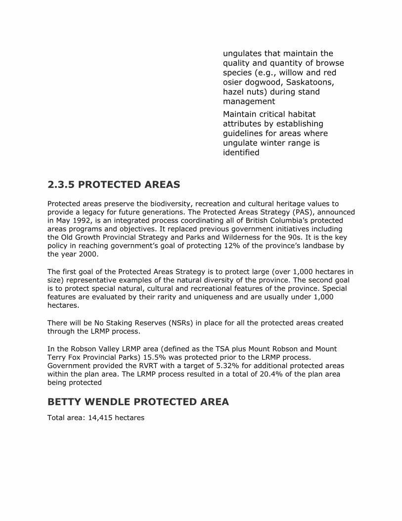
ungulates that maintain the quality and quantity of browse
species (e.g., willow and red osier dogwood, Saskatoons,
hazel nuts) during stand management
Maintain critical habitat attributes by establishing
guidelines for areas where ungulate winter range is
identified
2.3.5 PROTECTED AREAS
Protected areas preserve the biodiversity, recreation and cultural heritage values to provide a legacy for future generations. The Protected Areas Strategy (PAS), announced in May 1992, is an integrated process coordinating all of British Columbia‟s protected
areas programs and objectives. It replaced previous government initiatives including the Old Growth Provincial Strategy and Parks and Wilderness for the 90s. It is the key policy in reaching government‟s goal of protecting 12% of the province‟s landbase by
the year 2000.
The first goal of the Protected Areas Strategy is to protect large (over 1,000 hectares in size) representative examples of the natural diversity of the province. The second goal is to protect special natural, cultural and recreational features of the province. Special
features are evaluated by their rarity and uniqueness and are usually under 1,000 hectares.
There will be No Staking Reserves (NSRs) in place for all the protected areas created through the LRMP process.
In the Robson Valley LRMP area (defined as the TSA plus Mount Robson and Mount
Terry Fox Provincial Parks) 15.5% was protected prior to the LRMP process. Government provided the RVRT with a target of 5.32% for additional protected areas within the plan area. The LRMP process resulted in a total of 20.4% of the plan area
being protected
BETTY WENDLE PROTECTED AREA
Total area: 14,415 hectares
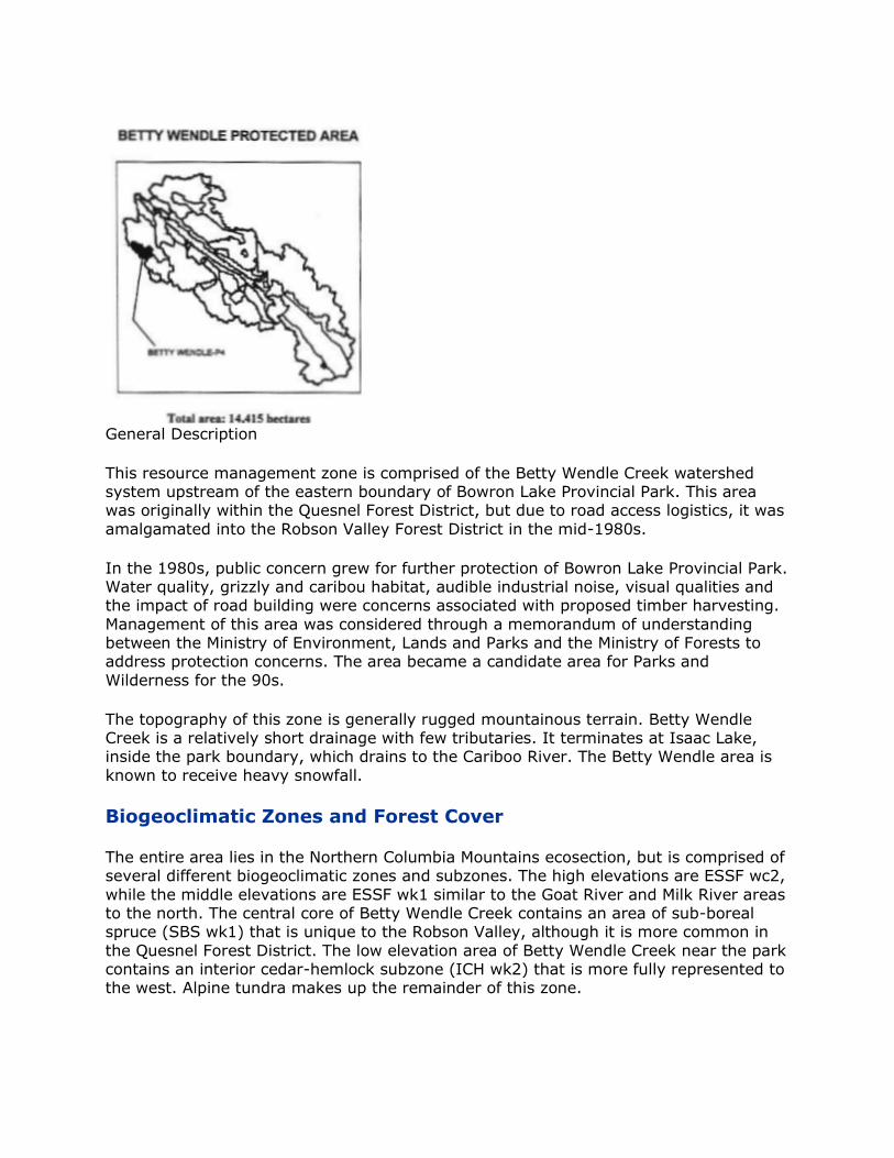
General Description
This resource management zone is comprised of the Betty Wendle Creek watershed system upstream of the eastern boundary of Bowron Lake Provincial Park. This area was originally within the Quesnel Forest District, but due to road access logistics, it was
amalgamated into the Robson Valley Forest District in the mid-1980s.
In the 1980s, public concern grew for further protection of Bowron Lake Provincial Park. Water quality, grizzly and caribou habitat, audible industrial noise, visual qualities and the impact of road building were concerns associated with proposed timber harvesting.
Management of this area was considered through a memorandum of understanding between the Ministry of Environment, Lands and Parks and the Ministry of Forests to address protection concerns. The area became a candidate area for Parks and
Wilderness for the 90s.
The topography of this zone is generally rugged mountainous terrain. Betty Wendle Creek is a relatively short drainage with few tributaries. It terminates at Isaac Lake, inside the park boundary, which drains to the Cariboo River. The Betty Wendle area is
known to receive heavy snowfall.
Biogeoclimatic Zones and Forest Cover
The entire area lies in the Northern Columbia Mountains ecosection, but is comprised of several different biogeoclimatic zones and subzones. The high elevations are ESSF wc2,
while the middle elevations are ESSF wk1 similar to the Goat River and Milk River areas to the north. The central core of Betty Wendle Creek contains an area of sub-boreal spruce (SBS wk1) that is unique to the Robson Valley, although it is more common in
the Quesnel Forest District. The low elevation area of Betty Wendle Creek near the park contains an interior cedar-hemlock subzone (ICH wk2) that is more fully represented to the west. Alpine tundra makes up the remainder of this zone.

Other than the Interior cedar-hemlock subzone mentioned above the forest cover is dominated by undisturbed stands of Engelmann spruce and alpine fir. Fire history is
minimal in this wet area. Forest health concerns that have been noted include minor bark beetle attacks and a periodic spruce budworm attack.
Wildlife and Fishery Values
Water quality is very important in Betty Wendle Creek as it drains into Bowron Lake Provincial Park. Betty Wendle Creek is a known class A fish habitat and has rainbow trout and Dolly Varden fish distribution to enhance the sports fishery downstream in the park.
Caribou habitat is rated high in the northern high elevation area. Little information is
available on grizzly habitat in this zone. However, as significant numbers of grizzly are known to frequent the mouth of Betty Wendle Creek in Bowron Provincial Park, it is likely that medium to high grizzly habitat exists in the lower elevation forests of this
zone. The entire Betty Wendle drainage is noted as sensitive range for upland furbearers, wolverine and bear. There are concerns that road access may result in habitat loss and increased mortality rates from hunting and poaching. Commercial
heliskiing operations are required to design flight lines and activities to minimize contact with caribou.
Resource Development
The Betty Wendle drainage has been allocated to Zeidler Forest Industries Ltd. and was placed in a deferral (or “log-around”) area in 1991. No development has taken place to date, although the area does contribute to the allowable annual cut calculation.
Mineral potential for base or precious metals is indicated but No Staking Reserves presently exist in the drainage.
There is no existing range use in the area.
Recreation
This area is considered to have high significance for outdoor recreational opportunities. One area with potential for commercial backcountry recreation has been identified primarily in higher elevation locations. Several small alpine lakes exist throughout the
zone. There is commercial heliskiing in this zone with the two tenures held by Crescent Spur Helicopter Holidays and Canadian Mountain Holidays (McBride). Helihiking also occurs, but is not yet a tenured commercial activity.
Summer recreational use is fairly low and comprised primarily of hikers and mountain
climbers along the eastern boundary of this zone. Intensive recreational use occurs on the Bowron Lake chain in the summer months which makes this proposed protected area a natural addition to the existing park area.
Culture
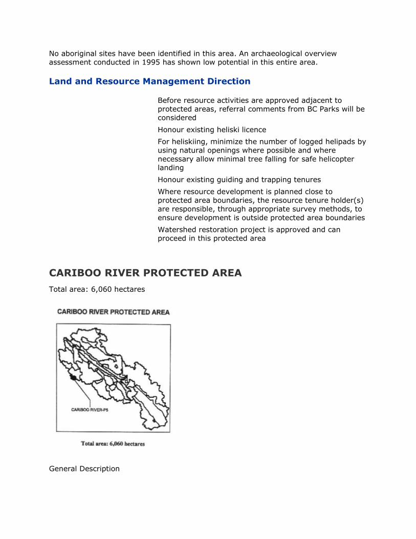
No aboriginal sites have been identified in this area. An archaeological overview assessment conducted in 1995 has shown low potential in this entire area.
Land and Resource Management Direction
Before resource activities are approved adjacent to protected areas, referral comments from BC Parks will be considered
Honour existing heliski licence
For heliskiing, minimize the number of logged helipads by using natural openings where possible and where
necessary allow minimal tree falling for safe helicopter landing
Honour existing guiding and trapping tenures
Where resource development is planned close to protected area boundaries, the resource tenure holder(s) are responsible, through appropriate survey methods, to
ensure development is outside protected area boundaries
Watershed restoration project is approved and can proceed in this protected area
CARIBOO RIVER PROTECTED AREA
Total area: 6,060 hectares
General Description
This protected area lies adjacent to the easternmost boundary of Bowron Lake Provincial Park. The boundary of the protected area includes five kilometres of the
Cariboo River and the tributaries flowing in from the eastern slopes. Toward the southeast, the boundary runs along the height of land above the Matthew River to the westernmost glaciers of Mt. Lunn. The area upstream from this protected area remains
in the operable forest and will be accessed from kilometre 38 of the Milk River road system to the northeast.
In the 1980‟s, public concern grew for further protection of Bowron Lake Provincial Park. Water quality, grizzly and caribou habitat, audible industrial noise, visual qualities
and the impact of road building were concerns of the proposed timber harvesting. The area became a candidate area for Parks and Wilderness for the „90s. The boundary for this protected area includes all areas considered visually sensitive as viewed from
Bowron Lake Provincial Park.
The topography of this zone is generally rugged mountainous terrain with glaciers at the higher elevations. The Cariboo River drains an extensive area and is important for many resource values including forming Lanezi and Sandy Lakes on the southern
portion of the Bowron Lakes Chain. South of the park, the Cariboo River joins the Quesnel River and empties into the Fraser River near Quesnel. This protected area is high in rainfall and annual snowpack.
Biogeoclimatic Zones and Forest Cover
The entire area lies in the Northern Columbia Mountains ecosection and contains several different biogeoclimatic zones and subzones. The lower elevations along the Cariboo River are interior cedar-hemlock (ICH wk2). The middle elevations are ESSF
wk1, which is also found in the Betty Wendle, Milk and Goat river systems to the north. The upper elevations are ESSF wc2, which is also found in Betty Wendle Creek and further south near Foster Creek on Kinbasket Lake. Alpine tundra, rock and ice make up
the remainder of this protected area.
The forests are dominated by Engelmann spruce and subalpine fir with the addition of cedar and hemlock at the lower elevations. Natural disturbances are minimal in this area with occasional spot fires, minor windthrow and seasonal avalanches or rockslides.
Forest health concerns have been expressed regarding periodic spruce budworm attack.
Wildlife and Fishery Values
Water quality is critical for the Cariboo River for several reasons. There are important salmon values further downstream and although there is no current inventory
information, it is likely that native fish species exist in the Cariboo River above Lanezi Lake. The high profile recreational usage on Lanezi and Sandy Lakes has generated additional public concern that the water quality be maintained.
Little information is available about the wildlife values in this protected area. Grizzlies
are known to frequent the mouth of Betty Wendle Creek on Issac Lake and it is likely that medium to high grizzly habitat exists in the lower elevations along the Cariboo
River. There are concerns that road access may result in habitat loss and increased mortality rates from hunting and poaching.
Resource Development
This portion of the Cariboo River was allocated to the MOF small business program and was placed in a deferral (or “log-around”) in 1991. No development has taken place to date, although the area does contribute to the allowable annual cut (AAC).
Mineral potential is rated low in this area and No Staking Reserves currently exist.
There is no existing range use in the upper Cariboo River.
Recreation
This proposed protected area has extremely remote access and a corresponding low level of recreational activity within the boundary. The primary interest at the present time is in providing a visual and auditory buffer for the established recreational users
on Bowron Lakes Provincial Park. Maintaining water quality is also a recreational concern. A small subalpine lake exists on a tributary of the Cariboo River within this protected area. There is good potential for commercial heliskiing in the higher
elevations of this protected area and the current tenure holder is Canadian Mountain Holidays (McBride).
Culture
No aboriginal sites have been identified in this area. An archaeological overview assessment conducted in 1995 has shown low potential in the drainage, although some of the valley bottom has unproven potential.
Land and Resource Management Direction
Before resource activities are approved adjacent to protected areas, referral comments from BC Parks will be considered
Honour existing heliski licence
For heliskiing, minimize the number of logged helipads by using natural openings where possible and where necessary allow minimal tree falling for safe helicopter
landing
Honour existing guiding and trapping tenures
Review existing no staking reserve once proposed
protected area is approved
Where resource development is planned close to protected area boundaries, the resource tenure holder(s)
are responsible, through appropriate survey methods, to ensure development is outside protected area boundaries
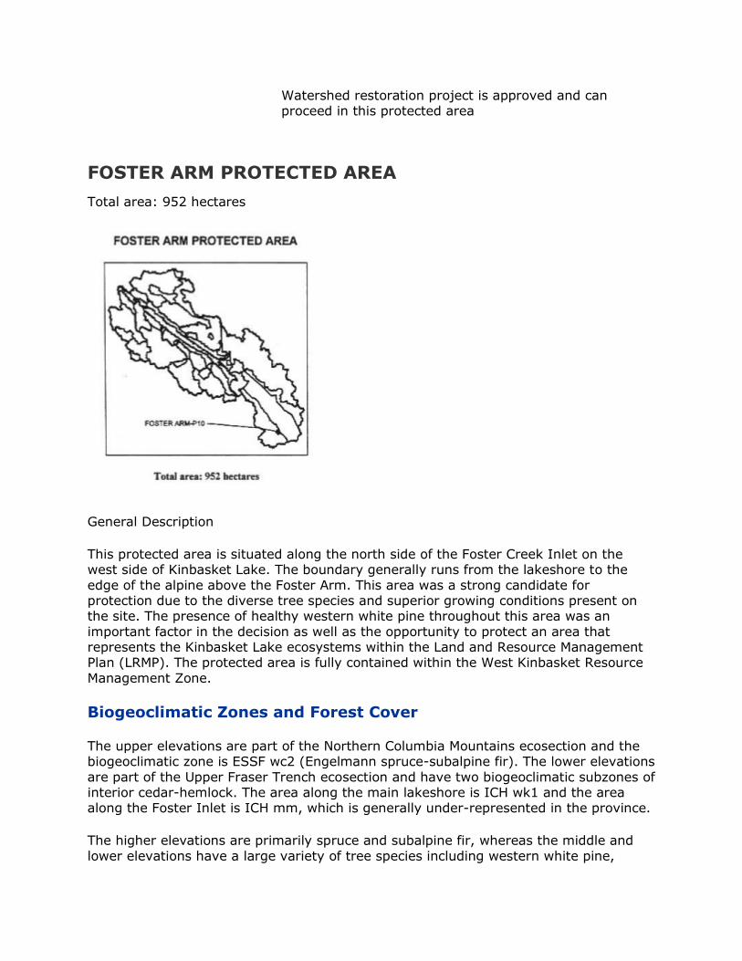
Watershed restoration project is approved and can proceed in this protected area
FOSTER ARM PROTECTED AREA
Total area: 952 hectares
General Description
This protected area is situated along the north side of the Foster Creek Inlet on the west side of Kinbasket Lake. The boundary generally runs from the lakeshore to the
edge of the alpine above the Foster Arm. This area was a strong candidate for protection due to the diverse tree species and superior growing conditions present on the site. The presence of healthy western white pine throughout this area was an
important factor in the decision as well as the opportunity to protect an area that represents the Kinbasket Lake ecosystems within the Land and Resource Management Plan (LRMP). The protected area is fully contained within the West Kinbasket Resource
Management Zone.
Biogeoclimatic Zones and Forest Cover
The upper elevations are part of the Northern Columbia Mountains ecosection and the biogeoclimatic zone is ESSF wc2 (Engelmann spruce-subalpine fir). The lower elevations
are part of the Upper Fraser Trench ecosection and have two biogeoclimatic subzones of interior cedar-hemlock. The area along the main lakeshore is ICH wk1 and the area along the Foster Inlet is ICH mm, which is generally under-represented in the province.
The higher elevations are primarily spruce and subalpine fir, whereas the middle and
lower elevations have a large variety of tree species including western white pine,
Douglas-fir, cedar, hemlock, spruce and lodgepole pine. The area has a low-to-moderate level of natural disturbance with occasional spot fires and windthrow. The
main forest health concern in this protected area is with white pine blister rust.
Wildlife and Fishery
The fishery values in this protected area are focused along the lakeshore, since only small creeks are present. Kinbasket Lake is considered class A fish habitat with most
native fish species present as well as Kokanee salmon.
There is important wildlife habitat in the Foster Arm Protected Area. The entire preserve is classified as high caribou habitat. The western half of the area is considered high for grizzly density and the eastern half is considered moderate.
Resource Development
There has been no logging or other resource development within the boundary of this protected area. The general area was allocated to the MOF small business program and some logging blocks are evident along the lakeshore of the Foster Inlet adjacent to the
protected area boundary. Any future road building from Howard Creek to Foster Creek would have to pass through the proposed protected area.
There is mining potential for polymetallic or carbonitite-related minerals throughout the protected area.
No range tenures exist in the area.
While guide/outfitting and trapping tenures exist for the West Kinbasket area, it is
considered likely that protection in this specific area would have little or no impact on the tenure holders.
Recreation
There are limited recreational values associated with this protected area. There is some potential for hunting or lakeshore fishing. There is a designated area with commercial back-country recreation potential in the higher elevations above this protected area. There is potential for heliskiing in this same area and the tenure is held by Mike
Wiegele.
Culture
There are no aboriginal sites indicated for this protected area.
Land and Resource Management Direction
Before resource activities are approved adjacent to protected areas, referral comments from BC Parks will be considered

Honour existing heliski licence
Minimize the number of logged helipads by using natural
openings where possible and where necessary allowing minimal tree falling for safe helicopter landing
Road allowance (future location unknown)
Existing hunting and trapping tenure will be honoured
Where resource development is planned close to protected area boundaries, the resource tenure holder(s)
are responsible, through appropriate survey methods, to ensure development is outside protected area boundaries
HOLLIDAY CREEK ARCH PROTECTED AREA
Total area: 397 hectares
General Description
This magnificent natural arch has been protected as a reserve for Use, Recreation and Enjoyment by Public (UREP) since the mid-1970‟s. This protected area preserves more of the surrounding terrain that is critical to the integrity of the special feature. It
includes a portion of the alpine tundra above the arch and both side boundaries will run down to Holliday (Baker) Creek. The terrain within this protected area is steep to extremely steep with frequent rock faces. It has a moderately wet climate, but is
subject to summer drought due to the south exposure.
Biogeoclimatic Zones and Forest Cover
This protected area lies within the Northern Park Ranges and has the Engelmann spruce-subalpine fir biogeoclimatic zone (ESSF mm1). Alpine tundra dominates the
higher elevations.
Wildlife and Fishery Values
The wildlife values in the area are highest for mountain goat. There are goat populations that have been frequently observed within this protected area. The lower
elevations are important as winter range for moose and deer. The grizzly densities are rated high in the timbered area and rated moderate in the alpine area. It has been indicated that aquatic habitat is also an important wildlife feature in this area.
Holliday Creek has class A fish habitat within a kilometre downstream from the
protected area, including salmon spawning grounds nearer to the Fraser River. Some or all of the following species are present in the Holliday Creek drainage: rainbow trout, bull trout and mountain whitefish.
Resource Development
There is an indicated potential for base or precious metals as well as industrial minerals along the southwestern boundary of the protected area. There is no road access or logging history for Holliday Arch.
There are no range tenures or agriculture lands within this protected area.
There are active traplines in the vicinity of this protected area. The lower slope trail
along Holliday (Baker) Creek provides access for the trapper as well as the recreationalists. The protected area lies within a guide/outfitting tenure used infrequently at the present.
Recreation
Recreation has played an important part in the history of this proposed protected area. There are two important hiking trails leading to viewpoints near the natural arch. Baker Ridge Trail is accessed up a very steep cat trail from the west side and the Natural Arch
Trail is accessed by approximately three kilometres of stream-side hiking and a steep climb up a hogsback to the east of the arch. The alpine is accessible through either route.
The heliskiing tenure in the area is held by Robson Helimagic, although Holliday Creek
is part of a deferred heliskiing area pending the completion of a mountain goat study.
Culture
There have been no aboriginal sites indicated near this natural arch feature.
Land and Resource Management Direction
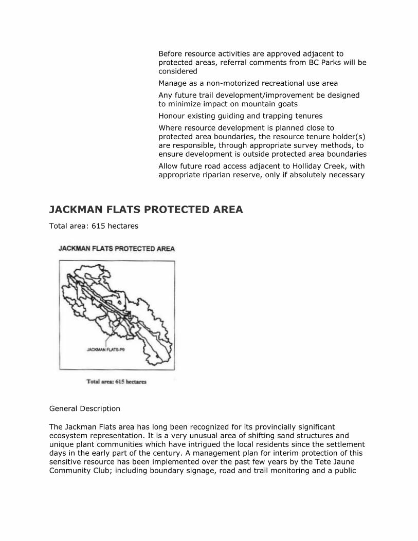
Before resource activities are approved adjacent to protected areas, referral comments from BC Parks will be
considered
Manage as a non-motorized recreational use area
Any future trail development/improvement be designed
to minimize impact on mountain goats
Honour existing guiding and trapping tenures
Where resource development is planned close to
protected area boundaries, the resource tenure holder(s) are responsible, through appropriate survey methods, to ensure development is outside protected area boundaries
Allow future road access adjacent to Holliday Creek, with appropriate riparian reserve, only if absolutely necessary
JACKMAN FLATS PROTECTED AREA
Total area: 615 hectares
General Description
The Jackman Flats area has long been recognized for its provincially significant ecosystem representation. It is a very unusual area of shifting sand structures and
unique plant communities which have intrigued the local residents since the settlement days in the early part of the century. A management plan for interim protection of this sensitive resource has been implemented over the past few years by the Tete Jaune
Community Club; including boundary signage, road and trail monitoring and a public
awareness program. This 615 ha. protected area lies between Highway 5 and the Blackman Road/ CN Rail right-of-way in a tract of land south of Tete Jaune Cache.
Biogeoclimatic Zones and Forest Cover
The topography of this small protected area is flat to rolling terrain with very sandy soils. The wind patterns between the Fraser system and the Kinbasket Lake area have created a mosaic of ridges, dunes and groups of stunted trees. The area receives low-
to-moderate levels of snow during the winter, but there is usually a long drought period during the summer months. The proposed area lies within the Upper Fraser Trench ecosection and is in the xeric (dry) site series of the sub-boreal spruce biogeoclimatic
subzone (SBS dh). The forests in this area are made up of stunted lodgepole pine trees with the occasional exception of a spruce or aspen in a wet depression.
In 1977, the Ministry of Environment recognized Jackman Flats as a unique area and applied for Ecological Reserve Status to protect it. Their report identified that the area
contains six very different plant communities, four of which are found infrequently in other areas, two of which are not found elsewhere. Among its unique plants is Stereocaulon condensatum a species of lichen not found in other areas of the province.
It was discovered by Trevor Goward in 1994.
There has been human access to these conifer stands since the railway construction era, but timber harvesting values are very low overall due to the low moisture and nutrients available to the trees. The threat of fire is very high in this area during the
busy summer tourist months. Forest health concerns are mainly with lodgepole pine pests such as mistletoe and bark beetles. The close proximity to Highway 16 makes this area particularly sensitive to visual concerns.
Wildlife and Fishery Values
The area around Jackman Flats is known as important winter range for ungulates. The protected area is used as a travel corridor for deer, moose and elk. The grizzly density is rated as low, although it was rated as moderate before human development. There
are no fish habitat values within Jackman Flats.
Resource Development
There is a potential for industrial minerals (mica, kyanite, silica) throughout this part of the Rocky Mountain Trench. The soil structure of this protected area is primarily sand
with occasional pockets of loamy sand.
Highway 5 borders the east side of the protected area and Blackman Road parallels the west side. There are old roads crossing through the preserved area that are often used in spite of the restrictions in place.
There are no range tenures in this area. Although Jackman Flats is part of trapping and
guide/ outfitting tenures, there has been little, if any, activity within the boundaries.
Recreation
The open nature of the Jackman Flats area is ideal for recreation but also makes it vulnerable to abuse. Recreation has been limited to hiking (nature walks) and cross-country skiing. There was previous motorbike activity in this area, but motorized use is no longer allowed. There is a concern regarding the enforcement of the non-motorized
classification.
Culture
There have been no aboriginal sites identified in this protected area. The Secwepemc nation has indicated the Tete Jaune area as part of its traditional territory. The open
forests of Jackman Flats would have provided a natural travel corridor to the Fraser River.
Land and Resource Management Direction
Before resource activities are approved adjacent to protected areas, referral comments from BC Parks will be considered
Consider closure of existing road with public input
Government to reconsider limiting access to local residents and restricting others to ensure that activities along the road do not endanger the protected area.
Manage as a non-motorized use area
Minimize site disturbance by keeping hiking use to designated locations and or trails
RVRT reached early consensus to protect this area
LOWER RAUSH PROTECTED AREA
Total area: 1,259 hectares

General Description
This area is situated in the lower stretch of the Raush River between four and eight kilometres upstream from the confluence with the Fraser River. The area is on the west
side of the Raush and runs up steep slopes through three different biogeoclimatic zones before ending in alpine tundra and rock cliffs. It is totally contained within the Castle resource management zone.
Biogeoclimatic Zones and Forest Cover
This protected area is within the Northern Columbia Mountains ecosection. The valley floor has a sub-boreal spruce biogeoclimatic subzone SBS dh. The lower slopes are interior cedar-hemlock (ICH mm), which is an under-represented subzone within the
LRMP area. The upper slopes are Engelmann spruce-subalpine fir (ESSF mm1). The area faces to the northeast and remains cool for much of the growing season.
The forest in the valley bottom is dominated by western white spruce with a mix of other species like Douglas-fir, hemlock, lodgepole pine and cedar. The lower slopes are
mainly cedar and hemlock and the upper slopes are dominated by Engelmann spruce and subalpine fir (balsam). There are no records of this area having been logged in the past.
Fire disturbance is infrequent in this area, although there is a high instance of
lightening strikes. Most fire damage results in small burn patches due to the moisture in the valley. Forest health concerns are low-to-moderate with the main concern being bark beetles.
Wildlife and Fishery Values
The wildlife habitat is one of the important features of the Lower Raush Protected Area. The alpine and subalpine areas are extremely important for mountain goat populations.

The valley bottom is important winter range for moose and deer and provides summer range for bear and other species. The grizzly bear densities are moderate through the
lower-to-upper forested slopes.
The alpine areas are rated as low grizzly density. The Raush River meanders through the lower stretch with a multitude of backwaters. This area is very important as aquatic habitat for bird nesting, fish rearing and non-fish aquatic species.
There is known class A fish habitat in the Raush River through this protected area.
There are salmon spawning sites a few kilometres downstream near the Fraser River. It is most likely that native species such as bull trout, rainbow trout and mountain whitefish are found within the protected area.
Resource Development
The Raush River drainage has not been developed for timber extraction.
There is no mining potential recorded for this protected area.
There is one moderate-sized range tenure in the lower Raush River and a small portion of it may lie in the lower part of the protected area.
There has been active trapping in the lower Raush River since the railroad construction era and the lower elevation portion of the protected area may be critical to the trapping
tenure holders. The Raush River is part of a large guide/outfitting tenure and has a history of infrequent but continual usage since the early part of the century.
Recreation
Recreation is currently low in this small protected area. There is no road access and most of the terrain is very steep with cliffs and scree slopes in the alpine. Hiking involves crossing a very large river and bushwhacking uphill. Jet-boating up the Raush from the Fraser River is done by a few local parties each summer season. Canoeing
could be an attraction if road access and launch sites were improved. Hunters have historically used this river system and its surrounding lowlands.
Culture
There are no aboriginal sites identified in this protected area. The Secwepemc nation has identified the Raush River as generally having historical significance within their traditional territory.
Land and Resource Management Direction
Before resource activities are approved adjacent to protected areas, referral comments from BC Parks will be considered
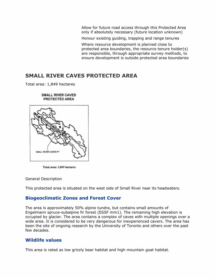
Allow for future road access through this Protected Area only if absolutely necessary (future location unknown)
Honour existing guiding, trapping and range tenures
Where resource development is planned close to protected area boundaries, the resource tenure holder(s)
are responsible, through appropriate survey methods, to ensure development is outside protected area boundaries
SMALL RIVER CAVES PROTECTED AREA
Total area: 1,849 hectares
General Description
This protected area is situated on the west side of Small River near its headwaters.
Biogeoclimatic Zones and Forest Cover
The area is approximately 50% alpine tundra, but contains small amounts of Engelmann spruce-subalpine fir forest (ESSF mm1). The remaining high elevation is occupied by glacier. The area contains a complex of caves with multiple openings over a
wide area. It is considered to be very dangerous for inexperienced cavers. The area has been the site of ongoing research by the University of Toronto and others over the past
few decades.
Wildlife values
This area is rated as low grizzly bear habitat and high mountain goat habitat.
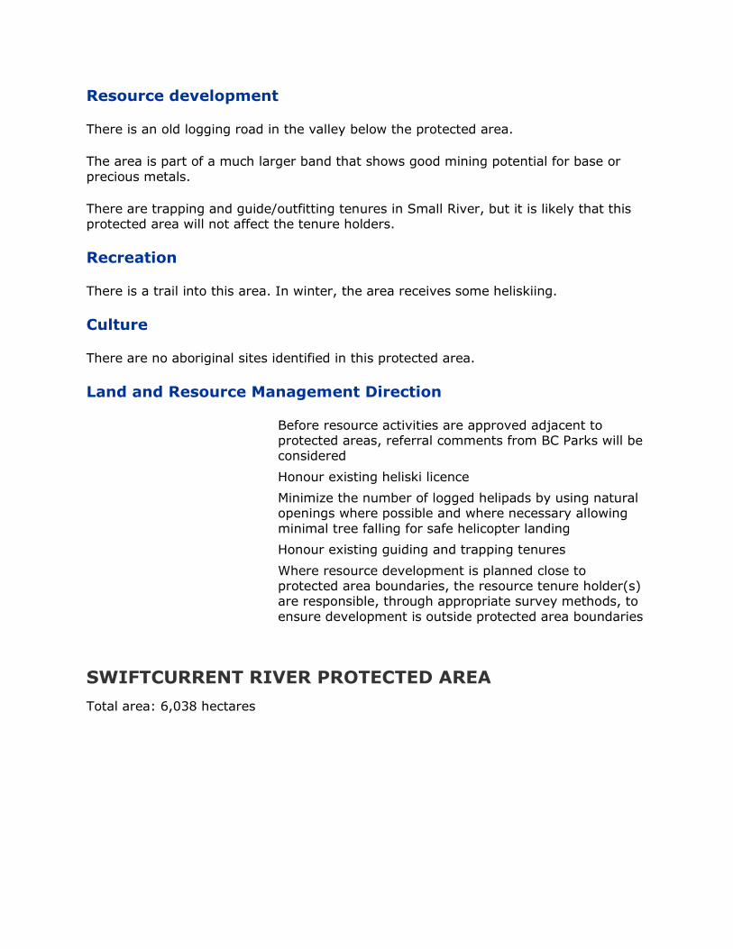
Resource development
There is an old logging road in the valley below the protected area.
The area is part of a much larger band that shows good mining potential for base or
precious metals.
There are trapping and guide/outfitting tenures in Small River, but it is likely that this protected area will not affect the tenure holders.
Recreation
There is a trail into this area. In winter, the area receives some heliskiing.
Culture
There are no aboriginal sites identified in this protected area.
Land and Resource Management Direction
Before resource activities are approved adjacent to protected areas, referral comments from BC Parks will be considered
Honour existing heliski licence
Minimize the number of logged helipads by using natural openings where possible and where necessary allowing
minimal tree falling for safe helicopter landing
Honour existing guiding and trapping tenures
Where resource development is planned close to protected area boundaries, the resource tenure holder(s) are responsible, through appropriate survey methods, to
ensure development is outside protected area boundaries
SWIFTCURRENT RIVER PROTECTED AREA
Total area: 6,038 hectares
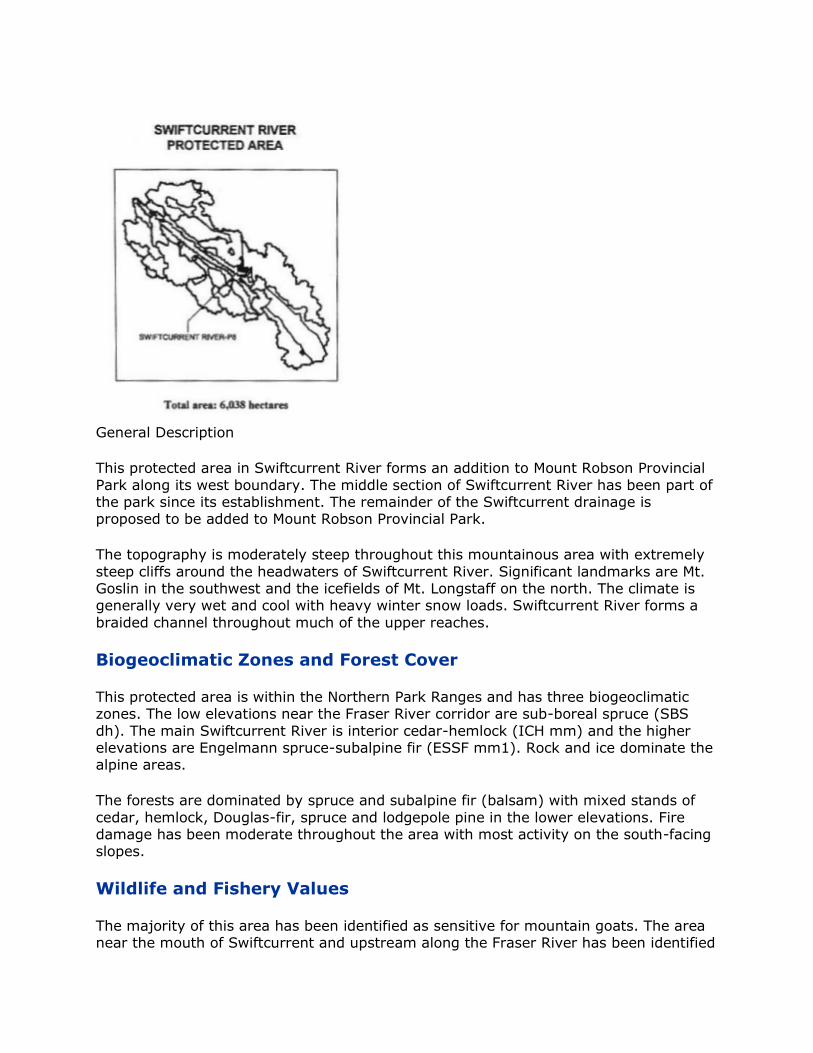
General Description
This protected area in Swiftcurrent River forms an addition to Mount Robson Provincial
Park along its west boundary. The middle section of Swiftcurrent River has been part of the park since its establishment. The remainder of the Swiftcurrent drainage is proposed to be added to Mount Robson Provincial Park.
The topography is moderately steep throughout this mountainous area with extremely
steep cliffs around the headwaters of Swiftcurrent River. Significant landmarks are Mt. Goslin in the southwest and the icefields of Mt. Longstaff on the north. The climate is generally very wet and cool with heavy winter snow loads. Swiftcurrent River forms a
braided channel throughout much of the upper reaches.
Biogeoclimatic Zones and Forest Cover
This protected area is within the Northern Park Ranges and has three biogeoclimatic zones. The low elevations near the Fraser River corridor are sub-boreal spruce (SBS
dh). The main Swiftcurrent River is interior cedar-hemlock (ICH mm) and the higher elevations are Engelmann spruce-subalpine fir (ESSF mm1). Rock and ice dominate the alpine areas.
The forests are dominated by spruce and subalpine fir (balsam) with mixed stands of
cedar, hemlock, Douglas-fir, spruce and lodgepole pine in the lower elevations. Fire damage has been moderate throughout the area with most activity on the south-facing slopes.
Wildlife and Fishery Values
The majority of this area has been identified as sensitive for mountain goats. The area near the mouth of Swiftcurrent and upstream along the Fraser River has been identified

as winter range for ungulates (moose, deer, elk) and summer range for bear species. The Fraser is considered sensitive aquatic habitat as well.
The forested areas are generally rated high for grizzly bear, with some moderate area
near the Highway 16 corridor. The alpine is rated as low grizzly density.
The Fraser River is known class A fish habitat with salmon spawning beds near the mouth of Swiftcurrent River. The river itself flows rapidly down a steep gradient and has no recorded inventory of native fish species.
Resource Development
There have been small amounts of logging in the lower reaches of Swiftcurrent River. This operating area has been assigned to Hauer Bros. Lumber Ltd. An old logging road accesses the Swiftcurrent River drainage. This road is presently used for recreational
purposes. Forest health concerns are generally low in these areas.
There are no range tenures in the Swiftcurrent drainage.
There is active trapping in the Swiftcurrent drainage. Guide/outfitting tenures have been issued for this area.
Recreation
The recreational activity is moderate in these areas but has potential for future use. The Swiftcurrent River area has been popular with local cross-country skiers for decades. Hiking and mountain climbing opportunities also exist. Commercial whitewater rafting is popular on the Fraser River. The heliskiing tenure for Swiftcurrent River and Small River
is held by Robson Helimagic (based nearby in Valemount).
Culture
No aboriginal sites have been identified in these areas. The Fraser River corridor has been a human travel corridor since the fur-trading days and Swiftcurrent River was the
scene of some prospecting activity around the turn of the century.
Land and Resource Management Direction
Before resource activities are approved adjacent to protected areas, referral comments from BC Parks will be
considered
Honour existing heliski licence
Minimize the number of logged helipads by using natural
openings where possible and where necessary allowing minimal tree falling for safe helicopter landing
Honour existing guiding and trapping tenures
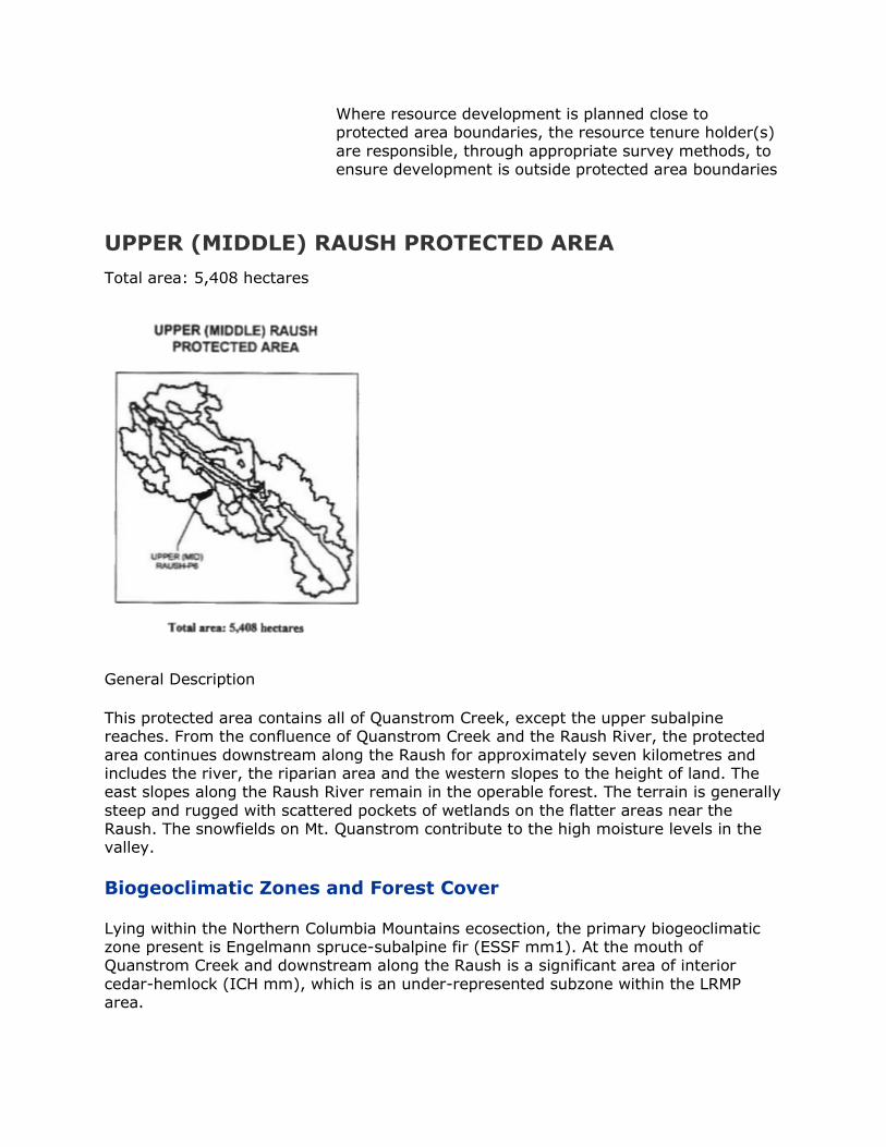
Where resource development is planned close to protected area boundaries, the resource tenure holder(s)
are responsible, through appropriate survey methods, to ensure development is outside protected area boundaries
UPPER (MIDDLE) RAUSH PROTECTED AREA
Total area: 5,408 hectares
General Description
This protected area contains all of Quanstrom Creek, except the upper subalpine reaches. From the confluence of Quanstrom Creek and the Raush River, the protected
area continues downstream along the Raush for approximately seven kilometres and includes the river, the riparian area and the western slopes to the height of land. The east slopes along the Raush River remain in the operable forest. The terrain is generally
steep and rugged with scattered pockets of wetlands on the flatter areas near the Raush. The snowfields on Mt. Quanstrom contribute to the high moisture levels in the valley.
Biogeoclimatic Zones and Forest Cover
Lying within the Northern Columbia Mountains ecosection, the primary biogeoclimatic zone present is Engelmann spruce-subalpine fir (ESSF mm1). At the mouth of Quanstrom Creek and downstream along the Raush is a significant area of interior
cedar-hemlock (ICH mm), which is an under-represented subzone within the LRMP area.

The forest on the lower slopes is a mixture of spruce, Douglas-fir, lodgepole pine, cedar and hemlock. The upper slopes along the Raush River and Quanstrom Creek are
forested with spruce and subalpine fir. A large part of the Raush/Quanstrom Old Growth Area is contained within this protected area.
The south-facing slopes above the Raush River have a past history of fire damage from lightening strikes, while Quanstrom Creek has a lower fire frequency. There have been
recent forest health concerns with bark beetles causing mortality in several tree species.
Wildlife and Fishery Values
Although no fish inventory information is currently available, it is likely that rainbow trout, bull trout and mountain whitefish are present in this system. There is known class A fish habitat in the lower stretches of the Raush River immediately north of this protected area.
Wildlife values are significant in this remote area. The forested areas are considered
moderate for grizzly bear habitat. There is an important winter range for moose and deer along the Raush River. Mountain goats are likely to be found as populations have been identified just to the north, along the peaks that divide the Raush Valley from
Castle Creek.
Resource Development
There has been no road building in this protected area and none of the area has been allocated to timber licensees. The area contributes to the allowable annual cut
determination.
The area has shown low potential for mine operations.
There have not been any grazing or range tenures issued for this protected area, although a grazing licence exists immediately downstream at the north end.
Trapping tenures have been historically active in this area. The Raush River is part of a large guide/outfitting tenure and has a history of infrequent, but continual usage, since
the early part of the century.
Recreation
There is potential for recreational activities within the Raush/Quanstrom area, but there has been a low level of public activity due to the lack of road access. The rugged
mountains and extensive glaciers contribute to the high visual quality of this protected area. One large area with high back-country tourism potential has been identified on the east flanks of Mt. Quanstrom, which is partially included within this protected area.
The primary activity at present is heliskiing with the tenure held by Canadian Mountain Holidays (McBride). The Raush has occasional jet-boat activity and has potential for canoeing if road access and launch sites were improved.
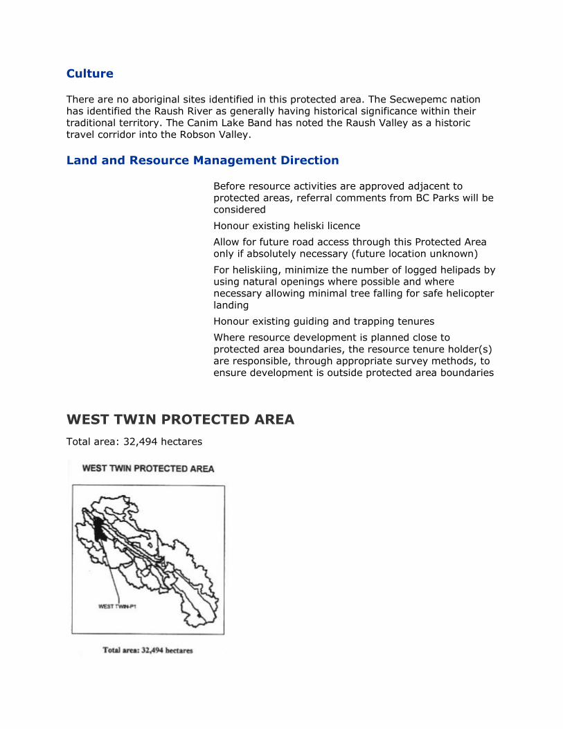
Culture
There are no aboriginal sites identified in this protected area. The Secwepemc nation has identified the Raush River as generally having historical significance within their traditional territory. The Canim Lake Band has noted the Raush Valley as a historic travel corridor into the Robson Valley.
Land and Resource Management Direction
Before resource activities are approved adjacent to protected areas, referral comments from BC Parks will be considered
Honour existing heliski licence
Allow for future road access through this Protected Area only if absolutely necessary (future location unknown)
For heliskiing, minimize the number of logged helipads by using natural openings where possible and where necessary allowing minimal tree falling for safe helicopter
landing
Honour existing guiding and trapping tenures
Where resource development is planned close to
protected area boundaries, the resource tenure holder(s) are responsible, through appropriate survey methods, to ensure development is outside protected area boundaries
WEST TWIN PROTECTED AREA
Total area: 32,494 hectares
General Description
This protected area was chosen due to the rich wildlife values, the wide biogeoclimatic representation and, most of all, the fact that this area is the only protected corridor
across the Robson Valley trench. This area runs from the Cariboo Mountains in the south, through the main Robson Valley trench, and up the fronting ranges of the Rocky Mountains. The north boundary includes the timbered slopes that are visible from the
main valley between, and including, La Salle Creek and Fleet Creek. From the Fleet area, the line runs south through the trench meandering to avoid the private land in the lower West Twin near the Fraser River. South of Highway 16, the line runs up the
height of land between the West Twin and Legrand creeks, crossing the two upper forks of Clyde Creek on its way to Bell Mountain. The south boundary encompasses the Ozalenka Creek tributary of the Dore River and winds around to Mt. Halvorson. The line
travels north between the Milk River and several upper tributaries of the West Twin. South of Bounding Creek, the line crosses the Goat River to include the La Salle lakes that lie several kilometres to the west. The line returns to the east along highway 16
and then descends toward the Fraser River on the west side of Goat River. Near the Fraser, the boundary swings in a loop to avoid private land and the community of Goat River and finally runs north up into the Rocky Mountains west of La Salle Creek.
The topography is diverse throughout this area. The majority of the upper West Twin
Creek drainage has steep slopes, unstable soils and barren rocky peaks. The only glaciers in this area are on the west side of Mt. Halvorson. The alpine areas in the West
Twin are scattered and isolated compared to the gentle alpine slopes of the Ozalenka Valley. The fronting ranges on both the north and south sides of the main trench are moderately steep and the trench itself is rolling forested terrain with occasional flat wet
areas. The soil types in the trench are deeply organic and generally rich in nutrients. The area receives a high level of precipitation, both summer and winter, and the forested area has a low level of natural disturbance by fire.
Biogeoclimatic Zones and Forest Cover
The West Twin Protected Area is part of three ecosections: the Northern Columbia Mountains on the south; the Upper Fraser Trench in the middle section; and the Northern Park Ranges in the north. The predominant biogeoclimatic zone in the mid-to-
upper elevations is Engelmann spruce-subalpine fir. In the West Twin, the subzone is ESSF wk1 and in both the Ozalenka and the La Salle/Fleet areas, the subzone is ESSF mm1. The biogeoclimatic zone of the mid-to-lower elevations is interior cedar-hemlock
(ICH wk3) with a few islands of sub-boreal spruce (SBS vk) near the Fraser River. The alpine tundra is mainly present in the south portion of this protected area.
The forests in the higher elevations are dominated by subalpine fir (balsam) and spruce. The lower elevations have dense forests of western hemlock and western red
cedar with occasional spruce or balsam. Some of these cedar-hemlock forests are more than 500 years old and have areas with a variety of macrolichen species. The south-facing slopes of the Rocky Mountains have Douglas-fir and lodgepole pine as well. The
lower areas near the Fraser River are forested with western white spruce and cottonwood. Fire history is negligible in this portion of the interior wet belt. Old growth is evident throughout this area. The north portion lies within the Morkill/McKale Old
Growth Area, the main body of the protected area lies within the Legrand/West

Twin/Goat Old Growth Area and in the east within the Bell/McIntosh/ Clyde Old Growth Area.
Wildlife and Fishery Values
The wildlife values are extraordinary in this protected area. There is a known goat area from Bell Mountain west to Clyde Creek. The entire main trench area, the lower Goat River and much of the fronting ranges are known as winter range for moose and deer.
There is high caribou habitat in the north below Mount Rider and in the south, the entire West Twin, Clyde, Ozalenka and Bounding Creek areas have also been rated as high habitat. The main valley trench provides caribou corridor as well as connectivity
between the ranges for many other species. Grizzly densities are high throughout these same areas, but the rating has been dropped to moderate in the main trench area due to human access.
There is known class A fish habitat along both sides of the Fraser River, including the
lower part of its main tributaries. The Goat River is class A fish habitat and supports important runs of Chinook salmon. There are salmon spawning areas within both the Goat River and the lower West Twin. La Salle Lakes are also class A fish habitat and
have been stocked in the past with bull trout and rainbow trout.
Resource Development
The Small Business Forest Enterprise Program has been operating in this area. Road building and timber harvesting began in the 1970‟s and continued to the early 1990‟s.
There are forest health concerns with spruce and balsam bark beetle and the hemlock looper attack in the mature forests and with leader weevils in the younger planted stands. The Ozalenka valley and two upper forks of the West Twin have been
designated as a Wildlife Emphasis Area.
The CN Rail line near the Fraser River was completed in 1914. Road development through this proposed protected area began with Highway 16 in the late 1960‟s. Two decades later, a 34 km. loop road was constructed into the steep West Twin valley. At
this same time, Mountainview Road, on the northeast side of the valley, was extended several kilometres to the west of Fleet Creek. There are two main access roads to agriculture lands in the valley bottom from Highway 16: one east of Goat River and a
second along West Twin Creek (Lamco Road). Several important gravel pits exist near the highway corridor. There is also an existing BC Hydro distribution line along the highway corridor.
There is potential for base or precious metals in a band that crosses the Goat River
from La Salle Lakes to Boulder Mountain. There is potential for industrial minerals (mica, kyanite, silica) that runs throughout the main trench area. There are two mineral claims in this proposed protected area (the Eagle and the Raven) held by one licensee.
There is a residential tenure in the vicinity of the claims.
On the north side of the Fraser River, there are significant portions of two existing range tenures both accessed by Mountainview Road. There have been no range tenures
issued within the remainder of this protected area.

Licenced trapping is actively pursued within this zone. Guide/outfitting tenures are present as well, but these are less active due to the lack of developed horse trails.
Recreation
The BC Forest Service sites at La Salle Lakes are the most popular recreation attraction in the north part of the forest district. They offer non-motorized boating, fishing, swimming, picnicking and camping and are within a few minutes of Highway 16. Little
La Salle Lake is accessed by foot trail only. The key hiking feature in the area is Boulder Mountain, which has a trail starting at one kilometre on the Goat FSR. There is a forest interpretive trail east of the West Twin bridge and a forest viewing platform located
below the highway east of the Goat River. There is alpine hiking available in many parts of this area, but bushwhacking is required. The Ozalenka Forest Service Cabin is accessed by a seven kilometre trail from the West Dore River. This area is very popular
for both summer and winter use. The West Twin area is popular for berry picking. There is active helihiking and heliskiing activity in this area. The tenure holder for heliskiing in the area is Crescent Spur Helicopter Holidays.
Culture
There are no reported aboriginal sites in the West Twin Protected Area.
Land and Resource Management Direction
Before resource activities are approved adjacent to protected areas, referral comments from BC Parks will be
considered
Commercial heliskiing licences honoured
Commercial helihiking, existing untenured use by current
operator, allow helihiking one day per week, maximum six times per year in the Ozalenka Valley. This agreement should be implemented when this operator applies for
tenure. Otherwise, designate the Ozalenka Valley a non-motorized use area
Minimize the number of logged helipads by using natural
openings where possible and where necessary, allowing minimal tree falling for safe helicopter landing
Consider developing a road access management plan to
ensure that road development and use is coordinated in a manner sensitive to caribou habitat and environmental values
Where feasible, new access roads through Protected Areas to private or Crown land will be avoided
Utilize existing roads where feasible
Access allowed to CN Railway land, private and Crown land and existing gravel reserves, dumps, right-of-ways
etc.
Save and except two mineral claims
Honour Frederickson residential tenure
Recognize BC Hydro transmission line right of way interest
Allow future hydro, gas, oil or other right-of-way through
this P.A. subject to minimal impacts to protected area objectives. Allow future telephone and hydro lines into private land and where feasible coordinate with existing
trails and roads
Ministry of Highways and Transportation to undertake future geotechnical work to prove and/or minimize area
for gravel reserve interests.
Allow future gravel extraction from reserves subject to a management plan that minimizes disturbance to this
protected area
Management plans and rehabilitation of any land use sites is the responsibility of land users as directed by BC
Parks
Important macrolichen areas will be identified within the
PAS area
Any future land use activities must avoid, wherever feasible, important macrolichen areas
Allow for CN Railway grade stabilization
Assess regeneration success of large clear cut areas within this protected area and priorize these areas for fill
planting in the next few years
Honour existing grazing, guiding and trapping tenures
Watershed restoration project is approved and can
proceed in this protected area.
3.0 SOCIAL, ECONOMIC and ENVIRONMENTAL IMPACT
ASSESSMENT
3.1 INTRODUCTION AND BACKGROUND
It is important to note that there have been some changes to the original Recommended Plan between the time that these scenarios were analyzed and the plan was given final approval. There was one significant change (the Upper Goat was
designated a subzone of the Goat River RMZ), as well as minor changes (small boundary modifications for Protected Areas). However, since the overall impact of these
changes to the assessments was considered to be marginal, the scenarios were not reassessed before final approval. That is, the assessments presented here carry over to
the final plan for the most part.
Midway through the negotiation process, the Robson Valley LRMP developed several land use scenarios. Multiple accounts assessments were prepared and utilized in the negotiating process and in developing the Plan, which was approved April 30, 1999. A brief description and assessment of these scenarios (1) in summary matrix form is
presented in this Appendix II of this report.
The impacts of the Plan are incremental to Base Case impacts. The Base Case is defined as the land and resource management plan that would likely have been implemented in the absence of an LRMP. It is assumed that the Base Case includes Provincial initiatives
such as the Timber Supply Review (TSR), the Forest Practices Code (FPC), and Protected Areas Strategy (PAS), since these initiatives would have been implemented even without a formal land use plan.
Base Case PAs are assumed to be the percentage of Areas of Interest (AOIs) identified
by the Regional Protected Areas Team (RPAT) because as a percentage of the land base, they are very close to Government's PAS target of 5.32% for new protected areas in the Robson Valley. Base Case FPC impacts include the riparian and wildlife tree
components of the Code but exclude the biodiversity component due to difficulties in speculation about biodiversity impacts in the absence of the LRMP.
Due to resource constraints and the similarity of the Plan to an earlier scenario developed by the LRMP, no formal resource or Geographic Information System (GIS)
analysis of the final plan was undertaken. The assessment of the Plan is thus based on resource analyses and approximate GIS area analysis undertaken by Government's Interagency Planning Team (IPT) for the four preliminary scenarios. Gary Holman,
Consulting Economist and Eliot Terry, Consulting Biologist, undertook the socio-economic and environmental evaluations, incorporating input from the IPT, the Ministry of Employment and Investment and previous scenario assessments.
3.2 OVERALL SUMMARY OF SOCIO-ECONOMIC IMPACTS
The quantifiable socio-economic impacts of the Base Case and Plan arise primarily from
timber supply impacts. Base Case initiatives such as TSR, FPC and RPAT AOIs could potentially place at risk 60-75 direct and indirect jobs (3% - 4% of total regional jobs) within the next 20 years. The Plan could place an additional 10 forest-related jobs at
risk. The Plan would slightly increase long term harvest levels due to timber freed up by selection harvesting in visually sensitive areas. However, since the harvest level in both
the Base Case and the Plan will be just over one-half current AAC, closure of a sawmill is likely in the long term (but no sooner than 20 years), unless new timber supplies (e.g., from Alberta or from currently inoperable wood in the TSA) are forthcoming.
The socio-economic impacts of the Plan for non-forestry sectors are more difficult to
quantify, because they primarily involve longer term implications on potential activity. The Plan increases job growth potential in tourism and recreation and other nature-based activities such as trapping and mushrooming. The Plan may preclude a very
small proportion of mining, energy potential and agricultural growth, but may increase development costs in some areas requiring more sensitive management.
The Economic Strategy recommended as part of this Plan and increased growth
potential in sectors such as tourism could substantially or completely mitigate the impacts of possible forestry job losses. Slow population and economic growth, and the gradual increase in the percentage of the local economy being service-based will likely
continue in the Base Case and the Plan.
3.2.1 Forestry
The current Allowable Annual Cut (AAC) in the Robson Valley TSA is approximately 600,000 m3/year, although historically not all of the AAC has been harvested. The Base
Case Timber Supply Assessment incorporated the 1994 Timber Supply Review (TSR) assumptions, updated the timber harvesting landbase to reflect removal of recommended Areas of Interest and updated the TSR forest practice assumptions to
fully reflect the Forest Practices Code.
The above update to the 1994 timber supply projection, resulted in a harvest flow similar to TSR, in that the timber supply equivalent to the current AAC could be maintained for up to ten years before a decline of some 78,000 m3 in the second
decade, and further declines of about 13% per decade thereafter, to a harvest level of 243,000 m3 by year 70, before climbing to a long term harvest level of 317,000 m3 by year 160.
With no future change in forest practices from those employed in 1994, beyond the
implementation of the Forest Practices Code and the recommended Protected Areas Strategy, as reflected in what has been called the Base Case, some 50-60 forestry jobs and up to 15 spin-off jobs could potentially be at risk in the Robson Valley, within the
next twenty years. The number of forestry-related jobs potentially placed at risk represent up to 4% of total employment in the Robson Valley. Further forestry job loss is likely in the Base Case as the AAC declines (at about 13% per decade) to long term
harvest levels, and due to technological change / industry rationalization.
The harvest impacts of the Plan could also be deferred for up to ten years, but thereafter would decline by about 15% (13% due to Base Case and 2% due to the
plan) per decade to 267,000 m3 by year 50, before climbing to a long term harvest level of 325,000 m3 by year 160. The incremental timber harvest impacts of new protected areas, sensitive management areas and visual quality objectives (VQOs) in
the Plan compared to the Base Case, are relatively minor, potentially placing at risk an additional 10 direct and indirect forestry jobs. The impacts of new VQOs recommended in the Plan are largely offset by the assumption that existing and new VQOs (retention
and partial retention zones) are harvested selectively, thus freeing up more timber than under a clear cut management regime. In fact, long term harvest levels are slightly higher in the Plan than in the Base Case because of the impacts of selection harvesting
in existing and new VQOs.
The shorter term forestry employment impacts estimated above are characterized as "jobs at risk" because they are based on the somewhat unrealistic assumption that
firms and workers make no adjustments to minimize or avoid impacts. For example, firms may find alternative sawlog supplies (e.g., from Alberta), invest in value added to
improve utilization or lower their labour costs through periodic shutdowns and/or attrition. In other words, the adjustment to harvest reductions could take the forms, for example, of lower average incomes due to longer periods of temporary unemployment.
Workers could also supplement their forestry income with part-time employment in FRBC programs or other activities.
This is not to trivialize the fact that adjustments for individual workers who may be displaced and cannot find alternative employment, and for their families, can be very
difficult in the absence of an affective economic strategy. However, there are a number of measures that could be implemented to mitigate the employment, income and government revenue impacts of land use changes in the shorter term, including timber
supply alternatives, watershed restoration and incremental silvicultural activities funded by FRBC, and more labour intensive harvesting and value-added processing. These measures and other possible economic development initiatives are summarized in the
Economic Strategy recommended as an integral part of this Plan.
Closure of a major processing facility in the Base Case or the Plan is unlikely in the next 20 years, given that the larger mills have historically operated at less than full capacity utilization, the availability of imports from Alberta, and the fact that the AAC may not be fully utilized. (2) The Plan would actually increase the long term harvest level slightly
compared to the Base Case, due primarily to the effects of selection harvesting in VQOs. However, since the harvest level will be just over one-half of current AAC within 50-60 years in both the Base Case and the Plan, closure of one of the larger mills in the
Valley is a distinct longer term possibility. These harvest reductions would result from the sustainability and management constraints associated with the Timber Supply Review process, regardless of the FPC or new protected areas.
The incremental impacts of the Plan at the provincial level, arising from marginal
reductions in timber and chip flows to other processing facilities in BC, will be negligible.
3.2.2 Other Sectors: Tourism/Recreation, Mining, Energy,
Agriculture, Botanical Forest Products, Fisheries and Trapping
The socio-economic implications of the Plan for non-forestry sectors are more difficult to quantify, and are generally less significant, at least in the short term, because they
primarily involve creating or foregoing potential activity over longer periods of time. Also, 85% of the planning area is excluded from the Timber Harvesting Land Base (THLB). Therefore, while the Plan will provide better management for nature-based
economic activities (e.g., trapping, guiding, wilderness tourism, wildcraft, fisheries), this additional management direction will be even more important if the THLB is expanded in the future.
3.2.2.1 Tourism/Recreation
In the Base Case, new Areas of Interest (AOIs) would permit further growth in sustainable recreation (e.g., camping and hiking) by tourists and residents. Over a ten

year period, it is estimated that growth in tourism supported by visitors to new PAs could generate the equivalent of 15 full-time jobs. (3) Growth in commercial
backcountry tourism activities (e.g., heliskiing) will continue, although new PAs would
place limits on this growth in some areas. The new Provincial commercial backcountry recreation policy will provide some additional investment certainty because of longer tenures, although such tenures do not exclude potentially conflicting uses such as
timber harvesting. Continued clear cut harvesting in the Valley Trench would erode some of the scenic beauty valued by residents and visitors.
The Plan would be more supportive of long term backcountry tourism growth compared to the Base Case by creating additional parks (e.g., the Raush, Small River Caves, Swift
Creek, addition to Mt. Robson). The Plan would better manage non-motorized recreation and high quality wilderness opportunities as a result of special management Resource Management Zones (RMZs) and access restrictions in a number of key areas
(e.g., Holliday Creek, Tete Creek, Kiwa Glacier, Boundary/Horsey, Ozalenka Valley, Eagle Valley, Upper Raush, Selwyn Range and the Cushing drainage). The additional VQOs and the emphasis on partial cutting methods in the Valley Trench proposed in the
Plan could encourage longer stays in the Valley compared to the Base Case, which could generate additional tourism spending and job gains.
The Plan also provides clearer direction with respect to the identification and management of recreation values such as trails and recreation sites, so that the visual
impacts of timber harvesting are minimized. For example, 65% of high potential commercial backcountry and other recreation sites are located in special management RMZs recommended by the Plan, double the proportion in the Base Case. Also, new
trails are to be located where possible outside the THLB.
Existing motorized recreation activities would be allowed to continue in most new PAs and other areas with motorized access restrictions, although expansion of these activities would be constrained. The Plan only places restrictions on less than 2% of the
roaded areas and there is sufficient potential to accommodate growth in motorized recreation for a number of years outside of PAs and restricted areas. Traditional snowmobile use areas will also be supported and retained in the Plan.
From a provincial perspective, protection of the Betty Wendle drainage in the Base Case
and in the Plan is very important to ecological, recreation and tourism values in the Bowron Lake Park adjacent to the Robson Valley. The new Betty Wendle PA would protect the wilderness backdrop to the Bowron and water quality and fisheries habitat
in streams feeding the Bowron and Isaac lakes. This protected area and additional motorized access management in the Caribou River area, will also serve as a buffer
against increased motorized access and industrial noise from the Robson Valley.
3.2.2.2 Mining/Energy
New PAs in the Base Case (i.e. the AOIs) and the Plan would not affect any existing or proposed new mines (e.g., mines in the Mine Development Assessment Process) or occurrences (i.e. mineral deposits that show promise or have a production history) in the planning area.(4) Establishing the AOIs as protected areas would preclude
development of about 2% of high industrial mineral potential and 4% - 5% of medium

industrial and metallic potential, which is unlikely to have any noticeable short term economic impact. The West Twin AOI contains several gravel reserves, two of which are
in current use. These reserves are an important component of total reserves and production in the Valley. Operation of existing and development of new reserves would likely be allowed if the West Twin were to be established as a PA under current
Provincial policy. The Base Case places no sites with previous exploration activity, and very minor high metallic or high industrial in special management areas.
The Plan would place a similar proportion of high industrial mineral potential in new protected areas as the Base Case, but would increase the proportion of mineral
potential in RMZs designated for sensitive management of wilderness and recreational values. The Plan places 4 of 8 exploration sites with recorded activity, about one-quarter of existing mineral tenures, about 20% of high industrial potential, and 5% of
high metallic potential in these RMZs. Exploration and development is not precluded from these RMZs, but regulatory and management guidelines may be more stringently applied. Also, the Plan places restrictions on access in a number of watersheds,
including helicopter-only access for initial exploration in all alpine areas. Depending on how access management guidelines are implemented, exploration and development costs could be increased, which could be significant for deposits that are marginally
economic. The likelihood of production from these areas in the near future is low, although subject to a great deal of uncertainty due to the "hidden" nature of the resource and a number of unpredictable market, cost and competitive factors.(5)
The operation and development of the four gravel reserves in the West Twin Protected Area are acceptable resource uses. However, the Plan will provide more specific
direction to more accurately delineate and minimize the size of these reserves, and to manage access, development and operations to ensure these activities are more consistent with the management objectives for the protected area.
The Forgetmenot gypsum deposit, the most promising mineral occurrence in the
Robson, is located in the Boundary/Horsey RMZ which has management strategies designed to maintain high wilderness and recreation values. Future exploration and development of this deposit, which at full production could create about 20 jobs
annually, would not be precluded although cost of development may be increased by management strategies in the Boundary/Horsey RMZ.
A review of the Base Case and Plans by BC Hydro indicates that there are no major hydro projects of concern to the Corporation that would be precluded by new protected
areas. The West Twin Protected Area, which is common to the Base Case and the Plan (boundaries vary slightly), would not preclude right of ways for power lines or other
linear development such as oil and gas pipelines. These developments are more clearly allowed for in the Plan, but could be more costly because of the implications of management objectives (e.g., re road access or routing).
Comparison of a mapped inventory of small hydro sites in the Robson by the RVRT
Resource Advisory Group with maps for the Base Case AOIs and the Plan, indicates that the Base Case would preclude development of 1 out of 14 "very high / good" sites and 4 out of 100 potentially "viable" sites.(6) The Plan appears to have similar impacts.
Forgone employment impacts, if any, would be primarily in the construction phase, not

in operations, unless the site was important to the viability of some other kind of project or activity (e.g., mine).
3.2.2.3 Agriculture
There are no major differences between the Base Case and the Plan in terms of PA impacts on agricultural land. New PAs in the Base Case and the Plan would allow existing agricultural activity such as grazing, but would preclude expansion of these
activities. The proposed West Twin PA, which is common to the Base Case and the Plan, would account for most of the grazing land affected. Expansion of intensive agriculture and / or grazing would be precluded on about 1,800 ha of ALR land. All of this ALR land
is forested and therefore it primarily represents future potential rather than existing production.
The Plan would also preclude future grazing in the Morkill drainage special management area, although there is no existing activity now in this area. Grazing in the upper Raush
special management RMZ would be allowed if consistent with management objectives. In general, the amount of grazing land affected is not a significant proportion of the total in the Valley, and impacts on existing activities are unlikely. The Plan also
recommends the identification and approval of other opportunities for grazing or forage production in those Crown lands underutilized for agriculture (particularly adjacent to existing operators) and new timber harvesting areas.
3.2.2.4 Fisheries
The risk to salmon habitat will increase over time in the Base Case as harvesting and road access in salmon-bearing watersheds proceeds. Increases in peak stream flows and sedimentation resulting from timber harvesting activities and associated road
construction / deactivation are the main risks to salmon habitat in the Robson Valley. Peak stream flow problems are mitigated by new Riparian Guidelines in the FPC (7) and
by the fact that about 85% of the land base is currently excluded from timber harvesting, although operability lines could expand in the future. Sedimentation
associated with harvesting and road building in the timber land base beyond riparian buffer zones can still be a significant problem. There are also risks associated with the large proportion of the salmon resource adjacent to private land, which are not
addressed by the FPC.
The Plan includes enhanced riparian zones on the Fraser River mainstem and the lower McLennan River within RMZ A.(8) The Plan also recommends a number of strategies to
identify, protect and enhance key fisheries habitats and populations. Access management provisions in the Plan may also result in less road development in salmon
bearing watersheds than in the Base Case. Therefore, the risk of damage to anadromous fisheries values resulting from timber harvesting impacts on peak stream flows and sedimentation is likely lower than in the Base Case.
The potential gains (or prevention of future losses) in commercial fisheries harvesting
and processing, First Nations subsistence fisheries and sport fishing for anadromous stocks which may result from the Plan, all accrue to non-residents of the Robson Valley. To fully realize the benefits of greater habitat protection, more selective commercial
fishing, so that the relatively small chinook stocks of the Robson are not harvested with much larger Fraser stocks such as sockeye, may be required.
There is little data on the abundance and distribution of freshwater stocks that support
recreational fishing in the Robson. It is likely that the Plan will provide somewhat more protection for freshwater stocks than the Base Case, for the reasons cited above. Access management provisions may help to prevent excessive harvesting pressure on
the limited number of lake fisheries in the region. The main benefits of sustaining freshwater fisheries for future recreational enjoyment will accrue to residents of the area, although preservation of growth potential could be more significant for non-
resident (i.e. tourist) use in the longer term.
3.2.2.5 Trapping and Botanical Forest Products
Income from trapping will likely decline in the Base Case as old growth-dependent species (e.g., marten) decline. Income from mushroom harvesting may also decline
without explicit recognition in resource management plans, which may be addressed by forthcoming Provincial policy on botanical forest products. The Plan provides clearer recognition of these resources and activities in forest management (e.g., wild
mushroom harvesting in RMZs A and B) and affirms them as allowable activities in protected areas, although establishment of new commercial operations is likely to be curtailed. PAs could also be beneficial for trapping if they protect critical habitat for
species such as marten, which are then trapped outside the PA.
3.2.2.6 First Nations
The traditional territories of both the Shuswap Nations Tribal Council (SNTC) and the Lheidli T‟enneh Nation cover almost the entire plan area. The Canim Lake Band‟s
traditional territory overlaps with the Raush Valley and the McBride - Dunster area, while that of the Williams Lake Band overlaps with a small area at the head of Castle Creek. The Land Use Plan is without prejudice to the land claims of these First Nations
groups, but the LRMP will form the basis of Government‟s position during treaty negotiations.
The SNTC, Secwepemc was the only group to submit a formal statement of interest to the LRMP, although formal discussions with other groups were held. The key principles
in the SNTC position include the recognition of their rights to participate in land and resource management and economic development in the Valley and to carry on their traditional subsistence activities. Specifically, the SNTC want to maintain and protect:
traditional occupation sites at Tete Jaune Cache, salmon runs in the Fraser River and its tributaries, biodiversity of plants and animals and water quality.
3.3 OVERALL SUMMARY OF ENVIRONMENTAL IMPACTS
The following summary highlights the potential environmental impacts of the Plan compared to the Base Case.
3.3.1 Protected Areas
The Plan recommends 10 new parks compared to 8 for the Base Case. Both the Base Case and the Land Use Plan would achieve similar representation (5.32% vs. 5.44% of
TSA) by capturing 4 of 7 ecosections and all 12 subzone variants. As an existing protected area, Mount Robson Provincial Park (MRPP) provides representation of the Northern Park Ranges (NPK) ecosection and 5 subzone variants including alpine tundra,
ESSF mm1, ESSF mm2 (unique to Mount Robson) and a small percentage of ICH mm and SBS dh.
3.3.2 Old Growth
Old growth forests provide essential habitat attributes for many plant and animal species. The Plan reduces the risk to old growth forests by managing key areas such as the lower Morkill River for high biodiversity emphasis. Management Objectives and Strategies outlined in the Plan provide increased certainty that old growth forests will
be managed to provide habitat for the plant (e.g., macro-lichen diversity in the ICH wk) and animal communities dependent on them.
3.3.3 Biodiversity
Although more landscape units would benefit from higher biodiversity emphasis, the 3 recommended landscape units (lower Morkill-Cushing, Northern Trench, Upper Raush) would provide for more natural levels of biodiversity than the Base Case by maintaining a greater proportion of these landscape units in mature and old forest age classes. A
higher biodiversity emphasis also allows for greater flexibility in maintaining connectivity through the use of FENs in these areas. Similar to the Base Case, landscape-level connectivity will remain poor in the southern portion of plan area (East
and West Kinbasket RMZs).
3.3.4 Riparian Habitats
The outlook for species dependent on riparian habitats is relatively good under the Base Case due to the implementation of FPC Riparian Management Areas. Many species
will benefit including blue-listed species such as American Bittern and Great Blue Heron. The Plan provides for similar levels of habitat protection except for enhanced protection of riparian habitats along portions of the Fraser River, McLennan River, Canoe River and
the wetlands near the lower Raush River. In these areas, the Plan proposes 100 m riparian reserve zones along the Fraser River between McBride and Tete Jaune, 60 m along the McLennan River and 50 m along the Canoe River. All riparian areas would
have 20 m riparian management zones similar to the FPC Riparian Management Areas regulations. Riparian habitat biodiversity will also be enhanced by management objectives and strategies for the lower Raush River wetlands.
3.3.5 Water Quality
Water quality for domestic water use will also benefit under the proposed enhanced riparian zones by reducing the risk of sedimentation. Riparian buffers have also been recommended around water intakes to maintain water quality.
3.3.6 Grizzly Bears
A number of high capability grizzly bear areas particularly higher elevation habitats receive adequate protection under current timber harvesting constraints and special management zones such as caribou zones identified in the Timber Supply Review. However, many seasonally important habitats at lower elevations remain at risk. The
Plan significantly reduces the risks to grizzly bears over most of the plan area by:
maintaining 100 m reserves zones adjacent to important avalanche chutes which will reduce potential displacement from key foraging areas;
designating the Morkill RMZ a general resource management zone and recognizing the high grizzly bear values in the Cushing Subzone; and, most importantly
enhanced access management strategies
Recommended direction to develop coordinated access management plans (CAMPs) and proposed gates at Cushing Creek, Upper Raush, Milk/Cariboo Pass and deactivation or gate on Hugh Allan Creek will significantly reduce the potential for bear/human conflict.
However, strict monitoring of compliance will be required to ensure the effectiveness of the mitigation strategies.
Furthermore, it should be noted that large low intensity and/or protected areas are preferred options for maintaining viable grizzly bear populations. In the Plan, many high
capability grizzly bear habitats remain in Resource Development Emphasis RMZs (Low and Medium Biodiversity emphasis) including the upper Goat, East and West Kinbasket. Therefore, although the access management strategies proposed will reduce the risk to
grizzly bears, overall, populations will remain vulnerable in these areas due to increase human activity and landscape-level fragmentation.
3.3.7 Woodland Caribou
Similarly, access management strategies outlined in the Plan will benefit the small woodland caribou populations that occur in the Robson Valley. Although winter snowmobiling remains a potential risk factor, coordinated management strategies may reduce the potential adverse effects of harassment, and winter range displacement.
Overall, the Plan provides increased certainty above the Base Case (i.e. TSR netdowns) that adequate habitat protection will occur. The majority of key caribou areas (e.g., West Twin) in the Plan are either proposed protected areas or specially managed
improving the outlook for caribou in the short term. Areas of concern remain in the West Kinbasket Resource Development RMZ and Goat RMZ and subzone may provide suitable seral stage distributions for moose and wolves in close proximity to key caribou
areas.
3.3.8 Ungulate Winter Range
The Plan proposes in the Objectives and Strategies to maintain quality and quantity of ungulate winter range throughout the Settlement/Agriculture and Rocky Mountain

Trench RMZs. Vegetation management strategies including the recommended direction to minimize the use of herbicides reduces the risk of damage to preferred forage
species. Overall, the Plan improves the outlook for moose, deer, and elk by provided clear direction to lower level plans to maintain adequate quantities of mature and early seral stands.
3.3.9 Mountain Goat
Regionally important mountain goat populations occur in the Rocky Mountains and North Columbia Mountains of the plan area. The Plan enhances protection for mountain goats due to the special management designation of the Boundary/Horsey Creek RMZ
and the management strategies proposed for the Holliday/Baker Creek Subzone. Together these will significantly reduce the risk associated with increased access and disturbance.
3.3.10 Fisheries
Although future road and resource development have the potential to negatively impact fish habitat, the Base Case outlook for fisheries on Crown land is relatively positive due to FPC Riparian Management Areas. The Plan reduces the risk to fisheries further by
providing specific management strategies and objectives that are designed to maintain or enhance fisheries values.
3.3.11 Visual Quality Objectives
VQOs would be maintained in the Base Case over most of the plan area due to the designation of retention and partial retention zones. A reduction in VQOs would likely occur in the modification management zone. The Plan proposes selection silvicultural systems (i.e. partial-cutting) to enhance visual quality. Selection silvicultural systems
will benefit scenic viewscapes along the valley walls of the trench as well as provide habitat and structural attributes required by some wildlife species. A potential negative effect of partial-cutting in all VQO areas is the greater risk to wildlife populations
through increased access (more open roads). Access management objectives and strategies outlined by the Plan may mitigate to some degree the potential adverse effects of increased access throughout the VQO zones.
Overall, several aspects of the Plan improve the outlook for fish and wildlife habitats
including:
Over 43% of the plan area has been designated as general (19%) and special management (24%).
Enhanced riparian buffers to maintain water quality and
fisheries values.
Access management plans and specific strategies that include road deactivation and gates will reduce risks to
many regionally significant wildlife species including grizzly bear, woodland caribou and mountain goats.
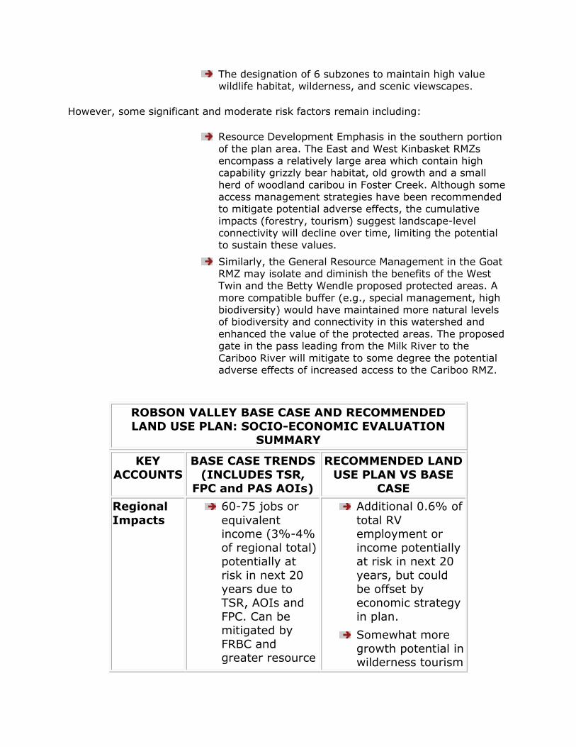
The designation of 6 subzones to maintain high value wildlife habitat, wilderness, and scenic viewscapes.
However, some significant and moderate risk factors remain including:
Resource Development Emphasis in the southern portion
of the plan area. The East and West Kinbasket RMZs encompass a relatively large area which contain high capability grizzly bear habitat, old growth and a small
herd of woodland caribou in Foster Creek. Although some access management strategies have been recommended to mitigate potential adverse effects, the cumulative
impacts (forestry, tourism) suggest landscape-level connectivity will decline over time, limiting the potential to sustain these values.
Similarly, the General Resource Management in the Goat RMZ may isolate and diminish the benefits of the West Twin and the Betty Wendle proposed protected areas. A
more compatible buffer (e.g., special management, high biodiversity) would have maintained more natural levels of biodiversity and connectivity in this watershed and
enhanced the value of the protected areas. The proposed gate in the pass leading from the Milk River to the
Cariboo River will mitigate to some degree the potential adverse effects of increased access to the Cariboo RMZ.
ROBSON VALLEY BASE CASE AND RECOMMENDED
LAND USE PLAN: SOCIO-ECONOMIC EVALUATION SUMMARY
KEY
ACCOUNTS
BASE CASE TRENDS
(INCLUDES TSR, FPC and PAS AOIs)
RECOMMENDED LAND
USE PLAN VS BASE CASE
Regional
Impacts
60-75 jobs or
equivalent income (3%-4%
of regional total) potentially at
risk in next 20
years due to TSR, AOIs and
FPC. Can be mitigated by
FRBC and greater resource
Additional 0.6% of
total RV employment or
income potentially at risk in next 20
years, but could
be offset by economic strategy
in plan.
Somewhat more
growth potential in wilderness tourism

utilization.
Slow economic and population
growth in longer term, driven by
tourism, in-migration,
retirement incomes and
import substitution.
Gradual increase % of
employment in service
industries.
and other nature-
based economic activity.
Slightly less long term growth
potential in mining, agriculture
and intensive tourism activities.
Economic Strategy coordinating
FRBC/MOF measures with
community economic
development
initiatives could more than offset
incremental impacts of Plan.
Otherwise, similar to Base Case.
ROBSON VALLEY BASE CASE AND RECOMMENDED
LAND USE PLAN: SOCIO-ECONOMIC EVALUATION SUMMARY (cont’d)
SECTORAL IMPACTS
Agriculture No existing
jobs impacted, but expansion
of grazing is precluded on
1,800 ha ALR
land in West Twin AOI,
most of which is forested.
Slow / no growth in dairy
and beef due to market and
Crown range
No job impacts but
precludes grazing expansion in West
Twin PA and Morkill drainage. Grazing in
other areas
permitted subject to management
objectives.
Recommendations to
identify other grazing opportunities
in unallocated Crown lands and new
logging areas should

limits. accommodate future
growth.
Community Stability
Population out-migration in
the next 20 years unlikely,
particularly if FRBC/resource
utilization
measures taken into
account.
In longer term,
mill closure could disrupt
community, unless
alternative wood supplies
can be secured.
Slow population
growth likely
as result of in-migration and
growth in other sources
of basic income.
Coordinated Economic Strategy
could offset disruptive impacts of
mill closure and diversify local
economy.
Short and longer term population
stability and trends similar to Base Case.
First
Nations Concerns
Participation in
resource management,
economic development
and protection of traditional
activities of the
SNTC, Lheidli T‟enneh and
Canim and
The LRMP will form
basis of Government‟s
position in treaty negotiations.
Although LRMP will not prejudice
outcome of
negotiations, greater protection of
environmental
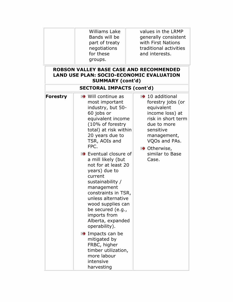
Williams Lake
Bands will be part of treaty
negotiations for these
groups.
values in the LRMP
generally consistent with First Nations
traditional activities and interests.
ROBSON VALLEY BASE CASE AND RECOMMENDED LAND USE PLAN: SOCIO-ECONOMIC EVALUATION
SUMMARY (cont’d)
SECTORAL IMPACTS (cont’d)
Forestry Will continue as most important
industry, but 50-60 jobs or
equivalent income (10% of forestry
total) at risk within
20 years due to TSR, AOIs and
FPC.
Eventual closure of
a mill likely (but not for at least 20
years) due to current
sustainability / management
constraints in TSR, unless alternative
wood supplies can be secured (e.g.,
imports from
Alberta, expanded operability).
Impacts can be mitigated by
FRBC, higher timber utilization,
more labour intensive
harvesting
10 additional forestry jobs (or
equivalent income loss) at
risk in short term due to more
sensitive
management, VQOs and PAs.
Otherwise, similar to Base
Case.

required by FPC.
Guiding/
Trapping/
Wildcraft
Continued decline
in guiding / trapping. Some
wildcraft opportunities will
be foregone unless these values
explicitly
recognized in management.
Greater
protection of key guiding and
trapping species (e.g., grizzly and
marten). Somewhat
greater
recognition of wildcraft values
in management.
Mining / Energy
No planned developments are
expected/ would be precluded by
AOIs.
1.5% of high
industrial mineral potential and 4
sand and gravel tenures may be
precluded by AOIs.
1 out of 14 very high / good small
hydro sites and 4 out of 100 viable
sites precluded by AOIs. Hydro / oil
and gas corridor may be precluded
or relocated to more costly route.
No existing job impact, but
Forgetmenot gypsum deposit
(20 jobs) in a Low Intensity
RMZ which could increase cost of
potential development.
Increase of high
industrial mineral potential in
sensitive management
areas may result in marginally
higher development and
operating costs.
Sand and gravel
/ energy corridor are
recommended as acceptable uses
in the West Twin
PA subject to management
objectives.
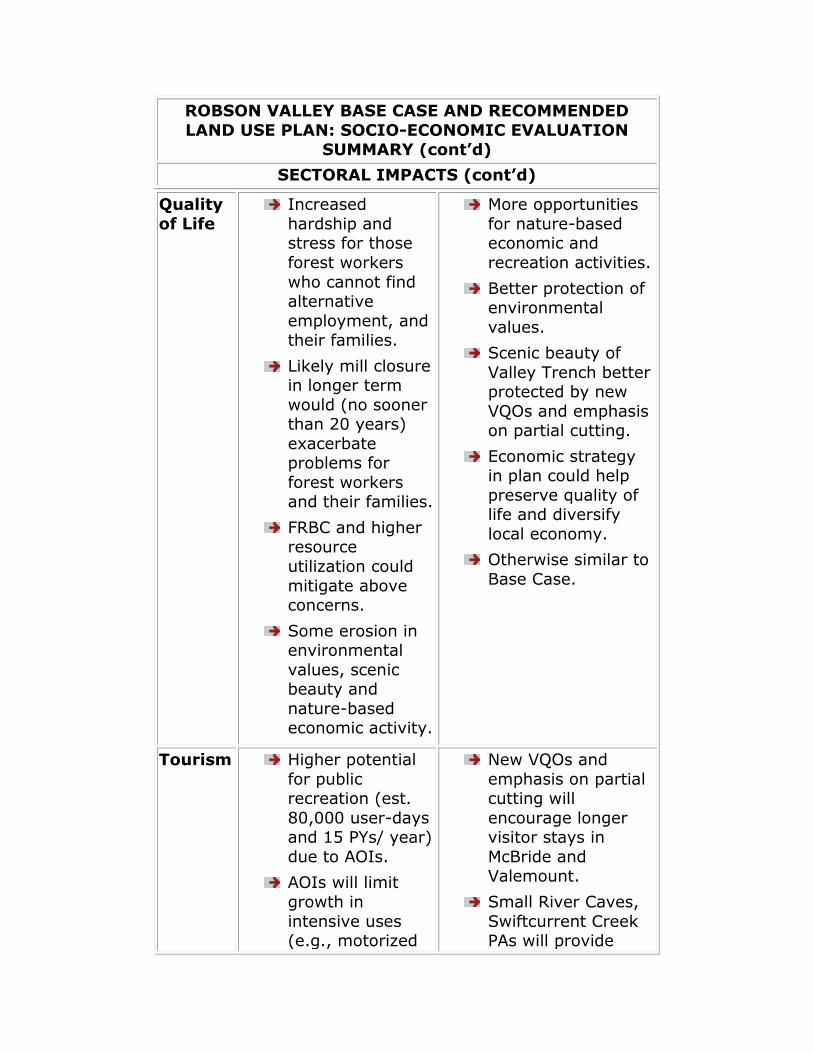
ROBSON VALLEY BASE CASE AND RECOMMENDED
LAND USE PLAN: SOCIO-ECONOMIC EVALUATION SUMMARY (cont’d)
SECTORAL IMPACTS (cont’d)
Quality
of Life
Increased
hardship and stress for those
forest workers
who cannot find alternative
employment, and their families.
Likely mill closure in longer term
would (no sooner than 20 years)
exacerbate problems for
forest workers and their families.
FRBC and higher resource
utilization could
mitigate above concerns.
Some erosion in environmental
values, scenic beauty and
nature-based economic activity.
More opportunities
for nature-based economic and
recreation activities.
Better protection of environmental
values.
Scenic beauty of
Valley Trench better protected by new
VQOs and emphasis on partial cutting.
Economic strategy in plan could help
preserve quality of life and diversify
local economy.
Otherwise similar to
Base Case.
Tourism Higher potential
for public recreation (est.
80,000 user-days and 15 PYs/ year)
due to AOIs.
AOIs will limit
growth in
intensive uses (e.g., motorized
New VQOs and
emphasis on partial cutting will
encourage longer visitor stays in
McBride and Valemount.
Small River Caves,
Swiftcurrent Creek PAs will provide
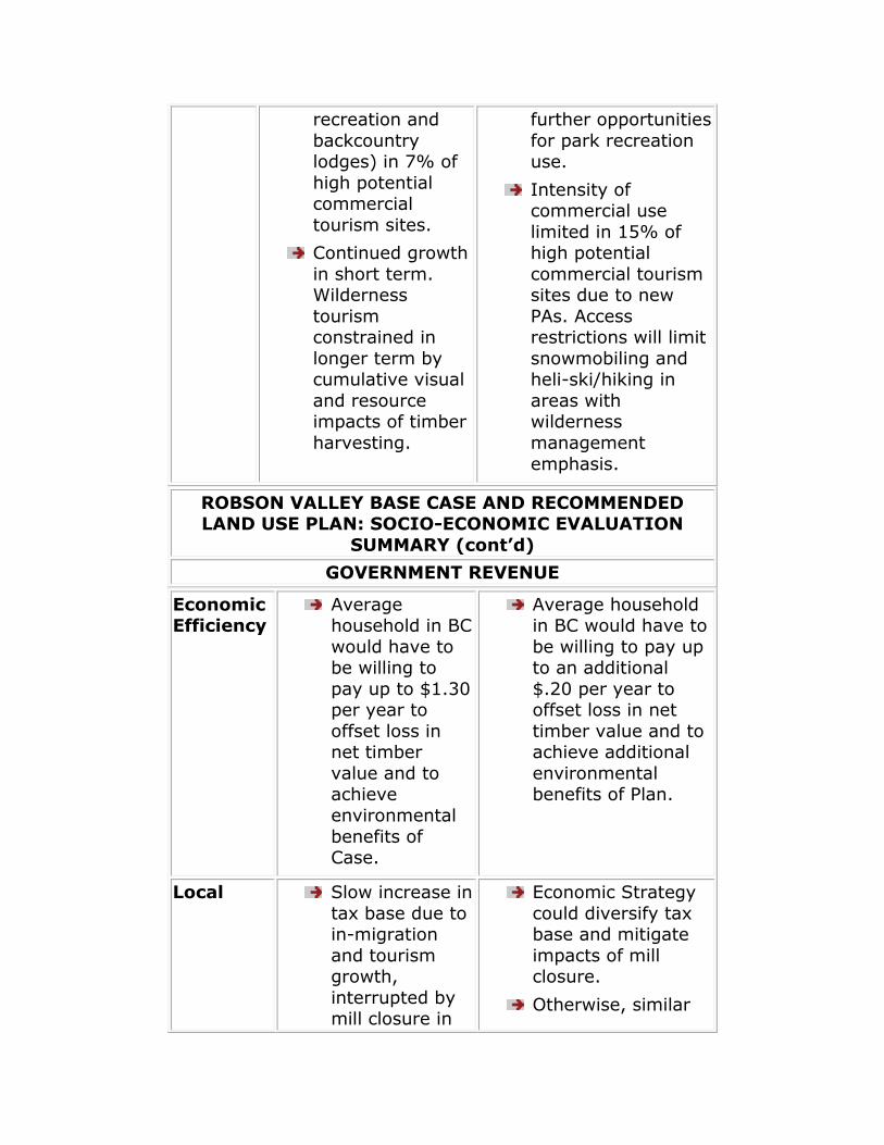
recreation and
backcountry lodges) in 7% of
high potential commercial
tourism sites.
Continued growth
in short term. Wilderness
tourism constrained in
longer term by cumulative visual
and resource impacts of timber
harvesting.
further opportunities
for park recreation use.
Intensity of commercial use
limited in 15% of high potential
commercial tourism sites due to new
PAs. Access restrictions will limit
snowmobiling and heli-ski/hiking in
areas with wilderness
management
emphasis.
ROBSON VALLEY BASE CASE AND RECOMMENDED LAND USE PLAN: SOCIO-ECONOMIC EVALUATION
SUMMARY (cont’d)
GOVERNMENT REVENUE
Economic Efficiency
Average household in BC
would have to be willing to
pay up to $1.30 per year to
offset loss in net timber
value and to achieve
environmental
benefits of Case.
Average household in BC would have to
be willing to pay up to an additional
$.20 per year to offset loss in net
timber value and to achieve additional
environmental benefits of Plan.
Local Slow increase in
tax base due to in-migration
and tourism growth,
interrupted by mill closure in
Economic Strategy
could diversify tax base and mitigate
impacts of mill closure.
Otherwise, similar
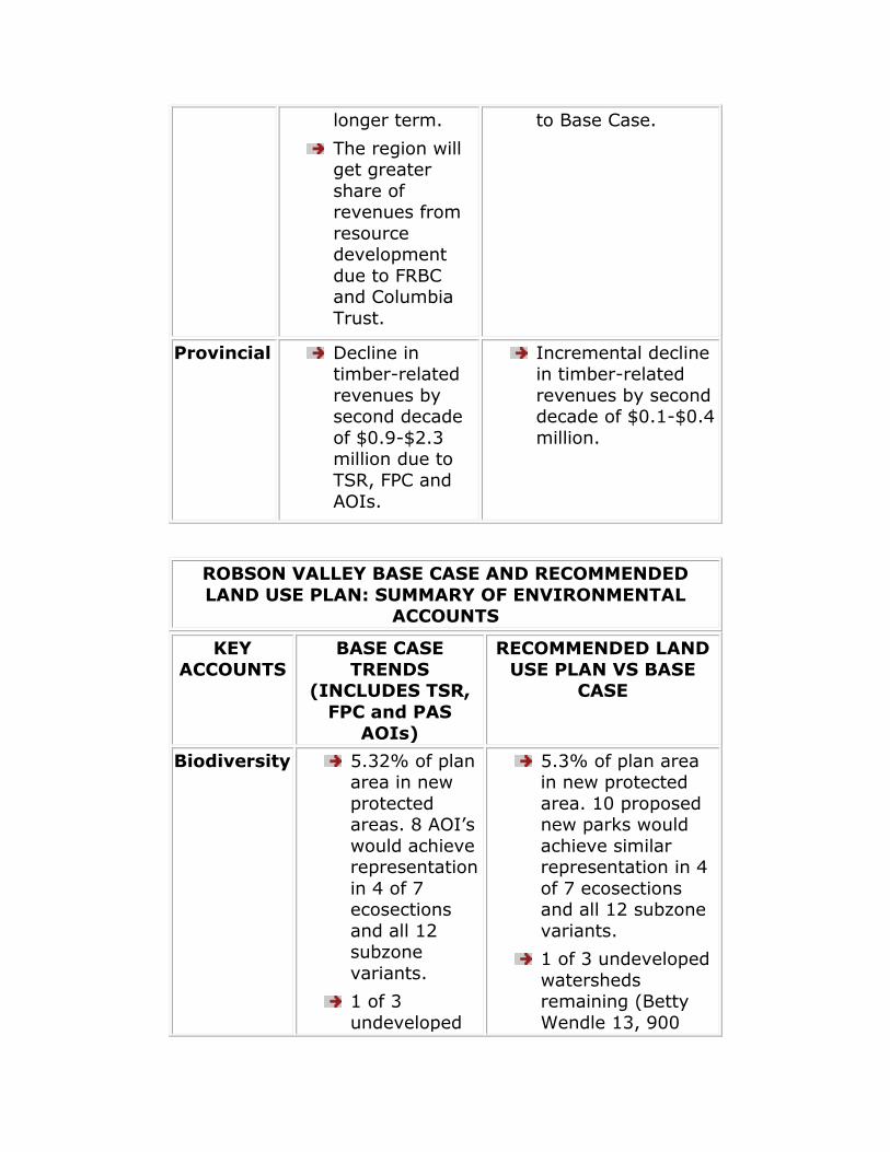
longer term.
The region will get greater
share of revenues from
resource development
due to FRBC and Columbia
Trust.
to Base Case.
Provincial Decline in timber-related
revenues by second decade
of $0.9-$2.3 million due to
TSR, FPC and
AOIs.
Incremental decline in timber-related
revenues by second decade of $0.1-$0.4
million.
ROBSON VALLEY BASE CASE AND RECOMMENDED
LAND USE PLAN: SUMMARY OF ENVIRONMENTAL ACCOUNTS
KEY
ACCOUNTS
BASE CASE
TRENDS (INCLUDES TSR,
FPC and PAS
AOIs)
RECOMMENDED LAND
USE PLAN VS BASE CASE
Biodiversity 5.32% of plan area in new
protected areas. 8 AOI‟s
would achieve representation
in 4 of 7 ecosections
and all 12 subzone
variants.
1 of 3
undeveloped
5.3% of plan area in new protected
area. 10 proposed new parks would
achieve similar representation in 4
of 7 ecosections and all 12 subzone
variants.
1 of 3 undeveloped
watersheds remaining (Betty
Wendle 13, 900
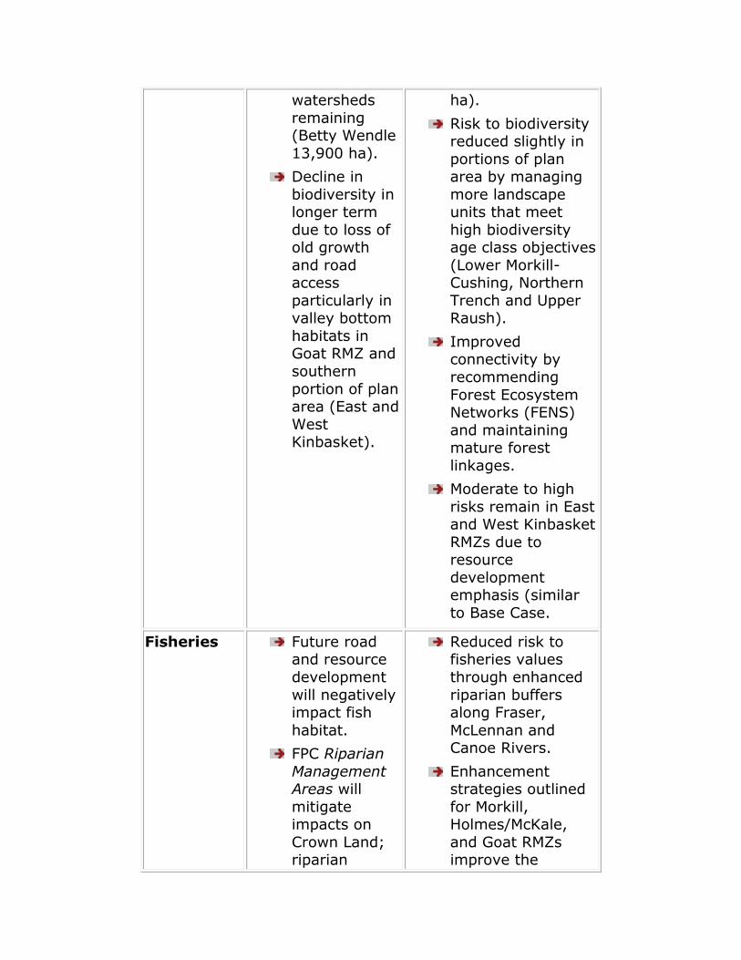
watersheds
remaining (Betty Wendle
13,900 ha).
Decline in
biodiversity in longer term
due to loss of old growth
and road access
particularly in valley bottom
habitats in Goat RMZ and
southern
portion of plan area (East and
West Kinbasket).
ha).
Risk to biodiversity reduced slightly in
portions of plan area by managing
more landscape units that meet
high biodiversity age class objectives
(Lower Morkill-Cushing, Northern
Trench and Upper Raush).
Improved connectivity by
recommending
Forest Ecosystem Networks (FENS)
and maintaining mature forest
linkages.
Moderate to high
risks remain in East and West Kinbasket
RMZs due to resource
development emphasis (similar
to Base Case.
Fisheries Future road and resource
development
will negatively impact fish
habitat.
FPC Riparian
Management Areas will
mitigate impacts on
Crown Land; riparian
Reduced risk to fisheries values
through enhanced
riparian buffers along Fraser,
McLennan and Canoe Rivers.
Enhancement strategies outlined
for Morkill, Holmes/McKale,
and Goat RMZs improve the
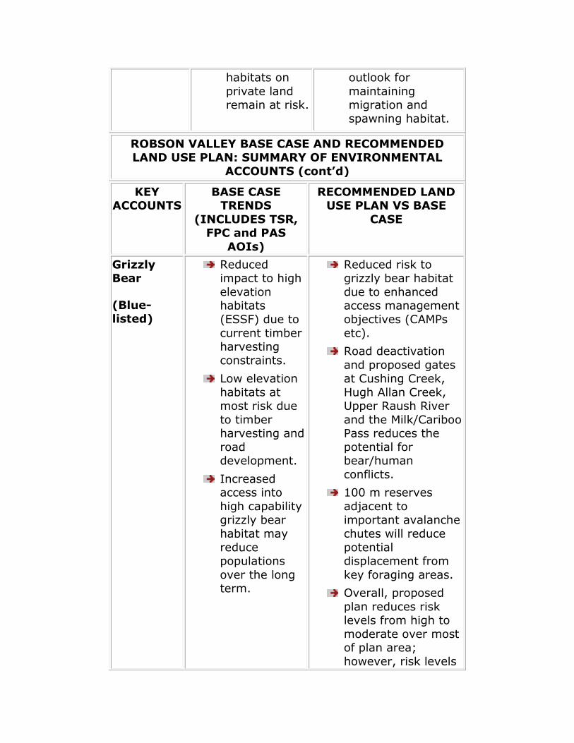
habitats on
private land remain at risk.
outlook for
maintaining migration and
spawning habitat.
ROBSON VALLEY BASE CASE AND RECOMMENDED LAND USE PLAN: SUMMARY OF ENVIRONMENTAL
ACCOUNTS (cont’d)
KEY ACCOUNTS
BASE CASE TRENDS
(INCLUDES TSR, FPC and PAS
AOIs)
RECOMMENDED LAND USE PLAN VS BASE
CASE
Grizzly Bear
(Blue-listed)
Reduced impact to high
elevation habitats
(ESSF) due to
current timber harvesting
constraints.
Low elevation
habitats at most risk due
to timber harvesting and
road development.
Increased access into
high capability grizzly bear
habitat may
reduce populations
over the long term.
Reduced risk to grizzly bear habitat
due to enhanced access management
objectives (CAMPs
etc).
Road deactivation
and proposed gates at Cushing Creek,
Hugh Allan Creek, Upper Raush River
and the Milk/Cariboo Pass reduces the
potential for bear/human
conflicts.
100 m reserves
adjacent to important avalanche
chutes will reduce
potential displacement from
key foraging areas.
Overall, proposed
plan reduces risk levels from high to
moderate over most of plan area;
however, risk levels

remain high over
portions of East and West Kinbasket
RMZs.
Mountain Goat
Majority (>90%) of
high capability goat habitat in
forest and non-forest
exclusions.
Proposed
Holliday Arch AOI too small
(400 ha) to significantly
benefit goat
population(s).
LEH and no
hunting zones will likely
maintain current
population levels.
Enhanced protection for key mountain
goat habitat due to special management
designation of the Boundary/Horsey
Creek RMZ.
Management
strategies proposed for Zone E including
Holliday/Baker Creek Subzone
reduces risks
associated with access and
disturbance and enhances protection
surrounding Holliday Arch AOI.
Population(s) anticipated to
remain stable in short and long term.
ROBSON VALLEY BASE CASE AND RECOMMENDED
LAND USE PLAN: SUMMARY OF ENVIRONMENTAL ACCOUNTS (cont’d)
KEY
ACCOUNTS
BASE CASE
TRENDS
(INCLUDES TSR, FPC and PAS
AOIs)
RECOMMENDED LAND
USE PLAN VS BASE
CASE
Old Growth
Dependent Species
Retention of mature and
old growth forests in
higher elevations will
Risk to macro-lichen forests reduced
slightly due to proposed
management strategy to identify

provide
adequate habitat for
some species.
Amount of
suitable habitat for
forest interior species (e.g.,
marten) expected to
decline over time,
especially in Resource
Development
RMZs.
Old growth
dependent plants (e.g.,
macro-lichens) and
animal species that
live in valley bottom ICH
and SBS habitats at
risk.
and conserve
representative areas of high lichen
diversity.
A greater proportion
of old growth will be maintained due high
biodiversity emphasis landscape
units.
Otherwise, similar to
Base Case.
Riparian Habitat
and
Species
A positive trend for
small red and
blue-listed species
(primarily waterfowl and
wading birds) anticipated
with implementatio
n of FPC Riparian
Enhanced protection (wider reserve
zones) of riparian
habitats along portions of the
Fraser River, McLennan River,
Canoe Rivers and the wetlands near the
lower Raush.
Otherwise similar to
Base Case.

Management
Areas on Crown Land.
Ungulate
Winter Range
Mature forest
cover required
during severe winters will be
limiting.
FPC Riparian
Management Areas and
Wildlife Habitat Areas
may partly mitigate loss
of mature
forest cover in key habitat
types.
Ungulate
populations likely to
remain stable in short term,
but may decline over
long term.
Enhanced protection
of ungulate winter range through
management strategies proposed
in Settlement/Agricultu
re and Rocky Mountain Trench
RMZs.
Vegetation
management strategies proposed
to maintain quality
and quantity of winter range will
likely result in stable population levels in
short and long term.
ROBSON VALLEY BASE CASE AND RECOMMENDED LAND USE PLAN: SUMMARY OF ENVIRONMENTAL
ACCOUNTS (cont’d)
KEY
ACCOUNTS
BASE CASE TRENDS
(INCLUDES TSR, FPC and PAS AOIs)
RECOMMENDED
LAND USE PLAN VS BASE CASE
Visual
Quality Objectives
Scenic quality of
viewscapes expected to be
maintained through VQO
retention and partial retention
VQOs enhanced
through proposed partial-cutting
regimes along trench.
However, partial-
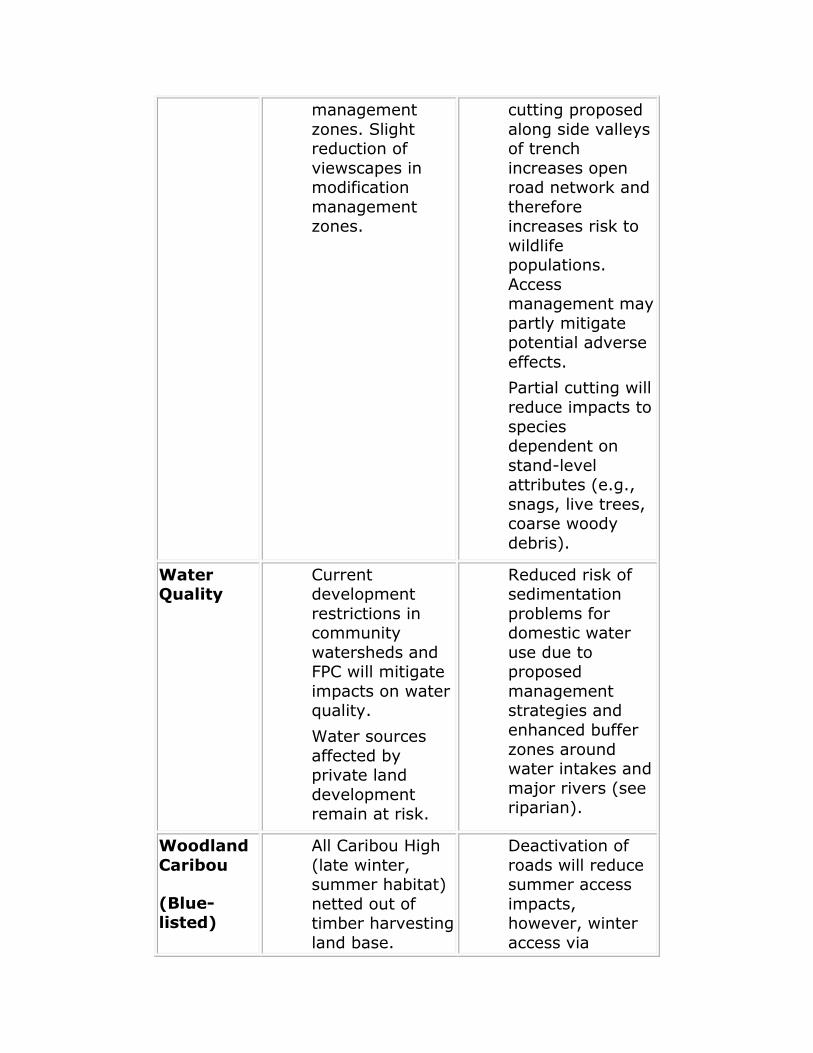
management
zones. Slight reduction of
viewscapes in modification
management zones.
cutting proposed
along side valleys of trench
increases open road network and
therefore increases risk to
wildlife populations.
Access management may
partly mitigate potential adverse
effects.
Partial cutting will
reduce impacts to
species dependent on
stand-level attributes (e.g.,
snags, live trees, coarse woody
debris).
Water Quality
Current development
restrictions in community
watersheds and FPC will mitigate
impacts on water quality.
Water sources
affected by private land
development remain at risk.
Reduced risk of sedimentation
problems for domestic water
use due to proposed
management strategies and
enhanced buffer
zones around water intakes and
major rivers (see riparian).
Woodland
Caribou
(Blue-listed)
All Caribou High
(late winter, summer habitat)
netted out of timber harvesting
land base.
Deactivation of
roads will reduce summer access
impacts, however, winter
access via

Caribou Medium
and Corridor managed for
arboreal lichen production
(TSR).
Some early
winter habitat remains at risk in
mid-slope ESSF and valley
bottom ICH.
Population(s)
likely to remain stable in short
term, however,
increased risks from road access
(summer and winter) and
predation may reduce
population(s) in long term.
snowmobiles
remain a moderate risk
factor. Proposed coordinated
access management may
mitigate potential adverse effects
(i.e. harassment, displacement).
Majority of key caribou areas
either protected or specially
managed.
Population(s) likely to remain
stable in short term; however,
benefits of caribou
management areas and
proposed protected areas
diminished by surrounding
Resource Development
Emphasis in West
Kinbasket RMZ and General
(Multi-Value) Resource
Management in the Goat RMZ.
Robson Valley LRMP Social, Economic and Environmental Impact Assessment
(1) "Robson Valley LRMP Socio-Economic and Environmental Assessment of Proposed Land Use Scenarios", G. Holman and E. Terry in cooperation with Robson Valley LRMP Resource Support Team, January, 1996.
(2) The current harvest level in the Robson is estimated at about 585,000 m3, but over the 1990-95 period, harvest levels have averaged less than 500,000 m3, in part due to
lower wood product prices.
(3) Based on an estimated increase of about 80,000 user-days annually and average daily expenditures of $17 (Source: BC Parks), and assumed wage and salary content of 30% and average wage of $25,000.
(4) There are currently no operating mines in the Robson Valley. No exploration
expenditures were recorded in 1994, although exploration has been more active in previous years.
(5) MEMPR data for BC indicates the probability of a mineral showing becoming a producing mine is low.
(6) The resource inventory identified about 100 potentially viable small hydro sites, 14
good sites and 5 very good sites. Very small scale, "micro" hydro developments (e.g., for a backcountry lodge) that do not require storage dams may be allowed subject to management objectives for the protected area.
(7) The biodiversity guidelines in the FPC could indirectly protect fisheries habitat by
affecting old seral stage retention in riparian and upland areas.
(8) Spawning habitat is more sensitive to resource development activities than migration habitat.
4.0 ECONOMIC STRATEGY
4.1 INTRODUCTION AND SUMMARY
An economic strategy should be a key component of a crown land use plan. The forestry sector is the main focus of this strategy for the Robson Valley LRMP since the most significant potential economic implications identified in the socio-economic
assessment are with respect to this sector. The primary goals of the economic strategy are to expand economic opportunities and to mitigate potential impacts of the decline of timber supply (as identified in the 1994 Timber Supply Review, Forest Practices Code
(FPC), Protected Areas Strategy (PAS), and the Robson Valley LRMP on workers and communities in the Valley.
While the economic strategy tends to be primarily forestry-related, it can also make an important contribution to economic goals that have been agreed to by the Robson
Valley Round Table, including economic diversity, sustainability, more local processing of resources (particularly "value added" processing), and resource enhancement. The economic strategy, including the key recommendations listed below, were approved
April 30, 1999, recognizing that both ministry and FRBC funds have become increasingly restricted since these recommendations were formulated:

adopt "no net job loss" and the pursuit of jobs paying comparable wages to those of the traditional forest sector
as the main objectives of the economic strategy
commitments for appropriate funding and support of an economic strategy should be in place before the LRMP is
implemented (e.g., annual funding contribution from FRBC)
appropriate mitigation measures should be timed so that
their effects coincide with any employment losses due to variations in forest industry activity
the economic strategy for the LRMP should be formally
linked with FRBC and integrated with ongoing initiatives (e.g., Valemount and McBride Economic Development Strategies, Columbia Basin Trust Fund) to maximize
effectiveness and minimize duplication of effort
a Technical Committee comprised of interested Valley residents, and key agencies such as Ministry of Forests
(MOF) and Forest Renewal BC (FRBC) could meet regularly (e.g., every 3 months) to identify appropriate projects, possibly reporting to a broader Valley-wide
economic development committee
4.2 POTENTIAL OPPORTUNITIES
4.2.1 Forestry
A large number of forest-related employment opportunities have been suggested in the Robson Valley LRMP Socioeconomic and Environmental Assessment of
Proposed Land Use Scenarios (January 1996), economic development strategies for McBride and Valemount, the Columbia River Treaty Valemount Report, and in discussions with LRMP stakeholders and government agency staff.
It should be noted that the January 1996 Assessment indicated that reduction of unsalvaged losses, greater use of underutilized timber,(1) and selection harvesting could
potentially generate about 30 jobs annually and that proposed FRBC-funded watershed restoration and intensive silviculture projects could generate up to another 40 jobs annually for a four-year period; additional projects could also likely be developed.
These initiatives could generate roughly the same number of jobs as the cumulative job impacts of the Base Case and the Plan over the next 20 years.
4.2.1.1 Measures to Augment Short-term Timber Supply
Utilization of inoperable/problem forest types; the Timber Supply Review identified approximately 43,000 ha of these forest types, although only a portion would be suitable for local sawmills, and netdowns would have to
be applied to address environmental values
Related to the above, review of operability in the TSA to determine if additional timber volumes are available,
possibly in conjunction with the next TSR
Reduction of unsalvaged losses due to fire, blowdown, disease, and insect damage, while still maintaining
biodiversity values at the stand level as per the FPC (e.g., coarse woody debris, snags, etc.); these losses are estimated at about 50,000 m3/yr, although only a portion
of losses could be feasibly prevented
MOF estimates that an annual harvest of about 6,000 m3 of birch and aspen could be sustained in the Robson
Valley; these volumes could support higher value-added uses such as flooring
Address Chief Forester's requirements in the last Robson
Valley TSA AAC decision (e.g., higher utilization of cedar-hemlock leading stands), within constraints imposed by management for old-growth/antique forests and subject
to the final outcome of the LRMP
Identify volumes and undertake commercial thinning in appropriate stands, particularly those regenerated from
fires in the early 1900's
Apply for a small forest licence in that portion of the
Prince George Forest District more accessible to the Robson (e.g., 10 year, 1 million m3 licence in looper kill being advertised now in the PGFD) or request TSA
boundary adjustment
Identify and encourage ecosystem rehabilitation (e.g., West Twin drainage)
Encourage more small business and woodlot sales to local contractors
4.2.1.2 Other Short-term Forestry Employment Initiatives
FRBC-funded watershed restoration and intensive silviculture (e.g., pruning, brushing, weeding, etc.) that would be both seasonal and on-going in nature (MOF and
the major licencees in the Valley have submitted a number of funding proposals to FRBC)
More labour-intensive selection harvesting in VQOs and in
low intensity RMZs
Encourage measures for local hiring of forest workers
4.2.1.3 Forest Sector Research and Other Longer-term Forestry
Initiatives
Feasibility/opportunities study for value-added wood processing (2) and evaluation of existing milling facilities

to assess capability for higher value manufacturing (e.g., utility of veneer dryer, dry kiln) from the anticipated
timber supply profile
Feasibility/marketing study for wood-waste utilization (particularly hog fuel currently burned in teepee burners)
and related value-added opportunities (e.g., wood pellet plant)
Disseminate information on FRBC-sponsored loans for
forestry businesses (e.g., value-added processors and logging contractors wishing to purchase equipment for selection harvesting) and encourage FRBC to make
appropriate arrangements for the provision of such loans to qualified Valley businesses (3)
Caribou research (e.g., review Caribou high habitat zones for harvesting opportunities and monitor selection
harvesting experience in Caribou medium areas)
Training, planning, GIS modeling in preparation for alternative/selection harvesting, hardwood management;
establish training centre
Review stumpage appraisal system to assess if revisions are possible to better reflect higher costs of more
sensitive harvesting methods such as selection and helicopter logging (could also be financed by FRBC-funded financial/technical assistance to contractors)
Potential forestry opportunities identified in the McBride Economic Development Strategy: establishment of a log sort yard; better linkage between Robson Valley
Wood Processors Association and Small Business Forest Enterprise Program to encourage local value-added processing; training, information and technology
programs to improve efficiencies: utilization of non-conventional timber and wood waste; establishment of cooperative marketing structures
Environmental certification of wood product shipments from the Robson Valley
Support efforts of Robson Valley Wood Processors Association (e.g., cooperative marketing, joint 16.1 award, log sort yard, improving wood utilization, etc.)
Re-inventory of timber supplies in the TSA to determine accuracy of volume information, possibly in tandem with information requirements for the next TSR
Encourage private land owners to cultivate commercial timber and provide silviculture training for such individuals
Encourage local processing of timber harvested in Robson Valley
Investigate feasibility of importing more timber from other areas
4.2.2 OTHER SECTORS
4.2.2.1 Tourism/Recreation
Trail building and maintenance, park infrastructure, signage, etc.(4)
Inventory of outdoor recreation attractions, strategy for additional attractions (e.g., Bell Mountain), and appropriate signage and interpretation
Development of management plans for new protected areas (e.g., West Twin) and other RMZs identified as having higher recreation use potential
Tourism/recreation opportunities identified in McBride Economic Development Strategy: e.g., develop
backcountry/ecotourism opportunities and facilities; facilitate sales of local arts and crafts
Tourism/Recreation development possibilities identified in
Valemount Economic Development Strategy: e.g., Kinbasket Lake hotsprings; community ski hill; development of multi-use trail system and adventure
packages; etc.
4.2.2.2 Agriculture/Wildcraft
Identification of alternative grazing opportunities, particularly on Crown land adjacent to existing operations, to accommodate future growth in the cattle and dairy industries
Market under-utilized cattle and dairy farm products from the Robson Valley to other parts of BC and western Canada
Initiate "buy Robson Valley" program for products
Recognition of botanical forest products in timber management plans and appropriate regulations to
preserve and realize their commercial potential
4.2.2.3 Mining
Review no-staking mineral reserves and remove when no longer required
Identification of unrealized gemstone and industrial mineral potential through government funded geoscience
studies
Provide opportunities for prospector training and assistance through grant programs

Promote the area to encourage investors to re-examine the potential for minerals (e.g., mica) for use in the
building products, paint, and plastics industries
4.2.2.4 Other Initiatives
Expand education and training opportunities (e.g., establishment of community learning centre, learning coordinator/programmer, distance education capabilities, sharing of computer/telecommunications equipment,
Internet access, etc.)
Enhance the Valley's desirability as a place to live and visit (e.g., downtown revitalization, new recreation
centre, etc.)
4.2.2.5 Columbia River Treaty Committee Valemount Report
A report by the Kinbasket Research and Economic Development Committee to the Columbia River Treaty Committee on the impacts of the operation of the Kinbasket Reservoir and possible compensation/mitigation initiatives identified a number of opportunities, including:
Establishment of trust fund(s) to serve as a source of
long term investment in the area
Completion of Kinbasket Reservoir rehabilitation (e.g., reservoir clean-up, restock fish populations, etc.)
Compensate for lost valley bottom habitat by protection of other areas (e.g., Starratt Wildlife Sanctuary, acquisition of key private lands, etc.)
Develop recreation and tourism potential of the Reservoir (e.g., recreation and camping sites, Canoe Valley Trail System, Canoe Mountain as a tourist attraction, etc.)
Develop alternative energy sources (e.g., small hydro, wind power)
Various economic development initiatives for Valemount
(e.g., availability of natural gas, tourism and business improvement centres, forestry/fisheries research centre, university satellite campus, etc.)
4.3 RESPONSIBILITY FOR IMPLEMENTATION
One possibility is that a representative Technical Committee comprised of interested
Valley residents plus staff from appropriate agencies such as Forest Renewal BC and Ministry of Forests could be designated as the body to recommend appropriate projects/initiatives. This group could report to a larger, Valley-wide economic
development association, with the latter having responsibility for implementation of the overall strategy. This larger association could also ensure that the strategy would be coordinated with other community or regional economic development initiatives.(5) A

potentially complementary approach would be to nominate interested community members to sit on a regional body (e.g., as part of a wider Omineca-Peace FRBC
“Regional Advisory Group” currently being organized) that would provide direct representation to FRBC regarding potential initiatives.
It has also been suggested that the IWA and other forest workers, possibly in conjunction with the licencees, create some form of "arm's-length" company or society
to ensure that the priority for new jobs created using FRBC funds is given to forest workers in the Valley whose traditional jobs may be at risk.(6)
4.4 RESPONSIBILITY FOR FUNDING
The key funding source for the LRMP economic strategy should be FRBC, because the most significant potential economic impacts arising out of the Base Case and recommended LRMP Plan are forestry-related. Therefore, it is particularly important
that the LRMP economic strategy be formally linked with FRBC. Most of the forestry initiatives summarized above, and a number of related initiatives (e.g., trail building and other recreation development) are consistent with FRBC funding criteria.(7)
FRBC is willing to play a more formal, on-going role in the LRMP economic strategy (e.g., to sit on a Technical Committee and consider means of providing on-going
funding support) rather than simply responding to proposals on an ad hoc basis. LRMP consensus on the elements of an economic strategy would increase the likelihood that a more formal, on-going relationship with FRBC could be established.
4.5 TIMING OF EVENTS
While there was not agreement among LRMP members regarding the most appropriate
timing of harvest flows, one of the key conclusions contained in the January 1996 socioeconomic assessment is that according to the timber supply analyses undertaken by MOF for the LRMP, harvest impacts associated with the TSR, FPC, PAS and the Robson Valley Land Use Plan can be deferred for about 10 years.(8) The analysis also
indicates that impacts in the second decade would be about 80,000 m3/year (or 14% of current AAC), and even this potential impact could be offset by the incremental timber volumes discussed in this report. This would allow time for workers, forest companies
and communities to adjust to harvest changes, for alternative timber supply and employment opportunities to be identified, and for growth factors in other sectors of the economy to take effect (e.g., tourism).(9)
The timing of harvest reductions due to TSR, PAS, FPC and the recommended LRMP remain, however, to be determined by the Chief Forester. If as expected, harvest
changes are phased in, some key initiatives could be planned in advance and timed to coincide with the socioeconomic implications. Training (via Forest Worker Employment and Training Program, administered by the Ministry of Education, Skills and Training)
could occur during the delay to maximize local hiring potential for FRBC-funded programs. However, it may not be appropriate to delay some FRBC initiatives for environmental reasons or other reasons.
To address concerns that delays would mean sacrificing projects, an annual allocation of FRBC funds to a "Robson Valley Forest Renewal Endowment Fund" is suggested, based
on stumpage generated and relative significance of impacts in the region. This Fund could then be a source for longer term financing of initiatives. Withdrawals from the Fund could be increased when most needed. Such an approach would require FRBC to develop appropriate policies and administrative mechanisms.(10)
4.6 ALTERNATIVE STRATEGIES
It is recognized in the introduction that an explicit goal of this strategy is "no net job
loss" and it is expected that those involved in implementation will work toward this goal. If, however, some reductions in traditional harvesting and/or processing jobs do occur (even if they are offset by creation of other forms of forest sector employment),
there are ways to minimize the economic and lifestyle implications that such adjustments can otherwise entail.
For example, a potentially important strategy made possible by the phasing in of harvest reductions could be the achievement of employment adjustments through
planned attrition and/or early retirement. Therefore, forest companies could reduce their work force over time prior to harvest reductions through these voluntary adjustments rather than laying off workers at the time of harvest reductions.(11) The
attrition rate could be increased by offering pension bridging and skills/business training
to forest workers.
Another adjustment strategy could be for local forest companies to achieve labour cost reductions through periodic shutdowns. In effect, the adjustment to harvest reductions could take the form of lower average forestry incomes due to longer periods of
unemployment for forestry workers. Workers could also supplement their remaining forestry income with part-time employment in FRBC-funded initiatives, income support and training programs, or other endeavours.
The advantages of such adjustment strategies is that they could be less disruptive to
employees who might otherwise by displaced, and to the families and communities that depend on the incomes of these workers.(12) They could also be less costly to
implement. Such measures could also complement FRBC and other employment creation initiatives and be designed to maintain year-round employment for younger
workers still supporting families.
However, while attrition/early retirement would mitigate impacts on employees and their families, there could still be an impact on the regional economy to the extent that these workers took other jobs or retired outside the region. Also, while periodic closures
effectively distribute available employment among all employees, a marginal income reduction is also shared by the entire workforce, in the absence of supplementary income from agencies such as FRBC.
4.7 CONCLUSIONS
The economic strategy has focused on five main themes:
1. finding alternative fibre supplies for at least the short term;
2. identifying possible employment opportunities for forest workers;
3. suggesting initiatives for FRBC funding;
4. pointing out areas that require further thought, research, and planning; and
5. listing ideas for longer term economic diversification.
The strategy has also had input from some LRMP members, the Ministry of Forests, the Ministry of Small Business, Tourism and Culture, and FRBC. FRBC has indicated that it wishes to become more involved in the Robson Valley, and an FRBC facilitator for the Robson Valley is now in place such that direct assistance for the development of
appropriate proposals is available.
However, only with the benefit of active participation by those with the most at stake in the outcome can the key elements of this or any economic development strategy be successfully implemented. Therefore the technical expertise and local knowledge of
Valley residents are necessary to achieve the desired results.
Finally, it should be reiterated that virtually all of the anticipated impacts on timber supply discussed above will occur even without a LRMP, due to the Timber Supply Review, Forest Practices Code, and Protected Areas Strategy. However, the economic
strategy, with the necessary implementation efforts provided by a designated group of Valley residents and appropriate government agencies, has the potential to more than
offset the implications of all these initiatives for at least the next 20-30 years.
Robson Valley LRMP Economic Strategy
(1) The historical under-utilization of the Robson Valley AAC could have positive implications for short term timber supply and employment. This is because harvest levels have averaged under 500,000 m3/year for the 1990-95 period, well under the
AAC of 600,000 m3/year. Since the socioeconomic assessment used 600,000 m3/year as the “starting point,” the impacts may be over-estimated. And while the most recent annual harvest estimate is 585,000 m3/year, this may have been due to temporarily
high markets.
(2) If 5% more of the existing TSA harvest could be diverted to value-added processing, an additional 30-60 jobs could be created. This estimate is based on
employment coefficient of 1-2 Person-Years, in addition to employment in primary breakdown, for every '000 m3 processed. (See Cariboo-Chilcotin Land Use Plan, 1994, p. 202.)
(3) Loans for forestry-related businesses are available from participating community
development corporations (up to $75,000) and some credit unions (up to $250,000), made possible by FRBC‟s Forest Community Business Program. There is currently no credit union in the Robson Valley.
(4) FRBC is currently developing a policy for the funding of recreation initiatives. The intent is to fund forest-based recreation infrastructure (e.g. trails, campgrounds, boat
launches etc.), forest interpretation (guides, maps, signs, etc.), and forest recreation management (skills upgrading, research, planning, etc.).
(5) This is essentially the approach being taken in the Cariboo-Chilcotin, under the auspices of the grass-roots “Cariboo Economic Action Forum”.
(6) The IWA in the Kamloops area is currently negotiating with a major licencee and
FRBC to initiate such a pilot project, to ensure that the interests of potentially displaced forest workers are represented in the most pro-active manner possible. The Kamloops project is likely to consist of silviculture work combined with classroom silvicultural
training. A related development is that government has recently passed Bill 12, the BC Forest Renewal Amendment Act, 1996, which directs and gives first priority on FRBC funded projects to eligible BC forest workers facing work reductions.
(7) Discussions with FRBC staff in Prince George indicate that the Corporation is already
actively involved in the Robson Valley, with at least 20 projects approved in principle. It is also anticipated that a locally accessible facilitator for FRBC-funded initiatives in the Valley will be in place soon - this individual will assist the Valley in priorizing “forest
opportunities” to be considered for FRBC funding.
(8) The current AAC exceeds the long term harvest level, and there are differing views over how quickly the AAC should approach the long term level, a decision which is at the discretion of the Chief Forester. The socioeconomic assessment chose to assess this
particular harvest flow alternative based upon what seems be the most likely outcome, given recent AAC decisions by the Chief Forester, including the last decision for the
Robson Valley TSA.
(9) The disadvantage of deferring timber harvest reductions is, of course, that adjustments to the long term harvest level will also be delayed, resulting in even greater reductions in subsequent decades.
(10) Note that FRBC already has the ability to provide funding for multi-year projects.
(11) For example, if the annual attrition/turnover rate of forest workers is 1% per year,
an 18% reduction in the workforce (about 90 workers) could be achieved without layoffs over 10 years. This compares to estimated job impacts of about 60 -70 forest workers attributable to the Base Case and Land Use Plan over the next 20 years in the
absence of an economic strategy.
(12) In other words, such strategies in some cases may better achieve preservation of a worker's "current lifestyle" as opposed to retraining and/or directing a worker into an unfamiliar job
5.0 IMPLEMENTATION, MONITORING AND AMENDMENT
5.1 INTRODUCTION
The Robson Valley LRMP is a working document that is to be implemented by all relevant government agencies through agency-specific management activities, more
detailed level plans, resource development permits and land dispositions. In the absence of more detailed level plans, all resource-specific development plans or permits will conform to the resource management zones objectives described in this plan. While
it is recognized that the Robson Valley LRMP may result in more stringent activities than required by current legislation, it is not meant to direct less than the minimum requirements of the legislation.
More detailed level plans will include a section that describes the linkages to the Robson
Valley LRMP. This will include an explanation of how the more detailed level plan meets the objectives outlined in this plan. Conversely, it is recognized that the resource management zone objectives may be amended as part of the plan's review process in
the future based on feedback from these detailed level plans.
5.2 DECLARATION OF THE ROBSON VALLEY LRMP AS A HIGHER LEVEL PLAN
Under sections 3 (1) and 3(2) of the Forest Practices Code of BC Act, the three ministers (Ministry of Forests, Ministry of Environment, Lands, and Parks, Ministry of Energy and Mines) may establish resource management zones and objectives as higher
level plans. Declaration occurs either after the plan is approved or concurrent with plan approval. Prior to submission for declaration as a higher level plan, the following referrals and assessments must be completed: an appropriate social, economic and
environmental assessment of all resource values, the public and First Nations have been consulted, an interagency review has been conducted and zones and objectives
are included in the document as the basis for direction to operational planning. The ministers may elect to bring the plan proposed for declaration to their Cabinet colleagues for comment.
After approval, operational plans must then be consistent with the Higher Level Plan
derived from the Robson Valley LRMP. While the Robson Valley LRMP may result in more stringent forest practices than required in the Code, it does not direct less than the minimum requirements of the Code.
5.3 TRANSITION
To ensure continuity of resource development plans or permits this LRMP includes
phase in provisions. These provisions facilitate a smooth transition from the operational plans in effect at the time the LRMP is approved by government, to operational plans which reflect this plan.
Licenced resource tenure holders have generally been involved in a substantive way
during the development of the Robson Valley LRMP. However, they do require some time and opportunity to design and institute management practices that will be consistent with the intent of this plan.
Responsible managers should strive to ensure that resource-specific development plans
and permits are consistent with the intent of strategies and objectives contained within the LRMP. For example, the forest service district manager should review all forest development plans after 1997 to ensure they meet the spirit and the intent of the

LRMP. In addition, short term guidance may be forwarded to resource tenure holders by the responsible managers for incorporation of innovative strategies that will meet the
objectives in the plan.
During this transition period, agencies will prepare an implementation matrix and action plan to ensure strategies and objectives are carried out, and review existing local level plans and resource management plans. Copies of the plan will be distributed to all
licenced resource users, resource agency staff and stakeholders and made available to the interested public.
Operational Plans must be consistent with any higher level plan developed from the Robson Valley LRMP.
5.4 IMPLEMENTATION AND MONITORING
5.4.1 Reports and Review
The Robson Valley LRMP will be implemented through plans at a lower level administered and approved by the appropriate resource ministries. The term of this LRMP will be 10 years with a formal review in year 5, and the major public strategic
planning process to renew this document beginning in year 8. The LRMP participants recommend implementation reporting be used to provide feedback to the public and LRMP participants regarding the successes and challenges of putting this plan into
action. The reports will require field work and office auditing in addition to personal interviews, and they should focus on all levels, from field work to management activities.
5.4.2 Implementation Committee
An implementation committee of no more than eight (8) public members will meet twice every year with the Interagency Planning Team (IPT) to monitor progress of implementation. These public members will be recommended by previous participants
of the Robson Valley Round Table. The Implementation Committee should represent a balanced mixture of all interests found in the Robson Valley.
Chaired by the Forest Service, the mandate of this committee would be to review and provide input to the Annual Monitoring Report, to provide meaningful insight,
background information, help identify gaps and put forward ideas and recommendations that will help agencies and responsible managers implementing the declared higher level plan. The committee could also recommend the formation of
adhoc subcommittees to tackle specific issues as they arise. Ultimately all agencies have a responsibility in the success of the plan.
5.4.3 Annual Report and Meeting
Each year, the Interagency Management Committee (IAMC) will prepare an LRMP Monitoring Report. It will include:
actions taken to conform with plan direction;
compliance with plan requirements; and,
instances of non-compliance and actions that may be
taken to ensure compliance.
The report will collate available indicators on how well the plan is meeting stated objectives. Each agency will be responsible for collating information, revising the indicators as necessary, and raising issues that need to be addressed. This material will
generally be referenced for the eight year review and renewal of the LRMP process, or a major amendment process, if required.
Following release of the Monitoring Report, the IAMC will hold an annual meeting to review the report and solicit public comment. The meeting would be widely advertised,
and LRMP participants, resource agency staff and interested public would be encouraged to attend. The meeting will be an opportunity for the public to raise issues that may require a plan update, or amendment of the plan.
It is anticipated that annual meetings may be held in June, unless field trips are more
suited to another season to review specific resource management practices, or more participants would be available at another time.
5.4.4 Audits
To provide better monitoring of the implementation of the LRMP, the IAMC may recommend to hold an audit when deemed necessary. If an audit is to be conducted, it would be conducted by government's auditing services, through telephone and personal interviews with LRMP participants, resource agency staff, resource users and the
general public.
5.5 DIRECTION FOR MORE DETAILED LEVEL PLANNING
All more detailed level plans should include a section that describes the linkages to the LRMP. For example, forest development plans should include an explanation of how they are consistent with the objectives outlined in the declared higher level plan.
Conversely, it is recognized that the resource management zone objectives and strategies in this recommended LRMP may be amended in the future based on feedback from more detailed level plans.
5.6 RELATIONSHIP BETWEEN PREVIOUS PLANNING INITIATIVES AND THE ROBSON
VALLEY LRMP
In April 1991, the Tete Jaune-Croydon Local Resource Use Plan (LRUP) was approved by the Ministry of Forests District Manager and incorporated into forest management
practices. The Upper Canoe-Valemount LRUP was approved in December 1992. The intent of the LRUPs was to better integrate all resource values and uses to maximize the social, economic and environmental benefits. The Crescent Spur-Loos LRUP and the
Old Growth Conservation Strategy for the Robson Valley remain in draft format and further development of these documents were postponed pending the outcome of the LRMP process.
Many of the directions provided to lower level plans from the LRUPs and other government initiatives have been consolidated in one fashion or another into the LRMP.
Where the objectives and strategies in the LRMP conflict with those of a LRUP, then the LRMP will supersede the LRUP. Wherever possible, the remaining portions of these lower level plans will be integrated with landscape units and objectives, sensitive areas
and objectives for interpretive forest sites, recreation sites or recreation trails and objectives, where it is practical to do so. A process will be developed to ensure the objectives and intent of these planning initiatives will be incorporated into landscape
unit plans. The process will include public participation.
5.7 UPDATES AND AMENDMENTS
5.7.1 Plan Updates
Plan updates are minor changes to the plan. Minor changes include:
revision of wording;
revised priorities for plans at a lower level;
small changes to boundaries or Resource Management Zones;
refinements to objectives and strategies suggested by
plans at a lower level;
changes required to make the plan conform with provincial laws, regulations or policies.
The Annual Monitoring Report will contain proposed plan amendments. The IAMC will approve plan updates. All changes to the plan will be documented and circulated to the public interest groups and tenure holders.
5.7.2 Scheduled Amendments
Scheduled amendments are those prepared within the formal review in year 5. The IAMC will establish the terms of reference for the amendment process, consistent with existing legislation and regulations. The public will be consulted in the amendment process.
5.7.3 Unscheduled Amendments
The public or agencies may identify issues that require an unscheduled amendment. These will be identified in the annual report or at an annual meeting. When issues arise that require a major amendment, the IAMC will establish the schedule and Terms of
Reference, for the amendment process, consistent with existing legislation and regulations.
A social, economic and environmental impact assessment will accompany any major amendment process. The public will be consulted in the amendment process.

5.8 INTERPRETATION AND APPEAL
From time to time, the public or agencies may become concerned about how the plan is being interpreted or about specific practices that are occurring. In all instances, the
purpose of a resolution process will be to uphold the spirit of the plan at the time it was developed. The IPT chair, with the guidance of the Inter-agency Planning Team, should be the first avenue for interpretation on the intent of any section of the LRMP.
Where the public or agencies raise concerns with specific resource management
practices that are occurring in the LRMP, they will raise the issue directly with the affected agencies. Where there is an existing review or appeal process, the concern will be dealt with through it. For example, concerns over forest road construction will be
dealt with under the Code.
Where a concern is raised over land use objectives and strategies, the concern will be addressed directly to the affected agencies. The responsible manager will respond to the concern in writing in consultation with IPT chair and Inter-agency Planning Team
where necessary. If a party feels that the matter is not satisfactorily resolved, the concern will be forwarded to the IAMC for resolution.
The IAMC will determine if the decision is consistent with the approved plan. If it is, no further action will be taken. If it is not, the responsible agency will be advised that the
decision is not consistent with the plan.
Any further concerns that are not addressed by the above statements will be addressed by a plan update or amendment
6.0 POLICY AND ADMINISTRATIVE RECOMMENDATIONS
There are a number of policy/administrative concerns that the non-government RVRT sectors want to forward to government for consideration. Some of these concerns represent RVRT consensus and some represent individual sector(s).
VALUE OBJECTIVE STRATEGY
ECONOMY Respect resource tenure rights
Respect job security
Encourage the development of road access to Quesnel
timber supply and market place
Wood harvested by licencees in the Robson
Valley will be processed in this valley
When licencing commercial backcountry operations,
give preference to local
established operating
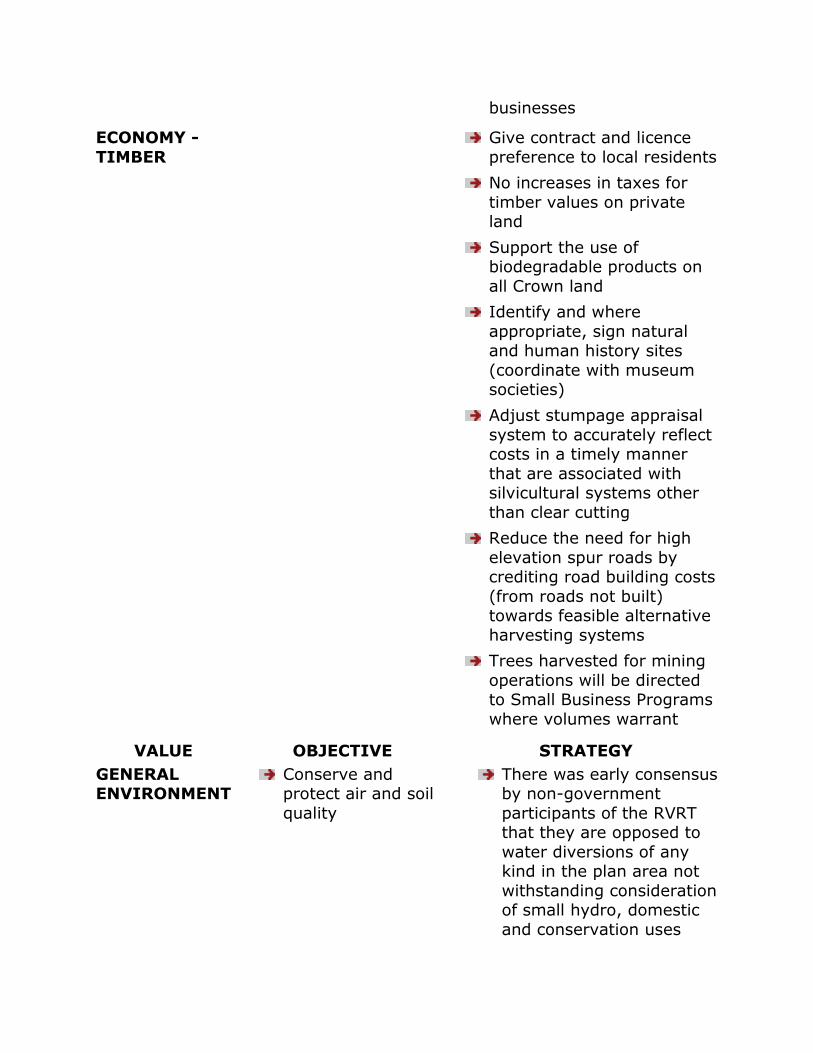
businesses
ECONOMY -
TIMBER
Give contract and licence
preference to local residents
No increases in taxes for
timber values on private land
Support the use of biodegradable products on
all Crown land
Identify and where
appropriate, sign natural and human history sites
(coordinate with museum societies)
Adjust stumpage appraisal
system to accurately reflect costs in a timely manner
that are associated with silvicultural systems other
than clear cutting
Reduce the need for high
elevation spur roads by crediting road building costs
(from roads not built) towards feasible alternative
harvesting systems
Trees harvested for mining
operations will be directed to Small Business Programs
where volumes warrant
VALUE OBJECTIVE STRATEGY
GENERAL ENVIRONMENT
Conserve and protect air and soil
quality
There was early consensus by non-government
participants of the RVRT that they are opposed to
water diversions of any kind in the plan area not
withstanding consideration of small hydro, domestic
and conservation uses
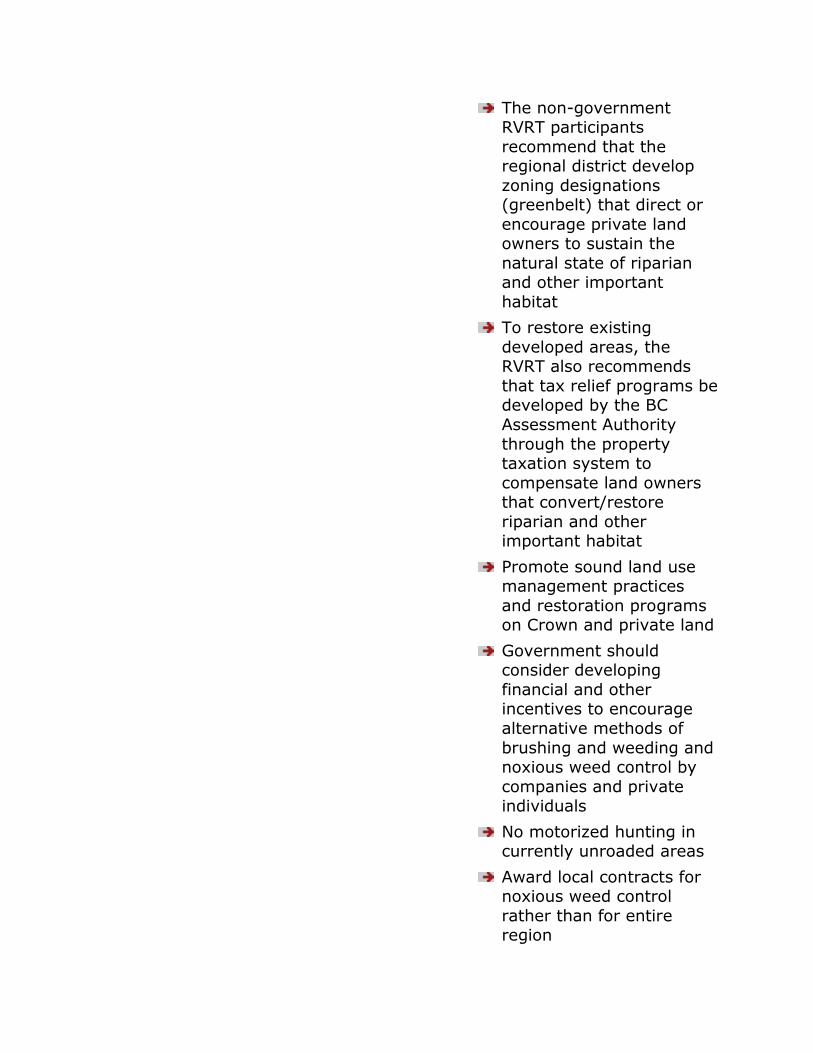
The non-government RVRT participants
recommend that the regional district develop
zoning designations (greenbelt) that direct or
encourage private land owners to sustain the
natural state of riparian and other important
habitat
To restore existing
developed areas, the RVRT also recommends
that tax relief programs be developed by the BC
Assessment Authority
through the property taxation system to
compensate land owners that convert/restore
riparian and other important habitat
Promote sound land use management practices
and restoration programs on Crown and private land
Government should consider developing
financial and other incentives to encourage
alternative methods of
brushing and weeding and noxious weed control by
companies and private individuals
No motorized hunting in currently unroaded areas
Award local contracts for noxious weed control
rather than for entire region
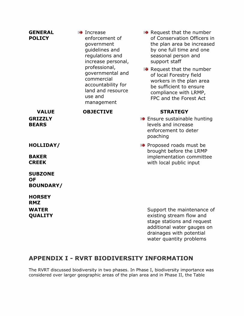
GENERAL POLICY
Increase enforcement of
government guidelines and
regulations and increase personal,
professional, governmental and
commercial accountability for
land and resource use and
management
Request that the number of Conservation Officers in
the plan area be increased by one full time and one
seasonal person and support staff
Request that the number of local Forestry field
workers in the plan area be sufficient to ensure
compliance with LRMP, FPC and the Forest Act
VALUE OBJECTIVE STRATEGY
GRIZZLY
BEARS
Ensure sustainable hunting
levels and increase
enforcement to deter poaching
HOLLIDAY/
BAKER CREEK
SUBZONE OF
BOUNDARY/
HORSEY RMZ
Proposed roads must be brought before the LRMP
implementation committee with local public input
WATER QUALITY
Support the maintenance of existing stream flow and
stage stations and request additional water gauges on
drainages with potential
water quantity problems
APPENDIX I - RVRT BIODIVERSITY INFORMATION
The RVRT discussed biodiversity in two phases. In Phase I, biodiversity importance was considered over larger geographic areas of the plan area and in Phase II, the Table

considered Phase I information and then determined biodiversity emphasis by recommended landscape unit.
PHASE I
The RVRT struck a subcommittee to deal with this issue and report back to the Table.
The biodiversity RVRT subcommittee and the RVRT generally agreed on the relative importance of higher biodiversity in the following areas within the plan area:
Morkill River drainage
Lower Kinbasket Lake
Goat River drainage
Boundary/Horsey Creek RMZ F
Upper Raush River drainage
However, in Phase I, the RVRT did not provide any specific objectives or strategies for these areas.
PHASE II
When the Biodiversity Guidelines (FPC) were released, the RVRT then discussed and negotiated biodiversity emphasis objectives by recommended landscape units to provide more detailed area specific direction. The eventual outcome included two lists.
Refer to page 204 for A and B Lists and options that follow:
A LIST: represents Spring 1996 negotiations of the RVRT for biodiversity objectives except for landscape unit 9 for which agreement was not reached. The IPT later
recommended the biodiversity emphasis for this area.
B LIST: represents Conservation Sector option which
address concerns of the biodiversity (FPC) guidelines to achieve long term sustainability.
RVRT OPTIONS PRESENTED
Conservation Sectors Option – Biodiversity Emphasis: All areas in the forest district should be
managed at a minimum of „medium‟ (intermediate) and the majority should be managed as „high‟ biodiversity. The age-class objectives should also apply separately to
each ecosystem site series, and until site series are adequately mapped, the age-class objectives should be applied separately to the valley bottom and mountainous
side-slopes of the BEC subzone variant within a landscape unit. In high biodiversity areas there should be 33% retention, and in medium biodiversity there should be
23% retention of old growth.Resource Sectors Option – Biodiversity Emphasis: The Negotiated List (A List)
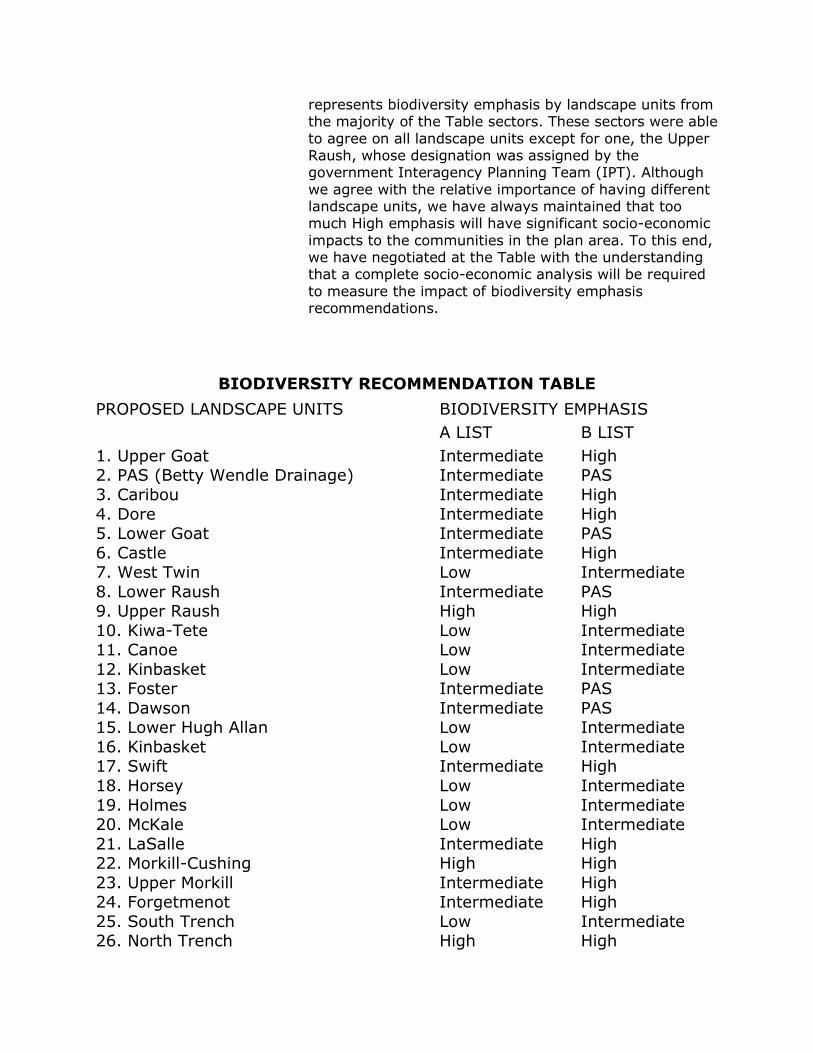
represents biodiversity emphasis by landscape units from the majority of the Table sectors. These sectors were able
to agree on all landscape units except for one, the Upper Raush, whose designation was assigned by the government Interagency Planning Team (IPT). Although
we agree with the relative importance of having different landscape units, we have always maintained that too much High emphasis will have significant socio-economic
impacts to the communities in the plan area. To this end, we have negotiated at the Table with the understanding that a complete socio-economic analysis will be required
to measure the impact of biodiversity emphasis recommendations.
BIODIVERSITY RECOMMENDATION TABLE
PROPOSED LANDSCAPE UNITS BIODIVERSITY EMPHASIS
A LIST B LIST
1. Upper Goat 2. PAS (Betty Wendle Drainage)
3. Caribou
4. Dore 5. Lower Goat
6. Castle 7. West Twin
8. Lower Raush 9. Upper Raush
10. Kiwa-Tete 11. Canoe
12. Kinbasket 13. Foster
14. Dawson 15. Lower Hugh Allan
16. Kinbasket 17. Swift
18. Horsey
19. Holmes 20. McKale
21. LaSalle 22. Morkill-Cushing
23. Upper Morkill 24. Forgetmenot
25. South Trench 26. North Trench
Intermediate Intermediate
Intermediate
Intermediate Intermediate
Intermediate Low
Intermediate High
Low Low
Low Intermediate
Intermediate Low
Low Intermediate
Low
Low Low
Intermediate High
Intermediate Intermediate
Low High
High PAS
High
High PAS
High Intermediate
PAS High
Intermediate Intermediate
Intermediate PAS
PAS Intermediate
Intermediate High
Intermediate
Intermediate Intermediate
High High
High High
Intermediate High
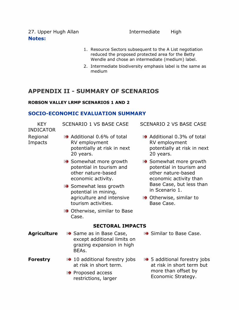
27. Upper Hugh Allan Intermediate High
Notes:
1. Resource Sectors subsequent to the A List negotiation reduced the proposed protected area for the Betty
Wendle and chose an intermediate (medium) label.
2. Intermediate biodiversity emphasis label is the same as medium
APPENDIX II - SUMMARY OF SCENARIOS
ROBSON VALLEY LRMP SCENARIOS 1 AND 2
SOCIO-ECONOMIC EVALUATION SUMMARY
KEY
INDICATOR
SCENARIO 1 VS BASE CASE SCENARIO 2 VS BASE CASE
Regional
Impacts
Additional 0.6% of total
RV employment potentially at risk in next
20 years.
Somewhat more growth potential in tourism and
other nature-based economic activity.
Somewhat less growth potential in mining,
agriculture and intensive tourism activities.
Otherwise, similar to Base Case.
Additional 0.3% of total
RV employment potentially at risk in next
20 years.
Somewhat more growth potential in tourism and
other nature-based economic activity than
Base Case, but less than in Scenario 1.
Otherwise, similar to Base Case.
SECTORAL IMPACTS
Agriculture Same as in Base Case,
except additional limits on grazing expansion in high
BEAs.
Similar to Base Case.
Forestry 10 additional forestry jobs at risk in short term.
Proposed access restrictions, larger
5 additional forestry jobs at risk in short term but
more than offset by Economic Strategy.
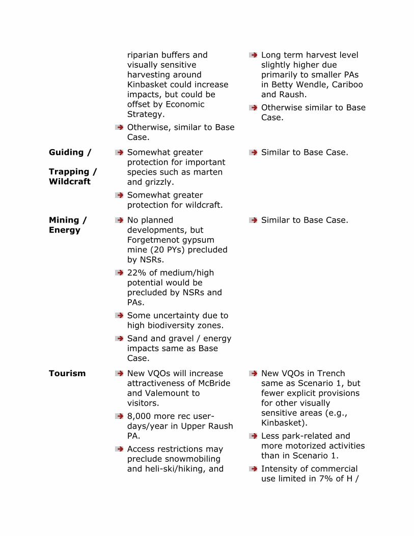
riparian buffers and visually sensitive
harvesting around Kinbasket could increase
impacts, but could be offset by Economic
Strategy.
Otherwise, similar to Base
Case.
Long term harvest level slightly higher due
primarily to smaller PAs in Betty Wendle, Cariboo
and Raush.
Otherwise similar to Base
Case.
Guiding /
Trapping /
Wildcraft
Somewhat greater
protection for important species such as marten
and grizzly.
Somewhat greater
protection for wildcraft.
Similar to Base Case.
Mining /
Energy
No planned
developments, but
Forgetmenot gypsum mine (20 PYs) precluded
by NSRs.
22% of medium/high
potential would be precluded by NSRs and
PAs.
Some uncertainty due to
high biodiversity zones.
Sand and gravel / energy
impacts same as Base Case.
Similar to Base Case.
Tourism New VQOs will increase attractiveness of McBride
and Valemount to
visitors.
8,000 more rec user-
days/year in Upper Raush PA.
Access restrictions may preclude snowmobiling
and heli-ski/hiking, and
New VQOs in Trench same as Scenario 1, but
fewer explicit provisions
for other visually sensitive areas (e.g.,
Kinbasket).
Less park-related and
more motorized activities than in Scenario 1.
Intensity of commercial use limited in 7% of H /
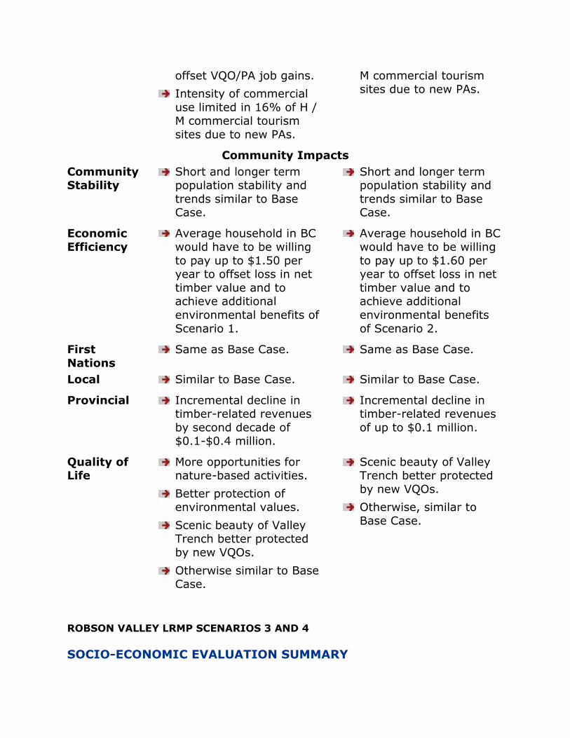
offset VQO/PA job gains.
Intensity of commercial
use limited in 16% of H / M commercial tourism
sites due to new PAs.
M commercial tourism sites due to new PAs.
Community Impacts
Community Stability
Short and longer term population stability and
trends similar to Base Case.
Short and longer term population stability and
trends similar to Base Case.
Economic Efficiency
Average household in BC would have to be willing
to pay up to $1.50 per year to offset loss in net
timber value and to achieve additional
environmental benefits of
Scenario 1.
Average household in BC would have to be willing
to pay up to $1.60 per year to offset loss in net
timber value and to achieve additional
environmental benefits
of Scenario 2.
First
Nations
Same as Base Case. Same as Base Case.
Local Similar to Base Case. Similar to Base Case.
Provincial Incremental decline in timber-related revenues
by second decade of $0.1-$0.4 million.
Incremental decline in timber-related revenues
of up to $0.1 million.
Quality of Life
More opportunities for nature-based activities.
Better protection of environmental values.
Scenic beauty of Valley Trench better protected
by new VQOs.
Otherwise similar to Base Case.
Scenic beauty of Valley Trench better protected
by new VQOs.
Otherwise, similar to
Base Case.
ROBSON VALLEY LRMP SCENARIOS 3 AND 4
SOCIO-ECONOMIC EVALUATION SUMMARY

KEY INDICATORS
SCENARIO 3 VS BASE CASE SCENARIO 4 VS BASE CASE
Regional Impacts
Additional 13%-15% of total RV jobs potentially
at risk in next 20 years.
Population decline in
short term, with growth resuming in longer term
due to attractiveness of
new parks to tourists and in-migrants.
Impacts could only be partially offset by
Economic Strategy.
Net increase of 3%-4% total RV employment in
next 20 years, compared to Base Case.
Higher population growth in short term, but
erosion in quality of
tourism opportunities and scenic beauty will
detract from long term growth.
SECTORAL IMPACTS
Agriculture No further growth in grazing on Crown land
likely.
No constraints on grazing expansion on Crown
land.
Forestry Mill closure and loss of
210-250 additional direct jobs (50% of total)
possible in next 20 years.
Impacts could only be
partially offset by FRBC
and higher timber utilization.
Loss of 50-60 forestry
jobs would be avoided in short term. Harvest level
and associated jobs could be maintained for
longer period.
Economic Strategy would further increase jobs,
although rationale for FRBC spending weaker.
Harvest level and employment higher in
long term but mill closure still possible due
to TSR.
Guiding /
Trapping / Wildcraft
Significantly enhanced
protection for important species such as marten
and grizzly.
Significantly greater
protection for botanical
Significantly less
protection for these activities.

forest products.
Mining /
Energy
Most sand and gravel pits,
mineral occurrences and potential, small hydro
sites, energy ROW would be precluded.
None of the sand and
gravel pits, mineral occurrences and
potential, small hydro sites, energy ROW would
be precluded from development.
Tourism New PAs will increase attractiveness of McBride
and Valemount to visitors.
Much higher potential for
growth in low intensity / wilderness recreation and
tourism.
Potentially severe
constraints on commercial
backcountry tourism growth.
No VQOs will erode scenic beauty and
attractiveness of Valley to visitors/in-migrants.
Little / no growth potential in park-related
/ wilderness recreation and tourism.
Higher potential for
motorized and commercial backcountry
tourism, but wilderness opportunities
significantly eroded in longer term.
COMMUNITY IMPACTS
Community
Stability
Population decline and
severe disruption of the valley economy very likely
in short term.
Population growth would
likely resume in the longer term, but only after a very
long and difficult adjustment period.
Population growth would
be higher in the short term.
Mill closure less likely in the longer term but
erosion of tourism potential would reduce
opportunities for diversification.
Economic Efficiency
Average household in BC would have to be willing to
pay up to $6.90 per year to offset loss in net timber
value and to achieve
Average household in BC would have to be paid up
to $1.70 per year to offset loss in net timber
value and to accept

additional environmental benefits of Scenario 3.
environmental costs of Scenario 4.
First Nations
Same as Base Case. Same as Base Case.
Local Likely mill closure would significantly reduce local
tax base in short term.
Tax base, driven by
tourism-related investments, could
resume growth in longer term.
Better possibility that mill closure could be avoided
in long term.
Less long term potential
for growth in tourism-related tax base.
Provincial Incremental decline in timber-related revenues of
about $2.1-$7.6 million in short term.
Incremental gain in timber-related revenues
of up to $2.3 million in short term.
Quality of
Life
Significantly higher
protection of environmental values and
scenic beauty.
Significant increase in
hardship and stress for forest workers who cannot
find alternative employment, and their
families.
Significant erosion in
environmental values and scenic beauty.
Difficult adjustments of forest workers and their
families would be delayed for several decades.
ROBSON VALLEY LRMP SCENARIOS 1 AND 2
ENVIRONMENTAL EVALUATION SUMMARY
RESOURCE VALUE
BASE CASE SCENARIO 1 SCENARIO 2
Biodiversity/ Ecosystem
Representation/
Protected Area
Strategy
Mount Robson
Provincial Park
(MRPP) and
8 AOI‟s would
MRPP and 7 proposed
parks would achieve
representation
in 3 of 7 ecosections
MRPP and 6 proposed
parks would achieve
representatio
n in 3 of 7 ecosections
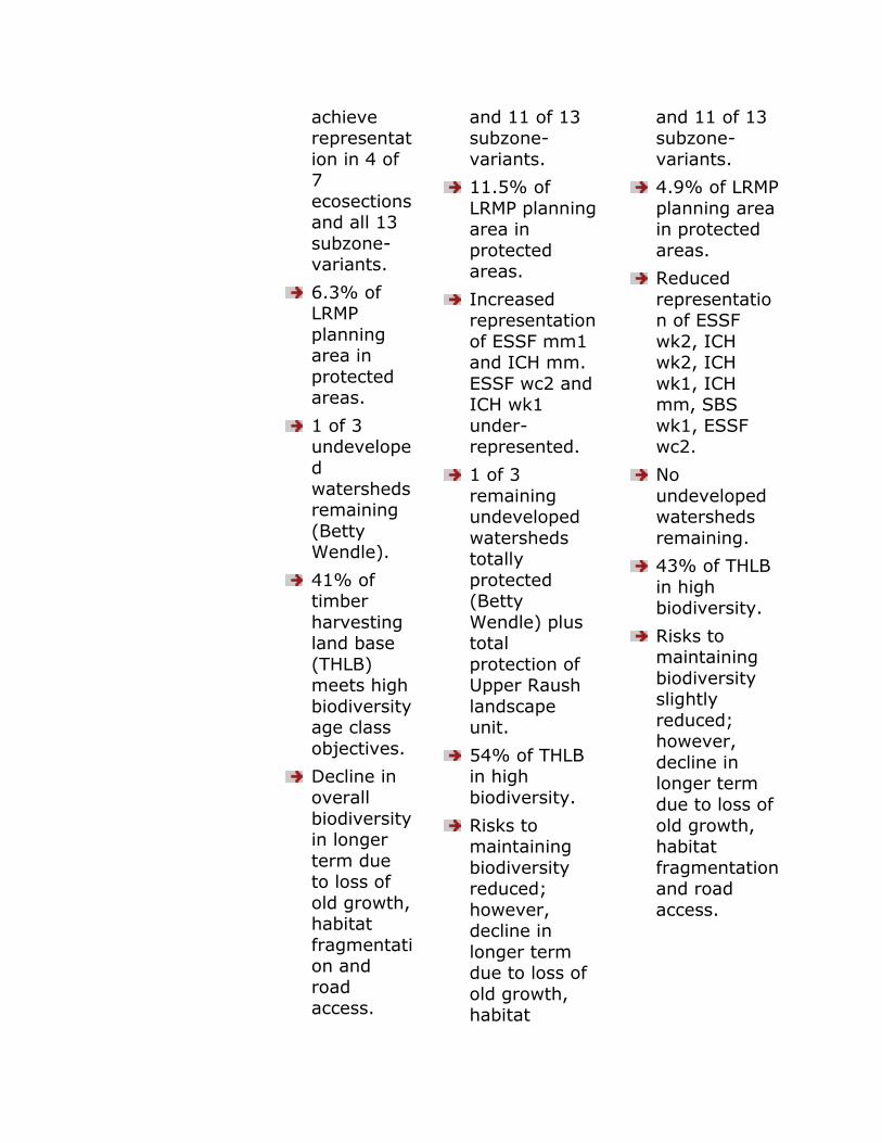
achieve representat
ion in 4 of 7
ecosections and all 13
subzone-variants.
6.3% of LRMP
planning area in
protected areas.
1 of 3 undevelope
d
watersheds remaining
(Betty Wendle).
41% of timber
harvesting land base
(THLB) meets high
biodiversity age class
objectives.
Decline in
overall
biodiversity in longer
term due to loss of
old growth, habitat
fragmentation and
road access.
and 11 of 13 subzone-
variants.
11.5% of
LRMP planning area in
protected areas.
Increased representation
of ESSF mm1 and ICH mm.
ESSF wc2 and ICH wk1
under-represented.
1 of 3
remaining undeveloped
watersheds totally
protected (Betty
Wendle) plus total
protection of Upper Raush
landscape unit.
54% of THLB in high
biodiversity.
Risks to maintaining
biodiversity reduced;
however, decline in
longer term due to loss of
old growth, habitat
and 11 of 13 subzone-
variants.
4.9% of LRMP
planning area in protected
areas.
Reduced
representation of ESSF
wk2, ICH wk2, ICH
wk1, ICH mm, SBS
wk1, ESSF wc2.
No
undeveloped watersheds
remaining.
43% of THLB
in high biodiversity.
Risks to maintaining
biodiversity slightly
reduced; however,
decline in longer term
due to loss of
old growth, habitat
fragmentation and road
access.
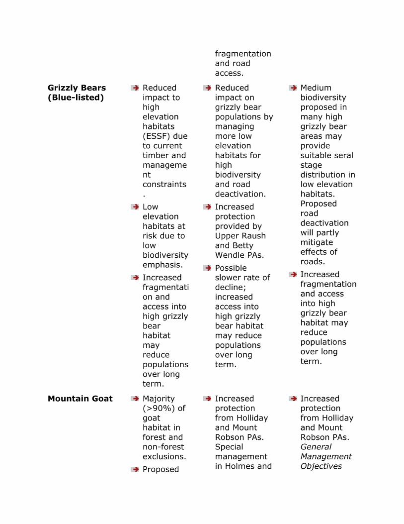
fragmentation and road
access.
Grizzly Bears
(Blue-listed)
Reduced
impact to high
elevation habitats
(ESSF) due to current
timber and manageme
nt constraints
.
Low
elevation
habitats at risk due to
low biodiversity
emphasis.
Increased
fragmentation and
access into high grizzly
bear habitat
may reduce
populations
over long term.
Reduced
impact on grizzly bear
populations by managing
more low elevation
habitats for high
biodiversity and road
deactivation.
Increased
protection
provided by Upper Raush
and Betty Wendle PAs.
Possible slower rate of
decline; increased
access into high grizzly
bear habitat may reduce
populations over long
term.
Medium
biodiversity proposed in
many high grizzly bear
areas may provide
suitable seral stage
distribution in low elevation
habitats. Proposed
road
deactivation will partly
mitigate effects of
roads.
Increased
fragmentation and access
into high grizzly bear
habitat may reduce
populations over long
term.
Mountain Goat Majority (>90%) of
goat habitat in
forest and non-forest
exclusions.
Proposed
Increased protection
from Holliday and Mount
Robson PAs. Special
management in Holmes and
Increased protection
from Holliday and Mount
Robson PAs. General
Management Objectives
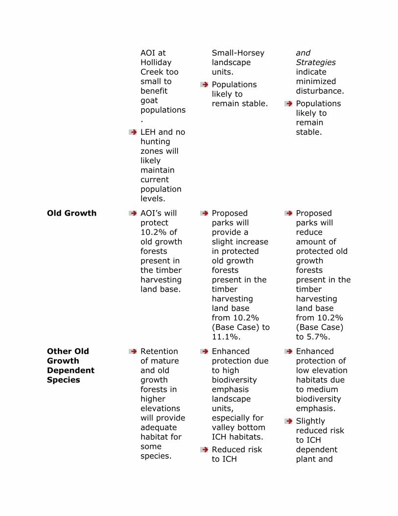
AOI at Holliday
Creek too small to
benefit goat
populations.
LEH and no hunting
zones will likely
maintain current
population levels.
Small-Horsey landscape
units.
Populations
likely to remain stable.
and Strategies
indicate minimized
disturbance.
Populations
likely to remain
stable.
Old Growth AOI‟s will
protect 10.2% of
old growth forests
present in the timber
harvesting land base.
Proposed
parks will provide a
slight increase in protected
old growth forests
present in the timber
harvesting land base
from 10.2% (Base Case) to
11.1%.
Proposed
parks will reduce
amount of protected old
growth forests
present in the timber
harvesting land base
from 10.2% (Base Case)
to 5.7%.
Other Old
Growth
Dependent Species
Retention
of mature
and old growth
forests in higher
elevations will provide
adequate habitat for
some species.
Enhanced
protection due
to high biodiversity
emphasis landscape
units, especially for
valley bottom ICH habitats.
Reduced risk to ICH
Enhanced
protection of
low elevation habitats due
to medium biodiversity
emphasis.
Slightly
reduced risk to ICH
dependent plant and

Carrying capacity of
forest interior
species such as
marten expected
to decline over time.
Old growth dependent
plant (e.g., macro-
lichens) and animal
species
that live in valley
bottom ICH and SBS
habitats at risk.
dependent plant (e.g.,
macro-lichens) and animal
species by shifting
towards more natural levels
of mature and old growth. 2
incremental biodiversity
emphasis options: Low
High.
animal species by
shifting towards more
natural levels of mature
and old growth. 1
incremental biodiversity
emphasis option: Low
Medium.
Riparian Habitat and
Species
A positive trend for
red and blue listed
bird species
dependent on riparian
habitats
(crown land only)
is anticipated
with implement
ation of FPC
Riparian Manageme
nt Areas
Enhanced protection of
riparian zones (300m
buffers) along Fraser, Canoe
and McLellan Rivers.
Enhanced
protection of wetlands in
Lower Raush landscape
unit.
Same as Base Case.
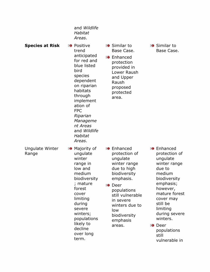
and Wildlife Habitat
Areas.
Species at Risk Positive
trend anticipated
for red and blue listed
bird species
dependent on riparian
habitats through
implementation of
FPC
Riparian Manageme
nt Areas and Wildlife
Habitat Areas.
Similar to
Base Case.
Enhanced
protection provided in
Lower Raush and Upper
Raush proposed
protected area.
Similar to
Base Case.
Ungulate Winter Range
Majority of ungulate
winter range in
low and medium
biodiversity; mature
forest
cover limiting
during severe
winters; populations
likely to decline
over long term.
Enhanced protection of
ungulate winter range
due to high biodiversity
emphasis.
Deer
populations
still vulnerable in severe
winters due to low
biodiversity emphasis
areas.
Enhanced protection of
ungulate winter range
due to medium
biodiversity emphasis;
however,
mature forest cover may
still be limiting
during severe winters.
Deer populations
still vulnerable in
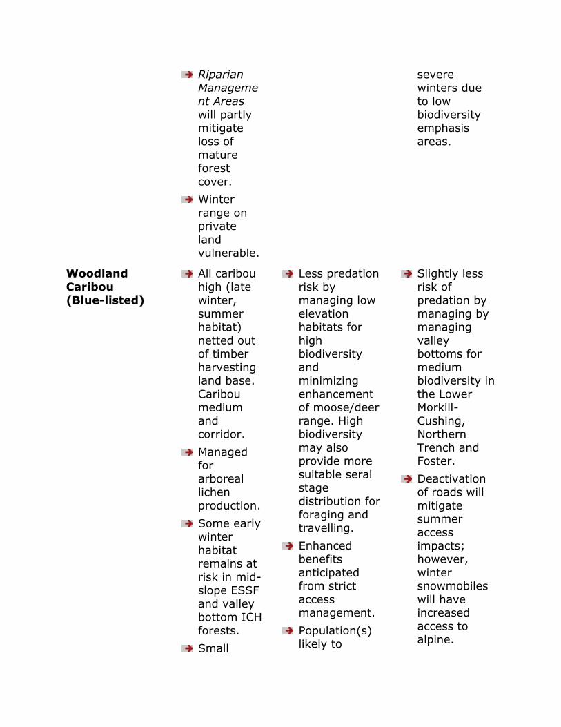
Riparian Manageme
nt Areas will partly
mitigate loss of
mature forest
cover.
Winter
range on private
land vulnerable.
severe winters due
to low biodiversity
emphasis areas.
Woodland Caribou
(Blue-listed)
All caribou high (late
winter,
summer habitat)
netted out of timber
harvesting land base.
Caribou medium
and corridor.
Managed for
arboreal lichen
production.
Some early winter
habitat remains at
risk in mid-slope ESSF
and valley bottom ICH
forests.
Small
Less predation risk by
managing low
elevation habitats for
high biodiversity
and minimizing
enhancement of moose/deer
range. High biodiversity
may also provide more
suitable seral stage
distribution for
foraging and travelling.
Enhanced benefits
anticipated from strict
access management.
Population(s) likely to
Slightly less risk of
predation by
managing by managing
valley bottoms for
medium biodiversity in
the Lower Morkill-
Cushing, Northern
Trench and Foster.
Deactivation of roads will
mitigate
summer access
impacts; however,
winter snowmobiles
will have increased
access to alpine.
population(s) likely to
remain stable;
however increased
risks from road
access and predation
over long term.
remain stable. Populations may remain
stable; but potential
exists for decline in
long-term.
FISHERIES
RESOURCE
VALUE
BASE CASE SCENARIO 1 SCENARIO 2
Anadromous Future road
and resource development
will negatively
impact fish habitat.
FPC Riparian Management
Areas will
mitigate impacts on
crown land; riparian
habitats on private land
remain at risk.
Majority of migration
and spawning
habitat managed for
low
Enhanced
protection of salmon habitat.
4 times more salmon habitat to
be managed for high biodiversity
9 times more spawning habitat
in high
biodiversity emphasis than
Base Case or Scenario 2.
Similar to
Base Case.
Slightly
higher proportion of
salmon habitat in
medium biodiversity
emphasis.

biodiversity.
Freshwater Future road
and resource development
will negatively
impact fish habitat.
FPC Riparian Management
Areas will mitigate
impacts on crown land;
riparian habitats on
private land
remain at risk.
Enhanced
protection for freshwater
species in high biodiversity
landscape units.
Increased
protection from proposed
extended riparian zones and
buffers.
Similar to
Base Case.
Slightly
higher proportion of
fish habitat in medium
biodiversity emphasis.
Range 45 grazing tenures and
current Animal Unit
Months (AUMs)
expected to remain
similar.
No expansion of grazing tenures
in high biodiversity
emphasis areas; reduced range
conflicts.
Same as Base Case.
Recreation Expanding
road network will increase
seasonal
access to recreation
areas.
Quality of
wilderness-based
recreation activities
likely to
Additional 1,200
resident user-days.
In Upper Raush
proposed protected area.
More protected area, high
biodiversity and access
restrictions better preserve
wilderness
Smaller
Betty Wendle PA
means less
protection of Bowron Lake
viewscapes and fish and
wildlife values.
Otherwise similar to
Base Case.
decline.
Additional
12,000 resident
user-days in AOI‟s.
Betty Wendle AOI provides
protection of Bowron Lake
viewscapes and fish and
wildlife values.
recreation opportunities.
Less motorized access to
recreation areas.
Visual Quality
Objectives
Scenic quality of
viewscapes
expected to be
maintained through VQO
retention and partial
retention management
zones.
Enhanced VQOs in trench.
Enhanced VQOs
in high biodiversity
landscape units and special
considerations around Kinbasket
Lake.
Enhanced VQOs in
trench.
Water
Quality
Current
development restrictions
in community
watersheds
and FPC will mitigate
impacts on water
quality.
Water
sources affected by
private land development
Reduced risk of
sedimentation problems due to
high biodiversity emphasis and
proposed
enhanced riparian zones.
Same as
Base Case.
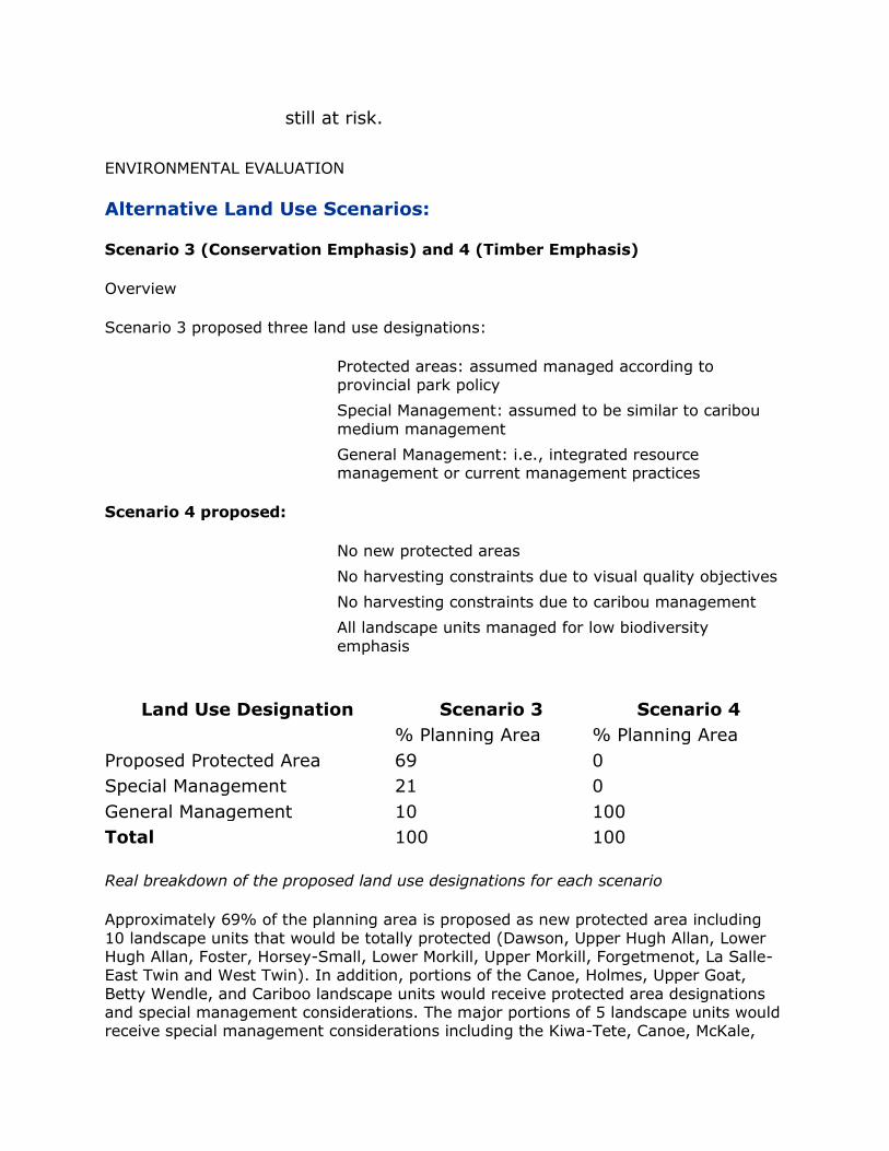
still at risk.
ENVIRONMENTAL EVALUATION
Alternative Land Use Scenarios:
Scenario 3 (Conservation Emphasis) and 4 (Timber Emphasis)
Overview
Scenario 3 proposed three land use designations:
Protected areas: assumed managed according to provincial park policy
Special Management: assumed to be similar to caribou
medium management
General Management: i.e., integrated resource management or current management practices
Scenario 4 proposed:
No new protected areas
No harvesting constraints due to visual quality objectives
No harvesting constraints due to caribou management
All landscape units managed for low biodiversity
emphasis
Land Use Designation Scenario 3 Scenario 4
% Planning Area % Planning Area
Proposed Protected Area 69 0
Special Management 21 0
General Management 10 100
Total 100 100
Real breakdown of the proposed land use designations for each scenario
Approximately 69% of the planning area is proposed as new protected area including
10 landscape units that would be totally protected (Dawson, Upper Hugh Allan, Lower Hugh Allan, Foster, Horsey-Small, Lower Morkill, Upper Morkill, Forgetmenot, La Salle-East Twin and West Twin). In addition, portions of the Canoe, Holmes, Upper Goat,
Betty Wendle, and Cariboo landscape units would receive protected area designations and special management considerations. The major portions of 5 landscape units would receive special management considerations including the Kiwa-Tete, Canoe, McKale,
West Kinbasket- Howard and East Kinbasket-Ptarmigan. The majority of the Southern Trench, Castle and portions of the Northern Trench and Dore landscape units would be
managed for general management.
Potential Impact of Scenarios on Biodiversity
The large geographic area proposed in Scenario 3 as new protected area would greatly reduce the risk of losing biodiversity by maintaining natural levels of disturbance and ecosystem processes over both the short and long term. Species expected to benefit
the most from this scenario would be dependent on late successional forests, old-growth and require relatively large undisturbed areas. Therefore, species such as grizzly bears, marten, and caribou, would likely have the necessary space to maintain viable
populations (assuming no catastrophic events such as disease and weather). Similarly, small mammals and bird species dependent on old growth attributes (coarse woody debris, snags) would be expected to benefit. This would be especially true for those
plant and animal species that live in the valley bottom ICH forests.
Conversely, Scenario 4 would result in the greatest negative impact to biodiversity over the long term by maintaining the whole planning area in a state of low biodiversity (Table 1). The abundance of early seral stages would provide habitat for some
pioneering plant and animal species; however, species and ecosystem processes dependent on late successional forests and old growth attributes (coarse woody debris, snags) would decline below Base Case projections. The resulting increase in
fragmentation and road access associated with intensive forest management would exacerbate the decline of old growth dependent species resulting in possible extirpation
of populations.
In relative terms, the potential risk to biodiversity, from most to least, (including the middle scenarios) would be: Scenario 4, Base Case, Scenario 2, Scenario 1, Scenario 3
APPENDIX III - GLOSSARY OF RESOURCE PLANNING TERMS
access management plan:
an operational plan that shows how road construction, modification and deactivation will be carried out to protect, or mitigate impacts on known resources or sensitive
areas while maximizing the efficiency of forest resource development.
age class:
any interval into which the age range of trees, forests, stands or forest types is divided for classification and use. The intervals are usually based on age in divisions of 10 years.
agriculture:

agriculture is the practice of growing and harvesting plants or animals, on land (including substrates) or in water, for the production of food, fibre, fuel, medicine,
ornamentals and industrial products or uses associated with or ancillary to the production of food, fibre, fuel, medicine, ornamentals and industrial items.
agricultural land:
land that is used for farming, including ranching, and land that has biophysical attributes that make it suitable for agricultural use. The latter includes lands identified by the Canada Land Inventory agricultural capability classes 1 to 5, as well as unique lands that have the capability to sustain agriculture in the regional context.
Agricultural Land Reserve (ALR):
land designated and reserved for agricultural purposes under the Agricultural Land Commission Act (the reserve covers about five percent of the province and includes most of BC's high quality agricultural land). It includes both private and public lands,
and covers land being farmed and land with agricultural potential. Non-agricultural uses on the ALR are regulated.
allowable annual cut (AAC):
the allowable rate of timber harvest from a specified area of land. The chief forester sets AACs for timber supply areas (TSAs) and tree farm licences (TFLs) in accordance with Section 8 of the Forest Act.
alpine:
the zone in a mountain system which lies above the timberline.
animal unit month (AUM):
the amount of forage required to feed a mature 1,000 pound cow with or without unweaned calf at her side, or equivalent (one 2-year-old horse or five deer) for one month.
archaeological sites:
locations containing or with the potential to contain the physical remains of past human activity. These sites are assessed through archaeological investigations (see also cultural heritage resource).
backlog treatment:
any silviculture activity applied to areas harvested before October 1, 1987, for major licensees and January 1, 1988, for the Small Business Enterprise Program.
base case (LRMP):
present conditions and likely future developments in a planning area in the absence of any changes to existing land and resource management. This should include a description of current resources and resource uses, current management strategies and land use designations, and relevant historical conditions and trends, as well as a
discussion of their contribution to current and long term social, economic and environmental conditions. In LRMP, the base case provides a benchmark for scenario evaluation.
benefit/cost analysis:
an analytical technique that estimates the net benefits and costs of a management scenario using fully quantified social (non-market) costs and benefits as well as financial (market) costs and benefits.
biodiversity:
biological diversity is the diversity of plants, animals and other living organisms in all their forms and level of organization and includes the diversity of genes, species and ecosystems, as well as the evolutionary and functional processes that link them.
The underlying assumption of applying the biodiversity management approach is that
all native species and ecological processes are more likely to be maintained if managed forests are made to resemble those forests created by the activities of natural disturbance agents such as fire, wind, insects and disease. The composition, size, age
and distribution of forest types and structural characteristics of forest stands have been determined by these natural processes.
Applying biodiversity emphasis options to landscape units across a planning area is a key biodiversity management strategy. LRMP tables can indirectly assign biodiversity
options to landscape units consistent with broad scale land use zonation using lower biodiversity emphasis.
When landscape level biodiversity management options have been established, the requirement for maintaining biodiversity in individual stands can be determined from
Biodiversity Field Guide.
biodiversity - lower level
first in a range of three landscape level options to maintain biodiversity. Where the primary management objectives are primarily socio-economic demands such as timber
supply, the lower biodiversity emphasis option may be appropriate. Habitat is provided for a wide range of species, however, the pattern of biodiversity will be significantly altered. Accordingly, there is a relatively high risk that some native species will be
unable to survive in a specific area.
biodiversity - intermediate level
second option, essentially a trade-off between biodiversity conservation and timber production. The risk to eliminating certain species from an area is reduced.
biodiversity - higher level
an option recommended for those areas where biodiversity conservation is a high management priority. It gives a higher priority to biodiversity conservation and has the greatest impact on timber supply.
biodiversity - stand level
stand management to maintain biodiversity, stand level recommendations for biodiversity are designed to maintain or restore important structural attributes such as wildlife trees (including standing dead or dying trees), coarse woody debris, tree
species diversity and understorey vegetation diversity.
biogeoclimatic ecosystem classification:
a hierarchical classification scheme having three levels of integration: regional, local and chronological; and combining climatic, vegetation, and site factors.
biogeoclimatic zone:
a large geographic area with a broadly homogeneous macroclimate. Each zone is named after one or more of the dominant climax species of the ecosystems in the zone, and a geographic or climatic modifier. British Columbia has 14 biogeoclimatic zones.
biological diversity: (see biodiversity).
blue-listed species:
sensitive or vulnerable species as identified by the Ministry of Environment, Lands and Parks. Blue-listed species are considered to be vulnerable and "at risk" but not yet
endangered or threatened. Populations of these species may not be decline but their habitat or other requirements are such that they are sensitive to further disturbance. The blue list also includes species that are generally suspected of being vulnerable, but
for which information is too limited to allow designation in another category.
botanical forest product:
non-timber based products gathered from forest and range land. There are seven recognized categories: wild edible mushrooms, floral greenery, medicinal products,
fruits and berries, herbs and vegetables, landscaping products, and craft products.
broadcast burning:
intentional burning of debris on a designated unit of land, where the fuel has not been piled or windrowed, allowing fire to spread freely over the entire area.
brushing:
a silviculture activity done by chemical, manual, grazing, or mechanical means to control competing forest vegetation and reduce competition for space, light, moisture, and nutrients with crop trees or seedlings.
buffer strip:
a strip of land (often including undisturbed vegetation) where disturbance is not allowed or is closely monitored to preserve or enhance aesthetic and other qualities along or adjacent to roads, trails, watercourses and recreation sites.
capability:
the potential of an area of land to produce resources, supply goods and services, and allow resource uses under an assumed set of management practices and at given levels of management intensity. Capability depends upon this set of conditions and site conditions such as climate, slope, landform, soils, and geology.
carrying capacity:
the average population that can be sustained on a management unit, compatible with management objectives for the unit. It is a function of site characteristics, management goals and management intensity.
clearcutting with reserves:
means a variation of the clearcutting silvicultural system which retains a variable number of reserve trees either uniformly or in small groups, for purposes other than regeneration.
clearcutting silvicultural system:
defined as a silvicultural system that removes an entire stand of trees from an area of one hectare or more, and greater that two tree heights in width, in a single harvesting operation. A new even-aged stand is obtained by planting, natural or advanced regeneration or direct seeding. The opening size and dimensions created are
generally large enough to limit significant microclimatic influence from the surrounding stand.
coarse woody debris:
sound and rotting logs and stumps that provide habitat for fungi, plants, animals and insects and their predators, and that provide a source of nutrients for soil development.
commercial backcountry recreation:
those outdoor recreational activities undertaken on a fee-for-service basis, with a focus on experiences associated with natural environments in rural or remote settings.
Commission on Resources and Environment (CORE):
a body established by the British Columbia government, independent of the various provincial ministries, whose legal mandate as defined in the Commissioner on Resources and Environment Act was to "develop for public and government
consideration a British Columbia-wide strategy for land use and related resource and environmental management." CORE was dissolved in 1996 after fulfilling its mandate.
community watershed:
defined in the Forest Practices Code of British Columbia Act as
a)the drainage area above the most downstream point of diversion on a stream for a
water use that is for human consumption and that is licenced under the Water Act for
i) a waterworks purpose, or
ii)a domestic purpose if the licence is held by or is subject to the control of a water users' community incorporated under the Water Act
if the drainage area is not more than 500 km2 and the water licence was issued before June 15, 1995 or
b)an area that is designated as a community watershed under subsection (10).
compatible:
capable of existing or operating together in harmony
connectivity:
a qualitative term describing the degree to which late-successional ecosystems are linked to one another to form an interconnected network. The degree of
interconnectedness and the characteristics of the linkages vary in natural landscapes based on topography and natural disturbance regime. Breaking of these linkages results in fragmentation.
consensus:
defined by the Robson Valley Round Table, Terms of Reference, dated May 11, 1994, Section 8.1 as: consensus will have been reached when there is agreement by all members present to support the outcome.
conserve:
to keep in a safe or sound state
corridor:
a band of vegetation, usually older forest, that serves to connect distinct patches on the landscape. Corridors are part of the forest ecosystem network (FEN), and by providing connectivity they permit the movement of plant and animal species between what would otherwise be isolated patches.
critical habitat:
areas considered to be critically important for sustaining a population and where development may cause an unacceptable decline in the population. A rating of the importance of the habitat (e.g., high, medium, low) may also be used.
critical wildlife habitat:
part or all of a specific place occupied by a wildlife species or a population of such species and recognized as being essential for the maintenance of the population. From the Prince George BC Environment staff: This is a non-comprehensive listing of what
might be defined as "critical" habitats for some of the development activities that are referred to in the objectives and strategies. Critical habitats include, but are not limited to: licks, seeps, springs, wetlands, breeding sites (elks, rutting arenas, etc.), birthing
sites (calving, spawning, etc.), riparian zones, colonies, rookeries, hibernacula, winter range and over wintering area (caribou, ungulates, trumpeter swam, etc.), caves, talus slopes, avalanche chutes, denning sites, nesting sites and cliffs.
Crown land:
land that is owned by the Crown; referred to as federal Crown land when it is owned by Canada, and as provincial Crown land when it is owned by a province. Land refers to the land itself and the resources or values on or under it.
cultural heritage resource:
an object, a site or the location of a traditional societal practice that is of historical, cultural or archaeological significance to the Province, a community or an aboriginal people. Cultural heritage resources include archaeological sites, structural
attributes, heritage landscape features and traditional use sites.
cutblock:
defined in the Forest Practices Code of British Columbia Act as a specific area of land identified on a forest development plan, or in a licence to cut or a cutting permit issued under a master licence to cut, road permit or Christmas tree permit, within which
timber is to be or has been harvested.
deactivation:
measures taken to stabilize roads and trails during periods of inactivity, including the control of drainage, the removal of sidecast where necessary, and the re-establishment
of vegetation for permanent deactivation.
designate:
a person undertaking work/activity on behalf and with the authority of another. For example, BC Environment or designate will usually be a contractor or licensee who is
doing work to the standards and with methods approved by BC Environment.
development:
any initiative that generates access to the harvesting of forest products.
economic impact analysis:
analytical techniques that estimate the economic impacts of management scenarios on income, revenues and employment within specific communities, regions or the province as a whole.
ecosection:
an ecological unit based on climate and physiography.
ecosystem:
a functional unit consisting of all the living organisms (plants, animals and microbes) in a given area, and all the non-living physical and chemical factors of their environment, linked together through nutrient cycling and energy flow. An ecosystem can be of any size — a log, pond, field, forest or the earth's biosphere — but it always functions as a
whole unit. Ecosystems are commonly described according to the major type of vegetation, for example, forest ecosystem, or range ecosystem.
endangered species: (see threatened or endangered species)
enhance:
raise, to add or contribute to. Improve. Increase.
environmentally sensitive area (ESA):
areas requiring special management attention. ESAs for forestry include potentially fragile, unstable soils that may deteriorate unacceptably after forest harvesting, and areas of high value to non-timber resources such as fisheries, wildlife, water and recreation.
equivalent clearcut area (ECA):

the area of a cutblock weighted to estimate an equivalent effect on snow hydrology as the area of a clear-cut unregenerated block. As examples, a 10 ha clear-cut
unregenerated block has an ECA of 10 ha; if a fully stocked stand has regenerated to a height of 6 m, the block now has an ECA of 5 ha. If, instead of being clear-cut the block was selection logged with 30% volume removal, the ECA is estimated to be 3 ha.
evaluation accounts:
accounts of the social, economic and environmental values (not necessarily monetary) affected by differing management strategies. Typically used in multiple accounts analysis to determine socio-economic impact.
even-aged stand:
a stand of trees consisting of one or two age classes (see also uneven-aged stand).
even-aged system:
a silviculture system that is designed to regenerate and maintain an even-aged stand. Clearcutting, seed tree and shelterwood are even aged systems.
five year silviculture plan:
a five year plan prepared annually to determine the progression of a silviculture program for a given forest licencee.
forest cover type:
forest stands consisting of a plant community made up of trees and other woody vegetation, growing more or less closely together.
forest development plan:
a five year plan prepared annually to determine the progression of forest access development for harvesting timber for a given forest licencee.
forest ecosystem network (FEN):
a planned landscape zone that serves to maintain or restore the natural connectivity within a landscape unit. It consists of a variety of fully protected areas, sensitive areas and old growth management areas.
Forest Land Reserve (FLR):
land designated under the Forest Land Reserve Act. This land includes private land within a tree farm licence and private land classed as managed forest land under the Assessment Act, as well as designated Crown land in the Provincial forest. Removal
of land from the Reserve is restricted. The purpose of the Reserve is to maintain the commercial working forest of British Columbia. FLR exclude all ALR lands.
forest practices:
any activity that is carried out on forest land to facilitate uses of forest resources, including but not limited to timber harvesting, road construction, silviculture, grazing, recreation, pest control, and wildfire suppression.
forest practices code (FPC):
commonly used to refer to the legislation (including the Forest Practices Code of British Columbia Act and associated regulations), standards and guidebooks that govern forest practices in BC.
forest resources:
defined in the Forest Practices Code of British Columbia Act as resources and values associated with forests and range including, without limitation, timber, water, wildlife, fisheries, recreation, botanical forest products, forage and biological diversity.
(see also resource values)
fragmentation:
the process of transforming large continuous forest patches into one or more smaller patches surrounded by disturbed areas. This occurs naturally through such agents as
fire, landslides, windthrow and insect attack. In managed forests, timber harvesting and related activities have been the dominant disturbance agents.
free growing:
healthy trees with growth unimpeded by competition from herbaceous plants, shrubs, or other trees.
genetic diversity:
variation among and within species that is attributable to differences in hereditary material (DNA).
grazing:
the consumption of any kind of standing, non-woody vegetation by livestock or wildlife.
green up:
the process of re-establishing vegetation following logging to achieve specific management objectives (for example, rate of harvest control, visual cover for wildlife,
visual quality, or hydrological recovery). The most common standards of green-up are:
green-up: the minimum height and stocking levels which trees (as described in either a silviculture prescription or regional stocking standards) on a cutblock must
achieve before an adjacent stand of timber may be harvested.
visually effective green-up: the stage at which
regeneration on a cutblock is perceived by the public as being newly established forest. The forest cover on the cutblock must generally be of sufficient height to block
stumps, logging debris, and bare ground from view. Once achieved, an adjacent stand of timber is available for harvest.
hydrological green-up: the point at which a second-growth stand of timber will hydrologically resemble old growth in terms of timing and quantity of water yield.
greened-up:
for the purposes of the Forest Practices Code of British Columbia Act means a cutblock that supports a stand of trees that
a) has attained the green-up height specified in a higher level plan for the area, or
b) in the absence of a higher level plan for the area, has attained a height that is 3m or
greater, and
i) if under silviculture prescription, meets the stocking requirements of that prescription, or
ii) if not under a silviculture prescription, meets the stocking specifications for that biogeoclimatic ecosystem classification specified by the regional manager.
group selection system:
a variant of the selection silvicultural system. It is defined as a silvicultural system that removes trees in defined groups to create stand openings with a width less that two times the height of adjacent mature trees, and that manages the area as
an uneven aged stand.
guidebooks:
guidebooks are guidelines and recommendations on how to best achieve the requirements of the Forest Practices Code of British Columbia Act. The guidebooks are
not legally enforceable. However, specifications and procedures recommended by the
guidebooks may be incorporated into plans, prescriptions and contracts in which case those specifications and procedures may become legally enforceable.
habitat:
the place where an organism lives and/or the conditions of that environment including the soil, vegetation, water and food.
habitat management:
management of the forest to create environments which provide habitats (food, shelter) to meet the needs of particular organisms.
heritage landscape feature:
a landscape feature that represents historical, architectural, archaeological, paleontological, or scenic significance to the province.
heritage trail:
a trail having cultural significance by reason of established aboriginal use or use by early immigrants (see also cultural heritage resource).
higher level plan:
defined in the Forest Practices Code of British Columbia Act as an objective
a) for a resource management zone,
b) for a landscape unit or sensitive area,
c) for a recreation site, recreation trail or interpretive forest site.
hydrological green-up: (see green up).
impact assessment:
a study of the potential future effects of resource development on other resources and on social, economic and/or environmental conditions
indicator:
analytical tools that provide quantitative or qualitative information by which bio-physical conditions can be measured. In LRMP, indicators are used to identify the existing state of the resource(s) as part of the base case, to assess the impacts of
alternative plan scenarios, and to monitor progress toward achieving management objectives.
indicator species:
in forestry, species of plants used to predict site quality and characteristics.
inoperable lands:
lands that are unsuited for timber production now and in the foreseeable future by virtue of their: elevation; topography; inaccessible location; low value of timber; small size of timber stands; steep or unstable soils that cannot be harvested without serious
and irreversible damage to the soil or water resources; or, designation as parks, wilderness areas, or other uses incompatible with timber production.
integrated resource management (IRM):
a land management regime that identifies and considers all resource values, along with social, economic, and environmental objectives, with the goal of resource stewardship guided by the principle of sustainable use.
Integrated Resource Planning Committee (IRPC)
the headquarters inter-agency committee that is responsible for coordinating the development of principles, policies and procedures for strategic Land and Resource
Management Planning.
Interagency Management Committee (IAMC)
the interagency committee of senior land and resource management officials in each region of the province. The committee is responsible for integrating all resource
planning and protected areas work in a region and for setting regional planning priorities.
Interagency Planning Team (IPT):
committee of local resource managers from government agencies who provide technical support for a Land and Resource Management Plan.
interest:
in reference to land, includes a right or estate in the land, and only occurs in the case of leases, rights of way and Crown grants.
interpretive forest site:
a designated forest site and ancillary facilities developed by the Minister of Forests to interpret, demonstrate, or facilitate the discussion of the natural environment, forest practices, and integrated resource management.
known:
as currently understood via all reasonable sources of information.
lakeshore management area:
the lands directly adjacent to a lake, in which forest practice standards are designed to maintain the unique combination of fish, wildlife, water, and recreation values that occur on and around lakes. For the purposes of the Forest Practices Code of British
Columbia Act it means an area established adjacent to a lake with a riparian class of L1, consisting of a riparian reserve zone, determined in accordance with Part 10, and a lakeshore management zone.
lakeshore management zone:
defined in the Forest Practices Code of British Columbia Act Operational Planning Regulation as that portion of the lakeshore management area established by the district manager around a lake with a riparian class of L1 that is outside of any
riparian reserve zone or, if there is no riparian reserve zone, that is located adjacent to the lake.
Land and Resource Management Plan:
a strategic, multi-agency, integrated resource plan at the subregional level. It is based on the principles of enhanced public involvement, consideration of all resource values,
consensus based decision making, and resource sustainability.
Land and Resource Management Planning (LRMP):
an integrated sub-regional consensus-based process requiring public participation that produces a Land and Resource Management Plan for review and approval by
government. The plan establishes direction for land use and specifies broad resource management objectives and strategies.
Resource Management Division (RMD):
RMD is the provincial government office established to coordinate both the administration of interagency Land and Resource Management Planning, and was to
coordinate between government agencies and the Commission on Resources and Environment.
landscape inventory: (see visual landscape inventory)
landscape unit:
landscape units are planning areas delineated on the basis of topographic or geographic features. Typically they cover a watershed or series of watersheds, and range in size
from 10,000 to 100,000 ha.
large organic debris (LOD):
entire trees or large pieces of trees that provide channel stability or create fish habitat diversity in a stream channel.
linear development:
straight line industrial development that is typical of power lines, highways, gas lines and seismic activities.
local resource use plan (LRUP):
a plan approved by the district manager for a portion of the Provincial forest that provides area-specific resource management objectives for integrating resource use in the area. These plans are prepared pursuant to Section 4(c) of the Ministry of Forests
Act.
logging plan:
a map and written plan, describing the road building, harvesting, and other related operations that are submitted for a Forest Officer's approval to ensure that the applicable standards and obligations stated in the silviculture prescription and the
harvesting agreement are met.
long-run impacts:
the effects of differing management regimes on the long term sustainability of the forest land base.
maintain:
to keep in an overall existing state (as of repair, efficiency or validity). This does not mean that status quo conditions prevail, but rather that resource development is sensitive to other values.
mineral:
ore of metal and every natural substance that can be mined and that either is in place where it was originally formed or deposited, or is in talus rock, and includes rock or other materials from mine tailings, dumps and previously mined deposits of minerals,
but does not include: coal, petroleum, natural gas, earth, soil, peat, marl, sand and gravel, and rock and riprap used in the construction of roads, buildings or structures.
multiple accounts analysis (MAA):
an analytical technique that specifies a framework of evaluation accounts under which management scenarios can be systematically assessed in terms of their social,
environmental and economic impacts. It is flexible, often utilizing non-monetary valuations of the likely effects.
natural disturbance types:
forest cover types resulting from natural disturbance regimes, such as wildfires, windstorms and, to a lesser extent, insects and landslides. For the purposes of setting biodiversity objectives, five natural disturbance types are recognized as occurring in
BC:
NDT1 Ecosystems with rare stand-initiating events
NDT2 Ecosystems with infrequent stand-initiating events
NDT3 Ecosystems with frequent stand-initiating events
NDT4 Ecosystems with frequent stand-maintaining fires
NDT5 Alpine Tundra and Sub-alpine Parkland ecosystems.
natural regeneration:
the renewal of a forest stand by natural rather than human means, such as seed on-site from adjacent stands or deposited by wind, birds or animals.
no staking reserve:
there are two types of reserves which are currently in use to manage mineral lands. A "no staking" mineral and/or placer reserve precludes location (staking) of a mineral and/or placer claim. To permit location with specific conditions or restrictions, a "subject to conditions" reserve would be established.
not satisfactorily restocked (NSR):
productive forest land that has been denuded and has failed, partially or completely, to regenerate either naturally or by planting or seeding to the specified or desired free growing standards for the site.
objective:
an aim, goal or end of action. Objectives and associated strategies contained in plans provide direction on land use and resource management for the plan area.
old growth:
forest that contains live and dead trees of various sizes, species, composition and age class structures. Old growth forests, as part of a slowly changing but dynamic
ecosystem, include climax forests but not sub-climax or mid-seral forests. The age and
structure of old growth varies significantly by forest type and from one biogeoclimatic zone to another.
old growth attributes:
structural attributes and other characteristics of old growth forests, including: large trees for the species and site; wide variation in tree sizes and spacing; accumulations of large dead standing and fallen trees; multiple canopy layers; canopy gaps and
understorey patchiness; elements of decay such as broken or deformed tops or trunks and root decay; and the presence of species characteristic of old growth.
old growth management area:
areas that contain specific old growth structural attributes, and which are mapped out and treated as special management areas.
operational plan:
Forest Practices Code of British Columbia Act states that within the context of area-specific management guidelines, operational plans detail the logistics for development.
Methods, schedules, and responsibilities for accessing, harvesting, renewing, and protecting the resource are set out to enable site-specific operations to proceed. Operational plans include forest development plans, logging plans, range use
plans, silviculture prescriptions, stand management prescriptions and site plans.
partial cutting:
refers generically to stand entries, under any of the several silvicultural systems, to cut selected trees and leave desirable trees for various stand objectives. Partial cutting includes harvest methods used for seed tree, shelterwood, selection, and clearcutting with reserves systems.
patch:
a stand of similar-aged forest that differs in age from adjacent patches by more than 20 years. When using the term patch in designing landscape patterns it refers to the size of either natural disturbance openings which led to even-aged forests or those
openings created by cutblocks.
patch cutting (or patch-cut system):
a silvicultural system that creates openings less than 1 ha in size and is designed to manage each opening as a distinct even-aged opening.
plan:
a detailed formulation of a program of action.
planning cell:
a unit of land within a Timber Supply Area. Historically, used as a specific land unit in which the timber resources had been inventoried.
pre-harvest silviculture prescription (PHSP):
a document that applied site-specific field data and developed forest management prescriptions for areas in advance of logging. Replaced under the Forest Practices Code
of British Columbia Act by silviculture prescriptions.
productive forest land:
forest land that is capable of producing a merchantable stand within a defined period of time.
protect:
the shielding, guarding, or defending of a value or an interest from harm or danger. Human activities can occur that may affect the value or interest but must be carried out in a manner to save significant harm or danger to the value or interest.
protected area:
a land designation for areas of land and water set aside to protect natural heritage, cultural heritage or recreational values (may include national park, provincial park, or ecological reserve designations).
Protected Areas Strategy (PAS):
the Provincial government strategy in place to meet BC's commitment to develop and expand the protected areas system to protect 12% of the province by the year 2000. The goals of the strategy are to protect viable, representative examples of natural diversity in the province, and special natural, recreational and cultural heritage
features.
Provincial forest:
Crown forest land designated under Section 5 of the Forest Act.
qualitative measures:
measures generally expressed in non-numeric terms.
quantitative measures:
measures generally expressed numerically.

range:
any land supporting vegetation suitable for wildlife or domestic livestock grazing, including grasslands, woodlands, shrublands and forest lands.
range development:
defined in the Forest Practices Code of British Columbia Act as
(a) if related to the management, for range purposes, of range land or livestock, a structure, excavation or constructed livestock trail, and
(b) a practice, excluding grazing, that is designed to improve range conditions or facilitate more efficient use of range land for range purposes.
range land:
defined in the Forest Practices Code of British Columbia Act as Crown range and land subject to an agreement under Section 18 of the Range Act.
range use plan:
an operational plan that describes the range and livestock management measures that will be implemented to ensure that range resources are protected and that the management objectives for other identified resource values are achieved.
reclamation:
returning the land and watercourses to a use and productivity equal to or better than
what existed prior to mining.
recreation:
any mental or physical revitalization and the voluntary pursuit of leisure activities. Outdoor recreation is recreation that takes place out-of-doors, and forest recreation takes place in a forest or wildland setting.
recreation feature:
defined in the Forest Practices Code of British Columbia Act as a biological, physical, cultural or historic feature that has recreational significance or value.
recreation features inventory:
an inventory of biological, physical, cultural, or visual features that have an ability to attract and sustain recreational use.
recreation inventory:
the identification, classification and recording of the types and locations of amenity resources. It is the umbrella inventory that includes the recreation features inventory, visual landscape inventory and recreation opportunity spectrum inventory, and inventories of rivers, sites, trails, caves and other recreation features.
recreation resource:
defined in the Forest Practices Code of British Columbia Act as
a) a recreation feature,
b) a scenic or wilderness feature or setting that has recreational significance or value, or
c) a recreation facility.
recreation site:
a site and its ancillary facilities established under Section 6 of the Forest Practices Code of British Columbia Act or designated under the Forest Act before the coming into force of this act and developed by the Ministry of Forests for recreation or to protect a recreation resource.
recreation trail:
a trail and its ancillary facilities established under Section 6 of the Forest Practices Code of British Columbia Act or designated under the Forest Act before the coming into force of this act and developed by the Ministry of Forests for recreation or to protect a
recreation resource.
red-listed species:
threatened or endangered species as identified by the Ministry of Environment, Lands and Parks. The taxa on the red list are either Extirpated, Endangered or Threatened, or are being considered for such status. Any indigenous taxon (species or sub-species)
threatened with imminent extinction or extirpation throughout all or a significant portion of its range in British Columbia is Endangered. Threatened taxa are those indigenous species or sub-species that are likely to become endangered in BC if factors
are not reversed.
referral:
the process which by applications for permits, licenses, leases, etc., made to one government agency by an individual or industry are given to another agency for review
and comment.

regional land use plan:
a plan resulting from one of the CORE regional processes.
Regional Protected Areas Team (RPAT):
the inter-ministry committee in each region that is responsible for conducting the technical inventories and analyses required to identify gaps in the protected areas system, identify areas of interest, consult with the public and propose study areas.
regionally important species:
species which are not red- or blue-listed, that require management practices that differ from standard integrated resource management guidelines in order to fulfil critical habitat needs; or locally or regionally threatened or declining species or those
that may reasonably be expected to decline without protection of critical habitats.
reserve zone: (see riparian reserve zone)
reserve:
an area of forest land that, by law or policy, is not available for timber harvesting or production.
reserves:
the retention of live or standing dead trees, pole size or larger, on site following harvest for purposes other than regeneration. Reserves can be uniformly distributed as single
trees or left in small groups, and they can be used with any silvicultural system. (see clearcutting with reserves)
resource agency:
defined in the Forest Practices Code of British Columbia Act Operational Planning Regulation as any government agency, ministry or department having jurisdiction over a resource that may be affected by any activity or operation proposed under a higher level plan or operational plan.
resource analysis:
the critical examination of resources and environment so as to support planning and decision-making. Resource analysis consists of:
gathering, examining and interpreting relevant resource-related information;
organizing and integrating information to assist in developing scenarios; and,
assessing the impacts of a proposed course of action (scenario).
resource impact assessment:
attempts to predict the effects of a set of land use designations and management strategies (base case and alternative scenarios) on the bio-physical resources in the
planning area.
resource management zone (RMZ) — from regional or sub-regional plan:
a division or zone of the planning area that is distinct from other zones with respect to biophysical characteristics, resource issues or resource management direction. Resource management zones (in LRMP these include settlement, agriculture, high
intensity resource development, general resource development, low intensity resource development and protection) may be drawn on a map to describe general management intent. The zones are usually further defined using descriptive objectives and strategies
to explain future land use and resource management activities.
resource management zone (RMZ) — under the Forest Practices Code:
an area established under the Forest Practices Code of British Columbia Act by the chief forester in accordance with policy direction from Cabinet or designated ministers. While the primary source of resource management zones and objectives will be approved Land and Resource Management Plans or regional Land Resource Management Plans,
Cabinet or the ministers can direct the chief forester to establish a resource management zone independent of a regional or sub-regional planning process.
resource unit:
resource units are a geographic subdivision of the area encompassed by a Land and Resource Management Plan.
resource value:
values on Crown land which include but are not limited to biological diversity, fisheries, wildlife, minerals, oil and gas, energy, water quality and quantity,
recreation and tourism, natural and cultural heritage resource, timber, forage, wilderness and aesthetic values.
riparian:
the land adjacent to the normal high water line in a stream, river or lake and extending to the portion of land that is influenced by the presence of the adjacent ponded or channelled water. Riparian areas typically exemplify a rich and diverse vegetative mosaic reflecting the influence of available surface water.
riparian class:
refers to the classification given to streams, wetlands and lakes under Part 10 of the Forest Practices Code of British Columbia Act Operational Planning Regulation.
riparian habitat
vegetation growing close to a watercourse, lake, swamp, or spring that is generally critical for wildlife cover, fish food organisms, stream nutrients and large organic debris,
and for stream bank stability.
riparian management area (RMA):
defined in the Forest Practices Code of British Columbia Act Operational Planning Regulation as an area, of width determined in accordance with Part 10 of the
regulation, that is adjacent to a stream, wetland or lake with a riparian class of L2, L3 or L4; and, consists of a riparian management zone and, depending on the riparian class of the stream, wetland or lake, a riparian reserve zone.
riparian management zone:
defined in the Forest Practices Code of British Columbia Act Operational Planning Regulation as that portion of the riparian management area that is outside of any riparian reserve zone or if there is no riparian reserve zone, that area located adjacent to a stream, wetland or lake of a width determined in accordance with Part 10
of the regulation.
riparian reserve zone:
defined in the Forest Practices Code of British Columbia Act Operational Planning Regulation as that portion, if any, of the riparian management area or lakeshore
management area located adjacent to a stream, wetland or lake of a width determined in accordance with Part 10 of the regulation.
road deactivation:
measures taken to stabilize roads and trails during periods of inactivity, including the control of drainage, the removal of sidecast where necessary, and the re-establishment of vegetation for permanent deactivation.
rotation:
the planned number of years between the formation or regeneration of a stand and its final cutting at a specified stage of maturity.
salvage harvesting:

logging operations specifically designed to recover damaged timber (dead or in poor condition) but still yield a wood product. Often carried out following fire or insect attack.
scenario:
a complete and workable set of resource management zones, objectives and strategies for the planning area which represent one potential option for analysis purposes.
scenic area:
any visually sensitive area or scenic landscape identified through a visual landscape inventory or planning process carried out or approved by the district manager.
selection silvicultural system:
a silvicultural system that removes mature timber either as single, scattered individuals or in small groups at relatively short intervals, repeated indefinitely, where the continual establishment of regeneration is encouraged and an uneven aged stand is maintained.
sensitive area:
any area that would be prone to increased frequency of landslides, erosion or compaction after forest development activities.
seral stages:
the stages of ecological succession of a plant community, e.g., from young stage to old stage. The characteristic sequence of biotic communities that successively occupy
and replace each other by which some components of the physical environment become altered over time.
short-run impacts:
the immediate (first five years or so) effects of implementing a decision (see also long-run impacts).
silvicultural system:
a planned program of treatments throughout the life of the stand to achieve stand structural objectives based on integrated resource management goals. A
silvicultural system includes harvesting, regeneration and stand-tending methods or phases. It covers all activities for the entire length of a rotation or cutting cycle.
The forest practices code Silvicultural Systems Guidebook identifies six major categories of silvicultural system: five even-aged systems and one uneven-aged
system. Even-aged categories include the clearcut, patch-cut, coppice, seed tree and shelterwood systems. Uneven-aged systems are termed selection silvicultural
systems.
silviculture:
silviculture is the art and science of controlling the establishment, growth, composition, health and quality of forests and woodlands. Silviculture entails the manipulation of
forest and woodland vegetation in stands and on landscapes to meet the diverse needs and values of landowners and society on a sustainable basis.
silviculture prescription:
a site-specific operational plan that describes the forest management objectives for an area. It prescribes the method for harvesting the existing forest stand, and a series of silviculture treatments that will be carried out to establish a free growing stand in a manner that accommodates other resource values as identified.
single tree selection system:
a variant of the selection silvicultural system. It is defined as an uneven-aged system in which new age classes are created by the removal of individual trees of all size classes, more or less uniformly throughout the stand.
site:
an area described or defined by its biotic, climatic, and soil conditions in relation to its capacity to produce vegetation; the smallest planning unit.
social, environmental and economic (SEE) impact assessment: (see socio-economic analysis and multiple accounts analysis (MAA))
socio-economic analysis:
an assessment of the impacts of a course of action on the social and economic well-being of a community, region, or the province as a whole. When socio-economic analysis is expanded to include environmental impacts it is generally referred to as social, environmental and economic (SEE) impact assessment (see also multiple
accounts analysis (MAA)).
stand:
a community of trees sufficiently uniform in species composition, age, arrangement, and condition to be distinguishable as a group from the forest or other growth on the
adjoining area, and thus forming a silviculture or management entity.
stand-initiating events:
occur when natural disturbances such as wildfire, wind, landslides and avalanches significantly alter an ecosystem. In most cases there is considerable mortality of plant
species, some degree of site disturbance and the initiation of successional processes that will form a new plant community with a different structure and likely a different composition than its predecessor.
stand-maintaining events:
the fairly frequent occurrence of wildfires, either as surface or as surface and crown fires, which serve to maintain an ecosystem at a particular successional stage. This may result in a "fire climax" such as is found in the Ponderosa pine or interior Douglas-
fir types, or in a coastal forest of mid-seral tree species in relatively even-aged stands.
stand management prescription:
a prescription for the application of treatments for forest stand management such as brushing, weeding, spacing, or fertilizing.
statusing:
the identification of interests and conflicts in a particular area of land by searching records, maps and other documents for jurisdictions and tenures.
strategic Land and Resource Management Planning:
planning at the regional, sub-regional and, in some cases, at the local level which
results in land allocation and/or resource management direction. Strategic Land and Resource Management Planning at the regional and sub-regional level involves the preparation of resource management zones, objectives and strategies.
strategies:
specific management instructions to achieve an objective.
structural attributes:
Components of a forest stand (including living and dead standing trees, canopy architecture, and fallen dead trees) which together determine stand structure.
subzone:
smaller geographic areas within a RMZ. There are usually one or two unique values identified within a subzone that require specific management direction.
succession:

the replacement of one plant community by another in progressive development toward climax vegetation.
sustainability:
a state or process that can be maintained indefinitely. The principles of sustainability integrate three closely interlinked elements — the environment, the economy and the social system — into a system that can be maintained in a healthy state indefinitely.
sustained yield:
a method of forest management that calls for an approximate balance between net growth and the amount harvested.
threatened or endangered species:
"red listed" species, as identified by the BC Ministry of Environment, Lands and Parks. These are indigenous species that are either threatened or endangered.
timber:
trees harvested for commercial purposes.
timber licence (TL):
area-based tenures which revert to the Crown when merchantable timber on the area has been harvested and the land reforested. Many of these licences have been
incorporated into tree farm licences.
timber supply area (TSA):
an integrated resource management unit established in accordance with Section 7 of the Forest Act. TSAs were originally defined by an established pattern of wood flow
from management units to the primary timber-using industries.
total resource plan:
a plan that covers a specific area that provides detailed operational direction for how resource use and management will meet strategic and local objectives.
tourism:
the aggregate of all business that directly provides goods or services to facilitate business, pleasure or leisure activities away from the home environment.
traditional use site:
any site which indicates that an area has been utilized traditionally by the First Nations.
uneven-aged stand:
a stand of trees consisting of 3 or more age classes.
uneven-aged system:
a silvicultural system designed to create or maintain and regenerate an uneven aged stand structure. Single tree and group selection are uneven aged silvicultural systems.
unique areas:
natural, ecological, recreational or cultural areas.
visual impact assessment:
an evaluation of the visual impact of resource development proposals on forest landscape.
visual landscape analysis:
the process of recommending visual quality objectives based on the visual landscape inventory, number of viewers, level of concern and in consideration of other values.
visual landscape inventory:
the identification, classification, and recording of the location and quality of visual resources and values.
visual quality objective (VQO)
a resource management objective established by the district manager or contained in a higher level plan that reflects the desired level of visual quality based on the physical
characteristics and social concern for the area. Five categories of VQOs are commonly used: preservation; retention; partial retention; modification; and, maximum modification.
visually effective green-up: (see green up).
watershed:
an area of land that collects and discharges water into a single main stream through a series of smaller tributaries.

watershed assessment:
defined in the Forest Practices Code of British Columbia Act Operational Planning Regulation as an evaluation of the cumulative impact that proposed activities and developments would have on stream flows, suspended sediment, landslide and stream channel stability within the watershed.
wetland:
a swamp, marsh or other similar area that supports natural vegetation that is distinct from adjacent upland areas.
wilderness:
an area of land generally greater than 1,000 ha that predominantly retains its natural character and on which the impact of humans is transitory and, in the long run, substantially unnoticeable.
wildlife:
defined in the Forest Practices Code of British Columbia Act as
(a) a vertebrate that is a mammal, bird, reptile or amphibian prescribed as wildlife under the Wildlife Act,
(b) a fish, including
(i) any vertebrate of the order Petromyzoniformes (lampreys) or class Osteichthyes
(bony fishes), or
(ii) an invertebrate of the class Crustacea (crustaceans) or class Mollusca (mollusks)
from or in the non-tidal waters of the British Columbia, and
(c) an invertebrate or plant listed by the Minister of Environment, Lands and Parks as an endangered, a threatened or a vulnerable species, and includes the eggs and
juvenile stages of these vertebrates, invertebrates and plants.
wildlife habitat:
areas of land and water that support specific wildlife or groups of wildlife.
wildlife patch:
a stand of trees and other habitat features (e.g. wetland, lick, etc.) deferred from harvest to maintain some habitat requirement for wildlife (e.g. hiding/security cover,
thermal cover, nesting, perching, forage, etc.). The size and shape required for a wildlife patch will depend on the habitat requirement being provided.
wildlife tree:
defined in the Forest Practices Code of British Columbia Act Operational Planning Regulation as a tree or group of trees that are identified in an operational plan to provide present or future wildlife habitat. A wildlife tree is a standing live or dead tree
with
special characteristics that provide valuable habitat for the conservation or enhancement of wildlife. Characteristics include large diameter and height for the site, current use by wildlife, declining or dead condition, value as a species, valuable location
and relative scarcity.
woodlot licence:
a form of tenure agreement, under the Forest Act, for not more than 400 hectares (Coastal BC) and 600 hectares (Interior BC) of Crown land which may be (and in rare
occasions, may not be) managed with some private land.
zone:
a land use classification and designation applied to a map which outlines land use intentions, objectives and permissible uses.
APPENDIX IV GLOSSARY OF ACRONYMS
AAC: Allowable Annual Cut
ALR: Agricultural Land Reserve
AOI: Area of Interest
AT: Alpine Tundra
AUM: Animal Unit Month
BBT: Big Bend Trench
BEO: Biodiversity Empahsis Options
BGC: Biogeoclimatic
CAM: North Cariboo Mountains
CAMP: Coordinated Access Management Plan
CAMP: Coordinated Action Management Plan
CN: Canadian National
CNR: Canadian National Railway
CORE: Commission on Resources and the Environment
CPK: Columbia Park Ranges
DEO: Designated Environment Offiecer
DFO: Department of Fisheries and Oceans
DM: District Manager of Forests
ECA: Equivalent Clearcut Area
ELUC: Environment and Land Use Committee
ESA: Environmentally Sensistive Area
ESSF: Englemann Spruce - Subalpine Fir
FEN: Forest Ecosystem Network
FLR: Forest Land Reserve
FPC: Forest Practices Code
FRBC: Forest Renewal BC
FSR: Forest Service Road
GIS: Geographic Information System
HAR: Hart Ranges
HLP: Higher Level Plan
IAMC: Interagency Management Committee
ICH: Interior Cedar-Hemlock
IPT: Interagency Planning Team
IRM: Integrated Resource Management
IRPC: Integrated Resource Planning Committee
IWA: International Woodworkers Association
IWMP: Integrated Watershed Management Plan
LOD: Large Organic Debris
LRMP: Land and Resource Management Plan
LRUP: Local Resource Use Plan
RMD: Resource Management Division
MAA: Multiple Accounts Analysis
MELP: Ministry of Envoronment, Lands and Parks
MOF: Ministry of Forests
MRPP: Mount Robson Provincial Park
NDT: Natural Disturbance Type
NEA: Natural Environment Area
NKM: Northern Kootenay Mountains
NPK: Northern Park Ranges
NSR: No Staking Reserve
NSR: Not Satsifactorily Restocked
OCP: Official Community Plan
OGA: Old Growth Area
PA: Protected Area
PAS: Protected Area Strategy
PGRLMG: Prince George Region Lakeshore Management Guidebook
PHSP: Pre-Harvest Silviculture Prescription
PY: Person Year
RCMA: Recreation and Conservation Management Area
RMA: Riparian Management Area
RMZ: Resource Management Zone
ROW: Right of Way
RPAT: Regional Protected Areas Team
RV: Robson Valley
RVRT: Robson Valley Round Table
SBS: Sub-Boreal Spruce
SEE: Social, Environmental and Economic
SNTC: Shuswap Nation Tribal Council
TFL: Tree Farm Licence
THLB: Timber Harvesting Land Base
TL: Timber Licence
TSA: Timber Supply Area
TSR: Timber Supply Review
UFT: Upper Fraser Trench
UREP:Use, Receration and Enjoyment by Public
VQO: Visual Quality Objectives
WHMA: Wildlife Habitat Management Area
YORA: Yellowhead Outdoor Recreation Association
APPENDIX V RESOURCE VALUE MAPS
A compendium of all resource value maps used to develop this LRMP, compiled by the Interagency Planning Team (IPT), are included in the attached folio.
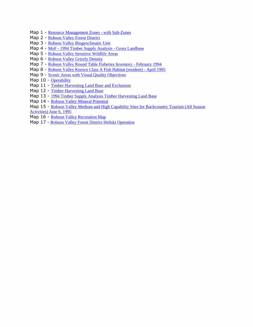
Map 1 - Resource Management Zones - with Sub-Zones
Map 2 - Robson Valley Forest District
Map 3 - Robson Valley Biogeoclimatic Unit
Map 4 - MoF - 1994 Timber Supply Analysis - Gross Landbase
Map 5 - Robson Valley Sensitive Wildlife Areas Map 6 - Robson Valley Grizzly Density
Map 7 - Robson Valley Round Table Fisheries Inventory - February 1994
Map 8 - Robson Valley Known Class A Fish Habitat (resident) - April 1995
Map 9 - Scenic Areas with Visual Quality Objectives
Map 10 - Operability
Map 11 - Timber Harvesting Land Base and Exclusions
Map 12 - Timber Harvesting Land Base
Map 13 - 1994 Timber Supply Analysis Timber Harvesting Land Base
Map 14 - Robson Valley Mineral Potential
Map 15 - Robson Valley Medium and High Capability Sites for Backcountry Tourism (All Season
Activities) June 6, 1995
Map 16 - Robson Valley Recreation Map
Map 17 - Robson Valley Forest District Heliski Operation