Embed Size (px)
Citation preview
Road Weather Information Systems (RWIS) Data Integration Guidelines
FINAL REPORT
OCTOBER 2002
Road Weather Information Systems (RWIS) Data Integration Guidelines
FINAL REPORT
OCTOBER 2002
Submitted by: Castle Rock Consultants, Inc.
6222 SW Virginia Avenue Suite 2 Portland, OR 97201
The authors, ENTERPRISE and Aurora do not endorse products or manufacturers. Trade or manufacturers’ names appear herein solely because they are considered essential to this report.

For more information about the Road Weather Information Systems (RWIS) Data Guidelines project, please contact the research team.
Project Contacts: ENTERPRISE http://enterprise.prog.org Manny Agah Arizona Department of Transportation 2302 W. Durango Street Phoenix, AZ 85009 Email: [email protected] Aurora http://www.aurora-program.org Curt Pape Minnesota Department of Transportation 395 John Ireland Boulevard – MS 722 2nd Floor South St. Paul, MN 55155-5127 Email: [email protected]
i
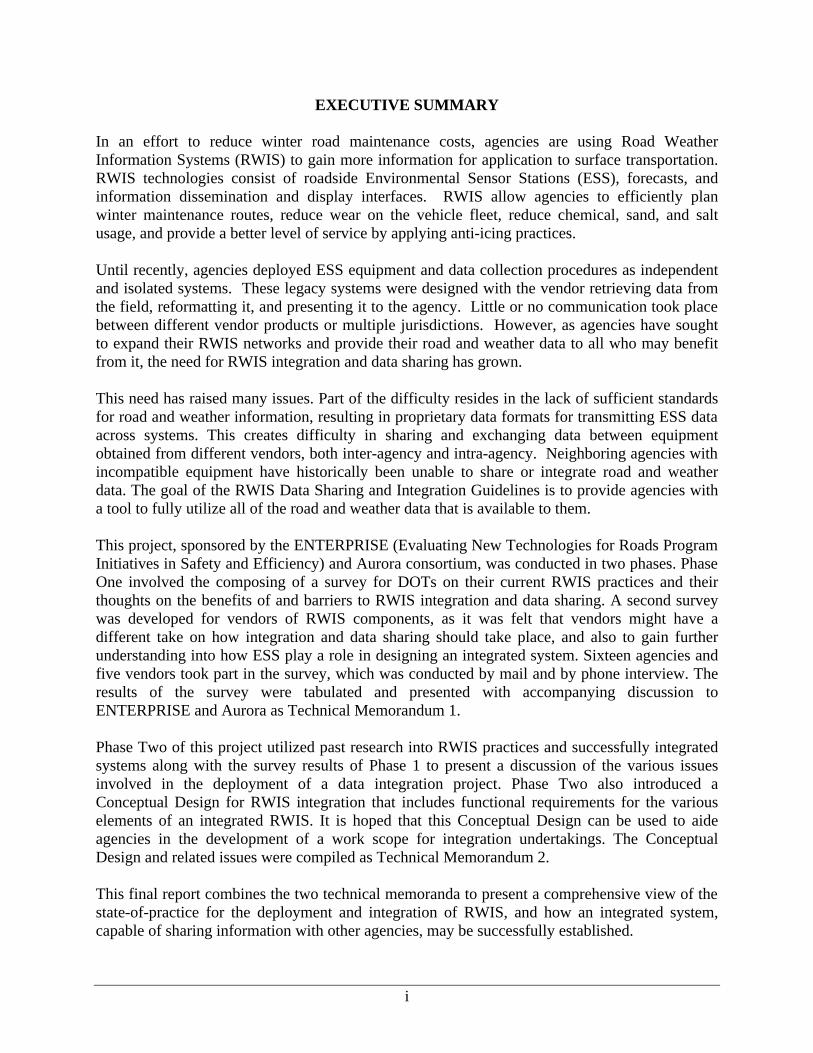
EXECUTIVE SUMMARY In an effort to reduce winter road maintenance costs, agencies are using Road Weather Information Systems (RWIS) to gain more information for application to surface transportation. RWIS technologies consist of roadside Environmental Sensor Stations (ESS), forecasts, and information dissemination and display interfaces. RWIS allow agencies to efficiently plan winter maintenance routes, reduce wear on the vehicle fleet, reduce chemical, sand, and salt usage, and provide a better level of service by applying anti-icing practices. Until recently, agencies deployed ESS equipment and data collection procedures as independent and isolated systems. These legacy systems were designed with the vendor retrieving data from the field, reformatting it, and presenting it to the agency. Little or no communication took place between different vendor products or multiple jurisdictions. However, as agencies have sought to expand their RWIS networks and provide their road and weather data to all who may benefit from it, the need for RWIS integration and data sharing has grown. This need has raised many issues. Part of the difficulty resides in the lack of sufficient standards for road and weather information, resulting in proprietary data formats for transmitting ESS data across systems. This creates difficulty in sharing and exchanging data between equipment obtained from different vendors, both inter-agency and intra-agency. Neighboring agencies with incompatible equipment have historically been unable to share or integrate road and weather data. The goal of the RWIS Data Sharing and Integration Guidelines is to provide agencies with a tool to fully utilize all of the road and weather data that is available to them. This project, sponsored by the ENTERPRISE (Evaluating New Technologies for Roads Program Initiatives in Safety and Efficiency) and Aurora consortium, was conducted in two phases. Phase One involved the composing of a survey for DOTs on their current RWIS practices and their thoughts on the benefits of and barriers to RWIS integration and data sharing. A second survey was developed for vendors of RWIS components, as it was felt that vendors might have a different take on how integration and data sharing should take place, and also to gain further understanding into how ESS play a role in designing an integrated system. Sixteen agencies and five vendors took part in the survey, which was conducted by mail and by phone interview. The results of the survey were tabulated and presented with accompanying discussion to ENTERPRISE and Aurora as Technical Memorandum 1. Phase Two of this project utilized past research into RWIS practices and successfully integrated systems along with the survey results of Phase 1 to present a discussion of the various issues involved in the deployment of a data integration project. Phase Two also introduced a Conceptual Design for RWIS integration that includes functional requirements for the various elements of an integrated RWIS. It is hoped that this Conceptual Design can be used to aide agencies in the development of a work scope for integration undertakings. The Conceptual Design and related issues were compiled as Technical Memorandum 2. This final report combines the two technical memoranda to present a comprehensive view of the state-of-practice for the deployment and integration of RWIS, and how an integrated system, capable of sharing information with other agencies, may be successfully established.
ii
TABLE OF CONTENTS 1. INTRODUCTION ........................................................................................................................................ 1
1.1 WHAT IS RWIS?......................................................................................................................................... 1 1.2 WHAT IS DATA INTEGRATION?................................................................................................................... 2 1.3 WHY INTEGRATION? .................................................................................................................................. 3 1.4 PROJECT GOALS ......................................................................................................................................... 3
2. APPROACH ................................................................................................................................................. 5 3. CURRENT PRACTICES ............................................................................................................................ 7
3.1 DATA PARAMETERS ................................................................................................................................... 9 3.2 DATA FORMATS AND NAMING CONVENTIONS ......................................................................................... 10 3.3 COMMUNICATIONS ................................................................................................................................... 13 3.4 NATIONAL STANDARDS............................................................................................................................ 15
4. DATA INTEGRATION METHODOLOGIES........................................................................................ 18 4.1 DATA INTEGRATION STATE OF THE PRACTICE.......................................................................................... 18 4.2 PERCEIVED BARRIERS FOR INTEGRATING DEVICES .................................................................................. 19 4.3.1 Data Formats ...................................................................................................................................... 24 4.3.2 Communications ................................................................................................................................. 25 4.3.3 NTCIP ................................................................................................................................................. 26 4.3.4 Software for Integration...................................................................................................................... 26 4.3.5 Security ............................................................................................................................................... 27 4.3.6 User Interfaces for Integrated Road and Weather Data..................................................................... 28 4.4 ADVANTAGES AND DISADVANTAGES TO SUGGESTED INTEGRATION ALTERNATIVES .............................. 31
5. INTEGRATED RWIS CONCEPTUAL DESIGN SPECIFICATION .................................................. 33 5.1 ESTABLISH BASELINE OF EXISTING RWIS NETWORK AND SYSTEM CONFIGURATION ............................. 34 5.2 ESTABLISH VISION FOR INTEGRATED SYSTEM ......................................................................................... 35 5.3 CENTRAL DATABASE AND SOFTWARE DESIGN REQUIREMENTS............................................................... 35 5.4 DEVELOP INTEGRATION SERVER AND DETERMINE TRANSMISSION METHODOLOGY................................ 38 5.5 GRAPHICAL USER INTERFACE DEVELOPMENT ......................................................................................... 38 5.6 PROVIDE TRAINING .................................................................................................................................. 39 5.7 DATA INTEGRATION DOCUMENTS ............................................................................................................ 40 5.8 REVISE EXISTING RWIS SPECIFICATIONS ................................................................................................ 41
6. SUMMARY AND CONCLUSIONS......................................................................................................... 42 APPENDIX A – AGENCY PARTICIPANTS AND SURVEY............................................................................. 44 APPENDIX B – VENDOR PARTICIPANTS AND SURVEY ............................................................................. 50 APPENDIX C – BRIEF GUIDE TO APPLICABLE ROAD WEATHER INFORMATION SYSTEM NATIONAL STANDARDS ..................................................................................................................................... 56
iii
TABLES AND FIGURES TABLE 1: NUMBER OF ESS BY AGENCY. ....................................................................................................................... 7 TABLE 2: ESS FIELD EQUIPMENT COMPONENTS. .......................................................................................................... 7 TABLE 3: ADDITIONAL RWIS COMPONENTS. ............................................................................................................... 8 TABLE 4: BREAKDOWN OF RWIS DATA USED BY AGENCIES. ...................................................................................... 8 TABLE 5: DATA OUTPUTS BY AGENCY........................................................................................................................ 10 TABLE 6: DATABASE FORMATS BY VENDOR/AGENCY. ............................................................................................... 12 TABLE 7: COMMUNICATIONS EQUIPMENT BY AGENCY. .............................................................................................. 13 TABLE 8: COMMUNICATION SYSTEMS WITH ASSOCIATED COSTS AND USAGE FEES.................................................... 14 TABLE 9: OPTION CONSIDERATIONS AND ISSUES FOR DATA PARAMETERS................................................................. 25 TABLE 10: COMMUNICATION CONSIDERATIONS AND ISSUES. ..................................................................................... 25 TABLE 11: NTCIP CONSIDERATIONS AND ISSUES....................................................................................................... 26 TABLE 12: CONSIDERATIONS AND ISSUES FOR INTEGRATION SOFTWARE. .................................................................. 27 TABLE 13: SECURITY CONSIDERATIONS...................................................................................................................... 28 TABLE 14: AGENCY COLOR CODES. ............................................................................................................................. 29 TABLE 15: CONSIDERATIONS FOR USER INTERFACE DESIGN. ..................................................................................... 30 TABLE 16: ESS PARAMETERS AND ATTRIBUTES. ........................................................................................................ 36 FIGURE 1: RWIS COMPONENTS. ................................................................................................................................... 1 FIGURE 2: RWIS COMMUNICATION LINKS ................................................................................................................. 13 FIGURE 3: LEVEL OF RWIS INTEGRATION BY AGENCY............................................................................................... 19 FIGURE 4: NO DATA INTEGRATION ............................................................................................................................. 21 FIGURE 5: INTERCHANGEABILITY OF DEVICES AT THE RPU LEVEL ............................................................................ 22 FIGURE 6: NTCIP COMPLIANT CPU............................................................................................................................ 23 FIGURE 7: CUSTOM DATA TRANSLATION SOFTWARE FOR INTEGRATION. ................................................................... 24 FIGURE 9: YAHOO! WEATHER ICONS .......................................................................................................................... 29 FIGURE 10: STEPS TO RWIS DATA INTEGRATION ....................................................................................................... 33
1
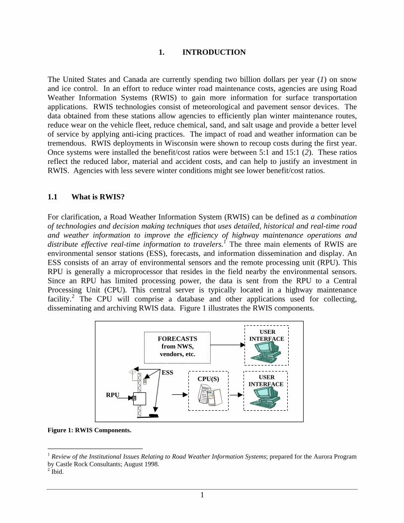
1. INTRODUCTION The United States and Canada are currently spending two billion dollars per year (1) on snow and ice control. In an effort to reduce winter road maintenance costs, agencies are using Road Weather Information Systems (RWIS) to gain more information for surface transportation applications. RWIS technologies consist of meteorological and pavement sensor devices. The data obtained from these stations allow agencies to efficiently plan winter maintenance routes, reduce wear on the vehicle fleet, reduce chemical, sand, and salt usage and provide a better level of service by applying anti-icing practices. The impact of road and weather information can be tremendous. RWIS deployments in Wisconsin were shown to recoup costs during the first year. Once systems were installed the benefit/cost ratios were between 5:1 and 15:1 (2). These ratios reflect the reduced labor, material and accident costs, and can help to justify an investment in RWIS. Agencies with less severe winter conditions might see lower benefit/cost ratios.
1.1 What is RWIS? For clarification, a Road Weather Information System (RWIS) can be defined as a combination of technologies and decision making techniques that uses detailed, historical and real-time road and weather information to improve the efficiency of highway maintenance operations and distribute effective real-time information to travelers.1 The three main elements of RWIS are environmental sensor stations (ESS), forecasts, and information dissemination and display. An ESS consists of an array of environmental sensors and the remote processing unit (RPU). This RPU is generally a microprocessor that resides in the field nearby the environmental sensors. Since an RPU has limited processing power, the data is sent from the RPU to a Central Processing Unit (CPU). This central server is typically located in a highway maintenance facility.2 The CPU will comprise a database and other applications used for collecting, disseminating and archiving RWIS data. Figure 1 illustrates the RWIS components.
Figure 1: RWIS Components.
1 Review of the Institutional Issues Relating to Road Weather Information Systems; prepared for the Aurora Program by Castle Rock Consultants; August 1998. 2 Ibid.
USER INTERFACE
CPU(S)
USER INTERFACE FORECASTS
from NWS, vendors, etc.
ESS
RPU
2
Data provided from RWIS include: • Weather data, including air temperature, amount and type of precipitation, visibility, dew
point, relative humidity, and wind speed and direction; and • Surface data, including pavement temperature, subsurface temperature, surface condition
(dry, wet, frozen), amount of deicing chemical on the roadway, and freezing point of the road surface.3
Until recently, agencies deployed ESS equipment and data collection procedures as independent and isolated systems. These legacy systems were designed with the vendor retrieving data from the field, reformatting it, and presenting it to the agency. Little or no communication took place between different vendor products or multiple jurisdictions. As agencies sought to expand their RWIS network and maximize the use of information for all who may benefit from it, there became an increased need for integration of the data collected by sensors manufactured by different vendors.
1.2 What is Data Integration? For the purposes of this study, integration can be defined as the process in which dissimilar data, devices, and systems are joined to allow for operation under one similar framework. In the case of data, integration is performed for many reasons, including improving operations efficiency, decreasing resources required to maintain a number of dissimilar systems, and providing data to end-users through one interface. An integrated RWIS is one where hardware manufactured by different vendors are able to successfully feed into one standardized system that can account for the variances in data and make the data available to multiple agencies and the general public. ESS collect information from the field, which is sent to a maintenance center, generally a highway maintenance office. The raw data is processed at remote processing units located out in the field and then sent to a central processing unit housed within a center. Once the data has been processed, the information is provided to end-users primarily maintenance and construction personnel. Some agencies disseminate road and weather information to the general public via telephone, television or the Internet. Questions that must be answered in integrating ESS data include at which level in the data processing will data be integrated and what types of data to integrate, what equipment is required to perform these functions, and communications and software requirements. The National ITS Architecture provides some guidance to this process in Market Packages relating to RWIS and weather data dissemination4. Market Packages can be thought of as miniature deployment plans that are not technology-specific. The Market Packages lay out what the system should do from a user perspective and the entities involved with the flow of information.
3 Ibid. 4 At the time of this writing, two new Market Packages are being drafted that will further address road and weather data collection and distribution.
3
1.3 Why Integration? The increasing complexity of RWIS deployed by various state agencies has raised many data sharing and integration issues. An early key problem had been the lack of sufficient standards and protocols, resulting in the development of proprietary data formats for transmitting information between the RPUs and CPUs. Now that standards have been developed and slowly adapted to, the question remains of what to do with incompatible legacy systems from different vendors. Similar to the problem of transferring files from a Mac to a PC, incompatible data formats create difficulty in sharing and exchanging data that has been obtained from different sensor manufacturers. Neighboring agencies with incompatible equipment have historically been unable to share or integrate road and weather data. It is felt that successful RWIS data sharing/integration can offer a variety of benefits: 1. Simplifies the step of gathering data from incompatible devices. 2. Minimizes the amount of hardware that must be installed and upgraded. 3. Minimizes the number of user interfaces that must be accessed and learned. 4. Provides a “free market” approach to acquiring equipment due to the ability of agencies
to procure devices from a variety of vendors. 5. Better coordination of weather related maintenance activities. 6. Better prediction of weather-related maintenance needs. Unfortunately, despite these benefits, the problem of incompatible data has made this task unduly difficult.
1.4 Project Goals The goal of the RWIS Integration project is to provide agencies with a reference for integrating and sharing road and weather information. This guide will enable the agencies to fully utilize all of the RWIS data that is potentially available to them. The project will achieve this goal through the following objectives: • Identify the level of data integration from different devices and agencies. This objective was
addressed during Phase One of this project. A total of 18 agencies and 5 vendors were contacted and interviewed regarding the current state-of-practice for data integration and sharing from their viewpoint. An analysis of their responses is presented in Technical Memorandum 1.
• Identify any standard data format for integration. The National Transportation
Communications for ITS Protocol (NTCIP) has developed a set of standards for RWIS information at the database level that may facilitate data sharing. A sample of these standards and accompanying discussion are included within this report.
4
• Identify pertinent practices in RWIS integration. A key step in conducting the research necessary for this project was the review of completed RWIS integration projects such as Mn/DOT’s Next Generation RWIS and the results of the discussions with state agencies and Mesonets5 in Phase One.
• Develop a conceptual design guideline for data exchange among various RWIS devices and
agencies. Phase One of this project involved the interviewing of both transportation agencies and ESS vendors in order to gain understanding of the current state-of-practice for data sharing and integration, as well as both groups’ thoughts on barriers to the same. It is the basis of the second phase of this project that the solution to this problem may be the development of a conceptualized design for RWIS integration.
5 A Mesonet is generally understood to be an undertaking whereby road and weather information are collected in any format from any free source; then formatted using a computer scripts, stored in a database, and output via the Internet. rWeather and MesoWest were two examples of Mesonets interviewed in Task 1.
5
2. APPROACH Phase One of the RWIS Data Sharing and Integration project investigated the current state-of-practices by interviewing users6 and vendors of ESS. The purpose of this phase was to highlight the level of data sharing and integration currently taking place. The surveys were devised to collect information pertaining to: • Current practices; • Data classification and formats; • Data integration, dissemination, and utilization; • State-of-the-practices; and • Barriers to data integration. A total of 20 agencies and 5 vendors were contacted for information regarding RWIS current practices. Of those contacted, 16 agencies and 5 vendors responded to the survey. While the number of agency respondents is relatively small, the intent of this survey was to document the variations in deployed systems and data collection procedures currently in place. The list of agencies that responded is listed in Appendix A, and vendors are listed in Appendix B. The participants were initially limited to members of ENTERPRISE, Aurora and a selection of RWIS vendors. As the survey progressed, some participants, who were initially contacted, did not respond and other participants were added to compensate. Separate surveys were developed for vendors and agencies. Both surveys went through a pre-sample process to ensure quality results. While some surveys were faxed and emailed to the respondents, approximately 75% of the survey data were obtained using twenty-minute telephone interviews. Agencies were asked detailed questions regarding ESS and level of data integration, while vendors were questioned on current capability and future development of data integration. Within the agency responses, two points of view emerged. Agencies that had sole-sourced their RWIS programs had not considered data integration an option or an issue. Agencies with multiple vendor systems expressed a desire for further integration. Phase Two of the RWIS Integration project involved researching and documenting various formats for road and weather data, means of accessing data, and previous successful integration projects to gain an understanding of the functions that a successfully integrated system must be capable of. Documents reviewed presented research on agency RWIS practices, as well as standards research and numerous agency web sites that present road and weather data online. Agencies originally contacted in Phase 1 were asked to share their methods for formatting road and weather data for presentation to the public. Phase 2 discussed considerations and issues relating to the design of an integrated RWIS and then presented several design alternatives. A conceptual design guideline was then developed.
6 Users in this case were DOT personnel responsible for high-level RWIS deployment and not the maintenance personnel who “use” the RWIS GUIs.

6
This final report combines the results of Phases One and Two to present an array of information pertaining to the deployment of an integrated RWIS, including state-of-the-practice, barriers to integration, system considerations, and finally a conceptual design that agencies can use as guidance for their own integration efforts. This integrated design approach is intended to simplify the sharing of road and weather data between agencies as well as provide suggestions and examples for streamlining the dissemination of information.
7
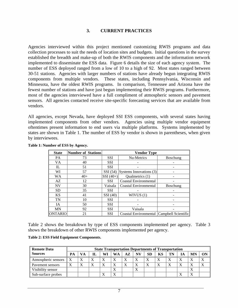
3. CURRENT PRACTICES Agencies interviewed within this project mentioned customizing RWIS programs and data collection processes to suit the needs of location sites and budgets. Initial questions in the survey established the breadth and make-up of both the RWIS components and the information network implemented to disseminate the ESS data. Figure 6 details the size of each agency system. The number of ESS deployed ranged from a low of 10 to a high of 92. Most states ranged between 30-51 stations. Agencies with larger numbers of stations have already begun integrating RWIS components from multiple vendors. These states, including Pennsylvania, Wisconsin and Minnesota, have the oldest RWIS programs. In comparison, Tennessee and Arizona have the fewest number of stations and have just begun implementing their RWIS programs. Furthermore, most of the agencies interviewed have a full compliment of atmospheric sensors and pavement sensors. All agencies contacted receive site-specific forecasting services that are available from vendors. All agencies, except Nevada, have deployed SSI ESS components, with several states having implemented components from other vendors. Agencies using multiple vendor equipment oftentimes present information to end users via multiple platforms. Systems implemented by states are shown in Table 1. The number of ESS by vendor is shown in parentheses, when given by interviewees. Table 1: Number of ESS by Agency.
State Number of Stations Vendor Type PA 73 SSI Nu-Metrics Boschung VA 40 SSI - - IL 51 SSI - - WI 57 SSI (54) Systems Innovations (3) - WA 40+ SSI (40+) Qualmetrics (1) - AZ 12 SSI Coastal Environmental - NV 30 Vaisala Coastal Environmental Boschung SD 35 SSI - - KS 41 SSI (40) WIVUS (1) - TN 10 SSI - - IA 50 SSI - -
MN 92 SSI Vaisala - ONTARIO 21 SSI Coastal Environmental Campbell Scientific
Table 2 shows the breakdown by type of ESS components implemented per agency. Table 3 shows the breakdown of other RWIS components implemented per agency. Table 2: ESS Field Equipment Components.
State Transportation Departments of Transportation Remote Data Sources PA VA IL WI WA AZ NV SD KS TN IA MN ON Atmospheric sensors X X X X X X X X X X X X X Pavement sensors X X X X X X X X X X X X X Visibility sensor X X X Sub-surface probes X X X X
8
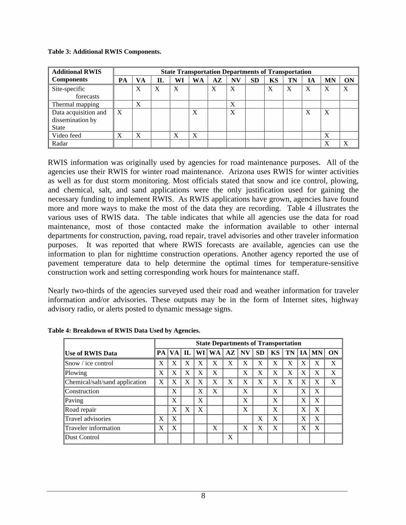
Table 3: Additional RWIS Components.
RWIS information was originally used by agencies for road maintenance purposes. All of the agencies use their RWIS for winter road maintenance. Arizona uses RWIS for winter activities as well as for dust storm monitoring. Most officials stated that snow and ice control, plowing, and chemical, salt, and sand applications were the only justification used for gaining the necessary funding to implement RWIS. As RWIS applications have grown, agencies have found more and more ways to make the most of the data they are recording. Table 4 illustrates the various uses of RWIS data. The table indicates that while all agencies use the data for road maintenance, most of those contacted make the information available to other internal departments for construction, paving, road repair, travel advisories and other traveler information purposes. It was reported that where RWIS forecasts are available, agencies can use the information to plan for nighttime construction operations. Another agency reported the use of pavement temperature data to help determine the optimal times for temperature-sensitive construction work and setting corresponding work hours for maintenance staff. Nearly two-thirds of the agencies surveyed used their road and weather information for traveler information and/or advisories. These outputs may be in the form of Internet sites, highway advisory radio, or alerts posted to dynamic message signs. Table 4: Breakdown of RWIS Data Used by Agencies.
State Departments of Transportation
Use of RWIS Data PA VA IL WI WA AZ NV SD KS TN IA MN ON
Snow / ice control X X X X X X X X X X X X X Plowing X X X X X X X X X X X X Chemical/salt/sand application X X X X X X X X X X X X X Construction X X X X X X X Paving X X X X X X Road repair X X X X X X X Travel advisories X X X X X X Traveler information X X X X X X X X Dust Control X
State Transportation Departments of Transportation Additional RWIS Components PA VA IL WI WA AZ NV SD KS TN IA MN ON Site-specific
forecasts X X X X X X X X X X
Thermal mapping X X Data acquisition and dissemination by State
X X X X X
Video feed X X X X X Radar X X
9
Data has also been used for legal purposes. One state has submitted RWIS data as evidence in a construction lawsuit brought against the state. A painting contractor claimed the job performed was completed during appropriate weather conditions and they were not to be held responsible for the paint not setting correctly. The state maintained the contractor applied the paint during weather conditions outside the paint specifications, and refused payment. The contractor filed a lawsuit against the state for nonpayment. In pretrial discovery, the state submitted RWIS data as evidence that the paint was applied at too low of a temperature. Once the RWIS data was entered into evidence, the contractor dropped the lawsuit. Other practices involving ESS data include dissemination and archival of information. ESS data can be displayed in a variety of methods. These include database format, graphs, charts, text, map and pictures. Each agency has chosen a presentation format which best suits their needs. The maintenance personnel then view information on an Internet browser. There are a variety of practices for data archival. One agency does not archive data beyond the storage capacity of the RPU, which is 3-4 months. Four agencies stored data between one to three years, with the remainder saving data indefinitely. Agencies were asked if data was shared with outside agencies. Only two reported not sharing data with anyone. These two states, Arizona and South Dakota, are currently working on developing funding to allow data sharing to take place. Most states share their data with the National Weather Service (NWS) and other state and public agencies via the Internet. The majority has real time (within 15 minutes) access to the data. Most agencies reported having no institutional issues with the practice of sharing RWIS data. However, concerns were raised over liability if the data was displayed on a website. These officials felt the public might hold the state responsible for damages; for example, if the forecast was incorrect and resulted in injury or harm to the public. However, agencies still felt that since the equipment had been paid for with tax dollars, the information should be made freely available.
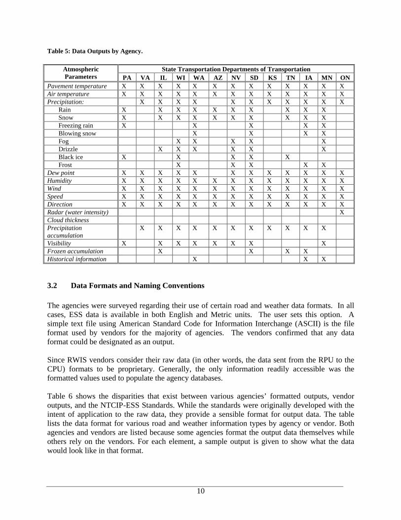
3.1 Data Parameters The fact that a variety of vendors develop ESS means that there are widespread differences in the types of data that are collected by each system. For example, of the 21 possible weather parameters displayed in Table 5, only five of these were common among the polled agencies. The five common parameters were pavement temperature, air temperature, humidity, wind speed, and wind direction.
10
Table 5: Data Outputs by Agency.
3.2 Data Formats and Naming Conventions The agencies were surveyed regarding their use of certain road and weather data formats. In all cases, ESS data is available in both English and Metric units. The user sets this option. A simple text file using American Standard Code for Information Interchange (ASCII) is the file format used by vendors for the majority of agencies. The vendors confirmed that any data format could be designated as an output. Since RWIS vendors consider their raw data (in other words, the data sent from the RPU to the CPU) formats to be proprietary. Generally, the only information readily accessible was the formatted values used to populate the agency databases. Table 6 shows the disparities that exist between various agencies’ formatted outputs, vendor outputs, and the NTCIP-ESS Standards. While the standards were originally developed with the intent of application to the raw data, they provide a sensible format for output data. The table lists the data format for various road and weather information types by agency or vendor. Both agencies and vendors are listed because some agencies format the output data themselves while others rely on the vendors. For each element, a sample output is given to show what the data would look like in that format.
State Transportation Departments of Transportation Atmospheric Parameters PA VA IL WI WA AZ NV SD KS TN IA MN ON
Pavement temperature X X X X X X X X X X X X X Air temperature X X X X X X X X X X X X X Precipitation: X X X X X X X X X X X
Rain X X X X X X X X X X Snow X X X X X X X X X X Freezing rain X X X X X Blowing snow X X X X Fog X X X X X Drizzle X X X X X X Black ice X X X X X Frost X X X X X
Dew point X X X X X X X X X X X X Humidity X X X X X X X X X X X X X Wind X X X X X X X X X X X X X Speed X X X X X X X X X X X X X Direction X X X X X X X X X X X X X Radar (water intensity) X Cloud thickness Precipitation accumulation
X X X X X X X X X X X
Visibility X X X X X X X X Frozen accumulation X X X X Historical information X X X

11
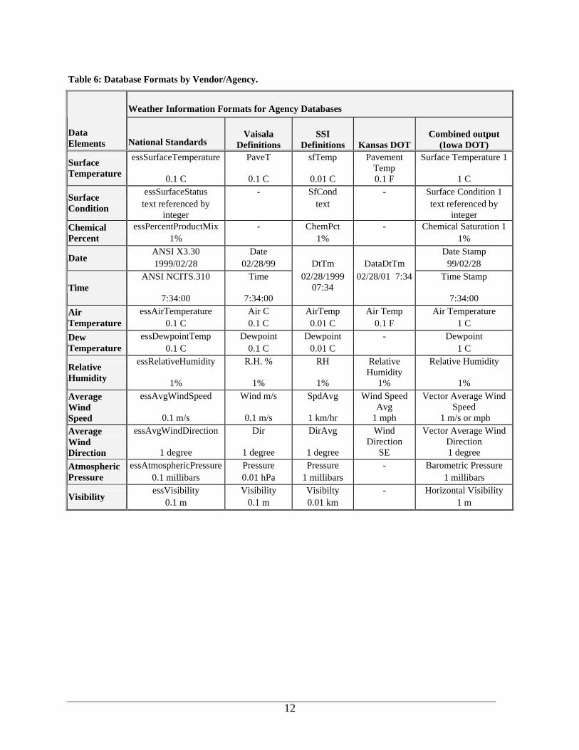
Shown in Column 2 are the NTCIP-ESS standards for the given data elements7. The NTCIP standard outputs follow a naming convention that begins with the prefix ‘ess’ for “Environmental Sensor Stations” and then follows with the full name of the element without abbreviations or spaces between words. This naming convention mirrors that for naming variables in programming code. Columns 3 and 4 show Vaisala and SSI, respectively, and serve to illustrate the differences between the vendors themselves. For example, SSI combines date and time into one element and calls it DtTm, whereas Vaisala has the two separate elements Date and Time. The two vendors also use different formats for the data and time, with Vaisala providing a column for seconds (07:34 versus 07:34:00) and SSI including the century as part of the year (1999 versus 99). Column 5 shows the Kansas DOT Web site format that is reported from SSI ESS and then output by the DOT. The format used by Kansas DOT varies significantly from SSI’s format. Kansas uses English units, which can be directly presented to users, as most users more readily comprehend these. Finally, Column 6 shows the formats as collected from the Iowa DOT web site that offers ESS information gathered from an integrated RWIS system that includes Coastal and Vaisala hardware. As with the other examples, Iowa’s integrated format differs from the other formats and the NTCIP standards. A successful data sharing and integration strategy will need to include a naming convention, format and units. A naming convention allows any user or data handler to identify information free of ambiguity. For example, the five examples given under Average Wind Speed each show a different name for the same data element. While the general meaning is arguably clear, having different names for the same measurement adds another layer to integration as two agencies sharing wind speed information would have to design some sort of program to convert the wind speed data into the format used by their system. The next component needed for compatibility is a common format for the actual reading. This allows the data to be combined with minimal effort. In Row 6, Air Temperature format varies 100-fold, from .01 to 1 C. Variations such as these can easily lead to multiplication errors resulting in the display of an incorrect reading.
7 NTCIP Object Definitions for Environmental Sensor Stations, published by the National Electrical Manufacturers’ Association, the American Association of State Highway and Transportation Officials, and the Institute of Transportation Engineers; 1998.
12
Table 6: Database Formats by Vendor/Agency.
Weather Information Formats for Agency Databases
Data Elements National Standards
Vaisala Definitions
SSI Definitions Kansas DOT
Combined output
(Iowa DOT) essSurfaceTemperature PaveT sfTemp Pavement
Temp Surface Temperature 1 Surface
Temperature 0.1 C 0.1 C 0.01 C 0.1 F 1 C essSurfaceStatus - SfCond - Surface Condition 1
Surface Condition text referenced by
integer text text referenced by
integer essPercentProductMix - ChemPct - Chemical Saturation 1 Chemical
Percent 1% 1% 1% ANSI X3.30 Date Date Stamp
Date 1999/02/28 02/28/99 DtTm DataDtTm 99/02/28 ANSI NCITS.310 Time 02/28/1999
07:34 02/28/01 7:34 Time Stamp
Time 7:34:00 7:34:00 7:34:00
essAirTemperature Air C AirTemp Air Temp Air Temperature Air Temperature 0.1 C 0.1 C 0.01 C 0.1 F 1 C
essDewpointTemp Dewpoint Dewpoint - Dewpoint Dew Temperature 0.1 C 0.1 C 0.01 C 1 C
essRelativeHumidity R.H. % RH Relative Humidity
Relative Humidity Relative Humidity 1% 1% 1% 1% 1%
essAvgWindSpeed Wind m/s SpdAvg Wind Speed Avg
Vector Average Wind Speed
Average Wind Speed 0.1 m/s 0.1 m/s 1 km/hr 1 mph 1 m/s or mph
essAvgWindDirection Dir DirAvg Wind Direction
Vector Average Wind Direction
Average Wind Direction 1 degree 1 degree 1 degree SE 1 degree
essAtmosphericPressure Pressure Pressure - Barometric Pressure Atmospheric Pressure 0.1 millibars 0.01 hPa 1 millibars 1 millibars
essVisibility Visibility Visibilty - Horizontal Visibility Visibility 0.1 m 0.1 m 0.01 km 1 m
13
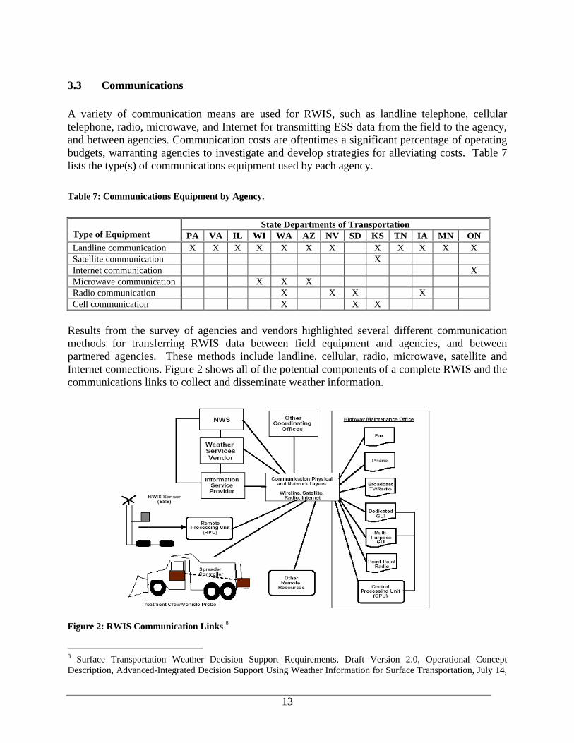
3.3 Communications A variety of communication means are used for RWIS, such as landline telephone, cellular telephone, radio, microwave, and Internet for transmitting ESS data from the field to the agency, and between agencies. Communication costs are oftentimes a significant percentage of operating budgets, warranting agencies to investigate and develop strategies for alleviating costs. Table 7 lists the type(s) of communications equipment used by each agency. Table 7: Communications Equipment by Agency.
Results from the survey of agencies and vendors highlighted several different communication methods for transferring RWIS data between field equipment and agencies, and between partnered agencies. These methods include landline, cellular, radio, microwave, satellite and Internet connections. Figure 2 shows all of the potential components of a complete RWIS and the communications links to collect and disseminate weather information.
Figure 2: RWIS Communication Links 8
8 Surface Transportation Weather Decision Support Requirements, Draft Version 2.0, Operational Concept Description, Advanced-Integrated Decision Support Using Weather Information for Surface Transportation, July 14,
State Departments of Transportation Type of Equipment PA VA IL WI WA AZ NV SD KS TN IA MN ON Landline communication X X X X X X X X X X X X Satellite communication X Internet communication X Microwave communication X X X Radio communication X X X X Cell communication X X X
14
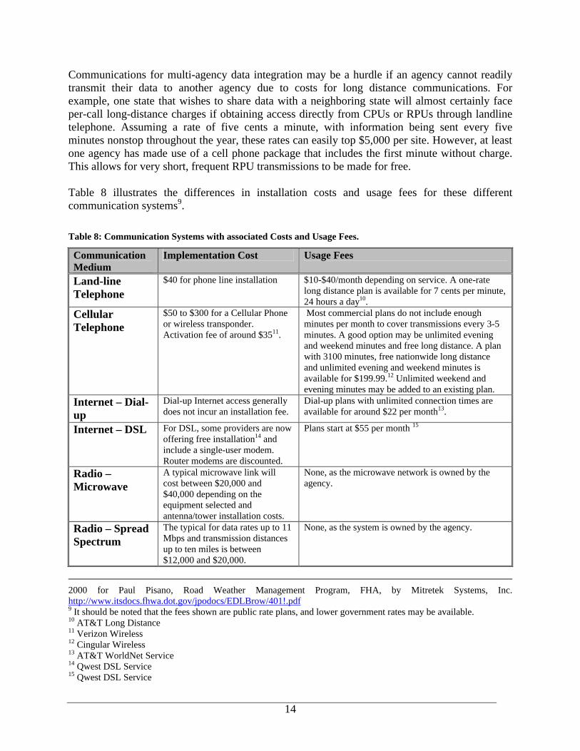
Communications for multi-agency data integration may be a hurdle if an agency cannot readily transmit their data to another agency due to costs for long distance communications. For example, one state that wishes to share data with a neighboring state will almost certainly face per-call long-distance charges if obtaining access directly from CPUs or RPUs through landline telephone. Assuming a rate of five cents a minute, with information being sent every five minutes nonstop throughout the year, these rates can easily top $5,000 per site. However, at least one agency has made use of a cell phone package that includes the first minute without charge. This allows for very short, frequent RPU transmissions to be made for free. Table 8 illustrates the differences in installation costs and usage fees for these different communication systems9. Table 8: Communication Systems with associated Costs and Usage Fees.
Communication Medium
Implementation Cost Usage Fees
Land-line Telephone
$40 for phone line installation $10-$40/month depending on service. A one-rate long distance plan is available for 7 cents per minute, 24 hours a day10.
Cellular Telephone
$50 to $300 for a Cellular Phone or wireless transponder. Activation fee of around $3511.
Most commercial plans do not include enough minutes per month to cover transmissions every 3-5 minutes. A good option may be unlimited evening and weekend minutes and free long distance. A plan with 3100 minutes, free nationwide long distance and unlimited evening and weekend minutes is available for $199.99.12 Unlimited weekend and evening minutes may be added to an existing plan.
Internet – Dial-up
Dial-up Internet access generally does not incur an installation fee.
Dial-up plans with unlimited connection times are available for around $22 per month13.
Internet – DSL For DSL, some providers are now offering free installation14 and include a single-user modem. Router modems are discounted.
Plans start at $55 per month 15
Radio – Microwave
A typical microwave link will cost between $20,000 and $40,000 depending on the equipment selected and antenna/tower installation costs.
None, as the microwave network is owned by the agency.
Radio – Spread Spectrum
The typical for data rates up to 11 Mbps and transmission distances up to ten miles is between $12,000 and $20,000.
None, as the system is owned by the agency.
2000 for Paul Pisano, Road Weather Management Program, FHA, by Mitretek Systems, Inc. http://www.itsdocs.fhwa.dot.gov/jpodocs/EDLBrow/401!.pdf 9 It should be noted that the fees shown are public rate plans, and lower government rates may be available. 10 AT&T Long Distance 11 Verizon Wireless 12 Cingular Wireless 13 AT&T WorldNet Service 14 Qwest DSL Service 15 Qwest DSL Service
15
Point-to-Point Protocol (PPP) is the standard used for NTCIP dial-up links. Interviewees noted however, that the Internet might be a more efficient and cost-effective strategy for transmitting ESS data. Since most Internet Service Providers (ISP) have local access numbers, agencies have been incorporating the Internet into the data retrieval process to reduce long-distance communications costs. One method of data retrieval is to utilize the FTP (File Transfer Protocol) to transmit data from each ESS to a central server. Authorized users from other agencies can also access this data, using FTP. FTP allows the agency to both receive and make available data more cost effectively. FTP allows systems to communicate via Internet Protocol (IP) addresses and not through cellular or landline telephone, which can result in long-distance charges as discussed above. IP addresses are assigned uniquely to each computer on the Internet, enabling a user with the right access to easily connect to the computer for purposes of exchanging information. Agencies surveyed with more than 40 stations in their network had moved from landline communications to using either microwave, cellular or radio transmission also to reduce long distance charges. States have taken advantage of these features and reduced communication costs by transmitting small amounts of data using cellular phones.
3.4 National Standards Within the Intelligent Transportation Systems (ITS) community, the movement to develop a set of national standards has begun. These efforts include the National Transportation Communications for ITS Protocols (NTCIP). Under the umbrella of NTCIP fall the Environmental Sensor Station (ESS) standards, known as NTCIP-ESS. The NTCIP-ESS standard is based on the BUFR (Binary Universal Form for the Representation of meteorological data) standard. The World Meteorological Organization (WMO) uses BUFR for standardizing data relating to meteorology, oceanography and hydrology. The NTCIP-ESS standards are designed to identify data elements such as variables, names and formats for RWIS hardware, including atmospheric and pavement sensors. While the meaning of each variable and the format in which the variable is to be displayed is defined, progress is underway to develop a message structure to define how and in which order to list variables. Vendors have historically offered a proprietary data format. With the implementation of TEA-21 (Transportation Equity Act for the 21st Century) in 1998, federal funding became contingent upon NTCIP compliance. All of the vendors contacted in this study have moved towards or are currently NTCIP compliant in their data format, with only one at 80-90% completion. An issue for vendors is that NTCIP is not a worldwide format, as it is not used outside of the United States. Several vendors cautioned that NTCIP might make integration more difficult by adding yet another data format to a field that is already overpopulated with the many proprietary formats that exist. Also, it is only necessary to comply with the “mandatory” sections of the standards in order to be considered “standards-compliant”, leaving the remainder open to interpretation. These concerns further illustrate the need for all parties to conform to a single format.

16
Another potential problem occurs with the use of numerical codes to represent message sets. NTCIP standards attempt to address this issue through agreement of standard message sets and their associated numerical codes. Appendix C provides a brief guide to applicable National standards for use in road weather information systems. The advantage of using NTCIP standard message sets and standards is that it will assist in facilitating the exchange or integration of road and weather data with other compliant ITS technologies. For example, if data is sent using a set of numbers, this information can be translated by other intelligent transportation systems technologies such as variable message signs, highway advisory radio or condition reporting systems without the addition of another integration layer. Benefits of adopting open standards based on the NTCIP include16: • Avoiding Early Obsolescence: Though it may not be practical to retrofit NTCIP support
in some old equipment, by adopting NTCIP, most vendors will offer NTCIP support in current and future products. An operating agency can ensure that its equipment remains useful and compatible long into the future by requiring NTCIP support for all future purchases and upgrades. This will include central computers and field stations for Environmental Sensor Station, traffic control, or traveler information devices.
• Providing Choice of Vendor: Once an agency has a weather information system that includes support for NTCIP, theoretically, it can buy field stations from any manufacturer offering NTCIP-compatible products. These devices would ideally communicate with the agency’s “Information Management Subsystem” (‘IMS’, typically termed CPU).
• Allowing Multijurisdictional Coordination: In the future, an agency may want to communicate with ESS devices owned by other users and/or procured from different vendors. Under NTCIP, these various devices can be added onto an existing communications channel and mixed with different types of devices on the same line.
• Using One Communications Network for All Devices: NTCIP also allows a central computer to communicate with a range of field devices on the same communications channel. For example, if a dynamic message sign is installed near an ESS, the central computer could communicate with the sign controller using the communications channel already in place for the ESS. The communications network is usually the most expensive component of a transportation management system and the use of the NTCIP maximizes that investment.
Disadvantages of NTCIP include: • Retrofitting legacy may not be practical. The cost of retrofitting legacy systems may be
much greater than the cost of upgrading or replacing with NTCIP compliant devices. Migration of legacy systems will probably take place over a number of years due to agency budgetary constraints.
• May not adequately address the issue of legacy systems. Should vendors move towards developing NTCIP compliant hardware and software, legacy systems will still remain incompatible with newer systems until agencies can fully migrate to a completely integrated network.
16 NTCIP Object Definitions for Environmental Sensor Stations, published by the National Electrical Manufacturers’ Association, the American Association of State Highway and Transportation Officials, and the Institute of Transportation Engineers; 1998.

17
• Increase cost of RWIS. Vendors will have to redesign or retool existing sensors, software, and hardware, which will come at a cost. These costs will more than likely be passed on to agencies.
• May limit value-added features of RWIS. NTCIP compliant devices may offer limited value-added or agency-specific features because previous proprietary vendor methods will now be open.
18
4. DATA INTEGRATION METHODOLOGIES The following section of this report looks at current integration practices, perceived barriers to data integration, suggested integration strategies based on research undertaken, and advantages and disadvantages to those recommended approaches.
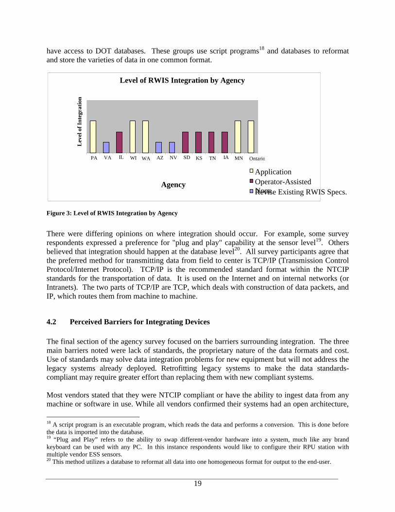
4.1 Data Integration State of the Practice Current data integration efforts undertaken by agencies interviewed within this project can be categorized accordingly: • No integration, integration not necessary; • Agency relies on human operators to consolidate several sources of data; and • Integration in place at the application level. The first level of no integration is due to the fact that the agency surveyed has implemented RWIS equipment from only one vendor. It is also possible that an agency might have equipment from several vendors and simply does not intend to integrate them. The second level, where no actual data integration takes place, requires an operator to visually compare data from multiple vendor systems using several software programs. These vendor interfaces and outside information sources such as the National Weather Service are individually evaluated for accuracy. The final level of integration is at the application level. In this design, a software application is developed that collects data either from the RPU, CPU or the vendor-specific database and outputs all information in a single display. This level requires that the format of information from each source be pre-defined to allow the system to properly interpret and display the data. Application-level integration includes database-level integration, where all data is converted into a user-defined format, stored in a centralized database, and displayed using a single user interface. The majority of the agencies contacted replied that data from different sources is currently “integrated” in some fashion. Most frequently, agencies rely on human interpretation of data from several sources. Only five of the agencies contacted actually integrate multiple road and weather data at the database or application level17. It was noted that integration at this level eliminates multiple software programs that must be operated and maintained by displaying the reformatted data with a single interface to the end user. Shown in Figure 3 is a detailed graph of the level of data integration for each state. Examples of successful integration efforts are rWeather (operated by the University of Washington and WSDOT) and MesoWest (operated by the University of Utah). These types of endeavors are commonly referred to as “Mesonets” and are able to take in and integrate data from a wide variety of sources. Mesonets accept data in any format from other agencies, which provide the data without charge. Mesonets may obtain data directly from the weather stations or
17 A software program or database takes input data from several different sources and reformats the data into one common format.
19
have access to DOT databases. These groups use script programs18 and databases to reformat and store the varieties of data in one common format.
Figure 3: Level of RWIS Integration by Agency
There were differing opinions on where integration should occur. For example, some survey respondents expressed a preference for "plug and play" capability at the sensor level19. Others believed that integration should happen at the database level20. All survey participants agree that the preferred method for transmitting data from field to center is TCP/IP (Transmission Control Protocol/Internet Protocol). TCP/IP is the recommended standard format within the NTCIP standards for the transportation of data. It is used on the Internet and on internal networks (or Intranets). The two parts of TCP/IP are TCP, which deals with construction of data packets, and IP, which routes them from machine to machine.
4.2 Perceived Barriers for Integrating Devices The final section of the agency survey focused on the barriers surrounding integration. The three main barriers noted were lack of standards, the proprietary nature of the data formats and cost. Use of standards may solve data integration problems for new equipment but will not address the legacy systems already deployed. Retrofitting legacy systems to make the data standards-compliant may require greater effort than replacing them with new compliant systems. Most vendors stated that they were NTCIP compliant or have the ability to ingest data from any machine or software in use. While all vendors confirmed their systems had an open architecture,
18 A script program is an executable program, which reads the data and performs a conversion. This is done before the data is imported into the database. 19 “Plug and Play” refers to the ability to swap different-vendor hardware into a system, much like any brand keyboard can be used with any PC. In this instance respondents would like to configure their RPU station with multiple vendor ESS sensors. 20 This method utilizes a database to reformat all data into one homogeneous format for output to the end-user.
Level of RWIS Integration by Agency
PA VA IL WI WA AZ NV SD KS TN IA MN Ontario
Agency
Lev
el o
f Int
egra
tion
ApplicationOperator-Assisted None Revise Existing RWIS Specs.
20
at the time of interviews, only Coastal Environmental Systems actually published their data format on the Internet. All of the other vendors do not freely provide this information except to customers. Four of the five vendors noted that these unpublished protocols might be a real barrier to data integration. Vendors and agencies disagreed about the level at which data should be Internet-ready. While agencies would like to see data from the RPUs already formatted, vendors felt that this would require unnecessary modifications to their equipment and that the use of a centralized server to format data was perfectly adequate. Another vendor issue was the different RWIS data needs which varied from state to state and agency to agency. For each customer, the vendor designs a system that is unique to the agency’s climate, geography and cost requirements. The vendors feel these system differences further complicate consistency and make data integration or the development of a standard format difficult. The majority of those interviewed felt that NTCIP is a good first step in reaching a solution. It was conveyed that NTCIP, when used with other mechanisms, would address some of the integration issues. However, some participants had reservations with NTCIP standards not being exactly the same as the World Meteorology Organization (WMO) standards, with regards to meteorological data. They were concerned about a reduction of accuracy in the ESS data as a result of data truncation. While adherence to NTCIP standards is perceived as part of the solution to data sharing, it was noted in one opinion that NTCIP standards are not adequate to establish data sharing at any level. Some vendors felt that since compliance with many of the data objects defined by the standards is “optional”, there is too much room for interpretation in the NTCIP standards to allow for data sharing. For example, while two agencies might use the same format for “Pavement Sensor Type”, they might differ in their format for “Pavement Temperature”. Also, it was expressed that field devices require specific “drivers” that may not be adequately addressed by NTCIP. Cost was another important factor in this equation. While agencies desired the same data format, they were hesitant to support standards at the field device level. Several interviewees voiced concerns that standardized ESS formats would increase the file size thereby increasing the overhead and bandwidth necessary for RPU transmissions. This would potentially increase the operating costs of RWIS by increasing the communication charges needed to transmit the enlarged data file. Agencies were also concerned that vendor adherence to standards could result in the increased cost of RWIS components in order to recoup research and development costs associated with format changes. Data security was another perceived barrier to RWIS integration. Data sent from the RPU are encrypted through a method that is proprietary to each vendor. The encrypted data are then sent from the RPU to the CPU. The CPU decodes the encrypted data and sends it to the agency server. The agency server then writes it to the appropriate database (after removing extraneous characters and applying appropriate formatting). 4.3 Suggested Integration Alternatives Based on current practices and reviewing successful integration methods, four alternatives were considered as approaches for the concept design of integrating ESS data. This section examines these alternatives for at what stage in the transferring of data should integration should occur.
21
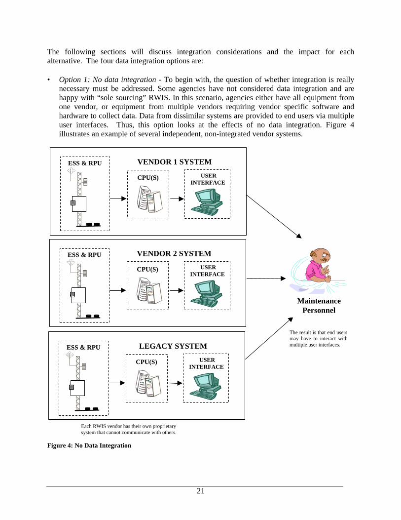
The following sections will discuss integration considerations and the impact for each alternative. The four data integration options are: • Option 1: No data integration - To begin with, the question of whether integration is really
necessary must be addressed. Some agencies have not considered data integration and are happy with “sole sourcing” RWIS. In this scenario, agencies either have all equipment from one vendor, or equipment from multiple vendors requiring vendor specific software and hardware to collect data. Data from dissimilar systems are provided to end users via multiple user interfaces. Thus, this option looks at the effects of no data integration. Figure 4 illustrates an example of several independent, non-integrated vendor systems.
Figure 4: No Data Integration
Maintenance Personnel
The result is that end users may have to interact with multiple user interfaces.
USER INTERFACE
CPU(S)
VENDOR 1 SYSTEM ESS & RPU
USER INTERFACE
CPU(S)
VENDOR 2 SYSTEM ESS & RPU
USER INTERFACE
CPU(S)
LEGACY SYSTEM ESS & RPU
Each RWIS vendor has their own proprietary system that cannot communicate with others.
22
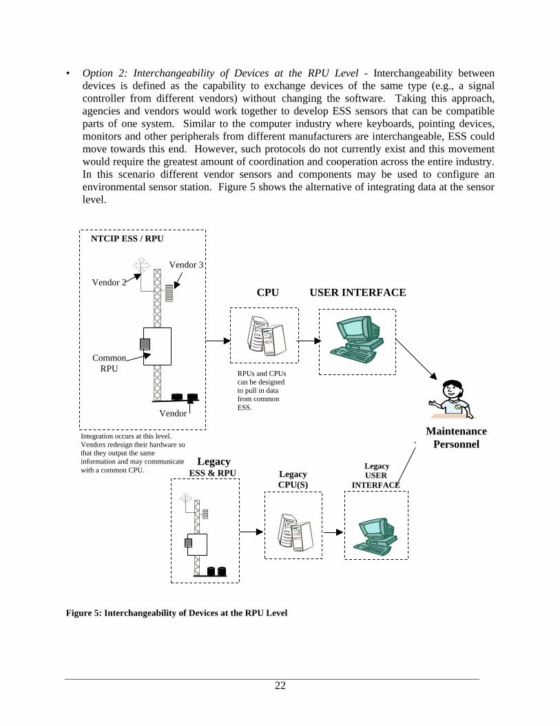
• Option 2: Interchangeability of Devices at the RPU Level - Interchangeability between devices is defined as the capability to exchange devices of the same type (e.g., a signal controller from different vendors) without changing the software. Taking this approach, agencies and vendors would work together to develop ESS sensors that can be compatible parts of one system. Similar to the computer industry where keyboards, pointing devices, monitors and other peripherals from different manufacturers are interchangeable, ESS could move towards this end. However, such protocols do not currently exist and this movement would require the greatest amount of coordination and cooperation across the entire industry. In this scenario different vendor sensors and components may be used to configure an environmental sensor station. Figure 5 shows the alternative of integrating data at the sensor level.
Figure 5: Interchangeability of Devices at the RPU Level
Vendor 3
Vendor
NTCIP ESS / RPU
Vendor 2 CPU USER INTERFACE
RPUs and CPUs can be designed to pull in data from common ESS.
Integration occurs at this level. Vendors redesign their hardware so that they output the same information and may communicate with a common CPU.
Common RPU
Legacy USER
INTERFACE Legacy CPU(S)
Legacy ESS & RPU
Maintenance Personnel
23
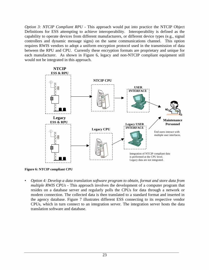
Option 3: NTCIP Compliant RPU - This approach would put into practice the NTCIP Object Definitions for ESS attempting to achieve interoperability. Interoperability is defined as the capability to operate devices from different manufacturers, or different device types (e.g., signal controllers and dynamic message signs) on the same communications channel. This option requires RWIS vendors to adopt a uniform encryption protocol used in the transmission of data between the RPU and CPU. Currently these encryption formats are proprietary and unique for each manufacturer. As shown in Figure 6, legacy and non-NTCIP compliant equipment still would not be integrated in this approach.
Figure 6: NTCIP compliant CPU
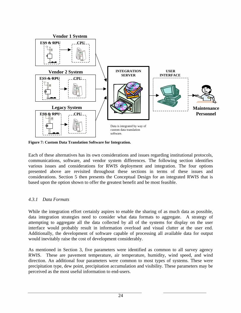
• Option 4: Develop a data translation software program to obtain, format and store data from
multiple RWIS CPUs - This approach involves the development of a computer program that resides on a database server and regularly polls the CPUs for data through a network or modem connection. The collected data is then translated to a standard format and inserted in the agency database. Figure 7 illustrates different ESS connecting to its respective vendor CPUs, which in turn connect to an integration server. The integration server hosts the data translation software and database.
USER INTERFACE
Maintenance Personnel
Integration of NTCIP compliant data is performed at the CPU level. Legacy data are not integrated.
End users interact with multiple user interfaces.
NTCIP CPU
Legacy CPU
Legacy USER INTERFACE
NTCIP ESS & RPU
Legacy ESS & RPU
24
Figure 7: Custom Data Translation Software for Integration.
Each of these alternatives has its own considerations and issues regarding institutional protocols, communications, software, and vendor system differences. The following section identifies various issues and considerations for RWIS deployment and integration. The four options presented above are revisited throughout these sections in terms of these issues and considerations. Section 5 then presents the Conceptual Design for an integrated RWIS that is based upon the option shown to offer the greatest benefit and be most feasible.
4.3.1 Data Formats While the integration effort certainly aspires to enable the sharing of as much data as possible, data integration strategies need to consider what data formats to aggregate. A strategy of attempting to aggregate all the data collected by all of the systems for display on the user interface would probably result in information overload and visual clutter at the user end. Additionally, the development of software capable of processing all available data for output would inevitably raise the cost of development considerably. As mentioned in Section 3, five parameters were identified as common to all survey agency RWIS. These are pavement temperature, air temperature, humidity, wind speed, and wind direction. An additional four parameters were common to most types of systems. These were precipitation type, dew point, precipitation accumulation and visibility. These parameters may be perceived as the most useful information to end-users.
INTEGRATION SERVER
USER INTERFACE
Data is integrated by way of custom data translation software.
Maintenance Personnel
CPU
Vendor 1 System ESS & RPU
CPU
Legacy System ESS & RPU
CPU
Vendor 2 System ESS & RPU
25
Table 9 illustrates some issues and considerations regarding the selection of data parameters for each of the four integration options. Table 9: Option Considerations and Issues for Data Parameters.
Alternatives Considerations and Issues Option 1: No data integration • Selection of data parameters is not a necessary step for
this option because integration will not occur. Option 2: Interchangeability of Devices at the RPU Level
• Selection of data parameters is not an issue for this option because all equipment will have been designed by the various vendors to output the same parameters.
Option 3: NTCIP Compliant RPU
• An issue with this option is that the custom application will only be designed to take in parameters from the existing vendor systems. Addition of a new vendor system will require a redesign of the custom application.
Option 4: Data translation software
• The flexibility of integration at the database level means that it will be a simple modification to add additional database fields for new parameters.
4.3.2 Communications In planning the communications for an integrated system, the necessary communications involve a means of connecting from the CPU to the integration layer, and then opening a connection to any neighboring agency that wishes to access to the database. An always on, low-to-medium bandwidth Internet connection for FTP file transfer or TCP/IP data transfer is a viable and low-cost option. Dial-up modems have commonly been deployed; however, the frequent dial-ups (as often as every three minutes) means that the modem is constantly in action and a more streamlined, dedicated connection would be desirable. High-speed Internet services, such as agency-owned WANs, DSL, wireless broadband or cable, modems should be considered as they have become much more affordable and with wider service areas in recent years. Below, in Table 10, are some issues and considerations regarding communications for each of the four integration options.
Table 10: Communication Considerations and Issues.
Alternatives Considerations and Issues Option 1: No data integration • Agencies may continue to use the current method of
communication. No additional costs will be incurred. Option 2: Interchangeability of Devices at the RPU Level
• May not require any change to the current method of communication.
Option 3: NTCIP Compliant RPU
• The custom application will need to be able to coordinate upload times from the field equipment so that all RPUs are polled regularly and there are no

26
Alternatives Considerations and Issues overlapping or missed connections. May have an impact on communication costs since the number of times RPUs are polled may increase.
Option 4: Data translation software
• Does not require any change to the current method of communication from field to center. Translation software will directly pull information from existing CPUs and method for doing this is to be determined.
• Consideration of which communication medium to pull from existing CPUs will be required.
4.3.3 NTCIP
At the time of this writing, standards-compliance is not as widespread as had been hoped. Compliance with NTCIP for certain data parameters is considered “mandatory” in order for a vendor to call itself “standards-compliant”. However, for those parameters where compliance is considered optional, NTCIP standards have not been widely adopted. Table 11 identifies some issues and considerations for each of the four integration options regarding the application of NTCIP-ESS standards. Table 11: NTCIP Considerations and Issues.
Alternatives Considerations and Issues Option 1: No data integration • Agencies will need to rely on vendors in order to become
standards-compliant. Option 2: Interchangeability of Devices at the RPU Level
• Data outputs from the integrated sensors should be in the standardized format. This would need to be a design requirement for the redesigned sensors.
Option 3: NTCIP Compliant RPU
• Using the NTCIP-ESS standards as a blueprint for formatting data would not unduly impact the design of the application.
Option 4: Data translation software
• Using the NTCIP-ESS standards as a blueprint for formatting data would not unduly impact the design of the software or database.
• Standards-compliance will assist in the design of the database, since the field names, data types and ranges are all provided.
4.3.4 Software for Integration In order to integrate road and weather information (e.g., pavement and environmental conditions) at the database level, it is necessary to include software that can translate the data formats of several vendors into one “universal” format. This format may then be shared between agencies
27
or simply used by the one agency in the frequent case that the agency has systems purchased from more than one vendor. The software solution can be deployed at two possible locations. In the case that the database server can connect directly to the CPUs, the software may run from the database server. If this connection is not possible, then another layer must be added to the architecture. The integration server collects the data from the CPUs and then runs the software solution to format the data before uploading it to the agency database. Below, in Table 12, are some issues and considerations regarding integration software for each of the four integration options. Table 12: Considerations and Issues for Integration Software.
Alternatives Considerations and Issues Option 1: No data integration • Translation software will not need to be developed. Option 2: Interchangeability of Devices at the RPU Level
• Translation software will not need to be developed by the agency because the vendors will have done the work of developing a standardized formatting system.
Option 3: NTCIP Compliant RPU
• Designers of the custom application will need access to the original “source code” used to format data received from the RPU. Vendors may not be forthcoming with this code.
Option 4: Data translation software
• It will not be necessary to work with proprietary code to develop this software because the data will already have been translated by the vendor CPU.
4.3.5 Security Data security is another aspect of RWIS integration. Data sent from the RPU are encrypted through a method that is proprietary to each vendor. The CPU decodes the encrypted data and sends it to the agency server. The agency server then writes it to the appropriate database (after removing extraneous characters and applying appropriate formatting). It is generally adequate to rely on the security measures provided by software vendors, such as password-protection for logging on to Windows NT, as well as password protection features in database programs such as MS SQL, Oracle or MS Access. Agencies that wish to share their data are subject to their own policies for data security. Often this means that outside agencies cannot be allowed direct access to agency files through the corporate firewall without possibly causing a security breach. Table 13 below show some issues and considerations regarding security for each of the four options.
28
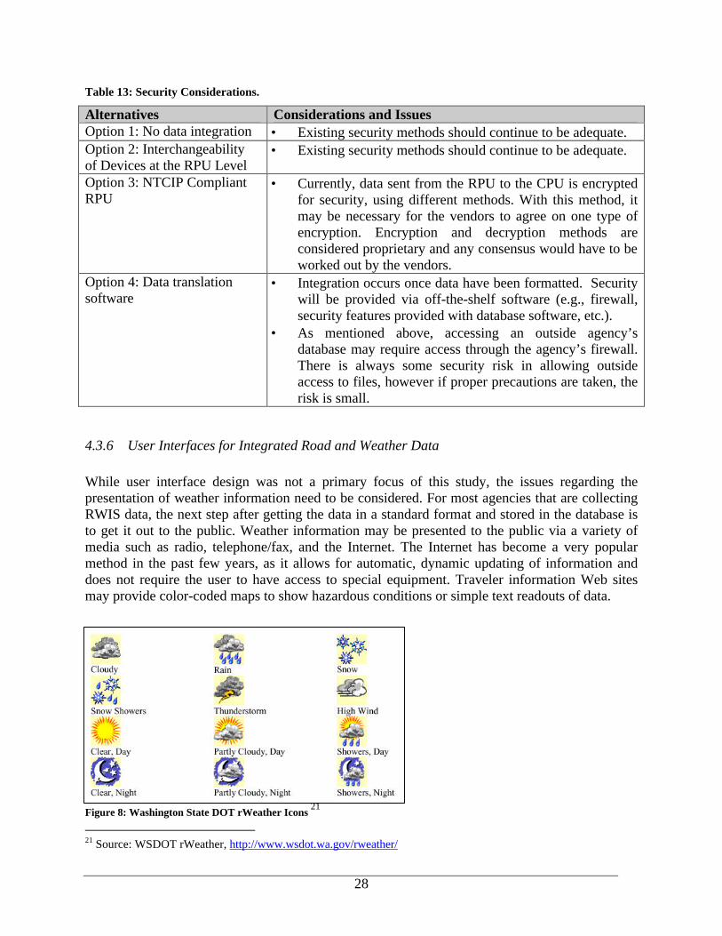
Table 13: Security Considerations.
Alternatives Considerations and Issues Option 1: No data integration • Existing security methods should continue to be adequate. Option 2: Interchangeability of Devices at the RPU Level
• Existing security methods should continue to be adequate.
Option 3: NTCIP Compliant RPU
• Currently, data sent from the RPU to the CPU is encrypted for security, using different methods. With this method, it may be necessary for the vendors to agree on one type of encryption. Encryption and decryption methods are considered proprietary and any consensus would have to be worked out by the vendors.
Option 4: Data translation software
• Integration occurs once data have been formatted. Security will be provided via off-the-shelf software (e.g., firewall, security features provided with database software, etc.).
• As mentioned above, accessing an outside agency’s database may require access through the agency’s firewall. There is always some security risk in allowing outside access to files, however if proper precautions are taken, the risk is small.
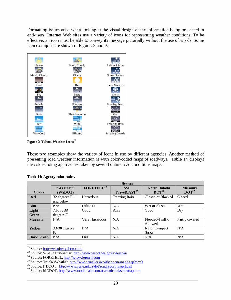
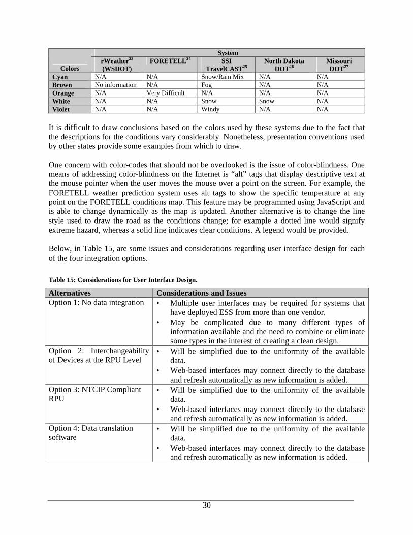
4.3.6 User Interfaces for Integrated Road and Weather Data While user interface design was not a primary focus of this study, the issues regarding the presentation of weather information need to be considered. For most agencies that are collecting RWIS data, the next step after getting the data in a standard format and stored in the database is to get it out to the public. Weather information may be presented to the public via a variety of media such as radio, telephone/fax, and the Internet. The Internet has become a very popular method in the past few years, as it allows for automatic, dynamic updating of information and does not require the user to have access to special equipment. Traveler information Web sites may provide color-coded maps to show hazardous conditions or simple text readouts of data.
Figure 8: Washington State DOT rWeather Icons 21
21 Source: WSDOT rWeather, http://www.wsdot.wa.gov/rweather/
29
Formatting issues arise when looking at the visual design of the information being presented to end-users. Internet Web sites use a variety of icons for representing weather conditions. To be effective, an icon must be able to convey its message pictorially without the use of words. Some icon examples are shown in Figures 8 and 9:
Figure 9: Yahoo! Weather Icons22
These two examples show the variety of icons in use by different agencies. Another method of presenting road weather information is with color-coded maps of roadways. Table 14 displays the color-coding approaches taken by several online road conditions maps. Table 14: Agency color codes.
System
Colors rWeather23 (WSDOT)
FORETELL24 SSI TravelCAST25
North Dakota DOT26
Missouri DOT27
Red 32 degrees F. and below
Hazardous Freezing Rain Closed or Blocked Closed
Blue N/A Difficult N/A Wet or Slush Wet Light Green
Above 38 degrees F.
Good Rain Good Dry
Magenta N/A Very Hazardous N/A Flooded-Traffic Allowed
Partly covered
Yellow 33-38 degrees F.
N/A N/A Ice or Compact Snow
N/A
Dark Green N/A Fair N/A N/A N/A
22 Source: http://weather.yahoo.com/ 23 Source: WSDOT rWeather, http://www.wsdot.wa.gov/rweather/ 24 Source: FORETELL, http://www.foretell.com 25 Source: TruckerWeather, http://www.truckersweather.com/maps.asp?hr=0 26 Source: NDDOT, http://www.state.nd.us/dot/roadreport_map.html 27 Source: MODOT, http://www.modot.state.mo.us/roadcond/statemap.htm
30
System
Colors rWeather23 (WSDOT)
FORETELL24 SSI TravelCAST25
North Dakota DOT26
Missouri DOT27
Cyan N/A N/A Snow/Rain Mix N/A N/A Brown No information N/A Fog N/A N/A Orange N/A Very Difficult N/A N/A N/A White N/A N/A Snow Snow N/A Violet N/A N/A Windy N/A N/A
It is difficult to draw conclusions based on the colors used by these systems due to the fact that the descriptions for the conditions vary considerably. Nonetheless, presentation conventions used by other states provide some examples from which to draw. One concern with color-codes that should not be overlooked is the issue of color-blindness. One means of addressing color-blindness on the Internet is “alt” tags that display descriptive text at the mouse pointer when the user moves the mouse over a point on the screen. For example, the FORETELL weather prediction system uses alt tags to show the specific temperature at any point on the FORETELL conditions map. This feature may be programmed using JavaScript and is able to change dynamically as the map is updated. Another alternative is to change the line style used to draw the road as the conditions change; for example a dotted line would signify extreme hazard, whereas a solid line indicates clear conditions. A legend would be provided. Below, in Table 15, are some issues and considerations regarding user interface design for each of the four integration options. Table 15: Considerations for User Interface Design.
Alternatives Considerations and Issues Option 1: No data integration • Multiple user interfaces may be required for systems that
have deployed ESS from more than one vendor. • May be complicated due to many different types of
information available and the need to combine or eliminate some types in the interest of creating a clean design.
Option 2: Interchangeability of Devices at the RPU Level
• Will be simplified due to the uniformity of the available data.
• Web-based interfaces may connect directly to the database and refresh automatically as new information is added.
Option 3: NTCIP Compliant RPU
• Will be simplified due to the uniformity of the available data.
• Web-based interfaces may connect directly to the database and refresh automatically as new information is added.
Option 4: Data translation software
• Will be simplified due to the uniformity of the available data.
• Web-based interfaces may connect directly to the database and refresh automatically as new information is added.
31
4.4 Advantages and Disadvantages to Suggested Integration Alternatives Each of these alternatives has a set of advantages and disadvantages. These are presented below. Following this section is the concept design for the alternative that appeared to be the most feasible in terms of current state of standards, technology available and vendor cooperation. Option 1: No data integration. Agencies would not modify their existing sole-sourced or multi-vendor systems, accepting that equipment from different vendors is not compatible. Advantages:
• No new development costs are incurred as data from different vendor systems remain separate.
• Issues and considerations facing other options are moot. Disadvantages: • May hinder the adoption of the NTCIP-ESS standards. • Maintains the status quo of multiple user interfaces for multiple ESS vendors as each
vendor has their own means of presenting and manipulating the collected data. • Agencies forced to purchase equipment from the same vendor to maintain single user
interface. • Agencies deploying different vendor systems will require multiple RPUs and CPUs for
each, thus increasing the effort to operate and maintain separate systems.
Option 2: Interchangeability at the sensor level. Sensors now on the market would be redesigned to act as “plug and play” components for ESS as agreed upon by the agencies and vendors. The collected data would be formatted per NTCIP standards for ESS.
Advantages: • May allow for “plug and play” compatibility. Agencies could purchase sensors from
different vendors and “plug” them into the existing system, much as any brand of computer keyboard may be plugged into any brand of desktop unit.
• Places responsibility for integration in the hands of the vendors. • NTCIP standards have been presented to the ITS community as intended for
implementation at the RPU server level. Disadvantages: • Would take the most time and negotiations to implement, as it would call for all
manufacturers of ESS to sit down and agree to modify their products to work identically. • Vendors would essentially give up any value-adding features that may have served to
give them an edge on the market. • Legacy systems would not be compatible with the new integrated sensors. • Retrofitting legacy systems could be costly and labor intensive. • Developing “plug and play” ESS components may come at great costs to manufacturers.
32
Option 3: Vendors to develop NTCIP compliant RPUs. This option would allow for uploading data from multiple-vendor RPUs, as all RPUs would send NTCIP compliant data
Advantages: • Places onus on vendors to be NTCIP compliant and eliminates proprietary encryption
formats. • Would eliminate the need for multiple-vendor CPU interfaces, if encryption protocols
were uniform and not proprietary. • Once developed, other agencies would be able to adopt the application into their own
systems. Disadvantages: • Agencies would need to wait for all vendors to become NTCIP-compliant before
integration can occur. • Would necessitate considerable cooperation between vendors as the data sent from the
RPU to the CPU is encrypted by a means proprietary to each vendor, as is the format of the data once it has been decrypted. Currently NTCIP compliant data are being wrapped in proprietary encryption formats.
• Agencies most likely would not be able to undertake this project independently. • Legacy equipment and other equipment not NTCIP compliant would not be integrated,
therefore still requiring multiple CPUs and user interfaces.
Option 4: Develop custom software application based on NTCIP standards to facilitate data integration at the database level. Data received by any CPU (whether NTCIP compliant or not) would be formatted and inserted in the agency database.
Advantages:
• Uses NTCIP-ESS standards and design parameters for data format, database and transportation procedures.
• Agencies can mandate vendor compliance to NTCIP data structure via the RFP process. • Agencies would not have to rely on vendors to make changes to products before
integration, nor does it rely on vendors redesigning proprietary encryption methods. • Easily adaptable to include new data parameters if they should become available. Data
from other sources may be added (e.g. other states, agencies, and legacy equipment). • Consolidated user interface for road and weather data regardless of vendor system. • Addresses legacy issues until vendor RPU outputs are NTICP-compliant. • Is a proven approach (e.g. VDOT).
Disadvantages: • Does not eliminate the problem of multiple CPUs. • Agencies most likely would not be able to undertake this project independently.

33
5. INTEGRATED RWIS CONCEPTUAL DESIGN SPECIFICATION The integration options presented previously noted a range of alternatives. Clearly, the “no integration” option is not a consideration for the conceptual design since it is not a relevant choice for this project. Option 2 would be difficult to accomplish at this point in time, and places the greatest burden on vendors to reconfigure their existing systems. While ultimately, the adoption of NTICP standards and methods would be ideal for departments of transportation, vendors have not completely accepted these standards to date. Option 3, the NTCIP Compliant RPU, specifically identifies an approach that which would fully embrace NTCIP standards, however, does not account for legacy systems. The option that best meets the need for both standards compliancy in the present and future, and the issue of legacy systems is Option 4. Following is a conceptual design specification for an integrated road and weather data sharing effort based on Option 4 – developing data translation software for integration. Suggested integration steps for the concept plan include: • Developing an understanding of agency-specific data integration needs; • Establishing vision for integrated system; • Defining information access and structure; • Defining database requirements including database structure and data input formats; • Defining data server and transmission code; • Developing graphical user interfaces; • Providing format specifications for sharing data and potential export to other ITS devices; • Develop training program; and • Documentation of entire process, including operations and maintenance procedures. Some steps will overlap while others must be completed before moving on. A suggested project flow is outlined in Figure 10:
Figure 10: Steps to RWIS Data Integration
Develop RWIS Data Export
Format Specs
Define Database Requirements
Develop Data Server and Transmission
Code
Understanding Baseline System
Revise Existing RWIS Specs
Develop Graphical User Interface Training
Document Entire Integration Process (Ongoing)
Establish Vision for Integrated
System
34
5.1 Establish Baseline of Existing RWIS Network and System Configuration The primary goal of this activity is to ensure that data integration tasks undertaken will consider the overall RWIS program. This task may include studying the existing ESS installations of the region, state or area in order to develop a complete understanding of data collection, processing, communications, storage, and dissemination procedures; and to understand the constraints related to integration among different vendors’ systems. The following baseline information should be gathered:
A. Gather sensor statistics i. Number of sensors to be integrated. ii. How these sensors are currently working together. iii. Process for adding new sensors to the network.
B. Determine existing communications
i. Existing methods for field-to-center and center-to-center communications. ii. Determining whether existing communications methods will be adequate for
integration or additional systems will be required. iii. Costs associated with current/new communications systems. iv. System characteristics where applicable: v. Performance (bandwidth); vi. Configuration; vii. Reliability; viii. Redundancy; ix. Security risks and mitigation strategies; x. Expansion capability; xi. Geographic availability; and xii. Manufacturer and provider supportability.
C. Gather sensor data
i. Data parameters being collected. ii. Frequency for which data is collected. iii. How data is currently being used and by whom. iv. Current method(s) for data archival and how/if it can be accessed remotely. v. Determine the data parameters that need to be shared.
D. Determine RWIS network software
i. Commercial software applications currently in use. ii. Any custom applications that are being used and whether they can be expanded for
the integration effort. iii. Key functions of software. iv. Analysis of upgrade ability. v. Analysis of potential for third party integration. vi. Analysis of software security.
35
vii. Analysis of maintenance requirements. viii. Analysis of warranty and support contract policies of major manufacturers.
E. Determine RWIS hardware
i. Analysis of current methods used to add new hardware to the network. ii. Documentation of any plans to purchase additional software in the near future. iii. Document the following attributes where applicable: iv. Reliability (level of redundancy); v. Storage capacity (memory size, disk size); vi. Expandability; vii. Performance capabilities (processor speed, i/o throughput, message throughput); viii. Connectivity capabilities (openness, number of slots, network); ix. Potential for third party integration; x. Security; xi. Maintenance requirements; xii. Warranty and support contract policies of major manufacturers; and xiii. Familiarity of IT staff with this technology.
5.2 Establish Vision for Integrated System After a thorough consideration of what the existing systems are capable of, a vision of the successful integrated system must be compiled. An example vision could include the following elements:
A. Be capable of wireless transmission; B. Minimize or eliminate long-distance charges that can be an issue with landline or cellular
telecommunications; C. A standardized, multi-platform-compatible solution; D. Secure, with minimal risk for malicious activity; E. Adaptable to multiple platforms, such as Internet and 5-1-1 systems; and F. Consider both the short and long term, as current methods may be perfectly adequate for
the time being, but emerging technologies may provide more of a standard in data sharing.
5.3 Central Database and Software Design Requirements The database design stage requires careful thought into the functional and informational needs of the end users and therefore is a crucial task in an RWIS data integration project. The central weather and road database design consists of the following tasks: • Determining data parameters to be shared; • Developing the database structure; • Defining input data formats; and • Developing central weather and road database software.
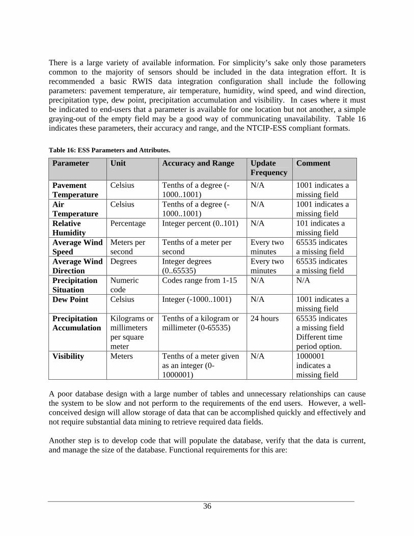
36
There is a large variety of available information. For simplicity’s sake only those parameters common to the majority of sensors should be included in the data integration effort. It is recommended a basic RWIS data integration configuration shall include the following parameters: pavement temperature, air temperature, humidity, wind speed, and wind direction, precipitation type, dew point, precipitation accumulation and visibility. In cases where it must be indicated to end-users that a parameter is available for one location but not another, a simple graying-out of the empty field may be a good way of communicating unavailability. Table 16 indicates these parameters, their accuracy and range, and the NTCIP-ESS compliant formats.
Table 16: ESS Parameters and Attributes.
Parameter Unit Accuracy and Range Update Frequency
Comment
Pavement Temperature
Celsius Tenths of a degree (-1000..1001)
N/A 1001 indicates a missing field
Air Temperature
Celsius Tenths of a degree (-1000..1001)
N/A 1001 indicates a missing field
Relative Humidity
Percentage Integer percent (0..101) N/A 101 indicates a missing field
Average Wind Speed
Meters per second
Tenths of a meter per second
Every two minutes
65535 indicates a missing field
Average Wind Direction
Degrees Integer degrees (0..65535)
Every two minutes
65535 indicates a missing field
Precipitation Situation
Numeric code
Codes range from 1-15 N/A N/A
Dew Point Celsius Integer (-1000..1001) N/A 1001 indicates a missing field
Precipitation Accumulation
Kilograms or millimeters per square meter
Tenths of a kilogram or millimeter (0-65535)
24 hours 65535 indicates a missing field Different time period option.
Visibility Meters Tenths of a meter given as an integer (0-1000001)
N/A 1000001 indicates a missing field
A poor database design with a large number of tables and unnecessary relationships can cause the system to be slow and not perform to the requirements of the end users. However, a well-conceived design will allow storage of data that can be accomplished quickly and effectively and not require substantial data mining to retrieve required data fields. Another step is to develop code that will populate the database, verify that the data is current, and manage the size of the database. Functional requirements for this are:
37
A. Design central database i. Capable of pulling in ESS data regardless of the sensor’s manufacturer. For example,
data shall be transmitted as files, which can be easily interpreted and formatted by the integration software and easily inserted in a database.
ii. Easily accommodate the addition of future sensors to the network New sensors, stations, and road and weather parameters may be easily added to the database.
iii. Database size shall be set to not exceed 1 GB in the interest of moderating search, insert and sort speeds.
iv. Each ESS site shall have its own table in the database for purposes of organization and also to moderate access speed, as one giant table is clearly more cumbersome than several small ones.
v. Database backup plan shall be established at the beginning of the design process. Backup plans will vary according to agency needs and policies. One large database stored on one server is vulnerable to server crashes and hard disk failures. Options for backup include mirroring the database on another server.
vi. Database backup plan shall include the formatted database, the CPU files, and the transaction logs.
vii. Data in the real-time database shall not be more than one month old. After this time, the database shall allow for archiving data. For example, data shall allow for automatic archival to a second database holding several months’ worth of data for study as needed, and perhaps finally retired to storage on CD-ROM or tape.
B. Define data output formats
i. Compliant with NTCIP-ESS standards. This effort is leading the way towards developing consistent variable field names, formats and variable limits in the Environmental Sensor Station area. Although the standards were originally proposed for application at the sensor level, sensor vendors are not yet fully compliant, resulting in the need for agencies to take on this initiative themselves.
ii. Non-proprietary. While this requirement may seem obvious, the frequent use of proprietary data formats has hindered data integration efforts.
iii. Data output formats shall be properly documented.
C. Define data formatting and develop translation script i. Poll the CPU(s) at regular, user-defined intervals to collect the data. ii. Translate the data collected from the CPU(s) into the integrated format; and write this
data to the central database. iii. Verify that new data collected is a true update of the database, so users will be able to
obtain the most recent weather information available. iv. Acknowledge when new data is available and then either retain, archive or delete
older data to ensure the central database remains functional and that its size is managed.
v. Allow for modification in the instance that additional vendor hardware is added to the system and the code is required to translate another data format.
vi. Open-source and non-proprietary.

38
The functionality of the database management component of the program will need to be investigated by agencies to determine the system functionality needed to satisfy end-users. Users may require the ability to view the data for an earlier time of the day or a previous day that week for a given site to be able to determine pavement temperature trends and the potential for icing or frost formation. In Phase 1, agencies mentioned a variety of diverse uses for RWIS data, including construction management uses such as the tracking of workdays (days when the weather had been conducive to outdoor work) for contractors.
5.4 Develop Integration Server and Determine Transmission Methodology In developing a data server, there are several alternative designs that can be implemented. These alternatives include transmitting flat files by FTP, creating a dedicated client/server environment, and using standard Open DataBase Connectivity (ODBC) specifications to run queries on the remote databases and populating the central database with the results. The following are the functional requirements for determining the appropriate transmission methodology:
A. Design integration server i. Have common operating system that is compatible with all other software that will
need to be run from that location. ii. Comply with agency’s regulations for network security. iii. Able to communicate with remote equipment via the protocol (for example, FTP,
ODBD/SQL database connection, TCP/IP) used by the agency. B. Determine transmission methodology
i. Work with devices initiating data transfer. In this design, the integration software will poll the CPUs as a function of the software.
ii. Accommodate defined data formats (for example, CSV, SQL queries to database or custom data formats).
iii. Accommodate communication methods used for data transfer (for example, FTP transfer, SQL database connection or custom code using TCP/IP sockets).
iv. Compatible with integration server and remote equipment. v. Utilize common technologies and protocols, in the interest of easing expansion and
access by other agencies.
5.5 Graphical User Interface Development The suggested graphical user interface is Internet-based. One advantage of an Internet-based GUI is that it only requires an Internet browser for viewing information. Internet browsers are free, and the latest version of the most popular browsers (Internet Explorer and Netscape) can be downloaded over the Internet. Further, the Internet GUI allows for virtually limitless numbers of users to access information at one time. Information can be accessed from anywhere with an Internet, either dial-up or dedicated, connection. The graphical user interface may be developed with consideration of the following functional requirements:

39
A. Design content, flow, and user interface i. Allow maintenance end users to access all pertinent road and weather data from one
user interface. ii. Provide both static and dynamic information based on user request. iii. Allow straightforward navigation of the site and allow users to obtain the information
with the least amount of effort. iv. Streamline design to allow for access to information via a dial-up modem. v. If color-coded maps are used to indicate road conditions, the user interface shall be
developed using a convention similar to other presentation formats used by other transportation agencies. For example, red indicates hazards, yellow indicates use caution and green indicates clear conditions.
vi. If icons are used to present weather information, the user interface shall be developed using a consistent set easily recognizable by end users. For example, weather icons shall not need to use words to convey their meaning and shall be graphically optimized for Internet display.
B. Determine user authorization and security
i. The Web site shall be password-protected if it is not open to the general public. ii. The latest virus software shall be installed on the server and updated regularly. iii. Firewalls used shall need to comply with these security standards. i. Shall a data be accessible to the public, the web site shall preserve security features
while allow access through the firewall.
C. Develop Web site i. The web site development process shall consist of developing at least one prototype
web site to allow for end users to provide design input and feedback. The prototype Web site may use either real or “dummy” data; however it shall be fully functional as a “done” site.
ii. Adhere to any agency standards for web development iii. Comply with federal guidelines for access by people with disabilities. iv. A disclaimer shall be posted prominently in adherence to any agency or state
requirements regarding accuracy or misuse of information on the web site.
5.6 Provide Training Training is another important consideration in the design of an integrated RWIS. Training allows for proper buy-in to new technologies and allows for sufficient familiarization with new solutions before a system goes “live.” It is important that users understand the proper procedures for using the system, as well as the limitations and capabilities of the system. Any unexplained portions of the system may lead to confusion during operation, and ultimately mistrust of the system.

40
It is recommended that in the development of training classes, the following guidelines are considered28:
A. Determine class structure i. Training session size shall be no more than 25 people, suggested size no more than 15
and optimally no more than 10. Smaller size encourages people to speak up if they are confused and allows for the instructor to tailor the class more to individuals.
ii. Minimum training time shall be 4 hours, optimally 6-8 hours shall be planned with adequate breaks.
B. Determine classroom setup
i. At a minimum, one computer running the system shall be present for demonstration purposes. Ideally, each participant has their own workstation.
C. Design learning materials
i. Handouts shall minimally include the instructor’s contact information and a synopsis of the points to be covered. Ideally, a brief user’s manual shall be developed and distributed in advance of the class. It is also recommended that “cheat sheets”, small laminated summaries of the most common system tasks, be developed and distributed at the end of class.
ii. Student exercises shall include a variety of real-world tasks, and include troubleshooting.
5.7 Data Integration Documents A task that needs to be undertaken throughout the entire design process is to ensure that the integration process is properly documented. At a minimum, documentation shall include design, software, and troubleshooting documents.
A. Develop design documents i. The data integration process shall be properly documented. ii. Design requirements shall be thoroughly detailed before any actual design work will
take place. iii. The design document shall detail steps to take to allow for adding of additional ESS
sensors in the future. B. Develop software documentation
i. Manuals shall be developed to document the software development process. ii. The database structure, field names, data types and descriptions shall be documented. iii. The communications protocols and equipment utilized shall be documented.
28 Adapted from the Electronic Information Sources Guidelines for Training Sessions. Written by the Committee on Education, Training, and Support, Reference and Adult Service Division, Machine-Assisted Reference Section.
41
C. Develop troubleshooting documents i. Documents shall be developed to assist end users in general use and troubleshooting
the system. For example, once the data structure for the integrated RWIS has been documented, these requirements can be used by agencies for future procurement of devices. Documented operating and maintenance procedures will also prove useful to end-users and for troubleshooting problems.
5.8 Revise Existing RWIS Specifications As additional ESS are installed, it is necessary to take steps to ensure that the system specifications will make any additional sites compatible. These specifications will aide the agency in future equipment procurements. In order to accomplish future site compatibility, the specifications will need to be reviewed and modified. As part of this review, the following topics shall be addressed:
A. Develop or revise existing specifications to ensure that future data from future RWIS components will be consistent with integrated system i. Include a means of ensuring that the quality of the data offered by the Internet site is
maintained, and ensuring that future ESS purchases may allow data to be integrated with the current system (e.g., future ESS will not require a separate user interface for viewing data). Revising existing RWIS specifications will be assisted by the earlier design work, if the capability to add additional ESS is built into the original program software.
ii. Document specification modifications. This may include specifying the output data stream, the format for data output, and data range parameters that will be used during the quality control processes of the system.
42
6. SUMMARY AND CONCLUSIONS By developing a program to integrate road and weather data, agencies can avoid “information overload” of redundant or duplicative data collected from multiple sources. Integration also eliminates the need for agencies to purchase and maintain separate systems. State agencies identified several issues that need to be resolved in order to facilitate data integration. These include: 1. Data Truncation - A concern of participants involved was that the precision and accuracy of
meteorological data might be lost as a result of data truncation. Some users indicated that if a sensor provided readings to the hundredth of a degree, they would be concerned that any standard may result in only values to the tenth of a degree being provided.
2. Communication Costs - Some officials felt NTCIP would add overhead and thus increase the size of the data packets needed for data retrieval. The larger file would increase the communication costs involved in operating the ESS stations.
3. Legacy Systems - Concerns with legacy systems in place involved the cost to upgrade existing equipment to become NTCIP compliant. The ability to develop a means of integrating data without the need for costly upgrading or retrofitting equipment was perceived as desirable.
4. Proprietary Issues - Each vendor has a unique data format, which is only read by the equipment of the same vendor. There is reluctance from the vendors to share data formats with other vendors making integration of equipment from multiple vendors difficult.
5. Firewall Security - Agencies were interested in sharing their ESS data with other users, such as neighboring states, police departments, traveler and visitor information sites; however, many agencies have their data behind a firewall. The development of potential solutions to allow the data to be shared without losing system security is required.
6. Liability – There were concerns regarding making the ESS data available to the public and other users who may not understand or may misinterpret the data. The potential for liability issues arising from the misuse of the information was a concern to some agencies. Other agencies felt the need to provide accurate road and weather information to the public outweighs liability issues.
Vendors provided several additional issues that affect the ability of data to be integrated. The first was with regards to contract specifications. Several vendors indicated that contract specifications often included system or sensor requirements that do not affect performance of the sensor, such as size or shape. The specifications would be more useful if they identified performance requirements for the system and/or sensors. The second issue involved a lack of consensus between states on a common format. This includes both the data format as well as the presentation format. Vendors also indicated that the more customized a state makes their system; the harder it is to integrate it with others. Based on the research performed, several levels at which data integration can occur were suggested. These included: 1. No data integration; 2. Interchangeability of Devices at the RPU Level ;
43
3. Integration through the use of a NTCIP Compliant RPU; or 4. Integration at the database level using custom data formatting software. This document focused on the fourth option as the most feasible and efficient, and provided a Conceptual Design for road and weather data integration at the database level. The NTCIP-ESS Standards provide a nationally recognized and supported format for data exchange at the field device, communications, and server level of integration. The NTCIP-ESS Standards also provide accepted naming conventions and numerical representation of road condition message sets. For agencies that wish to share their data with neighboring regions, standards-compliance eases the process by providing an accepted format for sensor data. The standards are also helpful for agencies that are collecting data from sensors manufactured by different vendors. Several vendors are working on increasing their levels of standards-compliance, and it is hoped that these efforts will broaden the standards’ acceptance. Few survey participants believed that the use of the NTCIP-ESS standards effort alone could achieve a satisfactory end, though NTCIP-ESS coupled with other solutions could address the many integration issues. Cost was a paramount concern in developing solutions to road and weather data integration. States will require that the cost of integration be not prohibitive to facilitate the expansion of their RWIS program. The solutions must also incorporate data from legacy systems and minimize the cost associated with these existing deployments. Such solutions could include integration at the sensor, database or application level. Several states have taken on the task of creating an integration strategy that meets their needs, including Virginia and Idaho. These efforts include hiring a third party to create a graphical user interface (GUI) to view data, developing a database, which will reformat multiple vendor data formats into one common format, and finally, stipulating data compatibility in procurement contract documents. The recommended solution for viewing integrated data is Internet-based. The Internet allows for the information to be accessed by a very high number of people at one time and from anywhere in the world. The involved agencies will need to develop the look and feel of the site, through storyboards or actual graphic mockups and determine user access and security practices. A prototype Web site should be tested with a sample audience to determine whether it meets its usability objectives. Throughout the data integration process, the involved agencies will want to thoroughly document both any known or expected changes to the RWIS specifications, as well as the integration process as a whole. This information will be extremely useful not only to other agencies embarking on similar projects but also in working with vendors to determine how new devices will fit in to the existing architecture. In conclusion, the effort to integrate road and weather data, while perhaps initially arduous, is a viable project that can have long-reaching benefits for agencies, end-users, and the RWIS industry as a whole.

44
Appendix A – Agency Participants and Survey PARTICIPANTS: A. Alfred Uzokwe, P.E., PennDOT B. Daniel Roosevelt, VDOT (obtained info from RWIS coordinator) C. Harold Dameron, IDOT D. Mike Adams, WisDOT E. William Brown, RWIS Project Manager, WSDOT F. John Harper, ADOT G. Rick Nelson, NDOT H. Mark King, Operations Support, SDDOT I. Peter Carrtar - KDOT J. Joe Holt - TDOT K. Dennis Burkheimer, IaDOT L. Curt Pape, Mn/DOT M. Paul Zimmerman, Ontario Ministry of Transport N. Leon Osborne, University of North Dakota O. Cliff Mass, University of Washington, rWeather P. John Horel, University of Utah, MesoWest

45
Agency Survey – RWIS Data Integration and Exchange
Name_______________________________________________________________________ Agency______________________________________________________________________ General Information 1. How many RWIS stations does your state currently operate? System Types 2. Does your RWIS network consist of more than one vendor? If so, please explain. 3. What equipment or services do your RWIS stations include? Please check all that
apply:
Yes No Type of Equipment Atmospheric sensors Pavement sensors Site-specific forecasts Other weather information. Please specify: Communications. Please specify type: Landline Satellite Internet-based (e.g., telephone with a dedicated Internet Protocol address) Microwave Other, please specify: Thermal mapping Data acquisition and dissemination Video feed Other, please specify:
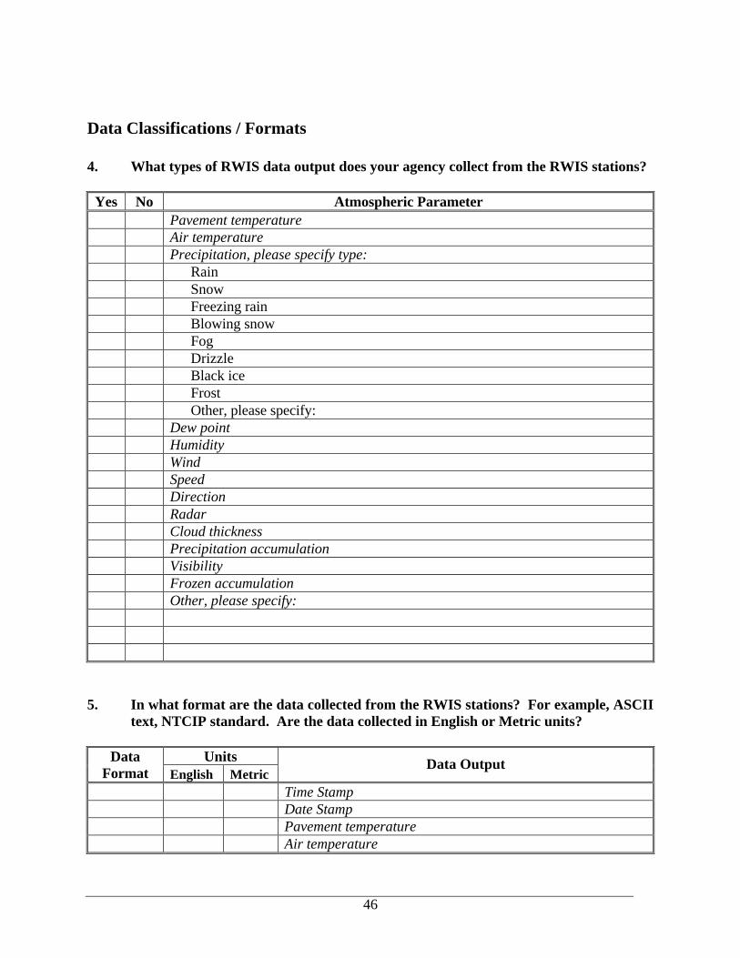
46
Data Classifications / Formats 4. What types of RWIS data output does your agency collect from the RWIS stations?
Yes No Atmospheric Parameter Pavement temperature Air temperature Precipitation, please specify type: Rain Snow Freezing rain Blowing snow Fog Drizzle Black ice Frost Other, please specify: Dew point Humidity Wind Speed Direction Radar Cloud thickness Precipitation accumulation Visibility Frozen accumulation Other, please specify:
5. In what format are the data collected from the RWIS stations? For example, ASCII
text, NTCIP standard. Are the data collected in English or Metric units?
Units Data Format English Metric
Data Output
Time Stamp Date Stamp Pavement temperature Air temperature
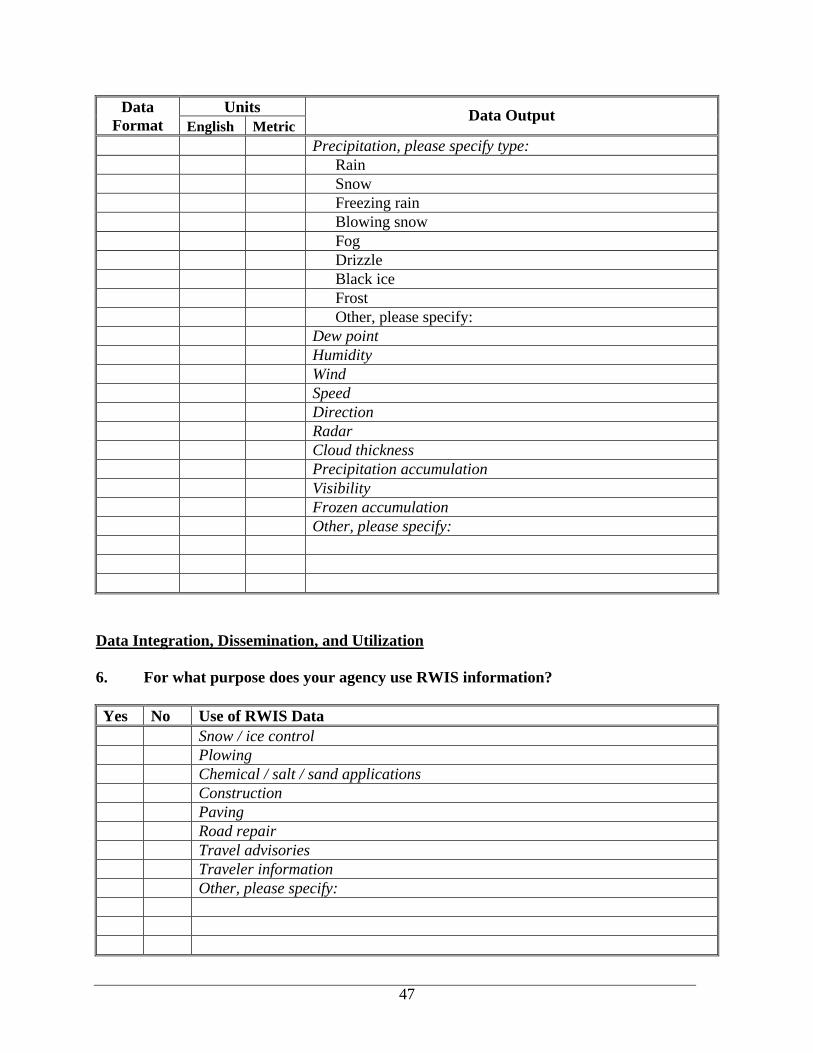
47
Units Data Format English Metric
Data Output
Precipitation, please specify type: Rain Snow Freezing rain Blowing snow Fog Drizzle Black ice Frost Other, please specify: Dew point Humidity Wind Speed Direction Radar Cloud thickness Precipitation accumulation Visibility Frozen accumulation Other, please specify:
Data Integration, Dissemination, and Utilization 6. For what purpose does your agency use RWIS information? Yes No Use of RWIS Data Snow / ice control Plowing Chemical / salt / sand applications Construction Paving Road repair Travel advisories Traveler information Other, please specify:

48
7. Does your agency “integrate” the RWIS data with other types of data? For
example, does your agency combine the data with other sources of information such as that obtained from the National Weather Service, or from other construction or maintenance databases at the DOT?
8. How does your agency present or disseminate RWIS data to its’ users? For
example, is it in database format, graphs and charts, or another format? 9. Does your agency archive the RWIS information it receives? If so, how and in what
format (i.e. data files, database)? State-of-the-Practices 10. Does your agency share RWIS data with other state or local agencies? Why, or why
not?
10a. If the answer to question 9 was yes, how does your agency share information with other agencies?
10b. Are data shared in real-time or near real-time format (within approximately 15 minutes)?

49
11. What have been some of the jurisdictional (or institutional issues) relating to the
sharing of RWIS data? 12. What have been some of the proprietary issues relating to the sharing of RWIS
data? Barriers for Integrating Devices from Multiple Vendors 13. In your opinion, what are some of the barriers that prevent agencies from integrating
devices or sharing information from multiple vendors? 14. If your state has multiple vendor RWIS RPUs, can you access each from the same
CPU? Or do you need a separate CPU for each system? 15. Do you have any recommendations on how to overcome any of the above barriers?
Is using NCTIP standards a potential solution to this barrier? Why or why not?

50
Appendix B – Vendor Participants and Survey PARTICIPANTS: A. Gordon Bell, SSI B. Pat Kelly, Coastal Environmental Systems C. Leon Osborne, Meridian Environmental Technology, Inc. D. Greg Friend, Nu-Metrics E. Leon Schneider, Vaisala
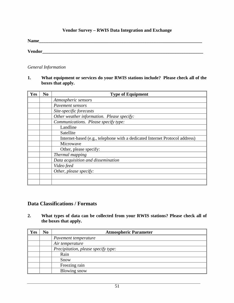
51
Vendor Survey – RWIS Data Integration and Exchange
Name_______________________________________________________________________ Vendor______________________________________________________________________ General Information 1. What equipment or services do your RWIS stations include? Please check all of the
boxes that apply.
Yes No Type of Equipment Atmospheric sensors Pavement sensors Site-specific forecasts Other weather information. Please specify: Communications. Please specify type: Landline Satellite Internet-based (e.g., telephone with a dedicated Internet Protocol address) Microwave Other, please specify: Thermal mapping Data acquisition and dissemination Video feed Other, please specify:
Data Classifications / Formats 2. What types of data can be collected from your RWIS stations? Please check all of
the boxes that apply.
Yes No Atmospheric Parameter Pavement temperature Air temperature Precipitation, please specify type: Rain Snow Freezing rain Blowing snow
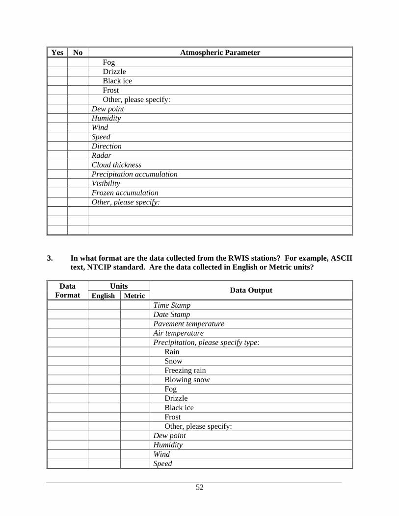
52
Yes No Atmospheric Parameter Fog Drizzle Black ice Frost Other, please specify: Dew point Humidity Wind Speed Direction Radar Cloud thickness Precipitation accumulation Visibility Frozen accumulation Other, please specify:
3. In what format are the data collected from the RWIS stations? For example, ASCII
text, NTCIP standard. Are the data collected in English or Metric units?
Units Data Format English Metric
Data Output
Time Stamp Date Stamp Pavement temperature Air temperature Precipitation, please specify type: Rain Snow Freezing rain Blowing snow Fog Drizzle Black ice Frost Other, please specify: Dew point Humidity Wind Speed
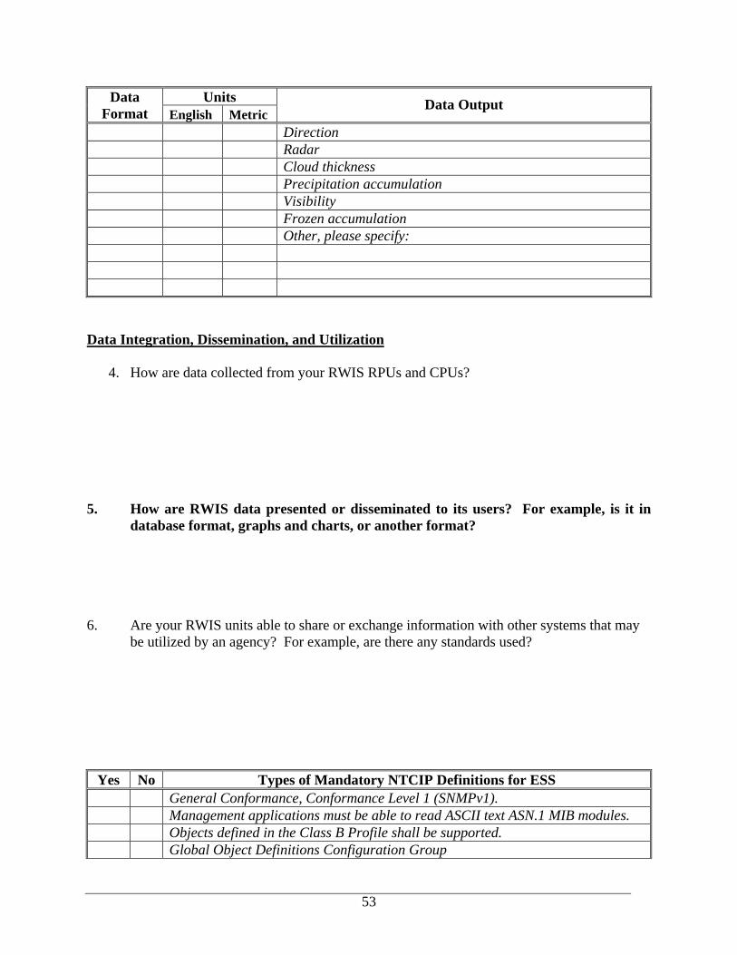
53
Units Data Format English Metric
Data Output
Direction Radar Cloud thickness Precipitation accumulation Visibility Frozen accumulation Other, please specify:
Data Integration, Dissemination, and Utilization
4. How are data collected from your RWIS RPUs and CPUs?
5. How are RWIS data presented or disseminated to its users? For example, is it in database format, graphs and charts, or another format?
6. Are your RWIS units able to share or exchange information with other systems that may
be utilized by an agency? For example, are there any standards used?
Yes No Types of Mandatory NTCIP Definitions for ESS General Conformance, Conformance Level 1 (SNMPv1). Management applications must be able to read ASCII text ASN.1 MIB modules. Objects defined in the Class B Profile shall be supported. Global Object Definitions Configuration Group
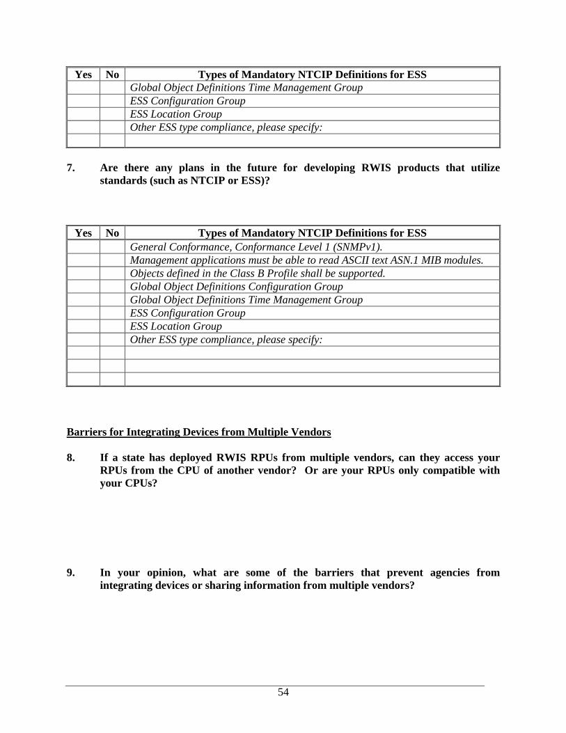
54
Yes No Types of Mandatory NTCIP Definitions for ESS Global Object Definitions Time Management Group ESS Configuration Group ESS Location Group Other ESS type compliance, please specify:
7. Are there any plans in the future for developing RWIS products that utilize
standards (such as NTCIP or ESS)?
Yes No Types of Mandatory NTCIP Definitions for ESS General Conformance, Conformance Level 1 (SNMPv1). Management applications must be able to read ASCII text ASN.1 MIB modules. Objects defined in the Class B Profile shall be supported. Global Object Definitions Configuration Group Global Object Definitions Time Management Group ESS Configuration Group ESS Location Group Other ESS type compliance, please specify:
Barriers for Integrating Devices from Multiple Vendors 8. If a state has deployed RWIS RPUs from multiple vendors, can they access your
RPUs from the CPU of another vendor? Or are your RPUs only compatible with your CPUs?
9. In your opinion, what are some of the barriers that prevent agencies from
integrating devices or sharing information from multiple vendors?

55
10. Do you have any recommendations as how to overcome any of the above barriers? Is using NCTIP standards a solution to this barrier? Why or why not?
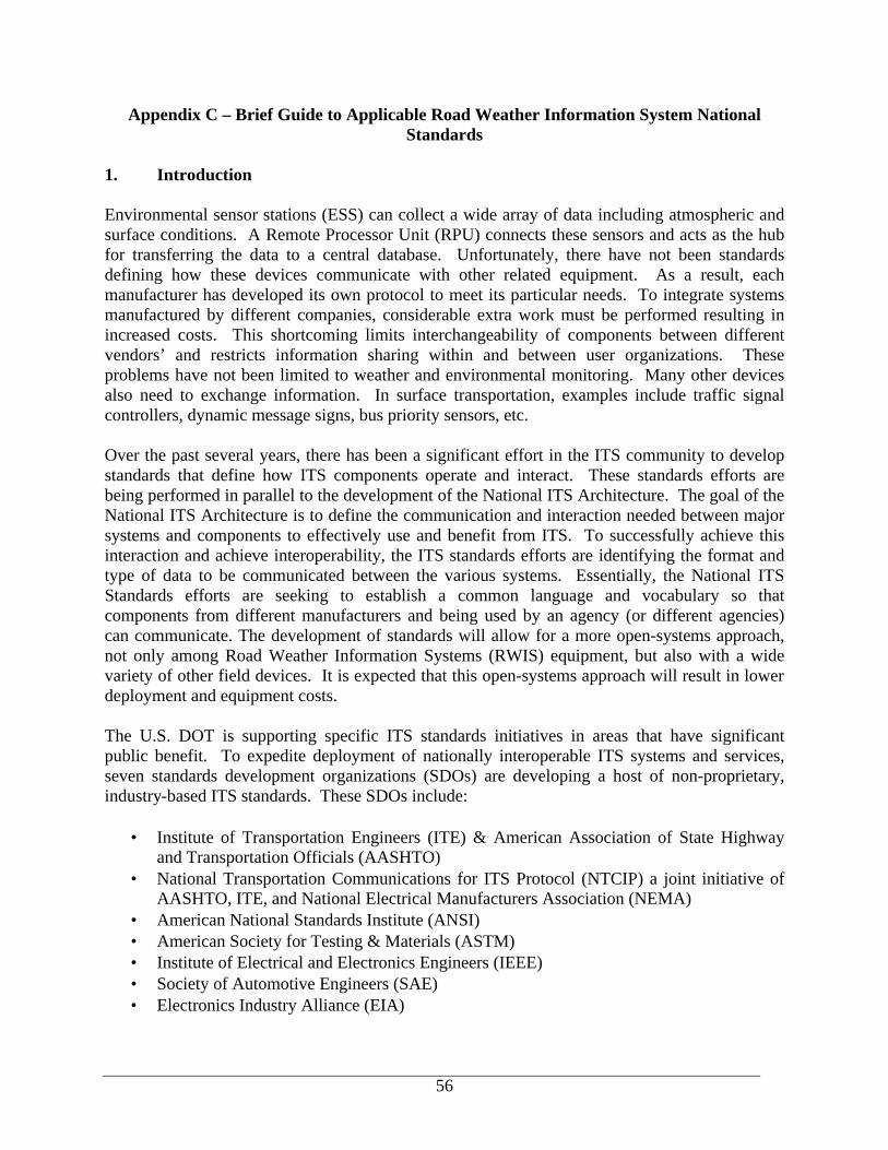
56
Appendix C – Brief Guide to Applicable Road Weather Information System National Standards
1. Introduction Environmental sensor stations (ESS) can collect a wide array of data including atmospheric and surface conditions. A Remote Processor Unit (RPU) connects these sensors and acts as the hub for transferring the data to a central database. Unfortunately, there have not been standards defining how these devices communicate with other related equipment. As a result, each manufacturer has developed its own protocol to meet its particular needs. To integrate systems manufactured by different companies, considerable extra work must be performed resulting in increased costs. This shortcoming limits interchangeability of components between different vendors’ and restricts information sharing within and between user organizations. These problems have not been limited to weather and environmental monitoring. Many other devices also need to exchange information. In surface transportation, examples include traffic signal controllers, dynamic message signs, bus priority sensors, etc. Over the past several years, there has been a significant effort in the ITS community to develop standards that define how ITS components operate and interact. These standards efforts are being performed in parallel to the development of the National ITS Architecture. The goal of the National ITS Architecture is to define the communication and interaction needed between major systems and components to effectively use and benefit from ITS. To successfully achieve this interaction and achieve interoperability, the ITS standards efforts are identifying the format and type of data to be communicated between the various systems. Essentially, the National ITS Standards efforts are seeking to establish a common language and vocabulary so that components from different manufacturers and being used by an agency (or different agencies) can communicate. The development of standards will allow for a more open-systems approach, not only among Road Weather Information Systems (RWIS) equipment, but also with a wide variety of other field devices. It is expected that this open-systems approach will result in lower deployment and equipment costs. The U.S. DOT is supporting specific ITS standards initiatives in areas that have significant public benefit. To expedite deployment of nationally interoperable ITS systems and services, seven standards development organizations (SDOs) are developing a host of non-proprietary, industry-based ITS standards. These SDOs include:
• Institute of Transportation Engineers (ITE) & American Association of State Highway and Transportation Officials (AASHTO)
• National Transportation Communications for ITS Protocol (NTCIP) a joint initiative of AASHTO, ITE, and National Electrical Manufacturers Association (NEMA)
• American National Standards Institute (ANSI) • American Society for Testing & Materials (ASTM) • Institute of Electrical and Electronics Engineers (IEEE) • Society of Automotive Engineers (SAE) • Electronics Industry Alliance (EIA)
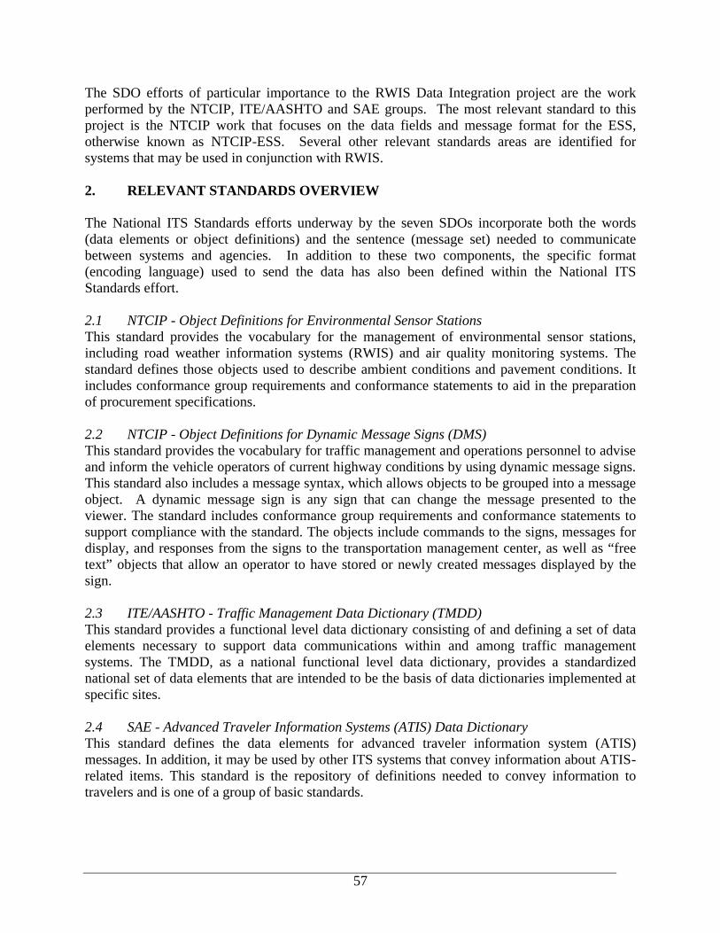
57
The SDO efforts of particular importance to the RWIS Data Integration project are the work performed by the NTCIP, ITE/AASHTO and SAE groups. The most relevant standard to this project is the NTCIP work that focuses on the data fields and message format for the ESS, otherwise known as NTCIP-ESS. Several other relevant standards areas are identified for systems that may be used in conjunction with RWIS. 2. RELEVANT STANDARDS OVERVIEW The National ITS Standards efforts underway by the seven SDOs incorporate both the words (data elements or object definitions) and the sentence (message set) needed to communicate between systems and agencies. In addition to these two components, the specific format (encoding language) used to send the data has also been defined within the National ITS Standards effort. 2.1 NTCIP - Object Definitions for Environmental Sensor Stations This standard provides the vocabulary for the management of environmental sensor stations, including road weather information systems (RWIS) and air quality monitoring systems. The standard defines those objects used to describe ambient conditions and pavement conditions. It includes conformance group requirements and conformance statements to aid in the preparation of procurement specifications. 2.2 NTCIP - Object Definitions for Dynamic Message Signs (DMS) This standard provides the vocabulary for traffic management and operations personnel to advise and inform the vehicle operators of current highway conditions by using dynamic message signs. This standard also includes a message syntax, which allows objects to be grouped into a message object. A dynamic message sign is any sign that can change the message presented to the viewer. The standard includes conformance group requirements and conformance statements to support compliance with the standard. The objects include commands to the signs, messages for display, and responses from the signs to the transportation management center, as well as “free text” objects that allow an operator to have stored or newly created messages displayed by the sign. 2.3 ITE/AASHTO - Traffic Management Data Dictionary (TMDD) This standard provides a functional level data dictionary consisting of and defining a set of data elements necessary to support data communications within and among traffic management systems. The TMDD, as a national functional level data dictionary, provides a standardized national set of data elements that are intended to be the basis of data dictionaries implemented at specific sites. 2.4 SAE - Advanced Traveler Information Systems (ATIS) Data Dictionary This standard defines the data elements for advanced traveler information system (ATIS) messages. In addition, it may be used by other ITS systems that convey information about ATIS-related items. This standard is the repository of definitions needed to convey information to travelers and is one of a group of basic standards.
58
2.5 ITE/AASHTO - Message Sets For External Traffic Management Center Communication This standard provides message sets necessary to convey data within and between traffic management centers and other ITS centers. It provides a list of specific data elements for each message plus other necessary format information. The standard is designed to be independent of any specific communications protocol.
2.6 IEEE - Standard for Data Dictionary for Intelligent Transportation Systems (Standard 1489-1999) This standard provides message sets necessary to convey data within and between traffic management centers and other ITS centers. It provides a list of specific data elements for each message plus other necessary format information. The standard is designed to be independent of any specific communications protocol. 2.7 DATEX-ASN.1 One of the first efforts to standardize the interface between transport control centres was a European Union effort led by the DATEX Task Force. A common interface was initially developed and named the Data Exchange Network (DATEX-Net) Specifications for Interoperability. In 1997, worldwide efforts began to merge together with the Abstract Syntax Notation (ASN.1) structures for the Data Exchange in Abstract Syntax Notation (DATEX-ASN) messages.
3. INTERNET STANDARDS The communication protocols for transmitting information between systems are governed by the standards, guidelines and procedures for communication over the Internet. The main protocols used are direct dial-up links and the dedicated links via the internet. A wide range of standards exist, including: • Point-to-Point Protocol (PPP) - which can be used for dial-up links; • Internet Protocol (IP) - which can be used for networks (local-area and wide-area); and • Transport Control Protocol (TCP) - that provides connection-oriented services over
networks.
4. ESS (RWIS) STANDARDS Standards related to Environmental Sensor Stations are governed by the National Transportation Communications for ITS Protocol which have identified the requirements for field devices. The NTCIP-ESS is the definitive standard that must be followed for deployments of ESS devices in order to remain NTCIP compliant and in line with national standards. The entire standard (NTCIP Object Definitions for Environmental Sensor Stations - Recommended Standard 1204) is available from http://www.ntcip.org and should be consulted prior to defining or procuring for RWIS deployments.
59
This standard is broken down into multiple components so that adherence to the standard can be easily verified. As discussed in Section 1, the National ITS Standards are generally divided into the main components necessary to communicate, such as the definition of the word (data elements or objects), the grammar of the sentence (message set) and the language to be used (communication rules). The NTCIP-ESS standard defines each of these three components. It defines the specific data objects, their structure and format, as well as the message structure and if a specific data object (or group of objects) is a required component in an ESS deployment. The objects (or data elements) are defined so that agencies and other users can understand the specific meaning of each object, understand the range of values allowed, the units to be used and the proper spelling of the object. This is similar to people spelling and using the word "tree" in various ways until the first dictionary defined how to spell it, what it meant and how to use it within a sentence. The standard also recognizes the fact that not all sensors will be deployed at a particular ESS and that not all sensors are capable of generating the exact same information. To accommodate these variations, the NTCIP-ESS standard defines which particular objects are required to effectively communicate relevant information and which may be considered optional. Specific object groups combine related objects so that information of a similar nature are transmitted as a group. 5. STANDARDS CONFORMANCE A key factor in developing interoperable and integrated systems is the conformance of devices to the developed standards. In the case of ESS devices, developing a standards compliant system requires conformance to the NTCIP-ESS standard. Conformance to the standard can be achieved at various levels, depending on the scope of the system being investigated. A device, a group of devices or an entire station can be considered standards compliant pending it meeting certain criteria, with a few exceptions. Specific exceptions, and examples are provided within the standard documents. In addition to the device and conformance groups, the communication protocols used to exchange data must also be adhered to. 5.1 Conformance Groups Conformance Groups are defined as being either mandatory or optional. For a device to claim compliance, it must be compliant with each of the mandatory Conformance Groups it involves and it must be compliant with each of the mandatory tables and mandatory objects as defined within the Conformance Groups. Table 4.1 identifies a list of groups as a minimum to claim compliance to the NTCIP-ESS standard. Additional objects or groups may be supported without being non-compliant with ESS objects or NTCIP.
A device may support a subset of defined values for an enumerated object or a restricted range of values for an numerical object without being categorized as non-compliant with ESS objects or NTCIP. However, if the remaining object requirements are not met, the device would be considered non-compliant with the NTCIP standard. A conformance group refers to a subset of devices that encompass a particular area of focus, such as wind data. A device is considered compliant if it supports at least one value of the object and all indicated functionality for the values it supports. The device may support any optional feature. Each of
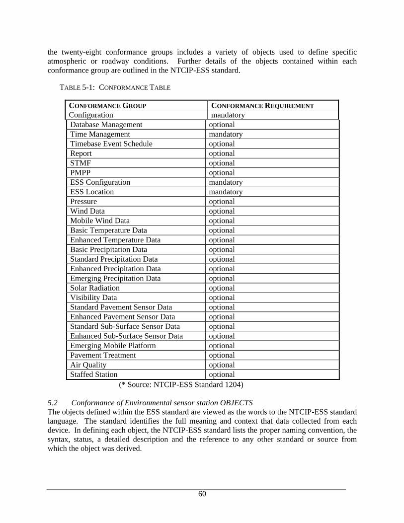
60
the twenty-eight conformance groups includes a variety of objects used to define specific atmospheric or roadway conditions. Further details of the objects contained within each conformance group are outlined in the NTCIP-ESS standard.
TABLE 5-1: CONFORMANCE TABLE
CONFORMANCE GROUP CONFORMANCE REQUIREMENT Configuration mandatory Database Management optional Time Management mandatory Timebase Event Schedule optional Report optional STMF optional PMPP optional ESS Configuration mandatory ESS Location mandatory Pressure optional Wind Data optional Mobile Wind Data optional Basic Temperature Data optional Enhanced Temperature Data optional Basic Precipitation Data optional Standard Precipitation Data optional Enhanced Precipitation Data optional Emerging Precipitation Data optional Solar Radiation optional Visibility Data optional Standard Pavement Sensor Data optional Enhanced Pavement Sensor Data optional Standard Sub-Surface Sensor Data optional Enhanced Sub-Surface Sensor Data optional Emerging Mobile Platform optional Pavement Treatment optional Air Quality optional Staffed Station optional
(* Source: NTCIP-ESS Standard 1204) 5.2 Conformance of Environmental sensor station OBJECTS The objects defined within the ESS standard are viewed as the words to the NTCIP-ESS standard language. The standard identifies the full meaning and context that data collected from each device. In defining each object, the NTCIP-ESS standard lists the proper naming convention, the syntax, status, a detailed description and the reference to any other standard or source from which the object was derived.
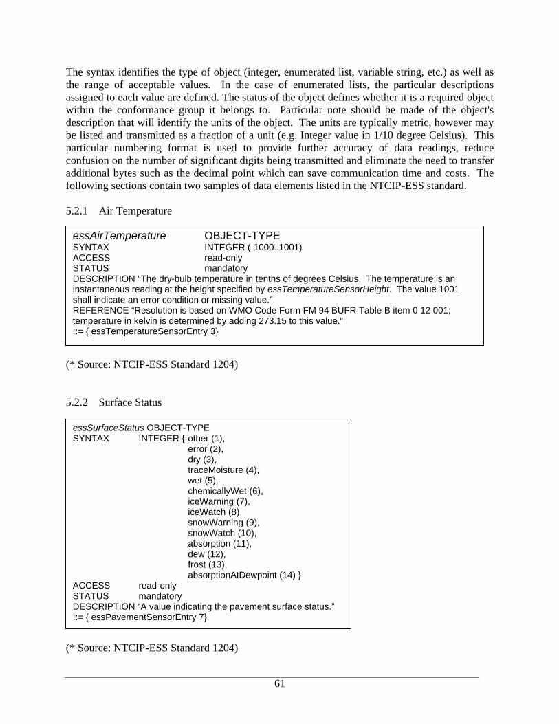
61
The syntax identifies the type of object (integer, enumerated list, variable string, etc.) as well as the range of acceptable values. In the case of enumerated lists, the particular descriptions assigned to each value are defined. The status of the object defines whether it is a required object within the conformance group it belongs to. Particular note should be made of the object's description that will identify the units of the object. The units are typically metric, however may be listed and transmitted as a fraction of a unit (e.g. Integer value in 1/10 degree Celsius). This particular numbering format is used to provide further accuracy of data readings, reduce confusion on the number of significant digits being transmitted and eliminate the need to transfer additional bytes such as the decimal point which can save communication time and costs. The following sections contain two samples of data elements listed in the NTCIP-ESS standard. 5.2.1 Air Temperature
(* Source: NTCIP-ESS Standard 1204) 5.2.2 Surface Status
(* Source: NTCIP-ESS Standard 1204)
essSurfaceStatus OBJECT-TYPE SYNTAX INTEGER { other (1), error (2), dry (3), traceMoisture (4), wet (5), chemicallyWet (6), iceWarning (7), iceWatch (8), snowWarning (9), snowWatch (10), absorption (11), dew (12), frost (13), absorptionAtDewpoint (14) } ACCESS read-only STATUS mandatory DESCRIPTION “A value indicating the pavement surface status.” ::= { essPavementSensorEntry 7}
essAirTemperature OBJECT-TYPE SYNTAX INTEGER (-1000..1001) ACCESS read-only STATUS mandatory DESCRIPTION “The dry-bulb temperature in tenths of degrees Celsius. The temperature is an instantaneous reading at the height specified by essTemperatureSensorHeight. The value 1001 shall indicate an error condition or missing value.” REFERENCE “Resolution is based on WMO Code Form FM 94 BUFR Table B item 0 12 001; temperature in kelvin is determined by adding 273.15 to this value.” ::= { essTemperatureSensorEntry 3}
62
5.2 Conformance of DATA COMMUNICATIONS There are several standards efforts that deal with communication of data between systems, centers and field devices. When NTCIP-ESS was first developed, a NTCIP message was to be conveyed using the Simple Transportation Management Framework (STMF) protocol for communications between agency centers and the ESS device. These messages were to be for access and modification of object values. However, since that time the use of DATEX-ASN.1 for communications became the defacto standard used by several other SDOs to define the method and protocols for communication. Some work was being considered to use DATEX-ASN.1 for NTCIP-ESS communications and data exchange, however this work has not yet been published. There are a number of additional methods available, including Simple Transportation Management Framework (STMF), Common Object Request Broker Architecture (CORBA) and Simple Network Management Protocol (SNMP). While these applications have been developed, they have not been adopted in the NTCIP-ESS domain for use. In the last year, the increased functionality and software market use of EXtensible Markup Language (XML) has pushed most SDOs to begin considering XML as an additional communications standard available for adoption in certain applications. XML allows for data to be exchanged over the Internet using commercial-off-the-shelf software to read and parse the data into a local database. The use of XML for the ESS community would be a logical avenue to exchange data both from the field device or RPU and the agency's central database, as well as between agencies. Work is currently in progress through NTCIP to develop a message set for ESS devices, with DATEX-ASN.1 and XML being considered. It is recommended that continued monitoring of the progress of this work be done so that agencies may adopt and require data to be transmitted by the standard communication method when it is published and recommended for use. 6. Benefits of Standardization The National ITS Standards being developed provide a common standard that can be used by all vendors. These standards provide agencies with the ability to choose from different vendors without concern for interoperability of equipment and provide increased flexibility in operating systems such as RWIS. It removes barriers to coordination between agencies and allows a single communications link to be used at a given location. By following and requiring conformance with the National ITS Standards, agencies will benefit from in the future. These benefits to the ESS (RWIS) community include:
• National ITS Standards will allow agencies to communicate with devices owned by other users and vendors. Agencies will be able to select and procure equipment from multiple vendors without concern for compatibility between devices.
• National ITS Standards will enable centralization of commands for control of field devices by allowing a single central computer to communicate with all devices. This will allow for a computer that controls a Highway Advisory Radio to collect data from a nearby ESS and, based on the conditions, adjust the message to advise travelers.

63
• National ITS Standards will allow for all future equipment to use a single structure, format and message structure to be followed by vendors. This consistency will ensure that computers are capable of communicating with all devices and that agencies will be able to obtain technical support and replacement parts well into the future. It should be noted that it may be cost prohibitive to retrofit some existing equipment to support the National ITS Standards and interim applications to interface the legacy systems may be required.
• Once an agency has a weather information system that includes support for NTCIP it can buy field stations from any manufacturer offering NTCIP-compatible products, and they will communicate with the agency’s “Information Management Subsystem” (‘IMS’, typically termed CPU).


![MACHINE LEARNING METHODS FOR THErmaclin/student-publications/aditya-m… · Web viewThe Road Weather Information System (RWIS) [Aurora; Boselly et al., 1993] is used for collection,](https://img.pdfslide.us/doc/110x75/6063236fed726244624b8565/machine-learning-methods-for-the-rmaclinstudent-publicationsaditya-m-web-view.jpg)