Embed Size (px)
Citation preview
ROAD NETWORK IDENTIFICATION AND EXTRACTION IN SATELLITE IMAGERY
USING OTSU'S METHOD AND CONNECTED COMPONENT ANALYSIS
P. Yadav 1*, S. Agrawal 2
1 GIS Cell, Motilal Nehru National Institute of Technology, Allahabad-211004, U.P., India – [email protected]
2 GIS Cell, Motilal Nehru National Institute of Technology, Allahabad-211004, U.P., India – [email protected]
Commission V, WG V/5
KEY WORDS: Road identification, road extraction, Otsu's method, connected component analysis, morphological operations.
ABSTRACT:
As the high resolution satellite images have become easily available, this has motivated researchers for searching advanced methods
for object detection and extraction from satellite images. Roads are important curvilinear object as they are a used in urban planning,
emergency response, route planning etc. Automatic road detection from satellite images has now become an important topic in
photogrammetry with the advances in remote sensing technology. In this paper, a method for road detection and extraction of
satellite images has been introduced. This method uses the concept of histogram equalization, Otsu's method of image segmentation,
connected component analysis and morphological operations. The aim of this paper is to discover the potential of high resolution
satellite images for detecting and extracting the road network in a robust manner.
1. INTRODUCTION
Satellite images obtain information of areas which are difficult-
to-reach, provide huge volume of data and monitor events and
areas without any interference. The new sensors in satellites
provide high resolution imagery with better quality. This has
increased the potential for analysis tools to identify and extract
linear features (Singh and Garg, 2013). For transportation and
city planning, roads are very essential linear features. Automatic
road detection from satellite images has now become an
important topic in photogrammetry after remote sensing
technology development. In this research paper, road detection
and extraction from satellite images has been performed. In the
methodology histogram equalization, Otsu's method of image
segmentation, connected component analysis and
morphological operations are used.
2. THEORITICAL BACKGROUND
Satellite images often contain noises. Therefore, these images
are preprocessed and enhanced before the extraction of objects.
In image enhancement, digital images are altered and its visual
interpretability is improved. Therefore, resultant images are
more appropriate for analysis. Contrast enhancement is one of
image enhancement technique. It improves the appearance of
object and the brightness between object and its backgrounds
(Chalekar and Yengantiwar, 2014).
Satellite images often contain several objects. Visual detection
of these objects by humans is a slow, expensive and endless
routine job. Therefore automatic object detection with the help
of computers was developed. Object detection algorithms
localise objects and annotates them with an object class label.
Both tasks face many difficulties. On one hand, the detection
method must be robust for different images or varying
illumination conditions and it must account for changes in the
object. On the other hand, these objects may appear of any size
and at anywhere in an image. Hence for practical systems,
efficiency is very important factor (Kapoor et al., 2014). The
objects in satellite images are divided into three main categories
of point, line and area type (Mohammadzadeh et al., 2009).
Linear features are of interest to a lot of researchers.
Mathematically, linear features are described by arbitrary curves
or straight lines. These features are used in GIS, digital
mapping, monitoring the dynamic changes of water and for
updating GIS vector data (Zhang et al., 2013). It can also used
in transportation database, city planning, military field and map
updating (Wang et al., 2016). Linear pattern recognition has
many practical applications like road detection, river detection,
railroads detection, plant root analysis, retinal vessel extraction
etc.
Automatic road detection from satellite images has now become
an important topic in photogrammetry after the advances in
remote sensing technology. An automatic process of road
extraction is needed by GIS for continuous data update (Hu et
al., 2009). Methods for road extraction can be semi-automatic
or fully automatic. Semi-automatic detection method requires
human interaction while automatic detection method does not
require human interaction (Lin et al., 2009).
In last three decades, a lot of research has been carried out in
automatic methods for road detection which has resulted in
many algorithms and strategies (Mena, 2003). Gruen and Li
(1997) have given a method that involved dynamic
programming. Keaton and Brokish (2002) suggested a method
for road extraction in which a seed point is selected from the
road and then a level set method is used to grow the region.
Iterative smoothing is performed which further improved the
extracted section and then road centreline is estimated
accurately. He et al. (2004) developed a road area detection
algorithm which has two modules. In first module, scene area
was reduced for the computation of mean and variance of
Gaussian distribution. In second module the road area was
extracted and then boundaries that fit the result of road
extraction were reinforced. Fuzzy method was applied for road
extraction in a paper (Mohammadzadeh et al., 2009, 2007).
The International Archives of the Photogrammetry, Remote Sensing and Spatial Information Sciences, Volume XLII-5, 2018 ISPRS TC V Mid-term Symposium “Geospatial Technology – Pixel to People”, 20–23 November 2018, Dehradun, India
This contribution has been peer-reviewed. https://doi.org/10.5194/isprs-archives-XLII-5-91-2018 | © Authors 2018. CC BY 4.0 License.
91
Hu et al. (2009) has adopted Least Squares Template Matching
(LSTM) for fitting the linear objects with a Scalable Slope Edge
(SSE) model. A method was presented for linear feature
extraction which has integrated the SSE with a LSTM model for
processing noisy images and blurred edges. Li and Briggs
(2009) gave an algorithm in which edge filtering was performed
to extract roads. Stage segmentation, grouping and optimization
were then applied for roads that are usually harder to identify
because of noise and also to fill big gaps. Wu and ShuFeng
(2009) have proposed an algorithm for unstructured road
detection. In this method, median filter is applied on original
images to suppress the stochastic type of noise and then multi-
threshold is selected by Otsu method on the basis of two-peak
method. Finally, the primary edge is detected with the help of
canny operator and operations of mathematics morphology are
used, which results in clear road image.
Valero et al. (2010) have used mathematical morphology in
road detection. Parvathi et al., (2010) have proposed a method
which extracted linear anthropogenic objects in hilly areas.
Object and ground separation was done by employing wavelets
in hilly terrain. It extracted desired objects in which marker-
controlled watershed segmentation is employed. Wang and
Zhang (2011) have given the gradient-based model in which
used extended Snakes model for positional optimization.
Alvarez et al., (2009) combined a classifier determining road
class-likelihood with an illumination invariant feature space to
provide reliable results regardless of shadows and lighting
variations. Wang et al. (2013) have used a knowledge-based
approach for road detection. Singh and Garg (2013) applied
morphological operations and adaptive global thresholding on
images to extract roads. In another paper, they used a two-stage
framework using fuzzy clustering, region part-segmentation,
segment linking and medial axis transformation (Singh and
Garg, 2014). Sujatha and Selvathi, (2015) have extracted road
centerline automatically from satellite image. This method has
three steps which are road region segmentation, connected
component operations to extract the connected component of
road from segmented part and then non road pixel removal by
morphological operations. Several other papers also used
connected component analysis and segmentation (Reddy and
Padmaja, 2016; Wang et al., 2016).
J. Wang et al. (2016) proposed an object-based method in
which extraction of spatial texture features was done by specific
spatial statistics and then derived texture was added to spectral
bands for road extraction. Maboudi et al. (2017) have
developed object-based image analysis (OBIA) method in
which object-based information is implanted in the ant colony
optimization algorithm to handle the problem of extraction of
road network.
In this way several techniques were developed or taken from
other fields for road extraction. They used image processing
along with mathematics, soft computing, artificial neural
network etc. This paper also developed and implemented a
method for road detection and extraction.
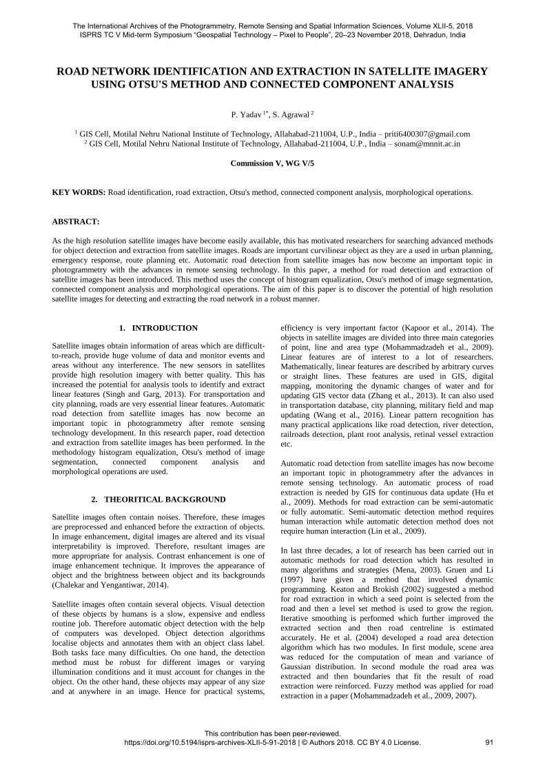
3. METHODOLOGY
In this paper, a novel method has been proposed for detecting
and extracting the road network from high resolution satellite
images. In this method, the input image is first preprocessed.
After that a threshold is computed by Otsu's method (Qu and
Zhang, 2010). Using this threshold, the gray image is converted
Figure 1: Road detection and extraction methodology
into binary image and it contains only black and white pixels.
Connected component analysis is then performed. After that,
the image is processed by morphological operators and thus a
finer road network is extracted. This extracted network is then
superimposed with the input image to highlight the road
network in the input image. Figure 1 shows the overall
methodology. Its steps are discussed in detail below:
3.1 Image Preprocessing
First of all, preprocessing is performed on the image. This step
removes the noise from the image and enhances the contrast of
the image. Preprocessing of the image has following steps:
3.1.1 Grayscale conversion
Colored images have three independent channels: red, green
and blue. This increases the cost, processing time and
Yes
No
Input Image
Grayscale Image
Histogram equalization
Scaling of Image
Threshold selection
Connected component analysis
Binary Image conversion
Is major axis
length of
object > 100?
Remove the
object
Morphological operation
Output image
Detect the road
network in the
image
Extract the road
network
The International Archives of the Photogrammetry, Remote Sensing and Spatial Information Sciences, Volume XLII-5, 2018 ISPRS TC V Mid-term Symposium “Geospatial Technology – Pixel to People”, 20–23 November 2018, Dehradun, India
This contribution has been peer-reviewed. https://doi.org/10.5194/isprs-archives-XLII-5-91-2018 | © Authors 2018. CC BY 4.0 License.
92
complexity of the image. Grayscale images are single channel
images on which contrast, shape, edges, etc can be studied
without using color channels. Therefore the coloured images are
converted into grayscale images.
3.1.2 Histogram equalization
Histogram equalization is a technique which remaps the input
image pixels so that almost uniform histogram may be achieved.
It helps in enhancing the contrast of the image. It is applied on
the grayscale image.
3.1.3 Image Scaling
Scaling of image is performed to remove the problem of
quantization and aliasing (Alemu, 2016). Quantization is a
process in which values of a range of pixels are replaced by a
specific value. Aliasing problem arises when various signals are
sampled and it becomes impossible to differentiate these signals
(Gioi et al., 2008).
3.2 Binary image conversion
3.2.1 Selection of threshold
Otsu's method of image segmentation is used for threshold
selection. Otsu's method was given by N. Otsu in 1979. Otsu's
algorithm selects threshold automatically. It is effective, fast,
simple and stable. In Otsu's algorithm, a global threshold is
computed which is later used to convert image into binary
image. This global threshold is a positive scalar.
3.2.2 Binarization
After threshold selection, image is converted into another image
where all pixel values which are greater than the threshold are
replaced by 1 and rest pixel values are replaced by 0. As a result
of this step, a black and white image is formed.
3.3 Connected component analysis
Connected pixels are set of pixels which are not divided by
boundary. Its basic idea is an identification logic whose role is
to detect the components which are single, broken or connected
characters (Vijayan et al., 2016). After finding connected
components, trivial opening is performed. Trivial opening
extracts the connected component based on some criteria. If
connected component of image satisfies the criteria T, then
component is preserved, if not then component is removed. The
criteria are selected so that only long features can be extracted.
Hence, the criterion (T) selected for trivial opening in this work
is major axis length. The longest diameter of an ellipse is called
its major axis. If P is the image and P(i) is a connected
component of the image, then the trivial operation is performed
by following equation (Sujatha and Selvathi, 2015) which gives
the connected component (R0):
R0 = {PLong axis of minimum ellipse enclosing P(i) T}
3.4 Morphological operation
After connected component analysis, the extracted roads still
contain some holes and noises. This is so because connected
component sometimes cannot identify small ground objects like
building, lanes, vehicles, etc. To eliminate them and improve
the accuracy of the results, the extracted results are processed
by the various operations of mathematical morphology like
opening, closing, dilation and erosion. Matheron and Serra
introduced method of mathematical morphology by in 1964.
Basic idea of this method is the application of mathematical
morphology for image processing and analysis. Morphology is
an approach in which objects and object features are identified
through their shape (Kaur and Ritika, 2013).
3.4.1 Area opening
This operation removes those connected components which
have less number of pixels than a threshold
(https://in.mathworks.com).
3.4.2 Thinning operation
This morphological operation reduces or thins the connected
components to lines. Pixels are removed in such manner that an
object which does not contain any holes reduces to a minimally
connected stroke while object with holes reduces to a connected
loop intermediate between holes and the external boundary.
3.4.3 Opening operation
This operation is a process of erosion followed by dilation.
Same structuring element is used for both erosion and dilation.
3.4.4 Closing operation
This operation is a process of erosion followed by dilation.
Same structuring element is used for both erosion and dilation.
3.5 Detection of road network
For detecting the road network in the original image, individual
red, green and blue color channels are extracted from original
RGB image. Road pixels are assigned red colours. This creates
an image with red colored road network with white background.
Then this red colored road network is superimposed with initial
Grayscale image. The image is shown as a Grayscale image with
its road network colored in red.
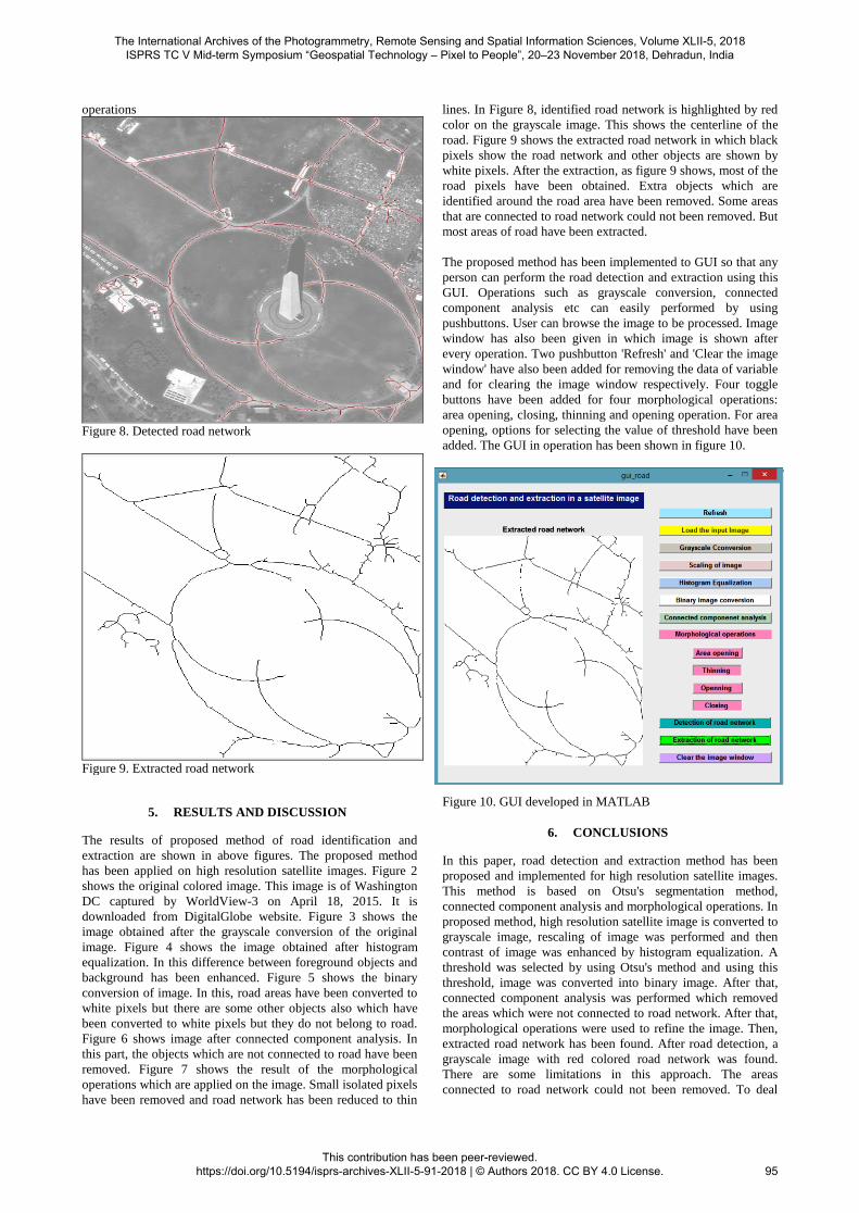
3.6 Extraction of road network
After morphological operation, the roads in single pixel are
formed. To get the extracted road network, black color is
assigned to all pixels of road network and white color is
assigned to rest of the pixels. Therefore, an extracted road
network is generated in which roads are shown in black pixels
with white background.
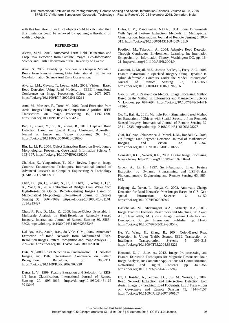
4. GRAPHICAL USER INTERFACE
Graphical User Interface is created in MATLAB. It contains a
figure window in which menus, text, graphics, buttons etc. are
provided. To open GUI, select File/New/GUI from menu or
type "guide" on Command Window and select “Create New
GUI”. Layout Editor is then opened in which the appearance of
GUI can be designed. On the left of the Layout Editor some
buttons are given for inserting objects like toggle buttons, push
buttons, static text, axes box etc. GUI is then created with the
help of Layout Editor. Property Inspector is used to alter the
object properties like text font, color etc. For saving a GUI,
click Save As from File menu and type the name of file without
any extension (Hunt et al., 2012). After saving it, two types of
files are created binary file with '.fig' extension and an M-file
with '.m' extension. When the M-file is run from tools menu,
GUI appears with selected buttons and menus of layout editor.
To assign the functionality to the GUI buttons callback function
is used. Commands are added to the buttons after opening the
M-file. Now it is saved and executed. GUI window is then
opened and on clicking the buttons desired operation are
performed.
The International Archives of the Photogrammetry, Remote Sensing and Spatial Information Sciences, Volume XLII-5, 2018 ISPRS TC V Mid-term Symposium “Geospatial Technology – Pixel to People”, 20–23 November 2018, Dehradun, India
This contribution has been peer-reviewed. https://doi.org/10.5194/isprs-archives-XLII-5-91-2018 | © Authors 2018. CC BY 4.0 License.
93

Figure 2. Original image
Figure 3. Image obtained after grayscale conversion
Figure 4. Image obtained after performing histogram equalization
on grayscale image
Figure 5. Image obtained after binarization
Figure 6. Image after connected component analysis
Figure 7. Image obtained after applying morphological
The International Archives of the Photogrammetry, Remote Sensing and Spatial Information Sciences, Volume XLII-5, 2018 ISPRS TC V Mid-term Symposium “Geospatial Technology – Pixel to People”, 20–23 November 2018, Dehradun, India
This contribution has been peer-reviewed. https://doi.org/10.5194/isprs-archives-XLII-5-91-2018 | © Authors 2018. CC BY 4.0 License.
94
operations
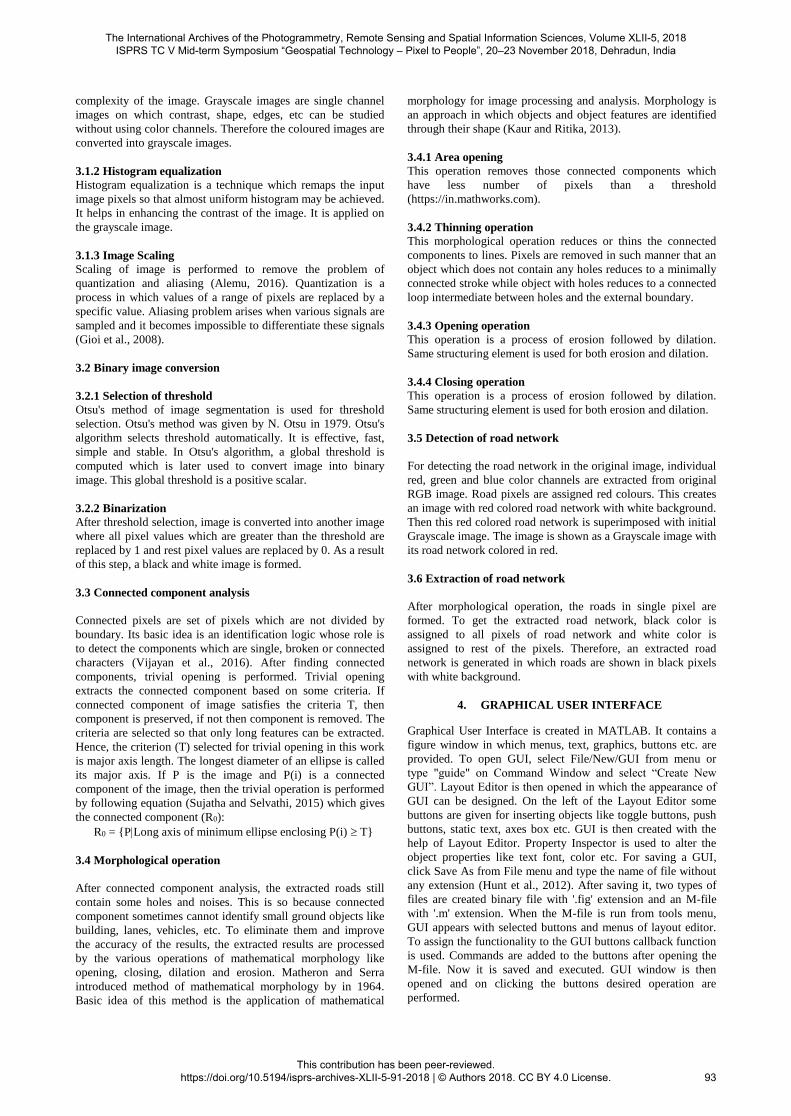
Figure 8. Detected road network
Figure 9. Extracted road network
5. RESULTS AND DISCUSSION
The results of proposed method of road identification and
extraction are shown in above figures. The proposed method
has been applied on high resolution satellite images. Figure 2
shows the original colored image. This image is of Washington
DC captured by WorldView-3 on April 18, 2015. It is
downloaded from DigitalGlobe website. Figure 3 shows the
image obtained after the grayscale conversion of the original
image. Figure 4 shows the image obtained after histogram
equalization. In this difference between foreground objects and
background has been enhanced. Figure 5 shows the binary
conversion of image. In this, road areas have been converted to
white pixels but there are some other objects also which have
been converted to white pixels but they do not belong to road.
Figure 6 shows image after connected component analysis. In
this part, the objects which are not connected to road have been
removed. Figure 7 shows the result of the morphological
operations which are applied on the image. Small isolated pixels
have been removed and road network has been reduced to thin
lines. In Figure 8, identified road network is highlighted by red
color on the grayscale image. This shows the centerline of the
road. Figure 9 shows the extracted road network in which black
pixels show the road network and other objects are shown by
white pixels. After the extraction, as figure 9 shows, most of the
road pixels have been obtained. Extra objects which are
identified around the road area have been removed. Some areas
that are connected to road network could not been removed. But
most areas of road have been extracted.
The proposed method has been implemented to GUI so that any
person can perform the road detection and extraction using this
GUI. Operations such as grayscale conversion, connected
component analysis etc can easily performed by using
pushbuttons. User can browse the image to be processed. Image
window has also been given in which image is shown after
every operation. Two pushbutton 'Refresh' and 'Clear the image
window' have also been added for removing the data of variable
and for clearing the image window respectively. Four toggle
buttons have been added for four morphological operations:
area opening, closing, thinning and opening operation. For area
opening, options for selecting the value of threshold have been
added. The GUI in operation has been shown in figure 10.
Figure 10. GUI developed in MATLAB
6. CONCLUSIONS
In this paper, road detection and extraction method has been
proposed and implemented for high resolution satellite images.
This method is based on Otsu's segmentation method,
connected component analysis and morphological operations. In
proposed method, high resolution satellite image is converted to
grayscale image, rescaling of image was performed and then
contrast of image was enhanced by histogram equalization. A
threshold was selected by using Otsu's method and using this
threshold, image was converted into binary image. After that,
connected component analysis was performed which removed
the areas which were not connected to road network. After that,
morphological operations were used to refine the image. Then,
extracted road network has been found. After road detection, a
grayscale image with red colored road network was found.
There are some limitations in this approach. The areas
connected to road network could not been removed. To deal
The International Archives of the Photogrammetry, Remote Sensing and Spatial Information Sciences, Volume XLII-5, 2018 ISPRS TC V Mid-term Symposium “Geospatial Technology – Pixel to People”, 20–23 November 2018, Dehradun, India
This contribution has been peer-reviewed. https://doi.org/10.5194/isprs-archives-XLII-5-91-2018 | © Authors 2018. CC BY 4.0 License.
95
with this limitation, if width of objects could be calculated then
this limitation could be removed by applying a threshold on
width of objects.
REFERENCES
Alemu, M.M., 2016. Automated Farm Field Delineation and
Crop Row Detection from Satellite Images. Geo-Information
Science and Earth Observation of the University of Twente.
Alian, S., 2007. Identifying Curviness of Overpass Mountain
Roads from Remote Sensing Data. International Institute For
Geo-Information Science And Earth Observation.
Alvarez, J.M., Gevers, T., Lopez, A.M., 2009. Vision – Based
Road Detection Using Road Models, in: IEEE International
Conference on Image Processing. Cairo, pp. 2073–2076.
https://doi.org/10.1109/ICIP.2009.54143211
Amo, M., Martínez, F., Torre, M., 2006. Road Extraction from
Aerial Images Using A Region Competition Algorithm. IEEE
Transactions on Image Processing 15, 1192–1201.
https://doi.org/10.1109/TIP.2005.864232
Bao, J., Zhang, Y., Su, X., Zheng, R., 2018. Unpaved Road
Detection Based on Spatial Fuzzy Clustering Algorithm.
Journal on Image and Video Processing 26, 1–15.
https://doi.org/10.1186/s13640-018-0260-3
Bin, L., Li, P., 2004. Object Extraction Based on Evolutionary
Morphological Processing. Geo-spatial Information Science 7,
193–197. https://doi.org/10.1007/BF02826290
Chalekar, K., Yengantiwar, T., 2014. Review Paper on Image
Contrast Enhancement Techniques. International Journal of
Advanced Research in Computer Engineering & Technology
(IJARCET) 3, 909–911.
Chen, C., Qin, Q., Zhang, N., Li, J., Chen, L., Wang, J., Qin,
X., Yang, X., 2014. Extraction of Bridges Over Water from
High-Resolution Optical Remote-Sensing Images Based on
Mathematical Morphology. International Journal of Remote
Sensing 35, 3664–3682. https://doi.org/10.1080/01431161.
2014.915437
Chen, J., Pan, D., Mao, Z., 2009. Image-Object Detectable in
Multiscale Analysis on High-Resolution Remotely Sensed
Imagery. International Journal of Remote Sensing 30, 3585–
3602. https://doi.org/10.1080/01431160802585348
Dal Poz, A.P., Zanin, R.B., do Vale, G.M., 2006. Automated
Extraction of Road Network from Medium-and High-
Resolution Images. Pattern Recognition and Image Analysis 16,
239–248. https://doi.org/10.1134/S1054661806020118
Duta, N., 2000. Road Detection in Panchromatic SPOT Satellite
Images, in: 15th International Conference on Pattern
Recognition. Barcelona, pp. 308–311.
https://doi.org/10.1109/ICPR.2009.902920
Dutra, L. V., 1999. Feature Extraction and Selection for ERS-
1/2 Insar Classification. International Journal of Remote
Sensing 20, 993–1016. https://doi.org/10.1080/01431169
9213046
Dutra, L. V., Mascarenhas, N.D.A., 1984. Some Experiments
With Spatial Feature Extraction Methods In Multispectral
Classification. International Journal of Remote Sensing 5, 303–
313. https://doi.org/10.1080/01431168408948810
Foedisch, M., Takeuchi, A., 2004. Adaptive Road Detection
Through Continuous Environment Learning, in: Internation
Symposium on Information Theory. Washington DC, pp. 16–
21. https://doi.org/10.1109/AIPR.2004.9
Gambini, J., Mejail, M.E., Jacobo-Berlles, J., Frery, A.C., 2006.
Feature Extraction in Speckled Imagery Using Dynamic B-
spline deformable Contours Under the Model. International
Journal of Remote Sensing 27, 5037–5059.
https://doi.org/10.1080/01431160600702616
Gao, S., 2013. Research on Medical Image Processing Method
Based on the Matlab, in: Informatics and Management Science
V. London, pp. 687–694. https://doi.org/10.1007/978-1-4471-
4796-1
Ge, Y., Bai, H., 2011. Multiple-Point Simulation-based Method
for Extraction of Objects with Spatial Structure from Remotely
Sensed Imagery. International Journal of Remote Sensing 32,
2311–2335. https://doi.org/10.1080/01431161003698278
Gioi, R.G. von, Jakubowicz, J., Morel, J.-M., Randall, G., 2008.
On Straight Line Segment Detection. Journal of Mathematical
Imaging and Vision 32, 313–347.
https://doi.org/10.1007/s10851-008-0102-5
Gonzalez, R.C.., Woods, R.E., 2008. Digital Image Processing,
Nueva Jersey. https://doi.org/10.1049/ep.1978.0474
Gruen, A., Li, H., 1997. Semi-Automatic Linear Feature
Extraction by Dynamic Programming and LSB-Snakes.
Photogrammetric Engineering and Remote Sensing 63, 985–
995.
Haigang, S., Deren, L., Jianya, G., 2003. Automatic Change
Detection for Road Networks from Images Based on GIS. Geo-
spatial Information Science 6, 44–50.
https://doi.org/10.1007/BF02826949
Hassaballah, M., Abdelmgeid, A.A., Alshazly, H.A., 2016.
Image Feature Detectors, Descriptors and Matching, in: Awad,
A.I., Hassaballah, M. (Eds.), Image Feature Detectors and
Descriptors. Springer International Publisher, pp. 11–45.
https://doi.org/10.1007/978-3-319-28854-3
He, Y., Wang, H., Zhang, B., 2004. Color-Based Road
Detection in Urban Traffic Scenes. IEEE Transaction on
Intelligent Transportation Systems 5, 309–318.
https://doi.org/10.1109/TITS.2004.838221
Hemanth D, J., Jude, A., 2012. Image Pre-processing and
Feature Extraction Techniques for Magnetic Resonance Brain
Image Analysis, in: Computer Applications for Communication,
Networking and Digital Contents. pp. 349–356.
https://doi.org/10.1007/978-3-642-35594-3
Hu, J., Razdan, A., Femiani, J.C., Cui, M., Wonka, P., 2007.
Road Network Extraction and Intersection Detection from
Aerial Images by Tracking Road Footprints. IEEE Transactions
on Geoscience and Remote Sensing 45, 4144–4157.
https://doi.org/10.1109/TGRS.2007.906107
The International Archives of the Photogrammetry, Remote Sensing and Spatial Information Sciences, Volume XLII-5, 2018 ISPRS TC V Mid-term Symposium “Geospatial Technology – Pixel to People”, 20–23 November 2018, Dehradun, India
This contribution has been peer-reviewed. https://doi.org/10.5194/isprs-archives-XLII-5-91-2018 | © Authors 2018. CC BY 4.0 License.
96
Hu, X., Zhang, Z., Li, J., 2009. Linear Feature Extraction Using
Adaptive Least ‐ Squares Template Matching and a Scalable
Slope Edge Model. International Journal of Remote Sensing 30,
3393–3407. https://doi.org/10.1080/01431160802562198
Huang, Z., Jia, X., 2012. Integrating Remotely Sensed Data,
GIS and Expert Knowledge To Update Object-Based Land
use/land Cover Information. International Journal of Remote
Sensing 33, 905–921. https://doi.org/10.1080/01431161.2010
.536182
Jeon, B.-K., Jang, J.-H., Hong, K.-S., 2002. Road Detection in
Spaceborne SAR Images using a Genetic Algorithm. IEEE
Transactions on Geosience and Remote Sensing 40, 22–29.
https://doi.org/10.1109/36.981346
Kapoor, D., Kumar, M., Pant, P., 2014. Automated Object
Recognition From High Resolution Satellite Images : A Review.
International Journal of Advanced Research in Computer
Engineering & Technology (IJARCET) 3, 4277–4282.
Kaur, S., Ritika, 2013. Contrast Enhancement Techniques for
Images – A Visual Analysis. International Journal of Computer
Applications 64, 20–25.
Kawashima, T., Shirakawa, Y., Aoki, Y., 1994. Multisensor-
based object identification using uncertain geometric models.
Advanced Robotics 8, 31–43. https://doi.org/10.1163/156855
394X00031
Keaton, T., Brokish, J., 2002. A Level Set Method for the
Extraction of Roads from Multispectral Imagery, in: Applied
Imagery Pattern Recognition Workshop. Washington DC, pp.
141–147. https://doi.org/10.1109/AIPR.2002.1182268
Lak, A.M., Zoej, M.J.V., Mokhtarzade, M., 2016. A New
Method for Road Detection in Urban Areas using High-
Resolution Satellite Images and Lidar Data Based on Fuzzy
Nearest-Neighbor Classification and Optimal Features. Arabian
Journal of Geosciences 9, 1–11.
https://doi.org/10.1007/s12517-016-2374-1
Lal, S., Kumar, R., Chandra, M., 2013. An Improved Method
for Contrast Enhancement of Real World Hyperspectral Images,
in: International Conference on Heterogenous Networking For
Quality, Reliability, Security and Robustness. pp. 273–282.
https://doi.org/10.1007/978-3-642-37949-3_23
Leelarani, B., Rameshnaidu, B., 2015. Recognition of License
Plate Numbers Using Image Processing Technique and Genetic
Algorithm. International Journal of Engineering Development
and Research 3, 1–5.
Li, Y., Briggs, R., 2009. Automatic Extraction of Roads from
High Resolution Aerial and Satellite Images with Heavy Noise,
in: World Academy of Science, Engineering and Technology.
pp. 416–422.
Lin, X., Liu, Z., Zhang, J., Shen, J., 2009. Combining Multiple
Algorithms for Road Network Tracking from Multiple Source
Remotely Sensed Imagery: A Practical System and Performance
Evaluation. Sensors 9, 1237–1258. https://doi.org/10.3390/
s90201237
Maboudi, M., Amini, J., Hahn, M., Saati, M., 2017. Object-
Based Road Extraction from Satellite Images using Ant Colony
Otimization. International Journal of Remote Sensing 38, 179–
198. https://doi.org/10.1080/01431161.2016.1264026
Malladi, C., 2017. Detection of Objects in Satellite images
using Supervised and Unsupervised Learning Methods.
Blekinge Institute of Technology.
Mena, J.B., 2003. State of the Art on Automatic Road
Extraction for GIS update: A Novel Classification. Pattern
Recognition Letters 24, 3037–3058. https://doi.org/10.1016/
S0167-8655(03)00164-8
Mnih, V., Hinton, G.E., 2010. Learning to Detect Roads in
High-Resolution Aerial Images, in: European Conference on
Computer Vision. Greece, pp. 210–223. https://doi.org/10.10
07/978-3-642-15567-3_16
Mohammadzadeh, A., ValadanZoej, M.J., Tavakoli, A., 2007.
Automatic Class Mean Calculation of Road Surface From
Ikonos Images Using Fuzzy Logic and Particle Swarm
Optimization, in: Photogrammetric Image Analysis. ISPRS,
Munich, pp. 119–124.
Mohammadzadeh, A., Zoej, M.J.V., Tavakoli, A., 2009.
Automatic Main Road Extraction from High Resolution
Satellite Imageries by Means of Particle Swarm Optimization
Applied to a Fuzzy-Based Mean Calculation Approach. Journal
of the Indian Society of Remote Sensing 37, 173–184.
https://doi.org/10.1007/s12524-009-0021-y
Parrinello, T., Vaughan, R.A., 2002. Multifractal Analysis and
Feature Extraction in Satellite Imagery. International Journal of
Remote Sensing 23, 1799–1825. https://doi.org/10.1080/014
31160110075820
Parvathi, K., Rao, B.S.P., Rao, T.V., Reddy, K.M., 2010.
Feature Extraction from Satellite Images of Hilly Terrains using
Wavelets and Watersheds. International Journal of Remote
Sensing 31, 5855–5866. https://doi.org/10.1080/01431161.201
0.512309
Peng, S., Guodong, Y., Xuefeng, N., Xuqing, Z., Fulei, Z.,
Tianqi, T., 2013. Information Extraction of High-Resolution
Remotely Sensed Image Based on Multiresolution
Segmentation, in: ISPRS /IGU/ICA Joint Workshop on
Borderlands Modelling and Understanding for Global
Sustainability. ISPRS, Beijing, pp. 117–121.
https://doi.org/10.5194/isprsarchives-XL-4-W3-117-2013
Qu, Z., Zhang, L., 2010. Research on Image Segmentation
Based on the Improved Otsu Algorithm, in: 2nd International
Conference on Intelligent Human-Machine Systems and
Cybernetics. Jiangsu, pp. 228–231. https://doi.org/10.1109/IH
MSC.2010.157
Reddy, D.S., Padmaja, M., 2016. Extraction of Roads from
High Resolution Satellite Images by Means of Adaptive Global
Thresholding & Morphological Operations. International
Journal of Scientific & Engineering Research, 7, 559–563.
Rianto, Y., Kondo, S., Kim, T., 1999. Detection of Roads from
Satellite Image Using the Optimal Search, in: International
Conference on Image Analysis and Processing. Venice, pp.
804–809. https://doi.org/10.1142/S0218001400000635
The International Archives of the Photogrammetry, Remote Sensing and Spatial Information Sciences, Volume XLII-5, 2018 ISPRS TC V Mid-term Symposium “Geospatial Technology – Pixel to People”, 20–23 November 2018, Dehradun, India
This contribution has been peer-reviewed. https://doi.org/10.5194/isprs-archives-XLII-5-91-2018 | © Authors 2018. CC BY 4.0 License.
97
Schowengerdt, R.A., 2007. Remote Sensing: Models and
Methods for Image Processing, 3rd ed. Elsevier.
Singh, K.K., Pal, K., Nigam, M.J., 2012. Shadow Detection and
Removal from Remote Sensing Images using NDI and
Morphological Operators. International Journal of Computer
Applications 42, 37–40. https://doi.org/10.5120/5731-7805
Singh, P.P., Garg, R.D., 2014. A Two-Stage Framework for
Road Extraction from High-Resolution Satellite Images by
using Prominent Features of Impervious Surfaces. International
Journal of Remote Sensing 35, 8074–8107. https://doi.org/10.
1080/01431161.2014.978956
Singh, P.P., Garg, R.D., 2013. Automatic Road Extraction from
High Resolution Satellite Image using Adaptive Global
Thresholding and Morphological Operations. Journal of Indian
Socociety Remote Sensing 41, 631–640. https://doi.org/10.
1007/s12524-012-0241-4
Skulimowski, A.M.J., 2012. Intelligent Science and Intelligent
Data Engineering, Lecture Notes in Computer Science
(including subseries Lecture Notes in Artificial Intelligence and
Lecture Notes in Bioinformatics). https://doi.org/10.1007/978-
3-642-31919-8
Soni, A., Pandey, N., Halarnkar, P., 2014. Review on Image
Object Extraction. International Journal of Current Engineering
and Technology 4, 864–869.
Sujatha, C., Selvathi, D., 2015. Connected Component-Based
Technique for Automatic Extraction of Road Centerline in High
Resolution Satellite Images. Eurasip Journal on Image and
Video Processing 8, 1–16. https://doi.org/10.1186/s13640-015-
0062-9
Sundaram, M., Ramar, K., Arumugam, N., Prabin, G., 2011.
Histogram Modified Local Contrast Enhancement for
Mammogram Images. Applied Soft Computing Journal 11,
5809–5816. https://doi.org/10.1016/j.asoc.2011.05.003
Tiwari, D., Saroha, G.P., Bhushan, U., 2012. Road Network
Extraction from Satellite Images By Active Contour (Snake)
Model And Fuzzy C-Means. International Journal of Advanced
Research in Computer Science and Software Engineering 2,
195–198.
Valero, S., Chanussot, J., Benediktsson, J.A., Talbot, H.,
Waske, B., 2010. Advanced Directional Mathematical
Morphology for the Detection of the Road Network in Very
High Resolution Remote Sensing Images. Pattern Recognition
Letters 31, 1120–1127. https://doi.org/10.1016/j.patrec.2009.
12.018
Veda, D., Suma, B., 2016. Automatic Road Extraction from
Satellite Image by Difference of Gaussian and Convolution
Overlap Add Method. International Journal of Advanced
Networking & Applications 239–243.
Vijayan, S.C., R.L., J., Anilkumar, 2016. Histogram Based
Connected Component Analysis for Character Segmentation.
International Journal of Scientific and Research Publications 6,
200–202.
Wang, J., Qian, J., Ma, R., 2013. Urban Road Information
Extraction from High Resolution Remotely Sensed Image based
on Semantic Model, in: International Conference on
Geoinformatics. IEEE, Kaifeng, pp. 1–5.
https://doi.org/10.1109/Geoinformatics.2013.6626045
Wang, J., Qin, Q., Gao, Z., Zhao, J., Ye, X., 2016. A New
Approach to Urban Road Extraction Using High-Resolution
Aerial Image. ISPRS International Journal of Geo-Information
5, 1–12. https://doi.org/10.3390/ijgi5070114
Wang, M., Zhang, S., 2011. Road Extraction from High-
Spatial-Resolution Remotely Sensed Imagery by Combining
Multi-Profile Analysis and Extended Snakes Model.
International Journal of Remote Sensing 32, 6349–6365.
https://doi.org/10.1080/01431161.2010.508801
Wang, S., Liu, C., Wu, S., Qianqian, N., Wang, Y., Shia, Z.,
Haifeng, Z., 2012. Automatic Extraction of Foreground Objects
from Mars Images. Geo-spatial Information Science 15, 17–25.
https://doi.org/10.1080/10095020.2012.708147
Wu, W., ShuFeng, G., 2009. Research on Unstructured Road
Detection Algorithm Based on the Machine Vision, in: Asia-
Pacific Conference on Information Processing. IEEE,
Shenzhen, pp. 112–115. https://doi.org/10.1109/APCIP.2009
.164
Zeng, G., 2008. Real-time Automatic Linear Feature Detection
In Images. Electrical and Computer Engineering Commons
Recommended. Clemson University.
Zhang, H., Lin, H., Li, Y., Zhang, Y., 2013. Feature Extraction
for High-Resolution Imagery Based on Human Visual
Perception. International Journal of Remote Sensing 34, 1146–
1163. https://doi.org/10.1080/01431161.2012.718459
The International Archives of the Photogrammetry, Remote Sensing and Spatial Information Sciences, Volume XLII-5, 2018 ISPRS TC V Mid-term Symposium “Geospatial Technology – Pixel to People”, 20–23 November 2018, Dehradun, India
This contribution has been peer-reviewed. https://doi.org/10.5194/isprs-archives-XLII-5-91-2018 | © Authors 2018. CC BY 4.0 License.
98


![An Algorithm for Coastline Extraction from Satellite Imagery · An Algorithm for Coastline Extraction from Satellite Imagery ... urban planning and safe navigation [3]. ... with 3-neighbor](https://img.pdfslide.us/doc/110x75/5b0088747f8b9a84338cc0ef/an-algorithm-for-coastline-extraction-from-satellite-algorithm-for-coastline-extraction.jpg)