Embed Size (px)
Citation preview
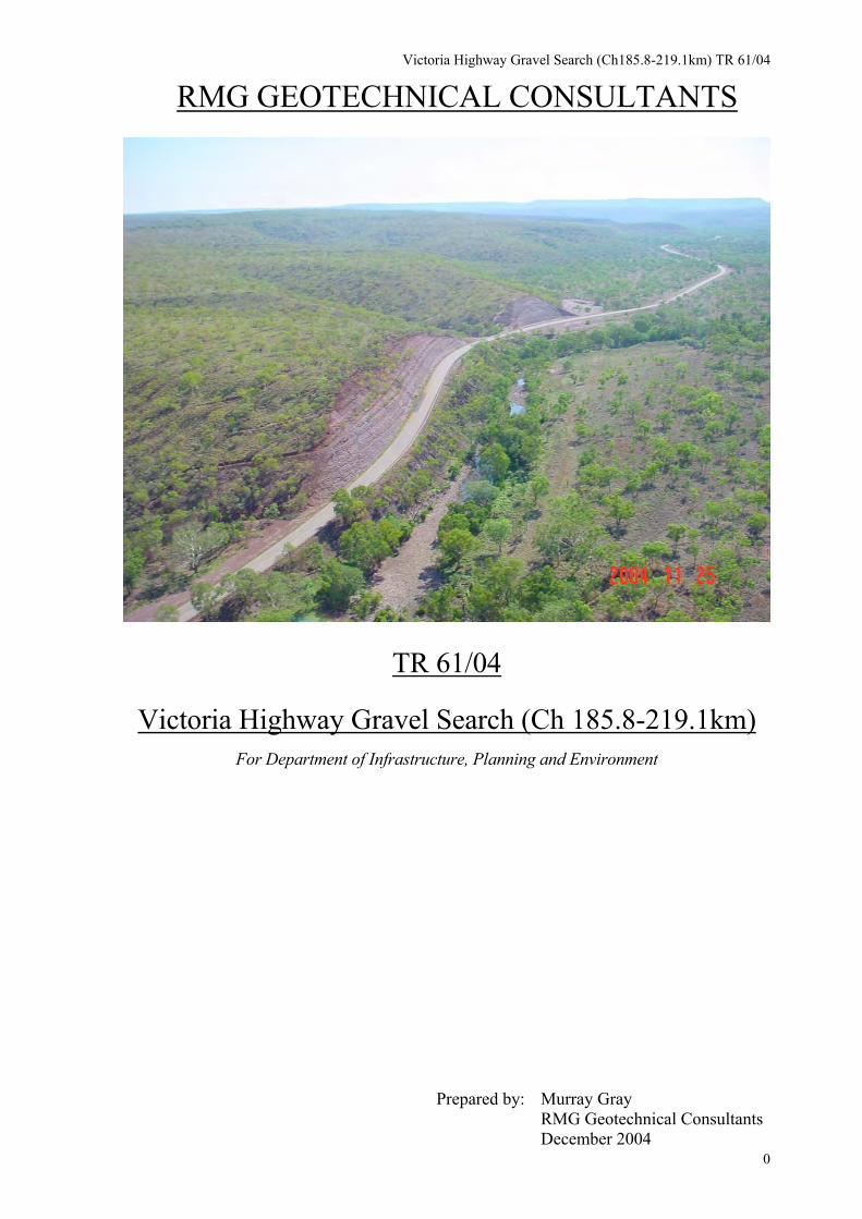
Victoria Highway Gravel Search (Ch185.8-219.1km) TR 61/04
RMG GEOTECHNICAL CONSULTANTS
TR 61/04
Victoria Highway Gravel Search (Ch 185.8-219.1km)
For Department of Infrastructure, Planning and Environment
Prepared by: Murray Gray RMG Geotechnical Consultants
0December 2004
Victoria Highway Gravel Search (Ch185.8-219.1km) TR 61/04
CONTENTS
PAGE
OVERVIEW 3
1.0 INTRODUCTION 4
2.0 SCOPE OF WORK 5
3.0 INVESTIGATION METHODS 6
4.0 RESULTS
4.1 SUMMARY OF INVESTIGATION SITES AND LABORATORY TEST RESULTS
4.1.1 SITE 1 INNESVALE SOUTH 10
4.1.2 SITE IP 2 INNESVALE SOUTH 10
4.1.3 SITE IP 3 INNESVALE SOUTH 11
4.1.4 SITE IP 4 INNESVALE SOUTH 11
4.1.5 SITE INNESVALE NORTH 11
4.1.6 SITE 17A 12
4.1.7 SITE 2 12
4.1.8 SITE 15 13
4.1.9 SITE 3 13
4.1.10 SITE 4 14
4.1.11 ESCARPMENT CREEK - SITE EC2 14
4.1.12 SITE 5 14
4.1.13 JOE CREEK - SITE 6 15
4.1.14 VICTORIA RIVER - SITE RG 2 15
4.1.15 EXISTING PIT (1) 15
4.1.16 VICTORIA RIVER - SITE RG 7 16
4.1.17 COOLIBAH PLATEAU PITS 16
4.1.18 EXISTING STOCKPILES (2) 16
4.1.19 EXISTING STOCKPILES (3&4) 17
1
Victoria Highway Gravel Search (Ch185.8-219.1km) TR 61/04
4.1.20 SITE 19 17
4.1.21 SITE 20 18
4.1.22 SITE 7 18
4.1.23 SITE 8 18
5.0 REFERENCES 19
TABLES
1 SUMMARY OF INVESTIGATION SITES AND LABORATORY TEST RESULTS
2 SUMMARY OF LABORATORY TEST RESULTS, VICTORIA HWY GRAVEL SEARCH BULK SAMPLES
3 COMPARISON OF VICTORIA HWY GRAVEL SEARCH BULK SAMPLES PSD RESULTS TO DIPE SPECIFICATION, PSD CLASS 2 & 3.
FIGURES
1 SITE LOCALITY PLAN VICTORIA HIGHWAY
2 SITE PLAN VICTORIA HIGHWAY GRAVEL SEARCH AREA GRAVEL PIT LOCATIONS, TOPOGRAPHIC 1:250 000
3 AAPA AUTHORITY CERTIFICATE SITE PLAN SHEET 1 OF 2
4 AAPA AUTHORITY CERTIFICATE SITE PLAN SHEET 2 OF 2
5 SUMMARY OF GRAVEL PIT DATA
APPENDIX A LABORATORY TEST REPORTS
B AAPA AUTHORITY CERTIFICATE
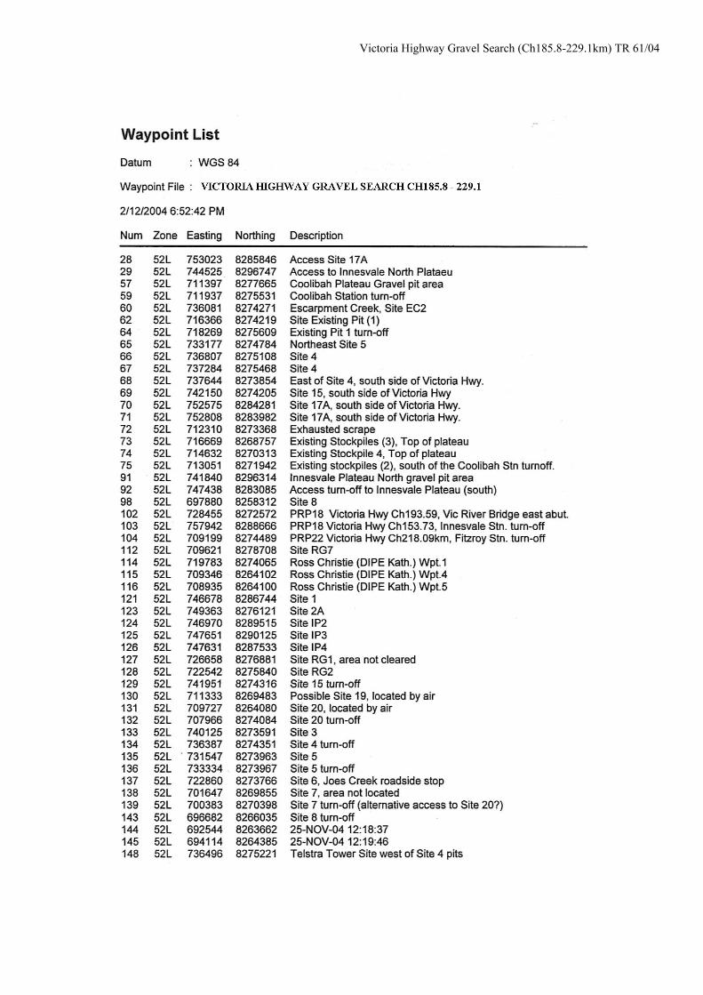
C GPS INFORMATION VICTORIA HIGHWAY GRAVEL SEARCH AREA
D SITE PHOTOGRAPHS Cover Photo: Victoria Highway facing east along Escarpment Creek
2
Victoria Highway Gravel Search (Ch185.8-219.1km) TR 61/04
OVERVIEW: VICTORIA HIGHWAY GRAVEL SEARCH, CH 185.8 TO 219.1KM Due to the size of the area to be covered and the number of gravel pit areas contained it was not deemed mandatory to land at gravel pit areas but to map the access and GPS pit location for the follow up ground traverse as stated in the fee proposal for Phase 1 of the project. Time limitations would not have allowed for the aerial reconnaissance of all the gravel areas for the purpose of sampling and mapping so the emphasis was to ensure the total area and all pits were covered, GPS co-ordinates were taken of gravel pit areas and access locations for the proposed 4WD traverse into the gravel areas. Unfortunately the follow up 4WD traverses were not possible into all gravel pit and stockpile areas where access tracks were overgrown and impassable due to terrain conditions including washouts and creeks. Further liaison with P&W, OEH & AAPA is required prior to any further fieldwork being carried out. Further discussion with Jerry Jones (Fitzroy Stn) & Milton Jones (Coolibah Stn) to gain local knowledge in regard to possible sources of both potential blending material for the river gravels and potential pavement gravels. Thick grassy undergrowth made locating some existing gravel areas east of the Victoria River difficult. West of the Victoria River Roadhouse gravel sources in the area are generally limited to the lower footslope and terrace areas along the Fitzroy & Stokes Ranges with a considerable haul distance from the Stokes Range area of Sites 19 & 20. Most sources along the Fitzroy Range have either been close to exhausted or are covered by an AAPA Avoidance Area. Further investigation is required into the potential use of suitable cutting material as a binder for river gravels.
3
Victoria Highway Gravel Search (Ch185.8-219.1km) TR 61/04
1.0 INTRODUCTION
The Department of Infrastructure, Planning and Environment (DIPE) is proposing to re-sheet the Victoria Highway from Ch185.8 to 219.1km. The construction would include raising the grade line along the section of the highway where wet season flooding closes the highway to traffic for long periods of time. The four bridges are also to be constructed along this section of the Victoria Highway. This will require the sourcing of approximately 75 000 compacted cubic meters of sealed basecourse quality material. Material should conform to the current DIPE specification for sealed basecourse material. Phase 1 of the investigation (described in this report) included a reconnaissance of all existing gravel pits and potential areas accessible by 4WD within an economic haul distance of the project. This was followed up with an aerial helicopter reconnaissance to locate all potential gravel areas within a 10km corridor either side of the highway. Potential gravel areas were mapped using a Garmin GPSmap60 followed by a further reconnaissance by 4WD to locate the potential areas found during the aerial survey.
It should be noted that the majority of gravel pits located are contained within the boundaries of the Gregory National Park. There are a number of AAPA exclusion zones along a 1km wide corridor along this section of the highway. These areas were not entered. In reference to the DIPE Roadworks master Specification Requirements, Chapter 1; Miscellaneous Provisions, all new gravel pit areas should conform to the following; • not within sight of road traffic • not within 125meters of a road • maximum area 1 hectare • maximum depth 2 meters • not within 25 meters of a water course • leave 25-meter wide natural vegetation strips between pits. Any proposed new pit areas shall need to be cleared of environmental, cultural and heritage concerns prior to pushing up of gravel pit areas. Authority for gravel extraction shall be applied for from the following bodies, • Aboriginal Areas Protection Authority (AAPA) • Office of Environment and Heritage (OEH) • Conservation and Natural Resources Division
4
Victoria Highway Gravel Search (Ch185.8-219.1km) TR 61/04
2.0 SCOPE OF WORK The scope of work “as discussed in the brief” on Phase 1 of this investigation consisted of the following: ● Locate suitable areas for investigation in conjunction with DIPE Roads
Project staff to obtain knowledge of local existing gravel pit areas and proposed new areas for investigation.
● Check past geotechnical reports, topographic maps and geological maps for
information relevant to potential gravel areas. ● Check past AAPA clearances. ● Authority for gravel extraction shall be applied for from the following bodies, • Aboriginal Areas Protection Authority (AAPA) • Office of Environment and Heritage (OEH) • Conservation and Natural Resources Division ● Assess all existing gravel pits located in the area containing sealed
basecourse quality material. ● Photography of all pit areas and relevant site conditions. ● Survey and mapping of all pit areas and prepare suitable plans. ● Laboratory testing of selected samples retrieved from potential pit areas for
proposed pavement material, comprising of the following, Particle Size Distribution (AS1289 3.6.1) Plastic Limit (AS1289 3.1.1) Liquid Limit (AS1289 3.2.1) Linear Shrinkage (AS1289 3.3.1) Plastic Index (AS1289 3.4.1) Maximum Modified Dry Density (AS1289 5.2.1) Californian Bearing Ratio at 100% (basecourse), MMDD 4-day soak (AS1289 6.1.1).
● Analysis of laboratory test results and field data. ● Production of a letter report for Phase 1 describing the investigation and
presenting the findings of the fieldwork, laboratory testing and containing all other information relevant to the investigation. This letter report shall be appended to the Phase 2 report.
5
Victoria Highway Gravel Search (Ch185.8-219.1km) TR 61/04
3.0 INVESTIGATION METHODS The following materials search was carried out by Murray Gray (RMG Geotechnical Consultants), and Lisa Noetzel (DIPE) between Tuesday September 23 and Saturday September 27, 2004. This investigation entailed an initial one-day 4WD reconnaissance followed by a one-day aerial reconnaissance of all existing gravel pits, stockpiles and roads located in the area of investigation. Access tracks to gravel pit areas and existing stockpiles were mapped by GPS from the helicopter for a follow up ground traverse by 4WD. One bulk sample was taken from the existing stockpiles (2) located approximately 3.2km south of the Coolibah turn off and 0.5km LHS. This material was sampled for laboratory testing to ascertain the quality of existing stockpiled material for use as a possible potential basecourse material for the pavement construction. This material is thought to be indicative of material to be found at Site 19 & Site 20 with varying percentages of oversize material. A large bulk sample of the river gravel was obtained from the Site RG 7. This material was obtained for future possible blending trials should a suitable blending material be located to improve the plastic properties of the screened river gravel. Oversize material from this sample will be crushed to minus 20mm and blended back into the screened sample at the required percentage to ascertain the PSD properties of the crushed product. Samples taken were subjected to the relevant laboratory classification tests. Lintin Geotechnical is a NATA registered laboratory and they carried out all laboratory testing. Laboratory test results are contained in Appendix A,
Digital photos were taken of all existing gravel pit areas and other relevant features and are contained in Appendix D, A summary of GPS information for gravel areas and access locations is contained in Appendix C of this report. The GPS used was a hand held Garmin GPSmap 60C and the accuracy of the readings are expected to be within 20m. The datum used for all GPS readings given in this report is WGS84. Survey of gravel pit areas was also carried out using the above-mentioned GPS. Due to a broken speedometer cable during the investigation all chainages and distances given in this report were calculated using the GPS data and therefore, are subject to considerable error. These chainages and distances should be used as a guide only. A summary of all gravel pit data is contained in Figure 5 of this report.
4.0 RESULTS
4.1 SUMMARY OF INVESTIGATION SITES AND LABORATORY TEST RESULTS
6
Victoria Highway Gravel Search (Ch185.8-219.1km) TR 61/04
Victoria Highway Gravel Search (Ch185.8-219.1km) TR 61/04
Victoria Highway Gravel Search (Ch185.8-219.1km) TR 61/04
Victoria Highway Gravel Search (Ch185.8-219.1km) TR 61/04
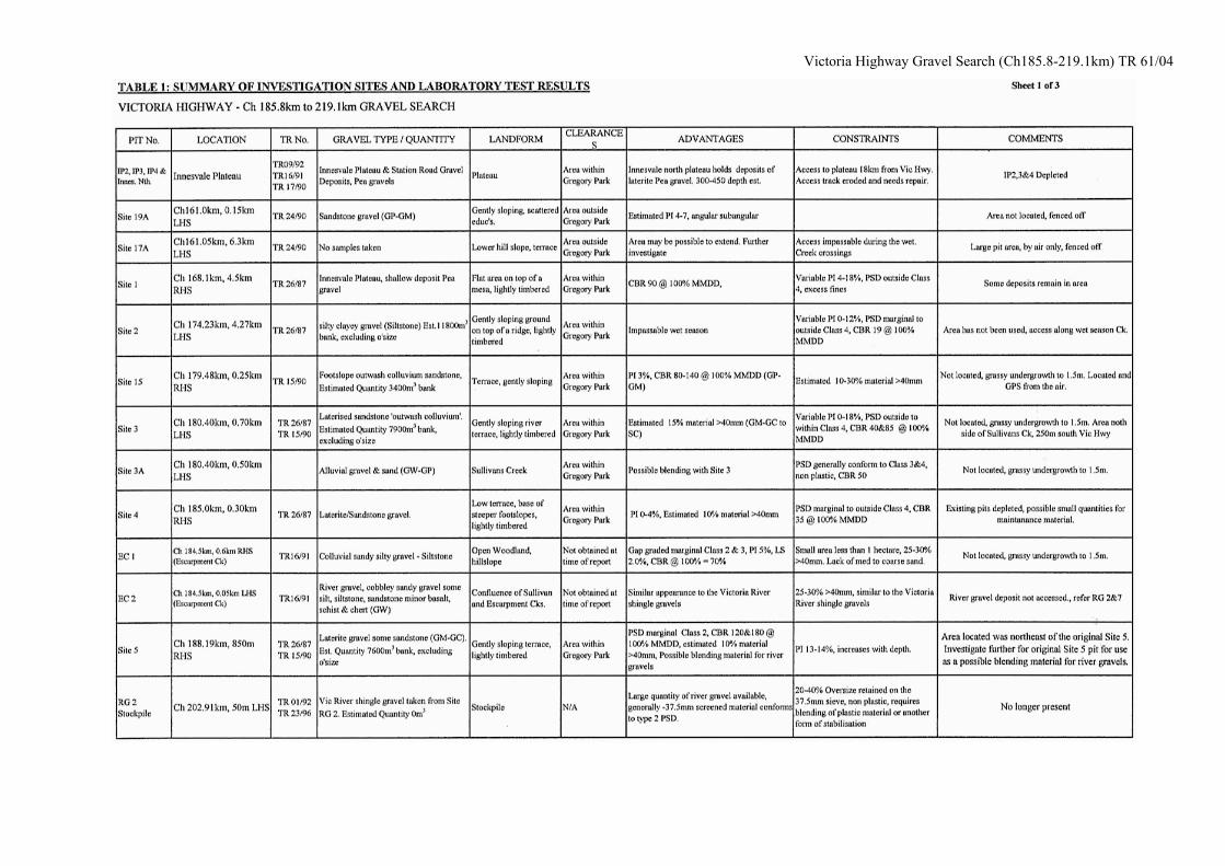
4.1.1 SITE 1, INNESVALE SOUTH Site 1 is located within the Gregory National Park. Access to the Innesvale South plateau is gained along the Innesvale Plateau track located 13.6km west of PRP 18, Menngen (Innesvale) Station road turn off, on the Victoria Highway at Chainage 167.33km. The Innesvale track runs north from the Victoria Highway to the top of the plateau where a Telstra Repeater Tower is located at approximately Ch 6.0km from the Victoria Highway. This is the smallest of the four gravel pit areas on the southern plateau, located along the Innesvale access track 1.3km south of the Telstra Repeater Tower at chainage 4.7km. Site 1 contained a shallow deposit of laterite Pea gravel. Materials from this area are generally sandy silty gravel, fine to medium gravel, fine sand. Max size 40mm., Nominal size 10 to 20mm. Estimated PI: 0 - 4 to 4 - 7. Sub rounded to rounded medium strength gravel. Light brown. GM-GM/GC. Loose to medium dense. This material overlies a dense Ferricrete generally found at depths of around 300 to 450mm. Some outcropping Ferricrete is evident in the area. A small quantity of gravel has been extracted from this location in the past where an existing pit of approximately 70x30meters is evident. This area could be extended to the north / northeast where a small reserve of gravel could be obtained although obtaining clearance for further extraction from the Innesvale area within the Gregory National Park would be difficult due to the large volume of reserves that have previously been utilised from this plateau. Reference to this area can be found within the following DIPE Technical Report - TR26/87.
4.1.2 SITE IP 2, INNESVALE SOUTH Site IP 2 is located within the Gregory National Park. Access to the Innesvale South plateau is gained along the Innesvale Plateau track located 13.6km west of PRP 18, Menngen (Innesvale) Station road turn off, on the Victoria Highway at Chainage 167.33km. The Innesvale track runs north from the Victoria Highway to the top of the plateau where a Telstra Repeater Tower is located at approximately Ch 6.0km from the Victoria Highway. This gravel pit is located approximately 1.4km north of the Telstra Repeater Tower where gravel reserves have been depleted. Reference to this area can be found within the following DIPE Technical Reports - TR17/90, TR16/91 & TR09/92. 10
Victoria Highway Gravel Search (Ch185.8-219.1km) TR 61/04
4.1.3 SITE IP 3, INNESVALE SOUTH Site IP 3 is located within the Gregory National Park. Access to the Innesvale South plateau is gained along the Innesvale Plateau track located 13.6km west of PRP 18, Menngen (Innesvale) Station road turn off, on the Victoria Highway at Chainage 167.33km. The Innesvale track runs north from the Victoria Highway to the top of the plateau where a Telstra Repeater Tower is located at approximately Ch 6.0km from the Victoria Highway. This gravel pit is located approximately 2.7km north of the Telstra Repeater Tower where gravel reserves were depleted during construction work carried out on the Victoria Highway east of chainage 152km prior to 1992. Reference to this area can be found within the following DIPE Technical Reports - TR17/90, TR16/91 & TR09/92.
4.1.4 SITE IP 4, INNESVALE SOUTH Site IP 4 is located within the Gregory National Park. Access to the Innesvale South plateau is gained along the Innesvale Plateau track located 13.6km west of PRP 18, Menngen (Innesvale) Station road turn off, on the Victoria Highway at Chainage 167.33km. The Innesvale track runs north from the Victoria Highway to the top of the plateau where a Telstra Repeater Tower is located at approximately Ch 6.0km from the Victoria Highway. This is the largest of the four gravel pit areas on the southern plateau, located 0.8km southeast of the Telstra Repeater Tower where gravel reserves have been depleted. Site IP 4 contained a shallow deposit of laterite Pea gravel. Materials from this area are generally sandy silty gravel, fine to medium gravel, fine sand. Max size 25mm., Nominal size 10 to 15mm. Estimated PI: 0 to 4. Sub rounded to rounded medium strength gravel. Light brown. GM. Loose to medium dense This material overlies a dense Ferricrete generally found at depths of around 300 to 450mm. Some outcropping Ferricrete is evident in the area. Reference to this area can be found within the following DIPE Technical Reports - TR17/90, TR16/91 & TR09/92.
4.1.5 SITE INNESVALE NORTH Innesvale North is located outside the Gregory National Park boundary. Access to the Innesvale North plateau is gained along Menngen (Innesvale) Station road located at PRP 18. Chainage 153.73km. The turn off for the north plateau is located at Ch 17.2km from the Victoria Highway on the LHS. The access track to the plateau gravel pit area is approximately Ch 2.5km west of the station road. At the time of this investigation the access track has been fenced off to limit access to the area. The access track was impassable due to deep erosion channels cut into the track. Repair work on the access road to the top of the plateau would need to be carried out before any further reserves could be removed from this area. 11
Victoria Highway Gravel Search (Ch185.8-219.1km) TR 61/04
This is a relatively new gravel pit area (In regard to the south plateau) on the northern plateau. This gravel pit contains a shallow deposit of laterite Pea gravel. Materials from this area are generally sandy silty gravel, fine to medium gravel, fine sand. Max size 20mm., Nominal size 10 to 20mm. Estimated PI: 0 - 4 to 4 - 7. Sub rounded to rounded medium strength gravel. Orange-red brown. GM to GM/GC. Loose to medium dense. Prior laboratory testing on this material show that the PSD is a fit to marginal DIPE Specification Class 2 gravel. Plasticity ranged from non-plastic to PI 12%, LS 0.5 to 6.0%. CBR testing carried out at 100% MMDD returned results that ranged from 90 to >200. This pit area is located outside the Gregory National Park boundary. Reference to this area can be found within the following DIPE Technical Reports - TR17/90, TR16/91 & TR09/92.
4.1.6 SITE 17A Site 17A is located outside the Gregory National Park boundary. Access to Site 17A is located 7.3km west of PRP 18, Menngen (Innesvale) Station road turn off, on the Victoria Highway at Chainage 161.03km, LHS. A Telstra Optical Fibre Regeneration Hut is located here on the LHS of the Victoria Highway where the access to the pit area runs from the front western corner of the compound. At the time of this investigation access to this area has been fenced off to restrict access to this area by 4WD. Aerial reconnaissance showed that a large pit area has been utilised on the lower footslope / terrace terrain in this area. Access to this area would become impassable during the wet season months.
4.1.7 SITE 2 Site 2 is located within the Gregory National Park. Access to Site 2 is located 20.5km west of PRP 18, Menngen (Innesvale) Station road turn off, on the Victoria Highway at Chainage 174.23km, LHS. The access track on the LHS of the Victoria Highway would become impassable during the wet season. This pit area could not be located by either 4WD or helicopter and it is possible that the source has not been utilised due to the 4.27km access track crossing at Sullivan Creek and the access track generally follows a feeder creek running into Sullivan Creek that would flood during the wet season months. Material encountered in this area was Colluvial siltstone gravel & cobbles. Prior laboratory testing on this material show that the PSD is marginal DIPE Specification Class 4 gravel. Plasticity ranged from non-plastic to PI 12%, LS 1.0 to 5.5%. CBR testing carried out returned results of 11 @ 95% MMDD & 19 at 100% MMDD. Because of the low CBR and variable Plasticity Index, this material is not suitable for use as pavement material. Site 2A was marked by GPS in the area along the same access track at Ch 4.65km where a possible small gravel deposit may have been utilised on lower hillslope / terrace terrain. This area would only be justified for use if the deposits from Site 2 were suitable for use as pavement material in sufficient quantities to warrant the construction of an access track along the existing wet season watercourse. Reference to this area can be found within the following DIPE Technical Report - TR26/87. 12
Victoria Highway Gravel Search (Ch185.8-219.1km) TR 61/04
4.1.8 SITE 15 Site 15 is located within the Gregory National Park. Access to Site 15 is located 25.75km west of PRP 18, Menngen (Innesvale) Station road turn off, on the Victoria Highway at Chainage 179.48km, LHS. The access track on the LHS of the Victoria Highway could not be located by 4WD but was located in the helicopter and GPS co-ordinates were taken. The pit area is located approximately 250 meters from the Victoria Highway but due to time constraints the area was unable to be located as it was obscured by thick grassy undergrowth throughout the area. Material encountered in this area was sandstone ‘outwash colluvium’. Prior laboratory testing on this material show that the PSD is marginal DIPE Specification Class 4 to Class 1 gravel. PI 3, LS 1.0 to 1.5%. CBR testing carried out returned results ranging from 80 to 140 at 100% MMDD. This area may have been depleted of gravel reserves over the years while being used for maintenance gravel. Reference to this area can be found within the following DIPE Technical Report – TR15/90.
4.1.9 SITE 3 Site 3 is located within the Gregory National Park. Access to Site 3 is located 27.67km west of PRP 18, Menngen (Innesvale) Station road turn off, on the Victoria Highway at Chainage 180.40km, LHS. The access track on the LHS of the Victoria Highway could not be located by 4WD but the gravel pit area was located in the helicopter and GPS co-ordinates were taken. The pit area is located approximately 250 meters from the Victoria Highway but due to time constraints the area was unable to be located as it was obscured by thick grassy undergrowth throughout the area. Material encountered in this area was laterised sandstone ‘outwash colluvium’. Prior laboratory testing on this material show that material from this area generally do not conform to the DIPE specification for sealed basecourse material. Blending trials with Site 3 material and material from Sullivan Creek (river gravel) south of this pit area have been conducted. Laboratory test results show the blended materials failed to conform to the DIPE specification for sealed basecourse material.
Proposed gravel areas on the south side of Sullivans Creek in this area could not be located by helicopter. It is possible that these reserves have not been utilised. Reference to this area can be found within the following DIPE Technical Reports - TR17/90, TR26/87 & TR15/90. 13
Victoria Highway Gravel Search (Ch185.8-219.1km) TR 61/04
4.1.10 SITE 4 Site 4 is located within the Gregory National Park. Access to Site 4 is located 31.27km west of PRP 18, Menngen (Innesvale) Station road turn off, on the Victoria Highway at Chainage 185.00km, RHS. The access track on the RHS is also an access to a Telstra Repeater Tower. Site 4 is located 1.1km from the Victoria Highway with a second pit area located a further 600 meters @ 1620 from the first pit area. This area could not be accessed by 4WD as the access track has become overgrown and erosion channels across the access track make it impassable. Site 4 is located on the lower footslope on the eastern side of the Telstra tower. The first pit covers an approximate area of 1700m2 where material has been extracted. Reserves in the pit area are colluvium laterised sandstone gravel with cobbles. Prior laboratory test results are not available for this gravel pit area. Reserves in the first pit area have been depleted and this old gravel area needs to be revegetated to minimise the erosion in the area. Access to the second pit area was not possible due to a large washout cutting the access track. Revegetation along the access track would indicate that this area has not been worked for quite a few years. Access to this area during the wet season would be restricted with a Creek crossing cutting across the access track. Reference to this area can be found within the following DIPE Technical Report - TR26/87.
4.1.11 ESCARPMENT CREEK SITE EC 2 Site EC 2 is located within the Gregory National Park. Site EC 2 is located at the confluence of Escarpment Creek & Sullivan Creek and is a source of river gravel similar to the Victoria River deposits. This non-plastic gravel would require blending with a binder to improve cohesion. No attempt was made to access this site. Reference to this area can be found within the following DIPE Technical Report – TR16/91.
4.1.12 SITE 5 Site 5 is located within the Gregory National Park. Access to Site 5 is located 34.46km west of PRP 18, Menngen (Innesvale) Station road turn off, on the Victoria Highway at Chainage 188.19km, RHS. The pit area is located 850 meters northwest of the Victoria Highway. Prior laboratory test results are not available for this gravel pit area. Reserves in this pit area generally have been depleted with a possibility of some small quantities of gravel remaining in the area. Reference to this area can be found within the following DIPE Technical Reports - TR26/87 & TR15/90. 14
Victoria Highway Gravel Search (Ch185.8-219.1km) TR 61/04
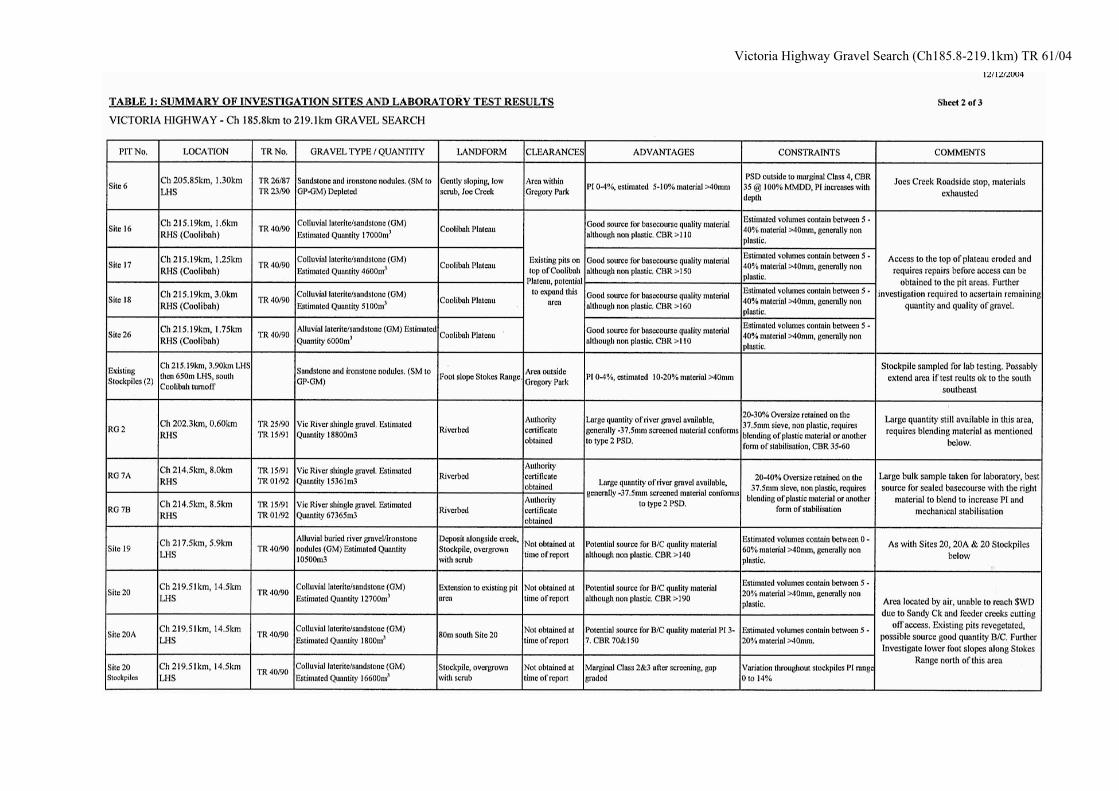
4.1.13 SITE 6 - JOE CREEK Site 6 is located within the Gregory National Park. Access to Site 6 is located 10.60km west of PRP 20, Victoria River Bridge east abutment, on the Victoria Highway at Chainage 204.20km, LHS. The access track on the LHS is also the access to the Joe Creek roadside stop. The pit area is located 1.6km from the Victoria Highway where gravel reserves have been depleted in the area. Reference to this area can be found within the following DIPE Technical Reports - TR17/90 & TR15/91.
4.1.14 VICTORIA RIVER - SITE RG 2 Site RG 2 is located within the Gregory National Park. Arial reconnaissance over the deposit RG 2 showed that this large deposit has remained relatively untouched. Material extracted from this area would require screening and the addition of material to improve the cohesion of the predominantly non-plastic material before it could be used as sealed basecourse material. This area has been cleared for gravel extraction by AAPA. Reference to this area can be found within the following DIPE Technical Reports – TR25/90 & TR15/90.
4.1.15 EXISTING PIT (1) Existing Pit (1) is located outside the Gregory National Park. Access to Existing Pit (1) is located 15.10km west of PRP 20, Victoria River Bridge east abutment, on the Victoria Highway at Chainage 208.69km, LHS. The pit area is located 2.7km southwest of the Victoria Highway. This pit would have been utilised as a Fill or subgrade material in the past and gravel reserves have been depleted in this pit. A shallow deposit of laterised sandstone gravel & cobbles is evident along the upslope areas along this access track to this pit area. This area may provide some shallow reserves of potential pavement material with screening of oversize material. Further investigation and test pits are required to confirm both the quality and quantity of reserves in this area. Access to this site would be impassable during the wet season months with a creek crossing that would restrict access. 15
Victoria Highway Gravel Search (Ch185.8-219.1km) TR 61/04
4.1.16 VICTORIA RIVER - SITE RG 7 Site RG 7 is located outside the Gregory National Park. Arial reconnaissance over the deposit RG 7 showed that this large deposit has remained relatively untouched. Access to this site is gained along the Coolibah Station Crocodile Farm road where the river access track intersects at the Crocodile Farm gate. A large bulk sample of the river gravel was obtained from an existing costean; this material was obtained for future possible future blending trials should a suitable blending material be located to improve the cohesion of the screened river gravel. Oversize material from this sample will be crushed to minus 20mm and blended back into the screened sample at the required percentage to ascertain the PSD properties of the crushed product. Reference to this area can be found within the following DIPE Technical Reports – TR15/91 & TR01/92.
4.1.17 COOLIBAH PLATEAU PITS, SITES 16, 17, 18 & 26 The Coolibah Plateau pits are located outside the Gregory National Park. Access to the Coolabah Plateau pit area is located 21.60km west of PRP 20, Victoria River Bridge east abutment, on the Victoria Highway at Chainage 215.19km, RHS. Coolibah Station turn-off. The access track is located 325 meters inside the Coolibah Station access road gate on the RHS, running up to the top of the plateau along the southern face. The access road has been eroded to the extent that the area is not accessible by 4WD. The haul road scouring would need to be repaired to make this site accessible. An aerial reconnaissance was carried out on the plateau where shallow reserves of laterite Pea gravel could be extracted from this area. Limited prior laboratory test results have shown the material encountered was non-plastic with CBR values >110. This area is originally mentioned in the AAPA authority certificate as being located within Avoidance Area 19 and it is not known whether clearance has since been granted for the extraction of gravel reserves on the Coolibah Plateau. Reference to this area can be found within the following DIPE Technical Report – TR40/90.
4.1.18 EXISTING STOCKPILES (2) These Existing Stockpiles (2) are located outside the Gregory National Park. Access to the Existing Stockpiles (2) is located south of the Victoria Highway at the Coolabah Station turn off, 21.60km west of PRP 20, Victoria River Bridge east abutment, on the Victoria Highway at Chainage 215.19km. The pit area is located 3.9km south of the Victoria Highway along the station fence line. At 3.9km the access to the pit area is 650 meters LHS. The existing stockpiles have revegetated with shrubs and saplings. The area is located on the lower foot slope area of Stokes Range. 16
Victoria Highway Gravel Search (Ch185.8-219.1km) TR 61/04
The existing pit area is estimated at 8500m2 and contains laterised sandstone gravel & cobbles.
Est. MPS 150-300mm, Nom. 40-75, PI 0-4, CBR >100. An estimated reserve in this pit area is 3000m3 not taking into account the oversize material estimated at 10-20% and loss due to the removal of the vegetation. This area could be extended if laboratory testing on a bulk sample taken from the stockpile return results that conform to the DIPE specification for sealed basecourse. Laboratory tests carried out on the bulk sample taken comprised the following,
• Particle Size Distribution (AS1289 3.6.1) • Plastic Limit (AS1289 3.1.1) • Liquid Limit (AS1289 3.2.1) • Linear Shrinkage (AS1289 3.3.1) • Plastic Index (AS1289 3.4.1) • Maximum Modified Dry Density (AS1289 5.2.1) • Californian Bearing Ratio at 100% (basecourse)
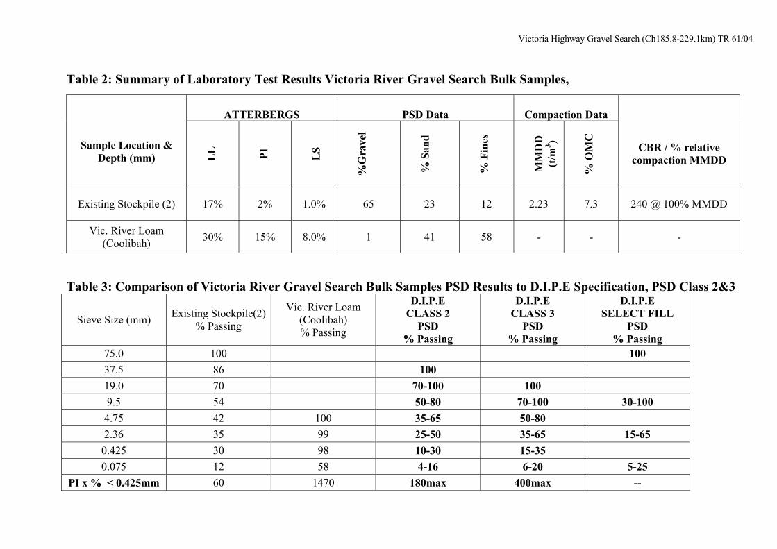
MMDD 4-day soak (AS1289 6.1.1), Access to this area during the wet season months would be difficult because there are a number of watercourses, which cross the access track to the stockpile area. Laboratory test results from the bulk sample taken are presented in Tables 2&3.
4.1.19 EXISTING STOCKPILES (3&4) These Existing Stockpiles (3&4) are located outside the Gregory National Park. These existing stockpiles are located on top of a plateau on the Stokes Range where it appears that a dozer has pushed up two stockpile areas of laterised sandstone gravel & cobbles. The existing stockpiles have revegetated. This area has not been utilised due to the difficulty in accessing this location where it appears that the dozer has been the only machinery on the plateau with no existing access track to the area. The estimated cost of building an access road to the top of Stokes Range would cost in excess of $1M due to difficult terrain and erosion protection measures required for the construction of the road.
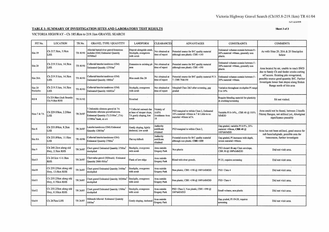
4.1.20 SITE 19 Site 19 is located outside the Gregory National Park. This area was located during the aerial reconnaissance where existing stockpiles were evident and GPS co-ordinates were taken. Site 19 could not be accessed by 4WD as Sandy Creek and feeder creeks have cut access to the area. This area holds promise for use as a source of sealed basecourse gravel. Material extracted from this area would require screening to remove the oversize material. Sampling and laboratory testing will need to be carried out to ascertain the properties of the existing stockpiled material. This area has promise as a potential sealed basecourse source that could be extended, although a site visit is needed to confirm the potential. Reference to this area can be found within the following DIPE Technical Report – TR40/90. 17
Victoria Highway Gravel Search (Ch185.8-219.1km) TR 61/04
4.1.21 SITE 20 Site 20 is located outside the Gregory National Park. Access to Site 20 is located 1.42km west of PRP 22, Fitzroy Station turn off, on the Victoria Highway at Chainage 219.51km. The pit area is located 14.5km south of the Victoria Highway along the station fence line. The existing stockpiles in this area have revegetated with shrubs and saplings. The area is located on the lower foot slope area of Stokes Range. This area was located during the aerial reconnaissance where existing stockpiles were evident and GPS co-ordinates were taken. Site 20 could not be accessed by 4WD as Sandy Creek and feeder creeks have cut access to the area. This area holds promise for use as a source of sealed basecourse gravel. Material extracted from this area would require screening to remove the oversize material. Sampling and laboratory testing will need to be carried out to ascertain the properties of the existing stockpiled material. This area has promise as a potential sealed basecourse source that could be extended, although a site visit is needed to confirm the potential. An alternative access to this area may be able to be located along the access track to Site 7. Reference to this area can be found within the following DIPE Technical Report – TR40/90.
4.1.22 SITE 7 Site 7 is located outside the Gregory National Park. Both aerial and ground reconnaissance was unable to locate any sign of a gravel pit area in this vicinity. According to TR26/87,Site 7 is located just outside AAPA avoidance area 18 and the area does not look to have been utilised. Located between knolls in the Fitzroy Range the area may have some significance in regard to aboriginal culture. Reference to this area can be found within the following DIPE Technical Report – TR26/87.
4.1.23 SITES 8 & 8A Site 8 & 8A are located outside the Gregory National Park. Access to Site 8 & 8A is located 15.80km west of PRP 22, Fitzroy Station turn off, on the Victoria Highway at Chainage 233.89km. The pit area is located 8.82km south of the Victoria Highway along the station fence line. This area was found and as yet has not been utilised. Prior laboratory testing on this material show that the PSD is a fit to marginal DIPE Specification Class 4 to marginal Class2 gravel. Plasticity ranged from non-plastic to PI 9%, LS 0.0 to 2.5%. CBR testing carried out at 100% MMDD returned results of 60. This area holds promise for use as a source of sub base gravel. Material extracted from this area would require screening to remove the oversize material. Further investigation of this site is required to locate Site 8A where TR40/90 states that a small quantity of material suitable for use as sealed basecourse is located. It may be possible this area could be extended. Reference to this area can be found within the following DIPE Technical Report – TR26/87 & TR40/90. 18
Victoria Highway Gravel Search (Ch185.8-219.1km) TR 61/04
5.0 REFERENCES
Technical Report 26/87 Victoria Highway, 124 to 280 KM (Delamere Road to Timber Creek) Materials Reconnaissance By Ted Warren & Associates Technical Report 02/88 Victoria Highway, 124 to 468 KM - Pavement Material Options By Berndt Weber Technical Report 15/90 Victoria Highway CH: 185.5 KM. to 193.0 KM Gravel Sites Evaluation By Ted Warren & Associates Technical Report 17/90 Victoria Highway Upgrading Gravel Search on Innesvale Plateau By Dames & Moore Technical Report 23/90 Victoria Highway CH. 203.8 KM Site 6 Gravel Re-evaluation By Ted Warren & Associates Technical Report 24/90 Victoria Highway, Potential Gravel Source Areas, Chainage 102 to 152 KM By Department of Transport & Works (Gordon Halstead) Technical Report 25/90 Victoria River Gravel Deposits, Materials Search By Acer Vaughan Pty/Ltd Technical Report 40/90 Victoria Highway: Joe Creek to Skull Creek, Pavement Materials Search By Ted Warren & Associates Technical Report 15/91 Victoria Highway Upgrading, Chainage 208.6 to 239.4 KM Victoria River Gravel Deposits, Preliminary Materials Investigation By Acer Vaughan Pty/Ltd Technical Report 16/91 Victoria Highway Upgrading, Chainage 151.9 to 185.5 KM Victoria River Gravel Deposits, Preliminary Materials Investigation By Acer Vaughan Pty/Ltd 19
DRAFT Victoria Highway Gravel Search (Ch185.8-219.1km) TR 61/04
Technical Report 09/92 Victoria Highway, Chainage 152 to 185 KM Gravel Sources (Innesvale Plateau Deposits) By Dames & Moore Technical Report 16/91 Victoria Highway Upgrading, Chainage 151.9 to 185.5 KM Preliminary Materials Investigation By Acer Vaughan Pty/Ltd Technical Report 23/96 Victoria Highway, Chainage 193 to 208 KM, (Victoria River Bridge to Lost Creek) Pavement Materials and Subgrade Investigation By Ullman & Nolan Geotechnic Pty/Ltd 20
Victoria Highway Gravel Search (Ch185.8-229.1km) TR 61/04
Table 2: Summary of Laboratory Test Results Victoria River Gravel Search Bulk Samples,
ATTERBERGS
PSD Data
Compaction Data
Sample Location & Depth (mm)
L
L
PI L
S %
Gra
vel
%
San
d
%
Fin
es
M
MD
D
(t/m
3 )
%
OM
C
CBR / % relative compaction MMDD
Existing Stockpile (2) 17% 2% 1.0% 65 23 12 2.23 7.3 240 @ 100% MMDD
Vic. River Loam (Coolibah) 30% 15% 8.0% 1 41 58 - - -
Table 3: Comparison of Victoria River Gravel Search Bulk Samples PSD Results to D.I.P.E Specification, PSD Class 2&3
Sieve Size (mm) Existing Stockpile(2) % Passing
Vic. River Loam (Coolibah) % Passing
D.I.P.E CLASS 2
PSD % Passing
D.I.P.E CLASS 3
PSD % Passing
D.I.P.E SELECT FILL
PSD % Passing
75.0 100 10037.5 86 10019.0 70 70-100 1009.5 54 50-80 70-100 30-1004.75 42 100 35-65 50-802.36 35 99 25-50 35-65 15-650.425 30 98 10-30 15-350.075 12 58 4-16 6-20 5-25
PI x % < 0.425mm 60 1470 180max 400max --
Victoria Highway Gravel Search (Ch185.8-229.1km) TR 61/04
APPENDIX C
GPS INFORMATION VICTORIA HIGHWAY GRAVEL SEARCH
AREA
Victoria Highway Gravel Search (Ch185.8-229.1km) TR 61/04