Embed Size (px)
Citation preview

Town and Country Planning Department, Punjab

CONTENTS
LIST OF FIGURES i LIST OF DRAWINGS i LIST OF TABLES ii LIST OF ANNEXURES iii EXECUTIVE SUMMARY iv
1 INTRODUCTION 1 1.1 Initial Steps 1 1.2 Regional Setting 2 1.3 Physiographic and Climate 4 1.4 Historical Background 5 1.5 Legal Framework for Preparation and Implementation of Master Plan 5
2 POPULATION ECONOMY AND EMPLOYMENT 12 2.1 Population Growth and Characteristics 12 2.2 Population Characteristics of M.C. Raman Mandi 14 2.3 Population Density 15 2.4 Settlement Pattern and Population Distribution in LPA Raman Mandi 17 2.5 Sex Ratio 20 2.6 Literacy 21 2.7 Employment LPA Raman Mandi 23 2.8 Occupational structure 23
3 HOUSING AND SLUMS 26 3.1 Growth of Housing in M.C. Raman Mandi 26 3.2 Housing Characteristics 27 3.3 Services to Households 27 3.4 Household by Source of Drinking Water 28 3.5 Slums in M.C Raman Mandi 28 3.6 General Characteristics of Slums in M.C. Raman Mandi 29 3.7 Distribution and Location of Slum Areas 30
4 EXISTING LAND USE 31 4.1 Existing Land Use: M.C. Raman Mandi 31 4.2 Existing Land Use: M.C. Raman Mandi 32 4.3 Residential 36 4.4 Commercial 36 4.5 Industry 36 4.6 Transportation 37 4.7 Public & Semi Public 37 4.8 Utilities 37 4.9 Agricultural/ Rural 37 4.10 Existing Rail- Road Network 38 4.11 Road Network at LPA level 38 4.12 Road Network at Town level 39 4.13 Environmental Status 41
Town and Country Planning Department, Punjab

4.14 Water Pollution 41 4.15 Heritage and Conversation 41
5 EXISTING INFRASTRUCTURE 42 5.1 Physical Infrastructure 42 5.2 Social Infrastructure 46
6 VISUALIZING THE FUTURE 48 6.1 Population Projections 2031 48 6.2 Method I: Ratio Method or Sharing Pattern Method 48 6.3 Method II: Population Projection by Extrapolation Method 50 6.4 Infrastructure Requirement 52 6.5 Constitution of Think Tank 54 6.6 The Strength Weakness Opportunities Threat (SWOT) Analysis 54
6.7 Vision-2031 54 7 THE MASTER PLAN 57
7.1 Components of the Master Plan 57 7.2 Master Planning Objectives 57 7.3 Evaluation of Present Town Structure 58 7.4 Future Town Structure Raman Mandi-2031 60 7.5 Land Use Requirements 61 7.6 Area required for main Land Uses 61 7.7 Residential Use 61 7.8 Commercial Use 62 7.9 Industrial 63 7.10 Recreational Facilities 64 7.11 Road Network Requirement at Town level 65 7.12 Road Network at LPA level 65 7.13 Terminal Required 66 7.14 Land Required for Social Infrastructure 66 7.15 Social Infrastructure and Public Utilities 67 7.16 Transportation 69 7.17 Proposed Land Use Plan 69 7.18 Residential 73 7.19 Commercial 75 7.20 Informal Sector 75 7.21 Existing Policy for Informal Sector 76 7.22 Planning Norms for Informal Trade 76 7.23 Industrial 77 7.24 Petroleum, Chemical & Petrochemical Investment Region (PCPIR) 78 7.25 Mixed land Use 79 7.26 Rural and Agricultural Zone 80 7.27 Transportation 80 7.28 Proposed Road Network 81 7.29 Main Roads 81 7.30 Sector Roads 83 7.31 Other Roads 83 7.32 Bus Stand 84 7.33 Truck Stand 84 7.34 Utilities 84 7.35 Public & Semi Public Uses 84
Town and Country Planning Department, Punjab
7.36 Parks & Play Grounds 84
8. ZONING REGULATIONS AND DEVELOPMENT CONTROL REGULATIONS 85 SECTION-I 8.1 Zoning Regulations 85 8.2 Land Use Zone 88 8.3 Use Provisions in Land Use Zones 88 8.4 Exceptions 94 8.5 Residential Densities 96 SECTION-II 8.6 Development Control Regulations 97 8.7 Development Controls along Roads 102 8.8 Transferable Development Rights 105 8.9Implementation of these Regulations 106
Town and Country Planning Department, Punjab

LIST OF FIGURES
Figure 1: Regional Setting, Raman Mandi 4 Figure 2: Growth Trend of Population of LPA Raman Mandi 1981-2001 13 Figure 3: Population Growth Rate of M.C. Raman Mandi 1951-200 15 Figure 4: Ward Wise Density Gradient in Raman Mandi Town 17 Figure 5: Population Growth of Urban and Rural Settlements of LPA Raman Mandi (1991-2001) 20 Figure 6: Sex Ratio of LPA Raman Mandi and M.C. Raman Mandi 21 Figure 7: Literacy Rate in LPA Raman Mandi and M.C.Raman Mandi 22 Figure 8: Literacy Rate of Males in LPA Raman Mandi and M.C.Raman Mandi 22 Figure 9: Literacy Rate of Females in LPA Raman Mandi and M.C. Raman Mandi 23 Figure 10: Occupational Structure of LPA,Raman Mandi 1981-2001 24 Figure 11: Occupational Structure of M.C.Raman Mandi 25 Figure 12: Existing Rail-Road Network Raman Mandi-2010 40 Figure 13: Growth of Water Connection in Raman Mandi 42 Figure14: Areas Covered under Water Supply M.C.Raman Mandi-2010 43 Figure15: Total Number of Sewer Connections in Raman Mandi (2007-2010) 44 Figure 16: Area Covered under Sewerage in M.C.Raman Mandi (2010) 45 Figure17: Social Infrastructure within M.C.Raman Mandi -2010 47 Figure 18: Work and Living Areas- Raman Mandi 59 Figure 19: Concept plan of Raman Mandi -2031 60
LIST OF DRAWINGS
1: LPA Raman Mandi 3 2: Existing Land Use Plan LPA Raman Mandi 33 3: Existing Land Use Plan Raman Mandi 36 4: Proposed Land Use Plan LPA Raman Mandi 72 5: Proposed Transport Network Plan Raman Mandi 82
Town and Country Planning Department, Punjab

5
10
15
20
25
30
35
40
45
LIST OF TABLES Table 1 : Population Growth Rate of Punjab State and LPA Raman Mandi 1981 -2001 12 Table 2 : Share of LPA Raman Mandi in Punjab State 13 Table 3 : Population Growth Rate of M.C. Raman Mandi - 1951 – 2001 14 Table 4 : Population Density (Within Municipal Limits) 15 Table : Ward Wise Population density of M.C. Raman Mandi Town: 2001 16 Table 6 : Density Gradient M.C.Raman Mandi (Ward Wise):2001 16 Table 7 : Growth Rate of Village of LPA Raman Mandi: 1981 – 2001 18 Table 8 : Sex Ratio of LPA Raman Mandi and M.C. Raman Mandi Town, 1981-2001 20 Table 9 : Literacy Rate of Local Planning Area, Raman Mandi 1981-2001 21 Table : Literacy Rate of M.C. Raman Mandi: 1981-2001 22 Table 11 : Workers and Non Workers in LPA and M.C.Raman Mandi 1981-2001 23 Table 12 : Occupational Structure of LPA,Raman Mandi 1981-2001 24 Table 13 : Occupational Structure of M.C.Raman Mandi 1981-2001 25 Table 14: Growth of Houses and Households in M.C. Raman Mandi 27 Table : Residential Houses by Their Type of Structure in Raman Mandi Town 2001 27 Table 16 : Households by Number of Dwelling Rooms in Bathinda District Urban 2001 28 Table 17: Houses by Source of Drinking Water in M.C.Raman Mandi: 2001 28 Table 18 : Detail of Identified Slum Areas in M.C.Raman Mandi 29 Table 19: Existing Land Use, LPA Raman Mandi-2001 31 Table : Existing Land Use of Municipal Council Raman Mandi-2010 34 Table 21 : Growth of Water Connections in Raman Mandi 42 Table 22 : Number of Sewer Connections,Raman Mandi (2007-2010) 44 Table 23: Education Facilities in Local Planning Area and Raman Mandi 46 Table 24 : Growth Rate of Population of Raman Mandi LPA,(Urban and Rural) 1981-2001) 48 Table : Projected Population of Punjab Total, Punjab Urban, and Punjab Rural
2001- 2026(In Thousands) 49 Table 26: Share of Population of LPA, Raman Mandi to Population of Punjab 49 Table 27: Share basis population of LPA Raman Mandi (Urban & Rural 2006-31) 50 Table 28: Projected Population for LPA Raman Mandi Total, Urban and Rural 2011 – 2031 51 Table 29: Comparison of Projected Population by Two Methods for the Year-2031 51 Table : Water Demand in Raman Mandi (2011-2031) 52 Table 31: Sewage Generation in Raman Mandi (2011-2031) 53 Table 32: Power Requirement of Raman Mandi Town (2011-2031) 53 Table 33: Calculation of Average Plot Area in Raman Mandi 62 Table 34: Stage wise Residential Area Requirements for Urban Area, LPA Raman Mandi
(2011-2031) 62 Table : Area of Commercial Centers 62 Table 36: Commercial Area Requirements for Urban Areas of LPA, Raman Mandi 63 Table 37: Projected Industrial Area Requirements for LPA Raman Mandi- 2031 64 Table 38: Land Requirement for Educational Facilities (For 100000 populations) 66 Table 39: Land Requirement for Medical Facilities (For 250,000 persons) 66 Table : Land Requirement for Police. (For 100,000 persons) 67 Table 41: Land Requirement for Fire Station 67 Table 42: Land Requirements for Main Public Amenities 67 Table 43: Norms and Standards of Cycle Tracks 69 Table 44: Break up of Major Proposed Land Uses LPA Raman Mandi-2031 71 Table : Planning Norms for Informal Sector 77 Table 46: Maximum Permissible Density 96
Town and Country Planning Department, Punjab

LIST OF ANNEXURES
Annexure 1: Notification Regarding Declaration of LPA Raman Mandi 107 Annexure 2: Notification Regarding Declaration of Planning Agency 109 Annexure 3: Comparative Statement of Norms and Standards for Social Infrastructure 110 Annexure 4: Preceeding of Meeting Relating to setting up of a PCPIR 113 Annexure 5: Policy Resolution for Promotion of PCPIR 122
]
Town and Country Planning Department, Punjab

Town and Country Planning Department, Punjab

EXECUTIVE SUMMARY
Introduction
Raman Mandi with its population of 19551 in 2001 is the 4th largest town in Bathinda district. This town had a very slow growth rate till 2001 but with the establishment of Guru Gobind Singh Refinery the growth Scenario of the town changed overnight and this sleepy town is becoming an important growth centre of the district.
Regional Setting
Raman Mandi is located at a distance of about 35kms towards south of Bathinda about 45kms towards north of Sirsa. It extends from 29º-52’-02”N to 30º-09’-08”N latitude and 74º-41’-57”E to 75º-03’-39”E longitude.It has road connectivity with Bathinda and Mansa via Talwandi Sabo and a near link by Bathinda – Dabwali road (N.H. 64) through refinery road.
Historical Background
Raman Mandi Town does not have deep historical roots.when the railway line from Sirsa to Bathinda was laid through this area,the town of Raman Mandi was established on Bathinda-Sirsa railway line. In the year 1953 small town committee was established and it became a municipal town in 1955.
Legal Framework
The Punjab Regional and Town Planning and Development Act, as amended 2006 provide the legal framework for preparation of Master Plan. The four stage process involves declaration of Local Planning Area, designation of Planning Agency, preparation of present land use map and preparation and approval of Master Plan. The contents of the Master Plan as laid down by the Act are;
(a) Broad indication of the manner in which the land in the area should be used. (b) Allocation of areas or zones of land for use for different purposes. (c) Indication, definition and provision of the existing and proposed highways, roads,
major streets and other lines of communication. (d) Indication of areas covered under heritage site and the manner in which
protection, preservation and conservation of such site including its regulation and control of development, which is either affecting the heritage site or its vicinity, shall be carried out.
(e) Regulations to regulate within each zone the location, height, number of storeys and size of buildings and other structures, open spaces and the use of buildings and structures.
Town and Country Planning Department, Punjab

Town and Country Planning Department, Punjab

CHAPTER: 1
INTRODUCTION
1.1 Initial Steps
The process of preparation of Master Plan of Local Planning Area Raman Mandi was
started with the delineation of Local Planning Area of Raman Mandi. The Local Planning
Area (LPA) Raman Mandi has been notified under section 56 (1) of “The Punjab
Regional and Town Planning and Development (Amendment) Act” 2006 in the official
gazette vide notification No. 12/55/2006-4HGI / 9857 Dated 19–12–2007 (refer
Annexure–I). As per this notification LPA Raman Mandi includes the two Municipal
towns Raman Mandi and Sangat Mandi and 39 (thirty-nine) villages. All of these villages
fall within the administrative boundaries of District Bathinda. The total area of LPA
Raman Mandi works to be 50555 hectares as per revenue records where as Punjab
Remote Sensing centre PAU Ludhiana provided this figure as 50574 hectares. The details
of areas and population etc of LPA Raman Mandi are given in Annexure-1.The
Government designated the Chief Town Planner, Punjab as the Planning Agency to
prepare Master Plan of LPA Raman Mandi (Refer Annexure – 2).
· While delineating LPA of Raman Mandi following factors mentioned in rule 22 of the
Punjab Regional and Town planning and Development (General Rules) 1995 have been
considered.
a) Administrative boundary limits of the villages, the district, and the state for better
identification and management of the LPA.
b) Geographical features Kotla branch of Sirhind canal, Lassara drain and other
physical features.
c) The means of communication and accessibility.
d) The present and future growth trends and distribution of the population.
e) Industrial location (That of Guru Gobind Singh Refinery) and expected growth
trends likely to take place because of Refinery.
f) Economic base and commercial activities of the towns and their surrounding
areas.
Town and Country Planning Department, Punjab

g) Preservation of historical and cultural heritage of the areas.
h) Urban expansions trends and management of periphery areas for ecological and
environmental balance have also been kept in mind.
i) Dispersal of economic activities to alleviate expected pressure on Raman Mandi
and balanced development of the area.
Local Planning Area Raman Mandi spreads over an area of 50574 hectares which comprises of revenue estates of 39 villages and two municipal towns known as Raman Mandi and Sangat Mandi besides this the site of Guru Gobind Singh refinery also falls in this LPA which measures to 880 hectares. Out of total area of LPA about 553 hectares are urban which comprises area of M.C.Raman Mandi 525 hectares and Sangat Mandi only 28 hectares only, which is about 1.09% of total area whereas 50021 hectare is rural area which is 98.97%. Local Planning Area Raman Mandi has a population of 131633 persons as per 2001 census out of which 24952 are urbanites and 106681 are ruralities.The jurisdiction of LPA Raman Mandi extends up to village Gehri Devi Nagar in North and village Giana in south whereas Jeon Singh Wala and Chak Kharak Singh Wala urf Doom Wali, are the last villages in east and west respectively. The Physical extent and boundaries of LPA Raman Mandi are shown in Drg. No. DTP (B) 1516/2007 dated 17-12-2007/19-12-2007.
1.2 Regional Setting
Raman Mandi is one of the small towns of district Bathinda which is a commercial centre
of southern part of Bathinda district. It is situated in southern part of Punjab State which
is known as cotton belt of the state. Raman Mandi is located at a distance of about 35
kms. towards south of Bathinda about 45 kms. towards north of Sirsa. Bathinda-Sirsa
railway line passes through the town and it is an important station between Bathinda and
Sirsa. It has road connectivity with Bathinda and Mansa via Talwandi Sabo and with
Bathinda-Dabwali road through refinery road as shown in Figure 1 below. In
geographical terms LPA Raman Mandi extends from 29°-52'-02"N to 30°- 09'-08"N
latitude and 74°-41'-57"°E to 75°-03'-39"E longitude.
Town and Country Planning Department, Punjab

Town and Country Planning Department, Punjab

Figure 2: Regional Setting, Raman Mandi.
1.3 Physiography and Climate
Local Planning Area Raman Mandi mostly comprises of sandy and sandy loam soils
which is considered as fertile. In some of the villages big sand dunes can still be seen
however the topography of area experienced a vast change with various ventures
connected with green revolution. A large number of sand dunes have been leveled by the
farmers to put more and more land under cultivation. No river flows through the Local
Planning Area however Kotla branch of Sirhind Canal passes through the area providing
a good irrigation network.
The district of Bathinda as well as LPA Raman Mandi lies in the southern region of the
State and is far away from the SHIVALIK HILL ranges in the North–East. It is nearer to
the Thar Desert of Rajasthan and away from the major rivers that run through the State.
Therefore climatically this area has a very hot summer. During the Month of June which
is peak of summer season the mercury sometimes touches 47ºC and the dust storms are
regular feature and this area. There is very short spell of rainy season with scanty rainfall
of about 410 mm per annum. The winter season is dry with minimum temperature
touching to 0ºC. The prevailing wind direction of this region is north–west to south–east.
Town and Country Planning Department, Punjab

1.4 Historical Background
The town of Raman Mandi does not have deep historical roots and has very recent origin
which is hardly one hundred years back when railway line from Sirsa to Bathinda was
laid through this area, under the British policy of establishment of Mandi towns in the
beginning of 20th century, the town of Raman Mandi was established on Bathinda– Sirsa
railway line. This town never availed any administrative status. In the year 1953 small
town committee was established and it became a municipal town in 1955.
1.5 Legal Framework for Preparation and Implementation of Master Plan
The principal `legislation governing regional and town planning in the State of Punjab is
the “ Punjab Regional and Town Planning and Development Act,1995 which was enacted
in the year 1995 ( Punjab Act No. 11 of 1995 ) and has been amended in the year 2006
and is now known as “ The Punjab Regional and Town Planning and Development
( Amendment ) Act 2006” (Punjab Act No.11 of 1995 ).This is an Act to make provision
for better planning and regulating the development and use of land in planning areas
delineated for that purpose, for preparation of Regional Plans and Master Plans and
implementation thereof, for the constitution of a Regional and Town Planning and
Development Board, for guiding and directing the planning and development processes in
the State, for the constitution of a State Urban Planning and Development Authority,
Special Urban Planning and Development Authorities and new Town Planning and
Development Authorities, for the effective and planned development of Planning Areas
and for undertaking urban development and housing programmers and schemes for
establishing new towns and for matters connected there with or incidental there to.
· Prior to the enactment of this Act the town planning activities within urban areas were
governed by different legislations such as 'The Punjab Town Improvement Act 1922',The
Punjab Municipal act 1911','The Punjab Municipal Corporation Act 1976',The Punjab
Urban Estates (Development and Regulation) Act 1964 etc and for areas falling outside
Municipal limits in the periphery of urban centers, there was "The Punjab Scheduled
Roads and Controlled Areas Restriction of Unregulated Development Act 1963 (Now
Repealed) but no comprehensive legislation was available for the overall control and
development at local and regional level.
Town and Country Planning Department, Punjab

· The Punjab Regional and Town Planning and Development (Amendment) Act 2006
(Main Provisions of the Law).
This Act provides the framework for preparing Master Plans and Regional Plans and
provides for the manner in which the use of land in the local planning area is regulated.
The Act also prescribes specific time period for various steps in the plan preparation
process.
The Act intends to achieve the following main objectives:
a) To consolidate, with suitable modifications, in one place laws dealing with the
different aspects of urban development.
b) To set up a high powered board to advise the State government and to guide and
direct planning and development agencies, with respect to matters pertaining to
the planning, development and use of urban and rural land.
c) To set up a state level Urban Planning and Development Authority and to provide
for the setting up of the Special Urban Planning and Development Authorities to
promote and secure better planning and development of different regions, area
and cities.
d) To create a legal and administrative setup for the preparation and enforcement of
Master Plans for regions, areas and for existing and new cities.
e) To make the whole programmes of urban development mainly a self - sustaining
and self - paying process.
f) To interlink land development and house construction permitting full exploitation
of the urban land resource to provide a boost to the programmers of house
construction, especially the Economically Weaker Sections of the Society.
g) To provide a legal, administrative, and financial framework for the preparation
and execution of Town Development Schemes aimed at filling the gaps in the
required civil infrastructure and securing the renewal and redevelopment of
congested and decayed areas in the existing towns.
· The main provisions of the Act related to preparation of Master Plan are described below:
Town and Country Planning Department, Punjab

a. Section 56(1) enables declaration of Local Planning Area (LPA) in the official gazette
for preparing Master Plan. Once an area has been declared under section-56 (1), no
person can institute or change the use of land for any purpose or carry out any
development in respect of any land without the prior permission of competent authority
until the Master Plan comes into operation. However, this prohibition does not apply to
any area comprised in ‘abadi deh’ of any village falling inside its ‘lal lakir’ or ‘phirni’.
b. Section 57 provides for the state Government to designate Planning Agency for area
declared as Local Planning Area.
c. Section 58 defines scope of Planning agency and provides that;
- The designated Planning Agency will work under the overall directions
and control of the State Government.
- The State Government may assign any or all of the following functions to
the Designated Planning Agency, namely the Chief Town Planner.
- Carry out survey of the regional planning area, local planning area or a site
for new town, as the case may be, and prepare reports on the surveys so
carried out;
- Prepare an existing land use map and such other maps as may be
necessary for the purpose of preparing regional plan and outline master
plan, a new town development plan or a comprehensive master plan, as the
case may be;
- Prepare a regional plan, an outline master plan, a new town development
plan, or a comprehensive master plan.
- Subject to and in accordance with the directions of the Govt., the
designated planning agency shall exercise all such powers as may be
necessary or expedient for the purposes of carrying out its functions under
this act and also perform any other functions which are supplemental,
incidental or consequential to any of the functions specified in sub section
(2) or as may be prescribed.
d. Section 59 deals with the preparation of present land use map and fixes six months time
for this purpose, which may be extended by the State Govt. from time to time.
Town and Country Planning Department, Punjab

e. Section 70(1) states that the planning agency shall not later than one year after
declaration of planning area and after the designation of that agency for that area shall
prepare and submit to the state government a master plan for its approval. The Master
Plan so prepared shall –
- Indicate broadly the manner in which the land in the area should be used.
- Allocate areas or zones of land for use for different purposes.
- Indicate, define, and provide the existing and proposed highways, roads,
major streets and other lines of communication.
- Indicate areas covered under heritage site and the manner in which
protection, preservation, and conservation of such site including its
regulation and control of development, which is either affecting the heritage
site or its vicinity, shall be carried out.
- Include regulations to regulate within each zone the location, height, number
of storeys and size of buildings and other structures, open spaces and the use
of buildings, structures, and land.
f. Section 70 (3) has the provision for the state government to direct the designated
planning agency to publish the existing land use plan and master plan and the information
regarding places where copies of the same may be inspected by the public for inviting
objections in writing with respect to existing land use plan and master plan within a
period of 30 days from the date of publication.
g. Under Section 70(4), the state government after considering the objections and in
consultation with the Board may direct the designated planning agency to modify the
master plan or approve it as such.
h. Under Section 70 (5), the Designated Planning Agency after approval of the state
government shall publish the final master plan in the official gazette after carrying out the
modification if any under intimation to the state government within a period of 30 days
from the date of according the approval by the state government.
i. According to Section 75, the Master Plan comes into operation from the date of
publication, referred in to sub section 5 of Section 70.
The entire process is shown in the form of flowchart:-
Stages of Master plan preparation
Town and Country Planning Department, Punjab

Town and Country Planning Department, Punjab

· Chapter XI of the Act also provides for “Control of Development and Use of Land in the
area where the Master Plan is in operation.”
· Chapter XII, Section 91 of the Act deals with the preparation of Town Development
Schemes that can play a significant role in the implementation of Master Plan by way of
planned development and through making land available for the open spaces, recreation,
education and health services, transport and communication network, water supply,
sewerage, sewage disposal and other public utilities including electricity and gas etc.
· Chapter XIV deals with “Control and Development along Scheduled Roads”
· In addition to the "The Punjab Regional and Town Planning and Development
(Amendment) Act 2006" there are a few Acts that have no direct bearing on preparation
of Master Plan but have a definite role to play in the implementation of the proposals of
the Master Plan. These are briefly described below;
(A) Punjab Apartment And Property Regulation Act, 1995
The Punjab Apartment and Property Regulation Act, 1995 has been enacted with a view to regulate the promotion of the construction, transfer and management of apartments on ownership basis, to regulate colonies and property transactions and to provide for registration of promoters and estate agents and enforcement of obligations on promoters and estate agents and for matters connected therewith or incidental thereto. - It provides planned development by checking, controlling and regulating the activities of
the private developers.
- It makes funds available for planned development.
- It provides land for social and physical infrastructure through the mechanism of planned
development.
- It also has the provision to make social housing available at low prices for Economically
Weaker Section of the society.
(B) Punjab Town Improvement Act, 1922
The Punjab Town Improvement Act, 1922 plays a significant role for the implementation of Master Plans in the following manner: - It helps to provide planned development through the mechanism of Development
Schemes.
- It makes land available for the development of social and physical infrastructure like schools, health, parks and playgrounds, and planned road network etc.
- It also provides social housing to Economical Weaker Sections and thus helps to check the growth of slums.
Town and Country Planning Department, Punjab

(C) Punjab Municipal Act 1911 and Punjab Municipal Corporation Act 1976. The Punjab Municipal Act, 1911 and Punjab Municipal Corporation Act 1976 like wise The Punjab Town Improvement' Act 1922 also play an important role to execute the master plan proposals. Under these Acts the regulatory schemes known as Town Planning Schemes (T.P.Schemes) are framed in which planned circulation pattern and spaces for parks are evolved. Since the local bodies are the main agencies to monitor the development activities within the Municipal areas the role of Town Planning Schemes becomes very important. The contribution of Town Planning Schemes for the implementation of Master Plan can be elaborated as follows.
- The T.P. Schemes provide smooth circulation pattern having different width.
- T.P.Schemes helps to reserve the areas for parks and open spaces within the provisions
of respective Acts.
- T.P.Schemes also regulates the development in a planned manner in which
residential plots of various sizes and roads of different hierarchy are proposed.
the
Town and Country Planning Department, Punjab

Town and Country Planning Department, Punjab

CHAPTER: 2
POPULATION, ECONOMY AND EMPLOYMENT
INTRODUCTION This chapter covers the details of the population characteristics, demographic details, the
economy, and the employment characteristics.
2.1 Population Growth and Characteristics of LPA, Raman Mandi
LPA, Raman Mandi includes revenue area of 39 villages and two urban settlements i.e.
Raman Mandi and Sangat Mandi. This LPA experienced a decline in the population
growth rate during the last decade which might be due to the weakening of the economic
base of the LPA. Raman Mandi is a stagnant town of Bathinda district and is main urban
settlement of its LPA with population of 19551 persons in 2001 whereas Sangat Mandi
can be said as inactive town having a population of 5401 persons only in 2001. Out of
total population, of LPA Raman Mandi the urban population has been recorded 24952
persons in 2001, whereas the population of rural areas is 106681 persons as per census
2001.The growth trend of population of LPA, Raman Mandi and Punjab State is given in
Table 1 below;
Table 1 : Population Growth Rate of Punjab State and LPA Raman Mandi 1981 -2001
POPULATION GROWTH RATE% 1981 1991 2001 1981 – 91 1991 – 2001
PUNJAB STATE *(POPULATION IN MILLIONS) TOTAL 16.79 20.28 24.36 20.79 20.12 URBAN 4.65 5.99 8.25 28.82 37.73 RURAL 12.14 14.29 16.11 17.71 12.74 LPA RAMAN MANDI TOTAL 98263 115536 131633 17.58 13.93 URBAN 17177 20006 24952 16.47 24.72 RURAL 81086 95530 106681 17.81 11.67
Source: Census of India, Punjab
· The above Table 1 depicts that the growth rate of population of total LPA Raman Mandi
has shown a decreasing trend during 1981-2001, with the growth rate of 17.58% during
1981-91 and 13.93% during 1991-2001 which is lower in comparison to the growth rate
of Punjab State during the respective decades. Again the growth rate of urban population
of LPA Raman Mandi was less than the State urban during 1981-91 and 1991-2001,
Town and Country Planning Department, Punjab
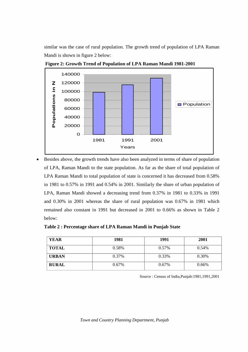
similar was the case of rural population. The growth trend of population of LPA Raman
Mandi is shown in figure 2 below:
Figure 2: Growth Trend of Population of LPA Raman Mandi 1981-2001
Population
Po
pu
lati
on
s i
n N
u 140000
120000
100000
80000
60000
40000
20000
0
Years
2001 1981 1991
· Besides above, the growth trends have also been analyzed in terms of share of population
of LPA, Raman Mandi to the state population. As far as the share of total population of
LPA Raman Mandi to total population of state is concerned it has decreased from 0.58%
in 1981 to 0.57% in 1991 and 0.54% in 2001. Similarly the share of urban population of
LPA, Raman Mandi showed a decreasing trend from 0.37% in 1981 to 0.33% in 1991
and 0.30% in 2001 whereas the share of rural population was 0.67% in 1981 which
remained also constant in 1991 but decreased in 2001 to 0.66% as shown in Table 2
below:
Table 2 : Percentage share of LPA Raman Mandi in Punjab State
YEAR 1981 1991 2001
TOTAL 0.58% 0.57% 0.54%
URBAN 0.37% 0.33% 0.30%
RURAL 0.67% 0.67% 0.66%
Source : Census of India,Punjab:1981,1991,2001
Town and Country Planning Department, Punjab

2.2 Population Characteristics of M.C. Raman Mandi
As already explained there are two urban areas in this LPA i.e. Raman Mandi and Sangat
Mandi. Since Sangat Mandi is a very small settlement which has a population of 5401
persons and an area of 28 hectares only there seems no need to conduct detailed studies
of this town however at time of proposals adequate areas will be indicated for different
uses. Raman Mandi being the main town of this LPA needs detailed studies.
As already stated that Raman Mandi is a small urban settlement of District Bathinda and
main urban settlement of LPA. As per the table given below regarding the population
growth of Raman Mandi from 1981 to 2001, it can be said that growth of population is
not uniform. Raman Mandi recorded a lowest growth rate of 13.18% during 1991–2001,
the town registered high growth rate of 47.49% during the decade of 1951-1961.The high
growth rate during this period perhaps may be because of resettlement process after the
partition. The population profile of Raman Mandi indicates that during the decade of
1981-91 a growth rate of 20.65% was recorded whereas during 1991-2001, the growth
rate of population decreased to 13.18%.The growth rate of the town thus was very low as
compared to Punjab urban growth rate of 37.73% during 1991-2001.The detail of
population growth of Raman Mandi from 1951 to 2001 is given in Table 3 below:
Table 3 : Population Growth Rate of M.C. Raman Mandi: 1951 - 2001
Years Population Decadal Growth Rate (%)
1951 6446 --------
1961 9507 47.49
1971 11574 21.74
1981 14318 23.71
1991 17275 20.65
2001 19551 13.18
Source: Census of India, Punjab, 2001 The diagrammatic presentation of above table quickly gives the trend of growth rate of
population of Raman Mandi between the periods of 1951 to 2001 as shown in Figure 3.
Town and Country Planning Department, Punjab

Figure 3: Population Growwth Rate of M.C. Raman Mandi 1951-2001
2.3 Population Density
The gross population densityy of M.C. Raman Mandi was about 36 personss per hectare as
per the figure of 1981 censuus. The M.C. limits of Raman Mandi were extetended in 1983
which now covers an area oof 525 hectares thus the density of population ddecreased to 33
persons per hectare in 19911. As per 2001 census the density increased to 38 persons per
hectare. The decade wise deensity is given in Table 4 below:
Table 4 : Population Densitity (Within Municipal Limits)
Year Popula ation Area ( in hectares) Populat tion Density in Perso ons / hectare
1981 14318 399 36
1991 17275 525 33
2001 19551 525 38
Source: Census of India,, 1981, 1991, 2001
The population density is not tthe same all over the town. It varies to a large eextent when discussed at ward level. The wward wise detail of population density is given inin Table 5 below:
Town and Country Planning Department, Punjab

Table 5 : Ward Wise Population density of M.C. Raman Mandi Town: 2001
Sr. No. Ward No. Area in Hect.
Population Density / Persons per Hect.
1 Ward No – 1 16.20 1560 96 2 Ward No – 2 10.90 1461 134 3 Ward No – 3 71.50 1524 21 4 Ward No – 4 103.60 1460 14 5 Ward No – 5 7.20 1299 180 6 Ward No – 6 5.50 1278 232 7 Ward No – 7 15.80 1682 106 8 Ward No – 8 32.60 1659 51 9 Ward No – 9 14.00 1600 114 10 Ward No – 10 89.40 1688 19 11 Ward No – 11 81.80 1545 19 12 Ward No – 12 64.50 1488 23 13 Ward No – 13 12.00 1297 108
TOTAL 525.00 19551 38 Source: Census of India, and M.C.Raman Mandi
· The decade wise comparison of ward density is however not possible as ward boundaries
and number of wards have been changing over the years. The density gradient as per
2001 census shows that ward no.6 is having a gross density of 232 persons per hectare.
The lowest density is only 14 persons per hectare in ward no.4. Wards no. 2,5,7,9 and 13
have density between 100-200 persons per hectare, Ward no.1 and 8 have density
between 50-100 persons per hectare and ward number 3, 4, 10, 11 and 12 have density
less than 50 persons per hectare. The density has been classified into four groups as
shown in Table 6 below;
Table 6 : Density Gradient M.C.Raman Mandi (Ward Wise):2001 Sr. No. Density Slab
(Persons/hectare) Number of wards
Ward Numbers
1. More than 200 1 6 2. 100 to 200 5 2,5,7,9,13 3. 50-100 2 1,8
4. 50 and below 5 3,4,10,11,12 Source: Census of India and M.C. Raman Mandi
· The inner part of the town falls in high density zone as this part is thickly built up area
with narrow streets. As per above table ward no.6 is only one ward which has gross
Town and Country Planning Department, Punjab

density of more than 200 persons per hectare which is located in central part of the town.
The developed parts of ward no 2,5,7,9 and 13 may have gross density more than the
calculated as the boundary of these wards has been delineated in such a way that the vast
open areas at outskirts of the town have been included in these wards clubbing with the
thickly built up areas of inner part of the town. Because of such character of ward
boundaries the exact picture of density gradient of the town could not have been depicted
in the thematic map of Raman Mandi. The ward wise density has been shown in Figure 4.
Figure 4: Ward Wise Density Gradient in Raman Mandi Town-2001
2.4 Settlement Pattern and Population Distribution in LPA Raman Mandi
Raman Mandi and Sangat Mandi are the two urban settlements of this LPA having a
population of 24952 persons with a figure 19551 persons and 5401 persons respectively
as per 2001 census. Pakka Kalan is the largest village having a population of 7586
persons whereas the smallest village is Dunewala having a population of 965 persons
only. The larger villages like .Pakka Kalan with a population of 7586 and village Pathrala
with population of 6233 persons have the advantage of its nearness to on Bathinda-
Dabwali Road (N.H. 64).The other villages which are situated on link roads are smaller
in size. The detail of population growth of these villages is given in Table 7 below:
Town and Country Planning Department, Punjab

Table 7 : Growth Rate of Village of LPA Raman Mandi: 1981 - 2001
Sr. No.
Name of Villages Population Year wise
Growth Rate of Villages%
1981 1991 2001 1981 – 1991
1991 – 2001
1 Ramsara 1526 1976 2412 29.49 22.06
2 Kanakwal 1398 1612 1687 15.31 04.65
3 Phulokhari 1169 1507 1912 28.91 26.87
4 Jajjal 2066 2564 2944 24.10 14.82
5 Giana 2970 3338 3984 12.39 19.35
6 Malkana 3054 3873 4250 26.82 09.73
7 Bagha 2154 2582 2931 19.87 13.52
8 Tarkhan wala 1422 1584 1758 11.39 10.98
9 Sekhu 3415 3768 4078 10.34 08.23
10 Chak Hira Singh Wala urf Pakka Khurd
1444 1638 1901 13.43 16.06
11 Laleana 2533 3132 3418 23.65 09.13
12 Kamalu 1433 1640 1808 14.44 10.24
13 Sukhladhi 1886 2184 2405 15.80 10.12
14 Bangi Raghu 1115 1394 1502 25.02 07.75
15 Bangi Deepa Singh 1468 1746 1866 18.94 06.87
16 Bangi Nihal Singh 2475 2797 3306 13.01 18.20
17 Bangi Ruldu 3146 3552 3911 12.90 10.11 18 Manwala urf Kishan
Garh 1433 1663 1833 16.05 10.22
19 Kot Bakhtu 3311 3857 4345 16.49 12.65 20 Jeon Singh Wala 2499 2892 3207 15.73 10.89
21 Nasib Pura urf Kaile Bander
2965 3569 3917 20.37 09.75
22 Shergarh 1182 1420 1689 20.13 18.94 23 Malwala 1820 2106 2394 15.71 13.67
24 Bhaghwangarh 1807 2133 2260 18.04 05.95
25 Dunewala 986 1085 965 10.04 -11.06
26 Jassi Bag Wali 2405 2693 3193 11.97 18.57
27 Gurthari 1346 1508 1615 12.03 07.09
Town and Country Planning Department, Punjab

28 Pakka Kalan 6292 7065 7586 12.28 07.37
29 Phalran urf Jodhpur Baga Singh
1597 1634 1967 02.32 20.38
30 Sangat Kalan** 1270 2116 199 66.61 -90.59 31 Gehari Devi Nagar 3084 3475 4267 12.68 22.79
32 Gehari Butter 2204 2927 3985 32.80 36.14
33 Mehta 2044 2410 2637 17.90 09.42
34 Mashana urf Dhiangarh 1086 1109 1263 02.12 13.89
35 Kishanpura urf Kutti 1180 1370 1527 16.10 11.46
36 Chak Ruldu Singh Wala
2003 2543 2845 26.96 11.87
37 Pathrala 4317 5205 6233 20.57 19.75 38 Chak Khark Singh
Wala urf Doomwali 1577 1863 3181 18.13 70.75
39 Raman Rural* --- --- --- --- ---
*Merged in M.Council Source: Census of India 1981, 1991, 2001
** Part of Sangat Kalan village merged in M.Cl. Sangat Mandi
The above Table depicts that the growth rate of the villages falling in LPA, Raman Mandi
varies considerably. The growth rate of population of village Sangat Kalan during 1991-
2001 periods has been recorded as low as 90.59 %( negative) which is lowest in LPA.
This is because of that fact that a larger part of village was taken within municipal limits
of Sangat Mandi during this period and that of village Chak Khark Singh Wala urf
Doomwali has been recorded as highest i.e. 70.75% during the same period. The size and
growth trend of all the settlements falling in LPA Raman Mandi is shown in Figure 5
Town and Country Planning Department, Punjab

Figure 5: Population Growth of Urban and Rural Settlements of LPA Raman Mandi (1991-2001)
2.5 Sex Ratio According to 1981 census, the sex ratio was 874 females per 1000 males in LPA Raman
Mandi and in 1991, the sex ratio improved to 882 and in 2001 it further improved to 894.
In case of M.C. Raman Mandi, the sex ratio increased from 866 in 1981 to 868 in 1991
and further to 887 in 2001.The sex ratio of LPA Raman Mandi when compared with the
Punjab state figure of 876 females per 1000 males as per 2001 census seems to be quite
positive with the figure of 894 in 2001.The details of sex ratio in LPA Raman Mandi and
M.C. Raman Mandi is given in Table 8.
Table 8 : Sex Ratio of LPA Raman Mandi and M.C. Raman Mandi Town, 1981-2001
Year LPA RAMAN MANDI M.C. RAMAN MANDI Total Population
Males Females Sex ratio
Total Population
Males Females Sex ratio
1981 98263 52432 45831 874 14318 7674 6644 866 1991 115536 61391 54145 882 17275 9247 8028 868 2001 131633 69484 62149 894 19551 10361 9190 887
Source: Census of India.1981, 1991, 2001
Town and Country Planning Department, Punjab

Figure 6: Sex Ratio of LPA Raman Mandi and M.C. Raman Mandi
850 855 860 865 870 875 880 885 890 895 900
2001
FE
MA
LE
S/1
000 M
AL
LPA
M.C. Raman Mandi
1981 1991
YEARS
. 2.6 Literacy
Table 9 depicts that the literacy rate is increasing in Local Planning Area, Raman Mandi.
The literacy rate in 1981 was 25.48%, which increased to 33.80% in 1991 and 46.41% in
2001. The percentage of male literates has been recorded 52.37% whereas in case of
females it was 39.74% in 2001. As per trend, literacy rate of female increased from
17.34% in 1981 to 39.74% in 2001 in Local Planning Area, Raman Mandi, which shows
that more and more girls are coming to schools. Similarly, literacy rate of M.C.Raman
Mandi also substantially increased from 43.83% in 1981 to 59.18 % in 2001 as shown in
Table 10.
Table 9 : Literacy Rate of Local Planning Area, Raman Mandi 1981-2001
Sr. Year
Total Total Total
Literacy Males Literacy Females
Literacy Rate No. Population Literates Rate
(%) Number %age Number %age
1. 1981 98263 25039 25.48 17092 32.60 7947 17.34 2. 1991 115536 39047 33.80 25023 40.81 14024 25.90 3. 2001 131633 61091 46.41 36391 52.37 24700 39.74
Source: Census of India 1981, 1991, 2001
Town and Country Planning Department, Punjab

Table 10 : Literacy Rate of M.C. Raman Mandi: 1981-2001
Sr. No.
Year Total
Population Total
Literates
Literacy Rate (%)
Males Literacy Females Literacy Rate
Number %age Number %age
1. 1981 14318 6276 43.83 3951 51.49 2325 34.99 2. 1991 17275 8018 46.41 4837 52.31 3181 39.62 3. 2001 19551 11571 59.18 6723 64.89 4848 52.75
Source: Census of India 1981, 1991, 2001.
Figure 7: Trend of Literacy Rate in LPA Raman Mandi and M.C.Raman Mandi.
0
10
20
30
40
50
60
70
1981 1991 2001
YEARS
LIT
ER
AC
Y R
AT
LPA
M.C. RAMAN MANDI
Figure 8: Trend of Literacy Rate of Males in LPA Raman Mandi and M.C. Raman Mandi
0
10
20
30
40
50
60
70
1981 1991 2001
YEARS
MA
LE
S L
ITE
RA
CY
RA
LPA
M.C. RAMAN MANDI
Town and Country Planning Department, Punjab

Figure 9: Literacy Rate of Females in LPA Raman Mandi and M.C.Raman Mandi
0
10
20
30
40
50
60
1981 1991 2001
YEARS
FE
MA
LE
S L
ITE
AR
CY
R
LPA
M.C. RAMAN MANDI
2.7 Employment LPA Raman Mandi Economic data as available for the state is not available for district or the town. The
trends of economic growth have therefore to be judged on the basis of employment data
as discussed ahead. The data depicts that the number of workers has increased in LPA,
Raman Mandi as the percentage of workers to the total population increased from 30.35
% in 1981 to 37.40% in 2001.The workforce participation rate of M.C. Raman Mandi has
increased from 31.95% in 1991 however it again decreased to 30.21 % in 2001. The
detail of workers and non-workers is given in Table 11.
Table 11 : Workers and Non Workers in LPA and M.C.Raman Mandi 1981-2001
Years LPA Raman Mandi M.C.Raman Mandi Workers Non-Workers Workers Non-Workers Total %age Total %age Total % age Total %age
1981 29820 30.35 68443 69.65 4322 30.19 9996 69.81 1991 36273 31.40 79263 68.60 5520 31.95 11755 68.05 2001 49231 37.40 82402 62.60 5906 30.21 13645 69.79
Source: District Census handbook 1981, 1991, 2001, Bathinda
2.8 Occupational Structure The change in occupational structure has been noticed as the persons engaged in primary
activities i.e. cultivators and agricultural laborers decreased from 74.35 % in 1981 to
66.95 % in 2001 in LPA, Raman Mandi and in household industries from 1.97% to
1.95% in 1981 and 2001 respectively. The most notable change during 1991-2001 is seen
in the percentage of workers engaged in other activities, which jumped from 23.68 % to
Town and Country Planning Department, Punjab

31.10% during this period. The detail of occupational structure is given in Table 12
below:
Table 12 : Occupational Structure of LPA,Raman Mandi 1981-2001 Year Total
workers Cultivators Agricultural
laborers Household industries
Others
No %age No %age No %age No %age 1981 29820 14677 49.22 7494 25.13 586 1.97 7063 23.68 1991 36273 16714 46.08 10004 27.58 576 1.59 8979 24.75 2001 49231 20472 41.58 12488 25.37 959 1.95 15312 31.10
Source: Census of India Handbook 1981, 1991, 2001
Figure 10 : Occupational Structure of LPA,Raman Mandi 1981-2001
0
10
20
30
40
50
60
1981 1991 2001
Years
Perc
en
tag
e o
f W
ork
ers
Cultivators
Agricultural laborers
Household industries
Others
· In case of Raman Mandi town the workers engaged in primary activities i.e. cultivators
and agricultural laborers although remained almost constant from 20.03 % to 20.33 % in
1981 and 2001 respectively as given in Table 13 however the cultivators decreased from
12.26% in 1981 to 8.82% in 2001 whereas the agricultural laborers increased from 7.77%
in 1981 to 11.51% in 2001. The house hold industry after showing a decreasing trend
during 1981 to 1991 again recorded an increase from 1.16 % to 1.83 % during 1991 to
2001. Similarly the share of workers engaged in other activities recorded an increase
from 76.59 % to 77.84 % in the year 1981 to 2001 as given in Table 13. These figures
show that the scenario of development of Raman Mandi has changed. During recent past
Guru Gobind Singh refinery and some institutions in this area attracted a large number of
workers engaged in different fields but this impact is yet to be experienced in the coming
census of 2011.
Town and Country Planning Department, Punjab

Table 13 : Occupational Structure of M.C.Raman Mandi 1981-2001 Year Total
workers Cultivators Agricultural
laborers Household industries
Others
Nos. %age Nos. %age Nos. %age No. %age 1981 4322 530 12.26 336 07.77 146 3.38 3310 76.59 1991 5520 636 11.52 636 11.52 64 1.16 4184 75.80 2001 5906 521 08.82 680 11.51 108 1.83 4597 77.84
Source: District Census Handbook 1981, 1991, 2001, Bathinda
Figure 11: Occupational Structure of M.C.Raman Mandi
Perc
en
tag
e o
f W
ork
ers
90
80
70
60
50
40
30
20
10
0
Cultivators
Agricultural laborers
Household industries
Others
1981 1991 2001
Years
Town and Country Planning Department, Punjab

Town and Country Planning Department, Punjab

CHAPTER: 3
HOUSING AND SLUMS INTRODUCTION Housing is one of the basic needs and it ranks after food and clothing in terms of priority.
Housing constitutes one of the most important parts of the social environment where an
individual is nurtured, grows, and matures as a human being, part of the society and as a
citizen. Housing, in addition to making contribution to the quality of living, also plays a
significant role in improving the national economy and generation of employment.
Housing has multiplier effect on the economy and industry of the country. It does not
provide merely a shelter but gives an identity to the human being besides making him
better human being. Housing is not merely confined to the four walls which make a house
but also all supporting infrastructure which is required to sustain the human beings in
terms of physical and social infrastructure. Accordingly, National Housing Urban Policy
laid emphasis not only on providing affordable shelter but also creation of appropriate
quantity and quality of essential services etc.
3.1 Growth of Housing in M.C. Raman Mandi
Housing is an activity, which is mainly driven by individuals to provide them with an
appropriate shelter. With the rapid increase in population, number of houses has also
recorded an increase. None of the Govt. agency like PUDA, Town Improvement Trust
etc. contributed anything towards housing sector in case of Raman Mandi. The central
part of the town is planned because of its establishment under Mandi Township policy of
Britishers during early 20th century. There are four Town Planning Schemes approved
under Punjab Municipal Act 1911, but the implementation part of these regulatory
schemes remained a failure as a result most of the new developments are unplanned and
haphazard. The detail of occupied residential houses in M.C. Raman Mandi is given in
Table 14.
Town and Country Planning Department, Punjab

Table 14: Growth of Houses and Households in M.C. Raman Mandi
Year Occupied Residential House
% age growth rate of Residential houses
No. of Households
% age growth rate of Households
Population Household Size
1981 2537 --- 2537 --- 14318 5.6 1991 2809 10.72 2911 14.74 17275 5.9 2001 3432 22.18 3398 16.66 19551 5.7
Source: Census of India 1981, 1991, 2001 Above table 14 depicts that the number of occupied residential houses and households
was equal in 1981(2537 residential houses and 2537 households) which increased at a
slow pace in comparison to increase in number of households during 1981-1991. During
the period of 1991-2001 the number of residential houses increased faster than number of
households thus producing a surplus housing stock in this town as the number of
occupied residential houses has been recorded to be 3432 in comparison to number of
households 3398 in 2001. Although the data of 2001 shows that number of occupied
residential houses are more than the households but good quality residential houses with
adequate environment are not available for common man.
3.2 Housing Characteristics Type of Housing Structure As per the classification of houses available from census 2001 the available livable
number of houses in M.C. Raman Mandi was recorded 3432 out of which 3017 are
classified as permanent which is 87.91% and 342 are semi permanent which is 9.96% and
only 73 are temporary which is 2.43% only. The detail is given in Table 15 below:
Table 145 : Residential Houses by Their Type of Structure in Raman Mandi Town 2001
Year Type of Structure
Permanent Semi-Permanent Temporary Total
No. of houses 3017 342 73
2001 %age of total 87.91 9.96 2.13
Source: Census of India, 2001
3.3 Services to Households Households by number of dwelling rooms There is no separate data available regarding households by number of dwelling room for
Raman Mandi town, therefore the data relating to Bathinda district Urban has been taken
for the purpose of making an assessment of housing stock available by type of rooms.
The figures of 2001 census indicated that out of the total households of the Bathinda
Town and Country Planning Department, Punjab

district urban about 21.39% live in the houses having one room, about 30.50% live in two
room set and 22.80% in three room accommodation there are only a few households who
live in no exclusive room. Thus maximum number of households i.e. 99.44% has at least
minimum one dwelling room and this number when compared to all India urban
proportion of only 35 % households living in one room or more, shows that the town has
relatively better housing condition and the houseless households are 361 which is 0.56%
only. This data shows the overall assessment of housing stock in Bathinda District urban
and the median works to 2 rooms per households. The same is adopted for M.C. Raman
Mandi. The detail of households by number of rooms is given in Table 16 below;
Table 16 : Households by Number of Dwelling Rooms in Bathinda District Urban 2001
Number of rooms
No exclusive Room
One Room
Two Room
Three Room
Four Room
Five Room
Six Rooms and above
Total
Households 361 13805 19687 14717 9058 3669 3245 64542
%age 0.56 21.39 30.50 22.80 14.03 5.69 5.03 100.00 Source: Census of India, 2001
3.4 Households by Source of Drinking Water As per the census 2001 about 74.01% of the total households have source of the drinking
water from tap and 24.33% are dependent on hand pump in case of Raman Mandi. In
category other than tap and hand pump about 0.44% of the total households are
dependent on tube well and only 1.22% are dependent upon other water sources which
shows that still 26% household are not getting good quality of drinking water. The detail
of source of drinking water is given in Table 17:
Table 17: Houses by Source of Drinking Water in M.C.Raman Mandi: 2001 Source of Drinking water
Tap Hand Pump Tube Well Any Other Total
Households 2540 835 15 42 3432 %Age of the total 74.01 24.33 0.44 1.22 100
Source: Census of India 2001 3.5 Slums in M.C. Raman Mandi
Slums represent multiple human deprivations in urban settlements and majority of urban
poor seems to reside in the slums and squatter settlements. With the industrialization,
slums and slum population have multiplied, as cities have been unable to support the
large number of migrants who cannot buy a house or a plot of land for their own shelter.
This has been putting strain on urban resources as poor unskilled migrants with negligible
income find it convenient to create a temporary shelter on government or private land
Town and Country Planning Department, Punjab

without security of tenure. Generally these settlements do not have any basic civic
amenities, and people live under unhygienic and unsanitary conditions. The Census of
India (2001) defines slums as, “all areas notified as slums by the state/local government
under any Act; and all areas recognized as slums by state/local government, which have
not been formally notified as slum under any Act and a compact area of about 300
population or about 60-70 households or poorly-built congested tenements in unhygienic
environment, usually with inadequate and lack of any proper sanitary and drinking water
facilities.”
However in case of Raman Mandi the slum areas are not the result of industrial
development, it is simply because of the concentration of the houses of weeker section of
society settled here due to one or the other reason. As intimated by Municipal Council
there are four slum areas in Raman Mandi spreading over an area of about 22 Hectare.
These slum areas are not notified however by virtue of the definition of slums in census
2001; M.C. Raman Mandi identified these areas as slum areas.
3.6 General Characteristics of Slums in M.C. Raman Mandi The total population of Raman Mandi was 19551 persons as per 2001 census out of
which 5842 persons were living in different slum areas which is 29.88% of total
population as intimated by Municipal Council. These slums occupy an area of about 22
hectares and accommodate about 1107 families. The emergence of slums in this town is
largely due to migration of poor people from rural areas of the state and from other states
for employment purpose and to avail higher level of facilities. The other reason for
emergence of slums is ever increasing population with a higher growth rate, inadequate
supply of good quality of housing stock from the Government agencies and existing high
land prices. The slum wise detail of general characteristics is given in Table 18.
Table 18 : Detail of Identified Slum Areas in M.C.Raman Mandi Sr. No. Name of Slum Area Location Area in
Hects. Total households
Population
1 Regar Basti W No. 1 & 2 on both sides of railway line
7 351 1813
2 Katcha Vass In the Ward No. 2 & 3 5 314 1654 3 Dhanak Basti Adjoining to the
Gaushala W. No. 7 3 162 891
4 Navi Basti In the W. No.12 7 280 1484 Total 22 1107 5842
Source: Municipal Council Raman Mandi
Town and Country Planning Department, Punjab

3.7 Distribution and Location of Slum Areas Out of four slum areas, three slums such as Regar Basti, Navi Basti and Katcha Vass are
located in northern part of the town and one i.e. Dhanak Basti in the central part of the
town.
As intimated by municipal council the facility of water supply and sewerage has been
provided to all these localities covering about 80% areas of each slums. Similarly street
light and pacca streets have also been developed there. The information supplied by M.C.
and the ground realities reveal that most of the part of these slums have most of the basic
infrastructure.
Town and Country Planning Department, Punjab

Town and Country Planning Department, Punjab

CHAPTER: 4 EXISTING LAND USE
4.1 Existing Land Use-LPA Raman Mandi The Local Planning Area Raman Mandi comprises 50551 hectares (505.51sq.kms.) of
area as per revenue record whereas as per the calculations of P.R.S.C. Ludhiana it works
to 50574 hectares (505.74 sq. kms) with the variation of 0.05. % only which is very
negligible thus ignored. Similarly the area of municipal council Raman Mandi works to
525 hectares (5.25 sq. kms). Since the Existing Land Use plan is prepared by PRSC on
the basis of satellite data therefore the area of LPA Raman Mandi and the town as work
out by PRSC, Ludhiana has been used for analysis of existing land use. The existing land
use pattern has been divided into seven broad categories; prominent of these are
residential, commercial, industrial, public & semi public, utilities and agriculture etc. The
detail of Existing Land Use of LPA Raman Mandi is given in Table 19.
Table 19: Existing Land Use, LPA Raman Mandi-2001
Sr. No. LAND USE Area in Hect. Percentage of Total Area
1 RESIDENTIAL 1661.63 3.28 Residential (Urban) Built Up 157.27 0.31 Residential Plotted 66.44 0.13 Rural Residential 1437.92 2.84
2 COMMERCIAL 105.44 0.21 Retail Shoppping/ General Bussiness 29.16 0.06 Whole Sale,Godowns,Ware Housing Regulated Market
76.28 0.15
3 INDUSTRIAL 952.31 1.88 Service & Light Industry 62.77 0.12 Medium 73.74 0.15 Heavy 815.80 1.61
4 PUBLIC & SEMI PUBLIC 178.32 0.35 Govt / Semi Govt / Public Offices 5.44 0.01 Educational & research 17.09 0.03 Govt. Land(Use Undetermined) 73.56 0.15 Medical & Health 10.21 0.02 Social,Cultural & Religious 46.02 0.09 Cremation & Burial Grounds 26.00 0.05
5 UTILITIES 61.88 0.13 Water Works 50.25 0.10 Electric Grid Station 8.63 0.02
Town and Country Planning Department, Punjab

Solid Waste Disposal 3.00 0.01 6 RECREATIONAL 8.26 0.02
Parks & Gardens,Playground (Public Open Spaces)
8.26 0.02
7 TRANSPORTATION & COMMUNICATION
460.56 0.90
Main Roads 204.01 0.40 Other Roads 45.74 0.09 Katcha Road 8.95 0.02 Bus Stand 0.71 0.00 Truck Stand 0.37 0.00 Railway line and Siding,Railway Station 200.78 0.39
8 AGRICULTURAL 47146.07 93.23 Agriculture 45702.38 90.37 Water Bodies 267.63 0.53 Plantation & Orchards 610.57 1.21 Dairy & Poultry Farms 2.88 0.01 Vacant Land 562.66 1.11 TOTAL 50574.00 100.00
Source: Punjab Remote Sensing Centre, PAU Ludhiana
· LPA Raman Mandi covers the revenue estates of 39 villages which also includes the area
of two urban centers i.e. Raman Mandi and Sangat Mandi as given in Annexure-2, Out of
the total area of LPA Raman Mandi a major chunk of about 47146.07 hectares is under
agricultural use which is 93.23% of the total area followed by residential which covers an
area of 1661.63 hectares sharing 3.28% and industrial 952.31 hectares which is 1.88%
only. The figure of area under industrial use ,looks reasonable only due to the inclusion
of area of under construction site of G.G.S. Refinery otherwise rest of industries in this
LPA cover only 146.51 hectares which is only 0.27% of total LPA area reflecting the
backwardness of this LPA from industrial angle. The geographical extent of different
uses in LPA Raman Mandi is shown in the plan Drg. No. DTP (B) 1624/2010 dated
02/08/2010.
Town and Country Planning Department, Punjab

Town and Country Planning Department, Punjab

4.2 Existing Land Use: M.C. Raman Mandi
The total area of Municipal Council Raman Mandi is 525 hectares as calculated by PRSC
Ludhiana which includes residential, industrial, commercial etc. The detail of existing
land uses with in M.C. limits of Raman Mandi is given in Table. 20
Table 20: Existing Land Use of Municipal Council Raman Mandi-2010 Sr. No.
LAND USE Area in Hect. Percentage of Total Area
1 RESIDENTIAL 112.36 21.40
Residential (Urban) Built up 82.45 15.70
Residential Plotted 29.91 5.70
2 COMMERCIAL 11.34 2.16
Retail Shoppping/ General Business 7.80 1.49
Whole Sale,Godowns,Ware Housing Regulated Market
3.54 0.67
3 INDUSTRIAL 11.15 2.12
Light Industry 7.40 1.41
Heavy Industry 3.75 0.71
4 PUBLIC & SEMI PUBLIC 26.82 5.11
Govt / Semi Govt / Public Offices 1.13 0.22
Educational & research 12.00 2.29
Govt. Land(Use Undetermined) 4.89 0.93
Medical & Health 1.28 0.24
Social,Cultural & Religious 4.92 0.94
Cremation & Burial Grounds 2.60 0.49
5 UTILITIES 10.52 2.00
Water works 5.86 1.12
Electric Grid Station 3.32 0.63
Solid Waste Disposal 1.34 0.25
6 TRANSPORTATION 47.17 8.99 Main Road 6.17 1.18
Other Roads 29.58 5.63
Katcha Road 1.95 0.37
Bus Stand 0.71 0.14
Truck Stand 0.37 0.07
Railway line and Siding,Railway Station 8.39 1.60
Town and Country Planning Department, Punjab

7 AGRICULTURAL 305.64 58.22
Agriculture 279.56 53.25
Water Bodies 3.94 0.75
Plantation & Orchards 5.03 0.96
Vacant Land 17.11 3.26
TOTAL 525.00 100.00
Source: Punjab Remote Sensing Centre, PAU Ludhiana
4.3 Residential
Although the a large extent of municipal area is still under agricultural use but out of the
developed area of this tiny town a major share goes under residential use covering an area
of 112.36 hectares which is 21.40% of total municipal area. The internal part known as
old Mandi area is the planned area of this town which is planned on grid iron pattern. The
other residential localities like Regar Basti and Katcha Vas in northern part, areas of
Raman village (now falling within M.C.), Pirkhana road, Shiv Colony and Gaushala road
is south Mohalla in east are other residential localities of the Raman Mandi. There is no
planned colony in Raman Mandi developed either by any Govt Agency or private
developer. Inspite of the fact that there are four approved Town Planning Schemes most
of the residential areas are unplanned having zig zag and narrow lanes. The extent of all
these residential areas is shown in Existing Land Use Plan Drg. No. DTP (B) 1631/2010
Dated 23/11/2010.
4.4 Commercial Raman Mandi is a small town of Bathinda district but still it is important in this part of
the district. The total area covered under commercial use is 11.34 hectare which is only
2.16% of total M.C. area. Out of total commercial area 7.80 hectare is under retail
shopping and 3.54 hectare is under wholesale business. This indicates that the town
functions as a service town facilitating the large number of surrounding rural settlements.
The main commercial areas in Raman Mandi are the Old Grain Market, Station road, and
Gurudwara road etc. Some commercial activities are also found on Talwandi Sabo road
and Kamalu road. The spatial extent of commercial areas is shown in the plan Drg. No.
DTP (B) 1631/2010 Dated 23/11/2010.
Town and Country Planning Department, Punjab
4.5 Industry
The existing land use table depicts that the area under industrial use is very limited
spreading over 11.15 hectares which is only 2.12% of total area as given in Table 20.
There is no prominent industry in this town, a few number of cotton factories exist in the
town. Some of the oil mills are famous in this town which have their regional reputation
and supply the branded mustered oil. The Existing Land Use Plan of Raman Mandi
shows the disposition of the industrial areas.
4.6 Transportation The total area under transportation is 47.17 hectare sharing 8.99% of total municipal area.
The area under this use is quite low in comparison to the norms of this size of towns. The
lower percentage of area under this use seems to be because of the fact that no regional
road passes through the town and less width of the roads and streets, lack of parking
spaces inadequate size of bus stand and truck stand. There is only one main road known
as Talwandi Sabo road which is about 80" feet wide, all other roads are found between 20
feet to 30 feet whereas a major part of internal streets is even less than 20 feet in width.
The railway line passing through Raman Mandi cover about 8.39 hectare of area which
includes the station part also. The spatial position of roads, streets, and railway is shown
in Existing Land Use Plan Drg. No. DTP (B) 1631/2010 Dated 23/11/2010.
4.7 Public & Semi Public This use comprises the areas covered under Govt. /semi Govt. offices, Govt. Lands,
Education Health Socio-Cultural activities etc. The total area covered by this use is 26.82
hectares which is 5.11% of total area. The spatial distribution of various activities of this
use is shown in Existing Land Use Plan Drg. No. DTP (B) 1631/2010 Dated 23/11/2010.
4.8 Utilities
Utilities include uses like Water Works, Sewage Disposal, and Electric Grid Station
(EGS), solid waste Dumping site etc. The total area under this use measures to about
10.52 hectare which is about 2% of total M.C. area as shown in Table 20. There is only
single water works towards eastern side of the town. The Electric Grid Station on
Talwandi Sabo road, solid waste site is located to back side of Guru Nanak Cotton
factory and Sewage disposal on Sarkari Bagh road are other utilities which are shown in
Existing Land Use plan of M.C. Raman Mandi.
Town and Country Planning Department, Punjab

Town and Country Planning Department, Punjab

4.9 Agricultural/Rural There are some large chunks of agricultural/rural areas within the municipal limits of
Raman Mandi. The north eastern part beyond Rajbaha, area on both sides of Talwandi
Sabo road and in western part on other side of railway line is big agricultural areas falling
within M.C. limits. Some chunks of vacant lands and areas covered under water bodies
are other components of this use zone. The Existing Land Use Plan Drg. No. DTP (B)
1631/2010 Dated 23/11/2010 shows the spatial distribution of all these uses within
municipal limits of Raman Mandi.
4.10 Existing Rail – Road Network The road network of towns and cities plays an important role in the growth of urban
areas. Urban transport has also been considered as an integral part of urban planning. The
objective of studying the transport sector is to analyze and understand the role of
transport in the present scenario of the town and the surroundings and to understand the
existing potentials, strengths, weakness, and constraints of the transport sector and
consequently arrive at strategies and projects which will form an integral part of the town
development strategy.
The roads and railways play significant role in the transport sector in LPA, Raman
Mandi. The road network is studied in terms of classification of roads, length of roads,
cross section of roads (divided and undivided carriageway, footpath, shoulders etc.), area
of road network and major road intersections. Similar data regarding rail network is also
studied.
Road Network 4.11 Road Network at LPA level
Local Planning Area Raman Mandi does not have a good regional road network.
Bathinda Dabwali road (N.H.64) is only one regional road serving this L.P.A which
passes through the north western part of LPA but does not touch the town of Raman
Mandi. A road of 100 ft. width from Bathinda-Dabwali road to Refinery site is another
main road of this LPA. This road also remains away from Raman Mandi, however it
provides accessibility to the Refinery. A small stretch of Bathinda-Talwandi Sabo state
highway passes through village Jeon Singh Wala which falls in this LPA. Talwandi-Sabo
road (MDR) is the only main road which connects Raman Mandi with other towns and
cities but this road goes no where further beyond Raman Mandi and has a dead end at
Town and Country Planning Department, Punjab

railway line in Raman Mandi. The length of National Highway passing through LPA is
about 25 kms. and the length of refinery road is about 18 kms. whereas Bathinda –
Talwandi Sabo state Highway passing through this LPA is only 4.5 kms. and Talwandi
Sabo-Raman Mandi major district road is 8 kms. long within LPA boundary rest are the
rural link roads. The network of rural link roads is very well serving the rural and urban
settlements of this LPA.
The length of National Highway and State High way within LPA shows that this
LPA is poorly served by main roads. Only northern part of the LPA is directly connected
with other main towns of the Punjab State and Haryana wheras rest of the area including
Raman Mandi itself, does not have the facility of regional roads. The location and the
alignment of these roads are shown in Existing Land Use Plan Drg. No. DTP (B)
1631/2010 Dated 23/11/2010.
4.12 Road Network at Town Level
As explained above, there is no National Highway, or State Highway passing through the
town. There is only one main road from Talwandi Sabo which connects the town with
rest of the state. The local roads in Raman Mandi are generally found about 20 feet wide.
Some of the local roads/sheets are even less than 20 feet width. There is no planned or
organized parking place in the town, the road sides are normally used for parking
purpose.
Besides the above facts the old part of the town (Inner area)
is planned where the roads are quite straight and have regular width. The roads in this
part cross each other at right angle. There are some village link roads like Bangi road,
Kamalu road, Ramsra road, Bagha road, Phulo khari road etc.These roads are part of the
local road network and provide accessibility to several residential areas like Regar Basti,
Katcha vaas, Navi Basti etc.Besides this the local roads like Peer Kana Road, Gaushala
road, Bank road and Gurudwara road etc.jointly completes the road network of Raman
Mandi.
There are some link roads loading to different near by villages like, Bangi road,Kamalu
road,Phulokhari road, Ram Sra road and Bagh road. These roads provide access to
various localities of the town such as Regar Basti,Katcha Vaas,Navi Basti and Raman
village(Now merged in M.C.). Besides this there are some internal roads like Peerkhana
Town and Country Planning Department, Punjab

road, Gaushala road, Gurudwara road, Ramsara road, Bank road etc. The existing road
network of Raman Mandi is shown in Figure 12.
Figure 12: Existing Rail-Road Network Raman Mandi-2010
· As already explained there is only one main road leading to this town i.e. from Talwandi Sabo to
Raman Mandi, the width of this road is about 24 meters where as other roads leading to different
villages are link roads having a width between 20-30 feet. The local roads and streets are mostly
narrow having width less than 20 feet. There is no road having central divider and the footpath.
There is no planned or organized parking place in the town the road sides are normally used for
parking.
· Raman Mandi is an important railway station between Bathinda and Sirsa. The town is connected
with Sirsa, Hissar in south and Bathinda in north through broad gauge railway line. There are
only two level crossings in this town on Ramsra and Bagha link roads. Originally there was no
regional traffic in this town but with the construction of refinery road some heavy vehicles are
seen passing through the level crossing of Ramsra link road. The detail of rail and road network
of the town is shown in Figure 12.
Town and Country Planning Department, Punjab

4.13 Environmental Status The intensity of the pollution in terms of air, water, and noise is evaluated in order to clearly
understand the level and causes of pollution existing within the town so that appropriate strategies
are put in place to tackle the problem of pollution. There is no observatory installed in the town to
check the air pollution, but on the whole the problem of air pollution in Raman Mandi is not so
serious to be taken care of.
4.14 Water Pollution The Ground water in this area contains high quantity of fluorides and Chlorides which
make the ground water unfit for human consumption and also plant life. The unsafe
ground water therefore forces the residents of town to have the risk of water borne
diseases. The use of brackish ground water for agricultural purposes has also led to the
degradation of the soil and presence of heavy metals into soil and vegetable crops grown
in the area.
4.15 Heritage and Conversation There is no heritage or historical building in this town declared under any Act thus the
detailed study of this subject is not required.
Town and Country Planning Department, Punjab

Town and Country Planning Department, Punjab

connections
CHAPTER: 5 EXISTING INFRASTRUCTURE
5.1Physical Infrastructure Water Supply Public Water supply in Raman Mandi was started in the year 1962. The town at present
has 2813 registered water connections in 2010. Table 20 shows the growth of water
connections from year 2007 to 2010. The number of water connections increased with a
slow rate as the total number of water connections from 2620 in 2007 to 2813 in the year
2010 as shown in Table 21 and Figure 13.
Table 21: Growth of Water Connections in Raman Mandi
Year No. of Connections Increase in Number
2007 2620 -----
2008 2680 60
2009 2743 63
2010 F
2813 70
Source: M.C. Raman Mandi Figure 13: Growth of water Connections in Raman Mandi
2620
2680
2743
2813
2500
2550
2600
2650
2700
2750
2800
2850
2007 2008 2009 2010
No.
of C
onne
ctio
ns
Years
Chart TitleNo. of No. of Connections
In Raman Mandi, the municipal water supply covers about 70% of the total household.
The purified canal based water is supplied to the citizens. There is only one water works
in the town situated in the eastern direction near the Mela ground. The source of water is
canal based which is taken from Ramsara minor having feedback from Kotla branch of
Town and Country Planning Department, Punjab

Sirhind canal. The total supply of water to the town is 2.72 MLD. There is only one
OHSR in the town with the capacity of storage of about 1 lakh gallons. The average
supply of water daily is calculated approximately 110 lpcd. The existing water supply
network covers almost every part of the town like Navi basti, Regar Basti, Old Mandi,
Gaushala road, Peerkhana road, Dhanak Basti, Katcha Vass, Raman village area(Now
merged in M.C.), Bank road, Station Chowk, Talwandi Sabo road, Kamalu road etc. The
areas covered under water supply are shown in Figure 14. The quality of sub surface
water is not fit for the drinking due excessive chlorides and fluorides and high degree of
T.D.S.
Figure 14: Area covered under Water Supply M.C.Raman Mandi-2010
· Sewerage The waste water of the town is disposed off through one lifting pumping station located
near Talwandi-Raman Road. The present disposal is located on the Sarkari bagh road.
The existing sewerage system covers the old bazars of the town like Station Chowk,
Mandi Chowk and Khoowala Chowk and includes the localities like Super market, Main
Bazar, Gau Shala Road, Peerkhana Road, Sarkari (Govt.) Bagh Road, Gali No. 9, Kamalu
Road, Bank Road and Hospital Road etc. As it has already mentioned that the waste
Town and Country Planning Department, Punjab

water of the town is dispossed off through one lifting pumping station ininstalled on the
Talwandi Sabo-Raman Maandi Road.The untreated sewage is finally discharged on
Kamalu Road.
At present the area covered by sewerage is only 25% of total inhabited areea. The gravity
of the situation can be judgged from the total number of sewer connectioons which was
only 797 in the year 2007 aand increased to 840 by the year 2010 as showwn in Table 22
and Figure 15 below.
Table 22: Number of Seweer Connections Raman Mandi (2007-2010) Year No. of Connections 2007 797 2008 808 2009 820 2010 840
Source: M.C.C. Raman Mandi Figure 15: Total Number oof Sewer Connections in Raman Mandi
(2007-2010)
As explained in above paraas the areas covered by sewerage network is limited to the
central part only whereas thhe outer areas such as Navi Basti, Regar Basti,ti, Katcha Vass,
Ramsra road, Kamalu road,, Raman village (Now merged in M.C.) etc. aare still left out
areas from this facility. Howwever as intimated by M.C. that in order to coveer whole of the
M.C. area under sewerage system the work is in progress and there iss not sewerage
treatment plant in the townn. The areas covered by sewerage network in Raman Mandi
M.C. shown in Figure 16.
Town and Country Planning Department, Punjab
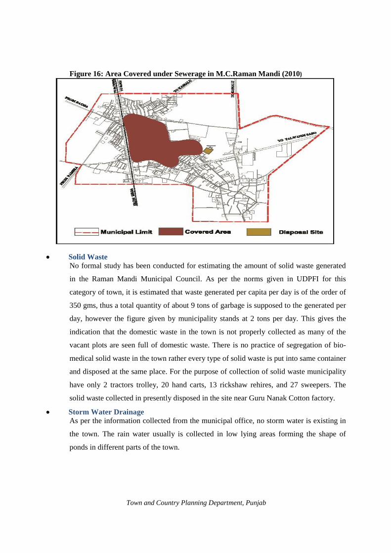
Figure 16: Area Covered under Sewerage in M.C.Raman Mandi (2010)
· Solid Waste No formal study has been conducted for estimating the amount of solid waste generated
in the Raman Mandi Municipal Council. As per the norms given in UDPFI for this
category of town, it is estimated that waste generated per capita per day is of the order of
350 gms, thus a total quantity of about 9 tons of garbage is supposed to the generated per
day, however the figure given by municipality stands at 2 tons per day. This gives the
indication that the domestic waste in the town is not properly collected as many of the
vacant plots are seen full of domestic waste. There is no practice of segregation of bio-
medical solid waste in the town rather every type of solid waste is put into same container
and disposed at the same place. For the purpose of collection of solid waste municipality
have only 2 tractors trolley, 20 hand carts, 13 rickshaw rehires, and 27 sweepers. The
solid waste collected in presently disposed in the site near Guru Nanak Cotton factory.
· Storm Water Drainage As per the information collected from the municipal office, no storm water is existing in
the town. The rain water usually is collected in low lying areas forming the shape of
ponds in different parts of the town.
Town and Country Planning Department, Punjab

5.1 Social Infrastructure Social infrastructure improves the quality of manpower available in urban area. In
addition, these facilities have been found to be leverage the economic development and
employment, like education, health, recreational areas and fire frightening etc.,which are
covered in LPA Raman Mandi are listed below.
· Education In LPA Raman Mandi, 45 Primary schools and 23 high and senior secondary school and
2 colleges to improve/upgrade the education standard in this area. But there is totally
absence of technical Institutes like Engg. College in LPA Raman Mandi.
Beside the availability of institutions in the field of Primary and Elementary in Raman
Mandi town. It's LPA has a sufficient number of institutions education at higher/sen. sec
school level. As shown in Table 23
Table 23: Education Facilities in Local Planning Area and Raman Mandi
Sr. No. Name of Facility Numbers
Raman Mandi Town LPA Raman Mandi 1 Primary and elementary Schools 7 45 2 Higher/Sen. Sec. Schools 4 23 3 Colleges (Degree) 1 2 4 College ---
Total 12 70 Source: D.E.D.Bathinda
· Health As per data collected there are 39 medical facilities of different types providing health
services to the residents of LPA Raman Mandi. Out of these there are 30 bed capacity
hospitals available each in Raman Mandi and Sangat Mandi both towns. Other than one
dispensary available in Raman Mandi town and 18 dispensaries which are serving LPA
Raman Mandi.
In l.order to take care of animals and pets there is one veterinary hospital functioning in
Raman Mandi and 2 veterinary hospitals in LPA Raman Mandi.
· Fire Prevention and Protection There is no fire station in Local Panning Area Raman Mandi to take care of fire safety.
As per information given by M.C. Raman Mandi, in case of emergency the M.C. Raman
Mandi depends upon Bathinda city for fire protections.
· Police Stations
Town and Country Planning Department, Punjab
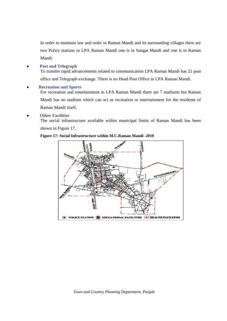
In order to maintain law and order in Raman Mandi and its surrounding villages there are
two Police stations in LPA Raman Mandi one is in Sangat Mandi and one is in Raman
Mandi.
· Post and Telegraph To transfer rapid advancements related to communication LPA Raman Mandi has 21 post
office and Telegraph exchange. There is no Head Post Office in LPA Raman Mandi.
· Recreation and Sports For recreation and entertainment in LPA Raman Mandi there are 7 stadiums but Raman
Mandi has no stadium which can act as recreation or entertainment for the residents of
Raman Mandi itself.
· Other Facilities The social infrastructure available within municipal limits of Raman Mandi has been
shown in Figure 17.
Figure 17: Social Infrastructure within M.C.Raman Mandi -2010
Town and Country Planning Department, Punjab

Town and Country Planning Department, Punjab

6.2
CHAPTER: 6
VISUALIZING THE FUTURE 6.1 Population Projections 2031
The population is the basic human factor for which planning is done. The
requirements of different types of infrastructure for Raman Mandi town and for
villages of LPA, Raman Mandi for the year 2031 would be based on the projected
population for that year and also migration of population that seeks livelihood in the
town. For the purpose of population projections following two methods have been
applied:
· Ratio method or sharing pattern method. · Extrapolation method: Extrapolation of the past trends and assuming that the trend
will continue in future. In addition to this, the government policies and the opportunities affecting the
growth of Raman Mandi town and rural areas of LPA, Raman Mandi has also been
kept in mind.
The following Table no. 24 gives the detail of decadal growth rate of LPA Raman
Mandi (Urban and Rural)
Table 24: Growth Rate of Population of Raman Mandi LPA, (Urban and Rural) 1981-2001
Year LPA Total Urban Rural Population Growth Population Growth Population Growth
rate(% age) rate(% age) rate(% age)
1981 98263 ----- 17177 ------ 81086 --------1991 115536 17.58 20006 16.47 95530 17.81 2001 131633 13.93 24952 24.72 106681 11.67
Source: Census of India, 1981, 1991, 2001
Method I: Ratio Method or Sharing Pattern Method With the establishment of GGS Refinery near Raman Mandi the growth trend of this
town will naturally change and it has been assumed that this town as well as the LPA
will grow with the overall growth rate of the state, therefore in order to achieve more
realistic picture of projected population it has been decided to follow the share of
Urban and Rural population of LPA, Raman Mandi to the total Urban and Rural
population of Punjab state. Report of the technical group on Population projections
constituted by the National Commission on Population entitled “POPULATION
Town and Country Planning Department, Punjab

PROJECTIONS FOR INDIA AND STATES 2026” has provided projection of
Punjab Urban, Punjab rural and their share in the total population of the state up to
year 2026 as represented in Table No. 25.
Table 25: Projected Population of Punjab Total, Punjab Urban, and Punjab Rural 2001- 2026(In Thousands)
Year 2001 2006 20011 2016 2021 2026 Punjab Total 24359 26059 27678 29112 30323 31345 Punjab Urban 8263 9439 10681 11940 13185 16456 Percentage Urban 33.92 36.22 38.59 41.01 43.48 52.50 Growth rate of Punjab Urban in % - 14.23 13.16 11.79 10.43 24.81 Punjab Rural 16096 16620 16997 17172 17138 14889 Percentage Rural 66.08 63.78 61.41 58.99 56.52 47.50 Growth rate of Punjab rural in % - 3.28 2.26 1.03 -0.20 -13.14
Source: National Commission on Population
The percentage share of LPA urban and LPA rural respectively of Punjab is calculated and
is given in Table No. 26.
Table 26: Share of Population of LPA, Raman Mandi to Population of Punjab Urban Share
(Total Raman Mandi inclusive of Ramsara village) Rural Share
1981 1991 2001 1981 1991 2001 0.37 0.33 0.26 0.67 0.67 0.64
(Source: Census of India 1981, 1991, 2001) For projecting the urban population the percentage of urban population (Raman and
Sangat Mandi town) is derived from the total urban population of Punjab in year 2001
which comes out as 0.26% in 2001. Since both the towns are distantly located
therefore the projections of future population are worked separately. It is expected
that village Ramsara will be part of proposed urbanisable area around Raman Mandi
thus the population of this village has been added in the population of Raman Mandi
town for calculation purpose. The figure of 0.26% has been used constantly for
projecting the urban population for Raman Mandi town for the year 2006, 2011, 2016,
2021, and 2026. For calculating the projected population of 2031, the projected
growth rate for the period between 2021 to 2026 has been taken. Besides this, the
floating population of about 5% has also been added to the projected population.
Similarly, for projecting the rural population of LPA, Raman Mandi, the percentage
share of rural population has been derived from total rural population of Punjab in the
year 2001 which comes out as 0.64% and the same has been used constantly for
Town and Country Planning Department, Punjab

6.3
projecting rural population up to the year 2016. There after average growth rate of
2006-2011and 2011–2016 (i.e. % 2.98 say 3%) has been taken for calculating the
projected population of LPA rural for the year 2021, 2026 and 2031 because the
growth rate of Punjab rural during the year 2016 - 2021 and 2021 – 2026 is given
negative, for the state as a whole but the character of the rural area of LPA Raman
Mandi is not expected too much the projected characters of the state. The Projected
population of LPA Raman Mandi total, urban and rural given in the Table No. 27.
Table 27: Share basis population of LPA Raman Mandi (Urban & Rural 2006-31) Year LPA Urban LPA Rural Total LPA
Raman Mandi (Inclusive Ramsara)*
Sangat Mandi
2006 24541 6135 103668 137044
2011 27770 6942 108780 143492
2016 31044 7761 109900 148705
2021 34281 8570 113197 156048
2026 42785 10694 116592 170071
2031 55621
Say 56000
13367 120089 189456
Population of Refinery Township
5000 ------ ------
Total 61000
Source: Calculated Figures and data supplied by G.G.S. Refinery
* It may be noted that percentage share of LPA urban and rural has been calculated separately and
the projected share of LPA total is the addition of these two components. The population of
Refinery Township has been added to Raman Mandi Town population as supplied by GGS
Refinery.
Method II: Population Projection by Extrapolation Method: Apart from the above method, another method known as Extrapolation Method adopted
for population projection which is based on the trend of past growth rate of population of
urban and rural areas. Besides the past growth trend this method is based on certain
assumption also which are applicable to this LPA as listed below:
· Establishment of G.G.S. refinery will boost the economic base of LPA.
· The proposals for Petroleum, Chemical & Petrochemical Investment Region (PCPIR) in
LPA will further strengthen the economic base of LPA.
Town and Country Planning Department, Punjab

· The growth rate of population of urban areas will be higher than the past trend.
· The improved road connectivity in LPA will provide higher level of infrastructure.
Taking into account the assumptions given above, the average growth rate of 30% is
assumed for calculating the projected population of towns against the past trend of
20.13% and 13.18% of Raman Mandi and 4.47% and 96.70% of Sangat Mandi during the
decades of 1981-1991 and 1991-2001 respectively. The rural area growth rate of
population for the decades of 1981-1991 and 1991-2001 is around 17.81% and 11.67%
respectively therefore the average growth rate of rural population is assumed as 15%
(average of two decades). The projected population of LPA Raman Mandi total urban and
rural for year 2011 – 2031 is given in Table No. 28.
Table 28: Projected Population for LPA Raman Mandi Total, Urban and Rural 2011 – 2031
Years
LPA
Total LPA Urban Rural
Raman Mandi (Inclusive Ramsara vill.) Sangat Mandi
Growth Rate in % age
Population (in persons)
Growth Rate in %age
2011 28551 7021 30 122683 15 158255
2021 37116 9127 30 141085 15 187328
2031 48250 11865 30 162248 15 222363 Source: Calculated Figures
The following Table No. 29 gives the comparative picture of projected population for
Raman Mandi town, rural areas, and LPA, Raman Mandi for 2031 by two methods:
Table 29: Comparison of Projected Population by Two Methods for the Year-2031 Method LPA Total LPA Urban (Raman Mandi
only) LPA Rural Areas
Method 1 189456 61000 120089 Method 2 222363 48250* 162248
*This figure does not include Sangat Mandi population which is 11865 persons.
Out of the above two methods, Population Projected by Method No.1 seems to be more
realistic as it has been assumed that in light of changed opportunities, this LPA will retain
its present share of population by competing with the overall growth of the state
population. Therefore the population projections by method no. 1 have been adopted for
plan formulation despite general trend of reduced population growth rate, Raman Mandi
Town and Country Planning Department, Punjab

town is likely to retain its share of urban population. The Projected Population of Raman
Mandi town therefore has been taken as 60621 (say 61000 persons) for the year 2031.
6.4 INFRASTRUCTURE REQUIREMENTS Water Requirements In true sense the term water demand refer to the estimated quantity of water required for a
city to fulfill water needs of the people residing in the city. The estimated water demand
includes per capita consumption, system losses, industrial and commercial consumption,
fire fighting demand etc. The water demand is broadly classified as domestic and non-
domestic water demand.
Domestic water demand: The Indian codal precisions recommended a minimum water supply of 135 lpcd for cities
and Raman Mandi adopts the same. The residential area in Raman Mandi is expected to
have a much higher demand due to better life style adopted by the residents. However
considering the availability of water and the norms followed by the PWSSB, a rate of
supply of 135 lpcd+15% losses for domestic purpose will be adopted for requirement
purpose.
Industrial water demand Bulk supply of water to large to industrial establishments will be considered as per
specific requirement of each industry. However the figures of 135 lpcd+15%losses
include water requirements for commercial, institutional and minor industries.
Fire Demand As per CPHEEO recommendations a provision fire demand based on formula of 100√P,
where P = population in thousands shall be kept in mind.
Estimation of Water Demand 2011-2031 The water demand has been projected based on water requirements calculated on the
basis of above norms adopted by Punjab Water Supply and Sewerage Board. The net
water demand for Raman Mandi Town thus works to 9.47 MLD by the year 2031 is as
given in Table No. 30.
Table 30: Water Demand in Raman Mandi (2011-2031) Year Water Demand in MLD 2011 5.08 2021 6.09 2031 9.47
Source: Calculated Figures
Town and Country Planning Department, Punjab

*This demand comprises consumption of domestic and non domestic purposes. Non domestic
user includes consumption by Institutions (Colleges, School and Hospital), Commercial
Establishment, Industries, Public Parks, Hotels, Tourist places etc. Gross water demand
comprises network demand and physical & non-physical losses the water requirements for the
rural settlements (village abadis) have not been projected since this aspect is independently
handled by the Department of Water Supply and Sanitation.
Sewerage Generation in Raman Mandi 2011-2031 Considering 85% of the water supplied to the consumption reaching the sewer and
adopting the recommended norms for infiltration (5%) the projected waste water flows
has been calculated. As per the norms adopted by Punjab Water Supply and Sewerage
Board (PWSSB) practical wastewater flow has been estimated to be 85% of water
supplied to the consumers Estimated net water demand and sewerage generation as
calculated by this office based on above norms is given in the Table No. 31.
Table 31: Sewage Generation in Raman Mandi (2011-2031)
Year Sewer generation in MLD
2011 4.31 2021 5.17 2031 8.04
Solid waste disposal The production of solid waste in an urban area is a function of the socio economic profile
of the population and activities in the area. As per UDPFI guidelines the generating of
waste varies from about over a quarter of a kilogram in small towns to about half a
kilogram per capita in large and metro cities. For Raman Mandi town which is medium
sized city by 2031 and the waste generation as per standard will be 350gram per capita
i.e. 350grm x 61000pesons = 21.35 ton per day.
Power
As per the standards given in UDPFI guidelines the power consumption works out to be 2
KW per household at city level. Based on above the power consumption for Raman
Mandi town on five yearly bases is calculated in the Table No. 32:
Town and Country Planning Department, Punjab

Table 32: Power Requirement of Raman Mandi Town (2011-2031) Year 2011 2021 2031 Household Number 5554 6856 11124 Power consumption 11.1 MW 13.7 MW 22.2 MW
As per UDPFI guidelines one electric substation of 11 KV is required for the population
of 15000 persons. Thus for the projected population of 2 lacs,a total number of about 4
electric sub stations of the capacity of 33 KV or 2 electric sub-station of the capacity of
66 KV are required.
6.5 Constitution of Think Tank In light of the Govt. instructions, the think tank for visualizing the future of the Raman
Mandi town (vision 2031) was constituted by Deputy Commissioner Bathinda on
6.09.2010 with the following members as listed in Annexure No. –IV.
6.6 The Strength Weakness Opportunities Threat (SWOT) Analysis For the preparation of master plan of LPA, Raman Mandi (Refinery) it is necessary to
develop a long term vision (2031) of the town that takes into account the present
strengths and weaknesses of the town and the opportunities and threats likely to be
presented by the surrounding region. Based on the above parameters, the issue paper
(SWOT Analysis) was prepared by the office of District Town Planner, Bathinda, which
was discussed and finalized in the meeting of Think Tank as given below;
Strengths; · Location on Bathinda-Sirsa railway line. · Important Urban centre of Bathinda district. · Establishment of Guru Gobind Singh Refinery.
Weakness: · No regional links through roads. · Slow growth rate of industries. · Lack of higher education institutions. · Shortage of affordable and qualitative housing stock. · No Sewage Treatment Plant. · Unplanned development of town.
Opportunities: · Establishment/Development of Guru Gobind Singh Refinery. · Construction of Refinery road from Bathinda-Dabwali road. · Establishment of some educational institutions within L.P.A. · Establishment of Super Power Plant at village Bananwali.
Town and Country Planning Department, Punjab

6.7
Threats: · Shadow of Bathinda the big urban centre. · Existence of other small towns having better road and rail connectivity.
Vision-2031 Developing a vision for the city is control for the preparation of a master plan. A vision
is a statement explaining that where the city wishes to go, within a given time frame and
is often expressed in terms of clear expectations. Based on the outcome of discussions
held in the various meetings of 'Think Tank' the vision Raman Mandi 2031 is articulated
as follow:
"To project Raman Mandi as a hub of agro-based industries and to revive its commercial supremacy by providing high quality physical and social infrastructure to all of its citizens in an inclusive and environmentally sustainable manner." Strategies' to attain Vision In order to achieve the objectives and goals enshrined in the vision statement, mission
statements for various focused areas have been detailed below:
Growth management · Promoting planned development through effective city planning. · Rationalizing land use pattern for effective traffic management and provision of
basic services and amenities. · Making effective plan implementation and enforcement as integral part of
city planning and development process. · Conserving the cultural fabric. · Making growth management process participatory. · Review of master plan on regular basis. · Improving system of approvals of building plan through use of IT and GIS. · Making urban development self sustaining.
Urban Environment · Urban environment to be made integral and essential part of city development
process. · Environment to be made integral part of planning and decision making
process. · Effective treatment of all sewage generated within the city. · Improving solid waste management. · Creating / developing new and improving existing parks and open spaces. · Promoting better water management. · Making city free from air, water and noise pollution. · Discouraging the growth of slums and improving existing slums.
Water supply · To ensure safe, equitable, reliable, adequate and quality water supply
Town and Country Planning Department, Punjab

· To ensure 100% coverage of the city · To promote rain water harvesting and recycling of water.
Sewerage and Drainage · Total coverage of the city with sewerage and drainage system including slums. · To promote eco-friendly decentralized treatment system. · To minimize sewage generation through water saving appliances. · To promote recycling of sewage · To promote protection of natural water bodies · To promote optimum use of storm water as an alternate source of water supply.
Solid waste management · To improve the solid waste management in the city using best practices. · To use PPP model for Solid waste management. · To promote “Recycling” system of SWM. · To make solid waste management people centric
Storm water disposal · To introduce the storm water disposal system in the entire city · To improve the capacity of the water bodies existing within the city · To improve the natural water drainage channels by de silting and stopping the sewage
water from entering the channels.
Traffic and Transportation · To improve safety, mobility and efficiency of traffic within and out side the city. · To segregate and rationalize the inter and intra city traffic · To improve road geometry and road capacity of existing network · To minimize pollution caused by traffic and transportation and improve
environment. · To create new road network and to improve the existing network to promote
operational efficiency of traffic. · To provide adequate parking spaces to remove traffic bottlenecks. · To plan and provide effective public transport services · Social Infrastructure · To provide adequate sites based on norms, for creating / developing various social
Infrastructure. · To involve private and corporate sectors for providing/developing and maintenance
of social infrastructure. · To make optimum use of mechanism of planned development for developing
adequate and quality infrastructure. · To promote community participation in maintenance and upkeep of social
infrastructure.
Town and Country Planning Department, Punjab

Town and Country Planning Department, Punjab

CHAPTER: 7
THE MASTER PLAN
7.1 Components of the Master Plan
The scope of a master plan is limited to the broad proposals and allocation of land for
various uses such as residential, industrial, commercial, recreational, public, and semi-
public etc. It will propose a network of roads and pattern of streets and traffic circulation
systems for the present and the future. It will identify areas required to be preserved and
conserved and development of areas of natural scenery and landscape together with
preservation of features, structures, or places of historical, architectural interest and
environmental value. It will include zoning regulations for regulating development within
each zone. Therefore, the Master Plan is an important instrument for guiding and
regulating development of a city over a period of time and contributing to planned
development both conceptually and operationally. The proposal part of Master Plan of
LPA Raman Mandi comprises four main components as follows:
· Proposed land use
· Transport network
· Heritage Conservation
· Zoning Regulations
7.2 Master Planning Objectives
The long term vision and the mission statements would require spatial land use planning,
infrastructure planning, financing and implementation, effective management and
operation of infrastructure services, and regulating and enforcing plan proposals. The
objective of the Master Plan is to create enabling spatial and Land Use Planning
framework to achieve the Vision of LPA Raman Mandi more specifically following are
the objectives.
Town and Country Planning Department, Punjab

· To make Raman Mandi town as the most vibrant economic centre to promote the
balanced regional growth.
· To make land allocation in an environmentally benign fashion.
· To minimize haphazard, unplanned, and sub-standard growth and development of
the town and to achieve planned growth to create healthy environment.
· To effectively manage the traffic and transportation within the town through the
mechanism of rationalizing the land use pattern defined in the Master Plan.
· To make land available for public purposes.
· To minimize travel within the town by creating self contained and self sufficient
communities.
· Adequate parking spaces to be created in the town as an integral part of
commercial, industrial, and institutional planning and development process.
· To strengthen the basic infrastructure favorable for petroleum, chemical &
petrochemical investment region (PCPIR) and agro based industries.
· To rationalize the distribution of physical and social infrastructure in order to
ensure appropriate quality of life to all the residents of the city.
· To identify man-made and natural heritage and to make heritage conservation as
integral part of the city planning and development process.
7.3 Evaluation of Present Town Structure
In order to visualize the future structure of the town it is necessary to understand the
existing town structure. The structure of the town can be appreciated by examining the
relationship between living and work areas in terms of their connectivity with each other.
Raman Mandi is a small town where work areas and residential areas are not separately
located. However efforts have been made to identify and show such areas through the
thematic map of Raman Mandi as given in Figure 18.
Town and Country Planning Department, Punjab

Figure 18: Work and Living Areas- Raman Mandi
· A careful study of the above thematic map shows that the central part of the town which
includes the Grain Market, Bank Bazar and part of the Gaushala road is the main work
area of the town where most of the people are engaged in trade and commerce. A small
pocket of such work area also exists around the intersection of Talwandi Sabo road and
Raman village road.
· The living area around Grain Market is formed to be planned whereas the rest of the
living areas are unplanned. The town mostly developed towards eastern side of railway
line with a few pockets towards west. It is observed that the development of town
followed the existing link road like, Talwandi Sabo road, Raman (village) road, Kamalu
road, Bangi road, and Bagha road etc.
· Because of the small size of the town no more detailed studies are meaningful. The fact
of the matter is that like other towns of this category the intermingling of different uses is
found in case of Raman Mandi also.
Future Town Structure Raman Mandi-2031
On the basis of studies conducted by the office of District Town Planner Bathinda, it
is observed that the development activities in Raman Mandi are very limited;
therefore the different alternatives cannot be envisaged for this town.
Town and Country Planning Department, Punjab
7.4

With the establishment of Guru Gobind Singh Refinery near Raman Mandi the scenario of
development of this town is expected to be changed dramatically because of the opening of new
opportunities for work, business, and other activities. Keeping in view the position of the existing
town of Raman Mandi on one side, site of Guru Gobind Singh Refinery on other side and
Refinery Township on refinery road it has been envisaged that the areas falling between these
three nodes would be most potential for future development of Raman Mandi. Besides this the
potentials of railway line and Talwandi Sabo road cannot be underestimated. Therefore the areas
along these transport lines may attract some activities. In light of the above facts and detailed
discussions held with the senior officers of this department and Advisor Town Planner, the future
town structure for Raman Mandi has been envisaged as shown in the thematic map at figure 19.
Figure 19: Concept plan of Raman Mandi -2031
7.5 Land Use Requirements
It is pertinent that before proceeding to prepare land use plan and transport network the
areas required for different purposes are to be worked out on the basis of norms and
standards of various organizations.
7.6 Area required for main Land Uses
The area requirements for different uses for projected population of Raman Mandi town
have been worked out on the basis of norms given in UDPFI. The assessment of the
Town and Country Planning Department, Punjab

urbanisable area is normally based on the proposed residential area which is considered
to be 40% of total proposed urbanisable area of towns like Raman Mandi i.e. The
Appendix-B of Norms and Standards, of UDPFI guidelines has been followed for
calculating the area requirements for different land uses.
7.7 Residential Use
As per the calculations of towns given at page 7 of UDPFI guidelines the towns having
the population between 50,000 persons fall in category of medium towns. By the year
2031 the population of Raman Mandi has been projected to 56,000 persons thus the town
will fall in category of medium towns. Therefore the norms of medium towns have been
taken for calculating the area requirements for different land uses.
For calculating the requirements of area for residential use the mean of number of
dwelling rooms per household has been taken. Since the data regarding households by
number of dwelling rooms is not available for small or medium towns therefore the data
regarding the district urban (excluding Bathinda city) has been followed.
It is evident from Table 16 given at sub-head 3.3 of this report that maximum numbers of
the households in Bathinda district urban have residential accommodation comprising
two rooms or more. About 30.5% have two rooms accommodation and 22.8% have three
rooms accommodation whereas 21.39% have one room accommodation. The mean of
dwelling rooms per house hold of all categories works to be 2, thus for the purpose of
calculating the area requirements for residential use the mean of the dwelling rooms per
house hold has been taken as shown in Table 33 and Table 34.
Table 33: Calculation of Average Plot Area in Raman Mandi
Sr. No. Description Area in sq.m.
1 Carpet area of average dwelling unit. 1 Living Room ,2 Bed Rooms, 1 Kitchen and other 120
2 Built up area inclusive of walls, verandahs etc 144
3 Plot area @ footprint to plot ratio of 0.65 222
Town and Country Planning Department, Punjab

Table 34: Stage wise Residential Area Requirements for Urban Area, LPA Raman Mandi (2011-2031)
Sr. No. Year No. of Families Net Land Required in hectare (Assumed 1 family plot)
Gross Residential Land in hectares
1 2011 5554 123.30 246 2 2021 6856 152.20 304 3· A 2031 11200 249.00 498
ssumed family size=5
· Plot size of 222 sq. mts.
· Assumed family per plot-1
· 50% area is assumed under other uses like neighborhood shopping, roads,
neighborhood parks and public buildings etc.
7.8 Commercial Use
The area requirements for commercial activities have been calculated as per norms given
at page 152 of UDPFI guidelines which have been reproduced in Table 35 below and
based on these norms the area requirements for Raman Mandi has been worked out as
given in Table 36.
Table 35: Area of Commercial Centers Name of Commercial Centre Area per 1000 person's
sq.mt. Number of shops
Cluster Centre 220 1 for 110 persons Sector Centre 300 1 for 200 persons Community Centre 500 1 for 200 persons District Centre 880 1 for 300 persons Total 1900
* Area per person required 1.9 sq. mts. say 2 sq. mts. Table 36: Commercial Area Requirements for Urban Areas of LPA, Raman Mandi Sr. No. Year Projected
Population Commercial area required in hectares
1. 2011 27770 5.6
2. 2021 34281 6.9
3. 2031 61000 12.20 * Population of Refinery Township 5000 persons is added in projected population.
Note: This does not include the area required for wholesale markets which will be worked out separately as per the nature of the wholesale market.
Town and Country Planning Department, Punjab

7.9 Industrial
The detailed data regarding various categories of workers in census 2001 pertaining to
Raman Mandi town is not available. The data of industrial workers available in census
2001 is limited to the household industry only. The no. of workers engaged in other
industries is not available. The projections of industrial workforce cannot be made
accurately, therefore, for calculating the industrial use requirements the proposed land
use structure standards cited in UDPFI guidelines on page no 143 are adopted as given
below.
· Total existing industrial area of Raman Mandi town 11.15 Hect. · Existing industrial use as a percentage
of town area 2.12% · Norms and standards for percentage of
Industrial use (as per UDPFI standards) 10-12 % As per existing land use plan, the area occupied by industrial use is only 2.12% of the
town area. With the coming up of Guru Gobind Singh Refinery and the role of Raman
Mandi to be played in future the number of industrial workers may increase abnormally.
Therefore the area projected for industrial use based on the figures of 2001 census may
not be relevant. The scope of agro based industries is foreseen in future around Raman
Mandi because of all around development of this town therefore to face such challenges
more areas are required for industrial use. In light of the above facts and the UDPFI guide
lines about 8-10% of the urbanisable area is assumed to be covered under industrial use
in proposed urbanisable area of Raman Mandi. The area requirements for industrial use
for Raman Mandi are given in Table No. 37.
Table 37: Projected Industrial Area Requirements for LPA Raman Mandi – 2031 Sr. No.
Year Projected Urbanisable Area in Hects.
Assumed % age of industrial use
Total Area Required for Industrial use in Hectares
1 2 3
2011 615 8 49.2 2021 760 9 68.4 2031 1245 10 124.5
The above projected area does not include the area of Guru Gobind Singh Refinery
because this is an independent industrial complex. The area required for Petroleum,
Town and Country Planning Department, Punjab

Chemical and Petrochemical Investment Region (PCPIR) has not been included in above
projections as this is a special use zone which is not covered in UDPFI guidelines.
7.10 Recreational Facilities
As per PAPR Act 1995, about 45 % of the area of a colony is to be left for non saleable
purposes out of which 10 % is to be left for public buildings. As per the provisions of this
Act normally 25-30% area is provided for circulation i.e. roads, pavements etc. Assuming
the figure at 27% for roads, the remaining 8% has been considered for recreational, park,
open spaces, sports etc. By this formula if we have one hectare area of a colony then 800
sq.mt. are supposed to be provided for this category. Keeping in view the average size of
plots as 200 sq.mts., about 28 plots can be adjusted in one hectare area (assuming 55%
saleable area), which would accommodate about 40 families taking average size of one
family as five members a total of 200 persons are estimated to live in one hectare.
Therefore, by this calculation about 4 sq.mt. Recreational area works as share of each
person. However at city level approx. 2 sq.mt. per capita area is to be added for city level
open spaces. Thus total 6 sq.mt. Per capita area is required at city level for recreational
facilities.
As per the above narration 37 hectares are required for parks, open spaces and play
grounds etc. but keeping in view the sentiments of the people and the pressure on urban
land it is not advisable to block one's land for such non-remunerative activities. It is
assumed that as and when the land is developed under PAPR Act, the areas for recreation
would be ensured to be allocated as per above.
Road Network and Terminal Required
7.11 Road Network required at Town Level
As it has already been discussed in detail, there is only one main road providing the
regional connectivity to the town of Raman Mandi i.e. Talwandi Sabo road. This road
ends at railway line in Raman Mandi and does not pass through the town thus the town is
lacking badly from regional connectivity point of view. The other main road leading to
Guru Gobind Singh Refinery from Dabwali road which runs near the town but does not
connect the town. This road ends at Refinery gate and has no direct bearing on Raman
Mandi.
Town and Country Planning Department, Punjab

This office made the efforts to conduct traffic volume on some roads of the town but the
volume of traffic was found too less to be recorded therefore it has been concluded that
the traffic volume survey would not serve any purpose and may not contribute any
relevant thing in preparation of Master Plan.
Since the two main roads i.e. Refinery road and Raman Mandi-Talwandi Sabo road are at
a distance of about 2.5 k.mts from each other, the proposal to connect these roads is most
urgent and needs immediate attention. During the discussions with prominent citizens
through the members of Think Tank it was the general consensus that the Talwandi Sabo
road which ends at railway line must be proposed to be connected with refinery road
towards South of village Ramsara. Another link of 150 feet wide road may be provided
through northern side of Raman Mandi connecting Talwandi Sabo road and refinery road.
Since the refinery road ends in refinery site this issue was discussed in the meeting of
Think Tank and the requirement of its extension of this road up to Talwandi Sabo road
along the refinery boundary was felt and decided to propose this vital link in Master Plan.
Besides this, the roads of lower hierarchy are required to be proposed for inter connecting
the main roads.
7.12 Road Network at LPA level
In addition to the proposed road network at town level the widening of existing village
roads been has proposed for better connectivity between existing road network at LPA
level and proposed roads. This lower hierarchy links would provide access to interior
areas and increase the scope of potentialities of the left out pockets.
7.13 Terminal Required
For the town like Raman Mandi in which about 60,000 populations has been projected
for the year 2031, only one Bus Stand of adequate size and one Truck Terminus would be
sufficient. Since no space norms have been given in UDPFI guidelines the area
requirements have not been worked out. However an area of 5-10 hectares for Bus Stand
and 10-12 hectare for Truck Terminus would be sufficient.
7.14 Land required for social infrastructure
The land requirement of social infrastructure for Education, Health Care, Police, Fire
facilities etc. for Raman Mandi urban is calculated as below:
Town and Country Planning Department, Punjab

Table 38: Land Requirement for Educational Facilities (For 100000 populations)
Category Norms No. of units Area/unit
(in ha.) Total area (in ha)
College 100000 1 4 4 Secondary School 7500 13 1.6 21 Primary School 5000 20 0.4 8 Pre-primary school 2500 40 0.08 3.2 Total 37
· Area per person required in sq.mts. =3.7
· Total area required 3.7 x 61000 = 22.57 Hects.
Table 39: Land Requirement for Medical Facilities (For 250,000 persons)
Category Norms No. of units
Area/unit (in hects.)
Total area (in hects.)
Hospital 250000 1 4 4 Intermediate (Category-A) 100000 2.50 2.7 6.75 Intermediate (Category-B) 100000 2.50 0.6 1.50 Dispensary 15000 17 0.1 1.7 Total 13.92
· Area per person required in sq.mt. 0.56 or Say 0.6 · Total area required under medical facilities 0.6 x 61000 = 3.66 Hects.
Table 40: Land Requirement for Police. (For 100,000 persons)
Category Number of persons
No. of units
Area/unit (in ha.)
Total area Required (in hects.)
Police station 100000 1 1.5 1.5
Police Post 50000 2 0.16 0.32
Total 1.82 (or 18200 sq. mtrs.)
· Area per person required in sq.mt = 0.18 sq mts · Total area required for police =0.18x61000 =1.0980 Hects.
Say 1.1 hects.
Town and Country Planning Department, Punjab

Table 41: Land Requirement for Fire Station
Category Number of persons
No. of units Area/unit (in ha.)
Total area (in hects.)
Fire/Sub Fire station 200000 1 1 1
· Area per person required = 0.05 sq.mt · Total area required = 0.05 x 61000= 0.31 Hects.
Table 42: Land Requirements for Main Public Amenities
Sr. No. Name of facility/Amenities Land required (in hectare)
1 Educational 22.57
2. Medical & Health care 3.66 3. Police & Security 1.10 4. Fire Prevention 0.31
Total 27.64
SPACE NORMS AND STANDARDS
7.15 Social Infrastructure and Public Utilities
Basically UDPFI norms and standards have been followed for calculating the area
requirements for different social infrastructure and public utilities however the Punjab
State Govt. policies issued time to time have also been adopted where it was applicable.
There are three different sets of norms and standards taken into consideration the
comparative chart of these is given in Annexure- III.
From the comparative table of norms and space standards as given at Annexure-III, the
norms suggested by UDPFI Guidelines have been found more suitable for the preparation
of Master Plan Raman Mandi because of the following reasons:
· The norms and standards suggested by UDPFI Guidelines are more detailed and
cover almost each physical and social infrastructure as compared to Master Plan
Zoning Regulation /Govt. policies
· Norms and standards suggested by UDPFI Guidelines are more realistic and suit to
local conditions such as prevailing development controls, availability of land, land
prices etc.
Town and Country Planning Department, Punjab

· UDPFI Guidelines suggest different norms and standards for different category of
towns like small and medium towns, large cities, and hill areas which is not
available in other guidelines.
· The Norms and standards of Master Plan Zoning regulation are not detailed and do
not cover the whole of activities, hence are not being adopted.
· Norms and standards suggested by Delhi Master Plan have not been found suitable
for local planning area Raman Mandi because these norms are of higher level,
formed especially for Mega city like Delhi, where development controls are very
tight, population is more than 1.25 crores and the land is scarce and costly.
Note:
· The norms space standards as suggested by Punjab Govt. policies from time to time
shall have the overriding effect on the norms and standards of UDPFI Guidelines
adopted for the preparation of Master Plan, Raman Mandi.
· For the aspects which are not covered under UDPFI Guidelines, the norms and
standards as suggested by Master Plan zoning Regulation in Punjab shall be adopted
and where these zoning regulation are also silent, only in that case, the norms and
standards suggested by Delhi Master Plan shall be followed.
7.16 Transportation
After due consideration the norms and standards for Traffic and transportation as given in
UDPFI Guidelines were discussed with the Advisor Town Planner and following roads
hierarchy has been adopted;
Road hierarchy R1: 200 feet (R.O.W.)
R2:150 feet (R.O.W.)
R3: 100 feet (R.O.W.)
R4: 80 feet (R.O.W.)
R5: 60 feet (R.O.W.)
Within the above ROW, width of footpaths and cycle tracks given may be provided as
follows if required.
Town and Country Planning Department, Punjab

Footpath
The width of footpaths is listed as below:
Minimum width 1.5 m
Adjoining shopping frontage At least 3.5 m
Longer shopping Frontage Minimum 4.5 m
Width should be increased by 1m in business/ shopping areas
Cycle Track
The minimum width of cycle tracks should be 2m. Each additional lane, where required,
should be one meter. The capacity of cycle tracks recommended is as below:
Table 43: Norms and Standards of Cycle Tracks
Width of Cycle Width in meters Capacity (Cycle /hr) Tracks One way Two way Two lanes 3 250-600 50-250 Three lanes 4 >600 250-600 Four lanes 5 >600
7.17 Proposed Land Use Plan
After going through the detailed studies conducted by the office of DTP Bathinda
pertaining to LPA Raman Mandi and discussions held at different levels i.e. with
S.H.U.D, Adviser, Town Planner, Chief Town Planner, Senior Town Planner and Think
Tank and further based on analysis, assumptions and projected population of LPA Raman
Mandi, the Proposed Land Use Plan 2031 has been prepared, in which different land use
zones have been earmarked such as residential, commercial, industrial, rural and
agricultural etc.
In order to maintain the connectivity of urban development the model of compact urban
development has been adopted while preparing proposed land use plan particularly
proposed urbanisable areas around existing towns of Raman Mandi & Sangat Mandi and
adjoining to Dabwali Mandi.
As discussed earlier in the chapter the future town structure was discussed in the meetings
of Think tank and the same has been adopted while preparing proposed land use plan of
LPA Raman Mandi. The pattern of continuous growth of Raman Mandi town spreading
over adjoining area has been kept in mind. As observed by the office of DTP Bathinda
the town of Raman Mandi does not have growth trend towards any particular direction
Town and Country Planning Department, Punjab

however the area lying between M.C. Raman Mandi, G.G.S. refinery site and Refinery
township is found most potential for future growth of this town. Keeping in view the
trend of present growth of the town some area on Talwandi Sabo road, Malkana road and
Bangi road have been proposed as urbanisable.
In order to fulfill the future requirements for expansion of Sangat Mandi the area around
M.C. limits of this town and some area between new proposed road and railway line has
been proposed as urbanisable and to strengthen the economic base a chunk of land
between Jassi Baghwali link road and link road leading to village Mashana up to revenue
boundary of Sangat Kalan has been proposed as industrial.
Keeping in view the trend of growth of adjoining town of Haryana i.e. Dabwali Mandi
some area adjacent to its Municipal limits falling in village Chak Kharak Singh wala urf
Doomwali has been proposed as urbanisable. Beside this one pocket adjoining to LPA
Bathinda on Dabwali road has been proposed for extension of industrial zone on this
road.
A special use zone proposed in this LPA is the vast area proposed for Petroleum,
Chemical & Petrochemical Investment Region (PCPIR). As per the policy of PCPIR the
basic character of this use zone will remain as agricultural only 40% area of PCPIR
would be used as processing area and remaining 60% will be agricultural zone therefore
this zone has not been counted towards urbanisable area. The different land use zones
have been shown in the Proposed Land Use Plan Drg.No. DTP (B) 1625/2010 dated
30/08/2010 and the detail of proposed areas is given in Table 44.
Town and Country Planning Department, Punjab

Table 44: Break up of Major Proposed Land Uses LPA Raman Mandi-2031
Sr. No.
Proposed Land Use Within Outside Urbanisable
limits
Total LPA
Urbanisable limits
Area in Hect.
%age Area in Hect.
%age
1 Residential 3005 58.19 1380 4385 8.67
2 Commercial 106 2.05 --- 106 0.21
3 Industrial 1856 35.94 811 2667 5.27
a) Refinery --- --- 811 --- ---
b) Other Industries 1856 35.94 --- --- ---
4 Designated Uses 197 3.82 795 1052 1.72
a) Traffic & Transportation
160 3.1 662 882 1.62
b) Public and semi public/Educational
22 0.43 88 110 0.22
c) Utilities 15 0.29 45 60 0.12
5 PCPIR* --- --- 24326 24326 48.1
6 Rural and Agricultural
--- --- 18098 18098 35.79
Total 5164 100 45410 50574 100
*Petroleum, Chemical & Petrochemical Investment Region (PCPIR).
Town and Country Planning Department, Punjab

Town and Country Planning Department, Punjab

It would be observed that the area requirements calculated earlier are considerably less
than the areas allocated in the proposed land use plan. It needs to be appreciated that
farmland incrementally acquires potential for growth as the road network and other
infrastructure develops. Consequently all the fringe areas are neither converted to urban
use nor are they developed at the same density at any given point of time. Thus proposed
land use plan apart from the area requirement based on the norms has taken cognizance
of this fact. As a result some of the fringe areas may not be converted to urban use till
2031 but will remain potential for this purpose.
The total area proposed for different uses other than rural and PCPIR is termed as
proposed urbanisable area which includes all the use zones such as residential, industrial
and commercial etc. The total urbanisable area of LPA Raman Mandi for the year 2031
works to about 5164.00 hectares which includes the proposed urban area around Raman
Mandi,Sangat Mandi,and Dabwali besides this a chunck of land adjoining the urbanisable
area of LPA Bathinda has been proposed to be urbanisable in terms of industrial zone on
Bathinda-Dabwali road. The spatial extent of different land use zones has been shown in
the Proposed Land Use Plan Drg. (B) 1625/2010 dated 30/08/2010.
However, the lands which come under the Optimum Utilization of Vacant Govt. Lands
(OUVGL) scheme of the state Govt., the use of such lands/sites shall be determined by the
Govt. later on at any appropriate time irrespective of their existing/proposed land use.
The sites on which various projects have been approved or whose change of land use has
already been permitted by competent authority/govt., such sites shall be deemed to be
adjusted as sanctioned/permitted.
7.18 Residential
The projected population of Raman Mandi Town for the year 2031 works to be about
56000 persons and that of Sangat Mandi is expected to be about 13367 persons which is
more than double the population of these towns recorded in 2001 therefore the demand
for residential areas would be quite more. As per the norms, the land required for
residential use to accommodate projected population of 56000 of Raman Mandi works to
be 1245 hectares only but keeping in view the expected impact of Refinery on the growth
mechanism of Raman Mandi the area measuring about 2140 hectares has been proposed
Town and Country Planning Department, Punjab
for urban residential purpose. The potential areas all around municipal limits of Raman
Mandi, and area along existing linkages having trend of residential growth have been
earmarked for residential purpose. Besides this the areas around new proposed roads
would also become potential with the proposals of new accessibilities. Assessing the
future trend of development the areas falling between the present limits of municipal
council of Raman Mandi and refinery road near village Ramsra thus has been proposed
for residential use. The other town of LPA Raman Mandi i.e. Sangat Mandi although is a
stagenent town but with the faster growth of Bathinda and Raman Mandi and likely
development of PCPIR the growth potentials of Sangat Mandi will also
increase.Therefore an area of 485 hectares around the existing limits of M.C.Sangat
Mandi has been proposed for residential purpose.
LPA Raman Mandi touches the municipal limits of Dabwali town of Haryana the area of
village Chak Kharak Singh wala urf Doomwali adjoining to municipal limits of Dabwali
has been found very potential for residential use and other compatible uses as a result of
natural growth of Dabwali town. Therefore an area of about 475 hectares falling between
Dabwali-Bathinda road and link road leading to Grain market Killianwali and areas lying
between Doomwali village and Haryana border in south of N.H. 64 has been proposed as
residential.
The total residential area proposed in urbanisable area at the above mentioned three
different locations measures to about 3005 hects. which is 58.19% of total urbanisable
area of LPA Raman Mandi. This area would also include commercial, institutional and
public-semi public uses etc. thus the actual percentage of residential use may scale down
to around 50%
In addition to the above explained proposed urban residential areas the proper vision for
growth and expansion of rural settlements falling within LPA Raman Mandi has been
made by allowing the expansion of these rural settlements around its existing built up
areas (Abadies) up to a distance of 200 meters.
The total residential area i.e. urban and rural in LPA Raman Mandi is proposed to be
about 4385.00 hectares which is about 8.67% of total area of LPA. The detail of areas is
given in Table 44 and the physical expansion is shown in Drg. No. DTP (B) 1625/2010
dated 30/08/2010.
Town and Country Planning Department, Punjab

7.19 Commercial
As discussed in earlier chapter the data of commercial workers is not available however it
is clear from the available data that other category carries a major share of workers which
also includes commercial workers. The study reveals that the present commercial areas
are concentrated in Old Grain in Market, Gaushala road, Bank road and some activities
on Talwandi Sabo road in Raman Mandi and old Grain Market in Sangat Mandi. In light
of the vision 2031 of Raman Mandi the existing commercial use have been marked in
proposed to be retained as such. As per the discussions held with Adviser Town Planner
and Senior officers of the department no specific commercial use has been proposed
Land Use Plan however it can come up at any place within residential use zone. As per
the provisions of PAPR Act 1995 about 5% area of residential colony can be provided for
commercial purpose, therefore as and when the new residential colonies will be planned
requisite commercial areas will be earmarked at the suitable place however the
independent commercial projects can come up within proposed residential zone fulfilling
the required parameters.
7.20 Informal Sector
A survey of unorganized trading activities in Raman Mandi and Sangat Mandi was
conducted by the office of DTP Bathinda but no specific area was found in the town
which can be considered as rehri market still a small number of rehries walas were seen
near bus stand and in old grain market area.
The unorganized sector in LPA Raman Mandi though is not an alarming problem still it
needs a proper attention. Since it is expected that because of the development of Refinery
site the large number of industrial workers will visit the town which may encourage such
type of activities therefore it is suggested that the organized and well planned sites for
rehri markets shall be proposed in new planned colonies and the interest of existing rehri
walas may be taken care by the municipal council Raman Mandi.
Town and Country Planning Department, Punjab
7.21 Existing Policy for Informal Sector
With a view to make informal sector, an integral part of the planning process and keeping
in view the National Policy on Urban Street vendors, the following provisions are
proposed to be made for the informal sector:
The location/concentration of present stationary informal units shall be taken into
account. It should be ensured that such activities do not spill over on the road network in
the right of way. The Govt. / concerned local agency would coordinate to achieve the
objective.
The areas of informal sector shall have suitable public convenience and arrangement of
solid waste disposal.
Formulation of guidelines for schemes would include 'Hawking' and 'No hawking' zones.
Specific areas would be earmarked for stationary and mobile street vendors by the
concerned local authority.
The local authorities would take up new design of stalls, push-carts and mobile vans of
various sizes and with cleaning facilities, giving due consideration to urban design
requirement of specific area, where informal shopping is being permitted.
No informal unit should be permitted along/near the intersection in order to avoid traffic
congestion and accidents.
7.22 Planning Norms for Informal Trade
As stated informal sector is proposed to be made an integral part of planning process.
Accordingly the informal sector would be incorporated in the planned development in
various use zones. The provision of informal sector should be ensured at the time of
sanction of building plans/layout plans as per the norms given in the Table 45.
Town and Country Planning Department, Punjab

Table 45: Planning Norms for Informal Sector
Sr. No. Use zones/use premises No. of informal shops/units i) Retail trade:
Metropolitan city centre, district centre, community centre, convenience
3 to 4 units per 10 formal shops(to be provided in informal bazaar/service market components)
ii) Government and commercial offices
5 to 6 units per 1000 employees
iii) Wholesale trade and freight complexes
3 to 4 units per 10 formal shops
iv) Hospital 3 to 4 units per 100 beds v) Bus terminal 1unit for 2 bus bay vi) Schools
Primary Secondary/ 3 to 4 units Senior secondary/ integrated 5 to 6 units
vii) Parks District parks 8 to 10 units at each major entry Neighborhood parks 2 to 3 units at each major entry
viii) Residential 1 unit/1000 population ix) Industrial 5 to 6 units per 1000 employees
Source: UDPFI
7.23 Industrial
The studies reveal that Raman Mandi is not an industrial town. There are very few
industrial units in this town such as Cotton industry, Oil mills, Rice mills etc. with the
establishment of G.G.S. Oil Refinery at Raman Mandi the character of the town is likely
to be changed. Keeping in view the needs for basic industries two pockets are proposed
for industrial use zone near Raman Mandi one between Malkana road and Bathinda
railway line and another on Talwandi Sabo road. In order to strengthen the economic
base of Sangat Mandi an area of about 280 hects between Jassi Baghwali roads Gurthari
road has been proposed for industrial use. In addition to this the provision of industrial
area on Dabwali road in village Gahri Butter, Mehta and Gehri Devi Nagar has been
made for the purpose of extension of proposed industrial zone in Master Plan of LPA.
Town and Country Planning Department, Punjab

The area proposed for industrial use has be measured to be about 1856 hectares within
proposed urbanisable limits of which is 35.94% of urbanisable area of LPA Raman
Mandi as given in Table no. 44. Anticipating the future industrial potential of this LPA,
the industrial areas have been proposed much more than the requirements as per UDPFI
guidelines. The spatial extent is shown in Proposed Land Use Plan Drg. No. DTP (B)
1625/2010 dated 30/08/2010. In order to take care of environment a 15 meter wide green
belt (buffer) of broad leaf trees has been proposed to be developed within industrial zone
where it coincides with residential zone; however the fulfillment parameters of Punjab
Pollution Control Board shall be mandatory for establishment of industries.
In addition to the above the entire area of Guru Gobind Singh Refinery which measures
to about 811 hectares has been reserved for the same purpose. The total industrial area
thus measures to be about 26667 hectares which is 5.27% of LPA Raman Mandi. The
spatial extent of these industrial areas is shown in Drg. No. DTP (B) 1625/2010 Dated
30/08/2010.
7.24 Petroleum, Chemical & Petrochemical Investment Region (PCPIR)
In light of the decisions taken in the meeting held under the chairmanship of the Principal
Secretary Industries & Commerce, Govt.of Punjab on 27/7/2007 (Refer Annexure-IV) an
area of about 250 Sq.Kms. has been indentified for Petroleum, Chemical &
Petrochemical Investment Region (PCPIR) in consultation with the District
Administration and the same has been ear marked in the proposed Land Use Plan of LPA,
Raman Mandi. As per the Policy Resolution for Promotion of Petroleum, Chemical and
Petrochemical Investment Regions (PCPIRs) an area of 250 Sq.Kms is required to be
specifically delineated and Planned for the establishment of manufacturing facilities for
the establishment of manufacturing facilities for domestic and export oriented production
in Petroleum, Chemical & Petrochemicals along with the associated services and
infrastructure Refer Annexure-V. This region (use zone) would consist two parts i.e.
processing and non-processing area. The minimum processing area for the PCPIR will be
about 40% of total designated area i.e. around 100 Sq.Kms. The processing area may or
may not be contiguous. This use zone would therefore be predominately agricultural as
Town and Country Planning Department, Punjab

60% area will remain non-processing area. The PCPIR could cover existing
settlements/industries & estates/services and would therefore benefit from and be
complementary to the region. The area ear marked for PCPIR is clearly shown in
Proposed Land Use Plan on LPA Raman Mandi Drg.No.DTP (B) 1625/2010 dated
30/8/2010.
7.25 Mixed Land Use
The need for creating mixed land use zone in Master Plan of LPA Raman Mandi arises
from the fact that the main roads passing through LPA boundary have become more
potential because of establishment of refinery, therefore these roads would attract
different kinds of economic activities thus the mixed land use zone parallel to the road on
both sides has been proposed along these roads up to the depth of 200 meters.The
distance of 200 meters will be measured from the outer side of proposed ROW of the
road. The main roads which have been identified for mixed land use in Master Plan are
listed as follows:
· Bathinda-Dabwali road
· Bathinda-Talwandi Sabo road
· Refinery road
· Raman Mandi-Talwandi Sabo road
· On one side of proposed road connecting Refinery road and Talwandi Sabo road.
(i) The mixed landuse along road fronts shall be permissible maximum depth up to
200mt.subject to the condition that the frontage of the plot/property must abut the
main road. The depth of 200mts.shall be measured from the outer boundary of the
proposed width of said road (ROW)
(ii) In case of Scheduled roads and Bye passes the distance upon which mix land use
along the road is permitted, excludes the distances within which building activity
is prohibited as per the Punjab Regional and Town Planning and Development
(Amendment) Act 2006 as per the provisions of Master Plan.
(iii) The mixed landuse has been proposed along above roads only outside the
municipal limits.
Town and Country Planning Department, Punjab

(iv) The other development controls along roads where mixed land development has
been proposed shall be as per zoning regulations of Master Plan of LPA, Raman
Mandi.
7.26 Rural and Agricultural Zone
With the motive to preserve the basic agriculture character of the state the land outside
the proposed urbanisable area falling within the LPA Raman Mandi has been proposed to
be retained as agricultural. Out of total area of LPA about 18098 hectares have be
proposed for this purpose which is about 35.79% of LPA area. Besides this 24326 hects
have been proposed for PCPIR use zone which would predominantly be agricultural
therefore it may be considered as partially agricultural thus a total of 42424 hects of area
has been proposed for agricultural use which comes to be 83.89% of LPA Raman Mandi.
However some compatible uses like forest, water bodies, orchards, etc. have been
retained as per existing landuse. Such areas will be part of agricultural zone where the
regulations of agricultural zone shall apply.
The spatial extent of rural and agricultural zone and partially agricultural zone i.e. PCPIR
has been as shown in proposed Land Use Plan Drg. No. DTP (B) 1625/2010 dated
30/08/2010.
Designated Areas
7.27 Transportation
Transport network and proposed land use need to be considered in an integrated manner.
For Master Plan of LPA Raman Mandi, extensive road network has been proposed taking
into account the connectivity requirements. The entire network may develop in phases as
the traffic demand builds. However, it is emphasized that landuse proposals of Master
Plan may be reviewed as the road network actually develops.
The concurrent planning of urban and rural growth in Raman Mandi Local Planning Area
and the Transportation system is required to provide an integrated, safe and efficient
system for transportation of people and goods. The system is intended to meet the
projected travel demands in that area. The road and rail sector occupy the significant
roles in the transport sector in Raman Mandi Local Planning Area.
The entire Local Planning and town of Raman Mandi and Sangat Mandi will be served
by well structured and well defined road hierarchy in order to cater to the needs of the
Town and Country Planning Department, Punjab

population living there and to the future requirements for the traffic pertaining to Guru
Gobind Singh Refinery. Further while proposing road network it has also been kept in
mind that a better road network may be provided to integrate LPA Raman Mandi with the
adjoining areas of LPA Bathinda.
7.28 Proposed Road Network
The proposed road network for LPA Raman Mandi has been developed in concurrently
with the proposed land use pattern as shown in the Proposed Land Use Plan Drg. No.
DTP (B) 1625/2010 dated 30/08/2010. The part of Inner and Outer Ring road as proposed
in Master Plan of Bathinda which falls in Raman Mandi has been proposed in integration
with the proposals of LPA Bathinda. Since the town of Raman Mandi is very small, no
concept of road pattern is existing at present however the efforts have been made to
follow the existing roads or the existing irrigation channels wherever available have been
followed. Following road hierarchy has been proposed;
R-1 200 feet (60 mt) (ROW)
R-2 150 feet (45 mt) (ROW)
R-3 100 feet (30 mt) (ROW)
R-4 80 feet (24 mt) (ROW)
R-5 60 feet (18 mt) (ROW)
7.29 Main Roads
In addition to the above mentioned Ring Roads the main road passing through LPA i.e.
Bathinda-Dabwali road (NH 64) has been proposed to be widened to 200 feet (R-1).The
Refinery road, Bathinda-Talwandi Sabo road and Raman Mandi-Talwandi Sabo road
have been proposed to the widened to 150 feet. In order to connect Raman Mandi-
Talwandi Sabo road with the refinery road a 150 feet wide road has been proposed
towards north of Raman Mandi to ensure uninterrupted flow of regional traffic. The detail
has been shown in Drg No. DTP 1627/2010 (B) Dated 18/11/2010 revised drawing
approved by PRTPD Board on 04.04.2011.
Town and Country Planning Department, Punjab

Town and Country Planning Department, Punjab

7.30 Sector Roads
In order to provide better connectivity and strengthen the basic infrastructure of LPA
Raman Mandi some new sector roads of R-3 category have been proposed and at many
other places the existing roads have been proposed to be widened. There is an important
missing link in the town as the Talwandi Sabo-Raman Mandi road ends all of Sudden
while touching the Sirsa railway line which has been proposed to be extended up to
refinery road in south direction of village Ramsra and from this road one link up to
refinery road connecting Refinery Township. Another important link along northern
boundary of refinery from Refinery Gate No. 1 outside the boundary of refinery site
towards Phulo Khari road crossing railway line following water channel and then along
link road up to Talwandi Sabo road has been proposed. One more new R-3 road has been
proposed along Raman Mandi-Bathinda railway line starting from R-2 road near Raman
Mandi up to the proposed Inner Ring road in LPA Bathinda. Several other R-3 (100 feet)
roads have also been proposed keeping in view the importance and status of existing
roads to integrate LPA Raman Mandi with LPA Bathinda city and other surrounding
areas as shown in Drg. No. DTP (B) 1627/2010 Dated 18/11/2010 revised drawing
approved by PRTPD Board on 04.04.2011.
In order to provide free and uninterrupted flow of traffic on main roads the proposal of
railway over bridge (R.O.B) has been made at ten different places on Bathinda-Sirsa and
Bathinda-Hanumangarh railway lines as shown in above mention drawing.
7.31 Other Roads
The lower hierarchy roads of R-4 (80’) and R-5 (60’) have been proposed to interlink the
main roads and integrate the main rural settlement with each other and with the urban
areas of the LPA. The efforts have been made to cover entire area of LPA Raman Mandi
with well conceived road network. However all the existing roads which have not been
proposed for widening in the plan shall be widened to minimum 40 feet. The detail of
proposed road network of LPA Raman Mandi has been shown in Drg. No. DTP(B)
1627/2010 (B) Dated 18/11/2010 revised drawing approved by PRTPD Board on
04.04.2011..
Town and Country Planning Department, Punjab

7.32 Bus Stand
The site of existing Bus stand though is very limited having on 0.71 hectare of area but
this bus stand simply serves as a halt for buses. There is no bus depot in this not be
required in near future however the proposal for bus stand as and when required can be
made at any appropriate place as per the provisions of zoning regulations.
7.33 Truck Stand
The present site of truck stand at Talwandi Sabo road is not sufficient for future
requirements of trucks operating from truck union of Raman Mandi. The large size truck
stand may be the need of future because of the development of manifold activities related
to refinery. The proposed site of truck stand as and when required can be selected within
the proposed industrial zone or wholesale zone as per the provisions of zoning
regulations.
7.34 Utilities
The sites of existing utilities like water supply and electric grid station have been retained
as such. The requirements of such utilities for the residential areas to be planned in future
would be taken care at the time of approval of such projects. However independent site
for the town as per future requirements can be selected as per the provisions of zoning
regulations of Master Plan Raman Mandi.
7.35 Public and Semi-Public Uses
The existing Public and Semi-Public uses are proposed to be retained as such. At this
stage no new specific areas are proposed for this purpose however the suitable sites will
be earmarked as per the provisions of PAPR Act 1995 as and when residential areas are
developed.
7.36 Parks and Play Grounds
There is no organized park in Raman Mandi however the play ground existing in LPA
has retained as such in proposed land use plan of LPA Raman Mandi. For future
requirements the green areas would be carved out as per the provisions of PAPR Act
1995 at the time of approval of industrial and residential/estate or private colonies.
Town and Country Planning Department, Punjab

Town and Country Planning Department, Punjab

CHAPTER -8
ZONING REGULATIONS AND DEVELOPMENT CONTROL REGULATIONS
SECTION-I 8.1 ZONING REGULATIONS
The zoning regulations proposed for adoption in L.P.A Raman Mandi are as below:-
Chief Town Planner, Punjab being the planning agency designated under section 57of
"The Punjab Regional and Town Planning and Development (Amendment) Act 2006" for
the Local Planning Area, Raman Mandi here by makes the following zoning regulations
as per the requirement under clause (d) of sub section 1 of section 70 of "The Punjab
Regional and Town Planning and Development (Amendment) Act 2006" relating to the
Master Plan prepared for Local Planning Area, Raman Mandi.
SHORT TITLE, SCOPE, EXTENT, & COMMENCEMENT Title These regulations shall be called the Zoning Regulations and development control
regulations for Local Planning Area, Raman Mandi 2010 (hereinafter referred to as
“these Regulations”).
Scope of the Regulations The scope of these regulations is limited to defining permissible land uses in various land
use zones depicted in the proposed land use plan forming part of the Master Plan. Other
aspects of “development” such as sub-division and layout of land or intensity of
development measured through FAR, ground coverage, parking requirements, building
design and construction etc. will be governed by other Acts and regulations promulgated
by Government from time to time. Competent Authorities under such regulations shall
ensure that the developments permitted by them are in conformity with these regulations.
Jurisdiction These regulations shall apply to all “development” in the Local Planning Area, Raman
Mandi declared under section 56(i) of "The Punjab Regional and Town Planning and
Development (Amendment) Act, 2006" vide notification no 12/55/2006 – 4 HGI/9857
dated 19.12.2007.
Date of Coming into Force
Town and Country Planning Department, Punjab

These regulations shall come into force on the day on which the designated Planning
Agency publishes the final Master Plan along with these regulations in the Official
Gazette after obtaining the approval of the State Government under sub section (5) of
section 70 of "The Punjab Regional and Town Planning and Development (Amendment)
Act 2006".
Till such approval, the authorities in considering the applications for permission for
development shall have due regard to the draft proposals including these regulations.
· DEFINITIONS For the purpose of these zoning regulations, the following definitions, unless the context
otherwise requires, shall apply:-
(i) “Act” means "The Punjab Regional and Town Planning and Development
(Amendment) Act, 2006" (Punjab Act No. 11 of 1995).
(ii) “Government” means the Government of the State of Punjab.
(iii) “Chief Town Planner” means the Chief Town Planner of The Department of Town
& Country Planning, Punjab or any other officer to whom his powers are delegated.
(iv) “Planning Agency ” means the Chief Town Planner Punjab designated as such
under Section 57 of "The Punjab Regional and Town Planning and Development
(Amendment) Act 2006" for Local Planning Area, Raman Mandi.
(v) “Local Planning Area” means the Local Planning Area declared under section
56(1) of "The Punjab Regional and Town Planning and Development (Amendment)
Act 2006" vide notification No 12/55/2006-4HG1/ 9857 dated 19/12/2007.
(vi) “Existing Landuse Plan” means the Plan showing the different landuses existing at
the time of preparation of the Existing Landuse Plan of Local Planning Area, Raman
Mandi as indicated on Drawing No. DTP (B) 1624/2010 dated 02/08/2010.
(vii) “Proposed Land use Plan” means the plan showing the proposed admissible uses
of different areas and landuse zones covered in the Local Planning Area, Raman
Mandi and as indicated on Drg. No. 1625/2010 dated 30/08/2010.
(viii) “Non- Conforming Building or use” means use in respect of any land or
building in the Local Planning Area, the existing use of which land or building is
contrary to the prescribed landuse.
Town and Country Planning Department, Punjab

(ix) “Zonal Plan” means the detail plan of a part of Master Plan as delineated in the
plan showing different zones and this zonal plan will show all or any of the
following:-
a) Areas earmarked for various land uses as per approved Proposed Land Use Plan.
b) Existing railway lines, existing and proposed road network, water bodies etc. c) Area temporarily or permanently prohibited for the building operation. d) Any other detail required to be provided in the zonal plan.
(x) “Zoning Plan” means the plan of area or part there of or supplementary layout plan
approved by the Chief Town Planner, Punjab and maintained in the office of
Competent Authority showing the permitted use of land and such other restrictions
on the development of land as may be prescribed in the zoning regulations, for any
part or whole of the area such as sub-division of plots, open spaces, streets, position
of protected trees and other features in respect of each plot, permitted land use,
building height, coverage and restrictions with regard to the use and development of
each plot in addition to such other conditions as laid down in these regulations
hereafter.
(xi) “Mixed Land Use”: Means the area where multiple use of land comprising
residential, commercial, institutional, recreational uses and industries other than
Red category as listed by Punjab Pollution Control Board (PPCB) or as amended
from time to time shall be permissible subject to environmental safeguards in a
regulated manner.
(xii) “I.T. Park": An IT Park is a cluster of separate buildings together with a technical
infrastructure, created with the aim of attracting an indulge of knowledge and
technology for science bodies and business."
(xiii) “Fashion Technology Park: " Means where knowledge based infrastructure to
inspire the global fashion community catching all segments of Designing,
Manufacturing, Marketing, R & D, Logistics, Broad forecasting, all are under one
roof."
(xiv) “Knowledge Park: "A platform for interaction and provider clustering
opportunities to all the Organizations, Institutions, Hotels, Restaurants, Hospitals.
Real Estate Agency clubs, Business Parks with main objective of facilitation of
technology better to public and private sector."
Town and Country Planning Department, Punjab

(xv) “Logistic Park”: "A logistic park is an area within which all activities related to
transport, logistics and the distribution of goods for both national and international
transits, are carried out by various operators on a commercials basis."
(xvi) “Farm House: Farm house means a building allowed on a holding of agricultural
land for residential and agricultural activity of the land holder. The total floor area
of such farm house shall not exceed 2 per cent of the area of holding or
200sq.m.whichever is less.
(xvii)“Industry”: Means the place or site where processing and reprocessing of raw
materials into consumer goods, or further processes goods from other industries or
builds capital good used to manufacture consumer and non consumer goods it also
includes energy-producing industries and the construction industries.
(xviii) “House Hold Industry”: Means house hold occupation/ Industry conducted only
by family members/persons residing in the dwelling with or without power and not
contrary to the provisions of the Water Pollution (Prevention and Control) Act 1974
Air pollution (Prevention and Control) Act 1981 and Environment (Protection) Act
1986.
(xix) “Public and Semi Public activities”: Means the uses relating to
governmental/semi governmental offices, educational, medical institutions,
recreational and entertainment facilities, cultural and religious institutions etc.
Terms and phrases used, but not defined in these regulations, shall have the
same meaning as assigned to them in Act.
8.2 LAND USE ZONES
The proposed land use plan incorporated in the Master Plan of LPA Raman Mandi depicts the following land use zones:-
(i) Residential
(ii) Commercial
(iii) Industrial
(iv) Petroleum, Chemical & Petrochemical Investment Region(PCPIR)
(v) Mixed Land use
(vi) Rural and Agricultural
(vii)
Town and Country Planning Department, Punjab

8.3 USE PROVISIONS IN LANDUSE ZONES Permissible uses in the above land use zones shall be as given below:-
· RESIDENTIAL: Permissible Uses
Housing
- Plotted housing, Group housing, Farm houses - Old age homes, Orphanages, Homes for mentally/physically challenged children,
leprosy ashram, hostels - Service apartments, Hotels, Motels, Guest houses, Dharamshalas, Lodging
houses, Serai, Rayan Baseras. - Jails, Asylums, Reformatories
Trade & Commerce
- Retail trade and service shops, restaurants. - Professional services such as those provided by lawyers, accountants, town
planners, architects and others, A.T.M., Cyber Cafes. - Rehri markets - Departmental stores, shopping malls,wholesale markets (In Low Density
residential zone only) - Milk collection centre,Pesteurisation,Plant,Fruit ripening etc. - Filling stations* - Gas distribution (without storage of cylinders) - Milk chilling plant (in low density residential only) - Gas godown / kerosene oil storage/fire cracker storage (in low density residential
zone on independent plot only which shall be permissible till that time the residential or any other activity compatible to residential comes within a radius of 100 mts from the site).
- Household industry, Cottage industry, Atta chakki,Biogas plants & Solar Energy - Repairs of household articles, cycles & scooters - I.T.Park, Knowledge Park, Fashion Technology Park
Public & Semi-Public
- Education- schools, coaching classes, I.T.I., polytechnic, engineering college, medical college and other degree colleges, universities, professional research and training Institutions, advanced education and training like IIM or IIT.
- Health care- Clinics, health centers, dispensaries, nursing homes / nursing care facilities, health clubs, hospitals( including super specialty hospitals) (subject to notification no.17/7/5-Hg2-311/11.1.08), veterinary dispensaries and hospitals
- Art, entertainment, cultural and religious activities such as libraries, museums, clubs, marriage palaces, bhawans, sports activities including parks, gardens, play grounds, swimming pools, gymnasia, stadia, golf courses etc ., amusement parks, cinemas, auditoriums, theatres, places of worship.
- Public utilities and Services- Fire station, Police stations, Post office, Dhobi Ghat etc., Bus Stand, Auto Rickshaw/Taxi Stand, and Telecom & Transmission Towers.
- Plant, nurseries and green houses related to nurseries, floriculture
Town and Country Planning Department, Punjab

- Cemeteries/ Cremation ground/ Graveyard/ existing Caracas sites - Water harvesting measures.
* The sitting of filling stations petrol pumps shall be subject to instructions / guide lines of MORTH / TCPO / Punjab Govt. issued from time to time.
Any other use not mentioned above but sub-servient to residential use shall be allowed with special permission from Chief Town Planner, Punjab.
· COMMERCIAL: Permissible uses
Trade & Commerce
- Retail trade, business showrooms & service shops, restaurants. - Rehri markets, Informal markets - A.T.M., Cyber Cafes - Super markets, Departmental stores, shopping malls, multiplexes,wholesale
markets - Trade fairs, Exhibition & Convention centers - Filling stations - Gas distribution (without storage of cylinders) - Printing presses, Atta chakki - Automobile showrooms & motor market (Garages) - Milk collection centre,pesteurisation plant,fruit ripening etc.
Housing
- Service apartments, Hotels, Motels, Guest Houses, Dharamshalas, Lodging House - Residences on upper floors only
Offices
- Offices of all types Public Semi - Public
- Education- coaching classes, distant education, I.T. enabled services, schools, colleges, Vocational Training Institute, Veterinary Services.
- Health care- Clinics, health centers, dispensaries, nursing homes, hospitals - Art, entertainment, cultural and religious activities such as libraries, museums,
marriage palaces, sports activities including parks, gardens, play grounds, swimming pools, gymnasia, stadia, golf courses etc ., amusement parks, cinemas, auditoriums, theatre, betting & gambling, pubs & bars, night clubs, night food streets, discotheques
- Plant, nurseries and green houses related to nurseries, floriculture - All Public utilities and Services- Fire station, police stations, post office etc., Bus
Stand, Auto Rickshaw/Taxi Stand, Telecom & Transmission Towers. - Water harvesting measures
** Any other use not mentioned above but sub-servient to commercial use shall be allowed with special permission from Chief Town Planner, Punjab.
Town and Country Planning Department, Punjab

· INDUSTRIAL GENERAL: Permissible uses
- All types of industries as classified by the department of industries and commerce further categorized by PPCB (Punjab Pollution Control Board) and following uses are permissible in the industrial zone:
- Junk yards, disposal works, gas works, power plant, hot mix plant. - I.T. Parks, Knowledge Parks, Industrial Parks, Fashion & Technology Park, Film
City. - Warehouses, godown & covered storage, cold stores, logistic parks, wholesale
markets,freight complex, container yards, dry port, weigh bridges - Loading & unloading yards, truck terminals, bus terminals, railway station and
siding, railway yards, helipads, metro stations - Tempo / Taxi stand, Bus stops, Tonga stand - *Petrol filling / service stations, fuel storage, LPG storage, storage of fire crackers - Education- Schools, coaching classes, I.T.I., polytechnic, engineering college,
medical college and other degree colleges, universities, professional research and training Institutions, advanced education and training like IIM or IIT.
- Health care- Clinics, health centers, dispensaries, nursing homes, health clubs, hospitals, including super specialty hospitals (subject to notification no.17/7/5-Hg2-311/11.1.08), veterinary dispensaries and hospitals
- Entertainment centre, multimedia centre, hotel, restaurant, showroom of mills, marriage palaces, places of worships, automobile showrooms
- Govt., Semi – Govt. / Private business offices, financial institutions - Residences for watch & ward staffs, residences for industrial workers /
management - All public utilities, police station police beat box, fire station, cemeteries /
graveyard, Caracas site (existing only), slaughter house - Farming, quarrying Any other use not mentioned above but sub-servient to industrial use shall be allowed with special permission from Chief Town Planner, Punjab.
· PETROLEUM, CHEMICAL & PETROCHEMICAL INVESTMENT REGION
(PCPIR)
As per policy of PCPIR out of 250 Sq.Kms.of earmarked area about 40% would be processing area i.e. about 100 Sq. Kms. and remaining would be no processing area. The processing area may or may not be contiguous.
Permissible Uses:
- Woven Sacks,Film,Food Packages - Furniture & Luggage, Polypropylene pipes - Fittings & Valves, Medical Syringes - Washing Machine Body, PP Luggage, Butyl Rubber - Car bumpers and PVC pipes & fittings, spirit industry, Distillery.
Town and Country Planning Department, Punjab
- Rice shellers/Sela plants, Cotton factory (Ginning/Spinning), Brick Kiln, Lime Kiln, Charcoal Kiln, Cement/Sand/Concrete hot mix plant, Cement pipes.
- Milk collection center, chilling station Pasteurization plants, Processing and Re-processing of farm products (grain, fruits, vegetables, wood etc.)
- Warehouses, godown & covered storage, cold stores, logistic parks, freight complex, container yards, dry port, weigh bridges, whole sale trade of agricultural and PCPIR related products
- Loading & unloading yards, truck terminals, tempo/taxi stand bus terminals, railway station and siding, railway yards, helipads, metro stations
- *Petrol filling / service stations, fuel storage, LPG storage, storage of fire crackers.
- Education- Schools, coaching classes, I.T.I., polytechnic, engineering college, medical college and other degree colleges, universities, professional research and training Institutions, advanced education and training like IIM or IIT.
- Health care- Clinics, health centers, dispensaries, nursing homes, health clubs, hospitals, including super specialty hospitals (subject to notification no.17/7/5-Hg2-311/11.1.08), veterinary dispensaries and hospitals
- Entertainment centre, multimedia centre, hotel, restaurant, showroom of mills, marriage palaces, places of worships, automobile showrooms
- Govt., Semi – Govt. / Private business offices, financial institutions - Residences for watch & ward staffs, residences for industrial workers /
management - All public utilities, public buildings, police station police beat box, fire station,
cemeteries / graveyard, Caracas site (existing only), slaughter house - Residential plotted or group housing for village expansion up to 200 meters from
village phirni - Farm houses, hostels for students, working women - Oldage homes, orphanages, jails, asylums - Agriculture, Horticulture, Dairy, Piggery, Fishing, Poultry Farming, Mushroom
growing centre, Slaughter house - Transmission and telephone lines and poles, telecommunication towers, surface
drainage, water bodies including irrigation canals
Any other use not mentioned above but sub-servient to mixed land use zone shall be allowed with special permission from Chief Town Planner, Punjab.
· MIXED LAND USE ZONE: Permissible uses
- All types of uses permissible in residential use zone. - All types of uses permissible in commercial use zone. - All industrial uses except those of red category with permission of PPCD shall be
permissible in this zone.
Any other use not mentioned above but sub-servient to mixed land use zone shall be
allowed with special permission from Chief Town Planner, Punjab.
Town and Country Planning Department, Punjab
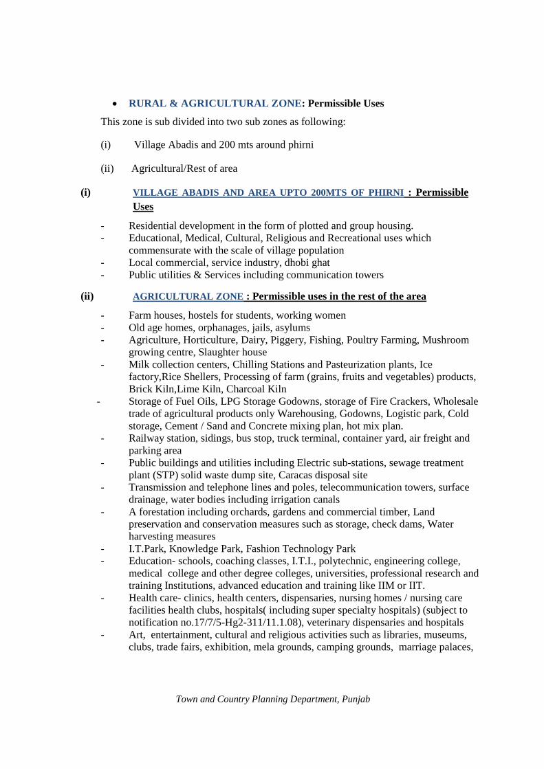
· RURAL & AGRICULTURAL ZONE: Permissible Uses
This zone is sub divided into two sub zones as following:
(i) Village Abadis and 200 mts around phirni
(ii) Agricultural/Rest of area
(i) VILLAGE ABADIS AND AREA UPTO 200MTS OF PHIRNI : Permissible Uses
- Residential development in the form of plotted and group housing. - Educational, Medical, Cultural, Religious and Recreational uses which
commensurate with the scale of village population - Local commercial, service industry, dhobi ghat - Public utilities & Services including communication towers
(ii) AGRICULTURAL ZONE : Permissible uses in the rest of the area
- Farm houses, hostels for students, working women - Old age homes, orphanages, jails, asylums - Agriculture, Horticulture, Dairy, Piggery, Fishing, Poultry Farming, Mushroom
growing centre, Slaughter house - Milk collection centers, Chilling Stations and Pasteurization plants, Ice
factory,Rice Shellers, Processing of farm (grains, fruits and vegetables) products, Brick Kiln,Lime Kiln, Charcoal Kiln
- Storage of Fuel Oils, LPG Storage Godowns, storage of Fire Crackers, Wholesale trade of agricultural products only Warehousing, Godowns, Logistic park, Cold storage, Cement / Sand and Concrete mixing plan, hot mix plan.
- Railway station, sidings, bus stop, truck terminal, container yard, air freight and parking area
- Public buildings and utilities including Electric sub-stations, sewage treatment plant (STP) solid waste dump site, Caracas disposal site
- Transmission and telephone lines and poles, telecommunication towers, surface drainage, water bodies including irrigation canals
- A forestation including orchards, gardens and commercial timber, Land preservation and conservation measures such as storage, check dams, Water harvesting measures
- I.T.Park, Knowledge Park, Fashion Technology Park - Education- schools, coaching classes, I.T.I., polytechnic, engineering college,
medical college and other degree colleges, universities, professional research and training Institutions, advanced education and training like IIM or IIT.
- Health care- clinics, health centers, dispensaries, nursing homes / nursing care facilities health clubs, hospitals( including super specialty hospitals) (subject to notification no.17/7/5-Hg2-311/11.1.08), veterinary dispensaries and hospitals
- Art, entertainment, cultural and religious activities such as libraries, museums, clubs, trade fairs, exhibition, mela grounds, camping grounds, marriage palaces,
Town and Country Planning Department, Punjab

-
bhawans, sports activities including parks, gardens, play grounds, swimming pools, gymnasia, stadia, golf courses etc ., amusement parks, places of worship. Panchayat ghars, dharamshalas and any other project of Central and State Govt. agencies / Deptt. / Undertaking / Local Bodies.
Any other use not mentioned above but sub-servient to rural & agricultural zone shall be allowed with special permission from Chief Town Planner, Punjab.
· DESIGNATED AREAS
Following areas have been specifically designated in the proposed land use plan.
(i) Traffic and Transportation (ii) Utilities (iii) Public & semi public
USE PROVISIONS IN DESIGNATED AREAS
Following uses are permissible in the designated areas
(i)
(ii)
(iii)
TRAFFIC & TRANSPORTATION: Permissible uses All types of roads, Railway lines, Rail yards, Railway station & sidings, Transport Nagar (including, Post & Telegraph offices & Telephone exchange, dhabas, labour yards, areas for loading and unloading, stores, depots, and offices of goods booking agencies, Petrol Filling station & service garages, parking spaces public utilities and buildings, broadcasting station) Bus Terminus & depot, bus stop shelter, taxi/ tonga/ rickshaw/scooter stands, parking space. UTILITIES: Permissible uses Water supply, Sewerage system (including main pumping station and Sewage Treatment Plant {STP}), drainage, storm water, waste processing and disposal, electricity, communication systems and related installations etc. PUBLIC AND SEMI-PUBLIC ACTIVITIES : Permissible uses Government and Semi-Government offices, Governmental Administrative Centers,
(Secretariat) Educational, Cultural and Religious institutions including theaters,
auditoriums etc. Medical Health Institutions, Community Centers, Club, Orphanage, Old
Age Home, Banks, Police Stations etc.
· SPECIAL CONDITIONS
· The sitting of Petrol Pump / Filling Stations shall be subject to fulfillment of
instructions/guidelines of IRC/MORTH/TCPO /Punjab Govt. issued from time to time.
· Minimum width of access road for warehousing uses shall be 80'.
· All public and semi-public uses in residential zone shall be located on independent plots
with minimum access of 80'.
Town and Country Planning Department, Punjab

· All types of industries permitted in the designated land use zone are subject to the
fulfillment of conditions issued by industries department / Punjab Pollution Control
Board from time to time.
8.4 EXCEPTIONS
· As provided under Section 79 of the Punjab Regional and Town Planning and
Development (Amendment) Act 2006, after coming into operation of this Master Plan, no person shall use or permit to be used any land or carry out any development in any area otherwise than in conformity with this Master Plan.
· Provided that the competent authority may allow the continuance of any use of any land,
for a period not exceeding ten years, upon such terms and conditions as may be provided
by regulations made in this behalf, for the purpose and to the extent, for and to which it
was being used on the date on which this Master Plan came into operation.
· Notwithstanding the above, the uses specifically provided for in the Sector / Zonal
Plans shall be permissible or as may be allowed by the Chief Town Planner, Punjab
after special appeal where Sector / Zonal Plan is not prepared.
· Uses determined by the Chief Town Planner, Punjab as compatible with uses
permissible shall be allowed in respective zones.
· Developments approved prior to coming into force of these Regulations shall be deemed
to be in compliance with these regulations.
· The site on which various projects have been approved or whose change of land use has
already been permitted by competent authority/Govt. such sites shall be deemed to be
adjusted.
· Uses of Land covered under Optimum Utilization of Vacant Govt. Land (OUVGL)
Scheme of the State Government shall be determined by the Government at any
appropriate time notwithstanding the provisions of these regulations subject to the
fulfillment of other requisites like minimum area, road width and frontage etc. of the
respective land use.
· In the event of conflict in interpretation of data within the study area the information in
the GIS format will be deemed as the accurate version and shall prevail.
· In case the area of a project falls partially under no construction zone along a water
body, relaxation of maximum up to 5% on the total area of the project shall be allowed
Town and Country Planning Department, Punjab

towards calculation of saleable area in lieu of the area falling under the no construction
zone. In case, the area falling under no construction zone is less than 5% of the total area
of the project then the relaxation shall be proportionately less.
· The buildings / premises for which the existing (present) land use has been retained as
such in the Master Plan may continue to operate without time limit. However, in case
the present use of the buildings / premises is discontinued (partially or wholly) these
buildings / premises or part thereof may be put to any compatible use (except industry)
with the surrounding use zone in the Master Plan provided it fulfills the other
development regulations / controls as laid down in the Master Plan or as prescribed by
the Govt. / Local Body from time to time.
8.5 RESIDENTIAL DENSITIES
Residential zone is divided into two sub zones viz. Medium Density Zone and Low
Density Zone and are shown on the Proposed Land Plan Drg no. DTP (B) 1625/2010
dated 30/08/2010. The maximum permissible density in these zones shall be as shown in
table 46 below:
Table 46: Maximum Permissible Density Sr. No. Zone Density 1 Medium Density Residential Zone (RD-1) Above 200 persons/acre 2 Low Density Residential Zone (RD-2) Below 200 persons/acre
Note: However to encourage group housing and save agricultural land, 60 dwelling units/acre shall be permissible in standalone group housing projects irrespective of the density of particular zone.
Town and Country Planning Department, Punjab

SECTION-II 8.6 DEVELOPMENT CONTROL REGULATIONS
The purpose of the Development Control Regulations (DCR) is to assist developers and
end users within the Local Planning Area, Raman Mandi to strive for a more quality and
environment –friendly development.
These Development Control Regulations are applicable to new and future developments.
The developers are requested to abide by the zoning and planning intentions of the
Master Plan. However, development proposals/projects that have been granted approval
(including CLU) by the Competent Authority before coming of these into operation will
continue to be honoured subject to the terms and conditions of approval and shall not be
affected by these controls.
Chapter XI of "The Punjab Regional and Town Planning and Development (Amendment)
Act 2006" provides for 'Control of Development and Use of Land where Master Plan is
in Operation.' The chapter lays down the procedural framework for exercising the
development control. "Development'' as defined by the Act means the carrying out of
building, engineering, mining, quarrying or other operation in, on, over or under land or
making of any structural or material changes in any building or land including that which
affects the appearance of any heritage site and includes demolition of any part or whole
of the building or change in use of any building or land and also includes reclaimation,
redevelopment, a layout or sub-division of land. The F.A.R., hieight, ground coverage,
parking, set backs, width of road & frontage of site etc. regarding residential,
commercial, institutional, industrial or any other use for areas falling with in municipal
limits shall be governed by municipal bye laws.
Some of the key regulations currently in force are reproduced below.
· Residential
Category Minimum area of colony Low Potential Zone II Low Potential Zone
III Low Potential Zone IV
Residential Plotted
Outside M.C. limits 5 Acs Within M.C. limits any area
Outside M.C. limits 5 Acs Within M.C. limits any area
Outside M.C. limits 5 Acs Within M.C. limits any area
Town and Country Planning Department, Punjab

In case of left out pocket i.e. where on all sides the construction has already taken place,
that left out area without any minimum stipulation can be developed as a residential
colony.
Note:
(i) The above potential zones falling in L.P.A.Raman Mandi are as per notification no. 17/17/2001-5Hg2/PF-1/1817 dated 22.06.2010 or as amended from time to time.
(ii) The minimum area of colony is as per Memo No.18/182/06-6HG2/5598 dated 17.07.2007, Memo No. 17/17/01-5HG2/7655 dated 19.09.2007 and Memo No. 17/17/01-5HG2/1640 dated 18.06.09 and memo no. 17/17/2001-5 M.O. 2/P.F-1/3585 dated 22-12-2010 or as amended from time to time.
(iii) F.A.R, height and ground coverage for individual residential plots within municipal areas, the municipal building byelaws shall be applicable and outside Municipal limit the building bye-laws of respective Development Authority shall apply. However, saleable area of any plotted residential colony (residential and commercial) shall not exceed 55%.
(iv)Any change in area or any other norms at later stage by the state Govt. shall be applicable.
· Parking requirements for plotted developments
Plot size* Parking requirements 85 sq m and less (100 sq yd and less) 2 scooter parking spaces 86-168 sq m (101-200 sq yd) 1.5 car parking space within plot area 169-425 sq m (201-500 sq yd) 2 car parking space within plot area 425 sq m and more (500 sq yd and more) 3 car parking space within plot area
Note:
(i) Deviation of up to 10% of this control is allowed, if it is arising from site conditions / constraints.
(ii) The minimum width of roads within residential areas shall not be less than 12 m, if the existing road is less than 12 m, the proportionate land on both sides shall be safeguarded for widening to comply with the minimum requirement. The height of buildings on these roads shall not exceed ground plus two (G+2) storeys.
(iii)Size of the front gate on boundary wall and construction of front boundary wall is optional to meet the parking requirements.
(iv)Any change in area or any other norms at later stage by the state Govt. shall be applicable.
Town and Country Planning Department, Punjab

· Group Housing
1 Minimum Plot size Within MC limits 4000 square meters or as per M.C. bye laws Outside MC limit 2 Acres
2 Minimum road width Group housing stand alone projects, shall be permissible on minimum existing 60' wide road with condition that the promoter shall be required to leave space from his own land for widening it to 80' and the space so left shall be public space. In the planned colony, group housing shall not be permissible on a road less than 60' wide.
3 Minimum Frontage 20 meters within & outside M.C limits 4 Permissible FAR 1:1.75 5 Permissible Height There shall be no restriction on the height of building
subject to clearance from Air Force Authority and fulfilment of other rules such as set backs, distance between buildings etc. However structural safety and fire safety requirements as per National Building Code shall be compulsory.
6 Parking Provisions For group housing developments, the requisite parking provision is 1.5 ECS per 100 sq m of covered area. The maximum provision allowable for group housing projects is 3ECS per dwelling unit.
· Or as per Municipal Committee requrement and outside as per the decision of the govt. if taken otherwise at data date.
Note:
(i) Construction of residential houses sold by promoters on floor basis shall also be considered as group/flatted housing development & parking requirement shall be as per the norms applicable to Group Housing.
(ii) Any change in applicable.
area or any other norms at later stage by the state Govt. shall be
· Farm House
Minimum area 2.5 acres FAR 0.04 Ground Coverage 2% (maximum 200 sq mts.) Number of storeys 2 Height Single Storey 18'-0''
Double Storey 28'-0'' Hard Surface 10%
Town and Country Planning Department, Punjab

Note: Farm House shall only be allowed to upkeep the farm operations and it shall not be used for independent residential or any other purpose.
· Commercial
Commercial uses in residential zones located within the municipal limits shall be
allowable along 80 feet wide roads with minimum frontage of 20 meters however area
requirements for such commercial developments shall be as per the Municipal byelaws
rules and regulations.
For standalone commercial complexes with height greater than three storey's within as
well as outside the Municipal limits, the additional criteria listed in following table shall
apply.
Additional criteria for stand-alone commercial complexes (more than three storeys)
1 Minimum area required As per M.C norms within M.C. limits
1000 sq m outside M.C.limit
2 Minimum frontage As per M.C. norms within M.C. limits
20 meters Outside M.C. limits
3 Maximum F.A.R As per MC norms within M.C. limits
1:1.75 Outside M.C. limits
4 Maximum height There shall be no restrictions on the height of building subject to clearance from Air Force Authority and fulfillment of other rules such as setbacks, distance between buildings etc. However, structural safety and fire safety requriements as per N.B.C shall be compulsory.
5 Maximum ground coverage As per MC norms (within M.C. limits)
40% (outside M.C. limits)
6 Parking For projects with no multiplexes, the minimum parking shall be 2ECS per 100 sq m of covered area (including circulation area).
Town and Country Planning Department, Punjab

For projects with multiplexes/cinemas/
theatres, the minimum parking shall be:
For
a) 3 ECS per 100 sq m of covered area in repect of the covered area by the mulitplex component +30% of the total covered area by that component and
b) 2 ECS per 100 sq m of covered area, in respect of balance commercial component and circulation area. Parking norms within the municipal limits shall be the same as that notified by the Department of Local Government.
Total parking requirement shall be provided in the compulsory front set back and within the development site boundary or in the basement.
7 Basement Multi level basement will be allowed behind the building in zoned area except in setbacks provided it is proposed for parking purposes only and satisfy the public health and structural requirements.
8 Minimum width of approach 80 feet outside M.C. limits and as per road municipal bye laws in M.C. limits
9 If the site area is 1 acre or more minimum 15% area is to be reserved for landscaping.
10 For the movement of fire tender the minimum set back distance to comply with the existing norms and standers.
Town and Country Planning Department, Punjab
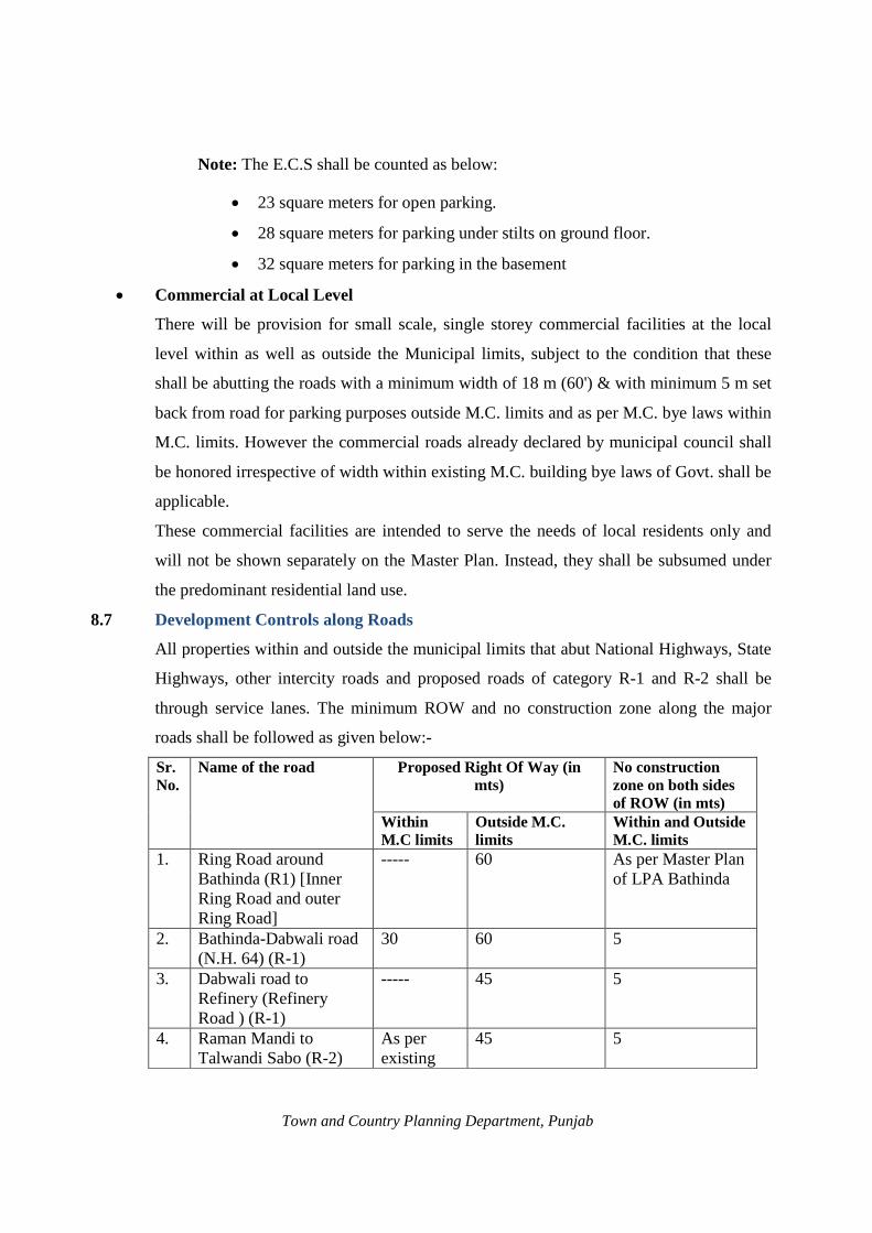
8.7
Note: The E.C.S shall be counted as below:
· 23 square meters for open parking.
· 28 square meters for parking under stilts on ground floor.
· 32 square meters for parking in the basement
· Commercial at Local Level
There will be provision for small scale, single storey commercial facilities at the local
level within as well as outside the Municipal limits, subject to the condition that these
shall be abutting the roads with a minimum width of 18 m (60') & with minimum 5 m set
back from road for parking purposes outside M.C. limits and as per M.C. bye laws within
M.C. limits. However the commercial roads already declared by municipal council shall
be honored irrespective of width within existing M.C. building bye laws of Govt. shall be
applicable.
These commercial facilities are intended to serve the needs of local residents only and
will not be shown separately on the Master Plan. Instead, they shall be subsumed under
the predominant residential land use.
Development Controls along Roads
All properties within and outside the municipal limits that abut National Highways, State
Highways, other intercity roads and proposed roads of category R-1 and R-2 shall be
through service lanes. The minimum ROW and no construction zone along the major
roads shall be followed as given below:-
Sr. No.
Name of the road Proposed Right Of Way (in mts)
No construction zone on both sides of ROW (in mts)
Within M.C limits
Outside M.C. limits
Within and Outside M.C. limits
1. Ring Road around Bathinda (R1) [Inner Ring Road and outer Ring Road]
----- 60 As per Master Plan of LPA Bathinda
2. Bathinda-Dabwali road (N.H. 64) (R-1)
30 60 5
3. Dabwali road to Refinery (Refinery Road ) (R-1)
----- 45 5
4. Raman Mandi to Talwandi Sabo (R-2)
As per existing
45 5
Town and Country Planning Department, Punjab

5. Bathinda-Talwandi Sabo
As per existing
30 5
6. Proposed Road (R-2) 45 45 5 7. Proposed Road (R-3) 30 30 5
Note: - (i) Front set back shall be over and above the proposed widening width of road, if any.
(ii) Where widening of existing road is proposed the land shall be taken proportionately equally from both the sides of existing road.
(iii) If there is extension of Municipal limits of any local body falling in LPA, after final notification of Master Plan, the development controls / zoning regulations as applicable to the area outside M.C. limits shall apply to the area so covered under extended M.C. limits.
· Institutional: Components Norms/Standards
Minimum Plot size As prescribed by affiliating authority.
Minimum frontage 200 feet
Minimum width of approach road 40 feet (12m) or as ammnended by Government from time to time
Maximum F.A.R 1:1
Maximum ground coverage 40%
Parking 1 ECS per 100 square meters of the covered area if the project is covered under notification no.17/171/5-Hg2/311 dated 11.01.08.
Note: Other building regulations shall be governed by Zoning Plan as approved by the competent authority.
· Industrial
Size of Plot Site Coverage For the first 2420 sq yds 50% of the site For the next 2420 sq yds 33% of the site In excess of 4840 sq yds 25 % of the site FAR 1:1.0 Parking I ECS per 100 square meters of the covered area. Road width The minimum road width for industrial unit shall be
12 mts.
Town and Country Planning Department, Punjab

Note: Residential component: Residential component in the industrial plot/premises shall not exceed 5% of the area of the site and shall be within the maximum permissible covered area.
· The minimum road width for each land use shall be as specified in the Master Plan or by
the Government policy / guidelines issued from time to time. However, in case the
existing road width is less than the minimum specified width in the Master Plan /
Government policy the proportionate land on both sides shall be safeguarded for
widening to comply with the minimum requirement. In case, where habitation /
settlement comes in the alignment, the widening shall be on other side of habitation /
settlement.
· In case the site of any project is situated within Municipal limits and the project is
submitted to Local Body for approval the building byelaws of the concerned local body
shall be applicable provided the land use is in conformity to Master Plan.
· Industrial / IT Park shall have minimum 10 acres area. In IT Park, IT component shall
have FAR 2. In industrial park, for an industry component FAR shall be 1 and other
components shall have FAR as mentioned under different uses in the Master Plan.
· Environment Considerations:
· Minimum buffer of 15 meters green belt of broad leaf trees should be provided around
the boundary of village abadies falling in the industrial zone of Master Plan. This should
also be provided between residential areas and red category industries falling in industrial
zone of Master Plan, boundaries of which are located within 100 m from the boundary of
such areas. However, for special type of industries such as Rice Shellers / Saila Plant,
Stone Crushers, Hot Mix Plant, the standards prescribed by the Punjab Pollution Control
Board or any other agency shall apply.
· All residential colonies, commercial establishments like shopping malls, multiplexes etc
shall maintain a minimum distance of 250 meters form the most hazardous (maximum
accident hazardous) industries notified by Director General, Factory Adviser Service
Labour Institute. The distance should be measured from source of pollution/hazard in the
industrial premises to the building lines as per Zoning Plan of the colony/complex.
Town and Country Planning Department, Punjab

· Other Development Controls and Guidelines Required
(i) Expansion of village abadies: Contiguous expansion of village abadies in non
residential zones of Master Plan is permissible up to 200mts in the Master Plan.
However, for the village abadies falling in residential zone of Master Plan no such
limit has been earmarked as the area around them is already earmarked as
residential.
(ii) The contiguous expansion of village abadies falling under agricultural zone of Local
Planning Area is also permissible to accommodate the natural growth of village
abadies.
(iii) Regulation for village abadi: Special building regulation shall be prepared for the
development and regulation of an area falling within the lal dora or phirni of the
villages falling in the Local Planning Area.
(iv) The existing high tension lines shall be shifted along the road but outside the right of
way to ensure unhindered ROW for traffic and other services for all times.
(v) Minimum 5 meters wide green strips on each side of minor, drain, canals,
underground pipelines shall be maintained. Realignment of water bodies shall be
permissible wherever feasible, subject to the certification by the Drainage /
Engineering Department to ensure free flow of storm water. After any such
realignment, the river mouth, the river bed, and the green strip on either side shall be
maintained at least to the minimum prescribed level.
Note: The Development controls/Guidelines/Norms & Standards revised from time to time by the Government shall have overriding effect on the Development controls mentioned in the master plan. Building regulations like area norms, ground coverage, parking norms etc. of M.C. shall be applicable in existing M.C. limits.
8.8 Transferable Development Rights To facilitate development, it is necessary to accord top priority to the implementation of
public utilities and infrastructure (such as roads, parks, green belts etc,) which will in turn
encourage urbanization.
However, the respective technical agency or authority will not be able to proceed with its
implementation programmers until the ownership of private land affected by these public
utilities and infrastructure has been transferred to the state or to the relevant authority(s).
Town and Country Planning Department, Punjab

Acquisition of private land for this purpose can be carried out through one of the following options:
· Cash compensation can be made to affected land owners whose land is to be acquired.
· A government – approved land pooling scheme can be implemented. · Transferable Development Rights (TDR).
Under the TDR scheme, the affected land owner(s) shall be entitled to additional FAR for
the development of his balance land parcel at a rate of 1:1.The additional FAR will not be
subjected to any CLU, EDC or license / permission fees. The land owner(s) also has the
option to sell it in total or in parts to a third party.
All the records of transactions administered under the TDR scheme shall be maintained
by the state and / or relevant authority(s), based on the precedence set in Mumbai. The
TDR scheme shall be restricted to development projects for public infrastructure and
facilities which shall be announced from time to time. The additional FAR shall not be
transferable from one L.P.A to another. The detailed policy guidelines on the operation
and implementation of TDR Scheme shall be prepared and announced by the competent
authority in due course of time.
8.9 IMPLEMENTATION OF THESE REGULATIONS · All authorities competent to grant permission for layout or sub-division of land or
construction of building or development of land in any other form shall ensure that
the permitted development is in compliance with these regulations.
· Land owners desirous of developing their land can obtain by applying to the
designated authority in writing and giving details of their land along with necessary
maps, a list of permissible uses.
· Similarly land owners proposing development of certain uses on their land can obtain
a certificate of “Compliance with Master Plan” from a designated authority.
· In the extended M.C limits after the notification of Master Plan the stimulations in the
Master Plan for area shall continue to be applicable in the extended M.C limits.
Town and Country Planning Department, Punjab

Town and Country Planning Department, Punjab

Annexure-I
DEPARTMENT OF HOUSING & URBAN DEVLOPMENT
HOUSING-1 (BRANCH)
NOTIFICATION
Date: 17/12/2007 19 Dec, 2007
No. 12/55/2006-4HGI/9857- Whereas it appears to Governor of Punjab that to ensure a planned workable framework for comprehensive planned and regulated development, preparation of Statutory Master Plan of the area around Raman Mandi is very essential to be prepared under “ The Punjab Regional and Town Planning and Development Act,1995.”And also to utilize the potentials of this area, Petroleum, Chemicals and Petrochemicals Investment Region (PCPIR) is required to be delineated within this Local Planning Area. Therefore, Governor of Punjab is pleased to declare the Local Planning Area Raman Mandi within the meaning of sub-section (1) of section 56 of the ‘Punjab Regional and Town Planning and Development (Amendment) Act,2006.”The total area proposed for Local Planning Area is 50555 Hectares (505.55 Sq.Kms) which includes Municipal Council, Raman Mandi, Municipal Council, Sangat Mandi and 39 villages as shown in list attached. The schedule of boundaries of Local Planning Area is as under :-North: Starting from point ‘A’ which is common Sarhada of village Kot Guru
(H.B.No.100),village Phulo Mithi (H.B.No.90)and village Sangat Kalan (H.B.No. 99),towards East along the Northern boundary of village Sangat Kalan (H.B.No. 99) Western side of village Gehri Butter (H.B.No. 93) again Northern side of village Gehri Butter (H.B.No. 93),village Mehta (H.B.No. 94),village Gehri Devi Nagar (H.B.No. 53),thence along Eastern side of village Gehri Devi Nagar (H.B.No. 53),Village Mehta (H.B.No. 94),thence along Northern side of village Bhagwangarh (H.B.No. 96),village Shergarh (H.B.No. 95),Nasibpura Urf Kailebander (H.B.No. 56) and village Jeon Singh wala (H.B.No. 55) up to point ‘B’ which is common Sarhada of village Jeon Singh wala (H.B.No. 55),village Chathe wala (H.B.No. 54) and Bhagi Bander (H.B.No. 46).
East: Starting from point ‘B’ towards South along Eastern side of village Jeon Singh wala (H.B.No. 55),village Kot Bakthu (H.B.No. 44),village Bangi Ruldu(H.B. No.37), village Laleana (H.B. No. 36), village Jajjal (H.B. No.35),village Malkana (H.B. No. 125),and village Giana (H.B. No. 126) up to point ‘C’ which is common Sarhada of village Giana (H.B. No. 126), village Gattwali (H.B. No. 127) and village Keol (H.B. No. 322 of district Sirsa,Haryana.)
South: Starting from point ‘C’ towards West along Southern boundary of village Giana (H.B. No. 126),village Kanakwal (H.B. No. 117), village Phalran urf Jodhpur
Town and Country Planning Department, Punjab
Bagga Singh (H.B. No. 116), village Ruldu Singhwala (H.B. No.113),village Pathrala (H.B. No. 108), village Chak Kharak Singh wala urf Doomwali (H.B. No. 109) up to point ‘D’ which is common Sarhada of village Chak Kharak Singh wala urf Doomwali (H.B. No. 109), village Killianwali (H.B. No. 8 of Distt. Muktsar) and village fatuhiawala (H.B. No. of 6 of Distt. Muktsar).
West: Starting from point ‘D’ towards North along the Western side of village Chak Kharak Singh urf Doomwali (H.B. No. 109), village Pathrala (H.B. No. 108), village Chak Ruldu Singh wala (H.B. No. 113), village Kishanpura urf Kuti (H.B. No. 110), village Jassi Baghwali (H.B. No. 111) and village Sangat Kalan (H.B. No. 99) upto starting point ‘A’.
The boundaries of Local Planning Area have been shown on Drawing No. DTP(B) 1516/2007, dated 17th October,2007. All provisions laid down under Section 56(2) of “The Punjab Regional and Town Planning and Development (Amendment) Act,2006 and all the concerned rules framed under this Act have been taken into consideration.
Chandigarh ARUN GOEL, I.A.S.,
The 11th December, 2007 Secretary to Government of Punjab,
Housing and Urban Development Department
Town and Country Planning Department, Punjab

Annexure-II
PUNJAB GOVERNMENT
DEPARTMENT OF HOUSING AND URBAN DEVELOPMENT
(HOUSING BRANCH-1)
NOTIFICATION
DATED-17/12/2007
No. 12/55/2006-4HG1/9863 Whereas the Governor of Punjab was pleased to declare the Local
Planning Area of Raman Mandi and its surrounding area u/s 56(1) of “ The Punjab Regional
and Town Planning and Development Act,1995 vide Notification No. 12/55/2006-4HG1/9857
Dated 17/12/2007.
Further the Governor of Punjab is pleased to designate the Chief
Town Planner, Punjab as Planning agency for the above Local Planning area under Section 57
of “ The Punjab Regional and Town Planning and Development Act,1995”.
Dated, Chandigarh Arun Goel
11-12-2007 Secretary to Government of Punjab
Department of Housing & Urban Development
Town and Country Planning Department, Punjab

Annexure-III
Comparative Statement of Norms and Standards for Social Infrastructure
Aspect
As per zoning regulations and sub-division clauses for Master Plan in Punjab/Govt. Policies
UDPFI Guidelines Delhi Master Plan
Primary school Population:3,000-4,000 No. of students: 600 Area Old city (over 650 ppha) : 0.2 ha Outer areas (less than 650ppha):0.5 ha
Population: 5,000 Number of students :500 Area per school:0.4 ha
Covered area:0.20 ha
Minimum play field area: 0.20 ha
Population: 10,000 Area:2000-4000 sq m
Senior Secondary Population:12,000-20,000 Population: 7,500 Population: 10,000 School
No. of students: 1000
Area Old city (over 650 ppha) : 1.00 ha
Outer areas (less than 650 ppha):2.5 ha
Number of students :1000 Area per school:1.60 ha
Covered area:0.60 ha
Minimum play field area: 1.00 ha
Area:6000-8000 sq m
College Population:30,000
No. of students: 800
Area Old city (over 650 ppha) : 2.50 ha
Outer areas (less than 650 ppha):5.00 ha
Population: 1,25,000 Number of students :1000-1500 Area per college:4.00 ha
Covered area:1.80 ha
Play field area:1.80ha
Residential/hostel area: 0.40 ha
Population: 5,00,000 Area: As per UGC Norms
University
N.A. New University Area:60.00ha
4 sites in urban extension to be provided at city level Area: up to 20.00 ha
Technical Population :10,00,00 Population :5,00,000 Education Centre
N.A.
Area per centre 4.00 ha
Area per technical centre:2.10 ha Area per ITI:1.40 ha
Area per coaching centre:0.30 ha
Area : 4000 sq m
New Engineering College Number of students :300
Area
2 Number to be provided in urban extension Strength of college : 1500 -1700 Students
Population :5,00,000
Area: As per AICTE norms
Town and Country Planning Department, Punjab

Old city:(over 650 ppha): 1.00 ha
Area per college:60.00ha
Outer areas (less than 650ppha):2.50 ha
Medical/Pharmacy College
Area :5 acres(Rural)
Area: 2.5 acres (Distt. Headquarter Corporation Limit)
2 site of 15 ha each in urban extension including space for specialized general hospital.
Population: 10,00,00
Area :As per Medical Council of India /Regulatory body
Dispensary Population :5,000 Area: 0.1ha
Population:15,000 Area :0.08 to 0.12 ha
Population:10,000 Area :800-2000 sq m
Nursing Home
N.A.
Population :45,000-1,00,000 Capacity:25 to 30 beds Area:0.20 to 0.30 ha
Population :50,000
Area:1000-2000sq m
General Hospital Population :50,000
Area:2.5 ha
Population:2,50,000
Capacity:500 beds
Area for hospital :400 ha
Area for resi accommodation :2.00ha
Total area :6.00ha
Population:5,00,000 Capacity :501 beds and above Area :25,000-45,000sq m
Veterinary Hospital N.A. N.A.
Population :5,00,000 Area:2,000sq m
Community Hall and Library N.A.
Population :15,000 Area: 2,000 sq m
N.A.
Club N.A.
Population :1,00,000 Area :10,000sq m
Population:5,00,000 Area:5000sq m
Amusement park N.A. N.A. Up to 10 ha
City level p ark N.A. N.A.
Population :5,00,000 Area 10acres
Neighborhood level park N.A. N.A.
Population 10,000 Area:10,000 sq m
Golf Course N.A. N.A.
Population :10,00,000 Area :10-30 ha
Sports Centre/Stadium N.A. N.A.
Population :5,00,000 Area :3-10 ha
Post and Telegraph Office
Population :10,000 Area :0.1 ha
N.A. Population :10,00,000 Area :2,500 sq m
Religious Building
Population :15,000 Area :0.1 ha
N.A. Population :10,00,000 Area :40,000 sq m
Old Age Home N.A. N.A.
Population :5,00,000 Area :1,000 sq m
Orphanage/ Children Centre N.A. N.A.
Population :5,00,000 Area :1,000 sq m
Town and Country Planning Department, Punjab

Multipurpose Ground (Exhibition cum fair Ground)
N.A. N.A.
Population :1,00,000
Area :20,000 sq m
Burial/ Cremation Centre N.A. N.A.
Population :10,00,000 Area :10,000 sq m
Electric sub-station
Population :50,000 Area : 0.4 ha
N.A. Population :5,00,000 Area :29,600 sq m
Police Post
N.A.
Population :40,000-50,000 Area :0.16 ha (area inclusive of essential residential accommodation)
Population :1,00,000
Area :1000 sq m
Police station/police
Division
Population:50,000
Area:0.8 ha
Population:90,000
Area:15 ha Area inclusive of essential residential accommodation 0.05 ha additional to be provided for civil Defense and home guards
Population :2,50,000
Area :10,000 sq m
Police Line
N.A. Population:20,00,000
Area:4.00 to 6.00 ha
1 for each administrative zone to be provided at city level Area:2.0 ha
District jail N.A.
Population :10,00,000 Area :10.00 ha
Population :25,00,000 Area :5.0 ha
Fire Station
N.A.
1 fire or sub-station within 1 to 3 km to be provided for 2 lakh population Area for fire station with essential residential accommodation :1.00 ha
Area for sub-fire station with essential residential accommodation :0.60 ha
Fire Station for 5,00,000 population within radius of 5 to 7 km
Area: 10,000 sq m
Town and Country Planning Department, Punjab

ANNEXURE-IV
PUNJAB STATE INDUSTRIAL
DEVELOPMENT CORPORATION LTD.
(A STATE GOVT. UNDERTAKING)
Regd. Office: Udyog Bhawan, 18 Himalaya Marg, Sector 17, P.Box No. 81, CHANDIGARH-160017(INDIA)
NO: PSIDC: PPD:
August 6, 2007
1. The Chairman Punjab State Electricity Board,
Patiala.
2. The Principal Secretary to Government of Punjab Department of Finance,
Chandigarh
3. The Principal Secretary to Government of Punjab Department of Water Supply & Sanitation
Chandigarh
4. The Secretary to Government of Punjab Department of Irrigation
Chandigarh
5. The Secretary to Government of Punjab Department of Power,
Chandigarh
6. The Secretary to Government of Punjab Department of PWD,
Chandigarh
7. The Secretary to Government of Punjab Department of Housing & Urban Development,
Chandigarh
8. The Secretary to Government of Punjab Department of PWD,
Chandigarh
Town and Country Planning Department, Punjab

9. The Secretary to Government of Punjab Department of Civil Aviation,
Chandigarh
10. The Director-cum-Secretary Department of Industries & Commerce, Punjab
Chandigarh
11. The Secretary to Government of Punjab Department of Labour,
Chandigarh
12. The Chairman, Punjab Pollution Control Board,
Nabha Road, Patiala
13. The Managing Director, Punjab Infrastructure Development Board,
Sector 34, Chandigarh
14. The Managing Director, Punjab Small Industries & Export Corpn. Ltd.
Udyog Bhawan, Sector 17,Chandigarh
15. The Managing Director, Punjab Small Warehousing Corporation,
Sector 17,Chandigarh
16. The Deputy Commissioner, Bathinda
17. The Deputy Commissioner, Mansa
18. The Managing Director, Punjab Water Supply & Sewerage Board,
Chandigarh
19. The Chief Town Planner, Punjab Old Estate Building,
Sector 18, Madhya Marg, Chandigarh
20. The Additional Chief Administrator,
Town and Country Planning Department, Punjab
Punjab Urban Palnning & Development Authority,
Bathinda
21. The Chief Coordinator, Udyog Sahayak,
Directories of Industries Punjab,
Udyog Bhawan, Sector 17, Chandigarh
22. Mr. Sanjeev Malhotra, Dy. General Manager(Finance),
Guru Gobind Singh Refineries Limited,
3rd Floor, UCO Bank Building,
Sansad Marg, New Delhi-110001.
23. Mr. T. Pramanik, Dy. General Manager(Process Engg.)
Guru Gobind Singh Refineries Limited,
3rd Floor, UCO Bank Building,
Sansad Margt, New Delhi-110001.
Town and Country Planning Department, Punjab

Re: Proceedings of the meeting held under the Chairmanship of the Principal
Secretary Industries & Commerce, Govt. of Punjab on 27.7.2007 at 11.30 AM
relating to setting up of a Petroleum, Chemicals and Petrochemicals Investment
Region (PCPIR).
Dear Sir,
Please find enclosed herewith the Proceedings of the meeting held under the
Chairmanship of the Principal Secretary Industries & Commerce, Govt. of Punjab on
27.7.2007 at 11.30 AM relating to setting up of a Petroleum, Chemicals and
Petrochemicals Investment Region (PCPIR) in the state of Punjab for further
necessary action at your end.
Town and Country Planning Department, Punjab

Thanking you.
Yours
faithfully,
For Punjab State
Industrial
Development Corpn.
Ltd.
MANAGER
Encls. As above.
Re: Proceedings of the meeting held under the Chairmanship of the Principal
Secretary Industries & Commerce, Govt. of Punjab on 27.7.2007 at 11.30 AM
relating to setting up of a Petroleum, Chemicals and Petrochemicals Investment
Region (PCPIR).
Town and Country Planning Department, Punjab
List of participants is at Annexure “A”.
Sh. A.R. Talwar, Principal Secretary Industries & Commerce,Govt. of
Punjab welcomed the officials of HPCL/GGSRL, consultants from Industrial
Developments Services (Private) Limited, New Delhi (IDS) and the officers present in
the meeting.
The team of officials from HPCL/GGSRL comprising of Sh. T. Pramanik,
DGM, GGSRL and Sh. Satyajit Kundu, Manager, GGSRL accompanied by Mr.
R.K.Gupta and Miss Rekha Misra made presentation giving current status/ Project
schedule of Guru Gobind Singh Refineries Limited. The presentation was followed up
by introduction of IDS (consultants). The officials of GGSRL also gave brief
background on the policy for promotion of Petroleum, Chemicals and Petrochemical
Investment Regions (PCPIRs). The master Plan for PCPIR as proposed by GGSRL is
to be implemented in two phases:
Phase I (2011-2015)
The potential industries proposed to be set up in Phase I of PCPIR shall
include Woven Sacks, Film, Food Package, Furniture & Luggage, Polypropylene
Pipes, and Fittings & Valves etc.
Phase II (2015-2020)
The potential industries proposed to be set up in Phase II of PCPIR shall
include Washing Machine body, PP Luggage, Butyl Rubber, Medical Syringes, Car
Bumpers and PVC Pipes & fittings.
Thereafter, the format for project proposal as circulated to the participants vide
notice of meeting/PSIDC’s letter dated 20.7.2007 was discussed. The points discussed
in the meeting were as under:
Town and Country Planning Department, Punjab

1 The legal frame work in the State under which the PCPIR is proposed to be formed,
including whether this would be under an existing Act or a new legislation to be
enacted for this purpose.
The officials from the Department of Housing & Urban Development informed that
the said legal frame work already exists and there is no need for a new legislation to be
enacted for the proposed PCPIR. It was further mentioned by them that once the land
is identified, the same shall be marked in the master plan and required notification
shall be done at the appropriate time for the purpose.
2 & 3 The location along with demarcation of the identified area with map and clearly
identifiable landmarks & zoning plan indicating the Processing area & non-
processing area.
A committee was constituted under the Chairmanship of D.C., Bathinda
comprising of officials representing PPCB, O/O Chief Town Planner/Punjab,
Department of Industries & Commerce/GOP, and PSIDC & HPCL/GGSRL to identify
the land required for setting up the PCPIR in district Bathinda.
4 Whether the State Govt. has identified (a) an anchor tenant, if so, the proposed
investment plan of the anchor tenant, if available (b) Developer(s)
It was decided that HPCL/GGSRl shall be the anchor tenant and the developer(s) shall
be selected in due course.
5 The time frame by which a detailed Master Plan would be formulated and
adopted.
The officials of Housing and Urban Development informed that once the land is
identified, the detailed master plan would be formulated and adopted.
6 A rapid Environmental Impact Assessment (EIA) report.
It was decided that once the land is identified, a rapid environment impact assessment
report shall be prepared by HPCL/GGSRL. However, it was decided that the
expenditure towards preparation of proposed report shall be borne by GGSRL of by
Special Purpose Vehicle to be constituted to develop PCPIR.
7 Estimated potential for generation of additional economic activity and future
growth, including potential investment from domestic and foreign sources.
Town and Country Planning Department, Punjab
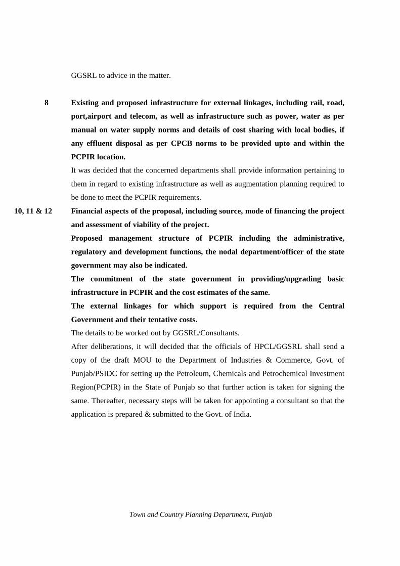
GGSRL to advice in the matter.
8 Existing and proposed infrastructure for external linkages, including rail, road,
port,airport and telecom, as well as infrastructure such as power, water as per
manual on water supply norms and details of cost sharing with local bodies, if
any effluent disposal as per CPCB norms to be provided upto and within the
PCPIR location.
It was decided that the concerned departments shall provide information pertaining to
them in regard to existing infrastructure as well as augmentation planning required to
be done to meet the PCPIR requirements.
, 10, 11 & 12 Financial aspects of the proposal, including source, mode of financing the project
and assessment of viability of the project.
Proposed management structure of PCPIR including the administrative,
regulatory and development functions, the nodal department/officer of the state
government may also be indicated.
The commitment of the state government in providing/upgrading basic
infrastructure in PCPIR and the cost estimates of the same.
The external linkages for which support is required from the Central
Government and their tentative costs.
The details to be worked out by GGSRL/Consultants.
After deliberations, it will decided that the officials of HPCL/GGSRL shall send a
copy of the draft MOU to the Department of Industries & Commerce, Govt. of
Punjab/PSIDC for setting up the Petroleum, Chemicals and Petrochemical Investment
Region(PCPIR) in the State of Punjab so that further action is taken for signing the
same. Thereafter, necessary steps will be taken for appointing a consultant so that the
application is prepared & submitted to the Govt. of India.
Town and Country Planning Department, Punjab

Town and Country Planning Department, Punjab

Town and Country Planning Department, Punjab
Annexure-V
Policy Resolution for Promotion of Petroleum,
Chemicals and Petrochemical Investment Regions (PCPIRs)
POLICY OBJECTIVES
1. The Petroleum, Chemicals and petrochemical industry in India is well establishment and has recorded a
steady growth over the years. The industry offers a wide scope for development that contributes positively
to economic growth and regional development. The future outlook for the industry is bright with positive
developments anticipated in various chemical sub sectors.
2. To promote investment in this sector and make the country an important hub for both domestic and
international markets, the government has decided to attract major investment, both domestic and foreign,
by providing a transparent and investment friendly policy and facility regime under which integrated
Petroleum, Chemicals & Petrochemical Investment Regions (PCPIRs) may be set up. The PCPIRs would
reap the benefits of co-sitting, networking and greater efficiency through the use of common infrastructure
and support services. They would have high-class infrastructure, and provide a competitive environment
conductive for setting up business. They would thus result in a boost to manufacturing of exports and
generation of employment.
CONCEPT OF PCPIR
3. A Petroleum, Chemicals and Petrochemicals Investment Region (PCPIR) would be a specifically
delineated investment region with an area of around 250 square kilometers planned for the establishment of
manufacturing for domestic and export led production in petroleum, chemicals & petrochemicals, along
with the associated services and infrastructure.
4. A PCPIR would be a combination of production units, public utilities, logistics, environmental protection
mechanisms, residential areas and administrative services. It would have a processing area, where the
manufacturing facilities, along with associated logistics and other social and institutional infrastructure.
The minimum processing area for the PCPIR will be about 40% of the total designated area, i.e. around 100
sq km. The processing area may or may not be contiguous.
5. The PCPIR may include one or more Special Economic Zones, industrial Parks, or Growth Centres, duly
notified under the relevant legislation or policy. All the benefits available under the relevant legislation or
policy will continue to remain available to the said Zones or parks, as the case may be forming part of the
PCPIR.
6. The PCPIR could cover existing settlement/industries & estates/services and would therefore benefit from
and be complementary to the region. The concerned state government may not acquire the entire area
comprising the PCPIR, but it will notify the same under the relevant Act for proper planning and zoning to
ensure coordinated development.
Town and Country Planning Department, Punjab

(Note: The word ‘state’ as used in this document shall include union territory)
7. Each PCPIR would have a refinery/petrochemical feedstock company as an anchor tenant. The internal
infrastructure of the PCPIR will be built and managed by a Developer, or a group of Co-developers. The
external linkages will be provided by Government of India and the concerned state government. The users
of external as well as internal infrastructure will pay for its use, except to the extent that the government
supports the service through budgetary resources.
ROLE OF THE CENTRAL GOVERNMENT
8. Government of India (GOI) will consider under this Policy all applications for establishment of PCPIRs
and approve expeditiously such proposals as are found feasible. It will constitute a High Powered
Committee to ensure necessary coordination among central ministries and state government, and also
monitor the progress of environmental and other clearness, as well as developments of the PCPIR, at
required intervals.
9. Government of India will ensure the availability of external physical infrastructure linkages to the PCPIR
including Rail, Road (national Highways), Ports, Airports, and Telecom, in a time bound manner. This
infrastructure will be created/upgraded through Public Private Partnership to the extent possible. Central
Government will provide the necessary viability gap funding through existing schemes. Wherever
necessary, requisite budgetary provisions for creation of these linkages through the public sector will also
be made.
10. Government of India will also support the state government concerned, and its agencies, in the
dissemination of information, with a view to promoting domestic as well as global investment in the
PCPIR.
11. The State Government would play the lead role in setting up of the PCPIR. It would identify a suitable site,
prepare the proposals and seek approval as elaborated below. It will notify the PCPIR area under the
relevant Act, and acquire/assist in acquiring the land necessary for setting up of the infrastructure,
processing and non-processing areas. The acquisition of land if any must be in accordance with law and
must provide for rehabilitation as per the laid down norms. As far as possible acquisition of agricultural
land may be avoided.
12. The State Government, applying for a PCPIR, will ensure that after notifying the area, all physical
infrastructure and utilities linkages under its jurisdiction are provided within a stipulated time frame. The
State Government will notify a nodal Department, which will coordinate these linkages required from the
State Government.
13. In particular, the State Government will be responsible for providing.facilitationg infrastructure:
i. Power connectivity and availability of reliable and good quality power. The units may also seek
open access as per the regulations of the State Electricity Regulator Commission.
ii. Provision of bulk requirements of water;
iii. Road connectivity(State roads);
Town and Country Planning Department, Punjab

iv. Sewerage and effluent treatment linkages, from edge of PCPIR, to the final disposal sites;
v. Appropriate infrastructure to address the health, safety and environment concerns.
14. The State Government may also notify an additional package of incentives for the development of the
PCPIR.
15. The State Government would constitute a Management Board for development and management of the
PCPIR, with functions as detailed below. This may be under the relevant state Act; the states will legislate
a new Act if necessary.
INSTITUTIONAL FRAMEWORK
16. The Department of Chemicals and petrochemicals (DoC & PC) will be the nodal department of the
Government of India for the PCPIRs.
17. A High Powered Committee constituted by the Government of India will scrutinize applications for setting
up the PCPIR, and subsequently monitor and expedite the progress of implementation. The composition of
the High Powered Committee is at Annex (i).
18. A Management Board constituted by the concerned state government for each PCPIR, under the relevant
legislation,will be responsible for the development and management of the PCPIR.it will also be
empowered to issue/expedite state level approvals. If the state legislation permits, the Board may be an
SPV in a corporate form headed by a CEO with sufficient autonomy, with the participation of the
Developer or Co-developers, as well as the anchor tenant. In addition the State Government should also a
supervisory body as a PCPIR state level Empowered Committee to:
a) Monitor, review and appraise the functions and the performance of the PCPIR.
b) Deal with issues relating to disputes between the stakeholders.
c) Any other function as may be presented by the State Government.
PROCEDURE
19. The application for notification of a PCPIR shall be moved by the State Government concerned to the nodal
Ministry namely Department of Chemicals & Petrochemicals. The State Government will attach with its
application a Project Proposals as per format at Annex (ii).
20. DoC & PC would ensure, in consultation with the State Government, and the central Ministries concerned,
that the proposals is as per this Policy and then place it before the High Powered Committee for its
recommendations.
21. DoC & PC will place the recommendations of High Powered Committee on Economic Affairs for decision.
22. The following guidelines will be kept in view while considering a PCPIR Proposal:
i. Potential generation of additional economic activity and future growth, including generation of
additional employment.
ii. Potential investment from domestic and foreign sources for production of goods & services.
Town and Country Planning Department, Punjab

iii. Potential linkages for Petroleum, Chemical and Petrochemical investment facilities both
domestically and internationally.
iv. Willingness and commitment of the State Government.
v. Interest of major anchor industry including PSUs.
vi. Present infrastructure linkages to the proposed site, and estimated cost of required addition/up
gradation.
vii. Land Availabality, especially close to port.
viii. Port connectivity/port condition (available draft, existing facilities, natural calamity risk).
ix. Maintenance of ecological balance and sustainable development in the region and ensure
conformity with Environment Laws in force.
23. The Note submitted to the CCEA for approval of a PCPIR will clearly state the commitments of Gol to the
provision of infrastructure (national highways, Railways, Ports, Airports, Telecom) in a time bound
manner.
24. Each PCPIR will be notified separately by DoC & PC after CCEA approval in each case. Each concerned
central Ministry will then prepare detailed project reports, and obtain financial approvals to the same
expeditiously as per extant guidelines of Ministry of Finance. Department of C & PC will enter into a
Memorandum of Agreement with the State Government concerned, indicating the respective commitments,
with timelines, of the Central and State Government, after the PCPIR has been approved by CCEA and
notified by Department of C & PC.
25. The Management Board will, after notification of the PCPIR prepare a detailed master plan using the expert
assistance of a technically qualified consultant. The consultant will be selected after following a transparent
process. The master plan will consist of a regional development plan specifying land use for processing and
non-processing areas, as well as technical details regarding the number and nature of downstream units that
may come up in the PCPIR, based on available feedstock. It will be prepared in consultation with the
anchor tenant, if in place by then.
26. The master plan as finalized through the above process shall be appraised by the competent authority under
the relevant state law to give it appropriate statutory status.
27. In case an amendment is required to the concept and design of the project, as encapsulated in the
preliminary project report submitted by the State Government, the same may be done in accordance with
procedure provided in the State law.
28. Proposals for setting up units in the PCPIR will be granted approval by the Management Board, or such
authority to which these powers are delegated, after obtaining such clearness as are necessary. Such
clearness and approvals will be granted within a stipulated period of time, as prescribed by the concerned
state government.
FUNCTIONS OF THE MANAGEMENT BOARD
29. Each Management Board will undertake such measures as it thinks fit for the development, growth.
Operation and management of the PCPIR. These measures will include:
Town and Country Planning Department, Punjab

i. Preparation and enforcement of the detailed Master plan.
ii. Providing the necessary infrastructure within the PCPIR, either directly or through developer(s).
iii. Selection of Developer/Co-developers and entering into concession agreements with them for the
development and maintenance of infrastructure internal to the PCPIR.
iv. Promotion of investment, both foreign and domestic, into the PCPIR.
v. Granting approvals for, and facilitating clearances to units within the PCPIR.
vi. Review of the functioning and performance of the PCPIR.
vii. Regulation of levy of user or service charges or fees or rent for the use of infrastructure/properties
in the PCPIR.
viii. Exercise of authority to delegate, enter into or create SPVs for specialized services.
ix. Any other functions as may be prescribed by the State Government.
DEVELOPERS AND CO-DEVELOPER
30. The Developer is a legal entity-Government, private or a Public Private Partnership-that develops, builds,
designs, organises, promotes, finances, operates, maintains or manages a part or whole of the infrastructure
and other facilities in the PCPIR. The Developers would be selected by the State Government/Management
Board through a transparent mechanism.
31. The required land within the PCPIR will be made available to the Developer by the State Government,
though the PCPIR Management Board, by way of a concession.
32. A Co-developer will be a legal entity-Government, private or a Public Private Partnership-that assists the
developer in providing infrastructure facilities in the identified area or to undertake various operations after
entering into an agreement with the developer for providing the same.
33. The benefits of tax holidays as provided under Section 80(I) (A) of the Income Tax Act for development,
operation and maintenance of power plants, airport, ports, waste management facilities, water treatment
plants, etc. would be available to the developer/Co-developers.
34. Any chemical or related industry/service that will support chemical industry in the investment region for
manufacturing, stocking, trading including logistics and utilities with local linkages, and for which site is
available as per the approved detailed Master Plan, will be eligible for being set up in the PCPIR, and may
apply to the Management Board in such form as will be specified by the authority concerned.
35. The Management Board, or the authority to which such powers are delegated, will allot sites to units
through a transparent process as specified.
36. A unit located in PCPIR, whether in SEZ or elsewhere, may produce/ export goods and services except
those prohibited either for manufacture or export under the EXIM Policy or any other Act in force. Rejects,
waste, and scrap arising out of the production process could be exported or sold outside the SEZ. Export of
Special Chemicals, Organisms, Materials, Equipment and Technologies (SCOMET) items would be as per
the law in force.
EXIT OPTIONS
Town and Country Planning Department, Punjab

37. In case the developer, or any Co-developer, is unable to discharge his functions, or violates the terms and
conditions of the concession agreement, the same may be transferred to new Developer/Co-developer under
terms and conditions to be provided in the concession agreement between the Developer/Co-developer and
the Management Board.
38. Any unit that wants to exit out of the PCPIR will be allowed subject to payment of applicable dues and in
compliance with the agreement with the Management Board in this regard.
DISPUTE RESOLUTION MECHANISM
39. The concession agreement(s) executed by the Management Board with the Developer/Co-developer(s), and
the agreements with the tenant units, may contain the condition that any dispute, difference or controversy
of whatever nature arising under or out of in relation to any Agreement (including its interpretation)
between the parties in the PCPIR, shall be notified in writing by either party to the other party and such
dispute, difference or controversy shall, in the first instance be attempted to be resolved amicably by
mutual consultation and if no solution is arrived after such consultation, the same may be referred to the
International centre for Alternate Dispute resolution, New Delhi or such other rules as may be mutually
agreed by the parties, and shall be subject to the Arbitration and Conciliation Act 1996 and amendments
made there to from time to time.
MISCELLANEOUS
40. This Policy will take effect from the date of its notification. Any subsequent modification in the Policy will
be applied only with prospective effect.
Town and Country Planning Department, Punjab

Annex (i)
HIGH POWERED COMMITTEE
Government of India will constitute a High Powered Committee (HPC) with the following composition:
i. Cabinet Secretary..............................Chairman
ii. Member Seceratary, Planning commission
iii. Seceretary, Ministry of Petroleum & Natural Gas
iv. Seceretary, Department of Commerce
v. Seceretary, Department of Industrial policy & promotion
vi. Seceretary, Department of Revenue
vii. Seceretary, Department of Expenditure
viii. Seceretary, Department of Economic Affairs
ix. Member Traffic,Railway Board, Minstry of Railways
x. Seceretary,Ministry of Shipping
xi. Seceretary, Road Transport and Highways
xii. Seceretary,Ministry of Civil Aviation
xiii. Seceretary,Ministry of Environment & Forests
xiv. Seceretary,Ministry of Labour & Employment
xv. Seceretary,Department of Chemicals &
Petrochemicals........................................................................Convenor
The Committee may co-opt any other member as required. Chief Secretaries of the State Governments
concerned may be invited to the meetings of the Committee as required.
Town and Country Planning Department, Punjab

ANNEX (ii)
Format for Project Proposal
The Project Proposal to be provided by the State Government, along with its application to the Department of
chemicals and Petrochemicals, GOI for setting up a PCPIR will include, inter alia, the following
information:
i. The legal framework in the State under which the PCPIR is proposed to be formed, including
whether this would be under an existing Act or under a new legislation to be enacted for this
purpose.
ii. The location along with demarcation of the identified area with map and clearly identifiable
landmarks.
iii. The total area of the proposed PCPIR, with the proposed zoning plan indicating the Process area &
non-processing area to include:
Processing Area
a) total area, with location/demarcation on map.
b) existing units and vacant land available.
c) land acquired and proposed to be acquired.
d) the existing and proposed processing activities in the PCPIR.
e) the feedback required for the anchor units(s), with its source and availability.
Non-processing area
a) identified areas with location/demarcation on map.
b) existing and proposed availability of basic and social infrastructure, trained manpower,
educational institutions and training etc.
iv. Whether the state government has identified.
a) an anchor tenant; if so, the proposed investment plan of the anchor tenant, if available;
b) Developer(s).
(Note: Details of the procedure adopted/proposed to ensure transparency in the selection of
Developers(s) may also be provided.)
Town and Country Planning Department, Punjab

v. The time frame by which a detailed MASTER Plan would be formulated and adopted.
vi. A rapid Environmental Impact Assessment (EIA) report.
vii. Estimated potential for generation of additional economic activity and future growth, including
potential investment from domestic and foreign sources.
viii. Existing and proposed infrastructure for external linkages, including rail,road,port, airport and
telecom, as well as infrastructure such as power, water as per manual on water supply norms and
details of cost sharing with local bodies, if any and effluent disposal as per CPCB norms to be
provided up to and within the PCPIR location.
ix. Financial aspects of the proposal, including source, mode of financing the project and assessment
of viability of the project.
x. Proposed management structure of PCPIR including the administrative, regulatory and
development functions; the nodal department/officer of the state Government may also be
indicated.
xi. The commitment of the state government in providing/upgrading basic infrastructure in PCPIR
and the cost estimates of the same.
xii. The external linkages for which support is required from the central government, and their
tentative costs.
Town and Country Planning Department, Punjab

FORMAT FOR PROJECT APPROVAL
Town and Country Planning Department, Punjab
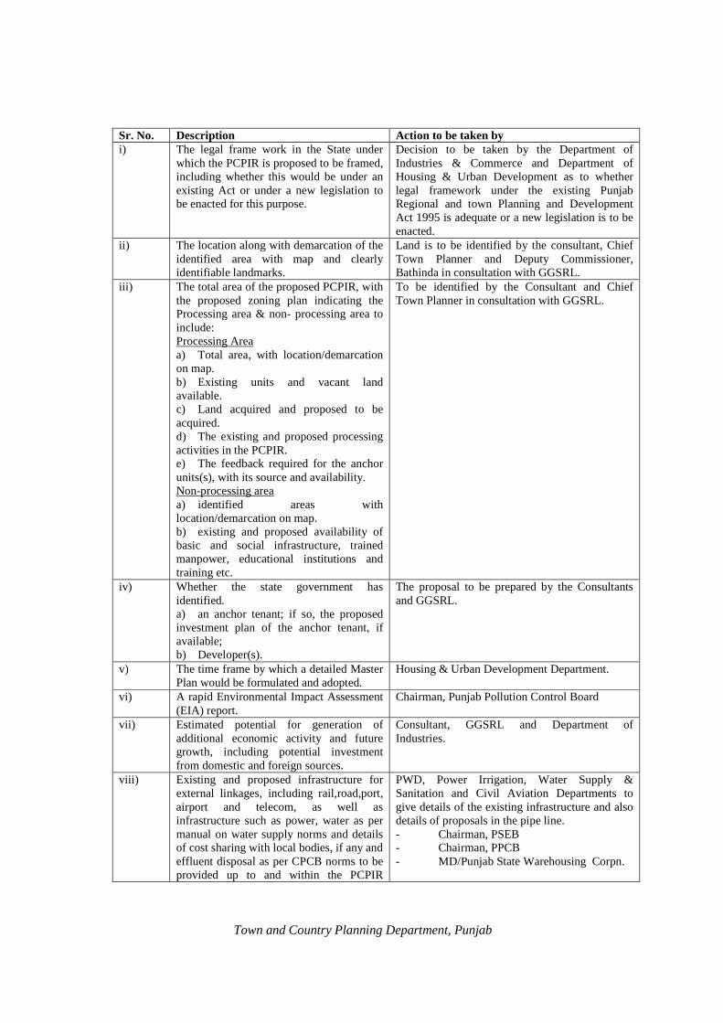
Sr. No. Description Action to be taken by i) The legal frame work in the State under
which the PCPIR is proposed to be framed, including whether this would be under an existing Act or under a new legislation to be enacted for this purpose.
Decision to be taken by the Department of Industries & Commerce and Department of Housing & Urban Development as to whether legal framework under the existing Punjab Regional and town Planning and Development Act 1995 is adequate or a new legislation is to be enacted.
ii) The location along with demarcation of the identified area with map and clearly identifiable landmarks.
Land is to be identified by the consultant, Chief Town Planner and Deputy Commissioner, Bathinda in consultation with GGSRL.
iii) The total area of the proposed PCPIR, with the proposed zoning plan indicating the Processing area & non- processing area to include: Processing Area a) Total area, with location/demarcation on map. b) Existing units and vacant land available. c) Land acquired and proposed to be acquired. d) The existing and proposed processing activities in the PCPIR. e) The feedback required for the anchor units(s), with its source and availability. Non-processing area a) identified areas with location/demarcation on map. b) existing and proposed availability of basic and social infrastructure, trained manpower, educational institutions and training etc.
To be identified by the Consultant and Chief Town Planner in consultation with GGSRL.
iv) Whether the state government has identified. a) an anchor tenant; if so, the proposed investment plan of the anchor tenant, if available; b) Developer(s).
The proposal to be prepared by the Consultants and GGSRL.
v) The time frame by which a detailed Master Plan would be formulated and adopted.
Housing & Urban Development Department.
vi) A rapid Environmental Impact Assessment (EIA) report.
Chairman, Punjab Pollution Control Board
vii) Estimated potential for generation of additional economic activity and future growth, including potential investment from domestic and foreign sources.
Consultant, GGSRL and Department of Industries.
viii) Existing and proposed infrastructure for external linkages, including rail,road,port, airport and telecom, as well as infrastructure such as power, water as per manual on water supply norms and details of cost sharing with local bodies, if any and effluent disposal as per CPCB norms to be provided up to and within the PCPIR
PWD, Power Irrigation, Water Supply & Sanitation and Civil Aviation Departments to give details of the existing infrastructure and also details of proposals in the pipe line. - Chairman, PSEB - Chairman, PPCB - MD/Punjab State Warehousing Corpn.
Town and Country Planning Department, Punjab

location.
ix) Financial aspects of the proposal, including source, mode of financing the project and assessment of viability of the project.
GGSRL and Consultants
x) Proposed management structure of PCPIR including the administrative, regulatory and development functions; the nodal department/officer of the state Government may also be indicated.
GGSRL and Consultants
xi) The commitment of the state government in providing/upgrading basic infrastructure in PCPIR and the cost estimates of the same.
Department of Finance/PIDB/PWD/Irrigation/Water Supply & Sanitation
xii) The external linkages for which support is required from the central government, and their tentative costs.
GGSRL and Consultants
Town and Country Planning Department, Punjab