Embed Size (px)
Citation preview

Rivers and Drainage Patterns

Drainage Regions of Canada
• There are 5 main drainage regions of Canada:– Pacific Ocean– Atlantic Ocean– Hudson Bay– Arctic Ocean– Gulf of Mexico
• Regions are based on physical features which dictate the flow of water (ex. mountain)

Drainage Patterns
• Dendritic iii) eg. Lethbrige, Alta.i) Uniform flow Rivers join together at acute anglesii) Occurs on bedrock

Trellis iii) ex. Tetsa River, B.C.i) Tributaries join at right anglesii) Located folded mountains

Radial iii) ex. Martinique, Quei) Water flows down from a high pointii) Common around mountain ranges

Deranged iii) ex. Peterborough, ONi) No real patternii) Often contains wetlands, bogs, and lakes

River Development
• Youth Stage– Straight, flowing water– Often in steep regions– V-shaped valley (shape of river)– Often lined with rocks, boulders– High amount of potential energy– Transports large amounts of material

• Maturity Stage– Meandering pattern– Water starts to erode weak regions along the streambed – River widens as a result of erosion– Deposits material in slower regions– Creates floodplains where water overflows

• Old Age Stage– Deposits more sediment than it transports- U-shaped river bed– Slow moving– Often muddy looking– Often occurs wen river rises above the flood plain– Rich soil along river edge– Ex. Nile

Factors Affecting River Development
• 1. Gradient– The steeper the slope, the faster the water flows – This increases the speed of erosion
• 2. Depth – Deeper rivers carry more water and this increases
erosion• 3. Width– Wider rivers allow more water to pass through the
river

River Development Animation
• http://River Animation

• Define the following:– Delta– Rejuvenation– Flood plain– Tributary
• Answer the following question:– Pg. 203 Q. 16– What are the benefits of a riparian watershed?

Red River Floodway
• Constructed in 1968• 47 km long• 2nd largest earth moving project (Panama Canal #1)
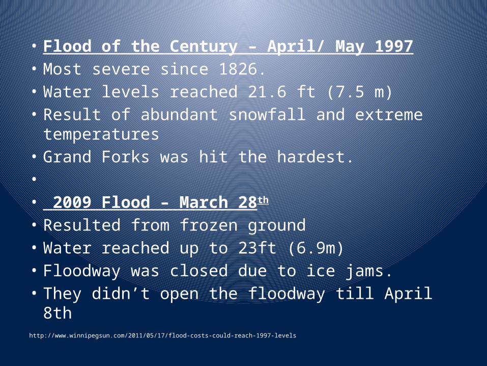
• Flood of the Century – April/ May 1997• Most severe since 1826.• Water levels reached 21.6 ft (7.5 m)• Result of abundant snowfall and extreme temperatures• Grand Forks was hit the hardest. • • 2009 Flood – March 28th
• Resulted from frozen ground• Water reached up to 23ft (6.9m)• Floodway was closed due to ice jams. • They didn’t open the floodway till April 8thhttp://www.winnipegsun.com/2011/05/17/flood-costs-could-reach-1997-levels

• "Should the rights of rural Manitobans be put aside so the City of Winnipeg can survive major floods?"