Embed Size (px)
Citation preview

River Systems - Runoff

Running Water
• Integral part of sculpting the Earth’s surface• MOST IMPORTANT AGENT OF
EROSION• Indirectly results in the formation of
sedimentary rocks
Stream Formation
• Sheetflow or Sheetwash – overland flow of water
• Repeated precipitation events cause a preferential channel to form – downcutting
• Tributaries form & the main channel continues to grow up slope – headward erosion

• Streams increase in length by headward erosion – erosion occurring at the beginning of the stream
• Streams become wider through lateral erosion – mass wasting of the stream banks
• Streams become deeper through downward erosion of the channel by abrasion of the sand and gravel
Stream Morphology

Fig. 11.13

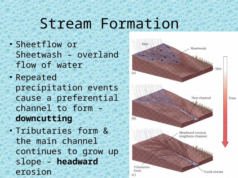
Stream Terminology• Stream System – main stream plus
tributaries
• Drainage Basin – area drained by main stream and tributaries
• Drainage Divide – area of higher elevation that divides drainage basins
• Function of size/scale
For Example:
Kickapoo CreekSangamon River Illinois River Mississippi River
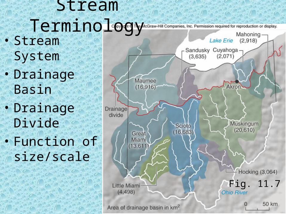
Fig. 11.7
Stream Terminology• Stream System
• Drainage Basin
• Drainage Divide
• Function of size/scale
Fig. 11.6

Stream Subsystems
• Collecting System– Tributaries is head water region– Funnel water and sediment to main
channel– Primarily erosion and transport
• Transporting System– Main tributary– Main process is the movement of the
sediment and water– Erosion, transport, and deposition all
occur
• Dispersing System– Distributaries at mouth region– Primarily deposition of the sediment– Coarse sediment along the confluence– Fine particles carried further in to body
of water

Fig. 11.8
Drainage Patterns

Streamflow Dynamics
• Examine the physical and hydraulic properties of the stream
• Discharge• Velocity
– Gradient– Channel Properties
• Wetted Perimeter• Shape• Size• Roughness
• Sediment Load
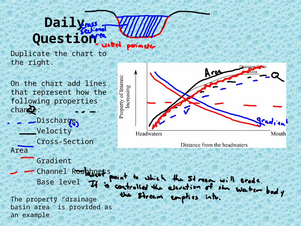
DailyQuestion
Duplicate the chart to the right.
On the chart add lines that represent how the following properties change:
Discharge
Velocity
Cross-Section Area
Gradient
Channel Roughness
Base level
The property “drainage basin area” is provided as an example
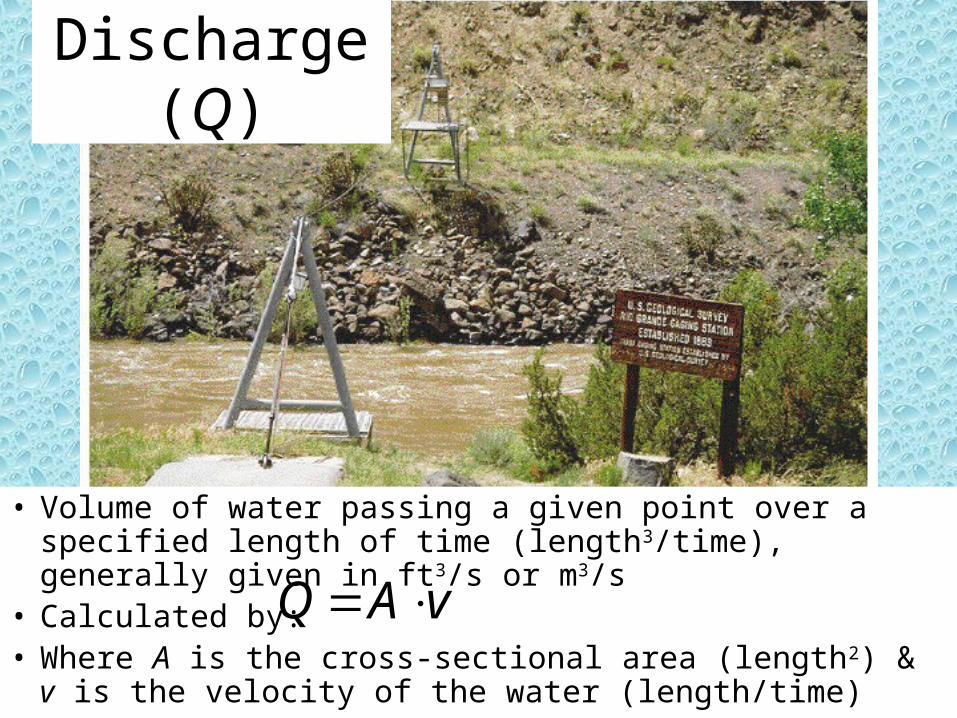
Discharge (Q)
• Volume of water passing a given point over a specified length of time (length3/time), generally given in ft3/s or m3/s
• Calculated by:• Where A is the cross-sectional area (length2) & v is the
velocity of the water (length/time)
vAQ
Velocity
• The speed of the water at a given point along a stream• Directly related to a stream’s ability to erode and
transport material• High velocity water can carry heavier sediment• Is a function of
– Gradient– Channel Properties
• Wetted Perimeter– Shape– Size– Roughness
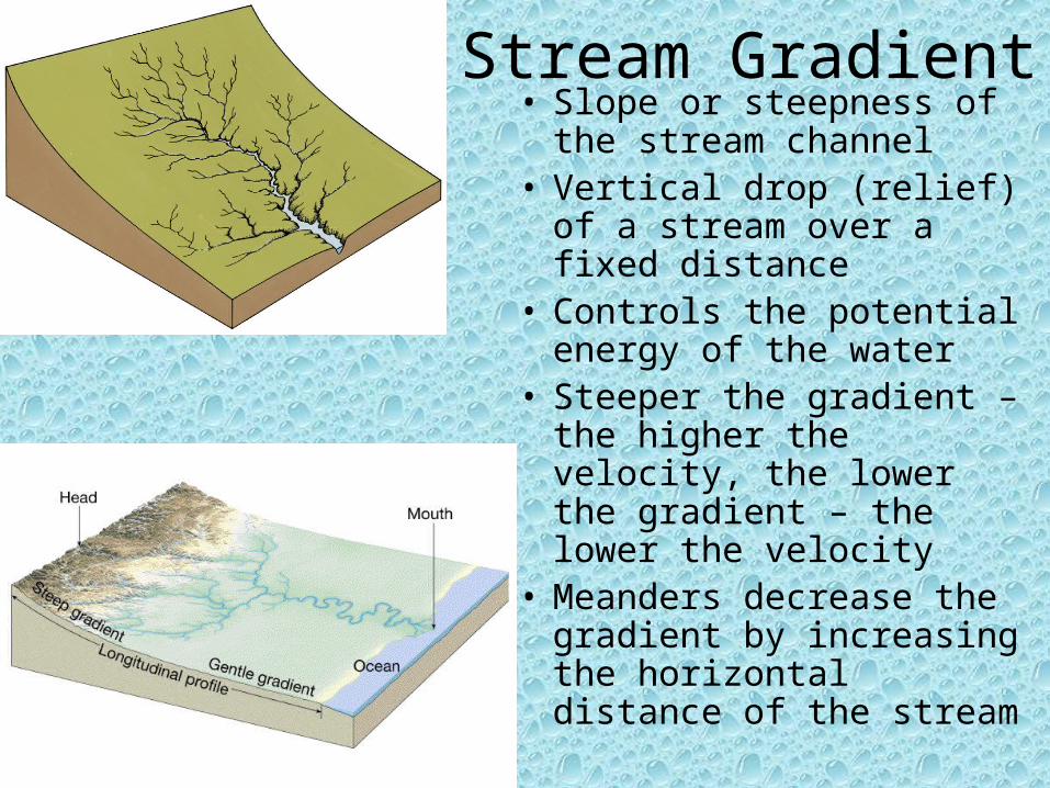
Stream Gradient• Slope or steepness of the
stream channel• Vertical drop (relief) of a
stream over a fixed distance• Controls the potential
energy of the water• Steeper the gradient – the
higher the velocity, the lower the gradient – the lower the velocity
• Meanders decrease the gradient by increasing the horizontal distance of the stream

Wetted Perimeter• The area in which water touches
the channel walls• Channel shape and size controls
the wetted perimeter• Most efficient streams have small
wetted perimeters• Roughness of the channel
controls the frictional resistance to water movement– A smooth channel decreases
frictional force– A rough channel increases frictional
force


![[hal-00945905, v2] Crowd Sculpting: A space-time sculpting](https://img.pdfslide.us/doc/110x75/61d00833c69c8e549e339118/hal-00945905-v2-crowd-sculpting-a-space-time-sculpting-.jpg)