Embed Size (px)
Citation preview
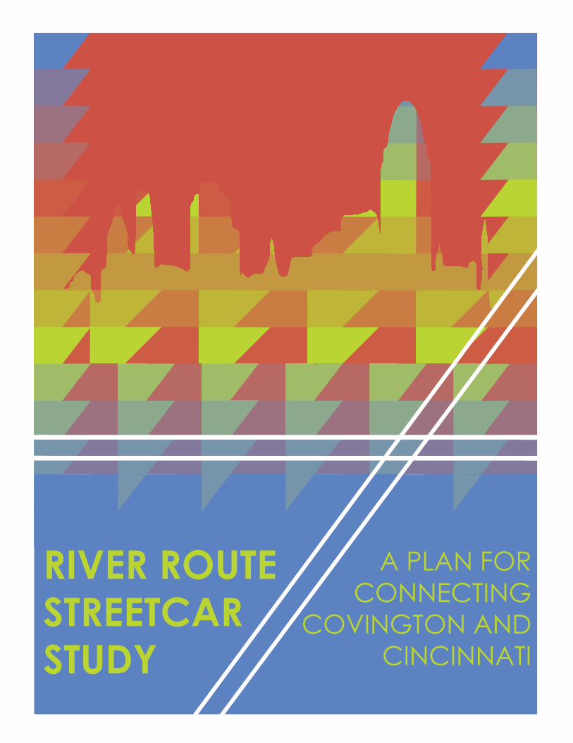
RIVER ROUTE STREETCAR STUDY
A PLAN FOR CONNECTING
COVINGTON ANDCINCINNATI

EXECUTIVE SUMMARYTABLE OF CONTENTS
Once-traversed by historic streetcars, Covington is a community ripe for implementation of a modern streetcar. With a rich tapestry of 10 distinct neighborhoods, many of which are comprised of dense, European-style neighborhood fabric that originally supported the historic streetcars - Covington has the density and potential to support a return to transit.
The timing is right as this year, 2016, marks the inception of the Cincinnati Streetcar. This $148 million modern streetcar serves the revitalized core of Cincinnati, spanning from The Banks, through Downtown, and through Over-the-Rhine. A planned Uptown extension will connect the region’s largest educational and healthcare institutions.
Located across the river in Kentucky, Covington brings to the table resources and policy support from another state. This region has always profited from multi-state cooperation in building a comprehensive transportation network, including the I-275 loop, Ohio River bridges, and the airport. It should turn toward regional, multi-state partnerships once again toward the goal of building a comprehensive streetcar network that serves the region.
This plan, prepared by Ohio State Knowlton School of Architecture student Nicholas Emenhiser, represents the culmination of class projects completed for the masters-level practicum course in Graphic Communication for Planners. Beyond course requirements, this plan is intended to support concurrent planning efforts underway in Covington and Newport. However, per the class requirements to focus on a single city, most mapping analyses will focus on Covington. That said, the broader context including Newport was a significant consideration toward a route recommendation.
The analysis conducted through GIS, using American Community Survey data, shows that non-motorized commuting is currently highest in neighborhoods flanking MLK Blvd., specifically the Seminary Square and Eastside neighborhoods. Considering streetcar’s unique ability to create new ridership demand, the dense Madison Avenue corridor and Riverfront are also worth connecting. It may also be that the concentration of commercial and institutional land uses in the northern end of Covington explains lower (but still significant) rates of non-motorized commuting.
Beyond providing mere transit service, a crucial community service in and of its own right, this streetcar plan presents unique opportunities for further revitalizing Covington and Newport. With streetcar station design, transit-oriented development, and more vibrant streets and sidewalks - this plan offers intrinsic value that justify its roughly $200 million cost to implement.
32
3
4
6
12
13
14
15
16
17
Executive Summary
Regional Context
GIS Analysis
Planning Process
Route Considerations
Station Design
Transit Alignment
Development Opportunities
Data Points
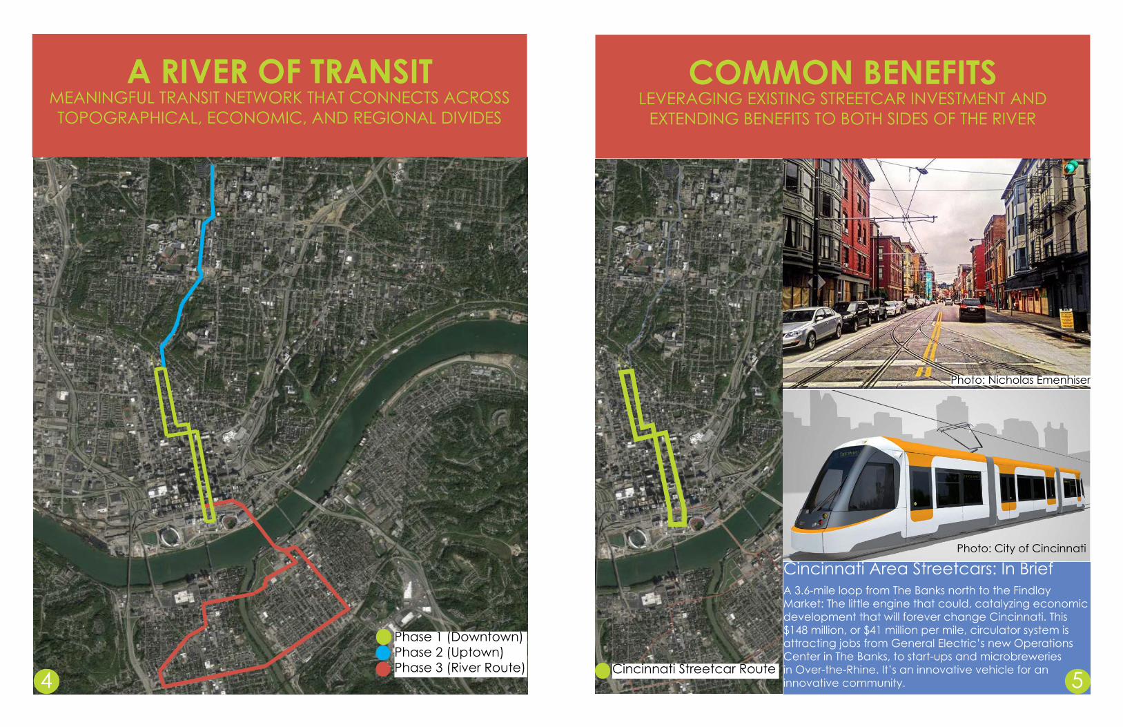
A RIVER OF TRANSITMEANINGFUL TRANSIT NETWORK THAT CONNECTS ACROSS TOPOGRAPHICAL, ECONOMIC, AND REGIONAL DIVIDES
Phase 1 (Downtown)Phase 2 (Uptown)Phase 3 (River Route)
Cincinnati Area Streetcars: In BriefA 3.6-mile loop from The Banks north to the Findlay Market: The little engine that could, catalyzing economic development that will forever change Cincinnati. This $148 million, or $41 million per mile, circulator system is attracting jobs from General Electric’s new Operations Center in The Banks, to start-ups and microbreweries in Over-the-Rhine. It’s an innovative vehicle for an innovative community.
Cincinnati Streetcar Route4
COMMON BENEFITSLEVERAGING EXISTING STREETCAR INVESTMENT AND
EXTENDING BENEFITS TO BOTH SIDES OF THE RIVER
5
Photo: City of Cincinnati
Photo: Nicholas Emenhiser

NKY RIVER ROUTEEXISTING CONDITIONS MAP
Ohio River
I-471
I-71/
75
MLK Blvd5th Street
4th StreetScott Blvd
Greenup Street
Monmouth Street
Vine Street
Broadway
CINCINNATI
NEWPORT
COVINGTON
Scott BlvdG
reenup Street
MLK Blvd
I-71/75
4th Street5th Street
I-471
CINCINNATI
NEWPORT
I-275
COVINGTON
NKY RIVER ROUTEREGIONAL CONTEXT MAP
BELLEVUE
Ohio River
6 7
Existing conditions to be explored include primary means of commuting by tract.
This study focused on com-muting alternatives including pedestrian, bicycling, and transit community.
Maps produced with ArcGIS using most recent American Community Survey data.

NKY RIVER ROUTEPEDESTRIAN COMMUTERS
Greenup Street
Scott Blvd
5th Street
4th Street
MLK Blvd
Monmouth Street
CINCINNATI
COVINGTONNEWPORT
BELLEVUE
NKY RIVER ROUTEBIKE COMMUTERS
Greenup Street
Scott Blvd
5th Street
4th Street
MLK Blvd
Monmouth Street
CINCINNATI
COVINGTON
NEWPORT
BELLEVUE
8 9
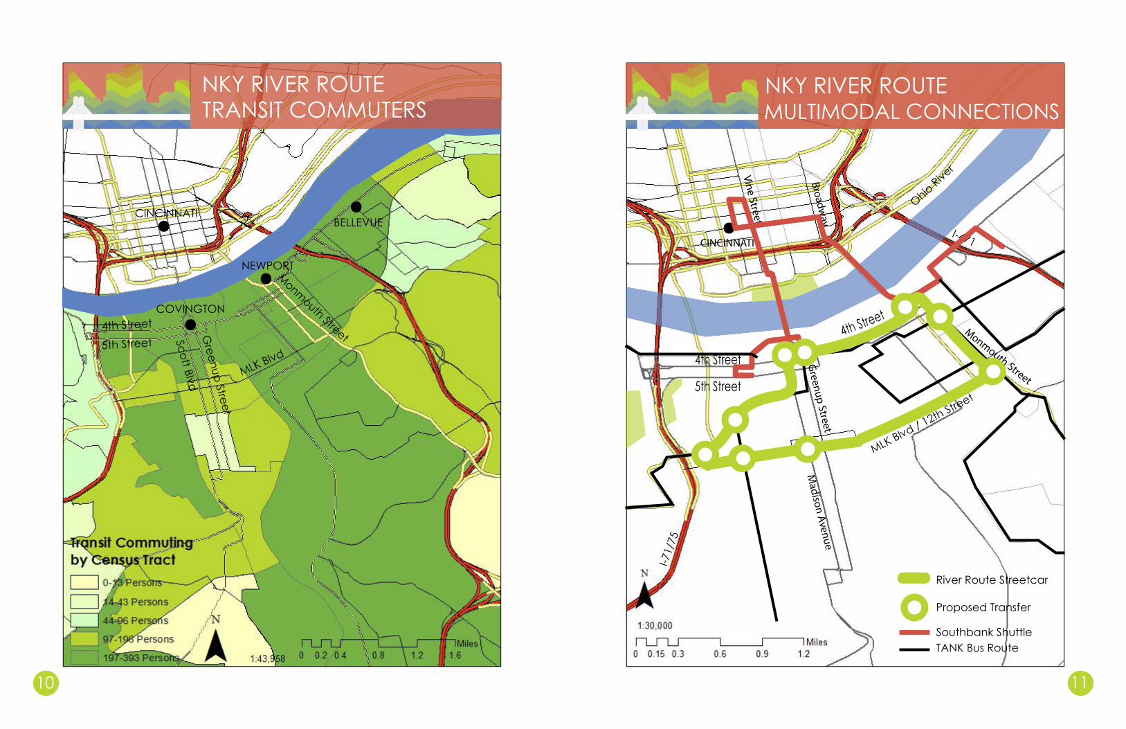
NKY RIVER ROUTEMULTIMODAL CONNECTIONS
Ohio River
I-471
I-71/
75
MLK Blvd / 12th Street
5th Street
4th Street Greenup Street
Monmouth StreetVine Street
Broadway
CINCINNATI
TANK Bus RouteSouthbank Shuttle
Proposed Transfer
River Route Streetcar
Madison Avenue
4th Street
NKY RIVER ROUTETRANSIT COMMUTERS
Greenup Street
Scott Blvd
5th Street4th Street
MLK Blvd
Monmouth Street
CINCINNATI
COVINGTON
NEWPORT
BELLEVUE
10 11
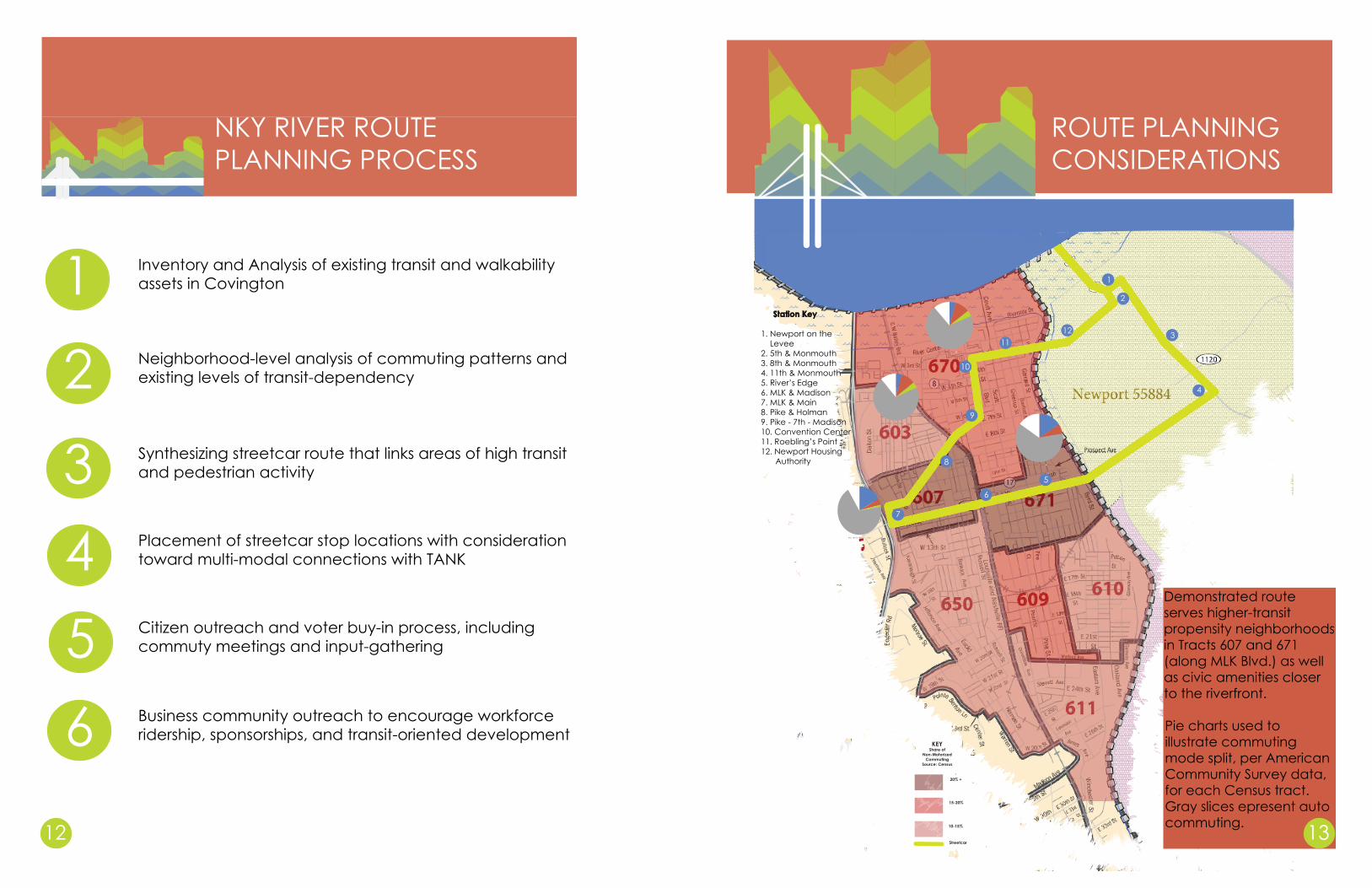
NKY RIVER ROUTEPLANNING PROCESS
1
2
34
Inventory and Analysis of existing transit and walkability assets in Covington
Neighborhood-level analysis of commuting patterns and existing levels of transit-dependency
Synthesizing streetcar route that links areas of high transit and pedestrian activity
Placement of streetcar stop locations with consideration toward multi-modal connections with TANK
5 Citizen outreach and voter buy-in process, including commuty meetings and input-gathering
1
2
34
4
5
6
7
8
9
10
1112
Tract 651
Bus Walk Bike Drive Other
Station Key
1. Newport on theLevee
2. 5th & Monmouth3. 8th & Monmouth4. 11th & Monmouth5. River’s Edge6. MLK & Madison7. MLK & Main8. Pike & Holman9. Pike - 7th - Madison10. Convention Center11. Roebling’s Point12. Newport Housing
Authority
Tract 671
Bus Walk Drive Other
Tract 670
Bus Walk Drive Other
Tract 607
Bus Walk Drive Other
20% +
15-20%
10-15%
KEYShare of
Non-Motorized Commuting
Source: Census
Streetcar
ROUTE PLANNING CONSIDERATIONS
Demonstrated route serves higher-transit propensity neighborhoods in Tracts 607 and 671 (along MLK Blvd.) as well as civic amenities closer to the riverfront.
Pie charts used to illustrate commuting mode split, per American Community Survey data, for each Census tract. Gray slices epresent auto commuting.12
6 Business community outreach to encourage workforce ridership, sponsorships, and transit-oriented development
13

NKY RIVER ROUTESTATION DESIGN
14 15
NKY RIVER ROUTETRANSIT ALIGNMENT
PROPOSED STREETCAR STATION
EXISTING CONDITIONS AT 5TH ST. AND MADISON AVE. IN DOWNTOWN COVINGTON
Streetcar footprintParking footprint
With a smooth track bed
embedded in pavement,
modern streetcars can
safely operate in mixed traffic with
few conflicts.

NKY RIVER ROUTEDEVELOPMENT OPPORTUNITIES
NKY RIVER ROUTEDATA POINTS
TOD, or transit-oriented development, is a strategy to develop land with immediate access to transit corridors and/or stations. Usually developed in the form of mixed-use nodes that market apartments, retail, and offices that benefit from transit access - often with reduced parking footprints - and with the deliberate goal of increasing transit ridership. TOD offers strategic benefits for both developers and transit operators.
Cities that have successfully implemented streetcar systems, such as Portland, often augment their transit investment with public-private partnership strategies for transit-oriented development. These strategies often include development bond financing, station-area improvements, value-capture mechanisms such as TIF, and land acquisition assistance. Covington could implement such a strategy by identifying target sites for TOD.
TOD siteStreetcar16 17
5.3 mile streetcarroute
million dollar proposal(roughly)200 3 historic cities
connected
Cincinnati Streetcar Funding Assistance
Federal
TIF
Blue Ash Sale
Duke Energy
In order to fund the $148 million Cincinnati streetcar, always intended to be the first phase of a larger regional network, several partners came together. Federal grants account for $45 million, comprising the largest funding source. TIF and development revenues covered $32 million, reinvesting the streetcar’s own TOD. A Blue Ash utility sale generated $26 million, and Duke Energy contributed $7 million. These partnerships whittled the required City of Cincinnati capital contribution to $38 million, or 1/4 of total cost.

RIVER ROUTE STREETCARThe right transit plan to connect Northern Kentucky to
Cincinnati and the greater region.