Embed Size (px)
Citation preview
Copyright © 2019 Johns Associates Limited
River Parrett Oath to
Burrowbridge Dredging
Environmental Impact
Assessment Screening and
Scoping Report
Report Status: Final
Job Number: J00256
Client: Parrett Internal Drainage Board
Date: April 2019
Copyright © 2019 Johns Associates Limited 2
DOCUMENT CONTROL
Report prepared for:
Client Name: Parrett Drainage Board Consortium
Main contributors:
Matt Johns BSc MSc CEnv FGS MCIEEM MIFM (Johns Associates, Director and Head of Environment & Planning)
Andy Wallace BEng MRes CEng MCIWEM (AW Water Engineering)
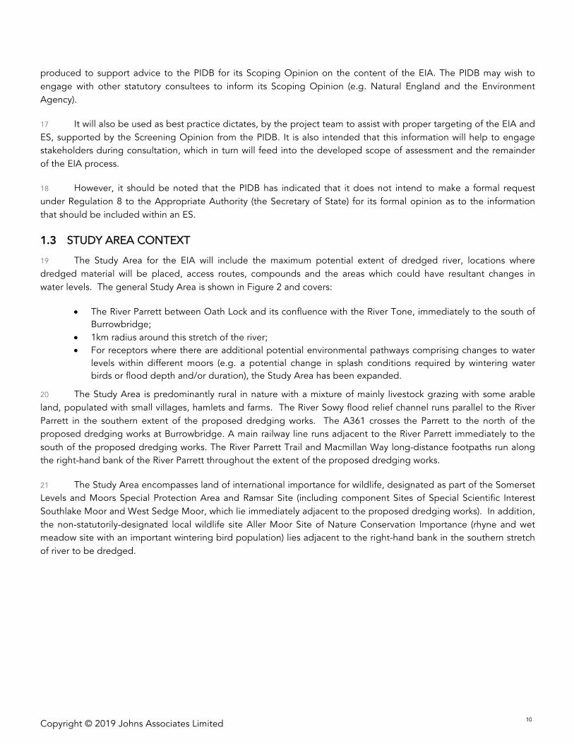
Reviewed & Issued by:
Liz Johns BSc MSc CEnv MCIEEM MRSB
Johns Associates Limited, The Old Brewery, Newtown, Bradford-on-Avon, BA15 1NF
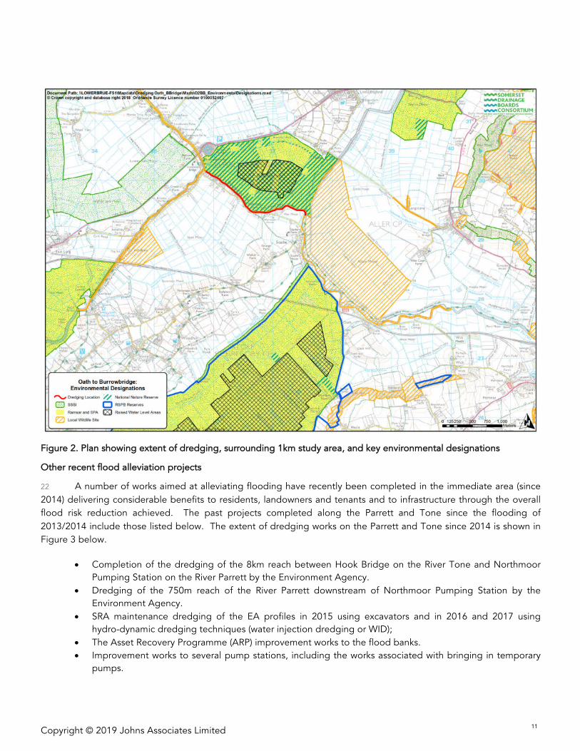
T: 01225 723652 | E: [email protected] | W: www.johnsassociates.co.uk
Copyright © 2019 Johns Associates Limited 3
DOCUMENT REVISIONS
Version Details Date
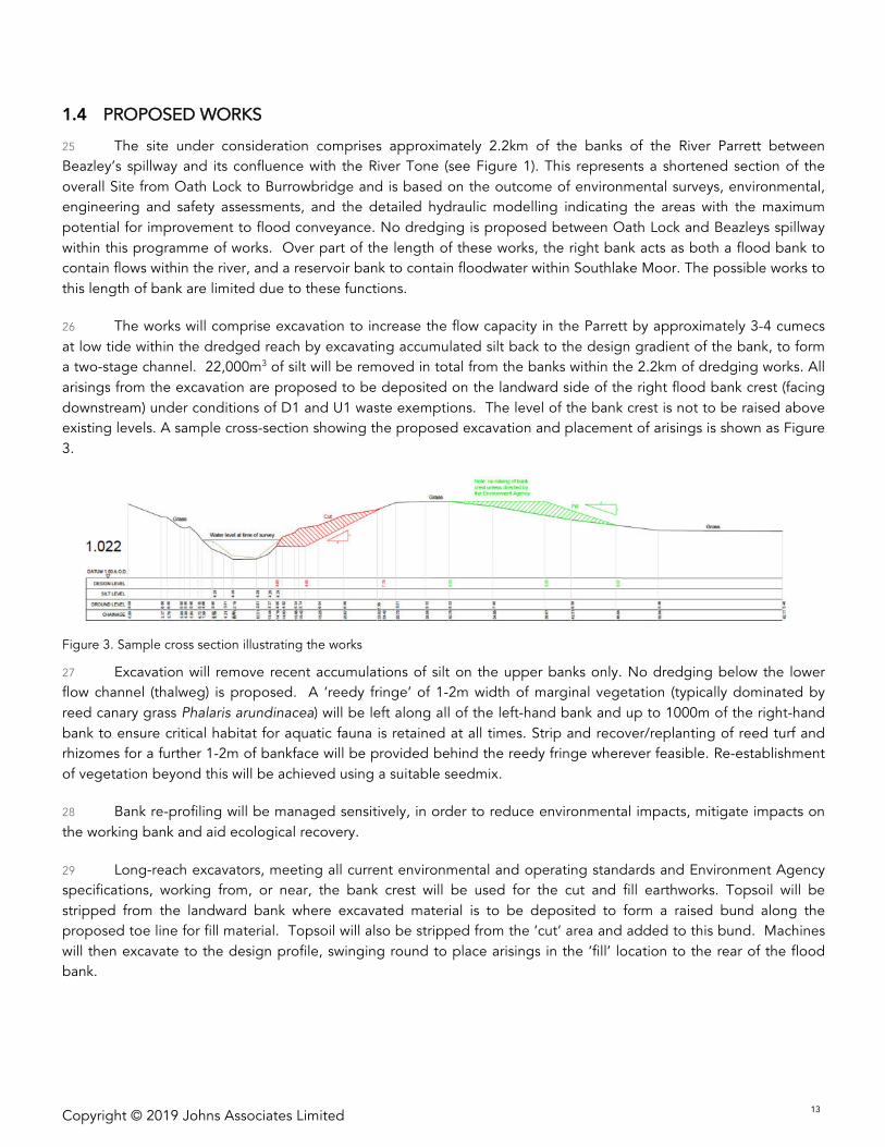
V1 Initial draft produced for client copy July 2018
V2
Updated draft incorporating baseline data, stakeholder
meeting feedback and design iteration, for client review
and approval.
March 2019
V3 Final draft for approval 10th April 2019
V4 Final version issued 15th April 2019
Third party disclaimer
Any disclosure of this report to a third party is subject to this disclaimer. The report was prepared by Johns
Associates at the instruction of, and for use by, our client named on the front of the report. It does not in any way
constitute advice to any third party who is able to access it by any means. Johns Associates excludes to the fullest
extent lawfully permitted all liability whatsoever for any loss or damage howsoever arising from reliance on the
contents of this report. We do not however exclude our liability (if any) for personal injury or death resulting from our
negligence, for fraud or any other matter in relation to which we cannot legally exclude liability.

Copyright © 2019 Johns Associates Limited 4
Copyright © 2019 Johns Associates Limited 5
TABLE OF CONTENTS
1 INTRODUCTION 7
1.1 Background ..................................................................................................................................................... 7
1.2 Purpose of this report ..................................................................................................................................... 8
1.3 Study area context ........................................................................................................................................ 10
1.4 Proposed works ............................................................................................................................................ 13
1.5 Consenting regime ....................................................................................................................................... 141.5.1 Planning Acts ................................................................................................................................................ 141.5.2 Environmental Impact Assessment ............................................................................................................... 151.5.3 Environmental Permits .................................................................................................................................. 151.5.4 SSSI Assent ................................................................................................................................................... 161.5.5 Habitats Regulations ..................................................................................................................................... 161.5.6 Water Framework Directive .......................................................................................................................... 16
2 METHODOLOGY 17
2.1 Approach to defining the baseline ............................................................................................................... 17
2.2 Approach to determining likely significant effects ........................................................................................ 18
2.3 Cumulative impact assessment ..................................................................................................................... 18
2.4 Consultation .................................................................................................................................................. 19
3 SUMMARY ENVIRONMENTAL BASELINE 21
3.1 Population and human health ....................................................................................................................... 213.1.1 Recreation ..................................................................................................................................................... 213.1.2 Tourism ......................................................................................................................................................... 22
3.2 Traffic and transport ...................................................................................................................................... 22
3.3 Geology and soils ......................................................................................................................................... 23
3.4 Sediment quality ........................................................................................................................................... 23
3.5 Water Environment ....................................................................................................................................... 243.5.3 Catchment .................................................................................................................................................... 243.5.4 Hydrogeology ............................................................................................................................................... 243.5.5 Water Framework Directive .......................................................................................................................... 253.5.6 Flood Management ...................................................................................................................................... 25
3.6 Landscape and Visual .................................................................................................................................... 263.6.7 National Character Area ............................................................................................................................... 263.6.8 Local landscape character assessment ......................................................................................................... 26
3.7 Ecology ......................................................................................................................................................... 273.7.9 International statutorily designated sites ...................................................................................................... 273.7.10 National statutorily designated sites ........................................................................................................ 293.7.11 Locally-designated sites ........................................................................................................................... 303.7.12 Habitats of principal importance (NERC Act, Section 41) ........................................................................ 313.7.13 On-site habitats ........................................................................................................................................ 313.7.14 Species ..................................................................................................................................................... 32
3.8 Historic Environment ..................................................................................................................................... 34
4 SCREENING 35
4.1 Characteristics of improvement works .......................................................................................................... 35
4.2 Location of improvement works .................................................................................................................... 35
4.3 Types and characteristics of the potential impact ........................................................................................ 35

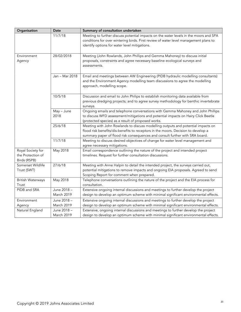
Copyright © 2019 Johns Associates Limited 6
4.4 Screening determination ............................................................................................................................... 35
5 SCOPING 37
5.1 Environmental factors ................................................................................................................................... 37
5.2 Scoping process ............................................................................................................................................ 37
5.3 Scoping of POTENTIAL environmental effects associated with dredging of the River Parrett ..................... 39
6 ES CONTENTS 55
Copyright © 2019 Johns Associates Limited 7
1 INTRODUCTION
1.1 BACKGROUND
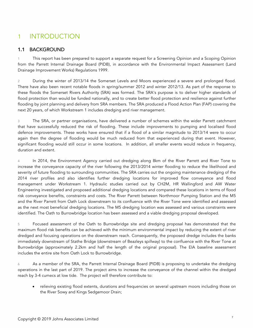
1 This report has been prepared to support a separate request for a Screening Opinion and a Scoping Opinion
from the Parrett Internal Drainage Board (PIDB), in accordance with the Environmental Impact Assessment (Land
Drainage Improvement Works) Regulations 1999.
2 During the winter of 2013/14 the Somerset Levels and Moors experienced a severe and prolonged flood.
There have also been recent notable floods in spring/summer 2012 and winter 2012/13. As part of the response to
these floods the Somerset Rivers Authority (SRA) was formed. The SRA’s purpose is to deliver higher standards of
flood protection than would be funded nationally, and to create better flood protection and resilience against further
flooding by joint planning and delivery from SRA members. The SRA produced a Flood Action Plan (FAP) covering the
next 20 years, of which Workstream 1 includes dredging and river management.
3 The SRA, or partner organisations, have delivered a number of schemes within the wider Parrett catchment
that have successfully reduced the risk of flooding. These include improvements to pumping and localised flood
defence improvements. These works have ensured that if a flood of a similar magnitude to 2013/14 were to occur
again then the degree of flooding would be much reduced from that experienced during that event. However,
significant flooding would still occur in some locations. In addition, all smaller events would reduce in frequency,
duration and extent.
4 In 2014, the Environment Agency carried out dredging along 8km of the River Parrett and River Tone to
increase the conveyance capacity of the river following the 2013/2014 winter flooding to reduce the likelihood and
severity of future flooding to surrounding communities. The SRA carries out the ongoing maintenance dredging of the
2014 river profiles and also identifies further dredging locations for improved flow conveyance and flood
management under Workstream 1. Hydraulic studies carried out by CH2M, HR Wallingford and AW Water
Engineering investigated and proposed additional dredging locations and compared these locations in terms of flood
risk conveyance benefits, constraints and costs. The River Parrett between Northmoor Pumping Station and the M5
and the River Parrett from Oath Lock downstream to its confluence with the River Tone were identified and assessed
as the next most beneficial dredging locations. The M5 dredging location was assessed and various constraints were
identified. The Oath to Burrowbridge location has been assessed and a viable dredging proposal developed.
5 Focused assessment of the Oath to Burrowbridge site and dredging proposal has demonstrated that the
maximum flood risk benefits can be achieved with the minimum environmental impact by reducing the extent of river
dredged and focusing operations on the downstream reach. Consequently, the proposed dredge includes the banks
immediately downstream of Stathe Bridge (downstream of Beazleys spillway) to the confluence with the River Tone at
Burrowbridge (approximately 2.2km and half the length of the original proposal). The EIA baseline assessment
includes the entire site from Oath Lock to Burrowbridge.
6 As a member of the SRA, the Parrett Internal Drainage Board (PIDB) is proposing to undertake the dredging
operations in the last part of 2019. The project aims to increase the conveyance of the channel within the dredged
reach by 3-4 cumecs at low tide. The project will therefore contribute to:
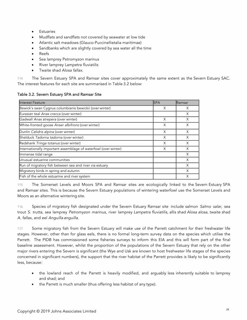
• relieving existing flood extents, durations and frequencies on several upstream moors including those on
the River Sowy and Kings Sedgemoor Drain;

Copyright © 2019 Johns Associates Limited 8
• reducing the duration of flooding to the surrounding road network; and
• reducing the flooding impacts on the wider community and businesses.
7 In addition to these direct benefits, this scheme, (alongside the other improvement works undertaken within
the FAP), will confer further benefits which are less readily quantified. By increasing the capacity of the channel this
will increase the overall flexibility in the system, and allow greater opportunities for more flexible operation within the
system. This can be especially important when flood events are localized more on one catchment than another, or if
emergency works need to be undertaken. Also, by increasing the flow passing Burrowbridge there will be an increase
in channel velocities during low tides. This will increase the natural erosion of sediment that happens in the
downstream channel, reducing the need for maintenance dredging.
8 The proposed dredging will be within the extents shown in Figure 1 below.
Figure 1. Plan showing extent of dredging and proposed working area
1.2 PURPOSE OF THIS REPORT
9 The proposed works could result in likely significant environmental effects in the absence of suitable scheme
design to avoid such effects or through appropriate mitigation. Consequently, the proposed works is considered to
fall under the Environmental Impact Assessment (Land Drainage Improvement Works) Regulations (SI 1999 No. 1783)
Copyright © 2019 Johns Associates Limited 9
(the ‘Land Drainage EIA Regulations’), which have been subject to significant revisions in 20051 and in 20172. The
1999 Regulations, and subsequent amendments, are referred to as the ‘Land Drainage EIA Regulations’ within this
report.
10 Environmental Impact Assessment (EIA) is process that ensures that the environmental effects of a proposed
development are fully considered and taken into account, before it proceeds. The EIA process is impartial and
systematic and it draws on a detailed understanding of current environmental conditions (the baseline), information
gathered during consultation, and from a detailed understanding of potential effects from the development. This
knowledge allows effects to be ‘designed’ out (e.g. avoiding dredging adjacent to residential properties) and where
this is not possible, allow suitable mitigation (e.g. providing alternative habitats for animals or improving water level
management) to be identified and included in the development proposal. Once these have been agreed and the final
design has been ‘frozen’ an assessment of likely effects is carried out. This focuses on those effects that are
considered to be significant. The findings of an EIA are reported in a document called and Environmental Statement
(ES), which has to meet certain legal standards, which broadly set the main headings, topics that need to be
considered, organisations that need to be consulted, stages of the project, timescales and types of effects and
mitigation that need to be taken into account.
11 Under the Land Drainage EIA Regulations, the Drainage Body (in this case, PIDB) is required, taking into
consideration the selection criteria in Schedule 2, to determine whether the proposed works are likely to have
significant effects on the environment (Reg. 4); and therefore, whether formal Environmental Impact Assessment is
required for this project. The process of determining whether proposed works require Environmental Impact
Assessment (EIA) or not is known as ‘screening’.
12 This report has been prepared to inform the EIA screening decision i.e. it considers and assesses whether the
proposed works are likely to have significant effects on the environment in the absence of appropriate detailed
design work to avoid such effects and/or the integration of appropriate mitigation.
13 This report therefore supports the advice to the PIDB that their Screening Opinion should be that an EIA is
required.
14 This report goes on to describe those environmental effects which are likely to be significant and that should
be taken forward for further detailed assessment within the EIA including consideration of changes in the design and
embedded/integrated environmental measures that will be adopted to minimise any residual effects. This process is
known as ‘scoping’.
15 The key aim of the scoping process as reported within this document, is to identify the likely significant effects
of the proposed works, describing those that need to be considered in depth as part of the EIA. By following the full
EIA process, PIDB will ensure that any potentially significant effects on the environmental resulting from proposed
pioneering dredging of the River Parrett are considered, and where appropriate, mitigated. By default, the scoping
process also identifies those effects which are not likely to be significant and can therefore be eliminated (or ‘scoped
out’) from the EIA.
16 This document is intended as an informal Scoping Report that meets the requirements of the Environmental
Impact Assessment (Land Drainage Improvement Works) Regulations (SI 1999 No. 1783). It therefore has been
1TheEnvironmentalImpactAssessment(LandDrainageImprovementWorks)(Amendment)Regulations2005(SI2005No1399)
2TheEnvironmentalImpactAssessment(LandDrainageImprovementWorks)(Amendment)Regulations2017(SI2017No585).
Copyright © 2019 Johns Associates Limited 10
produced to support advice to the PIDB for its Scoping Opinion on the content of the EIA. The PIDB may wish to
engage with other statutory consultees to inform its Scoping Opinion (e.g. Natural England and the Environment
Agency).
17 It will also be used as best practice dictates, by the project team to assist with proper targeting of the EIA and
ES, supported by the Screening Opinion from the PIDB. It is also intended that this information will help to engage
stakeholders during consultation, which in turn will feed into the developed scope of assessment and the remainder
of the EIA process.
18 However, it should be noted that the PIDB has indicated that it does not intend to make a formal request
under Regulation 8 to the Appropriate Authority (the Secretary of State) for its formal opinion as to the information
that should be included within an ES.
1.3 STUDY AREA CONTEXT
19 The Study Area for the EIA will include the maximum potential extent of dredged river, locations where
dredged material will be placed, access routes, compounds and the areas which could have resultant changes in
water levels. The general Study Area is shown in Figure 2 and covers:
• The River Parrett between Oath Lock and its confluence with the River Tone, immediately to the south of
Burrowbridge;
• 1km radius around this stretch of the river;
• For receptors where there are additional potential environmental pathways comprising changes to water
levels within different moors (e.g. a potential change in splash conditions required by wintering water
birds or flood depth and/or duration), the Study Area has been expanded.
20 The Study Area is predominantly rural in nature with a mixture of mainly livestock grazing with some arable
land, populated with small villages, hamlets and farms. The River Sowy flood relief channel runs parallel to the River
Parrett in the southern extent of the proposed dredging works. The A361 crosses the Parrett to the north of the
proposed dredging works at Burrowbridge. A main railway line runs adjacent to the River Parrett immediately to the
south of the proposed dredging works. The River Parrett Trail and Macmillan Way long-distance footpaths run along
the right-hand bank of the River Parrett throughout the extent of the proposed dredging works.
21 The Study Area encompasses land of international importance for wildlife, designated as part of the Somerset
Levels and Moors Special Protection Area and Ramsar Site (including component Sites of Special Scientific Interest
Southlake Moor and West Sedge Moor, which lie immediately adjacent to the proposed dredging works). In addition,
the non-statutorily-designated local wildlife site Aller Moor Site of Nature Conservation Importance (rhyne and wet
meadow site with an important wintering bird population) lies adjacent to the right-hand bank in the southern stretch
of river to be dredged.
Copyright © 2019 Johns Associates Limited 11
Figure 2. Plan showing extent of dredging, surrounding 1km study area, and key environmental designations
Other recent flood alleviation projects
22 A number of works aimed at alleviating flooding have recently been completed in the immediate area (since
2014) delivering considerable benefits to residents, landowners and tenants and to infrastructure through the overall
flood risk reduction achieved. The past projects completed along the Parrett and Tone since the flooding of
2013/2014 include those listed below. The extent of dredging works on the Parrett and Tone since 2014 is shown in
Figure 3 below.
• Completion of the dredging of the 8km reach between Hook Bridge on the River Tone and Northmoor
Pumping Station on the River Parrett by the Environment Agency.
• Dredging of the 750m reach of the River Parrett downstream of Northmoor Pumping Station by the
Environment Agency.
• SRA maintenance dredging of the EA profiles in 2015 using excavators and in 2016 and 2017 using
hydro-dynamic dredging techniques (water injection dredging or WID);
• The Asset Recovery Programme (ARP) improvement works to the flood banks.
• Improvement works to several pump stations, including the works associated with bringing in temporary
pumps.
Copyright © 2019 Johns Associates Limited 12
• The revised operating rules for the pumping stations following the ‘Trigger point’ project.
• Works at Beer Wall (A372) to increase the capacity of the culverts under the road.
• Changes to the operation of the River Sowy and Kings Sedgemoor Drain during flood events.
23 The EA are currently delivering improvements to the River Sowy and Kings Sedgemoor Drain on behalf of the
SRA. This project is being delivered in phases with the aim to increase the amount of flow that can be conveyed
through this system from the River Parrett prior to the formal spillways (Allermoor and Beazleys) being overtopped.
Upstream of Langport this project will deliver similar impacts to the dredging being considered by this report.
24 Awareness of the SRA Flood Action Plan and ongoing programme for flood alleviation since 2014 is an
important part of the cumulative impacts assessment within the EIA process and cover both past and present
cumulative impacts.
Figure 3. Extent of dredging works on the Rivers Parrett and Tone 2014 – present day
Copyright © 2019 Johns Associates Limited 13
1.4 PROPOSED WORKS
25 The site under consideration comprises approximately 2.2km of the banks of the River Parrett between
Beazley’s spillway and its confluence with the River Tone (see Figure 1). This represents a shortened section of the
overall Site from Oath Lock to Burrowbridge and is based on the outcome of environmental surveys, environmental,
engineering and safety assessments, and the detailed hydraulic modelling indicating the areas with the maximum
potential for improvement to flood conveyance. No dredging is proposed between Oath Lock and Beazleys spillway
within this programme of works. Over part of the length of these works, the right bank acts as both a flood bank to
contain flows within the river, and a reservoir bank to contain floodwater within Southlake Moor. The possible works to
this length of bank are limited due to these functions.
26 The works will comprise excavation to increase the flow capacity in the Parrett by approximately 3-4 cumecs
at low tide within the dredged reach by excavating accumulated silt back to the design gradient of the bank, to form
a two-stage channel. 22,000m3 of silt will be removed in total from the banks within the 2.2km of dredging works. All
arisings from the excavation are proposed to be deposited on the landward side of the right flood bank crest (facing
downstream) under conditions of D1 and U1 waste exemptions. The level of the bank crest is not to be raised above
existing levels. A sample cross-section showing the proposed excavation and placement of arisings is shown as Figure
3.
Figure 3. Sample cross section illustrating the works
27 Excavation will remove recent accumulations of silt on the upper banks only. No dredging below the lower
flow channel (thalweg) is proposed. A ‘reedy fringe’ of 1-2m width of marginal vegetation (typically dominated by
reed canary grass Phalaris arundinacea) will be left along all of the left-hand bank and up to 1000m of the right-hand
bank to ensure critical habitat for aquatic fauna is retained at all times. Strip and recover/replanting of reed turf and
rhizomes for a further 1-2m of bankface will be provided behind the reedy fringe wherever feasible. Re-establishment
of vegetation beyond this will be achieved using a suitable seedmix.
28 Bank re-profiling will be managed sensitively, in order to reduce environmental impacts, mitigate impacts on
the working bank and aid ecological recovery.
29 Long-reach excavators, meeting all current environmental and operating standards and Environment Agency
specifications, working from, or near, the bank crest will be used for the cut and fill earthworks. Topsoil will be
stripped from the landward bank where excavated material is to be deposited to form a raised bund along the
proposed toe line for fill material. Topsoil will also be stripped from the ‘cut’ area and added to this bund. Machines
will then excavate to the design profile, swinging round to place arisings in the ‘fill’ location to the rear of the flood
bank.

Copyright © 2019 Johns Associates Limited 14
30 The fill material will be allowed to dry out as necessary before it is graded and consolidated to the design
profile. The stripped topsoil will then be dressed back over the fill material. Light harrowing will then be undertaken
before seeding of the fill area.
31 It should be noted that the two-stage channel excavation will create marginal berms and areas of shallow
water, which have potential to substantially increase habitat diversity, particularly for fish populations. In addition,
morphological diversity will be retained on the river bank wherever possible. The bank surface will not be finished to
a smooth compacted surface: final roughing up with a toothed bucket will help assist vegetation become established
on the bank which will then assist with bank stability.
32 Vegetation recovery behind the retained reedy fringe will comprise reseeding using local native grass
dominated species. A stockproof fence and hedge will be provide at the outer toe of the regraded bank to provide
additional habitat features and to support appropriate and timely access of grazing livestock to the banks. Restoration
of poor quality rhynes will be implemented. The proposed hedge and rhyne works will provide a greater than 2:1
compensation of where these habitats necessarily will be modified through the proposals.
33 Dredging plant will access the right banks within the Working Area via the flood embankment of the River
Sowy (accessed from Stathe Bridge). It is proposed that the long reach excavators will only work from the crest of the
right bank to remove sediment from both the right and left of the channel (reaching across the channel) and deposit
silt on the rear downslope of the right bank.
34 A site compound will be provided adjacent to the working area and will include a welfare unit for staff, staff
parking for vehicles, a storage container and fuel bowser. It is anticipated that the mobile fuel bowser will be
transported to the excavators along the banks as necessary. The mobile fuel bowser will be deployed in accordance
with good practice EA guidance, with necessary spillage procedures and kits in place.
35 The works will commence in August 2019, with dredging commencing in September 2019. It is anticipated
that all works will be completed within ten weeks, although there is potential for the works to over-run. Further activity
to finalise bank profiles, vegetation restoration/management, deliver wider ecological enhancement and commence
post works monitoring will occur in 2020.
1.5 CONSENTING REGIME
1.5.1 Planning Acts
36 The proposal to dredge the watercourse is considered to be improvement works that are a development
activity. All proposed works (dredging and deposition of dredged arisings) will take place on the banks of the River
Parrett, defined as a main river and under the statutory authority of the Environment Agency. The works will be carried
out by the PIDB using powers delegated by the Environment Agency through a Public Sector Cooperation
Agreement (PSCA). As such, the works fall within the Environment Agency’s permitted development rights under
Class D of Part 13 (water and sewerage) of Schedule 2 to the Town and Country Planning (General Permitted
Development) (England) Order 2015:
Class D – development by the Environment Agency (58)
“Development in, on or under any watercourse or land drainage works and required in connection with the
improvement, maintenance or repair of that watercourse or those works.”
Copyright © 2019 Johns Associates Limited 15
1.5.2 Environmental Impact Assessment
37 ‘Improvement works’, as defined under Regulation 2(1) of the Environmental Impact Assessment (Land
Drainage Improvement Works) Regulations (SI 1999 No. 1783) (as amended in 20053 and 20174) (the ‘Land Drainage
EIA Regulations’), are works which are:
(i) the subject of a project to deepen, widen, straighten, or otherwise improve or alter, any existing
watercourse or remove or alter mill dams, weirs, or other obstructions to watercourses, or raise, widen, or
otherwise improve or alter, any existing drainage work; and
(ii) permitted development by virtue of Class C or Class D of Part 13 (water and sewerage) of Schedule 2 to
the Town and Country Planning (General Permitted Development) (England) Order 2015.
38 The proposal to dredge the watercourse and return it to its baseline condition, are considered to be
improvement works as per the bold highlighted definition above; and are further considered to be permitted
development. Therefore, the Land Drainage EIA Regulations apply to these works.
39 It is the ‘Drainage Body’ who is responsible for implementing the Land Drainage EIA Regulations. The
‘Drainage Body’ as defined by the Land Drainage EIA Regulations comprises a public authority initiating improvement
works, which can include an internal drainage board. As it is PIDB initiating the works, it is therefore PIDB who are
responsible for implementing the Land Drainage EIA Regulations and assessing whether any likely significant
environmental effects are likely to arise due to the works. In the event that formal EIA is required (screening), it is
PIDB 5 who will decide whether the improvement works should proceed, taking into account the necessary mitigation
measures (or conditions) that the works should be subject to.
40 This document has been prepared to record the initial screening and scoping stages of the EIA process (see
Sections 4 and 5).
1.5.3 Environmental Permits
41 Placement of dredging arisings on the rear of the flood bank will be undertaken in accordance with the
Environmental Permitting Regulations 2010 as amended). The deposition of dredging waste will be covered by a D1
exemption to deposit dredged waste from inland waters and is therefore exempt from the requirement for an
Environmental Permit. Sediment sampling has been carried out and confirms the waste code of the dredged arisings
and the suitability for use under a D1 exemption.
42 The D1 exemption requires that all deposition is carried out under one mechanical action and allows for up
to 50,000m3 of silt deposition over every metre of inland water dredged. The D1 exemption also allows for the
temporary stockpiling of material for up to 1 year should this be required (only 6 months is allowed under the
permitted development rights).
3TheEnvironmentalImpactAssessment(LandDrainageImprovementWorks)(Amendment)Regulations2005(SI2005No1399).
4TheEnvironmentalImpactAssessment(LandDrainageImprovementWorks)(Amendment)Regulations2017(SI2017No585).
5UnderRegulation12AoftheEnvironmentalImpactAssessment(LandDrainageImprovementWorks)(Amendment)Regulations2017(SI2017No585),SBDC
mayonlyprogressthedeterminationofwhethertheimprovementworksshouldproceedifthereisnoextantobjectioninrelationtothelikelysignificant
environmentaleffectsoftheworks.
Copyright © 2019 Johns Associates Limited 16
43 It is not anticipated that there will be a requirement to manage the dredging waste in more than 1 mechanical
action.
44 A U1 waste exemption would also be registered, allowing the dredged waste to be used in construction (i.e.
river bank structural support) and for specific spillway works.
1.5.4 SSSI Assent
45 The improvement works are partly located within the boundary of Southlake Moor Site of Special Scientific
Interest (SSSI). In addition, the works have the potential to damage the condition or special features of other SSSIs,
including Curry and Hay Moors SSSI and West Sedgemoor SSSI.
46 As such, these works would require advice and approval (known as assent) from Natural England before
carrying out the improvement works. However, where works are carried out under statutory permission (Environment
Agency powers) they do not require a formal application for SSSI assent but instead require consultation with Natural
England prior to works commencing. Consultation has been started with Natural England for this purpose.
1.5.5 Habitats Regulations
47 The SSSIs referred to above are also internationally designated as part of a network of ‘Natura 2000’ sites: the
Somerset Levels and Moors Special Protection Area (SPA) and Ramsar Site.
48 As the improvement works, in the absence of mitigation, could result in impacts to the SPA and Ramsar site, a
Habitats Regulations Assessment (HRA) will be required under the Conservation of Habitats and Species Regulations
(2017). It will be necessary to demonstrate that the improvement works will not adversely affect the integrity of the
SPA and Ramsar site, known as Appropriate Assessment.
49 PIDB are a ‘Competent Authority’ under the Habitats Regulations and will therefore undertake Habitats
Regulations Assessment, consulting with Natural England as required by Regulation 63. Coordination with Natural
England in accordance with Regulation 67 will also be required, as Natural England are also a Competent Authority
with regards to these improvement works.
50 This document has been prepared to jointly inform the proposed scope of the Stage 1 HRA.
1.5.6 Water Framework Directive
51 Public bodies, including PIDB, must, in exercising their functions so far as affecting a river basin district, have
regard to the river basin management plan prepared under The Water Environment (Water Framework Directive)
(England and Wales) Regulations 2003.
52 As such, PIDB will be required to undertake a Water Framework Directive (WFD) Compliance Assessment to
demonstrate that the improvement works support the objectives of the South West River Basin Management Plan
(RBMP).
Copyright © 2019 Johns Associates Limited 17
2 METHODOLOGY
2.1 APPROACH TO DEFINING THE BASELINE
53 The assessment of potentially significant effects requires a comparison to be made between the likely
environmental conditions in the presence of the proposed improvement works and in its absence (i.e. the ‘baseline’).
54 The ‘current baseline’ represents the conditions on the ground at the time of preparation of the
Environmental Statement (ES) (detailed surveys conducted in late spring/ summer 2018, which have informed the
detailed design iteration including engineering and hydrological investigations and this screening/scoping report and
to be updated in late spring 2019).
55 In the context of the River Parrett and River Tone, a number of recent flood alleviation measures have been
implemented since the flooding of 2013/2014 and had an impact on the fluvial environment. The current
environmental baseline is therefore inclusive of these recently completed projects and the considerable betterment
provided, in particular, those listed below:
• 2014 Environment Agency Phase 1 and 2 8km capital dredge of the River Parrett and Tone.
• 2015 Environment Agency 750m capital dredge.
• The Asset Recovery Programme (ARP) improvement works to the flood banks.
• Improvement works to several pump stations, including the works associated with bringing in temporary
pumps.
• The revised operating rules for the pumping stations following the ‘Trigger point’ project.
• Works at Beer Wall (A372) to increase the capacity of the culverts under the road
• Changes to the operation of the River Sowy and Kings Sedgemoor Drain during flood events.
• Ongoing SRA maintenance dredging to retain the 2014/15 dredge river cross sectional profiles.
• Other flood alleviation works completed between 2015 and 2019.
56 This allows for the potential impacts of the proposed Oath to Burrowbridge dredge to be considered in the
context of the cumulative changes to the system since the floods of 2013/2014 and the ongoing flood alleviation
works.
57 The current Environmental baseline therefore comprises the status of the River Parrett at the time of
preparing this EIA investigation (2019).
58 The Land Drainage EIA Regulations (Schedule 1) also require analysis of the likely evolution of the baseline
scenario without implementation of the improvement works as far as natural changes from the baseline scenario can
be assessed with reasonable effort on the basis of the availability of environmental information and scientific
knowledge.
59 As such, when assessing the potential environmental effects of the proposed improvement works, account
has also been taken of the ‘do-nothing scenario’ and the ‘future baseline’. This ensures that ongoing trends and
changes to the baseline environment, as a result of both natural and manmade processes, can be factored into the
assessment.
60 The future baseline scenario for the River Parrett and Tone environment could be reasonably considered to
include the ongoing maintenance dredging operations to retain the conveyance capacity achieved on the rivers since
Copyright © 2019 Johns Associates Limited 18
2014 for the remainder of the SRA 20 Year Flood Action Plan duration (15 years). The exact location and quantity of
future dredging maintenance will be informed by silt monitoring, refinements in methodology and lessons learnt. The
future baseline should therefore expect maintenance dredging to be continued as per present operations over the
short-medium term. Some consideration should be given to a ‘no maintenance’ future scenario that could result from
a change to policy, funding or over a longer timescale.
61 As described above, the Environmental Impact Assessment will therefore include consideration of two
baseline scenarios:
• Current baseline
• Future baseline
2.2 APPROACH TO DETERMINING LIKELY SIGNIFICANT EFFECTS
62 Decisions about the likely significant effects of the proposed improvement works have been based upon
professional judgement, with reference to the project description, and using information about:
• the receptors (people and environmental resources) that could be affected by the proposed improvement
works;
• the activities involved in undertaking the proposed improvement works;
• changes that could result from these activities (e.g. changes in water quality or land cover as a result of
the proposed improvement works);
• the expected magnitude and other characteristics of the environmental changes that could result from
these activities and that could affect important receptors;
• the susceptibility of important receptors to exposure to these changes e.g. how biodiversity receptors
might be affected by changes in land cover); and
• the extent to which the design of the proposed improvement works avoids or reduces any potential
effects.
63 If the information available at the time at which this document has been prepared does not enable a robust
conclusion to be reached that a potential effect is not likely to be significant, the precautionary principle is assumed
i.e. it is assumed that the potential environmental effect is likely to be significant.
2.3 CUMULATIVE IMPACT ASSESSMENT
64 There is a requirement under the Land Drainage EIA Regulations to consider the cumulative effects of the
proposed improvement works. This will identify whether any of the individual effects of the proposed improvement
works would combine to create a cumulative effect greater than the sum of the individual effects.
65 The cumulative effects assessment process considers this in two ways:
• Intra-project effects: Typically, these effects occur when different activities associated with a project act
upon the same environmental receptor. In determining such effects, consideration would be given to the
sensitivity of the receptor and the magnitude of environmental change. Consideration is given to both
the interaction of significant effects and the interaction of different impacts from project activities even if
individually they are not significant.
• Inter-project effects: Consideration will be given to whether there is the potential for the effects of the
proposed improvement works and effects of other ‘major’ developments to combine and result in a
significant environmental effect. Only potential cumulative impacts arising from ‘known’ developments or

Copyright © 2019 Johns Associates Limited 19
projects will be considered, i.e. only those projects that are within the public domain and for which
sufficient information is available.
66 In the first instance, a list of developments or projects to be included within the cumulative impact assessment
will be compiled and agreed. These projects will be screened in or out for further assessment. Following early
consultation with relevant bodies, the following major developments have been proposed for inclusion within the
cumulative impacts assessment:
• Ongoing agreed maintenance dredging.
• SRA Sowy Scheme (partial assessment only of hydraulic impacts).
67 The potential impacts of the proposed improvement works in-combination with following river projects on the
River Parrett and Tone will be assessed via reference to the relevant baselines, as described in section 2.1 above:
2.4 CONSULTATION
68 A range of statutory and non-statutory consultees have been engaged to inform the scope of the EIA (and
also the HRA and WFD assessment). A summary of the consultation undertaken to date has been provided in Table 1
below. Consultation with these and other organisations and with the public will continue iteratively throughout the
EIA process.
Table 2.1. Summary of consultation
Organisation Date Summary of consultation undertaken
South West Historic
Trust
27/3/18 Phone conversation and email from Dr Richard Brunning (Senior Historic Officer)
confirming that there are no apparent impacts to the historic environment from the
dredging of material from the river, the deposition of the dredged material onto the
existing floodbanks or the use of heavy machinery on the floodbanks.
Working compounds should be sited to avoid known archaeological sites, especially
the deserted medieval hamlets on the north bank of the river.
Natural England 2/5/18 Meeting (Mark Jones, Donna Gowler, Stephen Parker) to discuss scope of HRA; HRA
monitoring undertaken to-date relating to previous dredging works; best way to
progress mitigation and monitoring required for European sites; projects that need to
be assessed ‘in-combination’. It was agreed that Stephen would undertake initial
assessment of breeding bird surveys and BTO WeBS data to assess whether there is a
demonstrable link between dredging and decline in habitat suitability for wintering
water birds.
May 2018 Consultation with Natural England to agree the approach to water vole survey; and
potential approaches to mitigation. Included an email from Mark Jones (8/5/8)
confirming possible approach to licensing; and an email from Claire Howe (17/5/15) on
required extent and scope of water vole survey.
29/6/18 Meeting (Mark Jones, Stephen Parker) for initial discussion on the outcome of the
hydraulic modelling with regards to water levels on the moors during low magnitude
flood events (and the potential impacts on SPA conditions/target water levels for over
wintering birds). It was agreed to further process the data for further analysis during
the next meeting.
Copyright © 2019 Johns Associates Limited 20
Organisation Date Summary of consultation undertaken
11/7/18 Meeting to further discuss potential impacts on the water levels in the moors and SPA
conditions for over wintering birds. First review of water level management plans to
identify options for water level mitigations.
Environment
Agency
28/02/2018 Meeting (John Rowlands, John Phillips and Gemma Mahoney) to discuss initial
proposals, constraints and agree necessary baseline ecological surveys and
assessments.
Jan – Mar 2018 Email and meetings between AW Engineering (PIDB hydraulic modelling consultants)
and the Environment Agency modelling team discussions to agree the modelling
approach, modelling scope.
10/5/18 Discussion and email to John Philips to establish monitoring data available from
previous dredging projects; and to agree survey methodology for benthic invertebrate
surveys.
May – June
2018
Ongoing emails and telephone conversations with Gemma Mahoney and John Phillips
to discuss WFD assessment/mitigations and potential impacts on Hairy Click Beetle
(protected species) as a result of proposed works.
25/6/18 Meeting with John Rowlands to discuss modelling outputs and potential impacts on
flood risk benefits/dis-benefits to receptors in the moors. Decision to develop a
summary paper of flood risk consequences and consult further with SRA board.
11/7/18 Meeting to discuss desired objectives of change for water level management and
agree necessary mitigations.
Royal Society for
the Protection of
Birds (RSPB)
May 2018 Email correspondence outlining the nature of the project and intended project
timelines. Request for further consultation discussions.
Somerset Wildlife
Trust (SWT)
27/6/18 Meeting with Anne Halpin to detail the intended project, the surveys carried out,
potential mitigations to remove impacts and ongoing EIA proposals. Agreed to send
Scoping Report for comment when prepared.
British Waterways
Trust
May 2018 Telephone conversations outlining the nature of the project and the EIA process for
consultation.
PIDB and SRA June 2018 –
March 2019
Extensive ongoing internal discussions and meetings to further develop the project
design to develop an optimum scheme with minimal significant environmental effects.
Environment
Agency
June 2018 –
March 2019
Extensive ongoing internal discussions and meetings to further develop the project
design to develop an optimum scheme with minimal significant environmental effects.
Natural England June 2018 –
March 2019
Extensive, ongoing internal discussions and meetings to further develop the project
design to develop an optimum scheme with minimal significant environmental effects.
Copyright © 2019 Johns Associates Limited 21
3 SUMMARY ENVIRONMENTAL BASELINE
69 A brief description of the environmental baseline, as understood at this screening/ scoping stage has been
provided below.
3.1 POPULATION AND HUMAN HEALTH
70 The immediate Study Area in the vicinity of the worlds (Figure 2) encompasses a number of small villages and
hamlets as well as numerous farms. The hamlet of Stathe is located on the left-hand bank approximately half way
along the dredged stretch. There are a number of properties (40-50) that are located adjacent to the river on the
dredged stretch. The village of Burrowbridge is located at the downstream (northern) end of the works.
71 The wider area affected by changes to fluvial flooding and water levels as a result of the proposed works
includes properties, businesses, infrastructure (e.g. road network) and agricultural land within or adjacent to the
Parrett catchment moors upstream of the proposed works, and on the Sowy and Kings Sedgemoor Drain moors.
72 The Study Area is spatially dominated by aspects of the rural economy, such as fields of grazing livestock
and arable land. Much of the land is floodplain which is grazed typically by cattle and sheep. Much of the land within
the Study Area is covered by the Environmental Stewardship and Countryside Stewardship agri-environment schemes
that provide funding to farmers to deliver effective environmental management. Much of the land within the Study
Area is covered by Entry Level and Higher Level schemes as part of the overall Environmental Stewardship Scheme.
The Environmental Stewardship scheme is now closed to new applicants, although the existing schemes below will
run until the end of the agreement (10 years for most Higher Level schemes and 4 years for Entry Level). The new
Countryside Stewardship (CS) scheme was introduced during late 2016; and several farms within the Study Area are
now covered by Mid and Higher Tier CS schemes.
73 However, it should be noted that the most recent Census data for the area shows a spread of economic
activity in which the local population are engaged. The most dominant industry in terms of numbers employed in the
area, and in Somerset as a whole, is the wholesale and retail trade. Human health and social work and education are
also notably high employment areas. Agriculture, forestry and fishing account for a relatively small proportion of
employment (Somerset County Council Partnership Intelligemce Unit, 2011)
74 The main fisheries use of the Parrett and Tone is the glass eel fishery. This operates from the 14th February
to the 25th May annually. Licences are issued by the Environment Agency on an unlimited basis (i.e. there is no
limit to the number issued). In 2013, 169 licences were issued, which resulted in the capture of 4,000kg of glass
eels. This comprises 90% of the Environment Agency south-west region, and 40% of the total UK glass eel catch. The
economic value of the fishery fluctuates annually, depending on the prevailing market price of glass eels, which is
in turn a reflection of supply (i.e. natural abundance and catches). Thus, in 2013 the value was £100/kg, which, given
the capture of 4,000kg would have given the fishery a value of £400,000. In May 2018, the Environment Agency
reported the current legal market value of glass eels as £150/kg. However, in other years the market value has risen
as high as £250-£300/kg.
3.1.1 Recreation
75 Long Distance Paths are recreational trails which can, to varying degrees, be used for a range of non-
motorised travelling options (including walking, cycling and horse riding). Typically, they will be at least 31 miles
Copyright © 2019 Johns Associates Limited 22
(50km) long and will take the user more than a day to walk, but many are much longer than this. The Long-Distance
Paths in the Study Area (see Figure 2) are comprised of a mix of Public Rights of Way (PRoWs) and permitted paths.
76 There are three Long Distance Paths within the Study Area – these are the River Parrett Trail, East Deane
Way and Macmillan Way West (as shown on Figure 2). These paths are all in close proximity to the proposed dredging
locations along the River Parrett; and run along the right-hand bank of the channel for the entire dredging stretch.
The Parrett Trail section immediately adjacent to the dredging works is majority permitted path (2105m). This section
of path is permitted by Natural England as the landowner. A small section of path adjacent to planned dredging
works (immediate downstream of Beasleys spillway and Stathe Bridge) is a PRoW footpath (approx. 50m).
3.1.2 Tourism
77 Burnham-on-Sea is a designated beach for bathing and is tested by the Environment Agency regularly under
the EU Bathing Water Directive (2006/7/EC). Burnham-on-Sea is located approximately 3km downstream of the
confluence of the River Parrett with the Severn Estuary. The confluence is approximately 30km from the
downstream extent of the dredging area.
78 Many tourism-related businesses in Burnham-on Sea are reliant on the quality of the beach and bathing
water and could suffer if the bathing water quality does not satisfy the requirements of the new Directive in 2015.
79 A water quality warning is currently in place for Burnham Jetty North and bathing is therefore not advised at
this area due to poor water quality (based on monitoring results from 2014 to 2017). This bathing water is subject to
short term pollution. Short term pollution is caused when heavy rainfall washes faecal material into the sea from
livestock, sewage and urban drainage via rivers and streams. At this site, the risk of encountering reduced water
quality increases after rainfall and typically returns to normal after 1-3 days. The Environment Agency makes daily
pollution risk forecasts based on rainfall patterns and will issue a pollution risk warning if heavy rainfall occurs to
enable bathers to avoid periods of increased risk. 63 warnings advising against swimming due to an increase risk of
short term pollution were issued in 2017 for Burnham Jetty North bathing water (Environment Agency, n.d.).
80 The Somerset Levels are a popular destination for walkers, cyclists, ornithologists, photographers, for arts and
crafts and broader tourism.
3.2 TRAFFIC AND TRANSPORT
81 The local road network incorporates one main road (the A361) which runs through Burrowbridge immediately
to the north of the proposed dredging works. Through its connections with the A372 and A38, this road provides
connectivity for local communities within the Study Area to nearby towns such as Taunton, Bridgwater and
Glastonbury; as well as providing an important access route for emergency services. The A361 crosses the River
Parrett at Burrowbridge immediately to the north of the proposed dredging works.
82 There are also a large number of interconnected secondary local roads within the Study Area. Many of
the secondary roads are below 4m in width and serve to connect small communities and farms with the rest of the
road network and surrounding villages. In places, the secondary roads also form part of Long Distance Paths.
83 Of these secondary local roads, Stathe Road runs alongside the left-hand bank of the River Parrett for the
entire dredging stretch, before it crosses the River Tone close to its confluence with the Parrett at Burrowbridge
(Stanmoor Bridge). There are no other road bridges associated with this stretch of the River Parrett.
Copyright © 2019 Johns Associates Limited 23
84 Much of the local road network (including the A361) was flooded during the recent flooding events, in
particular the winter flooding of 2013/14. Flood risk to this road has been significantly improved as a result of the
flood risk benefits achieved by the 2014/15 capital dredges and the further SRA improvement works. However, the
road remains at risk of future flooding in extreme events.
85 A major railway line runs through the Study Area east-west, connecting London to Devon and Cornwall
(through Taunton). A second line runs through North Moor connecting Bristol to towns in Devon and Cornwall. This
line was closed during the 2013/14 flood event, but significant improvement works have been undertaken to the line
since this time to increase its resilience to flooding.
3.3 GEOLOGY AND SOILS
86 The superficial deposits underlying the area of proposed works comprises alluvium. This normally comprises
soft to firm consolidated, compressible silty clay, but can contain layers of silt, sand, peat and basal gravel. A stronger,
desiccated surface zone may be present.
87 The bedrock geology comprises the Mercia Mudstone Group, comprising dominantly red, less commonly
green-grey, mudstones and subordinate siltstones with thick halite-bearing units in some basinal areas. Thin beds of
gypsum/anhydrite widespread; sandstones are also present. The Mercia Mudstone Group outcrops near to the left-
hand bank of the Parrett at Stathe (British Geological Society , n.d.).
88 Soil type in the Study Area comprises loamy and clayey floodplain soils with naturally high groundwater. The
surrounding areas on marginally higher ground such as Stoke St Gregory are characterized by slightly acid loamy and
clayey soils with impeded drainage. Outside of the Study Area, isolated areas of fen peat soils are located on some of
the nearby moors such as West Sedgemoor and Kings Sedgemoor.
89 According to the provisional Agricultural Land Classification (ALC) of England & Wales, agricultural land may
be graded with regards to its quality. This takes into account the limitations of the land, typical cropping range
and the expected level and consistency of yield. The most productive and versatile land falls into grades 1, 2 and sub-
grade 3a, and collectively comprises about one third of agricultural land in England and Wales. Land which falls
into sub-grade 3b is considered moderate quality. Grade 4 and 5 land is considered poor, or very poor, producing
very low yields. The provisional ALC within the Study Area (Natural England, 2010) shows that Grade 3 agricultural
land is the dominant land use in the Study Area with small areas of Grade 2 (good) and Grade 4 (poor) agricultural
land also being present.
3.4 SEDIMENT QUALITY
90 Extensive sampling, chemical analyses and screening of the sediment within the site of the proposed
dredging has been completed in 2018 to ensure that there is no risk to human health or the environment from the
deposited sediment. Options for spreading the sediment to agricultural land and waste disposal have also been
explored. Geotechnical analysis in the form of Particle Size Distribution testing has been carried out to determine the
grading of the sediment.
91 Overall the sediment appears to be of good chemical quality, with no exceedances of any of the screening
criteria recorded in any of the samples. The sediment can be classified as ‘Dredging spoil not containing hazardous
substances’ with the European Waste Code (EWC) 170506. Based on the analyses carried out, the sediment is
suitable for bankside retention, and does not pose a risk to human health. The sediment passed the SSV and PTE
screening criteria, indicating that there are no contaminants present which would be detrimental to agricultural land.

Copyright © 2019 Johns Associates Limited 24
From the testing carried out to date, it appears that the sediment contains no anthropogenic contaminants of concern
which would complicate disposal.
3.5 WATER ENVIRONMENT
3.5.3 Catchment
92 The Parrett and Tone rivers and associated tributaries flow from their source in the Quantock and Brendon
Hills, Blackdown Hills and Dorset Heights to the southwest and east of the catchment and flow in a north and
westerly direction into an extensive lowland floodplain, before flowing out into the Bristol Channel through the
Parrett Estuary.
93 The watercourses in this catchment are typically steep, narrow and unconstrained in the uplands; while
further downstream they are slower moving and heavily constrained by flood embankments, particularly through the
low-lying, flat floodplain characteristic of the Somerset Levels and Moors, where the lowland rivers are known as
‘high-level carriers’. These are watercourses that are embanked on both sides, fully or partially straightened and
counter-drained on either side. Their normal water levels are set above the level of the surrounding floodplain.
The whole lowland area of the catchment is heavily dependent on a controlled system of drainage and water level
management, which has been in place for hundreds of years.
94 The lower reaches of the River Parrett and Tone are tidally influenced for about 30-40km inland
depending on the height of the tide. The flood tide brings in sediment up the watercourse from the Severn Estuary.
These tidal sections are depositional in nature and their sediment dynamics and modified physical form control
the nature of flows and the habitats for flora and fauna. During periods of high fluvial flow following rainfall, the
river will erode some of this sediment and convey it towards the Severn Estuary. Generally, this only occurs within the
lower parts of the channel, but will also often lead to slumping of the deposited sediment above this level.
95 The capacity of the main river, tributaries and drainage channels to discharge fluvial flows can be significantly
reduced by high tidal water levels backing up flow in the tidal River Parrett and Tone. Due to the very low gradient of
the lowland river system and current system of management in this area, the lowland rivers readily (annually) overtop
their embankments so that floodwater is temporarily stored in the moors before it slowly drains away or is pumped
back into the river system.
96 The underlying rock types influence the catchment’s response to rainfall, with relatively fast run-off from the
impermeable uplands in the east and water- logged conditions dominating the lowlands. The area does not
have any major aquifers so groundwater flooding is not a major risk; however, flooding in lowland areas, can take a
long time to drain away.
3.5.4 Hydrogeology
97 The area is underlain by the Tone and Somerset Streams groundwater body. The bedrock is Mercia
Mudstone which is not an aquifer. At the Curry Moor pumping station, a borehole indicates that the depth to
bedrock is about 15m. Soft alluvial clays and silts overlie a well- defined peat layer. Below this there is firm alluvial
clay above the Mudstone. None of these materials are considered to be aquifers.
Copyright © 2019 Johns Associates Limited 25
3.5.5 Water Framework Directive
98 The Study Area falls within the South West River Basin District and within the River Parrett WFD catchment.
The proposed dredging works will be undertaken within the Parrett Transitional water body (ID GB540805210900),
which is classified in the 2015 South West River Basin Management Plan (RBMP) (Department for Environment, Food
& Rural Affairs and the Environment Agency, 2015) as a heavily modified water body (HMWB) for the purpose of flood
protection. The water body is currently assessed as being moderate overall status (moderate ecological and good
chemical), with a target of good potential by 2027. The classification of the water body as heavily modified under the
WFD recognises the importance of the water body for flood protection, but dictates that any works must not prevent
delivery of measures that have been identified to improve the water body’s ecological potential.
99 The RBMP identifies that the major causes of water quality issues within the catchment are diffuse run- off
from agricultural land as well as discharges from sewage treatment works. Fine solids running off land or from
sewage discharges can carry an excess of nutrients that cause an imbalance in the river leading to algal blooms and
water quality problems. Too much fine sediment can also settle in the river bed, preventing a good flow of oxygen for
benthic fauna and flora. The specific methods and timings proposed by this pioneer dredging project have been
partially selected to minimise such effects on water quality.
100 The River Parrett discharges at Bridgwater Bay where there are six designated Bathing Waters in
neighbouring catchments, including the ‘Burnham Jetty North’ (Burnham-on-Sea) Bathing Water Quality Area (see
Section 3.1.2 above). Burnham is a sand and mud beach, approximately 2.2 kilometres wide with a shallow slope
backed by a sea defence wall. The beach has a very large tidal range so it can be up to half a kilometre to the sea at
low tide.
3.5.6 Flood Management
101 During fluvial flooding, there is wide scale inundation of the moor areas in the Parrett catchment. Depending
on the moor, this flooding can either drain back to the river by gravity when river levels recede, or has to be pumped
back into the river. Flooding happens to a large area of moors upstream of Langport, which acts to restrict the flow
passing this point in a flood. Pumping out of these moors is restricted partially based on when the spillways are
overtopping on the rivers downstream of Langport.
102 The flood water that does continue downstream of Langport either passes into the River Sowy via Monks
Leaze Clyse sluice or the spillways, or continues down the River Parrett. Flood water in the River Sowy is discharged
into the Kings Sedgemoor Drain, which then discharges into the River Parrett at low tides at Dunball Sluice. The River
Parrett is joined by the River Tone at Burrowbridge. During flood conditions, flow passes over spillways and banks
from the River Tone into Curry and Hay Moors. The amount of overtopping will be partially influenced by the flows
within the River Parrett.
103 During very extreme flood events (as happened in 2013/14), flood water can then pass from Curry Moor into
Salt and North Moors via Athelney spillway and Lyng Cutting. This can lead to flooding to the communities of
Moorland and Fordgate.
104 The works that have been undertaken by the SRA and partner organisations following the 2013/14 flood have
significantly reduced the risk of flooding. The greatest reductions in flood risk have been to Curry, Hay, North and Salt
Moors. The impact is most pronounced on North Moor, where, if the 2013/14 flooding was to be repeated, the scale
of flooding would be dramatically reduced.
Copyright © 2019 Johns Associates Limited 26
3.6 LANDSCAPE AND VISUAL
3.6.7 National Character Area
105 The Study Area is within National Character Area (NCA) number 142: Somerset Levels and Moors. This NCA
extends from the Bristol Channel coastline between Stolford and (but not including) Clevedon and inland in
stretches loosely encompassing the Rivers Parrett, Brue, Axe and Kenn. This area includes Bridgwater, Weston-
Super-Mare, Burnham-on- Sea and the majority of Street.
106 Key characteristics of this NCA as defined by Natural England include the following:
• Flat, open landscape of wet pasture, arable and wetland divided up by wet ditches or 'rhynes'.
• Absence of dispersed farmsteads or any buildings on levels and moors. Nucleated settlements on
ridges/islands.
• Surrounded, and divided up, by low hills, ridges and islands which form distinctive skylines.
• Peat working and nature reserves contrasting with the rectilinear planned landscape of the Moors.
• Dramatic and prominent hills such as Barrow Mump, rising above the Levels and Moors.
• Sparse tree cover on Levels and Moors contrasting with woodland, hedges and orchards of
surrounding hills.
• Sparsely populated Moors but settlements common on hills, ridges and islands.
• Historic landscape strongly evident in features ranging from prehistoric track- ways and lake villages to
post-medieval enclosures and peat working.
• International nature-conservation significance for wetland, waders and waterfowl.
• Raised rivers and levées, with main roads and causeways flanked by houses.
• Flooding in winter over large areas.
3.6.8 Local landscape character assessment
107 The stretch of the River Parrett within the Study Area falls within the scope of the Taunton and Deane
Landscape Character Assessment; and comprises Landscape Character Area 6A: Curry and West Sedge Moors
(Taunton Deane Borough Council, 2011). Wrapping around the North Curry Sandstone Ridge, this is a strikingly flat
landscape forming part of the much more expansive Levels and Moors landscape type, which stretches from South to
North Somerset and forms the largest area of lowland wetland in Britain. The landscape has been systematically
reclaimed from natural marsh (or fenland) that would have once been frequently flooded by the sea.
108 Key characteristics of Landscape Character Area 6A as defined by Taunton and Deane Borough Council
include the following:
• Low-lying landscape of drained inland marshland (Moors) predominantly defined by an agricultural land
use of dairying and stock rearing.
• Strong sense of human intervention in the landscape due to hierarchy of water channels – draining the
land and controlling flooding.
• Strikingly flat landform with a regular, geometric pattern of enclosure (boundaries often defined by
drainage channels or ‘rhynes’).
• Large areas of standing water in the winter, providing important habitat for wild fowl and wading birds.
Copyright © 2019 Johns Associates Limited 27
• Internationally important landscape – a designated Ramsar site, Special Protection Area and
Environmentally Sensitive Area. There are a number of SSSI sites and an area designated as a National
Nature Reserve.
• Fields of withies, associated with a long tradition of willow weaving.
• Lines of pollarded willows - aligning rhynes, droves and roads – create strong landscape pattern and
sense of place.
• Burrow Mump – a natural (although modified) landform feature with its ruined chapel is a prominent
landmark, offering extensive views across the Moors.
• Limited, linear settlement at Burrowbridge, Stathe and Curload - Athelney – following the course of main
water channels.
109 The strength of landscape character is judged to be strong. The dramatically flat landform, the engineered
drainage system of ditches, rhynes and embanked rivers, the fields of withies, the pollarded willows and areas of
standing water combine to make a very recognisable, distinct landscape. Landscape condition is judged to be
moderate overall (poor in places).
110 Between Stathe and Oath Lock, the River Parrett lies partly within South Somerset District. The South
Somerset Landscape Character Assessment (South Somerset District Council, 1993) concurs that the local landscape is
typified by ‘great grassy vistas’ lying almost at sea level. Although most of the landscape is classified as ‘open moor’,
parts of West Moor have been characterised as ‘semi-open moor’ due to the presence of withy beds of osier willow
supplying the basket industry.
3.7 ECOLOGY
3.7.9 International statutorily designated sites
111 The location of statutorily-designated sites within the Study Area is shown on Figure 2 above.
112 The Somerset Levels and Moors Special Protection Areas (SPA) and Ramsar sites comprise a number of
discrete areas of moorland. The SPA and Ramsar sites have the same boundaries. The moors are wet during the
winter, with water entering the moors from rivers either via overtopping flood banks or via water control structures.
The interest features for each site are summarised in Table 3.1 below:
Table 3.1. Somerset Levels and Moors SPA and Ramsar Site
Interest Feature SPA Ramsar
Bewick’s swan Cygnus columbianis bewickii (over winter) X X
European golden plover Pluvialis apricaria (over winter) X
Eurasian teal Anas crecca (over winter) X X
Northern lapwing Vanellus vanellus (over winter) X X
Eurasian wigeon Anas penelope (over winter) * X
Northern shoveler Anas clypeata (over winter) * X
Internationally important assemblage of waterfowl (over winter) X X
17 species of British Red Data Book invertebrates X
113 The River Parrett flows into the Severn Estuary Special Area of Conservation (SAC) at Bridgwater Bay,
towards the western extent of the estuary. The SAC is designated for the following habitat and species interest
features:
Copyright © 2019 Johns Associates Limited 28
• Estuaries
• Mudflats and sandflats not covered by seawater at low tide
• Atlantic salt meadows (Glauco-Puccinellietalia maritimae)
• Sandbanks which are slightly covered by sea water all the time
• Reefs
• Sea lamprey Petromyzon marinus
• River lamprey Lampetra fluviatilis
• Twaite shad Alosa fallax.
114 The Severn Estuary SPA and Ramsar sites cover approximately the same extent as the Severn Estuary SAC.
The interest features for each site are summarised in Table 3.2 below:
Table 3.2. Severn Estuary SPA and Ramsar Site
Interest Feature SPA Ramsar
Bewick’s swan Cygnus columbianis bewickii (over winter) X X
Eurasian teal Anas crecca (over winter) X
Gadwall Anas strepera (over winter) X X
White-fronted goose Anser albifrons (over winter) X X
Dunlin Calidris alpina (over winter) X X
Shelduck Tadorna tadorna (over winter) X X
Redshank Tringa totanus (over winter) X X
Internationally important assemblage of waterfowl (over winter) X X
Immense tidal range X
Unusual estuarine communities X
Run of migratory fish between sea and river via estuary X
Migratory birds in spring and autumn X
Fish of the whole estuarine and river system X
115 The Somerset Levels and Moors SPA and Ramsar sites are ecologically linked to the Severn Estuary SPA
and Ramsar sites. This is because the Severn Estuary populations of wintering waterfowl use the Somerset Levels and
Moors as an alternative wintering site.
116 Species of migratory fish designated under the Severn Estuary Ramsar site include salmon Salmo salar, sea
trout S. trutta, sea lamprey Petromyzon marinus, river lamprey Lampetra fluviatilis, allis shad Alosa alosa, twaite shad
A. fallax, and eel Anguilla anguilla.
117 Some migratory fish from the Severn Estuary will make use of the Parrett catchment for their freshwater life
stages. However, other than for glass eels, there is no formal long-term survey data on the species which utilise the
Parrett. The PIDB has commissioned some fisheries surveys to inform this EIA and this will form part of the final
baseline assessment. However, whilst the proportion of the populations of the Severn Estuary that rely on the other
major rivers entering the Severn is significant (the Wye and Usk are known to host freshwater life stages of the species
concerned in significant numbers), the support that the river habitat of the Parrett provides is likely to be significantly
less, because:
• the lowland reach of the Parrett is heavily modified, and arguably less inherently suitable to lamprey
and shad; and
• the Parrett is much smaller (thus offering less habitat of any type).
Copyright © 2019 Johns Associates Limited 29
3.7.10 National statutorily designated sites
Southlake Moor SSSI
118 Southlake Moor SSSI (also designated as part of the Somerset Levels and Moors SPA and Ramsar Site – see
above) is located at Burrowbridge, where the River Tone joins the River Parrett. Part of the SSSI is also designated
within the Somerset Levels National Nature Reserve (NNR). The land is below sea level in the basin of the River
Parrett. The water table is high throughout the greater part of the year with the system of ditches and rhynes being
penned at high levels during summer. When conditions in the River Sowy are suitable, it may be flooded deliberately
in winter by means of a sluice in the river bank
119 The majority of the site is permanent grassland with a wide range of grassland types resulting from
varying topographic and management conditions. There is a considerable variation in species composition. A
range of ditch clearing methods are used resulting in diverse aquatic communities, a good submerged flora and a
notable invertebrate assemblage.
120 When the moor is flooded, large numbers of waterfowl may be present; with up to 22,000 wigeon, 250
Bewick’s swan and good numbers of pochard Aythya farina, teal and tufted duck Aythya fuligula. When floods
recede, large flocks of lapwing Vanellus vanellus and snipe Gallinago gallinago return to feed; with dunlin and black-
tailed godwit Limosa limosa often present. Much of the moor remains moist into the spring and early summer,
providing suitable conditions for breeding snipe, redshank and lapwing
121 Regular signs of otter are seen on the banks of the River Parrett. The ditches on the east side of the site
contain a population of the palmate newt.
North Moor SSSI
122 North Moor SSSI lies to the west of the proposed dredging works at Burrowbridge. The site is designated
for its nationally important grazing marsh and ditch system. A range of neutral grassland types supporting
common and scarce plants has developed mainly due to variations in soil and management practices. Although
some fields are managed as short-term grass leys and a few are under arable cropping, most of the site is in
permanent pasture
123 Aquatic plant communities present are exceptionally diverse with good populations of nationally sparse
species. The main community type is characterised by a combination of emergent species, floating species and
submerged species. The ditches have a rare aquatic invertebrate community which includes two nationally rare
species. The meadows and ditches contain at least twenty-five nationally-notable invertebrate species.
124 The site has special interest in its breeding and wintering bird populations. There are good populations
of breeding lapwing and whinchat Saxicola rubetra on the central part of the moor. In winter, the wet grasslands
support large flocks of lapwing, snipe, dunlin and golden plover Pluvialis apricaria with small numbers of
additional species when flooding occurs.
125 The ditches and rhynes are known to be used by otter.
Copyright © 2019 Johns Associates Limited 30
West Sedgemoor SSSI
126 West Sedgemoor SSSI (also designated as a component part of the Somerset Levels and Moors SPA and
Ramsar Site – see above) lies immediately to the west of the River Parrett between Stathe and Oath Lock. The site
comprises numerous small, low lying fields and meadows separated by narrow water-filled rhynes and ditches. Many
of the meadows have a diverse flora including indicator species such as meadow rue Thalictrum flavum, meadow
thistle Cirsium dissectum, marsh arrowgrass Triglochin palustris and marsh ragwort Senecio aquaticus. The rhynes
exhibit a rich flora including locally rare species such as flowering rush Butomus umbellatus, frogbit Hydrocharis
morsus-ranae and fine-leaved water-dropwort Oenanthe aquatica.
127 A rich invertebrate fauna is present including scarce water beetles, dragonflies and bugs. The site also
supports good populations of waterfowl, especially waders. Breeding birds include snipe, lapwing, redshank, curlew,
water rail, yellow wagtail and whinchat. Large numbers of wintering birds visit and feed on the moor during the winter
months including particularly lapwing, snipe and Bewick’s swan; and significant numbers of passage waterfowl,
notably whimbrel, are recorded in Spring.
Curry and Hay Moors SSSI
128 Curry and Hay Moors SSSI is located adjacent to the River Tone. The river overtops annually, flooding the
fields in winter. Vegetation in the grazing meadows consists almost entirely of agriculturally improved swards. A small
number of hay meadows are herb-rich. The flora and fauna of the ditches is of national importance. Over 70
bankside vascular plants have been recorded. Over 100 species of aquatic invertebrates inhabit the ditches
including one nationally rare soldier fly and 13 nationally scarce species.
129 In winter, the flooded fields provide food for large numbers of waterfowl with several thousand lapwing,
hundreds of snipe and smaller numbers of golden plover and dunlin regularly present. Over 200 Bewick’s swans
have been recorded in the past, a t t h e t i m e making this site an internationally important wintering ground
for this species. It is understood that this is no longer the case (Stephen Parker, Natural England, Pers. comm. 2018).
Large numbers of wigeon, teal and pochard regularly winter on the flooded field
130 Raptor species including short-eared owl Asio flammeus, merlin Falco columbarius and peregrine Falco
peregrinus regularly hunt over the site in winter. Vertebrate species present include grass snake Natrix natrix and
common frog Rana temporaria. Otter are regularly recorded on the site.
Bridgwater Bay SSSI
131 See above under Severn Estuary SPA, Ramsar and SAC.
3.7.11 Locally-designated sites
132 Three non-statutory sites designated at the local level are located within or immediately adjacent to the
dredging stretch as follows (see Figure 2 above):
• The River Parrett, Middle Moor to Screech Owl Site of Nature Conservation Importance (SNCI) (the
designation covers the entire works area). Comprises river with legally protected species (otter) and rare
invertebrate species.
• The River Tone and Tributaries SNCI located immediately to the west of Burrowbridge. This site has been
designated as it is considered to: be the best example in the county of a whole river from source to saline
Copyright © 2019 Johns Associates Limited 31
limit of each river type; comprise a section of river with a minimum of modification to bed and water level
and a high proportion of semi-natural habitats on both banks; have high biological quality; and show
regular recent use by otter, including all bankside wetland, scrub and woodland.
• Aller Moor SNCI, located immediately to the east of the River Parrett between Stathe and Oath Lock.
Supports rhyne and wet meadow habitats; and an important wintering bird population.
3.7.12 Habitats of principal importance (NERC Act, Section 41)
133 There are several habitats of principal importance within the Study Area, including ‘Rivers’. ‘Coastal and
floodplain grazing marsh’ comprises the dominant habitat type surrounding the River Parrett. In addition, a collection
of lowland meadows is present over 300m from the River Parrett, to the south-east of Burrowbridge. Habitats
recorded are described here. Running water
3.7.13 On-site habitats
134 A detailed vegetation and habitat mapping survey has been completed in May/June 2018 in accordance with
the standardised system for classifying and mapping British Habitats Handbook for Phase 1 Habitat survey –a
technique for environmental audit (Joint Nature Conservancy Council, 2010). Appendix A contains habitat maps
illustrating the type and distribution of habitats within the study area.
135 Aquatic macrophytes growing submerged within running water are limited in species diversity, with fennel
pondweed Potomogeton pectinatus occurring abundantly at the edges of the channel in slower flowing water, in
localised stands. Additional macrophytes present, at occasional abundance, include unbranched bur-reed Sparganium
emersum and sea club-rush Bolboschoenus maritimus, suggesting a brackish influence in the Site.
136 Marginal vegetation occurs throughout the site along the base of the banks of the River Parrett, to a height of
approximately 1-2m from the water level at the time of survey. The banksides are typically 5m in height, at an
approximate angle of 45 degrees. Vegetation at the margins of the River Parrett is species poor and predominantly
consists of reed canary-grass Phalaris arundinacea, which occurs abundantly and is dominant in some places. Stands
of locally abundant common comfrey are also present, and species such as Himalayan balsam Impatiens glandulifera,
common nettle Urtica dioica and bindweed Calystegia sp. are present at a constant frequent abundance across the
habitat type. Himalayan balsam, a WCA 1981 Schedule 9 invasive species, is predominantly concentrated
downstream of target note 1 (Stathe Bridge) upon the north (right hand) bank of the river but is also present upon the
south bank (left hand bank) as smaller plants at the time of survey. This plant was also recorded as being generally
present on the north (right hand bank) upstream of target note 1 (Stathe Bridge). Due to the small size of Himalayan
balsam plants at the time of survey, unidentified stands may be present within the south bank (left hand bank) and its
tall ruderal sward upstream of target note 1. Further survey later in the summer of 2018 would confirm a full extent of
this species. No evidence was recorded of Japanese knotweed (Fallopia japonica) or giant hogweed (Heracleum
mantegazzianum). A small number of additional marginal species are present in local areas, increasing the plant
species diversity in places. Species including purple loosestrife Lythrum salicaria, water mint Mentha aquatica,
gypsywort Lycopus europaea and brooklime Veronica beccabunga occur at occasional to rare abundance.
137 Above the height of variation in water level within the river, marginal vegetation on the banksides succeeds
into tall ruderal vegetation, supporting common and competitive species which are typical of drier soils and nutrient
enriched conditions. Common nettle Urtica dioica and broad-leaved dock Rumex obtusifolius are dominant in local
swathes, particularly on northern most bank tops towards the south west of the Site near Oath. Additional ruderal
species include Himalayan balsam, hogweed Heracleum sphondylium, cow parsley Anthriscus sylvestris, hemlock
Conium maculatum and teasel Dipsacus fullonum, occurring at frequent to occasional abundance. Tall ruderal
Copyright © 2019 Johns Associates Limited 32
vegetation on banks which are adjacent to gardens on the southern (left hand) bank are typically managed through
cutting. Vegetation on the northern (right hand) banks are typically managed through grazing by cattle.
138 Neutral semi-improved grassland occurs towards the northwest of the Site, on the right-hand bank top. The
grassland is grazed by cattle and composed of fields interspersed with a network of wet ditches. A number of species
indicative of wet grassland are present, such as hard rush Juncus inflexus, marsh foxtail Alopecurus pratensis and
sweet-grass Glyceria sp. The grassland varies in quality between fields, with some areas supporting a more species-
poor sward typical of poor semi-improved grassland, and other areas supporting a greater species diversity with an
equal cover of forb and grass species and a sward height of up to 20cm. Areas of poorer-quality semi-improved
grassland are characterised by frequent perennial rye-grass Lolium perenne, cock’s-foot Dactylis glomerata, creeping
buttercup Ranunculus repens and white clover Trifolium repens, and occasional creeping thistle Cirsium arvense,
common nettle and docks, all of which are species typical of nutrient enriched conditions. Areas of good quality semi-
improved grassland support species indicative of wet soils with a neutral pH. Fine leaved grass species such as
abundant red fescue Festuca rubra and frequent smooth meadow grass Poa pratensis and meadow foxtail Alopecurus
pratensis are joined by a range of common forb species such as frequent meadow buttercup Ranunculus acris, red
clover Trifolium pratense, common cat’s-ear Hypochaeris radicata and ribwort plantain Plantago lanceolata and
occasional meadow vetchling Lathyrus pratensis and common sorrel Rumex acetosa.
139 Improved, species poor, grassland occurs on well-trodden paths at the top of the right-hand bank along the
public right of way. Constant species within the habitat, such as perennial rye-grass and cock’s-foot, are joined by
species tolerant of disturbed conditions, such as greater plantain Plantago major and annual meadow-grass Poa
annua. Cattle grazed fields towards the south west of the site, on the right-hand bank, are also improved for
agricultural purposes and support a species poor sward consisting of competitive species such as perennial rye-grass,
white clover and dandelion Taraxacum officinale agg.
140 A small number of standing trees occur on the bank tops of the river. Trees which could be assessed from
areas accessed during the survey are numbered on the Phase 1 Habitat map. Species included sycamore Acer
pseudoplatanus, ash Fraxinus excelsior, yew Taxus baccata, hawthorn Crataegus monogyna, elder Sambucus nigra
and willow Salix fragilis and salix sp. Only five small willow trees overhang the river channel, all other trees are situated
on the bank top with the canopy not directly overhanging the river channel.
141 Hedgerows occurring across field ditches and at road boundaries are defunct in nature, and outgrown.
Hedgerows are composed of mostly native species, with frequent hawthorn. It was not possible to assess entire
lengths of hedgerows due to access restrictions, and as such these hedgerows may be native and species-rich.
142 Scattered willow scrub occurs frequently on small areas of bank top towards Burrowbridge.
143 Roads used for vehicular access located within approximately 10m of the left-hand bank top are composed of
bare soil or tarmac, with no establishment of plant species
3.7.14 Species
144 Surveys during spring and summer 2018 by Johns Associates (unless otherwise stated) have shown the
following notable species to be associated with the stretch of the River Parrett between Oath Lock and Burrowbridge.
145 No current evidence was found of water voles upstream of Stathe (although this section comprises suitable
habitat and may be colonised by water voles in the future). The survey found a good population of water vole
Copyright © 2019 Johns Associates Limited 33
downstream of Stathe, prediminantly associated with the left-hand bank. There was very limited evidence of water
vole on the right-hand bank, likely to be limited by cattle grazing.
146 An otter survey found no evidence of holts or resting places, but evidence of otter was recorded in several
places indicating recent use of the river corridor (including fresh spraints, fish remains, footprints, scratch marks).
147 No potential bat roosts associated with the proposed working area were located between Stathe Bridge and
the confluence with the River Tone.
148 No optimal great crested newt breeding or resting habitats (including overwintering habitat) are associated
with the proposed working area. Potential breeding habitat is located within the wider area (e.g. rhynes) although
more extensive areas of optimal habitat are separated by the Sowy Flood Relief Channel and the River Tone/Parrett
channel.
149 The fish habitat survey found the habitat was generally limited by lack of channel diversity and lack of shade
from overhanging trees. However, good habitat for fish was present within the channel in places (submerged
vegetation) and with shelter provided by continuous belts of emergent vegetation. The river is considered to have
potential to support river lamprey (ammocoetes) as well as a range of coarse fish. The river is known to support large
numbers of migrating elver (glass eel) as well as other migratory species, including salmon and sea trout (population
extent unknown).
150 An assessment of the potential for rare and conservation notable species of invertebrates associated with the
Ramsar site was completed to inform part of the ecological baseline. This identified the potential for the presence of
three species associated with records from ditches close to Burrow Bridge but outside of the working area namely:
Hydaticus transversalis, Dytiscus dimidiatus, and Hydrophilus piceus, although proposed works to ditches are very
limited. A further species Lejops vittata may be associated with stands of sea club rush, located within the lower part
of the River Parrett channel (the Thalweg), which will not be affected by the proposals.
151 Fish surveys conducted by Loughborough University on behalf of the PIDB, within the study area recorded the
presence of: thin-lipped grey mullet Chelon ramada, common bleak Alburnus alburnus, roach Rutilus rutilus,
gudgeon Gobio gobio, bass Dicentrarchus labrax, pike Esox Lucius, common bream Abramis brama, chub Squalius
cephalus, flounder Paralichthys dentatus, European eel Anguilla Anguilla, perch Perca fluviatilis, three-spined
stickleback Gasterosteus aculeatus and rudd Scardinius erythrophthalmus.
152 Surveys for the endangered hairy click beetle Synaptus filiformis was completed by AEcol in 2018. The survey
recorded 26 adults from 21 locations along the River Parrett between 500 m downstream of Oath Lock and 250 m
downstream of Burrowbridge. The species was found to be associated with shallowly sloping tidal terraces, where
dense stands of reed canary-grass are subject to flooding on the highest tides. Of an overall seven locations in which
the species has historically occurred, it was recorded at three in 2018.
153 Aquatic macroinvertebrate surveys conducted in 2018 confirmed there were no notable or rare species found
in any of the samples and all were characteristic of lowland waterbody habitat at or around the tidal limit with low
diversity. However, relatively high numbers of the brackish shrimp Gammarus zaddachi were recorded from all four
samples, with a maximum count of 429 individuals from sample S3. Biological Monitoring Working Party scores were
generally low, although sample S1 contained some higher-scoring taxa (including blackfly larvae, water beetles,
alderfly larvae and the cased caddisfly larva Anabolia nervosa), which explains the higher score of 81. All samples had
a very similar ASPT, indicating a similar assemblage across the four sites.
Copyright © 2019 Johns Associates Limited 34
154 Seven active badger setts have been recorded by Country Contracts in 2018, from the immediate vicinity of
the river corridor, mostly associated with flood defence embankments.
155 A bird habitat survey found no evidence of nesting kingfisher. Two singing Cetti’s warbler were recorded
singing on the left-hand bank downstream of Stathe. Breeding was not confirmed and territories held by this species
are large, however, nesting within riparian vegetation is possible.
3.8 HISTORIC ENVIRONMENT
156 A review of online resources, including Historic England’s National Heritage List for designated heritage
assets and information from the Somerset Historic Environment Record (HER), has established that a small number of
statutorily designated heritage assets are located along this section of the River Parrett, including two Listed Buildings
and the Burrow Mump Scheduled Monument. These are located at sufficient distance from the proposed dredging
activities that they are deemed unlikely to be affected.
157 The Somerset Levels are known to have been used by humans since the Neolithic period. The
landscape includes large areas of former marshland and reed bed, reclaimed by people since at least the Roman
period.
158 There is evidence for human activity along the River Parrett from the prehistoric period onwards. In the vicinity
of the proposed scheme, an undated enclosure (potentially associated with later prehistoric activity) and Roman
period remains have been recorded. Prehistoric timber piles and post-Roman peat deposits have also been retrieved
from river banks. The landscape was extensively utilised in the medieval period, with evidence of river straightening,
drainage of the levels and associated industries (watermill) recorded along the scheme, together with areas of
settlement (at Burrowbridge and to the south-east, where deserted hamlets along the river have been identified).
Later activity is associated with local industries (withy boilers which facilitated basketry and brickworks).
Copyright © 2019 Johns Associates Limited 35
4 SCREENING
159 Under the Land Drainage EIA Regulations, PIDB is required, taking into consideration the selection criteria in
Schedule 2, to determine whether the proposed improvement works are likely to have significant effects on the
environment (Reg. 4).
160 This report sets out its view on the screening results based on the criteria set out in Schedules 2 and 2A of the
Land Drainage EIA Regulations, which are summarised below.
4.1 CHARACTERISTICS OF IMPROVEMENT WORKS
161 The scale of the works relates to 2.2km of river, with 22,000m3 of sediment to be removed, resulting in
approximately 3-4 cumecs of additional conveyance in the Parrett at Burrowbridge at low tide. These are relatively
small-scale works in the context of the whole catchment and the Somerset Levels, taking into account the quantum of
maintenance dredging that occur annually in both the rivers and rhynes.
162 In addition, the Parrett Transitional (TRaC) is a heavily modified water body and regular management is
required for the purposes of flood protection. Whilst this stretch of river has not been dredged in the recent past, it
has been dredged within the last 50 years, as evidenced by the lack of in-channel diversity. Providing mitigation is put
in place to ensure no conflict with WFD objectives, the dredging will not result in major impacts to river ecology.
4.2 LOCATION OF IMPROVEMENT WORKS
163 The proposed improvement works are located in a sensitive environmental area. In particular, a network of
statutorily-designated sites of nature conservation importance are located in close proximity to the improvement
works, including the Somerset Levels and Moors SPA and Ramsar Site, Southlake SSSI, Curry and Hay Moors SSSI and
West Sedgemoor SSSI. These sites are highly sensitive and have low tolerance or absorption capacity to
environmental change.
4.3 TYPES AND CHARACTERISTICS OF THE POTENTIAL IMPACT
164 Although impacts will mostly occur over a short time period, the magnitude and spatial extent has the
potential to be large e.g. impacts on international sites. In addition, some impacts could be long duration (e.g.
change to hydrological regime for Curry Moor).
165 The scoping exercise reported in Section 5 demonstrates that there are some likely significant impacts arising
from the works that need further detailed assessment and/or the integration/ embedding of mitigation as part of the
fundamental design of the project to avoid negative significant effects.
4.4 SCREENING DETERMINATION
166 In summary, the results of this EIA Screening have identified that the proposed improvement works are likely
to have significant effects on the environment in the absence of changes to the design and/or mitigation.
167 Therefore, this report has been produced to support a separate request to the PIDB that it provides its formal
Screening Opinion on the need to undertake an EIA under the Land Drainage EIA Regulations, and to publish this
conclusion that an EIA is required (Reg.6). If PIDB concludes that EIA is required, it will then undertake the EIA and
prepare an Environment Statement (Reg.7), carrying out the appropriate publicity (Reg.10) and consultation.

Copyright © 2019 Johns Associates Limited 36

Copyright © 2019 Johns Associates Limited 37
5 SCOPING
5.1 ENVIRONMENTAL FACTORS
168 Assuming PIDB concludes that EIA is required through its Screening Opinion, Regulation 12 (2) of the Land
Drainage EIA Regulations requires PIDB to assess the significance of the likely effects on a series of environmental
factors; and Schedule 1, paragraph 4 specifies those environmental factors which must be considered within an ES.
169 Table 5.1 lists the environmental factors outlined in Regulation 12 (2) and Schedule 1 of the Land Drainage
EIA Regulations and highlights where these have been considered in this Scoping Report and the subsequent
Environmental Statement (ES).
Table 5.1. Environmental topics and where they are addressed within Section 5.3
Environmental Factor (Land Drainage EIA Regulations) Where this factor is addressed in Section 5.3 (table reference
no)
Population Population & Human Health
The Water Environment
Landscape and Visual
Air Quality
Traffic and transport
Human health Population & Human Health
The Water Environment
Landscape and Visual
Air Quality
Traffic and transport
Biodiversity Biodiversity
Land Land Quality
Soil Land Quality
Water The Water Environment
Air Air Quality
Climate Climate change and sustainability
Material Assets Traffic and transport
Cultural heritage
Cultural heritage Cultural heritage
Landscape Landscape and Visual
5.2 SCOPING PROCESS
170 Scoping is a critical stage early in the EIA process. It provides an opportunity to identify and assess the key
environmental impacts and issues of concern, facilitated by thorough consultation. Scoping should ensure that a
progressively decreasing range of issues is considered as part of the EIA, but in increasing detail. It should ensure that
a balance is struck between ensuring all potentially significant effects are considered whilst making sure that
insignificant impacts are eliminated from further study.
171 The emphasis of EIA should be on the “main” or “significant” environmental effects to which a development
is likely to give rise; and the Environmental Statement (ES) should be proportionate and not be any longer than is

Copyright © 2019 Johns Associates Limited 38
necessary to assess properly those effects. Impacts which have little or no significance for the proposed works should
need only very brief treatment to indicate that their possible relevance has been considered.
172 This overall approach has been applied to the potential effects arising from the proposed improvement
works: the table in Section 5.1 records the results of the environmental scoping study.
173 The following potential causes of environmental effects were identified and ‘numbered’ for ease of reporting
in the table:
1. Dredging;
2. Vegetation clearance / tree removal;
3. Machinery / vehicle movement;
4. Deposit and spreading of dredging arisings;
5. Siting of a compound; and
6. Operational effect of dredging (e.g. impact on flood risk).
174 Where a receptor or sub-receptor has been scoped in for further environmental assessment this has been
recorded using a , where a receptor or sub-receptor has been scoped out of requiring further environmental
assessment this has been recorded using a X.
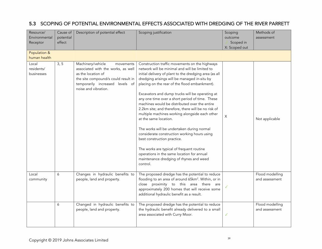
Copyright © 2019 Johns Associates Limited 39
5.3 SCOPING OF POTENTIAL ENVIRONMENTAL EFFECTS ASSOCIATED WITH DREDGING OF THE RIVER PARRETT
Resource/
Environmental
Receptor
Cause of
potential
effect
Description of potential effect Scoping justification Scoping
outcome
: Scoped in
X: Scoped out
Methods of
assessment
Population &
human health
Local
residents/
businesses
3, 5 Machinery/vehicle movements
associated with the works, as well
as the location of
the site compound/s could result in
temporarily increased levels of
noise and vibration.
Construction traffic movements on the highways
network will be minimal and will be limited to
initial delivery of plant to the dredging area (as all
dredging arisings will be managed in-situ by
placing on the rear of the flood embankment).
Excavators and dump trucks will be operating at
any one time over a short period of time. These
machines would be distributed over the entire
2.2km site; and therefore, there will be no risk of
multiple machines working alongside each other
at the same location.
The works will be undertaken during normal
considerate construction working hours using
best construction practice.
The works are typical of frequent routine
operations in the same location for annual
maintenance dredging of rhynes and weed
control.
X
Not applicable
Local
community
6 Changes in hydraulic benefits to
people, land and property.
The proposed dredge has the potential to reduce
flooding to an area of around 65km2. Within, or in
close proximity to this area there are
approximately 200 homes that will receive some
additional hydraulic benefit as a result.
Flood modelling
and assessment
6 Changed in hydraulic benefits to
people, land and property.
The proposed dredge has the potential to reduce
the hydraulic benefit already delivered to a small
area associated with Curry Moor.
Flood modelling
and assessment
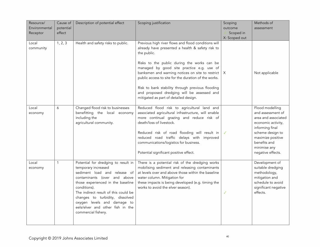
Copyright © 2019 Johns Associates Limited 40
Resource/
Environmental
Receptor
Cause of
potential
effect
Description of potential effect Scoping justification Scoping
outcome
: Scoped in
X: Scoped out
Methods of
assessment
Local
community
1, 2, 3 Health and safety risks to public.
Previous high river flows and flood conditions will
already have presented a health & safety risk to
the public.
Risks to the public during the works can be
managed by good site practice e.g. use of
banksmen and warning notices on site to restrict
public access to site for the duration of the works.
Risk to bank stability through previous flooding
and proposed dredging will be assessed and
mitigated as part of detailed design.
X
Not applicable
Local
economy
6 Changed flood risk to businesses
benefitting the local economy
including the
agricultural community.
Reduced flood risk to agricultural land and
associated agricultural infrastructure, will enable
more continual grazing and reduce risk of
death/loss of livestock.
Reduced risk of road flooding will result in
reduced road traffic delays with improved
communications/logistics for business.
Potential significant positive effect.
Flood modelling
and assessment of
area and associated
economic activity,
informing final
scheme design to
maximize positive
benefits and
minimise any
negative effects.
Local
economy
1 Potential for dredging to result in
temporary increased
sediment load and release of
contaminants (over and above
those experienced in the baseline
conditions).
The indirect result of this could be
changes to turbidity, dissolved
oxygen levels and damage to
eels/elver and other fish in the
commercial fishery.
There is a potential risk of the dredging works
mobilising sediment and releasing contaminants
at levels over and above those within the baseline
water column. Mitigation for
these impacts is being developed (e.g. timing the
works to avoid the elver season).
Development of
suitable dredging
methodology,
mitigation and
schedule to avoid
significant negative
effects.
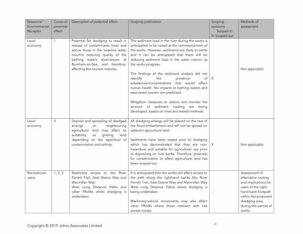
Copyright © 2019 Johns Associates Limited 41
Resource/
Environmental
Receptor
Cause of
potential
effect
Description of potential effect Scoping justification Scoping
outcome
: Scoped in
X: Scoped out
Methods of
assessment
Local
economy
1 Potential for dredging to result in
release of contaminants (over and
above those in the baseline water
column) reducing quality of the
bathing waters downstream at
Burnham-on-Sea; and therefore,
affecting the tourism industry
The sediment load in the river during the works is
anticipated to be raised at the commencement of
the works. However, sediments are likely to settle
and it can be anticipated that there will be
reducing sediment load in the water column as
the works progress.
The findings of the sediment analysis did not
identify the presence of
substances/concentrations that would affect
human health. No impacts to bathing waters and
associated tourism are predicted.
Mitigation measures to reduce and monitor the
amount of sediment loading are being
developed, based on tried and tested methods.
X
Not applicable
Local
economy
4 Deposit and spreading of dredged
arisings on neighbouring
agricultural land may affect its
suitability as grazing land
depending on the type/level of
contamination and salinity.
All dredging arisings will be placed on the rear of
the flood embankment and will not be spread on
adjacent agricultural land
Sediments have been tested prior to dredging
which has demonstrated that they are non-
hazardous and suitable for agricultural use prior
to depositing on river banks. Therefore, potential
for contamination to affect agricultural land has
been scoped out.
X
Not applicable
Recreational
users
1, 2, 3 Restricted access to the River
Parrett Trail, East Deane Way and
Macmillan Way
West Long Distance Paths and
other PRoWs whilst dredging is
undertaken.
It is anticipated that the works will affect access to
the path along the righthand banks (the River
Parrett Trail, East Deane Way and Macmillan Way
West Long Distance Paths) where dredging is
being undertaken.
Machinery/vehicle movements may also affect
other PRoWs where these intersect with site
access routes.
Assessment of
alternative routing
and implications for
users of the right-
hand bank footpath
within the proposed
dredging area,
during the period of
works.

Copyright © 2019 Johns Associates Limited 42
Resource/
Environmental
Receptor
Cause of
potential
effect
Description of potential effect Scoping justification Scoping
outcome
: Scoped in
X: Scoped out
Methods of
assessment
Air Quality
Local air
quality
1, 3 Emissions to air from machinery
and vehicles required for the
dredging activity
Excavators and dump trucks will be operating
over a short period of time (these machines
would be distributed over the entire 2.2km site;
and therefore, there will be no risk of multiple
machines working alongside each other at the
same location); and the resulting emissions
(including NOx and PM10) are considered to be
small-scale and temporary, resulting in negligible
change to local air quality
X
Not applicable.
4 Generation of dust during or
immediately after placement of dry
sediment, particularly in windy
conditions.
Sediments have been tested prior to dredging
and have been confirmed as non-hazardous. As
such, any dust generated will not contain
pollutants harmful to human health.
The potential nuisance impacts from generation
of dust will be managed through good
construction practice and are therefore scoped
out.
X
Not applicable.
Climate
change and
sustainability
Climatic
factors
6 Generation of gases (such as
carbon dioxide) that have potential
to increase the effects of global
warming
No significant generation of climate gases is
predicted due to the works. As such, the works
themselves are not considered likely to have a
significant effect on climate change and this
element is scoped-out of further assessment.
X
Not applicable.
6 Benefit of improved resilience to
the anticipated impacts of climate
change (increased rainfall and
associated flooding).
The works in isolation are not anticipated to result
in a significant impact in terms of improved
resilience to climate change. However, when
considered cumulatively with the package of
measures to be implemented as part of the SRA
Evaluation of
climate change
effects and
incorporation of
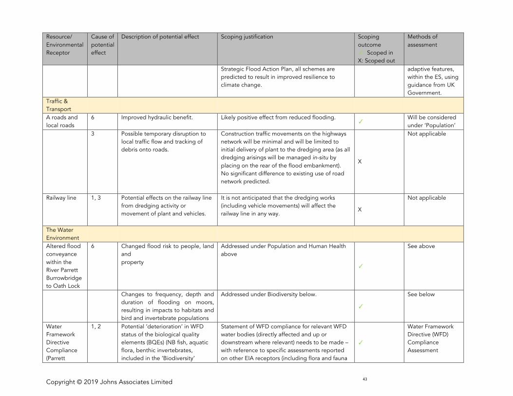
Copyright © 2019 Johns Associates Limited 43
Resource/
Environmental
Receptor
Cause of
potential
effect
Description of potential effect Scoping justification Scoping
outcome
: Scoped in
X: Scoped out
Methods of
assessment
Strategic Flood Action Plan, all schemes are
predicted to result in improved resilience to
climate change.
adaptive features,
within the ES, using
guidance from UK
Government.
Traffic &
Transport
A roads and
local roads
6 Improved hydraulic benefit. Likely positive effect from reduced flooding.
Will be considered
under ‘Population’
3 Possible temporary disruption to
local traffic flow and tracking of
debris onto roads.
Construction traffic movements on the highways
network will be minimal and will be limited to
initial delivery of plant to the dredging area (as all
dredging arisings will be managed in-situ by
placing on the rear of the flood embankment).
No significant difference to existing use of road
network predicted.
X
Not applicable
Railway line 1, 3 Potential effects on the railway line
from dredging activity or
movement of plant and vehicles.
It is not anticipated that the dredging works
(including vehicle movements) will affect the
railway line in any way.
X
Not applicable
The Water
Environment
Altered flood
conveyance
within the
River Parrett
Burrowbridge
to Oath Lock
6 Changed flood risk to people, land
and
property
Addressed under Population and Human Health
above
See above
Changes to frequency, depth and
duration of flooding on moors,
resulting in impacts to habitats and
bird and invertebrate populations
Addressed under Biodiversity below.
See below
Water
Framework
Directive
Compliance
(Parrett
1, 2 Potential ‘deterioration’ in WFD
status of the biological quality
elements (BQEs) (NB fish, aquatic
flora, benthic invertebrates,
included in the ‘Biodiversity’
Statement of WFD compliance for relevant WFD
water bodies (directly affected and up or
downstream where relevant) needs to be made –
with reference to specific assessments reported
on other EIA receptors (including flora and fauna
Water Framework
Directive (WFD)
Compliance
Assessment
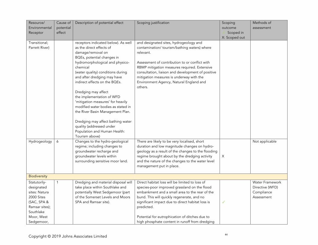
Copyright © 2019 Johns Associates Limited 44
Resource/
Environmental
Receptor
Cause of
potential
effect
Description of potential effect Scoping justification Scoping
outcome
: Scoped in
X: Scoped out
Methods of
assessment
Transitional;
Parrett River)
receptors indicated below). As well
as the direct effects of
damage/removal on
BQEs, potential changes in
hydromorphological and physico-
chemical
(water quality) conditions during
and after dredging may have
indirect effects on the BQEs.
Dredging may affect
the implementation of WFD
‘mitigation measures’ for heavily
modified water bodies as stated in
the River Basin Management Plan.
Dredging may affect bathing water
quality (addressed under
Population and Human Health:
Tourism above)
and designated sites, hydrogeology and
contamination/ tourism/bathing waters) where
relevant.
Assessment of contribution to or conflict with
RBMP mitigation measures required. Extensive
consultation, liaison and development of positive
mitigation measures is underway with the
Environment Agency, Natural England and
others.
Hydrogeology 6 Changes to the hydro-geological
regime; including changes to
groundwater recharge and
groundwater levels within
surrounding sensitive moor land.
There are likely to be very localised, short
duration and low magnitude changes on hydro-
geology as a result of the changes to the flooding
regime brought about by the dredging activity
and the nature of the changes to the water level
management put in place.
X
Not applicable
Biodiversity
Statutorily-
designated
sites: Natura
2000 Sites
(SAC, SPA &
Ramsar sites);
Southlake
Moor, West
Sedgemoor,
1 Dredging and material disposal will
take place within Southlake and
potentially West Sedgemoor (part
of the Somerset Levels and Moors
SPA and Ramsar site).
Direct habitat loss will be limited to loss of
species-poor improved grassland on the flood
embankment and a small area to the rear of the
bund. This will quickly regenerate, and no
significant impact due to direct habitat loss is
predicted.
Potential for eutrophication of ditches due to
high phosphate content in runoff from dredging
Water Framework
Directive (WFD)
Compliance
Assessment
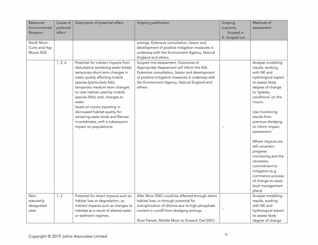
Copyright © 2019 Johns Associates Limited 45
Resource/
Environmental
Receptor
Cause of
potential
effect
Description of potential effect Scoping justification Scoping
outcome
: Scoped in
X: Scoped out
Methods of
assessment
North Moor,
Curry and Hay
Moors SSSI
arisings. Extensive consultation, liaison and
development of positive mitigation measures is
underway with the Environment Agency, Natural
England and others.
1, 2, 6 Potential for indirect impacts from
disturbance (wintering water birds);
temporary short-term changes in
water quality affecting mobile
species (particularly fish);
temporary medium-term changes
to river habitat used by mobile
species (fish); and, changes to
water
levels on moors (resulting in
decreased habitat quality for
wintering water birds and Ramsar
invertebrates, with a subsequent
impact on populations).
Scoped into assessment. Outcomes of
Appropriate Assessment will inform the EIA.
Extensive consultation, liaison and development
of positive mitigation measures is underway with
the Environment Agency, Natural England and
others.
Analyse modelling
results, working
with NE and
hydrological expert
to assess likely
degree of change
to ‘splashy
conditions’ on the
moors.
Use monitoring
results from
previous dredging
to inform impact
assessment.
Where impacts are
still uncertain,
progress
monitoring and the
necessary
commitment to
mitigation (e.g.
commence process
of change to water
level management
plans)
Non-
statutorily
designated
sites
1, 2 Potential for direct impacts such as
habitat loss or degradation; or,
indirect impacts such as changes to
habitats as a result of altered water
or sediment regimes.
Aller Moor SNCI could be affected through direct
habitat loss; or through potential for
eutrophication of ditches due to high phosphate
content in runoff from dredging arisings.
River Parrett, Middle Moor to Screech Owl SNCI
Analyse modelling
results, working
with NE and
hydrological expert
to assess likely
degree of change
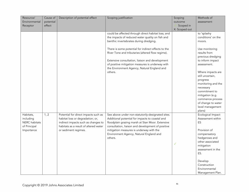
Copyright © 2019 Johns Associates Limited 46
Resource/
Environmental
Receptor
Cause of
potential
effect
Description of potential effect Scoping justification Scoping
outcome
: Scoped in
X: Scoped out
Methods of
assessment
could be affected through direct habitat loss; and
the impacts of reduced water quality on fish and
benthic invertebrates during dredging.
There is some potential for indirect effects to the
River Tone and tributaries (altered flow regime).
Extensive consultation, liaison and development
of positive mitigation measures is underway with
the Environment Agency, Natural England and
others.
to ‘splashy
conditions’ on the
moors.
Use monitoring
results from
previous dredging
to inform impact
assessment.
Where impacts are
still uncertain,
progress
monitoring and the
necessary
commitment to
mitigation (e.g.
commence process
of change to water
level management
plans)
Habitats,
including
NERC habitats
of Principal
Importance
1, 2 Potential for direct impacts such as
habitat loss or degradation; or,
indirect impacts such as changes to
habitats as a result of altered water
or sediment regimes.
See above under non-statutorily-designated sites.
Additional potential for impacts to coastal and
floodplain grazing marsh at Stan Moor. Extensive
consultation, liaison and development of positive
mitigation measures is underway with the
Environment Agency, Natural England and
others.
Ecological Impact
Assessment within
ES
Provision of
compensatory
hedgerows and
other associated
mitigation
assessment in the
ES.
Develop
Construction
Environmental
Management Plan.
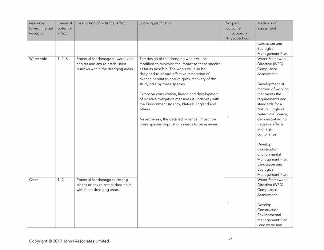
Copyright © 2019 Johns Associates Limited 47
Resource/
Environmental
Receptor
Cause of
potential
effect
Description of potential effect Scoping justification Scoping
outcome
: Scoped in
X: Scoped out
Methods of
assessment
Landscape and
Ecological
Management Plan.
Water vole 1, 2, 6 Potential for damage to water vole
habitat and any re-established
burrows within the dredging areas.
The design of the dredging works will be
modified to minimise the impact to these species
as far as possible. The works will also be
designed to ensure effective restoration of
riverine habitat to ensure quick recovery of the
study area by these species.
Extensive consultation, liaison and development
of positive mitigation measures is underway with
the Environment Agency, Natural England and
others.
Nevertheless, the detailed potential impact on
these species populations needs to be assessed.
Water Framework
Directive (WFD)
Compliance
Assessment
Development of
method of working
that meets the
requirements and
standards for a
Natural England
water vole licence,
demonstrating no
negative effects
and legal
compliance.
Develop
Construction
Environmental
Management Plan.
Landscape and
Ecological
Management Plan.
Otter 1, 2 Potential for damage to resting
places or any re-established holts
within the dredging areas.
Water Framework
Directive (WFD)
Compliance
Assessment.
Develop
Construction
Environmental
Management Plan.
Landscape and
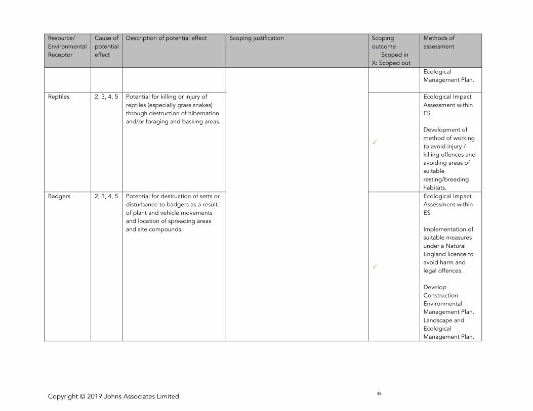
Copyright © 2019 Johns Associates Limited 48
Resource/
Environmental
Receptor
Cause of
potential
effect
Description of potential effect Scoping justification Scoping
outcome
: Scoped in
X: Scoped out
Methods of
assessment
Ecological
Management Plan.
Reptiles 2, 3, 4, 5 Potential for killing or injury of
reptiles (especially grass snakes)
through destruction of hibernation
and/or foraging and basking areas.
Ecological Impact
Assessment within
ES
Development of
method of working
to avoid injury /
killing offences and
avoiding areas of
suitable
resting/breeding
habitats.
Badgers 2, 3, 4, 5 Potential for destruction of setts or
disturbance to badgers as a result
of plant and vehicle movements
and location of spreading areas
and site compounds.
Ecological Impact
Assessment within
ES
Implementation of
suitable measures
under a Natural
England licence to
avoid harm and
legal offences.
Develop
Construction
Environmental
Management Plan.
Landscape and
Ecological
Management Plan.
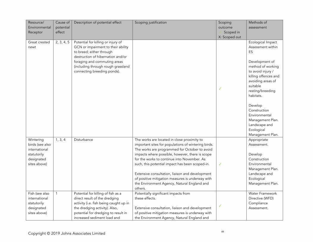
Copyright © 2019 Johns Associates Limited 49
Resource/
Environmental
Receptor
Cause of
potential
effect
Description of potential effect Scoping justification Scoping
outcome
: Scoped in
X: Scoped out
Methods of
assessment
Great crested
newt
2, 3, 4, 5 Potential for killing or injury of
GCN or impairment to their ability
to breed; either through
destruction of hibernation and/or
foraging and commuting areas
(including through rough grassland
connecting breeding ponds).
Ecological Impact
Assessment within
ES
Development of
method of working
to avoid injury /
killing offences and
avoiding areas of
suitable
resting/breeding
habitats.
Develop
Construction
Environmental
Management Plan.
Landscape and
Ecological
Management Plan.
Wintering
birds (see also
international
statutorily
designated
sites above)
1, 3, 4 Disturbance The works are located in close proximity to
important sites for populations of wintering birds.
The works are programmed for October to avoid
impacts where possible, however, there is scope
for the works to continue into November. As
such, this potential impact has been scoped-in.
Extensive consultation, liaison and development
of positive mitigation measures is underway with
the Environment Agency, Natural England and
others.
Appropriate
Assessment.
Develop
Construction
Environmental
Management Plan.
Landscape and
Ecological
Management Plan.
Fish (see also
international
statutorily
designated
sites above)
1 Potential for killing of fish as a
direct result of the dredging
activity (i.e. fish being caught up in
the dredging activity). Also,
potential for dredging to result in
increased sediment load and
Potentially significant impacts from
these effects.
Extensive consultation, liaison and development
of positive mitigation measures is underway with
the Environment Agency, Natural England and
Water Framework
Directive (WFD)
Compliance
Assessment.
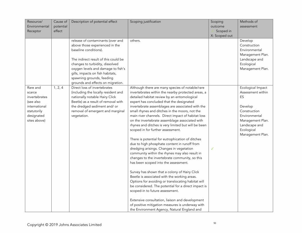
Copyright © 2019 Johns Associates Limited 50
Resource/
Environmental
Receptor
Cause of
potential
effect
Description of potential effect Scoping justification Scoping
outcome
: Scoped in
X: Scoped out
Methods of
assessment
release of contaminants (over and
above those experienced in the
baseline conditions).
The indirect result of this could be
changes to turbidity, dissolved
oxygen levels and damage to fish’s
gills, impacts on fish habitats,
spawning grounds, feeding
grounds and effects on migration.
others. Develop
Construction
Environmental
Management Plan.
Landscape and
Ecological
Management Plan.
Rare and
scarce
invertebrates
(see also
international
statutorily
designated
sites above)
1, 2, 4 Direct loss of invertebrates
(including the locally resident and
nationally notable Hairy Click
Beetle) as a result of removal with
the dredged sediment and/ or
removal of emergent and marginal
vegetation.
Although there are many species of notable/rare
invertebrates within the nearby protected areas, a
detailed habitat review by an entomological
expert has concluded that the designated
invertebrate assemblages are associated with the
small rhynes and ditches in the moors, not the
main river channels. Direct impact of habitat loss
on the invertebrate assemblage associated with
rhynes and ditches is very limited but will be been
scoped in for further assessment.
There is potential for eutrophication of ditches
due to high phosphate content in runoff from
dredging arisings. Changes in vegetation
community within the rhynes may also result in
changes to the invertebrate community, so this
has been scoped into the assessment.
Survey has shown that a colony of Hairy Click
Beetle is associated with the working areas.
Options for avoiding or translocating habitat will
be considered. The potential for a direct impact is
scoped-in to future assessment.
Extensive consultation, liaison and development
of positive mitigation measures is underway with
the Environment Agency, Natural England and
Ecological Impact
Assessment within
ES
Develop
Construction
Environmental
Management Plan.
Landscape and
Ecological
Management Plan.
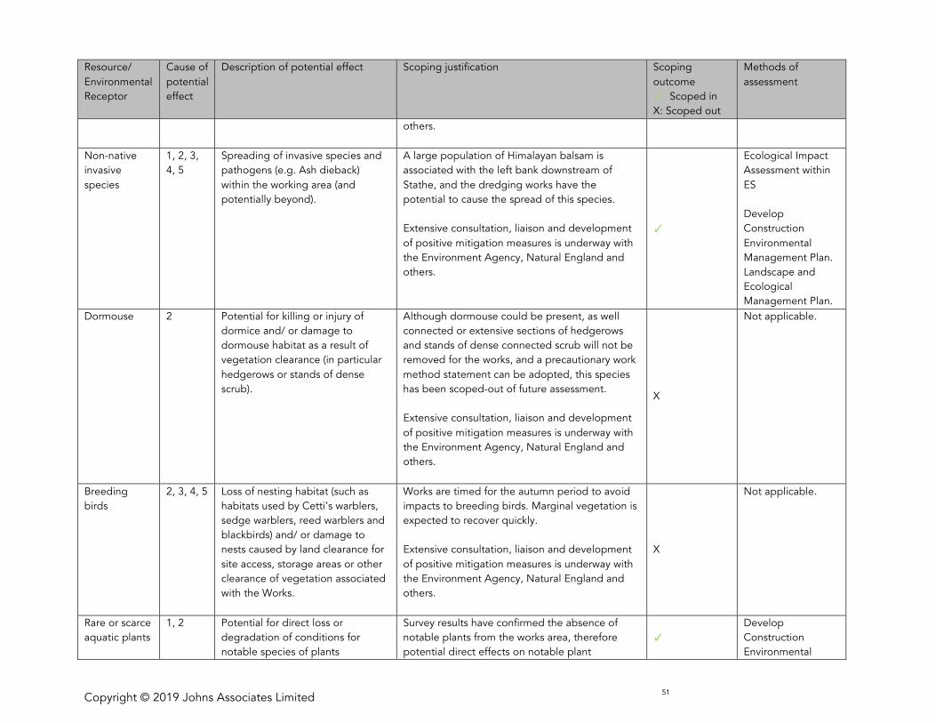
Copyright © 2019 Johns Associates Limited 51
Resource/
Environmental
Receptor
Cause of
potential
effect
Description of potential effect Scoping justification Scoping
outcome
: Scoped in
X: Scoped out
Methods of
assessment
others.
Non-native
invasive
species
1, 2, 3,
4, 5
Spreading of invasive species and
pathogens (e.g. Ash dieback)
within the working area (and
potentially beyond).
A large population of Himalayan balsam is
associated with the left bank downstream of
Stathe, and the dredging works have the
potential to cause the spread of this species.
Extensive consultation, liaison and development
of positive mitigation measures is underway with
the Environment Agency, Natural England and
others.
Ecological Impact
Assessment within
ES
Develop
Construction
Environmental
Management Plan.
Landscape and
Ecological
Management Plan.
Dormouse 2 Potential for killing or injury of
dormice and/ or damage to
dormouse habitat as a result of
vegetation clearance (in particular
hedgerows or stands of dense
scrub).
Although dormouse could be present, as well
connected or extensive sections of hedgerows
and stands of dense connected scrub will not be
removed for the works, and a precautionary work
method statement can be adopted, this species
has been scoped-out of future assessment.
Extensive consultation, liaison and development
of positive mitigation measures is underway with
the Environment Agency, Natural England and
others.
X
Not applicable.
Breeding
birds
2, 3, 4, 5 Loss of nesting habitat (such as
habitats used by Cetti’s warblers,
sedge warblers, reed warblers and
blackbirds) and/ or damage to
nests caused by land clearance for
site access, storage areas or other
clearance of vegetation associated
with the Works.
Works are timed for the autumn period to avoid
impacts to breeding birds. Marginal vegetation is
expected to recover quickly.
Extensive consultation, liaison and development
of positive mitigation measures is underway with
the Environment Agency, Natural England and
others.
X
Not applicable.
Rare or scarce
aquatic plants
1, 2 Potential for direct loss or
degradation of conditions for
notable species of plants
Survey results have confirmed the absence of
notable plants from the works area, therefore
potential direct effects on notable plant
Develop
Construction
Environmental

Copyright © 2019 Johns Associates Limited 52
Resource/
Environmental
Receptor
Cause of
potential
effect
Description of potential effect Scoping justification Scoping
outcome
: Scoped in
X: Scoped out
Methods of
assessment
populations have been scoped-out.
However, there is potential for eutrophication of
ditches within Southlake and West Sedgemoor
SSSIs due to high phosphate content in runoff
from dredging arisings. This could result in loss of
rare/ scarce aquatic plants from the affected
ditches.
Extensive consultation, liaison and development
of positive mitigation measures is underway with
the Environment Agency, Natural England and
others.
Management Plan.
Landscape and
Ecological
Management Plan.
Land quality
Soil resource 2, 3, 4, 5 Vehicle movements over saturated
soils can cause long-term
degradation to the structure of the
soil. Soil erosion is much
more likely under waterlogged
conditions especially where
vegetative matter has been
removed from the surface.
Ground cover removal to facilitate
the works (including storage and
site compounds) and vehicle
movements could result in
compaction and erosion, leading to
changes to the soil structure and
fertility and functionality of the soil
resource.
Works have been timed for the autumn period
when conditions are much more likely to be dry.
Soils will be protected through standard,
good working practice and ground
protection methods if necessary.
X
Not applicable.
Waste and
potential
contamination
1, 2, 4 Generation of arisings from
dredging, and waste from
vegetation clearance removal; and
potential ground contamination
arising from placement on the rear
Sediments have been tested prior to dredging to
demonstrate that they are non-hazardous prior to
depositing on river banks. X
Results of sediment
testing will be
provided within the
Water Environment
chapter
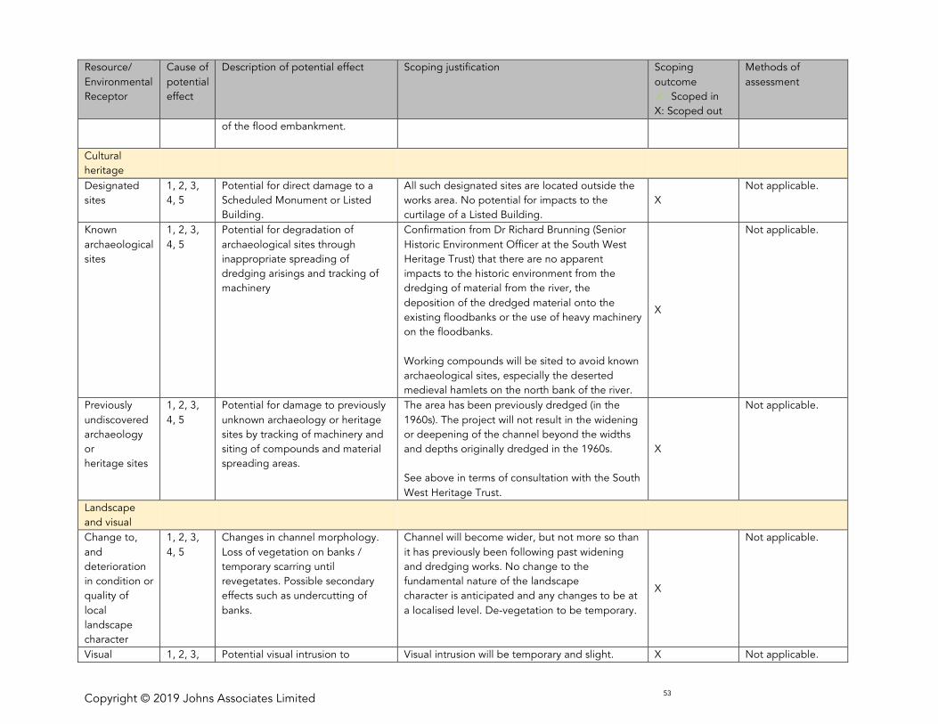
Copyright © 2019 Johns Associates Limited 53
Resource/
Environmental
Receptor
Cause of
potential
effect
Description of potential effect Scoping justification Scoping
outcome
: Scoped in
X: Scoped out
Methods of
assessment
of the flood embankment.
Cultural
heritage
Designated
sites
1, 2, 3,
4, 5
Potential for direct damage to a
Scheduled Monument or Listed
Building.
All such designated sites are located outside the
works area. No potential for impacts to the
curtilage of a Listed Building.
X
Not applicable.
Known
archaeological
sites
1, 2, 3,
4, 5
Potential for degradation of
archaeological sites through
inappropriate spreading of
dredging arisings and tracking of
machinery
Confirmation from Dr Richard Brunning (Senior
Historic Environment Officer at the South West
Heritage Trust) that there are no apparent
impacts to the historic environment from the
dredging of material from the river, the
deposition of the dredged material onto the
existing floodbanks or the use of heavy machinery
on the floodbanks.
Working compounds will be sited to avoid known
archaeological sites, especially the deserted
medieval hamlets on the north bank of the river.
X
Not applicable.
Previously
undiscovered
archaeology
or
heritage sites
1, 2, 3,
4, 5
Potential for damage to previously
unknown archaeology or heritage
sites by tracking of machinery and
siting of compounds and material
spreading areas.
The area has been previously dredged (in the
1960s). The project will not result in the widening
or deepening of the channel beyond the widths
and depths originally dredged in the 1960s.
See above in terms of consultation with the South
West Heritage Trust.
X
Not applicable.
Landscape
and visual
Change to,
and
deterioration
in condition or
quality of
local
landscape
character
1, 2, 3,
4, 5
Changes in channel morphology.
Loss of vegetation on banks /
temporary scarring until
revegetates. Possible secondary
effects such as undercutting of
banks.
Channel will become wider, but not more so than
it has previously been following past widening
and dredging works. No change to the
fundamental nature of the landscape
character is anticipated and any changes to be at
a localised level. De-vegetation to be temporary.
X
Not applicable.
Visual 1, 2, 3, Potential visual intrusion to Visual intrusion will be temporary and slight. X Not applicable.
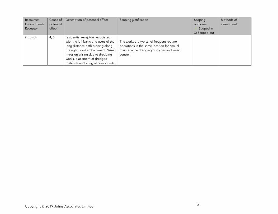
Copyright © 2019 Johns Associates Limited 54
Resource/
Environmental
Receptor
Cause of
potential
effect
Description of potential effect Scoping justification Scoping
outcome
: Scoped in
X: Scoped out
Methods of
assessment
intrusion 4, 5 residential receptors associated
with the left bank; and users of the
long distance path running along
the right flood embankment. Visual
intrusion arising due to dredging
works, placement of dredged
materials and siting of compounds
The works are typical of frequent routine
operations in the same location for annual
maintenance dredging of rhynes and weed
control.
Copyright © 2019 Johns Associates Limited 55
6 ES CONTENTS
175 Following the results of the scoping exercise set out in Section 4, the following chapters will therefore be
produced as part of the Environmental Statement:
• ES Non-Technical Summary (NTS) – a summary of the key issues and findings of the EIA
• ES Volume 1 – will comprise the full text of the EIA with chapter headings as follows.
o Chapter 1 Introduction and the EIA Team.
o Chapter 2. Description of Development Proposals
o Chapter 3. The Consenting Regime
o Chapter 4. Need and Alternatives
o Chapter 5. Approach to Preparing the ES
o Chapter 6. Policy and Legal Content
o Chapter 7. Population
o Chapter 7. The Water Environment
o Chapter 8. Biodiversity
o Chapter 10. Cumulative Effects
o Chapter 11. Summary of Significant Effects and Proposed Mitigation
o Glossary
• ES Volume 2 - Figures
• ES Volume 3 – Technical Appendices (providing supplementary information for the various technical
studies)
o This will also include:
§ Baseline Studies
§ Habitats Regulations Assessment
§ WFD Assessment

Copyright © 2019 Johns Associates Limited 56

Copyright © 2019 Johns Associates Limited 57
APPENDIX A – HABITAT MAPS

Copyright © 2019 Johns Associates Limited 58

IS
SI
SI
SI
SI
SI >>>>>>>>>>>>>>>>>>>>>>>>>>>>>>>>>>>>>>>>>>>>>>>>>>
>>
>>
>>
>>
/ / / / / / / / / / / / / / / / / / / / / / / / / / / / // //////////////
\ \ \ \ \ \ \ \ \ \ \ \ \ \ \ \ \ \ \ \ \ \ \ \ \ \ \ \ \
\\\\\\\\\\\\\\\
I I I I I I I I I I II
II
II
II
II
II
II
II
II
II
II
II
II
II
I
II
II
II I I I I I I I I I I I I I I I I I I I I I I I I I I I I I I I I I I I I I I I I I I I I I I I I I I I I I I I I I I I I I I I I I I I I I I I I I I I I I I I I I I I I I I I I I I I I I I I I I I I I I I I I I I I I I I I I I I I I I I
1.002
1.003
1.005
1.001
1.004
IS
SI
SI
>>>>>>>>>>>>>>>>>>>>>>>>>>>>>>>>>>>>>>>>>>>>>>>>>>>>>>>>>>>>
///////////////////////////
\\\\\\\\\\\\\\\\\\\\\\\\\\\
/ /\ \
I I I I I I I I I I I I I I I I I I I I I I I I I I I I I I I I I I I I I I I I I I I I I I I I I I I I I I I I I I I I I I I I I I I I I I I I I I I I I I I I I I I I I I I I I I I I I I I I I I I I I I I I I I I I I I I I I I I I I I I I I I I I I I I I I I I I I I I I I I I I I I I I I I I I I I
II
II
II
I I I I I I I I I
1.005
1.007
1.006
1718
Broadleaved tree
Scrub
Target note
> > G2 - Running water
/ / / /\ \ \ \J2.2.1 - Defunct hedge - nativespecies-rich
I I J2.4 - Fence
ISB2.2 - Neutral grassland - semi-improved
SI B6 - Poor semi-improved grassland
C3.1 - Other tall herb and fern -ruderal
F2.1 - Marginal and inundation -marginal vegetation
SCALE @ A3 CREATED BY CHECKED BY
REFERENCE REVISION DATE ISSUED
TITLE
PROJECT
CLIENT
°
°
This drawing is subject to copyright and is not to be reproduced, retained nor disclosed to any unauthorized person either wholly or in part without the consent of Johns Associates. Do not scale from this drawing.
OS data © Crown Copyright and database right 2018
JW1:1,000 MM
15/6/2018J00256.P1.s1/s2
Survey sheets 1 and 2
Oath to Burrowbridge Dredging
Somserset Levels Drainage Boards Consortium
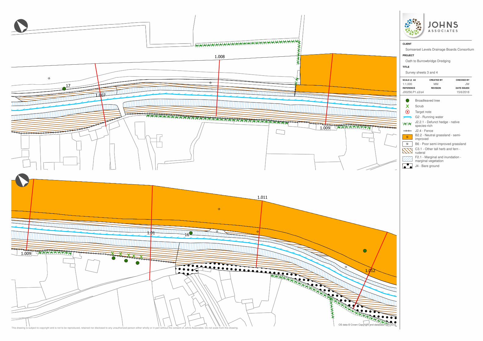
SI
SI
>>>>>>>>>>>>>>>>>>>>>>>>>>>>>>>>>>>>>>>>>>>>>>>>>>>>>>>>>>>>>
/ / / / / / / / / / / / / / / / / / / / / / / / / / / / / / / / / / / / / / / / / / / / / / / / / / / / / / / / / / / / / / / / / / / / / /
\ \ \ \ \ \ \ \ \ \ \ \ \ \ \ \ \ \ \ \ \ \ \ \ \ \ \ \ \ \ \ \ \ \ \ \ \ \ \ \ \ \ \ \ \ \ \ \ \ \ \ \ \ \ \ \ \ \ \ \ \ \ \ \ \ \ \ \ \ \/ / / / / / / / / / / / / / / / /\ \ \ \ \ \ \ \ \ \ \ \ \ \ \ \ \
////
\\\\
////////////
///////////////////////////////////////////////////\\\\\\\\\\\\
\\\\\\\\\\\\\\\\\\\\\\\\\\\\\\\\\\\\\\\\\\\\\\\\\\\
I I I I I I I I I I I I I I I I I I I I I I I I I I I I I I I I I I I I I I I I I I I I I I I
I I I I I I I I I I I I I I I I I I I I I I I I I I I I I I I I I I I I I I I I I I I I I I I I I I I I I I I I I I I I I I I I I I I I I I I I I I I I I I I I I I I I I I I I I I I I I I I I I I I I I I I I I I I I I I I I I
II
II
1.009
1.007
1.008
17
IS
IS
SI
SI
!
!
!
!
!
!
!
!
!
!
!
!
!
!
!
!
!
!
!
!
!
!
!
!
!
!
!
!
!
!
!
!
!
!
!
!
!
!
!
!
!
!
!
!
!
!
!
!
!
!
!
!
!
!
!
!
!
!
!
!
!
!
!
!
!
!
!
!
!
!
!
!
!
!
!
!
!
!
!
!
!
!
!
!
!
!
!
!
!
!
!
!
!
!
!
!
!
!
!
!
!
!
!
!
!
!
!
!
!
!
!
!
!
!
!
!
!
!
!
!
!
!
!
!
!
!
!
!
!
!
!
!
!
!
!
!
!
!
!
!
!
!
!
!
!
!
!
!
!
!
!
!
!
!
!
!
!
!
!
!
!
!
!
!
!
!
!
!
!
!
!
!
!
!
!
!
!
!
!
!
!
!
!
!
!
!
!
!
!
!
!
!
!
!
!
!
!
!
!
!
!
!
!
!
!
!
!
!
!
!
!
!
!
!
!
!
!
!
!
!
!
!
!
!
!
!
!
!
!
!
!
!
!
!
!
!
!
!
!
!
!
!
!
!
!
!
!
!
!
!
!
!
!
!
!
!
!
!
!
!
!
!
!
!
!
!
!
!
!
!
!
!
!
!
!
!
!
!
!
!
!
!
!
!
!
!
!
!
!
!
!
!
!
!
!
!
!
!
!
!
!
!
!
!
!
!
!
!
!
!
!
!
!
!
!
!
!
!
!
!
!
!
!
!
!
!
!
!
!
!
!
!
!
!
!
!
!
!
!
!
!
!
!
!
!
!
!
!
!
!
!
!
!
!
!
!
!
!
!
!
!
!
!
!
!
!
!
!
!
!
!
!
!
!
!
!
!
!
!
!
!
!
!
!
!
!
!
!
!
!
!
!
!
!
!
!
!
!
!
!
!
!
!
!
!
!
!
!
!
!
!
!
!
!
!
!
!
!
!
!
!
!
!
!
!
!
!
!
!
!
!
!
!
!
!
!
!
!
!
!
!
!
!
!
!
!
!
!
!
!
!
!
!
!
!
!
!
!
!
!
!
!
!
!
!
!
!
!
!
!
!
!
!
!
!
!
!
!
!
!
!
!
!
!
!
!
!
!
!
!
!
!
!
!
!
!
!
!
!
!
!
!
!
!
!
!
!
!
!
!
!
!
!
!
!
!
!
!
!
!
!
!
!
!
!
!
!
!
!
!
!
!
!
!
!
!
!
!
!
!
!
!
!
!
!
!
!
!
!
!
!
!
!
!
!
!
!
!
!
!
!
!
!
!
!
!
!
!
!
!
!
!
!
!
!
!
!
!
!
!
!
!
!
!
!
!
!
!
!
!
!
!
!
!
!
!
!
!
!
!
!
!
!
!
!
!
!
!
!
!
!
!
!
!
!
!
!
!
!
!
!
!
!
!
!
!
!
!
!
!
!
!
!
!
!
!
!
!
!
!
!
!
!
!
!
!
!
!
!
!
!
!
!
!
!
!
!
!
!
!
!
!
!
!
!
!
!
!
!
!
!
!
!
!
!
!
!
!
!
!
!
!
!
!
!
!
!
!
!
!
!
!
!
!
!
!
!
!
!
!
!
!
!
!
!
!
!
!
!
!
!
!
!
!
!
!
!
!
!
!
!
!
!
!
!
!
!
!
!
!
!
!
!
!
!
!
!
!
!
!
!
!
!
!
!
!
!
!
!
!
!
!
!
!
!
!
!
!
!
!
!
!
!
!
!
!
!
!
!
!
!
!
!
!
!
!
!
!
!
!
!
!
!
!
!
!
!
!
!
!
!
!
!
!
!
!
!
!
!
!
!
!
!
!
!
!
!
!
!
!
!
!
!
!
!
!
!
!
!
!
!
!
!
!
!
!
!
!
!
!
!
!
!
!
!
!
!
!
!
!
!
!
!
!
!
!
!
!
!
!
!
!
!
!
!
!
!
!
!
!
!
!
!
!
!
!
!
!
!
!
!
!
!
!
!
!
!
!
!
!
!
!
!
!
!
!
!
!
!
!
!
!
!
!
!
!
!
!
!
!
!
!
!
!
!
!
!
!
!
!
!
!
!
!
!
!
!
!
!
!
!
!
!
!
!
!
!
!
!
!
!
!
!
!
!
!
!
!
!
!
!
!
!
!
!
!
!
!
!
!
!
!
!
!
!
!
!
!
!
!
!
!
!
!
!
!
!
!
!
!
!
!
!
!
!
!
!
!
!
!
!
!
!
!
!
!
!
!
!
!
!
!
!
!
!
!
!
!
!
!
!
!
!
!
!
!
!
!
!
!
!
!
!
!
!
!
!
!
!
!
!
!
!
!
!
!
!
!
!
!
!
!
!
!
!
!
!
!
!
!
!
!
!
!
!
!
!
!
!
!
!
!
!
!
!
!
!
!
!
!
!
!
!
!
!
!
!
!
!
!
!
!
!
!
!
!
!
!
!
!
!
!
!
!
!
!
!
!
!
!
!
!
!
!
!
!
!
!
!
!
!
!
!
!
!
!
!
!
!
!
!
!
!
!
!
!
!
!
!
!
!
!
!
!
!
!
!
!
!
!
!
!
!
!
!
!
!
!
!
!
!
!
!
!
!
!
!
!
!
!
!
!
!
!
!
!
!
!
!
!
!
!
!
!
!
!
!
!
!
!
!
!
!
!
!
!
!
!
!
!
!
!
!
!
!
!
!
!
!
!
!
!
!
!
!
!
!
!
!
!
!
!
!
!
!
!
!
!
!
!
!
!
!
!
!
!
!
!
!
!
!
!
!
!
!
!
!
!
!
!
!
!
!
!
!
!
!
!
!
!
!
!
!
!
!
!
!
!
!
!
!
!
!
!
!
!
!
!
!
!
!
!
!
!
!
!
!
!
!
!
!
!
!
!
!
!
!
!
!
!
!
!
!
!
!
!
!
!
!
!
!
!
!
!
!
!
!
!
!
!
!
!
!
!
!
!
!
!
!
!
!
!
!
!
!
!
!
!
!
!
!
!
!
!
!
!
!
!
!
!
!
!
!
!
!
!
!
!
!
!
!
!
!
!
!
!
!
!
!
!
!
!
!
!
!
!
!
!
!
!
!
!
!
!
!
!
!
!
!
!
!
!
!
!
!
!
!
!
!
!
!
!
!
!
!
!
!
!
!
!
!
!
!
!
!
!
!
!
!
!
!
!
!
!
!
!
!
>>>>
>>
>>
>>
>>
>>
>>
>>
>>>>>>>>>>>>>>>>>>>>>>>>>>>>>>>>>>>>>>>>>>>
/ / / / / / / / / / / / / / / / /\ \ \ \ \ \ \ \ \ \ \ \ \ \ \ \ \
/ / / / / / / / / / / / / / / / / / / / / / / / / / / / / / / / / / / / / / / / / / / / / / / / / / / / / / / / / / / / / / / / /
\ \ \ \ \ \ \ \ \ \ \ \ \ \ \ \ \ \ \ \ \ \ \ \ \ \ \ \ \ \ \ \ \ \ \ \ \ \ \ \ \ \ \ \ \ \ \ \ \ \ \ \ \ \ \ \ \ \ \ \ \ \ \ \ \
///////////
\\\\\\\\\\\
I I I I I I I I I I I I I I I I I I I I I I I I I I I I I I I I I I I I I I I I I I I I I I I I I I I I I I I I I I I I I I I I I I I I I
1.01
1.012
1.009
1.011
16
Broadleaved tree
Scrub
Target note
> > G2 - Running water
/ / / /\ \ \ \J2.2.1 - Defunct hedge - nativespecies-rich
I I J2.4 - Fence
ISB2.2 - Neutral grassland - semi-improved
SI B6 - Poor semi-improved grassland
C3.1 - Other tall herb and fern -ruderal
F2.1 - Marginal and inundation -marginal vegetation
! !
! !
! ! !
! ! !J4 - Bare ground
SCALE @ A3 CREATED BY CHECKED BY
REFERENCE REVISION DATE ISSUED
TITLE
PROJECT
CLIENT
°
°
This drawing is subject to copyright and is not to be reproduced, retained nor disclosed to any unauthorized person either wholly or in part without the consent of Johns Associates. Do not scale from this drawing.
OS data © Crown Copyright and database right 2018
JW1:1,000 MM
15/6/2018J00256.P1.s3/s4
Survey sheets 3 and 4
Oath to Burrowbridge Dredging
Somserset Levels Drainage Boards Consortium
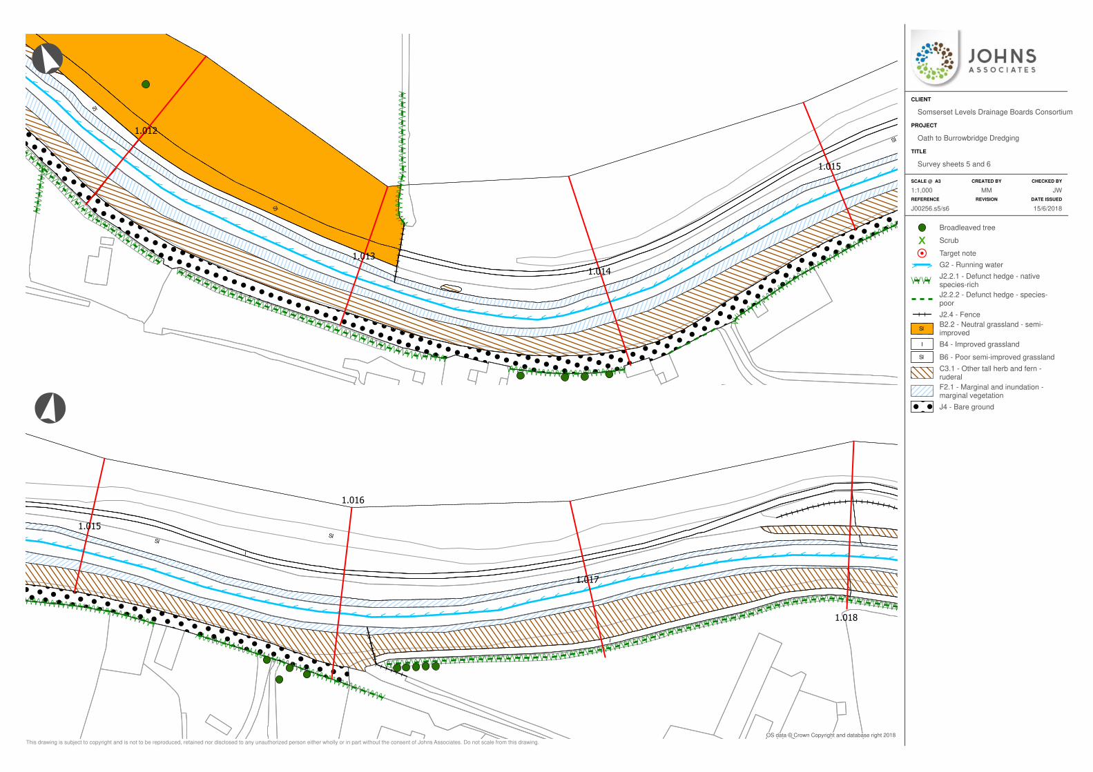
IS
SI
SI
!!
!!
!!
!!
!!
!
!!
!!
!!
!!
!!
!
!!
!!
!!
!!
!!
!
!!
!!
!!
!!
!!
!
!!
!!
!!
!!
!!
!
!!
!!
!!
!!
!!
!
!!
!!
!!
!!
!!
!
!!
!!
!!
!!
!!
!
!!
!!
!!
!!
!!
!
!!
!!
!!
!!
!!
!
!!
!!
!!
!!
!!
!
!!
!!
!!
!!
!!
!
!!
!!
!!
!!
!!
!
!!
!!
!!
!!
!!
!
!!
!!
!!
!!
!!
!!
!!
!!
!!
!!
!!
!!
!!
!!
!!
!!
!!
!!
!!
!!
!!
!!
!!
!!
!!
!!
!!
!!
!!
!!
!!
!!
!!
!!
!!
!!
!!
!!
!!
!!
!!
!!
!!
!!
!!
!!
!!
!!
!!
!!
!!
!!
!!
!!
!!
!!
!!
!!
!!
!!
!!
!!
!!
!!
!!
!!
!!
!!
!!
!!
!!
!!
!!
!!
!!
!!
!!
!!
!!
!!
!!
!!
!!
!!
!!
!!
!!
!!
!!
!!
!!
!!
!!
!!
!!
!!
!!
!!
!!
!!
!!
!!
!!
!!
!!
!!
!!
!!
!!
!!
!!
!!
!!
!!
!!
!!
!!
!!
!!
!!
!!
!!
!!
!!
!!
!!
!!
!!
!!
!!
!!
!!
!!
!!
!!
!!
!!
!!
!!
!!
!!
!!
!!
!!
!!
!!
!!
!!
!!
!!
!!
!!
!!
!!
!!
!!
!!
!!
!!
!!
!!
!!
!!
!!
!!
!!
!!
!!
!!
!!
!!
!!
!!
!!
!!
!!
!!
!!
!!
!!
!!
!!
!!
!!
!!
!!
!!
!!
!!
!!
!!
!!
!!
!!
!!
!!
!!
!!
!!
!!
!!
!!
!!
!!
!!
!!
!!
!!
!!
!!
!!
!!
!!
!!
!!
!!
!!
!!
!!
!!
!!
!!
!!
!!
!!
!!
!!
!!
!!
!!
!!
!!
!!
!!
!!
!!
!!
!!
!!
!!
!!
!!
!!
!!
!!
!!
!!
!!
!!
!!
!!
!!
!!
!!
!!
!!
!!
!!
!!
!!
!!
!!
!!
!!
!!
!!
!!
!!
!!
!!
!!
!!
!!
!!
!!
!!
!!
!!
!!
!!
!!
!!
!!
!!
!!
!!
!!
!!
!!
!!
!!
!!
!!
!!
!!
!!
!!
!!
!!
!!
!!
!!
!!
!!
!!
!!
!!
!!
!!
!!
!!
!!
!!
!!
!!
!!
!!
!!
!!
!!
!!
!!
!!
!!
!!
!!
!!
!!
!!
!!
!!
!!
!!
!!
!!
!!
!!
!!
!!
!!
!!
!!
!!
!!
!!
!!
!!
!!
!!
!!
!!
!!
!!
!!
!!
!!
!!
!!
!!
!!
!!
!!
!!
!!
!!
!!
!!
!!
!!
!!
!!
!!
!!
!!
!!
!!
!!
!!
!!
!!
!!
!!
!!
!!
!!
!!
!!
!!
!!
!!
!!
!!
!!
!!
!!
!!
!!
!!
!!
!!
!!
!!
!!
!!
!!
!!
!!
!!
!!
!!
!!
!!
!!
!!
!!
!!
!!
!!
!!
!!
!!
!!
!!
!!
!!
!!
!!
!!
!!
!!
!!
!!
!!
!!
!!
!!
!!
!!
!!
!!
!!
!!
!!
!!
!!
!!
!!
!!
!!
!!
!!
!!
!!
!!
!!
!!
!!
!!
!!
!!
!!
!!
!!
!!
!!
!!
!!
!!
!!
!!
!!
!!
!!
!!
!!
!!
!!
!!
!!
!!
!!
!!
!!
!!
!!
!!
!!
!!
!!
!!
!!
!!
!!
!!
!!
!!
!!
!!
!!
!!
!!
!!
!!
!!
!!
!!
!!
!!
!!
!!
!!
!!
!!
!!
!!
!!
!!
!!
!!
!!
!!
!!
!!
!!
!!
!!
!!
!!
!!
!!
!!
!!
!!
!!
!!
!!
!!
!!
!!
!!
!!
!!
!!
!!
!!
!!
!!
!!
!!
!!
!!
!!
!!
!!
!!
!!
!!
!!
!!
!!
!!
!!
!!
!!
!!
!!
!!
!!
!!
!!
!!
!!
!!
!!
!!
!!
!!
!!
!!
!!
!!
!!
!!
!!
!!
!!
!!
!!
!!
!!
!!
!!
!!
!!
!!
!!
!!
!!
!!
!!
!!
!!
!!
!!
!!
!!
!!
!!
!!
!!
!!
!!
!!
!!
!!
!!
!!
!!
!!
!!
!!
!!
!!
!!
!!
!!
!!
!!
!!
!!
!!
!!
!!
!!
!!
!!
!!
!!
!!
!!
!!
!!
!!
!!
!!
!!
!!
!!
!!
!!
!!
!!
!!
!!
!!
!!
!!
!!
!!
!!
!!
!!
!!
!!
!!
!!
!!
!!
!!
!!
!!
!!
!!
!!
!!
!!
!!
!!
!!
!!
!!
!!
!!
!!
!!
!!
!!
!!
!!
!!
!!
!!
!!
!!
!!
!!
!!
!!
!!
!!
!!
!!
!!
!!
!!
!!
!!
!!
!!
!!
!!
!!
!!
!!
!!
!!
!!
!!
!!
!!
!!
!!
!!
!!
!!
!!
!!
!!
!!
!!
!!
!!
!!
!!
!!
!!
!!
!!
!!
!!
!!
!!
!!
!!
!!
!!
!!
!!
!!
!!
!!
!!
!!
!!
!!
!!
!!
!!
!!
!!
!!
!!
!!
!!
!!
!!
!!
!!
!!
!!
!!
!!
!!
!!
!!
!!
!!
!!
!!
!!
!!
!!
!!
!!
!!
!!
!!
!!
!!
!!
!!
!!
!!
!!
!!
!!
!!
!!
!!
!!
!!
!!
!!
!!
!!
!!
!!
!!
!!
!!
!!
!!
!!
!!
!!
!!
!!
!!
!!
!!
!!
!!
!!
!!
!!
!!
!!
!!
!!
!!
!!
!!
!!
!!
!!
!!
!!
!!
!!
!!
!!
!!
!!
!!
!!
!!
!!
!!
!!
!!
!!
!!
!!
!!
!!
!!
!!
!!
!!
!!
!!
!!
!!
!!
!!
!!
!!
!!
!!
!!
!!
!!
!!
!!
!!
!!
!!
!!
!!
!!
!!
!!
!!
!!
!!
!!
!!
!!
!!
!!
!!
!!
!!
!!
!!
!!
!!
!!
!!
!!
!!
!!
!!
!!
!!
!!
!!
!!
!!
!!
!!
!!
!!
!!
!!
!!
!!
!!
!!
!!
!!
!!
!!
!!
!!
!!
!!
!!
!!
!!
!!
!!
!!
!!
!!
!!
!!
!!
!!
!!
!!
!!
!!
!!
!!
!!
!!
!!
!!
!!
!!
!!
!!
!!
!!
!!
!!
!!
!!
!!
!!
!!
!!
!!
!!
!!
!!
!!
!!
!!
!!
!!
!!
!!
!!
!!
!!
!!
!!
!!
!!
!!
!!
!!
!!
!!
!!
!!
!!
!!
!!
!!
!!
!!
!!
!!
!!
!!
!!
!!
!!
!!
!!
!!
!!
!!
!!
!!
!!
!!
!!
!!
!!
!
!!
!!
!!
!!
!!
!!
!!
!!
!!
!!
!!
!!
!!
!!
!!
!!
!!
!!
!!
!!
!!
!!
!!
!!
!!
!!
!!
!!
!!
!
!!
!!
!!
!!
!!
!!
!!
!!
!!
!!
!!
!!
!!
!!
!!
!!
!!
!!
!!
!!
!!
!!
!!
!!
!!
!!
!!
!!
!!
!
!!
!!
!!
!!
!!
!!
!!
!!
!!
!!
!!
!!
!!
!!
!!
!!
!!
!!
!!
!!
!!
!!
!!
!!
!!
!!
!!
!!
!!
!
!!
!!
!!
!!
!!
!!
!!
!!
!!
!!
!!
!!
!!
!!
!!
!!
!!
!!
!!
!!
!!
!!
!!
!!
!!
!!
!!
!!
!!
!
!!
!!
!!
!!
!!
!!
!!
!!
!!
!!
!!
!!
!!
!!
!!
!!
!!
!!
!!
!!
!!
!!
!!
!!
!!
!!
!!
!!
!!
!
!!
!!
!!
!!
!!
!!
!!
!!
!!
!!
!!
!!
!!
!!
!!
!!
!!
!!
!!
!!
!!
!!
!!
!!
!!
!!
!!
!!
!!
!
!!
!!
!!
!!
!!
!!
!!
!!
!!
!!
!!
!!
!!
!!
!!
!!
!!
!!
!!
!!
!!
!!
!!
!!
!!
!!
!!
!!
!!
!
!!
!!
!!
!!
!!
!!
!!
!!
!!
!!
!!
!!
!!
!!
!!
!!
!!
!!
!!
!!
!!
!!
!!
!!
!!
!!
!!
!!
!!
!
!!
!!
!!
!!
!!
!!
!!
!!
!!
!!
!!
!!
!!
!!
!!
!!
!!
!!
!!
!!
!!
!!
!!
!!
!!
!!
!!
!!
!!
!
!!
!!
!!
!!
!!
!!
!!
!!
!!
!!
!!
!!
!!
!!
!!
!!
!!
!!
!!
!!
!!
!!
!!
!!
!!
!!
!!
!!
!!
!
!!
!!
!!
!!
!!
!!
!!
!!
!!
!!
!!
!!
!!
!!
!!
!!
!!
!!
!!
!!
!!
!!
!!
!!
!!
!!
!!
!!
!!
!
!!
!!
!!
!!
!!
!!
!!
!!
!!
!!
!!
!!
!!
!!
!!
!!
!!
!!
!!
!!
!!
!!
!!
!!
!!
!!
!!
!!
!!
!
!!
!!
!!
!!
!!
!!
!!
!!
!!
!!
!!
!!
!!
!!
!!
!!
!!
!!
!!
!!
!!
!!
!!
!!
!!
!!
!!
!!
!!
!
!!
!!
!!
!!
!!
!!
!!
!!
!!
!!
!!
!!
!!
!!
!!
!!
!!
!!
!!
!!
!!
!!
!!
!!
!!
!!
!!
!!
!!
!
!!
!!
!!
!!
!!
!!
!!
!!
!!
!!
!!
!!
!!
!!
!!
!!
!!
!!
!!
!!
!!
!!
!!
!!
!!
!!
!!
!!
!!
!
!!
!!
!!
!!
!!
!!
!!
!!
!!
!!
!!
!!
!!
!!
!!
!!
!!
!!
!!
!!
!!
!!
!!
!!
!!
!!
!!
!!
!!
!
!!
!!
!!
!!
!!
!!
!!
!!
!!
!!
!!
!!
!!
!!
!!
!!
!!
!!
!!
!!
!!
!!
!!
!!
!!
!!
!!
!!
!!
!
!!
!!
!!
!!
!!
!!
!!
!!
!!
!!
!!
!!
!!
!!
!!
!!
!!
!!
!!
!!
!!
!!
!!
!!
!!
!!
!!
!!
!!
!
!!
!!
!!
!!
!!
!!
!!
!!
!!
!!
!!
!!
!!
!!
!!
!!
!!
!!
!!
!!
!!
!!
!!
!!
!!
!!
!!
!!
!!
!
!!
!!
!!
!!
!!
!!
!!
!!
!!
!!
!!
!!
!!
!!
!!
!!
!!
!!
!!
!!
!!
!!
!!
!!
!!
!!
!!
!!
!!
!
!!
!!
!!
!!
!!
!!
!!
!!
!!
!!
!!
!!
!!
!!
!!
!!
!!
!!
!!
!!
!!
!!
!!
!!
!!
!!
!!
!!
!!
!
!!
!!
!!
!!
!!
!!
!!
!!
!!
!!
!!
!!
!!
!!
!!
!!
!!
!!
!!
!!
!!
!!
!!
!!
!!
!!
!!
!!
!!
!
!!
!!
!!
!!
!!
!!
!!
!!
!!
!!
!!
!!
!!
!!
!!
!!
!!
!!
!!
!!
!!
!!
!!
!!
!!
!!
!!
!!
!!
!
!!
!!
!!
!!
!!
!!
!!
!!
!!
!!
!!
!!
!!
!!
!!
!!
!!
!!
!!
!!
!!
!!
!!
!!
!!
!!
!!
!!
!!
!
!!
!!
!!
!!
!!
!!
!!
!!
!!
!!
!!
!!
!!
!!
!!
!!
!!
!!
!!
!!
!!
!!
!!
!!
!!
!!
!!
!!
!!
!
!!
!!
!!
!!
!!
!!
!!
!!
!!
!!
!!
!!
!!
!!
!!
!!
!!
!!
!!
!!
!!
!!
!!
!!
!!
!!
!!
!!
!!
!
!!
!!
!!
!!
!!
!!
!!
!!
!!
!!
!!
!!
!!
!!
!!
!!
!!
!!
!!
!!
!!
!!
!!
!!
!!
!!
!!
!!
!!
!
!!
!!
!!
!!
!!
!!
!!
!!
!!
!!
!!
!!
!!
!!
!!
!!
!!
!!
!!
!!
!!
!!
!!
!!
!!
!!
!!
!!
!!
!
!!
!!
!!
!!
!!
!!
!!
!!
!!
!!
!!
!!
!!
!!
!!
!!
!!
!!
!!
!!
!!
!!
!!
!!
!!
!!
!!
!!
!!
!
>>
>>
>>
>>
>>
>>
>>
>>
>>
>>
>>
>>>>>>>>>>>>>>>
>>
>>
>>
>>
>>
>>
>>
>>
>>
>>
>>
>>
>>
>>
>>
/ / / / / / / / / / / / / / / / / / / / / / / / / / / / / / / / / / / / / / / /
\ \ \ \ \ \ \ \ \ \ \ \ \ \ \ \ \ \ \ \ \ \ \ \ \ \ \ \ \ \ \ \ \ \ \ \ \ \ \ \
///////////
\\\\\\\\\\\
/ / / / / / / / / / / / / / / / / / / / / / / / / / / / / / / / / / / / / / / / / / / / / / / / / / / / / / / / / / / / / /
\ \ \ \ \ \ \ \ \ \ \ \ \ \ \ \ \ \ \ \ \ \ \ \ \ \ \ \ \ \ \ \ \ \ \ \ \ \ \ \ \ \ \ \ \ \ \ \ \ \ \ \ \ \ \ \ \ \ \ \ \ \/ / / / / / / / / / / / / / / / / / / / / / / / / /\ \ \ \ \ \ \ \ \ \ \ \ \ \ \ \ \ \ \ \ \ \ \ \ \ \
/ /
/ // /
/ / / // /
/ // / / /
/ / / / / / / / / / / / / / / / / / / / / / / / /
\\
\ \\ \
\ \ \ \\ \
\ \\ \ \ \
\ \ \ \ \ \ \ \ \ \ \ \ \ \ \ \ \ \ \ \ \ \ \ \ \
///////
//// /
///
///////////////
\\\\\\\
\\\\\
\\\
\\\\\\\\\\\\\\\
II
II
II
II
II
1.014
1.012
1.013
1.015
I
I
SISI
! ! ! ! ! ! ! ! ! ! ! ! ! ! ! ! ! ! ! ! ! ! ! ! ! ! ! !
! ! ! ! ! ! ! ! ! ! ! ! ! ! ! ! ! ! ! ! ! ! ! ! ! ! ! !
! ! ! ! ! ! ! ! ! ! ! ! ! ! ! ! ! ! ! ! ! ! ! ! ! ! ! !
! ! ! ! ! ! ! ! ! ! ! ! ! ! ! ! ! ! ! ! ! ! ! ! ! ! ! !
! ! ! ! ! ! ! ! ! ! ! ! ! ! ! ! ! ! ! ! ! ! ! ! ! ! ! !
! ! ! ! ! ! ! ! ! ! ! ! ! ! ! ! ! ! ! ! ! ! ! ! ! ! ! !
! ! ! ! ! ! ! ! ! ! ! ! ! ! ! ! ! ! ! ! ! ! ! ! ! ! ! !
! ! ! ! ! ! ! ! ! ! ! ! ! ! ! ! ! ! ! ! ! ! ! ! ! ! ! !
! ! ! ! ! ! ! ! ! ! ! ! ! ! ! ! ! ! ! ! ! ! ! ! ! ! ! !
! ! ! ! ! ! ! ! ! ! ! ! ! ! ! ! ! ! ! ! ! ! ! ! ! ! ! !
! ! ! ! ! ! ! ! ! ! ! ! ! ! ! ! ! ! ! ! ! ! ! ! ! ! ! !
! ! ! ! ! ! ! ! ! ! ! ! ! ! ! ! ! ! ! ! ! ! ! ! ! ! ! !
! ! ! ! ! ! ! ! ! ! ! ! ! ! ! ! ! ! ! ! ! ! ! ! ! ! ! !
! ! ! ! ! ! ! ! ! ! ! ! ! ! ! ! ! ! ! ! ! ! ! ! ! ! ! !
! ! ! ! ! ! ! ! ! ! ! ! ! ! ! ! ! ! ! ! ! ! ! ! ! ! ! !
! ! ! ! ! ! ! ! ! ! ! ! ! ! ! ! ! ! ! ! ! ! ! ! ! ! ! !
! ! ! ! ! ! ! ! ! ! ! ! ! ! ! ! ! ! ! ! ! ! ! ! ! ! ! !
! ! ! ! ! ! ! ! ! ! ! ! ! ! ! ! ! ! ! ! ! ! ! ! ! ! ! !
! ! ! ! ! ! ! ! ! ! ! ! ! ! ! ! ! ! ! ! ! ! ! ! ! ! ! !
! ! ! ! ! ! ! ! ! ! ! ! ! ! ! ! ! ! ! ! ! ! ! ! ! ! ! !
! ! ! ! ! ! ! ! ! ! ! ! ! ! ! ! ! ! ! ! ! ! ! ! ! ! ! !
! ! ! ! ! ! ! ! ! ! ! ! ! ! ! ! ! ! ! ! ! ! ! ! ! ! ! !
! ! ! ! ! ! ! ! ! ! ! ! ! ! ! ! ! ! ! ! ! ! ! ! ! ! ! !
! ! ! ! ! ! ! ! ! ! ! ! ! ! ! ! ! ! ! ! ! ! ! ! ! ! ! !
! ! ! ! ! ! ! ! ! ! ! ! ! ! ! ! ! ! ! ! ! ! ! ! ! ! ! !
! ! ! ! ! ! ! ! ! ! ! ! ! ! ! ! ! ! ! ! ! ! ! ! ! ! ! !
! ! ! ! ! ! ! ! ! ! ! ! ! ! ! ! ! ! ! ! ! ! ! ! ! ! ! !
! ! ! ! ! ! ! ! ! ! ! ! ! ! ! ! ! ! ! ! ! ! ! ! ! ! ! !
! ! ! ! ! ! ! ! ! ! ! ! ! ! ! ! ! ! ! ! ! ! ! ! ! ! ! !
! ! ! ! ! ! ! ! ! ! ! ! ! ! ! ! ! ! ! ! ! ! ! ! ! ! ! !
! ! ! ! ! ! ! ! ! ! ! ! ! ! ! ! ! ! ! ! ! ! ! ! ! ! ! !
! ! ! ! ! ! ! ! ! ! ! ! ! ! ! ! ! ! ! ! ! ! ! ! ! ! ! !
! ! ! ! ! ! ! ! ! ! ! ! ! ! ! ! ! ! ! ! ! ! ! ! ! ! ! !
! ! ! ! ! ! ! ! ! ! ! ! ! ! ! ! ! ! ! ! ! ! ! ! ! ! ! !
! ! ! ! ! ! ! ! ! ! ! ! ! ! ! ! ! ! ! ! ! ! ! ! ! ! ! !
! ! ! ! ! ! ! ! ! ! ! ! ! ! ! ! ! ! ! ! ! ! ! ! ! ! ! !
! ! ! ! ! ! ! ! ! ! ! ! ! ! ! ! ! ! ! ! ! ! ! ! ! ! ! !
! ! ! ! ! ! ! ! ! ! ! ! ! ! ! ! ! ! ! ! ! ! ! ! ! ! ! !
! ! ! ! ! ! ! ! ! ! ! ! ! ! ! ! ! ! ! ! ! ! ! ! ! ! ! !
! ! ! ! ! ! ! ! ! ! ! ! ! ! ! ! ! ! ! ! ! ! ! ! ! ! ! !
! ! ! ! ! ! ! ! ! ! ! ! ! ! ! ! ! ! ! ! ! ! ! ! ! ! ! !
! ! ! ! ! ! ! ! ! ! ! ! ! ! ! ! ! ! ! ! ! ! ! ! ! ! ! !
! ! ! ! ! ! ! ! ! ! ! ! ! ! ! ! ! ! ! ! ! ! ! ! ! ! ! !
! ! ! ! ! ! ! ! ! ! ! ! ! ! ! ! ! ! ! ! ! ! ! ! ! ! ! !
! ! ! ! ! ! ! ! ! ! ! ! ! ! ! ! ! ! ! ! ! ! ! ! ! ! ! !
! ! ! ! ! ! ! ! ! ! ! ! ! ! ! ! ! ! ! ! ! ! ! ! ! ! ! !
! ! ! ! ! ! ! ! ! ! ! ! ! ! ! ! ! ! ! ! ! ! ! ! ! ! ! !
! ! ! ! ! ! ! ! ! ! ! ! ! ! ! ! ! ! ! ! ! ! ! ! ! ! ! !
! ! ! ! ! ! ! ! ! ! ! ! ! ! ! ! ! ! ! ! ! ! ! ! ! ! ! !
! ! ! ! ! ! ! ! ! ! ! ! ! ! ! ! ! ! ! ! ! ! ! ! ! ! ! !
! ! ! ! ! ! ! ! ! ! ! ! ! ! ! ! ! ! ! ! ! ! ! ! ! ! ! !
! ! ! ! ! ! ! ! ! ! ! ! ! ! ! ! ! ! ! ! ! ! ! ! ! ! ! !
! ! ! ! ! ! ! ! ! ! ! ! ! ! ! ! ! ! ! ! ! ! ! ! ! ! ! !
! ! ! ! ! ! ! ! ! ! ! ! ! ! ! ! ! ! ! ! ! ! ! ! ! ! ! !
! ! ! ! ! ! ! ! ! ! ! ! ! ! ! ! ! ! ! ! ! ! ! ! ! ! ! !
! ! ! ! ! ! ! ! ! ! ! ! ! ! ! ! ! ! ! ! ! ! ! ! ! ! ! !
! ! ! ! ! ! ! ! ! ! ! ! ! ! ! ! ! ! ! ! ! ! ! ! ! ! ! !
! ! ! ! ! ! ! ! ! ! ! ! ! ! ! ! ! ! ! ! ! ! ! ! ! ! ! !
>>>>>>>>>>>>>>>>>>>>>>>>>>>>>>>>>>>>>>>>>>>>>>>>>>
>>>>>>>>>>>
/ / / / / / / / / / / / / / / / / / / / / / / / / / / / / / /
\ \ \ \ \ \ \ \ \ \ \ \ \ \ \ \ \ \ \ \ \ \ \ \ \ \ \ \ \ \
///////////////////
\\\\\\\\\\\\\\\\\\\
/ / / / / / / / / / / / / / / / / / / / / / / / /
\ \ \ \ \ \ \ \ \ \ \ \ \ \ \ \ \ \ \ \ \ \ \ \ \
/ / / / / / / / / / / / / / / / / / / / / / / / / / / / / / / / / / / / / / / / / / / / / / / / / / / / / / / / / / / / / / / / / / / / / / / / / / / / / / / / / / / / / / / / / / / / / / / / / / / / / / / / / / / / / / / / / /
\ \ \ \ \ \ \ \ \ \ \ \ \ \ \ \ \ \ \ \ \ \ \ \ \ \ \ \ \ \ \ \ \ \ \ \ \ \ \ \ \ \ \ \ \ \ \ \ \ \ \ \ \ \ \ \ \ \ \ \ \ \ \ \ \ \ \ \ \ \ \ \ \ \ \ \ \ \ \ \ \ \ \ \ \ \ \ \ \ \ \ \ \ \ \ \ \ \ \ \ \ \ \ \ \ \ \ \ \ \ \ \ \ \
II
II
II
I I I I I I
I I I I I I I I I I I I I I I I I I I I I I I
1.016
1.018
1.017
1.015
Broadleaved tree
Scrub
Target note
> > G2 - Running water
/ / / /\ \ \ \J2.2.1 - Defunct hedge - nativespecies-rich
J2.2.2 - Defunct hedge - species-poor
I I J2.4 - Fence
ISB2.2 - Neutral grassland - semi-improved
I B4 - Improved grassland
SI B6 - Poor semi-improved grassland
C3.1 - Other tall herb and fern -ruderal
F2.1 - Marginal and inundation -marginal vegetation
! !
! ! !
! ! !
J4 - Bare ground
SCALE @ A3 CREATED BY CHECKED BY
REFERENCE REVISION DATE ISSUED
TITLE
PROJECT
CLIENT
°
°
This drawing is subject to copyright and is not to be reproduced, retained nor disclosed to any unauthorized person either wholly or in part without the consent of Johns Associates. Do not scale from this drawing.
OS data © Crown Copyright and database right 2018
JW1:1,000 MM
15/6/2018J00256.s5/s6
Survey sheets 5 and 6
Oath to Burrowbridge Dredging
Somserset Levels Drainage Boards Consortium
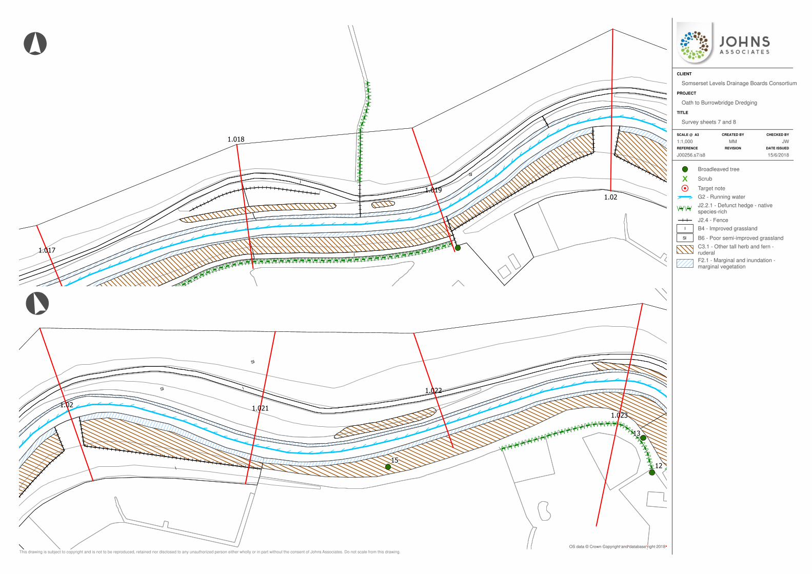
I
I
SI
>>
>>>>>>>>
>>
>>
>>
>>
>>
>>
>>
>>>>>>>>>>>>>>>>>>>>>>>>>>>
>>
>>
>>
>>
>/ / / / / / / / / / / / / / / / / / / / / / / / / / / / / / / / / / / / / / / / / / / / / / / / / / / / / / / / / / / / / / / / / / / / / / / / / / / / / / / / / / / / / /
\ \ \ \ \ \ \ \ \ \ \ \ \ \ \ \ \ \ \ \ \ \ \ \ \ \ \ \ \ \ \ \ \ \ \ \ \ \ \ \ \ \ \ \ \ \ \ \ \ \ \ \ \ \ \ \ \ \ \ \ \ \ \ \ \ \ \ \ \ \ \ \ \ \ \ \ \ \ \ \ \ \ \ \ \
//////////////// /
/ // /
/ //
/////
//\\\\\\\\\\\\\\\\\
\ \\ \
\ \\\\
\\\
\\
I I I I I I I I I I I I I I I I I I I I I I I I I I I I I I I I
II
II
II
II
II
II
II
II
I
II
II
II
II
II
II
II
II
II
II
II
II
II
II
I I I I I I I I I I I
II
II
II
II
II
II
I
I I I I I I I I I I I I I I I
1.02
1.019
1.018
1.017
I
I
SI
SI
>
>>
>>>>>>>>>>>
>>
>>
>>
>>
>>
>>>>>>>>>>>>>>>>>>>>
>>
>>>>>>>>>>>
>>
>>
>>
>
/ / / / / / / / / / / / / / / / / / / / / / / / / / / / / / / / / / / / / / / / / / / / / / / / / // / /
\ \ \ \ \ \ \ \ \ \ \ \ \ \ \ \ \ \ \ \ \ \ \ \ \ \ \ \ \ \ \ \ \ \ \ \ \ \ \ \ \ \ \ \ \ \ \ \ \ \\ \ \ / / /
\ \ \
II
II
II
II
II
II
I
II
II
II
II
II
II
II
II
I
I I I I I I I I I I I I I I I I I I I I I I I I I I I I I I I I I I I I I I I I I I I
1.023
1.021.021
1.022
1512
13
Broadleaved tree
Scrub
Target note
> > G2 - Running water
/ / / /\ \ \ \J2.2.1 - Defunct hedge - nativespecies-rich
I I J2.4 - Fence
I B4 - Improved grassland
SI B6 - Poor semi-improved grassland
C3.1 - Other tall herb and fern -ruderal
F2.1 - Marginal and inundation -marginal vegetation
SCALE @ A3 CREATED BY CHECKED BY
REFERENCE REVISION DATE ISSUED
TITLE
PROJECT
CLIENT
°
°
This drawing is subject to copyright and is not to be reproduced, retained nor disclosed to any unauthorized person either wholly or in part without the consent of Johns Associates. Do not scale from this drawing.
OS data © Crown Copyright and database right 2018
JW1:1,000 MM
15/6/2018
Survey sheets 7 and 8
Oath to Burrowbridge Dredging
Somserset Levels Drainage Boards Consortium
J00256.s7/s8

I
I
I
SI
SI
>>>>>>>>>>>>>>>>>>>>>>>>>>>>>>>>>>>>>>>>>>>>>>>>>
>>
>>
>>
>>
>>
>>
>
///////////
///// /
////
/ // /
/ // / / / / / / / / /
\\\\\\\\\\\
\\\\\ \
\\\\
\ \\ \
\ \\ \ \ \ \ \ \ \ \ \
/ / / / / / / / / / / / / / / / / / / / / / / / / / / / / / / / / / / / / / / / / / / / / / /
\ \ \ \ \ \ \ \ \ \ \ \ \ \ \ \ \ \ \ \ \ \ \ \ \ \ \ \ \ \ \ \ \ \ \ \ \ \ \ \ \ \ \ \ \ \ \/ / / / / / / / / / / / / / / / / / / / / / / / / / / / / / / / / / / / / / / / / / / / / / / / / / / / / / / / / / / / / / / / / / / / / / / / / / / / / / / / / / / / / / / / / / / / /\ \ \ \ \ \ \ \ \ \ \ \ \ \ \ \ \ \ \ \ \ \ \ \ \ \ \ \ \ \ \ \ \ \ \ \ \ \ \ \ \ \ \ \ \ \ \ \ \ \ \ \ \ \ \ \ \ \ \ \ \ \ \ \ \ \ \ \ \ \ \ \ \ \ \ \ \ \ \ \ \ \ \ \ \ \ \ \ \ \ \ \ \ \
///////////////////////
\\\\\\\\\\\\\\\\\\\\\\\
II
II
II
II
II
II
I
II
II
II
II
I
1.023
1.024
1.025
1.026
14
1213I
I
I
!!
!!
!!
!!
!!
!!
!!
!!
!!
!!
!!
!!
!!
!!
!!
!!
!!
!!
!!
!!
!!
!!
!!
!!
!!
!!
!!
!!
!!
!!
!!
!!
!!
!!
!!
!!
!!
!!
!!
!!
!!
!!
!!
!!
!!
!!
!!
!!
!!
!!
!!
!!
!!
!!
!!
!!
!!
!!
!!
!!
!!
!!
!!
!
!!
!!
!!
!!
!!
!!
!!
!
!!
!!
!!
!!
!!
!!
!!
!
!!
!!
!!
!!
!!
!!
!!
!
!!
!!
!!
!!
!!
!!
!!
!
!!
!!
!!
!!
!!
!!
!!
!
>>>>>>>>>>>>>>>>>>>>>>>>>>>>>>>>
>>
>>
>>
>>
>>
>>
>>
>>>>>>>>>>>>>>>>
/ / / / / / / / / / / / / / / / / / / / / / / / / / / / / / / / / / / / / / / /
\ \ \ \ \ \ \ \ \ \ \ \ \ \ \ \ \ \ \ \ \ \ \ \ \ \ \ \ \ \ \ \ \ \ \ \ \ \ \ \
A
A
1.026
1.029
1.028
1.027
1
5
4
32
1
11
Broadleaved tree
Scrub
Target note
> > G2 - Running water
/ / / /\ \ \ \J2.2.1 - Defunct hedge - nativespecies-rich
A Aquatic macrophytes
I B4 - Improved grassland
SI B6 - Poor semi-improved grassland
C3.1 - Other tall herb and fern -ruderal
F2.1 - Marginal and inundation -marginal vegetation
! !
! !
! ! !
! ! !
J4 - Bare ground
SCALE @ A3 CREATED BY CHECKED BY
REFERENCE REVISION DATE ISSUED
TITLE
PROJECT
CLIENT
°°
This drawing is subject to copyright and is not to be reproduced, retained nor disclosed to any unauthorized person either wholly or in part without the consent of Johns Associates. Do not scale from this drawing.
OS data © Crown Copyright and database right 2018
JW1:1,000 MM
15/6/2018
Survey sheets 9 and 10
Oath to Burrowbridge Dredging
Somserset Levels Drainage Boards Consortium
J00256.s9/s10
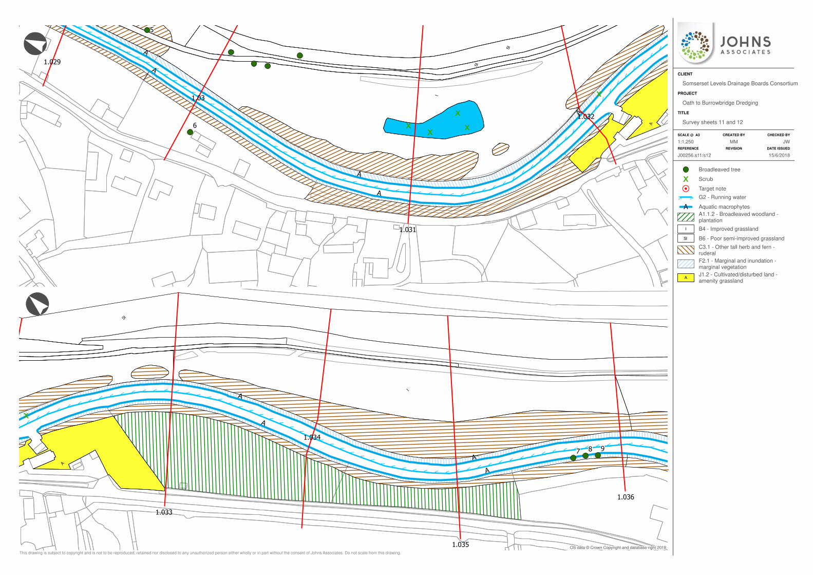
I
I
SI
SI
A
>>
>>
>>
>
>>
>>
>>
>>
>>
>>
>>
>>>>>>>>>>>>>>>>>
>>
>>
>>
>>
>>
>>
>>
>>
>>
>>
>>
>>
>>
>
A
A
A
A
A
1.031
1.03
1.032
1.029
6
5
I
SI
A
>>>>>>>>>>>>>>>>>>>>>>>>>>>>
>>
>>
>>
>>
>>
>>
>>
>>>>>>>>>>>>>>>>
>>
>>
A
A
A
A
1.035
1.034
1.033
1.036
7 8 9
Broadleaved tree
Scrub
Target note
> > G2 - Running water
A Aquatic macrophytes
A1.1.2 - Broadleaved woodland -plantation
I B4 - Improved grassland
SI B6 - Poor semi-improved grassland
C3.1 - Other tall herb and fern -ruderal
F2.1 - Marginal and inundation -marginal vegetation
AJ1.2 - Cultivated/disturbed land -amenity grassland
SCALE @ A3 CREATED BY CHECKED BY
REFERENCE REVISION DATE ISSUED
TITLE
PROJECT
CLIENT
°°
This drawing is subject to copyright and is not to be reproduced, retained nor disclosed to any unauthorized person either wholly or in part without the consent of Johns Associates. Do not scale from this drawing.
OS data © Crown Copyright and database right 2018
JW1:1,250 MM
15/6/2018J00256.s11/s12
Survey sheets 11 and 12
Oath to Burrowbridge Dredging
Somserset Levels Drainage Boards Consortium
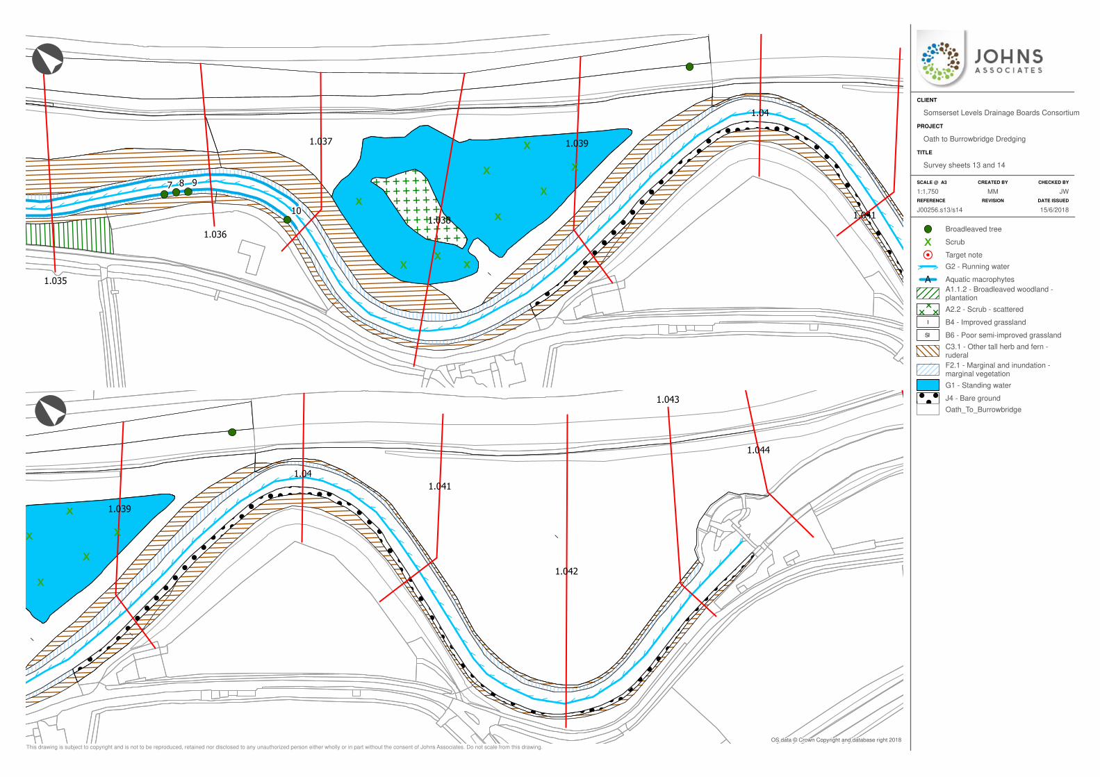
E
E
E
E
E
E
E
E
E
E
E
E
E
E
E
E
E
E
E
E
E
E
E
E
E
E
E
E
E
E
E
E
E
E
E
E
E
E
E
E
E
E
E
E
E
E
E
E
E
E
E
E
E
E
E
E
E
E
E
E
E
E
E
E
E
E
E
E
E
E
E
E
E
E
E
E
E
E
E
E
E
I
I
!
!
!
!
!
!
!
!
!
!
!
!
!
!
!
!
!
!
!
!
!
!
!
!
!
!
!
!
!
!
!
!
!
!
!
!
!
!
!
!
!
!
!
!
!
!
!
!
!
!
!
!
!
!
!
!
!
!
!
!
!
!
!
!
!
!
!
!
!
!
!
!
!
!
!
!
!
!
!
!
!
!
!
!
!
!
!
!
!
!
!
!
!
!
!
!
!
!
!
!
!
!
!
!
!
!
!
!
!
!
!
!
!
!
!
!
!
!
!
!
!
!
!
!
!
!
!
!
!
!
!
!
!
!
!
!
!
!
!
!
!
!
!
!
!
!
!
!
!
!
!
!
!
!
!
!
!
!
!
!
!
!
!
!
!
!
!
!
!
!
!
!
!
!
!
!
!
!
!
!
!
!
!
!
!
!
!
!
!
!
!
!
!
!
!
!
!
!
!
!
!
!
!
!
!
!
!
!
!
!
!
!
!
!
!
!
!
!
!
!
!
!
!
!
!
!
!
!
!
!
!
!
!
!
!
!
!
!
!
!
!
!
!
!
!
!
!
!
!
!
!
!
!
!
!
!
!
!
!
!
!
!
!
!
!
!
!
!
!
!
!
!
!
!
!
!
!
!
!
!
!
!
!
!
!
!
!
!
!
!
!
!
!
!
!
!
!
!
!
!
!
!
!
!
!
!
!
!
!
!
!
!
!
!
!
!
!
!
!
!
!
!
!
!
!
!
!
!
!
!
!
!
!
!
!
!
!
!
!
!
!
!
!
!
!
!
!
!
!
!
!
!
!
!
!
!
!
!
!
!
!
!
!
!
!
!
!
!
!
!
!
!
!
!
!
!
!
!
!
!
!
!
!
!
!
!
!
!
!
!
!
!
!
!
!
!
!
!
!
!
!
!
!
!
!
!
!
!
!
!
!
!
!
!
!
!
!
!
!
!
!
!
!
!
!
!
!
!
!
!
!
!
!
!
!
!
!
!
!
!
!
!
!
!
!
!
!
!
!
!
!
!
!
!
!
!
!
!
!
!
!
!
!
!
!
!
!
!
!
!
!
!
!
!
!
!
!
!
!
!
!
!
!
!
!
!
!
!
!
!
!
!
!
!
!
!
!
!
!
!
!
!
!
!
!
!
!
!
!
!
!
!
!
!
!
!
!
!
!
!
!
!
!
!
!
!
!
!
!
!
!
!
!
!
!
!
!
!
!
!
!
!
!
!
!
!
!
!
!
!
!
!
!
!
!
!
!
!
!
!
!
!
!
!
!
!
!
!
!
!
!
!
!
!
!
!
!
!
!
!
!
!
!
!
!
!
!
!
!
!
!
!
!
!
!
!
!
!
!
!
!
!
!
!
!
!
!
!
!
!
!
!
!
!
!
!
!
!
!
!
!
!
!
!
!
!
!
!
!
!
!
!
!
!
!
!
!
!
!
!
!
!
!
!
!
!
!
!
!
!
!
!
!
!
!
!
!
!
!
!
!
!
!
!
!
!
!
!
!
!
!
!
!
!
!
!
!
!
!
!
!
!
!
!
!
!
!
!
!
!
!
!
!
!
!
!
!
!
!
!
!
!
!
!
!
!
!
!
!
!
!
!
!
!
!
!
!
!
!
!
!
!
!
!
!
!
!
!
!
!
!
!
!
!
!
!
!
!
!
!
!
!
!
!
!
!
!
!
!
!
!
!
!
!
!
!
!
!
!
!
!
!
!
!
!
!
!
!
!
!
!
!
!
!
!
!
!
!
!
!
!
!
!
!
!
!
!
!
!
!
!
!
!
!
!
!
!
!
!
!
!
!
!
!
!
!
!
!
!
!
!
!
!
!
!
!
!
!
!
!
!
!
!
!
!
!
!
!
!
!
!
!
!
!
!
!
!
!
!
!
!
!
!
!
!
!
!
!
!
!
!
!
!
!
!
!
!
!
!
!
!
!
!
!
!
!
!
!
!
!
!
!
!
!
!
!
!
!
!
!
!
!
!
!
!
!
!
!
!
!
!
!
!
!
!
!
!
!
!
!
!
!
!
!
!
!
!
!
!
!
!
!
!
!
!
!
!
!
!
!
!
!
!
!
!
!
!
!
!
!
!
!
!
!
!
!
!
!
!
!
!
!
!
!
!
!
!
!
!
!
!
!
!
!
!
!
!
!
!
!
!
!
!
!
!
!
!
!
!
!
!
!
!
!
!
!
!
!
!
!
!
!
!
!
!
!
!
!
!
!
!
!
!
!
!
!
!
!
!
!
!
!
!
!
!
!
!
!
!
!
!
!
!
!
!
!
!
!
!
!
!
!
!
!
!
!
!
!
!
!
!
!
!
!
!
!
!
!
!
!
!
!
!
!
!
!
!
!
!
!
!
!
!
!
!
!
!
!
!
!
!
!
!
!
!
!
!
!
!
!
!
!
!
!
!
!
!
!
!
!
!
!
!
!
!
!
!
!
!
!
!
!
!
!
!
!
!
!
!
!
!
!
!
!
!
!
!
!
!
!
!
!
!
!
!
!
!
!
!
!
!
!
!
!
!
!
!
!
!
!
!
!
!
!
!
!
!
!
!
!
!
!
!
!
!
!
!
!
!
!
!
!
!
!
!
!
!
!
!
!
!
!
!
!
!
!
!
!
!
!
!
!
!
!
!
!
!
!
!
!
!
!
!
!
!
!
!
!
!
!
!
!
!
!
!
!
!
!
!
!
!
!
!
!
!
!
!
!
!
!
!
!
!
!
!
!
!
!
!
!
!
!
!
!
!
!
!
!
!
!
!
!
!
!
!
!
!
!
!
!
!
!
!
!
!
!
!
!
!
!
!
!
!
!
!
!
!
!
!
!
!
!
!
!
!
!
!
!
!
!
!
!
!
!
!
!
!
!
!
!
!
!
!
!
!
!
!
!
!
!
!
!
!
!
!
!
!
!
!
!
!
!
!
!
!
!
!
!
!
!
!
!
!
!
!
!
!
!
!
!
!
!
!
!
!
!
!
!
!
!
!
!
!
!
!
!
!
!
!
!
!
!
!
!
!
!
!
!
!
!
!
!
!
!
!
!
!
!
!
!
!
!
!
!
!
!
!
!
!
!
!
!
!
!
!
!
!
!
!
!
!
!
!
!
!
!
!
!
!
!
!
!
!
!
!
!
!
!
!
!
!
!
!
!
!
!
!
!
!
!
!
!
!
!
!
!
!
!
!
!
!
!
!
!
!
!
!
!
!
!
!
!
!
!
!
!
!
!
!
!
!
!
!
!
!
!
!
!
!
!
!
!
!
!
!
!
!
!
!
!
!
!
!
!
!
!
!
!
!
!
!
!
!
!
!
!
!
!
!
!
!
!
!
!
!
!
!
!
!
!
!
!
!
!
!
!
!
!
!
!
!
!
!
!
!
!
!
!
!
!
!
!
!
!
!
!
!
!
!
!
!
!
!
!
!
!
!
!
!
!
!
!
!
!
!
!
!
!
!
!
!
!
!
!
!
!
!
!
!
!
!
!
!
!
!
!
!
!
!
!
!
!
!
!
!
!
!
!
!
!
!
!
!
!
!
!
!
!
!
!
!
!
!
!
!
!
!
!
!
!
!
!
!
!
!
!
!
!
!
!
!
!
!
!
!
!
!
!
!
!
!
!
!
!
!
!
!
!
!
!
!
!
!
!
!
!
!
!
!
!
!
!
!
!
!
!
!
!
!
!
!
!
!
!
!
!
!
!
!
!
!
!
!
!
!
!
!
!
!
!
!
!
!
!
!
!
>>
>>
>>
>>
>
>>
>>
>>>>>
>>
>>
>
>>
>
>>
>>
>>
>>
>>
>>
>>
>>>>>
>>>
>>
>>
>>
>
>>
>>>>>>>>>>>>>>>>>
A
1.038
1.039
1.041
1.035
1.037
1.04
1.036
7 8 9
10
E
E
E
E
E
E
E
E
E
E
E
E
E
E
E
E
E
E
E
E
E
E
E
E
E
E
E
E
E
E
E
E
E
E
E
E
E
E
E
E
E
E
E
E
E
E
E
E
E
E
E
E
E
E
E
E
E
E
E
E
E
E
E
E
E
E
E
E
E
E
E
E
E
E
E
E
E
E
E
E
E
I
I
I
!
!
!
!
!
!
!
!
!
!
!
!
!
!
!
!
!
!
!
!
!
!
!
!
!
!
!
!
!
!
!
!
!
!
!
!
!
!
!
!
!
!
!
!
!
!
!
!
!
!
!
!
!
!
!
!
!
!
!
!
!
!
!
!
!
!
!
!
!
!
!
!
!
!
!
!
!
!
!
!
!
!
!
!
!
!
!
!
!
!
!
!
!
!
!
!
!
!
!
!
!
!
!
!
!
!
!
!
!
!
!
!
!
!
!
!
!
!
!
!
!
!
!
!
!
!
!
!
!
!
!
!
!
!
!
!
!
!
!
!
!
!
!
!
!
!
!
!
!
!
!
!
!
!
!
!
!
!
!
!
!
!
!
!
!
!
!
!
!
!
!
!
!
!
!
!
!
!
!
!
!
!
!
!
!
!
!
!
!
!
!
!
!
!
!
!
!
!
!
!
!
!
!
!
!
!
!
!
!
!
!
!
!
!
!
!
!
!
!
!
!
!
!
!
!
!
!
!
!
!
!
!
!
!
!
!
!
!
!
!
!
!
!
!
!
!
!
!
!
!
!
!
!
!
!
!
!
!
!
!
!
!
!
!
!
!
!
!
!
!
!
!
!
!
!
!
!
!
!
!
!
!
!
!
!
!
!
!
!
!
!
!
!
!
!
!
!
!
!
!
!
!
!
!
!
!
!
!
!
!
!
!
!
!
!
!
!
!
!
!
!
!
!
!
!
!
!
!
!
!
!
!
!
!
!
!
!
!
!
!
!
!
!
!
!
!
!
!
!
!
!
!
!
!
!
!
!
!
!
!
!
!
!
!
!
!
!
!
!
!
!
!
!
!
!
!
!
!
!
!
!
!
!
!
!
!
!
!
!
!
!
!
!
!
!
!
!
!
!
!
!
!
!
!
!
!
!
!
!
!
!
!
!
!
!
!
!
!
!
!
!
!
!
!
!
!
!
!
!
!
!
!
!
!
!
!
!
!
!
!
!
!
!
!
!
!
!
!
!
!
!
!
!
!
!
!
!
!
!
!
!
!
!
!
!
!
!
!
!
!
!
!
!
!
!
!
!
!
!
!
!
!
!
!
!
!
!
!
!
!
!
!
!
!
!
!
!
!
!
!
!
!
!
!
!
!
!
!
!
!
!
!
!
!
!
!
!
!
!
!
!
!
!
!
!
!
!
!
!
!
!
!
!
!
!
!
!
!
!
!
!
!
!
!
!
!
!
!
!
!
!
!
!
!
!
!
!
!
!
!
!
!
!
!
!
!
!
!
!
!
!
!
!
!
!
!
!
!
!
!
!
!
!
!
!
!
!
!
!
!
!
!
!
!
!
!
!
!
!
!
!
!
!
!
!
!
!
!
!
!
!
!
!
!
!
!
!
!
!
!
!
!
!
!
!
!
!
!
!
!
!
!
!
!
!
!
!
!
!
!
!
!
!
!
!
!
!
!
!
!
!
!
!
!
!
!
!
!
!
!
!
!
!
!
!
!
!
!
!
!
!
!
!
!
!
!
!
!
!
!
!
!
!
!
!
!
!
!
!
!
!
!
!
!
!
!
!
!
!
!
!
!
!
!
!
!
!
!
!
!
!
!
!
!
!
!
!
!
!
!
!
!
!
!
!
!
!
!
!
!
!
!
!
!
!
!
!
!
!
!
!
!
!
!
!
!
!
!
!
!
!
!
!
!
!
!
!
!
!
!
!
!
!
!
!
!
!
!
!
!
!
!
!
!
!
!
!
!
!
!
!
!
!
!
!
!
!
!
!
!
!
!
!
!
!
!
!
!
!
!
!
!
!
!
!
!
!
!
!
!
!
!
!
!
!
!
!
!
!
!
!
!
!
!
!
!
!
!
!
!
!
!
!
!
!
!
!
!
!
!
!
!
!
!
!
!
!
!
!
!
!
!
!
!
!
!
!
!
!
!
!
!
!
!
!
!
!
!
!
!
!
!
!
!
!
!
!
!
!
!
!
!
!
!
!
!
!
!
!
!
!
!
!
!
!
!
!
!
!
!
!
!
!
!
!
!
!
!
!
!
!
!
!
!
!
!
!
!
!
!
!
!
!
!
!
!
!
!
!
!
!
!
!
!
!
!
!
!
!
!
!
!
!
!
!
!
!
!
!
!
!
!
!
!
!
!
!
!
!
!
!
!
!
!
!
!
!
!
!
!
!
!
!
!
!
!
!
!
!
!
!
!
!
!
!
!
!
!
!
!
!
!
!
!
!
!
!
!
!
!
!
!
!
!
!
!
!
!
!
!
!
!
!
!
!
!
!
!
!
!
!
!
!
!
!
!
!
!
!
!
!
!
!
!
!
!
!
!
!
!
!
!
!
!
!
!
!
!
!
!
!
!
!
!
!
!
!
!
!
!
!
!
!
!
!
!
!
!
!
!
!
!
!
!
!
!
!
!
!
!
!
!
!
!
!
!
!
!
!
!
!
!
!
!
!
!
!
!
!
!
!
!
!
!
!
!
!
!
!
!
!
!
!
!
!
!
!
!
!
!
!
!
!
!
!
!
!
!
!
!
!
!
!
!
!
!
!
!
!
!
!
!
!
!
!
!
!
!
!
!
!
!
!
!
!
!
!
!
!
!
!
!
!
!
!
!
!
!
!
!
!
!
!
!
!
!
!
!
!
!
!
!
!
!
!
!
!
!
!
!
!
!
!
!
!
!
!
!
!
!
!
!
!
!
!
!
!
!
!
!
!
!
!
!
!
!
!
!
!
!
!
!
!
!
!
!
!
!
!
!
!
!
!
!
!
!
!
!
!
!
!
!
!
!
!
!
!
!
!
!
!
!
!
!
!
!
!
!
!
!
!
!
!
!
!
!
!
!
!
!
!
!
!
!
!
!
!
!
!
!
!
!
!
!
!
!
!
!
!
!
!
!
!
!
!
!
!
!
!
!
!
!
!
!
!
!
!
!
!
!
!
!
!
!
!
!
!
!
!
!
!
!
!
!
!
!
!
!
!
!
!
!
!
!
!
!
!
!
!
!
!
!
!
!
!
!
!
!
!
!
!
!
!
!
!
!
!
!
!
!
!
!
!
!
!
!
!
!
!
!
!
!
!
!
!
!
!
!
!
!
!
!
!
!
!
!
!
!
!
!
!
!
!
!
!
!
!
!
!
!
!
!
!
!
!
!
!
!
!
!
!
!
!
!
!
!
!
!
!
!
!
!
!
!
!
!
!
!
!
!
!
!
!
!
!
!
!
!
!
!
!
!
!
!
!
!
!
!
!
!
!
!
!
!
!
!
!
!
!
!
!
!
!
!
!
!
!
!
!
!
!
!
!
!
!
!
!
!
!
!
!
!
!
!
!
!
!
!
!
!
!
!
!
!
!
!
!
!
!
!
!
!
!
!
!
!
!
!
!
!
!
!
!
!
!
!
!
!
!
!
!
!
!
!
!
!
!
!
!
!
!
!
!
!
!
!
!
!
!
!
!
!
!
!
!
!
!
!
!
!
!
!
!
!
!
!
!
!
!
!
!
!
!
!
!
!
!
!
!
!
!
!
!
!
!
!
!
!
!
!
!
!
!
!
!
!
!
!
!
!
!
!
!
!
!
!
!
!
!
!
!
!
!
!
!
!
!
!
!
!
!
!
!
!
!
!
!
!
!
!
!
!
!
!
!
!
!
!
!
!
!
!
!
!
!
!
!
!
!
!
!
!
!
!
!
!
!
!
!
!
!
!
!
!
!
!
!
!
!
!
!
!
!
!
!
!
!
!
!
!
!
!
!
!
!
!
!
!
!
!
!
!
!
!
!
!
!
!
!
!
!
!
!
!
!
!
!
!
!
!
!
!
!
!
!
!
!
!
!
!
!
!
!
!
!
!
!
!
!
!
!
!
!
!
!
!
!
!
!
!
!
!
!
!
!
!
!
!
!
!
!
!
!
!
!
!
!
!
!
!
!
!
!
!
!
!
!
!
!
!
!
!
!
!
!
!
!
!
!
!
!
!
!
!
!
!
!
!
!
!
!
!
!
!
!
!
!
!
!
!
!
!
!
!
!
!
!
!
!
!
!
!
!
!
!
!
!
!
!
!
!
!
!
!
!
!
!
!
!
!
!
!
!
!
!
!
!
!
!
!
!
!
!
!
!
!
!
!
!
!
!
!
!
!
!
!
!
!
!
!
!
!
!
!
!
!
!
!
!
!
!
!
!
!
!
!
!
!
!
!
!
!
!
!
!
!
!
!
!
!
!
!
!
!
!
!
!
!
!
!
!
!
!
!
!
!
!
!
!
!
!
!
!
!
!
!
!
!
!
!
!
!
!
!
!
!
!
!
!
!
!
!
!
!
!
!
!
!
!
!
!
!
!
!
!
!
!
!
!
!
!
!
!
!
!
!
!
!
!
!
!
!
!
!
!
!
!
!
!
!
!
!
!
!
!
!
!
!
!
!
!
!
!
!
!
!
!
!
!
!
!
!
!
!
!
!
!
!
!
!
!
!
!
!
!
!
!
!
!
!
!
!
!
!
!
!
!
!
!
!
!
!
!
!
!
!
!
!
!
!
!
!
!
!
!
!
!
!
!
!
!
!
!
!
!
!
!
!
!
!
!
!
!
!
!
!
!
!
!
!
!
!
!
!
!
!
!
!
!
!
!
!
!
!
!
!
!
!
!
!
!
!
!
!
!
!
!
!
!
!
!
!
!
!
!
!
!
!
!
!
!
!
!
!
!
!
!
!
!
!
!
!
!
!
!
!
!
!
!
!
!
!
!
!
!
!
!
!
!
!
!
!
!
!
!
!
!
!
!
!
!
!
!
!
!
!
!
!
!
!
!
!
!
!
!
!
!
!
!
!
!
!
!
!
!
!
!
!
!
!
!
!
!
!
!
!
!
!
!
!
!
!
!
!
!
!
!
!
!
!
!
!
!
!
!
!
!
!
!
!
!
!
!
!
!
!
!
!
!
!
!
!
!
!
!
!
!
!
!
!
!
!
!
!
!
!
!
!
!
!
!
!
!
!
!
!
!
!
!
!
!
!
!
!
!
!
!
!
!
!
!
!
!
!
!
!
!
!
!
!
!
!
!
!
!
!
!
!
!
!
!
!
!
!
!
!
!
!
!
!
!
!
!
!
!
!
!
!
!
!
!
!
!
!
!
!
!
!
!
!
!
!
!
!
!
!
!
!
!
!
!
!
!
!
!
!
!
!
!
!
!
!
!
!
!
!
!
!
!
!
!
!
!
!
!
!
!
!
!
!
!
!
!
!
!
!
!
!
!
!
!
!
!
!
!
!
!
!
!
!
!
!
!
!
!
!
!
!
!
!
!
!
!
!
!
!
!
!
!
!
!
!
!
!
!
!
!
!
!
!
!
!
!
!
!
!
!
!
!
!
!
!
!
!
!
!
!
!
!
!
!
!
!
!
!
!
!
!
!
!
!
!
!
!
!
!
!
!
!
!
!
!
!
!
!
!
!
!
!
!
!
!
!
!
!
!
!
!
!
!
!
!
!
!
!
!
!
!
!
!
!
!
!
!
!
!
!
!
!
!
!
!
!
!
!
!
!
!
!
!
!
!
!
!
!
!
!
!
!
!
!
!
!
!
!
!
!
!
!
!
!
!
!
!
!
!
!
!
!
!
!
!
!
!
!
!
!
!
!
!
!
!
!
!
!
!
!
!
!
!
!
!
!
!
!
!
!
!
!
!
!
!
!
!
!
!
!
!
!
!
!
!
!
!
!
!
!
!
!
!
!
!
!
!
!
!
!
!
!
!
!
!
!
!
!
!
!
!
!
!
!
!
!
!
!
!
!
!
!
!
!
!
!
>>
>>
>>
>>
>>
>
>>
>>
>>>>>>
>>
>>
>>
>>
>>
>>
>>
>
>>
>>
>>>>>
>>
>>
>
>>
>
>>
>>
>>
>>
>>
>>
>
1.042
1.039
1.043
1.041
1.04
1.044
Broadleaved tree
Scrub
Target note
> > G2 - Running water
A Aquatic macrophytes
A1.1.2 - Broadleaved woodland -plantation
E E
E E
E E E
E E EA2.2 - Scrub - scattered
I B4 - Improved grassland
SI B6 - Poor semi-improved grassland
C3.1 - Other tall herb and fern -ruderal
F2.1 - Marginal and inundation -marginal vegetation
G1 - Standing water
! !
! !
! ! !
! ! !
J4 - Bare ground
Oath_To_Burrowbridge
SCALE @ A3 CREATED BY CHECKED BY
REFERENCE REVISION DATE ISSUED
TITLE
PROJECT
CLIENT
°°
This drawing is subject to copyright and is not to be reproduced, retained nor disclosed to any unauthorized person either wholly or in part without the consent of Johns Associates. Do not scale from this drawing.
OS data © Crown Copyright and database right 2018
JW1:1,750 MM
15/6/2018
Survey sheets 13 and 14
Oath to Burrowbridge Dredging
Somserset Levels Drainage Boards Consortium
J00256.s13/s14