Embed Size (px)
Citation preview
Image Credits: Lake Albert (G.Newton) Pelicans (G. Newton) River Murray Gorge (K. Walker) Wetlands (SA MDB NRM Board) Murray Mouth (K. Walker)
Threatened Species Scientific Committee
1 - 3 July, 2009 Adelaide
River Murray – Darling to Sea Ecological Community:
Expert Technical Workshop Report
River Murray–Darling to Sea Expert Technical Workshop, 1-3 July 2009
1
Threatened Species Scientific Committee
The establishment of the Threatened Species Scientific Committee is provided for under the Environment Protection and Biodiversity Conservation Act 1999 (EPBC Act). The EPBC Act also sets out the functions of the Committee. These include advising the Commonwealth Environment Minister on the amendment and updating of lists for threatened species, threatened ecological communities, and key threatening processes together with the making or adoption of recovery plans and threat abatement plans.
How to cite this report Threatened Species Scientific Committee (2010) River Murray – Darling to Sea Ecological Community: Expert Technical Workshop Report, 1-3 July 2009, Adelaide. Report to Department of the Environment, Water, Heritage and the Arts, Canberra. Disclaimer This report was compiled by the Threatened Species Scientific Committee. Release of this report does not imply endorsement of all of its contents by the Commonwealth, the Threatened Species Scientific Committee, workshop participants, or other experts.

River Murray – Darling to Sea Ecological Community:
Expert Technical WorkshopReport
Threatened Species Scientific Committee
1-3 July 2009, Adelaide
River Murray–Darling to Sea Expert Technical Workshop, 1-3 July 2009
2
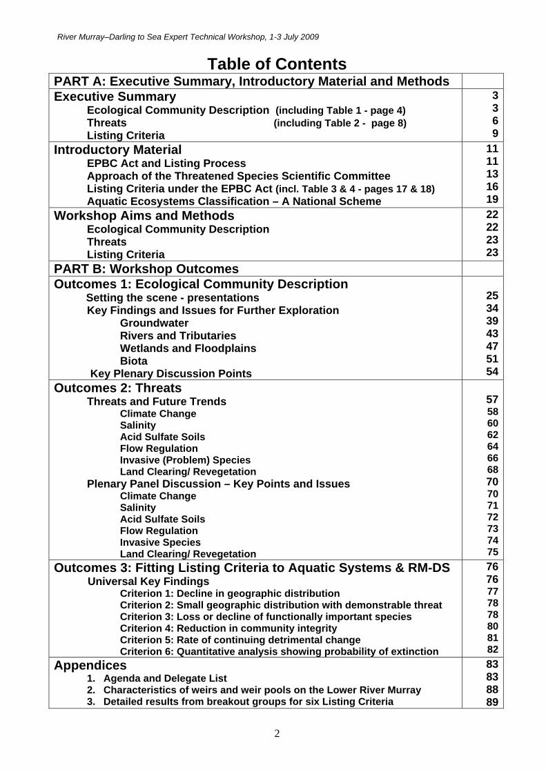
Table of Contents PART A: Executive Summary, Introductory Material and Methods
Executive Summary Ecological Community Description (including Table 1 - page 4) Threats (including Table 2 - page 8) Listing Criteria
3369
Introductory Material EPBC Act and Listing Process Approach of the Threatened Species Scientific Committee Listing Criteria under the EPBC Act (incl. Table 3 & 4 - pages 17 & 18) Aquatic Ecosystems Classification – A National Scheme
1111131619
Workshop Aims and Methods Ecological Community Description Threats Listing Criteria
22222323
PART B: Workshop Outcomes Outcomes 1: Ecological Community Description Setting the scene - presentations
Key Findings and Issues for Further Exploration Groundwater Rivers and Tributaries Wetlands and Floodplains Biota
Key Plenary Discussion Points
25343943475154
Outcomes 2: Threats Threats and Future Trends
Climate Change Salinity Acid Sulfate Soils Flow Regulation Invasive (Problem) Species Land Clearing/ Revegetation
Plenary Panel Discussion – Key Points and Issues Climate Change Salinity Acid Sulfate Soils Flow Regulation Invasive Species Land Clearing/ Revegetation
5758606264666870707172737475
Outcomes 3: Fitting Listing Criteria to Aquatic Systems & RM-DS Universal Key Findings
Criterion 1: Decline in geographic distribution Criterion 2: Small geographic distribution with demonstrable threat Criterion 3: Loss or decline of functionally important species Criterion 4: Reduction in community integrity Criterion 5: Rate of continuing detrimental change Criterion 6: Quantitative analysis showing probability of extinction
7676777878808182
Appendices 1. Agenda and Delegate List 2. Characteristics of weirs and weir pools on the Lower River Murray 3. Detailed results from breakout groups for six Listing Criteria
83838889
River Murray–Darling to Sea Expert Technical Workshop, 1-3 July 2009
3
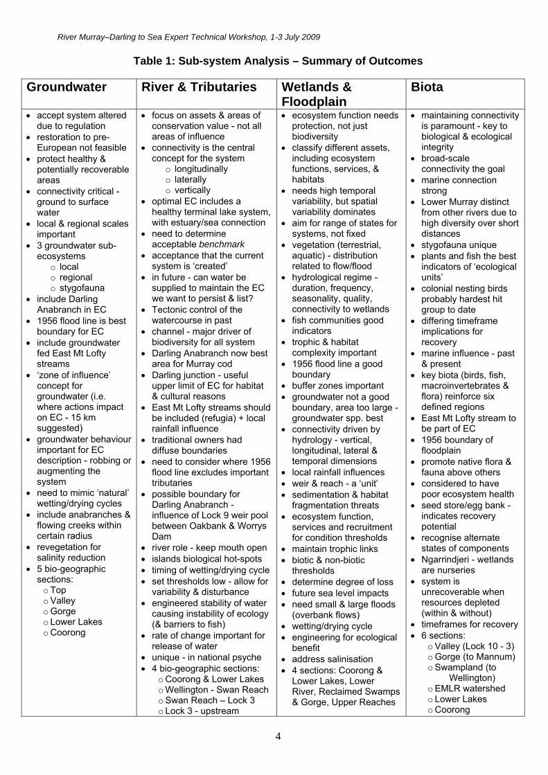
Part A - Executive Summary, Introductory Material, Workshop Aims and Methods Executive Summary - Ecological Community Description An expert technical workshop was held in Adelaide from 1 – 3 July 2009 (see Appendix 1 for agenda and delegate list). Deliberations resulted in a number of key findings regarding the boundaries, characteristic features, benchmarking, and conservation goals of the ecological community (EC) under assessment - the ‘Lower Murray River and associated wetlands, floodplains and groundwater systems from the junction of the Darling River to the Sea’ (RM-DS). A summary of outcomes from the workshop focus groups (groundwater; river and tributaries; wetlands and floodplain; biota) is provided at Table 1 on page 4. Scope and Boundaries The EC is a ‘constructed’ system that consists of a series of interconnected sub-units which include the river channel and its associated tributaries and wetlands, an infrequently flooded floodplain, and groundwater. The system is highly regulated. It incorporates the entire South Australian component of the River Murray (about three quarters of river reach length of the EC), with about one quarter of the river reach component having a shared boundary between NSW and Victoria. The EC ends at the junction (or confluence) of the Darling and Murray Rivers (near the town of Wentworth) and the workshop considered this as a sensible upper limit given habitat, biodiversity, and water quality changes upstream of this site. The region of the EC to be assessed is considered as distinctive due to its unique combination of landscape and habitat features and biodiversity elements. It was acknowledged that the region holds significant interest and connection for indigenous peoples, and information provided at the workshop confirmed that this region closely overlaps with the ‘creation story’ of the Ngarrindjeri. In terms of floodplain boundaries for the EC, the workshop suggested that, as a general principle, the 1956 flood-line provides the best overall boundary for the system – biologically, hydrologically and geomorphologically. This line has also been well mapped and has been tested in other legislative/regulatory processes. However, it was strongly considered that the Eastern Mt Lofty Ranges watershed (which flows into the River Murray and Lake Alexandrina), although excluded by the 1956 flood-line, should be included within the EC. Inclusion of the Darling Anabranch (or part thereof) in the EC was also discussed as this may offer potential refuge habitat, however this aspect requires further investigation. In alignment with Ramsar Convention conditions, the various islands of the region are considered to be included within the EC. Three main groundwater dependent/influenced sub-system types were identified: local groundwater system river-fed floodplain communities that occur along the length of the
EC regional discharge fed systems subsurface stygofaunal communities – not yet documented. The workshop suggested that a ‘zone of influence’ or ‘buffer zone’ concept be utilised for where actions on groundwater have a measurable influence on the ecosystem. This aspect requires further investigation. Overall, the workshop highlighted up to six bio-geographical sub-regions within the EC region that have ‘strong’ ecological identities: Coorong – estuarine to hyper-marine, includes river mouth, ‘end of system’ marker of condition Lower Lakes – lake system with marginal wetlands and adjacent ephemeral saline ponds,
regional groundwater input, plants different Eastern Mt Lofty Ranges Watershed - abundance of exotics, lack of natural floodplain, strong
diadromous influence of fish; Eastern Mt Lofty tributaries are Marne River, Saunders Creek, Reedy Creek, Bremer River, Angas River, Finniss River, Tookayerta Creek, and Currency Creek. All but Marne, Saunders and Reedy feed into Lake Alexandrina.
River Murray–Darling to Sea Expert Technical Workshop, 1-3 July 2009
4
Table 1: Sub-system Analysis – Summary of Outcomes
Groundwater River & Tributaries Wetlands & Floodplain
Biota
accept system altered due to regulation
restoration to pre-European not feasible
protect healthy & potentially recoverable areas
connectivity critical - ground to surface water
local & regional scales important
3 groundwater sub-ecosystems
o local o regional o stygofauna
include Darling Anabranch in EC
1956 flood line is best boundary for EC
include groundwater fed East Mt Lofty streams
‘zone of influence’ concept for groundwater (i.e. where actions impact on EC - 15 km suggested)
groundwater behaviour important for EC description - robbing or augmenting the system
need to mimic ‘natural’ wetting/drying cycles
include anabranches & flowing creeks within certain radius
revegetation for salinity reduction
5 bio-geographic sections:
o Top o Valley o Gorge o Lower Lakes o Coorong
focus on assets & areas of conservation value - not all areas of influence
connectivity is the central concept for the system
o longitudinally o laterally o vertically
optimal EC includes a healthy terminal lake system, with estuary/sea connection
need to determine acceptable benchmark
acceptance that the current system is ‘created’
in future - can water be supplied to maintain the EC we want to persist & list?
Tectonic control of the watercourse in past
channel - major driver of biodiversity for all system
Darling Anabranch now best area for Murray cod
Darling junction - useful upper limit of EC for habitat & cultural reasons
East Mt Lofty streams should be included (refugia) + local rainfall influence
traditional owners had diffuse boundaries
need to consider where 1956 flood line excludes important tributaries
possible boundary for Darling Anabranch - influence of Lock 9 weir pool between Oakbank & Worrys Dam
river role - keep mouth open islands biological hot-spots timing of wetting/drying cycle set thresholds low - allow for
variability & disturbance engineered stability of water
causing instability of ecology (& barriers to fish)
rate of change important for release of water
unique - in national psyche 4 bio-geographic sections:
o Coorong & Lower Lakes o Wellington - Swan Reach o Swan Reach – Lock 3 o Lock 3 - upstream
ecosystem function needs protection, not just biodiversity
classify different assets, including ecosystem functions, services, & habitats
needs high temporal variability, but spatial variability dominates
aim for range of states for systems, not fixed
vegetation (terrestrial, aquatic) - distribution related to flow/flood
hydrological regime - duration, frequency, seasonality, quality, connectivity to wetlands
fish communities good indicators
trophic & habitat complexity important
1956 flood line a good boundary
buffer zones important groundwater not a good
boundary, area too large - groundwater spp. best
connectivity driven by hydrology - vertical, longitudinal, lateral & temporal dimensions
local rainfall influences weir & reach - a ‘unit’ sedimentation & habitat
fragmentation threats ecosystem function,
services and recruitment for condition thresholds
maintain trophic links biotic & non-biotic
thresholds determine degree of loss future sea level impacts need small & large floods
(overbank flows) wetting/drying cycle engineering for ecological
benefit address salinisation 4 sections: Coorong &
Lower Lakes, Lower River, Reclaimed Swamps & Gorge, Upper Reaches
maintaining connectivity is paramount - key to biological & ecological integrity
broad-scale connectivity the goal
marine connection strong
Lower Murray distinct from other rivers due to high diversity over short distances
stygofauna unique plants and fish the best
indicators of ‘ecological units’
colonial nesting birds probably hardest hit group to date
differing timeframe implications for recovery
marine influence - past & present
key biota (birds, fish, macroinvertebrates & flora) reinforce six defined regions
East Mt Lofty stream to be part of EC
1956 boundary of floodplain
promote native flora & fauna above others
considered to have poor ecosystem health
seed store/egg bank - indicates recovery potential
recognise alternate states of components
Ngarrindjeri - wetlands are nurseries
system is unrecoverable when resources depleted (within & without)
timeframes for recovery 6 sections:
o Valley (Lock 10 - 3) o Gorge (to Mannum) o Swampland (to
Wellington) o EMLR watershed o Lower Lakes o Coorong
River Murray–Darling to Sea Expert Technical Workshop, 1-3 July 2009
5
Lower Swamps section - reach between Wellington and Mannum; dominated by exotic plant species (e.g. willow, agricultural weeds) and has very little natural floodplain due to conversion to dairy swamps; (Reedy Creek flows into this section)
Gorge section - Mannum to Overland Corner - valley and gorge plants and fish similar, but birds different, permanent large wetlands due to regulation; Marne and Saunders flow into this section of the Murray
Top Valley section - junction of the Murray and Darling rivers (Wentworth, also Lock 10) to the beginning of the gorge at the Overland Corner (Lock 3), floodplains, lakes, anabranch systems, river losing water to groundwater.
Benchmark State A benchmark state is the reference condition against which future evaluative comparisons can be made – it should not necessarily be equated as a target for management. The workshop accepted that this EC is a regulated, ‘created’ or ‘constructed’ system, and is therefore altered from its original, more natural condition. The weirs have been in place a long time (i.e. 72 - 87 years) and now there is a series of stepped pools formed by the weirs rather than a natural gradient through the river. Therefore using pre-European or pre-regulation condition as a benchmark state for the EC is less meaningful. Rather, pre-drought, good flow conditions (for example as occurred in the 1970s wet decade before there was a major shift in the system) were considered by the workshop as a more meaningful reference. In terms of conservation goals, it was considered that priority should be given to healthy and potentially recoverable areas. Experts considered that the majority of the system is recoverable, with the exception of a few highly salinised wetlands and the loss of very old trees such as 100 year old red gums, which provide complex habitat. Key Characteristic Features Flow was considered by the workshop to be the critical feature of the EC system – the ‘maestro’ or master variable that sustains all natural physical and biological processes. Flows provide freshwater, and perform flushing, dilution and transportation functions. Importantly, flow acts to keep the river mouth open and exchange with adjacent coastal waters (i.e. end-of-system concept). An adequate flow regime is needed (based on volume, frequency and timing) to ensure over-bank flow and wetting/drying requirements of wetlands and the floodplain. Flow is an enabler of connectivity. Other key characteristic features were identified by the workshop as:
hydrological connectivity – central for maintaining a healthy functioning ecosystem (ecological community); driven by flow; three main dimensions for operational connectivity – vertical (groundwater/surface water), longitudinally (along river to sea), laterally (across banks and floodplain).
salinity – key variable influencing biological sub-communities and productivity, particularly in lower reaches
temporal variability – key feature of the natural ecosystem; regulation reduces temporal variability and leads to a dominance of spatial variability
distinctiveness – EC region is ecologically different from its parent rivers; high degree of habitat diversity with key unique elements occurring over short distances; key biota reinforce the six defined sub-regions
iconic - the region of the EC is a ‘one of a kind’ system in the national context and different from other river systems due to its complex features, habitat heterogeneity, and high levels of biodiversity over relatively short distances. The River Murray holds an important place in the national ‘psyche’. The region of the EC has great significance for the Ngarrindjeri people as it is part of their traditional home and an integral part of their creation story.
River Murray–Darling to Sea Expert Technical Workshop, 1-3 July 2009
6
Conservation Goals The workshop consensus held that maintenance and increased resilience should be the guiding principle for conservation of the EC (i.e. not just biodiversity conservation). The optimal EC was considered to include a healthy terminal lake system, with an estuarine component connected to the sea. Characteristics of a healthy ecological community should also include trophic and habitat complexity, with no loss of key native species and presence of comparatively few alien species. Achieving enduring connectivity and temporal variability (e.g. adequate wetting/drying cycles) were considered as major conservation goals for the EC. A useful indicator may relate to the role of the river to keep the mouth open. Broad-scale connectivity should also be a goal, i.e. rather than managing wetlands etc. in isolation. Issues were raised by the workshop regarding the future availability of water for the system and it was agreed the aim should be to hold onto as much ecological character as possible until the water comes. However, it was recognised that rather than having an EC with a fixed ‘good condition’, there are a range of acceptable ‘states’ for each sub-community type - i.e. there are various states of the essential character of the system. Overall, the aim should be to turn the system towards a more sustainable one than we have at present. Executive Summary – Threats Key Findings A panel of experts provided a brief introductory commentary on what are considered some of the major threats to the EC – these were: Climate change Salinity Acid sulfate soils (ASS) Flow regulation/extraction Invasive species Land clearing/revegetation
From these overviews and resultant discussions the following key findings emerged. A summary matrix of outcomes is provided at Table 2 on page 8. There was agreement by the workshop that invasive species should include or be renamed ‘problem’ species for the purposes of the EC assessment. In addition to exotic species (invasives), over-abundant native animals and domestic stock can also pose a serious threat the system. The overarching threat to the EC system was considered by the workshop to be climate change; it is a threat that will exacerbate the impacts of all other threat types. A certain level of climate change is already ‘locked in’ to the climate system and future projections suggest a warming and drying trend, with substantial declines in rainfall and inflow to the southern Murray-Darling Basin1. Future policies, plans and strategies regarding balancing the levels of environmental flow and extraction to achieve and maintain ecosystem health were considered to be critical to the future of the EC. The workshop held the view that at this juncture, to reclaim the Murray there needs to be provision for more water for the environment. Experts at the workshop considered overwhelmingly that flow regulation is the most important specific threat to the RM-DS EC. This includes diversions and abstractions, with abstraction from both regulated and unregulated parts of the system. Importantly, flow regulation has changed the system from its natural state to a ‘constructed’ state – with a series of stepped weir pools. This has created a lack of temporal and spatial variability that the system needs for optimal health. The loss of floods under current extended drought conditions has also created problems for the wetlands
Newton, GM 2009 Australia’s environmental climate change challenge: overview with reference to water resources. Australasian Journal of Environmental Management 16: 130 -139

River Murray–Darling to Sea Expert Technical Workshop, 1-3 July 2009
7
and floodplain. Despite the various negative or limiting impacts of regulation, it was also seen as a potential tool to help address this aspect, for example to reinstate water variability and reintroduce wetting/drying cycles for some of these sub-systems. It could also be manipulated to increase the magnitude of in-channel flow pulses.
The workshop considered that with some threats the system has the ability to recover, particularly with the assistance of intervention. Both the threats of salinity and acid sulfate soils are currently being actively addressed with remedial action, for example liming for ASS, and salt interception schemes for salinity. (Note, some considered liming is unlikely to be an effective general treatment). Re-flooding is preferred, but recent science seems to indicate that reversal through re-flooding is a long-term prospect. Introduction of wetting and drying cycles with sufficient flows to remove oxidation/reduction products to the sea is preferred). The workshop held the view that the current degradation in the region of the EC caused by salinity and ASS has the potential to recover, with perhaps the exception of a few highly salinised smaller wetland areas. Invasive (or problem) species can have a broad range of impacts and can potentially be ‘ecosystem engineers’ causing significant change to habitats and composition of native species. Once established invasive species are extremely difficult to eradicate and the workshop felt that some priority should be given to identifying high risk taxa and keeping them out (e.g. Tilapia). Rivers such as the Murray naturally have a distinctive, erratic hydrographic signature. A consequence of this is that the native flora and fauna are likely to include species with wide tolerance to environmental change, opportunistic life cycles and a capacity for rapid dispersal. Most native species of plants and animals rely on variability of conditions to cue for reproduction and dispersal. However, regulation and infrastructure has increased the stability of seasonal and inter-annual water levels (although daily levels may be more variable) and, as a general rule, this has discouraged native species and favoured non-natives. For example, in the region of the EC there are about 150 invasive plant species (although only a small fraction are abundant and widespread), the common pest mammals and birds, and several introduced fish species. In particular, carp (Cyprinus carpio) is a significant problem and has led to increased turbidity and loss of aquatic plants (particularly macrophytes), insects and native fish. The marine invader, the tubeworm Ficopotamus enigmaticus, has also caused problems downstream, leading to the death of many turtles in the Lower Lakes. A significant proportion, 50 - 80%, of the land within the EC has already been cleared, however there are now good controls in place regarding further land clearing. There appears to be damage to vegetation caused by cattle, sheep and horse grazing in some places. Importantly, extended drought conditions, coupled with river regulation and abstraction, have resulted in the loss of many older trees that will be difficult to replace - this may constitute a continuing threat to biodiversity as such trees provide complex habitat to a range of biota. There also appears to be a current trend of a shift in floodplain plant species composition towards adjacent terrestrial upland community species – with suggestions that some plant species now common on the floodplain were not present 30 years ago.
Newlart Lagoon, near Renmark. Soils acidified on drying out, and afterwards refilling resulted in the water turning acidic (Source: Paul Shand, CSIRO).
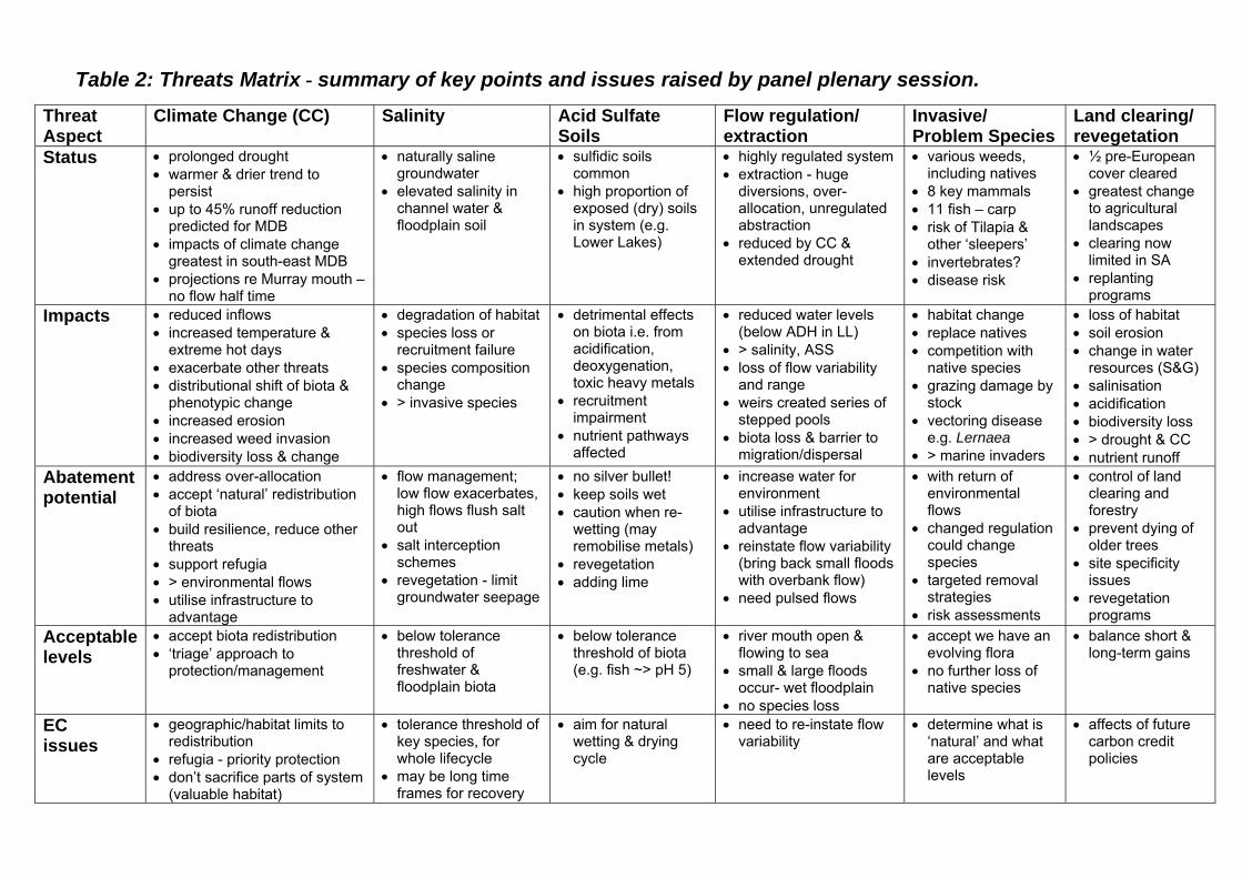
Table 2: Threats Matrix - summary of key points and issues raised by panel plenary session.
Threat Aspect
Climate Change (CC) Salinity Acid Sulfate Soils
Flow regulation/ extraction
Invasive/ Problem Species
Land clearing/ revegetation
Status
prolonged drought warmer & drier trend to
persist up to 45% runoff reduction
predicted for MDB impacts of climate change
greatest in south-east MDB projections re Murray mouth –
no flow half time
naturally saline groundwater
elevated salinity in channel water & floodplain soil
sulfidic soils common
high proportion of exposed (dry) soils in system (e.g. Lower Lakes)
highly regulated system extraction - huge
diversions, over-allocation, unregulated abstraction
reduced by CC & extended drought
various weeds, including natives
8 key mammals 11 fish – carp risk of Tilapia &
other ‘sleepers’ invertebrates? disease risk
½ pre-European cover cleared
greatest change to agricultural landscapes
clearing now limited in SA
replanting programs
Impacts reduced inflows increased temperature &
extreme hot days exacerbate other threats distributional shift of biota &
phenotypic change increased erosion increased weed invasion biodiversity loss & change
degradation of habitat species loss or
recruitment failure species composition
change > invasive species
detrimental effects on biota i.e. from acidification, deoxygenation, toxic heavy metals
recruitment impairment
nutrient pathways affected
reduced water levels (below ADH in LL)
> salinity, ASS loss of flow variability
and range weirs created series of
stepped pools biota loss & barrier to
migration/dispersal
habitat change replace natives competition with
native species grazing damage by
stock vectoring disease
e.g. Lernaea > marine invaders
loss of habitat soil erosion change in water
resources (S&G) salinisation acidification biodiversity loss > drought & CC nutrient runoff
Abatement potential
address over-allocation accept ‘natural’ redistribution
of biota build resilience, reduce other
threats support refugia > environmental flows utilise infrastructure to
advantage
flow management; low flow exacerbates, high flows flush salt out
salt interception schemes
revegetation - limit groundwater seepage
no silver bullet! keep soils wet caution when re-
wetting (may remobilise metals)
revegetation adding lime
increase water for environment
utilise infrastructure to advantage
reinstate flow variability (bring back small floods with overbank flow)
need pulsed flows
with return of environmental flows
changed regulation could change species
targeted removal strategies
risk assessments
control of land clearing and forestry
prevent dying of older trees
site specificity issues
revegetation programs
Acceptable levels
accept biota redistribution ‘triage’ approach to
protection/management
below tolerance threshold of freshwater & floodplain biota
below tolerance threshold of biota (e.g. fish ~> pH 5)
river mouth open & flowing to sea
small & large floods occur- wet floodplain
no species loss
accept we have an evolving flora
no further loss of native species
balance short & long-term gains
EC issues
geographic/habitat limits to redistribution
refugia - priority protection don’t sacrifice parts of system
(valuable habitat)
tolerance threshold of key species, for whole lifecycle
may be long time frames for recovery
aim for natural wetting & drying cycle
need to re-instate flow variability
determine what is ‘natural’ and what are acceptable levels
affects of future carbon credit policies

River Murray–Darling to Sea Expert Technical Workshop, 1-3 July 2009
9
Executive Summary – Listing Criteria Applicability to Aquatic Ecosystems In order for an ecological community to be listed under the EPBC Act, at least one of six criteria contained in the EPBC Regulations 2000 must be met. These criteria determine under which category an ecological community is eligible to be listed (e.g. critically endangered, endangered, vulnerable). The six listing criteria are:
1. Decline in geographic distribution 2. Small geographic distribution coupled with demonstrable threat 3. Loss or decline of functionally important species 4. Reduction in community integrity 5. Rate of continuing detrimental change 6. Quantitative analysis showing probability of extinction.
Listing criteria (and associated thresholds as in the Guidelines) were, in general, considered applicable by workshop participants, but the need for some evolution and additions to allow for the complexity and dynamism of a large, complex aquatic system and its biota was recognised. A number of key findings were elucidated which will assist in this adaptive process, including a greater emphasis on ecological functionality as opposed to geography, and greater inclusion of temporal aspects. A number of challenges were also identified, such as data availability, effects of engineering works, cumulative impacts of threats, natural versus anthropogenic variability, trophic cascade effects, etc. In particular it was recognised that the listing criteria need to take account of the fact that: aquatic systems have a high degree of temporal, spatial and qualitative variability of surface
water; and groundwater hydrodynamics and quality are key drivers that affect the performance and
therefore the degree of vulnerability of aquatic systems. To date (mid 2009), most of the 45 or so listed threatened ecological communities, the majority of which are terrestrial, vegetation-based systems, have triggered mainly (70%) on Criterion 1 and 2. However, the workshop recognised that Criterion 3 and 4 are more fundamentally relevant to the assessment of aquatic ecosystems, as these pick up on the critical aspect of ecological functionality. In most cases, geographic distribution or extent is of less relevance to complex and dynamic aquatic ecosystems. It is also likely that Criterion 5 will become more relevant as more data becomes available on aquatic health through initiatives such as the High Conservation Value Aquatic Ecosystem Framework and the Sustainable Rivers Audit.
Gorge section of the River Murray, SA (Source: SA MDB NRM).
River Murray–Darling to Sea Expert Technical Workshop, 1-3 July 2009
10
Specifics of Listing Criteria and the River Murray – Darling to Sea EC
The River Murray-Darling to Sea ecological community (RM-DS EC) was considered a hybrid between the terrestrial systems listed to date, and aquatic systems. Participants concluded that the nominated EC of the RM-DS should proceed to assessment guided by the outcomes of this workshop in terms of its definition, boundaries and major characteristics. It was accepted that for the RM-DS EC we are dealing with a ‘constructed’ system with values that are distributed across a range of ‘connected’ sub-units. The need to identify what ‘holds it together’ was recognised as essential. The main contenders from workshop deliberations were flow regime, connectivity, and saltwater-freshwater flooding interaction. There was discussion regarding the potential for different components of the system to trigger different criterion, however it was felt that this approach would: i) not align with the intent of the nomination as a ‘holistic’ functioning ecological entity, and ii) the imprimatur of the Threatened Species Scientific Committee (TSSC) to aim for the greatest possible extent – especially where there is a clearly demonstrated relationship between components of the broad-scale community. The need to recognise water quality and source for an aquatic system (be it rain, river or groundwater) and changes in quality, was also identified as central to the assessment process. Several benchmark states (baselines, reference conditions) were proposed by the workshop regarding listing criteria assessment and ‘natural’ or ‘healthy’ condition of the RM-DS system (see previous discussion p.5) – the pre-drought, good flow conditions of the 1970s was considered a useful reference condition or ‘benchmark state’ for the system. A significant outcome was the importance of Indigenous cultural aspects in the assessment process and the recognition that we are dealing with a ‘living’ system of great significance to story, particularly of the Ngarrindjeri people. In particular, it came to light that the major creation story of the Ngarrindjeri takes place over the proposed region of the RM-DS EC, that is from the sea to the junction with the Darling River. It is considered vital that the Ngarrindjeri and other indigenous groups partner in the assessment process and are included as an important source of information. Several keystone and foundation species were put forward by the workshop. These include:
Fauna: Murray cod, Murray River crayfish, the freshwater turtle (Emydura), small native fish assemblage, mussels/snails
Flora: red gum, black box, Melaleucas, coobah, Lignum, Ruppia tuberosa (Coorong lagoon). In terms of rehabilitation interventions as is happening currently for the Coorong and Lower Lakes (e.g. bioremediation), it was determined that the Threatened Species Scientific Committee will consider the situation as it is and make a judgement. This would be important contextual information to contribute to the listing assessment and decision making process. Importantly, the workshop proposed that the RM-DS EC, although currently (mid 2009) experiencing critical environmental decline, particularly in the Coorong and Lower Lakes, is considered to be recoverable if appropriate measures are taken in appropriate timeframes, i.e. there is a high level of restoration potential. However, there may be some differences to this generality in certain components or sub-units of the EC, particularly if compared to a pre-European standard as opposed to an acceptable contemporary standard. The ongoing impacts of climate change and water regulation policies on the entire Murray Darling Basin will also have a significant influence on the ecological community into the future.
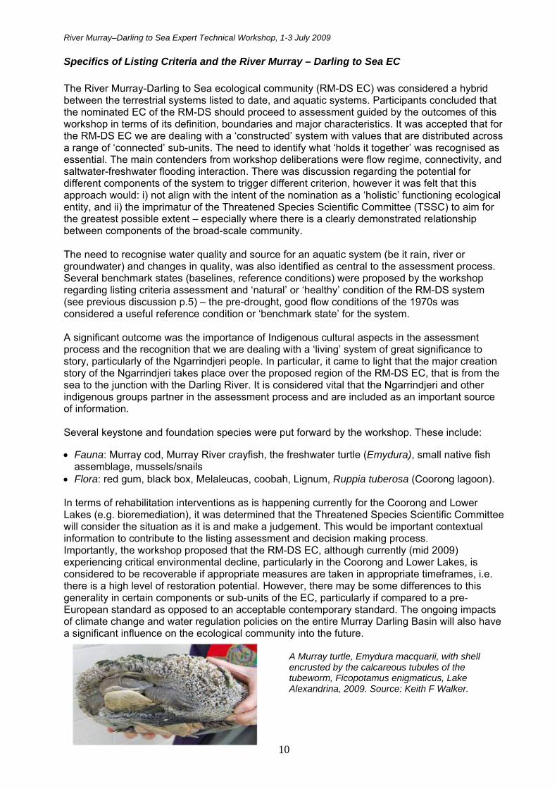
A Murray turtle, Emydura macquarii, with shell encrusted by the calcareous tubules of the tubeworm, Ficopotamus enigmaticus, Lake Alexandrina, 2009. Source: Keith F Walker.
River Murray–Darling to Sea Expert Technical Workshop, 1-3 July 2009
11
Introductory Material The EPBC Act and Listing Process for Threatened Ecological Communities Matt White (Director Ecological Communities, DEWHA) About the EPBC Act The Environment Protection and Biodiversity Conservation Act (EPBC Act) came into effect in July 2000. This premier Commonwealth legislation improves on the environmental legislative reforms of the 1970s and the Endangered Species Protection Act 1992. The EPBC Act focuses on nationally significant aspects of the environment and provides for the identification and protection of matters of National Environmental Significance (NES). Matters of NES as defined under the Act include: areas of World and National Heritage, Ramsar wetlands, threatened species and ecological communities, migratory species, Commonwealth marine areas, and nuclear actions. The Act promotes conservation of biodiversity, recognises indigenous interests, lists threatened species and ecological communities and associated recovery plans, and provides for high level environmental planning, such as the marine based Bioregional plans. Importantly, the EPBC Act regulates:
matters of NES Commonwealth land, places and actions international wildlife trade listed species in Commonwealth areas the Australian Whale Sanctuary.
The Approval Process The Act is unique in that direct powers of approval lie with the Australian Government Environment Minister. An ‘action’ that is likely to have a significant impact on a matter of NES cannot be undertaken without approval of the Minister. The Act provides administrative guidelines to aid with the determination of ‘significance’. An action constitutes a physical interaction or material change to the environment, including a development activity or capital works (e.g. road building, bulldozing, landuse change), or a downstream impact on wetlands etc. It is important to note that ongoing land use or activities that were legal and routine before the EPBC Act commenced, are exempt. The Commonwealth does not become involved in developments where those risks have been eliminated by design or by State/Local regulation or planning. Strong penalties may apply for breaches of the EPBC Act, for example up to $5.5 million for civil matters and up to seven years gaol for criminal matters. There are about 500 compliance and enforcement incidents reported per year. Specifically, the EPBC Act allows for the listing of nationally threatened species, nationally threatened ecological communities, and key threatening processes, and their associated recovery plans and threat abatement plans. For new listings since 2007, the preparation of ‘a conservation advice’ is required at the time of listing. Further information and guidance is produced to assist the determination if an action should be ‘referred’. Note, the Minister determines (based on advice from the Threatened Species Scientific Committee) whether to have a recovery plan, taking into account existing management plans. The Listing Process The listing process for threatened ecological communities (EC) begins with the receipt of nominations from the public. These are strategically assessed by the Threatened Species Scientific Committee for suitability and a Proposed Priority Assessment List (PPAL) is forwarded to the Environment Minister for approval. Based on the Minister’s determination, this list then becomes the Finalised Priority Assessment List (FPAL). For assessment of the ecological communities on the FPAL, the Department relies heavily on input and data from experts,
River Murray–Darling to Sea Expert Technical Workshop, 1-3 July 2009
12
including those from State/Territory agencies. Expert consultation also generally includes the holding of a technical workshop. In particular, the definition of an ecological community under the EPBC Act has a considerable amount of flexibility and the expert advice sought assists with refining the scope, context and boundary for a particular EC. The listing criteria, as set out in the Regulations of the EPBC Act, provide the enabling foundation for nomination and listing assessments. Assessment of listing criteria may also involve the analysis of thresholds for assigning conservation status (i.e. critically endangered, endangered, vulnerable) and expert advice is sought to assist with this aspect. A period of public consultation is also part of the preparation of listing advice. Taken cumulatively, this approach ensures that listings are both scientifically robust and legally defensible. It is also important that the definition of an ecological community listed under the Act should be described in such a way as to allow a lay-person to recognise the listed threatened ecological community in the field. Lastly in the process, a listing advice is forwarded to the Environment Minister, via the TSSC, for a final determination. If accepted for listing, the Department then publishes a ‘listing’ and a ‘conservation’ advice, and a ‘policy statement’ to assist the community with how to identify the EC, how to manage it, conservation actions, etc.
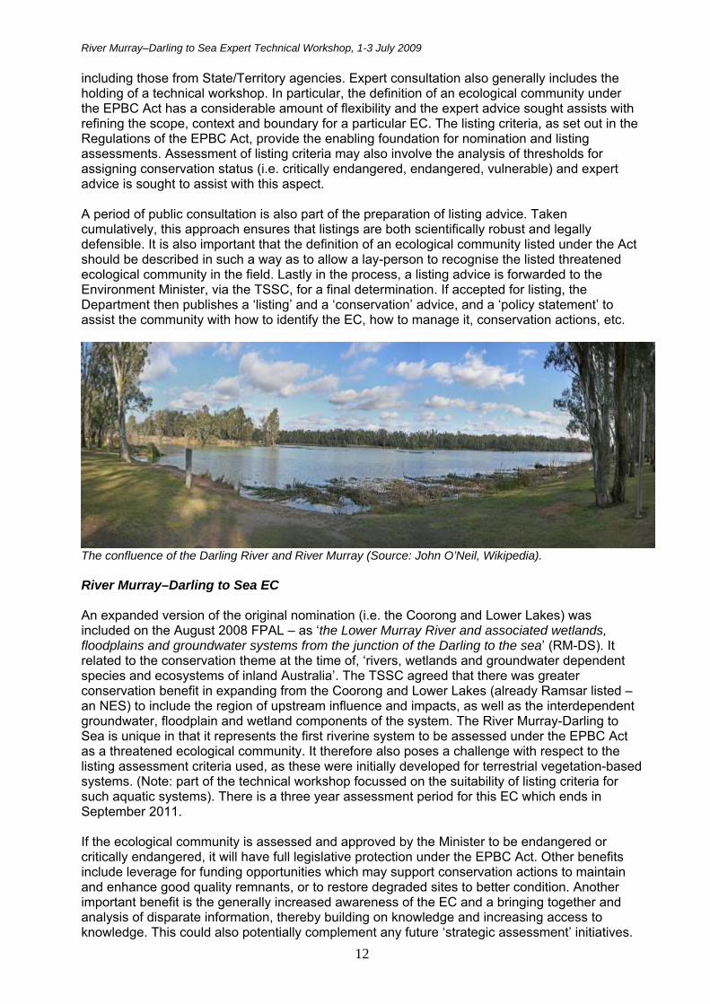
The confluence of the Darling River and River Murray (Source: John O’Neil, Wikipedia). River Murray–Darling to Sea EC An expanded version of the original nomination (i.e. the Coorong and Lower Lakes) was included on the August 2008 FPAL – as ‘the Lower Murray River and associated wetlands, floodplains and groundwater systems from the junction of the Darling to the sea’ (RM-DS). It related to the conservation theme at the time of, ‘rivers, wetlands and groundwater dependent species and ecosystems of inland Australia’. The TSSC agreed that there was greater conservation benefit in expanding from the Coorong and Lower Lakes (already Ramsar listed – an NES) to include the region of upstream influence and impacts, as well as the interdependent groundwater, floodplain and wetland components of the system. The River Murray-Darling to Sea is unique in that it represents the first riverine system to be assessed under the EPBC Act as a threatened ecological community. It therefore also poses a challenge with respect to the listing assessment criteria used, as these were initially developed for terrestrial vegetation-based systems. (Note: part of the technical workshop focussed on the suitability of listing criteria for such aquatic systems). There is a three year assessment period for this EC which ends in September 2011. If the ecological community is assessed and approved by the Minister to be endangered or critically endangered, it will have full legislative protection under the EPBC Act. Other benefits include leverage for funding opportunities which may support conservation actions to maintain and enhance good quality remnants, or to restore degraded sites to better condition. Another important benefit is the generally increased awareness of the EC and a bringing together and analysis of disparate information, thereby building on knowledge and increasing access to knowledge. This could also potentially complement any future ‘strategic assessment’ initiatives.
River Murray–Darling to Sea Expert Technical Workshop, 1-3 July 2009
13
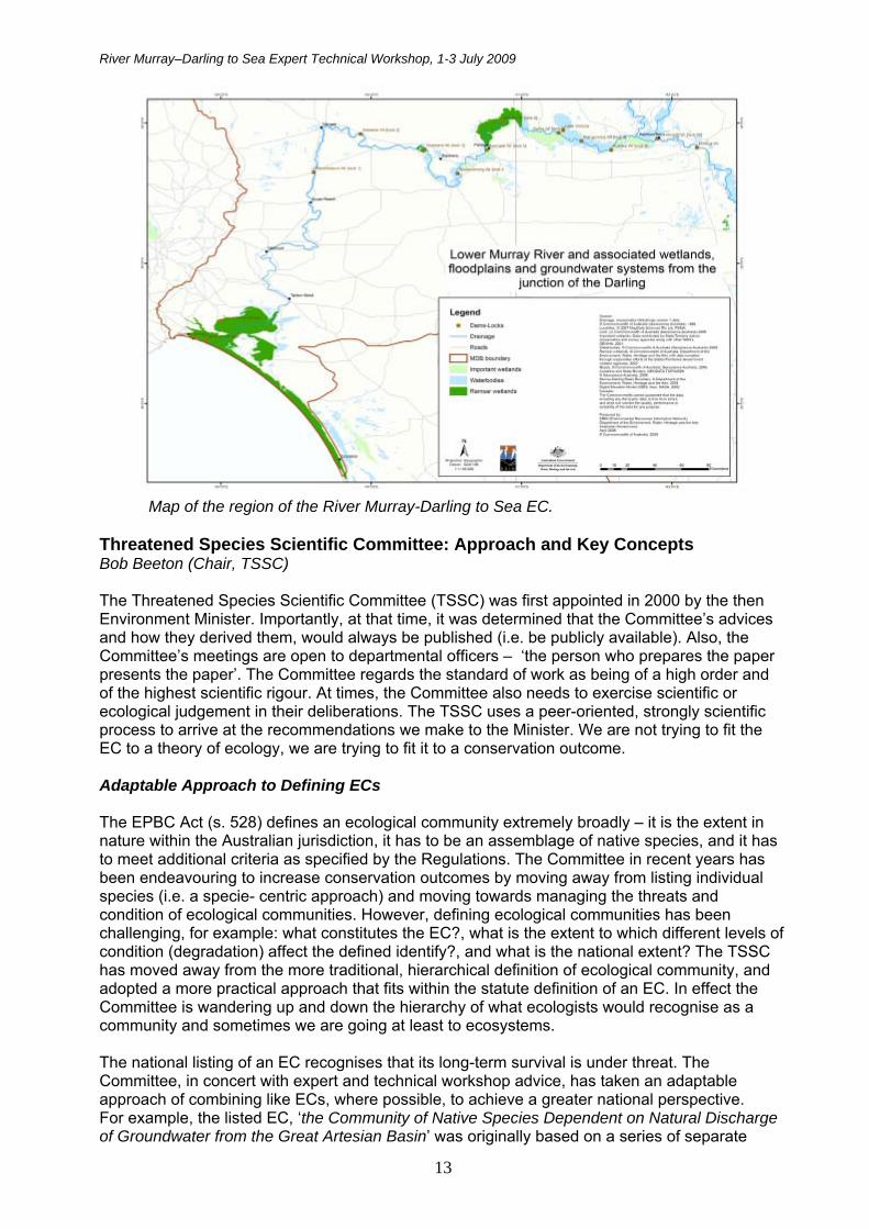
Map of the region of the River Murray-Darling to Sea EC. Threatened Species Scientific Committee: Approach and Key Concepts Bob Beeton (Chair, TSSC) The Threatened Species Scientific Committee (TSSC) was first appointed in 2000 by the then Environment Minister. Importantly, at that time, it was determined that the Committee’s advices and how they derived them, would always be published (i.e. be publicly available). Also, the Committee’s meetings are open to departmental officers – ‘the person who prepares the paper presents the paper’. The Committee regards the standard of work as being of a high order and of the highest scientific rigour. At times, the Committee also needs to exercise scientific or ecological judgement in their deliberations. The TSSC uses a peer-oriented, strongly scientific process to arrive at the recommendations we make to the Minister. We are not trying to fit the EC to a theory of ecology, we are trying to fit it to a conservation outcome. Adaptable Approach to Defining ECs The EPBC Act (s. 528) defines an ecological community extremely broadly – it is the extent in nature within the Australian jurisdiction, it has to be an assemblage of native species, and it has to meet additional criteria as specified by the Regulations. The Committee in recent years has been endeavouring to increase conservation outcomes by moving away from listing individual species (i.e. a specie- centric approach) and moving towards managing the threats and condition of ecological communities. However, defining ecological communities has been challenging, for example: what constitutes the EC?, what is the extent to which different levels of condition (degradation) affect the defined identify?, and what is the national extent? The TSSC has moved away from the more traditional, hierarchical definition of ecological community, and adopted a more practical approach that fits within the statute definition of an EC. In effect the Committee is wandering up and down the hierarchy of what ecologists would recognise as a community and sometimes we are going at least to ecosystems. The national listing of an EC recognises that its long-term survival is under threat. The Committee, in concert with expert and technical workshop advice, has taken an adaptable approach of combining like ECs, where possible, to achieve a greater national perspective. For example, the listed EC, ‘the Community of Native Species Dependent on Natural Discharge of Groundwater from the Great Artesian Basin’ was originally based on a series of separate
River Murray–Darling to Sea Expert Technical Workshop, 1-3 July 2009
14
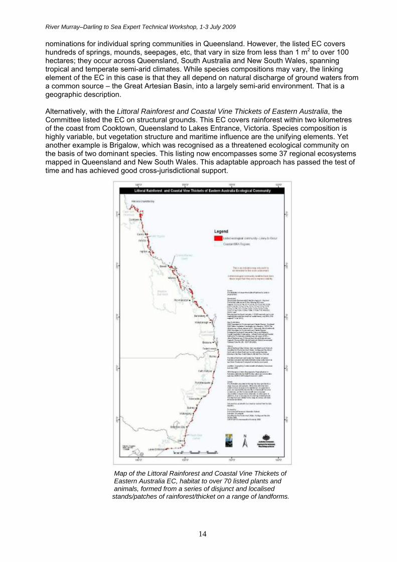
nominations for individual spring communities in Queensland. However, the listed EC covers hundreds of springs, mounds, seepages, etc, that vary in size from less than 1 m2 to over 100 hectares; they occur across Queensland, South Australia and New South Wales, spanning tropical and temperate semi-arid climates. While species compositions may vary, the linking element of the EC in this case is that they all depend on natural discharge of ground waters from a common source – the Great Artesian Basin, into a largely semi-arid environment. That is a geographic description. Alternatively, with the Littoral Rainforest and Coastal Vine Thickets of Eastern Australia, the Committee listed the EC on structural grounds. This EC covers rainforest within two kilometres of the coast from Cooktown, Queensland to Lakes Entrance, Victoria. Species composition is highly variable, but vegetation structure and maritime influence are the unifying elements. Yet another example is Brigalow, which was recognised as a threatened ecological community on the basis of two dominant species. This listing now encompasses some 37 regional ecosystems mapped in Queensland and New South Wales. This adaptable approach has passed the test of time and has achieved good cross-jurisdictional support.
Map of the Littoral Rainforest and Coastal Vine Thickets of Eastern Australia EC, habitat to over 70 listed plants and animals, formed from a series of disjunct and localised stands/patches of rainforest/thicket on a range of landforms.
River Murray–Darling to Sea Expert Technical Workshop, 1-3 July 2009
15
Types and States (Condition) of Ecological Communities The definition of ECs also allows for the recognition of different states, and for each ecological community allows for up to three condition classes:
good quality remnants, degraded but recoverable remnants, and irrecoverable remnants.
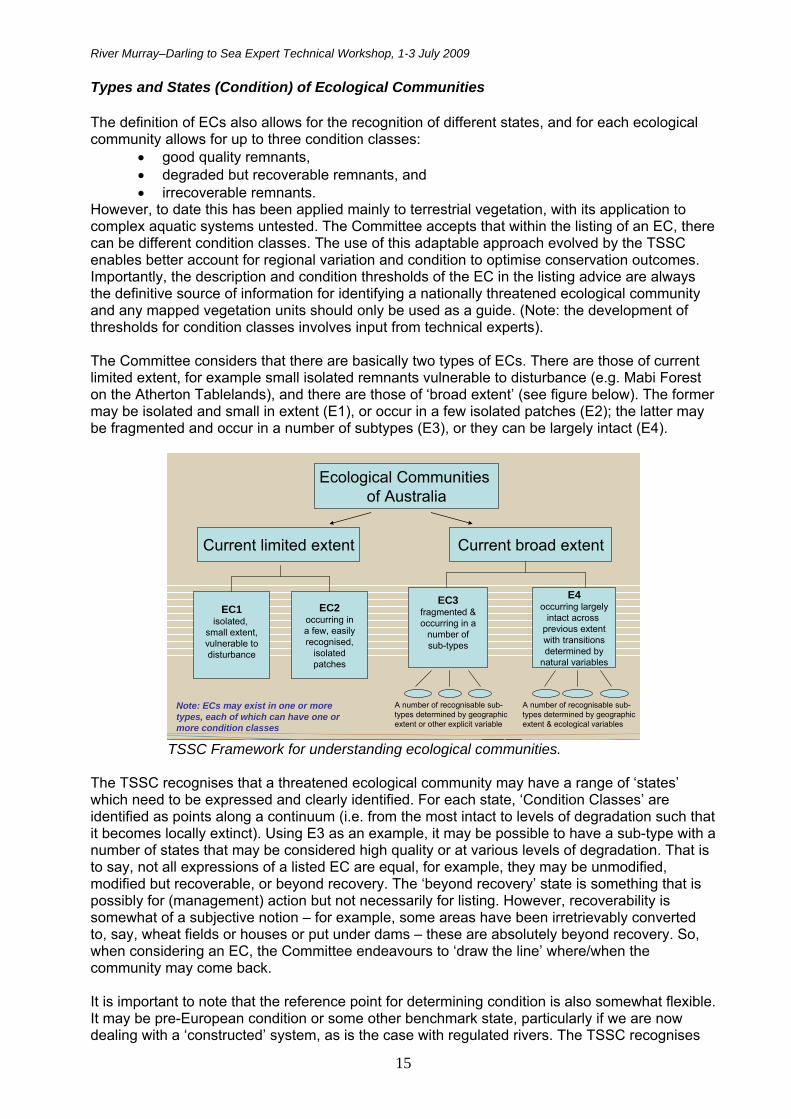
However, to date this has been applied mainly to terrestrial vegetation, with its application to complex aquatic systems untested. The Committee accepts that within the listing of an EC, there can be different condition classes. The use of this adaptable approach evolved by the TSSC enables better account for regional variation and condition to optimise conservation outcomes. Importantly, the description and condition thresholds of the EC in the listing advice are always the definitive source of information for identifying a nationally threatened ecological community and any mapped vegetation units should only be used as a guide. (Note: the development of thresholds for condition classes involves input from technical experts). The Committee considers that there are basically two types of ECs. There are those of current limited extent, for example small isolated remnants vulnerable to disturbance (e.g. Mabi Forest on the Atherton Tablelands), and there are those of ‘broad extent’ (see figure below). The former may be isolated and small in extent (E1), or occur in a few isolated patches (E2); the latter may be fragmented and occur in a number of subtypes (E3), or they can be largely intact (E4).
Ecological Communities of Australia
Current limited extent Current broad extent
EC1isolated,
small extent,vulnerable todisturbance
EC2occurring ina few, easilyrecognised,
isolatedpatches
EC3fragmented &occurring in a
number ofsub-types
E4occurring largely
intact across previous extentwith transitionsdetermined by
natural variables
A number of recognisable sub-types determined by geographic extent or other explicit variable
A number of recognisable sub-types determined by geographic extent & ecological variables
Note: ECs may exist in one or more types, each of which can have one or more condition classes
TSSC Framework for understanding ecological communities. The TSSC recognises that a threatened ecological community may have a range of ‘states’ which need to be expressed and clearly identified. For each state, ‘Condition Classes’ are identified as points along a continuum (i.e. from the most intact to levels of degradation such that it becomes locally extinct). Using E3 as an example, it may be possible to have a sub-type with a number of states that may be considered high quality or at various levels of degradation. That is to say, not all expressions of a listed EC are equal, for example, they may be unmodified, modified but recoverable, or beyond recovery. The ‘beyond recovery’ state is something that is possibly for (management) action but not necessarily for listing. However, recoverability is somewhat of a subjective notion – for example, some areas have been irretrievably converted to, say, wheat fields or houses or put under dams – these are absolutely beyond recovery. So, when considering an EC, the Committee endeavours to ‘draw the line’ where/when the community may come back. It is important to note that the reference point for determining condition is also somewhat flexible. It may be pre-European condition or some other benchmark state, particularly if we are now dealing with a ‘constructed’ system, as is the case with regulated rivers. The TSSC recognises

River Murray–Darling to Sea Expert Technical Workshop, 1-3 July 2009
16
that it should be possible to restore or create systems that have high biodiversity value and which are, in fact, artefacts – although that may be more of a natural resource management activity. The Committee has also discussed the potential use of ‘buffer zones’ around listed entities which would be ‘artificial constructs’. These would be zones of influence that, although not the legally defined EC, deserve consideration in determining ‘significant impact’ under the EPBC Act, and would guide mitigation and restoration actions.
Criteria for Listing Threatened Ecological Communities under the EPBC Act Gina Newton (Assistant Director, Ecological Communities, DEWHA) A vital aspect of the assessment process of an EC is the interpretation and assessment of ‘listing criteria’ as set out in the EPBC Regulations (Reg. 7.02). The listing criteria provide the enabling foundation for both nomination and listing assessments. They were adapted from international guidelines for threatened species. The Threatened Species Scientific Committee (TSSC) has adjusted the criteria and provided additional explanation for their application to ecological communities in its ‘Guidelines’. While the Guidelines ‘allow for’ aquatic ECs, to date they have mostly been applied to terrestrial vegetation-based ECs. There are six criteria and, in the past, these have had varying rates of application in terms of being triggered for an Australian threatened ecological community. For example, for the 45 or so ECs listed to date (mid 2009), Criterion 1, 2 & 4 have triggered the most (68%, 70% and 20% respectively), while Criterion 3 and 5 have hardly ever triggered (9% and 2% respectively), and Criterion 6 has not been triggered at all. Table 3 on page 17 provides a brief description of each criterion. Another important consideration for an EC assessment is the fact that it relies almost exclusively on existing available data. In addition to published academic studies, much data is State/Territory based rather than Commonwealth based. To address this requirement, experts from all relevant jurisdictions are involved from the start of the assessment process. Importantly, all criteria are assessed, but a criterion cannot be triggered without requisite ‘evidence’ to merit listing at a certain level of conservation status (i.e. vulnerable, endangered, and critically endangered). To assist with the assessment process, each criterion also specifies indicative thresholds against each conservation category (see Table 4 on page 18). The criterion with the highest conservation category is used to assign conservation status for the final listing of the EC. As an example: C1 may be ‘critically endangered’, C2 ‘endangered’, C3 not met, C4 ‘vulnerable’, and C5 and C6 not met - the EC if listed, would then have the category of ‘critically endangered’. The Guidelines also provide indicative thresholds for each of the categories for each of the six criteria. Threshold variables are used for establishing ‘condition classes’, for example: patch size, connectivity, species presence, etc. A number of assessment criteria also use timeframe thresholds to consider the possibility of restoration of the EC. For example:
• immediate future (or past) – next (past) 10 yrs, or 3 generations of any key long-lived species, to a maximum
of 60 yrs • near future (or recent past)
– next (past) 20 yrs, or 5 generations of key long-lived species, to a maximum of 100 yrs
• medium-term future (or past) – next (previous) 50 yrs, or 10 generations of key long-lived species, to a maximum
of 100 yrs.
Thresholds applied to date have been for terrestrial, vegetation based systems – it remains to be determined how, and/or, if the indicative thresholds and timeframes apply to aquatic ecological communities. Indicative thresholds as developed for vegetation systems are provided in Table 4.
River Murray–Darling to Sea Expert Technical Workshop, 1-3 July 2009
17
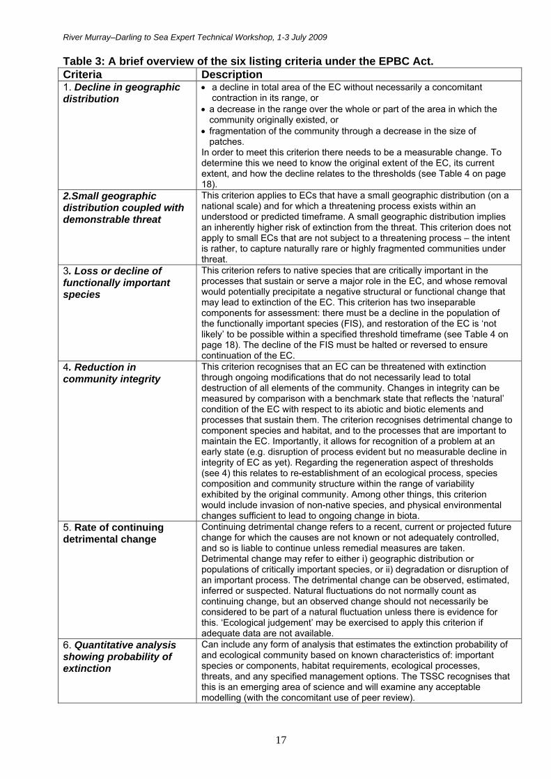
Table 3: A brief overview of the six listing criteria under the EPBC Act. Criteria Description 1. Decline in geographic distribution
a decline in total area of the EC without necessarily a concomitant contraction in its range, or
a decrease in the range over the whole or part of the area in which the community originally existed, or
fragmentation of the community through a decrease in the size of patches.
In order to meet this criterion there needs to be a measurable change. To determine this we need to know the original extent of the EC, its current extent, and how the decline relates to the thresholds (see Table 4 on page 18).
2.Small geographic distribution coupled with demonstrable threat
This criterion applies to ECs that have a small geographic distribution (on a national scale) and for which a threatening process exists within an understood or predicted timeframe. A small geographic distribution implies an inherently higher risk of extinction from the threat. This criterion does not apply to small ECs that are not subject to a threatening process – the intent is rather, to capture naturally rare or highly fragmented communities under threat.
3. Loss or decline of functionally important species
This criterion refers to native species that are critically important in the processes that sustain or serve a major role in the EC, and whose removal would potentially precipitate a negative structural or functional change that may lead to extinction of the EC. This criterion has two inseparable components for assessment: there must be a decline in the population of the functionally important species (FIS), and restoration of the EC is ‘not likely’ to be possible within a specified threshold timeframe (see Table 4 on page 18). The decline of the FIS must be halted or reversed to ensure continuation of the EC.
4. Reduction in community integrity
This criterion recognises that an EC can be threatened with extinction through ongoing modifications that do not necessarily lead to total destruction of all elements of the community. Changes in integrity can be measured by comparison with a benchmark state that reflects the ‘natural’ condition of the EC with respect to its abiotic and biotic elements and processes that sustain them. The criterion recognises detrimental change to component species and habitat, and to the processes that are important to maintain the EC. Importantly, it allows for recognition of a problem at an early state (e.g. disruption of process evident but no measurable decline in integrity of EC as yet). Regarding the regeneration aspect of thresholds (see 4) this relates to re-establishment of an ecological process, species composition and community structure within the range of variability exhibited by the original community. Among other things, this criterion would include invasion of non-native species, and physical environmental changes sufficient to lead to ongoing change in biota.
5. Rate of continuing detrimental change
Continuing detrimental change refers to a recent, current or projected future change for which the causes are not known or not adequately controlled, and so is liable to continue unless remedial measures are taken. Detrimental change may refer to either i) geographic distribution or populations of critically important species, or ii) degradation or disruption of an important process. The detrimental change can be observed, estimated, inferred or suspected. Natural fluctuations do not normally count as continuing change, but an observed change should not necessarily be considered to be part of a natural fluctuation unless there is evidence for this. ‘Ecological judgement’ may be exercised to apply this criterion if adequate data are not available.
6. Quantitative analysis showing probability of extinction
Can include any form of analysis that estimates the extinction probability of and ecological community based on known characteristics of: important species or components, habitat requirements, ecological processes, threats, and any specified management options. The TSSC recognises that this is an emerging area of science and will examine any acceptable modelling (with the concomitant use of peer review).

River Murray–Darling to Sea Expert Technical Workshop, 1-3 July 2009
18
Table 4: Indicative Thresholds for vegetation-based systems.
Criteria 1
Criteria 2 (small distribution plus demonstrable threat)
Criteria 3 Criteria 4 Criteria 5 Criteria 6
Indicative Threshold/ Conservation Threat Status
Decline in geographic
distribution
Area of Occupancy (actual area covered)
Extent of Occurrence (measure of geographic range)
Average Patch Size
Decline of a
functionally important
native species
Restoration Timeframe (not likely within)
Regeneration Timeframe (change in integrity such that regeneration is unlikely in)
Detrimental Change (immediate past or Immediate future)
Probability of extinction or extreme degradation over all geographic distribution
Critically Endangered
Very severe ≥95%
< 10 km2
(1000 ha) <100 km2
(10,000 ha) generally <10 ha
Very severe ≥80%
(over last 10 yrs
or 3 gens. if >)
Immediate future next 10 yrs (or 3 gens. max 60 yrs)
immediate future next 10 yrs (or 3 gens. max 60 yrs)
Very severe ≥80%
At least 50% in immediate future
Endangered
Severe ≥90%
< 100 km2
(10,000 ha) <1000 km2
(100,000 ha) generally < 100 ha
Severe ≥50%
(over last 10 yrs
or 3 gens. if >)
Near future next 20 yrs (or 5 gens. max 100 yrs)
Near future next 20 yrs (or 5 gens. max 100 yrs)
Severe ≥50%
At least 20% in the near future
Vulnerable Substantial ≥70%
< 1000 km2
(100,000 ha) <10,000 km2
(1,000,000 ha)
N/A Substantial ≥20%
(over last 10 yrs
or 3 gens. if >)
Medium-term future next 50 yrs (or 10 gens. max 100 yrs)
Medium-term future next 50 yrs (or 10 gens. max 100 yrs)
Substantial /Serious ≥30%
At least 10% in the medium-term future
Key: < = less than > = greater than ≥ = grater than or equal to max = maximum gen = generation

River Murray–Darling to Sea Expert Technical Workshop, 1-3 July 2009
19
Aquatic Ecosystem Classification – A National Scheme Chris Auricht A new Australian National Aquatic Ecosystem Classification Scheme is being developed as part of the High Conservation Value Aquatic Ecosystem Framework. This work is currently underway under the auspices of the NRM Ministerial Council (and managed by the Department) to support determination of conservation significance of aquatic ecosystems. It is likely that the assessment process of the River Murray-Darling to Sea EC will have relevant linkages with this work and may benefit from associated information and analysis. All jurisdictions have agreed to actions under the National Water Initiative (NWI), which aim to produce a more cohesive national approach to aquatic ecosystem (AE) classification, and to increase the efficiency of Australia’s water use - leading to greater certainty of water use for the environment. The Aquatic Ecosystem Task Group is developing a nationally coordinated approach and overseeing development of a national policy framework for the identification, classification and management of high conservation aquatic environments. The main objective of this process is to provide a nationally consistent approach for the identification and classification of aquatic ecosystems, and to provide a practical, scientifically robust tool to help meet NWI commitments, particularly where regions cross jurisdictional boundaries. It is not intended as a regulatory or conservation mechanism. Other important goals of the process are to:
identify aquatic ecosystems of high conservation value (HCVAE) and differentiate between HCVAEs of national and regional importance
improve knowledge of HCVAEs, information sharing, and cross-jurisdictional coordination guide planning, investment and management decisions assist in meeting national and international obligations for protection of aquatic
ecosystems. For the purposes of this process, aquatic ecosystems are those that depend on flows, and/or periodic or sustained inundation/water logging for their ecological integrity (they do not generally include marine waters). HCVAEs are those that meet the criteria outlined in the HCVAE framework. An endorsed guiding principle is that the determination of HCVAEs will be based on ecosystem functioning. One of the main issues with development of this process is that current classifications and mapping datasets are numerous, fragmented and inconsistent across jurisdictions. For example, a recent review of 135 wetland datasets revealed that many don’t have information on extent. Given the variable status of knowledge and the variety of classification schemes currently in existence, it is not practical to have a uniform set of classes within the scheme. Rather, the national scheme is designed to be flexible and provide a structure that will support future development and incorporation of nationally agreed components as they become available. We are endeavouring to develop a consistent typology that can be supported by conceptual models and diagrams and lead through to such aspects as identification of assets, drivers and values, threatened condition indicators and assessments, and prioritisation - all within an adaptive management framework. The classification scheme is based on a three tier approach: Tier 1: Aquatic Ecosystem – usually larger systems identified using the concepts of ecological functioning and integrity (the basic unit for identifying HCVAEs consists of one or more hydrosystems). A geographic area that consists of a single hydrosystem or an aggregation (complex) of spatially or ecologically connected hydrosystems. Tier 2: Hydrosystems – organising entities e.g. estuaries, rivers, complexes of swamps and lakes. A geographic area of an AE that consists of a single ecotope, or an aggregation (complex)
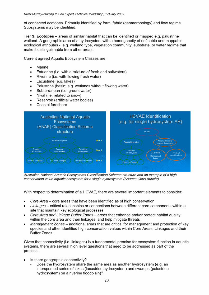
River Murray–Darling to Sea Expert Technical Workshop, 1-3 July 2009
20
of connected ecotopes. Primarily identified by form, fabric (geomorphology) and flow regime. Subsystems may be identified. Tier 3: Ecotopes – areas of similar habitat that can be identified or mapped e.g. palustrine wetland. A geographic area of a hydrosystem with a homogeneity of definable and mappable ecological attributes - e.g. wetland type, vegetation community, substrate, or water regime that make it distinguishable from other areas. Current agreed Aquatic Ecosystem Classes are:
Marine Estuarine (i.e. with a mixture of fresh and saltwaters) Riverine (i.e. with flowing fresh water) Lacustrine (e.g. lakes) Palustrine (basin; e.g. wetlands without flowing water) Subterranean (i.e. groundwater) Nival (i.e. related to snow) Reservoir (artificial water bodies) Coastal foreshore
Riverine Hydrosystem
Estuarine Hydrosystem
Palustrine Hydrosystem
Aquatic Ecosystem
Estuarine EcotopesRiverine Ecotopes Palustrine Ecotopes
Australian National Aquatic Australian National Aquatic Ecosystems Ecosystems
(ANAE) Classification Scheme (ANAE) Classification Scheme structurestructure
Tier 1
Tier 2
Tier 3
HCVAE IdentificationHCVAE Identification(e.g. for single hydrosystem AE)(e.g. for single hydrosystem AE)
Estuarine Hydrosystem
Aquatic Ecosystem
Estuarine Ecotopes
HCVAE
Area Additional to Aquatic Ecosystem
Practical considerations
AE Buffers
Management Zones
Australian National Aquatic Ecosystems Classification Scheme structure and an example of a high conservation value aquatic ecosystem for a single hydrosystem (Source: Chris Auricht) With respect to determination of a HCVAE, there are several important elements to consider: Core Area – core areas that have been identified as of high conservation Linkages – critical relationships or connections between different core components within a
site that maintain key ecological processes Core Area and Linkage Buffer Zones – areas that enhance and/or protect habitat quality
within the core area and their linkages, and help mitigate threats Management Zones – additional areas that are critical for management and protection of key
species and other identified high conservation values within Core Areas, Linkages and their Buffer Zones.
Given that connectivity (i.e. linkages) is a fundamental premise for ecosystem function in aquatic systems, there are several high level questions that need to be addressed as part of the process: Is there geographic connectivity?
- Does the hydrosystem share the same area as another hydrosystem (e.g. an interspersed series of lakes (lacustrine hydrosystem) and swamps (palustrine hydrosystem) on a riverine floodplain)?

River Murray–Darling to Sea Expert Technical Workshop, 1-3 July 2009
21
- Are the hydrosystems contiguous? Is there hydrological connectivity?
- Groundwater and surface water connectivity. - Flood regimes for aquatic landscape connectivity (e.g. floodplains).
Are there shared geomorphological processes? - Connected sediment budgets. - Dependence of flood regimes as a geomorphic process.
Are there shared chemical influences? - Salinity influence i.e. tidal or via salt spray?
Is the biota in the aquatic ecosystem dependent on the participating hydrosystems or ecotopes? - Source or sink of primary productivity (energy and nutrient flows). - Fauna may depend on a number of hydrosystems for foraging or
breeding purposes. In addition, any identified connectivity should have a measurable effect on the ecology and function of the core AE for them to be deemed connected. Next steps in this process include future trials to assess the ability of the national AE classification scheme to support the determination of national HCVAE sites at drainage division level, and the development of a common language guide.
Gorge section of the River Murray, SA (Source: Keith Walker).

River Murray–Darling to Sea Expert Technical Workshop, 1-3 July 2009
22
Workshop Aims and Methods Ecological Community Description Aim
Identify key descriptive aspects and characteristics of the ecological community of the “Lower Murray River and associated wetlands, floodplains and groundwater systems from the junction of the Darling River to the Sea” (RM-DS).
Background and Methods An important aspect of the assessment process (and ongoing operational aspects if the EC is listed by the Minister), is a scientifically acceptable and ‘workable’ (i.e. read practical, rational, sensible, legally enforceable) definition of the threatened ecological community, with quantitative or qualitative descriptions of the EC’s physical boundaries, major components, and condition. If listed, the EC will be both a ‘scientific’ and a ‘legal’ entity. Outcomes sought from the workshop related to description of major features, boundaries, connectivity aspects, condition thresholds and restoration/management issues. These outcomes will contribute to the listing assessment, with the ultimate goal being the future recovery/conservation (and sustainable use) of the EC. Four breakout discussion groups were designed around four major functional components (focus sub-system) of the EC, Groundwater; Rivers and Tributaries; Wetlands and Floodplains; and Biota. Each group used the same set of questions to structure their discussions, as below:
1) Major Description Features: What are the major ecological and bio-geo-physical features that describe and define your focus component of the EC? (e.g. geographic location, position in landscape, climate factors, structure, etc…..).
2) Boundaries: a) What are the ‘workable practical’ boundaries of the EC in relation to your
focus component? b) What is in and what is out? c) Where does it start and end? d) What are the issues that may blur these boundaries?
3) Connectivity: a) What are the main connectivity features of this focus component of the
EC compared with the three others? ( e.g. distance, process, functionality, etc). b) What are the main issues for ensuring future functional connectivity of your focus component?
4) Condition (Thresholds): a) What is the optimal condition/functionality of this component
of the EC and what would be the levels of acceptable change? b) When is the component too degraded to be ecologically functional/too difficult to restore and hence excluded from the EC? c) What (measurable) condition indicators are important?
5) Restoration/Management: a) What are the broad priority conservation and
management actions to maintain or restore condition?
6) Variation: Your Group has been provided with maps of the EC region as artificially divided into four discrete sections. How would you meaningfully divide the region into distinct sections and why? The four map regions provided were:
1) Sea to Tailem Bend 2) Tailem Bend to Flood Lock 1 3) Flood Lock 1 to Flood Lock 5 4) Flood Lock 5 to Wentworth (i.e. join with the Darling).
River Murray–Darling to Sea Expert Technical Workshop, 1-3 July 2009
23
Threats Aim
Identify priority threats to the River Murray-Darling to Sea ecological community. Approach A panel of six experts provided a brief introductory commentary on what are considered to be some of the major threats to the ecological community of the RM-DS. These overviews have been summarised and supplemented with further information for the workshop report. The six threats were:
Climate change Salinity Acid sulfate soils (ASS) Flow regulation/ extraction Invasive species Land clearing/ revegetation
A plenary general discussion was held following the expert presentations, with each of the threats discussed according to their status, impacts, abatement potential, acceptable levels and other EC related issues. Key points and issues raised from the discussion were analysed and summarised for the report in a Summary Threats Matrix (see Table 2 on page 8). Listing Criteria Aims
Consider suitability of current legislated Listing Criteria and Guidelines to aquatic systems, and options for future enhancement.
To inform the assessment process for the ecological community ‘Lower Murray River and
associated wetlands, floodplains and groundwater systems from the junction of the Darling River to the Sea’.
Methods The River Murray - Darling to Sea (RM-DS) EC is a ‘test case’, as it is the first time that the listing criteria (and their indicative associated thresholds) will be assessed for a complex, dynamic river system. Therefore consideration is needed regarding interpretation of the criteria and how they should be applied to aquatic ecosystems in general, and to the RM-DS EC specifically. The 6 Listing Criteria are as follows:
1. Decline in geographic distribution 2. Small geographic distribution coupled with demonstrable threat 3. Loss or decline of functionally important species 4. Reduction in community integrity 5. Rate of continuing detrimental change 6. Quantitative analysis showing probability of extinction
Workshop delegates were assigned to four groups (to ensure a multi-disciplinary mix – see Appendix 3), with each group chaired by a member of the Threatened Species Scientific

River Murray–Darling to Sea Expert Technical Workshop, 1-3 July 2009
24
Committee. Each group then considered and discussed the six listing criteria against a set of standard questions. Results were reported back in a plenary session which enabled further discussion and questions to be addressed. Summaries of major outcomes are provided for each criterion. Universal key findings (i.e. findings common to multiple groups) were also highlighted. The questions addressed for each criterion were: 1. Does this Criterion work for (complex, dynamic) aquatic ecosystems? 2. How do we best measure this Criterion in aquatic ecosystems? 3. What are the challenges/impediments/issues for applying this Criterion to aquatic
systems? 4. How can the Criterion be adapted better for aquatic ecological communities? 5. How does the Criterion work for the RM-DS EC?