Embed Size (px)
Citation preview
River Basin Management Plan South West River Basin District
Contact us You can contact us in any of these ways: • email at [email protected] • phone on 08708 506506 • post to Environment Agency (South West Region), Manley House, Kestrel Way, Exeter EX2
7LQ The Environment Agency website holds the river basin management plans for England and Wales, and a range of other information about the environment, river basin management planning and the Water Framework Directive. www.environment-agency.gov.uk/wfd You can search maps for information related to this plan by using ‘What’s In Your Backyard’. http://www.environment-agency.gov.uk/maps
SW River Basin Management Plan Erratum The following changes were made to this document in January 2011. Table 1 updated to reflect reduction by two in number of heavily modified river water bodies and increase by two in number of natural river water bodies. Figure 15 for Tamar catchment updated to reflect change in two river water bodies from heavily modified to natural (see erratum sheet in Annex B for water body specific details).
Published by: Environment Agency, Rio House, Waterside Drive, Aztec West, Almondsbury, Bristol, BS32 4UD tel: 08708 506506 email: [email protected] www.environment-agency.gov.uk © Environment Agency Some of the information used on the maps was created using information supplied by the Geological Survey and/or the Centre for Ecology and Hydrology and/or the UK Hydrographic Office All rights reserved. This document may be reproduced with prior permission of the Environment Agency. Cover image: Other images: © Nigel Carson, 2008, www.oursouthwest.com © Sue Dixon, 2005, www.oursouthwest.com © Rachel Malone, 2008, www.oursouthwest.com © Matt Redmond, 2008, www.oursouthwest.com © Phil Harding, 2008, www.oursouthwest.com
Environment Agency River Basin Management Plan, South West River Basin District 2 Main Document December 2009
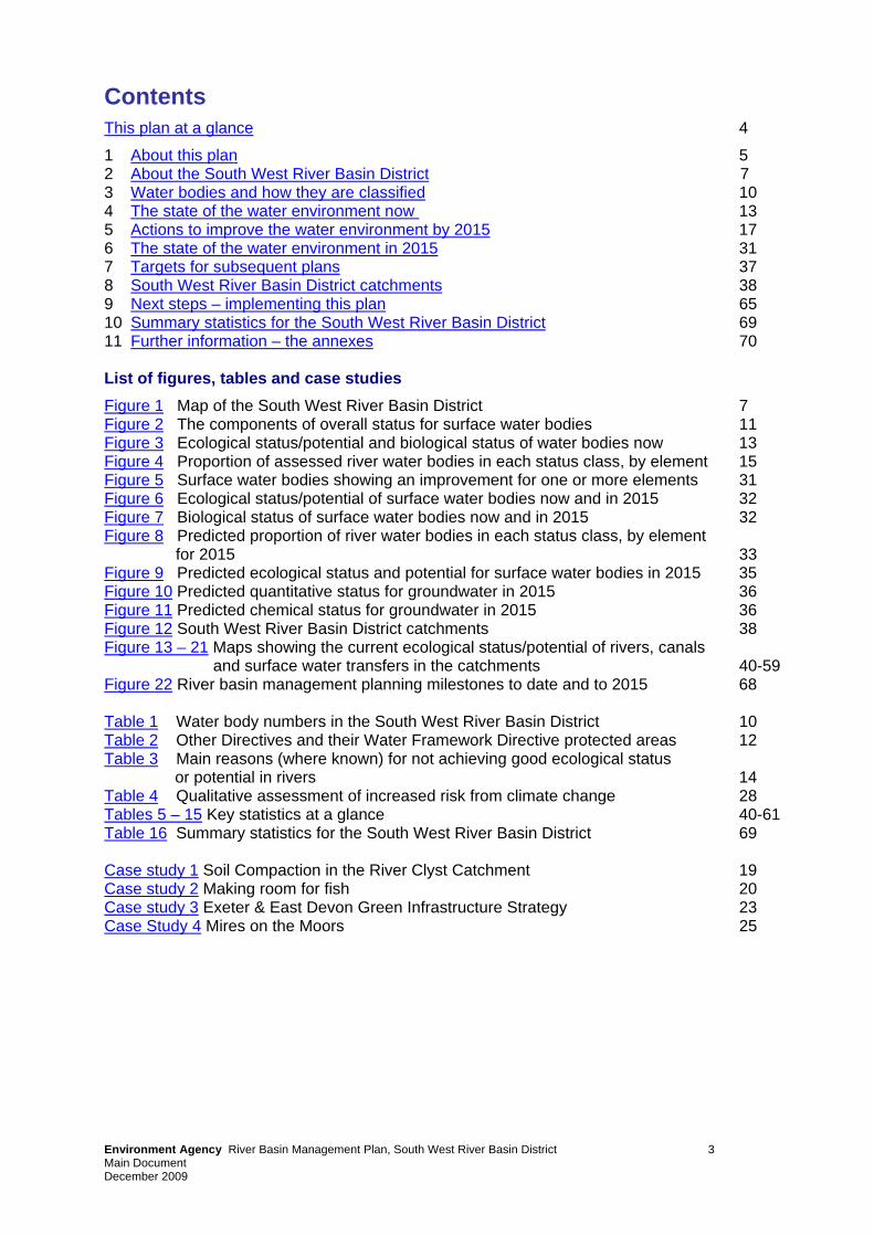
Contents This plan at a glance 4
1 About this plan 5 2 About the South West River Basin District 7 3 Water bodies and how they are classified 10 4 The state of the water environment now 13 5 Actions to improve the water environment by 2015 17 6 The state of the water environment in 2015 31 7 Targets for subsequent plans 37 8 South West River Basin District catchments 38 9 Next steps – implementing this plan 65 10 Summary statistics for the South West River Basin District 69 11 Further information – the annexes 70 List of figures, tables and case studies Figure 1 Map of the South West River Basin District 7 Figure 2 The components of overall status for surface water bodies 11 Figure 3 Ecological status/potential and biological status of water bodies now 13 Figure 4 Proportion of assessed river water bodies in each status class, by element 15 Figure 5 Surface water bodies showing an improvement for one or more elements 31 Figure 6 Ecological status/potential of surface water bodies now and in 2015 32 Figure 7 Biological status of surface water bodies now and in 2015 32 Figure 8 Predicted proportion of river water bodies in each status class, by element
for 2015 33 Figure 9 Predicted ecological status and potential for surface water bodies in 2015 35 Figure 10 Predicted quantitative status for groundwater in 2015 36 Figure 11 Predicted chemical status for groundwater in 2015 36 Figure 12 South West River Basin District catchments 38 Figure 13 – 21 Maps showing the current ecological status/potential of rivers, canals
and surface water transfers in the catchments 40-59 Figure 22 River basin management planning milestones to date and to 2015 68 Table 1 Water body numbers in the South West River Basin District 10 Table 2 Other Directives and their Water Framework Directive protected areas 12 Table 3 Main reasons (where known) for not achieving good ecological status
or potential in rivers 14 Table 4 Qualitative assessment of increased risk from climate change 28 Tables 5 – 15 Key statistics at a glance 40-61 Table 16 Summary statistics for the South West River Basin District 69 Case study 1 Soil Compaction in the River Clyst Catchment 19 Case study 2 Making room for fish 20 Case study 3 Exeter & East Devon Green Infrastructure Strategy 23 Case Study 4 Mires on the Moors 25
Environment Agency River Basin Management Plan, South West River Basin District 3 Main Document December 2009
This plan at a glance This plan is about the pressures facing the water environment in the South West River Basin District and the actions that will address them. It has been prepared under the Water Framework Directive as a product of the first of a series of six-year planning cycles. By 2015, 22 per cent of surface waters (rivers, lakes, estuaries and coastal waters) in this river basin district will improve for at least one element, measured as part of an assessment of status according to the Water Framework Directive. This includes an improvement of nearly 2,800km of river in relation to fish, phosphate, specific pollutants and other elements. 42 per cent of surface waters will be at good or better ecological status/potential and 57 per cent of groundwater bodies will be at good status by 2015. In combination 43 per cent of all water bodies will be at good or better status in 2015. The Environment Agency wants to go further and achieve an additional two per cent improvement to surface waters across England and Wales by 2015. The biological parts of how the water environment is assessed – the plant and animal communities – are key indicators. At least 61 per cent of assessed surface waters will be at good or better biological status by 2015. The South West River Basin District has an outstanding natural environment including the national parks of Dartmoor and Exmoor, the Somerset Levels, and the fantastic estuaries and coastline - the Jurassic Coast in Devon and Dorset is the only natural world heritage site in England. Water is essential to these landscapes and their wildlife, and it is vital to the livelihoods of those who live and work here. There has been great progress in protecting these natural assets and cleaning up many of the water environment problems people have created in the past. However, a range of challenges still remain, which will need to be addressed to secure the predicted improvements. They include: • diffuse pollution from agricultural activities; • diffuse and point source pollution from disused mines; • point source pollution from water industry sewage works; and • physical modification of water bodies. At present because of these pressures, and the higher environmental standards required by the Water Framework Directive, only 33 per cent of surface waters are currently classified as good or better ecological status. 51 per cent of assessed surface water bodies with a biological assessment are at good or better biological quality now, although this is likely to change to 47 per cent once all water bodies are assessed. In order to meet these targets, it is important for everyone to play their part now and in the future. River basin management is an opportunity for this generation – for people and organisations to work together to improve the quality of every aspect of the water environment – to create an environment we are all proud of and can enjoy.
Environment Agency River Basin Management Plan, South West River Basin District 4 Main Document December 2009
1 About this plan This plan focuses on the protection, improvement and sustainable use of the water environment. Many organisations and individuals help to protect and improve the water environment for the benefit of people and wildlife. River basin management is the approach the Environment Agency is using to ensure our combined efforts achieve the improvement needed in the South West River Basin District. River basin management is a continuous process of planning and delivery. The Water Framework Directive introduces a formal series of 6 year cycles. The first cycle will end in 2015 when, following further planning and consultation, this plan will be updated and re-issued. The South West River Basin District Liaison Panel has been central to helping us manage this process. The panel includes representatives of businesses, planning authorities, environmental organisations, consumers, navigation, fishing and recreation bodies, and central, regional and local government, all with key roles to play in implementing this plan. The Environment Agency has also worked extensively with local stakeholders to identify the actions needed to address the main pressures on the water environment. This plan has been prepared under the Water Framework Directive, which requires all countries throughout the European Union to manage the water environment to consistent standards. Each country has to: • prevent deterioration in the status of aquatic ecosystems, protect them and improve the
ecological condition of waters; • aim to achieve at least good status for all water bodies by 2015. Where this is not possible
and subject to the criteria set out in the Directive, aim to achieve good status by 2021 or 2027;
• meet the requirements of Water Framework Directive Protected Areas; • promote sustainable use of water as a natural resource; • conserve habitats and species that depend directly on water; • progressively reduce or phase out the release of individual pollutants or groups of pollutants
that present a significant threat to the aquatic environment; • progressively reduce the pollution of groundwater and prevent or limit the entry of pollutants; • contribute to mitigating the effects of floods and droughts. The plan describes the river basin district, and the pressures that the water environment faces. It shows what this means for the current state of the water environment, and what actions will be taken to address the pressures. It sets out what improvements are possible by 2015 and how the actions will make a difference to the local environment – the catchments, the estuaries and coasts, and the groundwater. Looking towards implementation, the plan highlights the programme of investigations to be undertaken. This will identify more actions, particularly those associated with diffuse pollution, for delivery during the first cycle. New national measures, made available by government, will also lead to additional improvements. At local level, the Environment Agency will be working closely with a wide variety of organisations and individuals, not only to deliver the commitments contained in the plan, but wherever possible to expand upon them for the benefit of the water environment.
Environment Agency River Basin Management Plan, South West River Basin District 5 Main Document December 2009
Strategic Environmental Assessment A Strategic Environmental Assessment of the draft plan was completed to review the effects of the proposals on the wider environment. The assessment enabled us to make sure that this plan represents the most sustainable way of managing the water environment. The Post Adoption Statement and accompanying Statement of Environmental Particulars is available at www.environment-agency.gov.uk/wfd. Habitats Regulations Assessment A Habitats Regulations Assessment of this plan has been carried out to consider whether it is likely to have a significant effect on any Natura 2000 sites. The assessment was undertaken by the Environment Agency in consultation with Natural England. The assessment concluded that the River Basin Management Plan is unlikely to have any significant negative effects on any Natura 2000 sites. The Plan itself does not require further assessment under the Habitats Regulations. This conclusion is reliant on the fact that before any measures in the plan are implemented they must be subject to the requirements of the Habitats Regulations. Any plans, project or permissions required to implement the measures must undergo an appropriate assessment if they are likely to have a significant effect. A copy of the Habitats Regulations Assessment of this plan is available at www.environment-agency.gov.uk/wfd. Impact Assessment An impact assessment of this plan has been completed. It looks at the costs of a reference case, which includes existing actions and new actions required by existing obligations, and the incremental costs and benefits of implementing the additional new actions required by this plan. The impact assessment also provides a forward look to the costs and benefits of potential action in future cycles (2015 to 2021 and 2021 to 2027). A copy of the impact assessment is available at www.environment-agency.gov.uk/wfd.
Environment Agency River Basin Management Plan, South West River Basin District 6 Main Document December 2009
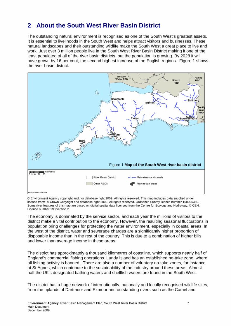
2 About the South West River Basin District The outstanding natural environment is recognised as one of the South West’s greatest assets. It is essential to livelihoods in the South West and helps attract visitors and businesses. These natural landscapes and their outstanding wildlife make the South West a great place to live and work. Just over 3 million people live in the South West River Basin District making it one of the least populated of all of the river basin districts, but the population is growing. By 2028 it will have grown by 16 per cent, the second highest increase of the English regions. Figure 1 shows the river basin district.
South East RBD
Thames RBD Severn
RBD
Western Wales RBD
Figure 1 Map of the South West river basin district
Environment Agency River Basin Management Plan, South West River Basin District 7
© Environment Agency copyright and / or database right 2009. All rights reserved. This map includes data supplied under licence from: © Crown Copyright and database right 2009. All rights reserved. Ordnance Survey licence number 100026380. Some river features of this map are based on digital spatial data licensed from the Centre for Ecology and Hydrology, © CEH. Licence number 198 version 2.
The economy is dominated by the service sector, and each year the millions of visitors to the district make a vital contribution to the economy. However, the resulting seasonal fluctuations in population bring challenges for protecting the water environment, especially in coastal areas. In the west of the district, water and sewerage charges are a significantly higher proportion of disposable income than in the rest of the country. This is due to a combination of higher bills and lower than average income in these areas.
The district has approximately a thousand kilometres of coastline, which supports nearly half of England’s commercial fishing operations. Lundy Island has an established no-take zone, where all fishing activity is banned. There are also a number of voluntary no-take zones, for instance at St Agnes, which contribute to the sustainability of the industry around these areas. Almost half the UK's designated bathing waters and shellfish waters are found in the South West.
The district has a huge network of internationally, nationally and locally recognised wildlife sites, from the uplands of Dartmoor and Exmoor and outstanding rivers such as the Camel and
Main Document December 2009
Hampshire Avon, to the fantastic estuaries and coastline. There are two national parks, and the Jurassic Coast in Devon and Dorset is the only natural world heritage site in England. Pressures on the water environment Agriculture is a major influence on the water environment in the South West. We all benefit from local and sustainable food production from well managed land, but pollution from farms and farmland must be reduced. Soil compaction is causing polluting run-off from farmland. Dealing with this will not only reduce pollution but also help manage the risk of surface water flooding, improve the quality of wildlife habitats and help protect drinking water sources. There are other issues, for example run-off from farm yards, inappropriate fertiliser and pesticide use, and impacts from livestock entering rivers which must also be addressed. Current and historic industrial discharges are affecting the quality of the water environment, particularly in relation to the legacy of metal mining in the west. Major investment in the water industry will continue, preventing deterioration of water quality and reducing pollution. Private sewage treatment plants or septic tanks need to be properly maintained to ensure they do not cause pollution. Bathing waters, shellfish waters and the internationally important wildlife sites in the South West will be priority areas for this work. Rivers, lakes and coasts have been physically modified, for instance to protect land and property from flooding, enable land drainage or allow for navigation. These physical modifications are a key issue. Continuing with habitat creation work along the rivers and coasts and uplands, improving weirs and other obstructions to benefit fish populations and changing the way that rivers and coasts are managed will reduce the impact of these changes. These actions will also help manage flood risk, adapt to climate change, and provide a better place to live and work. Cities, towns, villages and their infrastructure put pressure on the water environment, and this pressure is increasing. Government has identified a need for 2 million new homes in England by 2016. The South West draft Spatial Strategy and the South East Plan together propose that over 20,000 new homes will be required every year until 2026 within the South West River Basin District, and have identified where most of this growth should be focused. This development will support the improvement of water bodies, and not cause them to deteriorate. There are also concerns over maintaining the water resources available for people and the environment. There should be sufficient good quality water in the environment for wildlife to flourish, and water should also be provided to consumers affordably, without requiring excessive treatment processes. Natural forces such as sea level rise, coupled with climate change, can pose a threat to people, property and coastal habitats. All these challenges relate to a range of specific pressures that need to be dealt with in this river basin district. These are: • abstraction and other artificial flow regulation – problems related to taking water from
rivers, lakes and the ground • commercial fisheries – problems related to the direct capture and removal of fish or
shellfish, or habitat damage caused by some types of fishing • mines and minewaters – minewaters are usually acidic and contain metal contaminants
such as copper, iron, manganese and zinc which can have significant ecological impacts • nitrates – a nutrient found in manures and fertilisers used in agriculture, and in sewage
effluent
Environment Agency River Basin Management Plan, South West River Basin District 8 Main Document December 2009
• non-native species - invasive non-native species are plants and animals that have deliberately or accidentally been introduced outside their natural range, and by spreading quickly threaten native wildlife and can cause economic damage
• organic pollution – an excess of organic matter such as manure or sewage which depletes the oxygen available for wildlife
• pesticides and other chemicals – plant and animal control products and anti-foulants • phosphate – a plant nutrient in detergents, sewage and fertiliser that can cause excessive
growth of algae in rivers • physical modification – changes to the structure of water bodies, for instance to allow for
flood risk management • sediment –un-dissolved particles floating on top of or suspended within water, for example
those caused by increased rates of soil erosion from land based activities. Sedimentation can smother river life and spread pollutants from the land into the water environment.
• urban and transport pollution – a range of pollutants related to urban areas and the transport network
Environment Agency River Basin Management Plan, South West River Basin District 9 Main Document December 2009
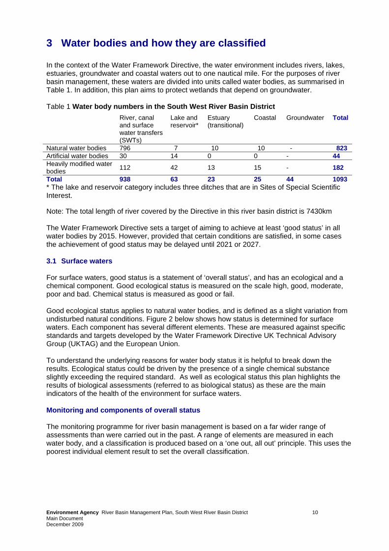
3 Water bodies and how they are classified In the context of the Water Framework Directive, the water environment includes rivers, lakes, estuaries, groundwater and coastal waters out to one nautical mile. For the purposes of river basin management, these waters are divided into units called water bodies, as summarised in Table 1. In addition, this plan aims to protect wetlands that depend on groundwater. Table 1 Water body numbers in the South West River Basin District
* The lake and reservoir category includes three ditches that are in Sites of Special Scientific Interest.
River, canal and surface water transfers (SWTs)
Lake and reservoir*
Estuary (transitional)
Coastal Groundwater Total
Natural water bodies 796 7 10 10 - 823 Artificial water bodies 30 14 0 0 - 44 Heavily modified water bodies 112 42 13 15 - 182
Total 938 63 23 25 44 1093
Note: The total length of river covered by the Directive in this river basin district is 7430km The Water Framework Directive sets a target of aiming to achieve at least ‘good status’ in all water bodies by 2015. However, provided that certain conditions are satisfied, in some cases the achievement of good status may be delayed until 2021 or 2027. 3.1 Surface waters For surface waters, good status is a statement of ‘overall status’, and has an ecological and a chemical component. Good ecological status is measured on the scale high, good, moderate, poor and bad. Chemical status is measured as good or fail. Good ecological status applies to natural water bodies, and is defined as a slight variation from undisturbed natural conditions. Figure 2 below shows how status is determined for surface waters. Each component has several different elements. These are measured against specific standards and targets developed by the Water Framework Directive UK Technical Advisory Group (UKTAG) and the European Union. To understand the underlying reasons for water body status it is helpful to break down the results. Ecological status could be driven by the presence of a single chemical substance slightly exceeding the required standard. As well as ecological status this plan highlights the results of biological assessments (referred to as biological status) as these are the main indicators of the health of the environment for surface waters. Monitoring and components of overall status The monitoring programme for river basin management is based on a far wider range of assessments than were carried out in the past. A range of elements are measured in each water body, and a classification is produced based on a ‘one out, all out’ principle. This uses the poorest individual element result to set the overall classification.
Environment Agency River Basin Management Plan, South West River Basin District 10 Main Document December 2009
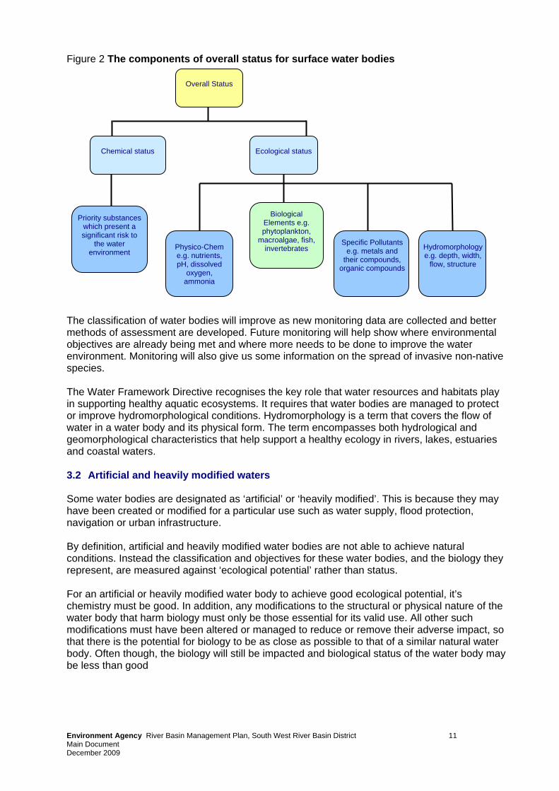
Figure 2 The components of overall status for surface water bodies
Physico-Chem e.g. nutrients, pH, dissolved
oxygen, ammonia
Biological Elements e.g. phytoplankton,
macroalgae, fish, invertebrates
Specific Pollutants e.g. metals and
their compounds, organic compounds
Hydromorphology e.g. depth, width,
flow, structure
Priority substances which present a significant risk to
the water environment
Chemical status
Overall Status
Ecological status
The classification of water bodies will improve as new monitoring data are collected and better methods of assessment are developed. Future monitoring will help show where environmental objectives are already being met and where more needs to be done to improve the water environment. Monitoring will also give us some information on the spread of invasive non-native species. The Water Framework Directive recognises the key role that water resources and habitats play in supporting healthy aquatic ecosystems. It requires that water bodies are managed to protect or improve hydromorphological conditions. Hydromorphology is a term that covers the flow of water in a water body and its physical form. The term encompasses both hydrological and geomorphological characteristics that help support a healthy ecology in rivers, lakes, estuaries and coastal waters. 3.2 Artificial and heavily modified waters Some water bodies are designated as ‘artificial’ or ‘heavily modified’. This is because they may have been created or modified for a particular use such as water supply, flood protection, navigation or urban infrastructure. By definition, artificial and heavily modified water bodies are not able to achieve natural conditions. Instead the classification and objectives for these water bodies, and the biology they represent, are measured against ‘ecological potential’ rather than status. For an artificial or heavily modified water body to achieve good ecological potential, it’s chemistry must be good. In addition, any modifications to the structural or physical nature of the water body that harm biology must only be those essential for its valid use. All other such modifications must have been altered or managed to reduce or remove their adverse impact, so that there is the potential for biology to be as close as possible to that of a similar natural water body. Often though, the biology will still be impacted and biological status of the water body may be less than good
Environment Agency River Basin Management Plan, South West River Basin District 11
Main Document December 2009
3.3 Groundwater For groundwater, good status has a quantitative and a chemical component. Together these provide a single final classification: good or poor status. A ground water body will be classified as having poor quantitative status in the following circumstances; where low ground water levels are responsible for an adverse impact on rivers and wetlands normally reliant on ground water; where abstraction of ground water has lead to saline intrusion; where it is possible that the amount of groundwater abstracted will not be replaced each year by rainfall. Poor chemical status occurs if there is widespread diffuse pollution within the groundwater body, the quality of the groundwater is having an adverse impact on wetlands or surface waters, there is saline intrusion due to over abstraction, or the quality of water used for potable supply is deteriorating significantly. There are other objectives for groundwater quality in addition to meeting good status. These are the requirements to prevent or limit the input of pollutants to groundwater and to implement measures to reverse significant and sustained rising trends in pollutants in groundwater.
3.4 Protected areas Some areas require special protection under European legislation. The Water Framework Directive brings together the planning processes of a range of other European Directives. These Directives, listed in Table 2, establish protected areas to manage water, nutrients, chemicals, economically significant species, and wildlife – and have been brought in line with the planning timescales of the Water Framework Directive. Meeting their requirements will also help achieve Water Framework Directive objectives. Table 2 Other Directives and their Water Framework Directive protected areas
Directive Protected area Number of protected areas Bathing Waters Recreational waters 187
Birds Natura 2000 sites (water dependent special protection areas)
9
Drinking Water Drinking water protected areas 120
Freshwater Fish
Waters for the protection of economically significant aquatic species
954
Shellfish Waters Waters for the protection of economically significant aquatic species
33
Habitats Natura 2000 sites (water dependent special areas of conservation)
40
Nitrates Nitrate Vulnerable Zones 41% land area Urban Waste Water Treatment Sensitive areas 13 Achieving the objectives of these protected areas is a priority for action in this plan. Annex D sets out their objectives and the actions required for Natura 2000 sites and the new Drinking Water Protected Areas required under the Directive. Annex C describes the actions required for all protected areas. In addition, there are two new daughter Directives (Groundwater and Environmental Quality Standards) that will be used to implement specific parts of the Water Framework Directive.
Environment Agency River Basin Management Plan, South West River Basin District 12 Main Document December 2009
4 The state of the water environment now
The current status classification is the baseline from which improvements and the ‘no deterioration in status' objective of the Water Framework Directive is measured. The current status classification has been updated since the draft plan. It is different to that presented in the draft plan because: • the quality of assessments has been improved by refining classification methods; • the accuracy of individual assessment tools has improved, especially for fish; • a number of water bodies that were identified as potentially being heavily modified have not
been designated as such in this plan because monitoring shows that they currently achieve good status;
• improvements from the water companies’ Periodic Review 2004 have now been factored in; • an additional 20 river waterbodies and 30 lakes have been classified that were previously
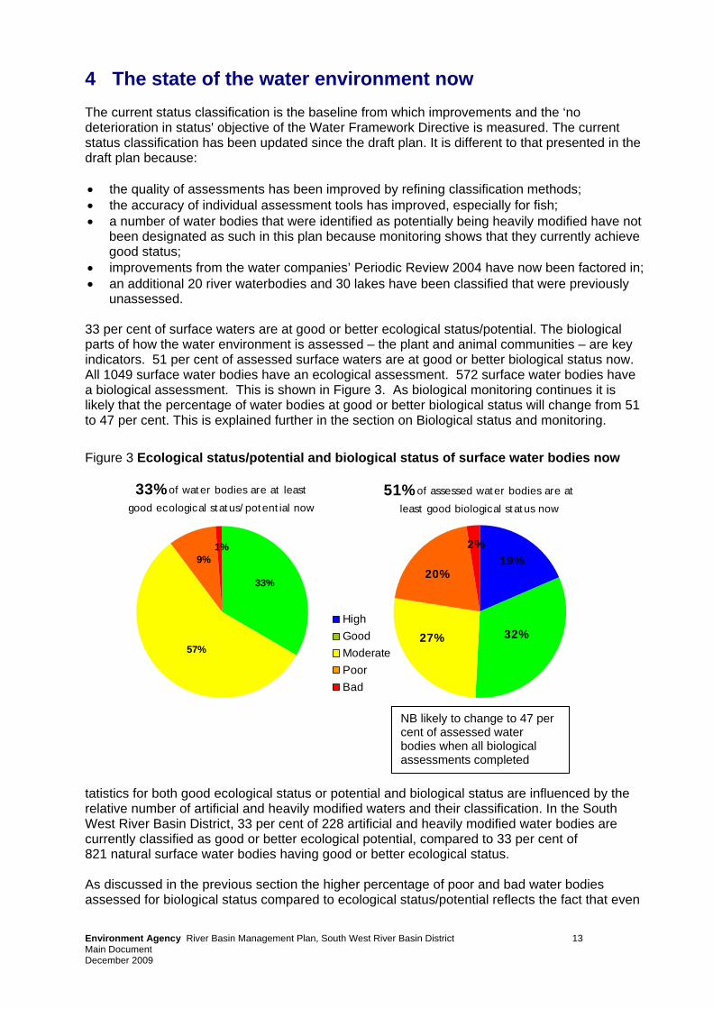
unassessed. 33 per cent of surface waters are at good or better ecological status/potential. The biological parts of how the water environment is assessed – the plant and animal communities – are key indicators. 51 per cent of assessed surface waters are at good or better biological status now. All 1049 surface water bodies have an ecological assessment. 572 surface water bodies have a biological assessment. This is shown in Figure 3. As biological monitoring continues it is likely that the percentage of water bodies at good or better biological status will change from 51 to 47 per cent. This is explained further in the section on Biological status and monitoring.
Figure 3 Ecological status/potential and biological status of surface water bodies now
33% of water bodies are at least
good ecological status/potential now
1%9%
33%
57%
51% of assessed water bodies are at
least good biological status now
32%
19%
27%
20%
2%
HighGoodModeratePoorBad
NB likely to change to 47 per cent of assessed water bodies when all biological assessments completed
tatistics for both good ecological status or potential and biological status are influenced by the relative number of artificial and heavily modified waters and their classification. In the South West River Basin District, 33 per cent of 228 artificial and heavily modified water bodies are currently classified as good or better ecological potential, compared to 33 per cent of 821 natural surface water bodies having good or better ecological status. As discussed in the previous section the higher percentage of poor and bad water bodies assessed for biological status compared to ecological status/potential reflects the fact that even
Environment Agency River Basin Management Plan, South West River Basin District 13 Main Document December 2009
Environment Agency River Basin Management Plan, South West River Basin District 14 Main Document December 2009
where all mitigation measures are in place to allow an artificial/heavily modified water body to be classified as good, the use of the water body may mean that biology is still impacted. For groundwater bodies, currently 84 per cent are at good quantitative status. 64 per cent are at good chemical status. 4.1 Reasons for not achieving good status or potential This section takes a closer look at rivers. The majority of management actions in the first river basin management cycle will be applied to rivers. Reasons for not achieving good status or potential in other surface waters are being developed. The first course of action for lakes, coasts and estuaries is to develop a better understanding of the issues. To identify what needs to be done to improve the environment, the reasons for not achieving good status need to be understood. The main reasons most frequently identified by Environment Agency staff using monitoring data and their knowledge and experience of individual water bodies are shown in Table 3. Each relates to one or more pressures, which in turn impact on elements of the classification. The reasons for failure include point source discharges from water industry sewage works, diffuse source pollution from agriculture, abstraction and a range of reasons due to physical modifications. The actions in this plan will increase the number of waters achieving good status or potential, for example through significant investment in improving discharges from sewage works and changes to land management practices. Even if good status is not completely achieved, they will also lead to improvements to the key elements impacted. Table 3 Main reasons (known or suspected) for not achieving good ecological status or potential in rivers
Reason for Failure Key elements impacted
Diffuse source agricultural ammonia, diatoms, dissolved oxygen, fish, invertebrates, macroalgae, macrophytes, pesticides, phosphate
Disused mines - point and diffuse source cadmium and its compounds, copper, fish, invertebrates, nickel and its compounds, ph, zinc
Point source water industry sewage works ammonia (phys-chem), diatoms, dissolved oxygen, fish, invertebrates, macrophytes, phosphate
Physical modification - urbanisation and flood protection fish, invertebrates, mitigation measures
Physical modification - water storage and supply (including for power generation) fish, mitigation measures
Physical modification - land drainage fish, mitigation measures
Physical modification - barriers to fish migration fish
Physical modification - wider environment mitigation measures
Point source trade industry - non water industry diatoms, fish, invertebrates, macrophytes
Abstraction hydrology It is important to note that because classification involves a wider range of elements than previous monitoring schemes, and many of the key pressures are complex and occur in combination, we often do not know the reason for a failure. For many water bodies either the
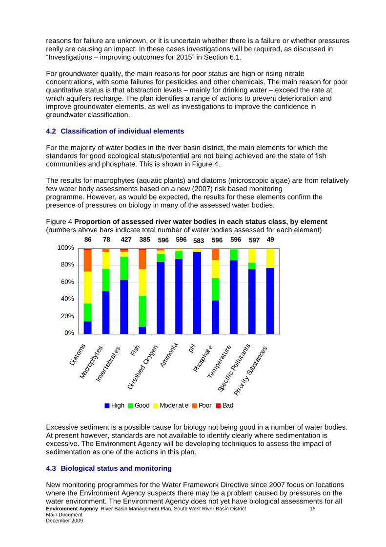
reasons for failure are unknown, or it is uncertain whether there is a failure or whether pressures really are causing an impact. In these cases investigations will be required, as discussed in “Investigations – improving outcomes for 2015” in Section 6.1. For groundwater quality, the main reasons for poor status are high or rising nitrate concentrations, with some failures for pesticides and other chemicals. The main reason for poor quantitative status is that abstraction levels – mainly for drinking water – exceed the rate at which aquifers recharge. The plan identifies a range of actions to prevent deterioration and improve groundwater elements, as well as investigations to improve the confidence in groundwater classification. 4.2 Classification of individual elements For the majority of water bodies in the river basin district, the main elements for which the standards for good ecological status/potential are not being achieved are the state of fish communities and phosphate. This is shown in Figure 4. The results for macrophytes (aquatic plants) and diatoms (microscopic algae) are from relatively few water body assessments based on a new (2007) risk based monitoring programme. However, as would be expected, the results for these elements confirm the presence of pressures on biology in many of the assessed water bodies. Figure 4 Proportion of assessed river water bodies in each status class, by element (numbers above bars indicate total number of water bodies assessed for each element)
0%
20%
40%
60%
80%
100%
Diat
oms
Mac
roph
ytes
Inve
rteb
rate
s
Fish
Diss
olve
d Ox
ygen
Amm
onia pH
Phos
phat
eTe
mpe
ratu
reSp
ecifi
c Po
lluta
nts
Prio
rity
Sub
stan
ces
High Good Moderate Poor Bad
86 596596 596 583 596 597 49427 38578 Excessive sediment is a possible cause for biology not being good in a number of water bodies. At present however, standards are not available to identify clearly where sedimentation is excessive. The Environment Agency will be developing techniques to assess the impact of sedimentation as one of the actions in this plan. 4.3 Biological status and monitoring
Environment Agency River Basin Management Plan, South West River Basin District 15
New monitoring programmes for the Water Framework Directive since 2007 focus on locations where the Environment Agency suspects there may be a problem caused by pressures on the water environment. The Environment Agency does not yet have biological assessments for all
Main Document December 2009
relevant water bodies. In this river basin district 55 per cent of water bodies have an assessment for at least one biological element. The number of water bodies covered by biological monitoring is set to increase over the next three years. As new information becomes available it is likely that some water bodies currently labelled as good biological status will be shown to have a lower quality. For instance, from the chemical monitoring the Environment Agency is now clear that there is a link between high levels of phosphate in surface waters and biological failures in the main river type (lowland alkaline rivers). The assessment of reasons for failure that the Environment Agency has started to undertake shows that across England and Wales 22 per cent of river water bodies are failing to achieve good status/potential because of excessive levels of phosphate. In this river basin district phosphate results show that it is likely that the percentage of water bodies at good or better biological status will change from 51 to 47 per cent when additional water bodies are assessed for diatoms and/or macrophytes. This same analysis points to discharges from sewage treatment works and releases from agriculture being responsible for the majority of this. Rather than wait for the results of more biological assessments, corrective action must be started in the first plan cycle. Through the Water Services Regulation Authority’s (Ofwat’s) determination of the water industry periodic review of investment, the water industry will continue their investment programme targeted at addressing their contribution to phosphate pollution. It is important that agriculture also makes a contribution in the first cycle improvements. The Environment Agency is now working with the main farming groups to understand better the main ways in which phosphate from land enters and is transported in water bodies. Farming groups have agreed to use this information to encourage individual farmers to take action to reduce their contribution to water pollution. This new approach is being trialled in the Anglian River Basin District and through the Campaign for Farmed Environment. The Environment Agency will also assess the advice and incentives available through agri-environment schemes and what the England Catchment Sensitive Farming Delivery Initiative can do to reduce phosphate pollution of water and wetlands. In parallel with this approach, the Environment Agency will continue to develop work on regulatory measures, such as piloting Water Protection Zones (WPZs) so that if voluntary approaches are shown not to work in a particular area, or where higher environmental standards are needed, for example in protected areas, we are ready and able to ensure progress is made before 2015. The work to identify the ways in which phosphate enters water bodies and the means of reducing this will inform the measures that might be applied in WPZs. WPZs will only be effective if the means of control have been clearly identified.
Environment Agency River Basin Management Plan, South West River Basin District 16 Main Document December 2009
5 Actions to improve the water environment by 2015 The following gives an overview of the key contributions from sectors and organisations that the Environment Agency will work with to implement this plan. All sectors Agriculture and rural land management Angling, fisheries and conservation Central government Environment Agency Industry manufacturing and other business Local and regional government Mining and quarrying Navigation Urban and transport Water industry Individuals and communities These actions are summarised versions of the full programme of actions that can be found in Annex C. The lead organisation for each action is given in brackets. Note that many actions will involve more than one sector and need to be implemented in partnership. Actions in Annex C are therefore duplicated across the relevant sectors. Sectors are encouraged to put further actions forward during the implementation of this plan. After the action tables there are sections on: Actions to protect drinking water The costs of action in this plan Taking action in a changing climate Working with other plans and programmes 5.1 All sectors All sectors must comply with the range of existing regulations, codes of practice and controls on the use of certain substances. Investigations will be carried out by the Environment Agency and partner organisations where appropriate, to establish the extent and source of pressures and to identify any further actions that are technically feasible and not disproportionately costly. These actions will be carried out during this or future management cycles. Investigations and actions will also be carried out in drinking water protected areas (where necessary focused in safeguard zones) to reduce the risk of deterioration in raw water quality and therefore reduce the need for additional treatment to meet drinking water standards. A small number of candidate Water Protection Zones (WPZ) will be promoted nationally early in the first plan cycle, where there is clear evidence that voluntary mechanisms such as the England Catchment Sensitive Farming Delivery Initiative and pollution prevention campaigns are not sufficient by themselves to achieve the required environmental objectives. The candidate WPZs will be used to establish the usefulness of the concept, but as outlined earlier in relation to the results of the biological monitoring, this relies on a clear understanding of the practices causing problems and the techniques to avoid them.
Environment Agency River Basin Management Plan, South West River Basin District 17 Main Document December 2009
5.2 Agriculture and rural land management This sector has a big role in looking after and improving the quality of the rural environment. Agriculture accounts for approximately three quarters of the land area in the South West River Basin District. Permanent grassland occupies the majority of agricultural land with arable farming making up the next most extensive agricultural activity, supporting many lowland livestock farms. A combination of incentive, advisory and regulatory measures have been in place for a number of years to help farmers and other land managers protect the environment. For instance the Code of Good Agricultural Practice and agri-environment schemes, such as Entry Level Stewardship and Higher Level Stewardship. Wise stewardship of resources such as soil, nutrients, water and energy helps to cut costs while maintaining or improving the productivity of land and livestock. Nevertheless, the way in which land is managed is still having a negative impact on natural resources and further action is needed to address diffuse pollution and other key pressures in rural areas. Government will consider the introduction of further restrictions of activities and restrictions on chemicals where there is evidence that voluntary actions failed to deliver. Example Actions Cross-Compliance – to help farmers comply with a range of Directives to reduce pollution from agriculture at farms receiving subsidies (all land managers) • Across the river basin district Pesticides statutory code of practice – advice for operators on control of plant protection products to prevent and limit pollution of waters (all operators) • Across the river basin district Maintain a nationally funded advice-led partnership under the England Catchment Sensitive Farming Delivery Initiative (Natural England, Environment Agency) to reduce diffuse water pollution from agriculture in priority areas • Priority Catchments to be targeted under the programme include: The Dorset Frome, The Fleet, part
of Poole Harbour, Dorset Stour (Middle Reaches), Exe Estuary, Hampshire Avon, River Camel, West Cornwall, Axe and Otter, Somerset Levels and Moors, Tamar and Tavy Catchments, Yealm and Erme Estuaries and Slapton Ley and Salcombe to Kingsbridge
Establish and enforce Nitrate Vulnerable Zones in river catchments and groundwater source areas at high risk from nitrate pollution (Environment Agency) to reduce the amount of nitrate and other pollutants entering water from farmland • Across the river basin district in designated areas
Form Strategic Partnerships with the England Catchment Sensitive Farming Delivery Initiative and other advice led partnership work (Natural England, Environment Agency) to provide further funding to reduce diffuse water pollution from agriculture • Blue Anchor and the Taw/Torridge catchments
Where appropriate, subject to the Environment Agency carrying out a 12 week public consultation and making an appropriate case to the Secretary of State, designate and enforce Water Protection Zones and apply appropriate measures to control high risk activities (Environment Agency, Defra). The Zones will provide a regulatory tool to control diffuse pollution in water or physical pressures in high risk areas where existing mechanisms will not meet Water Framework Directive objectives. • Candidate sites in the Pill/Carhampton catchment in West Somerset and the area influencing the
Cholderton boreholes in Dorset. Initially around eight Zones in locations to be decided across England.
Co-ordinate all the efforts to deliver environmental benefits under a strong regional partnership focused on farm pollution prevention • Across the river basin district Commission programmes of work under the South West Agricultural Resource Management Programme (SWARM) to deliver environmental protection and improvement, for instance through Soils for Profit, Resources for Farming and Innovation Fund. • Across the river basin district
Environment Agency River Basin Management Plan, South West River Basin District 18 Main Document December 2009
Example Actions Industry-led Water efficiency campaigns, for example the National Farmers' Union "Water Matters" • Across the river basin district Develop and run a demonstration Catchment Project to test the effect of agricultural diffuse pollution control measures in a representative range of catchment types (Environment Agency, Defra) • Hampshire Avon catchment
Environment Agency River Basin Management Plan, South West River Basin District 19
5.3 Angling and conservation The angling and conservation sector has a large role to play in delivering local ‘on the ground’ improvements to the water environment as well as working to establish new mechanisms. It engages communities and individuals, building on their skills and experience and actively involves them in making these improvements. Angling is a popular pass time that can provide local intelligence on environmental quality – there were over 85,000 licence holders resident in the South West in 2005 and visiting anglers accounted for a quarter of the fishing and associated economic activity. Anglers’ annual expenditure on fishing inland waters in the South West totalled about £100 million, supporting approximately 2300 jobs. It is crucial that the fish stocks on which angling depends are conserved, and that fish parasites, diseases or inappropriate fish stocking are prevented. Many environmental organisations can influence environmental quality through the land they own or manage. Riparian owners have specific responsibility for the management of their watercourses so their support, involvement and investment in implementing the actions is crucial. Example actions Restore wetlands through an advisory approach with landowners through the 'Working Wetlands Project'. This project will restore valuable habitats and reduce land-use impacts on water quality. • East Devon, North Devon and Tamar catchments Landscape scale habitat restoration, for example through the 'Wild Penwith Project', aiming to restore and link wetland, heath and river habitats from the North to the South Coast of the Penwith Peninsula. • West Cornwall and the Fal catchment Install eel passes at the top 5 priority sites in the South West River Basin District as part of the Eel Management Plan delivery, to include sites on the River Parrett, King Sedgemoor Drain, South Drain and North Drain • North Drain; Kings Sedgemoor Drain; Parrett; South Drain
Case Study 1 Soil Compaction in the River Clyst Catchment The England Catchment Sensitive Farming (CSF) Delivery Initiative provides advice to farmers on improving rural land management practices and reducing pollution from agriculture. An example of how the initiative operates can be shown through advisory work in the River Clyst catchment, East Devon. A soil structure survey undertaken by Environment Agency officers identified that the majority of fields within the Clyst catchment were suffering from soil compaction, with the resulting runoff of sediment and nutrients causing poor river quality. Catchment Sensitive Farming Officers worked in partnership with the Environment Agency and local farmers. They carried out trials on maize fields and permanent grassland to show the different methods of managing compaction and the resulting differences in crop yield. Events are being run at each trial site looking at crop establishment, harvest, and post harvest. Local farmers are invited to come and discuss the methods, results and share best practice.
Main Document December 2009
Example actions Develop and start to deliver a programme to resolve the 30 most significant physical barriers to fish movement, for instance at Evans on the Tavy, at Holne on the Dart, at Silverton on the Exe, on the Somerset Frome and on the Stour at Lydden • Across the river basin district Promote the 'River Fly Partnership' monitoring programme to assess the status of river health (Salmon and Trout Association). • Across the river basin district Case study 2 Making room for fish Barriers to fish passage are one of the big issues affecting the ecology of rivers. This plan’s fish pass programme will make more room for fish, by addressing 30 priority obstructions. These include gauging stations and flood gates as well as privately owned structures like mills. Together they will contribute to improving the ecological health of over 450 kilometres of river in the South West River Basin District. A recent success story has been the creation of Louds Mill Fish Pass. Louds Mill gauging weir is situated on the River Frome, a chalk stream on the outskirts of Dorchester. The gauging weir provides essential water flow data allowing effective management of the Frome river system, but acts as a significant obstruction to migrating salmon and a total barrier for other fish species. A fish pass was installed on the weir in 2008, making an additional 24km of good quality spawning habitat freely accessible to salmon. It also allows other fish species to move more freely. The project was carried out by the Environment Agency in partnership with the Frome, Piddle and West Dorset Fishery Association. 5.4 Central government Government will continue to influence the development of European legislation to help bring forward initiatives that protect and improve the water environment, and that are technically feasible and not disproportionately costly. Defra are considering further policy options to help improve ambition in achieving objectives in this first plan cycle. These include controls on phosphate in detergents, tackling mis-connections, general binding rules, code of practice on septic tanks and options to increase the use of sustainable drainage systems to reduce risks of flooding and pollution of surface waters during periods of high rainfall. The Environment Agency, Forestry Commission, Natural England and the Marine and Fisheries Agency (to become the Marine Management Organisation) are the key government agencies for this plan. The agencies will work together on relevant actions. Example actions Enhanced capital allowance scheme is a government incentive giving tax relief for the purchase of water efficient plant and machinery to business that pay income or corporation tax. See www.eca-water.gov.uk (Defra/Government). • National Implement the water related actions of the Invasive Non-native Species Framework Action Plan for Great Britain (Defra, Environment Agency). • National Woodland establishment targeted at vulnerable soils within England Catchment Sensitive Farming Delivery Initiative areas through the England Woodland Grant Scheme. (Forestry Commission) • Across the river basin district 5.5 Environment Agency
Environment Agency River Basin Management Plan, South West River Basin District 20
The Environment Agency is the Government’s lead agency for implementing the Water Framework Directive. We will continue to monitor, provide advice and manage improvements to
Main Document December 2009
the water environment. We regulate discharges to and abstraction from the water environment by issuing and enforcing environmental permits and licences. Where necessary we take enforcement action against those who act illegally and damage or put at risk the water environment. We also have responsibility to make sure there is enough water to meet the needs of industry, agriculture and wider society in the future. The Environment Agency will work closely with all sectors to learn from them, build on existing knowledge and to develop a shared commitment to implementing environmental improvements. Example actions Continue and develop a monitoring programme, to maintain our understanding of the state of the water environment (Environment Agency). • Across the river basin district Develop and deliver a programme of Farm Pollution Prevention visits, targeted at high risk soils and farming activities, including those impacts associated with soils and land driven problems • Across the river basin district Action to reduce the physical impacts of flood risk management activities in artificial or heavily modified water bodies (Environment Agency). • Waters specified in Annex C Run local pollution prevention campaigns (Environment Agency) to raise awareness of the need for responsible handling and disposal of chemicals, oil and other pollutants. • Specified water bodies identified at risk, such as safeguard zones Carry out a desk study into the origins, causes of and solutions to pollution where certainty needs to be improved (Environment Agency). • Across the river basin district Carry out investigative monitoring and field work into the origins, causes of and solutions to pollution and sediment where we need to improve certainty (Environment Agency). • Water bodies specified in Annex C Investigations at sites identified under the Restoring Sustainable Abstraction programme (Environment Agency). • Across the river basin district 5.5 Industry, manufacturing and other business The South West has a vibrant business community, with the highest survival rate for new businesses outside the South East and East of England. The public administration and defence sector contributes the highest proportion to the output of the South West River Basin District. The wholesale and distribution, retailing and construction sectors are also significant contributors and transport equipment is the largest manufacturing sector. Commercial sea-fishing makes an important economic contribution to some coastal areas. The most relevant actions in this plan are already underway or are part of the existing regulatory system. However, some actions are new, and will help reduce nutrients such as phosphate and will help meet tighter standards on ammonia and 40 other priority substances and pollutants. Where appropriate, industry will participate in pollution prevention campaigns and in investigations to establish the extent and source of pressures to define any further actions required for this and future plan cycles. Example actions Comply with regulations such as Environmental Permitting, Environmental Damage and Groundwater, to limit environmental damage and help prevent land contamination, pollution and deterioration of waters. • Nationally Industry support to investigate emissions from sites and pollution from contaminated land (Industry), to reduce uncertainty and provide additional information • Sites contributing to potential environmental quality standard failure Voluntary pollution prevention and remediation of existing land contamination, to bring land back into beneficial use and remove potential sources of groundwater contamination. • Sites contributing to potential environmental quality standard failure
Environment Agency River Basin Management Plan, South West River Basin District 21 Main Document December 2009
Example actions Run pollution prevention advice and campaigns to provide targeted advice and enforcement (Environment Agency) to reduce contaminants being released to groundwater from industrial estates, petrol stations and other sources. • High risk areas such as safeguard zones ‘Fishing for Litter' project will involve fishermen on 60 vessels working out of Newlyn, Brixham, Looe and Plymouth in a project to permanently remove marine litter by providing collection bags and dedicated waste reception facilities • Across the river basin district 5.6 Local and regional government Local and regional government have a major role in implementing this plan. The sector has a far reaching influence on businesses, local communities and leisure and tourism sectors. The four county councils, nineteen district and six unitary authorities also have duties and powers in relation to planning, waste and minerals, regeneration, highways, transportation, emergency planning, countryside management and other activities. Town and Parish councils exist at the local level across the whole of the river basin district. Many of the actions identified in the plan form part of this sector’s normal work. The Environment Agency and others will work with Local Authorities to ensure that all relevant actions are identified, prioritised, resourced and implemented. Example actions Ensure that planning policies and spatial planning documents take into account the objectives of the South West River Basin Management Plan, including Local Development Documents and Sustainable Community Strategies (Local Authorities). • Across the river basin district Action to reduce the physical impacts of urban development in artificial or heavily modified waters, to help waters reach good ecological potential (Local Authorities). • Waters specified in Annex C Promote the use of sustainable drainage systems in new urban and rural developments where appropriate, and retrofit in priority areas including highways where possible (Environment Agency, Local Authorities). • Across the river basin district Exeter and East Devon, Plymouth, Newton Abbot and North Devon Green Infrastructure Studies to protect and enhance the environment whilst planning for significant new growth. Opportunities will be identified for creating linked habitat networks. • East Devon, North Devon and Tamar catchments Promote sustainable water management best practice through pre-application discussions with developers (Environment Agency, Local Authorities) to ensure it is adopted by builders and developers. • Across the river basin district Ensure the requirement for Water Cycle Studies are set out in spatial planning documents and policies (Environment Agency, Local Authorities) so they are undertaken for all growth areas by 2012 and recommendations included in Local Development Documents. • Across the river basin district Develop water level management improvement schemes to enhance floodplain and habitat connectivity in the Somerset Levels and Moors through the WAVE (Water Adaptation is Valuable for Everyone) Project • South and West Somerset Catchment
Environment Agency River Basin Management Plan, South West River Basin District 22
Main Document December 2009
Case study 3 Exeter & East Devon Green Infrastructure Strategy A significant amount of new growth is planned within Exeter and East Devon, which may include the building of up to 28,500 new homes over the next 20 years. Due to physical constraints a large proportion of this new development will need to occur outside of Exeter, primarily in East Devon (about 11,500 homes), and to the south-west of the city in Teignbridge (about 2,000 homes). East Devon District Council, Exeter City Council, Teignbridge District Council and Natural England commissioned a study to provide a framework for green infrastructure to inform the planning process. This framework is being developed into a strategy, which will further explain how existing environmental assets will be protected and enhanced whilst new assets are created. The strategy will outline habitat restoration and creation projects, identifying opportunities to create linked habitat networks to increase ecological value, biodiversity and species persistence. It will ensure that accessible recreation facilities and open / green spaces are provided, and that highly valued assets such as the Pebblebed Heaths, Exe Estuary and general landscape character are not affected adversely by population increases. 5.7 Mining and quarrying This sector has some current operations in this river basin district, and there is a significant legacy from historic mining in Cornwall and parts of Devon. Water quality can be undermined by the silting of watercourses from mining and quarrying operations, by workings below the water table and most significantly in the South West, by discharges of mine water. Examples of work needed to reduce pollution includes identifying sustainable treatment methods for metal mines, cleaning up pollution from abandoned mines and introducing new technologies to recover energy and other resources from mine water and treatment residues. Example actions Comply with regulations such as Contaminated Land and Groundwater (Operators) to prevent or limit pollution of groundwater. • Nationally Investigate emissions from working sites and appraise options of best practice controls at mines and quarries to ensure environmental quality standards are met (Operators). • Sites contributing to potential environmental quality standard failure Develop agreements to manage the potential impacts of the withdrawal of the China Clay Industry • West Cornwall And The Fal, Tamar, and North Cornwall, Seaton, Looe and Fowey Catchments Investigate emissions from working sites and appraise options of best practice controls at mines and quarries to ensure environmental quality standards are met (Operators) • Sites contributing to potential environmental quality standard failure 5.8 Navigation Ports, harbours and marinas are essential for economic prosperity. Many navigation and port authorities have already done a great deal to help improve ecology and water quality and some harbours are home to internationally important wildlife. Careful planning will be needed to ensure that waters remain navigable whilst at the same time water quality is protected and improved. Proposals to build new ports or expand existing ones need to take sustainable water management goals into account. Physical changes are permitted to waters for navigation but only if certain conditions are met.
Environment Agency River Basin Management Plan, South West River Basin District 23 Main Document December 2009
The South West coast is popular with tourists and there are a significant number of marinas for example at Poole, Weymouth, Dartmouth, Plymouth and Falmouth. Recreation should be encouraged in the river basin district, whilst taking action to minimise any environmental impacts. Example actions Ban use of Tributyl Tin on ship hulls unless there is a coating to prevent leaching of underlying TBT anti-foulants, to prevent or limit pollution in marine waters (Marine and Fisheries Agency, others). • Nationally Apply national guidance framework on dredging and disposal to provide guidance to all those undertaking or permitting navigation dredging and dredged material disposal activities to assist in achieving the statutory objectives of the WFD and related EQS Directive (2008/105/EEC) and refine local measures as appropriate (where not disproportionately costly or technically infeasible) • Nationally (England) Green Blue Programme and associated advisory initiatives (for example in Areas of Outstanding Natural Beauty) promote environmental best practice to the recreational boating community including dealing with sewage and other waste from their boats. • Across the river basin district 5.9 Urban and transport Development and regeneration is a major opportunity to improve the water environment. However, when poorly planned or designed, urban and transport infrastructure can adversely impact on water quality or water resources. The Environment Agency and others want to work with the urban and transport sector to achieve an urban water environment rich in wildlife that local communities can benefit from and enjoy. A good quality water environment has the potential to help economic regeneration and to enhance the economic and social amenity value of developments, and improve the quality of life in cities, towns and villages. Spatial planning and design for urban development and infrastructure should aim to reduce surface water run off; protect and restore habitats; improve the quality of rivers, coastal waters, and groundwater, and thus protect drinking water supplies and bathing areas. The release of toxic pollutants that harm the water environment also need to be reduced. Example actions Encourage uptake of Voluntary Initiative best practice on pesticide use by land managers within the agricultural and amenity sectors (Voluntary Initiative, Environment Agency) • Across the river basin district Action to reduce the physical impacts of urban development in artificial or heavily modified water bodies, to help waters reach good ecological potential (Local Authorities). • Waters specified in Annex C Where appropriate, subject to the Environment Agency carrying out a 12 week public consultation and making an appropriate case to the Secretary of State, designate and enforce Water Protection Zones and apply appropriate measures to control high risk activities (Environment Agency, Defra). The Zones will provide a regulatory tool to control diffuse pollution in water or physical pressures in high risk areas where existing mechanisms will not meet Water Framework Directive objectives. • Candidate sites in the Pill/Carhampton catchment in West Somerset and the area influencing the
Cholderton boreholes in Dorset. Initially around eight Zones in locations to be decided across England.
Investigate emissions from sites and pollution from contaminated land to reduce uncertainty and provide additional information (Industry) • Sites contributing to potential environmental quality standard failure 5.10 Water industry
Environment Agency River Basin Management Plan, South West River Basin District 24
Water companies are major partners in the management and protection of the water environment. The Environment Agency works with companies, consumers and government to
Main Document December 2009
ensure that the sector’s environmental work is planned and implemented in a way that is affordable for the public. Improvement of continuous and intermittent sewage effluent discharges and of water resources management will be carried out as part of the ongoing water industry asset management programme. The companies’ programme of work under the periodic review of water industry investment in 2009 will make a large contribution to meeting the objectives in this plan. This includes carrying out investigations and specific improvement schemes to address water quality or water resources. In addition, specific actions will be carried out in drinking water protected areas to help safeguard drinking water supplies. Example actions Complete the current round of water company asset investment to deliver water quality improvements and reduce the impact of abstraction (Water companies). • Rivers, coasts and estuaries across the river basin district Improvements to water company assets under the next round of company investment (PR09), to deliver further water quality improvements and continue to reduce the impact of abstraction under a range of environmental Directives (Water companies). • Rivers, coasts and estuaries across the river basin district As part of South West Water's 'Upstream Thinking' project, the Mires on the Moors project will restore upland blanket bogs and mires on Exmoor and Dartmoor using sustainable management techniques, with flow, ecological and carbon capture benefits. • North Devon, East Devon, Tamar; South Devon, and South & West Somerset Catchments Reduce leakage through active leakage control and customer supply pipe repair policies to help ensure sufficient water for people and wildlife (Water companies). • Across the river basin district Coordinated education and awareness campaigns on water efficiency and re-use to promote value of water • Across the river basin district Protect drinking water sources from accidental contamination through the provision of targeted advice and projects to improve catchment management (Partnership) • Across the river basin district
Environment Agency River Basin Management Plan, South West River Basin District 25
Case Study 4 - Mires on the Moors Mires on the Moors is a landscape scale project using a partnership approach to restore up to 4,000 hectares of upland blanket bogs and mires on Exmoor and in pilot areas on Dartmoor using sustainable moorland management techniques. The key partners involved are the National Park Authorities, South West Water, the Environment Agency and Natural England. This project is important as peat landscapes help mitigate and adapt to climate change. If managed properly they act as a carbon store, preventing carbon being lost to the atmosphere, as well as acting to absorb heavy rainfall, helping to prevent flooding downstream. This project will help to re-establish natural stream flows in the headwaters of Dartmoor and Exmoor, improve aquatic environments and ecology and will increase the resilience of the ecosystem to climate change. Exmoor’s moorland has already benefited from the restoration of 276 hectares to date using
Main Document December 2009
5.11 Individuals and communities Everyone can help protect and improve the water environment. Actions people can take include the following. To save water in houses or offices • Turn off the tap when brushing teeth, and take short showers rather than baths. • Wash fruit and vegetables in a bowl rather than under the running tap - and use the
remainder on plants. • Install a 'hippo' or 'save-a-flush' in toilet cisterns. • Run dishwashers or washing machines with a full load on an economy setting, and boil the
minimum amount of water needed in kettles or saucepans. • Purchase low energy and low water use appliances. • Hand wash cars. • Ask water companies to fit a meter. This can reduce household water consumption. • Install a low-flush toilet, put flow regulators on taps and showers, and install waterless
urinals at work. • Consider installing grey-water recycling systems in homes or workplaces. This can save one
third of domestic mains water usage. in gardens • Choose plants that tolerate dry conditions. To help lawns through dry periods, don't cut them
too short. • To save water in gardens, collect rain in a water-butt, water at the beginning or end of the
day, mulch plants, and use watering cans where possible instead of sprinklers or hosepipes. • Fix dripping taps, and lag pipes to avoid them bursting in freezing weather. To prevent pollution • Use kitchen, bathroom and car cleaning products that don't harm the environment, such as
phosphate-free laundry detergents, and use as little as possible. This helps prevent pollution.
• Take waste oil and chemicals such as white spirit to a municipal recycling facility: don't pour them down the sink or outside drains.
• Check that household appliances are connected to the foul sewer, not the surface water drain.
• Ensure septic tanks or private sewage treatment plants are well maintained and working effectively.
• Ensure household oil storage is in good condition, with an up-to-date inspection record. • Report pollution or fly-tipping to the Environment Agency on 0800 807060. To protect water dependent wildlife • Put cotton buds and other litter in the bin, not down the toilet. It may end up in the sea where
it can harm wildlife. • Eat fish from sustainable sources, caught using fishing methods that don't cause damage to
marine wildlife and habitats. • Eliminate invasive non-native species from gardens, disposing of them responsibly. • Adopt-a-beach to help keep beaches clean of litter than can harm wildlife and cause
pollution.
Environment Agency River Basin Management Plan, South West River Basin District 26 Main Document December 2009
• Join a river group to spot pollution, invasive non-native species, and take part in practical tasks.
5.12 Actions to protect drinking water Drinking water supplied to households by water companies is of high quality and complies with strict standards enforced by the Drinking Water Inspectorate. Where water is abstracted from a water body for human consumption, the water body is designated as a Drinking Water Protected Area (DrWPA) – additional objectives apply and where necessary, additional action is put in place to protect the quality of the raw water abstracted. Where we are reasonably confident that the DrWPA objective is at high risk of not being complied with, a Safeguard Zone has been identified. In the Safeguard Zone additional actions will take place. These may include voluntary agreements, pollution prevention campaigns and targeted enforcement action of existing legislation. Additional monitoring is taking place to assess whether those DrWPAs currently not assessed at high risk, need a Safeguard Zone and additional action taken. In parallel with this approach, the Environment Agency will continue to develop work on regulatory measures, such as piloting Water Protection Zones in England. If voluntary approaches are shown not to work in a Safeguard Zone, we are ready and able to ensure progress is made before 2015. 5.13 The costs of action in this plan Overall the Environment Agency estimate that the cost for implementing the actions in the South West River Basin Management Plan will be £66 million annually. A significant proportion of this cost relates to existing measures. The existing measures are mainly required to fulfil the requirements of earlier EC Directives and are defined as the Reference Case in the Impact Assessment There are new measures in the plan which are estimated to cost £3 million, with a benefit of £44 million. In addition investigations will be carried out that will help to identify the additional measures necessary in future planning cycles. The new measures are defined as the Policy Option in the Impact Assessment. Further information on the approach used to assess the costs and benefits is contained in the Impact Assessment. 5.14 Taking action in a changing climate The UK’s Climate Projections (UKCP09) show that this region is likely to experience hotter drier summers, warmer wetter winters and rising sea levels. This is likely to have a significant effect on environmental conditions and will increase the impact of human activity on the water environment. Table 4 shows the likely effects of climate change on known pressures and the risk they pose on the water environment in the river basin district. It is essential that the actions in this plan take account of the likely effects of climate change. What is done now must not make it harder to deal with problems in the future. Most actions in this plan will remain valid as the climate changes. Others can be adapted to accommodate climate change.
Environment Agency River Basin Management Plan, South West River Basin District 27 Main Document December 2009
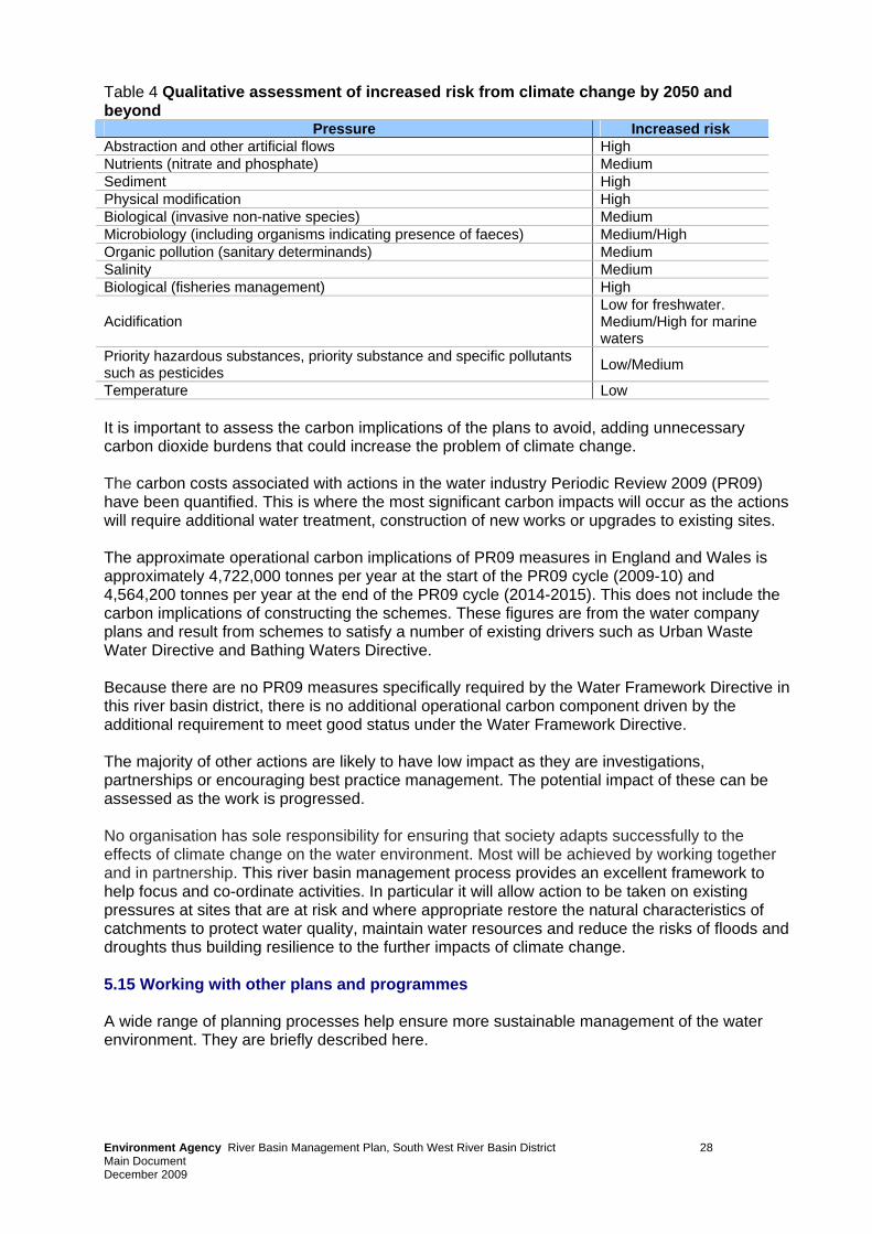
Table 4 Qualitative assessment of increased risk from climate change by 2050 and beyond
Pressure Increased risk Abstraction and other artificial flows High Nutrients (nitrate and phosphate) Medium Sediment High Physical modification High Biological (invasive non-native species) Medium Microbiology (including organisms indicating presence of faeces) Medium/High Organic pollution (sanitary determinands) Medium Salinity Medium Biological (fisheries management) High
Acidification Low for freshwater. Medium/High for marine waters
Priority hazardous substances, priority substance and specific pollutants such as pesticides Low/Medium
Temperature Low It is important to assess the carbon implications of the plans to avoid, adding unnecessary carbon dioxide burdens that could increase the problem of climate change. The carbon costs associated with actions in the water industry Periodic Review 2009 (PR09) have been quantified. This is where the most significant carbon impacts will occur as the actions will require additional water treatment, construction of new works or upgrades to existing sites. The approximate operational carbon implications of PR09 measures in England and Wales is approximately 4,722,000 tonnes per year at the start of the PR09 cycle (2009-10) and 4,564,200 tonnes per year at the end of the PR09 cycle (2014-2015). This does not include the carbon implications of constructing the schemes. These figures are from the water company plans and result from schemes to satisfy a number of existing drivers such as Urban Waste Water Directive and Bathing Waters Directive. Because there are no PR09 measures specifically required by the Water Framework Directive in this river basin district, there is no additional operational carbon component driven by the additional requirement to meet good status under the Water Framework Directive. The majority of other actions are likely to have low impact as they are investigations, partnerships or encouraging best practice management. The potential impact of these can be assessed as the work is progressed. No organisation has sole responsibility for ensuring that society adapts successfully to the effects of climate change on the water environment. Most will be achieved by working together and in partnership. This river basin management process provides an excellent framework to help focus and co-ordinate activities. In particular it will allow action to be taken on existing pressures at sites that are at risk and where appropriate restore the natural characteristics of catchments to protect water quality, maintain water resources and reduce the risks of floods and droughts thus building resilience to the further impacts of climate change. 5.15 Working with other plans and programmes A wide range of planning processes help ensure more sustainable management of the water environment. They are briefly described here.
Environment Agency River Basin Management Plan, South West River Basin District 28 Main Document December 2009
Development planning Development planning plays a key role in sustainable development. The Environment Agency will continue to work closely with planning authorities to ensure that planners understand the objectives of the Water Framework Directive and are able to translate them into planning policy. There are many planning processes and provisions involved. They include: • national guidance; • Regional Spatial Strategies • Local Development Documents; • local guidance (e.g. Supplementary Planning Documents). Current spatial plans in the South West River Basin District propose levels of new growth and development. The strategy targets growth at larger settlements, for instance Plymouth, Taunton, Exeter, Poole and Bournemouth, and discourages growth in rural areas with poor services and transport. Flood risk, coastal erosion planning There is a separate planning process for flood and coastal erosion risk management introduced by the new European Floods Directive (Directive 2007/60/EC on the assessment and management of flood risks). This requires that the environmental objectives of the Water Framework Directive are taken into account in flood and coastal erosion plans. Implementation of the Floods Directive in England and Wales will be co-ordinated with the Water Framework Directive. The delivery plans and timescales for the two directives will be closely aligned. Catchment Flood Management Plans (prepared by the Environment Agency) and Shoreline Management Plans (prepared by local coastal authorities and the Environment Agency) set out long term policies for flood risk management. The delivery of the policies from these long term plans will help to achieve the objectives of this and subsequent River Basin Management Plans. The Environment Agency plans its flood and coastal risk management capital investment through the ‘Medium Term Plan’, which is a rolling five-year investment plan. Using this, It has identified flood and coastal risk management activities that will deliver one or more restoration or mitigation measures included in this plan. Although these activities will be carried out for flood risk management purposes, they will be carried out in such a way to ensure any impacts are minimised and that the ecology is protected. Activities will not lower water body status unless fully justified under Article 4.7 of the Water Framework Directive. Marine Planning The Marine Strategy Framework Directive is closely linked with the Water Framework Directive and their application overlap in estuaries and coasts. The Environment Agency is working with Defra, Welsh Assembly Government and others to ensure that the implementation of both Directives is fully integrated. Managing new physical modifications In specific circumstances the Water Framework Directive provides a defence for when, as a result of a new physical modification, good ecological status or potential cannot be achieved or where deterioration in status occurs. This is covered under Article 4.7 of the Directive. Although protecting the water environment is a priority, some new modifications may provide important benefits to human health, human safety and/or sustainable development.
Environment Agency River Basin Management Plan, South West River Basin District 29 Main Document December 2009
Such benefits can include: • public water supply; • flood defence/alleviation; • hydropower generation; • navigation. It is often impossible to undertake such activities without causing deterioration of status to the water body. The benefits that such developments can bring need to be balanced against the social and economic benefits gained by maintaining the status of the water environment in England and Wales. The Environment Agency has developed a process for applying the tests and justifications required for such new modifications (Article 4.7) and will work with stakeholders to ensure these provisions are met during the first cycle of river basin management. Other planning processes The Environment Agency is also working to align planning processes in other areas. These include water resources and water quality, agriculture and rural development and natural heritage. Annex J provides further information about other planning processes.
Environment Agency River Basin Management Plan, South West River Basin District 30 Main Document December 2009
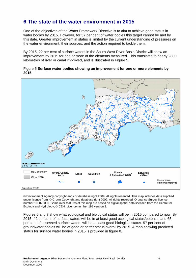
6 The state of the water environment in 2015 One of the objectives of the Water Framework Directive is to aim to achieve good status in water bodies by 2015. However, for 57 per cent of water bodies this target cannot be met by this date. Greater improvement in status is limited by the current understanding of pressures on the water environment, their sources, and the action required to tackle them. By 2015, 22 per cent of surface waters in the South West River Basin District will show an improvement by 2015 for one or more of the elements measured. This translates to nearly 2800 kilometres of river or canal improved, and is illustrated in Figure 5. Figure 5 Surface water bodies showing an improvement for one or more elements by 2015
© Environment Agency copyright and / or database right 2009. All rights reserved. This map includes data supplied under licence from: © Crown Copyright and database right 2009. All rights reserved. Ordnance Survey licence number 100026380. Some river features of this map are based on digital spatial data licensed from the Centre for Ecology and Hydrology, © CEH. Licence number 198 version 2. Figures 6 and 7 show what ecological and biological status will be in 2015 compared to now. By 2015, 42 per cent of surface waters will be in at least good ecological status/potential and 65 per cent of assessed surface waters will be at least good biological status. 57 per cent of groundwater bodies will be at good or better status overall by 2015. A map showing predicted status for surface water bodies in 2015 is provided in figure 8.
Environment Agency River Basin Management Plan, South West River Basin District 31
Main Document December 2009
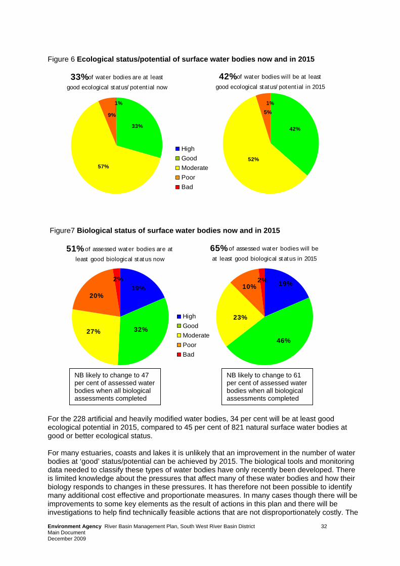
Figure 6 Ecological status/potential of surface water bodies now and in 2015
Environment Agency River Basin Management Plan, South West River Basin District 32
42% of water bodies will be at least 33% of water bodies are at least
good ecological status/potential in 2015good ecological status/potential now
42%
1%
5%
52%
9%
57%
1%
33%
HighGoodModeratePoorBad
Figure7 Biological status of surface water bodies now and in 2015
51% of assessed water bodies are at
least good biological status now
32%
19%
27%
20%
2%
65% of assessed water bodies will be
at least good biological status in 2015
2% 19%10%
46%
23%
HighGoodModeratePoorBad
NB likely to change to 47 per cent of assessed water bodies when all biological assessments completed
NB likely to change to 61 per cent of assessed water bodies when all biological assessments completed
For the 228 artificial and heavily modified water bodies, 34 per cent will be at least good ecological potential in 2015, compared to 45 per cent of 821 natural surface water bodies at good or better ecological status. For many estuaries, coasts and lakes it is unlikely that an improvement in the number of water bodies at ‘good’ status/potential can be achieved by 2015. The biological tools and monitoring data needed to classify these types of water bodies have only recently been developed. There is limited knowledge about the pressures that affect many of these water bodies and how their biology responds to changes in these pressures. It has therefore not been possible to identify many additional cost effective and proportionate measures. In many cases though there will be improvements to some key elements as the result of actions in this plan and there will be investigations to help find technically feasible actions that are not disproportionately costly. The
Main Document December 2009
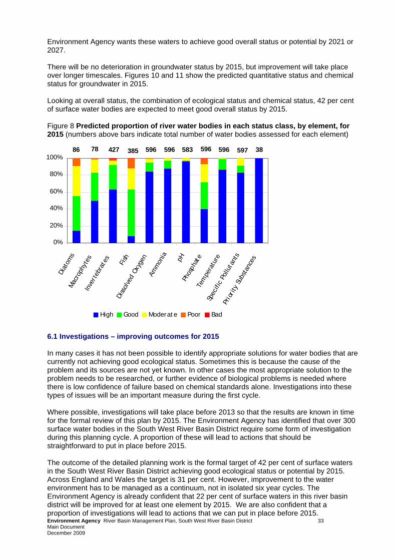
Environment Agency wants these waters to achieve good overall status or potential by 2021 or 2027. There will be no deterioration in groundwater status by 2015, but improvement will take place over longer timescales. Figures 10 and 11 show the predicted quantitative status and chemical status for groundwater in 2015. Looking at overall status, the combination of ecological status and chemical status, 42 per cent of surface water bodies are expected to meet good overall status by 2015. Figure 8 Predicted proportion of river water bodies in each status class, by element, for 2015 (numbers above bars indicate total number of water bodies assessed for each element)
0%
20%
40%
60%
80%
100%
Diat
oms
Mac
roph
ytes
Inve
rteb
rate
s
Fish
Diss
olve
d Ox
ygen
Amm
onia pH
Phos
phat
eTe
mpe
ratu
reSp
ecifi
c Po
lluta
nts
Prio
rity
Sub
stan
ces
High Good Moderate Poor Bad
5963854277886 596583596 597596 38
6.1 Investigations – improving outcomes for 2015 In many cases it has not been possible to identify appropriate solutions for water bodies that are currently not achieving good ecological status. Sometimes this is because the cause of the problem and its sources are not yet known. In other cases the most appropriate solution to the problem needs to be researched, or further evidence of biological problems is needed where there is low confidence of failure based on chemical standards alone. Investigations into these types of issues will be an important measure during the first cycle. Where possible, investigations will take place before 2013 so that the results are known in time for the formal review of this plan by 2015. The Environment Agency has identified that over 300 surface water bodies in the South West River Basin District require some form of investigation during this planning cycle. A proportion of these will lead to actions that should be straightforward to put in place before 2015.
Environment Agency River Basin Management Plan, South West River Basin District 33
The outcome of the detailed planning work is the formal target of 42 per cent of surface waters in the South West River Basin District achieving good ecological status or potential by 2015. Across England and Wales the target is 31 per cent. However, improvement to the water environment has to be managed as a continuum, not in isolated six year cycles. The Environment Agency is already confident that 22 per cent of surface waters in this river basin district will be improved for at least one element by 2015. We are also confident that a proportion of investigations will lead to actions that we can put in place before 2015.
Main Document December 2009
Environment Agency River Basin Management Plan, South West River Basin District 34 Main Document December 2009
To ensure we capture these additional opportunities, we will be ensuring that the South West River Basin District makes its contribution to a goal of achieving up to 33 per cent of surface waters across England and Wales at good ecological status or potential by 2015.
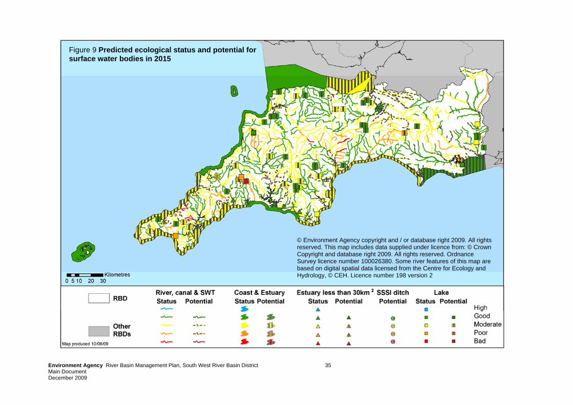
© Environment Agency copyright and / or database right 2009. All rights reserved. This map includes data supplied under licence from: © Crown Copyright and database right 2009. All rights reserved. Ordnance Survey licence number 100026380. Some river features of this map are based on digital spatial data licensed from the Centre for Ecology and Hydrology, © CEH. Licence number 198 version 2
Figure 9 Predicted ecological status and potential for surface water bodies in 2015
Environment Agency River Basin Management Plan, South West River Basin District 35 Main Document December 2009
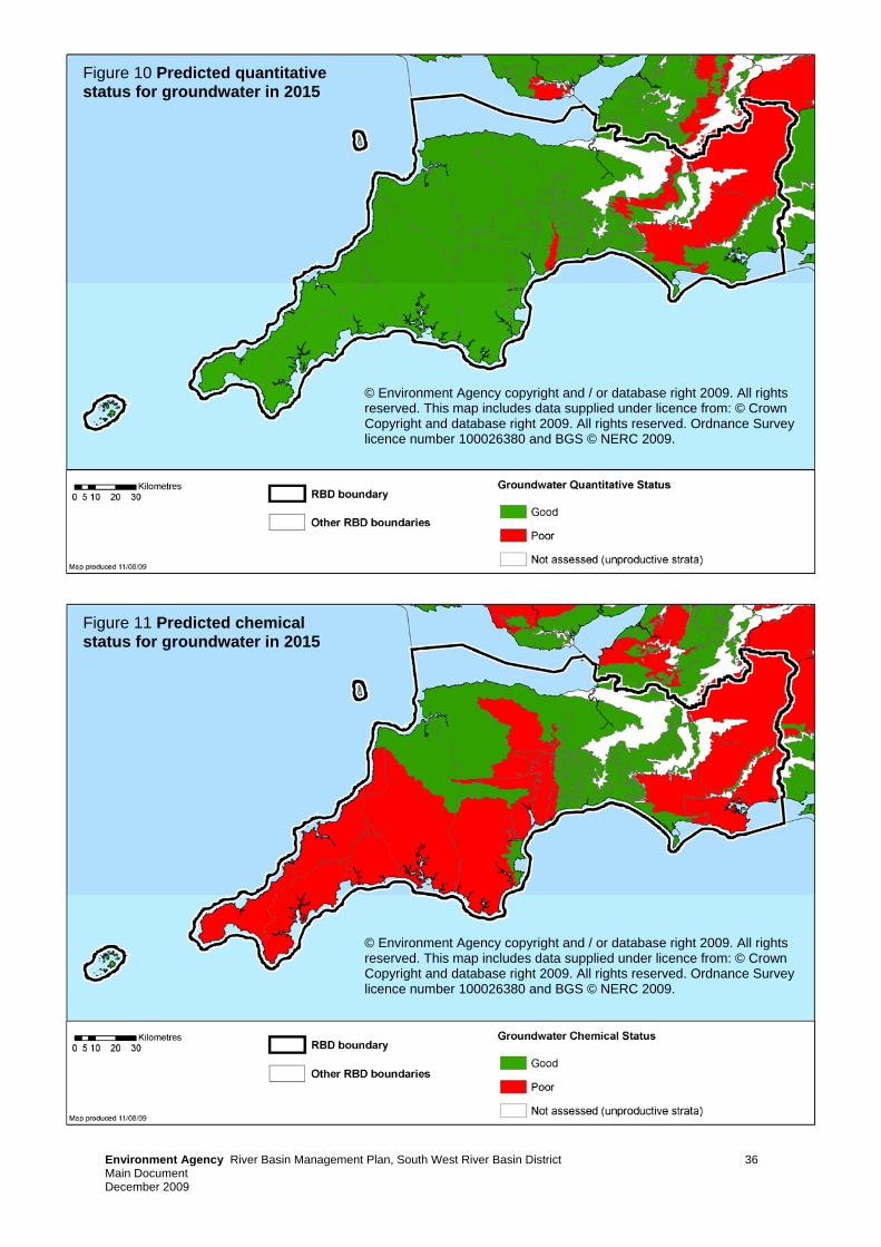
Environment Agency River Basin Management Plan, South West River Basin District 36 Main Document December 2009
© Environment Agency copyright and / or database right 2009. All rights reserved. This map includes data supplied under licence from: © Crown Copyright and database right 2009. All rights reserved. Ordnance Survey licence number 100026380 and BGS © NERC 2009.
Figure 10 Predicted quantitative status for groundwater in 2015
Figure 11 Predicted chemical status for groundwater in 2015
© Environment Agency copyright and / or database right 2009. All rights reserved. This map includes data supplied under licence from: © Crown Copyright and database right 2009. All rights reserved. Ordnance Survey licence number 100026380 and BGS © NERC 2009.
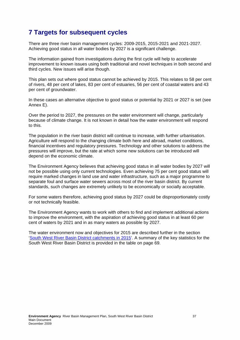
7 Targets for subsequent cycles There are three river basin management cycles: 2009-2015, 2015-2021 and 2021-2027. Achieving good status in all water bodies by 2027 is a significant challenge. The information gained from investigations during the first cycle will help to accelerate improvement to known issues using both traditional and novel techniques in both second and third cycles. New issues will arise though. This plan sets out where good status cannot be achieved by 2015. This relates to 58 per cent of rivers, 48 per cent of lakes, 83 per cent of estuaries, 56 per cent of coastal waters and 43 per cent of groundwater. In these cases an alternative objective to good status or potential by 2021 or 2027 is set (see Annex E). Over the period to 2027, the pressures on the water environment will change, particularly because of climate change. It is not known in detail how the water environment will respond to this. The population in the river basin district will continue to increase, with further urbanisation. Agriculture will respond to the changing climate both here and abroad, market conditions, financial incentives and regulatory pressures. Technology and other solutions to address the pressures will improve, but the rate at which some new solutions can be introduced will depend on the economic climate. The Environment Agency believes that achieving good status in all water bodies by 2027 will not be possible using only current technologies. Even achieving 75 per cent good status will require marked changes in land use and water infrastructure, such as a major programme to separate foul and surface water sewers across most of the river basin district. By current standards, such changes are extremely unlikely to be economically or socially acceptable. For some waters therefore, achieving good status by 2027 could be disproportionately costly or not technically feasible. The Environment Agency wants to work with others to find and implement additional actions to improve the environment, with the aspiration of achieving good status in at least 60 per cent of waters by 2021 and in as many waters as possible by 2027. The water environment now and objectives for 2015 are described further in the section ‘South West River Basin District catchments in 2015’. A summary of the key statistics for the South West River Basin District is provided in the table on page 69.
Environment Agency River Basin Management Plan, South West River Basin District 37 Main Document December 2009
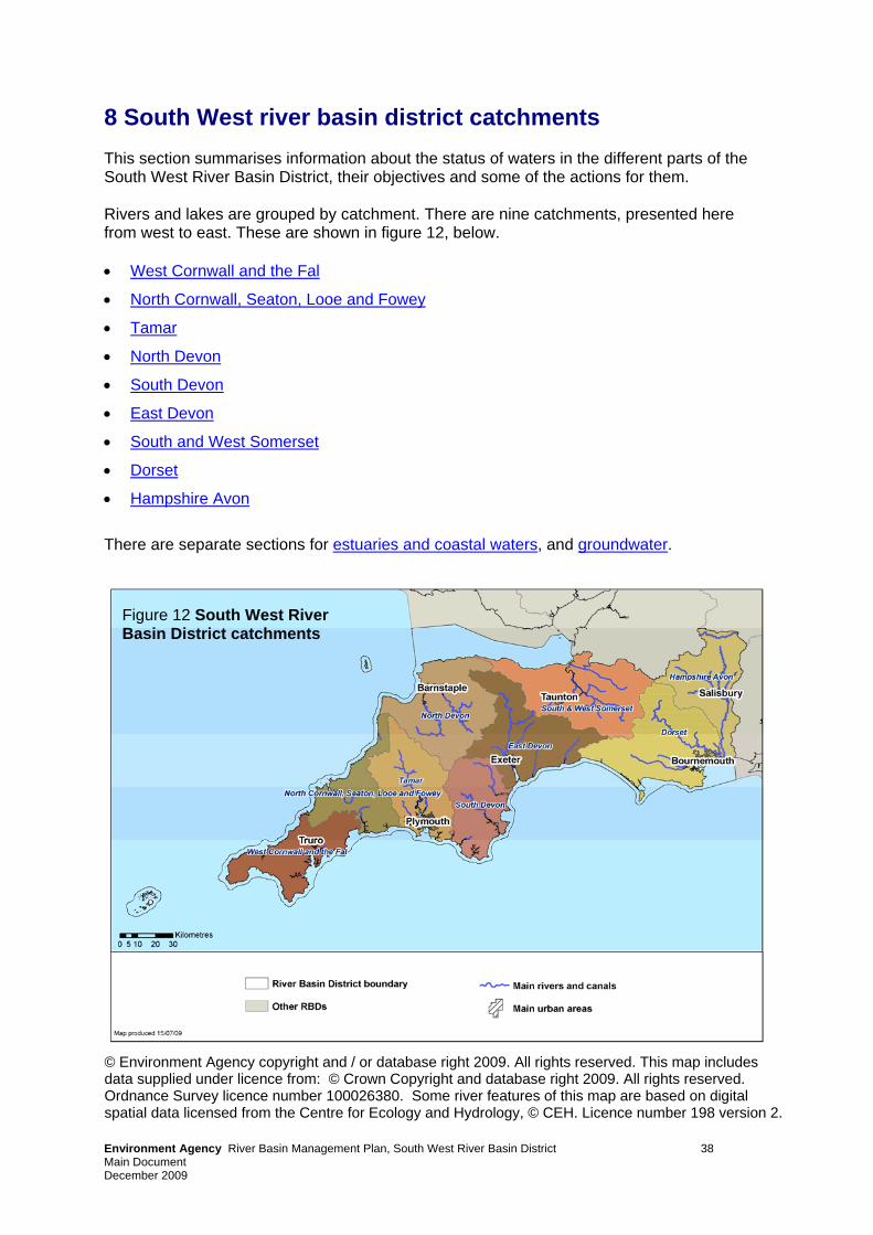
8 South West river basin district catchments This section summarises information about the status of waters in the different parts of the South West River Basin District, their objectives and some of the actions for them. Rivers and lakes are grouped by catchment. There are nine catchments, presented here from west to east. These are shown in figure 12, below. • West Cornwall and the Fal
• North Cornwall, Seaton, Looe and Fowey
• Tamar
• North Devon
• South Devon
• East Devon
• South and West Somerset
• Dorset
• Hampshire Avon
There are separate sections for estuaries and coastal waters, and groundwater. © Environment Agency copyright and / or database right 2009. All rights reserved. This map includes data supplied under licence from: © Crown Copyright and database right 2009. All rights reserved. Ordnance Survey licence number 100026380. Some river features of this map are based on digital spatial data licensed from the Centre for Ecology and Hydrology, © CEH. Licence number 198 version 2.
Figure 12 South West River Basin District catchments
Environment Agency River Basin Management Plan, South West River Basin District 38 Main Document December 2009
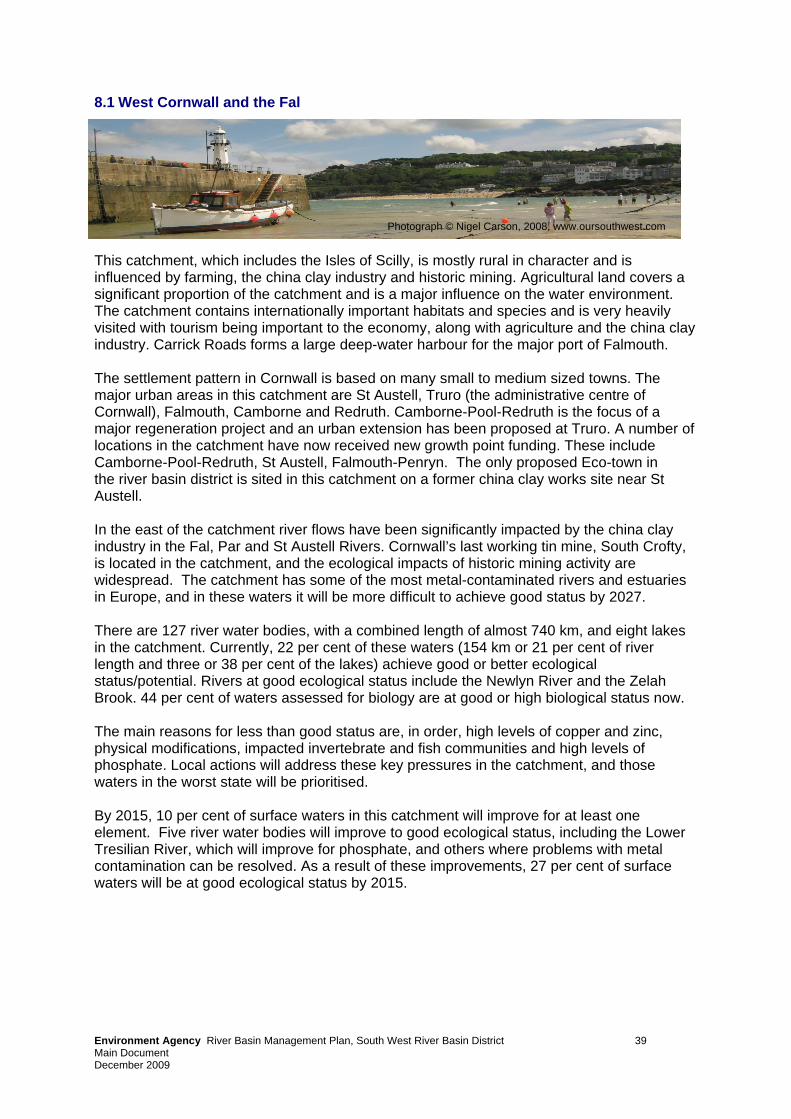
Env sin Management Plan, South West River Basin District 39 Main Document December 2009
ironment Agency River Ba
8.1 West Cornwall and the Fal
This catchment, which includes the Isles of Scilly, is mostly rural in character and is influenced by farming, the china clay industry and historic mining. Agricultural land covers a significant proportion of the catchment and is a major influence on the water environment. The catchment contains internationally important habitats and species and is very heavily visited with tourism being important to the economy, along with agriculture and the china clay industry. Carrick Roads forms a large deep-water harbour for the major port of Falmouth. The settlement pattern in Cornwall is based on many small to medium sized towns. The major urban areas in this catchment are St Austell, Truro (the administrative centre of Cornwall), Falmouth, Camborne and Redruth. Camborne-Pool-Redruth is the focus of a major regeneration project and an urban extension has been proposed at Truro. A number of locations in the catchment have now received new growth point funding. These include Camborne-Pool-Redruth, St Austell, Falmouth-Penryn. The only proposed Eco-town in the river basin district is sited in this catchment on a former china clay works site near St Austell. In the east of the catchment river flows have been significantly impacted by the china clay industry in the Fal, Par and St Austell Rivers. Cornwall’s last working tin mine, South Crofty, is located in the catchment, and the ecological impacts of historic mining activity are widespread. The catchment has some of the most metal-contaminated rivers and estuaries in Europe, and in these waters it will be more difficult to achieve good status by 2027. There are 127 river water bodies, with a combined length of almost 740 km, and eight lakes in the catchment. Currently, 22 per cent of these waters (154 km or 21 per cent of river length and three or 38 per cent of the lakes) achieve good or better ecological status/potential. Rivers at good ecological status include the Newlyn River and the Zelah Brook. 44 per cent of waters assessed for biology are at good or high biological status now. The main reasons for less than good status are, in order, high levels of copper and zinc, physical modifications, impacted invertebrate and fish communities and high levels of phosphate. Local actions will address these key pressures in the catchment, and those waters in the worst state will be prioritised. By 2015, 10 per cent of surface waters in this catchment will improve for at least one element. Five river water bodies will improve to good ecological status, including the Lower Tresilian River, which will improve for phosphate, and others where problems with metal contamination can be resolved. As a result of these improvements, 27 per cent of surface waters will be at good ecological status by 2015.
Photograph © Nigel Carson, 2008, www.oursouthwest.com
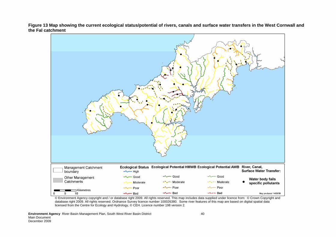
Environment Agency River Basin Management Plan, South West River Basin District 40 Main Document December 2009
Figure 13 Map showing the current ecological status/potential of rivers, canals and surface water transfers in the West Cornwall and the Fal catchment
© Environment Agency copyright and / or database right 2009. All rights reserved. This map includes data supplied under licence from: © Crown Copyright and database right 2009. All rights reserved. Ordnance Survey licence number 100026380. Some river features of this map are based on digital spatial data licensed from the Centre for Ecology and Hydrology, © CEH. Licence number 198 version 2.
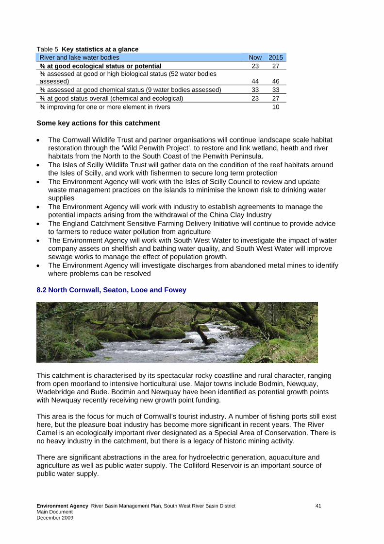
Table 5 Key statistics at a glance River and lake water bodies Now 2015 % at good ecological status or potential 23 27 % assessed at good or high biological status (52 water bodies assessed) 44 46 % assessed at good chemical status (9 water bodies assessed) 33 33 % at good status overall (chemical and ecological) 23 27 % improving for one or more element in rivers 10
Some key actions for this catchment • The Cornwall Wildlife Trust and partner organisations will continue landscape scale habitat
restoration through the ‘Wild Penwith Project’, to restore and link wetland, heath and river habitats from the North to the South Coast of the Penwith Peninsula.
• The Isles of Scilly Wildlife Trust will gather data on the condition of the reef habitats around the Isles of Scilly, and work with fishermen to secure long term protection
• The Environment Agency will work with the Isles of Scilly Council to review and update waste management practices on the islands to minimise the known risk to drinking water supplies
• The Environment Agency will work with industry to establish agreements to manage the potential impacts arising from the withdrawal of the China Clay Industry
• The England Catchment Sensitive Farming Delivery Initiative will continue to provide advice to farmers to reduce water pollution from agriculture
• The Environment Agency will work with South West Water to investigate the impact of water company assets on shellfish and bathing water quality, and South West Water will improve sewage works to manage the effect of population growth.
• The Environment Agency will investigate discharges from abandoned metal mines to identify where problems can be resolved
8.2 North Cornwall, Seaton, Looe and Fowey
This catchment is characterised by its spectacular rocky coastline and rural character, ranging from open moorland to intensive horticultural use. Major towns include Bodmin, Newquay, Wadebridge and Bude. Bodmin and Newquay have been identified as potential growth points with Newquay recently receiving new growth point funding. This area is the focus for much of Cornwall’s tourist industry. A number of fishing ports still exist here, but the pleasure boat industry has become more significant in recent years. The River Camel is an ecologically important river designated as a Special Area of Conservation. There is no heavy industry in the catchment, but there is a legacy of historic mining activity. There are significant abstractions in the area for hydroelectric generation, aquaculture and agriculture as well as public water supply. The Colliford Reservoir is an important source of public water supply.
Environment Agency River Basin Management Plan, South West River Basin District 41 Main Document December 2009
There are 99 river water bodies in the catchment, with a combined length of almost 600 km, and four lakes. Currently, 36 per cent of these waters (219 km or 37 per cent of river length, but none of the lakes) achieve good or better ecological status/potential. Rivers at good status include the upper Fowey and large parts of the River Camel. 58 per cent of surface waters assessed for biology are at good or high biological status now. The main reasons for less than good status are, in order, impacted fish communities, physical modifications, and high levels of copper, phosphate and zinc. By 2015, 16 per cent of surface waters in this catchment will improve for at least one element of good status. Nine river water bodies will improve to good status, including six that currently fail because of impacts on the fish population. These are the River Neet (Middle) and Week St Mary Stream, Jacob Stream, Upper River Amble, Issey Brook (Camel) and the Warleggan River. As a result of these improvements, 44 per cent of surface water bodies will achieve good ecological status by 2015, an increase of 9 per cent. Table 6 Key statistics at a glance River and lake water bodies Now 2015 % at good ecological status or potential 35 44 % assessed at good or high biological status (42 water bodies assessed) 58 78 % assessed at good chemical status (4 water bodies assessed) 100 100 % at good status overall (chemical and ecological) 35 44 % improving for one or more element in rivers 16
Some key actions for this catchment • The Camel Invasive Weeds Project will remove invasive weed from tens of miles of the
River Camel SAC by controlling Himalayan Balsam and Japanese Knotweed on the river Camel.
• The England Catchment Sensitive Farming Delivery Initiative will continue to provide advice to farmers to reduce water pollution from agriculture in the river Camel and it’s tributaries.
• The Environment Agency will work with South West Water to investigate the impact of water company assets on shellfish and bathing water quality and of the pressures on drinking water quality. South West Water will improve sewage works to manage the effect of population growth.
• South West Water will improve protection of drinking water sources from accidental contamination through the provision of targeted advice to farmers.
Environment Agency River Basin Management Plan, South West River Basin District 42 Main Document December 2009
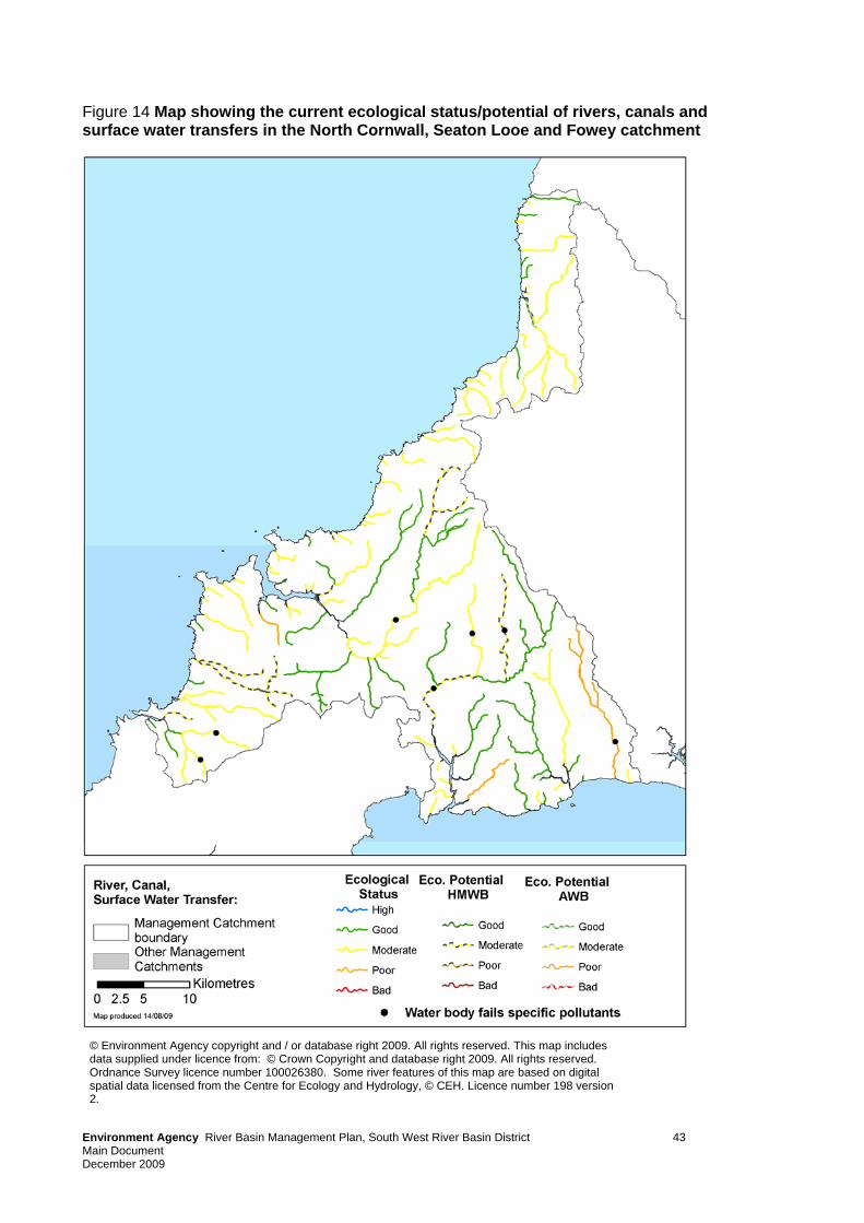
Environment Agency River Basin Management Plan, South West River Basin District 43 Main Document December 2009
Figure 14 Map showing the current ecological status/potential of rivers, canals and surface water transfers in the North Cornwall, Seaton Looe and Fowey catchment
© Environment Agency copyright and / or database right 2009. All rights reserved. This map includes data supplied under licence from: © Crown Copyright and database right 2009. All rights reserved. Ordnance Survey licence number 100026380. Some river features of this map are based on digital spatial data licensed from the Centre for Ecology and Hydrology, © CEH. Licence number 198 version 2.
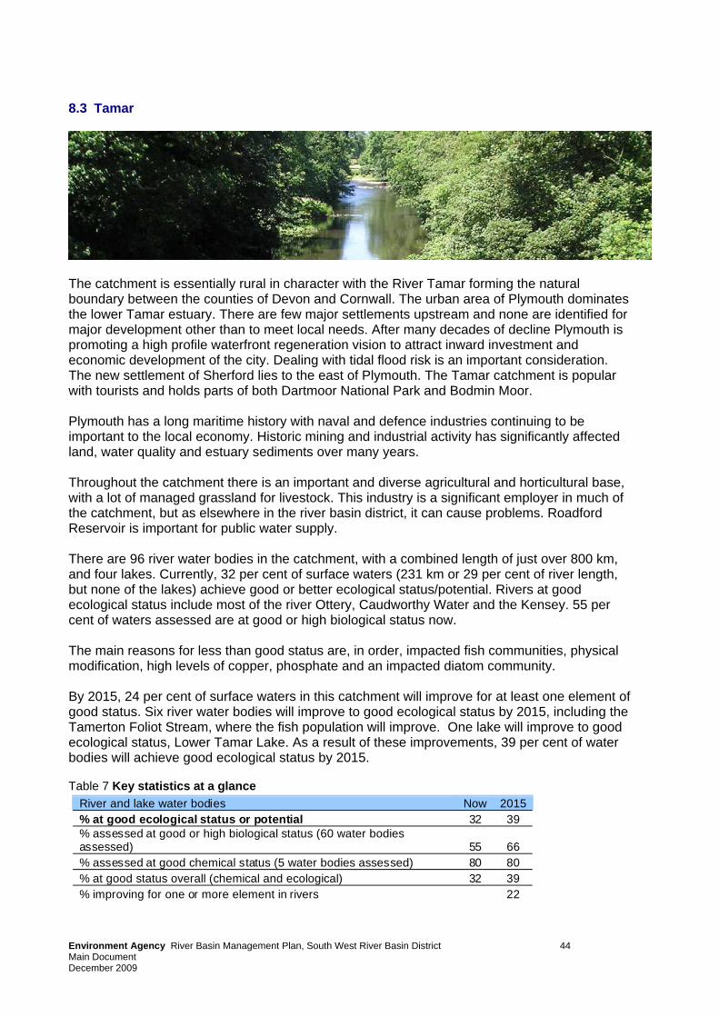
8.3 Tamar
The catchment is essentially rural in character with the River Tamar forming the natural boundary between the counties of Devon and Cornwall. The urban area of Plymouth dominates the lower Tamar estuary. There are few major settlements upstream and none are identified for major development other than to meet local needs. After many decades of decline Plymouth is promoting a high profile waterfront regeneration vision to attract inward investment and economic development of the city. Dealing with tidal flood risk is an important consideration. The new settlement of Sherford lies to the east of Plymouth. The Tamar catchment is popular with tourists and holds parts of both Dartmoor National Park and Bodmin Moor. Plymouth has a long maritime history with naval and defence industries continuing to be important to the local economy. Historic mining and industrial activity has significantly affected land, water quality and estuary sediments over many years. Throughout the catchment there is an important and diverse agricultural and horticultural base, with a lot of managed grassland for livestock. This industry is a significant employer in much of the catchment, but as elsewhere in the river basin district, it can cause problems. Roadford Reservoir is important for public water supply. There are 96 river water bodies in the catchment, with a combined length of just over 800 km, and four lakes. Currently, 32 per cent of surface waters (231 km or 29 per cent of river length, but none of the lakes) achieve good or better ecological status/potential. Rivers at good ecological status include most of the river Ottery, Caudworthy Water and the Kensey. 55 per cent of waters assessed are at good or high biological status now. The main reasons for less than good status are, in order, impacted fish communities, physical modification, high levels of copper, phosphate and an impacted diatom community. By 2015, 24 per cent of surface waters in this catchment will improve for at least one element of good status. Six river water bodies will improve to good ecological status by 2015, including the Tamerton Foliot Stream, where the fish population will improve. One lake will improve to good ecological status, Lower Tamar Lake. As a result of these improvements, 39 per cent of water bodies will achieve good ecological status by 2015. Table 7 Key statistics at a glance River and lake water bodies Now 2015
% at good ecological status or potential 32 39 % assessed at good or high biological status (60 water bodies assessed) 55 66 % assessed at good chemical status (5 water bodies assessed) 80 80 % at good status overall (chemical and ecological) 32 39 % improving for one or more element in rivers 22
Environment Agency River Basin Management Plan, South West River Basin District 44 Main Document December 2009
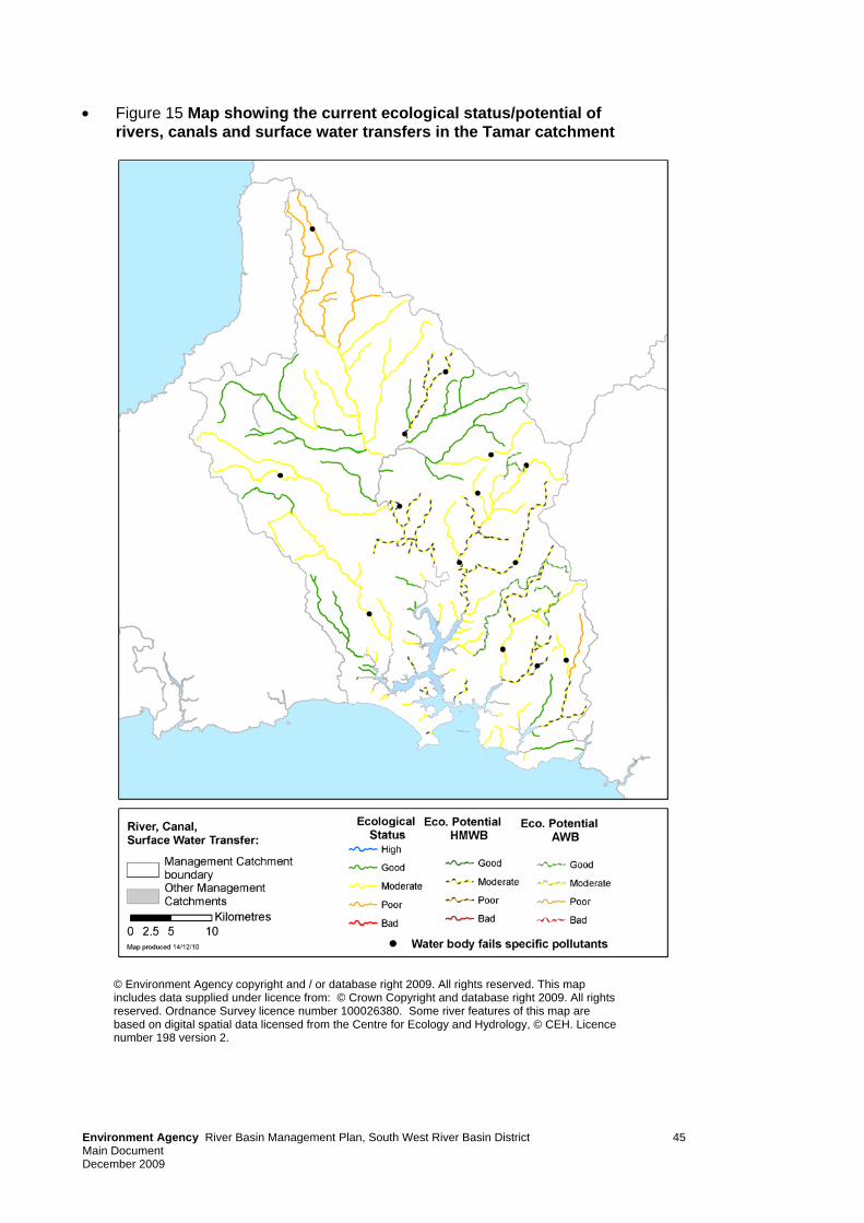
• Figure 15 Map showing the current ecological status/potential of rivers, canals and surface water transfers in the Tamar catchment
© Environment Agency copyright and / or database right 2009. All rights reserved. This map includes data supplied under licence from: © Crown Copyright and database right 2009. All rights reserved. Ordnance Survey licence number 100026380. Some river features of this map are based on digital spatial data licensed from the Centre for Ecology and Hydrology, © CEH. Licence number 198 version 2.
Environment Agency River Basin Management Plan, South West River Basin District 45 Main Document December 2009
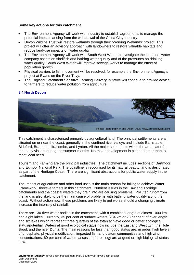
Some key actions for this catchment • The Environment Agency will work with industry to establish agreements to manage the
potential impacts arising from the withdrawal of the China Clay Industry. • Devon Wildlife Trust will restore wetlands through their ‘Working Wetlands’ project. This
project will offer an advisory approach with landowners to restore valuable habitats and reduce land-use impacts on water quality.
• The Environment Agency will work with South West Water to investigate the impact of water company assets on shellfish and bathing water quality and of the pressures on drinking water quality. South West Water will improve sewage works to manage the effect of population growth.
• Physical barriers to fish movement will be resolved, for example the Environment Agency’s project at Evans on the River Tavy.
• The England Catchment Sensitive Farming Delivery Initiative will continue to provide advice to farmers to reduce water pollution from agriculture
8.4 North Devon
Photo: Photograph © Sue Dixon, 2005, www.oursouthwest.com
This catchment is characterised primarily by agricultural land. The principal settlements are all situated on or near the coast, generally in the confined river valleys and include Barnstable, Bideford, Braunton, Ilfracombe, and Lynton. All the major settlements within the area cater for the many visitors during the summer months. No major development is planned other than to meet local need. Tourism and Farming are the principal industries. The catchment includes sections of Dartmoor and Exmoor National Park. The coastline is recognised for its natural beauty, and is designated as part of the Heritage Coast. There are significant abstractions for public water supply in the catchment. The impact of agriculture and other land uses is the main reason for failing to achieve Water Framework Directive targets in this catchment. Nutrient issues in the Taw and Torridge catchments and the coastal waters they drain into are causing problems. Polluted runoff from the land is also likely to be the main cause of problems with bathing water quality along the coast. Without action now, these problems are likely to get worse should a changing climate increase the intensity of rainfall. There are 130 river water bodies in the catchment, with a combined length of almost 1000 km, and eight lakes. Currently, 35 per cent of surface waters (284 km or 28 per cent of river length and six lakes which represent three quarters of the total) achieve good or better ecological status/potential. Waters at good ecological status now include the East and West Lyn, the Hole Brook and the river Duntz. The main reasons for less than good status are, in order, high levels of phosphate, physical modification, impacted fish and diatom communities and high zinc concentrations. 69 per cent of waters assessed for biology are at good or high biological status now.
Environment Agency River Basin Management Plan, South West River Basin District 46 Main Document December 2009
Environment Agency River Ba Plan, South West River Basin District 47 Main Document December 2009
sin Management
By 2015, 18 per cent of surface waters in this catchment will improve for at least one element of good status, many for copper. Sixteen river water bodies will improve to good ecological status by 2015, including the River Lew which will improve for phosphates. Melbury Reservoir, will also improve to good ecological status. As a result of these improvements, there will be an increase of 12 per cent of water bodies achieving good ecological status by 2015, to 47 per cent. Table 8 Key statistics at a glance
Some key actions for this catchment • The Environment Agency will continue to lead on coordinating the captive breeding
programme for the Freshwater Pearl Mussel will continue as part of the national recovery project and the river restoration work necessary to allow juveniles to be reintroduced to the wild in the Taw and Torridge catchments.
• The Environment Agency will establishment a Strategic Partnership in the Taw and Torridge catchments to deliver advice to farmers and reduce diffuse water pollution from agriculture.
• The Environment Agency will work with South West Water to investigate the impact of water company assets on shellfish and bathing water quality and of the pressures on drinking water quality. South West Water will improve sewage works to manage the effect of population growth.
• Devon Wildlife Trust will restore wetlands through their ‘Working Wetlands’ project. This project will offer an advisory approach with landowners to restore valuable habitats and reduce land-use impacts on water quality.
River and lake water bodies Now 2015 % at good ecological status or potential 35 47 % assessed at good or high biological status (75 water bodies assessed) 69 79 % assessed at good chemical status (7 water bodies assessed) 71 71 % at good status overall (chemical and ecological) 35 46
% improving for one or more element in rivers 18
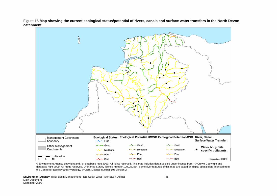
Environment Agency River Basin Management Plan, South West River Basin District 48 Main Document December 2009
Figure 16 Map showing the current ecological status/potential of rivers, canals and surface water transfers in the North Devon catchment
© Environment Agency copyright and / or database right 2009. All rights reserved. This map includes data supplied under licence from: © Crown Copyright and database right 2009. All rights reserved. Ordnance Survey licence number 100026380. Some river features of this map are based on digital spatial data licensed from the Centre for Ecology and Hydrology, © CEH. Licence number 198 version 2.
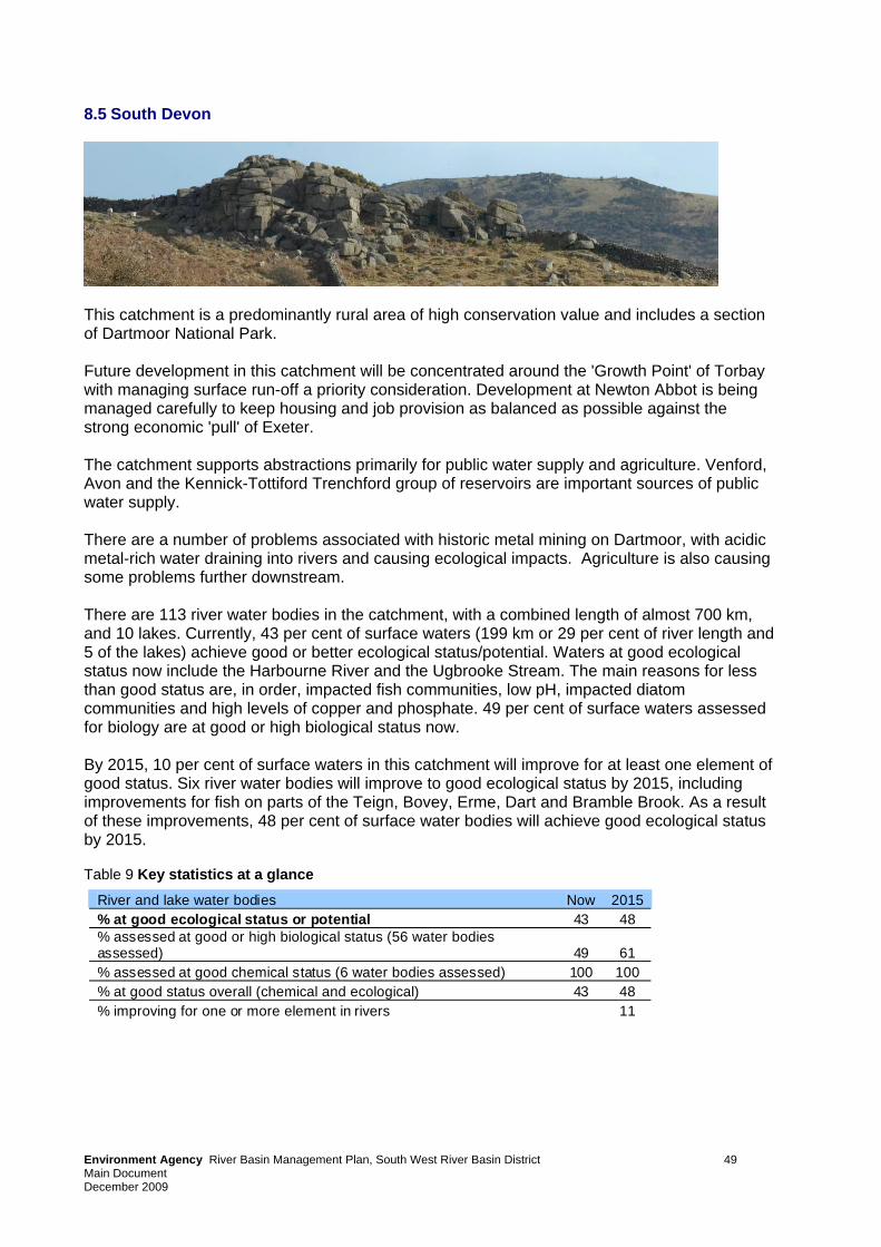
8.5 South Devon
This catchment is a predominantly rural area of high conservation value and includes a section of Dartmoor National Park. Future development in this catchment will be concentrated around the 'Growth Point' of Torbay with managing surface run-off a priority consideration. Development at Newton Abbot is being managed carefully to keep housing and job provision as balanced as possible against the strong economic 'pull' of Exeter. The catchment supports abstractions primarily for public water supply and agriculture. Venford, Avon and the Kennick-Tottiford Trenchford group of reservoirs are important sources of public water supply. There are a number of problems associated with historic metal mining on Dartmoor, with acidic metal-rich water draining into rivers and causing ecological impacts. Agriculture is also causing some problems further downstream. There are 113 river water bodies in the catchment, with a combined length of almost 700 km, and 10 lakes. Currently, 43 per cent of surface waters (199 km or 29 per cent of river length and 5 of the lakes) achieve good or better ecological status/potential. Waters at good ecological status now include the Harbourne River and the Ugbrooke Stream. The main reasons for less than good status are, in order, impacted fish communities, low pH, impacted diatom communities and high levels of copper and phosphate. 49 per cent of surface waters assessed for biology are at good or high biological status now. By 2015, 10 per cent of surface waters in this catchment will improve for at least one element of good status. Six river water bodies will improve to good ecological status by 2015, including improvements for fish on parts of the Teign, Bovey, Erme, Dart and Bramble Brook. As a result of these improvements, 48 per cent of surface water bodies will achieve good ecological status by 2015. Table 9 Key statistics at a glance River and lake water bodies Now 2015
% at good ecological status or potential 43 48 % assessed at good or high biological status (56 water bodies assessed) 49 61 % assessed at good chemical status (6 water bodies assessed) 100 100 % at good status overall (chemical and ecological) 43 48 % improving for one or more element in rivers 11
Environment Agency River Basin Management Plan, South West River Basin District 49 Main Document December 2009
Some key actions for this catchment • Projects on the Dart and Teign to buffer the river from the impacts of stock access,
contaminated runoff and other land use impacts through coppicing, fencing and other techniques.
• The Mires on the Moors Project will restore upland blanket bogs and mires on Exmoor and Dartmoor using sustainable management techniques.
• The SeaTorbay partnership will improve understanding of coastal wildlife and conservation and how the public can become involved. A key aspect of the project is to map the uses of Tor Bay sea bed and the activities affecting it.
• Resolution of physical barriers to fish movement, for example at Holne on the Dart. • Provision of advice to farmers under the England Catchment Sensitive Farming Delivery
Initiative to reduce diffuse water pollution from agriculture in the Erme catchment, areas draining to Slapton Ley and the Kingsbridge estuary and across the South Hams.
• Investigation of the impact of water company assets and urban diffuse pollution on shellfish and bathing water quality, and improvements to sewage works to remove nutrients and improve storm water storage.
Environment Agency River Basin Management Plan, South West River Basin District 50 Main Document December 2009
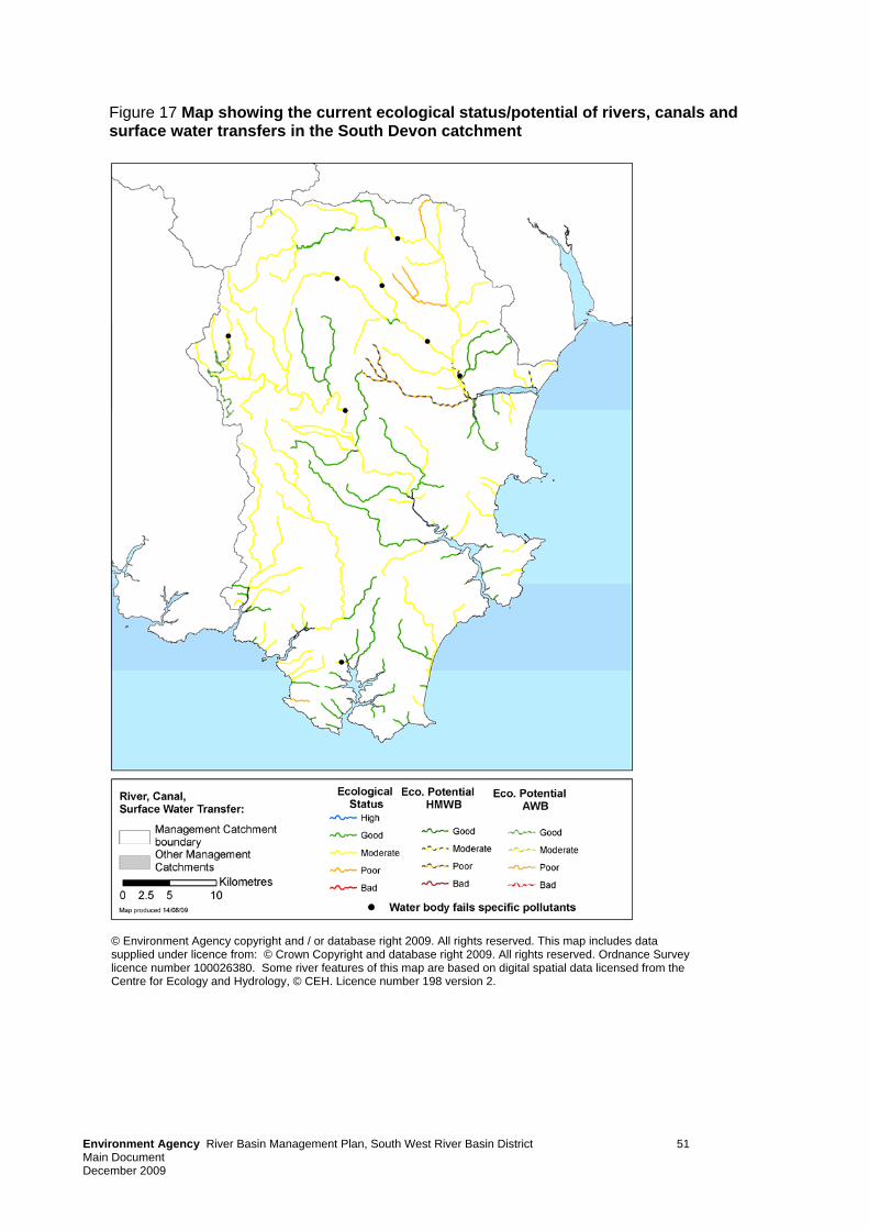
Figure 17 Map showing the current ecological status/potential of rivers, canals and surface water transfers in the South Devon catchment
© Environment Agency copyright and / or database right 2009. All rights reserved. This map includes data supplied under licence from: © Crown Copyright and database right 2009. All rights reserved. Ordnance Survey licence number 100026380. Some river features of this map are based on digital spatial data licensed from the Centre for Ecology and Hydrology, © CEH. Licence number 198 version 2.
Environment Agency River Basin Management Plan, South West River Basin District 51 Main Document December 2009
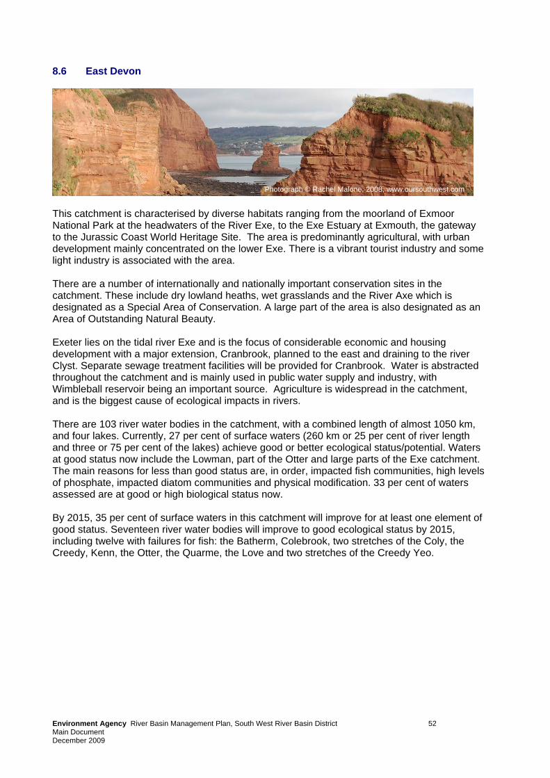
Environm Plan, South West River Basin District 52 Main Document December 2009
ent Agency River Basin Management
8.6 East Devon
This catchment is characterised by diverse habitats ranging from the moorland of Exmoor National Park at the headwaters of the River Exe, to the Exe Estuary at Exmouth, the gateway to the Jurassic Coast World Heritage Site. The area is predominantly agricultural, with urban development mainly concentrated on the lower Exe. There is a vibrant tourist industry and some light industry is associated with the area. There are a number of internationally and nationally important conservation sites in the catchment. These include dry lowland heaths, wet grasslands and the River Axe which is designated as a Special Area of Conservation. A large part of the area is also designated as an Area of Outstanding Natural Beauty. Exeter lies on the tidal river Exe and is the focus of considerable economic and housing development with a major extension, Cranbrook, planned to the east and draining to the river Clyst. Separate sewage treatment facilities will be provided for Cranbrook. Water is abstracted throughout the catchment and is mainly used in public water supply and industry, with Wimbleball reservoir being an important source. Agriculture is widespread in the catchment, and is the biggest cause of ecological impacts in rivers. There are 103 river water bodies in the catchment, with a combined length of almost 1050 km, and four lakes. Currently, 27 per cent of surface waters (260 km or 25 per cent of river length and three or 75 per cent of the lakes) achieve good or better ecological status/potential. Waters at good status now include the Lowman, part of the Otter and large parts of the Exe catchment. The main reasons for less than good status are, in order, impacted fish communities, high levels of phosphate, impacted diatom communities and physical modification. 33 per cent of waters assessed are at good or high biological status now. By 2015, 35 per cent of surface waters in this catchment will improve for at least one element of good status. Seventeen river water bodies will improve to good ecological status by 2015, including twelve with failures for fish: the Batherm, Colebrook, two stretches of the Coly, the Creedy, Kenn, the Otter, the Quarme, the Love and two stretches of the Creedy Yeo.
Photograph © Rachel Malone, 2008, www.oursouthwest.com
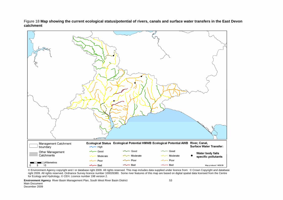
Environment Agency River Basin Management Plan, South West River Basin District 53 Main Document December 2009
Figure 18 Map showing the current ecological status/potential of rivers, canals and surface water transfers in the East Devon catchment
© Environment Agency copyright and / or database right 2009. All rights reserved. This map includes data supplied under licence from: © Crown Copyright and database right 2009. All rights reserved. Ordnance Survey licence number 100026380. Some river features of this map are based on digital spatial data licensed from the Centre for Ecology and Hydrology, © CEH. Licence number 198 version 2.
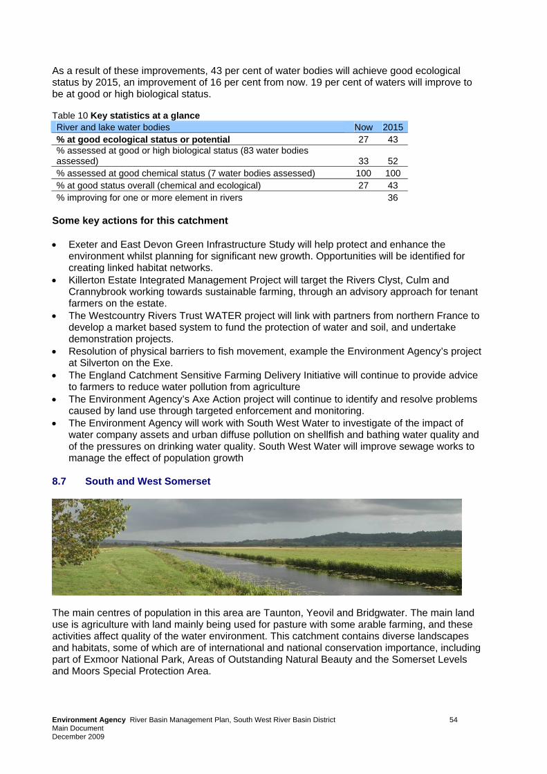
As a result of these improvements, 43 per cent of water bodies will achieve good ecological status by 2015, an improvement of 16 per cent from now. 19 per cent of waters will improve to be at good or high biological status. Table 10 Key statistics at a glance River and lake water bodies Now 2015 % at good ecological status or potential 27 43 % assessed at good or high biological status (83 water bodies assessed) 33 52 % assessed at good chemical status (7 water bodies assessed) 100 100 % at good status overall (chemical and ecological) 27 43 % improving for one or more element in rivers 36
Some key actions for this catchment • Exeter and East Devon Green Infrastructure Study will help protect and enhance the
environment whilst planning for significant new growth. Opportunities will be identified for creating linked habitat networks.
• Killerton Estate Integrated Management Project will target the Rivers Clyst, Culm and Crannybrook working towards sustainable farming, through an advisory approach for tenant farmers on the estate.
• The Westcountry Rivers Trust WATER project will link with partners from northern France to develop a market based system to fund the protection of water and soil, and undertake demonstration projects.
• Resolution of physical barriers to fish movement, example the Environment Agency’s project at Silverton on the Exe.
• The England Catchment Sensitive Farming Delivery Initiative will continue to provide advice to farmers to reduce water pollution from agriculture
• The Environment Agency’s Axe Action project will continue to identify and resolve problems caused by land use through targeted enforcement and monitoring.
• The Environment Agency will work with South West Water to investigate of the impact of water company assets and urban diffuse pollution on shellfish and bathing water quality and of the pressures on drinking water quality. South West Water will improve sewage works to manage the effect of population growth
8.7 South and West Somerset
The main centres of population in this area are Taunton, Yeovil and Bridgwater. The main land use is agriculture with land mainly being used for pasture with some arable farming, and these activities affect quality of the water environment. This catchment contains diverse landscapes and habitats, some of which are of international and national conservation importance, including part of Exmoor National Park, Areas of Outstanding Natural Beauty and the Somerset Levels and Moors Special Protection Area.
Environment Agency River Basin Management Plan, South West River Basin District 54 Main Document December 2009
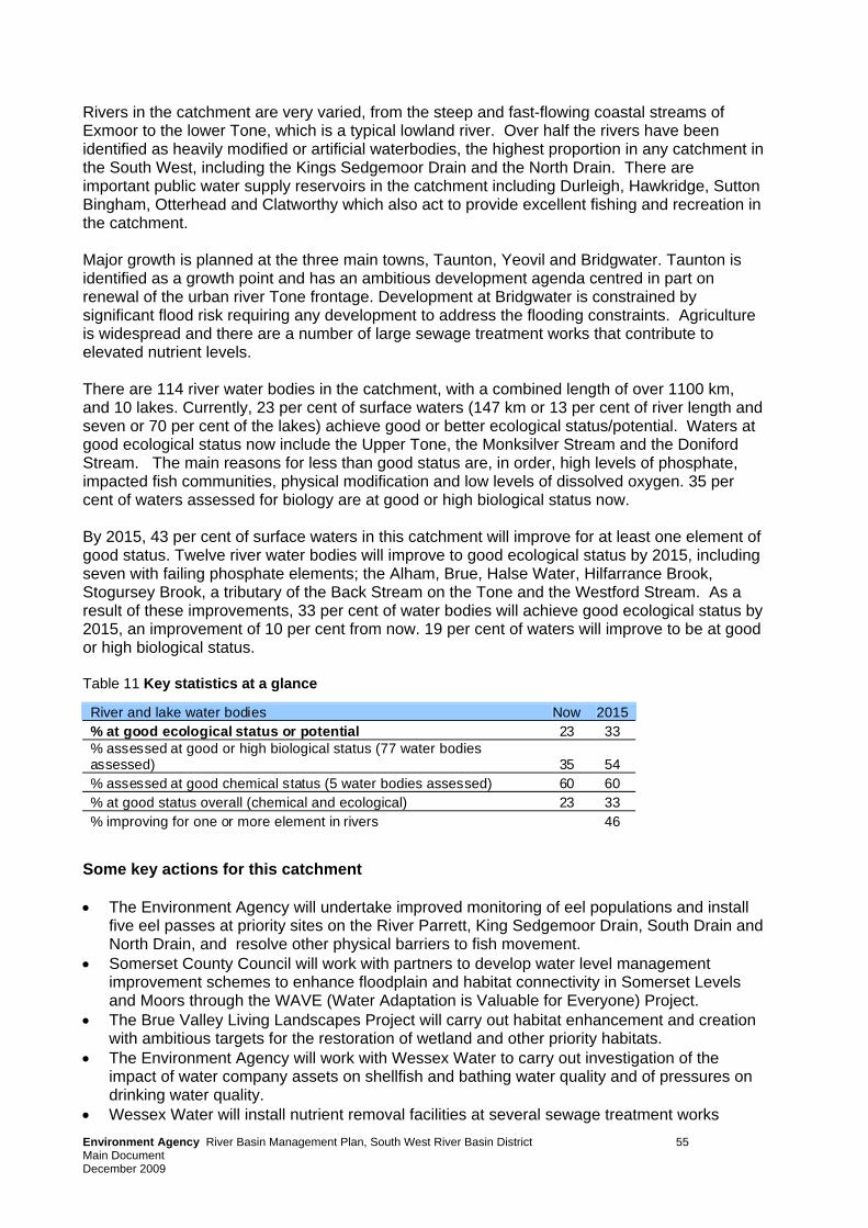
Rivers in the catchment are very varied, from the steep and fast-flowing coastal streams of Exmoor to the lower Tone, which is a typical lowland river. Over half the rivers have been identified as heavily modified or artificial waterbodies, the highest proportion in any catchment in the South West, including the Kings Sedgemoor Drain and the North Drain. There are important public water supply reservoirs in the catchment including Durleigh, Hawkridge, Sutton Bingham, Otterhead and Clatworthy which also act to provide excellent fishing and recreation in the catchment. Major growth is planned at the three main towns, Taunton, Yeovil and Bridgwater. Taunton is identified as a growth point and has an ambitious development agenda centred in part on renewal of the urban river Tone frontage. Development at Bridgwater is constrained by significant flood risk requiring any development to address the flooding constraints. Agriculture is widespread and there are a number of large sewage treatment works that contribute to elevated nutrient levels. There are 114 river water bodies in the catchment, with a combined length of over 1100 km, and 10 lakes. Currently, 23 per cent of surface waters (147 km or 13 per cent of river length and seven or 70 per cent of the lakes) achieve good or better ecological status/potential. Waters at good ecological status now include the Upper Tone, the Monksilver Stream and the Doniford Stream. The main reasons for less than good status are, in order, high levels of phosphate, impacted fish communities, physical modification and low levels of dissolved oxygen. 35 per cent of waters assessed for biology are at good or high biological status now. By 2015, 43 per cent of surface waters in this catchment will improve for at least one element of good status. Twelve river water bodies will improve to good ecological status by 2015, including seven with failing phosphate elements; the Alham, Brue, Halse Water, Hilfarrance Brook, Stogursey Brook, a tributary of the Back Stream on the Tone and the Westford Stream. As a result of these improvements, 33 per cent of water bodies will achieve good ecological status by 2015, an improvement of 10 per cent from now. 19 per cent of waters will improve to be at good or high biological status. Table 11 Key statistics at a glance
River and lake water bodies Now 2015 % at good ecological status or potential 23 33 % assessed at good or high biological status (77 water bodies assessed) 35 54 % assessed at good chemical status (5 water bodies assessed) 60 60 % at good status overall (chemical and ecological) 23 33 % improving for one or more element in rivers 46
Some key actions for this catchment • The Environment Agency will undertake improved monitoring of eel populations and install
five eel passes at priority sites on the River Parrett, King Sedgemoor Drain, South Drain and North Drain, and resolve other physical barriers to fish movement.
• Somerset County Council will work with partners to develop water level management improvement schemes to enhance floodplain and habitat connectivity in Somerset Levels and Moors through the WAVE (Water Adaptation is Valuable for Everyone) Project.
• The Brue Valley Living Landscapes Project will carry out habitat enhancement and creation with ambitious targets for the restoration of wetland and other priority habitats.
• The Environment Agency will work with Wessex Water to carry out investigation of the impact of water company assets on shellfish and bathing water quality and of pressures on drinking water quality.
• Wessex Water will install nutrient removal facilities at several sewage treatment works Environment Agency River Basin Management Plan, South West River Basin District 55 Main Document December 2009
EnMain Document December 20
vironment Agency River Basin Management Plan, South West River Basin District 56
09
• The England Catchment Sensitive Farming Delivery Initiative will continue to provide advice to farmers to reduce water pollution from agriculture across the area draining to the Somerset Levels and Bridgwater Bay.
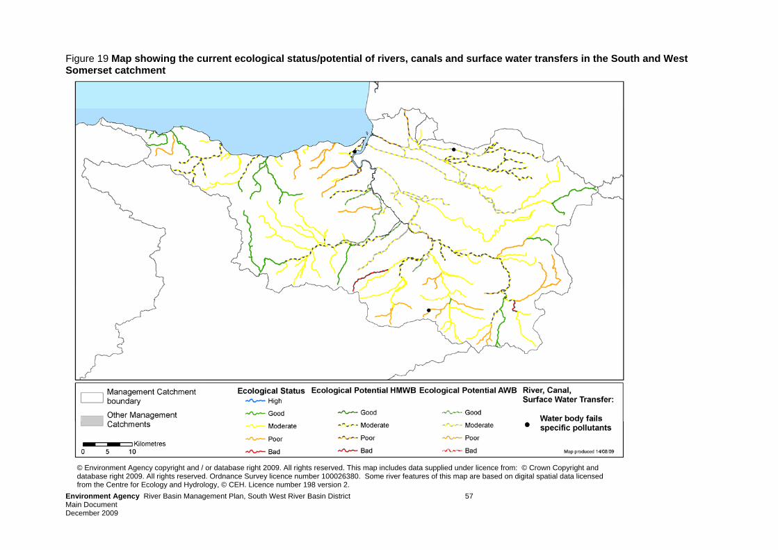
Environment Agency River Basin Management Plan, South West River Basin District 57 Main Document December 2009
Figure 19 Map showing the current ecological status/potential of rivers, canals and surface water transfers in the South and West Somerset catchment
© Environment Agency copyright and / or database right 2009. All rights reserved. This map includes data supplied under licence from: © Crown Copyright and database right 2009. All rights reserved. Ordnance Survey licence number 100026380. Some river features of this map are based on digital spatial data licensed from the Centre for Ecology and Hydrology, © CEH. Licence number 198 version 2.
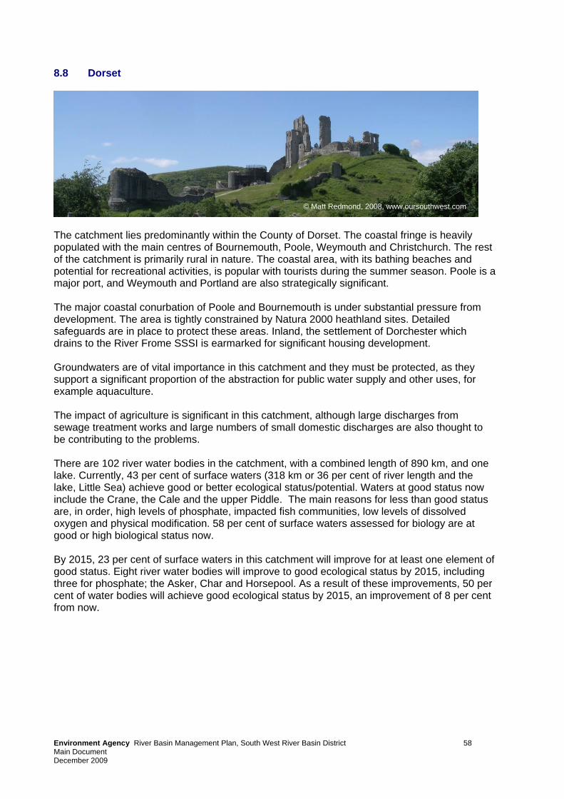
8.8 Dorset
© Matt Redmond, 2008, www.oursouthwest.com
The catchment lies predominantly within the County of Dorset. The coastal fringe is heavily populated with the main centres of Bournemouth, Poole, Weymouth and Christchurch. The rest of the catchment is primarily rural in nature. The coastal area, with its bathing beaches and potential for recreational activities, is popular with tourists during the summer season. Poole is a major port, and Weymouth and Portland are also strategically significant. The major coastal conurbation of Poole and Bournemouth is under substantial pressure from development. The area is tightly constrained by Natura 2000 heathland sites. Detailed safeguards are in place to protect these areas. Inland, the settlement of Dorchester which drains to the River Frome SSSI is earmarked for significant housing development. Groundwaters are of vital importance in this catchment and they must be protected, as they support a significant proportion of the abstraction for public water supply and other uses, for example aquaculture. The impact of agriculture is significant in this catchment, although large discharges from sewage treatment works and large numbers of small domestic discharges are also thought to be contributing to the problems. There are 102 river water bodies in the catchment, with a combined length of 890 km, and one lake. Currently, 43 per cent of surface waters (318 km or 36 per cent of river length and the lake, Little Sea) achieve good or better ecological status/potential. Waters at good status now include the Crane, the Cale and the upper Piddle. The main reasons for less than good status are, in order, high levels of phosphate, impacted fish communities, low levels of dissolved oxygen and physical modification. 58 per cent of surface waters assessed for biology are at good or high biological status now. By 2015, 23 per cent of surface waters in this catchment will improve for at least one element of good status. Eight river water bodies will improve to good ecological status by 2015, including three for phosphate; the Asker, Char and Horsepool. As a result of these improvements, 50 per cent of water bodies will achieve good ecological status by 2015, an improvement of 8 per cent from now.
Environment Agency River Basin Management Plan, South West River Basin District 58 Main Document December 2009
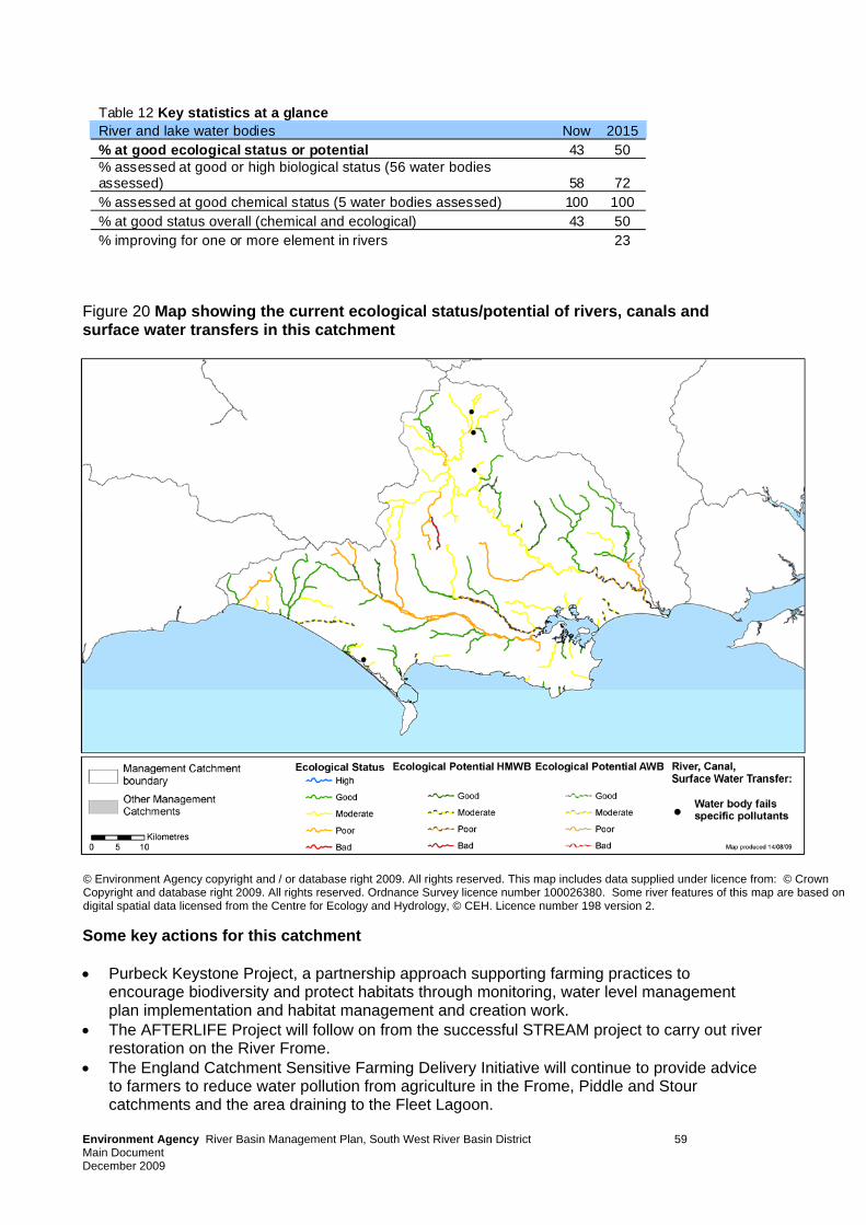
Table 12 Key statistics at a glance River and lake water bodies Now 2015 % at good ecological status or potential 43 50 % assessed at good or high biological status (56 water bodies assessed) 58 72 % assessed at good chemical status (5 water bodies assessed) 100 100 % at good status overall (chemical and ecological) 43 50 % improving for one or more element in rivers 23
Figure 20 Map showing the current ecological status/potential of rivers, canals and surface water transfers in this catchment
© Environment Agency copyright and / or database right 2009. All rights reserved. This map includes data supplied under licence from: © Crown Copyright and database right 2009. All rights reserved. Ordnance Survey licence number 100026380. Some river features of this map are based on digital spatial data licensed from the Centre for Ecology and Hydrology, © CEH. Licence number 198 version 2.
Some key actions for this catchment
• Purbeck Keystone Project, a partnership approach supporting farming practices to
encourage biodiversity and protect habitats through monitoring, water level management plan implementation and habitat management and creation work.
• The AFTERLIFE Project will follow on from the successful STREAM project to carry out river restoration on the River Frome.
• The England Catchment Sensitive Farming Delivery Initiative will continue to provide advice to farmers to reduce water pollution from agriculture in the Frome, Piddle and Stour catchments and the area draining to the Fleet Lagoon.
Environment Agency River Basin Management Plan, South West River Basin District 59 Main Document December 2009
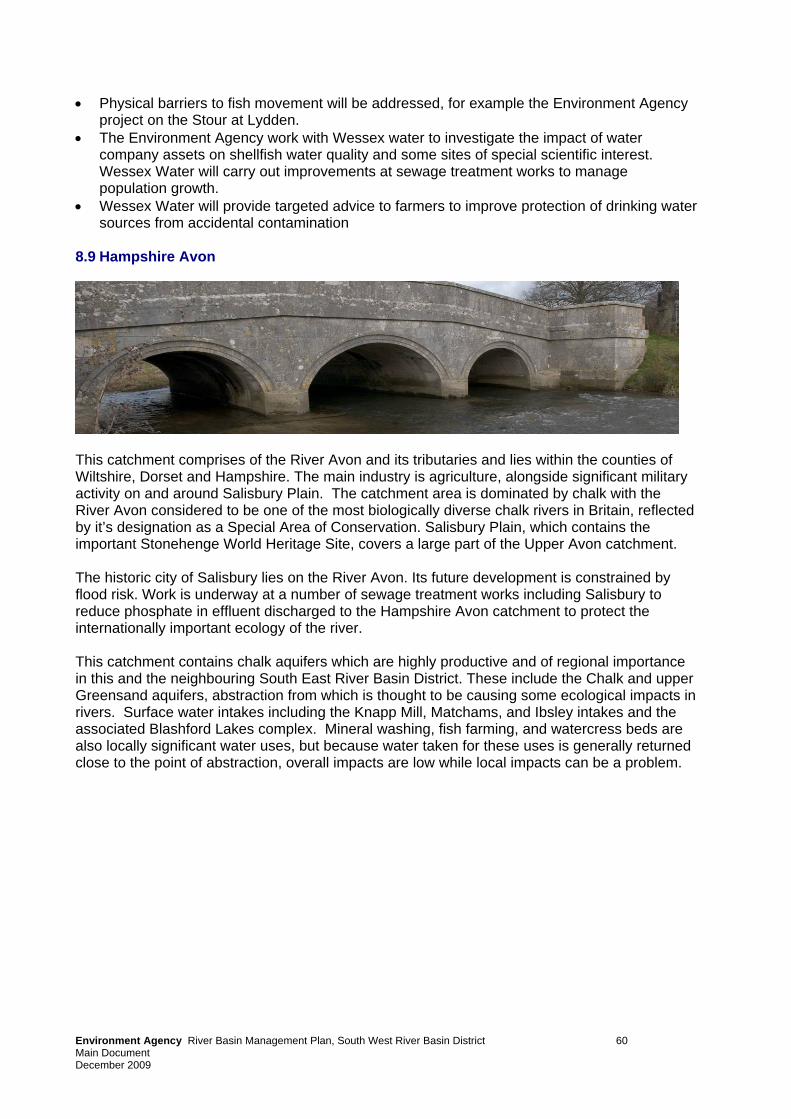
• Physical barriers to fish movement will be addressed, for example the Environment Agency project on the Stour at Lydden.
• The Environment Agency work with Wessex water to investigate the impact of water company assets on shellfish water quality and some sites of special scientific interest. Wessex Water will carry out improvements at sewage treatment works to manage population growth.
• Wessex Water will provide targeted advice to farmers to improve protection of drinking water sources from accidental contamination
8.9 Hampshire Avon
This catchment comprises of the River Avon and its tributaries and lies within the counties of Wiltshire, Dorset and Hampshire. The main industry is agriculture, alongside significant military activity on and around Salisbury Plain. The catchment area is dominated by chalk with the River Avon considered to be one of the most biologically diverse chalk rivers in Britain, reflected by it’s designation as a Special Area of Conservation. Salisbury Plain, which contains the important Stonehenge World Heritage Site, covers a large part of the Upper Avon catchment. The historic city of Salisbury lies on the River Avon. Its future development is constrained by flood risk. Work is underway at a number of sewage treatment works including Salisbury to reduce phosphate in effluent discharged to the Hampshire Avon catchment to protect the internationally important ecology of the river. This catchment contains chalk aquifers which are highly productive and of regional importance in this and the neighbouring South East River Basin District. These include the Chalk and upper Greensand aquifers, abstraction from which is thought to be causing some ecological impacts in rivers. Surface water intakes including the Knapp Mill, Matchams, and Ibsley intakes and the associated Blashford Lakes complex. Mineral washing, fish farming, and watercress beds are also locally significant water uses, but because water taken for these uses is generally returned close to the point of abstraction, overall impacts are low while local impacts can be a problem.
Environment Agency River Basin Management Plan, South West River Basin District 60 Main Document December 2009
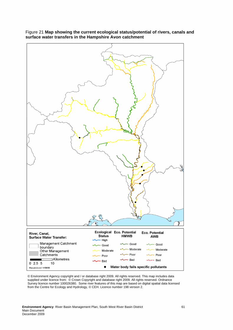
Figure 21 Map showing the current ecological status/potential of rivers, canals and surface water transfers in the Hampshire Avon catchment
© Environment Agency copyright and / or database right 2009. All rights reserved. This map includes data supplied under licence from: © Crown Copyright and database right 2009. All rights reserved. Ordnance Survey licence number 100026380. Some river features of this map are based on digital spatial data licensed from the Centre for Ecology and Hydrology, © CEH. Licence number 198 version 2.
Environment Agency River Basin Management Plan, South West River Basin District 61 Main Document December 2009
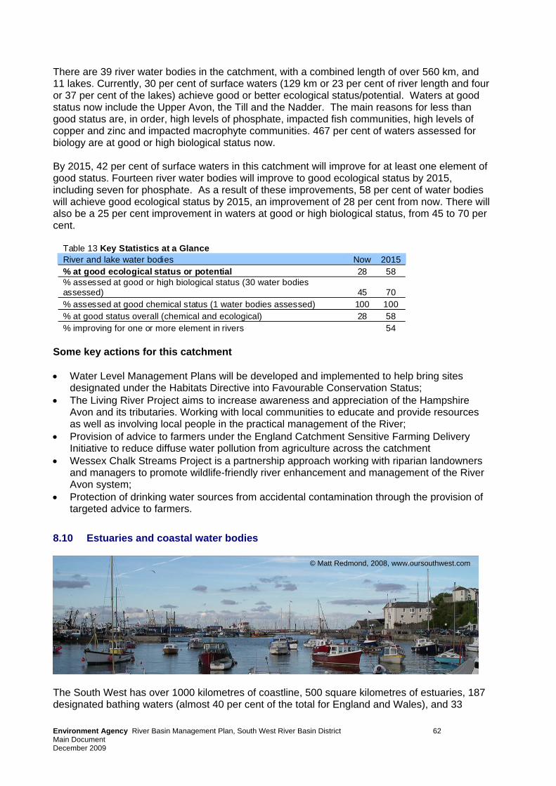
There are 39 river water bodies in the catchment, with a combined length of over 560 km, and 11 lakes. Currently, 30 per cent of surface waters (129 km or 23 per cent of river length and four or 37 per cent of the lakes) achieve good or better ecological status/potential. Waters at good status now include the Upper Avon, the Till and the Nadder. The main reasons for less than good status are, in order, high levels of phosphate, impacted fish communities, high levels of copper and zinc and impacted macrophyte communities. 467 per cent of waters assessed for biology are at good or high biological status now. By 2015, 42 per cent of surface waters in this catchment will improve for at least one element of good status. Fourteen river water bodies will improve to good ecological status by 2015, including seven for phosphate. As a result of these improvements, 58 per cent of water bodies will achieve good ecological status by 2015, an improvement of 28 per cent from now. There will also be a 25 per cent improvement in waters at good or high biological status, from 45 to 70 per cent.
Table 13 Key Statistics at a Glance River and lake water bodies Now 2015 % at good ecological status or potential 28 58 % assessed at good or high biological status (30 water bodies assessed) 45 70 % assessed at good chemical status (1 water bodies assessed) 100 100 % at good status overall (chemical and ecological) 28 58 % improving for one or more element in rivers 54
Some key actions for this catchment • Water Level Management Plans will be developed and implemented to help bring sites
designated under the Habitats Directive into Favourable Conservation Status; • The Living River Project aims to increase awareness and appreciation of the Hampshire
Avon and its tributaries. Working with local communities to educate and provide resources as well as involving local people in the practical management of the River;
• Provision of advice to farmers under the England Catchment Sensitive Farming Delivery Initiative to reduce diffuse water pollution from agriculture across the catchment
• Wessex Chalk Streams Project is a partnership approach working with riparian landowners and managers to promote wildlife-friendly river enhancement and management of the River Avon system;
• Protection of drinking water sources from accidental contamination through the provision of targeted advice to farmers.
8.10 Estuaries and coastal water bodies
© Matt Redmond, 2008, www.oursouthwest.com
The South West has over 1000 kilometres of coastline, 500 square kilometres of estuaries, 187 designated bathing waters (almost 40 per cent of the total for England and Wales), and 33
Environment Agency River Basin Management Plan, South West River Basin District 62 Main Document December 2009
designated shellfish waters as well as many important marine species and habitats. The South West's estuaries and coasts are vital to the region's economy, supporting nearly half of England’s commercial fishing operations and half of England’s shellfish waters. They also make a contribution to the tourism and leisure industry and the ports, harbours, shipping and associated industries they support. To help protect the fish stocks and wildlife around the coast of the South West, Lundy Island has an established no-take zone, where all fishing activity is banned, and there are a number of voluntary no take zones, for instance at St Agnes, which contribute to the sustainability of the industry around these areas. Important estuaries in the South West include the Fal, Helford, Looe, Fowey, Camel, Tamar, Exe, Salcombe-Kingsbridge, Yealm, Dart, Taw-Torridge, Parrett, Poole Harbour, Christchurch Harbour and the Portland Harbours. The main pressures on South West estuaries and coasts are pollution from industrial discharges, nutrient and microbiological contamination from run-off and sewage, sea level rise leading to coastal squeeze and potential over-exploitation of fisheries. The main reasons for less than good status are physical modification of the coast, high levels of nutrients and tributyltin, which used to be used as an antifoulant on boat hulls but is now banned. Table 14 Key statistics at a glance – estuaries and Coastal
Estuaries Coastal Now 2015 Now 2015 % at good ecological status or potential 26 26 44 44 % assessed at good or high biological status (27 water bodies assessed) 86 86 85 90 % assessed at good chemical status (17 water bodies assessed) 73 73 83 83 % at good status overall (chemical and ecological) 17 17 44 44 % improving for one or more element 0 8
Some key actions • Develop and start delivering a habitat creation programme to offset losses of important
coastal habitats through sea-level rise and climate change, focusing on opportunities in the Severn, Exe and Tamar Estuaries and in Poole Harbour in the first instance.
• Exe and Taw-Torridge Estuary Strategies will determine the long-term solutions to sustainable flood and coastal risk management and habitat restoration.
• The SeaTorbay partnership will improve understanding of coastal wildlife and conservation and how the public can become involved. A key project is to map the uses of Tor Bay sea bed and the activities affecting it.
• Investigation of the impact of water company assets and urban diffuse pollution on bathing and shellfish water quality.
• Improvements at sewage treatment works to manage the effect of growth and improve effluent quality.
• Education and liaison with recreational anglers promoting catch and release, carrying out invasive species surveys and preventing use of illegal anti-foulants, targeted at five Voluntary Marine Conservation Areas in Cornwall.
• Development of Shoreline Management Plans to help assess and plan to prevent habitat loss as a result of coastal squeeze.
• Fishing for Litter' project will involve fishermen on 60 vessels working out of Newlyn, Brixham, Looe and Plymouth in a project to permanently remove marine litter by providing collection bags and dedicated waste reception facilities.
Environment Agency River Basin Management Plan, South West River Basin District 63 Main Document December 2009
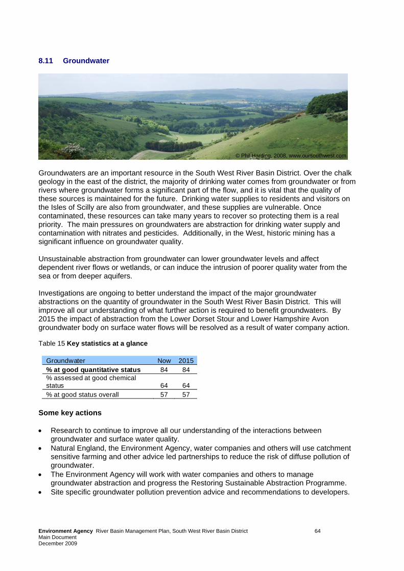
8.11 Groundwater
© Phil Harding, 2008, www.oursouthwest.com
Groundwaters are an important resource in the South West River Basin District. Over the chalk geology in the east of the district, the majority of drinking water comes from groundwater or from rivers where groundwater forms a significant part of the flow, and it is vital that the quality of these sources is maintained for the future. Drinking water supplies to residents and visitors on the Isles of Scilly are also from groundwater, and these supplies are vulnerable. Once contaminated, these resources can take many years to recover so protecting them is a real priority. The main pressures on groundwaters are abstraction for drinking water supply and contamination with nitrates and pesticides. Additionally, in the West, historic mining has a significant influence on groundwater quality. Unsustainable abstraction from groundwater can lower groundwater levels and affect dependent river flows or wetlands, or can induce the intrusion of poorer quality water from the sea or from deeper aquifers. Investigations are ongoing to better understand the impact of the major groundwater abstractions on the quantity of groundwater in the South West River Basin District. This will improve all our understanding of what further action is required to benefit groundwaters. By 2015 the impact of abstraction from the Lower Dorset Stour and Lower Hampshire Avon groundwater body on surface water flows will be resolved as a result of water company action. Table 15 Key statistics at a glance
Groundwater Now 2015% at good quantitative status 84 84 % assessed at good chemical status 64 64 % at good status overall 57 57
Some key actions • Research to continue to improve all our understanding of the interactions between
groundwater and surface water quality. • Natural England, the Environment Agency, water companies and others will use catchment
sensitive farming and other advice led partnerships to reduce the risk of diffuse pollution of groundwater.
• The Environment Agency will work with water companies and others to manage groundwater abstraction and progress the Restoring Sustainable Abstraction Programme.
• Site specific groundwater pollution prevention advice and recommendations to developers.
Environment Agency River Basin Management Plan, South West River Basin District 64 Main Document December 2009
9 Next steps – implementing this plan 9.1 Diffuse pollution investigation and action
In developing the River Basin Management Plans approximately 8,500 investigations have been identified for England and Wales, including further monitoring. The vast majority of these will be undertaken by the Environment Agency and all of these will be completed by the end of 2012. The investigations will focus on resolving what is causing the problem and what the best method to tackle it is. As a result of the evidence they will provide, we will be able to take further action in the first cycle where practicable. The remainder of the investigations – including over 100 water company catchment management investigations – will be carried out by co-deliverers across England and Wales during the course of the first delivery cycle. Working with the river basin district liaison panels, the Environment Agency will welcome the input of local data and knowledge from other parties to help drive action at catchment level. We are confident the investigation programme will lead to actions enabling a further reduction in diffuse pollution and more environmental improvement before 2015. As we have said earlier, the Environment Agency is already committed to delivering, through its own work or through working with others, an additional two per cent improvement towards good status or potential by 2015 across England and Wales
9.2 Additional national measures
In addition to commitments already provided, the UK Government and Welsh Assembly Government will continue to demonstrate their commitment and bring forward significant work starting with; • banning phosphates in household laundry detergents; • a new requirement contained within the Flood and Water Management Bill making the right
to connect to surface water sewers contingent on Sustainable Drainage Systems (SuDS) being included in new developments. Local authorities will be responsible for adopting and maintaining SuDS that serve multiple properties and the highways authorities will maintain them in all adopted roads;
• general binding rules to tackle diffuse water pollution by targeting abuse of drainage systems, potentially including industrial estates, car washes and construction by 2012;
• transferring the responsibility for misconnections to water companies by 2012; • the Water Protection Zones Statutory Instrument which will enter into force on 22 December
2009 and will be used to tackle diffuse pollution where voluntary measures are not sufficient; • more funding for the Catchment Sensitive Farming Delivery Initiative in England from 2010 –
a 50% increase in capital grant spend, and evaluation of the initiative to ensure it is achieving maximum effectiveness;
• better targeting of agri-environment schemes for water protection. In Wales, this includes aligning the forthcoming “Glastir” agri-environment scheme to contribute towards meeting Water Framework Directive requirements;
• supporting the farming industry in the Campaign for the Farmed Environment, which has reducing impacts on water quality as one of its priorities;
• encouraging farmers to use buffer strips to reduce diffuse pollution through guidance and advice provided under cross compliance;
• better understanding of the impact of sediment and measures to tackle it as a result of the additional funding announced in June 2009;
• further consideration of the impact of cross compliance and good agricultural and environmental conditions (GAEC) on water quality;
• implementation of the Sustainable Use of Pesticides Directive;
Environment Agency River Basin Management Plan, South West River Basin District 65 Main Document December 2009
• Environmental Permitting Regulations guidance setting essential standards of location, operation and maintenance for septic tanks.
These and the other actions in the plans will lead towards a greater achievement of good status and improvement within class, with more than a quarter of the length of all rivers improving. 9.3 Implementing the plans at catchment level The Environment Agency has found river basin liaison panels extremely valuable, and will continue to work with them throughout the plan delivery period. The panels will help to encourage river basin district-wide action through their sectors, monitor overall progress and prepare for the second cycle of River Basin Management Planning.
Given that implementation requires activity ‘on the ground’, it is essential that there is the maximum involvement and action from locally based organisations and people. Innovative ways of working together need to be identified that will deliver more for the environment than has been captured in this plan.
The Environment Agency will adopt a catchment-based approach to implementation that is efficient and cost-effective. This will support the liaison panels, complement existing networks and relationships, and enable better dialogue and more joined up approaches to action.
In some places there will be added value from adopting more detailed catchment plans to help deliver the River Basin Management Plan objectives during the planning cycles. The River Kennet is a case in point where we have set up a pilot group with a range of stakeholders. We will share the knowledge gained with the liaison panels, to help identify other catchments that could benefit from a similar approach.
9.4 Working with co-deliverers This plan sets out in detail the actions required to improve the water environment. All organisations involved must play their part, record their progress and make the information available.
Where the work of a public body affects a river basin district, that body has a general duty to have regard to the River Basin Management Plan. Ministerial guidance states that the Environment Agency should:
• work with other public bodies to develop good links between river basin management planning and other relevant plans and strategies, especially those plans that have a statutory basis such as the Local Development Plans and Wales Spatial Plan;
• encourage public bodies to include Water Framework Directive considerations in their plans, policies, guidance, appraisal systems and casework decisions.
For some, the actions in this plan may be voluntary and for others they will be required under existing legislation. We want to work with you to make these actions happen, and identify new action to create a better place.
9.5 Reporting on progress The Environment Agency will use its environmental monitoring programme and, where appropriate, information from other monitoring programmes, to review whether work on the ground is achieving the environmental objectives. We will update the classification status of water bodies accordingly and review progress annually. At the end of 2012 a formal interim report will be published. This will:
Environment Agency River Basin Management Plan, South West River Basin District 66 Main Document December 2009
EnvMain Document December 20
ironment Agency River Basin Management Plan, South West River Basin District 67
09
• describe progress in implementing the actions set out in this plan; • set out any additional actions established since the publication of this plan; • assess the progress made towards the achievement of the environmental objectives. Preparations have already begun for the next cycle period 2015 to 2021 and for the subsequent cycle to 2027. If you have proposals for actions that can be included in these future cycles please contact us.
9.6 River basin management milestones The plan builds on a number of other documents and milestones required by the Water Framework Directive. The work to date has ensured a strong evidence base, and a framework for dialogue with interested organisations and individuals. In terms of taking this plan forwards, it helps to understand the major milestones remaining. These future milestones are summarised in the figure below.
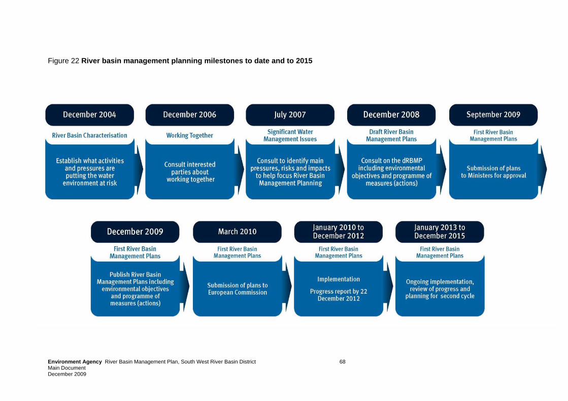
Figure 22 River basin management planning milestones to date and to 2015
Environment Agency River Basin Management Plan, South West River Basin District 68 Main Document December 2009
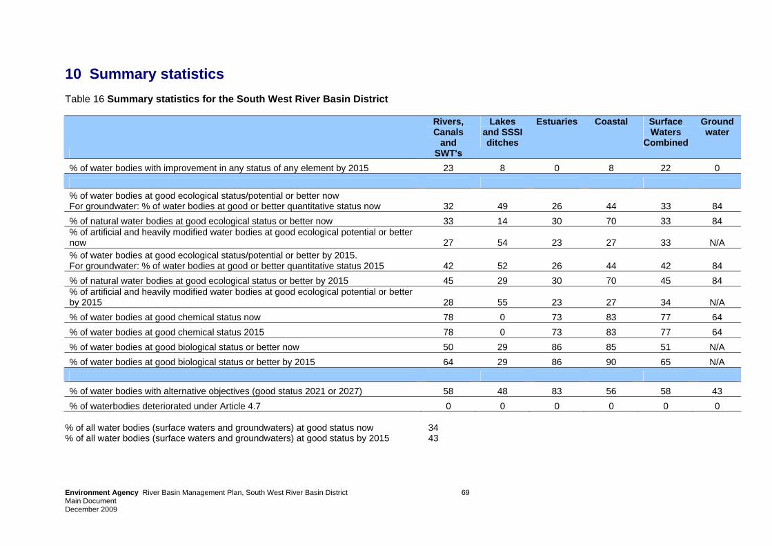
Environment Agency River Basin Management Plan, South West River Basin District 69 Main Document December 2009
10 Summary statistics Table 16 Summary statistics for the South West River Basin District
Rivers, Canals
and SWT's
Lakes and SSSI ditches
Estuaries Coastal Surface Waters
Combined
Groundwater
% of water bodies with improvement in any status of any element by 2015 23 8 0 8 22 0 % of water bodies at good ecological status/potential or better now For groundwater: % of water bodies at good or better quantitative status now 32 49 26 44 33 84 % of natural water bodies at good ecological status or better now 33 14 30 70 33 84 % of artificial and heavily modified water bodies at good ecological potential or better now 27 54 23 27 33 N/A % of water bodies at good ecological status/potential or better by 2015. For groundwater: % of water bodies at good or better quantitative status 2015 42 52 26 44 42 84 % of natural water bodies at good ecological status or better by 2015 45 29 30 70 45 84 % of artificial and heavily modified water bodies at good ecological potential or better by 2015 28 55 23 27 34 N/A % of water bodies at good chemical status now 78 0 73 83 77 64 % of water bodies at good chemical status 2015 78 0 73 83 77 64 % of water bodies at good biological status or better now 50 29 86 85 51 N/A % of water bodies at good biological status or better by 2015 64 29 86 90 65 N/A % of water bodies with alternative objectives (good status 2021 or 2027) 58 48 83 56 58 43 % of waterbodies deteriorated under Article 4.7 0 0 0 0 0 0
% of all water bodies (surface waters and groundwaters) at good status now 34 % of all water bodies (surface waters and groundwaters) at good status by 2015 43
Environment Agency River Basin Management Plan, South West River Basin District 70 Main Document December 2009 GESW0910BSTP-E-E
11 Further information – the annexes Annex A Current state of waters in the South West River Basin District
What the waters are like now. Information on our network of monitoring stations, the classification status of water bodies and the reference conditions for each of the water body types in the river basin district.
Annex B Water body status objectives for the South West River Basin District Information on water body status and objectives
Annex C Actions to deliver objectives Details of the actions planned (programmes of measures) for each sector to manage the pressures on the water environment and achieve the objectives of this plan.
Annex D Protected area objectives Details of the location of protected areas, the monitoring network, environmental objectives and the actions required to meet Natura 2000 sites and Drinking Water Protected Area objectives.
Annex E Actions appraisal and justifying objectives Information about how the water body objectives have been set for this plan and how we selected the actions. It also includes justifications for alternative objectives that have been set.
Annex F Mechanisms for action More detail about the mechanisms (i.e. policy, legal, financial tools) that are use to drive actions.
Annex G Pressures and risks Information about the significant pressures and risks resulting from human activities on the status of surface water and groundwater.
Annex H Adapting to climate change Information on how climate change may affect the pressures on the water environment and the ability to meet the objectives.
Annex I Designating artificial and heavily modified water bodies Information about the criteria used to designate waters as artificial or heavily modified water bodies.
Annex J Aligning other key processes to river basin management Aligning planning processes to deliver multiple benefits and sustainable outcomes
Annex K Economic analysis of water use Information about the costs of water services within the river basin district
Annex L Record of consultation and engagement Details of how the Environment Agency has worked with interested parties to develop this plan
Annex M Competent authorities List of the competent authorities responsible for River Basin Management Planning.
Annex N Glossary Explanation of technical terms and abbreviations.
Would you like to find out more about us, or about your environment? Then call us on 08708 506 506 (charged at local rates) email [email protected] or visit our website www.environment-agency.gov.uk incident hotline 0800 80 70 60 (Freephone 24 hour) Calls from mobile phones are not free and will be charged at normal network operator's call rates floodline 0845 988 1188 (24 hour)