Embed Size (px)
Citation preview

539 Flume Street Phone: (530) 894-5401 Chico, CA 95928 Fax: (530) 894-2970 [email protected] www.riverpartners.org
-
Prepared for:
US Fish and Wildlife Service
Riparian Restoration Plan for the Buffington Tract Stanislaus River Mile 2.1 -5.5 L Stanislaus County, California February 12, 2008

Restoration Plan for the Buffington Tract March 3, 2009 River Partners Page i
TABLE OF CONTENTS I. INTRODUCTION...............................................................................................................1
A. Project overview................................................................................................................1 B. Cooperative relationships and funding sources ................................................................2 C. Project goals and objectives .............................................................................................2 D. Summary of special considerations ..................................................................................3 E. Purpose of restoration plan ...............................................................................................3
II. SITE DESCRIPTION.........................................................................................................4 A. Location.............................................................................................................................4 B. Land-use History ...............................................................................................................4 C. Soils ..................................................................................................................................9 D. Topography .....................................................................................................................15 E. Hydrology ........................................................................................................................18 F. Salinity.............................................................................................................................32 G. Vegetation .......................................................................................................................33 H. Wildlife.............................................................................................................................38
III. CONCEPTUAL SITE MODEL ........................................................................................41 A. Past Environmental Conditions .......................................................................................41 B. Likely Successional Patterns without Restoration...........................................................42 C. Restoration Strategies for the Buffington Tract ...............................................................42 D. Identification of Ecological Benefits and Targeted Wildlife species.................................43
IV. PLANTING DESIGN .......................................................................................................45 A. Design Considerations ....................................................................................................47 B. Rationale for Plant Associations .....................................................................................48 C. Composition and Location of Planting Associations .......................................................49 D. Planting Tiles and Baseline Data ....................................................................................55
V. PROJECT IMPLEMENTATION......................................................................................57 A. Environmental Compliance .............................................................................................57 B. Field Layout.....................................................................................................................57 C. Site Preparation ..............................................................................................................59 D. Irrigation System .............................................................................................................61 E. Plant Material Collection and Propagation ......................................................................63 F. Plant Installation..............................................................................................................63 G. Plant Maintenance ..........................................................................................................63
VI. MONITORING AND REPORTING..................................................................................66 A. Field Reports...................................................................................................................66 B. End of Season Monitoring...............................................................................................66 C. Photo Points....................................................................................................................67 D. Annual Reports ...............................................................................................................67 E. Final Report.....................................................................................................................67
VII. SAFETY ISSUES............................................................................................................67 A. Standard Field Procedures .............................................................................................67 B. Flood and Fire Contingencies .........................................................................................68
VIII. PROJECT IMPLEMENTATION TIMELINE ....................................................................68 IX. REFERENCES................................................................................................................70

Restoration Plan for the Buffington Tract March 3, 2009 River Partners Page ii
List of Tables Table 1. Summary of typical soil conditions found in Buffington restoration fields (NRCS 2008).
............................................................................................................................................12 Table 2. Listed terrestrial species to benefit from project. .........................................................38 Table 3. Habitat requirements and design goals for targeted wildlife species. ..........................44 Table 4. Design considerations for riparian vegetation restoration on the Buffington Tract ......48 Table 5. Rationale for plant associations ...................................................................................49 Table 6. Composition of the Riparian Shrub Association, Land Side of Buffington Levee1, Fields
B1 and B2. ..........................................................................................................................52 Table 7. Composition of the Riparian Shrub Association, River Side of Buffington Levee1, Fields
B3-B11. ...............................................................................................................................52 Table 8. Composition of the Blackberry-Rose Riparian Shrub Understory Association.............53 Table 9. Composition of the Blackberry-Rose Riparian Shrub Border Association. ..................54 Table 10. Composition of the Blackberry-Rose Bunny Berm Association. .................................54 Table 11. Herbaceous understory species that may be planted within woody plant associations.
............................................................................................................................................55 Table 12. Summary of Herbivore Control Methods at the Buffington Tract. ..............................65 Table 13. Timeline for the Scope of Work Tasks for the Buffington Tract..................................69
List of Figures Figure 1. Location Map, Buffington Tract, San Joaquin River National Wildlife River, Stanislaus
County, California..................................................................................................................5 Figure 2. Project Area, Buffington Tract, San Joaquin River National Wildlife Refuge, Stanislaus
County, California..................................................................................................................6 Figure 3. 1937 Aerial Photograph of the Buffington Tract along the Stanislaus River, California.
..............................................................................................................................................8 Figure 4. Soils Map and Soil Pit Locations for the Buffington Tract, Stanislaus County,
California. ............................................................................................................................10 Figure 5. Sand splay detail from 1998 Aerial photo, showing exposed sand deposited in field B4
in 1997 flood........................................................................................................................14 Figure 6. Photograph of Natural Topography on the River Side of Buffington Levee, Stanislaus
County, California................................................................................................................16 Figure 7. Topography, Buffington Tract, Stanislaus County, California. ....................................17 Figure 8. Stanislaus River streamflow at Ripon, California for the period of record 1940-2007.19 Figure 9. Stanislaus River peak streamflows for period of record at Ripon gage #11303000. ...20 Figure 10. Hydrograph for water year 1956, Stanislaus River at Ripon, California.....................22 Figure 11. Hydrograph for water year 1997, Stanislaus River at Ripon, California.....................23 Figure 12. 1950 aerial photograph of Buffington project area shows extensive clearing on
western portion of project area and right bank of river. Courtesy of McHenry Museum, Modesto, CA. ......................................................................................................................24
Figure 13. 1963 historic aerial photograph of Buffington project area shows extensive clearing on western and eastern portions of the site. Courtesy of McHenry Museum, Modesto, CA.............................................................................................................................................25
Figure 14. 1977 historic aerial photograph of Buffington project area shows remnant tall trees around old oxbows and remnant shrub patches. Courtesy of McHenry Museum, Modesto, CA. ......................................................................................................................................26
Figure 15. 1980 historic aerial photograph of the Buffington project area. Courtesy of the McHenry Museum, Modesto, CA. .......................................................................................27

Restoration Plan for the Buffington Tract March 3, 2009 River Partners Page iii
Figure 16. 1985 historic aerial photograph of the Buffington project area. Courtesy of the McHenry Museum, Modesto, CA. .......................................................................................28
Figure 17. 1993 aerial photograph of Buffington project area. In recent decades, the river has largely stayed fixed in its main channel. Courtesy of Stanislaus County Assessor’s office.29
Figure 18.1998 aerial photograph of Buffington project area. Courtesy of Stanislaus County Assessor’s office. ................................................................................................................30
Figure 19. Aerial photograph of the 1997 flood on the Buffington Unit, Stanislaus County, California. ............................................................................................................................31
Figure 20. Stanislaus River Water Salinity at Ripon gage, 2005-2006. .....................................32 Figure 21. Stanislaus River Water Salinity at Ripon Gage, 2006-2007. ....................................32 Figure 22. Stanislaus River Water Salinity at Ripon Gage, 2007-2008. ....................................33 Figure 23. Photograph depicting the slow native regeneration under a dense remnant stand of
valley oaks on the west section of the Buffington Tract. .....................................................34 Figure 24. Photograph of Riparian understory reference habitat on Buffington Tract................35 Figure 25. Weeds and annual grasses currently dominate Buffington Tract clearings targeted
for restoration. .....................................................................................................................36 Figure 26. Photograph of leveled Buffington fields outside of the levee. ...................................37 Figure 27. Photograph of actively eroding river bank on the Buffington unit to be enhance by
riparian plantings.................................................................................................................40 Figure 28. . Planting Associations and Fields for the Buffington Tract ......................................46 Figure 29. Photo of riparian shrub reference habitat currently occupied by reintroduced riparian
brush rabbits, Christman Island, San Joaquin River NWR, 2007. ......................................51 Figure 30. Photo of open understory around rabbit release pen 2, to be planted in Blackberry-
Rose Riparian Shrub Understory Association.....................................................................53 Figure 31. Map of riparian brush rabbit flood refugia, Buffington Unit, Stanislaus County,
California. ............................................................................................................................60 Figure 32. Irrigation design for the Buffington Tract...................................................................62

Restoration Plan for the Buffington Tract March 3, 2009 River Partners Page iv
List of Appendices Appendix I Field Logs of Soil Pits Excavated on the Buffington Tract Appendix II Long Duration Flood Report Appendix III Planting Association Tiles Appendix IV USFWS Special Use Permit Appendix V Caswell State Park Seed Collection Permit Suggested citation:
River Partners. 2008. Restoration Plan for the Buffington Tract, Stanislaus County, California. Modesto, California.

Restoration Plan for the Buffington Tract March 3, 2009 River Partners Page v
Acknowledgements The following individuals contributed to this restoration plan:
Name Affiliation Kim Forrest USFWS Eric Hopson USFWS Patrick Kelly, Ph.D. Endangered Species Recovery Program Laurissa Hamilton Endangered Species Recovery Program Matt Lloyd Endangered Species Recovery Program Jason Schwenkler Geographical Information Center, CSU, Chico Stacy Small, Ph.D. River Partners Tom Griggs, Ph.D. River Partners Stephen Sheppard River Partners Lauren Singleton River Partners Helen Swagerty River Partners

Restoration Plan for the Buffington Tract March 3, 2009 River Partners Page vi
EXECUTIVE SUMMARY This restoration and management plan describes procedures River Partners will implement to restore and enhance approximately 53 acres of riparian habitat on the Buffington unit of the San Joaquin River National Wildlife Refuge (Refuge), along the Stanislaus River between river miles 2.1L-5.5L. The primary goal of this plan is to increase and improve riparian habitat at a key reintroduction site for captive-bred riparian brush rabbits, in cooperation with the Endangered Species Recovery Program and US Fish and Wildlife Service, while simultaneously providing multi-species benefits. Habitat restoration strategies include creating a network of dense riparian thickets -- the habitat structure most preferred by brush rabbits -- and high-ground flood refugia for survival of flood events for the brush rabbit and other terrestrial species. Other wildlife targets include federal- and state-listed endangered species such as the San Joaquin “riparian” woodrat, valley elderberry longhorn beetle, Least Bell’s Vireo and other Neotropical migrant songbirds, year-round resident and wintering migrant songbirds, and California Quail. Funding for this 53-acre riparian restoration project was awarded to River Partners by the US Fish and Wildlife Service through a CalFed grant administered by the California Bay-Delta authority. A detailed site evaluation examined soil texture, structure, stratification, and depth to water table, as well as past land use and current conditions. Based upon the site evaluation, five woody plant associations and a native herbaceous layer will be planted on the project site. River Partners will implement the riparian restoration and flood refugia plans described with this document. Monitoring and adaptive management are an integral part of this restoration. An annual monitoring timeline will allow for rapid adaptation of management actions. The entire planting pattern is stored in an electronic database that will allow for quick information retrieval and future hypothesis testing of the success of this planting design relative to site factors such as soil textures and depth to water table. Wildlife monitoring conducted by collaborating organizations will further contribute to effective adaptive management.

Restoration Plan for the Buffington Tract March 3, 2009 River Partners Page 1
RIPARIAN RESTORATION PLAN FOR THE BUFFINGTON TRACT SAN JOAQUIN RIVER NATIONAL WILDLIFE
STANISLAUS COUNTY, CALIFORNIA
I. INTRODUCTION
A. Project overview This plan describes the implementation activities of restoring approximately 53 acres of riparian vegetation on the Buffington Tract of the San Joaquin River National Wildlife Refuge (Refuge). The project supplements River Partners’ ongoing restoration work on the San Joaquin National Wildlife Refuge (River Partners 2002, 2006) by increasing total riparian habitat cover between the confluences of the San Joaquin River and two of its major tributaries, the Stanislaus and Tuolumne Rivers. The primary goals of this plan are to increase and improve riparian habitat at a key reintroduction site for captive-bred riparian brush rabbits and improve conditions for the riparian woodrat, in cooperation with the Endangered Species Recovery Program and US Fish and Wildlife Service, while simultaneously providing multi-species benefits. Habitat restoration goals include creating a network of dense riparian shrub cover -- the habitat structure most preferred by brush rabbits and riparian woodrats-- and high-ground flood refugia for terrestrial wildlife. Other wildlife targets include federal- and state-listed endangered species such as the riparian woodrat, valley elderberry longhorn beetle, Least Bell’s Vireo and other Neotropical migrant songbirds, year-round resident and wintering migrant songbirds, and California Quail. A detailed monitoring program will allow for adaptive management decisions. The riparian brush rabbit (Sylvilagus bachmani riparius; “brush rabbit”), and the San Joaquin Valley [riparian] woodrat (Neotoma fuscipes riparia; “woodrat”), are two of the most critically endangered species in the Central Valley of California. Both species were federally listed as endangered on February 23, 2000 (USFWS 2000a). Decline of these two species has been the result of riparian habitat loss associated with agricultural and urban development in the San Joaquin Valley and construction and maintenance of dams and flood control levees. Only about 6% of the riparian forest community remains in the San Joaquin Valley (CalFed 1999). Actions described in this proposal focus on the immediate recovery needs of the brush rabbit and providing important habitat for the woodrat. Until recently only three populations of the brush rabbit were found in small, isolated patches of habitat of variable quality. The continued survival of brush rabbits and woodrats is tenuous because these patches of habitat are subject to wildfire and periodic and extensive flooding that exposes these two species to increased predation, and the rabbit to drowning. The San Joaquin River and its tributary, the Stanislaus River, is a human-impacted ecosystem where natural processes can no longer properly regulate the riparian ecosystem. Water diversion, flow regulation, floodplain leveling and clearing, and invasive species function as major stressors on native plant and wildlife communities. Cumulative effects of these stressors are manifested in the numerous special status

Restoration Plan for the Buffington Tract March 3, 2009 River Partners Page 2
species currently under federal protection. The width of the riparian corridor adjacent to the Stanislaus River is greatly reduced from historical levels, reducing the amount of quality upland habitat (forage and cover) available for the brush rabbit and the woodrat. In addition, the uplands outside the levees have been leveled and are largely in agricultural production, which does not provide the necessary vegetative cover or topography for brush rabbits’ and woodrats’ use as refugia during high river flows. During high water, land within the levees may be entirely submerged, with few or no high ground sites where terrestrial animals can seek shelter and few places to seek cover outside of the levees, as these areas lack the appropriate vegetative cover and natural topography. As was evident in 1995 and 1997, the reduced floodplain corridor concentrates floods and creates catastrophic events for the brush rabbit and woodrat. We present the following habitat restoration plan to support the recovery of wild populations of riparian brush rabbits, with multi-species benefits. This will be achieved by increasing native riparian shrub cover and habitat structure and providing high-ground flood refugia with appropriate vegetative cover.
B. Cooperative relationships and funding sources This habitat restoration project has been made possible through a grant agreement with the US Fish and Wildlife Service, funded by the California Bay-Delta Authority. The site is situated between Caswell State Park, which hosts the only remnant wild population of riparian brush rabbits on public lands, and the Gallo family’s Faith Ranch, another brush rabbit reintroduction site. River Partners has consulted closely with The Endangered Species Recovery Program (ESRP) based at California State University, Stanislaus to evaluate habitat needs of the riparian brush rabbit and create a restoration design that will improve predator- and flood-refugia at this key brush rabbit reintroduction site. We have also applied recommendations presented in the Riparian Bird Conservation Plan (RHJV 2004) and PRBO Conservation Science reports (Geupel et al. 1996, Small et al. 1999, Hammond et al. 2002) to improve habitat structure for riparian-associated bird species.
C. Project goals and objectives This document presents a specific restoration plan for the Buffington unit that, once implemented, should meet the following objectives:
• Restore riparian habitat on approximately 53 acres of floodplain to serve as a re-introduction site and flood-refugia for the endangered riparian brush rabbit
• Increase the habitat connectivity of the project area to existing riparian habitat • Provide habitat for other Federal- and State-listed species including the, riparian
woodrat, Least Bell’s Vireo, and valley elderberry longhorn beetle. • Provide habitat for other riparian-associated wildlife and anadramous fish. • Establish self-sustaining native plant communities within a three-year period. • Plant over 20,000 native trees, shrubs and vines. • Reduce extent of invasive weeds by planting a dense herbaceous understory. • Monitor plants at the end of the growing season. • Evaluate project using adaptive management.

Restoration Plan for the Buffington Tract March 3, 2009 River Partners Page 3
• Build partnerships with Federal, State, and local entities.
D. Summary of special considerations • Create additional high ground on leveled floodplains, connected with remnant
riparian habitat. • Connect patches of existing shrub understory habitat to facilitate dispersal and
survival of captive bred brush rabbits released on site. • Coordinate restoration efforts with ESRP and USFWS. • Aggressively control weed infestation.
E. Purpose of restoration plan The restoration plan provides an adaptive management framework (River Partners, 2005) to evaluate project progress and success. This framework links monitoring and implementation to the restoration plan to determine project success and suggest management improvements. More specifically, the purpose of the plan is to:
• Identify project goals, objectives, management hypotheses and potential implementation challenges,
• Summarize the site land-use history, soils, hydrology, vegetation, and wildlife, • Outline our current understanding of the physical and biological factors that
influence site ecology (a conceptual site model), • Describe the plant design and the rationale for its selection, • Describe the implementation process including field preparation, planting
methods, irrigation design and schedule, methods of weed control, • Outline project monitoring, and • Provide a timeline for project tasks.

Restoration Plan for the Buffington Tract March 3, 2009 River Partners Page 4
II. SITE DESCRIPTION
A. Location The San Joaquin River National Wildlife Refuge, located in Stanislaus County, California, was created in 1987 to provide foraging and roosting habitat for the threatened Aleutian Canada goose as well as other endangered species and migratory birds. The Refuge is positioned at and between the confluences of the San Joaquin River and two of its major tributaries, the Stanislaus and Tuolumne Rivers. Most of the Refuge acquisition boundary was located east of the San Joaquin River. In addition to other land acquisitions, USFWS purchased Christman Island in 1989 and Gardner’s Cove in 1996 to protect some of the last riparian woodland on this reach of the river. In 2002, UFWS approved an expansion to the San Joaquin River NWR boundary, to include the Buffington Parcel along the Stanislaus River as its northern boundary. The purchase was funded by a CalFed acquisition grant; negotiations for land purchase continued through 2005, the acquisition was closed in August 2006, and additional CalFed funds were released for restoration and management in October 2006. The Buffington project is located east of the San Joaquin-Stanislaus River confluence, between river miles 2.1L and 5.5L. It is bordered by the Stanislaus River to the north and Beckwith Road to the south. It is positioned adjacent to and immediately downstream from Caswell State Park to the east and bordered by the Gallo Family’s Faith Ranch to the west (Figure 1). Figure 2 shows planting fields for the Buffington restoration project.
B. Land-use History The land along the Stanislaus River, now referred to as the Buffington unit of the San Joaquin National Wildlife Refuge, was once co-owned by Dio Koetitz, father of Mrs. Helen Buffington (born 1922). Mrs. Buffington currently lives on Beckwith Road, across from the project site. Koetitz and his business partner, Paul Davies, purchased the land in the 1930’s. It was previously part of the Elliott Ranch, dating back to the 1800’s. Within the current decade, the land was briefly owned by the Lyons family, after which it was acquired by the US Fish and Wildlife Service and incorporated into the San Joaquin National Wildlife Refuge in 2006.
According to Helen Buffington, the land was cattle grazed from the 1940’s through 2005, but not as intensively as some other ranches during the time her father managed it. Cattle were rotated and removed from the river banks in the summer because they could cross low water to neighbors’ property (“and people don’t like chasing black cows at night!”). Grazing intensity was kept to moderate levels, and “never grazed too close.”
Comment [HLS1]: There needs to be consistency in the name of the place. Is it Bufington Parcel? Buffington Unit? Or Buffington Tract?

Restoration Plan for the Buffington Tract March 3, 2009 River Partners Page 5
Figure 1. Location Map, Buffington Tract, San Joaquin River National Wildlife River, Stanislaus County, California.

Restoration Plan for the Buffington Tract March 3, 2009 River Partners Page 6
Figure 2. Project Area, Buffington Tract, San Joaquin River National Wildlife Refuge, Stanislaus County, California.

Restoration Plan for the Buffington Tract March 3, 2009 River Partners Page 7
Mrs. Buffington recalls several fires jumping the river at this location. One fire burned the historic Elliott house and another some time in the late 1970’s or early 1980’s. Koetitz used to conduct controlled burns to clear the understory vegetation, every 10-15 years; however she recalled that rose thickets survived these burns. To her knowledge, none of the trees in the remnant forest were planted. Koetitz had actively protected the valley oaks on site, once moving survey markers to prevent them from being cleared by the Army Corps of Engineers. The forest gaps that now exist on the river side of the levee have been open and grazed for the duration of Helen Buffington’s memory; although a 1937 aerial photo shows them to be densely vegetated with shrubs (Figure 3). She suggested that river activity had created the gaps, but it may also have been a combination of controlled burns and wildfire that initially created the gaps, which were then probably maintained by grazing and weed colonization. Sandy, well-drained soils combined with altered hydrology have probably slowed the succession of native plants in these clearings. The fields on the land side of the levee that are currently in alfalfa have been in forage and pasture crops since the 1940’s or before. The fields were probably leveled in the 1920’s.

Restoration Plan for the Buffington Tract March 3, 2009 River Partners Page 8
Figure 3. 1937 Aerial Photograph of the Buffington Tract along the Stanislaus River, California.

Restoration Plan for the Buffington Tract March 3, 2009 River Partners Page 9
C. Soils Dynamic river processes create heterogeneous floodplain soils that vary in texture, structure, and stratification. These variable soil characteristics greatly affect riparian vegetation composition, structure, and patterns. Soils on the Buffington Tract are a mosaic of loamy alluvial soil types derived primarily from granite, characteristic of flat alluvial floodplains and similar to those at the San Joaquin-Stanislaus River confluence (NRCS 1964; Figure 4).
1. General soil series information The fields included in this restoration plan are composed of nine soil mapping units (SMUs) as delineated by the NRCS Web Soil Survey (Figure 4). Soils along the river channel are of the Columbia series -- channeled and silt loam. Channeled Columbia soils are typically layered, with interspersed sand and loamy layers. On the land side of the levee, restoration acres are primarily Columbia silt loam, with small areas of Rossi clay loam, Grangeville, Traver and Chualar sandy loams, and Hilmar loamy sand.
2. Soil pit results In addition to the information provided by the NRCS Soil Survey for Eastern Stanislaus County (NRCS 1964, Table 1), thirteen backhoe pits (surveyed by River Partners in June, October, and December 2007; Figure 4) were excavated to further assess ecological site conditions (Appendix I). The principal soil and hydrologic information gathered from these surveys was:
• soil texture and structure • stratification of textural classes • depth to water table • rooting depth of existing vegetation
We did not reach the water table in our excavated soil pits, which ranged in depth from 3-12.5 ft. although we did encounter damp soils throughout most soil layers. A few shallow pits on the river side of the levee can be attributed to sandy layers filling the pit with loose soil as we excavated. The following sections describe soil series delineated in each field and information gathered from River Partners’ detailed local soil surveys.
Fields B1 and B2, on the land side of the Buffington levee, are a mosaic of loamy alluvial soil types derived primarily from granite, characteristic of broad valley floodplains with little slope. The major portion of the land side planting area is comprised of Columbia silt loam (CfA), but other soil types are present, as detailed below.

Restoration Plan for the Buffington Tract March 3, 2009 River Partners Page 10
Figure 4. Soils Map and Soil Pit Locations for the Buffington Tract, Stanislaus County, California.

Restoration Plan for the Buffington Tract March 3, 2009 River Partners Page 11

Restoration Plan for the Buffington Tract March 3, 2009 River Partners Page 12
Table 1. Summary of typical soil conditions found in Buffington restoration fields (NRCS 2008). Soil
Property Columbia
Soils, Channeled
Columbia silt loam
Rossi clay loam
Grangeville sandy loam
Traver sandy loam
Hilmar loamy sand
Grangeville sandy loam,
slightly saline-alkali
Chualar sandy loam
Fresno sandy loam
Mapping unit
CsB CfA RkA GhA TpA HfA GkA CbA FtA
Locations Along river channel;
Fields B4, B6-11
Adjacent to levee;
Fields B2, B3, B5,
B12;
Field B1 Fields B1 Field B1 Field B2 Field B2 Field B2 Field B2
% Slope 0-8% 0-1% 0-1% 0-1% 0-1% 0-1% 0-1% 0-3% 0-1%
Texture Fine sandy loam to stratified
sandy loam
Silt loam Clay loam Sandy loam Sandy loam
Loamy sand Sandy loam Sandy loam
Sandy loam
Depth of soil Very Deep Very Deep Very deep Very deep Very deep Very deep Very deep Very Deep
Moderate
Drainage Somewhat poor
Somewhat poor
Poor Somewhat poor
Moderately well
Somewhat excessive
Somewhat poor
Moderate Moderately well
Permeability Slow Slow Very slow Slow
Moderate Moderate Moderate Moderate Very slow
Available water
capacity
Moderate Moderate Moderate Moderate Moderate Moderate Moderate Moderate Low
Limitations to plant growth
Slight erosion hazard, surface runoff
negligible or very low
Slight erosion hazard, surface runoff
negligible or very low
Most areas are strongly saline-sodic
affected
Negligible to very low surface runoff
Low runoff; slightly saline
Fluctuating water table depending
on drainage and rainfall
Low runoff; slightly saline
Low runoff; may be saline
Slight to moderate
salinity

Restoration Plan for the Buffington Tract March 3, 2009 River Partners Page 13
Clearings on the river side of the levee (Fields B3, B4, B6, B7, B8, B9 and B11) are highly layered Columbia soils (channeled and silt loam) with great local heterogeneity in soil profiles, indicating a history of river action: flooding, scour, and deposition. Sand layers of varying depth and thickness were encountered in some soil pits, which suggest excessive drainage conditions in some locations. In other soil pits, soils exhibited high integrity, with some soil content throughout all layers. Such heterogeneity is to be expected in floodplain soils along a river channel, and lends itself to a heterogeneous plant community composition and structure.
a) Field B1 This field is a narrow strip running north-south that transects several loam soil types. The northern half is Rossi clay loam (RkA), the southern half is primarily Grangeville sandy loam (GhA), and the southern tip is Traver sandy loam (TpA). River Partners excavated a backhoe soil pit (B2-SP3; figure 4) in the northern part of this field, revealing a silty clay loam layer 0-21 inches, a silty clay layer at 21-28 inches, and a loamy sand layer below, at 28-144 inches. A 1 foot plow layer was evident, as this field is currently planted in alfalfa. Red mottling appeared throughout the lower loamy sand layer, and an alkali layer was detected at 100”. Roots were present to a depth of 44”.
b) Field B2 This field, immediately south of the Buffington levee, is comprised of loamy soils. Columbia silt loam (CfA) is the dominant soil type in this field. Along most of the southern boundary, Grangeville sandy loam-slightly saline-alkali (GkA) occurs. Fresno sandy loam (FtA) comprises the southwest corner, while Hilmar loamy sand (HfA) and Chualar sandy loam (CbA) comprise the southeast corner of field B2. River Partners dug two backhoe soil pits in this field (B2-SP1 & SP2; figure 4). Soil pit 1 revealed a thick layer of loamy sand flecked with pyrite to a depth of 72 inches, a silty loam layer 72-108 inches, and sandy loam layer 108-150 inches. Soil pit 2 revealed a sandy clay loam layer to a depth of 48 inches, with a sandy loam layer below, at 48-144 inches. Large roots were detected as deep at 4 feet beneath the surface.
c) Field B3 This field is comprised of Columbia silt loam, according to NRCS soil data. A backhoe pit revealed sandy clay loam to a depth of 2 feet, with a deep layer of loamy sand 2-11 feet. Soil was fairly homogenous in texture and damp throughout. Annual grass roots were present to 2 feet.
d) Field B4 The soils in this field are classified as channeled Columbia soils by NRCS. Two backhoe pits excavated in this clearing revealed local variation in soil layers. The first pit (B4-SP5) revealed predominately loamy sand top layer 0-4 feet in depth, with

Restoration Plan for the Buffington Tract March 3, 2009 River Partners Page 14
a pure sand layer below at a depth of 4-6 feet. The second soil pit (B4-SP6) revealed a higher loam content to 7’ depth, with layers alternating between silty loam, loamy sand, and finer loamy sand textures.
Figure 5 shows a sand splay detail in field B4 from a 1998 aerial photo, deposited by the 1997 flood. Floodwaters appear to have flowed around the high ground area, which a soil pit revealed to be of loamier texture. Local variation in soil textures has developed over centuries of flood and deposition events and may result in variable plant growth rates and heterogeneous habitat structure.
Figure 5. Sand splay detail from 1998 Aerial photo, showing exposed sand deposited in field B4 in 1997 flood.
e) Field B6
The soils in this field are classified as channeled Columbia soils by NRCS. Soil pit excavated in this clearing (B6-SP7) indicated a top layer of loamy sand 0-2’4” in depth, with pure sand layers below, to a depth of 6 feet, at which point the pit filled with loose sandy soils.

Restoration Plan for the Buffington Tract March 3, 2009 River Partners Page 15
f) Field B7 The soils in this field are classified as channeled Columbia soils by NRCS. A soil pit excavated to a depth of 12 feet revealed fairly homogenous loamy sand soil texture, with native plant roots running throughout soil profile. The site currently supports native forbs such as mugwort, creeping wild rye, and gumplant.
g) Field B8 The soils in this field are classified as channeled Columbia soils by NRCS. A backhoe soil pit revealed primarily loamy sand with interspersed pure sand deposits. A top layer of loamy sand 4 feet thick rests above a sandy loam layer 4-6’, and thin layers of sand are found among loamy sand layers to 10’ depth.
h) Field B9 This clearing has varied topography, with strong evidence of historic river action. The soils in this field are classified as channeled Columbia soils by NRCS. River Partners excavated three backhoe pits in this clearing to compare soils at different elevations. A backhoe soil pit (B9-SP10) was dug on the upper terrace to a depth of 3’, at which point loose sandy soils slumped and filled the pit. The top layer, 0-3’ is a loamy sand mix with pure sand layers, both coarse and fine in texture. A blue elderberry root was observed running through a sand layer. A second pit (B9-SP11) was excavated, also on the upper terrace, which filled in at 3’depth with loose sandy soil. The upper layer 0-3’ was predominately fine sandy loam. Fine grass roots grew to 1.5’. A third soil pit (B9-SP12) was excavated in a low scour area, and revealed layers of loamy sand, sand/gravel/soil mix, and sandy coarse loam below. At a depth of 5’, the pit began to fill with sand.
i) Field B11 The soils in this field are classified as channeled Columbia soils by NRCS. A soil pit (B11-SP13) excavated to 9’ revealed fairly homogenous loamy sand soil texture with high integrity. A 1” live woody root was observed at 5’ and a live black willow root was observed at 7’.
D. Topography Humans have vastly altered the topography of the Refuge and surrounding areas. The project fields outside of the Buffington levee have been graded and leveled to accommodate agricultural operational needs. In general, the large field outside of the levee drains to the north, toward the levee.
Topography on the river side of the levee is more variable, with evidence of historic river scour, deposition, side channels and oxbow lakes. Natural topography on the river side of the levee provides opportunities to create vegetated high ground flood refugia for terrestrial wildlife (Figure 6).
The elevation of the river side fields ranges from approximately 22 to 36 feet above mean sea level (Figure 7). Natural topography on the riverside of the levee provides

Restoration Plan for the Buffington Tract March 3, 2009 River Partners Page 16
Figure 6. Photograph of Natural Topography on the River Side of Buffington Levee, Stanislaus County, California.

Restoration Plan for the Buffington Tract March 3, 2009 River Partners Page 17
Figure 7. Topography, Buffington Tract, Stanislaus County, California.

Restoration Plan for the Buffington Tract River Partners
high ground refugia sites that will be vegetated with riparian shrub cover for the riparian brush rabbit and other terrestrial wildlife. Knowing the depth to water table over time is critical for an accurate site assessment of riparian and associated communities. Flood frequency and duration directly affect ground water elevations. The water table of the project area is likely > 12 feet, soil pits of this depth did not expose the water table.
E. Hydrology The 65- mile Stanislaus River is one of the largest tributaries to the San Joaquin River, draining approximately 1,075 sq-miles, with an annual average flow of almost 1,000,000 acre-feet. The Stanislaus originates as three upper forks on the western slope of the Sierra Nevada range. Historically, its flows have peaked in spring and early summer with snowmelt runoff from the Sierra Nevada Mountains.
The Stanislaus River is now extensively dammed and diverted on its forks and mainstem -- Donnells and Beardsley’s Dams stand on the middle fork, McKay’s Point Diversion Dam on the north fork. Below the confluence of its three forks stands the most significant barrier in the Stanislaus River system, the New Melones Dam. It is California’s second largest earthfill dam and one of the most controversial structures of the large dam-building area (Palmer 1982). Construction of the New Melones Dam structure began in 1974 and was completed in 1978. Construction of the associated diversion tunnel took place earlier, between 1966 and 1973. Initial filling of the reservoir took place in 1983. The old Melones Dam was submerged along with popular whitewater rafting spots upstream. Downstream from New Melones Dam are two more dam structures – Tulloch and Goodwin Dams.
The Stanislaus River was one of much greater dynamism before the construction of New Melones Dam. This dam was constructed for the purpose of flood control on the Stanislaus and lower San Joaquin Rivers, and Stanislaus River streamflows since its construction are far less variable than pre-dam flows, with extremes that are dramatically less extreme (Figure 8). Daily mean flows regularly approached or exceeded 10,000 cfs before the New Melones Dam went in, but have only once exceeded 7,000 cfs in the post-dam period, during the 1997 floods. USGS river data at Ripon, CA (river gage #11303000) for the pre-dam period of record 1941-1977 show greater variation in daily streamflow compared to the post-dam period 1978-present.

Restoration Plan for the Buffington Tract River Partners
Figure 8. Stanislaus River streamflow at Ripon, California for the period of record 1940-2007.
Data shows much higher variation before the New Melones Dam became operational in the early 1980’s. Vertical red line indicates 1982, the year New Melones Reservoir filled.

Restoration Plan for the Buffington Tract River Partners
River data pre-1978 show an extremely wide range of annual peak streamflows (Figure 9; min=259 cfs, max=62,500, range=62,241). After the construction of New Melones Dam, the range of streamflow variation below the dam narrowed considerably. The lowest annual peak flow in the post-dam period has been 1,040 cfs in 1991 and the maximum peak flow was 7,320 cfs in 1997.
For comparison, the largest pre-dam flood event on record peaked at 62,500 cfs on December 24, 1956, while the largest post-dam flood event peaked on February 28, 1997 at 7,320 cfs. In the 34-year period on record before the dam went in, there were 17 peak events greater than 6,000 cfs, while in the 30-year post-dam period, only 3 events occurred of a magnitude greater than 6,000 cfs.
Figure 9. Stanislaus River peak streamflows for period of record at Ripon gage #11303000.
Comment [HLS2]: This is your former Figure 12 that you were having problems with.

Restoration Plan for the Buffington Tract River Partners
A comparison of the two peak flow years on record for the Stanislaus River, pre-and post-New Melones Dam, reveal two very different flood years. The annual hydrograph for water year 1956 shows winter and spring flows of much higher magnitude, variation, and longer duration (Figure 10) than the floods of 1997 (Figure 11), the largest on record since this dam was constructed. Since the construction of New Melones Dam, water availability has been lower than initially anticipated by the U.S. Bureau of Reclamation, especially during the drought period of 1987-1992. This generated further controversy with agricultural water users downstream, over water quality and quantity for irrigation (BOR 2008).
The extirpated Stanislaus River spring run of Chinook salmon once navigated snowmelt flows to spawn in the upper reaches of the system, but their passage was blocked by the construction of Goodwin Dam, the first obstacle encountered by anadramous fish moving upstream. This dam still forms the upper limit to salmon and steelhead migration on the Stanislaus (Yoshiyama et al. 1996, 2000). Furthermore, water temperature regulation has become a major challenge since the construction of New Melones Dam.
In drought years, when the water level in New Melones Lake drops below 350,000 acre-feet, the now-submerged old Melones Dam prevents cold water from passing from the bottom of the reservoir, creating water temperatures too high for fish downstream (BOR 2008).
The Buffington unit is located along the Stanislaus River near its confluence with the San Joaquin River, approximately two miles upstream from the San Joaquin River. In its current regulated state, the Stanislaus River rarely exceeds its banks at the project area, leaving little chance for the recharge of historic oxbows and side channels. The river now remains fixed in its current channel, with little opportunity for lateral migration.

Restoration Plan for the Buffington Tract River Partners
Figure 10. Hydrograph for water year 1956, Stanislaus River at Ripon, California.
This is the biggest flood year on record. This graphs shows winter and spring flows of high magnitude, variation, and long duration, graphed against median daily flows for the period of record (1940-2007). The hydrograph shows the largest winter flood event since the construction of New Melones Dam and spring flows barely exceeding daily median flows for the period of record (1940-2007).

Restoration Plan for the Buffington Tract River Partners
Figure 11. Hydrograph for water year 1997, Stanislaus River at Ripon, California.
Historic aerial photos show evidence of this extremely dynamic river action on the landscape prior to 1978. Evidence of river meander in the form of oxbow lakes, side channels running along the left bank, exposed sand bars, scour and sand deposition on the floodplain are clear in aerial photos (Figures 3 and 12-14) of the Buffington Tract between 1937-1977. Exposed sandbars that appear in historic aerial photos have since revegetated, and formation of new sandbars may be inhibited by river regulation (Figures 3 and 15-18).

Restoration Plan for the Buffington Tract March 3, 2009 River Partners Page 24
Figure 12. 1950 aerial photograph of Buffington project area shows extensive clearing on western portion of project area and right bank of river. Courtesy of McHenry Museum, Modesto, CA.

Restoration Plan for the Buffington Tract March 3, 2009 River Partners Page 25
Figure 13. 1963 historic aerial photograph of Buffington project area shows extensive clearing on western and eastern portions of the site. Courtesy of McHenry Museum, Modesto, CA.

Restoration Plan for the Buffington Tract March 3, 2009 River Partners Page 26
Figure 14. 1977 historic aerial photograph of Buffington project area shows remnant tall trees around old oxbows and remnant shrub patches. Courtesy of McHenry Museum, Modesto, CA.

Restoration Plan for the Buffington Tract March 3, 2009 River Partners Page 27
Figure 15. 1980 historic aerial photograph of the Buffington project area. Courtesy of the McHenry Museum, Modesto, CA.

Restoration Plan for the Buffington Tract March 3, 2009 River Partners Page 28
Figure 16. 1985 historic aerial photograph of the Buffington project area. Courtesy of the McHenry Museum, Modesto, CA.

Restoration Plan for the Buffington Tract March 3, 2009 River Partners Page 29
Figure 17. 1993 aerial photograph of Buffington project area. In recent decades, the river has largely stayed fixed in its main channel. Courtesy of Stanislaus County Assessor’s office.

Restoration Plan for the Buffington Tract March 3, 2009 River Partners Page 30
Figure 18.1998 aerial photograph of Buffington project area. Courtesy of Stanislaus County Assessor’s office.

Restoration Plan for the Buffington Tract March 3, 2009 River Partners Page 31
In this static condition, recruitment and survival of new riparian trees, especially those species adapted to a natural hydrograph (i.e. willows and cottonwoods), will be rare at this site. At flows the magnitude of the 1997 flood, the river does overflow its banks at the Buffington Tract, as evidenced by a 1997 aerial photo at the SJRNWR headquarters in Los Banos, CA (Figure 19), so we know that moderate local flooding can still occur below the New Melones Dam if the conditions are right, such as prolonged heavy rains at a time of high river flow. At flows the magnitude of the 1956 flood, water crosses Beckwith Rd. as far as the current residence of Mrs. Helen Buffington.
Figure 19. Aerial photograph of the 1997 flood on the Buffington Unit, Stanislaus County, California.
Detail from spliced aerial photo shows western half of Buffington unit, courtesy US Fish and Wildlife Service.

Restoration Plan for the Buffington Tract March 3, 2009 River Partners Page 32
F. Salinity Most irrigation water for the Buffington restoration project will be drawn from the Stanislaus River. In the years 2005-2008, Stanislaus River salinity levels at the Ripon gage, measured as electrical conductivity (micro-seconds/cm), have peaked in winter and spring months. In 2005, they peaked at 242 on April 4 (Figure 20); in 2006 at 147 on February 24 (Figure 21); in 2007 at 190 on December 18 Figure 22).
Figure 20. Stanislaus River Water Salinity at Ripon gage, 2005-2006.
Figure 21. Stanislaus River Water Salinity at Ripon Gage, 2006-2007.

Restoration Plan for the Buffington Tract March 3, 2009 River Partners Page 33
Figure 22. Stanislaus River Water Salinity at Ripon Gage, 2007-2008.
G. Vegetation Inside the Buffington levee, the remnant canopied forest is concentrated around historic oxbows, composed of mature valley oaks, Fremont cottonwoods, and Oregon ash. Stands of heavy-shading mature box elders are scattered throughout low areas. A large solid-canopied grove of valley oaks stands on the west section of the project area (Figure 23), with patches of regenerating shrub understory below. A historic aerial photo from 1963 (Figure 13) shows the site in its likely most de-forested state. In this photo, the pattern of remnant mature forest around old oxbows and side channels may be clearly seen on the landscape.
Restoration Plan for the Buffington Tract March 3, 2009 River Partners Page 34
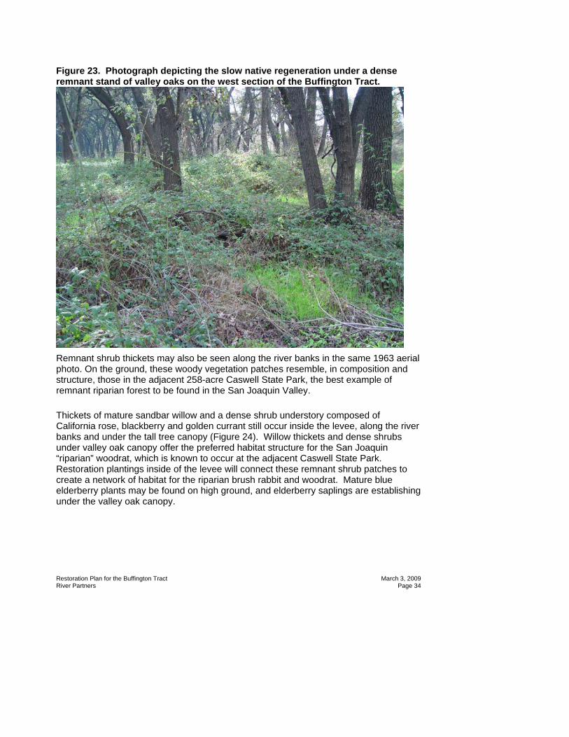
Figure 23. Photograph depicting the slow native regeneration under a dense remnant stand of valley oaks on the west section of the Buffington Tract.
Remnant shrub thickets may also be seen along the river banks in the same 1963 aerial photo. On the ground, these woody vegetation patches resemble, in composition and structure, those in the adjacent 258-acre Caswell State Park, the best example of remnant riparian forest to be found in the San Joaquin Valley.
Thickets of mature sandbar willow and a dense shrub understory composed of California rose, blackberry and golden currant still occur inside the levee, along the river banks and under the tall tree canopy (Figure 24). Willow thickets and dense shrubs under valley oak canopy offer the preferred habitat structure for the San Joaquin “riparian” woodrat, which is known to occur at the adjacent Caswell State Park. Restoration plantings inside of the levee will connect these remnant shrub patches to create a network of habitat for the riparian brush rabbit and woodrat. Mature blue elderberry plants may be found on high ground, and elderberry saplings are establishing under the valley oak canopy.

Restoration Plan for the Buffington Tract March 3, 2009 River Partners Page 35
Figure 24. Photograph of Riparian understory reference habitat on Buffington Tract.
Thickets of mature sandbar willow and a dense shrub understory composed of California rose, blackberry and golden currant still occur inside the levee, along the river banks and under tall tree canopy.
The historically grazed shrub and herbaceous understory is slowly regenerating in areas where there is the least weed competition, and most slowly in the open, weed-dominated clearings that are designated for restoration planting (Figure 25). Weeds in the historically grazed clearings are predominately star thistle, milk thistle, poison hemlock, curly dock, and annual grasses. However, some mature native trees and shrubs can be found in these clearings, including coyote brush, blue elderberry, valley oak and black willow.
These clearings are positioned at meander bends at points were the river would have flowed at highest velocities over the banks during floods, so these are areas that most likely underwent the highest degree of flood disturbance and sediment deposition throughout time on this site. A historic aerial photo from 1950 (Figure 12), apparently taken shortly after the western section of the project was burned or cleared by some other means, shows the historic pattern of water flow and sediment deposition across the floodplain that may contribute to current vegetation growth patterns on the landscape.

Restoration Plan for the Buffington Tract March 3, 2009 River Partners Page 36
Figure 25. Weeds and annual grasses currently dominate Buffington Tract clearings targeted for restoration.
Native herbaceous plants may be found scattered around this part of the project area, including stinging nettle, mugwort, gumplant, Santa Barbara sedge, and creeping wild rye.
Fields outside of the levee have been leveled for a large part of the past century, and have most recently been planted in alfalfa, through 2007 (Figure 26). The remnant riparian forest that stands inside the levee may be seen on the horizon.

Restoration Plan for the Buffington Tract March 3, 2009 River Partners Page 37
Figure 26. Photograph of leveled Buffington fields outside of the levee.

Restoration Plan for the Buffington Tract March 3, 2009 River Partners Page 38
H. Wildlife Table 2 shows federally listed wildlife species that will benefit as a result of restoration activities on the Buffington unit. Table 2. Listed terrestrial species to benefit from project.
Common Name Scientific Name Listed Status Riparian brush rabbit Sylvilagus bachmani riparius Endangered (State and Federal) Riparian wood rat Neotoma fuscipes riparia Endangered (Federal) Least Bell’s Vireo Vireo bellii pusillus Endangered (State and Federal) Valley elderberry longhorn beetle Desmocerus californicus
diamorphus Threatened (Federal)
1. Riparian Brush Rabbit By the mid-1980’s, riparian brush rabbit populations had declined perilously, with only two known locations of very small subpopulations remaining. One of these remnant populations occurs at Caswell State Park, adjacent to and upstream from the Buffington project area. This species’ decline has been primarily attributed to habitat loss, especially the dense riparian shrub cover upon which it depends and the elimination of high-ground flood refugia as a result of floodplain leveling for agriculture.
The riparian brush rabbit is now being reintroduced at the Buffington unit and other locations on the Refuge by the Endangered Species Recovery Program in accordance with its recovery plan, which states a goal of three new self-sustaining populations (USFWS 1998). Captive-bred brush rabbits are now reproducing in the wild and utilizing the shrubbiest areas of the Refuge. Since the flood of 2006 in which radio-collared rabbits suffered high drowning mortality, an effort is underway to construct more high ground flood refugia for this species and to vegetate natural high-ground and levees with dense shrub cover.
2. San Joaquin Riparian wood rat The federally-endangered San Joaquin Valley “riparian” woodrat occurs typically in areas with willow thickets with an oak overstory. Like the riparian brush rabbit, it prefers a dense, shrubby understory, and its current population has dwindled as a result of habitat loss from floodplain clearing, leveling, flood control, and cattle-grazing. It co-occurs with the riparian brush rabbit at the adjacent Caswell State Park (USFWS 1998). Current vegetation conditions on the river side of the Buffington project areas fit the habitat description for this species although they can be improved, as impacts of human land use are evident across the site. River Partners’ restoration designs for this site will further enhance habitat conditions for the riparian woodrat in the project area.
3. Least Bell’s Vireo Least Bell’s Vireos have been documented as breeding on restoration sites planted by River Partners on the San Joaquin River NWR in the past several years. This

Restoration Plan for the Buffington Tract March 3, 2009 River Partners Page 39
represents a return to the Valley by this breeding riparian songbird after an estimated 60 years of extirpation. Like several other endangered riparian species in California, it relies upon dense riparian shrub and willow cover, in this case for breeding habitat and has suffered from the clearing of riparian vegetation from the floodplains (RHJV 2004). River Partners will enhance habitat conditions for this recolonizing species by creating more potential breeding habitat on the Buffington unit.
4. Valley Elderberry Longhorn Beetle The valley elderberry longhorn beetle (VELB) spends most of its life cycle on its host plant, blue elderberry. Floodplain clearing throughout the Valley has resulted in widespread loss of riparian forests and its host plant. Furthermore, cattle grazing and river regulation has inhibited regeneration of the blue elderberry, and many existing host plants are senescing or succumbing to fungal infections (USFWS 1984). The federal recovery plan for this species calls for protection of Valley elderberry beetle habitat along the Stanislaus River, among other Central Valley rivers (USFWS 1984). In a recent survey of VELB habitat, River Partners detected VELB presence on four sites along the Stanislaus River (River Partners 2007). River Partners will enhance habitat conditions for this species on the Buffington unit by planting approximately 1,050 blue elderberry plants in clusters throughout the project area.
5. Anadromous Fish The Anadromous Fish Restoration Program, administered by the U.S. Fish and Wildlife Service, calls for habitat restoration and flow management for the benefit of fall-run Chinook salmon and steelhead in the Stanislaus River. Riparian restoration of the Buffington unit will support this recovery effort by creating more potential shaded riverine aquatic habitat in the project area, as well as increasing terrestrial inputs to the aquatic environment such as vegetation, woody debris, and insects. Figure 27 shows one of three riverbank planting fields on the Buffington unit, where riparian plantings will enhance in-stream habitat conditions in the future.

Restoration Plan for the Buffington Tract March 3, 2009 River Partners Page 40
Figure 27. Photograph of actively eroding river bank on the Buffington unit to be enhance by riparian plantings.

Restoration Plan for the Buffington Tract March 3, 2009 River Partners Page 41
III. CONCEPTUAL SITE MODEL This conceptual site model:
• Presents our understanding of the physical and biological factors that influence site ecology,
• Outlines our restoration strategy, • Provides an overview of the plant design, and • Identifies ecological benefits and targeted wildlife species.
The principles described in this section will guide the implementation of the project.
A. Past Environmental Conditions Prior to the construction of New Melones Dam in the late 1970’s, this section of the river was characterized by great river dynamism. High lateral meander is evident in historic aerial photos (Figures 3 and 12-14), which show active side channels, exposed sand bars, small oxbow lakes holding water, and visible scour and deposition patterns on the landscape. Since the construction of the dam, the river appears fixed over time in its main channel (Figures 15-18).
Historic aerial photos (Figures 3 and 12-18) commissioned by the Stanislaus County Assessor’s Office offer a visual timeline of the river and floodplain at this location:
• August 9, 1937 - Total shrub and tree cover along active river meander zone, no levee on site (Figure 3). Today’s clearings are still shrub filled. Vegetation growth patterns on landscape show evidence of past sand deposition, river coursing across the floodplain in meander zones, and sand splays radiating out laterally from the river channel. Active river meander is visible where water appears to be standing in oxbow lakes. Exposed sandbars are present. Right (north) bank floodplain is still forested in meander zone. Fields south of the riparian forest are in irrigated crops and pasture.
• March 3, 1950 – Shrubs have been cleared on west side with a road cut parallel to river, but tall trees remain around oxbows (Figure 12). Clearing may be the results of a controlled burn or wildfire. The east side of the project area is still totally vegetated. The forest on right (north) bank meander zone has been cleared, except for vegetation around oxbow lakes. Some oxbows appear to contain standing water. Fields south of the riparian forest are in irrigated crops and pasture.
• June 25, 1963 – Shrubs cleared on both east and west sides except in sharp meander bends (Figure 13). Still water stands in oxbows along the north side of the river. Tall trees grow in patterns outlining historic oxbows. Again, it looks like a controlled burn. Patterns of past sand deposition are visible, radiating out from river channel. Exposed sandbars are observed on river bends.
• May 14, 1977 – Last aerial photo before the New Melones dam construction was completed (Figure 14). Exposed sandbars are visible with some vegetation regeneration. Large clearings are present on the landscape with tall trees maturing. The oxbow pattern is still visible in tree stands with most other upland

Restoration Plan for the Buffington Tract March 3, 2009 River Partners Page 42
vegetation still cleared except right along the riverbank. The levee has been constructed at its current site.
• April 18, 1980 – Some shrub succession occuring around clearing edges and on sandbars (Figure 15). Shrub and tree stands are mostly cleared in south fields.
• March 15, 1985 through 1998– River course appears fixed in main channel and no water in oxbow lakes. Sandbars are overgrown with no new sand deposits. Large trees are senescing while slow shrub succession is occurring.
B. Likely Successional Patterns without Restoration The floodplain is now on a path of slow shrub succession with heavy weed competition. Loss of the historic disturbance regime – especially floods and fire – and the regenerative processes that they activate will result in a fairly static and senescing vegetation community. The river may occasionally exceed its banks, at flows above 7,300 cfs as it did in the 1997 flood, but overall there is little opportunity for river and floodplain reconnection in it its present state. Loss of floodplain connectivity prevents the recharge of historic oxbow lakes and inhibits geomorphic processes such as sand deposition, scour, and creation of floodplain topography. Furthermore, new tree (cottonwood, willow) recruitment on lower terraces is unlikely with the disturbed hydrograph. Weed competition now also may seriously inhibit native plant establishment in the most historically disturbed areas.
C. Restoration Strategies for the Buffington Tract We recommend the following strategies for Buffington Tract:
• Employ active restoration techniques to establish riparian vegetation. Active restoration employs modern farming techniques to efficiently and rapidly establish riparian vegetation. Tasks include site preparation, native plant species propagation and planting, weed control, and supplemental irrigation.
• Recognize current site conditions. The target vegetation is not a “historical” endpoint, but is based on a historical overview and a pragmatic assessment of current site conditions (a fallow field filled with non-native species). Based on these conditions, most of the site is well suited for the rapid establishment of native riparian forest and shrub communities.
• Construct new high ground flood refugia for terrestrial wildlife and revegetate existing high ground on floodplain.
• Link existing habitat patches with restoration plantings to increase habitat connectivity, especially dense riparian shrub patches
Passive restoration strategy means minimum input to restore floodplain habitat. As currently practiced this method involves: a) site preparation that removes all weed mulch and crop residue through discing, burning, and/or prolonged flooding; and b) flooding the field in early spring. Managed flooding of the field attempts to mimic the recession limb of the annual hydrograph such that the soil surface is exposed by slowly drawing down the water level at the time willow and cottonwood seeds are flying in April

Restoration Plan for the Buffington Tract March 3, 2009 River Partners Page 43
and May. Ideally, seedlings would establish and grow to be 3 to 5 feet tall saplings by the end of year one. Unfortunately, non-native agricultural weed seeds, already in the soil, can germinate and rapidly outgrow native seedlings, slowing their growth and eventually killing them through shading effects. This is a primary reason that passive techniques have never been successful in the Central Valley for large-scale restoration. The logistics of weed control with passive restoration would be complex because a tractor with spray-rig could not access the field until the soil dried sufficiently, allowing the weeds an advantage of early growth. Active restoration is a strategy where modern farming techniques are used to establish the forest, including intensive site preparation, on-going weed control using herbicides as necessary, irrigation through the growing season for up to three years, and planting of several month-old saplings from nursery grown container stock. Advantages of this method are: a) demonstrated success of over 70% survival after three years in the Cnetral Valley; and b) the methods used are essentially the same as those used to establish commercial orchards, allowing for the opportunity of contracting with local farmers to carry out the implementation, a great outreach benefit.
D. Identification of Ecological Benefits and Targeted Wildlife species The restoration plantings will result in structurally diverse vegetation that should provide habitat for a variety of wildlife species (Table 3):
• The riparian brush rabbit and riparian woodrat will benefit from the abundance of low, dense shrub cover in this planting design that will provide nesting habitat for reproduction and predator cover for survival and dispersal.
• Multiple species of Neotropical migratory birds, including Least Bell’s Vireo will use the structurally diverse vegetation for breeding, migration stopover, and overwintering.
• Planting over 1,000 elderberry saplings will eventually support shrubs to host the federally listed valley elderberry longhorn beetle.
• During flood events, constructed high ground refugia and revegetated natural topography inside the levee will provide important flood refugia as well as food and cover for the endangered riparian brush rabbit, as well as other terrestrial wildlife.
Comment [HS3]: Remove?-not necessary?

Restoration Plan for the Buffington Tract March 3, 2009 River Partners Page 44
Table 3. Habitat requirements and design goals for targeted wildlife species. Target Species Status Habitat Requirements Design Goals/Considerations
Riparian brush rabbit (Sylvilagus bachmani riparius)
Endangered Shrubby understory, specifically dense thickets of low growing California rose and blackberry; Natural topography on floodplains and upland high-ground
Restore suitable habitat for reintroduced populations; plant dense mixed shrub patches at 227 or 545 plants/acre. Create accessible, vegetated high-ground for survival of flood events.
Riparian woodrat (Neotoma fuscipes riparia)
Endangered Willow thickets and dense shrub with valley oak canopy
Restore and link riparian habitat; plant dense shrub cover, willow thickets, and (inside levee) valley oaks
Least Bell’s Vireo (Vireo bellii pusillus)
Endangered Structurally diverse riparian woodlands, including cottonwood-willow forests, oak woodlands, dense shrubs
Restore suitable nesting habitat; Plant diverse vegetative structure, shrub clusters, willow thickets, and dense understory
Valley elderberry longhorn beetle (Desmocerus californicus diamorphus)
Threatened Riparian and associated upland habitat in the CentralValley where blue elderberry, the beetle’s host plant, grows
Plant approximately 1,000 elderberry plants in riparian shrub habitat

Restoration Plan for the Buffington Tract March 3, 2009 River Partners Page 45
IV. PLANTING DESIGN River Partners has developed a site-specific planting design that represents a synthesis of the available information on the site conditions, project objectives, and recommendations from the Endangered Species Recovery Program (ESRP, CSU Stanislaus), the Riparian Mammals Technical Group, U.S. Fish and Wildlife Service, and PRBO Conservation Science. A map of the Buffington planting fields is shown in Figure 28. Plant associations are based on the vegetation series concept described by Sawyer and Keeler-Wolf (1995). Plant series are named for the dominant plant species, but every series also contains other associated plant species. The similar “association” concept provides a useful descriptive label for vegetation differences that allows for design flexibility depending upon project goals. It does not specify arrangement, density, or other quantifiable factors that must also be addressed to translate the conceptual design to field implementation. The composition and density of the association is based on several site-specific factors:
• Soil properties (texture, stratification, seasonal water table), • Topography/hydrology (flood regime), • Proximity to existing vegetation, • Habitat characteristics for targeted species, and • Management considerations.
The plant composition for the Buffington restoration site has been selected from locally occurring species and designed to promote quick growth of dense, low shrub cover with some trellis support species and an herbaceous layer for forage and additional cover. The primary goals of this particular planting design will be:
• Rapid growth of low and trellising shrub cover to provide cover from predators, • Habitat structure that will maintain a low, dense stature over time, as the riparian
brush rabbit population is re-established, • Increased connectivity of existing riparian shrub habitat • High-quality native herbaceous forage planted in close proximity to dense shrub
cover, as riparian brush rabbits prefer to forage and conduct most other activities within 1 meter of shrub cover,
• Basking logs introduced to the field planting after herbaceous layer is planted, using local native woody debris,
• Minimize predation risk during flood events by not planting tall trees that could function as predator perches near constructed flood refugia.
To promote shrub growth and persistence of a riparian shrub layer structure, we will minimize heavy shading tree species in the planting mix. We will plant no tall tree species on the landside of the levee, to avoid creating predator perches around the constructed “bunny berms.” The plant mix will feature:

Restoration Plan for the Buffington Tract March 3, 2009 River Partners Page 46
Figure 28. . Planting Associations and Fields for the Buffington Tract .

Restoration Plan for the Buffington Tract March 3, 2009 River Partners Page 47
• A high proportion of dense, low-stature shrub species such as California blackberry (Rubus ursinus), California rose (Rosa californica), and golden currant (Ribes aureum).
• Trellis species, such as sandbar willow (Salix exigua), coyote brush, and blue elderberry (Sambucus mexicanus).
• Native herbaceous species for forage and/or cover, such as creeping wild rye (Leymus triticoides), Spanish clover (Lotus pershianus), mugwort (Artemesia douglasiana), and gumplant (Grindelia camporum).
A. Design Considerations Physical and biological factors determine site potential, limiting what will grow on an area. Based on these factors, the Buffington unit can support a riparian forest, riparian shrub and herbaceous species. However, wildlife objectives and management issues also influence the arrangement, composition, and vegetation associations that are selected. We refer to these factors as “design considerations” (Table 4).
The primary objectives of this project are to increase wildlife habitat quantity, quality, and connectivity. Specific design considerations support these objectives:
• Increase dense shrub understory habitat for the endangered riparian brush rabbit, designed according to recommendations from the Endangered Species Recovery Programs at CSU Stanislaus. Habitat features will include a network of shrub cover across the site, forage vegetation, basking sites, and high-ground flood refugia. Restore and enhance habitat for other threatened, endangered, and/or Neotropical migrant riparian species including riparian woodrat, valley elderberry longhorn beetle (Desmocerus californicus dimorphus), Least Bell’s Vireo (Vireo bellii pusillus), Yellow Warbler (Dendroica petechia), and Black-headed Grosbeak (Pheucticus melanocephalus) .
• Provide breeding habitat for shrub-nesting resident bird species including Wrentit (Chamaea fasciata), Song Sparrow (Melospiza melodia mailliardi), California Quail, and Spotted Towhee (Pipilo maculatus).
• Provide shrub understory habitat for wintering migrant songbirds that use the Refuge, including Fox Sparrow, White-crowned Sparrow, Golden-crowned Sparrow, Lincoln’s Sparrow, Hermit Thrush, and Ruby-crowned Kinglet.
• Plant a site-appropriate native plant community. • Establish native plant species within a three-year period. • Use local seed and cutting sources. • Maintain existing native plants. • Establish a native grass and forb layer in close proximity to shrub cover, for
brush rabbit forage. • Control invasive weeds where they occur in high densities in the designated
project area, to reduce weed seed sources. • Monitor native plants in restoration plantings at the end of the growing season.

Restoration Plan for the Buffington Tract March 3, 2009 River Partners Page 48
Table 4. Design considerations for riparian vegetation restoration on the Buffington Tract
Objective/Factor Example of Project Design Considerations Increase habitat connectivity for shrub-dependent terrestrial wildlife.
• Increase dispersal and survival potential of captive-bred riparian brush rabbits by connecting patches of existing riparian shrubs throughout the project area.
• Increase shrub cover around rabbit release pens. Provide rapid dense, cover for riparian brush rabbit, woodrats, and Neotropical migrant birds, with immediate (< three years) habitat benefits.
• Incorporate designs that have a high proportion of low stature plants that can quickly provide a protective cover, such as California rose and blackberry.
• Increase planting density in sandy, high drainage areas. • Provide basking logs for thermoregulation close to shrub cover.
Provide high-quality forage for riparian brush rabbits.
• Brush rabbits prefer to forage close to shrub cover. Plant native grasses, forbs, and clover close to shrub cover.
Provide suitable refugia for riparian brush rabbits during flood events.
• Plant dense shrub and herbaceous cover on natural high ground • Create topography in previously leveled fields by constructing
densely vegetated “bunny berms.” • Don’t plant tall trees that could function as predator perches
near constructed flood refugia. Provide valley elderberry longhorn beetle habitat.
• Plant clusters of its host plant, blue elderberry, in appropriate areas of the site.
Minimize weed sources, provide native habitat on project edges.
• Control weeds along access roads, on planting sites, and in buffer zones around plantings to reduce weed seed source and weed dispersal potential.
• Plant native herbaceous understory to displace weeds in designated weed control areas.
B. Rationale for Plant Associations Using our knowledge of site conditions and design considerations, River Partners developed several plant associations to be planted on the Buffington unit (Table 5). The planting pattern has been designed to achieve a network of dense riparian thickets for enhanced predator cover, breeding sites, and dispersal corridors for endangered riparian mammals and other wildlife of conservation concern, as described above. High density plantings will benefit the riparian brush rabbit and many of the Neotropical migrant songbirds which require dense shrubby vegetation (RHJV 2004). Abundant blackberry, rose, golden currant, and sandbar willow in the planting design will form dense thickets that will expand and connect existing riparian shrub habitat. Coyote brush, blue elderberry, and shrubby willows will function as trellis species and habitat structure. Results from River Partners’ recently completed long-duration flood study have indicated that these species are most likely to thrive on sites that drain quickly after flood events and do not retain standing waters, such as the Buffington unit (River Partners 2007; Appendix II). For this plan, River Partners has developed five plant associations to be distributed throughout the fields. River Partners expects at least 70% survival of its restoration plantings at the end of the three year maintenance period. After maintenance is

Restoration Plan for the Buffington Tract March 3, 2009 River Partners Page 49
discontinued, River Partners anticipates more mortality based on differences of soil textures and water table depths. Variable plant survival may result in a network of shrub patches at this site with heterogenous habitat structure that will still enhance wildlife survival and dispersal. Table 5. Rationale for plant associations
Association Planting Location Characteristics
Design Characteristics Habitat Benefits
Riparian Shrub Soil: sandy to clay loam, weak/no hardpan
Water Table: >12 ft.
Shrub-dominated, dense low shrubs and willows. Density: 272 or 545 plants/acre
• Provides thickets for riparian brush rabbit and woodrat, required for breeding, shelter, and cover from predators.
• Favored by many nesting and wintering songbirds: Least Bell’s Vireo, Black-headed Grosbeak, Yellow Warbler, Song Sparrow, Spotted Towhee, Wrentit, Hermit Thrush and wintering sparrow species.
• Because of rapid growth, provides quick structure and habitat for wildlife.
Herbaceous Understory All plant associations Densely planted; composed of aggressive herbaceous understory species and legumes.
Goal is 100% cover by native species.
• Provide forage for the riparian brush rabbit.
• Reduce weed invasions
• Provide nesting substrate for songbirds including Lazuli Bunting, Common Yellowthroat, Song Sparrow, and Blue Grosbeak.
C. Composition and Location of Planting Associations The overall density and numbers of each plant species are presented by planting area in Tables 6 - 11. Based on specific physical and biological conditions, River Partners developed several vegetation associations that vary by species composition, depending on their location or physical characteristics and project design requirements.

Restoration Plan for the Buffington Tract March 3, 2009 River Partners Page 50
1. Land side of Buffington levee The leveled fields outside of the levee (“landside”), B1 and B2, total approximately 37 acres and will serve as flood refugia areas for terrestrial mammals during high water events. Field B1 forms the western border of the alfalfa field extending southward to Beckwith Road, and will provide a high-water escape corridor moving away from the levee where water can accumulate. A narrow shrub strip along the length of the entrance road on the eastern boundary of the unit, which is slightly elevated, will provide flood refugia as well. This road border will consist of two parallel rows of shrubby vegetation along the west side of the road, approximately 3,800 feet in length.
2. River side of Buffington levee The previously grazed clearings on the river side of the levee will be planted in dense shrub cover to connect existing patches of quality riparian shrub habitat. Eleven planting locations, fields B3-B13, will expand and connect existing high-quality riparian brush rabbit habitat patches and increase shrub cover around the two existing rabbit release pens. The riverside planting in field B3, at the site of rabbit release pen 1, will eventually connect the existing riverside habitat with the flood escape corridor over the levee and into the landside fields. These fields will be planted at a higher density for two main reasons: 1) to provide rapid cover for brush rabbits being released inside the levees, and 2) site conditions, especially patches of well-drained sandy soil, may result in slower plant growth than on the landside fields. Field B13 will be a strip of high-density brush, approximately 20 feet by 100 feet, at the very narrow portion of the property that is bordered by the Faith Ranch boundary fence to the south and the Stanislaus River to the north. This strip of vegetation will serve to connect the two wider portions of the property, providing habitat connectivity for riparian brush rabbits. This area will be irrigated by the pasture tailwater routinely spilling from the Faith Ranch pasture. Approval to utilize this spill water has been granted by the Faith Ranch to the USFWS. Native sedge patches will be planted on the riverside of the levee where weed patches currently occur -- in shady areas under mature Valley Oaks, along the road connecting fields B3-B13, and in weed buffer zones around the restoration plantings (approximately 2 acres total).
3. Riparian Shrub Association This association will be planted on approximately 37 acres in the landside fields B1 and B2 (Table 6). Blackberry, rose, currant and sandbar willow dominate, with stands of blue

Restoration Plan for the Buffington Tract March 3, 2009 River Partners Page 51
elderberry included, to create a complex habitat structure for the benefit of target wildlife species. Figure 29 represents reference habitat structure. Reference sites: Existing remnant riparian shrub understory along the Stanislaus River on Buffington unit and adjacent Caswell State Park and on Chrisman Island, San Joaquin River National Wildlife Refuge.
Figure 29. Photo of riparian shrub reference habitat currently occupied by reintroduced riparian brush rabbits, Christman Island, San Joaquin River NWR, 2007.

Restoration Plan for the Buffington Tract March 3, 2009 River Partners Page 52
Table 6. Composition of the Riparian Shrub Association, Land Side of Buffington Levee1, Fields B1 and B2.
Species name Percent composition
(%)
Density (plants/acre)
Total number
Arroyo willow 8 18 666
Blue elderberry 6 14 518
California blackberry 28 64 2,368
California rose 24 54 2,016
Coyote brush 6 14 518
Golden currant 10 23 840
Sandbar willow 18 41 1,517
Total 100 227 8,399 1No tall tree species will be planted in these fields, so as not to provide predator perches around constructed high-ground rabbit refugia.
Table 7. Composition of the Riparian Shrub Association, River Side of Buffington Levee1, Fields B3-B11.
Species name Percent composition
(%)
Density (plants/acre)
Total number
Arroyo willow 8 44 660
Blue elderberry 6 33 495
California blackberry 26 142 2,130
California rose 20 109 1,853
Coyote brush 6 33 495
Golden currant 10 55 927
Oregon ash 4 22 330
Sandbar willow 16 87 1,305
Valley oak 4 22 330
Total 100 545 9,265 1This planting mix will include two tall tree species, reflecting and enhancing existing plant community composition.
a) Blackberry-Rose Riparian Shrub Understory Association
This association, a variant of the riparian shrub association, will be planted under the dense stand of mature valley oaks around rabbit release pen 2, Field B12. Figure 30 shows part of the area to be planted with this mix. Reference site: Riparian shrub understory patches on-site and at adjacent Caswell State Park.

Restoration Plan for the Buffington Tract March 3, 2009 River Partners Page 53
Figure 30. Photo of open understory around rabbit release pen 2, to be planted in Blackberry-Rose Riparian Shrub Understory Association.
Table 8. Composition of the Blackberry-Rose Riparian Shrub Understory Association.
Species name Percent Composition
(%)
Density (plants/acre)
Total number
Blue elderberry 14% 76 38
California blackberry 38% 207 103
California rose 38% 207 103
Golden currant 10% 55 27
Total 100 545 272
b) Blackberry-Rose Riparian Shrub Border Association This variant association (Table 9 )will be planted along the access road and “bottleneck” area, Field B13, between the Buffington Unit and the Faith Ranch. It is

Restoration Plan for the Buffington Tract March 3, 2009 River Partners Page 54
a modification of the riparian shrub association described above but excludes blue elderberry, in case road maintenance is required. Table 9. Composition of the Blackberry-Rose Riparian Shrub Border Association.
Species name Percent composition
(%)
Density (plants/acre)
Total number
California blackberry 32 174 496
California rose 32 174 496
Coyote brush 6 3 93
Golden currant 10 55 155
Sandbar willow 20 109 310
Total 100 545 1,550
c) Blackberry-Rose Bunny Berm Association The blackberry-rose bunny berm association (Table 10) will provide quick dense shrub cover with some trellis support and winter foliage on constructed flood refugia, “bunny berms.” One row of sandbar willows will be planted along the base of all berms, with plants spaced 10 feet apart.
Table 10. Composition of the Blackberry-Rose Bunny Berm Association. Species name Percent
composition (%)
Density (plants/acre)
Total number
California blackberry 35 191 569
California rose 30 164 495
Coyote brush 11 60 173
Sandbar willow 24 130 396
Total 100 545 1,633
4. Herbaceous Understory Planting The restoration of an herbaceous understory is included in this project because it is:
• An important element of the native plant community for this region. A relic riparian meadow exists on the Refuge and large stands of other native herbaceous species provide an invaluable seed-source for the propagation of several understory species.
• An important element of wildlife habitat. The riparian brush rabbit’s diet will be enhanced with the planting of native Spanish clover (Lotus purshianus).

Restoration Plan for the Buffington Tract March 3, 2009 River Partners Page 55
• An effective weed control measure. Invasive weeds, including milk thistle and yellow starthistle are well established in the understory of the Buffington unit, and active weed control followed by native plantings will be required to outcompete colonizing weeds.
Maintenance activities, including discing, mowing, and herbicide application during the restoration process will prevent these invasives from establishing in the restoration fields. However, at the end of the project, restored areas could be at risk to invasion by these weeds. To prevent establishment and limit the extent of weed invasions, a dense, native herbaceous understory will be planted throughout the woody plantings. Native grass and sedges will be planted in weed control areas along access corridors and weed buffer zones around riverside plantings (Table 11). Recent understory plantings on the Refuge of mugwort (Artemesia douglasiana), gumplant (Grendelia camporum), and creeping wild rye (Leymus triticoides) resulted in virtually 100% cover after two growing seasons. Very few weeds were found in these planted areas. We believe these species will be an effective form of weed control in restored areas. All of these species are currently present on the Buffington site, in the remnant riparian habitat. Table 11. Herbaceous understory species that may be planted within woody plant associations.
Buffington Riparian Shrub Association Herbaceous Species
Landside Riverside
Creeping wildrye (Leymus triticoides) X X
Gumplant (Grindelia camporum var. camporum) X X
Native clover (Trifloium sp. and Lotus sp.) X X
Mugwort (Artemesia douglasiana) X X
D. Planting Tiles and Baseline Data River Partners has developed a computer database system that identifies the plant species at a particular row and planting location within the field. This planning tool allows us to develop specific planting patterns that will create a vegetation mosaic of structural patterns within the restoration planting. Each plant will receive a computer-generated label that lists its row and plant number, location, plant species name and number code. The labels will be installed on stakes in the field prior to planting, allowing us to clearly communicate the plan to the planting crew. In the future, the database will be an important adaptive management tool because it will allow us to discern any patterns in a plant species’ survival rate or growth patterns across a field.

Restoration Plan for the Buffington Tract March 3, 2009 River Partners Page 56
Within each association the main planting subunits are expressed as “tiles” (Appendix III). Each tile covers an area of 5 rows by 10 planting locations within each row and is approximately 1/5 of an acre. Each tile will be replicated as often as needed to fill in the area for a particular association. Within each tile, plants are arranged so that we can create a mosaic of vegetative structure across the field.

Restoration Plan for the Buffington Tract March 3, 2009 River Partners Page 57
V. PROJECT IMPLEMENTATION
A. Environmental Compliance
1. Access During the term of this restoration project, River Partners and its subcontractors will be operating under a Special Use Permit (B1654-07-0018) issued by the Refuge. The permit “authorizes River Partners, and/or subcontractors of River Partners, to access the San Joaquin River National Wildlife Refuge to conduct riparian habitat restoration activities.” See permit for special conditions (Appendix IV).
2. Herbicide application permits USFWS Region 1 has approved the use of RoundupTM (glyphosate), Rodeo, and 2-4-D (Weedar) for application on Refuge properties. USFWS has also received annual pesticide use permits (USFWS internal process) for other herbicides including TranslineTM (for yellow star-thistle control), and TelarTM and Garlon 3ATM (both used for perennial pepperweed). River Partners would be authorized to use these herbicides and will be required to inform the USFWS of which herbicides are being used on the Refuge. River Partners is required to obtain pesticide use permits from the Stanislaus County Ag Commission and will provide them and the USFWS with monthly pesticide use reports.
3. Seed Collection permit A permit for collected golden currant seed in Caswell State Park has been issued to River Partners (Appendix V).
B. Field Layout
1. Fields B1 and B2 Fields B1 and B2, on the landside of the levee, will be planted with native woody vegetation (trees and shrubs) at a density of 272 plants/acre. The constructed flood refugia (“bunny berms”), the levee, and clearings on the riverside of the levee will be planted at a higher density, 545 plants/acre, as well as the entrance road border and “bottleneck” area between the Buffington unit and the Faith Ranch. The planting rows in fields B1 and B2 will be approximately 16 feet apart. The rows in each field will be oriented approximately north-south, in the direction that best accommodates the flow of irrigation water. Rows will be curved so as not to appear straight to the human eye. The in-row plant spacing will be approximately 10 feet. The 10 x 16 feet arrangement yields a plant density of 272 plants per acre, designed with the assumption that not all plants will survive. Field B1 will be planted in 5 rows

Restoration Plan for the Buffington Tract March 3, 2009 River Partners Page 58
contoured to the western boundary of the existing alfalfa field and drip-irrigated. Field B2 will be planted in its entirety and flood irrigated.
2. Fields B3-13 Higher density shrub plantings will be installed on the river side of the levee, in fields B3-B13. The higher density planting is designed to provide shrub cover more quickly in the area that rabbits are being released. Well-drained sandy soils and drip (vs. flood) irrigation may create conditions for slower plant growth inside the levee. Higher density plantings are intended to compensate for these factors and provide a network of dense shrub cover within a few years from planting. The planting rows in fields B3-B13 will be approximately 16 feet apart. The rows in each riverside field will be oriented approximately parallel with river flow across the floodplain. Rows will be curved so as not to appear straight to the human eye. The in-row plant spacing will be approximately 5 feet. The 5 x 16 feet arrangement yields a plant density of 545 plants per acre, designed with the assumption that not all plants will survive. High soil heterogeneity on the river side of the levee, where layers of sand have been deposited across the site in flood events throughout time, may lead to variable drainage conditions and a patchy network of shrub cover, post-irrigation. Field B13 is the “bottleneck area” between Buffington unit and Faith Ranch, where existing riparian habitat narrows considerably. This will be planted at 545 plants/acre over a 20 x 100-feet area.
3. Entrance Road The entrance road border will be planted in 2 rows with a 7 x 12-feet spacing, and rows will run parallel to the road.
4. Bunny Berms The three 660-feet long flood refugia (“bunny berms”) will be constructed in field B2 before planting is initiated. The berms will be planted with 5 parallel rows of shrubs running laterally along the length of the berms, with one centered along the top.
5. Levee This planting is pending levee district approval to the USFWS. See “Riparian Brush Rabbit Flood Refugia Plan,” section C2 (p. 59) for planting details.

Restoration Plan for the Buffington Tract March 3, 2009 River Partners Page 59
C. Site Preparation
1. Restoration Fields The fields will be disced twice and then planting-beds will be formed by a disc-ridger. These planting-beds will be slightly above the soil surface to ensure drainage of water away from the crown of the plant.
2. Riparian Brush Rabbit Flood Refugia As part of this restoration project, we will create a network of high-ground flood refugia (Figure 31), using a combination of constructed mounds in the currently leveled field B2, the existing levee structure (pending levee district permission to USFWS), and natural topography on the river side of the levee. River Partners will use four main strategies intended to minimize flood impacts on terrestrial wildlife populations:
a) Construct high ground refugia outside of the levee To mimic historic floodplain topograghy, high-ground flood refugia (“bunny berms”) will be constructed in the previously leveled field B2. Berms will be constructed of compacted fill and built large enough to be substantial and high enough to keep the tops out of water during severe floods. They will be densely vegetated and easily accessible from the levee for rabbits seeking shelter from high water and predators during flood events. Field B2, immediately south of rabbit release pen 1, will be re-graded to include three curved linear berms leading away from the levee, running parallel on a roughly north-south axis. The berms will consist of approximately 2,200 cubic yards of compacted local soil. The dimensions will be approximately 660 feet long, 3 feet tall, 10 feet wide on top, and a total width (including slope) of approximately 30 feet. These berms will be planted with five rows of dense native vegetation and drip-irrigated and will require hand spraying/weeding.
b) Revegetate natural high ground Natural topography created by historic river action on the floodplain will be maintained on the riverside of the levee to provide additional high-ground flood refugia. High density shrub plantings (545 plants/acre) on these flood refugia sites will provide cover from predators.
c) Vegetate flood escape corridors on levee The levee banks will be vegetated for flood refugia corridors along approximately one kilometer of levee, pending levee district permission to USFWS. Levee bank planting will be in accordance with California Department of Water Resources restrictions. This will include:
• A 10-foot wide strip of rose and blackberry to be planted on the riverside levee bank, from the toe to 10 feet upslope. The plants used for this strip of vegetation will consist of shrubs with main stems no larger than two inches in

Restoration Plan for the Buffington Tract March 3, 2009 River Partners Page 60
Figure 31. Map of riparian brush rabbit flood refugia, Buffington Unit, Stanislaus County, California.

Restoration Plan for the Buffington Tract March 3, 2009 River Partners Page 61
diameter at maturity, in accordance with Army Corps of Engineers guidance barring vegetation over two inches in diameter on levees. In addition, the plant species selected are short in stature, such that natural growth will tend to reach no more than five feet in height at maturity; in accordance with California Department of Water Resources and Reclamation Board criteria.
• On both the river-side of the levee and the land-side of the levee, the levee top will be planted with creeping wild rye leading up and over the levee, excluding the levee road and mowed area described below.
• On the land side of the levee, a 10-foot wide strip of mugwort will be planted along the base of the levee, from the toe outward into the field 10 feet. Mugwort will provide wildlife cover, yet can survive annual mowing, which is necessary for levee inspection.
d) Create emergency brushpiles Orchard prunings will be staged at the south end of the unit (“landside”) to be used in emergency brush piles during flood events, to create cover for wildlife moving up and over the levee into fields B1 and B2 for refuge. Orchard cuttings (from local winter pruning on private orchards) will be stockpiled on the landside of the levee (on a staging area for the existing alfalfa field). The quantity will be adequate to create 10’ x 10’ x 2’ high brush piles across the road/levee top and across the mowed strip at the three “bunny berm” locations. These emergency brushpiles will be installed during flood events to provide access routes over the levee and into the flood refugia for riparian brush rabbits.
3. Basking Logs Downed woody material in the riverside planting areas will be cut into log sections and distributed along shrub rows in fields B1 and B2 as basking logs for the riparian brush rabbit in the final year of the project, after the native herbaceous layer has been established.
D. Irrigation System Figure 32 shows irrigation infrastructure. Field B1 will be flood irrigated with water from the existing, operational Stanislaus River pump. The pump will be fitted with a 7,000 custom GPM fish protection intake screen system “fish screen” manufactured by Morrill Industries, Inc., Escalon, CA, to prevent pump-related fish mortality. Water in this field will flow with topography, south to north, toward the levee and river channel. Fields B1, B3-B12, bunny berms, and levee plantings will be drip-line irrigated. The water source for these fields will be a submersible pump and, if necessary, a well will be drilled. Field B1 rows will be contoured with the western boundary of the field. Rows on the river side of the levee will run roughly parallel to the estimated flow of water across the floodplain.

Restoration Plan for the Buffington Tract March 3, 2009 River Partners Page 62
Figure 32. Irrigation design for the Buffington Tract.

Restoration Plan for the Buffington Tract March 3, 2009 River Partners Page 63
Field B13 will be irrigated with tailwater from the adjacent Faith Ranch, by permission of the Gallo family to USFWS. All other planting fields will be dripline irrigated. The main PVC pipeline for drip irrigation will be buried and run along the existing riverside road: sub-mains will branch out to each planting field.
E. Plant Material Collection and Propagation Field cuttings of willows will be collected from the cuttings nursery (established on the Refuge in 2000) and planted in spring 2008. The original nursery material was collected on the Refuge and on the Faith Ranch, immediately north of Highway 132. River Partners will plant additional species grown out as container stock at nurseries (blackberry, coyote brush, blue elderberry, golden currant, valley oak, Oregon ash, and California rose) into the fields in spring 2008. Seeds of these species were collected on the Refuge, Mapes Ranch, and Faith Ranch (both ranches are just north of Highway 132 and east of the San Joaquin River) during summer and fall 2007. Seeds of herbaceous plants will also be collected on the Refuge in summer and fall 2008. River Partners will plant the herbaceous plants (grasses and sedges) in appropriate locations in years 2 and 3 using techniques developed from test-plots. Golden currant seed was harvested on-site and in the adjacent Caswell State Park in July 2007 (see permit Appendix V) and will be grown out to be planted as container stock in fall 2008. Seed-produced golden currants may be supplemented with cuttings, depending upon the viability and plant yield of last year’s seed harvest.
F. Plant Installation
1. Woody species Planting of willow stem-cuttings, collected in January 2008, will take place in March 2008. Shrubs will be propagated by nursery operators and planted in March 2008. Valley oak acorns were collected in 2007 and will be direct seeded.
2. Herbaceous species Native grass (creeping wildrye), Spanish clover, and forbs (mugwort and gumplant) seeds will be planted in year 2 on sites that are determined to be appropriate. These plantings will be used as sources of seed for future dispersal to other areas of the restoration project.
G. Plant Maintenance
1. Plant protectors Milk cartons will be installed as plant protectors with 4 inches of wood shavings applied as mulch to hold soil moisture and minimize weed growth. The cartons protect the plant from herbivory and drift from herbicide applications. In addition, we will place additional protectors around any native trees that might colonize the site.
Comment [HS4]: Typically, we will state the area to be seeded, seeding rate, etc.

Restoration Plan for the Buffington Tract March 3, 2009 River Partners Page 64
2. Weed Control During the growing season weeds will be controlled as needed by spraying Roundup herbicide or one of several new generic brands with glyphosate as the active ingredient on the planting rows. The aisles between the rows will be mowed, disced, or sprayed as needed to remove weeds. The aisles will be sprayed prior to planting herbaceous understory species. Weed control will be conducted on twenty (20) acres of the riverside enhancement area. This includes the clearings targeted for woody species planting, a buffer zone around each clearing where weed patches occur, and along the roadsides connecting clearings. This targeted weed control approach is intended to reduce the weed seed source and dispersal potential of existing weeds into restoration fields in the restoration maintenance period. Weed control patches along roads and in the restoration buffer zones will be re-planted with native sedge plugs or grasses in year 2 or 3, when weeds are determined to be under control.
3. Irrigation schedule Because of the dry summers typical of the climate in the area, irrigation will be required. Irrigation will be applied with the goal that plants will become self-sufficient after the third growing season. In the first growing season, the rapidly growing seedlings have roots only in the surface (the top 1-2 feet) of the soil profile. The rooting zone must be kept moist through the season to ensure optimum growth and survival. On loam soils, a frequency of once every 10 days is sufficient; irrigation on sandy soils may need to be more frequent. The intervals between irrigations are dependent upon soil texture, depth to water table, the weather conditions, and plant water stress. Because we propose a mixture of species with different water demands, the plants must be carefully observed to maintain a balance of soil moisture that is acceptable for xeric species like valley oak and elderberry as well as more mesic species like sandbar and arroyo willow. The strategy for the second and third year is to train the roots to grow deep. Roots at depth (5-15 feet) will need less water and may be able to tap into the shallow water table on the site and out-compete more shallow-rooted weeds. Less frequent deep watering will encourage roots to grow deeper, well below the roots of the weeds, allowing the tree exclusive use of this deep moisture. As the tree’s roots grow deeper, the times between irrigations become longer (4-8 weeks in year 2, 3-4 months in year 3), which allows the soil surface layers to dry, thereby reducing weed vigor.

Restoration Plan for the Buffington Tract March 3, 2009 River Partners Page 65
4. Herbivore Control Herbivores can have a large impact on young plants. A number of measures can help control or minimize their effects (Table 12). Cultural practices such as mowing or spraying can discourage most of these herbivores. One of the advantages of active restoration is that typically, more plants are planted than the herbivores can eat. Mortality of plants is expected to occur over time and is built into the planting design. Some damage by herbivores is tolerable and will not necessarily impact the success of the planting. Table 12. Summary of Herbivore Control Methods at the Buffington Tract.
Herbivore Type of Damage Comment on measure(s) or plant response
Voles (Microtus)
Eat bark and cambium at the base of sapling, usually girdling the entire stem. Dig-up and eat recently planted acorns.
Saplings resprout, unless vole population is high. Voles live only in dense herbaceous (weed) cover and never stop moving when in the open to avoid predators. Remove dense weed cover through herbicides or mowing.
Pocket Gophers (Thomomys bottae)
Eat root systems (probably killing more saplings than any other vertebrate pest).
Control of weed cover allows predators to hunt gophers. However, gophers can persist in an open, weed-free field. Frequent disking, weed mulch control or flooding reduces populations. A variety of birds will prey on gophers if given the opportunity. Raptor perches and owl boxes may increase predation.
Ground Squirrels (Otospermophilus beecheyi)
Dig up and shred plants and protectors.
Flooding or disking can reduce populations.
Rabbits and Hares Browse early spring growth. Rabbits are target wildlife species, plant at high densities to provide forage and cover.

Restoration Plan for the Buffington Tract March 3, 2009 River Partners Page 66
VI. MONITORING AND REPORTING Monitoring is essential to demonstrate and improve project success throughout the restoration cycle. It is important to respond to new information and changing conditions in order to “close the loop” between monitoring and project implementation. Much of the information in this restoration plan can be viewed as testable hypotheses. For example, the planting design matches plant species to specific conditions and stores this information in a computer database. Using the monitoring information, we can evaluate the planting design and/or field management across the field. The sections below outline some of the monitoring information collected for the project. Annual plant monitoring takes place between June and August so that changes to field management or the planting palette can be made at the end of each growing season. More frequent observations allow improvements to management or responses to changes during the growing season. In the years after maintenance, River Partners expects mortality based on differences of soil textures and water table depths. Subtle ecological factors across the project area will affect each species differently, resulting in different growth rates and mortality rates in different areas of the project. River Partners’ horticultural goal for this project is a 70% survival rate at the end of the maintenance period, or 190 plants per acre on the land side plantings, and 382 plants per acre on the river side plantings.
A. Field Reports Field managers will complete monthly reports documenting project activities and observations. The reports will note planting and maintenance activities, weed pressure, plant growth, soil moisture, vandalism, rodent damage, irrigation system performance, and the effectiveness of field operations. Information on soil moisture (from soil moisture probes and field observations) should also be collected. These reports allow the review of performance and timing of events throughout the restoration process.
B. End of Season Monitoring Monitoring is important to determine plant survivorship and assess the effectiveness of management practices. Our monitoring approach includes the following:
• Conduct a full census at the end of the first growing season. This allows the biologists and field managers to measure an exact survival rate and determine the initial success of the project. Survivorship patterns (e.g. survival of a single species in a certain soil type) can also be derived from this information and better direct management of the site.
• Monitor permanent plots at the end of the growing season in years 2 and 3. • Compare plant growth and coverage with several physical parameters such as
topography, soils, and hydrology.

Restoration Plan for the Buffington Tract March 3, 2009 River Partners Page 67
• Monitor herbaceous vegetation planted throughout the project by estimating vegetative cover.
• Analyze the data, review the findings, and adjust field design accordingly. • Host an end of season meeting with staff to discuss the project and make
adaptive management recommendations. The data collected will provide information on any necessary replant activities and management responses for the following season.
C. Photo Points Photographs can provide qualitative information in vegetation changes at a restoration site. Photographs taken over time can provide a compelling picture of a project’s success with a minimum of time and expense. When pictures are taken, we suggest that the monitor document the location, direction, focal point, and camera lens. Aerial photographs may also provide useful information when comparing changes over time.
D. Annual Reports The annual report documents the monitoring data, reviews the site activities, provides a budget analysis, and recommends future management actions. These are produced following the end of season meeting to help managers prioritize the project’s needs.
E. Final Report The final report summarizes the project, including information developed in the end of season memos. We will also analyze our activities in terms of the restoration plan and provide long-term management suggestions.
VII. SAFETY ISSUES The health and safety of out employees are an integral part of our work. Prior to any work on the Refuge, River Partners staff will be briefed on safety issues associated with the site. Employees will have a safety binder that will entail safety procedures and emergency information. All employees will be responsible for complying with safe work practices. In addition, River Partners will comply with the requirements of the Drug-Free Workplace Act of 1990 (Government code Section 8350 et seq.) and will provide a drug-free workplace. In case an employee incurs any injuries or illnesses while on the job, they are instructed to contact the office to inform someone of the situation and to contact the nearest health care provider.
A. Standard Field Procedures All employees have a safety binder that describes safe work practices, and they are responsible for complying with these practices. In case of injuries or illnesses while on the job, employees will:

Restoration Plan for the Buffington Tract March 3, 2009 River Partners Page 68
• Call 911, or • Call Enloe Medical Hospital, (530) 332-7300 or (800) 822-8102, located at 1531
Esplanade, Chico, California 95926, and • Contact the River Partners office at (530) 894-5401.
In addition, River Partner employees will comply with the requirements of the Drug-Free Workplace Act of 1990 (Government code Section 8350 et seq.).
B. Flood and Fire Contingencies Flooding is likely to have minimal impact on restoration activities on the site. Regulated flows on the Stanislaus River have reduced the frequency of widespread flooding, although some out of bank flooding can occur with heavy precipitation, if San Joaquin and Stanislaus River flows are high. Riparian species are extremely well adapted to surviving winter and early spring floods, and the most of the Buffington restoration areas inside the levee are likely to drain quickly due to topography and sandy soils. There is a history of wildfire on the site. During the implementation of the restoration, weed control activities will reduce the abundance of dry vegetative fuels, thus lowering the probability of wildfire. Access roads will be mapped for fire escape routes.
VIII. PROJECT IMPLEMENTATION TIMELINE The timeline for the project is shown for 3 years in Table 13. .
Comment [HS5]: You might want to fill this out with your specific details for your employees.

Riparian Restoration Plan for the Buffington Tract March 3, 2009 River Partners Page 69
Table 13. Timeline for the Scope of Work Tasks for the Buffington Tract. Tasks 2007 2008 2009 2010
S F W S S F W S S F W S
Planning and Permitting Prepare Areas for Restoration Establish Layout for Restoration Install Irrigation System Collect and Propagate Plants Plant Riparian Vegetation Maintain Riparian Plantings Monitor and Report Results Decommission Site

Riparian Restoration Plan for the Buffington Tract March 3, 2009 River Partners Page 70
IX. REFERENCES Anderson, B. W. 1989. Research as an integral part of revegetation projects. Pages 413-419 in Proceedings of the California Riparian Systems Conference, Berkeley, California. General technical report PS-110: Pacific Southwest Forest and Range Experiment Station, Forest Service, US Department of Agriculture; 544 p. Chouinard, T., V. Lyon, B. Barbour, D. Woolington. 1999. San Joaquin River National Wildlife Refuge riparian habitat protection and flood plain restoration project biological inventory and monitoring. US Fish & Wildlife Service, Los Banos, California. Geupel, G.R., N. Nur, A. King, and G. Ballard. 1997. Songbird monitoring on the San Luis National Refuge: Results from the 1996 field season. PRBO unpublished report to the US Fish and Wildlife Service. Stinson Beach, CA. Hammond, J., R. Chruchwell, and G.R. Geupel. 2002. Songbird monitoring on the San Joaquin River National Wildlife Refuge: Progress report for the 2001 field season. Point Reyes Bird Observatory. Publication Number 966. Howard, A.D. 1979. Geologic History of Middle California. University of California Press, Berkeley. Keren, R. 2000. Salinity. Pages G3-G25 in M. E. Sumner (ed) Handbook of soil science. CRC Press, Boca Raton, FL. Natural Resources Conservation Service. 1964. Soil Survey of Eastern Stanislaus County Area, California. Series 1957, No. 20. Orr, R.T. 1940. The Rabbits of California. Occasional Papers of the California Academy of Sciences, No. XIX. The California Academy of Sciences, San Francisco, CA. Palmer, Tim. 1982. Stanislaus: The Struggle for a River. University of California Press. Berkeley, CA. 297 pp. RHJV (Riparian Habitat Joint Venture). 2004. The riparian bird conservation plan: a strategy for reversing the decline of riparian associated birds in California. California Partners in Flight. http://www.prbo.org/calpif/riparian.v-2.pdf River Partners. 2007(a). Valley elderberry longhorn beetle habitat and colonization of remnant and planted elderberry along the Stanislaus and San Joaquin Rivers: San Joaquin, Stanislaus and Tuolumne Counties, California. Sara Taylor, Tom Griggs, and Lauren Singleton. Modesto, California. River Partners. 2007(b). Effects of long duration flooding on riparian plant species. Draft report to the U.S. Fish and Wildlife Service. L. Singleton, S. Small, and F.T. Griggs. River Partners, Modesto, CA. Sawyer, J.O. and T. Keeler-Wolf. 1995. A manual of California vegetation. California Native Plant Society, Sacramento, CA. Small, S.L., J. DeStaebler, G.R. Geupel, and A. King. 1999. Landbird response to riparian restoration on the Sacramento River system: Preliminary results from the 1997 and 1998 field seasons. PRBO report to The Nature Conservancy and US Fish and Wildlife Service. Stinson Beach, CA. U.S. Fish and Wildlife Service. 1984. Valley elderberry longhorn beetle recovery plan. US Fish and Wildlife Service, Portland, OR. 62 pp.

Riparian Restoration Plan for the Buffington Tract March 3, 2009 River Partners Page 71
U.S. Fish and Wildlife Service. 1998. Recovery plan for upland species of the San Joaquin Valley, California . Region 1, Portland, OR. 319 pp. Yoshiyama, R.M., E.R. Gerstung, F.W. Fisher, and P.B. Moyle. 1996. Historical and present distribution of chinook salmon in the Central Valley drainage of California. pp. 309-361 in: Sierra Nevada Ecosystem Project: Final report to Congress, vol. III. Centers for Water and Wildland Resources, University of California, Davis. Davis CA. Yoshiyama, R.M., E.R. Gerstung, F.W. Fisher, and P.B. Moyle. 2000. Chinook Salmon in the California Central Valley: an Assessment. Fisheries Management 25(2). pp. 6-15.

Restoration Plan for the Buffington Tract March 3, 2009 River Partners
Appendix I Field Logs of Soil Pit Excavations at the Buffington Tract

Restoration Plan for the Buffington Tract March 3, 2009 River Partners
Table I. Soil Pit Logs for Buffington Tract Date Surveyors Field Pit
# Location Depth Type of
test Description Water
06/20/2007 Small,
Neubert,
Sheppard
B2 1 East side of
alfalfa field
0-24”
24-72”
72-108”
108-150”
Backhoe Loamy sand;dry;alfalfa root zone;pyrite flakes
Loamy sand; damp; some roots; pyrite flakes
Silty loam;damp;some roots
Sandy loam; redox signs – reddish iron layer
w/black mottling approx. 1’ thick
None
06/20/2007 Small,
Neubert,
Sheppard
B2 2 Center of
field
0-48”
48-144”
Backhoe Sandy clay loam; damp; iron oxidation layer at 4’;
large roots at 4’
Sandy loam; damp
None
06/20/2007 Small,
Neubert,
Sheppard
B1 3 NW corner of
field
0-16”
16-21”
21-28”
28-144”
Backhoe Silty clay loam; damp; 1 ft. plow zone
Silty clay loam; damp
Silty clay; damp; clay layer mixed with soil
Loamy sand; damp; some red mottling; alkali layer
at 100”; roots to 44”
None
10/10/2007 Small,
Sheppard
B3 4 Center of
field
0-24”
24-132”
Backhoe Sandy clay loam; dry; grass roots to 2 ft.
Loamy sand; damp; consistent soil texture
throughout
None
10/10/2007 Small B4 5 Center of
field
0-48”
48-72”
72-84”
Backhoe Loamy sand; dry; grass roots to 3 ft.
Pure sand layers; dry
Damp sand at 7’; alternating sand and loamy sand
layers 1-2’ thick from surface to 7’ depth, sand
None

Restoration Plan for the Buffington Tract March 3, 2009 River Partners
layers causing pit to fill in
10/10/2007 Small B4 6 North corner
of field, on
natural
mound
0-48”
48-72”
72-84”
Backhoe Silty loam; slightly damp; much greater soil integrity
that pit #5
Loamy sand; slightly damp
Finer loamy sand
None
10/10/2007 Small B6 7 Center of
field, just
east of large
oaks
0-28”
28-72”
Backhoe Loamy sand; damp; woody roots
Layers of sand to 4’, filling pit, can’t excavate
deeper
None
12/12/2007 Small,
Sheppard,
Robbins
B7 8 0-144” Backhoe Loamy sand; damp; fairly homogenous soil texture;
roots of forbs and grasses to 12 ft. depth; mugwort,
creeping wild rye, gumplant growing on site
None
12/12/2007 Small,
Sheppard,
Robbins
B8 9 West of
center field
0-48”
48-72”
72”
72-120”
Backhoe Loamy sand; dry-damp; top 1 ft. damp from rain,
dry powdery below; fine roots to 4 ft.
Loamy sand; damp; sandier than layer above
Pure fine sand; damp
Loamy sand; damp; sand deposits evident
None
12/12/2007 Small,
Sheppard,
Robbins
B9 10 Upper
terrace of
clearing
0-36” Backhoe Loamy sand mix; sand and loamy sand layers
damp w/rain moisture, 1.5 ft. layer at surface with
fine roots, elderberry root
None
12/12/2007 Small,
Sheppard,
B9 11 Upper
terrace of
0-36” Backhoe Fine loamy sand; homogenous texture; damp
upper 1 inch, rain moisture; fine grass roots to 1.5
None

Restoration Plan for the Buffington Tract March 3, 2009 River Partners
Robbins clearing ft.; pit fills with loose sand
12/12/2007 Small,
Sheppard,
Robbins
B9 12 Low scour,
southern
edge of
clearing
0-18”
18-30”
30-60”
Backhoe Loamy sand; damp to 1”; fine grass roots to 1.5 ft.;
river scour
Sand/gravel/soil mixture; fine roots to 2.5 ft.
Coarse sandy loam; pit begins to fill with sand; no
water table hit
None
12/12/2007 Small,
Sheppard,
Robbins
B11 13 0-108” Backhoe Loamy sand; damp; homogenous texture; high soil
integrity; 1” root at 5 ft., live black willow root at 7 ft.
None

Restoration Plan for the Buffington Tract March 3, 2009 River Partners
Appendix II-Long Duration Flood Report

Restoration Plan for the Buffington Tract March 3, 2009 River Partners
Appendix III-Plant Association Tiles Comment [HS6]: Update with your tiles.

Restoration Plan for the Buffington Tract March 3, 2009 River Partners
Appendix IV US Fish and Wildlife Service Special Use Permit
Comment [HS7]: Insert permit

Restoration Plan for the Buffington Tract March 3, 2009 River Partners
Appendix V- Caswell State Park Seed Collection Permit
Comment [SLS8]: Insert permit