Embed Size (px)
Citation preview
APPENDIX A18
RIGHT‐OF‐WAY TECHNICAL MEMORANDUM
FOR THE
State Highway 9 Iron Springs Alignment
Environmental Assessment
Prepared for
COLORADO DEPARTMENT OF TRANSPORTATION
FEDERAL HIGHWAY ADMINISTRATION
Prepared by
FELSBURG HOLT & ULLEVIG
April 2014

Right-of-Way for the State Highway 9 Iron Springs Alignment EA
April 2014 i
CONTENTS
Introduction .................................................................................................................. 1
Proposed Action .............................................................................................................. 1
No Action Alternative ..................................................................................................... 2
Current Conditions ........................................................................................................ 2
Proposed Action ........................................................................................................... 5
No Action Alternative ................................................................................................... 7
Consequences ............................................................................................................... 9
Consequences of the Proposed Action ........................................................................... 9
Consequences of the No Action Alternative................................................................... 9
Minimization .............................................................................................................. 10
Regulatory Information .............................................................................................. 10
Acquisition Statement .................................................................................................. 10
Relocation Statement ................................................................................................... 11
Mitigation ................................................................................................................... 11
Relocation Planning ...................................................................................................... 12
Relocation Assistance ................................................................................................... 12
References .................................................................................................................. 13
TABLES
Table 1 Descriptions of Publicly Owned Right‐of‐Way ............................................................. 2
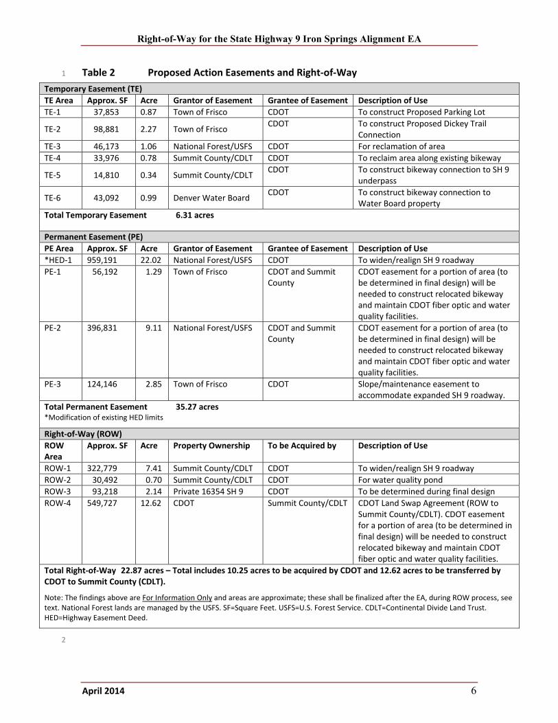
Table 2 Proposed Action Easements and Right‐of‐Way ........................................................... 6
Table 3 No Action Easements and Right‐of‐Way ...................................................................... 7
Figures
Figure 1 Proposed Action ........................................................................................................... 3
Figure 2 No Action Alternative (Previously Approved) .............................................................. 4
Figure 3 Map of Proposed Action Right‐of‐Way Impacts .......................................................... 5
Figure 4 Map of No Action Alternative Right‐of‐Way Impacts .................................................. 8
Right-of-Way for the State Highway 9 Iron Springs Alignment EA
April 2014 ii
ACRONYMS
CDLT Continental Divide Land Trust CDOT Colorado Department of Transportation EA Environmental Assessment EIS Environmental Impact Statement FHWA Federal Highway Administration HED Highway Easement Deed MP milepost PE Permanent Easement ROW right‐of‐way ROD Record of Decision SH 9 State Highway 9 SF square feet TE Temporary Easement USFS U.S. Forest Service
Right-of-Way for the State Highway 9 Iron Springs Alignment EA
April 2014 1
INTRODUCTION 1
This technical memorandum has been prepared in support of the State Highway (SH) 9 Iron 2
Springs Alignment Environmental Assessment (EA). This memorandum evaluates the effects of 3
the Iron Spring Alignment (Proposed Action) and the No Action Alternative (widening on the 4
existing alignment) with respect to existing right‐of‐way (ROW) conditions in the study area. 5
Parcel data along the existing SH 9 ROW were collected from the Summit County Assessor’s 6
Office. Descriptions of the publicly owned ROW (in Colorado Department of Transportation 7
[CDOT] ownership or under an easement agreement from the U.S. Forest Service [USFS]) along 8
SH 9 from the signalized intersections at Swan Mountain Road (milepost 92.9) and Recreation 9
Way (milepost 94.8). 10
To provide the necessary improvements for the Proposed Action and No Action Alternative, 11
additional ROW will need to be acquired between owners (referred to as property acquisitions). 12
Where residences or businesses occupy the property to be acquired, the displacement of 13
residences or businesses will result (referred to as displacements). In other cases, only a portion 14
of the land will be needed (referred to as partial acquisitions), leaving the remainder of the 15
property viable for the existing or planned land use. 16
Temporary Easements (TEs) for construction will also be needed to construct the improvements. 17
A temporary construction easement is a right granted for a specific period of time so that the 18
contractor can complete construction. Before relinquishing the TEs, the property is to be 19
returned as close as possible to its pre‐construction condition. Once the easements expire, the 20
rights granted return to the property owner. 21
Permanent Easements (PEs) and Highway Easement Deeds (HEDs) are rights granted by a 22
property owner that entitle the easement holder specific use of the property. The property 23
owner’s rights to use the land are determined by the agreement for the easement. 24
Right‐of‐way property acquisition is done in accordance with the Uniform Relocation Assistance 25
and Real property Acquisitions Policies Act of 1970 (Public Law 91‐646 as amended), as 26
described in the Mitigation section. The purpose of the Uniform Act is to provide consistent and 27
equitable treatment of all persons displaced from their homes, businesses, or farms. 28
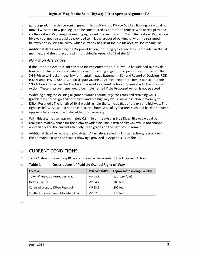
Proposed Action 29
As part of implementation of the SH 9 improvements between Frisco and Breckenridge, CDOT 30
and Federal Highway Administration (FHWA) are proposing to realign approximately 1.3 miles of 31
existing SH 9 just south of the Town of Frisco, Colorado (see Figure 1). This stretch of SH 9, 32
which falls between mileposts 93 and 95, would be realigned to provide a four‐lane reduced 33
section roadway away from Dillon Reservoir. This Proposed Action, also referred to as the Iron 34
Springs Alignment, would shorten SH 9 by approximately 0.4 mile. The Proposed Action would 35
provide roadway safety benefits, as well as water quality and drinking water protection benefits, 36
as a result of straightening the highway to remove a tight, compound curve (known as Leslie’s 37
Curve), which is in close proximity to Dillon Reservoir. The existing condition on Leslie’s Curve is 38
considered substandard and contributes to accidents in the area. 39
The Proposed Action would include realignment of a portion of the existing Frisco‐Farmer’s 40
Korner‐Blue River Bikeway (also referred to herein for brevity as the Blue River Bikeway or 41
bikeway). This portion of the bikeway would be moved to the alignment currently occupied by 42
SH 9, would be approximately 0.4 mile longer than the existing bikeway, and would be at a 43
Right-of-Way for the State Highway 9 Iron Springs Alignment EA
April 2014 2
gentler grade than the current alignment. In addition, the Dickey Day Use Parking Lot would be 1
moved west to a new parking lot to be constructed as part of the project, with access provided 2
via Recreation Way using the existing signalized intersection at SH 9 and Recreation Way. A new 3
bikeway connection would be provided to link the proposed parking lot with the realigned 4
bikeway and existing bikeway, which currently begins at the old Dickey Day Use Parking Lot. 5
Additional detail regarding the Proposed Action, including typical sections, is provided in the EA 6
main text and the project drawings provided in Appendix A1 of the EA. 7
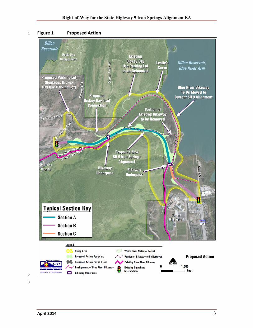
No Action Alternative 8
If the Proposed Action is not selected for implementation, SH 9 would be widened to provide a 9
four‐lane reduced section roadway along the existing alignment as previously approved in the 10
SH 9 Frisco to Breckenridge Environmental Impact Statement (EIS) and Record of Decision (ROD) 11
(CDOT and FHWA, 2004a; 2004b) (Figure 2). The 2004 Preferred Alternative is considered the 12
“No Action Alternative” for this EA and is used as a baseline for comparison with the Proposed 13
Action. These improvements would be implemented if the Proposed Action is not selected. 14
Widening along the existing alignment would require large rock cuts and retaining walls 15
(problematic to design and construct), and the highway would remain in close proximity to 16
Dillon Reservoir. The length of SH 9 would remain the same as that of the existing highway. The 17
tight Leslie’s Curve would not be eliminated; however, safety features such as a barrier between 18
opposing lanes would be installed to improve safety. 19
With this alternative, approximately 0.8 mile of the existing Blue River Bikeway would be 20
realigned to allow space for the highway widening. The length of bikeway would not change 21
appreciably and the current relatively steep grades on the path would remain. 22
Additional detail regarding the No Action Alternative, including typical sections, is provided in 23
the EA main text and the project drawings provided in Appendix A1 of the EA. 24
CURRENT CONDITIONS 25
Table 1 shows the existing ROW conditions in the vicinity of the Proposed Action. 26
Table 1 Descriptions of Publicly Owned Right‐of‐Way 27
Location Milepost (MP) Approximate Average Widths
Town of Frisco at Recreation Way MP 94.8 (120–150 feet)
Dickey Day Lot MP 94.2 (180 feet)
Curve adjacent to Dillon Reservoir MP 93.5 (200 feet)
South of curve at Swan Mountain Road MP 92.9 (120 feet)
28
Right-of-Way for the State Highway 9 Iron Springs Alignment EA
April 2014 3
Figure 1 Proposed Action 1
2
3
Right-of-Way for the State Highway 9 Iron Springs Alignment EA
April 2014 4
Figure 2 No Action Alternative (Previously Approved) 1
2 3
Right-of-Way for the State Highway 9 Iron Springs Alignment EA
April 2014 5
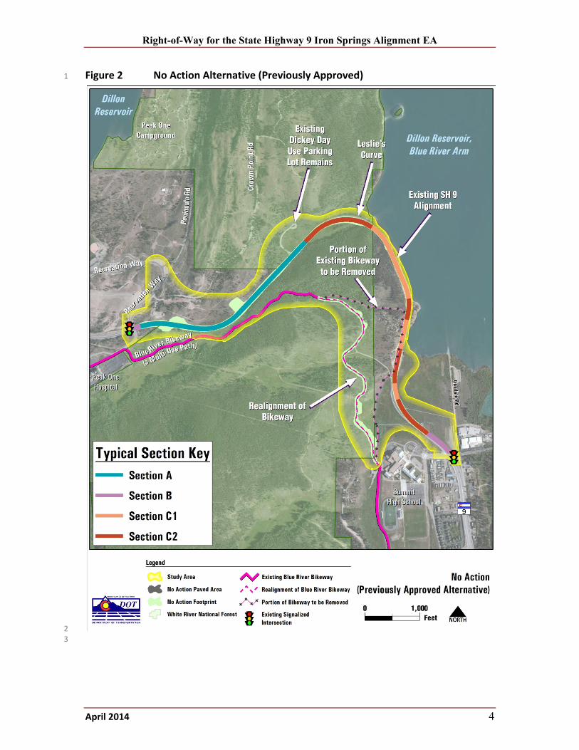
PROPOSED ACTION 1
Figure 3 and Table 2 summarize the impacts for the Proposed Action. 2
With the Proposed Action, the Blue River Bikeway would be relocated onto the current SH 9 3
alignment. The bikeway realignment would require an amendment of the existing USFS Special 4
Use Permit to Summit County for the countywide recreation path system. 5
Figure 3 Map of Proposed Action Right‐of‐Way Impacts 6
7
Right-of-Way for the State Highway 9 Iron Springs Alignment EA
April 2014 6
Table 2 Proposed Action Easements and Right‐of‐Way 1
Temporary Easement (TE)
TE Area Approx. SF Acre Grantor of Easement Grantee of Easement Description of Use
TE‐1 37,853 0.87 Town of Frisco CDOT To construct Proposed Parking Lot
TE‐2 98,881 2.27 Town of Frisco CDOT To construct Proposed Dickey Trail
Connection
TE‐3 46,173 1.06 National Forest/USFS CDOT For reclamation of area
TE‐4 33,976 0.78 Summit County/CDLT CDOT To reclaim area along existing bikeway
TE‐5 14,810 0.34 Summit County/CDLT CDOT To construct bikeway connection to SH 9 underpass
TE‐6 43,092 0.99 Denver Water Board CDOT To construct bikeway connection to
Water Board property
Total Temporary Easement 6.31 acres
Permanent Easement (PE)
PE Area Approx. SF Acre Grantor of Easement Grantee of Easement Description of Use
*HED‐1 959,191 22.02 National Forest/USFS CDOT To widen/realign SH 9 roadway
PE‐1 56,192 1.29 Town of Frisco CDOT and Summit County
CDOT easement for a portion of area (to be determined in final design) will be needed to construct relocated bikeway and maintain CDOT fiber optic and water quality facilities.
PE‐2 396,831 9.11 National Forest/USFS CDOT and Summit County
CDOT easement for a portion of area (to be determined in final design) will be needed to construct relocated bikeway and maintain CDOT fiber optic and water quality facilities.
PE‐3 124,146 2.85 Town of Frisco CDOT Slope/maintenance easement to accommodate expanded SH 9 roadway.
Total Permanent Easement 35.27 acres *Modification of existing HED limits
Right‐of‐Way (ROW)
ROW Area
Approx. SF Acre Property Ownership To be Acquired by Description of Use
ROW‐1 322,779 7.41 Summit County/CDLT CDOT To widen/realign SH 9 roadway
ROW‐2 30,492 0.70 Summit County/CDLT CDOT For water quality pond
ROW‐3 93,218 2.14 Private 16354 SH 9 CDOT To be determined during final design
ROW‐4 549,727 12.62 CDOT Summit County/CDLT CDOT Land Swap Agreement (ROW to Summit County/CDLT). CDOT easement for a portion of area (to be determined in final design) will be needed to construct relocated bikeway and maintain CDOT fiber optic and water quality facilities.
Total Right‐of‐Way 22.87 acres – Total includes 10.25 acres to be acquired by CDOT and 12.62 acres to be transferred by CDOT to Summit County (CDLT).
Note: The findings above are For Information Only and areas are approximate; these shall be finalized after the EA, during ROW process, see text. National Forest lands are managed by the USFS. SF=Square Feet. USFS=U.S. Forest Service. CDLT=Continental Divide Land Trust. HED=Highway Easement Deed.
2
Right-of-Way for the State Highway 9 Iron Springs Alignment EA
April 2014 7
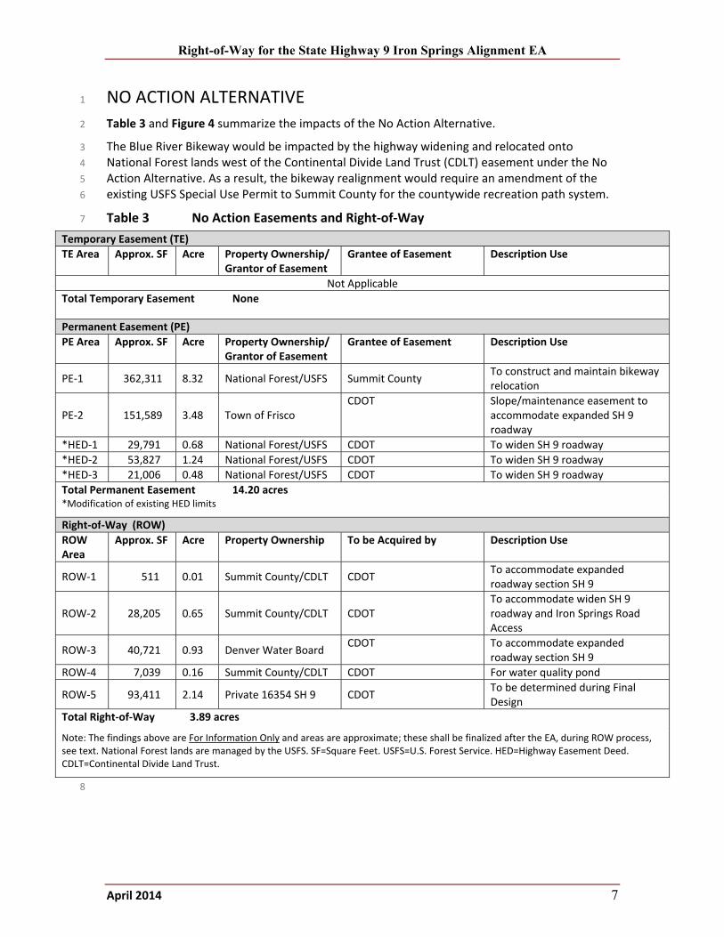
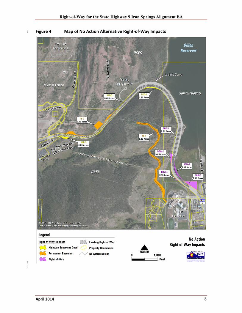
NO ACTION ALTERNATIVE 1
Table 3 and Figure 4 summarize the impacts of the No Action Alternative. 2
The Blue River Bikeway would be impacted by the highway widening and relocated onto 3
National Forest lands west of the Continental Divide Land Trust (CDLT) easement under the No 4
Action Alternative. As a result, the bikeway realignment would require an amendment of the 5
existing USFS Special Use Permit to Summit County for the countywide recreation path system. 6
Table 3 No Action Easements and Right‐of‐Way 7
Temporary Easement (TE)
TE Area Approx. SF Acre Property Ownership/Grantor of Easement
Grantee of Easement Description Use
Not Applicable
Total Temporary Easement None
Permanent Easement (PE)
PE Area Approx. SF Acre Property Ownership/Grantor of Easement
Grantee of Easement Description Use
PE‐1 362,311 8.32 National Forest/USFS Summit County To construct and maintain bikeway relocation
PE‐2 151,589 3.48 Town of Frisco CDOT Slope/maintenance easement to
accommodate expanded SH 9 roadway
*HED‐1 29,791 0.68 National Forest/USFS CDOT To widen SH 9 roadway
*HED‐2 53,827 1.24 National Forest/USFS CDOT To widen SH 9 roadway
*HED‐3 21,006 0.48 National Forest/USFS CDOT To widen SH 9 roadway
Total Permanent Easement 14.20 acres *Modification of existing HED limits
Right‐of‐Way (ROW)
ROW Area
Approx. SF Acre Property Ownership To be Acquired by Description Use
ROW‐1 511 0.01 Summit County/CDLT CDOT To accommodate expanded roadway section SH 9
ROW‐2 28,205 0.65 Summit County/CDLT CDOT To accommodate widen SH 9roadway and Iron Springs Road Access
ROW‐3 40,721 0.93 Denver Water Board CDOT To accommodate expanded
roadway section SH 9
ROW‐4 7,039 0.16 Summit County/CDLT CDOT For water quality pond
ROW‐5 93,411 2.14 Private 16354 SH 9 CDOT To be determined during Final Design
Total Right‐of‐Way 3.89 acres
Note: The findings above are For Information Only and areas are approximate; these shall be finalized after the EA, during ROW process, see text. National Forest lands are managed by the USFS. SF=Square Feet. USFS=U.S. Forest Service. HED=Highway Easement Deed. CDLT=Continental Divide Land Trust.
8
Right-of-Way for the State Highway 9 Iron Springs Alignment EA
April 2014 8
Figure 4 Map of No Action Alternative Right‐of‐Way Impacts 1
2
3
Right-of-Way for the State Highway 9 Iron Springs Alignment EA
April 2014 9
CONSEQUENCES 1
Consequences of the Proposed Action 2
The highway horizontal curve adjacent to the Denver Water property would be flattened 3
to meet a 50 mile per hour design speed. The new highway curve would be supported by 4
a cantilevered fill wall system to allow the vertical profile to elevate up toward Iron 5
Springs. This configuration avoids the Denver Water Board property acquisition ROW‐3 6
as required in the No Action Alternative and indicates the potential for minimizing or 7
avoiding impacts to the Antler House residential structure and property access located at 8
16354 SH 9. Possibilities to avoid or minimize impacts to the Antler House will be 9
evaluated in final design. 10
A cantilevered fill wall system continues north and connects to a pedestrian underpass 11
located at Iron Springs Road. This segment of highway requires acquisition of 12
approximately 7.41 acres identified as ROW‐1 and would be property owned by Summit 13
County with an easement held by CDLT. The acquisition of ROW‐1 is part of a proposed 14
land exchange, replacing ROW‐1 with parcel ROW‐4 (consisting of 12.62 acres), along 15
with other project features that will be constructed as described in the Iron Spring Open 16
Space Proposed Amendment and Restatement of the Deed of Conservation Easement 17
Continental Divide Land Trust White Paper (March 29, 2013). 18
North of the pedestrian underpass, near Iron Springs Road, are cantilevered fill walls that 19
transition to 3:1 cut slopes resulting in the need for property acquisition from USFS. This 20
property acquisition from the USFS would be obtained through a new HED and 21
Agreement of Understanding that is based on the following stipulations: 22
o On‐site and off‐site mitigations for direct impact to National Forest land 23
o Iron Springs Open Space Proposed Amendment and Restatement of the Deed of 24
Conservation Easement Continental Divide Land Trust White Paper (CDLT, 2013) 25
Inside the Town of Frisco limits, there are segments where highway cut slopes do not fit 26
inside the existing 120 to 150 feet of ROW. As a result, a slope/maintenance easement 27
would be required to construct the ultimate four‐lane roadway section. 28
A portion of the Blue River Bikeway would be relocated to the existing SH 9 roadway 29
(positioned between the two new pedestrian underpasses), which connects back to 30
existing bikeway conditions. The property acquisition required for the Blue River Bikeway 31
relocation will be based on the CDOT/Summit County/CDLT Land Swap Agreement and 32
appropriate land use authorization with the USFS. 33
Consequences of the No Action Alternative 34
The horizontal curve north of the Antler House residence located at 16354 SH 9 would be 35
flattened to meet a 50 mile per hour design speed. The new highway curve would be 36
shifted toward the reservoir and would directly impact the residential structure and 37
property access. This is shown as a property acquisition in the EIS and ROD (CDOT and 38
FHWA, 2004a; 2004b). 39
Additional fill retaining walls are required in locations along the reservoir to minimize 40
impacts. Conceptual design of these retaining walls suggests they would fit inside the 41
existing ROW. However, construction of these retaining walls would require special 42
permits and would have unique structural requirements due to the close proximity to 43
reservoir water elevations. 44
Right-of-Way for the State Highway 9 Iron Springs Alignment EA
April 2014 10
On the west side of the highway adjacent to the reservoir are large scale rock cuts 1
required to allow for additional space to construct the ultimate four‐lane roadway 2
section. Property acquisition would be required from Summit County and CDLT easement 3
for this construction. 4
Property acquisition from the USFS would be obtained through a new HED agreement. 5
This is consistent with existing management prescriptions and would not require an 6
amendment to the White River National Forest Land and Resources Management Plan 7
(USFS, 2002). 8
Inside the Town of Frisco limits, there are segments where highway cut slopes do not fit 9
inside the existing 120 to 150 feet width. As a result, a slope/maintenance easement 10
from the Town of Frisco would be required to construct the ultimate four‐lane roadway 11
section. 12
A portion of the Blue River Bikeway would be relocated due to the widening of the 13
existing SH 9 that would directly impact a segment of the existing bikeway system. As a 14
result, an amendment of the existing USFS Special Use Permit to Summit County for the 15
countywide recreation path system would be required to construct the bikeway 16
realignment. 17
MINIMIZATION 18
In the development of conceptual design for the No Action Alternative and Proposed Action, 19
respectively, efforts have been made to avoid and minimize ROW and relocation impacts to the 20
extent feasible. This was done with alignment decisions and the use of engineering features, 21
including a number of complex retaining walls. 22
REGULATORY INFORMATION 23
Acquisition Statement 24
According to CDOT (2013): For any person(s) whose real property interests may be impacted by 25
this project, the acquisition of those property interests will comply fully with the Uniform 26
Relocation Assistance and Real Property Acquisition Policies Act of 1970, as amended (Uniform 27
Act). The Uniform Act is a federally mandated program that applies to all acquisitions of real 28
property or displacements of persons resulting from federal or federally assisted programs or 29
projects. It was created to provide for and ensure the fair and equitable treatment of all such 30
persons. To further ensure that the provisions contained within this act are applied “uniformly,” 31
CDOT requires Uniform Act compliance on any project for which it has oversight responsibility 32
regardless of the funding source. Additionally, the Fifth Amendment of the U.S. Constitution 33
provides that private property may not be taken for a public use without payment of “just 34
compensation.” All impacted owners will be provided notification of the acquiring agency’s 35
intent to acquire an interest in their property including a written offer letter of just 36
compensation specifically describing those property interests. A ROW specialist will be assigned 37
to each property owner to assist them with this process. 38
Right-of-Way for the State Highway 9 Iron Springs Alignment EA
April 2014 11
Relocation Statement 1
According to CDOT (2013): In certain situations, it may also be necessary to acquire 2
improvements that are located within a proposed acquisition parcel. In those instances where 3
the improvements are occupied, it becomes necessary to “relocate” those individuals from the 4
subject property (residential or business) to a replacement site. The Uniform Act provides for 5
numerous benefits to these individuals to assist them both financially and with advisory services 6
related to relocating their residence or business operation. Although the benefits available 7
under the [Uniform Relocation Assistance and Real Property Acquisition Policies Act of 1970, as 8
amended, (Uniform Act)] are far too numerous and complex to discuss in detail in this 9
document, they are available to both owner occupants and tenants of either residential or 10
business properties. In some situations, only personal property must be moved from the real 11
property and this is also covered under the relocation program. As soon as feasible, any person 12
scheduled to be displaced shall be furnished with a general written description of the displacing 13
agency’s relocation program that provides, at a minimum, detailed information related to 14
eligibility requirements, advisory services and assistance, payments, and the appeal process. It 15
shall also provide notification that the displace person(s) will not be required to move without at 16
least 90 days advance written notice. For residential relocatees, this notice cannot be provided 17
until a written offer to acquire the subject property has been presented, and at least one 18
comparable replacement dwelling has been made available. Relocation benefits will be provided 19
to all eligible persons regardless of race, color, religion, sex, or national origin. Benefits under 20
the [Uniform] Act, to which each eligible owner or tenant may be entitled, will be determined 21
on an individual basis and explained to them in detail by an assigned ROW Specialist. 22
MITIGATION 23
Property acquisition for ROW will conform to the requirements set forth in the Uniform 24
Relocation Assistance and Real Property Acquisitions Policies Act of 1970 (Public Law 91‐646 as 25
amended). 26
In cases where CDOT needs property currently owned by public agencies for highway 27
construction, CDOT typically obtains the required property using some type of 28
intergovernmental agreement covering either acquisition of the property or easement. For 29
National Forest land that is needed, the required property will be obtained through a new HED, 30
which may include stipulations for impacts to National Forest resources and funding of USFS 31
vegetation mitigation activities. Property needs from the Summit County/CDLT open space 32
parcel will be acquired through a land exchange for the adjacent area currently occupied by 33
SH 9. 34
For all property acquired, CDOT must offer the property owner just compensation. Also, under 35
Colorado Revised Statute 38‐1‐121, CDOT is required to pay the reasonable cost of the property 36
owner’s appraisal, provided: (1) the estimated value of the property to be acquired is more than 37
$5,000; (2) the appraisal is made using sound, fair, and recognized appraisal practices consistent 38
with the law; and (3) two signed originals of the appraisal are submitted to CDOT within 90 days 39
of the date of notification of the property owner of this statute. Relocation benefits would be 40
provided to eligible displacees. 41
Right-of-Way for the State Highway 9 Iron Springs Alignment EA
April 2014 12
Relocation Planning 1
Prior to relocation, CDOT staff will prepare a relocation analysis that will enable the relocation 2
activities to be planned so that the problems associated with the displacement of individuals, 3
families, and businesses are recognized and so that solutions are developed to minimize the 4
adverse impacts of displacement. The scope of planning will be based on the complexity and 5
nature of the anticipated displacing activity, including the evaluation of program resources 6
available to carry out timely and orderly relocations. The relocation study will include the 7
following: 8
A current estimate of the number of households to be displaced, including information 9
such as owner/tenant status, estimated value and rental rates of the property to be 10
acquired, family characteristics, and special consideration of impacts on minorities, the 11
elderly, large families, and the handicapped, when applicable 12
An estimate of the number of comparable replacement dwellings in the area (including 13
the price ranges and rental rates) that are expected to be available to fulfill the needs of 14
those households displaced (when an adequate supply of properties for displacees to be 15
relocated into is NOT available, CDOT must take actions or make assurances to address 16
the inadequate supply before it can start any relocation activities) 17
An estimate of the number, type, and size of the businesses and nonprofit organizations 18
to be displaced and the approximate number of employees that may be affected 19
Consideration of any special advisory services that may be necessary from CDOT and 20
cooperating agencies 21
Relocation Assistance 22
Relocation assistance advisory services will include: 23
Determining the relocation needs and preferences of each person to be displaced and 24
explaining the relocation benefits and other assistance for which the person may be 25
eligible 26
Providing current and continuing inventory of available residential and business 27
properties to purchase or lease, and information about such properties 28
Minimizing hardships to persons adjusting to relocation by providing counseling, advice, 29
and other sources of assistance that may be available and other help as may be 30
appropriate 31
Supplying the person to be displaced with appropriate information concerning federal, 32
state, and local housing programs administered by the Small Business Administration, 33
and other programs offering assistance to the displaced persons, as well as technical help 34
to persons applying for such assistance 35
Right-of-Way for the State Highway 9 Iron Springs Alignment EA
April 2014 13
REFERENCES 1
Colorado Department of Transportation (CDOT). 2013. CDOT NEPA Manual, Version 3. 2
Appendix F, Standard Language. Accessed September 26, 2013. 3
http://www.coloradodot.info/programs/environmental/nepa‐program/nepa‐manual/appendix‐4
f‐standard‐language/view 5
Colorado Department of Transportation (CDOT) and Federal Highway Administration (FHWA). 6
2004a. State Highway 9 Frisco to Breckenridge Final Environmental Impact Statement and 4(f) 7
Evaluation. February. [Note: This document is an abbreviated Final EIS which incorporates the 8
Draft EIS, constituting the complete Final EIS.] 9
Colorado Department of Transportation (CDOT) and Federal Highway Administration (FHWA). 10
2004b. State Highway 9 Frisco to Breckenridge Record of Decision. May. 11
Continental Divide Land Trust (CDLT). 2013. Iron Springs Open Space Proposed Amendment and 12
Restatement of the Deed of Conservation Easement White Paper. March. 13
U.S. Forest Service (USFS). 2002. Land and Resource Management Plan—2002 Revision for the 14
White River National Forest. Accessed 2013. 15
http://www.fs.usda.gov/Internet/FSE_DOCUMENTS/fsbdev3_000999.pdf 16