Embed Size (px)
Citation preview

RIGHT OF WAY ENGINEERING MANUAL
PREPARATION OF RIGHT OF WAY DOCUMENTS
February 2005
Prepared by Right of Way Engineering
U.S. Customary English Units

Table Of Contents
Section Title Page
1.0 Introduction 1
2.0 Definitions And Abbreviations 1
3.0 Row Document Preparation Schedule 5
4.0 Documents Required 6
5.0 Material Specifications 6
6.0 ROW Parcels To Be Acquired 7
7.0 Common Row Easements Parcels 7
8.0 Denial Of Access Parcels 8
9.0 Row Document Preparation - General Information 8
A. Entire Tract Map 8
1. Key Sheet 8
a. Checklist 8
b. Procedures 9
2. Checklist For Remaining ETMs 10
3. Procedures For ETM Preparation 10
B. General Property Parcel Map 12
1. Checklist (Except For Tab Sheet) 12
2. Procedures 13
3. Tab Sheet 27
a. Checklist 27
b. Procedures 27
C. IPM Preparation 28
1. Checklist 28
2. Procedures 29
3. IPM Reviewer Checklist 33
4. Descriptions 34
a. Checklist 34
b. Procedures 34
c. Writing Procedures 34
d. Description Clauses 35
Attachment A 52
Attachment B 53

Table Of Contents (Continued)
Section Title Page
Attachment C 54
Attachment D 55
Attachment E 56
Attachment F 57
Attachment G 58
Attachment H 59
Attachment I 60
Attachment J 61
Attachment K 62
Attachment L 63
Attachment M 64
10.0 Application Of Upland Owner On Tidal Water For A Lease Or
License /Grant Of Riparian Land
65
11.0 Row Document Submissions 66
A. General 66
B. Submission Packaging 66
Attachment N 67
Attachment O 68
12.0 ROW Engineering Process 69
A. Consultant Designer 69
B. In House Designer 71
13.0 Process For Eliminating A Parcel 73
14.0 Process For Revising A Parcel 73
15.0 Process For A Condemnation Case 74
16.0 ROW Parcel Dedication Requirements 75

Right Of Way Engineering Manual 1
1.0 Introduction
These procedures have been developed to establish uniformity in the preparation of
ROW Maps and Descriptions.
Scoping procedures outlined in the Capital Project Procedures, balanced among many
other factors, impact the proposed design along with the ROW impacts. This limits, but
does not preclude, the designer from adjusting the proposed ROW acquisitions to
minimize their size and impact upon the remaining property. The designer should also
be aware that the ROW design does not have to follow the precise contours of the
roadway (e.g.: slopes). Where it appears that it may be beneficial, the ROW line and
easement lines may be reasonably expanded to enhance the ease of construction of
the project. The designer may also reduce the ROW width of the normal typical section
in order to eliminate small acquisitions, small easements and to avoid sensitive areas
or structures, etc. The designer, therefore, shall prepare the ROW design, balancing
the impact upon the property and the cost of acquisition while maintaining the safety,
constructability, cost of construction and staying within the basic scope of the project.
This manual is to be used on NJDOT projects, as well as Public Transportation
projects, Local Aid projects and Developer projects. Every instance that a designer
may encounter is not covered in this manual. When used in conjunction with sound
engineering, surveying knowledge and good judgment, this manual should enable the
designer to prepare accurate ROW documents efficiently.
2.0 Definitions And Abbreviations Used
AGRICULTURAL DEVELOPMENT AREA (ADA) (with 8 year deed restrictions): Property
that cannot be used for other than agriculture for 8 years. The property owner enters
into an agreement with the County Agriculture Board resulting in a restrictive
covenant being attached to the property.
AGREEMENT: Contract between the owner of the subject property and the
Department of Transportation for conveyance of fee or lesser interest of lands set
forth in the description; conveys equitable title as compared to legal title.
ACQUISITION SECTION OF TECHNICAL SUPPORT (AS): Section within the office of
ROW responsible for handling condemnation cases.
BLOCK: A square or portion of an incorporated municipality as shown on the official
municipal tax map; a grouping of lots assigned the same number on the official tax
map.
BOARD DATE: The date that the research records are updated to for each county.
This date may be obtained from personnel in the county‟s record room.
BUREAU OF ENVIRONMENTAL PROJECT SUPPORT (BEPS): Office responsible for all
environmental recommendations within the NJDOT.

Right Of Way Engineering Manual 2
CONDEMNATION: The act of filing of a complaint seeking entry of a final judgment
confirming the proper exercise of the Power of Eminent Domain and the recording of a
Declaration of Taking in the Book of Deeds with the County recording officer.
COURSE: A boundary of a property that can be described by distance, bearing and/or
arc length.
DECLARATION OF TAKING (DT): The means by which title to a property is acquired
after a condemnation complaint is filed.
DEED: Conveyance of legal title; a writing signed by the owner of the property
conveying real property to another.
DESCRIPTION: The legal description of the property identifying the location,
including, but not limited to county, municipality, street, street number block and lot,
metes and bounds of the property, as well as description of the easement rights, if
any.
DOMINANT ESTATE PARCEL (DE): A parcel containing an existing private (access,
parking or other similar type) easement owned by another entity encumbering a fee
parcel being acquired.
EASEMENT: A right to use land of another for a specific or particular purpose
consistent with the grant under which it was made.
EMINENT DOMAIN: The power of government to acquire real property, including
improvements, subject to the provisions of the Eminent Domain Law of 1971.
ENCUMBRANCE: A lien upon real property.
ENTIRE TRACT MAP (ETM): A plan used to show the location of all parcels to be
acquired and their remaining area. This map shall be signed and sealed by a New
Jersey licensed surveyor and filed by NJDOT‟s Office of Title in the County courthouse
where the deed was obtained.
ET AL: And others, and another.
ET CON: And husband, also ET VIR.
ET SEQ: And following.
ET UX: And wife.
GENERAL PROPERTY PARCEL MAP (GPPM): A plan used to show the property to be
acquired. This map shall be signed and sealed by a New Jersey licensed surveyor and
filed by NJDOT‟s Office of Title in the County courthouse where the deed was obtained.
GRANT: An instrument that conveys some estate or interest in the lands that it
embraces.
Right Of Way Engineering Manual 3
GRANTEE: The person to whom a grant is made; the one who acquires the property.
GRANTOR: The person by whom a grant is made; the one who transfers the property.
INDIVIDUAL PARCEL MAP (IPM): A plan that depicts a parcel and related parcels,
having unity of ownership and associated easements. It is used for appraising and
negotiating acquisition; it is also used as the map attached as an exhibit to a
condemnation complaint and declaration of taking where and when condemnation is
pursued. It must be based upon and totally consistent with the GPPM.
KEY SHEET: The first ETM sheet. It identifies the area to be acquired for the ROW of a
specific section of a highway.
LOT: A fractional part or subdivision of a block, according to a survey.
MEAN HIGH WATER LINE (MHWL): The line formed by the intersection of the tidal
plane of mean high tide with the shore.
METES AND BOUNDS: A description of real property which begins at a specified
starting point (point of beginning or P.O.B.) and proceeds, clockwise or counter
clockwise, around the parcel or easement utilizing directions, distances (metes) and
monuments (bounds) as descriptive elements of the property lines and property
corners. An area is also generally given in the deed. This type of land description is
usually based on an actual land survey.
MONUMENTS: Tangible landmarks indicating boundaries.
NEW JERSEY DEPARTMENT OF TRANSPORTATION (NJDOT): The department of the
State of New Jersey responsible for the State highway system.
NORTH AMERICAN DATUM 1983 (NAD 83): The official plane coordinate system for
the NJDOT.
OFFICE OF ACCESS DESIGN (OAD): Office with the responsibility for all access issues
relating to State highway projects. They review and set the driveway design within the
limits of the project.
PARCEL: Property to be acquired for highway purposes, described by metes and
bounds.
PROJECT MANAGER (PM): Representative of the NJDOT who oversees the project.
REMAINING AREA (RA): Property retained by the owner of the fee after a portion of
the fee parcel is acquired, including areas of any associated easements.
RIGHT OF ENTRY (ROE): A right to enter the property of another for a temporary
purpose given by the owner of the fee to the NJDOT. This is to be obtained by a
representative of the NJDOT. This can also include the right to enter prior to
commencement of condemnation or tender of a deed for a permanent easement or

Right Of Way Engineering Manual 4
parcel. It is always to be in writing, signed by the owner of the property or authorized
corporate officer where a corporation is involved.
RIPARIAN GRANT: The grant by the State Tidelands Resource Council of its right to
area within the flow of the mean high tide or which was historically flowed by the
mean high tide and was artificially filled in without the appropriate consent or
permission of the State, as reflected upon the tidal claims map maintained by the N. J.
Department of Environmental Protection, Division of Coastal Resources, Bureau of
Tidelands.
RIPARIAN RIGHTS: The rights of the owner of land on the bank of a watercourse
relating to the water, its use and ownership of soil under the watercourse. In Section
2.0, the term is used only to describe those rights of landowners abutting on tide
flowed lands.
RIGHT: A real estate interest in a property (e.g. access, drainage, slope, etc.)
RIGHT OF WAY (ROW): Land owned or to be acquired by NJDOT for highway
purposes.
RIGHT OF WAY ENGINEERING (ROWE): The unit that is responsible for the in-house
design of ROW documents and the review of design consultants‟ documents.
SERVIENT ESTATE PARCEL (SP): A parcel to be acquired that is encumbered by an
existing private (access, parking or other similar type) easement owned by another
entity.
SLOPE RIGHTS: An easement over the lands of others abutting the ROW line, upon
which cuts and fills may be constructed and maintained subject to the terms thereof.
TAB SHEET: The last GPPM sheet. It contains a tabulation or listing of owners.
TIDAL WATERS: Any watercourse affected by tides.
TIDELANDS CLAIM LINE: The line that defines the lands now or formerly flowed by
the mean high water line and claimed by the State of New Jersey.
TITLE: Ownership. Shown on ETMs, GPPMs and IPMs adjacent to the parcel bubble.
UNDERGROUND STORAGE TANKS (UST): Subsurface containers which (1) store
motor fuel for noncommercial purposes (more than 1100 Gal.), (2) store heating oil
(more than 200 Gal.) or (3) store any quantity of fuel/oil for commercial purposes.
Sites that have such containers are subject to the NJDEP regulations.

Right Of Way Engineering Manual 5
3.0 Row Documents Preparation Schedule
Schedule
In order to prepare the ROW documents and at the same time minimize acquisition
delays, the following schedule is established for ROW document submissions. All days
are calendar days. See Attachment N for submission requirements.
A. An Initial Meeting with the PM, the ROWE Unit, a representative from the ROW
Technical Support Unit and the designer shall be held prior to the development of
any ROW documents. The ROWE Unit will supply the designer with sample ETMs,
GPPMs, IPMs and descriptions at the meeting (These samples may be obtained
earlier, upon request to ROWE.). The designer is responsible for scheduling the
meeting. When a sub-consultant will be preparing the ROW documents, the prime
consultant shall also attend the meeting. The ROW procedure will be customized
for the project at this meeting.
B. A Preliminary Design (PD) ROW Plan Submission shall be sent to the Director,
Division of ROW, ATTN: Project Coordination & Funding in accordance with the
schedule established by the PM for consultant-designed projects and in
coordination with the In-House Production Manager for In-House projects. These
submission requirements are not listed in ATTACHMENT N. It shall contain two
sets of prints of the GPPMs (without the Alignment Schematic Plan and Tab
Sheet); each sheet shall be stamped with “PD ROW PLAN”. This submission is to
be used by the Division of ROW to refine their cost to acquire estimate and to
submit for funding.
C. A Preliminary ROW Submission shall be submitted as denoted in ATTACHMENT N
and in accordance with the schedule established by the PM. ROWE will perform a
quality assurance review and review of the documents to assure conformance to
current standards. Comments will be returned to the designer approximately 3 to
4 weeks after the Preliminary Submission has been received.
D. A Pre-Final ROW Submission shall be submitted directly to ROWE only,
approximately two to four weeks before the Final Submission date as established
by the PM. The submission requirements are not listed in ATTACHMENT N. The
submission shall contain two sets of prints of the ETMs, GPPMs, one set of
descriptions and a portion of the IPMs as directed by ROWE. This review will insure
that all Preliminary Submission comments have been addressed, allow ROWE to
review any new or changed parcels/descriptions and to insure the accuracy of all
ROW documents before the extensive printing required for the Final Submission.
E. A Final ROW Submission shall be submitted as denoted in ATTACHMENT N and in
accordance with the schedule established by the PM. The letter of transmittal shall
state the number of parcels to be acquired for the contract and list all parcels that
were changed since the preliminary submission.
Note: Any change in these schedules must be requested through the PM.

Right Of Way Engineering Manual 6
4.0 Documents Required
Documents required in the preparation of ROW maps include, but are not limited to:
Metes and bounds survey of the property to be acquired in accordance with
N.J.S.A. 46:23-9.9 et seq. & N.J.A.C. 13:40-5.1, (f), (g), (h), (I) and (j)
(minimum survey detail requirements as promulgated by the State Board of
Professional Engineers and Land Surveyors), whether an entire or a partial
acquisition.
Latest deeds, wills, all easements, leases and other property rights documents
on each property involved.
Current development maps, tax maps, zoning maps, county maps or master
plans.
Road return books, where applicable.
Filed maps establishing public rights of way.
Vacations for streets that have been abandoned.
Dedications and acceptance.
Subdivision Plans and Site Plans (Preliminary and/or final).
Municipal Resolutions.
Status of Paper Streets.
These documents will be helpful in laying out the existing properties and showing
existing public ROW in all affected areas where ROW maps are needed.
5.0 Material Specifications
Plan sheets for ETMs and GPPMs shall be of synthetic film, such as Mylar, and shall be
4 mils thick and matted on both sides. Markings shall be in ink and must be
permanent. Mylars to be submitted must also be permanent with ink that does not
come off with handling. Erasures and changes shall be made in accordance with
instructions given for the material used so as not to harm the permanent original
tracing.
IPMs shall be submitted on print paper and are limited to a maximum (as measured
from the cutting edge) of 30" x 42". Parcels may be submitted on 8 ½” x 13", 11” x
17”, 15” x 17”, 15” x 21”, 18” x 24”, 22” x 36” and 24” x 36” size paper. For large
parcels where match lines are necessary, plan sheets are limited to 22” x 36”. The
designer should use the smallest legible map size that shows the parcel and conforms
to the requirements of Section 9.0.
Parcel descriptions shall be prepared on 8 ½” x 11” paper. Descriptions for the Final
ROW submission are also submitted on 3.5” diskettes or other formats, when
approved by ROWE.
ETM and GPPM plans shall be prepared on 22” x 36” sheets.

Right Of Way Engineering Manual 7
Riparian Grant applications shall be prepared on 8 ½” x 11” paper.
6.0 Row Parcels To Be Acquired
The property to be acquired by the State of New Jersey for highway purposes is
accomplished by “fee” parcels. These parcels appear on ETMs, GPPMs, IPMs, and in
descriptions. Guidance for the preparation of “fee” parcels is contained in each of
those sections.
The types of “fee” parcels are as follows:
Entire acquisition - Whole property is acquired with no RA.
Partial acquisition – An unencumbered portion of the property is acquired and
the owner has RA.
Riparian - A parcel to be acquired within actual flowing tidal waters. Use “T”
with the parcel number.
Utility - A parcel to be acquired to provide replacement for the utility company's
land interest lost under the terms of an "Order" or "Agreement" issued by the
NJDOT. Use “U” with the parcel number.
Servient Estate - A parcel to be acquired containing an existing private
easement (access, parking or other similar type) encumbering the subject
property. Use "SP" with the same parcel number as that of the unencumbered
fee. (See Attachments A and B)
Dominant Estate – A parcel to be acquired containing an existing private
easement (access, parking or other similar type) encumbering a neighboring fee
parcel. Use "DE" with a parcel number designated for the owner of the
easement (a different number than that of the servient estate parcel number).
(See Attachments A and B)
Remainder Acquisitions - Parcels acquired that are beyond the Proposed ROW
Line of the approved Typical Section, that may be used for temporary
construction, future mitigation or acquired due to economic reasons
(uneconomic remainder, landlocked parcels), etc. These parcels may be
considered for private sale at a future date. Use the next available letter with
the parent parcel number (“X” is no longer to be used).
7.0 COMMON ROW EASEMENTS PARCELS
The acquisition of property rights less than a fee interest, for a particular use by the
State for highway purposes, is accomplished by easement parcels. These parcels
appear on ETMs, GPPMs, IPMs, and in descriptions. Guidance for the preparation of
“easement” parcels is contained in each of those sections.
The most common types of easement parcels are as follows:
Slope - E parcels
Grading - E parcels

Right Of Way Engineering Manual 8
Drainage - E parcels
Temporary Diversionary Road - E parcels
Utility - UE and AE parcels
Bridge - E parcels
Construction and Maintenance - E parcels
Site - S parcels
Private - PE and PAE parcels
Sight Triangle - E parcels
Temporary Site Mitigation Work - S parcels
Temporary Site Alternative Access Work – S Parcels
8.0 Denial Of Access Parcels
A Denial of access parcel is a separate category from those in Sections 6.0 and 7.0.
They are parcels set up for limiting direct access only and are designated as “DA”
parcels. Use the following procedure:
A. Delineate “NO ACCESS”.
B. Delineate every point at which access is denied by acquisition by a vertical leader
line and arrows.
C. Show no area.
Note: For access that is denied administratively or by regulation, see Section 9.0, B.,
2., m., 4) and Section 9.0, C., 2., c.
9.0 Row Documents Preparation-General Information
The preparation of all ROW maps shall comply with N.J.S.A. 46:23-9.9 et seq. and
N.J.A.C. 13:40-5.1, (f), (g), (h), (I) and (j) (minimum survey detail requirements as
promulgated by the State Board of Professional Engineers and Land Surveyors). The
ROW Title Unit or other designated unit within the NJDOT will file each sheet of the
ETMs with the appropriate County recording officer when all parcels contained within
an individual ETM have been acquired. Also, place a combined Map Filing
Statement on the Key Sheet in the lower left corner of the Key Sheet (see
CHECKLIST below).
A. ENTIRE TRACT MAP:
1. KEY SHEET
a. CHECKLIST
Scale
Title Block/Surveyor‟s Title Block
Construction project reference
Map showing location of the project
Corporate lines
North Arrow
The term KEY MAP

Right Of Way Engineering Manual 9
Limits of ROW section
Adjacent ROW section(s)
Designer‟s name
Project location
Map Filing Statement
b. PROCEDURES
1) The Key Sheet shall be the first sheet, covering the entire ROW
section. It should indicate the project area, showing partial coverage
of adjoining sections, including mileposts and stations at the beginning
and end of the ROW project.
2) The Key Sheet shall be prepared at a convenient scale to show the
entire ROW section plus partial coverage of the adjacent ROW
section(s). The New Jersey licensed Land Surveyor‟s Title Block is
required on all ETMs, shall comply with N.J.A.C. 13:40-1.1, 1.2, and
1.3, et seq. (including signature and original seal) and shall be placed
above the NJDOT Title Block or in the lower left corner as an alternate
location. ROWE will supply a sample of the licensed Land Surveyor‟s
Title Block at the Initial Meeting.
3) Place the Title Block in the lower right hand corner. Use the standard
NJDOT Title Block, 3.5” x 6”. A sample Title Block is provided at the
end of Section 9.0, ATTACHMENT C. Obtain the Title Block information
from the ROWE Unit. See Attachment C; substitute “ENTIRE TRACT
MAP” for “GENERAL PROPERTY PARCEL MAP”. See 3. b. under
PROCEDURES FOR ETM PREPARATION for information on the Licensed
Land Surveyor‟s Title Block.
4) Place the name of the construction project to the left of the Title Block
as a reference for this ROW project.
5) Center the map on the sheet. It shall show corporate lines, names of
counties, municipalities, major highways, streets, any geographical
and man made features (lakes, rivers, railroads, etc.)
6) Show the North Arrow from the ROW Standard Legend that depicts
the basis for the northing orientation.
7) Center the term KEY MAP below the map showing the project location
with a bar scale also centered below.
8) Show the limits of the ROW section outside of the KEY MAP by lines
extending into the map to the locations on the subject route that are
the beginning and end of that section.
9) Show a portion of the adjacent ROW sections in the same manner as
in 8) above. The portion shown should be enough to readily identify

Right Of Way Engineering Manual 10
the adjacent ROW sections and can be determined at the Initial
Meeting when the consulting designer is unsure of the limits.
10) Show the designer‟s name on the outside of the left longitudinal
border starting at the lower left hand corner of the border.
11) Show the ROW project location by highlighting the subject route on
the KEY MAP and designating the limits of the ROW project in a similar
method to the NJDOT Sample Plans for construction projects,
available from the Bureau of Quality Management Services,
Engineering Documents Unit.
12) Show the Map Filing Statement in the lower left corner of the sheet. It
should state the total number of sheets and break out the number of
ETMs and GPPMs. For example, 10 SHEETS FILED IN THE OFFICE OF
THE MERCER COUNTY CLERK, 3 ETMS AND 7 GPPMS. Leave one line
of space below the above statement and add DATE. Add FILE NO on
the next line below. This statement is not required on any other sheet.
2. CHECKLIST FOR REMAINING ETMS
Scale
Title Block/Surveyor‟s Title Block
North Arrow
Revision Block
Designer‟s name
Baselines (Existing & Proposed)
Block and lot for each property
Existing deed information when not shown on the GPPMs
Proposed parcels
Parcel numbers
Entire Property shown
Adjacent owners
Building and structures
Municipal and county lines
GPPM layout
3. PROCEDURES FOR ETM PREPARATION
a. Scale: 1” = 100‟ throughout (Other scales may be used if approved by the
ROWE Unit). Inserts at other scales are permissible, if necessary for
clarification. Show the entire areas of the properties involved. Map
coverage shall be complete and continuous end to end of the project.
Either Match Lines or the overlap method is acceptable.
b. Use the standard NJDOT Title Block, 3.5” x 6”. A sample Title Block is
provided at the end of Section 9.0, Attachment C. The New Jersey licensed
Land Surveyor‟s Title Block is required on all ETMs, shall comply with
N.J.A.C. 13:40-1.1, 1.2, and 1.3, et seq. (including signature and original

Right Of Way Engineering Manual 11
seal) and shall be placed above the NJDOT Title Block or in the lower left
corner as an alternate location. ROWE will supply a sample of the licensed
Land Surveyor‟s Title Block at the Initial Meeting.
c. Show the North Arrow from the ROW Standard Legend. Other coordinate
systems may be used with the permission of the ROWE Unit.
d. Place a revision block in upper left longitudinal margin.
e. Show the designer‟s name and the surveyor‟s name on the outside of the
left longitudinal border starting at the lower left hand corner of the border.
f. Show existing baseline stationing, if possible. Show the proposed baseline
in the same manner.
g. Show the current tax map block and lot numbers for each property to be
acquired.
h. Show all courses - deed bearing and distance noted by the line
representing it, when not shown on GPPMs. Show deed book and page or
any instrument conveying property rights, when not shown on GPPM.
Show the complete outline of the entire property for each owner.
i. Show the proposed parcel by completely outlining the property to be
acquired with a heavy solid line.
j. Show the parcel number (inside parcel if possible).
k. Show entire remaining property adjoining the parcel (required for fee and
easement parcels).
l. Show current names of all adjacent owners, when not shown on GPPMs.
m. Show all buildings, structures, driveways, parking lots, internal roads and
other important features within the area to be acquired and within the area
of the remainder, that exist as of the time frame the maps are turned over
to the NJDOT for acquisition. Current aerial photo location verified in the
field by visual observation at the time maps are submitted to the NJDOT
for acquisition of included parcels and associated easements may be used,
except when these features are within 100‟ of the parcel. Locate all items
noted above accurately in the field by survey when within 100‟, and
properly draw on the ETM in accordance with in-field survey notes and in
accordance with generally accepted standards. Show the type of land
(wooded, swamp, farm, etc. as per legend or note on ETM sheet). In-field
verification shall occur prior to the time the ETM is submitted to the NJDOT
for acquisition of parcels and associated easements depicted on the ETM.
Update the ETM with any changes that have occurred since the time the
ETM was originally prepared in accordance with the requirement stated
above.

Right Of Way Engineering Manual 12
n. Show all municipal and county lines.
o. Index the layout of the GPPM sheets on the ETM, showing just the corners
of the GPPMs with the sheet numbers.
B. GENERAL PROPERTY PARCEL MAP
General
The preparation of the GPPM shall comply with N.J.S.A. 46:23-9.9 et seq. and N.J.A.C.
13:40-5.1, (f), (g), (h), (I) and (j) (minimum survey detail requirements as
promulgated by the State Board of Professional Engineers and Land Surveyors). The
ROW Title Unit or other designated unit within the NJDOT will file each sheet of the
GPPMs with the appropriate County recording officer when all parcels contained within
an individual GPPM have been acquired.
There shall be a research reference noted for each parcel. All pertinent documents,
such as development maps, tax maps, deeds, vacations, abandonments, dedications
and other county, municipal or corporate resolutions shall be shown as notes on the
GPPM. The designer shall indicate the Board Date, which is the date of the current
record‟s update for each county, for the research reference material. The Board Date
may be posted or may be obtained from personnel in the county‟s record room. The
researcher should check the owner‟s of all the parcels right before the Pre-Final ROW
plans are submitted and place that date on the plans at this point in the plan
development. The designer is to use the Board Date when this final check started and
place it with the reference material.
Note: Place the following statement, as part of the Standard Legend (See
Attachments D and E), on the first GPPM sheet. “The proposed parcel courses and the
north arrow depicted may differ from the system utilized to plot the deed distances
and courses”. Also, place the Map Filing Statement on the Key Sheet, see 9.0,
A., 1., b., 12).
1. CHECKLIST (EXCEPT FOR TAB SHEET)
Title Block/Surveyor‟s Title Block
Legend
Scale
Layout
North Arrow
Revision Block
County
Municipality
Designer
Reference
Baselines
Topography
Field ties
Research references/Properties plotted

Right Of Way Engineering Manual 13
Existing and proposed ROW Lines
Parcels to be acquired
Proposed easements
Riparian grant applications
Environmentally sensitive parcels
2. PROCEDURES
a. Obtain ROW Title Block information from the ROWE Unit. The lower right
hand corner of all sheets shall have an area of 3.5” vertical by 6”
horizontal for the Title Block (See Attachment C). The licensed Land
Surveyor‟s Title Block is required on all GPPMs, shall comply with N.J.A.C.
13:40-1.1, 1.2, and 1.3, et seq. (including signature and original seal) and
shall be placed above the NJDOT Title Block or in the lower left corner as
an alternate location. ROWE will supply a sample of the licensed Land
Surveyor‟s Title Block at the Initial Meeting.
b. Show the standard legend (See Attachments D and E) on the first GPPM. A
combination legend and tabulation sheet may be used on the last GPPM, if
approved by the ROWE Unit. The ROWE Unit can furnish this sheet. Line
weights shall comply with those shown on the standard legend.
c. Use the same scale as the construction plans, normally 1” = 30‟.
d. Use of either Match Lines or overlapping images on successive GPPM
sheets by a minimum of 1” is acceptable. Number the sheet; place a 0.5”
diameter circle in lower right corner of the 3.5” by 6” space reserved for
the Title Block. Number the ETMs, including the Key Sheet, separately
from GPPMs, which include the Tab sheet.
e. Show the North Arrow from the ROW Standard Legend. Other coordinate
systems may be used with the permission of the ROWE Unit.
f. Place a revision block in upper left longitudinal margin.
g. Show the county and municipality designated in upper right corner of each
sheet (except for Key Map and Tab sheet).
h. Show the name of the prime consultant; sub-consultant or in-house unit
that prepared the ROW plans in the lower left longitudinal margin.
i. Show the construction project reference (Route and Section) to the left of
the Title Block. Provide all references used to determine the existing ROW.
j. BASELINES:
1) Mark all control lines, existing and proposed, on the GPPMs (baselines,
centerlines, survey lines, etc.).

Right Of Way Engineering Manual 14
2) When there is more than one new baseline, use the controlling base
line as Baseline "A", others as Baseline "B", Baseline "C", Baseline
Ramp “D”, etc. W.B. (Westbound) and E.B. (Eastbound) baselines
may be used on dual highways.
3) Show existing and new baselines/centerlines accurately. Indicate their
relationship by providing actual ties, that is, stations and offsets.
Provide ties to every P.C., P.C.C., P.T. and P.I. between the existing
and the new baseline.
4) Calculate stations and coordinates of P.C., P.C.C., P.T., P.I., equation
stations, and record to the nearest 0.01‟ from traverses calculated,
adjusted and tied into NAD 83, or other approved coordinate systems,
to a minimum closure accuracy of 1/10,000 by field survey methods.
5) Show grid bearings to nearest second, if warranted by accuracy of
fieldwork and computations.
6) Tie baselines of side streets into the NJDOT Baseline by field survey
methods with sufficient information and monumentation given for
complete layout.
7) Include complete layout information for proposed realignment of
intersecting streets.
8) Coordinate the establishment of county and municipal baselines, along
with the existing ROW width, with the county and municipal engineers.
9) Number curves and tabulate curve data elsewhere on the same GPPM
sheet.
10) Show existing monuments designating or controlling existing
baselines. Provide station, offset and coordinates to all existing
NJDOT, county and municipal monuments.
11) Show proposed monuments for baselines or ROW lines (please note
Section r (12) of the Map Filing Law for setting monuments). Locate
ROW monuments on and along the State‟s proposed ROW lines at the
following locations (Note: Monuments are to be set by the
contractor‟s surveyor):
a) At most points of intersection locations along normal/tangent
proposed ROW lines. It is not necessary to place a monument
where the proposed ROW meets existing ROW. Examples of
exceptions so as to not “over monument” the project would be to
eliminate some monuments at points of intersection locations on
small or short changes such as when the proposed ROW line would
go around a proposed sign structure, building or small drainage
structure. The designer shall contact ROWE with any questions.

Right Of Way Engineering Manual 15
b) At most P.C., P.T., P.R.C., and P.C.C. locations along curved
proposed ROW lines. It is not necessary to place a monument
where the proposed ROW meets existing ROW. An example of an
exception so as to not “over monument” the project would be to
eliminate some monuments at points on compound curves with
multiple P.C.C. points. The designer shall contact ROWE with any
questions.
c) At radial or perpendicular lines to all horizontal changes in the
project‟s proposed baseline or existing baseline, if the existing
baseline is being used (i.e., P.C. and P.T. offsets).
d) At points not greater than 1320‟ apart where the ROW is straight
or on a continuous horizontal curve of constant radius.
e) At an offset where a physical obstruction impedes the exact
location.
f) At the crest of a sharp hill or the shoulders of a large/rounded hill.
g) As directed by ROWE.
k. TOPOGRAPHY (Refer to IPM Procedures, Section 9.0, C., 2., f, for
standards).
1) Show existing buildings, bridges and other permanent structures.
a) Type; use (e.g. 2-1/2 sty. Brick Dwelling, 1 sty. Masonry Dwelling,
Commercial, etc.) and house number.
b) Offsets to structures on the RA within 10‟ of the proposed ROW line
or from the proposed slope line shall be measured and shown from
the proposed ROW line to the nearest 0.10‟.
c) All overhangs of structures within 10‟ of proposed ROW line shall
be shown and labeled to nearest 0.10‟.
2) Show above and below ground physical features in detail within 100‟
from the proposed ROW or proposed slope line, including, but not
limited to:
transmission lines
railroads
inlets
manholes
drainage pipes
headwalls
retention and detention basins
sewage systems - municipal, corporate or individual septic system.
Obtain as-built location plans from municipality, if possible, or field

Right Of Way Engineering Manual 16
investigate, as necessary, to ascertain location – both exiting and
proposed
wells
driveways, parking lots and paved areas - type: concrete, gravel,
blacktop, etc.
trees, shrubbery and outlined wooded areas
fences, signs and light standards
retaining walls
all water lines, all gas lines and underground storage tanks
concrete pads, islands, pumps, and appurtenances - show offset
distance to the nearest 0.10‟ within 10‟
other utility lines and facilities - for example, valve boxes,
hydrants, traffic control boxes, etc.
existing floodway, floodplain and wetlands limits (show these limits
for the entire property using an inset)
guiderail
Aerial photography maps should be used for the area beyond the 100‟
survey limit and label all significant items (buildings, wells, etc.)
l. FIELD TIES TO FOUND PROPERTY CORNER MARKERS shall be obtained by
surveys within the limits of the project. Only show property corners found
in the field and identify what the markers are (iron pipes, monuments,
etc.). Provide station and offset from the proposed baseline to the nearest
0.01‟. If property corners cannot be found, other means such as deeds,
filed maps, etc., will be used to establish the sidelines.
m. RESEARCH REFERENCES/PROPERTIES PLOTTED – Show research
references. List all references including deeds, filed maps, surveys, site
plans, NJDOT maps, etc. Show the following information for properties
plotted:
1) Deed dimensions (Plotting).
a) Label courses as per deed description.
b) Show Latin abbreviations et ux, et vir, or et al on GPPMs and ETMs,
if necessary.
2) Deed book and page or will book and page (show this information
within the property, if possible).
3) Tract number and tract lines.
4) Exceptions outlined and noted.
5) Easements outlined and identified as follows: width; purpose; location
of street or utility within easement; deed book and page.

Right Of Way Engineering Manual 17
6) Current names of adjacent owners. Use n/f (now or formerly) in front
of the adjacent owner‟s name.
7) Private ROW outlined and identified as follows: width, purpose; location
of road or path, etc.; Deed book and page.
8) Public ROW (may need to check jurisdictional control).
a) Streets with official width, name and source of information
(provide road return book and page, where applicable).
b) Municipal resolution, filed development map, tax map, deed calls,
etc. (show name, date and index references).
c) Vacations or abandonments, including date and location of
information (provide road return book and page, name, date and
index references).
d) Map references and file number, if available.
9) Development name and owner's name (from filed maps, if available).
10) Block and lot numbers using the most current tax map (including its
date in the research reference); house number, if available: land use
and/or zoning.
11) All land previously acquired by NJDOT shall indicate the route, section,
parcel number and date of acquisition.
n. LOCATIONS OF EXISTING AND PROPOSED ROW LINES.
1) Designate lines enclosing an intersection with direct traffic connection
to and from the main route as proposed ROW for the main route. For
those intersections with an overpass or underpass only, designate lines
set as proposed for the cross street as proposed line of said cross street
and in descriptions as northerly or westerly lines of said cross street.
When questions arise in applying these rules, contact the ROWE Unit.
2) Set points, stations, offsets, angles and/or bearings shown accurately
and clearly. Provide sufficient information to enable the laying out of the
ROW lines from the GPPM.
a) Show set points to proposed ROW lines and easement lines to the
nearest 0.01‟ from the proposed base line by stations and offsets.
3) Use solid heavy line weight to designate proposed ROW lines with small
circles accurately defining each angle or direction change in the line.
4) Label all existing and proposed ROW lines, including existing access
easements, to indicate where access is denied by acquisition. Also,
Right Of Way Engineering Manual 18
where access is denied administratively or by regulation, such action
shall be indicated on the GPPM for the easement or fee parcel being
acquired. Use the same format as when showing “No Access”, but use
the following note: Access Denied administratively or by regulation.
5) Mark proposed and existing ROW lines "Proposed ROW Line”, “Existing
ROW Line", “Proposed Line” or “Existing Line”.
6) The designer shall establish the existing NJDOT baselines and ROW
lines from existing NJDOT baseline and ROW line monuments.
7) A ROW Alignment Schematic Plan shall be provided as a GPPM. The
term Alignment Schematic Plan shall be placed at the top center of
the sheet. This sheet shall be placed in front of the Tab Sheet, after all
other GPPM sheets and shall be at the same scale as the Tie Sheet in
the construction plans or at a scale approved by ROWE. The proposed
ROW line shall be tied to the proposed baseline (or existing baseline if it
is being utilized in the project). The existing monuments shall be tied to
the project baseline. A summary of the existing monuments that have
been found shall be provided indicating station, offset and/or
coordinates.
o. PARCELS TO BE ACQUIRED IN FEE
Parcels to be acquired in fee shall encompass only the property that is
required for the ROW (in fee, license or grant). The designer shall
review plan impacts early on in the ROW plan preparation in order to
identify remainders that are too small for use and/or severely damaged
by the acquisition (for example, landlocked because access is being
denied). The designer should discuss these impacted remainders with
the Division of ROW to determine if the property should be an entire
acquisition. If this determination occurs later in the ROW plan
preparation, the acquisition shall be designated as a separate parcel
using the “parent” parcel number with the next available letter as the
prefix (For example, the RA to be acquired for parcel 15 would become
15B). At no time should a RA, which is not to become part of the
physical and permanent part of the ROW, be acquired without the
authorization of ROW Technical Support.
1) Delineate the fee parcel with heavy lines (see standard ROW legend).
Show a bearing and distance for each course and number each course.
Describe each numbered course of the proposed parcel with a metes
and bounds description (bearing and distance).
2) Parcel number (inside parcel if possible).
a) Begin with lowest number (obtained from the ROWE Unit) and
increase in direction of stationing.
Right Of Way Engineering Manual 19
b) Where more than one right is required (e.g. a fee parcel plus an
easement) from an owner for various construction needs, set up
only one parcel and identify each additional right (except utility
parcels). This procedure only applies where the rights are
contiguous to the subject parcel. Set up separate parcels
when the rights are not contiguous.
c) Parcels required from contiguous properties in the same
ownership, each having a separate tax lot designation, the
designer should consult with ROWE and ROW Technical Support.
The designer shall determine if the lots shall be treated as an
assemblage with one parcel and one remaining area or as
individual properties with each having its own parcel and remaining
area designated. Different treatment may be required due to the
presence of separate and distinct “highest and best uses” for each
property. This consultation shall take place prior to the
development of the Preliminary ROW Submission.
d) On the GPPM the "SP" and "DE" designation shall be used to
identify the area to be acquired that includes a fee parcel and an
existing private easement. Two different parcel numbers should be
used to identify the component parts of the acquisition on the
GPPM; one for "SP" parcel (owner of the acquisition parcel) and
one for the "DE" parcel (under the name of the holder of the
easement). (See Attachments A and B)
3) Parcel area
a) Show areas to the nearest 0.001 acres for areas greater than or
equal to 0.20 acres and to the nearest square foot when they are
less than 0.20 acres. Use square feet in Metropolitan areas,
subdivisions and very small areas.
b) Show the easement area where delineated (ditch, drainage
easement, diversionary road, slope, etc.).
4) Show the remaining area and label it R.A. Where areas remain on both
sides the highway, show them as: R.A. North and R.A. South, or R.A.
East and R.A. West.
a) For example: R.A. = 6.543 Ac or R.A. = 1,043 SF. RA - Calculate
by subtracting the parcel area from the deed area, except for areas
subject to public ROW (e.g. roadways). Place a note on each GPPM
that contains an RA indicating this method of calculation.
b) Total area should equal the deed area.
c) Whenever an easement is required, include the area of the
easement as part of the remaining area.

Right Of Way Engineering Manual 20
5) Subdivision of parcel - Parcel 21 becomes Parcel 21A and Parcel 21B,
and Parcel 21A becomes Parcel 21A1 and Parcel 21A2, if again divided.
The original parcel number should remain and, if necessary, arrows
should be added to show extent of parcel before subdivision.
6) Types of Parcels to be acquired in fee. - Add a letter before the parcel
numbers as noted in Section 6.0. The types of parcels are as follows:
Entire acquisition
Partial acquisition
Riparian
Utility
Servient Estate
Dominant Estate
Remainder acquisition
7) Structures - The area under bridges (to the outer extent of the
wingwalls, abutments and footings), culverts (crossing under highway
and ramp sections), and other permanent structures (e.g., sign
structures), including their footings, shall be acquired in fee, when
practical (See Bridge Easements under EASEMENTS AND RIGHTS TO BE
ACQUIRED) (See Attachments F and G) and other areas as directed by
the “scoping team” (see Bridge Easements, Drainage Easements and
Construction and Maintenance Easements for the additional area
required for construction of the structure.). For structures over water,
the designer shall obtain a letter from the N. J. Department of
Environmental Protection, Division of Coastal Resources, Bureau of
Tidelands, confirming any existing riparian rights or the lack thereof.
p. EASEMENTS AND RIGHTS TO BE ACQUIRED - All easements, both
permanent and temporary, shall be tied to the proposed baseline by
stations and offsets. However, easements which constitute a substantial
use of a property (easements that are so intrusive that they allow no other
use for the area of the easement, for example, slopes formed with rock
backfill) should be treated like acquisitions in fee, that is each course of
this type of easement should be described by metes and bounds.
Easement areas, including easements that constitute a substantial use of a
property, are not deducted from the RA. A letter prefix designates any
easement that is not included in a property acquisition, for example:
parcel E1, UE8, TE9, and so on. For easements to be acquired from
property designated as riparian lands by NJDEP that are actually tidally
flowed, use the procedure for the type of easement that the parcel would
have been if it had not been over tidelands and add the letter T in front of
the parcel number. See RIPARIAN GRANT APPLICATIONS, Section p.
below. Use the same method for calculating easement areas as described
in 9.0, B, 2, o, 3) & 4) (Parcel area). All easements, except for Slope
Temporary Site Alternative Access Work and Temporary Site Mitigation
Work (These three types of easements do not represent the same line as
the “construction top and toe of slope), shall be placed on the construction

Right Of Way Engineering Manual 21
plans. Show all Temporary Easements in a chart on the Tab Sheet. See
Section 9.0, B, 3, a and b.
1) SLOPE EASEMENTS: Show proposed slope line, if outside of proposed
ROW line. See the standard ROW legend.
Note: This proposed slope line is not the same as the slope line shown on
the construction plans. This slope includes wash and spread. See
Attachment H for the sketch showing Slope E. In areas where the
Department has acquired slope rights the easement parcel will be
the computed area between the previously acquired slope line and
the new Slope E Line. If the owner has filled or cut his property to
the grade of the highway and no deed of release was issued by the
Department, any new slope which falls within this previously
acquired slope area will not require an easement parcel, however,
if a deed of release for the slope easement was issued, a new
slope easement parcel is required.
a) Dimension slope offsets at the beginning and ending stations and
at 50‟ intervals from the ROW line. Slope offsets shall be shown to
the nearest foot.
b) Show slopes previously acquired (reference to Route, Section and
date of acquisition).
c) Show proposed slope easement area for each parcel, excluding
existing slope areas previously acquired. Show multiple slope areas
individually and totaled.
d) Label the slope ratio for all slopes on the GPPM. It is important that
this be done so that the effect, if any, on the remaining lands can
accurately be determined. Label the slope as: Slope "E" (4:1),
Slope "E" (2:1), Slope "E" (1:1½), etc (See Attachment H).
2) GRADING RIGHTS
a) Delineates a temporary right to grade the remaining lands in
accordance with any change of grade along the road improvement
and with b) below. The time period for the entry and a detailed
explanation of the work should be included within the description.
b) Slopes 6:1 or flatter are considered "Limit of Grading" areas (For
Temporary Site Mitigation Work or Temporary Site Alternative
Access Work for driveways, see d), below).
c) Show an area on the GPPM.
d) See Section 14 of the NJDOT Procedural Manual for Access
Adjustments/ Modifications/ Revocations. DRIVEWAY GRADING
OUTSIDE OF THE ROW IS NOT A PERMANENT EASEMENT.
Right Of Way Engineering Manual 22
(1) Place the following note on the GPPM when the property owner
has executed a ROE - Access: “This property owner has
executed a ROE for construction of the driveway(s) and
associated site improvements identified on this plan.”
This note should only be used in cases where there is no other
right of way involvement (if the owner had not signed the ROE,
a Site Parcel would have been required). Also, before putting
the note on the GPPM, check the plan showing what is to be
constructed against the plan attached to the ROE to be certain
that they agree and the proposed construction has not
changed.
(2) OAD will send out a ROE letter to affected property owners.
OAD will not send out a ROE letter to the owner if other ROW
(fee or easement) is being acquired on that property (See
Attachment I). If the ROE is not signed, the designer must
prepare ROW documents for a Site Parcel easement (see
paragraph 10), this section). The PM will send out the ROE
letters for projects that are on local roads (e.g. Local Aid
Projects).
(3) Show a short dashed line indicating the limits of the driveway
work with 5‟ minimum additional distance outside the physical
limits of the work for construction purposes and label this line
“Temporary Site Mitigation Work Line” or “Temporary Site
Alternative Access Work”. Show additional 5‟ offsets when
needed for clarification.
(4) Show an area for “Temporary Site Mitigation Work” or
“Temporary Site Alternative Access Work ”.
(5) Use the appropriate clause in the description.
e) Do not consider slopes along graded driveways as part of the
roadway toe or top of slope (this is the limit of Temporary Site
Mitigation Work” or “Temporary Site Alternative Access Work).
Carry roadway slopes across each driveway as though the
driveway did not exist. This slope line across the driveway
represents the toe or top of slope for support of the highway. Use
the appropriate slope clause.
3) DRAINAGE EASEMENTS
a) Show pipes, headwalls and other drainage appurtenances. Do not
dimension these items.
(1) Proposed drainage system shall indicate direction of flow. Do
not show pipe size.

Right Of Way Engineering Manual 23
(2) Easement areas shall encompass proposed headwalls and
other drainage structures.
(3) Determine the width of the easement by pipe size, structure
size, depth of excavation and other factors. A minimum width
of 10‟ from the outside of the pipe or structure on each side is
recommended. However, provide enough area to enable the
proper construction, including access to the site, and future
maintenance of the drainage structure.
(4) Special situations, such as large or extremely deep drainage
easements, where a larger area is required for the initial
construction, include a Temporary Construction Easement with
the Drainage Easement to minimize the permanent easement
area.
(5) The designer shall be aware of sensitive areas (e.g. high cost
properties) and adjust the easement area appropriately for site
conditions.
(6) Show areas individually and, in the case of multiple drainage
easement areas, provide a total area.
4) TEMPORARY DIVERSIONARY ROAD EASEMENTS
a) Show the traveled way, berms, slopes, and drainage system
affecting the RA.
b) The limits of the temporary diversionary road shall include slopes
and be marked "Temporary Diversionary Road". Dimension the
temporary diversionary road from the existing ROW line or set
from baseline. Show an area.
5) UTILITY EASEMENTS
a) Show the width of easement.
b) Show easement area.
c) Show the type of utility within the easement.
6) BRIDGE EASEMENTS
a) To be used only when a fee acquisition is not practical.
b) Delineate the proposed easement for the area required to
construct and maintain the structure, including access to the site.
c) Set bridge easement lines a minimum of 15 feet from the structure
Right Of Way Engineering Manual 24
d) The designer shall include a clause in the description (see Section
9.0, C., 4, d, 10) and 11) specifically prohibiting the storage of any
combustible, hazardous and/or toxic material within the easement
area, that could cause a fire, corrosive damage to the structure, or
that would be a potential health hazard to any personnel
performing their duties around or on the structure.
e) Show easement area.
7) CONSTRUCTION AND MAINTENANCE EASEMENTS
a) Retaining walls, culverts, cofferdams and other structures not
included in 6) above.
(1) Delineate and label any footings "Limit of Footing".
(2) Show the construction and maintenance easement. In the case
of retaining walls where ROW was not acquired in fee to the
back face of the footing, set the proposed ROW line on the
back face of the proposed wall. See Attachments F and G.
(3) Set the easement width sufficient to construct, inspect and
maintain the structure (including the footing). The easement
shall include a means of access to the site.
(4) Show easement area.
8) PRIVATE EASEMENTS
a) Delineate and dimension limits of easement.
b) Label easement “Private Easement”.
c) Show easement area.
d) The same procedures used in a) - c) above also apply to the PAE.
9) AERIAL EASEMENTS (For utility pole overhangs only.)
a) Delineate and dimension width of easement.
b) Label easement “Aerial Easement”
c) Show easement area.
10) SITE PARCELS (Temporary Rights of Entry for Construction of
Driveways and related work)
a) Use when the property owner does not sign the ROE and there is
no additional fee parcel involved.

Right Of Way Engineering Manual 25
b) Delineate by a dashed line labeled “Limit of Site Parcel”, including
5‟ additional outside the physical limits of the driveway work for
construction purposes.
c) Show area.
11) SIGHT TRIANGLE EASEMENTS
a) Delineate and dimension limits of easement.
b) Label easement “Sight Triangle Easement”.
c) Show easement area.
12) EXISTING EASEMENTS (Dominant Estate)
a) A separate parcel shall be assigned to the existing easement that
is affected by any acquisition.
b) Existing easements shall be shown as a parcel with the property
for which it serves (not as a part of the property which it crosses
or upon which it is physically located). (See Attachments A and B)
c) Delineate the dimension and limits of the easement.
d) Label the existing easement as DE (Dominant Estate). Label the
underlying fee within the existing easement as a SP (Servient
Estate) parcel. Note: See Section 9.0, B, 2, o, 2), d) herein.
e) Show Dominant Estate easement area.
q. INTERIM LICENSE/RIPARIAN GRANT APPLICATIONS.
1) Identify the riparian parcels or the possibility of riparian involvement.
2) Contact NJDEP, Bureau of Tidelands to verify the riparian involvement.
3) If there is riparian involvement, schedule a meeting with NJDEP,
Bureau of Tidelands to gather and confirm data required on the ROW
documents. The designer shall define the existing mean high water line
and provide a current NAVD88 elevation for the MHWL for parcels
bordering on or inclusive of a natural tidal watercourse. This line must
be accurately established in the field and confirmed with NJDEP. The
designer shall define the tidelands claim line for lands formerly flowed
by the mean high tide, as shown on the tidelands claims maps.
Tidelands claims maps are filed in each county and municipality where
these tidelands are located. Copies may be purchased from the Bureau
of Tidelands Management, NJ Dept. of Environmental Protection, PO Box
439, Trenton, NJ. All tidelands claims lines are also in digital format, on
the CD ROM entitled “GIS Resource Data - NJ Dept. of Environmental

Right Of Way Engineering Manual 26
Protection Series 1, Volume 4” and can be purchased form NJ Dept. of
Environmental Protection‟s Map and Publications.
4) Do not label parcels subject to “formerly flowed claims lines” with the
“T” (riparian) designation. The designer shall list only the upland owner
of the property in the Title Bubble (not NJDEP). The area to be acquired
shall be listed under the parcel bubble for the upland owner. However,
the area of the “formerly flowed claims” encumbrance shall be
calculated and also listed under the parcel bubble. This area is to be
labeled “formerly flowed claim area=”. The RA shall be the deed area
minus the parcel area. The parcel area is the sum of both the
encumbered and unencumbered areas. The plan shall show the total
parcel area and the area of the encumbrance (formerly flowed claims
line).
5) The application form for a tidelands grant is found in Section 10.0. The
designer shall submit the prints and application as shown in Attachment
N for each submission. The Manager, ROW Technical Support will
forward the application and required documents to the Bureau of
Tidelands Management, NJ Dept. of Environmental Protection.
r. ENVIRONMENTALLY SENSITIVE PARCELS
1) Define environmentally sensitive parcels as early as possible in the
design process. These parcels will be identified by the BEPS, “E Team”
during the preparation of the documents for the Categorical Exclusion
(CE), Environmental Assessment (EA), Environmental Impact Statement
(EIS) or EO 215 (state funded projects). BEPS shall notify the ROW
designer of all environmentally sensitive parcels as soon as they are
identified.
2) Acquisition from any of the following example properties (but not
limited to) will qualify them as environmentally sensitive parcels:
Spill Act and Contaminated Soils Properties
UST (Underground Storage Tanks)
Section 4(f) properties
Green Acre properties
Historic Properties (Section 106 Involvement)
Landfills
3) Identify environmentally sensitive parcels on the GPPM as “Sensitive
Area” with the type indicated in parenthesis for each sensitive area. For
example: “Sensitive Area (Landfill)”. In areas where the GPPMs are too
congested, list and describe the sensitive parcels within a box located in

Right Of Way Engineering Manual 27
the lower left corner, if space permits. If not, place where space allows
(All sensitive parcel information should also be noted on the IPM). For
example:
Sensitive Parcels
Parcel # Type
28
47
53
UST
Historic
Landfill
3. TAB SHEET - Provide a tabulation sheet and number it as the last GPPM, with
the parcel numbers, parcel areas, owner‟s names, addresses, etc.
a. CHECKLIST
Title Block
Plan sheet number
Parcel numbers
Parcel areas
Easements
Location
Ownership (show names exactly as indicated in the deed)
Deeds
Remarks
Revision block
Designer‟s name
Standard ROW legend (optional)
Temporary Easement Chart
b. Procedures
Sample Tab Sheets are available from ROWE and can be included in the material
distributed at the initial meeting. The “STANDARD ROW LEGEND” may be placed on
the TAB SHEET for projects that have a small number of parcels to save room on the
first GPPM sheet. Get approval from the ROWE Unit to use this combined sheet.
A Temporary Easement Chart shall be shown on the Tab Sheet as a separate item. It
shall contain the Parcel Number, GPPM Sheet Number(s), Type and Duration (For
Example).
Temporary Easements
Parcel No. GPPM Sheet Number(s) Easement Type Duration
8 3 Erosion Control 2 Months
10 4 Construction 4 Months

Right Of Way Engineering Manual 28
C. IPM PREPARATION
General
Prepare an IPM for each parcel to be acquired (see Section 5.0 for IPM sizes). IPMs
should be as clear and concise as possible since they are used for appraisals,
negotiations and court hearings/cases. When there are multiple parcels under the
same ownership, contiguous to the same remainder, show all the parcels on one IPM.
Show the ROW and pertinent construction information for about 50‟ on each side of
the parcel. Generally, the scale of the IPM should be the same as the scale of the
GPPM. Smaller scales (e.g. 1‟ = 50‟) may be used with the permission of ROWE and
inserts at a larger scale may be used for clarification. Show the owner‟s entire
property. An entire tract insert is permitted for large properties, generally at the same
scale as the ETM (see samples of IPMs). However, IPMs that show the entire property
without the use of an entire tract insert are preferred. Match lines and additional
sheets may be used in the preparation of the IPM. Show a note describing the
calculation method used for the RA, e.g. calculated by subtracting the parcel area from
the deed area, except for areas subject to public ROW (e.g. roadways).
When providing additional IPMs for condemnation cases, fold all sheets to 8½" x 11"
with the Title Block showing (See Attachments J and K). Provide a border,
approximately 1/2" around all IPMs (except that the top border shall be 1½"). Along
the upper left margin, place the name of the designer (consultant or ROWE). Signing
and sealing of the IPMs is not required.
1. CHECKLIST
GPPM reference
Sets
Access
Baselines
Slopes
Topography
Existing easements
Existing street widths
Proposed easements
Deed Information
Scaled distances
Block & lot
North Arrow
Bar scale
Parcel bubble
Title Block
Parcel identification
Inserts
Calculated parcel depth
Contiguous fee parcels
Servient and Dominant Estate Parcels
Color code

Right Of Way Engineering Manual 29
IPM reviewer Checklist
IPM description
2. PROCEDURES
a. GPPM reference – Base the IPM on the GPPM and reference the GPPM that
the parcel is derived from. Show Route, ROW Section, date and “GPPM,
Sheet ___ of ___.”
b. Sets - Show sets from the proposed baseline to the proposed ROW lines by
stations and offsets along with references to the GPPM and the
Construction Plan. Set all parcel lines that are proposed ROW lines or
proposed street lines from the baseline. In addition, designate proposed
easements by baseline stations and offsets.
c. Access - Label all existing and proposed ROW lines to indicate where
access is denied by acquisition. Also, where access is denied
administratively or by regulation, such action shall be indicated on the IPM
for the fee parcel or easement being acquired.
d. Baselines - Show and label all baselines used to set the parcel or to locate the
parcel in the description. Show baseline bearings, radii, central angles, P.T.,
P.C., P.C.C. and P.I. stations affecting the setting of the ROW line. When two
intersecting base lines are used for setting the ROW, show the equation.
e. Slopes - Show and label slopes within the remaining area of the subject
parcel with offsets. When there are two or more separate slope
easements, show the area of each and a total slope area. Show and label
slope rights acquired previously, ”Slope Rights Previously Acquired”
(Route & Section, with date from the Map Quote).
f. Topography - Show all structures, trees, sidewalks, underground and
aboveground utilities, etc., within the subject property and adjoining
streets and highways. Also show any feature that could affect the value of
the property (e.g. wetlands). Do not show topography in adjoining
properties, except where it affects the subject property (e.g. shared
driveways, row houses, wetlands that are continuous from those located
on the subject property or within the areas of the parcel, landfills, etc.). To
further clarify and delineate the property impacts, add the following
additional information on each IPM: the distance, to the nearest 0.1‟, from
the proposed ROW line to any building or appurtenance, including
overhangs, commercial signs, pump islands, canopies, oil tanks, wells,
detention/retention basins, parking spaces and septic locations within 100‟
of the proposed ROW line. Existing improvements must be clear and
concise on the map. Show all sensitive parcel information as shown on the
GPPM. Base the IPM on the same topographic survey as the GPPM, so that
they shall be consistent with each other.

Right Of Way Engineering Manual 30
g. Existing Easements - Show all existing easements (e.g. utility, private,
drainage, bridge, access, etc.) within the subject property; dimension and
identify the holder of the easement (deed book & page.). When there is an
acquisition of a existing private easement, a separate parcel shall be set
up under the name of the owner of the easement and shown only on the
IPM associated with that owner DE parcel).
h. Existing Curb and Traveled Way - Show existing edge of pavement and/or
the existing curb line.
i. Existing Street Widths - Show the existing ROW width of the highway or
street. Show and name all streets that affect the subject property.
j. Proposed Easements - Show and label all proposed easements within the
remaining area with dimensions or offsets. When there are two or more
easements of the same kind, each shall have its individual area labeled.
Inserts at enlarged scales may be used for clarification in the case of
multiple and/or overlapping easements. Where permanent easements
overlap, place a note showing the area of overlap of the smaller easement
within the larger one (e.g. 450 SF+/- of Slope within the Drainage
Easement). Where there are multiple overlaps, show a total overlap area
for each type.
k. Deed Information - Show deed bearings, distances, radii and arc lengths
along property lines of the parcel (or file map or survey map information).
Also show the deed book(s)/page and block/lot number) and remaining
area. Never mix deed and other map information.
l. Scaled Distances - Use scaled distances under the following conditions*:
1) When the subject property is made up of more than one lot and it
appears that the information comes from different deeds and there is no
total deed distance.
2) When the deed line runs to the center of the roadway, in addition to the
deed bearing.
3) When the parcel intersects the property line, in addition to the deed
bearing.
* Identify scaled distances as (s) on plans. Show scaled distances to the
nearest foot, on each course inside the fee parcel area and on the
adjoining remaining property lines. Also, show a scaled perpendicular
distance from the existing ROW line to the proposed ROW line.
m. Block & lot - Show block and lot numbers of the properties adjacent to the
parcel.
n. North Arrow - Show a north arrow with the basis for its northing
orientation.

Right Of Way Engineering Manual 31
o. Bar Scale - Show above Title Block. If an entire tract insert is used, show
bar scale for the insert.
p. Parcel Bubble - Show the parcel bubble (title area) in the form as depicted
in Attachment L.
q. Title Block (See Attachment M) - Show the ROW route and section, section
limits, parcel number(s), municipality, county and the date the IPM was
prepared.
r. Parcel Identification - Indicate by a line and arrow from the title circle to
the parcel or by a smaller circle within or adjacent to the parcel. Indicate
parcels on the entire tract insert with a small circle. When two or more fee
parcels are contiguous, indicate each by a small parcel circle showing the
area, and the main title shall have the circles connected either horizontally
or vertically and show the total area.
s. Calculated Parcel Depth – Dimension indicating the distance from the
proposed ROW line to the existing ROW line. It shall be shown
perpendicular or radial to the proposed ROW line.
1) The dimension shall be shown at the approximate center of each parcel
with a proposed baseline station shown at the dimension location. The
dimension shall be shown to 0.1‟. Additional dimensions should be
shown on complicated (odd shaped) parcels to depict the parcel depth.
2) The distance will be based on verifying the existing baseline and
existing ROW plan information and supplying a tie from the existing
baseline to the proposed baseline.
3) When the existing ROW information cannot be verified, due to lack of
original monumentation, a clarification note should be placed on the IPM
and GPPM (For example: “The existing ROW information is based on the
1927 line, but was unable to be verified in the field.” Note the reason for
being unverified.
t. Contiguous parcels - Describe together only the outer boundary of those
parcels joined in the title (parcel bubble area). Easement or utility parcels,
even when they adjoin a fee parcel, require a separate title listing.
u. Servient and Dominant Estate Parcels - Acquire Dominant Estate (DE)
parcels under the name of the owner of the easement as a separate parcel
and depict on a separate IPM from that used to show the acquisition of the
underlying fee parcel (SP) which shall be established under the name of
the owner of the fee. Also the "SP" parcel shall be shown in red with
dimensions and area and the "DE" parcel shall be shown in pink with
dimensions and areas. (See Attachments A and B)

Right Of Way Engineering Manual 32
v. Color Code - Highlight the parcel and all proposed easements in the
following colors (no line is ever double colored). The color code box shall
be placed on the lower left corner of the IPM and shall only contain the
colors used on each particular map:
1) Red – Fee Parcel Line (Including Servient Estate Line).
2) Yellow - Slope Easement Line
3) Purple - Bridge Easement Line.
4) Blue - Utility Easement Line.
5) Orange – Private Easement Line and Denial of Access Line when it
extends beyond the parcel limits.
6) Green - Drainage Easement Line, Ditch Easement Line, Channel
Easement Line and Riprap Easement Line.
7) Brown - Limit of Grading, Temporary Site Alternative Access Work Line,
Temporary Site Mitigation Work Line, Construction and Maintenance
Easement Line, all Temporary Easements Lines and any other easement
lines not otherwise covered above.
8) Pink – Dominant Estate Line.

Right Of Way Engineering Manual 33
3. IPM REVIEWER CHECKLIST
IPM Reviewer Checklist
OK Error Information
GPPM Reference
Set Information - Proposed ROW Lines, Proposed Street Lines
Access Denied, Where Applicable
All Baseline Data Shown
Baseline Properly Labeled
Slope and Slope Offsets
Topography and Note Data Based on GPPM
Utilities and Utility Easements
Existing Curb and Traveled Way
Existing Street Widths, road vacations and township ordinances
Proposed Easements
Deed Information
Scaled Distances
Block & Lot Numbers
North Arrow
Bar Scale
Bar Scale - Insert
Title - Parcel Number(s), Name, Area, Easement Areas, Remaining
Area
Title Block - Route and Section, Limits, Parcel Number, Municipality
and County, Date
Calculated Parcel Depth
Color Code
Reference to GPPM and Construction Project
Designer
Area Correct
RA Correct
Folded Properly (for condemnation cases only)
Other Comments:
Right Of Way Engineering Manual 34
4. DESCRIPTIONS
a. Descriptions are to be attached to agreements prepared by ROW
Negotiators and may be attached to condemnation complaints and
Declarations of Taking, where agreements are not consummated.
Checklist
Date, initials of writer and typist
All that certain land and premises clause
Title block quotation
Parcel description
Block and lot clause
Clauses
SUBJECT HOWEVER clause
Color code
b. PROCEDURES
1) Place the date, initials of the writer and typist in the upper left corner.
2) Insert clause: “All that certain land and premises, situate, lying and
being in the __________ of __________, in the County of
__________ and the State of New Jersey and more particularly
described as follows:” For easements, with no fee parcel, start with:
“An easement in certain lands etc.”
3) Insert GPPM Title Block and IPM Title Block map quote clause. Add a
reference to the construction project after citing the map quote (For
example: “and also being construction project ROUTE US 46 (1953),
SECTION 11M;”).
4) Describe the parcel boundaries.
5) Insert clause: “Being also known as Lot _____ in Block _____ on the
tax map of the ________ of ________.” Use “Being also known as
part of Lot ____ in Block ____ etc.” for partial fee takes. For easement
with no fee parcel use “Being also known as an easement in Lot ____
in Block ____ etc.”.
6) Insert other clauses: See Typical Clauses.
7) Include the IPM color code clause as the last clause in description:
“The above described premises are color-coded “Exhibit B” in the
following manner: Red – Fee Parcel Line, Blue – Utility Easement Line,
etc. (List only codes involved with the parcel)”.
c. WRITING PROCEDURES:
1) Begin at a control point on the proposed ROW line for the parcel being
described [See 3) below if this is not possible].

Right Of Way Engineering Manual 35
2) Give the station and offset to that point.
3) If there is no control point in the parcel, begin at the intersection of
the proposed ROW line and the property line between the parcel and
the adjacent property. Give an approximate station only.
4) Proceed in a clockwise direction.
5) Use the correct bearing in the appropriate direction as you proceed
around the parcel. It may become necessary to rotate a source
bearing by 180 (For example: S __E __‟ __” W would have to be
changed to N __E __‟ __” E to maintain the clockwise direction to
describe the parcel).
6) Quote the source of the bearing on all property lines, including existing
ROW lines (For example: Deed, subdivision plans, etc.).
7) Cite courses as “to a point in the division line between lots __ & __,
block __” or “along said division line” where appropriate, in addition to
the bearing and distance call out.
8) Show metric distances on proposed ROW lines, including scaled
distances, followed by English equivalents in parenthesis.
9) On existing ROW or property lines, if the source distance is English and
is used for the entire course, place this data on the parcel line and do
not give a metric equivalent. If a scaled distance is used, place the
metric distance first with the English equivalent in parenthesis.
10) Areas shall be in square feet. Use acres where appropriate (See
Section 9.0, B, 2, o, 3).
11) Parcel (course) lines shall be numbered and data may be shown in
table form when necessary.
12) Scaled distances shall be shown to the nearest foot
d. DESCRIPTION CLAUSES: Work to be constructed on an owner‟s property
requires the acquisition of a corresponding right to do that construction.
Examples can include roadway widening, realignment, footings that extend
past the existing ROW, a temporary right to enter to repair a driveway,
etc. The following are standard clauses for typical situations and are for
example only. Where additional rights are required that are not covered
by the standard clauses, the nature of the work, including maintenance,
must be included in the clause. The Designer should take maintenance
into account with all clauses. When a right is acquired for
transportation purposes, the clause shall provide space to enter
and maintain and reconstruct as appropriate. When a right is
acquired for the benefit of the property owner (Site Parcel, Temporary Site
Alternative Access Work, Temporary Site Mitigation Work, repairing

Right Of Way Engineering Manual 36
driveways, parking spaces, etc.) no maintenance right is required.
Specialized description clauses may be required to ensure that appropriate
rights are acquired and that the full impact of the fee acquisition and/or
easement is understood. Again, it is important that the designer take into
account that, unless stated otherwise, the responsibility of maintenance of
the property, unrelated to the State‟s improvements, is to be assumed by
the owner of the fee interest and not by the NJDOT, unless specifically
spelled out within the terms of the description. If the designer concludes
that greater rights are needed, they must be specifically set forth in very
certain terms. Descriptions for all temporary easements shall contain
language identifying when the easement starts and its duration (except on
Temporary Site Alternative Access Work, Temporary Site Mitigation Work
and Site Parcels).
CLAUSE PREPARATION: The first clause after the parcel description begins
with TOGETHER WITH and each subsequent clause begins with AND ALSO
(except for existing utility easement clause which begins with SUBJECT,
HOWEVER, TO). The normal closing clause is the “All Right, Title and
Interest, etc.” clause except when there is a SUBJECT, HOWEVER, TO
clause. The typical clauses that follow begin with lower case letters as they
come after one of the word sequences mentioned above (TOGETHER
WITH, etc.). The color code statement follows these clauses and is the last
entry on the description. The typical clauses cite the name of the right to
be acquired, the reason or purpose for the clause followed by the clause
itself in quotes. Use the following typical clauses as models in preparing
descriptions:
1) DENIAL OF ACCESS
The ROW designer, OAD and a representative from the Division of
ROW must meet early in the ROW plan preparation to determine if
there are situations were a denial of access needs to be addressed,
the type of denial, line symbol/nomenclature and the proper clause
to use.
When a new roadway, ramp (at grade or elevated) or some other
road structure is built along a property that requires permanent
removal of access and the owner is to have no access, use the
following clause (The map should show the double slash line
symbol with the limit arrows and notes):
Clause A
“The owner and its successors and assigns shall not have any direct
access to and from the new roadway (ramp, bridge, etc.), (EXCEPT that
the owner shall have direct access as far as the line marked “ACCESS
PERMITTED”), as shown on the aforesaid maps;”

Right Of Way Engineering Manual 37
Note: Again, the ROW designer must consult with OAD to
determine the owner‟s ability to apply for access (e.g. In the case
of a wall, guide rail, severe grade change, etc. where the access is
physically restricted, a determination must be made as to whether
the owner will be allowed to “fix” the physical obstruction and
apply for access. If he would be allowed to apply for access, no
denial is needed. This is most common where the grade change
makes the present access unworkable.).
When acquisition of this right is not required because access is
denied administratively as directed by OAD, the following note
shall be placed on the description to indicate this condition (The
map should show the limit arrows and the note “Access (denied,
modified) Administratively”):
Clause B
“It is hereby noted that access to the abutting highway, to the extent
shown on the aforesaid maps, has been denied by administrative action
pursuant to the State Access Management Act, N.J.S.A. 27:7-89 et seq.,
and Code, N.J.A.C. 16:47-1.1, et seq.”
When acquisition of this right is not required because access is
denied by regulation as directed by OAD, the following note shall
be placed on the description to indicate this condition (The map
should show limit arrows and the note “Access is not permitted by
Regulation”):
Clause C
“It is hereby noted that access to the abutting highway, to the extent
shown on the aforesaid maps, has been denied by under regulation by the
State Highway Management Code, N.J.A.C. 16:47-1.1, et seq.”
When access has been denied and there is no reasonable
alternative access, the following clause shall be used unless
specifically directed otherwise by the OAD (The map should show
the double slashed line symbol with the limit arrows and notes
(ACCESS PERMITTED, NO ACCESS):
Clause D
“any direct access, which the owner may have to and from the highway
and/or ramp; (EXCEPT that the owner shall have direct access to and from
Smith Street;) (EXCEPT that the owner shall have direct access as far as
the line marked “ACCESS PERMITTED”), as shown on the aforesaid maps.”
NOTE: This clause shall only be used when removal of some or all
of an owner‟s ability to cross the existing or proposed right of way

Right Of Way Engineering Manual 38
line and/or where access is being acquired as directed by OAD.
(See Section 9.0, C., 2., c.)
2) SLOPE
The following clause is to be used to acquire slope rights outside the
Proposed ROW Line for support of the roadway:
“the permanent right to form and maintain slopes for grading the said
State roadway as far as the line marked “Slope E”, as shown on the
aforesaid maps, including the right to topsoil; seed, plant trees, vines and
shrubs, in such a manner, so as not to interfere with points of access and
to maintain the same so as to support the adjoining roadway; stabilize the
soil, prevent erosion and/or to improve the aesthetic aspects of the
roadway; areas of existing or proposed driveways, parking lots or other
paved areas that are to remain in accordance with the construction plans
and specifications for the project, may be replaced with equal or better
paving or impervious or semi-impervious materials. The owner shall retain
the right to use the area within said slope easement consistent with the
purposes and rights described above, however, the owner shall not have
the right to remove vegetative material, add or remove material from the
slope to be constructed, construct walls or other structures, or in any
manner modify said slope easement rights, without first applying for
permission to the New Jersey Department of Transportation (NJDOT). The
permission to modify or release said slope may be obtained from the
NJDOT, Office of ROW, where it is demonstrated by the owner, to the
satisfaction of the NJDOT in its sole discretion, that the slope is no longer
needed to support the roadway or that the proposed modification will not
interfere with or adversely affect the integrity of the slope; the NJDOT,
however, reserves the right to impose such terms and conditions on the
release of any slope rights that are necessary to ensure the stability of the
adjacent roadway”.
NOTE: See Section 9.0, B, 2, p, 1), for establishing the size of the
easement.
3) DRAINAGE
The following clause is to be used for subsurface drains and
outfalls.
“the permanent right to access, construct, reconstruct and maintain
subsurface drains, headwalls and appurtenances as far as the line marked
“Drainage Easement Line”, as shown on the aforesaid maps. The drainage
improvements shown are for illustration purposes only. The State reserves
the right to place all drainage improvements as far as the line marked
“Drainage Easement Line”, as shown on the aforesaid maps.”
or

Right Of Way Engineering Manual 39
The following clause is to be used on surface ditches and swales
(insert swale instead of ditch where necessary).
“the permanent right to construct, reconstruct and maintain an open ditch
as far as the line marked “Ditch Easement Line”, as shown on the
aforesaid maps. The ditch improvements shown are for illustration
purposes only. The State reserves the right to place all ditch
improvements as far as the line marked “Ditch Easement Line”, as shown
on the aforesaid maps”
or
The following clause is to be used for access to natural drainage
areas (stream, creek, etc.) for restoration purposes.
“the permanent right to clean and remove debris, silt or other such
material which has the potential of impacting the ability of the depicted
waterway to drain the adjoining highway and carry out other
improvements to such banks or other structures in order to stabilize the
adjoining banks of the existing waterway and prevent water from coming
in contact with and damaging a state highway or construct such drain or
drains as may be necessary to accomplish the preservation of the highway
within the existing boundaries of said waterway; together with the right to
enter the easement area for the purpose of accessing such waterway with
personnel, materials and equipment to perform the above stated or
related work as far as the line marked “Drainage Restoration Easement
Line”, as shown on the aforesaid maps.”
NOTE: See Section 9.0, B, 2, p, 3), for instructions on establishing
the easement size.
4) TEMPORARY DIVERSIONARY ROAD
The following clause is to be used to acquire rights for a
temporary roadway:
“the temporary right to construct and maintain a temporary diversionary
road, utility facilities, and appurtenances as far as the line marked
“Temporary Diversionary Road Line”, as shown on the aforesaid maps.
This right shall begin from the date of notice from the State‟s Resident
Engineer for use during the construction of the bridge and/or roadway
improvements and shall terminate at the completion of the work, which
shall be for a duration of ___ months. When the bridge and/or roadway
improvements are completed and prior to opening to traffic, the land will
be graded and seeded. All other items, including trees, shrubs, etc. will
not be restored. If the State, within its sole discretion, determines that the
temporary easement or right needs to be extended in order to complete
the Work, such right may be extended simply by written notice from the
Resident Engineer to the owner or its assigns. In such event that this

Right Of Way Engineering Manual 40
temporary right is extended, payment will be made semi-annually during
the extended term of the temporary right, based upon the „per-monthly‟
rate set forth in the State‟s offer letter.”
5) TEMPORARY MUCKING AREA
The following clause is to be used to acquire temporary rights to
remove and replace unsuitable material:
“the temporary right to remove unsuitable material and replace with
suitable material as far as the line marked “Limit of Unsuitable Material
Line”, as shown on the aforesaid maps. This right shall begin from the
date of notice from the State‟s Resident Engineer and shall terminate
upon the completion of this work, which shall be for a duration of ___
months. If the State, within its sole discretion, determines that the
temporary easement or right needs to be extended in order to complete
the Work, such right may be extended simply by written notice from the
Resident Engineer to the owner or its assigns. In such event that this
temporary right is extended, payment will be made semi-annually during
the extended term of the temporary right, based upon the „per-monthly‟
rate set forth in the State‟s offer letter.”
6) PUBLIC UTILITY
The following clause is to be used in connection with a highway
construction project when the parcel to be acquired is subject to a
specific public utility easement. The second variation (after “or”)
is to be used when no specific public utility easement is present
but utilities are present on the construction project. This clause
should be inserted into most descriptions.
“SUBJECT, HOWEVER, to the easement of (name of Public Utility
Company) and all other public utility easements, recorded or unrecorded,
affecting the herein described premises.”
or
“SUBJECT, HOWEVER, to all public utility easements, recorded or
unrecorded, affecting the herein described premises;”
7) PRIVATE UTILITY
The following clause is to be used when the parcel to be acquired
is subject to a specific privately owned utility, such as Transco,
Algonquin, etc.
“SUBJECT, HOWEVER, to all right, title and interest that the (name of
Utility Company, e.g. Algonquin Transmission Company) may have in and
to the above described premises.”

Right Of Way Engineering Manual 41
8) PERMANENT EASEMENT ADD ON CLAUSE
The following clause is to be placed directly before the “Right,
Title & Interest” clause when any permanent easement is cited in
the description.
“The location of all permanent easements and improvements constructed
therein shall not be changed or modified in any manner without the
specific written permission of the Division of ROW, New Jersey
Department of Transportation within its sole discretion and upon such
terms and conditions as it determines.”
9) RIGHT, TITLE AND INTEREST CLAUSE
The following clause is to be used when the property adjoins a
dedicated roadway, whether existing, a road return of an historic
ancient roadway or a paper street. This clause should not be used
where the roadway has been impliedly dedicated and for which
there appears no formal dedication or deed transferring title or
making a dedication to a public entity. In such case, the Division
of Law should be consulted. Either the right should be acquired as
a separate parcel as a fee simple subject to condition subsequent
as a public roadway or “all right, title and interest to (the ramp,
access road, etc.)” should be inserted.
“any ownership, reversionary or associated right, title and interest that
the owner may have in the right of way of (insert name of roadway), as
shown on the aforesaid maps.”
10) BRIDGE EASEMENT
The following easement shall only be used with the approval of
ROWE; in most cases, a fee interest should be acquired for the
construction of a bridge or viaduct subject to an access easement
where necessary [See 11) below]. A similar form of this clause
may be used where only a wing wall or footing is being
constructed or where bridge is small in size and does not allow
one to traverse or store underneath; in such instances, 19) or 21)
below should be used and modified to reflect exact purpose and
intent. The number of hours that a car can park within the
easement area needs to be calculated by an engineer based on
safety criteria. Where parking is not to be allowed, the clause
should be modified accordingly.
“a right, in perpetuity, to construct and maintain a bridge (viaduct) and/or
associated approaches and roadways as far as the line marked “Bridge
Easement Line”, as shown on the aforesaid maps. This easement shall
further include the right, in perpetuity, to re-enter in the future to
reconstruct, improve or enlarge said bridge (viaduct) or associated

Right Of Way Engineering Manual 42
approaches and roadways as far as the line marked ”Bridge Easement
Line”, as shown on the aforesaid maps. This easement right shall also
include, by way of example and not limitation, the right to enter and re-
enter from time to time, along with equipment, personnel and materials,
for the purposes of: a) constructing footings, abutments, piers, wing
walls, retaining walls, decks, parapets and all related elements,
appurtenances and structures associated with or needed for the
construction and maintenance of a bridge or viaduct; b) perform
maintenance, repair and related activities; and c) perform inspections as
far as the line marked “Bridge Easement Line”, as shown on the aforesaid
maps. The owner, or its assigns, as well as business invitees, tenants
lessees and guests (to the extent permitted by the owner) shall retain the
right to use the area of the easement, as depicted on the aforesaid maps,
so long as such use does not interfere with the rights set forth herein and
does not adversely affect the physical integrity of the structures
constructed or to be constructed or that may be reconstructed, enlarged
or improved in the future within the area of the easement as far as the
line marked “Bridge Easement Line”, as shown on the aforesaid maps.
However, the owner or its assigns as well as invitees, tenants and guests
(to the extent permitted by the owner) shall not have the right to a) erect
or construct any building or structures (exclusive of parking lots) within
the area as depicted on the aforesaid maps, b) park or store vehicles on a
continuous long term basis (such continuous period shall not extend more
than___ hours); c) store material or carry out or permit any activity which
in any manner involves or includes combustible, hazardous or toxic
material that has the reasonable potential of causing, directly or indirectly,
a fire, explosion, implosion, or corrosive damage; or d) store material in
such a manner or carry out or permit any activity that could have the
potential of causing, directly or indirectly, a detrimental effect upon the
physical integrity of the structure constructed or to be constructed, or that
may be reconstructed, enlarged or improved in the future within the area
of the easement as far as the line marked “Bridge Easement Line”, as
shown on the aforesaid maps. The owner, or its assigns, also, shall not
use the easement area in any manner which could reasonably cause,
directly or indirectly, a potential health hazard, safety hazard to the
traveling public or any personnel of the State or the contractor performing
work, maintenance or inspection services on or around the structure.
Similarly, the owner, or its assigns, shall not do anything which shall
unreasonably prevent or interfere with entry or re-entry by personnel of
the State or a contractor, or their material or equipment to the area of the
easement as depicted on the aforesaid maps when carrying out or
implementing the rights created under this easement. Access to the
easement area shall be as far as the line marked “Bridge Easement Line”,
as shown on the aforesaid maps, except where access is not designated,
access shall be permitted across the remainder in such a manner so as to
minimize adverse impact upon the use of the remainder. Any permitted
improvement removed by the State within the area of the easement
during entry, which is not within or near the footprint of a structure, will

Right Of Way Engineering Manual 43
be reasonably replaced in kind by the State. Upon ten calendar days
written notice from the State, the owner or its assigns shall vacate the
area of the easement as depicted on the aforesaid maps and remove all
property which may interfere with the construction, reconstruction,
enlargement, improvement, maintenance, repair, inspection or operation
within the reasonable discretion of the State until written notice is
provided by the State that the construction or operation has been
completed, except in the event of an emergency which threatens the
safety of the traveling public, the owner, or its assigns, shall immediately
vacate the area of the easement upon receipt of oral or written notice.”
11) OWNER‟S ACCESS EASEMENT (UNDER VIADUCT OR BRIDGE WHERE
FEE INTEREST HAS BEEN ACQUIRED)
The following clause is to be used in conjunction with fee
acquisitions only where there is a need to provide access to a
remainder, such as where the remainder will be landlocked or will
not retain reasonable access but for an access way beneath bridge
or viaduct and is to be used only where conditions so permit.
Thus, it is necessary to tailor this clause to the specific property
conditions for which access is being provided, so as to minimize
any damages to the remainder and to properly accommodate
planned structures or future reconstruction. The intended areas of
the access way need to be identified and situated so as to
accommodate construction, future reconstruction, maintenance,
inspection and other activities. Terms may have to be changed
depending upon the purpose of the access way and the use or
potential highest and best use of the remainder. If the access way
will not accommodate all types of vehicles that could conceivably
be using the access way, such clause needs to be amended
accordingly. Similarly, if the access way is to be used by vehicles
in the other adjacent property, further amendments need to be
made. The engineer shall determine the width of access and in
doing so shall take into account the needs of the user of the
property for current and future uses.
“EXCEPT however, reserving to the owner, or its assigns, as well as
business invitees, tenants lessees and guests (to the extent permitted by
the owner) a nonexclusive right of ingress and egress under the bridge or
viaduct, across the acquired right of way, as far as the line marked
“Owner‟s Access Easement Line”, as shown on the aforesaid maps or at
such other location which may be re-established by the State, from time
to time at its discretion, and at its expense, on a permanent or temporary
basis, within the area of the State‟s right-of-way. Such access way shall,
however, be feet in width, shall permit two way traffic and shall be
constructed or relocated so as to accommodate vehicles from the point of
ingress or egress along the border of the remainder(s) as far as the line
marked “Owner‟s Access Easement Line”, as shown on the aforesaid
maps; after the access way is constructed or relocated in the future, all
Right Of Way Engineering Manual 44
maintenance of the improved access way, short and long term, shall be
the responsibility of the owner or its assigns, exclusive of highway
drainage except that drainage which serves only the remainder(s) and/or
the access road, shall also remain the responsibility of the owner or its
assigns. The access way shall not be used for storage of any personal
property of the owner or its assigns or of anyone else and parking or
storage of vehicles shall not be permitted for any reason, except on a
temporary basis in conjunction with maintenance of the access way or
drainage system only and not to exceed a 12 hour period without the
written consent of the State, which consent may be denied within its
discretion. The access way within the area of the ROW may be used for
access by the State and its contractor(s) without notice and at the State‟s
discretion, but shall not be open to the public.”
12) TEMPORARY GRADING ON OWNER'S LAND
The following clause is to be used for small temporary areas of
grading, 6:1 or flatter, in lieu of a permanent slope easement. This
clause is not intended for any driveway grading work.
“the temporary right to enter upon the remaining lands of the owner for
the purpose of grading, topsoiling and seeding as far as the line marked
“Limit of Grading”, as shown on the aforesaid maps. This temporary right
shall begin from the date of notice from the State‟s Resident Engineer,
and shall terminate upon the completion of the work.”
NOTE: See Section 9.0, B.2.p.2). (a - e) for instructions.
13) BUILDING ENCROACHMENT
The following clause is to be used to acquire the rights to allow
the owner use of specific portions of a building within the
proposed ROW:
“it is further agreed that the owner shall have the right to use that portion
of the ___ story building (or describe nature of other encroachment
permitted to remain temporarily such as septic fields, signs or other
structures), which is within the proposed ROW (or existing right of way
where applicable as determined by the commissioner pursuant to N.J.S.A.
27:7), during its natural period of usefulness without the right of
extending same or causing same to become longer lasting and that upon
the termination of the useful life of the structure, the owner will be
required to demolish said portion of building and all rights of the parties
hereto will be extinguished.”

Right Of Way Engineering Manual 45
14) FLOOD FRINGE AREA EASEMENT
The following clause is to be used to acquire the rights to restrict
the owner from placing any embankment or erect any permanent
buildings in the Flood Fringe Area:
“a permanent easement fill for flood control purposes at about
Station_________ (Baseline Stationing), specifically the acquisition of the
owner's right to place embankment, or to erect any permanent buildings
or structures as far as the line marked “Flood Fringe Area Line”, as shown
on the aforesaid maps; but to allow its use for recreational, landscaping or
for other passive use which does not decrease the storage capacity of the
Flood Fringe Area as shown on the aforesaid maps.”
15) PLACING FILL AGAINST STRUCTURE
The following clause shall only be used with approval of the ROWE
Unit; an inset shall be prepared and shown on the IPM, which
shall identify limits and height of fill, as well as the angle of the
slope and other relevant dimensions and characteristics, including
landscaping or paving type as required by the Division of ROW.
“the permanent right to enter upon the remaining lands of the owner to
place fill against the existing (type of structure) structure as shown on the
aforesaid maps. The owner or its assigns shall not have the right to
remove said fill without the written consent of the State and said right can
only be annulled where the owner or its assigns has provided and agrees
to maintain adequate alternate support or protection for the highway and
only after reasonable notice (at least 60 days notice to the NJDOT ROW
Division) has been provided to the State. The fill will not exceed a height
of ____ feet; the fill shall be topsoiled and seeded or paved.”
16) TEMPORARY EROSION CONTROL
The following clause is to be used to acquire the temporary right
to enter the remaining lands of the owner to construct temporary
erosion control devices:
“the temporary right to enter upon the remaining lands of the owner for
the purpose of constructing and maintaining erosion control facilities and
appurtenances including the right to construct and maintain temporary
fencing as far as the line marked “Temporary Erosion Control Line”, as
shown on the aforesaid maps, for use during the construction of the
channel, culvert, and highway, as shown on the aforesaid maps. This right
shall begin from the date of notice from the State‟s Resident Engineer,
and shall terminate when the new construction is completed, which shall
be for a duration of ___ months, and prior to opening to traffic, the land
will be graded and seeded; all other items, including trees, shrubs, etc.,
will not be restored. If the State, within its sole discretion, determines that

Right Of Way Engineering Manual 46
the temporary easement or right needs to be extended in order to
complete the work, such right may be extended simply by written notice
from the Resident Engineer to the owner or its assigns. In such event that
this temporary right is extended, payment will be made semi-annually
during the extended term of the temporary right, based upon the „per-
monthly‟ rate set forth in the State‟s offer letter.”
17) TEMPORARY SITE MITIGATION WORK
The following clause is to be used when there is need to acquire a
right of entry to perform work for the benefit of the remaining
lands to mitigate damages to the owner and is not intended to
serve or function as part of or facilitate construction or
maintenance of the ROW or transportation project. Label as
“Parcel S___, at about Station ___, (Baseline __ Stationing)
consisting of” to the beginning of the clause when not
accompanied by the taking of a fee or lesser permanent right and
a right of entry (ROE) was not executed. In all cases label the line
“Temporary Site Mitigation Work Line”.
“the temporary right to enter upon the remaining lands of the owner with
personnel, material and equipment for the purpose of implementing
mitigation work in kind such as paving, constructing curb and grading of
paved areas and appurtenances (add specific items of work to be carried
out for this particular property such as drainage basin, parking lot
expansion relocation, landscaping, etc.), as well other forms of
construction intended to mitigate or lessen damages, which may
otherwise emanate from the proposed acquisition of parcel(s) and or other
lesser rights for a proposed transportation project, as far as the line
marked “Temporary Site Mitigation Work Line”, as shown on the aforesaid
maps. This right shall begin from the date of notice from the State‟s
Resident Engineer, and shall terminate upon the completion of the work,
after which the improvements constructed shall become the property and
responsibility of the owner, its successors and assigns.”
18) TEMPORARY SITE ALTERNATIVE ACCESS WORK
The following clause is to be used when there has been a
revocation or modification of access and work needs to be carried
out to provide alternate reasonable access. It should not be used
where the reason the work is being done is to mitigate damages.
The consultant should confer with the OAD and the Division of
ROW as to the appropriate clause. Label as “Parcel S , at about
Station , (Baseline __ Stationing) consisting of” to the
beginning of the clause when not accompanied by the taking of a
fee or lesser permanent right and a right of entry (ROE) was not
executed. In all cases label the line “Temporary Site Alternative
Access Work Line”.

Right Of Way Engineering Manual 47
“the temporary right to enter upon the remaining lands of the owner with
personnel, material and equipment for the purpose of implementing the
mandates of N.J.S.A. 27:7-94 (d) pursuant to a prior, final administrative
determination by the Commissioner of Transportation regarding access
modification or revocation for the purpose of providing necessary
assistance to the property owner in establishing alternative access by
causing to have improvements constructed in kind for the benefit of the
property owner such as paving, constructing curb and grading a driveway
and appurtenances or other form of construction specified under the
aforesaid administrative determination (Specify specific form if not
covered herein, such as relocation, construction of drainage, slopes,
parking, etc), as far as the line marked “Temporary Site Alternative
Access Work Line”, as shown on the aforesaid maps”. This right shall
begin from the date of notice from the State‟s Resident Engineer, and
shall terminate upon the completion of the work, after which the
improvements constructed shall become the property and responsibility of
the owner, its successors and assigns.”
19) CONSTRUCTION AND MAINTENANCE EASEMENT
The following clause to be used when part or all of the permanent
sections of the structure are within the proposed easement limits.
“the permanent right to enter upon the remaining lands of the owner or
its assigns with personnel, equipment and materials for the purpose of
constructing or reconstructing a (insert what is to be constructed. e.g.
retaining wall, noise wall) and appurtenances as far as the line marked
“Construction and Maintenance Easement Line”, as shown on the
aforesaid maps; along with the permanent right to access and perform
maintenance and repairs upon the (repeat what is being constructed) and
appurtenances; the permanent sections of the structures will be limited to
the locations as far as the line marked “Construction and Maintenance
Easement Line”, as shown on the aforesaid maps.”
or
The following clause is to be used when the permanent sections of
the structure are entirely within the right of way where the
construction equipment is within the easement outside of the
ROW area.
“the permanent right to enter upon the remaining lands of the owner or
its assigns with personnel, equipment and materials for the purpose
constructing or reconstructing a (insert what is to be constructed, e.g.
retaining wall, noise wall) and appurtenances within the right of way from
the proposed easement area along with the permanent right to access and
perform maintenance and repairs upon the (repeat what is being
constructed) and appurtenances from the easement area as far as the line

Right Of Way Engineering Manual 48
marked “Construction and Maintenance Easement Line”, as shown on the
aforesaid maps.”
20) UTILITY EASEMENT
The following clause is to be used to acquire rights to construct
and maintain utilities on the owner‟s property. The designer shall
confer with the utility companies and the Utility and Railroad
Engineering Unit for the specific rights to be acquired and
restrictions that must be maintained.
“Parcel UE , at about Station , (Baseline Stationing), consisting
of the permanent right to construct, place and maintain and repair
(Identify the type of utility and whether it is above or below ground) utility
facilities and appurtenances as far as the line marked “Utility Easement
Line”, as shown on the aforesaid maps”.
21) TEMPORARY CONSTRUCTION EASEMENT
NOTE: The following clause to be used when an additional
temporary work area is required for the construction of highway
related facilities.
“the temporary right at about Station (Base Line Stationing), to enter
upon the remaining lands of the owner or assigns with personnel,
equipment and materials to construct , (e.g. curb, relocate utility pole,
store construction equipment and vehicle etc.) and appurtenances as far
as the line marked “Temporary Construction Easement Line”, as shown on
the aforesaid maps. This temporary right shall begin from the date of
notice from the State‟s Resident Engineer, and shall terminate upon
completion of said work, which shall be for a duration of months. If the
State, within its sole discretion, determines that the temporary easement
or right needs to be extended in order to complete the Work, such right
may be extended simply by written notice from the Resident Engineer to
the owner or its assigns. In such event that this temporary right is
extended, payment will be made semi-annually during the extended term
of the temporary right, based upon the „per-monthly‟ rate set forth in the
State‟s offer letter.”
22) AERIAL UTILITY EASEMENT
The following clause is to be used to acquire rights to allow for the
overhang of utility wires onto the owner‟s property only:
NOTE: The standard distance is presently 15‟. The designer,
however, must check with the Utility Company through the PM to
verify this dimension.

Right Of Way Engineering Manual 49
“Parcel AE ____, at about Station ________, (Baseline __ Stationing),
consisting of the permanent right to allow utility facilities to overhang the
owner‟s property, including the right to construct, maintain, repair and
replace overhead utility facilities and appurtenances, including the right to
trim trees and remove vegetation as far as the line marked “Aerial Utility
Easement Line”, as shown on the aforesaid maps. The owner or its
successors and assigns shall not be allowed to construct any structures
and/or structure additions or improvements above ** feet vertically under
said overhead utility facilities. The State and/or the utility owner must
approve any installations encroaching into the restricted area.”
23) SERVIENT ESTATE
The following clause is to be used to acquire the property
encumbered by a private easement (for example, access,
conservation, parking, or similar types):
“Parcel SP____, at about station ________, Baseline Stationing, including
all the land and premises of the owner, exclusive of the right (name type
of easement, e.g. to ingress and egress through a private easement held
now or formerly by [the owner of the easement]), as shown on the
aforesaid maps, and is more particularly described as follows;” (metes and
bounds descriptions follows).
24) DOMINANT ESTATE
The following clause is to be used to acquire the rights on a
property containing an existing private (access, conservation,
parking, or similar types) easement owned by another entity
encumbering a parcel being acquired:
Where rights remain on the remainder of the Servient property after the
DE parcel is acquired, use the following:
“Parcel DE___, at about station ________, Baseline Stationing, consisting
of the owners‟ right to (insert right acquired…ingress, egress and
parking) through the private easement held in lands now or formerly of
(owner of the Servient parcel) as shown on the aforesaid maps. The
acquisition of Parcel DE___ does not change any rights the owner may
have within the remainder of the existing easement and is more
particularly described as follows:” (metes and bounds description follows).
Where no rights remain on the Servient property, use the
following:
“Parcel DE___ at about station ________, Baseline Stationing, consisting
of the owners‟ right to (insert right acquired…ingress, egress and
parking) through the private easement held in lands now or formerly of
(owner of the Servient parcel) as shown on the aforesaid maps and is

Right Of Way Engineering Manual 50
more particularly described as follows:” (metes and bounds description
follows).
25) PRIVATE EASEMENT
The following clause should reflect all properties that are to use or
may use the private easement. This clause applies to easements
being created to provide access to remainders or to properties
where access was denied and is to be distinguished from existing
private easements (DE Parcels). The PE clause should not be used
where an access road for maintenance purposes is needed by the
State. Instead a special clause would have to be drafted using PAE
(Private Access Easement) as the pre-fix to the parcel, but using
the same color as the PE parcel. The PAE pre-fix may be used
where access is needed by the State on a permanent basis from a
public roadway to a fee parcel under a bridge, viaduct, a drainage,
utility, construction or maintenance easement. Where a specific
access route is not feasible or will result in significant damages to
the remainder, a „floating‟ easement may be used. This shall take
the form of a general right to use a private ring road, parking lot,
internal circulation road or driveway which connects or intersects
with the easement or fee parcel to which access is sought. Use of
such easements for the State‟s access to fee parcels or easements
should be used only when necessary and should be flexible so as
not to unreasonably restrain potential development of a RA. When
no specific route is to be depicted, the pre-fix PAE should not be
used, although the right may be described as a right of non-
exclusive ingress and egress to (parcel or easement) and from
(describe public road from which access is sought) for purposes of
performing maintenance, repair and inspection across the
remaining lands with personnel, equipment, and material.
Because of the diversity of rights that may be needed, no standard
clause is provided; the required language will be dependent upon
the surrounding circumstances. Thus, consultation with ROWE
shall be required in such instances and the particular clause
chosen must be approved. The engineer must determine which
entity is to maintain the roadway; typically the one who will
primarily enjoy such use. Where it is equal, the clause should say
both parties should be responsible.
“Parcel PE (or PAE) ____, at about Station _________, (Baseline
Stationing), consisting of the permanent, nonexclusive right of ingress and
egress for the owners, successors and assigns, as well as business
invitees and guests (to the extent permitted by the owner) of Lot
____Block _____, ________________________, across lands of
__________________in Lot _____ Block ______, as far as the line
marked “Private Easement Line”, as shown on the aforesaid maps;
maintenance shall be the responsibility of the owner of Lot ___ Block

Right Of Way Engineering Manual 51
(change as necessary depending upon circumstances) as far as the line
marked “Private Easement Line”, as shown on the aforesaid maps.”
26) SIGHT TRIANGLE EASEMENT
The following clause is to be used when it is necessary to acquire
the rights to keep the owner‟s property clear of items that could
restrict the line of sight of a driver:
“consisting of a permanent restriction against the use of any portion
thereof for any structure, growth or physical impediment that would in
any manner infringe upon a free and open line of sight over the same, as
far as the line marked “Sight Triangle Easement Line”, as shown on the
aforesaid maps. The State has the permanent right to enter the easement
area to remove any of the aforementioned impediments should the owner
or its assigns fail to maintain the integrity of the sight triangle.”

Right Of Way Engineering Manual 52

Right Of Way Engineering Manual 53
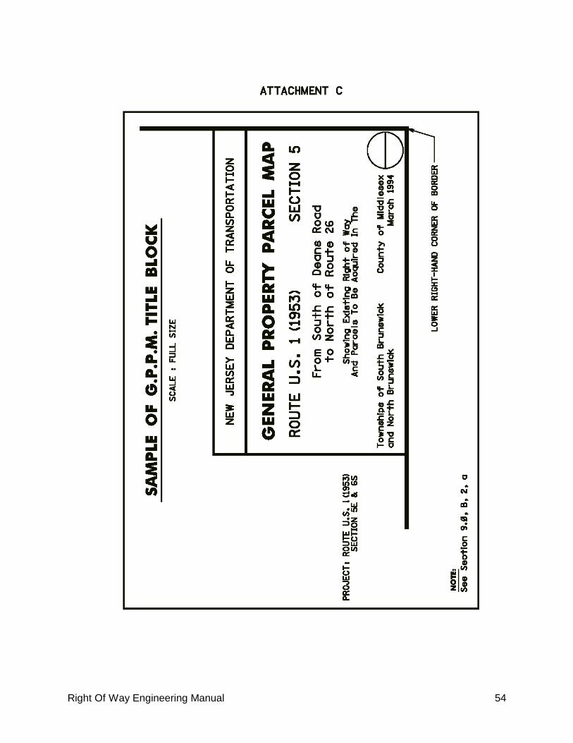
Right Of Way Engineering Manual 54

Right Of Way Engineering Manual 55

Right Of Way Engineering Manual 56

Right Of Way Engineering Manual 57

Right Of Way Engineering Manual 58

Right Of Way Engineering Manual 59
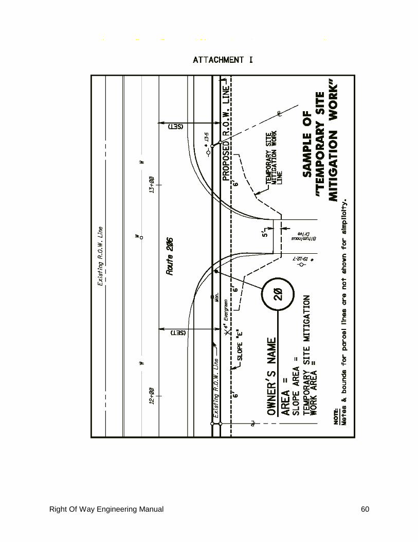
Right Of Way Engineering Manual 60

Right Of Way Engineering Manual 61

Right Of Way Engineering Manual 62

Right Of Way Engineering Manual 63

Right Of Way Engineering Manual 64

Right Of Way Engineering Manual 65
10.0 Application Of Upland Owner On Tidal Water For A Lease Or License/Grant Of Riparian Land
To the Bureau of Tidelands Management in the Land Use Regulation Program of the
Department Of Environmental Protection:
WHEREAS, a State Highway designated as Route Section , __________
(ROW section limits) as heretofore been laid out and construction provided for
pursuant to the provisions of Title 27 of the Revised Statutes of New Jersey; and
WHEREAS, portions of the said State Highway (or roadway, as required) are over tidal
lands, lands owned and/or claimed to be owned, pursuant to Titles 12 and 13 of the
Revised Statues of New Jersey;
NOW, THEREFORE, I, the undersigned, Director of ROW, Department of Transportation
of the State of New Jersey, acting for and in the name of the State of New Jersey, do
hereby apply for a grant of tidelands as indicated on a map entitled: (insert Map Quote)
Parcel T (insert description) or TE ___(insert description)_.
THE STATE OF NEW JERSEY, Department of Environmental Protection, Division of
Coastal Resources, Bureau of Tidelands, AT THE RECEIPT OF THIS APPLICATION, is
requested to make the herein above described GRANT to the STATE OF NEW JERSEY,
Department of Transportation in accordance with and subject to the provisions of an
act of the New Jersey Legislature entitled: "A further supplement to an act entitled:
„An act to ascertain the rights of the State and riparian owners in the lands lying under
the waters of New York Bay and elsewhere in the State', approved April eleventh, one
thousand, eight hundred and sixty-four", which said supplement was approved March
16, 1916.
Applicant recognizes that the State is under no obligation to make the grant or lease
desired and the issuance of same is within the sole and absolute discretion of the State.
Applicant recognizes that the action of the Tidelands Resource Council is subject to the
approval of the Commissioner of the Department of Environmental Protection, the
Attorney General and Governor, and that no grant is valid unless and until actually
delivered.
We therefore request the State to consider this application and if in the State‟s
discretion, decide to issue a grant or lease, to fix the fair consideration or annual
rental for the conveyance and to designate the lands now or formerly under tidewater
that may properly be included in the conveyance and to fix such other terms and
consideration of said conveyance as may be deemed appropriate.
Date:
Director, Division of ROW
Department of Transportation
Witness:

Right Of Way Engineering Manual 66
11. ROW Documents Submission
A. GENERAL
1. All documents shall be completely checked before being submitted.
2. Plans shall be checked for compliance with this manual‟s checklists and
procedures. The design of all ROW parcels, slopes, drainage, etc., including
temporary features, shall facilitate the building of the highway to its complete
and final design.
3. The ROW line shall only indicate what is required for highway purposes. The
Division of ROW shall determine whether to acquire any additional property
(for example, an uneconomic remnant).
4. A complete ROW submission shall include:
ETMs, including a Key Sheet
GPPMs, including an Alignment Schematic Plan and a Tab Sheet
IPMs
Descriptions (CD-ROMs may be substituted for the 3.5” diskette)
Riparian application, if needed
Other documentation - Deeds, tax maps, etc.
5. The PM, in coordination with the ROWE Unit, may waive the requirement to
include any of the above. The PM may request a copy of the ROW submission.
This copy should be sent directly to the PM and is not part of the Preliminary
or Final ROW Submission.
B. SUBMISSION PACKAGING
1. The designer shall submit the ROW documents for the required submission,
Preliminary or Final, to the units listed in Attachment N. All documents for a
Preliminary Submission shall be stamped “Preliminary”. The requirements for
the PD ROW Plan submissions are listed in Section 3.0, B and are shown in
ATTACHMENT N. The PD ROW Plan submission shall be sent only to The
Division of ROW, HQ. The requirements for the Pre-Final Submission are
listed in Section 3.0, C. and are shown in a note on Attachment N. The Pre-
Final submission shall be sent only to ROWE. CD-ROMs may be
substituted for the 3.5” diskettes for the Pre-Final & Final submissions.
2. The consultant designer shall fill out and submit Attachment O to ROWE with
the Preliminary and Final ROW Submissions.
3. The designer shall submit 1 set of final sepia mylars (or equivalent) of the
GPPMs & ETMs, without signatures and seals, to the EDU as the Final ROW
submission. The Designer shall provide and hold 2 sets of signed & sealed ETM
& GPPM mylars, for each county, and submit them when notified by the
Engineering Documents Unit.

Right Of Way Engineering Manual 67

Right Of Way Engineering Manual 68
Attachment O
Consultant Quality Control Checklist
ROW Documents
Route _________________________ Section ________________________
_________________________ _____________________________
Federal Project _______________ County ________________________
State Project No. _______________
Preliminary Submission Final Submission
YES NO NA
1. All right-of-way plans (ETMs, GPPMs & IPMs), and descriptions
have been prepared in accordance with the requirements
outlined in the ROW Manual.
2. All right-of-way lines and easement lines have been identified
and are consistent between the right-of-way plans and
construction plans.
3. The access control has been established in accordance with
direction from the Project Manager/other offices within NJDOT
and is in accordance with all applicable laws, regulations,
FHWA and NJDOT policies.
4. All comments regarding the right-of-way plans and
descriptions have been addressed.
5. A field check was conducted on _____________________ to
verify that all buildings and other important features are
accurately shown on the ROW plans (final submission only).
NOTE: Any item checked NO shall be explained in the space provided below. Attach
additional sheets if needed.
Item No ______________________________________________________________
________________________________________________________________
________________________________________________________________
________________________________________________________________
Consultant __________________________________
Project Manager ______________________________ Date __________________
Sub-consultant* ______________________________
Project Manager ______________________________ Date __________________
* If applicable

Right Of Way Engineering Manual 69

Right Of Way Engineering Manual 70

Right Of Way Engineering Manual 71

Right Of Way Engineering Manual 72

Right Of Way Engineering Manual 73
13.0 Process For Eliminating A Parcel
A. The PM contacts the Project Coordination/Funding Unit within ROW Technical
Support, by memorandum or e-mail, with a copy to ROWE, requesting the
acquisition status of a parcel to be eliminated.
B. After the parcel acquisition status is determined, Project Coordination/Funding will
advise the PM whether the parcel can be eliminated. A parcel cannot be eliminated
if the NJDOT has already taken possession of it. However, a parcel may be
eliminated after a Declaration of Taking is filed, but only if the property owner
agrees.
C. If the parcel can be eliminated, the PM will contact the design consultant or ROWE,
if the PM desires the work to be done in-house. The designer will update the ETM
and GPPM, showing the parcel elimination using the following procedure:
1. Draw an "x", through the parcel number. Print “Eliminated” on the GPPM and
ETM near the affected parcel number. Place the parcel number, date and
“Eliminated” in the revision block.
2. Draw a line through the parcel on the Tab sheet and place “Eliminated” and
the date in the remarks column.
D. The designer shall submit the updated ETM and GPPM to ROW Technical Support,
ATTN: Project Coordination/Funding as outlined in Attachment I, Final Submission.
14.0 Process For Revising A Parcel
A. The initiator of the revision (ROW designer, Department ROW negotiator, etc.)
shall notify the PM that a revision is necessary (The initiator of the revision shall
contact ROWE to determine if a revision is required before making contact with the
PM.). Consultant designers must contact ROWE before beginning any work on a
revision. The PM then requests the acquisition status of a parcel to be revised from
the Project Coordination/Funding Unit within ROW Technical Support by
memorandum or e-mail, with a copy to ROWE. All revisions made to ROW plans
after the Final Submission must be made only with the authorization of the PM.
B. After the parcel acquisition status is determined, Project Coordination/Funding will
contact the PM and advise whether the parcel can be revised. A parcel cannot be
revised if the NJDOT has already taken possession of it. However, a parcel may be
revised after a Declaration of Taking is filed, but only if the property owner agrees.
C. If the parcel is already owned by the NJDOT, a new parcel will have to be added to
include whatever rights are needed for that parcel.
D. If the parcel can be revised, the PM will place that parcel “on hold” with the Office
of ROW and will contact the design consultant or ROWE (if the work is to be done
in-house), who will revise the ROW documents.

Right Of Way Engineering Manual 74
E. Changes to the ROW after the final ROW submission that would necessitate
another appraisal shall require a revision number (e.g. area changes, adding or
removing slope, drainage, denial of access, limit of grading, etc.).
F. The following procedure shall be followed for revisions to the ROW documents:
1. Change the parcel number on the ETMs, GPPMs. IPMs, and descriptions. For
example:
Original 1st. Revision 2nd Revision
Parcel 8 R8 2R8
Easement Parcel E8 ER8 E2R8
Utility Parcel U8 UR8 U2R8
Utility Easement Parcel UE8 UER8 UE2R8
Tideland Parcel T8 TR8 T2R8
Tideland Easement Parcel TE8 TER8 TE2R8
Landscape Parcel L8 LR8 L2R8
2. Specify all revisions in the revisions block of the ETMs (not including the Key
Sheet) and the GPPMs. Show the parcel number, date and, under the revisions
column, the revised parcel number and the revision. For example:
Parcel Date Revision
48 01-02-98 Parcel 48 to parcel R48; Revised parcel area
R35 02-15-98 Parcel R35 to 2R35; Slope area added
E20 03-06-98 Parcel E20 to ER20; Slope area revised
G. The design consultant or ROWE shall submit the revised ROW documents to ROW
Technical Support, ATTN: Project Coordination/Funding, as outlined in Attachment
N, Final Submission. Submission of the descriptions on 3.5” diskettes is required.
However, other formats, for example, e-mail. CDs (compact discs), when
approved by ROWE, may be used. Specify all revisions in the revisions block,
showing date, parcel affected, and the reason for the revision. The submission
letter should also note the reasons for the revision of each parcel.
15.0 Process For A Condemnation Case
A. When negotiations have reached an impasse, the District Office Supervisor
contacts the supervisor of the Acquisition Section (AS) of ROW Technical Support
to advise that this case must go through the condemnation process.
B. The supervisor of the AS is responsible for obtaining the proper number of
condemnation maps (IPMs) and descriptions. The number of copies is based on
the number of parties having an interest in the subject parcel and the number
required by NJDOT personnel (the average is 30 copies).

Right Of Way Engineering Manual 75
C. The supervisor of the AS must contact the PM, who decides who will supply the
condemnation documents. NOTE: The decision by the PM as to who supplies the
condemnation map is based on the designer‟s contract/proposal, time
considerations, where the existing color copies of the IPM‟s are located and
whether any revisions to the IPMs are required. The PM should have the
designer supply the condemnation material for consultant designed
projects.
D. If the PM chooses the consultant and authorizes him to supply the condemnation
material, then the consultant is responsible for supplying all the condemnation
material (including properly folded IPMs) to the AS, while copying the PM on all
transmittals. The PM may request that the consultant and the AS deal directly with
each other on any questions that arise.
E. If the PM chooses to have ROWE supply the condemnation material, ROWE will be
responsible for making the color copies of the IPM. The AS will be responsible for
providing ROWE with a color copy of the IPM and a copy of the complaint
description (both supplied to the AS at the Final ROW Submission).
F. If the project is being designed in-house, ROWE will be responsible for supplying
the required number of copies of the description and IPM, properly folded, to the
AS.
G. The AS is responsible for the proper distribution of the condemnation material.
16.0 ROW Parcel Dedication Requirements
The requirements and process for a ROW dedication package can be found in N.J.A.C.
16:47-4.20. Any dedicated parcel, including parcels involved in Developer‟s projects
shall follow this process.
Parcels that are “donated” on standard ROW projects, that is, parcels that are given to
the NJDOT at a minimal cost without appraisal, usually $1.00, shall be set up like
other parcels, except they shall be labeled “Donated”. Donated parcels shall also have
an IPM and description prepared.
Prepared by Mike Drangula, Reviewed by Fred Azimi, Edited by Glenn Lawrence