Embed Size (px)
Citation preview

R I C H M O N D G E N E R A L P L A N 2 0 3 0
City of Richmond Planning and Building Services Department | 450 Civic Center Plaza, Richmond, California 94804Phone: 510-620-6706 | Fax: 510-620-6858 | www.ci.richmond.ca.us/planning
CERTIFICATION
The Richmond General Plan 2030 was adopted by the Richmond City Council on April 25, 2012.
This document certifies, pursuant to California State Government CodeSection 65350, that the text of this General Plan meets all guidelines
set forth by Governor’s Office of Planning and Research.
Signed this 25 day of May 2012
Richard H. MitchellDirector of Planning and Building Services
3.38 | R I C H M O N D G E N E R A L P L A N 2 0 3 0
3 Land Use and Urban Design
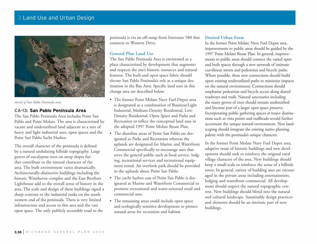
CA-13: San Pablo Peninsula AreaThe San Pablo Peninsula Area includes Point San Pablo and Point Molate. The area is characterized by vacant and underutilized land adjacent to a mix of heavy and light industrial uses, open spaces and the Point San Pablo Yacht Harbor.
The overall character of the peninsula is defined by a natural undulating hillside topography. Large groves of eucalyptus trees on steep slopes fur-ther contribute to the natural character of the area. The built environment varies dramatically. Architecturally-distinctive buildings including the historic Winehaven complex and the East Brothers Lighthouse add to the overall sense of history in the area. The scale and design of these buildings signal a sharp contrast to the industrial tanks on the south-western end of the peninsula. There is very limited infrastructure and access to this area and the vast open space. The only publicly accessible road to the
peninsula is via an off-ramp from Interstate 580 that connects to Western Drive.
General Plan Land UseThe San Pablo Peninsula Area is envisioned as a place characterized by development that augments and respects the site’s historic resources and natural features. The built and open space fabric should elevate San Pablo Peninsula’s role as a unique des-tination in the Bay Area. Specific land uses in this change area are described below.
• The former Point Molate Navy Fuel Depot area is designated as a combination of Business/Light Industrial, Medium-Density Residential, Low-Density Residential, Open Space and Parks and Recreation to reflect the conceptual land uses in the adopted 1997 Point Molate Reuse Plan.
• The shoreline areas of Point San Pablo are des-ignated as Parks and Recreation whereas the uplands are designated for Marine and Waterfront Commercial specifically to encourage uses that serve the general public such as food service, lodg-ing, recreational services and recreational equip-ment rental. An overlook park should be provided in the uplands above Point San Pablo.
• The yacht harbor east of Point San Pablo is des-ignated as Marine and Waterfront Commercial to promote recreational and water-oriented retail and commercial uses.
• The remaining areas could include open space and ecologically sensitive development to protect natural areas for recreation and habitat.
Desired Urban FormIn the former Point Molate Navy Fuel Depot area, improvements to public areas should be guided by the 1997 Point Molate Reuse Plan. In general, improve-ments to public areas should connect the varied open and built spaces through a new network of intimate curvilinear streets and pedestrian and bicycle paths. Where possible, these new connections should build upon existing underutilized paths to minimize impacts on the natural environment. Connections should emphasize pedestrian and bicycle access along shared roadways and trails. Natural sanctuaries including the many groves of trees should remain undisturbed and become part of a larger open space preserve. Incorporating public gathering spaces at major destina-tions such as vista points and trailheads would further accentuate the unique natural environment. New land-scaping should integrate the existing native planting palette with the peninsula’s unique character.
In the former Point Molate Navy Fuel Depot area, adaptive reuse of historic buildings and new devel-opment should seek to reinforce the original rural village character of the area. New buildings should keep a small-scale to reinforce the sense of a hillside town. In general, variety of building uses are encour-aged in the private areas including entertainment, lodging and waterfront commercial. All develop-ment should respect the natural topographic con-text. New buildings should blend into the natural and cultural landscape. Sustainable design practices and elements should be an intrinsic part of new buildings.
Aerial of San Pablo Peninsula area
S H A P I N G T H E N E W 1 0 0 Y E A R S | 3.67
3 Land Use and Urban Design
Action LU4.E Point Molate Redevelopment PlanContinue to pursue redevelopment of the ex-Point Molate Fuel Station, the ex-Red Rock Marina, Terminal #4, and improve conditions at the San Pablo Yacht Harbor. Identify and incorporate opportunities for public open space and recreational facilities. Integrate previous planning efforts including the Point Molate Reuse Plan and San Pablo Peninsula Open Space Study.
See also: ED9.A
GOAL LU4
Enhanced Environmental Quality
S H A P I N G T H E N E W 1 0 0 Y E A R S | 3.69
3 Land Use and Urban Design
GOAL LU5
Balanced and Compatible Uses
Policy LU5.2 A Mixed-Use WaterfrontContinue to create a dynamic mixed-use waterfront that includes amenities and attractions for residents and visitors. There are a number of different uses, features and assets along Richmond’s shoreline that can be enhanced to create a series of distinct places along the waterfront.
The San Pablo Peninsula is characterized by large natural open spaces, shoreline parks and beaches, sweeping views of the San Francisco Bay Area and historic structures. The City will support development on the Peninsula as a regional recreation destina-tion that is well connected to rest of the City and accessible to the greater community. Disturbed sites such as the Winehaven complex at Point Molate and the Terminal 4 site at Point San Pablo will be remediated and redeveloped into mixed-use activity centers to serve a broad range of visitors and provide long-term revenue to the City.
The Richmond Port (public and private) is recognized as a productive and important component of the community’s economy and identity. Many of the adjacent industries embrace high standards and provide high-wage, local jobs. Creative transitions should be developed between port related activities and potential mixed-used neighborhoods along the waterfront to provide strong connections, design cohesion and effective buffers where necessary.
The Ford Peninsula in Marina Bay is a gateway to Richmond and an integral part of the City where people work, live and recre-ate. The Peninsula’s historic Ford Assembly Plant, open space, connection to the Bay Trail and convenient freeway access present great potential for developing the eastern portion of the area as an active mixed-use neighborhood that will attract visitors from around the Bay. In February 2006 the City Council passed Resolution No. 15-06 to support and promote the location of the pro-posed ferry terminal. Ferry transit to San Francisco will enhance the Southern Shoreline’s appeal to residents and businesses.

S H A P I N G T H E N E W 1 0 0 Y E A R S | 3.97
3 Land Use and Urban Design
C O U N T Y
S A N P A B L O
23
RD
ST
RIC
HM
ON
D P
KW
Y
CUTTING BLVD
MACDONALD AVE
GIA
NT
RD
RUMRILL BLVD
GARRARD BLV
D
WEST CUTTING BLVD
13T
H S
T
HA
RB
OU
R W
Y
BROOKSIDE DR
I-580
San Pablo Creek
Richmond
BART Station
City of Richmond
Hillside Residential
Residential Neighborhoods
Key Corridors
Activity Centers
Business and Industry
Low-Density Residential
Live/Work
Medium Density Residential
Medium Density Mixed-Use (Residential Emphasis)
Medium Intensity Mixed-Use (Commercial Emphasis)
Marine and Waterfront Commercial
Business/Light Industrial
Neighborhood Mixed-Use
Medium Intensity Mixed-Use (Gateway and/or Community Node)
Regional Commercial Mixed-Use
High Intensity Mixed-Use (Major Activity Center)
Industrial
Port
CommunityAgriculture
Public, Cultural and Institutional
Parks and Recreation
Open Space
Transition Zone Overly District (TZOD)Pursuant to Ordinance No. 1808, residential uses are prohibited within this zone.
Overlay Zones
N
0 1 20.5 MILES
ACRES10
50
Change Area 13San Pablo Peninsula
Map 3.15