Embed Size (px)
Citation preview

Rice University Tropospheric Ozone Pollution Project (RU-TOPP)
Gary A. Morris

1) Motivation
2) Work to Date
3) Future of Project
Rice University Tropospheric Ozone Pollution Project (RU-TOPP)
Gary A. Morris

Environmental Threats and Health Impacts Caused by Ozone Pollution
• Exacerbate/Cause Respiratory Problems
• Damaging to Plants
• Highly Reactive
• Can Be Transported Over Long Distances

Economic Impacts from Ozone Pollution
• Loss of Federal Transportation Funds
• $30,000 per day fines to all stationary sources
• Factor in locating business offices
• Factor in attracting workers

Current EPA Standards Only Address Ground-Level Ozone
Stage 1: 1-Hour Standard Region must not exceed
125 ppb on more than 3 days in a consecutive 3-year period.Deadline: 2007
Stage 2: 8-Hour Standard Region must not exceed
85 ppb for the 3-year average of the 4th highest daily maximum 8-hour ozone concentration.Deadline: 2010

Houston Regularly Violates Both Standards
125
85
August 21 – September 2, 2000

20-Year Record Shows Improvement But We’re Not There Yet
1982 1990 2000
310
200
125
85
8-Hour 1-Hour

Areas at Risk in the United States
Severe Risk Chicago, Houston,
Los Angeles, New York, Washington, DC
Serious Risk Atlanta, Boston, Dallas,
Hartford, Phoenix
Moderate Risk Cincinnati
EPA Non-Attainment Areas
August 2003

GalvestonBay
N DowntownHouston
IndustrialComplexes
East TexasForested
(Evergreens)
NASA Space Shuttle Photo from STS-61
Houston, Texas: A Case Study for Ozone Pollution
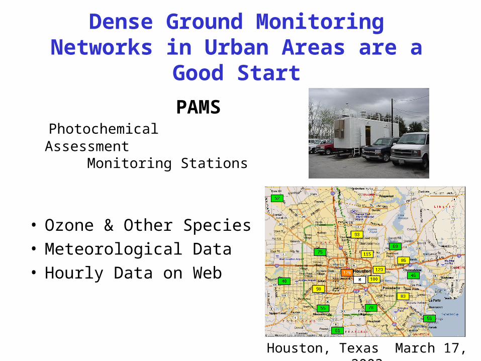
Dense Ground Monitoring Networks in Urban Areas are a Good Start
PAMS Photochemical Assessment
Monitoring Stations
• Ozone & Other Species• Meteorological Data• Hourly Data on Web
Houston, Texas March 17, 2003

Winds Transport Ozone Pollution
“Although many cities have made efforts to control ozone by reducing local emissions, incoming ozone transported from upwind areas also needs to be addressed.” (EPA)

Houston Exceeds L.A. Again in 2004
Last week’s Houston Chronicle reported that Houston will again surpass L.A. for the number of violations of EPA Air Quality standards in 2004.

EPA Studies O3 Production in 5 Cities
Nashvilleisolated city, biogenic sources, NOx emitters (power plants)
Phoenix isolated, low biogenic, low
industry, dry
Philadelphia and NYC inter-urban transport
Houstonextensive industry, coastal

Houston Unique Among Cities in the EPA Study
City
Number of Flights
Total
O3 > 100
O3 > 120
Max O3 (ppbv)
Nashville (’95) 17 7 3 146
NYC (’96) 13 4 0 119
Phoenix (’98) 24 1 0 101
Philadelphia (’99) 20 6 1 147
Houston (’00) 18 12 9 2118 flights in Houston show ozone > 150 ppbv
Data courtesy P. Daum (2003)
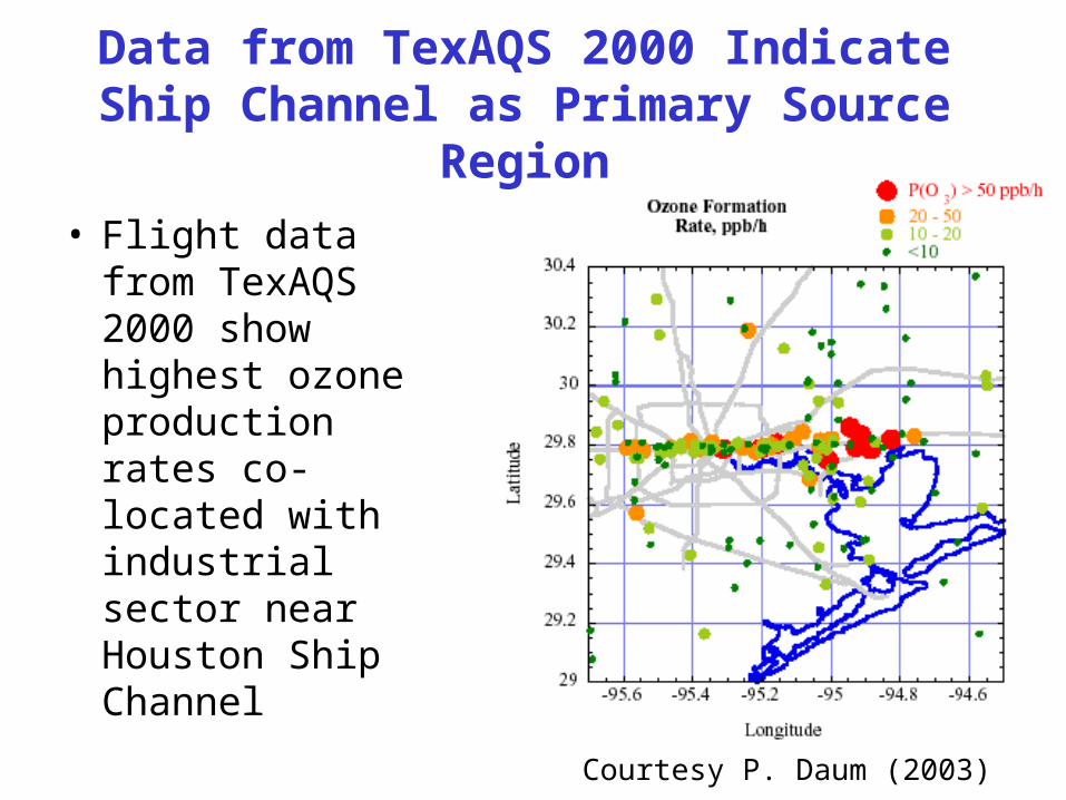
Data from TexAQS 2000 Indicate Ship Channel as Primary Source Region
Courtesy P. Daum (2003)
• Flight data from TexAQS 2000 show highest ozone production rates co-located with industrial sector near Houston Ship Channel

Back-Trajectory Analysis Trace Plumes Back to Ship Channel
Courtesy P. Daum (2003)
• Calculate back-trajectories.• Black dots are 1-hr intervals.
• O3 production: High Low
• “Without exception, back-trajectories from the locations where these high O3 plumes were observed passed over, or in close proximity to, sources of NOx and hydrocarbons surrounding the Houston Ship Channel.” Daum (2003).
Latitude
Longitud
eL
ongitude

Limitations of Current Ground-Level Ozone Monitoring Instrumentation
• No Information on Vertical Distribution of Ozone
• Transport (especially aloft) Not Well Monitored
• Few Rural Measurements

TexAQS 2000 Data Show Ozone Formation Above the Surface
• Down-looking lidar observers large plumes of ozone above the surface
• Ground monitors unable to detect this ozone pollution

telescope
Ground-Based Ozone Lidar Would Provide Important Data
• Continuously monitor O3 above the surface.
• Total magnitude of the pollution problem.
• O3 aloft results in more persistent high levels of O3 at the ground.
• Proposal to NSF in January 2005 High Powered
UV Laser System
O 2N2
O3

Shell Center for Sustainability Funds RU-TOPP in 2004
• $40,000 grant
• Acquire ozonesonde laboratory
• Fly balloons to begin characterizing O3 aloft.
• Undergraduate student participation

RU-TOPP Launches 25 Ozonesondes in July and August 2004
• Nearly daily launches during peak pollution season
• Coordination with NASA
• Media attention: KHOU, the Houston Chronicle, National Public Radio…

Early Analysis Shows Impact of Remote Forest Fires
• July 19th and 20th
• High ozone levels in Houston
• Air mass trajectories show air came from West Coast

Early Analysis Also Shows Local Production of Ozone
• Launches on Aug. 5 @ 7 am & 2 pm
• Low levels in morning & High levels in afternoon
• Local production of ~600 tons of O3 per day.

Sharing Data with NASA and the Scientific Community
• Data available on web:www.ruf.rice.edu/~ozone
• Part of NASA project to examine transport of pollution across U.S. and the Atlantic
• U. of Houston Models
• Proposals to NASA to continue this research.

Sustainability Assessment Through Continued Data Acquisition
• Continued monitoring of O3 above Houston with regular flights
• Better understanding of O3 problem: remote vs. local sources
• More effective solutions to meet the EPA 1-hour and 8-hour standards
• Community awareness

1) Motivation
2) Work to Date
3) Future of Project
Rice University Tropospheric Ozone Pollution Project (RU-TOPP)
Gary A. Morris