Embed Size (px)
Citation preview
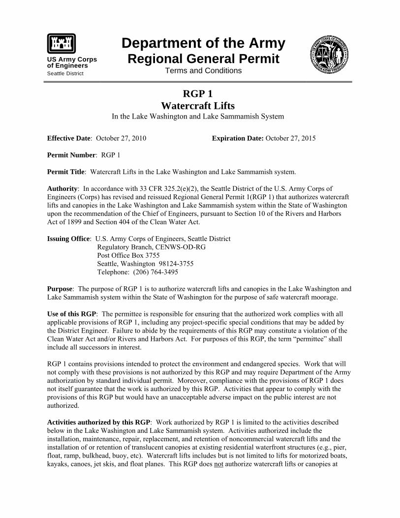
US Army Corpsof EngineersSeattle District
Department of the Army Regional General Permit
Terms and Conditions
RGP 1 Watercraft Lifts
In the Lake Washington and Lake Sammamish System
Effective Date: October 27, 2010 Expiration Date: October 27, 2015 Permit Number: RGP 1 Permit Title: Watercraft Lifts in the Lake Washington and Lake Sammamish system. Authority: In accordance with 33 CFR 325.2(e)(2), the Seattle District of the U.S. Army Corps of Engineers (Corps) has revised and reissued Regional General Permit 1(RGP 1) that authorizes watercraft lifts and canopies in the Lake Washington and Lake Sammamish system within the State of Washington upon the recommendation of the Chief of Engineers, pursuant to Section 10 of the Rivers and Harbors Act of 1899 and Section 404 of the Clean Water Act. Issuing Office: U.S. Army Corps of Engineers, Seattle District Regulatory Branch, CENWS-OD-RG Post Office Box 3755 Seattle, Washington 98124-3755 Telephone: (206) 764-3495 Purpose: The purpose of RGP 1 is to authorize watercraft lifts and canopies in the Lake Washington and Lake Sammamish system within the State of Washington for the purpose of safe watercraft moorage. Use of this RGP: The permittee is responsible for ensuring that the authorized work complies with all applicable provisions of RGP 1, including any project-specific special conditions that may be added by the District Engineer. Failure to abide by the requirements of this RGP may constitute a violation of the Clean Water Act and/or Rivers and Harbors Act. For purposes of this RGP, the term “permittee” shall include all successors in interest. RGP 1 contains provisions intended to protect the environment and endangered species. Work that will not comply with these provisions is not authorized by this RGP and may require Department of the Army authorization by standard individual permit. Moreover, compliance with the provisions of RGP 1 does not itself guarantee that the work is authorized by this RGP. Activities that appear to comply with the provisions of this RGP but would have an unacceptable adverse impact on the public interest are not authorized. Activities authorized by this RGP: Work authorized by RGP 1 is limited to the activities described below in the Lake Washington and Lake Sammamish system. Activities authorized include the installation, maintenance, repair, replacement, and retention of noncommercial watercraft lifts and the installation of or retention of translucent canopies at existing residential waterfront structures (e.g., pier, float, ramp, bulkhead, buoy, etc). Watercraft lifts includes but is not limited to lifts for motorized boats, kayaks, canoes, jet skis, and float planes. This RGP does not authorize watercraft lifts or canopies at
CENWS-OD-RG-RGP 1 Page 2 of 21
commercial marinas. This RGP does not authorize platform lifts, fill material in waters of the U.S., or pile driving. The applicant must, to the maximum extent practicable, orient the watercraft lift and canopy (lengthwise) in a north-south direction to minimize shading impacts. Definitions, descriptions, and/or examples of terms used in this RGP are located in Appendix E of this document. Categories of Activities: Category A: Installation or retention of one ground-based or floating watercraft lift without a canopy, per adjacent upland property, where no other watercraft exists. If watercraft lifts are proposed to be installed at a joint-use pier owned by two upland property owners, under this Category, only one can be installed.
Category B: Installation or retention of additional watercraft lifts beyond one, without a canopy, at a single residential use waterfront structure. A maximum of 3 lifts are allowed at a single residential use overwater structure. However, only two lifts can be ground-based, all other lift(s) must be floating or suspended lift(s).
Category C: Installation or retention of additional watercraft lifts beyond one, without a canopy, at a joint
use waterfront structure. There is no limitation to the maximum amount of watercraft lifts at an existing joint use structure. However, different project impact reduction and mitigation measures will be required based on the type of additional lifts (e.g., floating or suspended versus ground-based).
Category D: Installation or retention of a translucent canopy on a new or existing watercraft lift.
1. The canopy and structure should be located waterward of the 9-foot depth elevation (based on
OHW). If this condition cannot be met, additional project impact reduction measures are required.
2. The lowest edge of the canopy must be at least 8 feet above the plane of OHW.
3. Only 1 (one) canopy can be installed per single or joint use residential overwater structure.
4. The watercraft lift with the canopy must be oriented with the length in the north-south direction to the maximum extent practicable.
Category E: Replacement, repair or maintenance of existing watercraft lifts and translucent canopies. This includes parts which are located above or below the plane of OHW including parts which make contact with the substrate of the waterbody. If a watercraft lift or translucent canopy is being replaced, it must be replaced in the same footprint as the original one or in a location at the same water depth or deeper on the same property. Location of Authorized Activities: RGP 1 is applicable in the Lake Washington and Lake Sammamish system which includes: Lake Washington, Lake Sammamish, Lake Union, Union Bay and the Lake Washington Ship Canal upstream of the Ballard/Hiram Chittenden Locks in King County, Washington.
CENWS-OD-RG-RGP 1 Page 3 of 21
Application Procedure: The application procedure varies based on the category of work (Categories A – E described above). All categories require submittal of a JARPA (Joint Aquatic Resource Permit Application), Appendix A, and drawings in the format described in Appendix D.
Any applicant proposing work closer than 30 feet from the OHW mark on the shoreline, in any of the categories except Category E, must submit application materials and receive approval before any work in waters of the U.S. can commence. The Corps’ review process for this work requires coordination with National Marine Fisheries Service. Categories A and E: Application materials must be submitted before or within 30 days after the work is completed for these activities. Categories B, C, and D: Application materials must be submitted to the Corps before the work can commence. Written approval must be obtained from the Corps before any work can commence for this category of work.
Work Windows: To minimize impacts to aquatic species, certain work is restricted to specific time periods.
a. For activities not contacting the substrate (e.g., repair of above substrate portions of the lift, installation of a canopy, or installation of floating or suspended watercraft lifts) or work performed in the dry, there are no work window restrictions. Work can occur at any time.
b. For activities contacting the substrate (e.g., installation of a ground-based watercraft lift) refer to
current allowable work windows located on the Corps’ website at www.nws.usace.army.mil click on Regulatory – Regulatory Permits --Endangered Species Act -- Allowable Work Windows. Project Impact Reduction and Conservation Measures: While the individual activities described above will have minimal impacts to the aquatic environment, direct, indirect, and cumulative impacts from these structures have not been fully avoided.
Salmonids, including juvenile chinook salmon and sub-adult and adult bull trout use the nearshore areas of Puget Sound for feeding, rearing, and/or as a migratory corridor. As small individuals, they stay in shallow waters to avoid large fish predators found in deeper water, and to rear and feed.
The watercraft lift structure itself and canopy inhibits light from entering the water. This loss of light reduces the ability of aquatic vegetation to grow. This subsequently has an impact on the feeding and rearing habitat of fish. Also, the shadow created by the structures may provide cover for predators of salmonid fish species. Therefore, the amount of shade created by these structures needs to be minimized. Also, because the shallow water habitat is an important habitat feature, structures should be placed in deeper water to minimize impacts to the shallow water habitat.
The purpose of these measures is to offset losses to the aquatic environment resulting from direct,
indirect, and cumulative impacts of watercraft lifts and canopies. These mitigation measures will restore or create important fish habitat to offset the impact of the project.

CENWS-OD-RG-RGP 1 Page 4 of 21
Table 1. Number of Required Mitigation Points for Certain Categories, Different Water Depths, and Habitats Different Aquatic Habitats.
Project Work Description
Location of Proposed Work A B
Landward most side of the watercraft lift is in or over a
water depth of 9 feet or greater (based on OHW)
Landward most side of the watercraft lift is in or over a water depth less than 9 feet
(based on OHW)
# Required Mitigation Points # Required Mitigation Points
Category A or E 0 0 Category B or C For each new floating or suspended watercraft lift installed beyond one
2
4
Category B or C For each new ground based watercraft lift installed beyond one
4
6
Category D (mitigation points for this category is added to any of the other applicable categories) For a translucent canopy.
0
2 Table 2. Project Impact Reduction and Mitigation Measure Options and Corresponding Mitigation Points
Mitigation Measure Option #
Number of Mitigation Points
Project Impact Reduction and Mitigation Measure Description
1 2
Plant 1 tree and 1 shrub (from the planting list and per planting specifications in this RGP) within 15 feet landward of OHW and parallel to the shoreline
2 2 Remove 1 pile located waterward of OHW Guidance on best management practices for pile removal is located at: http://www.nws.usace.army.mil/PublicMenu/documents/ REG/Revised_EPA_Piling_Removal_BMP's_3_01_07.pdf Guidance on disposal and disposal location of treat wood material is located at www.ecy.wa.gov/programs/hwtr/demodebris/pages2/demowood.html
3 3 Remove 90 square feet of an existing overwater structure. This includes the permanent removal of a covered moorage, opaque watercraft lift canopies, and skirting.
4 6 Remove 3 linear feet of hardened shoreline and plant removal area with
CENWS-OD-RG-RGP 1 Page 5 of 21
Mitigation Measure Option #
Number of Mitigation Points
Project Impact Reduction and Mitigation Measure Description
native vegetation (see Table 3) 5 Varies Removal of an entire or portion of an existing groin. The number of
mitigation points varies depending on the size of the groin. Three mitigation points = 90 square feet (footprint) of groin removed. This option will require before and after photos of the groin and removal area and a vicinity map showing the location of the groin. For example: The groin to be removed is 90 feet long and 3 feet wide. This structure has a footprint of 270 square feet. 270 square feet divided by 90 = 3 times 3 → 9 mitigation points.
6 Varies Removal of an entire or portion of an existing boat ramp. The number of mitigation points varies depending on the size of the boat ramp. Three mitigation points = 90 square feet (footprint) of boat ramp removed. This option will require before and after photos of the boat ramp and removal area and a vicinity map showing the location of the boat ramp. For example: The boat ramp to be removed is 12 feet long and 8 feet wide. This structure has a footprint of 96 square feet. 96 divided by 90= 1.07 times 3 → 3 mitigation points.
7 Varies Install grating on an existing overwater structure with a solid deck surface. Grating must have at least 60% open area and must be oriented to maximize the amount of light passage. Three mitigation points = 90 square feet of installed grating For example: A boatlift will be installed adjacent to a pier which has the surface area completely decked with wood, no open surface area. The decking is removed from an area 6- by 30-feet and grating is installed for a total area of 180 square feet. 180 divided by 90 sq. ft equals 2 times 3 → 6 mitigation points.
8 Varies If mitigation cannot be accomplished onsite, the Corps will consider mitigation at an approved offsite location.
Note 1: Fractional numbers 0.5 or above are rounded up and fractional numbers below 0.5 are rounded down. Examples: The number 7.3 would be rounded down to 7. The number 6.5 would be rounded up to 7. Note 2: No “credit” is given for constructed mitigation points exceeding the required amount of required mitigation points.
CENWS-OD-RG-RGP 1 Page 6 of 21
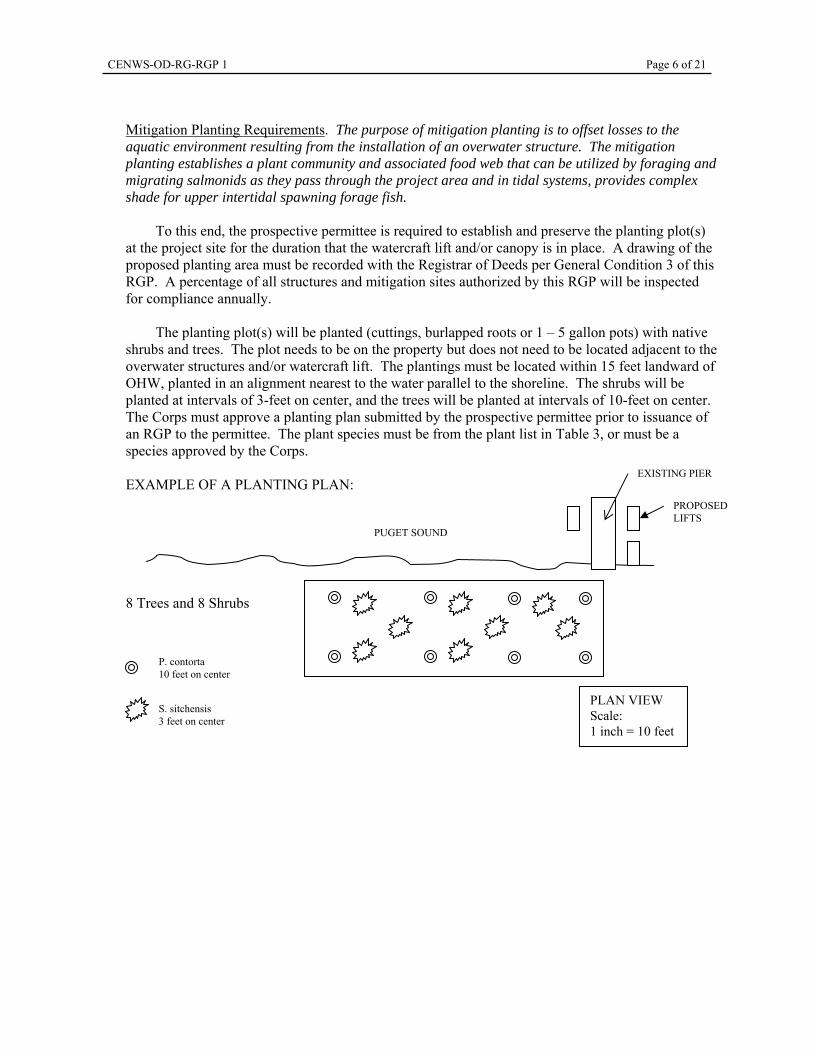
Mitigation Planting Requirements. The purpose of mitigation planting is to offset losses to the aquatic environment resulting from the installation of an overwater structure. The mitigation planting establishes a plant community and associated food web that can be utilized by foraging and migrating salmonids as they pass through the project area and in tidal systems, provides complex shade for upper intertidal spawning forage fish.
To this end, the prospective permittee is required to establish and preserve the planting plot(s)
at the project site for the duration that the watercraft lift and/or canopy is in place. A drawing of the proposed planting area must be recorded with the Registrar of Deeds per General Condition 3 of this RGP. A percentage of all structures and mitigation sites authorized by this RGP will be inspected for compliance annually.
The planting plot(s) will be planted (cuttings, burlapped roots or 1 – 5 gallon pots) with native
shrubs and trees. The plot needs to be on the property but does not need to be located adjacent to the overwater structures and/or watercraft lift. The plantings must be located within 15 feet landward of OHW, planted in an alignment nearest to the water parallel to the shoreline. The shrubs will be planted at intervals of 3-feet on center, and the trees will be planted at intervals of 10-feet on center. The Corps must approve a planting plan submitted by the prospective permittee prior to issuance of an RGP to the permittee. The plant species must be from the plant list in Table 3, or must be a species approved by the Corps.
EXAMPLE OF A PLANTING PLAN:
8 Trees and 8 Shrubs
PUGET SOUND
P. contorta 10 feet on center
S. sitchensis 3 feet on center
PLAN VIEW Scale: 1 inch = 10 feet
EXISTING PIER
PROPOSED LIFTS
CENWS-OD-RG-RGP 1 Page 7 of 21
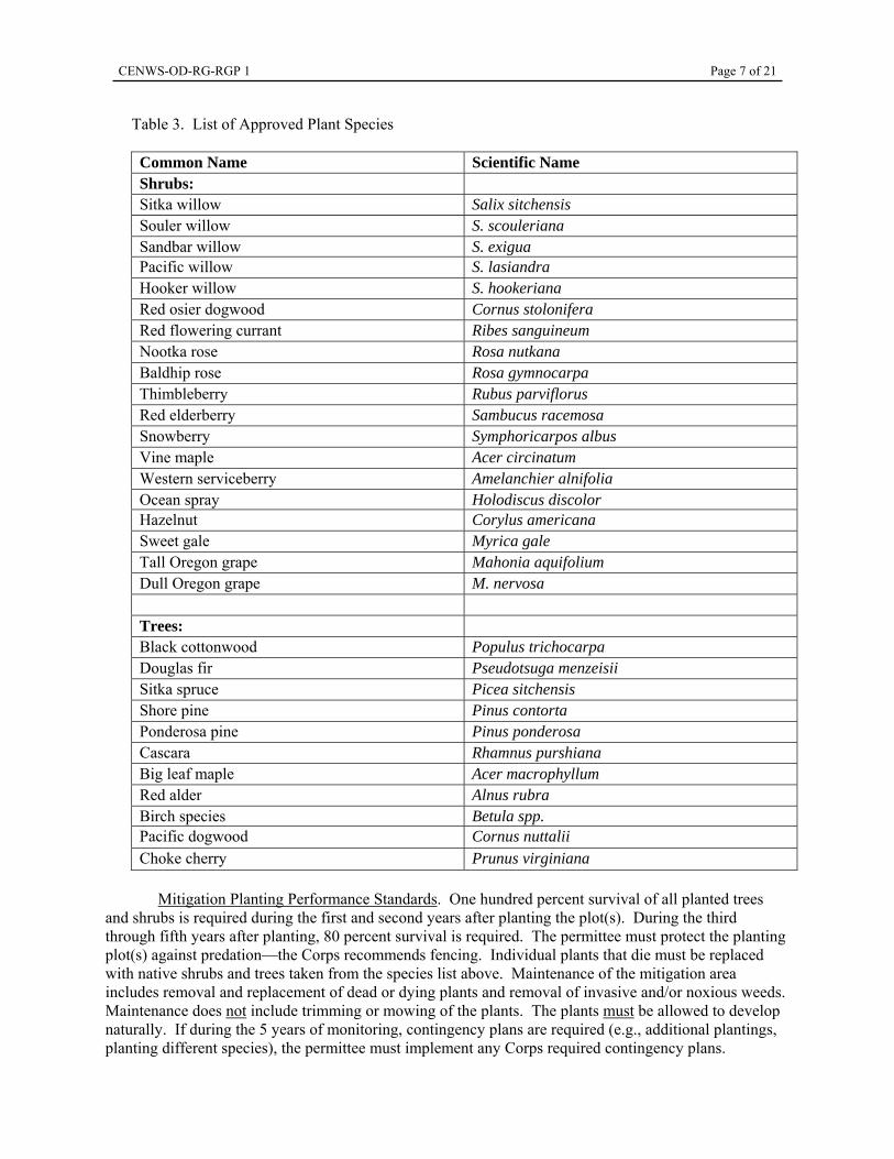
Table 3. List of Approved Plant Species Common Name Scientific Name Shrubs: Sitka willow Salix sitchensis Souler willow S. scouleriana Sandbar willow S. exigua Pacific willow S. lasiandra Hooker willow S. hookeriana Red osier dogwood Cornus stolonifera Red flowering currant Ribes sanguineum Nootka rose Rosa nutkana Baldhip rose Rosa gymnocarpa Thimbleberry Rubus parviflorus Red elderberry Sambucus racemosa Snowberry Symphoricarpos albus Vine maple Acer circinatum Western serviceberry Amelanchier alnifolia Ocean spray Holodiscus discolor Hazelnut Corylus americana Sweet gale Myrica gale Tall Oregon grape Mahonia aquifolium Dull Oregon grape M. nervosa Trees: Black cottonwood Populus trichocarpa Douglas fir Pseudotsuga menzeisii Sitka spruce Picea sitchensis Shore pine Pinus contorta Ponderosa pine Pinus ponderosa Cascara Rhamnus purshiana Big leaf maple Acer macrophyllum Red alder Alnus rubra Birch species Betula spp. Pacific dogwood Cornus nuttalii Choke cherry Prunus virginiana
Mitigation Planting Performance Standards. One hundred percent survival of all planted trees and shrubs is required during the first and second years after planting the plot(s). During the third through fifth years after planting, 80 percent survival is required. The permittee must protect the planting plot(s) against predation—the Corps recommends fencing. Individual plants that die must be replaced with native shrubs and trees taken from the species list above. Maintenance of the mitigation area includes removal and replacement of dead or dying plants and removal of invasive and/or noxious weeds. Maintenance does not include trimming or mowing of the plants. The plants must be allowed to develop naturally. If during the 5 years of monitoring, contingency plans are required (e.g., additional plantings, planting different species), the permittee must implement any Corps required contingency plans.
CENWS-OD-RG-RGP 1 Page 8 of 21
Mitigation Reports. Mitigation reports must be submitted to the Corps for all projects where mitigation is required.
a. Mitigation must be completed within one year of permit issuance. A report on mitigation completion, including as-built drawings, must be submitted to the Corps 12 months from the date the Corps issues an RGP to the permittee. The permittee can meet this reporting requirement by submitting to the Corps a completed Report for Mitigation Work Completion, Appendix B.
b. If plantings are implemented: Mitigation planting monitoring reports will be due annually, no later than November 30 of each monitoring year, for 5 years from when Corps accepts the as-built drawings. The mitigation monitoring report will include written and photographic documentation on tree and shrub mortality and replanting efforts. Photographs must be taken between June – August (the best time of year to show plant growth). Photographs must show a panoramic view of the entire mitigation planting area. A set point from where photos are taken must be established and used repeatedly for each monitoring year. The date of the photos must be noted on the monitoring report. The permittee can meet this reporting requirement by submitting to the Corps a completed Mitigation Planting Monitoring Report, Appendix C.
Water Quality Certification: The Corps requested that the Washington Department of Ecology (Ecology) pursuant to Section 401 of the CWA and Chapters 173 - 225 of the Washington Administrative Code (WAC), certify that those activities authorized by this RGP for which these agencies are responsible, will not violate established State water quality standards. Ecology issued Section 401 Water Quality Certification for this RGP on September 30, 2010. Coastal Zone Management Consistency: The Corps requested that the Washington Department of Ecology pursuant to the requirements of the U.S. Coastal Zone Management Act (16 U.S.C. 1452 et seq.) and its implementing regulations (15 CFR 923-930) concur that the activities authorized by this RGP will be consistent with the requirements of the State of Washington’s CZM program. Ecology issued CZM consistency for this RGP on September 30, 2010. Endangered Species: The Endangered Species Act (ESA) of 1973, as amended, requires all Federal agencies to consult with the National Marine Fisheries Service (NMFS) and/or the U.S. Fish and Wildlife Service (USFWS), pursuant to Section 7 of the ESA, on any action, or proposed action, permitted, funded, or undertaken by the agency that may affect a species listed as threatened or endangered under the ESA, or its designated critical habitat. Section 7 Consultation has been completed for the proposed activity with the USFWS through the programmatic letter of concurrence for selected activities in the Lake Washington Lake Sammamish Basins (USFWS reference number 13410-2009-I-386). On September 9, 2010, NMFS concurred with the Corps determination of “may affect, not likely to adversely affect” (NMFS reference number 2010/03600). Essential Fish Habitat: The Magnuson-Stevens Fishery Conservation and Management Act (MSA), as amended by the Sustainable Fisheries Act of 1996, requires all Federal agencies to consult with the NMFS on all actions, or proposed actions, permitted, funded, or undertaken by the agency that may adversely affect Essential Fish Habitat (EFH). This RGP will not adversely affect EFH for federally managed fisheries in Washington waters. No further consultation is required. RGP Special Conditions: Special Conditions pertaining to construction specifications and conservation measures for this revised RGP 1will be listed in Section D of Appendix A: Application form for RGP 1.
CENWS-OD-RG-RGP 1 Page 9 of 21
RGP General Conditions: Department of the Army authorization under this RGP is subject to the following general conditions. In order to be authorized under this RGP, the permittee must also meet the construction specifications and conservation measures listed in Appendix A, Section D.
1. Reliance on Permittee’s Information. In verifying a permittee’s authorization under this RGP, the Department of the Army has relied, in part, on the information provided by the permittee. If this information proves to be false, incomplete, or inaccurate, the permittee’s authorization may be modified, suspended, or revoked, in whole or in part. If the authorization is revoked, any work completed under the authorization must be removed, without expense to the United States.
2. Compliance with Terms and Conditions. Projects authorized by this RGP shall comply with all
terms and conditions herein. Failure to abide by these terms and conditions invalidates this authorization and may result in a violation of Federal law, which may require that the permittee restore the site or take other remedial action. Activities requiring Department of the Army authorization that are not specifically authorized by this RGP are prohibited unless authorized by another Department of the Army permit.
3. Deed Restriction: For projects with mitigation, a copy of the completed Appendix A, permit
drawings, mitigation planting plan (if applicable), and final authorization letter shall be recorded with the local government (Registrar of Deeds of the county or city), within 60 days after final Corps authorization, to ensure that subsequent property owners are aware of the construction, use, and mitigation requirements. Proof of this must be provided to the Corps within 65 days after the date of the Corps’ RGP verification letter to the permittee.
4. Contractor’s Copy of Permit. The permittee shall provide complete copies of this permit and the
Corps verification letter for the authorized project to each contractor involved in the project and keep copies of this permit and Corps verification letter available for inspection at the project site.
5. Compliance Certification. Every permittee shall submit to the Corps, within 30 days of
completing the authorized work, certification that the work, including any required mitigation, was conducted in accordance with the provisions of this RGP, including case-specific special conditions. The permittee must use the Statement of Compliance Form (Appendix B) of this RGP.
6. Access for Inspection. The permittee shall allow the District Engineer or his authorized
representative to inspect the project whenever deemed necessary to ensure that the activity is in compliance with the terms and conditions prescribed herein.
7. Limits of Authorization. This permit does not:
a. Obviate the requirement to obtain all other Federal, State, or local authorizations required by law for the activity authorized herein, including any authorization required from Congress.
b. Convey any property rights, either in real estate or material, or any exclusive privileges. c. Authorize any injury to property, invasion of rights, or any infringement of Federal, State, or
local laws or regulations. d. Authorize the interference with any existing or proposed Federal project.
CENWS-OD-RG-RGP 1 Page 10 of 21
8. Limits of Federal Liability. This permit is not an approval of the design features of any authorized project or an implication that such project is adequate for the intended purpose; a Department of the Army permit merely expresses the consent of the Federal Government to conduct the proposed work insofar as public rights are concerned. In issuing this RGP, the Federal Government does not assume any liability for the following:
a. Design or construction deficiencies associated with the authorized work.
b. Damages to the permitted project or uses thereof as a result of other permitted activities or
from natural causes, such as flooding.
c. Damages to persons, property, or to other permitted or unauthorized activities or structures caused by the activity authorized by this permit.
d. Damages associated with any future modification, suspension, or revocation of this permit. e. The removal, relocation, or alteration of any structure or work in navigable waters of the
United States ordered by the Secretary of the Army or his authorized representative. f. Damage to the permitted project or uses thereof as a result of current or future activities
undertaken by, or on behalf of, the United States in the public interest. 9. Tribal Rights. No activity may impair reserved tribal rights, including, but not limited to,
reserved water rights and treaty fishing and hunting rights. 10. State Owned Aquatic Lands. Projects proposed on state owned aquatic lands may require a Use
Authorization from the Washington Department of Natural Resources. Applicants should call (360) 902-1100 for more information.
11. Obstruction of Navigation. The permittee understands and agrees that, if future operations by the
United States require the removal, relocation, or other alteration of the work herein authorized, or if, in the opinion of the Secretary of the Army or his authorized representative, said structure or work unreasonably obstructs the full and free use of navigable waters of the United States, the permittee shall, upon due notice from the Corps, remove, relocate, or alter the obstructions caused thereby, without expense to the United States. If the permittee fails to comply with the direction of the Corps, the District Engineer may restore the navigable capacity of the waterway, by contract or otherwise, and recover the cost thereof from the permittee.
12. Stability. The permittee shall design projects to be stable against the forces of flowing water,
wave action, and the wake of passing vessels. 13. Maintenance. The permittee shall properly maintain all authorized structures, including
maintenance necessary to ensure public safety. This RGP or Nationwide Permit 3 can authorize any required maintenance activities on the structures authorized by this RGP.
14. Marking Structures. The permittee shall install and maintain any lights, signals, or other
appropriate markers necessary to clearly designate the location of structures or work that might pose a hazard to public safety. Permittees shall abide by U.S. Coast Guard requirements concerning the marking of structures and work in navigable waters of the United States.
CENWS-OD-RG-RGP 1 Page 11 of 21
15. Endangered Species. This RGP does not authorize any activity that is likely to jeopardize the continued existence of a threatened or endangered species or a species proposed for such designation, as identified under the Endangered Species Act.
16. Essential Fish Habitat. This RGP does not authorize any activity that may adversely affect
designated Essential Fish Habitat as defined under the Magnuson-Stevens Fishery Conservation and Management Act.
17. Historic Properties. This RGP does not authorize any activity that may affect historic properties
listed, or eligible for listing, in the National Register of Historic Places (NRHP) until the provisions of 33 CFR 325, Appendix C, have been satisfied. Historic properties include prehistoric and historic archeological sites, and areas or structures of cultural interest. A prospective permittee must notify the District Engineer if the proposed activity may affect an historic property that is listed, eligible for listing, or may be eligible for listing in the NRHP, and shall not begin the activity until notified by the District Engineer that the requirements of the National Historic Preservation Act have been satisfied and that the activity is authorized. If a previously unknown historic property is encountered during work authorized by this RGP, the permittee shall immediately cease all ground disturbing activities in the immediate area and notify the Corps within 1 business day of discovery. The permittee shall perform any work required by the Corps in accordance with Section 106 of the National Historic Preservation Act and Corps regulations and avoid any further impact to the property until the District Engineer verifies that the requirements of 33 CFR Part 325, Appendix C, have been satisfied.
18. Water Quality Standards. All activities authorized herein that involve a discharge of dredged or
fill material into waters of the United States shall, at all times, remain consistent with all applicable water quality standards, effluent limitations and standards of performance, prohibitions, pretreatment standards, and management practices established pursuant to the Clean Water Act (P.L. 92-500; 86 Stat. 816) or pursuant to applicable State and local law. Spills into state waters, spills onto land with a potential for entry into state waters or other significant water quality impacts, shall be reported immediately to Ecology’s Regional Spill Response Office at the Northwest Regional Office: 425-649-7000.
19. Soil Erosion and Sediment Controls. The permittee shall use and maintain appropriate erosion
and sediment controls in effective operating condition and permanently stabilize all exposed soil and other fills, including any work below the ordinary high water mark or mean higher high water mark, at the earliest practicable date using native vegetation to the maximum extent practicable. The permittee shall remove all installed controls as soon as they are no longer needed to control erosion or sediment.
20. Equipment. When working in wetlands, the permittee shall place heavy equipment on removable
mats, or take other appropriate measures to minimize soil disturbance. 21. Aquatic Life Movements. The permittee shall not substantially disrupt the necessary life-cycle
movement of those species of aquatic life indigenous to the waterbody, including those species that normally migrate through the area.
22. Management of Water Flows. To the maximum extent practicable, the activity must be designed
to maintain downstream flow conditions. Furthermore, the activity shall not permanently restrict or impede the passage of normal or expected high flows. The permittee should limit the work conducted in waters of the United States to low- or no-flow periods.
CENWS-OD-RG-RGP 1 Page 12 of 21
23. Water Supply Intakes. The permittee shall ensure that activities authorized by this RGP have no
more than a minimal adverse impact on public water supply intakes. 24. Disposal of Excess Material. All construction debris and any other material not authorized by the
Corps for permanent placement into waters of the United States shall be disposed of in an upland location in a manner that precludes it from entering waters of the United States.
25. Transfer of RGP Verification. If the permittee sells the property associated with this RGP verification, the permittee may transfer the RGP verification to the new owner by having the new owner submit a letter to the Seattle District Corps office to validate the transfer. A transfer must occur if mitigation is associated with the verification so that the new owner is aware of mitigation requirements. A copy of the RGP verification and permit drawings must be attached to the letter, and the letter must contain the following statement and the new owner(s) signature: “I (we) understand that the structures or work authorized by this RGP verification have specific terms and conditions, including (if applicable) mitigation requirements. I (we) understand that these terms and conditions will continue to be binding on us as the new owner(s) of the property as well as the associated liabilities associated with compliance with its terms and conditions.”
Modification, suspension, or revocation of the RGP: This RGP may be modified or suspended in whole or in part if the Secretary of the Army or his authorized representative determines that the individual or cumulative impacts of work that would be authorized using this procedure are contrary to the public interest. Any such modification, suspension, or revocation shall become effective 30 days after the issuance of a public notice announcing such action. The final decision whether to modify, suspend, or revoke this permit, in whole or in part, shall be made pursuant to procedures prescribed by the Chief of Engineers. Following such revocation, any future activities heretofore authorized by this RGP will require alternate Department of the Army authorization. The authorization of an individual project under this RGP may also be summarily modified, suspended, or revoked, in whole or in part, if the permittee either fails to abide by the terms and conditions of this permit or provides information that proves to be false, incomplete, or inaccurate, or upon a finding by the District Engineer that such action would be in the public interest. If a permittee’s authorization is revoked, the permittee shall, upon notice of such revocation, without expense to the United States and in such time and manner as the Secretary of the Army or his authorized representative may direct, restore the waterway to its former condition. If the permittee fails to comply with the direction of the Secretary of the Army or his authorized representative, the Secretary or his designee may restore the waterway to its former condition, by contract or otherwise, and recover the cost thereof from the permittee. Expiration of the RGP: This permit shall become effective on the date of the signature of the District Engineer or his authorized representative and will automatically expire 5 years from that date unless the permit is modified, revoked, or extended prior to that date. Activities that have commenced (e.g., are under construction) or are under contract to commence in reliance upon this permit will remain authorized provided that the activity is completed within 1 year of the date of this permit's expiration, modification, or revocation, unless discretionary authority has been exercised on a case-by-case basis to modify, suspend, or revoke the authorization. Section 401 Water Quality Certification and CZM Federal Consistency for this RGP will expire on the date that the RGP expires.
CENWS-OD-RG-RGP-1 Page 13 of 21
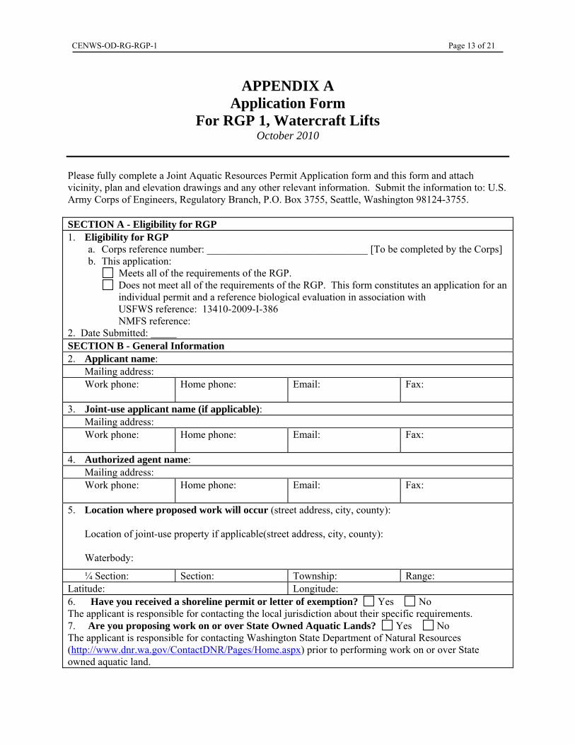
APPENDIX A Application Form
For RGP 1, Watercraft Lifts October 2010
Please fully complete a Joint Aquatic Resources Permit Application form and this form and attach vicinity, plan and elevation drawings and any other relevant information. Submit the information to: U.S. Army Corps of Engineers, Regulatory Branch, P.O. Box 3755, Seattle, Washington 98124-3755. SECTION A - Eligibility for RGP 1. Eligibility for RGP
a. Corps reference number: _______________________________ [To be completed by the Corps] b. This application: Meets all of the requirements of the RGP.
Does not meet all of the requirements of the RGP. This form constitutes an application for an individual permit and a reference biological evaluation in association with USFWS reference: 13410-2009-I-386 NMFS reference:
2. Date Submitted: SECTION B - General Information 2. Applicant name:
Mailing address: Work phone:
Home phone:
Email:
Fax:
3. Joint-use applicant name (if applicable): Mailing address: Work phone:
Home phone:
Email:
Fax:
4. Authorized agent name: Mailing address: Work phone:
Home phone:
Email:
Fax:
5. Location where proposed work will occur (street address, city, county): Location of joint-use property if applicable(street address, city, county): Waterbody:
¼ Section: Section: Township: Range: Latitude: Longitude: 6. Have you received a shoreline permit or letter of exemption? Yes No The applicant is responsible for contacting the local jurisdiction about their specific requirements. 7. Are you proposing work on or over State Owned Aquatic Lands? Yes No The applicant is responsible for contacting Washington State Department of Natural Resources (http://www.dnr.wa.gov/ContactDNR/Pages/Home.aspx) prior to performing work on or over State owned aquatic land.
CENWS-OD-RG-RGP 1 Page 14 of 21
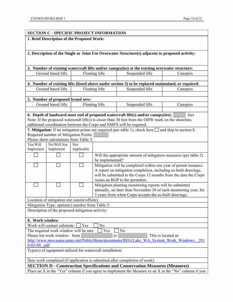
SECTION C - SPECIFIC PROJECT INFORMATION 1. Brief Description of the Proposed Work:
2. Description of the Single or Joint Use Overwater Structure(s) adjacent to proposed activity: 3. Number of existing watercraft lifts and/or canopy(ies) at the existing overwater structure:
Ground based lifts Floating lifts Suspended lifts Canopies
4. Number of existing lifts (listed above under section 3) to be replaced maintained, or repaired: Ground based lifts Floating lifts Suspended lifts Canopies
5. Number of proposed brand new:
Ground based lifts Floating lifts Suspended lifts Canopies
6. Depth of landward most end of proposed watercraft lift(s) and/or canopy(ies): ______ feet Note: If the proposed watercraft lift(s) is closer than 30 feet from the OHW mark on the shoreline, additional coordination between the Corps and NMFS will be required.
7. Mitigation: If no mitigation points are required (per table 1), check here and skip to section 8. Required number of Mitigation Points: _______ Please show calculations from Table 2: Yes/Will Implement
No/Will Not Implement
Not Applicable
Will the appropriate amount of mitigation measures (per table 2) be implemented?
Mitigation will be completed within one year of permit issuance. A report on mitigation completion, including as-built drawings, will be submitted to the Corps 12 months from the date the Corps issues an RGP to the permittee.
Mitigation planting monitoring reports will be submitted annually, no later than November 30 of each monitoring year, for 5 years from when Corps accepts the as-built drawings.
Location of mitigation site (onsite/offsite): Mitigation Type: option(s) number from Table 2: Description of the proposed mitigation activity: 8. Work window Work will contact substrate: Yes No The required work window will be met: Yes No Please list work window: from _______________ to ______________ This is located at: http://www.nws.usace.army.mil/PublicMenu/documents/REG/Lake_WA_System_Work_Windows__2010-03-09_.pdf Type(s) of equipment utilized for watercraft installation: Date work completed (if application is submitted after completion of work): SECTION D - Construction Specifications and Conservation Measures (Measures) Place an X in the “Yes” column if you agree to implement the Measure or an X in the “No” column if you
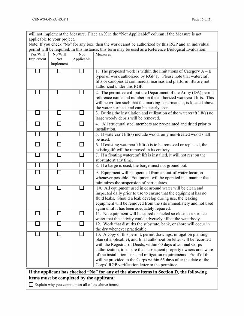
CENWS-OD-RG-RGP 1 Page 15 of 21
will not implement the Measure. Place an X in the “Not Applicable” column if the Measure is not applicable to your project. Note: If you check “No” for any box, then the work canot be authorized by this RGP and an individual permit will be required. In this instance, this form may be used as a Reference Biological Evaluation.Yes/Will
Implement No/Will
Not Implement
Not Applicable
Measures
1. The proposed work is within the limitations of Category A – E types of work authorized by RGP 1. Please note that watercraft lifts or canopies at commercial marinas and platform lifts are not authorized under this RGP.
2. The permittee will put the Department of the Army (DA) permit reference name and number on the authorized watercraft lifts. This will be written such that the marking is permanent, is located above the water surface, and can be clearly seen.
3. During the installation and utilization of the watercraft lift(s) no large woody debris will be removed.
4. All structural steel members are pre-painted and dried prior to installation.
5. If watercraft lift(s) include wood, only non-treated wood shall be used.
6. If existing watercraft lift(s) is to be removed or replaced, the existing lift will be removed in its entirety.
7. If a floating watercraft lift is installed, it will not rest on the substrate at any time.
8. If a barge is used, the barge must not ground out.
9. Equipment will be operated from an out-of-water location whenever possible. Equipment will be operated in a manner that minimizes the suspension of particulates.
10. All equipment used in or around water will be clean and inspected daily prior to use to ensure that the equipment has no fluid leaks. Should a leak develop during use, the leaking equipment will be removed from the site immediately and not used again until it has been adequately repaired.
11. No equipment will be stored or fueled so close to a surface water that the activity could adversely affect the waterbody.
12. Work that disturbs the substrate, bank, or shore will occur in the dry whenever practicable.
13. A copy of this permit, permit drawings, mitigation planting plan (if applicable), and final authorization letter will be recorded with the Registrar of Deeds, within 60 days after final Corps authorization, to ensure that subsequent property owners are aware of the installation, use, and mitigation requirements. Proof of this will be provided to the Corps within 65 days after the date of the Corps’ RGP verification letter to the permittee
If the applicant has checked “No” for any of the above items in Section D, the following items must be completed by the applicant:
Explain why you cannot meet all of the above items:

CENWS-OD-RG-RGP 1 Page 16 of 21
Based on the existing environmental conditions and the proposed work, the applicant is proposing additional mitigation as described below:
APPLICATION IS HEREBY MADE FOR A PERMIT OR PERMITS TO AUTHORIZE THE ACTIVITIES DESCRIBED HEREIN. I CERTIFY THAT I AM FAMILIAR WITH THE INFORMATION CONTAINED IN THIS APPLICATION, AND THAT TO THE BEST OF MY KNOWLEDGE AND BELIEF, SUCH INFORMATION IS TRUE, COMPLETE AND ACCURATE. I FURTHER CERTIFY THAT I POSSESS THE AUTHORITY TO UNDERTAKE THE PROPOSED ACTIVITIES. I HEREBY GRANT TO THE AGENCIES TO WHICH THIS APPLICATION IS MADE, THE RIGHT TO ENTER THE ABOVE-DESCRIBED LOCATION TO INSPECT THE PROPOSED, IN-PROGRESS OR COMPLETED WORK. I VOLUNTARILY AGREE TO MEET ALL REQUIREMENTS OF THIS RGP. I AGREE TO START WORK ONLY AFTER ALL NECESSARY PERMITS HAVE BEEN RECEIVED. Signature of Applicant Date Signature of Co-Applicant (if applicable) Date Signature of Authorized Agent Date
Signature of Contractor (if available) Date
CENWS-OD-RG-RGP 1 Page 17 of 21
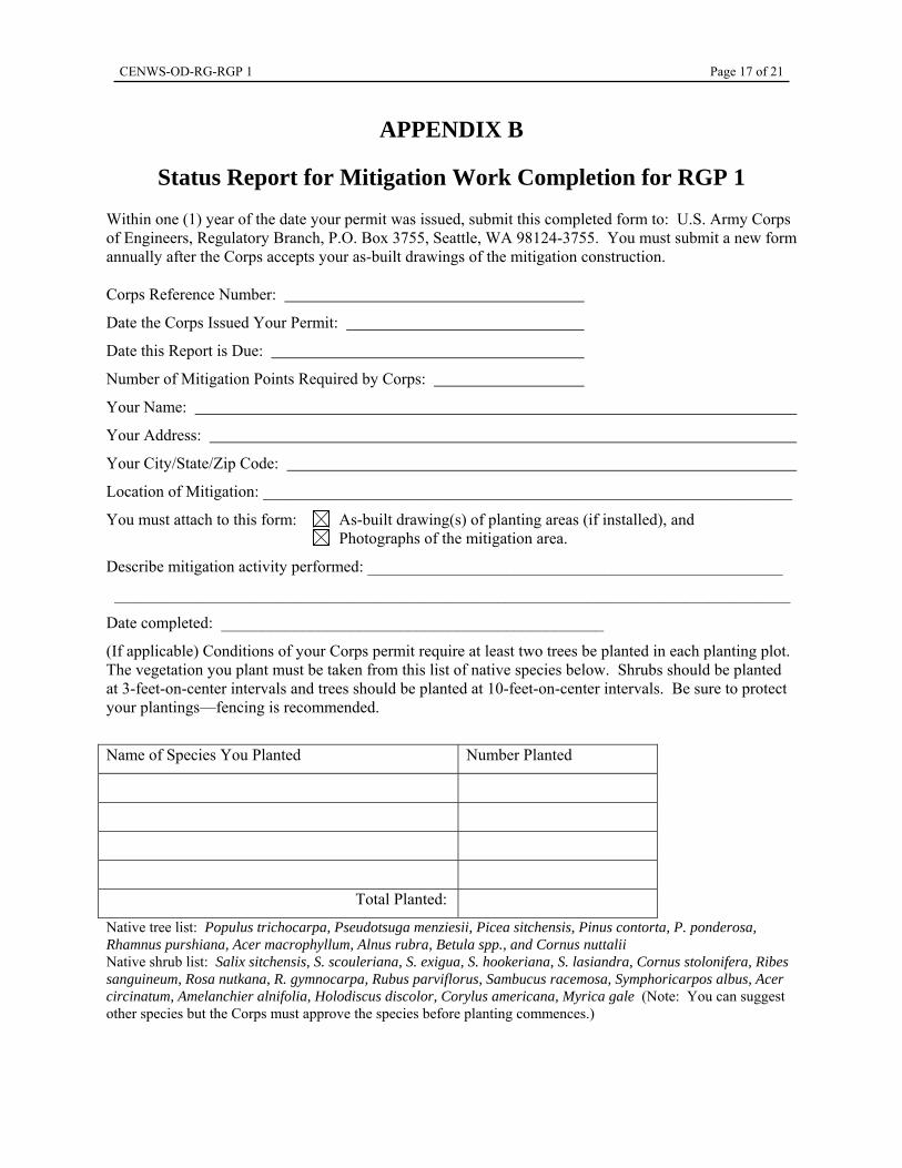
APPENDIX B
Status Report for Mitigation Work Completion for RGP 1
Within one (1) year of the date your permit was issued, submit this completed form to: U.S. Army Corps of Engineers, Regulatory Branch, P.O. Box 3755, Seattle, WA 98124-3755. You must submit a new form annually after the Corps accepts your as-built drawings of the mitigation construction.
Corps Reference Number:
Date the Corps Issued Your Permit:
Date this Report is Due:
Number of Mitigation Points Required by Corps:
Your Name:
Your Address:
Your City/State/Zip Code:
Location of Mitigation: _________________________________________________________________
You must attach to this form: As-built drawing(s) of planting areas (if installed), and Photographs of the mitigation area.
Describe mitigation activity performed: ___________________________________________________
___________________________________________________________________________________
Date completed: _______________________________________________
(If applicable) Conditions of your Corps permit require at least two trees be planted in each planting plot. The vegetation you plant must be taken from this list of native species below. Shrubs should be planted at 3-feet-on-center intervals and trees should be planted at 10-feet-on-center intervals. Be sure to protect your plantings—fencing is recommended.
Name of Species You Planted Number Planted
Total Planted:
Native tree list: Populus trichocarpa, Pseudotsuga menziesii, Picea sitchensis, Pinus contorta, P. ponderosa, Rhamnus purshiana, Acer macrophyllum, Alnus rubra, Betula spp., and Cornus nuttalii Native shrub list: Salix sitchensis, S. scouleriana, S. exigua, S. hookeriana, S. lasiandra, Cornus stolonifera, Ribes sanguineum, Rosa nutkana, R. gymnocarpa, Rubus parviflorus, Sambucus racemosa, Symphoricarpos albus, Acer circinatum, Amelanchier alnifolia, Holodiscus discolor, Corylus americana, Myrica gale (Note: You can suggest other species but the Corps must approve the species before planting commences.)
CENWS-OD-RG-RGP 1 Page 18 of 21
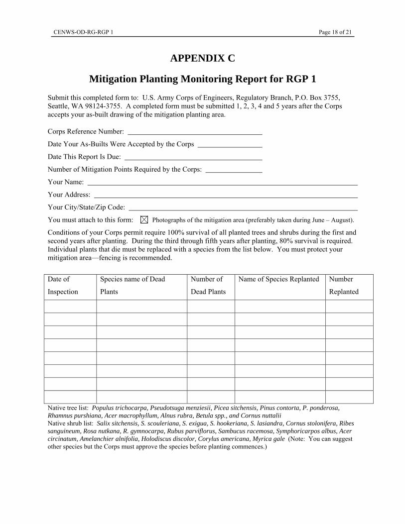
APPENDIX C
Mitigation Planting Monitoring Report for RGP 1
Submit this completed form to: U.S. Army Corps of Engineers, Regulatory Branch, P.O. Box 3755, Seattle, WA 98124-3755. A completed form must be submitted 1, 2, 3, 4 and 5 years after the Corps accepts your as-built drawing of the mitigation planting area.
Corps Reference Number:
Date Your As-Builts Were Accepted by the Corps
Date This Report Is Due:
Number of Mitigation Points Required by the Corps:
Your Name:
Your Address:
Your City/State/Zip Code:
You must attach to this form: Photographs of the mitigation area (preferably taken during June – August).
Conditions of your Corps permit require 100% survival of all planted trees and shrubs during the first and second years after planting. During the third through fifth years after planting, 80% survival is required. Individual plants that die must be replaced with a species from the list below. You must protect your mitigation area—fencing is recommended.
Date of
Inspection
Species name of Dead
Plants
Number of
Dead Plants
Name of Species Replanted Number
Replanted
Native tree list: Populus trichocarpa, Pseudotsuga menziesii, Picea sitchensis, Pinus contorta, P. ponderosa, Rhamnus purshiana, Acer macrophyllum, Alnus rubra, Betula spp., and Cornus nuttalii Native shrub list: Salix sitchensis, S. scouleriana, S. exigua, S. hookeriana, S. lasiandra, Cornus stolonifera, Ribes sanguineum, Rosa nutkana, R. gymnocarpa, Rubus parviflorus, Sambucus racemosa, Symphoricarpos albus, Acer circinatum, Amelanchier alnifolia, Holodiscus discolor, Corylus americana, Myrica gale (Note: You can suggest other species but the Corps must approve the species before planting commences.)
CENWS-OD-RG-RGP 1 Page 19 of 21
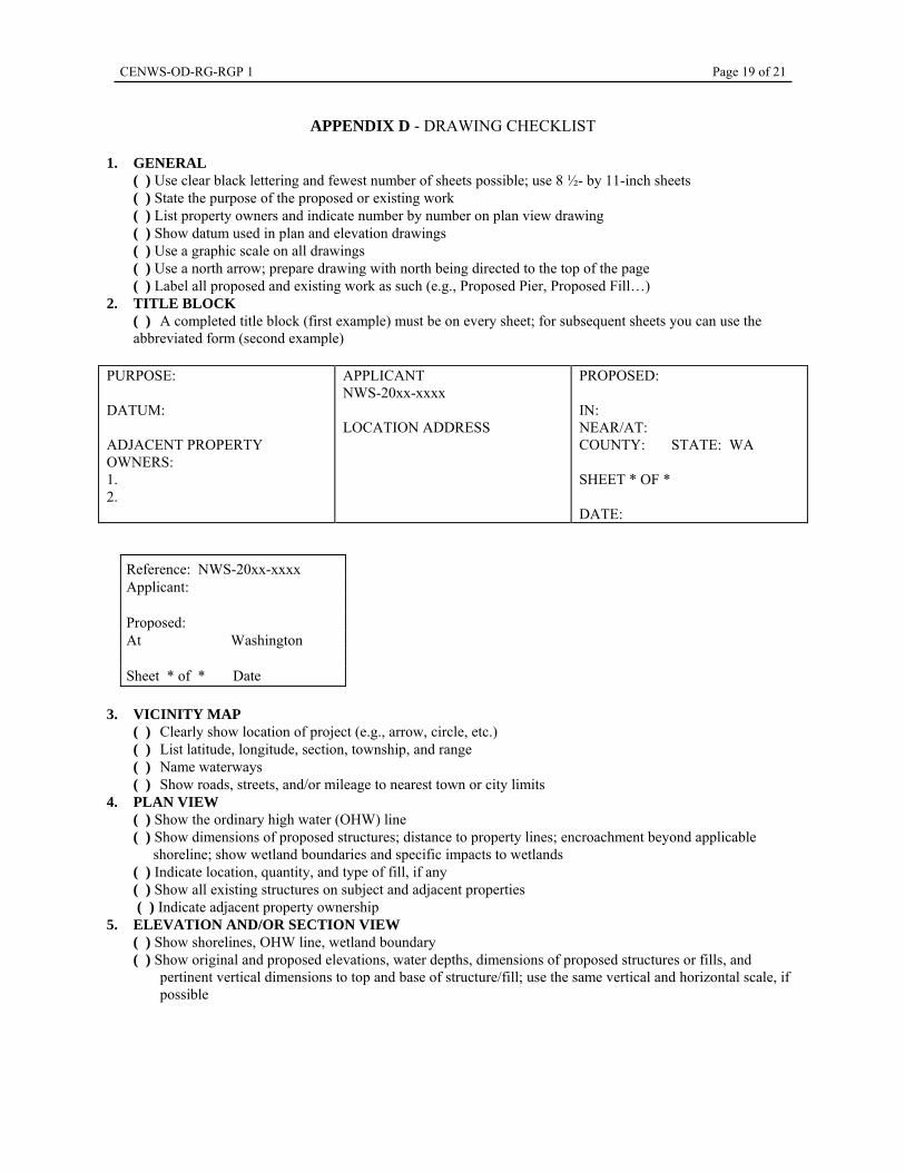
APPENDIX D - DRAWING CHECKLIST 1. GENERAL
( ) Use clear black lettering and fewest number of sheets possible; use 8 ½- by 11-inch sheets ( ) State the purpose of the proposed or existing work ( ) List property owners and indicate number by number on plan view drawing ( ) Show datum used in plan and elevation drawings ( ) Use a graphic scale on all drawings ( ) Use a north arrow; prepare drawing with north being directed to the top of the page ( ) Label all proposed and existing work as such (e.g., Proposed Pier, Proposed Fill…)
2. TITLE BLOCK ( ) A completed title block (first example) must be on every sheet; for subsequent sheets you can use the abbreviated form (second example)
PURPOSE: DATUM: ADJACENT PROPERTY OWNERS: 1. 2.
APPLICANT NWS-20xx-xxxx LOCATION ADDRESS
PROPOSED: IN: NEAR/AT: COUNTY: STATE: WA SHEET * OF * DATE:
3. VICINITY MAP ( ) Clearly show location of project (e.g., arrow, circle, etc.) ( ) List latitude, longitude, section, township, and range ( ) Name waterways ( ) Show roads, streets, and/or mileage to nearest town or city limits
4. PLAN VIEW ( ) Show the ordinary high water (OHW) line ( ) Show dimensions of proposed structures; distance to property lines; encroachment beyond applicable
shoreline; show wetland boundaries and specific impacts to wetlands ( ) Indicate location, quantity, and type of fill, if any ( ) Show all existing structures on subject and adjacent properties ( ) Indicate adjacent property ownership
5. ELEVATION AND/OR SECTION VIEW ( ) Show shorelines, OHW line, wetland boundary ( ) Show original and proposed elevations, water depths, dimensions of proposed structures or fills, and
pertinent vertical dimensions to top and base of structure/fill; use the same vertical and horizontal scale, if possible
Reference: NWS-20xx-xxxx Applicant: Proposed: At Washington Sheet * of * Date
CENWS-OD-RG-RGP 1 Page 20 of 21
APPENDIX E
Definitions, descriptions, and/or examples of Terms
“Bank” is the rising ground bordering the waterbody forming an edge or steep slope “Commercial marinas” are marinas where anybody can purchase and/or lease the use of a slip. This does not include marinas or joint use piers owned by a homeowners association. Marinas or joint use piers owned by homeowners associations allow the use of the facility by only members of typically adjacent residences in the designed homeowners group and typically include fees in the maintenance fees or cost of the home A “canopy” is an overhead structure that provides shelter above a watercraft lift. Canopies must be translucent. A “floating watercraft lift” is any lift, except a platform lift, that does not and will not in the normal course of events contact the waterbody substrate at any time. “Groin” is a rigid structure (constructed of rock, wood, or other durable material) built out from the shore, usually perpendicular to the shore, to protect the shore from erosion or to trap sand. A “ground-based watercraft lift” is any lift wherein any part of the lift attaches to, or will at any time in the future attach to, rest on, or otherwise be in contact with or be supported by the waterbody substrate. “Hardened shoreline” includes but is not limited concrete, rock or timber bulkheads, riprap, or concrete boat ramp access. “Joint-use” piers, ramps, and floats are constructed and utilized by more than one contiguous residential waterfront property owner or by a homeowner’s association. This does not include commercial marinas. “Offsite” means outside the property boundaries of the waterfront property owner(s) proposing the project. For the purpose of this RGP, the property boundary in the water, unless already shown on a deed or legal description, is a straight-line extension of the property line on the land, projected waterward, and perpendicular to the shoreline. “Onsite” means within the property boundaries of the waterfront property owner(s) proposing the project. For the purpose of this RGP, the property boundary in the water, unless already shown on a deed or legal description, is a straight-line extension of the property line on the land, projected waterward, and perpendicular to the shoreline. “Opening size” of grating is the area enclosed between the rectangular bars and cross rods in bar grating, or the area enclosed between the bonds and strands in expanded grating. “Ordinary high water” Line on the shore of non-tidal streams and lakes “established by fluctuations of water and indicated by physical characteristics such as a clear, natural line impressed on the bank; shelving; changes in the character of the soil; destruction of terrestrial vegetation; the presence of litter and debris; or other appropriate means that consider the characteristics of the surrounding areas.” It is the line of jurisdiction in freshwaters for the Corps of Engineers Regulatory program.
CENWS-OD-RG-RGP 1 Page 21 of 21
“Overwater structures”, for the purposes of this RGP, includes piers, ramps, floats, and their associated structures. “Percent open area” is a relative measure of the degree which light can pass through grating. The manufacturer often provides this value. Otherwise, it can be calculated by dividing the opening size by the sum of the opening size and the surface area of the adjacent rectangular bars and cross rods. “Platform lift” is a watercraft lift with a level surface (wider than 1 foot) and a mechanism that lowers the surface into and out of the water. “Removal” means to remove from the area waterward of OHW and dispose of, or place in, an appropriate upland or approved disposal area. “Single residential use” pier, ramp, and float constructed and utilized by only one residential waterfront property. “Suspended lifts” include floating watercraft lifts and any watercraft lift, except platform lifts, which can be affixed to the existing overwater structure with no parts contacting the substrate. “Translucent canopy” is a canopy constructed of material which allows sunlight to pass through and which is translucent enough for a person to read the text of this RGP. “Uplands” (for the purposes of this RGP) are areas landward of the ordinary high water line. “Watercraft” includes but is not limited to motorized boats, kayaks, canoes, jet skis, and float planes.